10 years of watershed research, conservation, and protection. 2008 - 2018 + Bonus 2019 Content Ecosystems Explorations A publication of the Ecosystems & Watershed Management and Scenic Rivers Operations Departments.
Transcript
10 years of watershed research, conservation, and protection.2008 - 2018 + Bonus 2019 Content
EcosystemsExplorations
A publication of the Ecosystems & WatershedManagement and Scenic Rivers Operations Departments.
Grand River Dam Authority
2 10 Year Review Introduction
Dr. Darrell Townsend
TABLE OF CONTENTSThe following is a compilation of programs, projects, and research performed and supported by the Ecosystems and Watershed Management Department of the Grand River Dam Authority (GRDA). The work that is displayed in the following pages represent the commitment that GRDA has made to be good stewards of the natural resources under our control.
GRDA’s 5E’s of Excellence 4GRDA’s Aims, Purposes, and Objectives 5GRDA’s Watersheds 6-8GRDA Programs & Events 9-18GRDA Fellowship & Featured Projects 19-49 University of Oklahoma 20-35 University of Oklahoma Capstone Classes 36-41 Oklahoma State University 42-49GRDA Supported Projects 50-53 Rogers State University 50 Pitt State University 51-53Closing Notes - Thank You 54-55
GRDA FellowshipSupported Students
University of Oklahoma
Completed:Russell C. Dutnell : PhDJulie A. LaBar : PhDLeah R. Oxenford : PhDDerrick Nguyen : MSNicholas Shepherd : MSSarah Yepez : MSBrendan Furneaux : MSJuan Arango Calderon : MSAlan Dennis : MS Amy Sikora : MSEllen Fielding : MS
In Progress: Nicholas Shephard : PhDJuan Arango Calderon : PhDBrandon Holzbauer-Shweitzer : PhDZepei Tang : PhD
EDITORS: GRAPHIC DESIGN: COVER CONCEPT: REVIEWERS:Justin Alberty Page Layouts: Dustin Browning Darrell Townsend Melanie EarlDustin Browning Logos: GRDA Media Department Dustin Browning Kate Wollman Joel Barrow Courtney Stookey Jacklyn Jaggars
This publication was produced with input from the entire Ecosystems and Watershed Management and Scenic Rivers Operations teams. All maps are property of the GRDA GIS Department. All photos and student summaries have been submitted to GRDA via project updates, and are now authorized for use by GRDA.
This publication printed by The Print Shop in Claremore, OK, is issued by the Grand River Dam Authority at no cost to taxpayers as authorized by 82 O.S. Sec. 861 et seq. 500 copies have been printed at a cost of $3750.00. Copies have been deposited with the Publications Clearinghouse of the Oklahoma Department of Libraries.
OPENING THOUGHTS FROM DR. DARRELL TOWNSEND
Water resources are an ever increasing concern that is continuously threatened by external anthropological forces that are applied within a watershed. For
instance, management of non-point sources originating from agricultural practices or point sources associated with waste water treatment plants, water quality is becoming an ever increasing challenge to watershed scientists and lake managers, alike. Most of the GRDA’s water originates outside of Oklahoma in neighboring states with more than 10,000 square miles of runoff impacting water quality and indirectly impacting the economies of local communities in and around Grand Lake. In addition there has been a large focus surrounding the Tri-state Mining District (includes Kansas, Missouri, and Oklahoma) where the world’s number one superfund site lies just upstream of Grand Lake. Therefore, GRDA’s lake management strategies over the past decade have primarily focused on the impacts of the Tri-state Mining District, as well as the conservation and restoration implications on water quality and subsequent shoreline management. Furthermore, following the “Great Algae Bloom of 2011” that began on Grand Lake, but eventually spread to lakes throughout the state, was primarily driven by excessive nutrients and extreme summer time temperatures that led to these historical blooms. These challenges are but a few of the key factors our Ecosystems Management team are trying to mitigate.
Focusing on GRDA’s “5 E’s” of excellence, Employees of GRDA’s Scenic Rivers Operations and the Ecosystems and Watershed Management team have Efficiently utilized our university partnerships to focus on the Environmental Stewardship necessary to promote Economic Development and produce clean affordable Electricity that is generated using our water resources.
Throughout the following pages, you will find valuable information gained over the last decade that highlights the quality of research that has helped shape GRDA’s watershed management programs. Additionally, we highlight the fellowship program that simultaneously supports graduate students throughout the state while providing GRDA with valuable insights that help shape GRDA’s watershed and lake management priorities. The fellowship program not only prepares the next generation of watershed management professionals but also saves GRDA rate payers significant resources, as the information obtained under direct supervision of GRDA and our university partners, saves millions of dollars that would otherwise be spent on professional engineering services. Throughout the past 10-years these critical partnerships not only address information gaps associated with our statutory obligations, but also helps address issues associated with regulatory and license compliance with the Federal Energy Regulatory Commission.
We believe the following 10-year review will demonstrate GRDA’s commitment to our natural resources as we prepare to address the water resource challenges of the next decade.
If you have any questions about the ongoing cooperative research programs, visit our link on the GRDA website at www.grda.com or contact our offices at (918) 256-0723.
Sincerely,
Darrell Townsend, Ph.D.
Welcome from our Vice President
4 Grand River Dam Authority Ecosystems & Watershed Managment 5
Grand River Dam Authority Ecosystems & Watershed Management
To learn more about the Grand River Dam Authority, please visit our website at www.grda.com.
Scan the QR Code to visit the website!
GRDA’S 5E’S OF EXCELLENCE
Electricity: We will produce low-cost, reliable electricity for our customers.
Environmental Stewardship: We will practice environmental awareness and promote conservation and reclamation of the naural resources under our control.
Economic Development: We will support economic growth and quality of life enhancement in Oklahoma.
Employees: We will be a diverse and energetic workforce, working together in a safe environment and treating each other with dignity and respect.
Efficiency: We will operate in the most efficient manner possible, to benefit our ratepayers and the people of Oklahoma.
MISSION STATEMENT
We deliver affordable, reliable ELECTRICITY, with a focus on EFFICIENCY and a commitment to ENVIRONMENTAL STEWARDSHIP.
We are dedicated to ECONOMIC DEVELOPMENT, providing resources and supporting economic growth.
Our EMPLOYEES are our greatest asset in meeting our mission to be an Oklahoma Agency of Excellence.
-ELECTRICITY -EFFICIENCY -EMPLOYEES -ENVIRONMENTAL STEWARDSHIP-ECONOMIC DEVELOPMENT
GRDA
GRDA’S AIMS, PURPOSES, AND OBJECTIVESThe following are excerpts from GRDA’s 2019 Policy Manual
OBJECTIVE: To further the Authority’s mission to provide low-cost, reliable electric power and related services to its customers and to be responsive to the interests and concerns of public power users, the communities the Authority affects, and the people of the State of Oklahoma. The Authority pledges to assist in area economic development and help its customers adapt to changes in their business environments, as well as supporting environmental awareness, recreational development, and good safety practices on and around the Authority’s lakes, to ensure the continued improvement of the quality of life for all those who utilize these resources.
POLICY: The following objectives of the Grand River Dam Authority are established to focus attention on the need to initiate, develop and promote active programs designed to serve the needs of the Authority’s customers, its employees, and the general public who utilize our resources; to conserve, preserve, and protect the environmental health and welfare of the lakes and lands within the Authority’s district; and to utilize effectively the Authority’s lakes for recreational purposes. The Authority, it’s Board Members, Management, and Employees, in accomplishing these goals, will act only in accord with the highest ethical and legal standards, acknowledging the duty owed to the Authority’s customers, its bondholders, and the citizens of the State of Oklahoma, to refrain from violating those standards.
ENABLING LEGISLATION - GRAND RIVER DAM AUTHORITY The following are excerpts from 82 Okl.St.Ann. § 861
There is hereby created within the State of Oklahoma a conservation and reclamation district to be known as “Grand River Dam Authority”, hereinafter called the district, and consisting of that part of the State of Oklahoma which is included within the boundaries of the Counties of Adair, Cherokee, Craig, Delaware, Mayes, Muskogee, Ottawa, Osage, Pawnee, Payne, Lincoln, Logan, Tulsa, Wagoner, Sequoyah, Haskell, Latimer, Pittsburg, McIntosh, Creek, Okmulgee, Nowata, Washington and Rogers. Such district shall be, and is hereby declared to be, a governmental agency of the State of Oklahoma, body politic and corporate, with powers of government and with the authority to exercise the rights, privileges and functions hereinafter specified, including the control, storing, preservation and distribution of the waters of the Grand River and its tributaries, for irrigation, power and other useful purposes and reclamation and irrigation of arid, semiarid and other lands needing irrigation, and the conservation and development of the forests, minerals, land, water and other resources and the conservation and development of hydroelectric power and other electrical energy, from whatever source derived, of the State of Oklahoma.
Nothing in this act or in any other act or law contained, however, shall be construed as authorizing the district to levy or collect taxes or assessments, or to create any indebtedness payable out of the taxes or assessments, or in any manner to pledge the credit of the State of Oklahoma, or any subdivision thereof.
All that body of land and the water impounded above the Pensacola Dam, Pensacola Project, shall be hereafter designated and known as “Grand Lake O’ The Cherokees”. All that body of land and the water impounded above Robert S. Kerr Dam, Markham Ferry Project, shall be hereafter designated and known as “Lake Hudson”. All that body of land and the water impounded above Chimney Rock Dam, Salina Pumped-Storage Project, shall be designated and known as “W. R. Holway Reservoir”.
GRDA
Grand River Dam Authority Ecosystems & Watershed Management
GRDA
GRDA’s Grand River
The Grand River 7
GRDA GRDA
WHAT IS A WATERSHED?A watershed is defined as an area that drains all of its rivers, streams, creeks, and runoff to a common outlet. This outlet may be the outflow of a reservoir, or the mouth of a bay, depending on your geographic location. A watershed consists of all of the surface water - lakes, rivers, reservoirss, and wetlands as well as subsurface groundwater.
A large watershed may consist of many smaller “sub-watersheds”, for example the Grand River watershed can be separated into four distinct sub-watersheds, the Spring River, the Neosho River, the Elk River, and the Lake O’ the Cherokees watersheds.
THE GRAND RIVER WATERSHEDThe Grand River watershed is a collection of rivers, streams, creeks, and runoff that stretches across a roughly 10,300 mile area and eventually flows into the Grand River in Oklahoma’s northeast corner. It rests in four states, straddles two EPA regions and impacts the lives of hundreds of thousands of people.
Most of the watershed lies in the state of Kansas, with the water eventually making its way to Oklahoma by way of the Neosho River. In Missouri, another large portion of the watershed drains into our state mostly through the Spring River. The confluence of the Neosho and Spring rivers, near the heart of Ottawa County, is the beginning of the Grand River. Impounded by three separate dams, this river then gives us Grand Lake (Pensacola Dam), Lake Hudson (Robert S. Kerr Dam) and the Fort Gibson Lake (Fort Gibson Dam). Together, these lakes provide not only the “fuel” for hydroelectric generation and a valuable water supply across a large region, but also serve as a foundation for economic development tied to multiple industries, including manufacturing, tourism, recreation and more.
To learn more about GRDA’s conservation efforts, watch our documentary Our Borrowed Waters at the link below.https://www.youtube.com/watch?v=Eu5bXH1CfpY
Scan the QR Code to view the documentary!
£¤75
£¤69UV20
£¤69
§̈¦40
§̈¦40
£¤71
£¤270
£¤69
£¤412
§̈¦49
£¤50
£¤56§̈¦135
£¤400
£¤81
£¤64
£¤64
£¤177
£¤377
£¤69
£¤271
§̈¦49
£¤54
§̈¦49
Muskogee Turnpike
£¤62
Indian Natiion Turnpike
UV278
UV22
£¤75 UV4
£¤59
£¤160
£¤377
UV88
UV20
UV20
UV3W
UV33
£¤177
§̈¦44
§̈¦35
§̈¦30
§̈¦49
§̈¦135
§̈¦70
§̈¦44
§̈¦35
§̈¦44
§̈¦44
§̈¦35
§̈¦40
§̈¦70
§̈¦335
§̈¦35
§̈¦44
§̈¦70
§̈¦35
§̈¦35
§̈¦40
§̈¦70
£¤259
£¤65
£¤177
£¤75
£¤70
£¤271
£¤412
£¤270
£¤169
£¤377
£¤56
£¤82
£¤59
£¤266
£¤160
£¤81
£¤64
£¤166
£¤62
£¤24
£¤371
£¤199
£¤70
£¤270
£¤75
£¤371
£¤69
£¤64
£¤270
£¤56
£¤59
£¤67
£¤177
£¤166
£¤81
£¤75
£¤54
£¤77
£¤270
£¤65
£¤75
£¤75
£¤75
£¤64
£¤169
£¤412
£¤71
£¤60
£¤166
£¤160
£¤62
£¤54
£¤81
£¤59
£¤59
£¤169
£¤169
£¤62
£¤65
£¤69£¤65
£¤412
£¤271
£¤59
£¤77
£¤270
£¤160
£¤50
£¤69
£¤77
£¤77
£¤40
£¤160
£¤62
£¤65
£¤59
£¤400
£¤177
£¤412
£¤60
£¤77
£¤70
£¤271
£¤64
£¤177
£¤59
£¤62
£¤60
£¤70
£¤69
£¤412
£¤50
£¤71
£¤71
£¤59
£¤177
£¤60
£¤77
£¤64
£¤75
£¤259
£¤71
£¤81
£¤77
£¤70
£¤271
£¤400
£¤169
£¤62
£¤166
£¤50
£¤50
£¤71
£¤71
£¤259
£¤62
£¤81
£¤77
£¤59
£¤82
£¤160
£¤70
£¤75
£¤69
£¤60
£¤60
£¤400
£¤59
UV48
UV32
UV63
UV78
UV1
UV3
UV37
UV9
UV51
UV8
UV96
UV13
UV27
UV31
UV105
UV33
UV19
UV20
UV177
UV11
UV29
UV66
UV61
UV89
UV174
UV291
UV199
UV332
UV152
UV19
UV11
UV3
UV3
UV18
UV96
UV74
UV76
UV2
UV7
UV45
UV83
UV7
UV164
UV56
UV15
UV177
UV76
UV78
UV66
UV37
UV99
UV56
UV39
UV82
UV48
UV177
UV48
UV59
UV74
UV18
UV51
UV9
UV10
UV51
UV66
UV9
UV18
UV37
UV20
UV18
UV74
UV7
UV26
UV10
UV1
UV18
UV7
UV1
UV10 UV13
UV1
UV10
UV96
UV278
UV66
UV31
UV99
UV99
UV39
UV9
UV88
UV19
UV76
UV27
UV162
UV59
UV53
UV33
UV76
UV8
UV51
UV123
UV59
UV254
UV2
UV16
UV51
UV72
UV74
Ada
Enid
Nixa
Hope
Yukon
Tulsa
Moore
Miami
Jenks
Bixby
Ozark
Derby
Paris
Owasso
Norman
Edmond
Durant
Duncan
Coweta
Neosho
Joplin
Belton
Topeka
Salina
Ottawa
Olathe
Newton
Lenexa
Rogers
Shawnee
Sapulpa
Mustang
Guthrie
ChoctawBethany
Ardmore
Sedalia
Raytown
Raymore
Branson
BolivarWichita
Shawnee
Parsons
Merriam
Leawood
Gardner
Emporia
Andover
Sherman
Denison
Okmulgee
Muskogee
Glenpool
Del City
RepublicCarthage
Winfield
Lawrence
Tahlequah
McAlester
Claremore
Chickasha
Webb City
Grandview
Pittsburg
McPherson
Haysville
El Dorado
Van Buren
Centerton
Stillwater
Ponca City
Hutchinson
Springdale
Fort Smith
Warrensburg
Springfield
Kansas City
Coffeyville
Bentonville
Bella Vista
Gainesville
Sand Springs
Broken Arrow
Bartlesville
Lee's Summit
Independence
Grain Valley
Fayetteville
Oklahoma City
Harrisonville
Overland Park
JunctionCity
Arkansas City
SiloamSprings
Oklahoma
Kansas
Arkansas
Missouri
²
GrandLake
FortGibson
LakeHudson
MarionReservoir
CouncilGroveReservoir
JohnRedmondReservoir
LakeTenkiller
BrokenBowLake
Mountain ForkRiver
LittleLeeCreek
Barren Fork
IllinoisRiver
Flint Creek
NeoshoRiver
SpringRiver
NeoshoRiver
Spring River
ElkRiver
Legend
Grand Lake Watershed
Lake GRDA Jurisdiction
River GRDA Jurisdiction
Watershed River
Lower Neosho Watershed
Watershed Reservoir
Scenic River
Scenic Rivers Watersheds
State Line
Cottonwood River
S. Cottonwood
N. Cottonwood
Neosho River
S. Fork Cottonw
ood
Elk River
N. Fork Spring
W. Fork Spring
LeeCreek
•Ecosystems and Education Center Scenic Rivers OperationsGRDA Jurisdiction and Respective Watersheds
Grand River Dam Authority Ecosystems & Watershed Management
NSU & GRDA 9 8 Scenic Rivers
Northeastern State UniversityGRDA’s Scenic Rivers
GRDA’S SCENIC RIVERS WATERSHEDS
Scenic River: A scenic river is a free-flowing stream or river that has been designated by the Oklahoma Legislature as possessing “such unique natural scenic beauty, water conservation, fish, wildlife and outdoor recreational values of present and future benefit to the people of the state” that they are in need of special protection.
On July 1, 2016, the Grand River Dam Authority (GRDA) absorbed the mission and responsibilities of the Oklahoma Scenic Rivers Commission (OSRC). That mission is to protect, enhance, and preserve the outstanding aesthetic, historic, archaeological and scientific features of the Illinois River and its tributaries (Lee Creek, Little Lee Creek, Barren Fork Creek, Flint Creek, and the Upper Mountain Fork River). Currently, Oklahoma has six scenic rivers that collectively extend 161 miles through six counties. The scenic river designation affords these valuable resources the highest protection and priority available through Oklahoma’s environmental agencies. Specific requirements of this designation include a strict prohibition on additional pollutants, dams, and wastewater treatment plants, and a close monitoring of construction activities alongside the river.
The GRDA Scenic Rivers Operations department is invested with the power to establish minimum standards for planning and other ordinances affecting scenic rivers. As the OSRC had done since its establishment in 1977, GRDA continues to work with communities, businesses and individuals to mitigate their impact on scenic rivers. We strive to educate the public about scenic rivers and also to provide everyone the opportunity to enjoy the features that make these water resources so special.
The new partnership with NSU to create the GRDA-NSU Scenic Rivers and Watershed Research Lab is meant to help protect and better understand the Illinois River and its watershed, as well as the rest of the scenic rivers. Together, the Ecosystems & Watershed Management department and the Scenic Rivers Operations department are ready to carry out the provisions of the Scenic Rivers Act through protection, preservation, and education.
RIPARIAN PROTECTION CONSERVATION EASEMENTSSince GRDA absorbed the OSRC on July 1 2016, the total acres of conservation easements have increased from a total of roughly 414 acres pre-absorbtion, to a total of around 1,094 acres as of November 2019. That is an increase of roughly 680 acres of conservation easements. In total, since the inception of the program, $2,377,691 has been spent on developing conservation easements to help better protect Oklahoma’s scenic rivers.
Conservation Easement: A voluntary agreement that limits the uses of land in order to protect its conservation values.
GRDA & NSU PARTNER FOR WATERSHED RESEARCH In the summer of 2017, GRDA and Northeastern State University (NSU) joined in a partnership to help protect and better understand the Illinois River watershed, as well as the rest of the Oklahoma scenic rivers. This move comes after GRDA’s absorption of the Oklahoma Scenic Rivers Commission in July of 2016. GRDA was already second only to the Oklahoma Water Resources Board (OWRB) in jurisdiction over the waters of Oklahoma, and with this absorption, GRDA became responsible for the Illinois River watershed, as well as the other scenic rivers. A research laboratory on the Tahlequah campus of NSU has been designated for GRDA use and use for projects supported by the partnership. The GRDA-NSU Scenic Rivers and Watershed Research lab is staffed by full-time GRDA employees, and is available for use by NSU students and faculty. The lab is currently in the development phase, however, GRDA has already begun making sampling runs and conducting research to decide how to best use resources and supplement data that is already being collected by other entities.
GRDA is very excited about the partnership and the unique opportunity it brings to NSU students. In addition to use of state-of-the-art equipment and access to knowledgeable water professionals, this partnership will also offer summer internship opportunities to students with an interest in pursuing a career in the field of natural resources. While the partnership is a great opportunity for NSU students, they will not be the only ones that benefit. GRDA having a presence in the area is great for the community as well. GRDAt strives to be involved in local communities through educational outreach, public events and sharing long term data sets to help local entities better understand the waters near them.
“This partnership will help fund student scholarships, as well as a variety of research opportunities including in-
class projects and independent research.”
- Pamela Hathorn – NSU 2017
“Locating the GRDA-NSU Scenic Rivers and Watershed Research Laboratory on campus will facilitate interaction among students, scien-
tists and water resource professionals that will provide students a unique opportunity to utilize what they have learned in their classes and apply that knowledge to address real world challenges and watershed issues.”
– Darrell Townsend – GRDA 2017
GRDA NSU & GRDA
Grand River Dam Authority Ecosystems & Watershed Management
10 Rush for Brush
Group photo from a 2017 Rush for Brush eventA group of kids build a structure
Rush for Brush
RUSH FOR BRUSHThe Rush for Brush program is designed to rehabilitate aging lakes by improving aquatic habitat for popular game fish in lakes managed by the Grand River Dam Authority (GRDA). Our program encourages local volunteers to become actively involved in conservation and management of our natural resources. Over time, fish habitat in the form of old stumps and trees that were buried when the lakes were originally impounded (50 to 75 years ago) have long since rotted and decayed away. As a result, fishermen often cut trees and limbs along the shoreline for use as brush piles to attract popular game fish. Frequent tree cutting and removal along the shoreline encourages soil erosion and reduces shoreline habitat used by other species of wildlife. GRDA’s Rush for Brush events are designed to educate fishermen and conservationists alike about sound management practices and shoreline conservation. Local anglers and volunteers are encouraged to attend these annual events to construct artificial habitats that simulate and provide similar benefits commonly attributed to traditional brush piles. Our Rush for Brush program discourages the practice of removing shoreline habitat for use as fishery brush piles and promotes shoreline conservation by providing anglers an alternative measure to attract fish to their favorite fishing hole. This artificial habitat not only provides protection to fry and young-of-the-year game fish but will also simultaneously provide fish attractants that last much longer than traditional “natural” brush piles. To date, more than 1,100 volunteers have built nearly 16,000 structures, which cover nearly 11 acres of lake bed.
Since the program’s inception, the design and efficiency of assembling these artificial structures has evolved over time. Initially, the structures were built by cutting polyvinyl chloride (PVC) pipes into four to six foot lengths and were subsequently secured in cinder block holes with concrete to create a “spider like” structure. During the first year, in 2007, the volunteers had to mix bagged concrete by hand where it took more than 8 hours to construct 60 structures. The popularity quickly grew and the final workshop that year, brought over 50 volunteers. The following year and based on popularity and demand, GRDA increased construction efficiency by utilizing two concrete trucks, rather than mixing bags of concrete by hand. This process improved efficiency and resulted in the construction of 750 structures over an eight hour day improving production by more than 12 times the number constructed at the first workshop. However, this process (although more productive) remained very labor intensive as the volunteers had to carry 5-gallon buckets of concrete through rows of cinder blocks, producing a final structure weighing more than 25 to 30 lbs. For eight more years, GRDA continued to use the same design concept until a new, and even more efficient design was fabricated. In 2016, GRDA started using four inch drain pipe to
GRDA GRDA
Rush for Brush 11
GRDA was awarded the 2017 “Environmental Excellence”
award for a State Agency from Keep Oklahoma Beautiful for its Rush for Brush Program
Team GRDA accepting the “Environmental Excellence” award
Rush for Brush
replace the cinder blocks. The drain pipe was drilled with holes necessary to receive the same PVC pipe to create the tree-like structures. That year, the volunteers drilled the holes in the pipe, cut the PVC to length, and assembled the structures, yet again increasing efficiency and building more than 1,200 structures in less than half the time (4 hours) that it took to build similar structures utilizing concrete trucks and cinder blocks. Finally, in 2017, GRDA custom ordered the sewer drain pipe to include pre-drilled holes that would accept one inch PVC pipe, enabling volunteers to construct approximately 1,000 in a two hour time frame. There were more than 100 volunteers at each of these events.
GRDA has been pleasantly surprised at the number of volunteers that continue to participate in the program. Volunteers are tracked by online registration, as well as a check-in on the day of the event. Like some volunteer-driven events, there are ebbs and flows with participation, but GRDA’s program has consistently maintained its participation, year after year. With the exception of the first year, GRDA has averaged 80-100 volunteers, with approximately 15% of those being repeat attendees. GRDA plans to continue supporting the program by purchasing materials and organizing the event, as long as volunteers continue to participate. Recently, GRDA recruited cadets from the Thunderbird Youth Academy (TYA) in Pryor, OK, to help construct the tree-like structures for deployment on Lake Hudson. Approximately 450 structures were deployed in a three-hour time frame, to establish a public fishing area near the Highway 20 Bridge, west of Salina, OK. GRDA was awarded an “Environmental Excellence – State Agency” award from the Keep Oklahoma Beautiful organization for these efforts. There are plans to continue utilizing the TYA in promoting aquatic enhancement on GRDA’s lakes.
Award Winning Program2018-“Outstanding Stewards of America’s Waters” - National Hydropower Association2017-“Evironmental Excellence” - Keep Oklahoma Beautiful
GRDA GRDA
Grand River Dam Authority Ecosystems & Watershed Management
12 Wildlife
Wildlife Surveys
BALD EAGLE MONITORINGThe Ecosystems and Watershed Management team conducts aerial bald eagle surveys from a helicopter every year in January and April. Surveys are typically conducted by a GRDA pilot and at least one observer. These surveys take place 400-500 feet. above the tree line at airspeeds ranging between 50-60 MPH. In the January surveys, adults, juveniles, paired eagles, and active nests are counted. Nesting locations from previous years are also inspected for new activity. New nesting locations are always noted and marked. During the spring survey, observers look for new eagle nests and also check eagle nesting sites from previous surveys for activity and for the numbers of juveniles and adult eagles present at the time of the survey. New nesting locations are marked with a GPS and the coordinates are examined to determine if these nests are located within the project boundary. The information that is collected on these surveys is then shared with the George Miksch Sutton Avian Research Center, to help update their bald eagle nesting database as GRDA is an active member of their Bald Eagle Survey Team (BEST).
THREATENED AND ENDANGERED BAT SPECIESWith the help of The Nature Conservancy and the United States Fish and Wildlife Service, GRDA manages three bat caves around the Grand Lake area. Two of these caves are found inland, and one is found directly on the shores of Grand Lake. These caves hold maternity colonies of the endangered cave obligate Gray Bat (Myotis grisescens). The shores of Grand Lake are also home to the threatened tree dwelling Northern Long-Eared Bat (Myotis septentrionalis).
Management activities are conducted by GRDA through agency and university partnerships. These management techniques include population estimates, nighttime counts, and White Nose Syndrome monitoring. GRDA has also written protective measures into its shoreline management plans to prevent any harm or habitat loss to these unique guests of GRDA lakes.
GRDA
Educational Outreach 13
Dustin Browning and Matt Conrad conduct a mock interviewGRDA Staff alongside 2019 Interns
Outreach
GRDA & EDUCATIONAL OUTREACHThe Ecosystems & Watershed Management department, along with GRDA as a whole, has made a valiant effort to support regional educational outreach opportunities through partnerships with universities, facility visits or supporting local education through initiatives such as “Mayes County Third Graders go to Work”. This initiative allows selected third grade classes to visit and tour GRDA. It also allows students an opportunity to learn about GRDA careers in fields such as electrical safety, hydropower and ecosystems management. Later in the day, students are also given the chance for a “mock interview” in their choice of career fields. Initiatives such as this support education, students and perhaps even future members of the GRDA workforce.
GRDA also facilitates learning through school visits. Schools are able to contact GRDA through multiple avenues to schedule guest speakers who are able to talk to students about GRDA careers, projects, or special topics as requested. GRDA is typically able to facilitate either a visit to the requesting school, or allow the school to take a field trip and visit a GRDA facility. The Ecosystems & Watershed Management department typically gives a presentation that is both interesting and educational for students. The topics range from endangered bat species to bald eagles to water quality and ultimately wraps up with why all of these things are important to each and every one of us. Topics can range in complexity to accommodate the different grade levels of students. These students range from third graders all the way up to senior-level college students, as well as graduate students.
It is estimated that our team reached over 1,200 students in 2017 through these outreach programs, and close to those numbers again in 2018 and 2019. It is our hope to continue increasing these numbers through the years. Additionally, GRDA shares information with the public through various social media outlets.
To schedule a guest speaker, please contact us at (918) 256-5545 or by emailing Justin Alberty at [email protected].
Scan the QR Codefor more information!
GRDA
Grand River Dam Authority Ecosystems & Watershed Management
14 Keepin’ it Grand
Shoreline Management
ADOPT-THE-SHORELINEThe Adopt-the-Shoreline program is designed to remove trash and debris from the shorelines of the Grand River, to safeguard the ecosystem and enhance the quality of life for all who use it. The program enables participants to organize cleanups through a process of shoreline adoption. GRDA provides resources and assistance for the cleanups. Grand Lake has been divided into 10 zones to allow participants to choose an area of the lake they wish to focus their preservation efforts on.
The program is still in the beginning phases, so we are seeking volunteers, homeowners, organizations, and civic groups to adopt portions of the shoreline for annual cleanups. We are also seeking businesses to act as supporting members to assist volunteers with barges, loading equipment, and trailers on an annual basis. The first step is to determine which zone your desired shoreline location is located in.
GRDA & SHORELINE MANAGEMENTThe Shoreline Management team is responsible for managing dock applications and inventory, vegetation managment permits, and shoreline cleanup efforts. Shoreline surveys are performed monthly, and management activities are planned accordingly.
To learn more about the Adopt-the-Shoreline, please visit our website at www.grda.com/adopt-the-shoreline-program
Scan the QR Code to visit the website!
To learn more information about permitting please visitwww.grda.com/lake-permits or email us at [email protected]
Scan the QR Code to visit the website!
GRDA
United States Environmental Protection Agency Logo
Guard the Grand 15
Guard the Grand
GUARD THE GRANDGuard the Grand is one of the GRDA’s in-progress solutions to help protect the Grand River. This program will reach out to home owners, land owners, businesses, and students to inform them about watershed protection. In collaboration with the Oklahoma Water Survey and with funding received by the EPA Environmental Education grant program, GRDA will offer workshops, informational handouts, and educational videos that discuss a variety of critical watershed preservation topics such as septic system maintenance, lawn care, household hazardous products, and boat and dock maintenance. A typical workshop will begin with the history of the Grand River and GRDA’s lakes: Grand Lake, Lake Hudson, and W. R. Holway Reservoir. Participants will be taught the concept of what a watershed is and how it affects them, but most importantly, how they affect it.
With this basic understanding of the resource values that GRDA’s lakes provide, participants will be encouraged to take what they learn about protecting the lakes and take action for themselves. In this manner, they will become a Guardian of the Grand! The responsibility of protecting our watershed’s future is everyone’s. In addition to educating property owners and students, local businesses will be invited to attend special workshops on how they can better serve the public in ways that are beneficial to the Grand River. These businesses will be able to advertise themselves as Guardians of the Grand and will receive advertising opportunities from GRDA as preferred watershed partners.
GRDA will launch the Guard the Grand program in early 2020.
This publication was developed under Assistant Agreement No. NE-01F62701-0 awarded by the U.S. Environmental Protection Agency. It has not been formally reviewed by EPA. The views expressed are solely those of the Grand River Dam Authority and EPA does not endorse any products or commercial services mentioned.
GRDA
Grand River Dam Authority Ecosystems & Watershed Management
Water Quality 17 16 Water Quality
GRDA staff take water quality samples
Water Quality
Matt Conrad - GRDA pepares bottles for sample collection
GRDA
Water Quality
To see more up to date current water conditions for GRDA lakes, please visit www.grda.com/water-quality-advisory-map
Scan the QR Code to visit the website!
Woodard Hollow on Grand Lake during a holiday weekend Brian Lambert - GRDA gives a helicopter tour during a flight break
GRDA
HEAVY USE COVES MONITORINGIn the summer of 2016, GRDA began a project to measure the effect, if any, that recreational boating has on water quality. The intent of the project is to determine if human activities in heavy use coves cause negative effects on water quality. GRDA would strive to determine whether the effects, if any are identified, are transient or rise to a level which would require GRDA to determine a strategy to mitigate the impacts and protect public health and the resource. GRDA identified heavy use areas during aerial boat counts conducted throughout the years and on holiday weekends. The areas that GRDA chose to monitor on Grand Lake included popular local destinations such as Dripping Springs, Summerfield Hollow, Duck Creek, and Woodard Hollow.
With respect to boating use, it’s clear that Woodard Hollow, Dripping Springs, and Summerfield Hollow become very busy on heavy use/holiday weekends. In general, the Independence Day Holiday on Grand Lake is the most popular. On this day in 2016 and 2017, Woodard Hollow held 301 and 322 boats, respectively. Overall we found that between the coves there was a significant difference in the amount of boat traffic between holiday and non-holiday weekends which gave us a broad range of disturbance to investigate.
GRDA closely monitored water conditions prior to and immediately after holiday and off-season weekends for a period of two years. Parameters that were monitored include Total Nitrogen, Total Phosphorus, Chlorophyll-a, Temperature, Turbidity, and many other parameters.
Overall, our 2016-2017 heavy use study was unable to link heavy recreational use to changes in water quality. Our study was able to document classical seasonal water quality trends in these coves. While it is possible that changes in water quality do occur at the same moment heavy use is occurring, it appears that any changes that occur are short lived (i.e. less than 3-4 days).
WATER QUALITY MONITORING The GRDA Ecosystems & Watershed Management Department opened the doors on its state-of-the-art water quality laboratory in 2010, and has been expanding and developing its capabilities and water monitoring efforts ever since. In fact, the installation of several floating water quality profilers in Grand and Hudson lakes in years past has allowed the department to make real-time water quality data readily available to interested lake stakeholders.
Currently, the department has 15 established sampling sites on Grand Lake, along with six on Lake Hudson and one on the W.R. Holway Reservoir. Monitoring efforts are still in the development phase for the Scenic Rivers, as GRDA wants to be certain it is selecting sites that will best supplement and add to existing data being collected by other agencies. These monitoring locations are visited twice monthly during the recreation season, and once monthly during the off-season. Samples are taken more frequently and at non-established locations in the case of problem events such as blue green algae (BGA) blooms, bacteria outbreaks, and any public call out. During each visit, physiochemical profiles are collected from the surface of the water, to one meter off bottom, along with physical samples of water to take back to the laboratory for analysis. Laboratory analysis includes water quality tests such as chlorophyll, nutrients, bacterial content, and many more.
One goal of GRDA’s water quality laboratories is to implement and conduct a long-term water quality monitoring program on GRDA project lakes and rivers. These programs and the data that are produced when paired with agency and university partnerships will allow water professionals to make more informed and scientifically supported decisions on watershed management techniques in GRDA’s watersheds. This goal of conducting long-term water quality monitoring programs ties hand in hand with supporting collaborative projects with other agencies and universities. When different research entities share data, everyone wins!
The water quality laboratory is also responsible for handling any call outs from the public concerning water quality. These can include BGA blooms, bacteria outbreaks, fish kills, and general concerns for health and public safety. These are areas that the Ecosystems & Watershed Management team take very seriously, and typically respond on the same business day.
Courtney Stookey using a water quality sonde
Grand River Dam Authority Ecosystems & Watershed Management
18 Agriculture and Land Management
Northeastern Oklahoma A&M
A food plot planted by GRDATeam GRDA and Team NEO accept the Regents award
GRDA - NEOSHO BOTTOMS MANAGEMENT & NORTHEASTERN OKLAHOMA A&M PARTNERSHIPWhat started as a conversation between Northeastern Oklahoma A&M College (NEO A&M) faculty and Grand River Dam Authority staff in 2013, has since grown into a successful private-public partnership which aims to increase educational and research opportunities for students. In the summer of 2016, GRDA and NEO A&M formally announced a partnership agreement for pecan orchards and livestock grazing. The original plan was for GRDA to lease 1,600 acres in Ottawa County to NEO A&M for $1 per year. Since then, the original 1,600 acres has turned into around 3,000 acres available for the school’s use. The partnership allows NEO A&M to sublease the pecan orchards to local pecan producers and allows it to become a revenue stream for the school. The annual revenue from this partnership/project is projected to be more than $50,000 in 2018. These types of private-public partnerships help universities deal with massive reductions to public education budgets.
While this partnership has provided an increased revenue stream for the university, perhaps its biggest future impact will be increased research opportunities for students. The agricultural department at NEO A&M has already began to align existing courses with these new opportunities for outdoor learning. In fact, undergraduate research projects concerning wheat production, water quality, and timber evaluation have already began and this partnership has already attained state recognition. In March of 2018, the Oklahoma State Regents for Higher Education awarded GRDA and NEO A&M with a “Business Partnership Excellence” award for efforts on the partnership.
In addition to this partnership, GRDA opened around 1,800 acres of this area along the Neosho River for controlled hunts, managed by GRDA. The general public is able to register for these hunts online. Winners are then selected at random with special consideration being given to those who are residents of municipal customers or public power communities. The different types of hunts include deer, waterfowl and turkey. The concept of opening GRDA lands to hunting was not new in 2017, because in 2014, a partnership was formed between GRDA and the Mid-America Chapter of the Paralyzed Veterans of America (PVA). Since then, around 1,000 acres of GRDA land has been designated for PVA hunts. This partnership with PVA has given hunting opportunities to people with impaired mobility, who would otherwise have very limited access to public hunting lands.
Photo of Illinois River by Courtney Stookey
NEO A&M GRDA Supported Research Projects
Grand River Dam Authority Ecosystems & Watershed Management
20 Nuisance Parameter Export
OU Researcher surveying plans in the passive treatment system
University of OklahomaOUOU
Biodiversity Assessment of a Passive Treatment System 21
Aerial view of Meyer Ranch Passive Treatment System A mining-impacted pond in the Tar Creek superfund site
University of Oklahoma
Biodiversity Assessment of a Passive Treatment System for Metals-Contaminated Mine Drainage
Brendan Furneaux* and Robert W. NairnCenter for Restoration of Ecosystems and Watersheds, University of Oklahoma
*GRDA Fellow 2009-2011, Masters of Science in Environmental Engineering awarded 2014
The Mayer Ranch Passive Treatment System (MRPTS) was constructed in 2008 to address metals-contaminated mine waters at the Tar Creek Superfund Site. As an ecological engineering alternative to traditional chemical treatment, the series of 10 pond-like cells treats mine water discharging from a group of boreholes southeast of Commerce, OK. The design of the system incorporates aquatic plants in some stages of treatment, and the system supports a developing ecosystem including amphibians, insects, birds, and mammals.
This research, supported by GRDA, investigated the species richness, one form of biodiversity, of the different cells of MRPTS, in compar-ison with other impacted and non-impacted ponds in the area. A total of 20 ponds were selected in four groups: i) the pond-like cells at MRPTS; ii) ponds in the Tar Creek Superfund Site which are impacted by runoff from chat piles, mine water, or both; iii) a group of ponds south and west of Commerce, OK, which were constructed in 2006 as part of mining impacted land reclamation; and iv) several ponds from the GRDA Carbon Sequestration and Ecosystems Research and Restoration Area (CSERRA) on the Neosho River floodplain, which have not been impacted by mining.
At each site, the number of species of plants, dragonflies and damselflies, and amphibians was determined through field surveys in the summer and fall of 2011. These groups of organisms were selected because of their relative ease of collection and identification, and because they represent a wide variety of ecological niches. Data about the water chemistry, physical characteristics, and surrounding area were also collected for each pond.
The goal of the research was to assess ecosystem development of the MRPTS in comparison with other local ponds, and to determine what characteristics influence pond biodiversity in the Tar Creek area. This knowledge could help target remediation efforts at this and other sites, and also guide the design of future passive treatment systems, both to encourage biodiversity in groups of organisms which are bene-ficial and attractive, and potentially to discourage those groups of organisms which may interfere with the function of the system.
To learn more about the CREW program at OU, please visit their website at http://coecs.ou.edu/crew
Scan the QR Code to visit the website!
OUOU
Nuisance Parameter Export from a Mine Drainage Passive Treatment System in the Tar Creek Watershed
Sarah Yepez* and Robert W. NairnCenter for Restoration of Ecosystems and Watersheds, University of Oklahoma*GRDA Fellow 2010-2012, Masters of Environmental Science awarded 2012
In 2008, construction was completed on a passive treatment system near Commerce, OK, built to treat artesian mine water discharges. The system has been performing as designed, decreasing concentrations of metal contaminants such as iron, zinc, cadmium, lead, and arsenic. However, the system may produce so-called “nuisance parameters,” potentially harmful levels of non-target contaminants that need to be addressed. Nuisance parameters are typically not considered in the design and evaluation phases of passive treatment. For mine drainage passive treatment systems, nuisance parameters include nutrients, sulfide and oxygen demanding substances. Excess nutrients (specifically nitrogen and phosphorus) discharged to streams and lakes can lead to algal blooms and overall poor water quality. Nutrient pollution is especially relevant in the Grand Lake watershed, due to documented excess nutrient problems from many sources, including agriculture. Sulfide produces unpleasant odors and can be toxic to aquatic life. Oxygen demanding substances can lead to problematic decreases in dissolved oxygen in receiving waters.
The passive treatment system was studied for nutrient and sulfide export from fall 2010 through summer 2011. The primary treatment cells of interest in this study were the vertical flow bioreactors (VFBRs). The designed purpose of these cells is to remove trace metals via bacterial sulfate reduction. These bacteria naturally establish in these cells because of the available carbon and nutrients (provided by compost and wood chips), elevated sulfate concentrations (present in the mine water) and reducing conditions (as part of the design). Sulfate is microbially reduced to sulfide, which combines with trace metals forming metal sulfides. VFBRs are designed with a mix of carbon sources, some easy to digest (compost), some more difficult (wood chips), thus ensuring that the targeted bacteria have a carbon source for the entire lifespan of the system. However, the initial “honeymoon period” immediately after system start up can result in a bacterial population and activity boom. At the same time, the compost may flush and leach nutrients. Therefore, especially in the early years of operation of a system, there is potential for export of nitrogen, phosphorus, and sulfide.
All three of these nuisance parameters were produced by the VFBRs seasonally (nitrogen) or year-round (phosphorus and sulfide). Sulfide was removed by processes in later treatment cells in fall and spring, but in summer sulfide levels were too high for complete removal, and it was exported above aquatic toxicity levels out of the system. Phosphorus was found in the mine water but largely removed in the first three cells, and phosphorus produced by the VFBRs later in the system did not reach concentrations near those present in the inflow. Therefore, the system was a year-round phosphorus sink. Nitrogen was also present in the mine water, removed oxidatively in the first few cells, and produced in the VFBRs later in the system. Nitrogen production by the system was only exceeded by inflow levels in fall and spring. In summer, the system was actually a source of nitrogen rather than a sink.
A study was also made of algae present in the final outflow cell. Although phosphorus levels in the system outflow were significantly lower than inflow levels, they were still elevated. Nitrogen concentrations were also elevated. Diatoms found in this cell are common in high-nutrient waters; some found to be present are used as indicators of wastewater pollution. However, the ratio of nitrogen to phosphorus in the outflow cell was relatively low, 6:1 in the summer. An N:P ratio of less than 29:1 indicates that a blue-green algal bloom may occur. Many blue-green algae are capable of fixing nitrogen from the air and converting it to a usable form. When phosphorus is abundant and nitrogen is scarce, these algae will dominate in a system, and this is what happened in the outflow cell of the passive treatment system.
Export of these parameters is expected to decrease over time.
Grand River Dam Authority Ecosystems & Watershed Management
22 The Effects of Mine Drainage on Fish Communites
Fish collections on the Unnamed Tributary to Tar Creek before and after the implementation of the Commerce Passive Treatment System
University of Oklahoma
The Effects of Net Alkaline Mine Drainage on Fish Communities and Design of a Comprehensive Treatment System to Address Unabated Mine Drainage Sources
Nicholas L. Shepherd* and Robert W. NairnCenter for Restoration of Ecosystems and Watersheds, University of Oklahoma*GRDA Fellow 2018, Doctor of Philosophy in Environmental Engineering expected 2021
The Tar Creek Superfund site is the Oklahoma portion of the Tri-State Lead-Zinc Mining District. Lead and zinc mining began in the early 1900s and ended in the 1970s; producing nearly nine million tons of zinc and two million tons of lead (ODEQ, 2006; Nairn et al., 2009). When the mining ceased, the aquifer began to recharge and eventually daylighted through open bore holes and mine shafts. The water con-tains elevated concentrations of Cd, Fe, Pb, and Zn; negatively impacting aquatic and terrestrial biota. Passive treatment has shown to be an effective solution to treating mine drainage within the Tar Creek Superfund Site. Two passive treatment systems (PTS), constructed in 2008 and 2017, have been successfully treating a combined flow of approximately 250 gpm before it effluents into an Unnamed Tributary (UT) and confluences to Tar Creek. The systems remove approximately 99% Fe, 95% Zn, with Cd and Pb below detectable limits. The first set of objectives for this research will be: (1) evaluate the fish communities along the impacted reach of Tar Creek, (2) determine the impacts of passive treatment on fish communities in UT (3) determine the ecosystem services provided by these two PTS. The existing PTS are treating a small fraction of the mine drainage contributing to Tar Creek. The majority of the mine drainage enters Tar Creek further north at the Tar Creek and Lytle Creek confluence near Douthat, OK. The location has numerous sources of mine drainage flowing through bore holes, collapse features, and mine shafts. The second set of objectives for this research will be to locate, quantify, and analyze the sources of mine drainage near Douthat, OK then propose a design to capture and treat these sources using PTS.
A weir installed in January 2019 to measure flow of mine drainage sources contributing to a nearby wetland
OU
The Effects of Beaver Dams on Mine-impacted Streams 23
USEPA habitat assessment stream complexity parameters comparison with and without beaver dams on Unnamed Tributary to Tar Creek
University of Oklahoma
The Effects of Castor canadensis (North American Beaver) Colonization on a Mine Drainage Impacted Stream
Nicholas L. Shepherd* and Robert W. NairnCenter for Restoration of Ecosystems and Watersheds, University of Oklahoma
*GRDA Fellow 2016-2017, Masters of Science in Civil Engineering – Water Resources awarded 2017
This study investigated four aspects of North American Beaver (Castor canadensis) colonization: (1) retention of metals in-stream due to the presence of dams, (2) metals contamination and leachability of sediments (3) potential for metal mobilization during dam destruction and (4) hydrologic and habitat alterations due to the presence of dams. The study was conducted on an Unnamed Tributary impacted by net alkaline mine drainage since 1979 and was colonized by beaver in late 2013. By the end of 2014, most of the tributary was transformed into a series of impoundments due to beaver dams. By August 2016, the stream had eleven dams impounding water along the one-mile long study reach. The tributary flows into Tar Creek, located within the Tar Creek Superfund Site, which is the Oklahoma portion of the abandoned Tri-State Lead Zinc Mining District.
The study found (1) The presence of beaver dams showed a decrease in Fe and Cd concentrations, with minimal effect on Pb concentra-tions. The beaver dam with the greatest initial concentrations had mean Fe and Cd removal efficiencies of 57% and 63%, respectively. (2) Stream sediments contained elevated Cd, Pb, and Zn concentrations, with many of the metals concentrations more than five times the EPA site specific guidelines for probable effects concentrations (PEC) of 11.1 mg Cd/kg, 150 mg Pb/kg, and 2,083 mg Zn/kg). Fe concen-trations in five of 13 sediment samples exceeded 200,000 mg/kg. The metals had greater concentrations in sediments at the dam outflow compared to the dam inflow. The leachate from a single sediment sample exceeded the Resource Conservation and Recovery Act (RCRA). Cd standard for Toxicity Characteristic Leaching Procedure (TCLP) with 1.08 mg/L compared to the threshold of 1.0 mg/L. (3) Beaver dam removal caused Fe and Cd concentrations to increase over time and remain elevated for the six-hour sampling period. (4) The EPA rapid habitat assessment in presence of beaver dams had a higher habitat score compared to the absence of dams, however the difference between each category was not statistically significant (p=0.26). The presence of beaver dams resulted in a 23% longer mean retention time using a conservative tracer and increased the storage capacity of the stream by 250% (2,500 m3). The study highlights the potentially im-portant role beaver can play in the treatment of mine drainage. As ecosystem engineers, their dam building activities impound water which contributes to decreased metals concentrations.
OU
Grand River Dam Authority Ecosystems & Watershed Management
24 Predicting secchi disk depths using satellite imagery
Comparison of Predicted SDD and Actual SDDSecchi disk depth in Grand Lake based on location of sample site
University of Oklahoma
Prediction of Secchi Disk Measurements in Grand Lake O’ the Cherokees, Lake Hudson and Lake Texoma Using Landsat 7 Images
Juan G. Arango Calderon* and Robert W. NairnCenter for Restoration of Ecosystems and Watersheds, University of Oklahoma*GRDA Fellow 2013-2015, Masters of Science in Civil Engineering – Water Resources awarded 2015
The purpose of this study was to develop a statistical model capable of predicting Secchi Disk Depths (SDD) in three reservoirs in the state of Oklahoma (Grand Lake O’ the Cherokees, Lake Hudson, and Lake Texoma) using remote sensing images from Landsat 7 satellite. Although SDD are relatively easily obtained point measurements of water clarity, they have been shown to be related to other water quality measurements, including chlorophyll and phosphorus concentrations. However, these types of in-situ determinations can be time consuming, susceptible to errors and can only be related to a single known point in time and space. Statistically relating SDD to satellite imagery allows expansion of extrapolated water quality indicators to larger spatial databases. In order to develop this relationship, two sets of data were acquired for the 2011-2013 period: i) in-situ Secchi disk measurements, collected by the Grand River Dam Authority (GRDA) and the Department of Biology at the University of Oklahoma and ii) Landsat 7 images corrected for atmospheric disturbance using the Landsat Ecosystem Disturbance Adaptive Processing System (LEDAPS). By using a linear model approach a total of 40 models were created and evaluated. The best fit model was determined by the coefficient or determination (R2) and the Akaike information criterion (AIC). Results indicate that the relationship between SDD measurements and reflectance values is best described by the ratios between TM1/TM3 bands. The developed model creates a data set that statically has no difference when compared to the in-situ SDD measurements collected from 2011-2013. In addition, this model addresses two of the most important limiting factors when obtaining in-situ measurements: i) the subjective error susceptibility associated with Secchi disk measurements and ii) the limited discrete sampling point coverage.
Secchi Disk Depth: Secchi disk depth at its most basic is a measurement of water clarity.
It can be an indicator of algal concentrations as well as lake productivitySecchi disk measurements are typically performed with the device on the left.
OU
Floodplain analysis of the Neosho River 25
Members of OU CREW pose next to GRDA’s sampling vessel Image of a TIN model for the full study area with bathymetry
University of Oklahoma
Floodplain Analysis of the Neosho River Associated with Proposed Rule Curve Modifications for Grand Lake O’ The Cherokees
Alan Dennis* and Randall L. KolarCenter for Restoration of Ecosystems and Watersheds, University of Oklahoma
*GRDA Fellow 2012-2014, Masters of Science in Environmental Engineering awarded 2014
A hydraulic model of the Grand Lake O’ The Cherokees hydrologic system was developed for the purpose of analyzing the backwater effect of a proposed rule curve adjustment at Pensacola Dam in Langley, OK. The HEC-RAS and HEC-GeoRAS software developed by the U.S. Army Corps of Engineers were used to develop the hydraulic model. Statistical analyses of four streams (Neosho, Spring, and Elk Rivers and Tar Creek) were conducted in order to estimate extreme flood events. Two methods of data extraction for statistical analysis were compared, namely annual maxima and partial duration, or peaks-over-threshold. The partial duration method was found to be a better fit of the data based on RMSE comparison, and the annual maxima method was found to be more conservative. The more conservative annual maxima method was chosen for the final flood-frequency analysis. The flood frequency estimation guidelines included in Bulletin 17B were employed to calculate the final flood frequency streamflows for the hydraulic model. Model calibration and validation were conducted using the unsteady flow routing capability of HEC-RAS, and sensitivity analyses and model application were conducted using the steady-state capability of the program. The flood frequency streamflows were applied to the hydraulic model with two downstream conditions representing the existing and proposed rule curves. The upstream effect of the change in downstream conditions was recorded and analyzed to understand the effect of the proposed rule curve adjustment. According to the model, upstream water surface elevations are influenced much more by streamflow magnitude than downstream dam conditions.
The conclusions of the study found that the proposed rule curve adjustment would cause a minimal increase in water surface elevations for upstream locations near Miami, OK. Several sensitivity analyses were performed testing various phenomenon in the model to ensure that the conclusions are not sensitive to changes in the different parameters. These sensitivity analyses provide insight into the physics governing the behavior of the hydraulic system, which in turn provides more confidence that the model results faithfully represent that system.
OU
Grand River Dam Authority Ecosystems & Watershed ManagementUniversity of Oklahoma
26 Using sUAS to predict water quality
Brandon pilots OU’s sUAS Brandon and Juan prepare the sUAS for flight and data collection
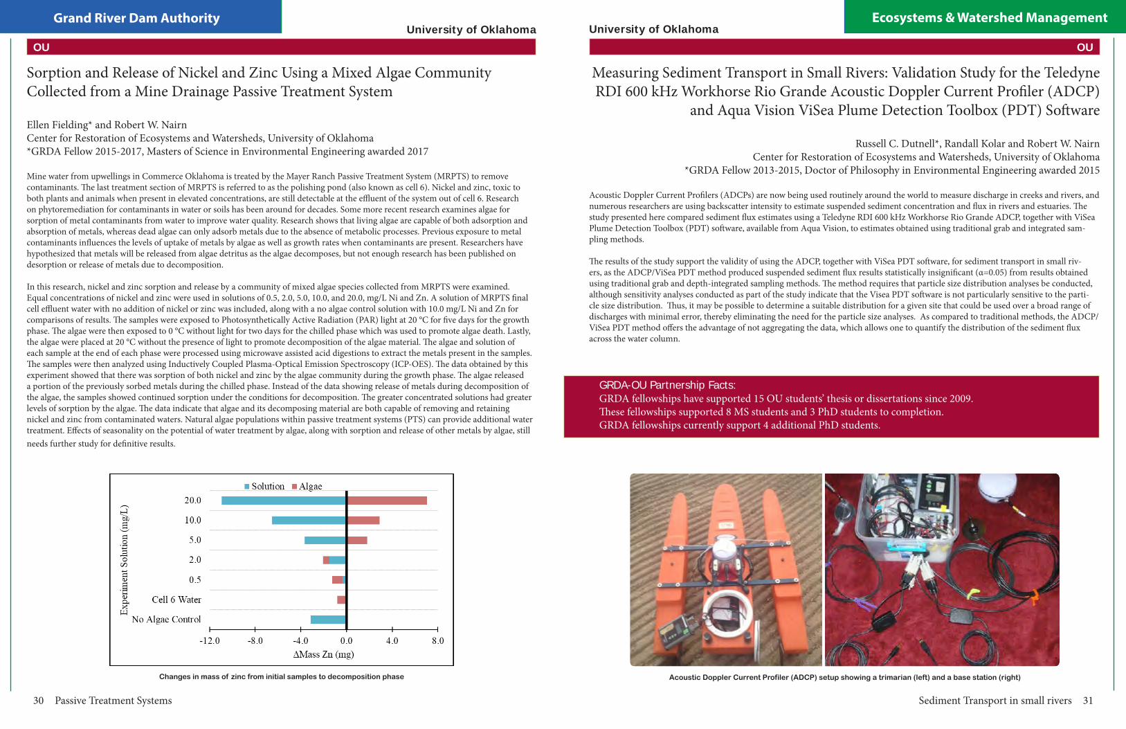
Utilizing Small Unmanned Aerial System (sUAS)-Derived Multispectral Imagery to Predict Surface Water Quality
Brandon Holzbauer-Schweitzer* and Robert W. NairnCenter for Restoration of Ecosystems and Watersheds, University of Oklahoma*GRDA Fellow 2017-2019, Doctor of Philosophy in Environmental Science expected 2020
During the summer months, especially during times of high activity, algal blooms are common in the “party coves” within Grand Lake o’ the Cherokees. Addressing this problem upstream in the watershed will help to minimize the number and magnitude of blooms remote sensing technologies may help do so. The advent of small Unmanned Aerial Systems (sUAS or drones) addresses some of the limitations of satellite technologies, by allowing the user to acquire site-specific imagery at high temporal resolutions, fly under the clouds (producing significantly higher spatial resolution), and purchase a state-of-the-art system at extremely lost costs relative to satellite deployment. The sUAS utilized for this project was an Aerial Technologies International (ATI) AgBot equipped with a MicaSense RedEdge high-resolution multispectral sensor capable of capturing imagery in five discrete spectral bands: blue, green, red, red edge, and the near-infrared region of the electromagnetic (EM) spectrum. Additionally, a spectroradiometer (Analytical Spectral Devices (ASD) FieldSpec3) measuring reflected light energy every nm from 350-2500 was used to supplement the multispectral dataset. The data produced from these two platforms are reflected radiant energy signatures that can be used to evaluate water quality constituents, habitat quality, and assess the impact underlying substrates have on the overall spectral signature. The sUAS has been used to evaluate water quality in two passive treatment systems (PTS) located in the Tri-State Lead-Zinc Mining District of northeastern Oklahoma, in natural and human-made ponds on Grand River Dam Authority-owned properties in the Neosho River Bottoms, and in the Neosho River. The objectives of this study are to 1) evaluate the role of optical depth with relation to development of spatial water quality models, 2) develop spatial water quality models capable of predicting concentrations of traditional water quality parameters (e.g., chlorophyll-a and total suspended solids (TSS)), 3) expand on initial models and address mapping and transport of trace metals and other surface water contaminants, 4) determine the validity of developed models outside of the initial study site, and 5) examine the impacts various operational parameters (e.g., flight speed, altitude, orientation, and time-of-day) have on the predictability of developed models. A preliminary multiple regression analysis of multispectral imagery from fourteen sUAS missions acquired in May 2017 to August 2018 revealed moderate relationships between a combination of bands in the visi-ble portion of the EM spectrum and chlorophyll-a concentrations (R = 0.55) and TSS (R = 0.45), indicating that predicting water quality in optically shallow waters may require additional data related to the underlying substrate. Not only do the constituents in the water column (e.g., chlorophyll-a, TSS, and turbidity) impact the overall signature, but the surface of the underlying substrate may do so as well. Howev-er, this is only the case if the optical depth (depth of light penetration through the water column) exceeds the physical depth (from water surface to substrate surface) because the substrate will then be visible through the water column. To verify, an optical depth transect was completed at the Mayer Ranch PTS. The results of this transect showed that substrate that was exposed to the air reflected approximately 10 percent more radiant energy. Additionally, as the transect progressed from shallow water to the deep-water column, there was no signif-icant difference (p-value > 0.05) in the amount of energy reflected. Therefore, if the substrate cannot be visibly seen, it has no significant impact on the overall spectral signature measured.
OU
University of Oklahoma
Using sUAS to predict water quality 27
The sUAS OU is using to collect aerial imagery dataSecchi Disk Depth output created from sUAS data
Prediction of Optical and Non-Optical Water Quality Parameters in Trophic State Systems Using a Small Unmanned Aerial System
Juan G. Arango Calderon* and Robert W. NairnCenter for Restoration of Ecosystems and Watersheds, University of Oklahoma
*GRDA Fellow 2017-2019, Doctor of Philosophy in Environmental Engineering expected 2020
The United States Geological Survey (USGS), in their National Water Quality Assessment Program (NAWQA), defines water quality moni-toring as a continuous period of data collection (in lakes, streams, rivers, reservoirs, wetlands or oceans), in order to evaluate the chemical, physical, and biological characteristics of the body of water with respect to its ecological conditions and designated water uses. Monitoring water quality typically involves a series of in-situ observations, measurements, and water sample collections that are analyzed for various parameters depending on the individual project goals, such as temperature, phosphorus (P), nitrogen (N), total solids, pH, fecal bacteria, conductivity, dissolved oxygen (DO), biochemical oxygen demand (BOD), hardness, alkalinity, suspended sediments, other nutrients, trace metals and water clarity. Traditionally, water quality indicators are determined by the collection, field examination, and laboratory analyses of water samples, following consistent protocols and guidelines. Although in-situ measurements are highly accurate, these measurements can be time-consuming, susceptible to errors (especially visual subjectivity) and can only be related to a specific point in time and space.
Considering these constraints, the use of remote sensing and satellite imagery in water monitoring and management has been implement-ed to estimate different water quality parameters. Images from different Earth observing satellites (Landsat 5, Landsat 7, Landsat 8, Terra, Aqua, SPOT, among others), with the capability of obtaining information in the visible (0.4 – 0.8 μm), near infrared (0.8 – 1 μm) (NIR) and thermal (10 – 12 μm) portion of the electromagnetic (EM) spectrum, have been used to estimate different water quality parameters. Despite the benefits of using this technology, a major challenge when using optical imagery is its excessive susceptibility to data loss due to cloud coverage. Despite these challenges, the collection of high-resolution images using Small Unmanned Aerial Systems (sUAS) has become more popular in recent years. By pairing sUAS with multispectral sensors, not only can cloud free images can be obtained, but also images with higher revisiting time (temporal resolution) and smaller spatial resolution at relatively low-cost can be acquired.
The main purpose of this ongoing research, supported by the Grand River Dam Authority (GRDA), is to develop statistical models capable of predicting optical (Total Suspended Solids (TSS), Chlorophyl- a (Chl-a) and Sechi Disk Depth (SDD)) and non-optical (Total Phos-phorus (TP), Total Nitrogen (TN) and Ammonia Nitrogen (NH3-N)) water quality parameters in reservoirs with different trophic states, so that these models (that rely on imagery capture by sUAS) get implemented in Grand Lake O’ the Cherokees in order to identify the source(s) of water quality impairment. Preliminary results indicate that a mixture between band ratios in the visible portion of the EM spectrum (blue, green and red), applied to multiple variable linear models, best describe the relationship between TSS(R2=0.98), Chl-a (R2=0.84), SDD (R2=0.88), TP(R2=0.98), TN (R2=0.97) and reflectance values obtained from imagery capture by sUAS. This means that the data created by these different water quality models, produces data statistically no different (p>0.005) from the collected in-situ data.
OU
Grand River Dam Authority Ecosystems & Watershed Management
28 Soil Trace Metal Concentrations
University of Oklahoma
Elm Creek riparian zone soil zinc concentrations, showing Tri-State Mining District-specific SQG
Soil Trace Metals Concentrations in A Mining Impacted Agricultural Watershed: Comparison of Analytical Methods, Geospatial Distribution, and Evaluation of Risk
Amy L. Sikora* and Robert W. NairnCenter for Restoration of Ecosystems and Watersheds, University of Oklahoma*GRDA Fellow 2016-2018, Masters of Science in Environmental Engineering awarded 2018
This study investigated four aspects surrounding lead, zinc, and cadmium soil trace metals concentrations within a mining impacted watershed: (1) a comparison of three soil trace metal quantification methods relating measurements from field portable X-ray fluorescence spectroscopy (XRFS) in in situ and laboratory environments, and inductively coupled plasma-optical emission spectrometry (ICP-OES), (2) distribution of soil trace metals in riparian terraces of a creek, (3) distribution of soil trace metals in an upland environment, (4) analysis of trace metals uptake into white-tailed deer (Odocoileus virginianus) and the human health risk associated with consuming said deer. This study was conducted within the Elm Creek watershed, located in Ottawa County in northeastern Oklahoma, and situated to the west and south of the Tar Creek Superfund Site, part of the historic Tri-State Lead-Zinc Mining District (TSMD). Trace metals contamination has been documented in Elm Creek, however, questions remain about broader impacts in the Elm Creek watershed. The Elm Creek watershed properties purchased by the Grand River Dam Authority (GRDA), a public power provider, are designated to be used as offsite mitigation for fish and wildlife impacts under the Pensacola Dam Hydropower License under the Federal Energy Regulatory Commission.
This study found: (1) In situ XRFS analysis on soils with less than 10% moisture content yielded statistical similarities to laboratory XRFS concentrations for lead and zinc when the samples were homogenized, dried and sieved, while samples with moisture continents exceeding 20% showed no similarities. Organic contents greater than 10% caused underreporting of lead XRFS values when compared to ICP concentrations. ICP and laboratory XRFS concentrations were not statistically different for lead but were for zinc (p < 0.05). The XRFS overreported zinc concentrations when compared to ICP values. (2) The creek branch with headwaters originating within the Tar Creek Superfund Site had the most influence on downstream soils concentrations, and concentrations of trace metals within creek terraces decreased with increasing distances from the headwaters. (3) Areas with elevated trace metals concentrations within upland environments were located closest to the stream at lower elevations suggesting that the creek is depositing contaminated material during flood events. Creek terraces and upland soils within 100 m of the creek reflected background soil concentrations 11.5 km downstream from the headwaters of the branch originating within the Tar Creek Superfund Site. (4) Uptake of trace metals into white-tailed deer tissues were accurate for lead and cadmium, and conservative estimates of risk to humans from consumption of white-tailed deer found no associated human health risk (HI < 1). This study highlights the differences in trace metals detection methods and impacts of trace metals within a mining impacted agricultural watershed. The results of this study will influence long-term land use in the watershed.
OU
Phosphorus, Iron, and Trace Metals 29
University of Oklahoma
Maggie sampling microcosms containing sediments and culturesLaboratory phosphorus retention experiments
Phosphorus, Iron and Trace Metal Interactions at the Sediment Layer-Water Column Interface: The Potential Role of Recovered Mine Drainage Residuals
Zepei Tang* and Robert W. NairnCenter for Restoration of Ecosystems and Watersheds, University of Oklahoma
*GRDA Fellow 2017-2019, Doctor of Philosophy in Environmental Engineering expected 2020
This study was focused on metal-nutrient interactions at the sediment layer-water column interface in Grand Lake o’ the Cherokees due to the reason that this watershed has been impaired by nutrient (especially phosphorous (P)) pollution and suffered from several severe algae blooms, as well as trace metals from ore-bearing bedrocks and mine tailings, due to the fact that it is located very close to the abandoned Tri-State Lead-Zinc Mining District. At the Mayer Ranch passive treatment system (MRPTS), mine drainage seepage with elevated iron (Fe) concentration discharges from the underground mine pool and forms a considerable amount of iron hydroxides precipitates in the system after exposure to oxygen. These by-products will be later referred to as Mine Drainage Residuals (MDRs), which proved to have the ability to bind and remove P from water.
Three stages of research were planned, including laboratory preliminary studies to estimate the type, dosage ratio and exposure time of MDR to achieve best performance in P-sorbing; greenhouse microcosm studies to identify different parameters’ (biomass addition, mixing and MDR addition) impact on metals and nutrients interaction in some 20-L vessels; pond mesocosm studies to evaluate the two param-eters’ (MDR+biomass and MDR+mixing) impact on metals and nutrients interaction in larger scales. The finished greenhouse biomass addition study results showed that after 30-day incubation period, all three treatments (control, low biomass and high biomass) all had different plankton, attached and benthic biomass growth, as well as some changes in the dominant algae species and species richness. Soluble reactive phosphorus (SRP) and nitrate nitrogen (NO3-N) in the water column showed decreasing trends over time, indicating nutrients uptake by the biomass growth. Within the study period, iron (Fe), nickel (Ni) and cadmium (Cd) concentrations from all water samples were below the practical quantitation limit (PQL), while lead (Pb) and zinc (Zn) concentrations were around 0.015~0.04 mg L-1 and 0.015~0.05 mg L-1, respectively, due to residual contamination in the sediments.
Compared to EPA National Recommended Water Quality Criteria (NRWQC), over the 30-day study period, Pb concentrations were all below Criteria Maximum Concentration (CMC) and above Criterion Continuous Concentration (CCC) while Zn concentrations were all below both CMC and CCC. At the end of study, Pb, Zn and Cd concentrations in the sediment showed no significant changes with various biomass growth and all treatments had these trace metal concentrations above the freshwater sediment quality guideline (SQG) thresholds as well as below the Tri-State Mining District (TSMD) specific SQG thresholds. Therefore, it concluded that the biomass growth could change the P balance between the water column and sediment layer while not impacting the trace metal concentrations in this system. It could suggest that the algal bloom in the lake would not further release heavy trace metals from the contaminated sediment into the water column.
OU
Grand River Dam Authority Ecosystems & Watershed Management
30 Passive Treatment Systems
Changes in mass of zinc from initial samples to decomposition phase
University of Oklahoma
Sorption and Release of Nickel and Zinc Using a Mixed Algae Community Collected from a Mine Drainage Passive Treatment System
Ellen Fielding* and Robert W. NairnCenter for Restoration of Ecosystems and Watersheds, University of Oklahoma*GRDA Fellow 2015-2017, Masters of Science in Environmental Engineering awarded 2017
Mine water from upwellings in Commerce Oklahoma is treated by the Mayer Ranch Passive Treatment System (MRPTS) to remove contaminants. The last treatment section of MRPTS is referred to as the polishing pond (also known as cell 6). Nickel and zinc, toxic to both plants and animals when present in elevated concentrations, are still detectable at the effluent of the system out of cell 6. Research on phytoremediation for contaminants in water or soils has been around for decades. Some more recent research examines algae for sorption of metal contaminants from water to improve water quality. Research shows that living algae are capable of both adsorption and absorption of metals, whereas dead algae can only adsorb metals due to the absence of metabolic processes. Previous exposure to metal contaminants influences the levels of uptake of metals by algae as well as growth rates when contaminants are present. Researchers have hypothesized that metals will be released from algae detritus as the algae decomposes, but not enough research has been published on desorption or release of metals due to decomposition.
In this research, nickel and zinc sorption and release by a community of mixed algae species collected from MRPTS were examined. Equal concentrations of nickel and zinc were used in solutions of 0.5, 2.0, 5.0, 10.0, and 20.0, mg/L Ni and Zn. A solution of MRPTS final cell effluent water with no addition of nickel or zinc was included, along with a no algae control solution with 10.0 mg/L Ni and Zn for comparisons of results. The samples were exposed to Photosynthetically Active Radiation (PAR) light at 20 °C for five days for the growth phase. The algae were then exposed to 0 °C without light for two days for the chilled phase which was used to promote algae death. Lastly, the algae were placed at 20 °C without the presence of light to promote decomposition of the algae material. The algae and solution of each sample at the end of each phase were processed using microwave assisted acid digestions to extract the metals present in the samples. The samples were then analyzed using Inductively Coupled Plasma-Optical Emission Spectroscopy (ICP-OES). The data obtained by this experiment showed that there was sorption of both nickel and zinc by the algae community during the growth phase. The algae released a portion of the previously sorbed metals during the chilled phase. Instead of the data showing release of metals during decomposition of the algae, the samples showed continued sorption under the conditions for decomposition. The greater concentrated solutions had greater levels of sorption by the algae. The data indicate that algae and its decomposing material are both capable of removing and retaining nickel and zinc from contaminated waters. Natural algae populations within passive treatment systems (PTS) can provide additional water treatment. Effects of seasonality on the potential of water treatment by algae, along with sorption and release of other metals by algae, still needs further study for definitive results.
OU
Sediment Transport in small rivers 31
Acoustic Doppler Current Profiler (ADCP) setup showing a trimarian (left) and a base station (right)
University of Oklahoma
Measuring Sediment Transport in Small Rivers: Validation Study for the Teledyne RDI 600 kHz Workhorse Rio Grande Acoustic Doppler Current Profiler (ADCP)
and Aqua Vision ViSea Plume Detection Toolbox (PDT) Software
Russell C. Dutnell*, Randall Kolar and Robert W. NairnCenter for Restoration of Ecosystems and Watersheds, University of Oklahoma
*GRDA Fellow 2013-2015, Doctor of Philosophy in Environmental Engineering awarded 2015
Acoustic Doppler Current Profilers (ADCPs) are now being used routinely around the world to measure discharge in creeks and rivers, and numerous researchers are using backscatter intensity to estimate suspended sediment concentration and flux in rivers and estuaries. The study presented here compared sediment flux estimates using a Teledyne RDI 600 kHz Workhorse Rio Grande ADCP, together with ViSea Plume Detection Toolbox (PDT) software, available from Aqua Vision, to estimates obtained using traditional grab and integrated sam-pling methods.
The results of the study support the validity of using the ADCP, together with ViSea PDT software, for sediment transport in small riv-ers, as the ADCP/ViSea PDT method produced suspended sediment flux results statistically insignificant (α=0.05) from results obtained using traditional grab and depth-integrated sampling methods. The method requires that particle size distribution analyses be conducted, although sensitivity analyses conducted as part of the study indicate that the Visea PDT software is not particularly sensitive to the parti-cle size distribution. Thus, it may be possible to determine a suitable distribution for a given site that could be used over a broad range of discharges with minimal error, thereby eliminating the need for the particle size analyses. As compared to traditional methods, the ADCP/ViSea PDT method offers the advantage of not aggregating the data, which allows one to quantify the distribution of the sediment flux across the water column.
GRDA-OU Partnership Facts: GRDA fellowships have supported 15 OU students’ thesis or dissertations since 2009.These fellowships supported 8 MS students and 3 PhD students to completion. GRDA fellowships currently support 4 additional PhD students.
OU
Grand River Dam Authority Ecosystems & Watershed Management
32 Trace Metal Removal in Bioreactors
University of Oklahoma
Micrographs of VFBR substrates studied
Determination and Predication of Products of Trace Metal Removal in Laboratory and Field-Scale Vertical Flow Bioreactors
Julie A. LaBar* and Robert W. NairnCenter for Restoration of Ecosystems and Watersheds, University of Oklahoma*GRDA Fellow 2014-2016, Doctor of Philosophy in Environmental Science awarded 2016
Mine drainage is characterized by elevated concentrations of dissolved iron, sulfate, and trace metals and generally exhibits an acidic pH. These constituents, particularly trace metals, can pose serious risks to both environmental and human health and require some sort of treatment. Passive treatment systems (PTS) have become a common technology used in the treatment of mine drainage. A component of these systems, vertical flow bioreactors (VFBR), may be used to remove trace metals through a variety of mechanisms, resulting in different removal products. Ionic strength is a measure of dissolved ions in solution and correlates strongly with total dissolved solids (TDS) concentrations and conductivity. In mine drainages, ionic strength is commonly dominated by the sulfate anion and various cations, including calcium, magnesium, iron, and occasionally sodium. Large concentrations of these constituents may impact trace metal removal processes in VFBR, including sulfide precipitation, adsorption to and complexation with organic matter, and carbonate precipitation by impacting solubility and availability. The premise of this dissertation are that trace metals are removed from mine drainage through a variety of mechanisms in vertical flow bioreactors, that ionic strength has an impact on which mechanisms play a dominant role in trace metal removal, and that geochemical modeling can be used to predict how trace metals will be retained in VFBR. Three studies, resulting in four chapters, were performed to evaluate these ideas. Chapters One and Two describe the results of the first study, which evaluated ionic strength impacts on trace metal removal in VFBR. Chapter One, “Evaluation of the impact of Na-SO4 dominated ionic strength on effluent water quality in bench-scale vertical flow bioreactors using spent mushroom compost” specifically addresses the effects on water quality as a result of elevated ionic strength, whereas Chapter Two, “Evaluating the impact of Na-SO4 dominated ionic strength on trace metal removal products in bench-scale vertical flow bioreactors using sequential extractions, acid-volatile sulfide analyses, and mineralogical methods” addresses the effects of ionic strength on the products of trace metal removal. Elevated ionic strength appeared to have significant impacts on pH, alkalinity, and trace metal removal. Elevated ionic strength had differing effects on the five trace metals examined, with an increase in ionic strength increasing the rate of removal of Cd and Zn and decreasing the rate of removal of Ni and Mn. Despite the differences observed in effluent concentrations between different ionic strengths, there were no significant differences in total metals concentrations in the associated substrates. Elevated ionic strength resulted in less Cd being retained as an insoluble sulfide, while the opposite was true for Pb. In addition, increased ionic strength caused a decrease in the amount of Pb retained in the labile organic fraction. The SEM/AVS ratio indicated that a large portion of Cd, Mn, Ni, Pb, Zn was likely in soluble and bioavailable forms. When all of the removal products are considered, Ni retention within the substrate was the most stable and Mn was the least stable of the trace metals examined. Chapter Three, “Characterization of mine drainage vertical flow bioreactor substrates using sequential extractions, acid-volatile sulfide analyses, and scanning electron microscopy,” examined products of trace metal removal in a field-scale VFBR. Water quality data collected at a VFBR in the Tar Creek Superfund Site in northeastern Oklahoma indicate significant removal of trace metals from the mine drainage. Spent substrate samples from the VFBR were collected after 5.5 years of system operation. Results of a sequential extraction procedure (SEP) showed that the vast majority of Cd, Co, Fe, Ni, Pb, and Zn were retained in the VFBR as insoluble sulfides. Subsequent acid-volatile sulfide/simultaneously extracted metals (AVS-SEM) analyses confirmed the retention of Cd, Fe, Pb, and Zn as sulfides, but Co and Ni results were less certain due to the lack of solubility of Co- and Ni- sulfides in cold, dilute hydrochloric acid. With the exception of Mn, trace metals were retained as insoluble products in the VFBR. Results presented in Chapters One, Two, and Three were used to perform a geochemical modeling study, the results of which are described in Chapter Four, “Using reactive transport modeling to predict trace metal removal products in vertical flow bioreactors.” Water quality data and SEP results from the experimental VFBR described in the first two chapters were used to construct and calibrate a reactive transport model in PHREEQC, which was then validated with data from the third chapter and samples from a third party. The model results provided fair predictions of VFBR effluent quality. Predictions of trace metal removal products were upheld by SEP results, with the exception of the labile organic fraction, which was generally underpredicted.
OU
Reactive media for bioretention cell design 33
University of Oklahoma
A summary of potential pollutant removal mechanisms by reactive media. Red=Export, Green=Retention, Gray=No Change
Evaluation of Stormwater Treatment by Various Reactive Media for Bioretention Cell Design Considerations
Derrick X. Nguyen* and Robert W. NairnCenter for Restoration of Ecosystems and Watersheds, University of Oklahoma
*GRDA Fellow 2016-2018, Masters of Science in Environmental Engineering awarded 2018
Bioretention cells (BRC) can be effective at filtering particulate pollutants from stormwater runoff, but substantial removal of the dissolved pollutant fraction is challenging. Various reactive treatment media for BRCs were evaluated to address nitrate (NO3-N) and dissolved fractions of phosphorus (P), copper (Cu2+), lead (Pb2+), and zinc (Zn2+) removal in BRCs. Fly ash (FA) and iron oxyhydroxide mine drainage residuals (MDR) were blended with sand at 5% (FA5.0) and 7.5% (MDR7.5) by mass. Additionally, APTsorb (APT) and bioAPT (BIO), commercially available granulated and hardened peat products, were evaluated as treatment media, each with a sand layer to augment hydraulic retention time. Pollutant removal performance was evaluated by pumping synthetic stormwater (SS) through packed up-flow columns. 100% sand (SAND) was used as the control media. SS had target concentrations of NO3-N at 1.5 milligrams per liter (mg/L), phosphate (PO43-P) at 0.5 mg/L, Cu2+ at 25 μg/L, Pb2+ at 30 μg/L, and Zn2+ at 100 μg/L. FA5.0 and MDR7.5 both removed over 84% of P. SAND, APT, and BIO had limited TP and TDP removal rates with BIO showing net export.
All proposed media had Cu2+ and Zn2+ removal rates of over 75% and 89%, respectively. APT showed the highest Pb2+ removal at over 84%. FA5.0 and MDR7.5 were the most cost-effective options that did not show export of pollutants, therefore they are recommended as amendments to BRC media.
OU
Grand River Dam Authority Ecosystems & Watershed Management
34 Iron Transport and Removal in a Passive Treatment System
Iron Transport and Removal Dynamics in the Oxidative Units of a Passive Treatment System
Leah R. Oxenford* and Robert W. NairnCenter for Restoration of Ecosystems and Watersheds, University of Oklahoma*GRDA Fellow 2015-2016, Doctor of Philosophy in Environmental Science awarded 2016
Mine drainage is a threat to water systems in legacy mining districts as elevated concentrations of dissolved iron, sulfate, and trace metals have an unmitigated impact on water quality. Changes in pH due to acidity loading as well as the mobilization of trace metals poses an unacceptable risk to environmental and human health. A variety of remediation strategies exist, but differ in their initial capital investment, operational requirements, and maintenance making them less attractive options for remote or abandoned locations due to cost. Passive treatment systems (PTS) have become an increasingly more popular technology for the treatment of acid mine drainage (AMD) with the goal of improving water quality through (1) acid neutralization, (2) metals removal and retention and (3) alkalinity generation. Passive treatment systems are composed of a series of treatment cells, in which each unit is designed to meet one or more of the afore mentioned goals through the control of physical, chemical, and biological aspects of the treatment cells. The preliminary oxidation cells of a passive treatment system focus on the removal and retention of iron specifically due to its roll in physical (solids accumulation and retention to maintain hydraulic conductivity through the system), chemical (latent acidity produced via oxidation and hydrolysis; trace metals sorption to FeOOH(s)), and biological (use of emergent hydrophytes to facilitate solids sedimentation) system functions. The premise of this dissertation is that passive treatment system performance is dependent on the dynamic removal, fate, and transport of iron oxides over time. The following chapters each contribute to a detailed assessment of the design and performance of the oxidative unit of a full scale passive treatment system under expected (design driven) operational conditions and under periods of disturbance due to frequent storm activity. The performance of the oxidative unit, and the performance of the system overall for the first seven years of operation are addressed through intracellular transport, removal, and accumulation profiling.
Chapter One, “Full Scale Passive Treatment of Net-Alkaline Ferruginous Acid Mine Drainage at the Tar Creek Superfund Site” describes the need for site specific passive treatment, and the critical decisions involved in treatment system design. This chapter represents data as a collaborative work of monitoring by the Center for the Restoration of Ecosystems and Watersheds over a period of nearly 10 years (2004-2015) leading up to the installation and application of full scale treatment technologies in fall of 2008, and their performance evaluation over the next seven years of operation to assess effectiveness in achieving the goal of water quality improvement. The Mayer Ranch Passive Treatment system meets water quality improvement expectations as seep concentrations of iron (192 mg/L), zinc (9.78 mg/L), nickel (0.933 mg/L), cadmium (15.1 µg/L), lead (60 µg/L) and arsenic (66 µg/L) are attenuated prior to discharge into a tributary of Tar Creek [99% (Fe), 95%(Zn), 83% (Ni), 93%(Cd), with Pb and As being removed to levels below detection limits]. The system also generates alkalinity in multiple steps (Cells 3N/S; 5N/S) to mitigate what has been lost due to metals latent acidity yielding a net alkalinity of nearly 200 mg/L as CaCO3 equivalence. The MRPTS has successfully removed iron within the oxidative unit specifically (iron oxidation pond+ two surface flow wetland cells) over the lifetime of the system, yet the variability in the efficiency of the preliminary oxidation cell (Cell 1) demands additional investigation.
An example of an autosampler used in the iron transport study
University of OklahomaOU
Iron Transport and Removal in a Passive Treatment System 35
Iron Concentrations with flow through successive process units in the Mayer Ranch passive treatment system
Iron Transport and Removal Dynamics in the Oxidative Units of a Passive Treatment System Continued...
Chapter Two, “Spatial Profiling of Seasonally Influenced Iron Removal in an Oxidation Treatment Cell”, provides a detailed evaluation of seasonal iron removal within Cell 1 thorough a series of samples collected between the influent and effluent flows typically used for cell performance evaluation. This detailed survey of iron removal corresponds well with the solids accumulation profiling detailed within Chapter 5, “Characterization of the Spatial Iron Accumulation in the Preliminary Oxidative Cells of a Passive Treatment System”, as the accumulation of precipitated iron oxides follows spatial orientation consistent with average removal dynamics. Periods of colder temperatures (winter: ~6oC) decrease the rate of iron removal within Cell 1 with the majority of material transported into Cells 2N/2S being in the dissolved state (Fe2+). The overall function of removal for the oxidative unit is not compromised during the winter months of operation as the surface flow wetlands provide additional hydraulic residence time for the removal of iron prior to discharge on to the vertical flow bioreactors (VFBR). Although iron removal has not been impacted by the accumulation of iron oxides thus far, the hydraulic retention time of Cell 1 has been reduced from a design time of 7.7 days to 5.5 days based on the results of a rhodamine dye tracer study. Cells 2N/2S were assessed to have shorter retention times (2.5 days) versus design (3.5 days) in 2009, yet demonstrate extended retention times approach 9 days due to successive rain events and flow restriction due to the vertical flow bioreactors (VFBRs) indicating that short term storm events play a role in iron transport and removal dynamics.
Chapters Three and Four focus on the role of acute storm disturbance on iron transport between the cells of the oxidative unit, exported from the oxidative unit to the VFBRs, and exported out the system into the receiving stream. Storm frequency, intensity, yield, and duration were evaluated from archived data from the Oklahoma Mesonet to determine a storm classification criteria based on intensity (Low: 0.25-0.99 cm/hr; Moderate: 1.00-1.99 cm/hr; High: 2.00-2.99 cm/hr; Extreme: >3.00 cm/hr). Iron transport out of cells 1, 2N, 2S, and 6 was determined for a select group of individual storms between 2009-2013 and mass transport of iron was determined on a storm by storm basis. The amount of iron transported during a 30-hour sampling window following the storm event did not correlate to rainfall intensity, and thus the mechanism of transport is not believed to be due to resuspension of accumulated materials. Rather, disruption of sedimentation of iron oxide flocs is suspected due to the frequency between rain events. Low intensity rainfall events dominate the precipitation profile for the MRPTS, and significance in transport is not only observed for individual rain events, but also for seasonal and annual transport within the oxidative unit. Iron transport out of the passive treatment system due to storm events was minimal as iron removal and storage occurs multiple cells before the final polishing wetland (spatially isolated from oxidative unit transport).
University of Oklahoma
OU
Grand River Dam Authority Ecosystems & Watershed Management
36 2010 OU Capstone Class
Selected Chemical Constituents in Water and Sediment of Grand Lake O’ the Cherokees
2010 Environmental Science and Environmental Engineering Senior Capstone ClassSchool of Civil Engineering and Environmental Science, University of Oklahoma
Students enrolled in the University of Oklahoma’s Environmental Science and Environmental Engineering Senior Capstone Class conduct comprehensive analyses of open-ended, real-world environmental problems. In academic year 2009-2010, student teams worked cooperatively with the GRDA Ecosystems and Education Center (EEC) staff to examine water and sediment metal concentrations in Grand Lake. Students sampled and analyzed sediment cores from seven locations around the lake, including sites in the Spring, Neosho and Elk Rivers, Carey Bay, and Duck and Drowning Creeks coves. Designed as an initial survey, the study provided information for GRDA decision-making regarding dredging applications. Total metals concentrations in sediment were compared to Threshold Effects Concentration (TEC) and Probable Effects Concentration (PEC) Sediment Quality Guidelines (SQG). Sediment cores from four sites demonstrated concentrations in individual sediment depth increments that exceeded the TEC or both the TEC and PEC. All re-composited sediment samples had metals concentrations below Resource Conservation and Recovery Act (RCRA) criteria for Toxicity Characteristic Leaching Procedure (TCLP) metals. For water samples collected near the coring sites, zinc was the only metal of concern with concentrations above detectable levels. Aqueous concentrations of several metals, adjusted for hardness, were compared against the National Recommended Water Quality Criteria (NRWQC) and other regulatory values set by the Oklahoma Water Resources Board. All concentrations were well below these criteria. At one location, turbidity exceeded regulatory limits. Recommendations were made for sediment management.
Students generated a 105-page final written report that was orally presented to the project-specific Environmental Engineering and Science Advisory Board, which consisted of representatives from GRDA, Oklahoma State University, and Grand Lake stakeholders at the EEC.
Zinc concentrations vs. depth in the Spring River sediment core2010 Capstone students conducting water quality analyses
University of OklahomaOU
2012 OU Capstone Class 37
Chemical Constituents in Water and Sediment from Duck and Drowning Creek Coves, Grand Lake O’ the Cherokees
2012 Environmental Science and Environmental Engineering Senior Capstone ClassSchool of Civil Engineering and Environmental Science, University of Oklahoma
Following up on the 2009-2010 lake wide study, 2011-2012 University of Oklahoma Environmental Science and Environmental Engineering Senior Capstone students targeted sampling and analysis efforts on specific coves of Grand Lake where development practices may require dredging. Water and sediment samples were collected at ten different locations in the Drowning Creek and Duck Creek Coves of Grand Lake. Water analyses included standard physicochemical parameters (pH, temperature, specific conductance, dissolved oxygen), total alkalinity, turbidity, Secchi disk depth, nitrate, nitrite, phosphate, and a suite of 15 total metals (aluminum, arsenic, calcium, cadmium, cobalt, chromium, copper, iron, potassium, magnesium, manganese, sodium, nickel, lead and zinc). Sediment samples were depth-incremented and analyzed for water content, organic matter as loss-on-ignition, mercury and total metals concentrations. Metals concentrations found in the sediments were compared to Sediment Quality Guidelines outlined in MacDonald et al. (2000) to determine if any metals exceeded the Threshold Effects Concentration (TEC). The Grand Lake Shoreline Management Plan requires applicants to obtain a dredging permit from GRDA. Under certain conditions, analysis of sediments for metal concentrations is also required. If the concentrations of cadmium, lead, or zinc exceed the TEC, the data must be submitted to the Federal Energy Regulatory Commission for final approval. Results showed that some water quality data did exceed the National Recommended Water Quality Criteria for total metals concentrations. All (100%) of the sediment core increments that were analyzed exceeded the TEC for cadmium. Zinc concentrations exceeded the Probable Effects Concentration in 55% of the samples analyzed. Recommendations were made for sediment management.
Students generated a 126-page final written report that was orally presented to the project-specific Environmental Engineering and Science Advisory Board, which consisted of representatives from GRDA and Grand Lake stakeholders at the EEC.
Lead concentrations vs. depth in the Drowning Creek core2012 Capstone students collecting a sediment core
University of Oklahoma
OU
Grand River Dam Authority Ecosystems & Watershed Management
38 2013 OU Capstone Class
Design of Stormwater Runoff Best Management Practices at the Grand River Dam Authority Ecosystems and Education Center
2013 Environmental Science and Environmental Engineering Senior Capstone ClassSchool of Civil Engineering and Environmental Science, University of Oklahoma
In 2012-2013, two capstone student teams were tasked by the Grand River Dam Authority (GRDA) to design a storm water runoff collection and treatment system for the Ecosystems and Education Center (EEC). Due to the prolonged drought Oklahoma had been enduring, a simulated rainfall event (provided by the Langley Fire Department) was carried out to generate runoff, in order to get an accurate representation of storm water runoff water quality. Two runoff sampling sites were established (North and South); one team focused primarily on the South site, while the North site was examined by the other team. Several constituents were evaluated such as coliform bacteria, E. coli, oxygen demand, total suspended solids (TSS), total metals, oil and grease, and nutrients (total phosphorus, nitrate + nitrite, ammonia and dissolved reactive phosphorus). Among the constituents analyzed, nutrients, TSS and coliform bacteria were found to be above average runoff concentrations and to be of environmental concern. Each team then completed both hydraulic (to address runoff quantity) and water quality engineering designs. They identified a suite of best management practices (BMPs) feasible for the EEC including surface sand filters, vegetative filters, rain gardens, treatment wetlands, biofiltration swales, floating wetlands, infiltration trenches and bioinfiltration terraces. BMPs were evaluated based on cost, performance and aesthetics. The South team determined that a rain garden was the most appropriate BMP, and the North team selected a bioinfiltration terrace. Both capital and operation/maintenance costs were estimated.
Once again, student teams generated final written reports that were orally presented to the project-specific Environmental Engineering and Science Advisory Board, which consisted of representatives from GRDA and Grand Lake stakeholders at the EEC.
2013 Capstone students working in the GRDA Water Quality Research Laboratory
University of OklahomaUniversity of OklahomaOU
2015 OU Capstone Class 39
Grove Springs Park Stormwater Runoff Best Management Practice Design
2015 Environmental Science and Environmental Engineering Senior Capstone ClassSchool of Civil Engineering and Environmental Science, University of Oklahoma
In cooperation with GRDA staff, the 2014-2015 environmental science/engineering capstone project addressed water flowing in Grove Springs Park in the City of Grove, along the shores of Grand Lake The namesake spring still flows crystal clear water, but its water quality is impacted by urban drainage with elevated nutrient and sediment concentrations, trash, algae, and other materials. The combined flow eventually discharges to Wolf Creek Park. The project involved collecting and analyzing upstream and downstream samples on both drainages and the combined flow. The resulting data were used to develop both non-structural and structural low impact development (LID) best management practices (BMPs) for the park to address urban storm water runoff quantity and quality. Two teams developed individual solutions to the stated problem. Runoff quantity was determined using an acoustic Doppler velocimeter and estimated using a variety of computational methods, and water quality was determined through collection and analysis of samples for specific conductance, pH, temperature, dissolved oxygen, total dissolved solids, oxidation-reduction potential, total alkalinity, turbidity, total suspended solids, biochemical oxygen demand, total phosphorus, dissolved reactive phosphorus, nitrate + nitrite, ammonia nitrogen, oil and grease, total coliform, E. coli, hardness and a suite of metals. Storm hydrographs were generated and water quality analyses indicated substantial urban runoff pollution impacts. Teams recommended a bioretention pond and a bioswale, respectively. Both capital and operation/maintenance costs were estimated.
Student teams generated final written reports that were orally presented at a public meeting of the Grove City Council as part of a regularly-scheduled city council meeting. Environmental Engineering and Science Advisory Board members included representatives from GRDA, the Grove City Manager and Public Works Director, other City Staff and local citizen leaders.
Grove Springs Park post-development stormwater runoff hydrographs
University of OklahomaUniversity of Oklahoma
OU
Grand River Dam Authority Ecosystems & Watershed Management
40 2016 OU Capstone Class
Design and Monitoring of a Mine Drainage Passive Treatment System
2016 Environmental Science and Environmental Engineering Senior Capstone ClassSchool of Civil Engineering and Environmental Science, University of Oklahoma
The intent of the 2015-2016 capstone project was to develop engineering plans and specifications for the construction of a mine drainage passive treatment system, and to develop and implement a post-construction water quality monitoring plan. The study site focused on specific discharges from reclaimed surface collapse features at the Tar Creek Superfund Site near Commerce, Ottawa County, in the Grand Lake watershed. Designs were to effectively improve water quality through exploitation of pre-determined abiotic and biotic biogeochemical mechanisms for retention and sequestration of specific metal contaminants in designed, specialized unit processes. Mine drainage had previously been intercepted via a subsurface drainage system that discharged untreated via gravity to a nearby road culvert and receiving stream. Mine drainage had to be intercepted and directed into the passive treatment system prior to discharge. Two teams worked collaboratively in data collection and developed individual ecological engineering designs. Multiple ground water and surface water locations were sampled, as well as site soils. Elevation surveys were completed. Water quality analyses included total alkalinity, turbidity, temperature, specific conductance, dissolved oxygen, oxidation-reduction potential, total dissolved solids, salinity, pH, total suspended solids, total nitrogen, total phosphorus, nitrate + nitrite, dissolved reactive phosphorus, sulfate, and total and dissolved metals (Al, As, Ca, Cd, Co, Cr, Cu, Fe, K, Mg, Mn, Na, Ni, Pb and Zn). Volumetric discharge rates were determined for flowing waters and pressure transducers were deployed for determination of mine pool (ground water) levels. Soil analyses included moisture content, liquid limit, plastic limit, and soil identification. The project presented numerous challenges to successful design, but each team determined that water quality and quantity were amenable to passive treatment. Final designs included oxidation pond, surface flow wetland, vertical flow bioreactor, re-aeration pond and polishing pond process units. Both capital and operation/maintenance costs were estimated.
Student teams generated final written reports that were orally presented at a public meeting of the City of Commerce Council as part of a regularly-scheduled city council meeting. Environmental Engineering and Science Advisory Board members included representatives from GRDA, the City of Commerce Public Works Director, representatives from the Oklahoma Department of Environmental Quality and local citizen leaders. It is important to note that a mine drainage passive treatment system, based in part on capstone designs, was constructed in 2016 and has been in continuous operation since early 2017.
2016 Capstone students performing elevation surveys and mine water sampling
University of OklahomaOU
Dr. Robert Nairn Sabbatical (University of Oklahoma) 41
Sabbatical Leave-of-Absence at the Grand River Dam Authority Ecosystems and Education Center
Robert W. Nairn, PhDProfessor, School of Civil Engineering and Environmental Science, University of Oklahoma
In 2013-2014, Professor Robert Nairn completed a sabbatical at the GRDA EEC. Approximately one-half of his time was spent collaborating with GRDA EEC personnel. The other half was spent at various field research sites, traveling to visit colleagues and provide research seminars, conducting research/writing, and organizing, planning, and chairing the 31st National Meeting of the American Society of Mining and Reclamation (ASMR).
Several objectives were explored related to reinvigorating and expanding research efforts on watershed biogeochemistry and ecological engineering. One objective included retooling research efforts beyond environmental contamination and remediation research (e.g., clean-up of pollution) to more holistically examine ecological restoration (e.g., replacing lost or damaged ecosystems) to provide ecosystem services to society. To this end, he worked with GRDA on a 3,500 acre wetland restoration project in the Neosho River Bottoms of Ottawa County, OK. Specifically, he used new instrumentation (a field-portable x-ray fluorescence analyzer) to evaluate soil ecotoxic metal concentrations in proposed wetland development units in bottomland hardwood, upland forest and agricultural ecosystems and in stream riparian zones. This work directly led to future research with GRDA and proposals to other funding sources. He also worked with GRDA scientists on in-lake sediment metals fate and transport in Grand Lake and Lake Hudson.
He visited colleagues and provided research seminars at 12 higher education institutions in four states and visited field research sites and worked with colleagues in western and central Pennsylvania, southeastern Ohio, and Kansas. A total of 15 publications and seven research proposals were produced. He also dedicated time to serving as President of ASMR and chairing the ASMR National Meeting, no small endeavors. This professional society includes over 400 individuals with a budget of over $600K/year. The national meeting was held in mid-June at the Oklahoma City Renaissance Hotel and Convention Center, and included pre-conference workshops, post-conference field tours, social events, over 125 oral and poster presentations and was attended by over 230 mining and environmental professionals.
Trace metal concentrations (mean ± standard error) in soils of the proposed wetland development units in the Neosho Bottoms and in the Elm Creek watershed riparian zone (denoted by County Road (CR) stream crossings) compared to a range of regional reference soil concentrations. BDL refers to below detachable limits. Neosho Bottoms and downstream locations were within reference concentrations.____________________________________________________________________________________________ Lead Zinc Cadmium mg/Kg mg/Kg mg/Kg____________________________________________________________________________________________Reference soil 17 to 91 44 to 433 0.4 to 4.1Proposed wetland development units surface soils 18±1.6 103±11 BDLCR30- Elm Creek riparian surface soil 458±233 3179±1211 27±12CR65- Elm Creek riparian surface soil 58±26 787±488 11±2.1CR70- Elm Creek riparian surface soil 44±35 657±852 16 (n=1)CR74- Elm Creek riparian surface soil 73±46 620±177 22 (n=1)CR87- Elm Creek riparian surface soil 15±2.6 7 8±7.2 BDLCR90- Elm Creek riparian surface soil 14±1.4 66±7.8 BDL____________________________________________________________________________________________
University of Oklahoma
OU
Grand River Dam Authority Ecosystems & Watershed ManagementOklahoma State University Oklahoma State University
Samples for Shane Morrison’s heavy metals project
Heavy Metals and Toxicity: Impacts of Tri-State Mining District (Superfund Site) on Shoreline Sediments in Grand Lake Shane Morrison* and Jason BeldenDepartment of Integrative Biology, Oklahoma State University*GRDA Fellow 2012-2014; PhD Awarded 2016
The presence of the Tri-State Mining District (lying just upstream of Grand Lake) and the subsequent questions surrounding the environmental impacts primarily associated with lead and zinc contamination has long been a concern in Grand Lake. Because previous work has suggested that contamination is present in Grand Lake and is frequently documented to be above general sediment quality guidelines (SQGs), there have been many questions surrounding the impact on ecosystem processes throughout the lake. However, despite the presence of elevated lead and zinc concentrations in Grand Lake sediments, there has been little evidence suggesting these concentrations are toxic to benthic organisms occupying these sediments. For instance, of special concern is trace metal contamination in shallow regions of the lake where there is greater chance of contact with aquatic biota. These shallow sediments are disturbed due to dredging, wave action and/or boat traffic, which could influence availability of these metals to the environment. Despite these concerns, there has been limited data available on the presence and related toxicity of metals from shallow areas of Grand Lake. Therefore, we conducted a two-year study in collaboration with the Grand River Dam Authority (GRDA) that included sediment sampling from over 100 locations, analyzing up to 67 samples for metals and subsequent toxicity. We performed a suite of toxicity tests on sediments from twelve sites including those that were the most highly contaminated. Toxicity tests included treatments where the sediment was well mixed and oxygenated to determine if metal availability is impacted by common environmental conditions that routinely impact sediments (i.e. dredging, boating or wave action). These tests utilized amphipods (small crustaceans) and snails, two of the most sensitive aquatic organisms known to be negatively impacted by metal contamination.
Our sampling efforts confirmed that the trace metal sediment concentrations in Grand Lake are higher in shallow areas closer to the Tri-State Mine District (TSMD) superfund site. Laboratory investigations conducted at the GRDA’s Water Quality Research Lab and at Dr. Jason Belden’s lab at OSU demonstrated that simulated disturbance events (i.e. vigorously aerating sediments for 30 d prior to toxicity tests) did not facilitate significant trace metal release from contaminated sediments, suggesting that these metals remain bound to the sediment and have low biological availability to sediment dwelling organisms. Furthermore, we did not document any significant mortality or differences in growth rates under natural or disturbed sediment conditions for either of the aquatic invertebrate species analyzed, despite using some sediments that exceeded both general and TSMD-specific SQGs. The results of our research demonstrates that typical disturbance events that routinely occur on Grand Lake (e.g. boat traffic, wave action, and dredging associated with dock construction) have little influence on the bioavailability of trace metals released from sediments and current levels of contamination do not appear to be acutely toxic or impact growth rates of known species sensitive to metal exposure.
Current regulatory and management decisions for Grand Lake are based on the more conservative sediment quality guidelines (MacDonald et al. 2000) that are used for general screening levels, despite the existence of a Tri-State Mining District (TSMD)-specific SQGs (MacDonald et al. 2009) developed for use in small shallow streams draining the TSMD. The biggest obstacle preventing the use of the TSMD-specific SQGs within the greater lake body was the limited knowledge of how well these guidelines would predict toxicity in the much larger reservoir. As a result, we conclude that our data suggests that the TSMD has little impact on sediment dwelling organisms in Grand Lake south of Twin Bridges. Continuing collaborative research using similar testing on sediment collected north of Twin Bridges to establish the sediment concentrations of metals that are likely to cause toxicological effects.
OSUOSU
Nutrient Concentrations in Grand Lake 43
Steve Nikolai collecting samples from Grand Lake
OSUOSU
Spatiotemporal variation in nutrient concentrations in Grand Lake, OK, and the potential influence of internal nutrient loading
Steve Nikolai* and Andy Dzialowski Department of Zoology, Oklahoma State University
*GRDA Fellow 2011-2013; Masters Awarded 2013
Eutrophication, the enrichment of a waterbody with plant nutrients including nitrogen (N) and phosphorus (P), is one of the leading causes of pollution in lakes and reservoirs (Smith, 2003). With respect to Grand Lake, it has been classified as eutrophic to hypereutrophic because it has high P concentrations (OWRB, 2007). As a result, areas of the reservoir experience seasonal hypolimnetic (e.g., at the bottom of the reservoir) oxygen depletion and periodic nuisance algal blooms (Burkes and Wilhm, 1995, OWRB, 2007).
Historically, eutrophication management has focused on controlling external nutrient inputs that come from disturbed watersheds (Sas, 1989; Anderson et al., 2005). However, internal mechanisms can also contribute to, accelerate, and/or prolong the processes of eutrophication. For example, large quantities of nutrients can build-up in the bottom sediments of a reservoir and then be released back into the water column over time (Søndergaard et al., 2001). While a number of environmental factors have been shown to influence internal sediment P release rates, release is often associated with anoxic conditions (e.g., no oxygen) at the sediment-water interface (Nurnberg, 1984; Bostrom et al., 1988). If nutrients are released from the sediments, they could in turn stimulate algal growth in the water column.It is also important to know how nutrients impact algal growth in a system. While P is often considered to be the nutrient that most often limits or determines how much algae can grow in a system, recent research suggests that N or N and P together can also limit algal growth. Therefore, from a management perspective it is important to have an understanding of which nutrient (N and/ or P) limits algal growth in a reservoir and if the nutrient limiting status changes seasonal.
Scientists from Oklahoma State University (OSU) in collaboration with the Grand River Dam Authority (GRDA) addressed several questions related to nutrients and nutrient limitation in Grand Lake in the summer of 2011. These questions included: 1. How do N and P vary temporally and spatially throughout the reservoir? 2. What nutrient limits algal growth in the reservoir? 3. Is P released from the bottom sediments under anoxic conditions?
We used several complimentary approaches to answer these questions. First, we collected water samples from the reservoir and analyzed the amount of N and P at the GRDA Ecosystem Center. Second, we conducted a series of laboratory bioassay experiments were we added nutrients (e.g., N and/ or P) to Grand Lake water and assessed changes in algal biomass(Question 2). Third, we collected water samples from the bottom of the reservoir and analyzed the amount of N and P at the GRDA Ecosystem Center to determine if phosphorus accumulated in the hypolimnion as the reservoir became anoxic through the summer.(Question 3).Our results showed that nutrient concentrations varied both spatially and temporally in the reservoir. P concentrations were generally lowest near the dam and decreased with distance upriver. P concentrations were also highest at the start of the summer and then decreased until late summer and early fall when they began to increase again. This increase may have resulted from the release of P from
the hypolimnetic sediments under anoxic conditions.
Nutrient bioassay experiments showed that there was a seasonal shift in the nutrient limitation status of the reservoir. In the early summer the reservoir appeared to be P limited, while it shifted to co-limitation by N and P in the mid- to early-summer, and finally to N limitation in the late summer and early fall.Combined, our results suggest that both N and P can limit algal growth in the reservoir depending on the season. While there was a build-up of sediment released P in the hypolimnion under anoxic conditions, it did not appear to have a major influence on overall water quality in the reservoir. While additional studies are being conducted to further assess nutrient dynamics in the reservoir, our results indicate that both N and P reduction strategies should be considered for improving water quality in Grand Lake.
42 Heavy Metals in Sediments
Grand River Dam Authority Ecosystems & Watershed Management
44 Zebra Mussels
Assessing abiotic and biotic heterogeneity in GRDA reservoirs with a focus on zooplankton communities and aquatic invasive/nuisance species
William E. Mausbach* and Andy DzialowskiDepartment of Integrative Biology, Oklahoma State University*GRDA Fellow 2015-2016; PhD Awarded 2018
Reservoirs can be complex ecosystems due to their diversity in shape, size, watershed area, and geographical locations. The transition from riverine to lacustrine zones in reservoirs often produces gradients in environmental heterogeneity. Starting in 2013, the Grand River Dam Authority (GRDA) started a comprehensive sampling regime for monitoring water quality throughout three GRDA reservoirs: Grand Lake, Lake Hudson, and WR Holloway. These three reservoirs differ greatly in size, watershed area, and morphometry, all of which can influence within-reservoir environmental heterogeneity. However, within-reservoir heterogeneity is seldom investigated in terms of its impacts on biological communities, particularly invasive and nuisance species to which reservoirs are susceptible (Havel et al 2005). Reservoirs tend to be more vulnerable to invasion by non-native species than natural lakes (Havel et al., 2005; Johnson et al., 2008), because reservoirs are subjected to high levels of disturbance and act as invasion “hubs” in which propagules move through interconnected waterways and can be transported across the landscape to nearby habitats (Havel et al 2005).
Our goals of this study were to 1) assess the within-reservoir abiotic (water quality) and biotic (zooplankton) heterogeneity across the three GRDA reservoirs: Grand Lake, Lake Hudson, and WR Holloway Lake and 2) study the population dynamics of invasive and nuisance species across the GRDA reservoirs, including Daphnia lumholtzi (cladoceran zooplankton) and Dreissena polymorpha (zebra mussels).
We found that temporal variation in water quality was greater than spatial variation, which is typical of temperate reservoirs. Overall, Grand Lake exhibited more environmental heterogeneity than Lake Hudson and Lake WR Holloway. There were gradients in turbidity, conductivity, total phosphorus, and nitrates across Grand Lake in which the highest values were recorded near the confluence of the Neosho and Spring Rivers but decreased downstream towards the Pensacola Dam. We found that zooplankton biodiversity decreased with reservoir size, which is a typical ecological pattern (Area Hypothesis). Overall, the zooplankton communities exhibited little within-reservoir heterogeneity, indicating that zooplankton need only be collected from a few sites for assessing reservoir zooplankton community structure. In contrast, D. lumholtzi and zebra mussels exhibited strong spatial and temporal trends. Daphnia lumholtzi dominated the upper, more riverine portion of Grand Lake, peaking in the late summer months, but was only detected at low densities throughout Lake Hudson and WR Holloway Lake.
Zebra mussel veligers were found at high densities at the lower stretches of both Grand Lake and Lake Hudson, but were uncommon in WR Holloway. Zebra mussel populations in all three reservoirs crashed during the summer of 2015, which we believe was caused by exceptionally high temperatures, low dissolved oxygen levels, and severe flooding. Zebra mussel crashes have occurred previously in other Oklahoma reservoirs such as Lake Texoma (Churchill 2013) and Lake Oologah (Boeckman 2011), which also experienced similar changes in lake elevation, high temperatures, and/or low dissolved oxygen levels. Continued monitoring of zebra mussel populations and in situ field experiments in these reservoirs are recommended to determine what environmental factors are causing them to crash.
Daphnia lumholzi is a large invasive cladoceran known for producing long
helment and tail spines
Oklahoma State UniversityOSU
Zebra Mussels 45
Map and chart demonstrating sampling locations and veliger density
Oklahoma State University
OSU
Downstream Dispersal of Zebra Mussels from an Invaded Reservoirs
Danielle Czekaj and Andy DzialowskiChestnut Hill College, Philadelphia, PA
Oklahoma State University, Stillwater, OKResearch Experience for Undergraduates
The zebra mussel, Dreissena polymorpha, is an invasive species that is spreading rapidly across U.S. lakes and reservoirs. Reservoirs are highly susceptible to invasion due to their riverine connections to other reservoirs. Grand Lake is the largest and most heavily used of the three GRDA reservoirs and discharges into Lake Hudson via the Grand River. The objective of this study was to determine if zebra mussel veligers are being discharged through the Pensacola Dam at Grand Lake downstream through the Grand River to Lake Hudson. We sam-pled seven sites between the Pensacola Dam and the top of Lake Hudson for zebra mussel veligers during June 2017.
Zebra mussel densities decreased downstream and were barely detectable beyond 9 km from the dam; however, the site closest to Lake Hudson had the highest veliger density of all the sites. Our findings indicate that zebra mussel veligers are being discharged from upstream dams, but that they are not dispersing far in high densities. The high densities near Lake Hudson are probably from an established popula-tion in that portion of the river, rather than downstream dispersal from Grand Lake.
Grand River Dam Authority Ecosystems & Watershed Management
46 Iron and BGA Blooms
Oklahoma State University
Amount of BGA observed with different treatmentsFilters showing the difference in algae based on treatment
OSU
Heavy Metals and Toxicity 47
Oklahoma State University
Heavy Metals and Toxicity: Have Snails in Grand Lake Watershed Become Tolerant to Zinc?
Joel Hickey(1), Allison Wells(2), Scott McMurry, Barney Luttbeg, and Jason BeldenDepartment of Integrative Biology, Oklahoma State University
(1)GRDA Fellow 2016-2018, Masters awarded Spring 2019, (2)GRDA Fellow 2018, Masters awarded Fall 2019
Despite elevated levels of heavy metals found in Grand Lake sediment, the effects of chronic or historic exposure to toxic metals on resident biota has not been well studied. Our objective was to determine if native populations of snails (Physa acuta) have developed tolerance to environmental metal concentrations in highly contaminated regions and if so, the extent of tolerance along a downstream gradient from the metals-contaminated area.
Snail collection sites were chosen to reflect the expected gradient of contamination with the highest levels of metals contamination found upstream in Tar Creek and the lowest levels of metals contamination found downstream in Grand Lake, Lake Hudson, and Spavinaw Lake. Snails were collected and used to establish lab-grown populations representing each collection site. Toxicity tests were performed on each population to determine tolerance of snail mortality, egg mass production, and body mass to zinc exposure.
Egg mass production from snails collected from the clean sites, Lake Hudson and Spavinaw, were not tolerant to zinc, in contrast to egg production by snails from the heaviest contaminated sites on Tar Creek. Further, snails from Bernice and Twin Bridges, sites of intermediate location and metals contamination, tended to have intermediate susceptibility. These results suggest that aquatic organisms are experiencing physiological stress and selective pressures because of metals contamination, particularly at the most northern reaches of Tar Creek, but also at the intermediate sites. Alternatively, indications of tolerance at the intermediate sites, especially at Bernice where contamination is minimal, could be the result of genetic flow from upstream organisms.
We also evaluated how P. acuta’s reproductive life history decisions are altered when exposed to sub-lethal concentrations of zinc, and how it is altered by a population’s past exposure to zinc. We hypothesized that in an unfavorable environment, an individual will increase reproductive efforts in order to raise its net reproductive fitness and be more likely to have offspring survive in harmful environments.
Three sites associated with the Tar Creek Superfund site drainage were chosen: Rock Creek, Twin Bridges, and Tar Creek. Snails were collected from these sites and allowed to reproduce in the laboratory. Their offspring were then exposed to varying zinc concentrations ranging from 0-500μg/L, and we measured growth, age of first reproduction, the number of egg masses and eggs laid, and egg hatching success.
Overall, differences were found in reproductive behaviors across sites. Descendants from the Tar Creek population matured quicker, grew larger, and produced more offspring than those from other populations. The populations also differed in their responses to the zinc treatments. As zinc concentration increased, descendants from the Rock Creek population (a historically low-zinc site) had increasingly delayed reproductive events and were smaller in general. Conversely, descendants from the Tar Creek population (a historically high-zinc site), grew larger and produced more offspring as zinc concentration increased. Interestingly, descendants from the Tar Creek population reproduced at the same age despite being exposed to different zinc concentrations. Knowing how these different environmental changes can affect life history decision-making among individuals and populations can give us relevant perspective into population dynamics and ecological change.
Reproductive rates of control snails vs. exposed snails
OSU
The role of iron in blue-green algal blooms
Patrick Lind*, Andrew Dzialowski, and Punidan JeyasinghOklahoma State University*GRDA Fellow 2016-2018, Doctor of Philosophy in Integrative Biology awarded 2018
Freshwater ecosystems are often considered limited by nitrogen (N) and phosphorus (P) with P-limitation being of particular importance when concerning blue-green algae (BGA) blooms. Studies have shown a strong correlation between P and N concentration and algal growth, and policies for reducing BGA blooms have focused on these two elements. However, P and N supply alone does not explain all of the occurrences of BGA blooms. As many BGA are N-fixers, and N-fixation is an iron (Fe) intensive process, we hypothesized that Fe sup-ply would have a significant effect on BGA growth with minimal effect on total lake productivity. We tested this hypothesis in Grand Lake, Oklahoma by measuring sediment P and Fe release rates and conducting in situ P and Fe addition experiments.
We took 1 liter glass bottles and filled them with filtered lake water to remove zooplankton. The bottles were then divided into one of four treatments- adding either 0.25mg, 0.5mg, or 1mg of Fe or a control treatment with no additional Fe. These bottles were then attached to ropes tied to the dock and suspended one meter below the surface of Grand Lake for three days. After the three days, we removed the bot-tles and filtered them, first to count algae, and then to determine the quantity of key nutrients (e.g., dissolved N, P, and Fe).
We found that sediment release can provide a large source of Fe. We found that while N and P supply had the largest effect on total algal biomass and chlorophyll content, Fe addition produced an increase in BGA at nearly the same rate as P addition. While N and P content remained the best predictors of total seston biomass and chlorophyll content, Fe content was strongly correlated with BGA abundance. These results indicate that BGA abundance can be limited by Fe supply, which can differ substantially between lakes. Understanding Fe bioavailability in lakes could improve our understanding of harmful algal blooms.
Grand River Dam Authority Ecosystems & Watershed Management
48 Oklahoma State University Projects
Development of a 3-layer steady state vertical dissolved oxygen model in Grand Lake
Project Summary:Eutrophication is the over enrichment of lakes and reservoirs with nutrients. One major impact of eutrophication is hypoxia or loss of oxygen in the bottom of a stratified lake due to decomposition and respiration. Grand Lake provides recreational activities, water supply, hydroelectric power, and flood control to the residents of Oklahoma and beyond. Grand Lake has experienced eutrophication resulting in long periods of hypoxia during summer stratification. The purpose of this research was to develop a model that could be used to better understand hypoxia throughout Grand Lake. Specifically, a three-layer steady state vertical dissolved oxygen model was developed for summer-stratified conditions to investigate oxygen profiles above and below the thermocline. The model was used to determine the relative effects of source and loss terms for oxygen and sediment oxygen demand (SOD) on bottom water hypoxia under summer stratified conditions. The source terms investigated were atmospheric reaeration and phytoplankton production in the surface layer, while the loss terms were phytoplankton respiration, decomposition of organic matter, nitrification, and SOD. Observed water quality data, kinetic coefficients, and physical data obtained from Grand Lake were used in pre-processing calculations to derive estimates to the model inputs. Spatial gradients along the length of Grand Lake for riverine, transition, lacustrine zones, and a site close to the dam were analyzed using data collected by Grand River Dam Authority (GRDA) personnel in 2013 and 2015 under stratified conditions when the hypolimnion was depleted of oxygen in June, July, and August. Predictions from the four stations provided reasonable agreement to the observed dissolved oxygen profiles.
Investigators:Josephus BorsuahAndrew StoddardScott StoodleyDaniel Storm Andrew Dzialowski
Project Timeline:Completed in 2017
Oklahoma State University
Josephus Borsuah taking a water sample
Development of water quality models for reservoirs in the Grand Lake, OK watershed using remotely sensed satellite imagery
Project Summary:The objective of this project is to develop a series of models that can be used to estimate water quality parameters in Grand Lake based on Landsat 8 OLI (Operational Land Imager) and historical Landsat 5 TM (Thematic Mapper) 30-meter resolution multispectral satellite imagery. We are developing empirical models that relate to in situ measurements of total algal biomass (chlorophyll a), cyanobacteria (phycocyanin), turbidity, and Secchi Disk to spectral reflectance values from temporally and spatially corresponding Landsat satellite imagery. Water quality data is being collected from Grand Lake (2 years of data collection), John Redmond (1 year of data collection), Marion (1 year of data collection), and Council Grove (1 year of data collection) to develop reservoir specific models and explore the potential for a universal watershed model. The models developed from this project can be used to estimate water quality conditions in Grand Lake and other reservoirs in the watershed using current and historic Landsat satellite imagery.
Algae Communities Chart Richard Melstorm surveying fisherman at a boat ramp
Microbial communities mediating algal detritus turnover under anaerobic conditions
Project Summary:Algae encompass a wide array of photosynthetic organisms that are ubiquitously distributed in aquatic and terrestrial habitats. Algal species often bloom in aquatic ecosystems, providing a significant autochthonous carbon input to the deeper anoxic layers in stratified water bodies. In addition, various algal species have been touted as promising candidates for anaerobic biogas production from biomass. Surprisingly, in spite of its ecological and economic relevance, the microbial community involved in algal detritus turnover under anaerobic conditions remains largely unexplored.
Investigators:Jessica M. MorrisonChelsea L. MurphyKristina BakerShawn Wilder Mostafa S. ElshahedNoha H. Youssef
Project Timeline:Completed in 2016
Valuing the Grand’s Liquid Assets
Project Summary:Lakes and rivers are valuable amenities to society. Some of the amenities can be bought and sold, such as water for industry and hydro-generated electricity. When sold, the price of water conveys to homes, factories and water resource managers critical information about the demand for and benefits of supplying water. But there is no similar price information for water-based recreation. In fact, the cost to use water for recreation is often deliberately kept at zero by state and city parks and lake management authorities. This does not mean there is no value in water-based recreation. Indeed, it is quite the opposite—by making sure a lot of people can access public waterbodies, there is enormous value in water for recreation.To learn the value of water-based recreation in the Grand River Watershed, in 2015 the GRDA funded a study of recreational visitors at five waterbodies: Grand Lake, Lake Hudson, Lake W.R. Holway, Council Grove Lake and Elk River. A team of researchers at OSU and OCU conducted more than 600 interviews between May and September of 2015. Interviews followed a pre-determine set of questions that asked about visitor’s travel plans, time spent at the water, past visits, residential location and demographic characteristics.
Investigators:Richard “Max” Melstrom Tracy BoyerArt StoeckerBrannon DanielsSusan BrandRussell EvansSteven C. AgeeKyle Dean
Project Timeline:Completed in 2016
OSU
Dustin Browning - GRDA operates a water quality sonde
Grand River Dam Authority Ecosystems & Watershed Management
50 Rogers State University Projects
Rogers State University
Team GRDA deploying an anabat
Temporal and Spatial Evaluation of Activity Patterns along the Grand Lake Shoreline by Gray Bats (Myotis grisescens) and Northern long-eared Bats (Myotis septentrionalis )
Project Summary:Hindering our understanding of bat ecology is the recent emergence of continental threats to bat populations that underscores the importance for population monitoring efforts. The volant nature of bats during their nightly and seasonal migratory movements, allows them access to multiple habitats, and in some cases multiple landscapes, decreasing their dependence on any single habitat. This study combined the use of stationary and mobile boat acoustic routes to assess aspects of aquatic foraging ecology of the endangered gray bat and threatened northern long-eared bat along the shoreline of Grand Lake in northeastern Oklahoma. We assessed bat activity in summer 2015 and 2016 using acoustic detection units. There were 34,593 identifiable echolocation calls recorded for 9 species of bats during the shoreline surveys: 274 identifiable echolocation calls were recoded using mobile surveys and 34,319 identifiable echolocation calls were recorded at stationary survey locations. Echolocation calls for the tri-colored bat and gray bat were the most frequently recorded, comprising 92% of the total number of the identifiable calls. Stationary surveys identified a greater species richness compared to mobile surveys. Mobile shoreline routes recorded 2.4 gray bats per hour of effort compared to 0.7 gray bats detected per hour of recording effort at stationary transect points. Using GPS data and corresponding recorded echolocation calls, 48 specific locations along the Grand Lake shoreline were identified as supporting foraging activity of federally imperiled species of bats (28 gray bat; 20 northern long-eared bat). On a broader scale, 293 specific locations have been identified that support bat activity across 9 different species. These GPS referenced calls can be used to potentially define spatial habitat variations that are preferred or avoided by different species of bats in general, and federally imperiled species specifically.
Investigators:Keith MartinCraig Zimmermann
Project Timeline:Completed in 2016
“RSU’s partnership with GRDA will provide a tremendous hands-on
learning opportunity for our students, along with
some very interesting research opportunities for
our faculty,” -Keith Martin - RSU 2012
RSU
Kerr Dam at the bottom of Lake Hudson
Pitt State University Projects 51
Lake Hudson Creel Survey
Project Summary:A creel survey was conducted from August 2014 to August 2015 on Lake Hudson, Mayes County, Oklahoma. The aim of this survey was to provide estimates of: total hours of fishing pressure, catch, release, and harvest rate by species, total catch and harvest by species, rela-tive fishing pressure by species, geographic distribution of angler’s residence, anglersatisfaction with Lake Hudson, and angler monetary expenditures. An estimated 81,306 anglerhours (AH) of pressure was exerted on Lake Hudson throughout the year. Pressure peaked in the fall at 26,499 AH. The most sought species were Blue Catfish and Largemouth Bass. Catfish were the most caught group with an estimated total of 15,792 caught during the year. Catfish were also the second most released (4,654) type of fish on the lake. Bass species were second most caught (15,267) and released (8,497) type of fish. Blue Catfish, Gizzard Shad, and White Bass were the most harvested species. Anglers were mostly satisfied with the fishing on Lake Hud-son; over 80% of angler’s gave their fishing trip a positive rating. Over half of the anglers interviewed came from Mayes County. The second largest county of origin was Tulsa. Over the course of the year an estimated $573,206.10 was expended by anglers on fishing trips to Lake Hudson.
Investigators:Jacob HeilJames TriplettDixie Smith
Project Timeline:Completed in 2015
Vascular Plant Survey of the GRDA Neosho Bottoms Management Area in Ottawa County, Oklahoma
Project Summary:The vascular plant diversity of the Neosho Bottomlands Management Area of the Grand River Dam Authority in northeast Oklahoma, west of Miami (Ottawa County), was documented between October 2014 and November 2016. 937 specimens were obtained from an area of 1021.5 hectares. We documented 460 unique taxa (species, subspecies, varieties) representing 80 families,254 genera, 450 species, and 10 non-nominal infraspecific taxa. The 78 species and infraspecific taxa exotic to North America represent 16.9% of the total taxa. Twelve species are considered “noxious” by various sources. Five state records were found for Oklahoma, including Arenaria serpyllifolia var. tenuior, Carex sparganioides, Cerastium semidecandrum, Crataegus phaneropyrum, and Trifoliumaureum –– of these, only the two species of Carex are native. In addition to the new state records, 100 taxa were documented for the first time in Ottawa County, 23 of which were non-native. Our study increased the number of known unique taxa of vascular plants in Ottawa County by 105 to a total of 1025, representing an increase of 11.4% over its earlier total of 920 species. The large number of state and county level records justifies additional floristic studies in poorly surveyed areas and peripheral regions of states, especially when distant from active herbaria and given that modern distributional data of plants are useful to others besides taxonomists, such as by land use managers.
Investigators:Neil SnowSamantha Young Chance CurranJohn Kartesz
Project Timeline:Completed in 2017
GRDA’s Neosho Bottoms Property
Miami
²
GRDA Conservation AreaNeosho Bottoms
GRDA/ODWC - Wetland Development
City of Miami
Neosho Bottoms
CoalCreekUnit
0 1 20.5 Miles
Pitt State University
PSU
Grand River Dam Authority Ecosystems & Watershed Management
Map of the Grand Lake Watershed
MiamiNeosho
Joplin
Parsons
Emporia
Carthage
Pittsburg
Bella Vista
Kansas
Oklahoma
Missouri
Arkansas
²
0 25 5012.5 Miles
MarionReservoir
CouncilGroveReservoir
JohnRedmondReservoir
GrandLake
LegendLand Cover Type
Open Water
Developed, Open Space
Developed, Low Intensity
Developed, Medium Intensity
Developed, High Intensity
Barren Land
Deciduous Forest
Evergreen Forest
Mixed Forest
Shrub/Scrub
Herbaceuous
Hay/Pasture
Cultivated Crops
Woody Wetlands
Emergent Herbaceuous Wetlands
Neosho River
SpringRiver
ElkRiver
52 Grand Lake Watershed Community Survey
Pitt State University
Grand Lake Watershed Community Survey
Alicia MasonCommunication Research Lab: Pitt State University Project Completed in 2015
A quantitative analysis of Grand Lake O’ the Cherokees (GL) Watershed was commissioned by the Grand Lake o’ the Cherokees Watershed Alliance Foundation (GLWAF) through a grant provided by Oklahoma’s Grand River Dam Authority (GRDA) and conducted by the Communication Research Lab (CRL) in the Department of Communication at Pittsburg State University. The 2015 Grand Lake Watershed Community Survey was publicized and posted through various social media sites, received local news coverage, was presented at a variety of local community meetings (e.g., Masons, Rotarians). It was also distributed by various stakeholder groups and targeted through multiple online email campaigns. Over 1, 015 people participated in the survey representing all regions in the watershed area across Oklahoma, Kansas, Missouri and Arkansas.
The GL watershed survey was inspired by a previously employed EPA backed watershed survey. This study served as the framework for the development of the GL Watershed survey items. Watershed community members were surveyed on a variety of factors including: the importance of water quality to the region, the perceived severity of the known pollutants contributing to poor water quality, the consequences of poor water quality to the GL region, as well as their perceived personal and economic impact on water quality. An emphasis was placed on proper septic tank maintenance and repair. Participants were additionally surveyed about how they preferred to receive future watershed-related information and behaviors or actions they were willing to try in order to preserve the water quality in the GL Watershed region. In exchange for participation respondents were able to register for a complimentary weekend getaway to Monkey Island, Oklahoma.
Overall the regional attitudes of watershed residents indicated that the primary concerns are: littering and illegal dumping, chemical and manufacturing processes, commercial poultry operations and improperly maintained septic systems. Regional differences were found on several of these factors. Residents reported that both the scenic beauty and access to water for boating/sailing and personal watercraft purposes are important recreational activities, followed by eating the fish and swimming in GL Watershed resources.
Currently the perceptions of overall water quality are good. Concerns toward activities such as fishing and eating fish from the water resources remain. The issues of trash and debris as well as algae growth have the highest perceived severity to the quality of water. This explains why the consequences of poor water quality, specifically, reduced quality of recreational activities and excessive plants/algae were found to be of the greatest concern.
The behavioral practices data was enlightening. Although 46% of those responding indicated they were willing to try making a rain garden, 44% indicated they “never heard of it” or “had heard, but weren’t familiar with the practice.” Furthermore over 80% of members report they are willing to follow pesticide application instructions and properly dispose of household wastes (CFL lightbulbs, and batteries), yet only 60% report actually disposing of waste properly and only 44% report follow the guidelines for pesticide application. While 73% of the participants report they are willing to use lawn fertilizer at or below the manufacturers guidelines, only 20% at actually do so. These findings support the need for ongoing educational and community outreach to GL watershed community residents. It is important to note that many of the behavioral decisions are impacted by key factors such as the out-of-pocket expense (32%), their own physical abilities (29%) the environmental benefit of the practice (30%) and the equipment needed to perform the task (24%).
PSU
Photo of blue-green algae seen on Grand Lake
Watershed Survey & Controlling Media Messages 53
Pitt State University
Grand Lake Watershed Community Survey Continued...
Residents report being more responsive to community-based environmental groups opposed to state regulatory agencies. A central repository of publicly available information regarding GL Watershed activities is recommended. A core component of the study examined septic tank use practices watershed-wide. Given that the survey analyzed a variety of individuals throughout the watershed those which responded as owning/operating a septic tank represent a small portion of the total sample. Of those owning a septic tank nearly 50% reported that reminders from local health departments regarding septic upkeep would be beneficial, yet a majority do not think a local government agency should be responsible for inspection and or maintenance. Furthermore 68% of septic tank owners report not having any problems in the past 5 years.
There are a few notable limitations to the findings concerning regional differences. There were not enough respondents originating from within the hydrologic unit code (HUC) regions 2 and 3, so these regions were collapsed into HUC region 1 and thus represent a larger geographic area of the watershed with fewer respondents, compared to HUC regions 8, 9, and 10. Given that numerous efforts were made to reach participants electronically in the upper regions of the watershed, in addition to community and social networks of relevant civic organizations it is recommended that future efforts use direct, interpersonal efforts to collect data from individuals living in this region. It is recommended that additional efforts be made to initiate, establish and maintain relationships between the upper and lower watershed residents and WRAPS groups.
Controlling Environmental Crisis Messages in Uncontrollable Media Environments: The 2011 Case of Blue-Green Algae on Grand Lake O’ the Cherokees, OK
Project Summary:This report documents a content analysis of 62 media reports related tothe 2011 blue-green algae (BOA) outbreak on Grand Lake O’ the Cherokees in Oklahoma. A three-stage crisis model is used to understand the media framing and crisis communication related to the event. Media reports were categrized according to rnodality. The data set included: traditional media reports (n= 21, 33 %), on line biogs (n = 7, 11 % ), and onli ne press releases (n = 34, 54 % ). These units ofanalysis represent both controlled and uncontrolled media representations of the crisis event. The objectives of this analysis are to understand ho’A1 risk and crisis communication strategies were utilized before, during, and after the BGA outbreak. Five strategies and techniques for improving crisis communication effectiveness aredetailed. Limitations and irnplications are provided.
Investigators:Alicia MasonJames Triplett
Project Timeline:Completed in 2015
PSU
54 Grand River Dam Authority
Grand River Dam Authority
10 YEARS OF WATERSHED RESEARCH AND PROTECTION!
Ecosystems & Watershed Management
GRDA Employees Darrell Townsend : Vice President - ECO
Ed Fite : Vice President - SRO
Jacklyn Jaggars : Dir. of Hydropower Proj.
Steve Nikolai : Research and Project Director
Bill Mausbach : Limnologist
Kate Wollman : SRWRL Manager
Dustin Browning : Biologist
Matt Conrad : Biologist
Courtney Stookey : Biologist
Aaron Roper : Neosho Bottoms Director
Wyatt Speer : Natural Resource Technician
Jared Griffith : Natural Resource Technician
Joel Barrow : GIS Specialist
Scott Horton : Supt. Shoreline Enforcment
Derrick Bidleman : Shoreline Officer
Janet Dellisanti : Shorline Compliance
Kenny Baker : Permitting Official
Charlie Floyd : Permitting Official
Shane Johnston : Shoreline Technician
Cory Bogle : Shoreline Technician
Ira Gaylord : Shoreline Technician
Mike Bednar : Environmental Manager
Travis Hinshaw : Environmental Specialist
Nancy Sanchez : Senior Admin. Asst.
Suzanna Allen-Daniels : Admin. Asst.
The next 10 Years
CLOSING THOUGHTS FROM ED FITE
Having served as the administrator of the Oklahoma Scenic Rivers Commission (OSRC) since 1983, I have had the opportunity to be fully immersed in Oklahoma
water issues for more than three decades. During that time, I was privileged to serve for 12 years as a board member for the Oklahoma Water Resources Board (OWRB) along with serving for many years as a board member for the Cherokee Nation Environmental Protection Commission. I have been recognized by peers across the country for contributions to river management and have invested much in the ongoing work of water quality improvement. Most importantly, I’ve partnered with many others where the synergy of our combined efforts actually improved water quality in the Illinois River watershed during a time when the population grew threefold.
With all this already behind me before the OSRC merged with the Grand River Dam Authority in July 2016, resting on my laurels and simply moving into retirement was an option. Yet I was so impressed with the passion of GRDA’s leadership and ecosystems team that I wanted to continue my work with team members. It was evident to me that they are looking beyond the end of their own careers, to develop strategies that ensure future Oklahomans will have access to reliable, safe water resources.
Beginning with the board of directors and running throughout the organization, Team GRDA has made stewardship of the natural resources under its control a top priority. It has invested in state-of-the-art water quality laboratories in both Langley and in Tahlequah to serve all the waters under our jurisdiction. At the same time, our team of professionals involved in this stewardship effort is large and diverse focused on all aspects of research, riparian buffers, shoreline management, permitting and public outreach. As evidenced by the material in this publication, you can see that our team is accomplishing its mission, while partnering with our stakeholders around these waters.
As we look back on these 10 years of research, we can see many accomplishments. However, I do think it is important to note that GRDA understands there is always more to do. Water will become one of the most valuable resources in years ahead. Preservation and protection of our water resources is a cause that has no end point. There is no point at which we may say our work is finished. The GRDA team will always be committed to that work, so future generations of Oklahomans will be able to enjoy these resources and depend on them as I have throughout my life.
As a final thought, this old “River Coot” would like to challenge everyone reading this document to take pause in their daily routines to pick up two pieces of trash every day.
Sincerely,
Ed Fite
Closing Thoughts 55
Grand River Dam AuthorityEcosystems & Watershed Management420 Highway 28PO Box 70Langley, OK 74350(918) 256-5545