EcoSystems Management Associates, Inc. Oceanographic, Geophysics and Underwater Engineering Services 21 August 2014 Statewide Geophysical Coordinator California State Lands Commission Mineral Resources Management Division 200 Oceangate, 12 th floor Long Beach, CA 90802-4331 Subject: Proposed Geophysical Survey Offshore San Clemente at the Wheeler North Reef Dear Statewide Geophysical Coordinator: Please find attached our pre-survey requirements for a geophysical survey at offshore of San Clemente at the Wheeler North Reef. This survey will include a multibeam sonar survey and a single beam echosounder survey. Equipment will include a Kongsberg EM3002 dual multibeam sonar, a single beam echosounder, a sound velocity profiler, and a DGNSS positioning and attitude system. Equipment specifications for the sonar equipment are in Exhibit F. The purpose of this survey is to inspect the condition and position of reef modules, which were originally placed in 2005 for the Wheeler North Reef. Results from this survey will be compared to the previous 2009 bathymetric survey to quantify any changes which may have occurred over time, to assess whether or not well-placed reef substrate disappears into the sediment, and to provide the necessary information for use in determining the surface material present. These objectives will be achieved by determining water depth, seabed hazards, geomorphology, and the presence of kelp using survey-grade hydrographic and geophysical survey instruments. Enclosed in this application you will find: 1) Exhibit F (Notification of Geophysical Survey Equipment Used), 2) the Marine Wildlife Contingency Plan (which covers the MM BIO 1-9 specifications listed in Exhibit H), 3) the Oil Spill Contingency Plan (which covers the MM HAZ-1 –3 specifications listed in Exhibit H), 4) Verification of equipment service and/or maintenance and sound output, 5) Copies of certified mail sent to recipients indicated in Exhibit E, and 6) the Exhibit G Checklist. The proposed survey will be conducted approximately 0.6-1.2 miles offshore of the City of San Clemente, in 11-15m water depths. Figure 1 shows the location of the survey area and the proposed track lines. Table 1 gives the GPS coordinates of each track line. The target dates for the survey will be the week of September 22-26, 2014. Survey activities will only be conducted during daylight hours. EcoSystems Management Associates, Inc. (ECO-M) maintains a permit for conducting offshore geophysical surveys with the California State Lands Commission and provides pre-cruise information required by the State for 2166 Avenida de la Playa, Suite G, La Jolla, California 92037 Tel. (858) 459-0008 Fax (858) 459-0107
Transcript
EcoSystems Management Associates, Inc. Oceanographic, Geophysics and Underwater Engineering Services
21 August 2014
Statewide Geophysical Coordinator
California State Lands Commission
Mineral Resources Management Division
200 Oceangate, 12th
floor
Long Beach, CA 90802-4331
Subject: Proposed Geophysical Survey Offshore San Clemente at the Wheeler North
Reef
Dear Statewide Geophysical Coordinator:
Please find attached our pre-survey requirements for a geophysical survey at offshore of
San Clemente at the Wheeler North Reef. This survey will include a multibeam sonar survey and
a single beam echosounder survey. Equipment will include a Kongsberg EM3002 dual
multibeam sonar, a single beam echosounder, a sound velocity profiler, and a DGNSS
positioning and attitude system. Equipment specifications for the sonar equipment are in Exhibit
F.
The purpose of this survey is to inspect the condition and position of reef modules, which
were originally placed in 2005 for the Wheeler North Reef. Results from this survey will be
compared to the previous 2009 bathymetric survey to quantify any changes which may have
occurred over time, to assess whether or not well-placed reef substrate disappears into the
sediment, and to provide the necessary information for use in determining the surface material
present. These objectives will be achieved by determining water depth, seabed hazards,
geomorphology, and the presence of kelp using survey-grade hydrographic and geophysical
survey instruments.
Enclosed in this application you will find: 1) Exhibit F (Notification of Geophysical
Survey Equipment Used), 2) the Marine Wildlife Contingency Plan (which covers the MM BIO
1-9 specifications listed in Exhibit H), 3) the Oil Spill Contingency Plan (which covers the MM
HAZ-1 –3 specifications listed in Exhibit H), 4) Verification of equipment service and/or
maintenance and sound output, 5) Copies of certified mail sent to recipients indicated in Exhibit
E, and 6) the Exhibit G Checklist.
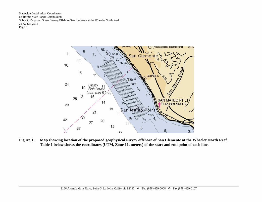
The proposed survey will be conducted approximately 0.6-1.2 miles offshore of the City
of San Clemente, in 11-15m water depths. Figure 1 shows the location of the survey area and the
proposed track lines. Table 1 gives the GPS coordinates of each track line.
The target dates for the survey will be the week of September 22-26, 2014. Survey
activities will only be conducted during daylight hours. EcoSystems Management Associates,
Inc. (ECO-M) maintains a permit for conducting offshore geophysical surveys with the
California State Lands Commission and provides pre-cruise information required by the State for
2166 Avenida de la Playa, Suite G, La Jolla, California 92037 Tel. (858) 459-0008 Fax (858) 459-0107
Statewide Geophysical Coordinator
California State Lands Commission
Subject: Proposed Sonar Survey Offshore San Clemente at the Wheeler North Reef
21 August 2014
Page 2
minimizing impacts to marine life. Furthermore, survey timing and location are coordinated with
local government agencies and fisheries to avoid interference with recreational and commercial
boating.
New amendments to Safety Zone Monitoring (Condition 7(i) and MM BIO-3) specify
that the monitoring of safety zones for surveys using passive geophysical equipment and surveys
where any and all active geophysical equipment is operated at frequencies ≥ 200 kHz are no longer required. During this survey, we plan to use only high frequency equipment ( > 200 kHz,
see Exhibit F). Thus, safety zone monitoring is not required. However, ECO-M staff will still
implement safety measures to ensure marine mammals are not disturbed or injured during survey
activities. Because safety zone monitoring is not required for this survey, and due to the small
size of the ECO-M vessel (27’), we are proposing an exemption from the MWM requirement.
Instead, we propose to utilize a crew member to perform these functions. Crew aboard during
the survey dates will be both ECO-M crew and C&C Technology crew. Both are reputable
companies with many years of experience performing sonar surveys. Despite the absence of a
MWM, crew members will still implement safety measures to ensure marine mammals are not
disturbed or injured during survey activities. These measures are outlined in the Marine Wildlife
Contingency Plan, which all crew members will be required to read.
Sincerely,
ECOSYSTEMS MANAGEMENT ASSOCIATES, INC.
Hany Elwany, Ph.D.
President
Attachments (Electronic):
a. Exhibit G checklist
b. Exhibit F
c. Marine Wildlife Contingency Plan
d. Oil Spill Contingency Plan
e. Verification of Equipment Service and/or Maintenance and Sound Output
f. Copies of certified mail sent to recipients indicated in Exhibit E.
2166 Avenida de la Playa, Suite G, La Jolla, California 92037 Tel. (858) 459-0008 Fax (858) 459-0107
Statewide Geophysical Coordinator
California State Lands Commission
Subject: Proposed Sonar Survey Offshore San Clemente at the Wheeler North Reef
21 August 2014
Page 3
Figure 1. Map showing location of the proposed geophysical survey offshore of San Clemente at the Wheeler North Reef.
Table 1 below shows the coordinates (UTM, Zone 11, meters) of the start and end point of each line.
2166 Avenida de la Playa, Suite G, La Jolla, California 92037 Tel. (858) 459-0008 Fax (858) 459-0107
Statewide Geophysical Coordinator
California State Lands Commission
Subject: Proposed Sonar Survey Offshore San Clemente at the Wheeler North Reef
21 August 2014
Page 4
Table 1. Line names and starting and ending points of each survey line for the Sonar
Survey Offshore San Clemente at the Wheeler North Reef Survey.
Line Name Start Point - Northing Start Point - Easting End Point - Northing End Point - Easting
2166 Avenida de la Playa, Suite G, La Jolla, California 92037 Tel. (858) 459-0008 Fax (858) 459-0107
EXHIBIT G
California State Lands Commission Presurvey Notice Requirements for
Permittees to Conduct Geophysical Survey Activities
All parts of the Presurvey Notice must be adequately filled out and submitted to the CSLC staff a
minimum of twenty-one (21) calendar days prior to the proposed survey date to ensure adequate
review and approval time for CSLC staff. Note that one or more of the items may require the
Permittee to plan well in advance in order to obtain the necessary documentation prior to the
Notice due date (e.g., permits from other State or Federal entities).
Please use the boxes below to verify that all the required documents are included in the
Presurvey Notice. If “No” is checked for any item, please provide an explanation in the space provided. If additional space is needed, please attach separate pages.
Yes No
Geophysical Survey Permit Exhibit F
Permit(s) or Authorization from other Federal or State agencies (if applicable) Explanation:
21-Day Written Notice of Survey Operations to Statewide Geophysical Coordinator/
U.S. Coast Guard Local Notice to Mariners/
Harbormaster and Dive Shop Notifications
Explanation:
Marine Wildlife Contingency Plan
Explanation:
Oil Spill Contingency Plan
Explanation:
Notification of Geophysical Survey Equipment Used
Explanation:
Verification of Equipment Service and/or Maintenance (no older than 12 months; must
verify sound output)
Explanation: .
Permit(s) or Authorization from California Department of Fish and Wildlife for
surveys in or affecting Marine Protected Area(s) (if applicable)
Explanation: Survey area is away (~6 miles) from the nearest MPA.
NOTE: CSLC staff will also require verification that current biological information was
obtained and transmitted as outlined in Section 5 of this permit
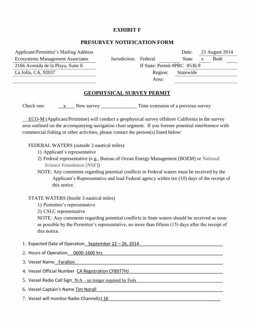
EXHIBIT F
PRESURVEY NOTIFICATION FORM
Applicant/Permittee’s Mailing Address Date: 21 August 2014
Ecosystems Management Associates Jurisdiction: Federal State x Both
2166 Avenida de la Playa, Suite E If State: Permit #PRC 8536.9
La Jolla, CA, 92037 Region: Statewide
Area:
GEOPHYSICAL SURVEY PERMIT
Check one: x New survey Time extension of a previous survey
ECO-M (Applicant/Permittee) will conduct a geophysical survey offshore California in the survey
area outlined on the accompanying navigation chart segment. If you foresee potential interference with
commercial fishing or other activities, please contact the person(s) listed below:
FEDERAL WATERS (outside 3 nautical miles)
1) Applicant’s representative
2) Federal representative (e.g., Bureau of Ocean Energy Management [BOEM] or National
Science Foundation [NSF])
NOTE: Any comments regarding potential conflicts in Federal waters must be received by the
Applicant’s Representative and lead Federal agency within ten (10) days of the receipt of
EcoSystems Management Associates, Inc. i Oil Spill Contingency Plan
Oil Spill Contingency Plan
ECOSYSTEMS MANAGEMENT ASSOCIATES, INC.
MANAGEMENT OF ACCIDENTAL DISCHARGE AND VESSEL PROBLEMS
DURING OFFSHORE/ONSHORE GEOPHYSICAL SURVEY
1.0 INTRODUCTION
At the initiation of each project or project phase, a spill management review will be
conducted by the vessels captain who is in all cases the responsible authority. It should be pointed
out that any oil spill in United States (U.S.) marine waters shall be reported immediately (on the
same day). Reporting information is stated in Section 8.0.
2.0 OPERATIONAL SPILLS
Operational spills might involve one or more of the following substances carried on board the
vessel: (i) fuel; (ii) lube oil; (iii) hydraulic oil; or (iv) waste oil. The vessel is equipped with a
Buffalo Quick-Response Oil Spill Kit, which includes socks for fast spill containment (three 4’’
socks), woven polypropylene sheets (15 sheets) for rapid absorption of surface oil and protective
gear, protective gloves (1 pair), disposal bag (1), and a set of instructions. This oil spill kit is located
in the forward cabin of the vessel. This spill kit is rated to clean up 5 gallons of liquid. All of the
liquids (listed below) that could cause a hazardous spill are either in the fuel tank or are located in
the engine room of the vessel. Thus, if a spill occurred, these would be contained in the engine room,
or if a grounding or instance occurred that punctured the gas tank, this would leak into the water,
which is beyond the scope of our cleanup efforts. In the event a spill occurred in the engine room, the
oil spill kit would be used to contain the hazardous liquids and the bilge would not be emptied until
it could be pumped out at a hazardous waste facility. We do not anticipate a spill of greater than 5
gallons.
(i) Fuel:
A spill kit shall be available for use in the event of a spill. If the fuel is spilled on the deck,
it shall be immediately removed, bagged and disposed of at an appropriate hazardous waste reception
facility. In the event of spillage in the water, the vessel foreman shall notify the Coast Guard and port
facility.
(ii) Lube oil:
A spill kit shall be available for use in the event of a spill. If the oil is spilled on deck or in
the machinery space, it shall be immediately removed, bagged and disposed of at an appropriate
hazardous waste reception facility. In the event of spillage in the water, the vessel foreman shall
notify the Coast Guard and port facility.
EcoSystems Management Associates, Inc. 1 Oil Spill Contingency Plan
Oil Spill Contingency Plan
(iii) Hydraulic oil:
A spill kit shall be available for use in the event of a spill. If the oil is spilled on deck or in
the machinery space, it shall be immediately removed, bagged and disposed of at an appropriate
hazardous waste reception facility. In the event of spillage in the water, the vessel foreman shall
notify the Coast Guard and port facility.
(iv) Pipe leakage:
The vessel foreman shall check the piping and rubber hose daily for leakage. Where leakage
is found, it shall be repaired immediately. In the event of leakage, the vessel deck engineer shall
secure valve(s) at the appropriate tank before repairing the leak. Spilled fuel on the vessel shall be
immediately removed, bagged and disposed of at an appropriate hazardous waste reception facility.
In the event of spillage in the water, the vessel foreman shall notify the Coast Guard and port facility.
3.0 EMPLOYEE TRAINING ON OIL SPILL CONTINGENCY PLAN
Prior to the launching of the vessel for any activities, all captain and crew members on the
vessel will have read the Oil Spill Contingency Plan, understand procedures to be implemented
in the event of an oil spill, and know where the oil spill kit is located on the vessel.
4.0 SPILLS RESULTING FROM CASUALTIES AND VESSEL PROBLEMS
In the event of a casualty, the vessel foreman’s first priority is to ensure the safety of the
vessel’s personnel and to initiate actions that may prevent escalation of the incident and marine
pollution.
(i) Grounding:
The likelihood of grounding, although remote, could occur when the vessel is working near
shore. Should an unforeseeable grounding event occur that causes a spill, the vessel foreman shall
immediately report the accident to the Coast Guard and port facility. It is mandatory that the survey
company immediately report the incident to the California Office of Emergency Services (“OES”).
(ii) Fire or explosion:
If a fire or explosion occurs, the Coast Guard and port facility will be notified immediately
by the vessel foreman. While awaiting a response from the USCG or local fireboat agencies, all
crewmen shall report to the foreman for a head count. In the event that one or more crewmen are
missing, the vessel foreman shall so notify the site safety officer and direct a search for the missing
crew where practical. If one or more crewmen are injured, the foreman shall render first aid with the
assistance of available crewmen. The foreman shall also notify the site safety officer of any injuries
sustained as a result of the fire or explosion.
EcoSystems Management Associates, Inc. 2 Oil Spill Contingency Plan
Oil Spill Contingency Plan
The crew will fight the fire with portable fire extinguishers if this can be done safely. The
foreman shall determine if the fire or explosion warrants abandoning the vessel. If it is determined
that the vessel is to be abandoned, the crew shall don life vests and safely enter the water or available
life raft.
If there is a spill as a result of the fire or explosion, the vessel foreman shall immediately
report the incident to the Coast Guard and port facility. It is mandatory that the survey company
immediately report the incident to the OES.
(iii) Collision:
A collision is unlikely to cause a spill unless the vessel sinks or the fuel tank is “holed.” If it is determined that the vessel is to be abandoned, the crew shall don life vests and safely enter the
water or available life raft.
If the collision causes a spill from the fuel tank, the foreman shall immediately report the
incident to the site safety officer, Coast Guard, and port facility. It is mandatory that the survey
company immediately report the incident to the OES.
(iv) Vessel submerged/foundered:
If the vessel is submerged or foundered to the extent that it, or parts of it, is submerged, all
measures shall be taken to evacuate all persons on board. Avoid contact with any spilled oil. Alert
other vessels/vessels and/or the nearest coastal state for assistance in rescuing lives and the vessel as
far as possible.
5.0 SPILLS RESULTING FROM VESSEL FUELING
All vessel fueling will be conducted on land at a gas station or at an approved docking
facility. No cross vessel fueling will be performed.
6.0 PRIORITY ACTIONS TO ENSURE PERSONNEL AND VESSEL SAFETY
Safety of vessel personnel and the vessel are paramount. In the event that a crewman’s
injuries require outside emergency assistance, the site safety officer shall be contacted immediately
and emergency personnel contacted. While awaiting emergency assistance, the survey company’s
vessel personnel will render first aid and/or CPR.
7.0 MITIGATING ACTIVITIES
If safety of both the vessel and the personnel has been addressed, the vessel foreman shall
care for the following issues:
EcoSystems Management Associates, Inc. 3 Oil Spill Contingency Plan
Oil Spill Contingency Plan
Assessment of the situation and monitoring of all activities as documented evidence.
Care for further protection of the personnel, use of protective gear, assessment of further
risk to health and safety.
Containment of the spilled material by absorption and safe disposal within leakproof
containers of all used material onboard until proper delivery ashore, with due
consideration to possible fire risk.
Decontamination of personnel after finishing the cleanup process.
All personnel shall refer to the MSDS’s on board for additional information.
8.0 MEASURES TO BE TAKEN IN THE EVENT OF CASUALTY
(i) Response to collision
The vessel foreman and crew shall ensure that the following actions are taken.
When there is no immediate danger to their own vessel and crew, rescue crew of the
other vessel.
Investigate the damaged area of the vessel and the ingress of water and take emergency
measures to prevent the damage from becoming worse.
When ingress of water is found as a result of damage investigation, take necessary
measures to prevent water from coming in, or pump out the water already taken in,
according to the position and amount of water taken in. Such measures include the
closing of water-tight doors, inserting wooden plugs, use of collision mats, cement box,
strengthening of bulkhead, and use of water discharge pumps.
When water penetration is severe even after countermeasures are taken and there is a
danger of the vessel sinking, consider intended grounding on an appropriate shore.
(ii) Response to grounding
If the vessel runs aground, the vessel foreman and crew shall muster and the following steps
should be taken immediately.
(1) Eliminate all avoidable sources of ignition and ban all smoking on board.
Further actions:
(1) Carry out a visual inspection of the vessel to determine the severity of the situation.
(2) Take soundings around the vessel to determine the nature and gradient of the seabed.
(3) Check difference in the tidal ranges at the grounding site.
(4) Evaluate tidal current in the grounding area.
Having assessed the damage that the vessel has sustained, and taking into account the effects
EcoSystems Management Associates, Inc. 4 Oil Spill Contingency Plan
Oil Spill Contingency Plan
of hull stress and stability, the foreman should decide whether any action can be taken to
avoid further spillage, such as:
(1) Transfer of cargo and bunkers internally. If the damage is limited—for example, to one
or two tanks—consideration should be given to transfer of liquid from damaged to intact
tanks.
(2) Review existing and forecasted weather conditions to see if they will adversely affect the
vessel.
(3) Evaluate the possibility of transferring cargo to barges or other vessels, and request such
assistance accordingly.
(4) Trim or lighten the vessel sufficiently to avoid damage to intact tanks, thereby avoiding
additional pollution from spillage of oil or noxious liquid substance.
The foreman should obtain information about the situation, including the following.
(1) Tides and currents
(2) Weather, including wind, state of sea and swell.
(3) Any weather forecast changes.
(4) Nature of the bottom.
(5) Depth of water around the vessel, the calculated buoyancy needed to refloat, draught, and
trim after refloating.
(6) Condition of the vessel, including stresses on the hull.
Strict safety precautions should be taken before entering any empty space, in order to avoid
any risks from toxic fumes or oxygen deficiency.
Soundings should be taken around the vessel to determine the extent of the
grounding/stranding as accurately as possible. If the sea is too rough for accurate sounding, it
may be possible to measure the distance from the seabed to the main deck. By marking this
on a longitudinal section from the general arrangement drawings, the extent of grounding can
be determined.
If the vessel is structurally intact, an immediate attempt may be made to refloat her with or
without assistance. In deciding whether to make an immediate attempt to refloat, the foreman
should consider the use of the tugs and ground tackle as well as the possible damage that
might be caused to the vessel.
Immediate refloating may be the best course to adopt even if the vessel has sustained bottom
damage. However, if there are signs of excessive hogging, sagging or of undulations in the
sides of the hull, more careful consideration is required before attempting to refloat the
vessel. In these circumstances, lightening of the vessel may reduce the risk of further damage
and pollution.
(iii) Response to submerged/foundered
EcoSystems Management Associates, Inc. 5 Oil Spill Contingency Plan
Oil Spill Contingency Plan
The vessel foreman and crew shall muster and ensure that the following actions are taken
immediately.
If the vessel is wrecked to the extent that it or parts of it are submerged, take all measures
to evacuate all persons on board.
Avoid contact with any spilled oil.
Alert other vessels and/or the nearest coastal state for assistance in rescuing lives.
All openings in hull and superstructures are to be checked for watertight integrity.
Ensure that all water doors, sewage and other relevant damage control valves are closed.
Fill bottom tanks with ballast low side first.
Should the situation appear to be deteriorating, urgency or distress messages should be
dispatched as appropriate.
The nearest hospital to our survey area is the San Pedro Urgent Care Facility, located at 1499 W. 1st
St. San Pedro, California 90732. The number is: 310-241-2590.
9.0 REPORTING AN OIL SPILL TO STATE AND FEDERAL AGENCIES
Any oil spill in U.S. marine waters shall be reported immediately (on the same day) to the
state and federal phone numbers below:
West Coast Oil Spill hot-line 800-OILS-911, or Department of Fish and Game CalTIP 888-CFG-CALTip
(Californians Turn In Poachers & Polluters) (888-334-2258). and U.S. Coast Guard National Response Center 800-424-8802
California Office of Emergency Services (OES) 800-OILS-911 or 800-852-7550.
During the phone call, the following information will be given over the phone.
a. Name and telephone number of caller.
b. Where did you see the spill?
c. What do you think was spilled (oil, gas, diesel, etc.)?
d. Can you estimate the size of the spill?
e. The date & time you saw this spill? (PLEASE report on the same day).
f. Did you see any oiled or threatened wildlife?
g. Do you have any information or thoughts about who spilled the material?
h. What, if any, activity did you observe at the spill site?
After taking the necessary actions, the spill will be reported in writing to the Governor’s
Office of Emergency Services on their forms.
Additionally, California Department of Fish and Game certified wildlife rescue/response
organizations will be contacted about the spill. In the Palos Verdes area, these include the following
contacts:
EcoSystems Management Associates, Inc. 6 Oil Spill Contingency Plan
Oil Spill Contingency Plan
Oiled Wildlife Care Network Animal Advocates
1-877-UCD-OWCN 323-651-1336
California Wildlife Center South Bay Wildlife Rehab
818-222-2658 310-378-9921
All Wildlife Rescue & Education
562-434-0141
10.0 DIVER CHECKLIST
Prerequisites:
1. Copy of dive manual shall be at work site.
2. Site safety has reviewed work plan.
3. A written pre-job brief has been approved by the manager or designee.
4. All prerequisites required in the dive manual have been met.
5. Verify that a rescue plan is in place.
6. All procedures, drawings, and work documents are available.
7. All video and communication equipment is operable.
8. All diver qualifications are active.
9. Any known hazards have been identified.
10. Verify that all hazard barriers are in place.
11. Verify that waves and tidal conditions will not impact diving operations.
12. A diving supervisor shall be present at all times while the diver is in the water.
Diver Equipment Checkout:
1. Ensure that there are two sources of breathing air available.
2. Ensure that air compressor fuel tank and oil levels are full prior to diving.
3. Ensure that breathing air compressors are not located in an area where the induction of
harmful gases is possible.
4. Ensure that the Dive Supervisor inspects the diver’s equipment per their daily equipment
checklist.
5. Ensure that diver communication equipment checkout is performed.
Placing a Diver in the Water:
1. Notify the control room prior to commencing dive activities. Also:
a. Verify method of communication to be used with the control room.
b. Notify control room at conclusion of daily dive activities.
2. Verify that standby divers are in the immediate area and in a state of preparedness to enter
the water within two minutes.
3. If SCUBA equipment is used, two divers shall be in the water.
4. Remove the diver from the water if any operational changes are encountered.
EcoSystems Management Associates, Inc. 7 Oil Spill Contingency Plan
The R/V Almar MBES patch test was conducted in the north end of Lake Washington over a known
calibration site. The patch tests was processed onboard immediately after patch test acquisition using
CARIS HIPS 8.1.8 Calibration Editor. Final offsets are in the table below.
R/V Almar offsets
Final offsets 0.00 -2.05 -0.06 -1.92
Figure 1 Pre-offset calibration site Figure 2 Post offset calibration site
Latency (ms) Pitch (°) Roll (°) Yaw (°)
Figure 3 Pre-offset full surface Figure 4 Post offset full surface
Seafloor Information System
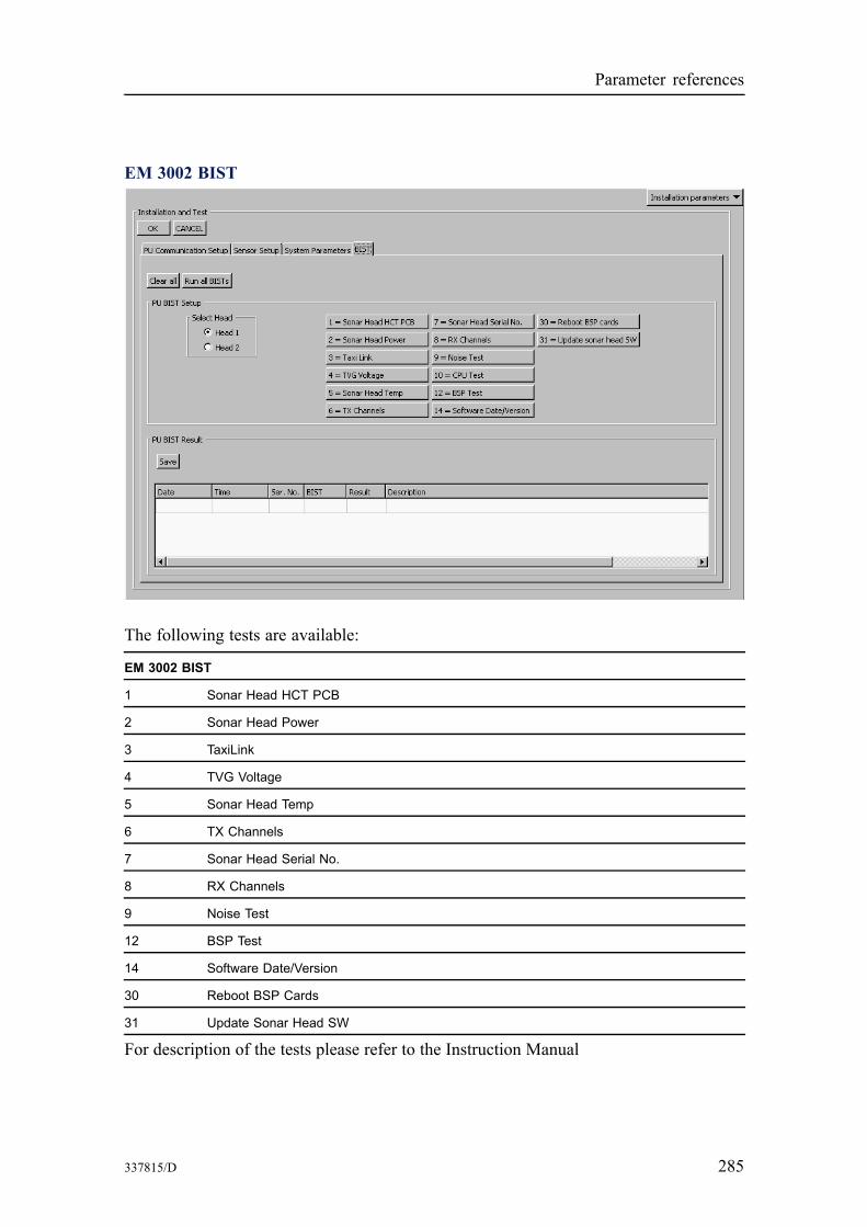
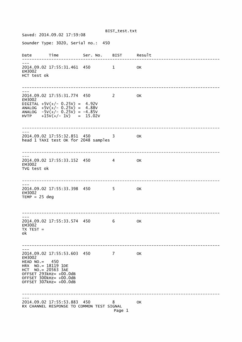
BIST – Built-In Self Test The BIST (Built-In Self Test) options provide a number of automatic tests that may be started to check the operation of the echo sounder system.
Note
The tests may be automatically run at echo sounder startup provided that this option is set to On from the Tools→Custom→Set parameters→Startup options for the system page.
BIST is located on the Installation parameters display view.
Various test are available, and the test presented will depend on what system you have.
Parameters
• Clear all: Press to clear results of previous BIST tests. • Run all BISTs: Press to run all available BIST tests.
Note
When the button is pressed, all BIST tests will be run, without any further questions.
• BIST test buttons: Single BIST tests can be run by pressing the corresponding test buttons. The button turns green if the test results are OK, it turns yellow if the test is not successfully carried out. The button will turn red if the test fails. Note
When a button is pressed, the selected BIST test will be run, without any further questions.
• Select Head / Transceiver Unit: Select the sonar head or transceiver unit you want to run test for.
• Save: The results of the BIST tests may be saved to file. Press Save to set file name and storage location.
• PU BIST Result area: The results are presented in this area with the following information for each test: – Date: Date when the test was run. – Time: Time when the test was run. – Ser. No: Serial number of the transceiver unit. – BIST: The number of the BIST test that has been run. – Result: The overall result of the test. – Description: A description of the test returned from the PU (Processing Unit).
284 337815/D
1
2
3
4
5
6
7
8
9
Parameter references
EM 3002 BIST
The following tests are available:
EM 3002 BIST
Sonar Head HCT PCB
Sonar Head Power
TaxiLink
TVG Voltage
Sonar Head Temp
TX Channels
Sonar Head Serial No.
RX Channels
Noise Test
12 BSP Test
Software Date/Version
Reboot BSP Cards
Update Sonar Head SW
For description of the tests please refer to the Instruction Manual