African Journal of Land Policy and Geospatial Sciences, ISSN2657-2664, Issue no2, December 2018 61 Effects of land titling and registration on tenure security and agricultural investments: Case of Gataraga sector, Northern Rwanda 1 Emmanuel Muyombano, 2 Margareta Espling , 3 Petter Pilesjo 1 Centre for Geographic Information systems and Remote sensing of the University of Rwanda, [email protected], Rwanda 2 Unit of Human Geography, Department for Economy and Society, University of Gothenburg, [email protected], Sweden 3 Centre for Geographic Information Systems, Department of Physical Geography and Ecosystem Science, Lund University, [email protected], Sweden Abstract Rwanda has undertaken a land registration and titling program since 2008 with a registration of 10.3 million land parcels in 2013. The aim of this paper is to investigate the early effects of the program on tenure security and agricultural investments since few studies have been carried out in this research area. The study was undertaken in Musanze district in Northern Rwanda, with specific focus on Gataraga sector and it draws on a mix of qualitative and quantitative research methods. The findings indicate that the program led to reduced land conflicts and improved tenure security. Further, it had resulted in increasing collateral value of land; however mortgaging land to access loans seemed to depend on various factors including demographic and socio-economic characteristics of households. Land rental was the most common form of land market and the relatively well-off farmers seemed to gain most from the program than the poorest farmers. Key words: Land registration and titling, agricultural development, land tenure security, land market, Rwanda Résumé Le Rwanda a lancé un programme d'enregistrement foncier et d'attribution de titres de propriété depuis 2008 avec un enregistrement de 10,3 million de parcelles en 2013. Cet article a pour objectif d'étudier les premiers effets du programme sur la sécurité du régime foncier et les investissements agricoles, car peu d'études ont été menées à ce sujet. L'étude a été entreprise dans le district de Musanze, dans le nord du Rwanda, avec une attention particulière sur le secteur de Gataraga et s'appuie sur un mélange de méthodes de recherche qualitatives et quantitatives. Les résultats indiquent que le programme a permis de réduire les conflits fonciers et d’améliorer la sécurité d’occupation. En outre, une augmentation de la valeur collatérale des terres a augmenté; Cependant, hypothéquer les terres pour accéder aux prêts semblait dépendre de divers facteurs, notamment les caractéristiques démographiques et socio-économiques des ménages. La location de terres était la forme la plus courante de marché foncier et les agriculteurs relativement aisés semblaient profiter davantage du programme plus que les agriculteurs les plus pauvres. Mots-clés: Enregistrement et attribution des titres fonciers, développement agricole, sécurité foncière, marché foncier, Rwanda
Transcript
African Journal of Land Policy and Geospatial Sciences, ISSN2657-2664, Issue no2, December 2018
61
Effects of land titling and registration on tenure security and
agricultural investments: Case of Gataraga sector, Northern Rwanda
Rwanda has undertaken a land registration and titling program since 2008 with a registration of 10.3 million land parcels in 2013. The aim of this paper is to investigate the early effects of the program on tenure security and agricultural investments since few studies have been carried out in this research area. The study was undertaken in Musanze district in Northern Rwanda, with specific focus on Gataraga sector and it draws on a mix of qualitative and quantitative research methods. The findings indicate that the program led to reduced land conflicts and improved tenure security. Further, it had resulted in increasing collateral value of land; however mortgaging land to access loans seemed to depend on various factors including demographic and socio-economic characteristics of households. Land rental was the most common form of land market and the relatively well-off farmers seemed to gain most from the program than the poorest farmers.
Key words: Land registration and titling, agricultural development, land tenure security, land market,
Rwanda
Résumé Le Rwanda a lancé un programme d'enregistrement foncier et d'attribution de titres de propriété depuis 2008 avec un enregistrement de 10,3 million de parcelles en 2013. Cet article a pour objectif d'étudier les premiers effets du programme sur la sécurité du régime foncier et les investissements agricoles, car peu d'études ont été menées à ce sujet. L'étude a été entreprise dans le district de Musanze, dans le nord du Rwanda, avec une attention particulière sur le secteur de Gataraga et s'appuie sur un mélange de méthodes de recherche qualitatives et quantitatives. Les résultats indiquent que le programme a permis de réduire les conflits fonciers et d’améliorer la sécurité d’occupation. En outre, une augmentation de la valeur collatérale des terres a augmenté; Cependant, hypothéquer les terres pour accéder aux prêts semblait dépendre de divers facteurs, notamment les caractéristiques démographiques et socio-économiques des ménages. La location de terres était la forme la plus courante de marché foncier et les agriculteurs relativement aisés semblaient profiter davantage du programme plus que les agriculteurs les plus pauvres. Mots-clés: Enregistrement et attribution des titres fonciers, développement agricole, sécurité foncière, marché foncier, Rwanda
Emmanuel M. and Margareta E and Petter P. / Effects of land titling and registration on tenure security
African Journal of Land Policy and Geospatial Sciences, ISSN2657-2664, Issue no2, December 2018
62
1. INTRODUCTION
Poor property rights, including land tenure insecurity, have been considered a crucial obstacle for economic development in developing countries (Deininger, 2003; Galiani & Schargrodsky, 2010). Since the 1990s, the development of legal frameworks along with land registration and titling (LRT) programs that secure and clearly define people’s land rights, have been seen as vital for the economic development in rural areas, where the majority of the people live off the land (Galiani & Schargrodsky, 2010; Obeng-Odoom, 2012). De Soto (2000) strongly argued for the formalization of existing land rights through private land titles in developing countries, so that these individual land titles could be capitalized as collateral to access loans for productive investments(Obeng-Odoom, 2012). Secure and clearly defined land rights are expected to stimulate investments in land and agriculture, but also to activate a land market, which is regarded as crucial for creating a more dynamic agricultural and rural sector in developing countries (Broegaard, 2009; Deininger, 2003). Based on these arguments, LRT programs have been promoted by governments in developing countries supported by international development agencies, as part of their poverty alleviation efforts (Deininger, 2003; Deininger and Feder, 2009).
In the 1970s and 1980s, there was consensus among international development agencies about the importance of formalizing private property rights in Africa, based on the belief that such rights converted into land title certificates were necessary to boost the agricultural sector (Deininger and Feder, 2009; Feder and Nichio, 1999; Firmin-Sellers & Sellers, 1999). These ideas to gained momentum during the 1990s (Obeng-Odoom, 2012). First, landholder farmers would be more willing to undertake long-term investment when they had long-term tenure security over their land, the known as the “assurance effect” (Deininger, 2003:39). According to Place et al. (1994: 19), land tenure security exists ‘when an individual perceives that he or she has rights to a piece of land on a continuous basis, free from imposition or interference from outside sources, as well as ability to reap the benefits of labor and capital invested in that land, either in
use or upon transfer to another holder’. Secondly, a land title certificate would enhance the collateral value of land, leading to more easy access to credit for landholders, the “collateralization effect” (Boucher et al., 2005; Feder and Nichio, 1999:5; Twerefou et al., 2011:261). Thirdly, investment incentives could be enhanced when land could be easily transferred at a low cost through land rentals and sales, the “realization effect” (Boucher et al., 2005; Brasselle et al., 2002:374; Deininger et al., 2011). Therefore, many post-colonial states in Africa implemented land tenure reforms and titling programs based on the idea that customary systems did not provide people with sufficient tenure security to ensure agricultural investment and efficient land use. Some African states nationalized all land, i.e. state owned land, while others implemented LRT programs to create and enforce private land rights (Cotula et al., 2004; Pinckney & Kimuyu, 1994). However, studies have shown that LRT programs implemented in Africa during the 1970s and 1980s failed to achieve the expected results of improving tenure security, nor did they lead to agricultural investment and increased agricultural production (Bromley, 2009; Bruce & Migot-Adholla, 1994; Jacoby & Minten, 2007;Pender et al., 2004;Peters, 2009;Place & Migot-Adholla, 1998;Platteau, 1996). Instead, these programs were costly and accelerated speculation in land, favoured the elite, and lead to corruption, conflicts and unequal access to land among people in the communities (Cotula et al., 2004; Peters, 2004). Also in some countries in Asia and Latin America where land registration and titling were implemented, there was little rigorous analysis of their cost-effectiveness and long-term impacts. Therefore, the formalization of land rights through land registration and titling should not be seen as a universal solution and that interventions should be undertaken only after a careful analysis of the policy, social, and governance environment of each country (Deininger & Feder, 2009).
In Rwanda, more than 80 per cent of the population depends on subsistence agriculture at the same time as the country has long been struggling with land scarcity and low agricultural productivity (GoR, 2000).Therefore, the Government of Rwanda (GoR) initiated a
Emmanuel M. and Margareta E and Petter P. / Effects of land titling and registration on tenure security
African Journal of Land Policy and Geospatial Sciences, ISSN2657-2664, Issue no2, December 2018
63
process of renewing the land tenure policies in the country during the 1990s and 2000s, in which the main objective was to promote the formalization of individual land rights vested in local people in order to develop themselves economically. In 2006, the GoR initiated an LRT program for the ‘clarification of land rights through a land administration system, the process of registering and disseminating information related to land titles and transactions is crucial to guarantee the security of land tenure and promote bank loan security in the form of mortgage of land’ (GoR, 2004: 30-31). By 2013, 10.3 million land parcels had been registered (Byamugisha, 2013; Gillingham and Buckle, 2014). Only a few reports and papers have explored the early stages of the LRT program, assessing the Organic Land Law, the National Land Policy, and the pilot phase of the LRT program (DFID, 2011; Rurangwa 2013; Saito, 2011). Other studies, carried out after the completion of the LRT, have described Rwanda as a successful example, where the LRT program was implemented rapidly within five years (Byamugisha, 2013; Gillingham & Buckle, 2014).These studies highlight the approach taken to ensure gender equality in land rights, and Bayisenge (2015a) focused specifically on women’s experiences of the Rwandan reform. Further reasons for the success of the Rwanda case have been identified, such as a detailed implementation plan for the program, the community-based approach, and the low cost. However, the sustainability of the land administration system at district level is mentioned as a threat to the long-term success (Gillingham & Buckle, 2014). Taking a point of departure in the strong belief that land registration and titling is key to agricultural and rural development, the aim of this paper is to investigate the early effects of the LRT program as experienced by smallholder farmers in Northern Rwanda. The following three specific objectives have been formulated:
i) To investigate if the land registration and titling resulted in sufficient land tenure security for farmers, in order to undertake agricultural investments,
ii) To analyse if the land registration and titling resulted in an increase of the collateral value of land, and
iii) To examine if the land registration and titling resulted in a growing land market (buying and renting) to expand farming areas and increase the agricultural productivity.
This paper contributes to the debate on LRT programs by investigating the early effects on tenure security, collateral value of land, and land markets as experienced by smallholder farmers at local level in Gataraga sector in Muzanse District in Northern Rwanda. This study draws on a mix of qualitative and quantitative methods. 2. THE LAND REGISTRATION AND TITLING PROGRAM IN RWANDA In Rwanda, all land belongs to the State and landholders are under a lease system for 99 years. Based on the customary system, land has been inherited from father to son and it is a common heritage for past, present and future generations. With the new Constitution in 2003, the post-genocide Rwandan government initiated a land tenure reform process to deal with problems of tenure insecurity and what was regarded as land use inefficiencies. A National Land Policy was adopted in February 2004, emphasizing an appropriate land administration system as key to an improved land tenure security through the possibility of registering and transferring land. According to the National Land Policy, the role of the Government is to guarantee the family heritage of land by ensuring its good management and supporting economic dynamics of all land users (GoR, 2004). The main objective of the National Land Policy was to establish a land administration system within which a land registration and titling (LRT) program was to be implemented. The LRT program was designed to clarify the rights of the existing owners of land by registering all landownership and issuing individual/household land title certificates. The legally recognized title would allow people to transact their interests in land and use their title certificates to mortgage land and access loans for investments (GoR, 2008a). In 2005, the Organic Land Law (OLL), ‘Determining the Use and Management of Land in Rwanda’, was established. The Law specifically calls for the registration of land through issuing private titles, with the aim of
Emmanuel M. and Margareta E and Petter P. / Effects of land titling and registration on tenure security
African Journal of Land Policy and Geospatial Sciences, ISSN2657-2664, Issue no2, December 2018
64
promoting investments in agriculture. The aim of the LRT program was to guarantee land tenure security, and thus reduce the opportunities for conflict of interests, as well as to promote investments in land for improved agricultural production (GoR, 2005a). The LRT program was implemented through a decentralized structure. The local government system consists of four provinces and Kigali City, 30 districts, 416 sectors, 2,148 cells, and 14,837 villages (imidugudu)(GoR, 2005b). The LRT program required the establishment of land commissions both at national and district levels. The National Land Commission was responsible for the strategic direction of the National Land Centre, a technical agency supporting the delivery of efficient land management services. The National Commission was also responsible for overseeing the District Land Commissions and Bureaus. The principal role of the District Land Commissions was to oversee the District Land Bureaus in charge of the implementation of land use planning and registration, to ensure compliance with the laws and regulations (GoR, 2008a). Land committees were established at both sector and cell levels to assist the Land Commissions. The members of land committees were elected by local communities and were formed by relatively educated people. The main function of the cell land committees was to implement the LRT processes in terms of demarcation, adjudication, dispute resolution and the issuance of provisional land certificates (Saito, 2011). Currently, the Land Commissions at national and district levels, the District Land Bureaus, as well as the sector and cell land committees are no longer functioning. Currently all services related to land, provided by a unit called ‘One Stop Centre’ (oral communication, former Head of District Land Bureau, November 2018). The LRT program was implemented in three phases: field consultations, a pilot phase consisting of field trials, and a scaling-up phase. First, field consultations, involving local authorities at sector and cell levels together with local communities, were carried out in 2006 to determine the scope and detailed feasibility of the LRT program in the whole country (GoR, 2008a). Thereafter, field trials were conducted in 4 districts in 2007 and 2008.
In each district 1 cell was selected, and in each cell land demarcation and registration took about a month and half on average. The land registration trials were conducted as follows: first, the cell land committee was formed and trained to understand the content of the OLL, the importance of land registration, and the procedure of the demarcation of land on aerial photographs. Secondly, a large meeting was organized with the residents of the cell in which the field trial was carried out. Each household was advised to send one member to participate in this meeting, and it was also a requirement that all landholders should attend. During such a meeting, the cell land committee would explain the importance of the LRT and the procedure of the demarcation. In each cell, 6 relatively young and educated people were identified and trained to be para-surveyors and conduct the verification of land boundaries on the ground (GoR, 2008a; Saito, 2011). From 2009 to 2013, the full-scale LRT program was implemented countrywide and 10.3 million land parcels were demarcated. During the pilot and the scaling-up phases of the program, land registration was carried out from one cell to another and from one parcel to the next. Boundary demarcation of parcels was based on the identification of parcel numbers on aerial photographs used by trained local para-surveyors to demarcate parcels (Byamugisha, 2013; Gillingham & Buckle, 2014). All regularized land under the above process was registered and titled to claimants as defined by the OLL. The process aimed at converting informal customary rights into formally registered rights, which was the key purpose of the LRT. This process was applied to all land in Rwanda including private and state land in both private and public domain (IFAD, 2012).Further, the OLL gives all children, male or female, equal rights to inherit land from their parents. This does not, however, apply to children of co-wives in polygamous unions. In the absence of registered marriage contracts (legal or customary), these children are considered illegitimate. Therefore, the LRT program has solved land conflicts related to land boundaries, while other social conflicts remain (Bayisenge, 2015b; Pottier, 2006; Saito, 2011).
Emmanuel M. and Margareta E and Petter P. / Effects of land titling and registration on tenure security
African Journal of Land Policy and Geospatial Sciences, ISSN2657-2664, Issue no2, December 2018
65
Another important program is the Vision 2020 Umurenge Programme (VUP). VUP is a social protection program, supporting the overall Rwandan Vision 2020 in fighting poverty and create a national human resource-based economy and development (GoR, 2012a; NISR, 2015). The Vision 2020 is a central reference document, which defines the pillars of the national development to be achieved by 2020. VUP has three components: public works, direct support, and financial services (GoR, 2012a:3-4). As part of VUP, cooperative financial institutions, Saccos have been established in each sector to support rural landholders to develop their farming activities. Saccos are both savings and lending institutions, and individuals can get a loan for investments, with an interest of 2 per cent per year. Saccos provide loans of 60,000 RWF (75 USD) for an individual, and farming association or cooperative of 10 people may get loans of 75,000 RWF (95 USD) for each member (GoR, 2008b: 5). The VUP encourages women’s associations to join the Saccos. In addition, and in line with the Rwandan Vision 2020 and the 2013-18 Economic Development and Poverty Reduction Strategy, all districts have developed their District Development Plans (DDP) 2013-18 for the implementation of land use master plans. The DDPs play a role in the realization of the national goals of economic development and poverty reduction (GoR, 2012b). 3. METHODOLOGY The study was carried out in Gataraga sector in Musanze district in Northern Rwanda. In order to investigate the early effects of the LRT program, a study area offered the possibility of investing the period before and after the LRT. The first fieldwork was carried out in January 2012 when the implementation of the LRT program had not yet started. The second fieldwork was carried out in the same sector in August 2014, after the LRT program had been implemented. Gataraga sector comprises four cells: Mudakama, Murago, Rubindi and Rungu (see Figure 1).
Fig 1. The study area: Four cells of Gataraga sector Source: (GoR, 2018).Centre for Geographic Information Systems and Remote Sensing, University of Rwanda The paper draws on a mix of qualitative and quantitative research methods to get a more comprehensive account of the area of enquiry (Bryman, 2012). During the first fieldwork, structured interviews were carried out through a short questionnaire with the heads of 20 households, selected in four cells of different geographical locations (see Figure 1). In each cell, five households were selected based on socio-economic status and the gender of the household head. At least two poor and two better-off households, and one female-headed household were selected. One of the village chiefs assisted in selecting the households, as he knew them all. However, the village chief was never present during the interviews. The questionnaire included demographic and socio-economic characteristics of the households, as well as questions on the number of farming or forest plots, the size of the plots, their vegetation cover and use. A mapping technique (obtaining plot border coordinates using GPS) was also used. All plots of the 20 households were mapped and measured. During the second fieldwork in 2014, individual semi-structured interviews were carried out in the same 2households selected in 2012. These interviews focused on tenure security, collateral value of land, land use and land markets, as experienced by the smallholder farmers. A voice recorder was used to collect interview data in the local language, Kinyarwanda, which were then transcribed and
Emmanuel M. and Margareta E and Petter P. / Effects of land titling and registration on tenure security
African Journal of Land Policy and Geospatial Sciences, ISSN2657-2664, Issue no2, December 2018
66
translated into English. Data were coded by themes using NVivo program. According to (Nowell et al.(2017) the process of coding includes looking for patterns and themes. A theme is an abstract entity that brings meaning and identifies experience and its variant manifestations. As such a theme captures and unifies the basis or the basis of experience into a meaningful whole. In the current study, the three themes which responded to the three specific questions on the effects of land registration and titling comprised tenure security, collateral value of land, land markets, as experienced by the smallholder farmers. One of the strategies to analyse such qualitative data is to review the research questions. As stated by Kawulich (2004), the research questions in qualitative studies are used to guide the design and implementation of the study. They are the questions one wants answered by the study; hence it is important to view the data in terms of ensuring that sufficient data were collected to enable the researcher to address the corresponding specific objectives of the study. New GPS measurements were made in four cases, where the households had experienced
some changes in their land areas since January 2012. In total, 20 structured interviews and 20 semi-structured interviews were made, and 53 farming and 19 forest plots were mapped and measured with GPS equipment. The qualitative data from the semi structured interviews were analysed using thematic analysis to answer the specific research questions. Sufficient data by each theme were collected and key experiences of smallholder farmers in each of the three themes were highlighted. Quantitative research method using structured interview was used to be informed about the number and size of farming and forest plots owned by smallholder farmers. The reason of measuring plots was to investigate if the size of plots are within a minimum size of 0.9 ha, seen by Food Agricultural Organization (FAO) as an economically viable cultivation plot in Rwanda (Bruce, 2007: 9). As argued by Walliman (2011), quantitative research methods are research methods dealing with numbers and anything that is measurable in a systematic way of investigation of phenomena and their relationships.
4.RESULTS AND DISCUSSIONS 4.1. Presentation of the households In August 2012, structured interviews were carried out in 20 households in Gataraga sector. All plots of these households were measured and the land use noted. In total, 53 farming and 19 forest plots were registered. The findings show that the great majority of the farming plots were very small, as 83 per cent of the measured farming plots ranged between 0.01 ha and 0.1 ha. In Rwanda, landholdings are generally very small and scattered. The national household surveys EICV2 and EICV3, indicate that the average cultivated land area per household was 0.59 ha in 2010-11, a decrease from 0.75 ha in 2005-06.EICV3 shows that more than 45 per cent of the farmers cultivate areas of less than 0.3 ha, and only about 2 per cent have access to farming plots of more than 3 ha (NISR, 2007; 2012). According to Musahara et
al. (2014), there is a strong link between access to land and poverty in Rwanda, as land size is strongly correlated to consumption quintiles. More than 70 per cent of the households in the lowest consumption quintile cultivate land areas of less than 0.7 ha. The Food and Agriculture Organization (FAO) has recommended a minimum size of 0.9 ha for an economically viable cultivation plot in Rwanda (Bruce, 2007: 9), meaning that only about 15 per cent of the population can only carry out what could be considered sustainable agricultural activities (Bizoza, 2014; NISR 2012).In Musanze district, the average farm plot size per household was 0.5 ha in 2006 (GoR, 2008c), which had decreased to 0.45 ha in 2012 (NISR, 2012).The tables(in appendix) show the household characteristics in each cell.
The four tables (in appendix) show that all but two of the respondents were subsistence
farmers, non-educated or having some primary schooling. The tables also show that the total
Emmanuel M. and Margareta E and Petter P. / Effects of land titling and registration on tenure security
African Journal of Land Policy and Geospatial Sciences, ISSN2657-2664, Issue no2, December 2018
67
farming land possessed by each of the 20 households is very small in general, and only 2 households in Rubindi cell could fulfil the FAO recommendation. Rubindi cell is located near the main road and some people there had acquired bigger land areas. For instance, the household head of Rubindi 5 was educated and got additional income from non-farming activities. The household head of Rubindi 4 had inherited the 1.5 ha farming plot and the forest plot of 2 ha from her husband, who had worked in the cell administration. The farming plot was regularly being rented by smallholder farmers, from which Rubindi 4 generated an income. Among the other households, 1 had access to 0.555 ha, 5 had land areas of in-between 0.13-0.425 ha, while 12 households had access to land areas of less than 0.1 ha. Further, the tables indicate that the forest plots of most households also are very small.
Smallholders often consider woodlots as small as 0.01 ha as forests (GoR, 2010). Based on the small size of forest plots and that a forest plot takes three years to be harvested, the likelihood that forest plots support the improvement of living standards of the farmers is low. During the follow-up fieldwork in August 2014, individual semi-structured interviews were made in the same 20 households included in the first fieldwork. Six new measurements were made including4 farming plots where there had been changes in land use since the 2012 fieldwork, and 2 purchased plots (one farming and one forest plot).In 2012, crops covered the 4 plots where changes had been made, while in 2014these plots had been taken for the preparation of sites for a road construction connecting the settlement to the main road under the District Development Plan
4.2. Effects of the land registration and
titling on the collateral value of land
The general impression among the interviewees was that the collateral value of land had increased after the implementation of the LRT program. Requests for loans, however, seem to depend on the demographic and socio-economic characteristics of the households, as well as their geographical location and the consequent involvement in the LUC program. Among the 20 households, 8 farmers had requested loans or were planning to do so. These included 6 relatively better off farmers (Rubindi 4 and 5, Murago 4 and 5, Mudakama 4 and 5), 1 medium ranked (Rungu 3) and 1 poor household (Rungu 2). Of these, two elderly farmers (Rubindi 4, Murago 5) were reluctant to request loans even though they possessed relatively big or scattered farming land (1.5 and 0.425 ha respectively). However, as stated by Rubindi 4, she might request a loan if in need: ‘I haven’t requested any loan but I’m planning to, as my son needs to pay school fees to study at the University’ (August 19, 2014).Another 4 interviewees, who said they were afraid to take loans using their land as collateral, further highlighted this reluctance among elderly farmers. Because of reduced strength in old age and limited land areas, their production was low, and they therefore thought they would have difficulties repaying any loans (Rubindi 2, Murago 3, Mudakama 2, Rungu 1). Another 5 respondents, less than 60 years old
and with limited land, also stated that they had not requested any loans (Rubindi 1, Murago 2, Mudakama 1, Rungu 4 and 5). Rungu 4 (30 years old) said:
I would like to request a loan by mortgaging my
land title certificate. However, the problem is that I have too small land, and I think that if I request it and fail to pay back the loan, the bank will take my land. I know some people with limited land who are experiencing this problem so I don’t engage myself in requesting loans. (August 22, 2014).
According to the respondent, the
“collateralization effect” was not achieved. It is fullfilled when land title certificate enhances the collateral value of land, leading to more easy access to credit for landholders (Boucher et al., 2005; Feder and Nichio, 1999:5; Twerefou et al., 2011:261). In this case, smallholder farmers are reluctant to mortgage their land for various reasons.
Other aspects affect the households’ possibilities to access loans, such as the agro-ecological conditions of the sector where the households are located, whether households accept to cultivate the crops selected in the LUC program or not, as well as the households’ willingness to join farming associations or cooperatives. For instance, in Rubindi and Murago the farmers were reluctant to organize
Emmanuel M. and Margareta E and Petter P. / Effects of land titling and registration on tenure security
African Journal of Land Policy and Geospatial Sciences, ISSN2657-2664, Issue no2, December 2018
68
themselves into associations/cooperatives and cultivate maize in groups within the LUC program, and they preferred to cultivate crops of their own choice. Therefore, it was difficult for them to get loans, because Saccos prefer to give loans to smallholder farmers who had joined the LUC program and were grouped in farming associations or cooperatives, rather than to individuals.
However, some of the better off farmers in Rubindi and Murago cells had the means and possibilities to join farming associations or cooperatives in Rungu and Mudakama through which they could access loans. Murago 4, for instance, had joined farming cooperatives and has requested a loan. The situation was different in Rungu and Mudakama cells, where most of the farmers interviewed were members in farming associations or cooperatives, and therefore could access loans more easily, both individually We have requested a loan by just providing a copy of a land title certificate of one of my five plots and we pay the loan regularly according to the contract signed with the Sacco. (August 20, 2014) and collectively. A copy of a member’s land certificate was generally mortgaged to get a loan. Mudakama 4 with five scattered plots highlighted the benefits of joining farming cooperatives:
The good thing of being a member of a farming
cooperative here, is the facility to get quick loans through the cooperative when for example we have to pay school fees or need to buy seeds or fertilizers. We pay back the loan within one year with 2 per cent of interest. (August 20, 2014) In all 4 cells potatoes are grown as a selected crop. The findings show that the farmers who get loans often use these to grow potatoes, since potatoes provide very good production in this region within a short period of time.
I’m in a farming association and after mortgaging my land certificate through my association I got a loan equivalent to 30,000 RWF [37.5 USD] to buy seed potatoes and fertilizers. I have been producing potatoes on my land and have managed to pay the loan within 3 months after harvesting. (Rungu 2, August 22, 2014)
4.3. Effects of the land registration and titling on land markets The land market transactions encountered in Gataraga were mostly land rentals and some few sales. All 20 interviewees stated that land is rarely sold, mainly due to the tradition of keeping land within the family to safeguard their very livelihood. The main reason to sell land is when families are in serious need of accessing cash:
People do not like selling their land, as according to the tradition, the land belongs to the family. We have small land and we always think that we should keep it and try to use it efficiently instead of selling it. It can only happen when someone is facing problems /.../ the person who sells land usually has children who need school fees and the parents decided to sell a plot unwillingly. (Rubindi 3, August 18, 2014). Brown and Hughes (2017) also confirmed that there is some occasional situation where a landowner can sell a parcel of land to meet a household need. These could be the payment of school fees or health emergencies. With the implementation of the LRT program, old procedures of writing contracts by hand are no longer functioning. Instead, it is the land title certificate that is formally transferred from sellers to buyers of land. Interviews indicate that the official process of transferring land to the new owner is costly and bureaucratic, which might complicate land transactions for smallholder farmers. Murago 5 pointed out that:
Selling and buying land is not frequent here
but some people do it. The administrative procedures for transferring land take long time to finalize and they are done at the district land office, which is far from us and they have to pay a transfer fee equivalent to 20,000 RWF [25 USD] to the government. (August 19, 2014). In this study, the “realization effect” is not fullfilled as the transfer fee for land sales is still too high for the buyer and seller who have to pay jointly. It is indeed achieved when land could be easily transferred at a low cost through land rentals and sales, (Boucher et al., 2005; Brasselle et al., 2002:374; Deininger et al., 2011). No one of the 20 interviewees said they had sold land, but 2 had bought land; a forest plot and a
Emmanuel M. and Margareta E and Petter P. / Effects of land titling and registration on tenure security
African Journal of Land Policy and Geospatial Sciences, ISSN2657-2664, Issue no2, December 2018
69
farming plot. Rungu 1, who had bought a farming plot of 0.3 ha, told us that:
I bought land equivalent to 300,000 RWF
[375 USD] from a widow who was obliged to sell it in order to pay school fees for her children. The seller transferred her land title certificate to me and we are in the process of paying transfer fee to the Government equivalent to 20,000 RWF [25 USD]. I only have a receipt testifying that I have bought the plot from her and the land will belong to me once I have the land title certificate in my name. (August 21, 2014) Land rentals seemed much more common than land sales. The findings show that 4 of interviewed farmers in Rungu and Mudakama cells had taken loans to rent land, which seemed to be the most common land market type used to expand farming areas and increase the agricultural production through farming associations or cooperatives. Murago 4, who had joined a cooperative in Mudakama, said that:
A group of 10 people from our cooperative has
a project for growing potatoes and by mortgaging one of my land title certificates we requested a loan equivalent to 750,000 RWF [937.5 USD] used to rent land, buy seed potatoes and fertilizers. We have been producing potatoes and we are now about to finish paying the 2 per cent of interest to the Sacco. (August 19, 2014)
Rungu 3 also stated that loans taken through a farming association were used to rent land and to buy agricultural inputs to increase the production of potatoes for the market:
I’m in a farming association and after
mortgaging my land certificate we have got a loan equivalent to 60,000 RWF [75 USD] which was used to buy seed potatoes, fertilizers and rent land to increase our production. (August 22, 2014)
Smallholder farmers only provide land for renting for the same reason that people have to sell their land: the need for money to pay school fees or for other necessary expenditure such as paying for the treatment of illness. Mudakama 1, who only had 1 small plot of 0.04 ha, said that: “As I’m lacking school fees for my child, who is in a private school, I’m planning to rent out my plot
for one year to be able to pay school fees” (August 20, 2014). Since the implementation of the LRT program it seems there is yet another reason why people do not want to sell their land, which is related to the increased land value. Thus, instead of selling, people who have the possibility would rather mortgage their land to get a loan and access the cash needed:
The land registration and titling has not
really resulted in a growing land market because people are reluctant to sell land, the land registration and titling has instead increased the value of land as it is now used as collateral to get loans. (Rubindi 4, August 19, 2014)
5. CONCLUSIONS The aim of this paper was to investigate the early effects of the land registration and titling program on land tenure security and agricultural investments in rural Northern Rwanda. Interviews, mapping exercises and field observations were carried out in 2012 and 2014, involving 20 households. The time period for the study is short, but the data indicate some early effects related to the LRT program. All the 20 interviewees confirmed that the implementation of the LRT program had reduced land conflicts in comparison with what was experienced before the program, which was one of the aims with the LRT program (GoR, 2005a). Based on the interviews, the general impression is that the collateral value of land had increased after the implementation of the LRT program. However, whether smallholder farmers used their land as collateral for accessing loans depended on the demographic and socio-economic characteristics of the households, but also on their geographical location. The elderly and the poorer farmers were very reluctant to mortgage their land for credits, as they risked losing the land if they could not repay the loans. Loans taken were used for land rentals and agricultural investment, but also for school fees or other household necessities. The direct link between secure land tenure with a land title and the easy access to credit for landholders for agricultural investment and development, that is made in much of the literature (e.g.Boucher et al., 2005; de Soto, 2000; Feder and Nichio, 1999;
Emmanuel M. and Margareta E and Petter P. / Effects of land titling and registration on tenure security
African Journal of Land Policy and Geospatial Sciences, ISSN2657-2664, Issue no2, December 2018
70
Twerefou et al., 2011), as well as in the Rwandan policy frameworks (GoR, 2004; 2005a), seems to be much more complex and not very straightforward, which has been raised by Platteau (1996). There were no indications of an increase in selling and buying land in the region for this study, but the land rental market had increased. Generally, people did not want to sell their land, which was mainly explained by traditional values, according to which the land belongs to the family line. Through land rentals, the better off and more entrepreneurial farmers could access larger land areas to develop their agricultural production for the market. The study concludes that relatively better off farmers seem to gain most from the market-oriented reforms related to the LRT program, in combination with other programs for rural economic development, while the poor farmers with very limited land and other resources lose out. 6. ACKNOWLEDGEMENT This work was supported by the National University of Rwanda-Swedish international Development Cooperation Agency (Sida)/Sarec Research Cooperation, funded by Sida, Sweden
7. REFERENCES
Bayisenge, J. (2015a). Changing Gender Relations? Women’s Experiences of Land Rights in the Case of the Land Tenure Reform Program in Rwanda, Department of Social Work, University of Gothenburg, PhD thesis.
Bayisenge, J. (2015b). Women’s Experiences of Land Conflicts in the Context of the Land Tenure Reform Program in Rwanda. International Journal of Gender and Women’s Studies, 3(1), 118-133.
Bizoza, A.(2014). Population Growth and Land Scarcity in Rwanda: the other side of the “Coin”. Paper presentation at the conference on land policy in Africa, African Union Conference Center, Addis Ababa, Ethiopia, November 11-14, 2014.
Boucher, S. R., Barham B. L; &Carter. M. R. (2005).
The impact of “market-friendly” reforms on credit and land markets in Honduras and Nicaragua, World Development,
Land tenure security and investment incentives: puzzling evidence from Burkina Faso. Journal of Development Economics, 67 (2), 373-418.
Broegaard, R. B., (2009). Land access and titling in Nicaragua. Development and Change, 40(1), 149-169.
Bromley, D. W.(2009). Formalising property relations in the developing world: the wrong
prescription for the wrong malady, Land Use Policy, 26(1), 20-27.
Brown, M; & Hughes, A.K. (2017). Is land tenure “secure enough” in rural Rwanda? Paper presented at the World Bank Conference on Land and Poverty,
Washington, USA. Bruce, J. W.(2007).
Drawing a line under the crisis. Humanitarian Policy Group Working Paper. Humanitarian Policy Group and Overseas Development Institute, London.
Bruce, J. W;& Migot Adholla, S. E. (eds.). (1994).Searching for land tenure security in Africa. Kendall: Hunt publishing company.
Bryman, A. (2012). Social research methods (4th ed.), Oxford: Oxford University Press.
Byamugisha, F. F. K.(2013). Securing Africa's land for shared prosperity: a program to scale up reforms and investments. Washington: World Bank Publications.
Cotula, L., Toulmin C; & Hesse, C.(2004). Land tenure and administration in Africa: lessons of experience and emerging issues, London: International Institute for Environment and Development.
Deininger, K. (2003). Land policies for growth and poverty reduction. Washington: World Bank Publications.
Deininger, K.; & Feder. G. (2009). Land registration, governance, and development: Evidence and implications for policy, The World Bank Research Observer, 24(2), 233-266.
Deininger, K., Ali D. A; & Alemu T. (2011).
Emmanuel M. and Margareta E and Petter P. / Effects of land titling and registration on tenure security
African Journal of Land Policy and Geospatial Sciences, ISSN2657-2664, Issue no2, December 2018
71
Impacts of land certification on tenure security, investment, and land market participation: evidence from Ethiopia. Land Economics,
87(2), 312-334. De Soto, H.(2000).
The mystery of capital: Why capitalism triumphs in the West and fails everywhere else. New York: Basic books.
DFID. (2011). Mid Term Review (MTR) of DFID’s support to the Government of Rwanda’s Land Tenure Regularisation Programme. Maputo: Terra Firma
Feder, G;& Nishio A.(1999). The benefits of land registration and titling: economic and social perspectives. Land Use Policy, 15(1), 25-43.
Firmin-Sellers, K; & Sellers , P.(1999). Expected failures and unexpected successes of land
titling in Africa. World Development, 27(7), 1115-1128. Galiani, S; & Schargrodsky, E. (2010).
Property rights for the poor: Effects of land titling. Journal of Public Economics, 94(9), 700-729.
Government of Rwanda (GoR). (2000). Vision 2020. Ministry of Finances and Economic Planning, MINECOFIN. Kigali.
Government of Rwanda (GoR).(2004). National Land Policy. Ministry of Lands Environment Forests, Water and Mines, MINITERE. Kigali, Rwanda
Government of Rwanda (GoR).(2005a). Organic Land Law. Ministry of Lands Environment Forests, Water and Mines,MINITERE. Kigali,Rwanda
Government of Rwanda (GoR). (2005b). Organic Law determining the administrative entities of the Republic of Rwanda. Office of the Prime Minister.Primature. Kigali, Rwanda
Government of Rwanda (GoR).(2008a). Strategic road map for land tenure reform. Ministry
of Lands Environment and Natural Resources, MINIRENA. Kigali,Rwanda Government of Rwanda (GoR).(2008b).
Umurenge Saccos Strategy. Ministry of Finance and Economic Planning, MINECOFIN. Kigali,Rwanda
Government of Rwanda (GoR). (2008c).
Rwanda State of Environment and outlook. Rwanda Environmental Management Authority. REMA. Kigali, Rwanda
Government of Rwanda (GoR). (2010). Strategic Plan for the Forest Sector 2009-20012. Ministry of Forestry and Mines. Kigali,Rwanda
Government of Rwanda (GoR).(2012a). Vision 2020 Umurenge (VUP). Intermediate Impact Assessment 2008-2011.Ministry of Finance and Economic Planning, MINECOFIN.
Kigali, Rwanda Government of Rwanda (GoR). (2012b).
Rwanda Vision 2020 revised. Rwanda Development Board (RDB). Kigali.
Government of Rwanda. (GoR). (2018). Study area: four cells of Gataraga sector. Centre for Geographic Information Systems and Remote Sensing (CGIS), University of Rwanda. Kigali
Government of Rwanda(GoR).(2015). Fourth Population and Housing Census. Ministry of Finance and Economic Planning, MINECOFIN. Kigali, Rwanda
Government of Rwanda (GoR). (2018). The study area: Four cells of Gataraga sector. Centre for Geographic Information Systems and Remote Sensing, University of Rwanda. Kigali, Rwanda
Gillingham, P., & Buckle F.(2014). Rwanda land tenure regularization case study. HTSPE and DFID, Hertfordshire, U.K.
Kawulich, B.B. 2004. Data analysis techniques in qualitative research. Journal of Research in Education 14(1), 96-113.
IFAD. (2012). Land tenure and poverty reduction: enabling poor rural poor to overcome poverty. Rome: International Fund for Agricultural Development.
Jacoby, H. G; & Minten, B .(2007). Is land titling in Sub-Saharan Africa cost-effective? Evidence from Madagascar. The World Bank Economic Review, 21(3), 461-485.
Kathiresan, A. (2011). Strategies for Sustainable Crop Intensification. Shifting focus from producing enough to producing for surplus. Kigali: The Ministry of Agriculture and Animal Resources (MINAGRI).
Emmanuel M. and Margareta E and Petter P. / Effects of land titling and registration on tenure security
African Journal of Land Policy and Geospatial Sciences, ISSN2657-2664, Issue no2, December 2018
72
Kloos,K; McClung,M;& Huang,S.(2016). Insights from Rwanda: Analysis of a land conflict resolution project in Eastern Province. Paper presented at the World Bank Conference on Land and Poverty, Washington, USA.
Musahara, H., Nyamulinda, B; Bizimana, C; & Niyonzima, T. (2014).
Land Use Consolidation and Poverty Reduction in Rwanda?. Paper presented at the World Bank Conference on Land and Poverty, Washington, USA.
National Institute of Statistics or Rwanda (NISR).(2007).
Integrated Household Living Conditions Survey (EICV2), Kigali, Rwanda.
National Institute of Statistics or Rwanda (NISR). (2012).
The Third Integrated Household Living Conditions Survey (EICV3). Kigali, Rwanda.
National Institute of Statistics of Rwanda (NISR).(2015).
Social protection and VUP Report, Integrated Household Living Conditions Survey 2013/14 (EICV4), Kigali, Rwanda.
Nowell, L. S., Norris, J.M; White, D.E; & Moules, N. J. (2017).
Thematic analysis: Striving to meet the trustworthiness criteria. International Journal of Qualitative Methods 16(1).
Obeng-Odoom, F. (2012). Land reforms in Africa: Theory, practice, and outcome, Habitat
Strategies to increase agricultural productivity and reduce land degradation: evidence from Uganda’. Agricultural economics, 31(2), 181-195.
Peters, P. E.(2004). Inequality and social conflict over land in Africa. Journal of Agrarian Change 4(3), 269-314.
Peters, P. E. ( 2009). Challenges in land tenure and land reform in Africa: Anthropological Contributions, World Development, 37(8), 1317-1325.
Pinckney, T. C; & Kimuyu, P. K. (1994). Land tenure reform in East Africa: good, bad or unimportant? Journal of African Economies, 3(1), 1-28.
Place, F., Roth, M; & Hazell, P.(1994).
Land Tenure Security and Agricultural Performance in Africa: Overview of Research Methodology’, in: Bruce, J. W. and S. E.Migot-Adholla(eds.)
Place, F ; & Migot-Adholla, S. E.(1998). The economic effects of land registration on smallholder farms in Kenya: evidence from Nyeri and Kakamega districts, Land
Economics, 74(3), 360-373. Platteau, J.P.(1996).
The evolutionary theory of land rights as applied to sub-Saharan Africa: a critical assessment. Development and change, 27(1), 29-86.
Pottier, J.(2006). Land reform for peace? Rwanda's 2005 land law in context. Journal of Agrarian Change, 6(4), 509-537.
Rurangwa, E.( 2013). Land tenure reform: The case study of Rwanda. Paper presented at the Conference on Land Divided: Land and South African Society in 2013, in Comparative Perspective, University of Cape Town, Republic of South Africa.
Rwanda state of the environment and outlook report, Kigali.
Saito, F. (2011). Land Reform in Post-Genocide Rwanda: Connecting sustainable livelihoods and peace building. Ryukoku University, Kyoto, Japan
Twerefou, D. K; Osei-Assibey, E; & Agyire-Tettey, F. (2011).
Land tenure security, investments and the environment in Ghana. Journal of Development and Agricultural Economics, 3(6), 261-273.
Walliman, N. 2011. Research Methods: The basics. Routledge.
8. KEY DEFINITIONS A cell: A small official administrative unit in Rwanda after a sector, district and province. A GPS: A system of measuring coordinates of a geographical location using a required instrument which takes data from satellites. Farming cooperative: An organization of a group of farmers aimed at developing themselves in agricultural activities.
Emmanuel M. and Margareta E and Petter P. / Effects of land titling and registration on tenure security
African Journal of Land Policy and Geospatial Sciences, ISSN2657-2664, Issue no2, December 2018
73
9. APPENDIX
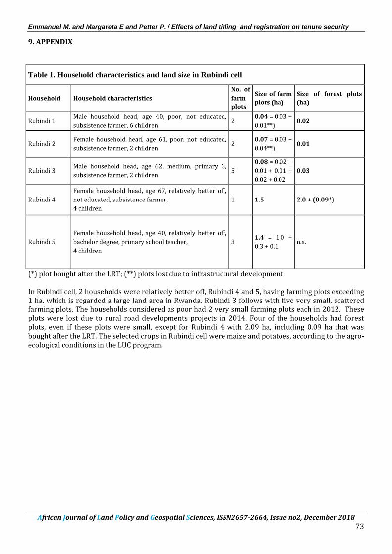
(*) plot bought after the LRT; (**) plots lost due to infrastructural development In Rubindi cell, 2 households were relatively better off, Rubindi 4 and 5, having farming plots exceeding 1 ha, which is regarded a large land area in Rwanda. Rubindi 3 follows with five very small, scattered farming plots. The households considered as poor had 2 very small farming plots each in 2012. These plots were lost due to rural road developments projects in 2014. Four of the households had forest plots, even if these plots were small, except for Rubindi 4 with 2.09 ha, including 0.09 ha that was bought after the LRT. The selected crops in Rubindi cell were maize and potatoes, according to the agro-ecological conditions in the LUC program.
Table 1. Household characteristics and land size in Rubindi cell
Household Household characteristics
No. of
farm
plots
Size of farm
plots (ha)
Size of forest plots
(ha)
Rubindi 1 Male household head, age 40, poor, not educated,
subsistence farmer, 6 children 2
0.04 = 0.03 +
0.01**) 0.02
Rubindi 2 Female household head, age 61, poor, not educated,
subsistence farmer, 2 children 2
0.07 = 0.03 +
0.04**) 0.01
Rubindi 3 Male household head, age 62, medium, primary 3,
subsistence farmer, 2 children 5
0.08 = 0.02 +
0.01 + 0.01 +
0.02 + 0.02
0.03
Rubindi 4
Female household head, age 67, relatively better off,
not educated, subsistence farmer,
4 children
1 1.5 2.0 + (0.09*)
Rubindi 5
Female household head, age 40, relatively better off,
bachelor degree, primary school teacher,
4 children
3
1.4 = 1.0 +
0.3 + 0.1
n.a.
Emmanuel M. and Margareta E and Petter P. / Effects of land titling and registration on tenure security
African Journal of Land Policy and Geospatial Sciences, ISSN2657-2664, Issue no2, December 2018
74
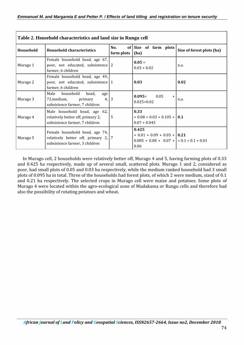
In Murago cell, 2 households were relatively better off, Murago 4 and 5, having farming plots of 0.33 and 0.425 ha respectively, made up of several small, scattered plots. Murago 1 and 2, considered as poor, had small plots of 0.05 and 0.03 ha respectively, while the medium ranked household had 3 small plots of 0.095 ha in total. Three of the households had forest plots, of which 2 were medium, sized of 0.1 and 0.21 ha respectively. The selected crops in Murago cell were maize and potatoes. Some plots of Murago 4 were located within the agro-ecological zone of Mudakama or Rungu cells and therefore had also the possibility of rotating potatoes and wheat.
Table 2. Household characteristics and land size in Rungu cell
Household Household characteristics No. of
farm plots
Size of farm plots
(ha) Size of forest plots (ha)
Murago 1
Female household head, age 67,
poor, not educated, subsistence
farmer, 6 children
2 0.05 =
0.03 + 0.02 n.a.
Murago 2
Female household head, age 49,
poor, not educated, subsistence
farmer, 6 children
1 0.03 0.02
Murago 3
Male household head, age
72,medium, primary 4,
subsistence farmer, 7 children
3 0.095= 0.05 +
0.025+0.02 n.a.
Murago 4
Male household head, age 62,
relatively better off, primary 2,
subsistence farmer, 7 children
5
0.33
= 0.08 + 0.03 + 0.105 +
0.07 + 0.045
0.1
Murago 5
Female household head, age 74,
relatively better off, primary 2,
subsistence farmer, 3 children
7
0.425
= 0.01 + 0.09 + 0.03 +
0.085 + 0.08 + 0.07 +
0.06
0.21
= 0.1 + 0.1 + 0.01
Emmanuel M. and Margareta E and Petter P. / Effects of land titling and registration on tenure security
African Journal of Land Policy and Geospatial Sciences, ISSN2657-2664, Issue no2, December 2018
75
In Mudakama cell, 2 households were relatively better off, Mudakama 4 and 5, having farming plots of 0.13 and 0.555 ha respectively. For Mudakama 4, the land area was made up of 5 small, scattered farming plots. Households considered as poor had only 1 small farming plot each, while the medium ranked household had 2 plots of 0.05 ha in total. Each household had a forest plot, all small or very small. The selected crops in Mudakama cell were wheat and potatoes.
Table 3. Household characteristics and land size in Mudakama cell
Household Household characteristics No. of
farm plots
Size of farm plots
(ha)
Size of forest plots
(ha)
Mudakama 1
Male household head, age 57,
poor, not educated, subsistence
farmer, 6 children
1 0.04 0.02
Mudakama 2
Female household head, age 78,
poor, not educated, subsistence
farmer, 4 children
1 0.02 0.02
Mudakama 3
Female household head, age 60,
medium, not educated,
subsistence farmer, 4 children
2 0.05
= 0.03 + 0.02 0.005
Mudakama 4
Male household head, age 53,
relatively better off, primary 4,
subsistence farmer, 7 children
5
0.13
= 0.04 + 0.03 + 0.025 +
0.025 + 0.01
0.09
Mudakama 5
Female household head, age 53,
relatively better off, primary 4,
subsistence farmer, 4 children
3 0.555
= 0.3 + 0.13 + 0.125 0.02
Emmanuel M. and Margareta E and Petter P. / Effects of land titling and registration on tenure security
African Journal of Land Policy and Geospatial Sciences, ISSN2657-2664, Issue no2, December 2018
76
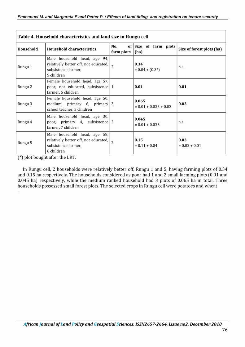
(*) plot bought after the LRT.
In Rungu cell, 2 households were relatively better off, Rungu 1 and 5, having farming plots of 0.34 and 0.15 ha respectively. The households considered as poor had 1 and 2 small farming plots (0.01 and 0.045 ha) respectively, while the medium ranked household had 3 plots of 0.065 ha in total. Three households possessed small forest plots. The selected crops in Rungu cell were potatoes and wheat .
Table 4. Household characteristics and land size in Rungu cell