Introducing Our Guest Speaker, Eric Alger June 2014 El Agrimensor El Agrimensor Channel Islands Chapter of the California Land Surveyors Association Table of Contents Chapter News 2 Calendar of Events 3 Board of Directors Minutes 3 NSPS Update 4 Caltrans Liaison Report 4 College of the Canyons Fall Semester Begins 4 Jobs for Hire 5 2014 Chapter Membership Application 6 2016 Update on ALTA/ACSM Standards 9 Annual Chapter Picnic 15 Contacts 16 Summer is almost upon us and daylight hours are plentiful. A traffic re- lated incident with one of our local surveyors recently reminds us of the dangers we may encounter during field work. Sometimes it’s easy to be- come complacent regarding safety and effort is necessary to remain vigi- lant. Our profession does include some inherent risks, but a little plan- ning, equipment, and situational awareness can help reduce or minimize them. We are getting close to the magic number. This month we will be contact- ing local surveyors (some being past members) to encourage them to be- come current members of the local CLSA Chapter and the state association. We already know the answer to the ultimate question of life, the universe, and everything is 42 (Hitchhiker’s Guide), but we only need 41 local/state members to qualify for a third Chapter Director in 2015. We will have lists available at the next meeting – Thursday, June 19 – in Ventura. Upcoming Local Events – please invite a fellow surveyor (member or not): Joint Meeting with Los Angeles Chapter (July 10th) and Channel Islands Picnic (August 2nd, see page 15). Bill Hurdle, PLS [email protected]President’s Message Eric Alger is a GIS Specialist with the County of Ventura, IT Services, GIS Divi- sion. He has been with the County for ten years and has been involved with the development and enhancement of the County View application, which can be seen here: http://gis.ventura.org/countyview/ Eric will be presenting a demonstration of the County View application and how it can benefit surveyors.
Transcript
Introducing Our Guest Speaker, Eric Alger
June 2014 El Agrimensor
El Agrimensor Channel Islands Chapter of the California Land Surveyors Association
Table of Contents
Chapter News 2
Calendar of Events 3
Board of Directors
Minutes
3
NSPS Update 4
Caltrans Liaison
Report 4
College of the Canyons
Fall Semester Begins 4
Jobs for Hire 5
2014 Chapter
Membership
Application
6
2016 Update on
ALTA/ACSM
Standards
9
Annual Chapter Picnic 15
Contacts 16
Summer is almost upon us and daylight hours are plentiful. A traffic re-
lated incident with one of our local surveyors recently reminds us of the
dangers we may encounter during field work. Sometimes it’s easy to be-
come complacent regarding safety and effort is necessary to remain vigi-
lant. Our profession does include some inherent risks, but a little plan-
ning, equipment, and situational awareness can help reduce or minimize
them.
We are getting close to the magic number. This month we will be contact-
ing local surveyors (some being past members) to encourage them to be-
come current members of the local CLSA Chapter and the state association.
We already know the answer to the ultimate question of life, the universe,
and everything is 42 (Hitchhiker’s Guide), but we only need 41 local/state
members to qualify for a third Chapter Director in 2015. We will have lists
available at the next meeting – Thursday, June 19 – in Ventura.
Upcoming Local Events – please invite a fellow surveyor (member or not):
Joint Meeting with Los Angeles Chapter (July 10th) and Channel Islands
8/2/14 CLSA Chapter Picnic (see Page 15) Bob Kildee Park, Camarillo
8/21/14 Chapter Meeting TBD
Speaker: Zach Hunt (CIRGIS)
9/17/14 & 9/19/14 Seminar by Richard Snay TBD
Topic: Evolution of the North American Datum of 1983
Calendar
Directors Report for the CLSA Board of Directors Meeting, April 26, 2014
We accomplished one big task: The revisions for the Association bi-laws were finally
approved. Ballets and a copy of the amended bi-laws with instructions will be mailed to Association
Corporate Members soon. Per the current bi-laws, “The adoption of said amendment shall require two-
thirds of such votes cast.” We approved a $3,000.00 budget item to purchase a new CLSA exhibitors booth. If you have
seen the old one, it was held together with rubber bands and duct tape, and the pictures were a bit out-
dated. By the way, this is something our Chapter can borrow; we helped pay for it. We agreed to some revised language for the Discussion Board Guide. Hopefully, the revisions
will clear up the issue of posting someone else’s maps, deeds, etc. without permission. The slate of Association Officers was approved for 2015: 2015 President Elect (this is like Vice
President) is Rodger Hanlin (Northern Counties), 2015 Secretary is D. Ian Wilson (Sacramento
Chapter), and 2015 Treasurer is Jeff Steffan (Cascade Chapter). The Workshop Committee has several events in the works. An Opus Seminar, taught by Bill
Stone and Mark Armstrong will be on June 9-10 in Riverside, and June 11-12 in Santa Rosa. They have
confirmed the dates of September 17 and 19 for a seminar by Richard Snay, on the evolution of the
North American Datum of 1983. The locations are yet to be determined. The CSRC is planning
seminars at three locations across the state. They are always looking for webinar and seminar ideas. A committee has presented an MOU (Memorandum of Understanding) to NSPS and is awaiting
a response. We (the Directors) have not seen those terms at this time, but it appears that it is just a
matter of negotiating a few details, then the MOU will be reviewed for approval by the Directors. Once
approved by the Directors, the MOU should go to all corporate members for a vote on CLSA
participation in 100% membership in NSPS. If any Chapter member would like to see a complete agenda or minutes of any Board of
Directors meeting, we can email a copy to you upon request. These reports are often over 100 pages,
Due to low student count, this wonderful program is in jeopardy of closing
down. So if you’re considering improving your skills, or you know of some-
one who is studying for their LS or LSIT, please refer them to College of the
Canyons.
Page 5 El Agrimensor
Jobs For Hire
The City of Ventura will open recruitment beginning June 23 for a Survey Specialist position in the Public Works Department with the posting of a job flyer. If you have an interest, or know of someone with interest in this position, please visit www.cityofventura.jobs for more information and to view the job description (see sidebar on webpage). Applicants can register and fill out a job application online in advance of the job posting. A supplemental questionnaire will become available
when the job is posted and must be completed along with submission of the application on-line before the July 13, 2014 filing deadline.
GIT Technical Specialist III Camarillo, Irvine or Ontario, CA
RBF Consulting, a Company of Michael Baker International, has an exciting opportunity for a GIT Technical Specialist III to join our Surveying Geomatics team in our Camarillo, Ontario or Irvine, CA office.
The GIT Technical Specialist’s responsibilities will include:
▪ Assist in managing mapping projects in the private land development and public/municipal sectors.
▪ Accept professional responsibility for some specific Land Survey assignments.
▪ Develop and mentor technical staff.
▪ Ensure project goals/objectives are met within prescribed timeframe and funding parameters.
▪ Develop and maintain work plans, budgets, schedules and staffing for all project phases.
▪ Assist in developing and writing proposals, define scopes of work and cost/bid estimates.
▪ Perform mapping related research, boundary analysis, calculations, exhibits, and legal descriptions for a variety of land development and public works related projects from small infill developments to large master-planned communities and public related improvement projects throughout Southern CA.
▪ Perform mission planning and post processing for GPS surveys.
▪ Prepare flight plans, control schemes and coordination for aerial mapping projects.
▪ Review construction plans and perform calculations for layout staking and prepare exhibits.
▪ Perform survey data processing and prepare reports for spatial monitoring.
▪ Compile topographic information, compute and manipulate digital terrain models for topographic mapping.
▪ Prepare and/or oversee the preparation of final maps, parcel maps, record of survey and ALTA maps; and prepare and/or oversee preparation of legal descriptions and associated plats, and boundary analysis, as well as work closely with engineers to ensure coordina-tion of technical surveying and engineering aspects of a project.
▪ Direct staff in preparation of various survey/mapping related projects.
Requirements:
▪ Professional Land Surveyor License in California
▪ Bachelor’s degree in Surveying Geomatics, Engineering or related field, or equivalent in experience.
▪ Minimum of ten (10) years of Surveying Geomatics experience with increasing levels of responsibility
▪ Knowledge of California Subdivision Map Act and Land Surveyors Act, and a thorough knowledge of drafting standards and processing project requirements. Baker, founded in 1940, provides professional engineering and consulting services for its clients worldwide. With nearly 3,000 em-ployees in over 100 U.S. offices, Engineering News-Record consistently ranks Baker in the top 8 percent of the 500 largest U.S. engi-neering design firms and in the top 25 of numerous individual markets. The firm's primary business areas are architecture, aviation, defense, environmental, geospatial, homeland security, municipal & civil, oil & gas, rail & transit, telecommunications & utilities, transportation, urban development and water. Baker’s headquarters is located in Moon Township, Pennsylvania, near Pitts-burgh. Baker recently became part of Michael Baker International, LLC, a leading provider of end-to-end engineering, development, intelligence and technology solutions with global reach and mobility. Baker offers excellent benefit packages that includes: Medical, Dental, Vision, Disability Insurance, Life Insurance, Flexible Spending Accounts, Additional Paid Time Off, Flex-Time, 401-K Retirement Plan, Tuition Reimbursement and Employee Credit Union. To learn more, please visit us on the web at www.mbakercorp.com. To apply for this position, please log on to www.mbakercorp.com/careers select “Job Search” and reference IRC47214 in “Keywords.” (Note: if you are unable to apply online, please contact the Systems Administrator at [email protected] ) Baker is an EEO/AAP (M/F/V/H) e-Verify Employer
The NSPS committee on the ALTA/ACSM Standards met in San Diego in April and made it through just over 2 of
the 8 pages of suggestions. I have attached the list with my notes in blue on how they wanted to address each sugges-
tion. For those that were “approved,” I will eventually draft language for everyone’s review.
It seemed to me that many of the committee’s decisions were based on whether the suggestion was truly relevant
in (1) adding value to, or (2) clarifying wording in the standards - or whether it would just add unnecessary words to an
already detailed document. That is how it should be and I respect that attitude; this really should not be a “teaching”
document any more than absolutely necessary.
Since I last sent the listing to you, there have been a couple of new suggestions which I have included near the
end of the document.
I am, at the same time as all of this, engaging the ALTA committee – in particular as to those items on the list
that specifically mention needing its opinion or input.
In the meantime, I will work with the group that was in San Diego to continue working incrementally on the list before we
meet again face-to-face in the fall. For everyone else, if you have thoughts on any of the suggestions, please let me know
so they can be documented and acknowledged. And, regardless, I will keep everyone in the loop as we progress.
2016 Suggestions (as of 05/07/2014)
Review entire document for proper and considered use of the words “all,,” “any," and “necessary.”
Section 1, 7 or 8 – Limit period of time that the survey is valid (not a statute of limitations, just re: usability of the survey for current
transaction). [YES to the extent that it is worth discussing with ALTA. One suggestion was to send unsigned versions of old surveys,
so they will have to order an ‘update’ if they want a signed one,]
Section 1 or 3 – State that surveyors do not/cannot determine ownership; have no legal authority. [NO. Some in the group like the
idea, some do not, even though they know the idea is true. Suggested it is a contractual/education issue.]
Section 2 – Mention easements as another type of atypical property [grk] [YES]
▪ Mention not just insurer, but lender and anyone else not responsible for payment unless contractually bound? [NO; contract issue]
▪ Purchase agreement to be provided if an original survey. [NO; contract issue]
Section 3 – Include copyright statement [Curt Sumner] [Consensus to look at it further.]
Section 3 or 1 - Issues/considerations when dealing with out-of-country banks. [Ask Victor O. Schinnerer Co. (Professional liability
managers who assist NSPS in reviewing the standards for liability issues)]
Section 3, 1, 7, or 8 - Time frame limitation on validity of survey? [Same as above; also talk to ALTA]
Section 3.A – Add “Any ALTA/ACSM Land Title Survey ordered on or after [Effective Date] must be conducted in accordance with
these Standards. Any ALTA/ACSM Land Title Survey delivered on or after [Effective Date] may be conducted in accordance with the
2011 Standards if the order was placed prior to February 23, 2011.” [NO; but write this as one of a series of FAQs to put on NSPS and
ALTA websites.]
Section 3.B – Remove reference to “Standards of Practice”? [grk] [NO; but remove "Federal Agencies” from this list; there are none.]
▪ Look at 95% vs. 2 Sigma. [YES. Remove parenthetical "(or 2 Standard Deviations)"]
Section 3.D – Specifically state that an ALTA/ACSM Land Title Survey IS a boundary survey [Curt Sumner] [NO; this is already
addressed to some extent.]
▪ Include field in front of 'survey' (last word). [YES.]
▪ Address appurtenant easements? [add - "...of any property being surveyed as part of an ALTA/ACSM Land Title Survey (including
appurtenant easements if requested pursuant to Table A item 20a and/or 20b)...] [NO.]
Section 3.E – Measurement standard shall be in accordance with the measurement standard of the state in which the property resides.
If the state has no such regulation or statute, then follow 3.E. (grk) [NO; the ALTA/ACSM Standards should provide for its own spe-
cific measurement standard]
▪ Precision vis-à-vis local vs. network [See ‘new’ NGS precision standards] [ASK Dave Doyle]
Section 3.E.i – approximately 2 standard deviations [95% is actually 1.96 sigma] [Similar comment above; simply remove reference
to 2 standard deviations.]
Section 3.E.ii(?) – Add a comment similar to the last sentence in paragraph 3 of the 1962 standards about differences of opinions with
other surveyors. [Gary Kent] But include wording about relying on the same evidence. (i.e. “It is expected that the exercise of profes-
sional judgment by the surveyor will minimize differences of opinions with other professional surveyors exercising equally prudent
judgment in such situation and in relying on the same evidence.” [KAPS Lexington] [NO; even though there is broad agreement with
the statement, it doesn't belong in the standards.]
Page 10 El Agrimensor
Section 4 –“It is recognized that for the performance of an ALTA/ACSM Land Title Survey, the surveyor will be provided with appro-
priate data which can be relied upon in the preparation of the survey. The request for an ALTA/ACSM Land Title Survey shall set forth
the current record description of the property to be surveyed or, in the case of an original survey, the current record description of the
parent parcel that contains the property to be surveyed. Complete copies of the most recent title commitment the current record de-
scription of the property to be surveyed (or, in the case of an original survey, the parent parcel), the current record descriptions of ad-
joiners (except where the adjoiners are lots in platted, recorded subdivisions, unless the client has selected Table A item 13), any record
easements benefiting the property, the record easements or servitudes and covenants burdening the property (all hereinafter referred to
collectively as "Record Documents"), documents of record referred to in the Record Documents, documents necessary to ascertain, if
possible, the junior/senior relationship pursuant to Section 6.B.vii. below, and any other title documents containing desired appropriate
information affecting the property being surveyed, and to which the ALTA/ACSM Land Title Survey shall make reference (all herein-
after referred to collectively as "Record Documents"), shall be provided to the surveyor for use in conducting the survey. Reference is
made to Section 3.B. above. [YES to moving the parenthetical definition of Record Documents. Ask ALTA if they need adjoiner
names. YES to clarifying with the suggested parenthetical. Craig will consider the Michigan problem whereby they have a definition
of parent tract that is not what we contemplate on the standards.]
▪ Add “according to current public records” with regard to adjoiner and subject deeds. [This should be a NOTE on the survey by the
individual surveyor, not specified in the standards.]
▪ Divide into 2 paragraphs, starting with “Complete copies of….” This one paragraph is too long; need go find a logical place to bifur-
cate it. [YES]
▪ Specify a reasonable time frame in which the documents need to provided to the surveyor. [NO; this is a contractual/communication
issue, not a standards issue.]
▪ Use “Title commitment, title policy, abstract of title and/or title opinion” instead of “title commitment?” [ALTA will need to pro-
vide guidance]
▪ Clarify research responsibilities. If titles are supposed to be provided, and they are not, there is no way to provide an adequate cost
estimate that will foresee that event. When one party does not perform, Surveyors, not title researchers, are the ones that suffer. The
ALTA/ACSM requirements are supposed to reduce 3rd parties misunderstandings and they do not. There needs to be an educational
effort on behalf of the title researchers and title companies. I do not understand where the line is drawn where title researchers are
allowed to stop researching. (Vermont). [NO; Gary will write an NSPS News and Views article and an FAQ addressing this.]
Section 5 – Introductory comments – Unless noted otherwise, all features to be located pursuant to Section 5 should be located to an
appropriate degree of precision based on various considerations such as the use of the property, the contemplated use of the property, if
known, and the location of the property.
▪ Express the intent of “on the ground” vis-à-vis state plane grid distances. Section 5.A.i – “The location, size, character and type of any monuments, and the location, description, and character of any lines, that
control…”
Section 5.A.ii - “The location, size, character and type of any monuments found …”
Section 5.B.ii – Pavement on the other side of the street? What about pavement in limited access rights of way?
Section 5.B.v – “Without expressing a legal opinion as to the ownership or nature of the possible encroachment…” Section 5.B.vi – Look at wording; does this include right of way width on the opposite side of the street? Also, define “parcel cor-
ners” (i.e., fence corners? monuments?)
▪ “Recovered in the process of conducting the fieldwork" Section 5.C.ii and iii – Specify that surveyor does not need to show trees, bushes, shrubs and other natural vegetation on boundary line
[unless specifically included in the terms of the contract?]
▪ Give examples?
Section 5.C.ii – "Within 5 feet of a perimeter boundary line?" ▪ Show pipeline markers further than 5 feet from the boundary line?
Section 5.E.ii – “ways of access” rather than R/W?
Section 5.F - Look at wording vis-à-vis does the surveyor need to show all gravesites in a cemetery or burial ground?
Section 5.G.i – Define “bordering on.” Consider ‘within 5 feet’ to be consistent with Section 5.C.ii.?
Section 5.G.i and ii – Locate water features to the appropriate degree of precision (similar wording as used in 5.D.)
Section 5.G.ii – Move 5.G.ii. to 5.C. (‘and reference 5.G.ii.’ (??)) Section 6.B – Add a new subsection re: the relationship of surveyed tract/record description/new description to the title commitment
description?
▪ Address the validity of a parcel vis-à-vis zoning ordinances (illegal split; not enough square feet; etc.)
▪ Address grid vs. ground distances on survey and in any description prepared. [Illinois discussion 4/2013] ▪ Address the creation of invalid parcels (e.g., through foreclosure or noncompliant splitting of parcels). [“An issue that comes up
regularly in my [state] that doesn’t appear to be addressed by the standards is whether a parcel is valid. The Assessor’s office will split
anything that a deed comes through on but it may be a violation of the platting laws and the parcel may be unbuildable. This is a prob-
Update on 2016 ALTA/ACSM Standards Work (cont’d)
Page 11 El Agrimensor
lem that is fundamental to the use of the property. I’m working with several banks that have foreclosed on properties only to find that
they don’t have a valid parcel and the another party, often the entity that they foreclosed on, has them over a barrel.] Section 6.B.i. – If a new description is prepared (1) don’t ‘screw up the title,’ and (2) explain in a note the relationship of the new de-
scription to the record description.
▪ Consider statement that the property described hereon is one and the same as the property in Schedule A of title work provided to the
surveyor
Section 6.B.iii or 6.B.iv - Label P.O.B. Section 6.B.iii. – Suggested rewording “Where measured or calculated dimensions are shown at the discretion of the surveyor, such
dimension shall be shown in addition to, and differentiated from, the corresponding record dimension.” [Ben Drerup, Georgia]
Section 6.B? – Add note similar to 6.B.vi. for dedicated roads with unknown right of way width. [Dick Bales see 10/5/12 email]
Section 6.B.vi – Clarify water boundary as being a property boundary vs. simply the bounds of the water feature.
Section 6.B.vii – Also disclose to buyer if different from client.
Section 6.B.ix – Rename as Section 6.C.xiii. Section 6.B.xi – Add a new subsection xi. requiring that evidence of possession/occupation and possible encroachments be dimen-
sioned (referring to Sections 5.C.i. and iii.)
Section 6.C.i – “Location, width and recording information of … ▪ Including any easements identified in Table A if a title commitment provided to the surveyor
Section 6.C.ii – Add an item for illegible documents [KY Seminar 11/12/2010] ▪ Add new (f) “that has been released or otherwise terminated.” and move the current (f) to (g)
▪ Incorporate “lack of observed evidence shall be noted” clause in the 2nd to the last sentence of 2005 paragraph 5h into new standards? ▪ In the case of an off-site/Schedule A/insured easement - No evidence of the easement parcel being used or blocked by the owner of
the fee simple interest observed in the process of conducting the survey (associated with Table A item 20). (Dick Bales)
▪ Access to easement
▪ Address “Affected by” an easement
Section 6.C.iii – Make the surveyor’s burden consistent with Section 5.B.iii. (‘Visible’ vs. ‘observed in the process of conducting the
survey.) “A note if no physical access to a public way was visible observed in the process of conducting the survey Section 6.C.iv – “The width of abutting rights of way, and those rights of way that cross the surveyed property, and the source of such
information…” Clarify responsibility of surveyor as to R/W research. Section 6.C.vi – Are ‘names’ of adjoiners really necessary? What if adjoiner is a condo with many percentage interests? Include con-
dos developments with subdivisions? Any other similar exceptions?
Section 6.C.vii(?) – Prior to or on delivery of… [re: notification of gaps or overlaps]
Section 6.D – Require a table of Schedule B2 items? ▪ Tax Parcel number?
Section 6.D.i – Standard legend?
Section 6.D.iii. – Reword to “No buildings on the surveyed property observed in the process of conducting the survey” [grk]
Section 6.D.iv – Show company website instead of registrant’s email?
Section 6.D.v. – Number of total pages if multiple pages. Section 6 - Combine the various sub-sections that require “Notes on the face of the plat or map” into one sub-section in Section 6; or
simply add a new Section 6 subsection that all notes should be in some sort of singular surveyors report or otherwise presented in some
organized fashion. Might give a better appearance/presentation than a bunch of disparate notes.
Section 7 – In certification “The field work was completed on ________ [date].” ▪ Add Title Company policy number to the certification to better protect the surveyor from unauthorized reuse of the plat. [12/1/2010] ▪ In the certification “… and includes Items _____ of Table A thereof as selected by the client” [From Illinois – one person thought
that as currently written, it could be interpreted to mean that the surveyor needed to study the surveys and list the items of Table A that
appear on the survey regardless of whether or not they were selected by the client. The rest of the audience disagreed this interpreta-
tion.]
▪ Provide guidance on how to word a HUD certification on a separate sheet of paper. (Bob Dahn)
Section 8 – Clarify that signed digital copies do not have to be provided unless contracted [ R.A. Smith National] ▪ Consideration of the ‘fall-out’ of statutes or ordinance requirements that require filing of new surveys or recordation of surveys or lot
line adjustments.
Section 8 (?) – Caution on notes on the plat/map or certifications (even on separate sheets) that call for express warranties of violation
of registration laws. (gk) Table A items –Identify which are negotiable and which are not? Maybe use standard wording “as specified by client, etc.) to indicate
which are negotiable. Or, have Table A and Table B – one contains non-negotiable items and one contains negotiable items. [Bock
and Clark]
▪ No additional items may be requested other than what is in the standards and in Table A items 1-21.
▪ Note on face of plat/map explaining any modifications to Table A items that may have been negotiated? [grk and others]
Update on 2016 ALTA/ACSM Standards Work (cont’d)
Page 12 El Agrimensor
▪ Introductory comment on design surveys – perhaps should be moved to Section 1. [grk]
▪ Introductory Comments – Additional items should be 22a, 22b, etc.
Table A Item 1 – Required if the state has no regulations otherwise. Clarify how this option relates to mandatory state laws. (Judy B.)
Table A Item 2 – Address “of the surveyed property.” [grk]
Table A Item 3 – consider an option for elevation determination and/or elevation certificate Table A Item 4 – “Other areas” – clarify what this means (other specified areas on or within the surveyed property that the client may
wish to have areas for? Or square feet vs. acres vs. hectares?)
▪ Specify precision of area.
Table A Item 6 –“As provided by the insurer when it has been requested to provide a zoning endorsement.” ▪ “Provided by ?” [the standards cannot obligate a title company…]
▪ Require that a zoning letter be provided [Texas surveyor]
Table A Item 6a and 6b – Start with the word “List.” Table A Item 6b – Surveyor will not graphically depict setbacks due to interpretation unless the jurisdiction will specifically outline to
the surveyor how the setbacks apply to the surveyed property.
Table A Item 7a – Include in the main part of the standards under 5.D. [Dick Bales] Table A Item 8 – Include in the main part of the standards (would need to look at exact wording). [Dick Bales]. Or do NOT include
do this since could create a large expense and effort on a large site [Kansas]. Also, “located to the appropriate degree of precision.” Table A Item 9 – “Striping, number and type (e.g. handicapped, motorcycle, regular, etc.) of clearly identifiable parking spaces…”
Make striping optional.
▪ This item now inadvertently includes striping in parking garages. [grk]
Table A Item 11a - Include in the main part of the standards under 5.E. [Dick Bales]
Table A Item 11b – Clarify if the examples apply to 11(a) or 11(b). Remove railroads as examples of utilities. ▪ Discussion on one-call issues. (Craig Amey) Table Item 15 – “Rectified orthophotography, photogrammetric mapping, airborne/mobile laser scanning remote sensing and other
similar products, tools or technologies
Table A Item 16-18 – “Observed in the process of conducting the survey” [grk]
Table A Item 18 – Remove in favor of a Phase One Environmental Assessment. Perhaps a note in the standards in that regard? [grk]
Table A Item 19 – “Qualified persons” not “appropriate authorities.” ▪ “Note – showing a wetlands delineation of the plat or map is not a certification by the surveyor that the delineated area is, in fact, a
wetlands or not.” ▪ Write out more specifically what we mean viz. “If wetlands have been delineated and marked by qualified persons prior to the survey,
the surveyor shall locate those markers and show them on the survey.” [grk] Perhaps require a note (similar to the water boundaries
note) that the surveyor cannot certify as to the existence or non-existence of wetlands, only show the delineation marks. [grk]
▪ Suggested/required note to clarify what surveyor did on this item (Ohio). [This may be taken care of by fixing the wording of the
item. [grk] Table A Item 20 – “Appurtenant to the surveyed property” rather than “offsite.” Clarify that what this requirement is intended to do is
to treat the appurtenant easement as if it were a fee parcel from the standpoint of the ALTA/ACSM requirements (see comment on 20a
below). [grk]
▪ Suggestion to remove due to problems when quotes are given without benefit of a title commitment [Texas surveyor] Table A Item 20a – Should refer back to Section 5 requirements for any such easement. [grk] Should require that the survey show or
note if there is no observed evidence of the easements parcel’s use by the owner of the easement. [Dick Bales]
Table A Item 21 – ▪ Better define what is meant by “throughout the contract term.” (i.e. as requested by client?)
▪ Reconsider?
▪ Suggestion to remove due to a perceived conflict with limit of liability clauses [Texas surveyor] Table A Item 22 – if used, there needs to be a note explaining what was negotiated. Also, if there is more than one additional item,
they shall be identified as 22a, 22b, 22c, etc.
Table A New Item – Location of environmentally or culturally significant areas as designated by appropriate authorities. ▪ Latitude and Longitude at a client-designated location on the surveyed property
▪ Evidence of subsidence (suggestion from Alabama)
▪▪▪Throughout the standards – Relook at the term “Observed in the process of conducting the survey.” Does this provide an easy out
for the surveyor? [Chicago Title’s regional counsel] Provide a sample plat and sample AutoCAD standards (e.g. lineweights) showing
various types of notes, line weights, etc.? Address treatment of “Updates?”
▪▪▪An indirectly related item: When an owner’s affidavit and “old” survey are used at a closing, provide for the surveyor whose survey
is being used - acknowledge payment for its use, thus preventing violation of his or her federal copyrights.
Post 3/11/2014 email notice
Update on 2016 ALTA/ACSM Standards Work (cont’d)
Page 13 El Agrimensor
Section 1 – Add the same sentence as the first sentence of Section 4 to Section 1, only add the word “equally” (i.e., “It is equally rec-
ognized that…”. [from BLM]
Section 2 (Section 1?) – Clarify that ALTA/ACSM Land Title Surveys may be performed on non-fee parcels. [from BLM]
Section 4 – “Legible” copies
▪ Current record descriptions of adjoiners ▪ Shall be provided to the surveyor in legible form and be the entire complete instrument or document for use in conducting the
survey.
▪ Define “most recent” title commitment
▪ Clarify what is to happen if record documents are not provided
Section 4 (?) – Define original survey vis-à-vis common grantor vs. simply the first monument set at a corner [from BLM] Section 4 (?) (also Table A Item 11, and perhaps other locations) – Clarify the responsibility of the surveyor with respect to obtain-
ing non-public documents that might be necessary for conducting the survey. [from BLM]
Section 5.A – Add item iii: “Any monuments found or set on the boundary or parent parcel.” [from BLM] Section 5.B.v – Without expressing a legal opinion as to ownership or nature, the location and extent of any potentially encroaching
driveways, alleys, and other ways of access from adjoining properties onto the surveyed property within ten feet on each side of any
boundary line being surveyed (unless additional information is needed to clarify the possible encroachment) observed in the
process of conducting the survey.
Section 5.C.ii – Identify the types of wires (also Table A item 11)
Section 6.C.ci – Require PIN/APN numbers for surveyed property and adjoiners (T.D’A) Section 8 - Digital copies of the plat or map may be provided in addition to, or in lieu of, hard copies in accordance with the terms of
the contract. [some states like SC and NY require a raised seal]
Introduction to Table A – Clarify that Item 22 is not only for engineering design-related requests. Table A Item 11 – Include options or other content vis-à-vis Levels A, B, C, or D from ASCE Standard 38-02. See http://
www.dot.ga.gov/doingbusiness/utilities/sue/Documents/ASCE%2038-02.pdf or, mention somewhere in the standards that subsurface utility engineering is a specialty practice that has a separate set of nationally
accepted standards that are independent of the ALTA/ACSM Standards. ▪ Identify the types of wires
Update on 2016 ALTA/ACSM Standards Work (cont’d)
Did You Know? * Captain James Cook was one of the first
surveyors who sailed into every ocean and
surveyed all of the areas he discovered. He was
also one of the first English men to step on every
major continent in the world, and the first to cross
both the Antarctic and Arctic Circles. His
surveying equipment included a brass telescopic, a
theodolite, and small station flags.
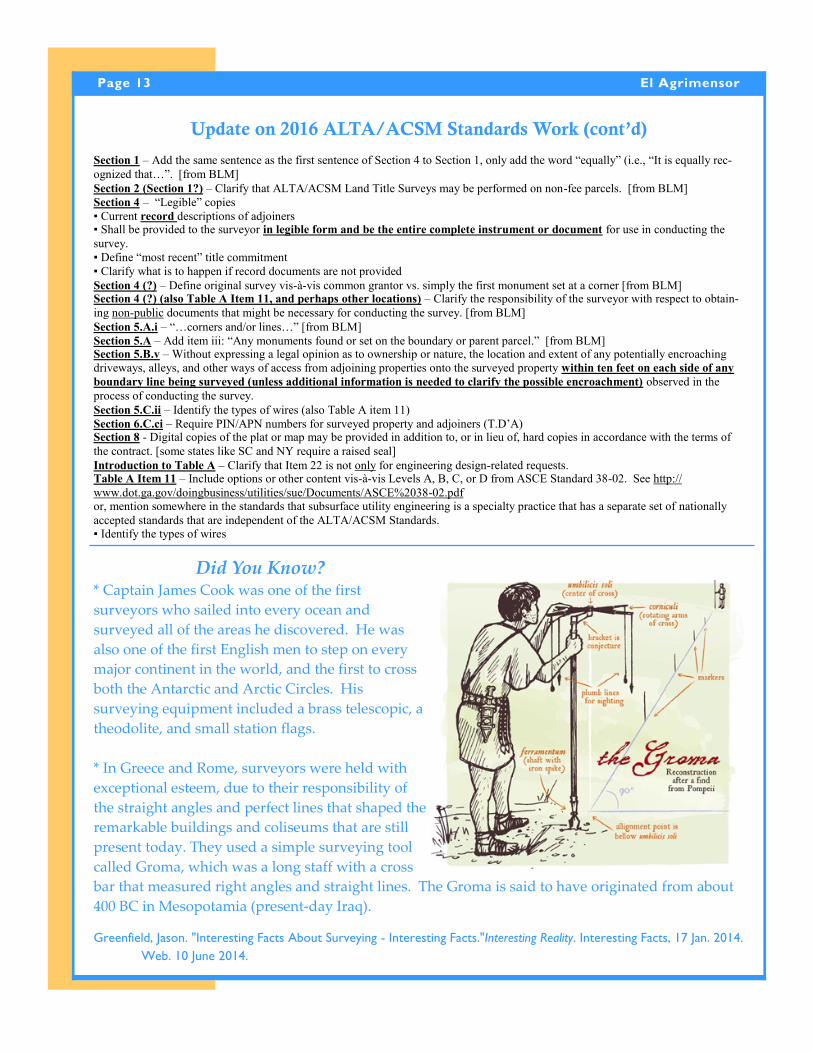
* In Greece and Rome, surveyors were held with
exceptional esteem, due to their responsibility of
the straight angles and perfect lines that shaped the
remarkable buildings and coliseums that are still
present today. They used a simple surveying tool
called Groma, which was a long staff with a cross
bar that measured right angles and straight lines. The Groma is said to have originated from about
It is a violation of state law for an unlicensed individual to offer and/or practice civil, electrical, or mechanical engineering, land surveying, geology, and geo-
physics unless he/she is appropriately licensed by the Board. Our Board takes this unlicensed offering and/or practice of professional services seriously. Since
the Enforcement Unit is limited in its resources and cannot proactively search for unlicensed activities, we rely on others to inform staff when unlicensed work
is being offered and/or performed. The Board is asking that any listing of these services by an individual not licensed to perform those services be sent to our
office for review. Licenses can be verified on our websites, www.pels.ca.gov and www.geology.ca.gov, or by calling the Board Office. If you become aware of
unlicensed and/or practiced activities, please provide us with documentary evidence of the alleged unlicensed activity. This may include copies of the adver-
tisement, the written contract, a business card, or other documents that may support the allegation. You may choose to submit the complaint anonymously, if
you wish. The goal of the Board is to ensure understanding of and compliance with the laws through education to prevent future violations and enforcement
actions, when necessary. Any questions or concerns you may have regarding possible unlicensed practice should be directed to Enforcement Analyst Larry
Kereszt of The Board For Professional Engineers, Land Surveyors and Geologists by email at [email protected] or telephone at (916) 263-2240.
A Message from the Board About Unlicensed ActivityA Message from the Board About Unlicensed Activity