I ORGANIZATION OF AMERICAN STATES INTERNATIONAL HYDROLOGICAL PROGRAMME UNESCO/OAS ISARM Americas Programme TRANSBOUNDARY AQUIFERS OF THE AMERICAS 2 nd COORDINATION WORKSHOP El Paso, Texas, USA November 10 th -12 th , 2004 FINAL REPORT Washington, D.C. May, 2005
Transcript
I
ORGANIZATION OF
AMERICAN STATES
INTERNATIONAL
HYDROLOGICAL
PROGRAMME
UNESCO/OAS ISARM Americas Programme TRANSBOUNDARY AQUIFERS OF THE AMERICAS
2nd COORDINATION WORKSHOP El Paso, Texas, USA
November 10th-12th, 2004
FINAL REPORT
Washington, D.C.
May, 2005
II
With the support of Deltamerica Project
Acknowledgements The UNESCO/OAS ISARM-Americas Steering Committee wishes to thank:
• IBWC/CILA U.S. - MX for the generosity in hosting the event and for the support expressed during the Workshop;
• The UNESCO-ROSLAC and the Deltamerica Project (GEF – PNUMA, OAS, IWRN) for co-sponsoring the workshop;
• ISARM-Americas National Coordinators for their essential contribution to accomplish the Programme tasks;
• OSDE staff assistants at the GS/OAS Headquarters-Washington D.C., for the constant and untiring support in organizing the workshop and divulgating information and news to the countries.
III
UNESCO/OAS ISARM AMERICAS PROGRAMME (Transboundary Aquifers of the Americas) SECOND COORDINATION WORKSHOP
El Paso, November 10th - 12th, 2004
TABLE OF CONTENTS Page
TABLE 1.a,b Matrix of the American Transboundary Aquifers and Countries sharing the Resources
8-9
FIGURE 1. Approximate location of the transboundary aquifers identified in the Americas 7 PHOTOS 1.Welcome Ceremony – Opening speech by IBWC/CILA 11 2. Field-trip to the Fred Hervey Water Reclamation Plant in El Paso 21
1. TRANSBOUNDARY GROUNDWATER IN THE AMERICAS: AN OVERVIEW
1
2. UNESCO/OAS ISARM AMERICAS PROGRAMME: BACKGROUND AND RESULTS
3
3. EL PASO WORKSHOP
9
3.1 WELCOME TO PARTICIPANTS AND WORKSHOP AGENDA
9
3.2 ISARM-AMERICAS CASE-STUDY PRESENTATIONS
14
3.3 SPECIAL PRESENTATIONS ON “IBWC/CILA ISARM AMERICAS HUECO BOLSON CASE STUDY”
14
3.4 SHORT TECHNICAL PRESENTATIONS
17
3.5 LEGAL ASPECTS FOR TRANSBOUNDARY AQUIFERS
17
3.6 INVITED PRESENTATIONS
18
4. FUTURE ACTIONS AND RECOMMENDATIONS
18
5. IDENTIFIED PRIORITY TRANSBOUNDARY AQUIFERS AND STATUS IN 2005
20
6. WORKSHOP CLOSURE
20
IV
APPENDICES 1. COUNTRY TECHNICAL PAPERS AND INVITED SPEAKERS CONTRIBUTIONS:
22
1.1 ISARM-AMERICAS CASE-STUDY PRESENTATIONS
• A.T. Yrenda- Toba – Tarijeno (Argentina-Bolivia-Paraguay) National Coordinators: Ofelia Tuchneider; Julio Torres, Celso Velasquez
• A.T. Artibonito and Masacre (Haiti-Rep. Dominicana) National Coordinators:
Yvelt Chery; Jose Febrillet
• A.T. Pantanal (Bolivia-Brazil-Paraguay)National Coordinator for Brazil: Julio Kettelhut
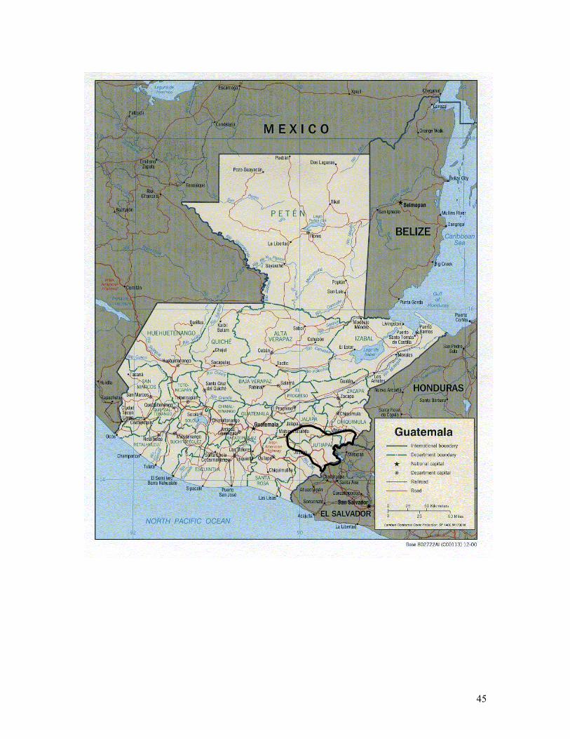
• T. Ostua-Metapan (El Salvador-Guatemala) National Coordinators: Celina
Mena; Fulgencio Garavito
23
23
27
34
40 1.2 SPECIAL PRESENTATIONS ON “IBWC/CILA ISARM AMERICAS HUECO BOLSON CASE STUDY”:
• Hueco Bolson Transboundary Aquifer – Executive summary International Border Water Commission - US
Comision Internacional de Limites y Aguas (CILA) – MX which includes:
• Acuífero del Bolsón del Hueco: Aspectos Geohidrológicos Ing. Ezequiel Rascón Mendoza, Coordinador de Geohidrología y Perforación de Pozos, de la Junta Municipal de Agua y Saneamiento, CdJuarez
• Acuífero del Bolsón del Hueco: Aspectos internacionales Luis Antonio
Rascón Mendoza, Ingeniero Principal, Sección mexicana de CILA
• Acuífero del Bolsón del Hueco: Aspectos Legales e institucionales Ing. Rubén Chávez Guillén, Comisión Nacional de Agua, Gerente de Aguas Subterráneas
• Aspectos Científicos y Ambientales: Compartiendo Información y Datos: Una propuesta Binacional para el Estudio de Acuíferos Transfronterizos Dr. Alfredo Granados Olivas; Profesor –Investigador, Coordinador del
CIG-IIT-Universidad Autónoma de Ciudad Juárez
• Acuífero del Bolsón del Hueco: Aspectos Socio-económicos Ing. Humberto Silva Hidalgo, Junta Central de Agua y Saneamiento de
Chihuahua
47
47
55
V
1.3 PRESENTATIONS ON HUECO BOLSON FROM INVITED SPEAKERS:
• Use of Ground Water Flow model in the Hueco Bolson for the El Paso
Utilities William Hutkinson, Hydrogeology Manager, El Paso Utilities
• Salinization and Predevelopment Recharge of the Rio Grande Aquifer,
El Paso/Juárez Area – A New model Barry Hibbs, University of California at Los Angeles
• Resolving U.S.-Mexico Water Quantity Disputes
Steve Mumme, Colorado State University
• Legal aspects of internationally shared aquifer resources management in the El Paso-Ciudad Juárez region Darcy Frownfelter, Kemp Smith, LLP
• Regulatory Requirements of Texas State Agencies
Steve Musik, Texas Council on Environmental Quality
61
61
62
63
64
66
1.4 SHORT TECHNICAL PRESENTATIONS
• Sinópsis de la Caracterización Hidrogeológica del Acuífero Zarumilla. Ecuador – Peru Napoleon Burbano, Nat. Coordinator for Ecuador
• Acuifero Transfronterizo Rio Negro. Nicaragua – Honduras
Silvia Martinez, Nat. Coordinator for Nicaragua
• Conjunctive Management of the Rio Bravo/Rio Grande and its Aquifers Susan V. Roberts, Walter Rast, Aquatic Resources Program, Texas State University
• Guarani GEF Project: Lessons learnt after two years of project
execution Luiz Amore, Guarani Aquifer System Project General Secretary
68
68
71
74
77
VI
1.5 LEGAL ASPECTS FOR TRANSBOUNDARY AQUIFERS:
• Transboundary aquifers in International Law: the process at the UN ILC Raya Stephan, UNESCO IHP Consultant
• Creating a Roadmap to an International Groundwater Agreement along
the United States-Mexico Border Amy Hardberger, Texas Tech University School of Law
80
80
82
1.6 INVITED PRESENTATIONS:
• Estratégias y políticas del proyecto OIEA de Manejo Sostenible de Aguas Subterráneas en América Latina: Condicionantes del éxito. Edmundo Garcia Agudo, IAEA
• Data-base for the ISARM Americas Transboundary Aquifers Inventory
and the IGRAC web-site. Jac Van Der Gun, IGRAC
• A Methodology for schematic mapping of aquifers for policy-makers. Luiz Amore, Guarani Aquifer System General Secretary
• GEF-STAP – Strategic options for groundwater in the future GEF Programmes. Bo Appelgren, UNESCO IHP Consultant
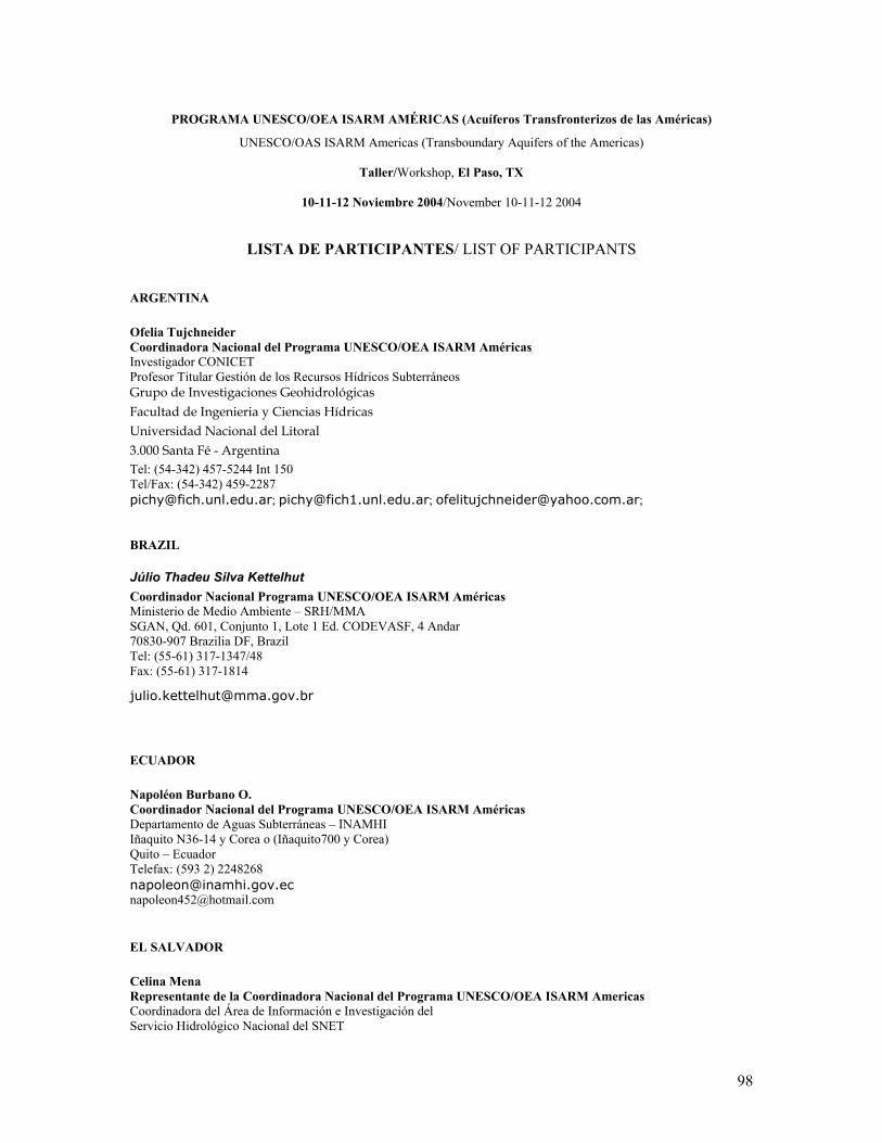
2. WORKSHOP AGENDA 3. LIST OF PARTICIPANTS
83
83
86
88
90
93
97
VII
LIST OF ACRONYMS DELTAmerica Preparation and Execution of Diffusion Mechanisms on Experiences and Lessons
Learned from the Transboundary Water Resources Integrated Management in the Americas / Preparación y Ejecución de Mecanismos de Difusión de Experiencias y Lecciones Aprendidas en la Gestión Integrada de Recursos Hídricos Transfronterizos en las Américas
EPWU El Paso Water Utilities FAO Food and Agriculture Organization/Organización de las Naciones Unidas para
Agricultura y Alimentos (United Nations/Naciones Unidas) FEMCIDI Special Multilateral Fund of the Inter-American Council for Integral Development/
Fondo Especial Multilateral del Consejo Interamericano para el Desarrollo Integral GAS/SAG Guarani Aquifer System/Sistema Acuífero Guaraní GEF/ FMAM Global Environment Facility/Fondo para el Medio Ambiente Mundial GS/OAS/SG/OEA General Secretariat of the Organization of American States/Secretaría General de la
Organización de Estados Americanos IAEA/OIEA International Atomic Energy Agency/Organisacion Internacional para Energia Atomica IAH/AIH International Association of Hydrogeologists/Asociación Internacional de
Hidrogeólogos IBWC/CILA International Boundary and Water Commission/Comisión Internacional de Límites y
Aguas IHP/PHI International Hydrological Programme/Programa Hidrológico Internacional IGRAC International Groundwater Resources Assessment Centre ISARM Internationally Shared Aquifer Resources Management/Gestión de los Recursos
Acuíferos Internacionalmente Compartidos IWRN/RIRH Interamerican Water Resources Network/Red Interamericana de Recursos Hídricos JMAS Junta Municipal de Agua y Saneamiento de Juarez MERCOSUR Mercado Común Sudamericano NC/CN National Coordinator/Coordinador Nacional OAS/OEA Organization of American States/Organización de Estados Americanos OSDE/ODSMA Office for Sustainable Development and Environment/Oficina de Desarrollo Sostenible
y Medio Ambiente PNUMA/UNEP United Nations Environmental Program / Programa de las Naciones Unidas para el
Medio Ambiente ROSLAC/ORCLAC Regional Office for Science and Technology for Latin America and the Caribbean/
Oficina Regional de Ciencia de la UNESCO para America Latina y el Caribe TA Transboundary Aquifer TARM Transboundary Aquifer Resources Management UNESCO United Nations Educational, Scientific, and Cultural Organization/Organización de las
Naciones Unidas para la Educación, la Ciencia y la Cultura UN ILC United Nations International Law Commission
1
1. TRANSBOUNDARY GROUNDWATER IN THE AMERICAS: AN OVERVIEW Though the American hemisphere is considered a blessed region for the abundance of water resources, large areas of the continent correspond to arid and semi-arid regions, increasingly affected by recurrent drought and flood cycles. In South America for example, approximately 5,000,000 km2 are arid or semi-arid areas, including northeastern Brazil, and large parts of Argentina, Chile, Bolivia and Peru. In these regions, nearly one third of the total water supply comes from aquifers and their role is expected to increase even further in years to come. In addition, population tends to grow and concentrate in large urban settlements, increasing the water-demand and the necessity to mine groundwater resources. Sixty per cent of the urban centers in the state of São Paulo in Brazil, for example, are served by groundwater sources, supplying a population of 5,500,000 people. In the Americas, some aquifers are becoming polluted and the fragile aquifer recharge and extraction zones are severely damaged, as a consequence of extensive agriculture and industrial development. Many of the aquifers are currently being mined beyond their recharge capacity, threatening their sustainability and others are slowly recovering from over-exploitation like the Hueco Bolson, one of the 18 transboundary aquifers that underlain the border between Mexico and the Unites States. Still, the American continent has an enormous groundwater potential as it is endowed with large, sometimes under-utilized, good-quality water aquifers. Such is the case of the Guarani, the 1,200,000 km2 gigantic transboundary aquifer
system shared by Argentina, Brazil, Paraguay and Uruguay, that has a capacity sufficient to supply 360,000,000 people on a sustainable basis. In 2002 the Governments of the four countries, with the collaboration of the World Bank and the OAS and through Global Enviromental Facility – GEF funding, launched the Guarani Aquifer System Project, the first project in the Americas focusing on transboundary aquifers and the first groundwater project supported by GEF. The project is one of the first multi-country initiatives being undertaken worldwide and seeks to implement a common institutional framework for managing and preserving the Guarani Aquifer for current and future generations. This remarkable initiative not only attracted the attention of the global community as one of the first models of international cooperation towards sustainable groundwater management, but also rose the awareness on “groundwater issues” among the other countries of the American hemisphere. Many of the large aquifers in the Americas are transboundary and shared between neighboring countries and/or states: in several countries, water experts and governmental agencies have started to recognize the strategic role of shared groundwaters, and their potential to dramatically improve the quality of human life and environment. Recognizing the multi-facet value of transboundary aquifers also implies to recognize the necessity of establishing a joint management among countries which, in general, neither have adequate legal and institutional frameworks for groundwater management, nor a support by international bi- or multi-lateral agreements or by integrated administrative policies for environmental protection.
2
Water shortage is currently affecting not only the arid and semi-arid areas like those located in North and South America, but also the tropical subregions, extremely vulnerable to natural hazards, located in Central America and in the Caribbean. All these areas of the American hemisphere are now affected by violent effects of climatic fluctuations with alternating periods of droughts and floods, that stress the environment and further threaten the most degraded zones, with severe consequences for human lives. The concerns for the present situation are compounded by forecasts of growing water-demand in the future: more and more in the American hemisphere, stake-holders and decision-makers are requested to take measures in order to enhance water supply and maintain social and economic security in border zones, which are the most fragile and potentially conflictive. The implementation of ISARM Americas has provided a unique platform to promote energies and interest fot the development of transboundary aquifer projects. Several actions are being taken in response to this situation. In La Plata Basin, one of the largest basins in the world with more than 3,300,000 km2, located in the hearth of South America, the sustainable and integrated joint water resources management of the whole basin has been planned and is going to be coordinated by an intergovernmental body, the Basin Intergovernmental Commission, which represents five Mercosur countries. The basin-management plan will include the strategic use and protection of shared groundwater and dependent ecosystems, like the Yrenda-Toba-Tarijeno, the 350,000 km2 wide transboundary aquifer system located in the unique semi-arid eco-region of Gran Chaco Americano and shared by Argentina, Bolivia and Paraguay.
Other American countries are moving towards the same direction. In the Caribbean island of Hispaniola, Haiti and Dominican Republic governments in 2002 signed a Binational Agreement for the sustainable joint management of the Artibonito Transboundary Basin. Two years later, under the auspices of the UNESCO-OAS ISARM Americas Programme, the two countries oficially agreed to work together on the management of two transboundary aquifers, Artibonito and Masacre, with the aim to integrate the shared groundwater management into the Artibonito basin management framework. Bolivia, Brazil and Paraguay have recently called for international support for the protection of the Pantanal transboundary aquifer, which partially underlain the Pantanal wetlands, one of the most unique natural setting in the world, and contributes to the health of the rich and diverse wetland-related ecosystem. In Central America, El Salvador and Guatemala identified the Ostua-Metapan transboundary aquifer, a potential under-utilized resource which, if strategically managed, could solve the water-scarcity problems of the area during the periods of drought. The balance of the shared groundwaters initiatives started in the Americas in the past three years is definitely positive and the expectation for the future optimistic. Still, the American countries identified the need of more sounded scientific information, technical capacity-building, but overall of institutional enhancement and legal strengthening as the major gaps that urge to be solved in the near future.
3
2. UNESCO/OAS ISARM AMERICAS PROGRAMME: BACKGROUND AND RESULTS The UNESCO/OAS ISARM-Americas Programme is the regional initiative for the American hemisphere of the worldwide ISARM Programme and is jointly coordinated by the UNESCO International Hydrological Programme (IHP) and the Office for Sustainable Development and Environment of the Organization of the American States (OSDE/OAS).
The global “Internationally Shared Aquifer Resources Management - ISARM Programme” involves several other international organizations, notably the Food and Agriculture Organization (FAO), the United Nations Economic Commission for Europe (UNECE) and the International Association of Hydrogeologists (IAH). It aims to promote the recognition and understanding of transboundary groundwater resources, and foster collaboration among the countries sharing the same resource to achieve consensus on legal, institutional, socio-economic, scientific, and environmental aspects.
One of the most important objectives of the ISARM regional programme is to create a comprehensive Inventory of Transboundary Aquifers of the Americas, a collection of data regarding the hydro-geological characteristics, the actual use of the shared groundwaters and the legal and institutional aspects. From the start of its activities in 2003 up to now, the Programme has assessed the prevalence of
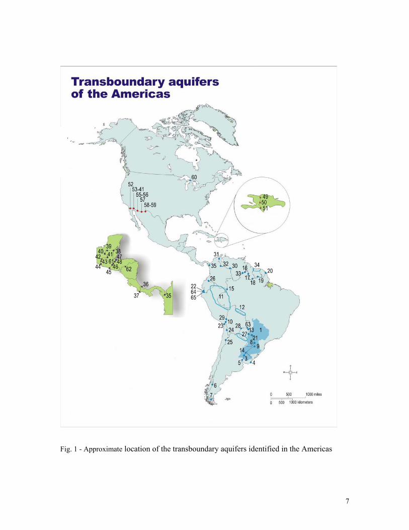
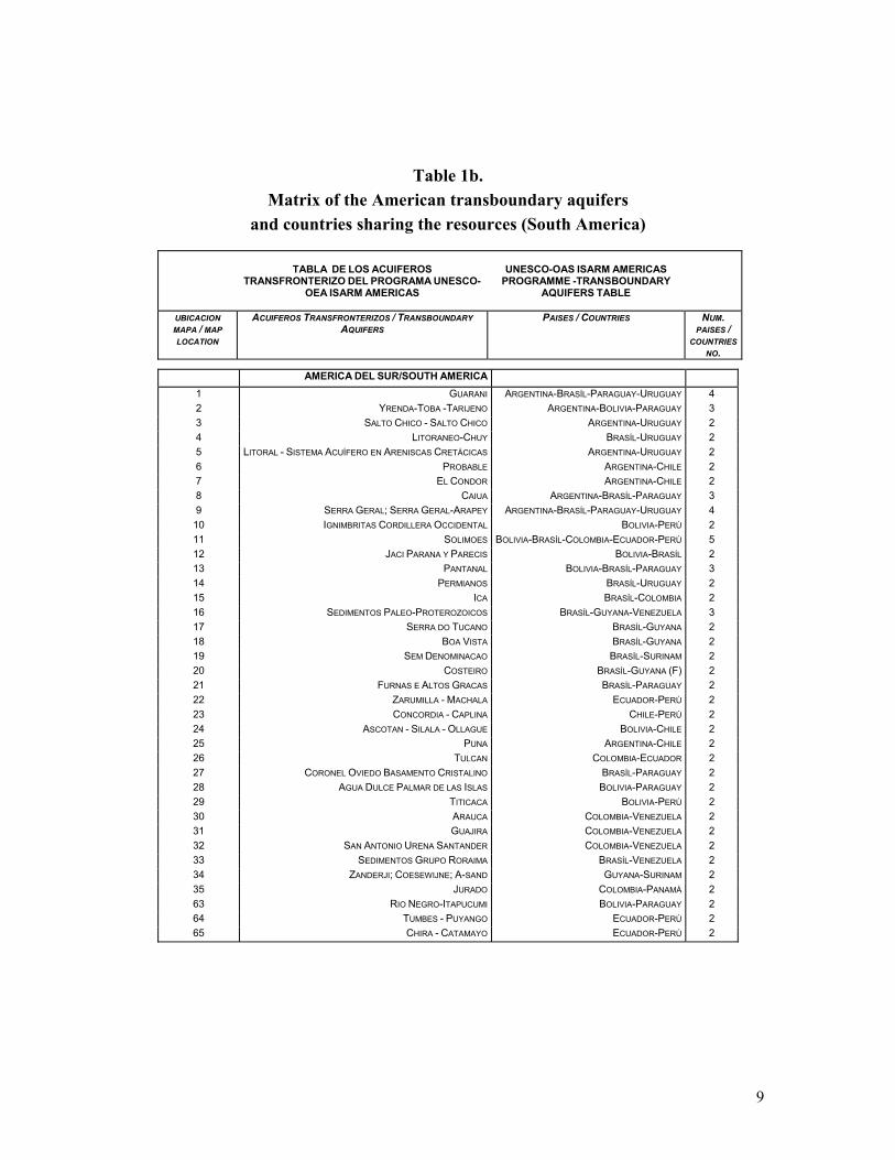
transboundary aquifers in the Western Hemisphere, through compiled questionnaires sent by a network of National Coordinators, which represent 25 countries of the American hemisphere. According to the Inventory, as of November 2004, 62 transboundary aquifers have been identified: 36 located in South America, 15 in Central America, 8 in North America (U.S.A.-Mexico border only), and 3 in the Caribbean (Fig. 1; Table 1a,b). Interestingly, recurrent features emerged from this first assessment of the western hemisphere transboundary aquifers, like the fact that many American transboundary aquifers are located:
- in arid and semi-arid regions; - in areas extremely vulnerable to natural
hazards and to climatic variability due to Climate Change;
- in areas with severe land/water degradation due to increased urbanization and industrialization, extensive agriculture and deforestation, which heavily impact entire ecosystems;
- in areas of potential water use conflict, with high levels of poverty and health uncertainty.
The First Coordination Workshop of the ISARM Americas Programme was held in Montevideo, Uruguay, on September 24th - 25th, 2003, one year after the official launching at the IAH/ALHSUD Congress of Mar del Plata, Argentina, 2002. During the Montevideo workshop, representatives from twenty American countries related the characteristics of transboundary aquifers and the major concerns identified in the hemisphere, mainly the irrational use and lack of protection of the
4
aquifers, the increasing demand for water due to population growth and economic expansion, associated with poverty and health problems. The countries proposed nine transboundary aquifers as possible case-studies for project implementation, using the ISARM approach. In the Spring of 2004, the ISARM-Americas
Steering Committee identified three priority case-studies from the list. They are located in areas of particular concern in the Americas:
- Inter-mountaneous and coastal transboundary aquifers in Small Islands Developing States (SIDs) : the Artibonite and Masacre aquifers in the Hispaniola Island (Haiti – Dominican Rep.)
- Transboundary aquifers in semi-arid zones
of South America: the Yrenda-Toba-Tarijeno aquifer system in the Gran Chaco Americano (Argentina-Bolivia-Paraguay)
- Transboundary aquifers in urban areas: the
Hueco Bolson aquifer (Mexico-USA) The Artibonito and Masacre Transboundary Aquifers (Dominican Rep. – Haiti) are respectively located in the intermontainous central region and in the northern coast of the Hispaniola Island, along the border between the two countries. Extensive deforestation in the upper reaches of the Artibonito basin has transformed the natural landscape, heavily impacting the health of ecosystems and introducing elements of high vulnerability to climatic fluctuations. Along the northern coast, sea-water intrudes into shallow aquifers polluting groundwater with its high saline content. Masacre
coastal transboundary aquifer represents a valuable freshwater resource for both the countries and it is being affected by saline intrusion due to over-exploitation. Under the auspices of the UNESCO/OAS ISARM Americas Programme, the Dominican Republic and Haiti officially agreed to undertake a cooperative work “To sustainably manage the aquifers in the intermountain and coastal regions of Hispaniola with a view to reduce land degradation, excess erosion-sedimentation, and poverty “, through a pilot-project which is being submitted for funding to the Global Environment Facility (GEF), and executed with the support of the OAS, the United Nations Environment Programme (UNEP) and the UNESCO-IHP. The joint sustainable management of the Hispaniola shared groundwater resources will help to mitigate the devastating rate of land degradation and of the ecosystems associated to groundwater. The project will identify the technical, legal, scientific and governance gaps, and strengthen the institutions responsible for water resource management. It will also focus on testing schemes for managed groundwater recharge in identified adequate locations and aquifers, as a mean to mitigate the high vulnerability of these two countries to extreme climatic conditions, such as destructive hurricanes, high rainfall periods that alternate with extended droughts, which cause innumerable deaths, economic losses and further degradation. The Yrenda – Toba – Tarijeño Transboundary Aquifer System – SAYTT underlies the Gran Chaco Americano, a wide semi-arid region where nearly the eighty per cent of the rural population lacks access to potable water.
5
The aquifer extends in Bolivia, Argentina and Paraguay for approximately 350.000 km2, covering about 40 per cent of the Gran Chaco, from the intermountain aquifers and recharge areas in the Andean belt to the Chaco plains, where groundwater recharge from the Andes foothills mixes with the saline groundwater of the plain creating a complex aquifer system. In this area, the problem of water scarcity is compounded by the recent population increase, agricultural land use and/or industrial intensification, and by salinization and pollution. This ISARM case-study will be addressed within the wider context of the Project “Framework for the Management of the Water Resources of the La Plata River Basin”. This project is being carried out by the countries that share the basin - Argentina, Bolivia, Brazil, Paraguay and Uruguay, in close coordination with the Plata Basin Intergovernmental Commission - and supported by UNEP and OAS, with financial assistance from the GEF. La Plata Project will seek to identify joint water management priorities and to establish a framework to adapt to increasing risks of major floods and droughts, due for example to the El Nino events, as well as to prevent contamination from excessive sediment loads in the Plata estuary. As part of this effort, the Yrenda-Toba-Tarijeno pilot-project is being developed with a special fund obtained from the Ministry of Environment of Italy, dedicated to strengthen the joint management of the shared groundwaters, as a strategic component of the overall Plata Basin Management context.
UNESCO-IHP is coordinating and supporting member states in the development and/or update of the water balance, water use, and demand in the La Plata Basin. The SAYTT pilot-project will provide a comprehensive understanding of the aquifer system and of its function in supporting human needs and providing environmental sustainability, as well as a guidance for the actions to be taken in other aquifers located in the La Plata Basin in order to establish more sustainable management mechanisms. The Hueco-Bolson Transboundary Aquifer is shared by Mexico and the United States and represents an interesting example of urban aquifer in an arid area, primarily mined for domestic and industrial use. Hueco-Bolson is located to the east and south of the cities of El Paso, Texas, USA, and Ciudad Juarez, Chihuahua, Mexico, and is bisected by an international river, Rio Grande/Rio Bravo, that forms the boundary between the two countries. It is one of the few good quality-water resources of this very arid region, currently the sole water source for Ciudad Juarez and accounting for 30% of the domestic water for the City of El Paso. The Cities of El Paso and Ciudad Juarez apply a diverse program for the explotation and protection of the aquifer, with elements of conservation, water rights acquisition, surface water use, and use of wastewater effluent treated to advanced secondary/tertiary standards. An important source of artificial recharge is the Hueco Bolson Recharge Project operated by the El
6
Paso Water Utilities (EPWU). In the Fred Hervey Water Reclamation Plant approximately 10 million gallons (37,854,120 liters) per day of raw wastewater is treated to potable water standards. Half that amount is then injected into the aquifer. Up to now, still few legal agreements relative to the groundwater mining from the Hueco Bolson are currently in place, and water extraction is subject to the laws and regulations of the Republic of Mexico and the states of Texas and New Mexico. For many years, the Hueco Bolson was the object of long disputes between the two states of New Mexico and Texas, that finally ended in 1991 with the creation of a Joint Settlement Agreement, and of the New Mexico Texas Water Commission in 2001.
There is a memorandum of understanding between the El Paso Water Utilities (EPWU) and the Junta Municipal de Agua y Saneamiento de Juarez (JMAS) based on data exchange and future development planning.
The Hueco Bolson Transboundary Aquifer was designated as an ISARM Americas advanced case-study. The experience achieved in Hueco Bolson through a large amount of studies and initiatives in the past fifteen years can greatly benefit other American countries, facing for the first time the joint management of shared groundwater resources.
7
Fig. 1 - Approximate location of the transboundary aquifers identified in the Americas
8
Table 1.a Matrix of the American transboundary aquifers
and countries sharing the resources (North, Central Americas and the Caribbean)
TABLA DE LOS ACUIFEROS TRANSFRONTERIZO DEL PROGRAMA
52 TIJUANA MEXICO-UNITED STATES 2 53 VALLE DE MEXICALI MEXICO-UNITED STATES 2 54 VALLE SAN LUIS -RIO COLORADO (YUMA) MEXICO-UNITED STATES 2 55 RIO SANTA CRUZ MEXICO-UNITED STATES 2 56 NOGALES MEXICO-UNITED STATES 2 57 RIO SAN PEDRO MEXICO-UNITED STATES 2 58 CONEJOS - MEDANOS MEXICO-UNITED STATES 2 59 BOLSON (VALLE DE JUAREZ) MEXICO-UNITED STATES 2 60 CAMBRIAN - ORDOVICIAN CANADA-UNITED STATES 2 AMERICA CENTRAL/CENTRAL AMERICA
36 SIXAOLA COSTA RICA-PANAMÁ 2 37 COTO COSTA RICA-PANAMÁ 2 38 HONDO SAN PEDRO GUATEMALA-MEXICO 2 39 SAN PEDRO GUATEMALA-MEXICO 2 40 USAMANCITA GUATEMALA-MEXICO 2 41 CHIXOY - XACLBAL GUATEMALA-MEXICO 2 42 SELEGUA - CUILCO GUATEMALA-MEXICO 2 43 COATAN - SUCHIATE GUATEMALA-MEXICO 2 44 BAJO SUCHIATE GUATEMALA-MEXICO 2 45 CUENCA LA PAZ (AHUACHAPAN-LAS CHINAMAS) EL SALVADOR-GUATEMALA 2 46 ALTO-PAZ - OSTUA/METAPAN EL SALVADOR-GUATEMALA 2 47 MOTAGUA NORTE GUATEMALA-HONDURAS 2 48 MOTAGUA SUR GUATEMALA-HONDURAS 2 61 OLOPA GUATEMALA-HONDURAS 2 62 RIO NEGRO HONDURAS-NICARAGUA 2 CARIBE/CARIBBEAN
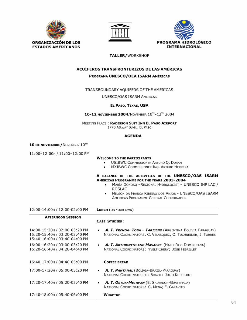
3. EL PASO WORKSHOP The UNESCO/OAS ISARM Americas yearly workshop is becoming an important appointment for the transboundary groundwater community of the Americas. The regional network of ISARM National Coordinators, international organizations, governmental agencies, academia and research institutions welcome the opportunity to compare experiences, discuss the advances of the Programme and make their recommendations for future actions. The Second Coordination Workshop of the UNESCO/OAS ISARM-Americas Programme has been kindly hosted by the International Border and Water Commission - United States and Mexico (IBWC), in El Paso, Texas, U.S.A., November 10th - 12th, 2004. The Workshop was co-sponsored by UNESCO-IHP and the DELTAMERICA Project (IWRN, GEF, UNEP, OAS). The El Paso Workshop has been a benchmark for the ISARM Americas Programme and its follow-up in the 2005. Thanks to the past two years of activities, the countries have achieved a better understanding of the problems and opportunities of the American transboundary aquifers, enriching the meeting with a common ground of experiences that call for a regional strategy on the sustainable management of shared groundwater. Nearly fifty experts attended the event, most of them coming from different American countries (governamental agencies, institutions and
universities) and others from international organizations. The workshop included opening addresses from representatives of the International Border and Water Commission - United States and Mexico (IBWC/CILA), and an initial overview of the activities of the Programme by UNESCO and OAS officers. The U.S. and Mexican experts welcomed the opportunity to present the case-study of Hueco Bolson, the transboundary aquifer shared between the U.S.A. and Mexico, in the El Paso-Ciudad Juarez region. ISARM Americas National Coordinators presented thorough descriptions of the priority case-studies in process or under consideration. Participants from international organizations and academia provided a broad overview of what is being discussed in the international fora and the approaches adopted in transboundary groundwater projects. The section on legal aspect for The ISARM Americas community showed a particular interest to the legal aspects of shared groundwater, either related to the US-Mexico border experience or to the preparation of a future transboundary groundwater international legal instrument. The ISARM Americas National Coordinators identified that legal and institutional gaps are the priority at a regional level and should be more specifically addressed by the Programme. This undoubtedly represents a significant progress from the 1st Coordination Workshop in 2003, when legal and institutional management issues had not yet taken the position of a priority.
11
The Workshop ended with a brainstorming in which the Member State representatives pointed out specific interests and needs for the future activities, included in the recommendations for the year 2005. 3.1 WELCOME TO PARTICIPANTS AND WORKSHOP AGENDA The US-IBWC Principal Engineer Mr.Bernardino Ollague (*), and the MX-IBWC Commissioner, Ing. Arturo Herrera, opened the workshop with welcoming remarks to the country National Coordinators and to the representatives of the international organizations attending the meeting. In his speech, Ing. Herrera mentioned the transboundary nature of the two cities, El Paso and Ciudad Juarez, located in a very arid region and indissolubly linked by same problems.
He pointed out how the economic activities of the area are strictly related to groundwater explotation, for which there are coordination plans between the two cities. The existing technical exchange and understanding will facilitate the agreement and realization of long-term viable technical solutions to preserve and manage the shared water resources. Mrs. Donoso, regional hydrologist at the UNESCO Regional Office for Science and Technology for Latin America and the Caribbean (UNESCO/ROSLAC), gave a balance of the ISARM Americas programme since its beginning in 2003. She presented the work carried out by the ISARM Americas Programme and its link to the global ISARM Programme. To conclude, Ms. Donoso thanked the IBWC/CILA authorities for their support to the workshop. Mr. Da Franca dos Anjos, Principal Water Resources of the OSDE/OAS and General Coordinator of the UNESCO/OAS ISARM Americas Programme (Transboundary Aquifers of the Americas) thanked the IBWC/CILA representatives and welcomed the participants, explaining the objectives of the workshop. He decribed the results obtained by the ISARM Americas Programme during the year 2004, in particular, the transboundary aquifer data collected by the countries to produce the Inventory. A draft of the Inventory was circulated among the participants.
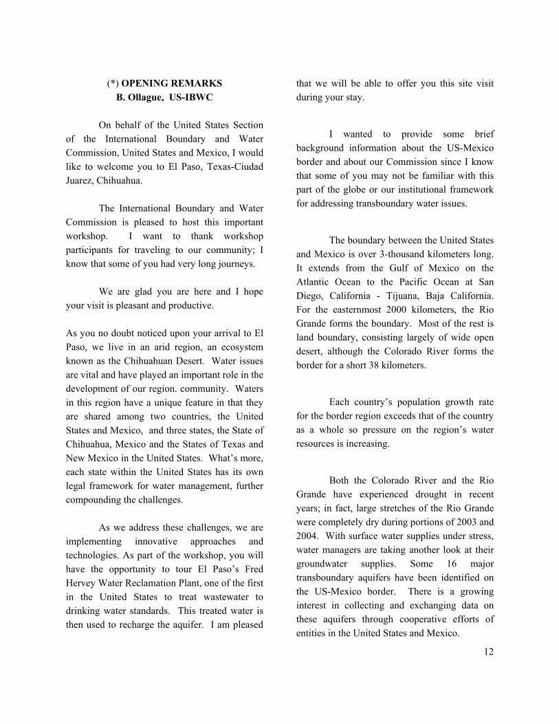
1. MX-CILA COMMISSIONER ING. ARTURO HERRERA
12
(*) OPENING REMARKS B. Ollague, US-IBWC
On behalf of the United States Section of the International Boundary and Water Commission, United States and Mexico, I would like to welcome you to El Paso, Texas-Ciudad Juarez, Chihuahua.
The International Boundary and Water Commission is pleased to host this important workshop. I want to thank workshop participants for traveling to our community; I know that some of you had very long journeys.
We are glad you are here and I hope your visit is pleasant and productive.
As you no doubt noticed upon your arrival to El Paso, we live in an arid region, an ecosystem known as the Chihuahuan Desert. Water issues are vital and have played an important role in the development of our region. community. Waters in this region have a unique feature in that they are shared among two countries, the United States and Mexico, and three states, the State of Chihuahua, Mexico and the States of Texas and New Mexico in the United States. What’s more, each state within the United States has its own legal framework for water management, further compounding the challenges. As we address these challenges, we are implementing innovative approaches and technologies. As part of the workshop, you will have the opportunity to tour El Paso’s Fred Hervey Water Reclamation Plant, one of the first in the United States to treat wastewater to drinking water standards. This treated water is then used to recharge the aquifer. I am pleased
that we will be able to offer you this site visit during your stay.
I wanted to provide some brief background information about the US-Mexico border and about our Commission since I know that some of you may not be familiar with this part of the globe or our institutional framework for addressing transboundary water issues.
The boundary between the United States and Mexico is over 3-thousand kilometers long. It extends from the Gulf of Mexico on the Atlantic Ocean to the Pacific Ocean at San Diego, California - Tijuana, Baja California. For the easternmost 2000 kilometers, the Rio Grande forms the boundary. Most of the rest is land boundary, consisting largely of wide open desert, although the Colorado River forms the border for a short 38 kilometers.
Each country’s population growth rate for the border region exceeds that of the country as a whole so pressure on the region’s water resources is increasing.
Both the Colorado River and the Rio Grande have experienced drought in recent years; in fact, large stretches of the Rio Grande were completely dry during portions of 2003 and 2004. With surface water supplies under stress, water managers are taking another look at their groundwater supplies. Some 16 major transboundary aquifers have been identified on the US-Mexico border. There is a growing interest in collecting and exchanging data on these aquifers through cooperative efforts of entities in the United States and Mexico.
13
The International Boundary and Water Commission, or IBWC, has a long history of addressing issues along the U.S.-Mexico border. Our Commission was established in 1889 to apply the rules determining the location of the boundary when the boundary rivers meander.
The modern-day IBWC is responsible for applying the boundary and watertreaties between the United States and Mexico and settling differences that arise in the application of the treaties.
The IBWC has two distinct Sections – the U.S. Section and the Mexican Section, each headed by en engineer-commissioner appointed by his president. IBWC is both an engineering and diplomatic agency, seeking technical and diplomatic solutions to boundary and water issues.
Although we are an independent commission which cooperates with various agencies, we work most closely with the U.S. State Department, which provides foreign policy guidance. To carry out its work, the IBWC can conclude agreements, known as minutes, based on the authorities of the boundary and water treaties.
The two major water treaties between the United States and Mexico are the Convention of 1906 and the 1944 Water Treaty. The 1906 agreement allots the surface water of the Rio Grande in the area of El Paso-Cd. Juarez. The 1944 Water Treaty allots the surface water of the Colorado River and the
portion of the Rio Grande downstream of El Paso-Ciudad Juarez.
The IBWC also has authority related to groundwater studies. The U.S. Section received general authority to conduct groundwater studies from the U.S. Congress in 1935. The 1944 Water Treaty, though focused on surface waters, contains broad language authorizing the IBWC to initiate and carry on investigations dealing with international waters. A 1973 agreement (Minute 242) refers to consultations on groundwater issues and mentions a possible future agreement on shared groundwater between the United States and Mexico. Although many agreements address surface water issues, there is no groundwater treaty.
Grounded in a long and proud history, the United States Section of the Commission regularly updates its vision, mission, and strategic plan to meet contemporary challenges. “Our mission is to provide boundary, water, and environmental solutions along the United States-Mexico border region through leadership, binational cooperation, and future sustainability in a manner that is responsive to stakeholders.”
One of the goals of U.S. Commissioner Arturo Q. Duran is to build partnerships and, through collaboration, advance important work on boundary and water issues.
We all took an important step in that regard last year when we participated in the first ISARM workshop in Uruguay. Representatives of the United States and Mexican Sections of our Commission attended along with representatives from some 20 other nations.
14
Over and over, we heard concerns over the inadequate use and protection of aquifers and the increasing demand for water in the Americas.
We share those concerns for the transboundary aquifers on the U.S.-Mexico border and we offered to host the second workshop this fall in El Paso.
The aquifer shared by El Paso and Cd. Juarez, the Hueco Bolson, was selected as one of
nine proposed case studies. We look forward to presenting our case study and we are very interested in learning from your case studies.
Once more, welcome to El Paso and thank you for attending. I know we will have a productive workshop for the next three days.
Bernardino Olague, IBWC Principal Engineer
El Paso, Nov. 10th, 2004
14
3.2 UNESCO/OAS ISARM-AMERICAS CASE-STUDY PRESENTATIONS The workshop started with the technical presentations of the ISARM Americas case-studies. The session included four presentations: two case-studies on transboundary aquifers located in South America, namely the Yrenda-Toba-Tarijeno Transboundary Aquifer System - SAYTT (Argentina, Bolivia, Paraguay) and Pantanal Transboundary Aquifer (Bolivia, Brazil, Paraguay); one case-study located in Central America: the Hostua-Metapan Transboundary Aquifer (El Salvador, Guatemala) and one located in the Hispaniola Island, the Caribbean: Artibonito and Masacre Transboundary Aquifers (Dominican Republic, Haiti). The SAYTT and the Artibonito-Masacre transboundary aquifer case-studies have been choosen in mid-2004 to implement pilot-projects, while the other two are still under evaluation. The presentations provided an updated overview of the existing information of the selected transboundary aquifers. The National Coordinators of the UNESCO/OAS ISARM Americas Programme analyzed the available information from different perspectives, from the hydrogeological characteristics to the socio-economic, legal and institutional aspects.
They pointed out the major problems affecting the areas where the aquifers are located, among the others: i) water shortage, ii) urban and rural expansion; iii) land-water irrational use, iv) deforestation and degradation of the ecosystem in particular the wetlands, v) biodiversity loss, vi) pollution and health diseases, etc. The National Coordinators also identified the major gaps existing in their countries, mainly related to the lack of laws specifically devoted to groundwater, the lack of regulations - or of their application - to govern water use and quality and protect dependent ecosystems, and the lack of coordination among institutions with authority in water and environment issues. 3.3 SPECIAL PRESENTATIONS ON “IBWC/CILA ISARM AMERICAS HUECO BOLSON CASE STUDY”
A special session of the workshop was dedicated to the Hueco Bolson Transboundary Aquifer case-study. Beside the presentations and the extensive technical papers prepared for the workshop by the IBWC-CILA US-MX staff, an account of the the Hueco Bolson transboundary aquifer under different perspectives was provided by invited speakers from governamental water-related agencies and universities. Two groups of presentations were provided: the first was focused on the scientific aspects of the aquifer, the other concerned socio-economical, legal and institutional issues, including an overview of groundwater management.
15
The technical session provided an assessment of the Hueco Bolson hydrogeological characteristics, aquifer water quality, use and demand, as well as an overview of the measures to reduce depletion and of the management priorities. Presentations related several important information, which include:
• The two most important groundwater management issues facing the Hueco Bolson are declining groundwater levels and brackish water intrusion.
• The Mexican and the US local water
utilities - Junta Municipal de Agua y Saneamiento de Juarez JMAS, and El Paso Water Utility EPWU - are actively seeking alternative water sources and encourage the reduction of per capita use with education programs. Pumping has been aggressively reduced in the last years, which has led to stabilization of water levels.
• Technological alternatives, like
desalinization and artificial recharge are also planned or applied. EPWU is planning for the construction and operation of a Joint Desalination Facility, which will intercept brackish groundwater and protect fresh groundwater.
• The same agency is presently operating
an artificial recharge project, the Hueco Bolson Recharge Project. Approximately 10 million gallons (37,854,120 liters) per day of raw
wastewater is treated to potable water standards at the Fred Hervey Water Reclamation Plant. Half that amount is then injected into the aquifer.
Relevant information and elements of discussion emerged from the second group of presentations, among the others:
- Reasons for concern and objects of
potential conflict, like the declining of water levels for over-exploitation and mutual interference of extraction wells along the border. Factors to consider: wells distribution with respect to the border, water withdrawal, aquifer characteristics.
- The example of groundwater
management approach from Texas: a structure based on local government units called “Groundwater Conservation Districts” with the authority to manage groundwater resources, and the designation of critical areas as “Priority Groundwater Management Areas”1.
- Hueco Bolson as an example of aquifer
shared by four states and two countries, with diverse national water regulation and laws, distinct cultures and economic factors, topographic differences, and
1 El Paso County was evaluated for critical groundwater problems by the Texas Commission on Environmental Quality (TCEQ) in the late 1980s, and eventually designated as a priority area in December 1998, with the recommendation of applying a regional approach to address interstate and international groundwater depletion issues.
16
geologic variations. Assessment of the concrete difficulties to create a comprehensive regulatory framework for groundwaters shared by different countries and different states.
- Discussion on existing groundwater law:
international law, United States interstate law, federal law of the United States and Mexico, state law of the States of Texas, New Mexico, and Chihuahua, and local law of El Paso and Cd. Juárez. Policy objectives of ground water law and allocation theories.
- Assessment of the existing border
agreements between Mexico and USA.2
- Very few legal and policy agreements to jointly manage the Hueco Bolson transboundary aquifer. Presently: i) current cooperation between IBWC/CILA US – MX, mainly based on technical information sharing and water quality monitoring (Minutes 242, 289); ii) memorandum of understanding between El Paso Water Utility (EPWU) and the Junta Municipal de Agua y
2 Minute 242 (IBWC – U.S. and Mexico, Aug. 1973); Minute 289 (IBWC – U.S. and Mexico, Nov. 1992); La Paz Agreement (Environmental Treaty between U.S. and Mexico Aug.1983); NAFTA Environmental Side Accord (Trade Agreement U.S., Mexico, and Canada 1995); Memorandum of Understanding (City of Juarez Utilities & El Paso Water Utilities Dec. 1999); Proposed Senate Bill S. 1957(United States-Mexico Transboundary Aquifer Assessment Act, Senator Bingaman, 108th Congress/1st Session, Nov. 25, 2003).
Saneamiento de Juarez (JMAS) on data exchange and planning for future development of the Hueco Bolson
- Planning for more articulated technical
collaboration between IBWC/CILA US – MX sections: creation of a binational technical team, binational reports, meetings, agreements for mutual technical assistance and for compatible water-flow model studies, etc.
- Recommendations of the elements necessary to draw a future IBWC/CILA US – MX agreement: set up and maintenance of database; criteria to define protection and conservation areas; critical situations notification and alert; systematic Commission and public consultation, etc.
- Analysis of legal, political, economic
constraints and opportunities for a binational cooperation on the transboundary groundwater management of the Hueco Bolson. Accordingly, potentiality for cooperation is likely where: i) groundwater is the sole source of supply for binational community; ii) scarcity looms-backed by reliable data are credible in both countries; iii) there is coincidence or greater approximation of legal and administrative systems; iv) local, informal, and modest practical measures are reciprocally taken to conserve the total water supply; v) institutional models are available.
17
3.4 SHORT TECHNICAL PRESENTATIONS A section of the workshop was dedicated to short presentations on transboundary aquifer case-studies in the Americas, being studied by national water-agencies or academia. The transboundary aquifers of the two first presentations are included in the priority list of the ISARM Americas Programme, and they under consideration for possible project implementation. The presentations were: Sinópsis de la Caracterización Hidrogeológica del Acuífero Zarumilla. Ecuador – Peru Nat. Coordinator for Ecuador: Napoleon Burbano
Acuifero Transfronterizo Rio Negro. Nicaragua – Honduras
Nat. Coordinator for Nicaragua: S.ilvia Martinez Conjunctive Management of the Rio Grande/Río Bravo and its Associated Groundwater Aquifers Susan V. Roberts, P.G. & Walter Rast, Ph.D., Program Director, Aquatic Resources, Department of Biology, Texas State University, San Marcos, Texas. 3.5 LEGAL ASPECTS FOR TRANSBOUNDARY AQUIFERS Also thank to the interest that the Hueco Bolson experience rose, particular attention was given to issues like water dispute resolution and gaps
existing in national and international legislation for what concerns shared groundwaters. The session on Legal Aspects covered the topic of International Law for transboundary aquifers from different perspectives. It initiated with the description of the first appearance of the “groundwater subject” in the existing international conventions and resolutions adopted. It was also briefed on the UN International Law Commission advances in the preparation of a new international legal instrument on Transboundary Aquifers, which is being proposed by the Special Rapporteur for the topic, assisted by a group of multidisciplinary experts organised by UNESCO-IHP. In preparation of this instrument, many issues are considered while others are still under investigation, like those regarding State practice, existing treaties, and domestic legislation. The particular case of US-Mexico border was analysed and recommendations for approaching an agreement were provided. They included: - proactive planning and flexibility of the parties, - wise application of the principles of equitable utilization and reasonable use, - consideration of surface-ground water resources relationships to ensure integrated management. The importance of regional agreements and the effectiveness of local organizations for enforcement were pointed out, especially in international agreements.
18
Considerations were done on factors and conditions necessary for the creation of an international groundwater agreement between the U.S. and Mexico border: from the availability of sufficient factual information, such as ground water modeling, economic impacts and international law, to less tangible aspects including negotiation principles and reasonableness. The presentations provided a useful outline of the existing international rules, agreements and treaties concerning transboundary groundwater3 3.6 INVITED PRESENTATIONS Invited experts from various internationl agencies and institutions, as well as consultants and project directors participated in the workshop, some of which made presentation describing ongoing projects and/or special initiatives. One of the presentations was focused on the strategies and suggestions on
3 1966 Helsinki Rules : concept of drainage basin 1978 Franco-Swiss Genevese Aquifer Agreement: Agreement between France and Switzerland regarding the Lake Geneva Basin groundwater 1986 Seoul Rules on groundwater : application of the Helsinki Rules to all groundwaters, connected or not. 1989 Bellagio Draft Treaty : Model treaty drafted by
a group of multidisciplinary experts. 1997 Convention on the Non-Navigational Uses of
International Watercourses. 2004 Berlin Rules: application to domestic and
transboundary waters. Introduction of environmental law.
groundwater proposed by the Science and Technology Advisory Panel (STAP) of the Global Environmental Facility (GEF). These presentations were: - Estratégias y políticas del proyecto
OIEA de Manejo Sostenible de Aguas Subterráneas en América Latina: Condicionantes del éxito. Edmundo Garcia-Agudo, AIEA
- Data-base for the ISARM Americas
Transboundary Aquifers Inventory and the IGRAC web-site. Jac Van Der Gun, IGRAC
- A Methodology for schematic
mapping of aquifers for policy-makers. Luiz Amore, Guarani Aquifer System General Secretary
- GEF-STAP – Strategic options for
groundwater in the future GEF Programmes. Bo Appelgren, Josè Luis Martin UNESCO IHP.
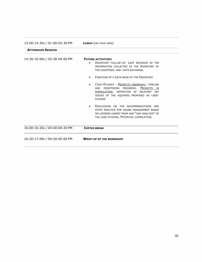
4. FUTURE ACTIONS AND
RECCOMENDATIONS
During the last day of the Workshop, the participants discussed the future activities of the Programme and the specific interests of the Member countries to be addressed during the coming year. The year 2005 will be mainly devoted to the preparation of the monograph on the Inventory of
19
the Transboundary Aquifers of the Americas, which will be published by UNESCO and presented to the World Water Forum, which will be held in Mexico, in 2006. The country members unanimously agreed that the legal aspect, at international and national level, was one of the most important issues to be developed by the programme in the future, and recommended more activities and information exchange on this regard. The ISARM National Coordinators and the other participants eventually proposed a list of recommendations, based on the identification of several gaps existing in the American countries for the study and management of transboundary aquifers. The recommendations referred to different topics: Hydrogeological and environmental aspects
• Take into account the role of Groundwater in mitigating the effects of the climatic variability and in preserving related ecosystem in the development of the integrated groundwater/surface water management. • Call for attention for the devastating effects of deforestation on the fragile areas of aquifer recharge.
• Concentrate efforts to improve and preserve the information on the aquifers, beyond the socio-political and technical ups and downs of
the countries. Encourage the involvement of academia and centers of investigation in studies and projects.
• Introduce the isotopic and hidrogeoquemistry techniques as a common tool in the aquifer studies, to help understand the aquifers dynamic and the water mixing processes.
Socio-economical aspects
• Need for multidisciplinary GW management, driven by the concept of sustainability and by conflict resolution approach. Involvement of the civil society, including indigenous population.
Institutional and legal aspects
• Legal and institutional gaps are the major concerns identified at regional level. Request to the ISARM Americas Programme to support information exchange and guide the countries to address specific problems. • Take into account other countries’ examples and experience in the preparation of GW regulations, laws and agreements.
• Base the formulation of legislative instruments on technical information.
• Adopt or learn from, whenever the case, laws and regulations for surface waters.
20
• Strengthen the institutions.
5. IDENTIFIED PRIORITY TRANSBOUNDARY AQUIFERS AND STATUS IN 2005:
The UNESCO/OAS ISARM Americas National Coordinators and the Steering Committee for the Programme discussed the status of the transboundary aquifers selected as priority case-studies in the previous meetings and updated the list as it follows: North America : Bolson del Hueco (Mexico-USA) Status: on-going, executed by IBWC/CILA Caribbean: Artibonito-Masacre (Dominan Rep.-Haiti) Status: Concept paper developed by UNEP-OAS to be submitted to GEF for financing
Central America: Ostua-Metapan (Guatemala-El Salvador) Status: under consideration Estero Real-Rio Negro (Honduras-Nicaragua) Status: under consideration
South America: Guarani (Argentina-Brazil-Paraguay-Uruguay) Status: On-going project (GEF/World Bank/OAS) Yrenda-Toba-Tarijeno (Argentina-Bolivia-Paraguay) Status: PDF-B developed by UNEP-OAS to be submitted to GEF for financing in the frame of the La Plata GEF/UNEP/OAS Project
Pantanal (Bolivia-Brazil-Paraguay) Status: Project concept definition on-process: meeting in Corumba’ (Br), March 30th-31st, 2005 Boa Vista – North Savanna (Guyana-Brazil) Status: Submitted to OAS for financing through FEMCIDI funds Zarumilla (Ecuador-Peru) Status: Project funded by IAEA Patino (Argentina-Paraguay) Status: under consideration San Antonio del Tachira – Cucuta (Colombia-Venezuela) Status: under consideration
6. WORKSHOP CLOSURE
The US-IBWC Commissioner Mr. Arturo Duran, and the MX-IBWC Principal Engineer Mr. Luis Antonio Rascon, closed the Workshop with the auspices of a strengthened collaboration among the ISARM American countries, also based on the relevant outcomes achieved during the three-day meeting. The National Coordinator of Brazil kindly offered to host the 3rd UNESCO/OAS ISARM Americas Programme Coordination Workshop in Sao Paulo do Brazil, in September, 2006. Mrs. Donoso, on behalf of the UNESCO/OAS ISARM Americas Programme Steering Committee, concluded the meeting acknowledging IBWC/CILA for the hospitality and for the help given to
21
UNESCO and OAS to host the best experts of the region for the event. She also congratulated the countries for their active participation and for the success of the event, and thanked the invited experts for their relevant contributions.
Fig. 2 - Field-trip to the Fred Hervey Water Reclamation Plant in El Paso. The $ 33 million Plant turns wastewater into drinking water. It can process up to 10,000,000 gallons (37,854,120 liters) a day of wastewater coming from the northeastern area of El Paso.
National Coordinators: S.ra Ofelia Tuchneider; Sr. Celso Velasquez; Sr. Julio Torres
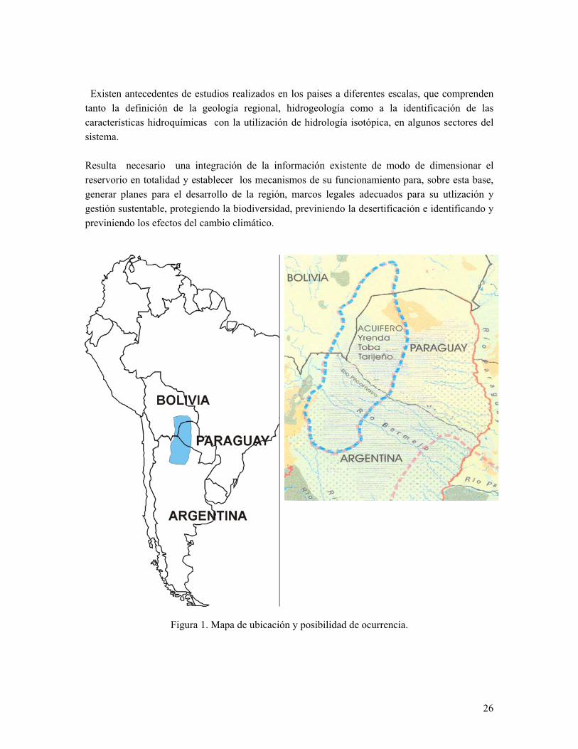
RESUMEN EJECUTIVO Este Acuífero Transfronterizo se encuentra en el subsuelo de: Argentina (llamado Toba), Bolivia (llamado Tarijeño) y Paraguay (llamado Y Rendá). Durante el desarrollo del Taller Internacional de ISARM Américas (Programa UNESCO/OEA) – agosto de 2004 en Tarija - se acordó llamarlo Sistema Acuífero Transfronterizo Yrendá - Toba - Tarijeño (SATYTT). Introduccion De modo preliminar se estima que abarca un área entre 250.000 y 300.000km2, lo que debe ser corroborado, dado que sus límites aún deben ser verificados. Figura 1: Mapa de ubicación y posibilidad de ocurrencia. En la República de Bolivia abarca los Departamentos de Tarija, Chuquisaca y Santa Cruz de la Sierra, asociado a los conos aluviales de los grandes ríos de la planicie chaqueña, como son el Grande, Parapetí, Pilcomayo, Bermejo y Salado. En Paraguay se lo considera incluído en la gran región del Chaco y en Argentina subyace a las Provincia de Tucumán, Salta, Santiago del Estero y Chaco. Dada la gran heterogeneidad geológica de los sedimentos que lo alojan y la variabilidad espacial de la calidad del agua, desde salina-salobre a dulce, la cantidad de personas que se verían favorecidas por su utlización debe ser evaluada con mayor seguridad, pero se estima mayor a 500.000.
24
Los tres países tiene excelentes relaciones de vecindad y el antecedente de encontrarse incluídos en la Cuenca de El Plata, por ello cuentan con acuerdos y tratados desde el siglo pasado que aseguran la cooperación y el entendimiento en la gestión compartida de los recursos hídricos superficiales. No existen antecedentes en la región de acuerdos, tratados o cualquier otra herramienta legal en vigencia para el tema de las aguas subterráneas.. Aspectos hidrogeologicos En Bolivia se lo define como un sistema acuífero multicapa, con acuíferos interconectados e interdigitados entre si. De acuerdo al sector se presentan acuíferos libres, semiconfinados ó confinados. En el sector de la Llanura Chaqueña y elevaciones terciarias, los acuíferos son de características semiconfinados y/o confinados profundos, ubicados a partir de los 180 - 200 metros de profundidad. Las aguas son de salinidad aceptable, alrededor de los 1500 µS/cm de conductividad eléctrica, los pozos existentes no superan generalmente los 3 l/s de caudal. En áreas de valle y piedemonte, los acuíferos existentes están constituidos por sedimentos más finos, por lo que los caudales de producción de agua pueden ser algo menores. Se estima que la recarga de los acuíferos ubicados en la Llanura Chaqueña y en los afloramientos terciarios se produce fundamentalmente en los sectores de Piedemonte y la dirección de escurrimiento del agua subterránea es predominantemente de oeste a este. Generalizando, el agua subterránea obtenida de los diferentes pozos en el Chaco Tarijeño es apta para consumo humano, riego y ganado. En algunos sectores, como el área de paleoterrazas del cono aluvial del río Pilcomayo, existen algunas restricciones para uso humano y riego, por la elevada salinidad contenida en los acuíferos someros, ubicados hasta los 140 metros de profundidad. El potencial hidrogeologico del acuifero es aún poco conocido en gran parte del Chaco Boliviano. Para poder efectuar recomendaciones de uso sustentable del recurso, es necesario profundizar el conocimiento con relación tanto a los volúmenes de recarga como a los de explotación de los acuíferos. En Paraguay se designa como Acuífero “Yrenda” ( Y: lugar, Rendá : agua) al complejo de agua subterranea constituído por niveles confinados y semiconfinados alojados en sedimentos del Terciario y Cuaternario. Su ocurrencia se define al sur de la linea de 21º de latitud sur en el Gran Chaco Americano.generalmente a mas de 50 m de profundidad en el oeste reduciendose al este.
25
Litológicamente, se aloja en formaciones constituídas por arenas finas y medianas, intercaladas con estratos de material arcilloso, con niveles de cristales de yeso y concreciones carbonáticas. En gran parte del oeste del Chaco Paraguayo se presenta inversion de salinidad, dado que los acuíferos superiores son salados a salobres y en profundidad, salobres a dulces con caudales medios de 80 m3/hora, y caudales especificos medios de 1,6 m3/hora. Sólo a través de estimaciones se considera que la recarga provendría desde Bolivia y la descarga se realiza a traves de: las explotaciones en el sector de Paraguay y el afloramiento de las aguas subterráneas en humedales salobres a salados. En los ultimos 30 años se ha detectado una elevacion del nivel estatico, el cual se encuentra cercano a la superficie hacia el este, en proximidades de rio Paraguay. Se estima que en la actualidad el aprovechamiento del acuífero se ha incrementado si bien no se precisan cifras.. Esto se da principalmente para consumo del ganado, lo que podría favorecer un avance del agua dulce de la recarga en direccion este. En Argentina existe una gran heterogeneidad en la calidad físico-química y en la productividad de los diferentes reservorios acuíferos que componen al sistema. Se lo ha definido como un sistema multinivel, constituído por un acuífero libre al que infrayacen un número aún no determinado de capas semiconfinadas a confinadas. Se presenta alternancia de niveles con agua salada-salobre y dulce, que no han sido debidamente identificados y dimensionados. Se estima que la recarga principal de los reservorios subterráneos es alóctona, probablemente proveniente de las cuencas hidrológicas del área montañosa ubicada hacia el oeste de la Llanura Chaqueña. Ya en algunos sectores se han identificado explotaciones intensivas, no controladas eficientemente por los estados provinciales, que han generado descensos importantes en los niveles piezométricos. Existe riesgo de salinización de los niveles acuíferos de agua dulce,debido a deficiencias constructivas de las perforaciones. En función de las características climáticas del área y a la escasez de recursos hídricos superficiales, el agua subterránea adquiere un interés estratégico en el desarrollo socieconómico de la región. La falta de control en la explotación del agua subterránea, puede llevar a pérdidas irreparables en la calidad y disponibilidad del agua subterránea.
26
Existen antecedentes de estudios realizados en los paises a diferentes escalas, que comprenden tanto la definición de la geología regional, hidrogeología como a la identificación de las características hidroquímicas con la utilización de hidrología isotópica, en algunos sectores del sistema. Resulta necesario una integración de la información existente de modo de dimensionar el reservorio en totalidad y establecer los mecanismos de su funcionamiento para, sobre esta base, generar planes para el desarrollo de la región, marcos legales adecuados para su utlización y gestión sustentable, protegiendo la biodiversidad, previniendo la desertificación e identificando y previniendo los efectos del cambio climático.
Figura 1. Mapa de ubicación y posibilidad de ocurrencia.
National Coordinators: Sr. Yvelt Chery; Sr. Jose Febrillet
CASO DE ESTUDIO DE LOS ACUÍFEROS TRANSFRONTERIZOS DE LA REGIÓN CENTRO SEPTENTRIONAL DE LA ISLA HISPANIOLA
REPÚBLICA DE HAITÍ – REPÚBLICA DOMINICANA.
1. Introducción: La Isla Hispaniola, compartida por la República de Haití y la República Dominicana, está localizada en la cuenca del Caribe, en la ruta de los huracanes y en el centro de los movimientos sísmicos de la región con frecuencia de un sismo importante cada 7.4 años (el último ocurrió el 22 septiembre 2003 de 6.5 escala Richter), fue visitada por tres huracanes en el presente año (Frances, Ivan y Jeanne) con saldo negativo para ambos países. La temporada se inició con las inundaciones del río Soliette o río Blanco, en Jimaní, en la zona de los Lagos de frontera con Haití, arrasando parcialmente las poblaciones de Mapov, Font Verrettes y Jimaní, con un saldo aproximado de 2,000 muertos. Este río desemboca en la Lago Enriquillo (-46 mbnm). Ivan cruzó por el centro del Mar Caribe y dejó grandes daños materiales y la muerte de 34 personas en Grenada, 1 en Trinidad y Tobago, 5 en Venezuela, 4 en República Dominicana, 3 en Haití y 19 en Jamaica. Jeanne cruzo como Tormenta Tropical a lo largo de la costa norte de la Hispaniola dejando incomunicado numerosos poblados y 9 muertos en la Rep. Dominicana. En Haití la crecida del río Artibonito ocasionó 709 muertos en Gonaive (200,000 habitantes) y dejó sin agua, luz, ni alimentos a 167,000 personas. La situación hídrica de ambos países es la siguiente:
28
INDICADORES DE LA SITUACION HIDRICA No. Características Generales Rep. Dominicana Rep. Haití 1 Superficie 48,670 km2 27,750 km2 2 Población (2001) 8.5 Millones 8.1 Millones 3 Precipitación media 1,500 mm 1,300 mm 4 Volumen precipitado 73 km3 36 km3 5 Volumen evaporado 51 km3 25 km3 6 Volumen disponible 22 km3 11 km3 7 Volumen per cápita 2,500 m3/h 1,360 m3/h 8 Índice de déficit hídrico (OMM) 1,000 m3/h 1,000 m3/h 9 Índice del grado de competencia Problemas generales Tensión hídrica
10 Grado de competencia en sequías Tensión hídrica Escasez crónica Valores aproximados Acuíferos Transfronterizos: La República Dominicana y la República de Haití comparten 390 km de frontera, a lo largo de la cual se encuentran cuatro (4) cuencas hidrográficas y acuíferos compartidos, denominados, de norte a sur:
• Cuenca y acuífero del Masacre. • Cuenca y acuífero del Artibonito. • Zona de los Lagos, en cuya frontera ocurrió el desastre de Jimaní.
o En los últimos 50 años el Lago Saumatre, en Rep. Haití, subió de 12 msnm a 16 msnm, inundando y penetrando 300 metros en territorio Dominicano según Embajador Páez Piantini en taller ISARM 2004. En tanto que el Lago Enriquillo, en Rep. Dominicana, descendió de -40 mbnm a -44 mbnm. Hoy día se encuentra a -46 mbnm.
• Cuenca y acuífero del Pedernales. o Zona de caliza arrecifal con ríos cársticos subterráneos.
2. Objetivo del Proyecto:
Estudio de la subcuencas Guayamouc, República de Haití y Macasia, República Dominicana, en la cuenca del Río Artibonito, y del acuífero costero de Marión, Rep. Haití, a Chacuey, Rep. Dominicana, en la zona del Río Masacre.
3. Objetivo General del Proyecto:
29
Manejo ambiental que incluye al uso de los recursos subterráneos transfronterizos disponibles, para mejorar el uso del suelo en las planicies intramontanas y costeras, que han sido progresivamente degradados por el mal manejo en épocas de sequías por la falta de agua. Objetivos Específicos:
• Reducir la degradación ambiental mediante el uso de las aguas subterráneas como soporte al abastecimiento de agua potable y al mejoramiento de las prácticas agrícolas y de reforestación para aumentar la recarga.
• Reducir la elevada erosión ocasionada por la perdida de cobertura vegetal, al mal uso de los suelos y a la fuerte variación estacional de la lluvia.
• Promover la participación comunitaria.
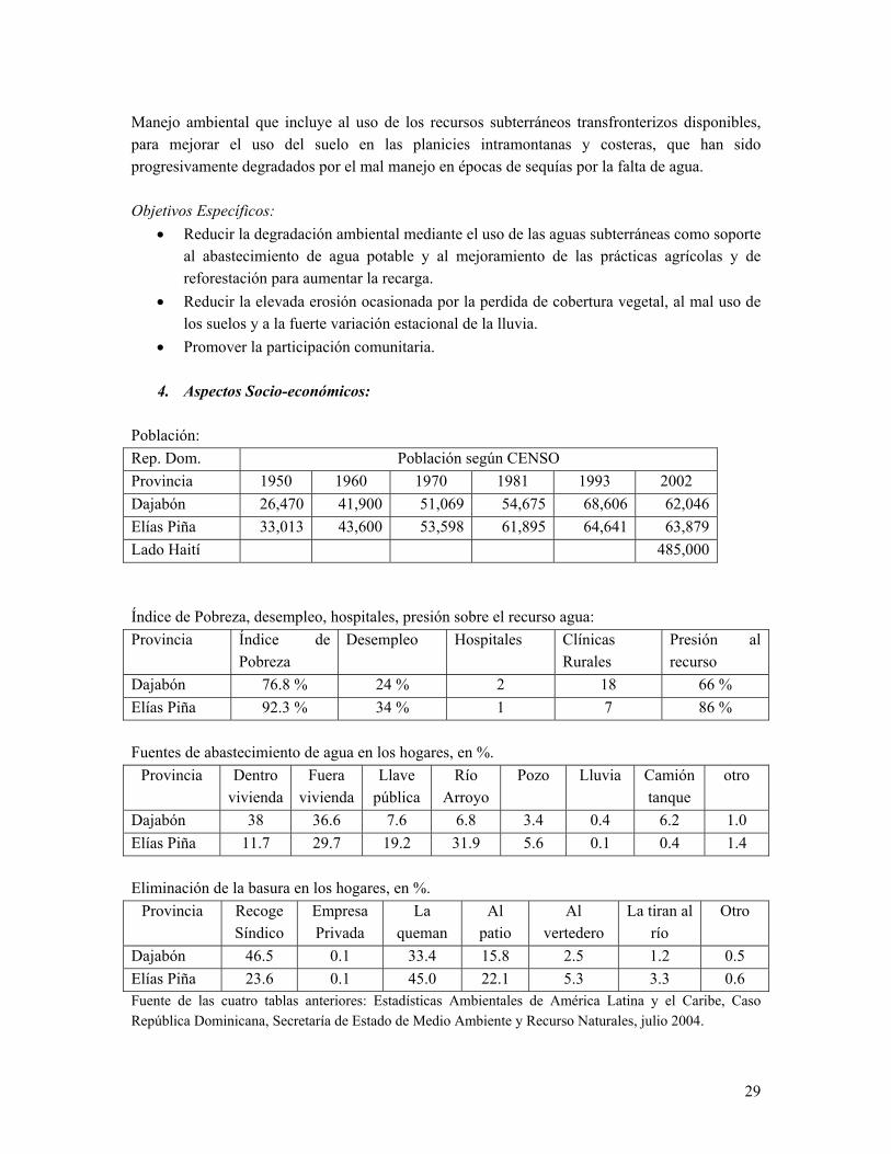
4. Aspectos Socio-económicos: Población: Rep. Dom. Población según CENSO Provincia 1950 1960 1970 1981 1993 2002 Dajabón 26,470 41,900 51,069 54,675 68,606 62,046 Elías Piña 33,013 43,600 53,598 61,895 64,641 63,879 Lado Haití 485,000 Índice de Pobreza, desempleo, hospitales, presión sobre el recurso agua: Provincia Índice de
Pobreza Desempleo Hospitales Clínicas
Rurales Presión al recurso
Dajabón 76.8 % 24 % 2 18 66 % Elías Piña 92.3 % 34 % 1 7 86 % Fuentes de abastecimiento de agua en los hogares, en %.
Provincia Dentro vivienda
Fuera vivienda
Llave pública
Río Arroyo
Pozo Lluvia Camión tanque
otro
Dajabón 38 36.6 7.6 6.8 3.4 0.4 6.2 1.0 Elías Piña 11.7 29.7 19.2 31.9 5.6 0.1 0.4 1.4 Eliminación de la basura en los hogares, en %.
Provincia Recoge Síndico
Empresa Privada
La queman
Al patio
Al vertedero
La tiran al río
Otro
Dajabón 46.5 0.1 33.4 15.8 2.5 1.2 0.5 Elías Piña 23.6 0.1 45.0 22.1 5.3 3.3 0.6 Fuente de las cuatro tablas anteriores: Estadísticas Ambientales de América Latina y el Caribe, Caso República Dominicana, Secretaría de Estado de Medio Ambiente y Recurso Naturales, julio 2004.
30
Cobertura Vegetal: 16.7 %
5. Aspectos Hidrogeológicos: Cuenca del Masacre: En las montañas predominan rocas plutónicas y volcánicas intrusitas del Cretácico Superior con permeabilidad media por figuración, mientras que en la planicie predominan conglomerados del Neoceno y del Cuaternario, y terrazas fluviales del Cuaternario. La salinidad varía de 0.6 gr/l a 10 gr/l próximo a la costa. La red de monitoreo de la calidad de agua subterránea esta basada en pozos pocos profundos y bacteriológicamente están contaminados. Cuenca del Artibonito: En la cuenca alta del Río Artibonito predominan rocas volcanosedimentarias masivas, volcánicas masivas, materiales de Facies Flysch del Terciario-Cretácico y calizas Cretácicas, que descargan hacia el oeste a través de las cuencas de los Ríos Artibonito, Joca y Tocino. Algo similar se encuentra en la cuenca del Guayamouc. Las descargas totales desde la República Dominicana, por este borde oeste se estiman en 190 MMC/año medio, de los cuales sólo el 8 % (unos 15 MMC) corresponden a la escorrentía subterránea. (INDRHI-EPTISA, 2004) Hacia el afluente Macasía predominan conglomerados, arenas, molazas y calizas arrecifales del Pleistoceno/Plioceno, con permeabilidad media y flujo hacia Haití. En el Plató Central de Haití se encuentran calizas arrecifales del mismo período. En perforación petrolera de 3,641 metros, a unos 2 km de la frontera y próxima al Macasía se encontraron las siguientes formaciones: Era Formación Espesor Acumulado Cuaternario • Terrazas fluviales, p 30 m 30 mTerciario Superior • Plioceno • Mioceno inferior /
medio • Oligoceno
superior
• Conglomerado Las Matas, p • Arroyo Seco-Arroyo Blanco, i
(Shale, areniscas, caliza) • Trinchera, i
(Shale, areniscas)
921 m 372 m
1,598 m
951 m
1,323 m
2,921 m
Terciario Inferior • Oligoceno medio • Eoceno superior
• Sombrerito, sp
(Calizas margosas y marga) • Neiba – Plaisance, p
(Calizas cristalizadas y litográficas)
265 m
455 m
3,186 m
3,641 m
(INDRHI, 1989, Mapa Hidrogeológico Nacional)
31
6. Degradación de los recurso naturales y procesos causales.
Según PAN-FRO, junio 2003, en talleres celebrados en Elías Piña (19-20 Nov. 04) y Dajabón (17-18 Dic. 04) se llegaron a las siguientes conclusiones: Degradación de: Causas Efecto
Suelo • Deforestación • Sistemas agrícolas y pecuarios no
• Deforestación • Deterioro del bosque • Pérdida biodiversidad
Recurso Hídricos • Deforestación • Sistemas inadecuados de riego y
drenaje • Sequías • Cambio climático • Contaminación por vertidos
• Disminución caudales • Extinción de acuíferos • Deterioro calidad • Escasez de agua para riego
y potable
32
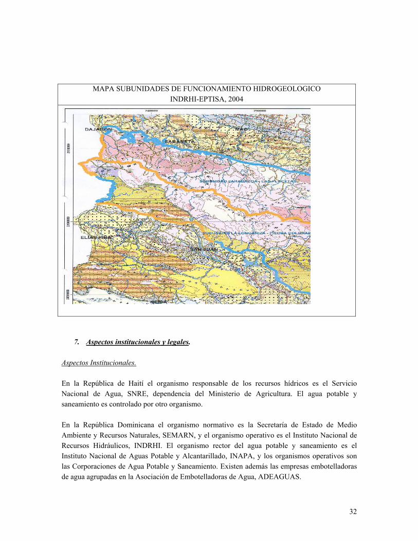
MAPA SUBUNIDADES DE FUNCIONAMIENTO HIDROGEOLOGICO INDRHI-EPTISA, 2004
7. Aspectos institucionales y legales. Aspectos Institucionales. En la República de Haití el organismo responsable de los recursos hídricos es el Servicio Nacional de Agua, SNRE, dependencia del Ministerio de Agricultura. El agua potable y saneamiento es controlado por otro organismo. En la República Dominicana el organismo normativo es la Secretaría de Estado de Medio Ambiente y Recursos Naturales, SEMARN, y el organismo operativo es el Instituto Nacional de Recursos Hidráulicos, INDRHI. El organismo rector del agua potable y saneamiento es el Instituto Nacional de Aguas Potable y Alcantarillado, INAPA, y los organismos operativos son las Corporaciones de Agua Potable y Saneamiento. Existen además las empresas embotelladoras de agua agrupadas en la Asociación de Embotelladoras de Agua, ADEAGUAS.
33
Aspectos Legales. En Haití está en proceso la ley de agua. En República Dominicana existen:
• Ley 487 sobre aguas subterráneas, del 15 de octubre de 1969. • Ley 6 de creación del INDRHI, del 8 septiembre de 1965. • Ley 64-00 sobre Medio Ambiente y Recurso Naturales. • Se encuentra en el congreso dominicano la nueva de Ley General de Agua. • El nuevo Reglamento y las Normas de Agua Subterráneas están pendiente de
promulgación. Aspectos Internacionales.
• Tratado de límites fronterizos del 21 de enero de 1929. • Acuerdo Básico de Cooperación del 3 de mayo de 1979. • Dentro de este acuerdo existe la Comisión Mixta Dominico-Haitiana.
34
3RD CASE-STUDY: PANTANAL TRANSBOUNDARY AQUIFER SYSTEM
BOLIVIA-BRAZIL-PARAGUAY
National Coordinator for Brazil: Sr. Julio Kettelhut
RESUMO EXECUTIVO Introdução
O Sistema Aqüífero Transfronteiriço Pantanal ocorre desde o Rio Apa, na fronteira do Brazil com o Paraguai, até a região a oeste de Cáceres (Brazil), na linha EW, da fronteira Brazil/Bolívia. Situa-se sob o contexto do Ecossistema Pantanal, maior planície alagada do planeta e uma das maiores concentrações de biodiversidade do mundo, declarado recentemente Patrimônio Natural da Humanidade pela Unesco. A região sofre com a expansão desordenada e rápida da agropecuária, principalmente na área do seu entorno, com a utilização progressiva de pesadas cargas de agroquímicos e a exploração de diamantes e ouro nos planaltos, com utilização intensiva de mercúrio, sendo responsáveis por profundas transformações regionais. Desta forma, constata-se que o crescimento econômico que afeta a região, trazendo impactos negativos em relação à sustentabilidade ambiental e a qualidade de vida das populações locais. No intuito de controlar os possíveis problemas a serem gerados, será necessária uma série de ações em busca de políticas regionais de desenvolvimento auto-sustentável e da gestão integrada entre os países de recursos hídricos da região. Questões Científico-Hidrogeológicas O Sistema Aqüífero Transfronteiriço Pantanal é formado no Brazil por sedimentos arenosos e conglomeráticos de idade Tércio-quaternária da Formação de mesmo nome. Também se associam ao sistema sedimentos aluvionares recentes que cobrem parcialmente a Bacia do Alto Paraguai. Na Bolívia Corresponde a Plataforma Mojeño. O Mapa Hidrogeológico da América do Sul, executado pelo Serviço Geológico do Brazil (1:5.000.000), apresenta indicativos de que a qualidade das águas subterrâneas é boa na porção
35
Brazileira do aqüífero, enquanto na Bolívia e Paraguai estas são, em grande parte, salobras e salgadas. Entretanto, os dados utilizados são poucos e não há nenhum fato geológico explicito para tal ocorrência.
Vários projetos foram desenvolvidos na região, inclusive atualmente está em andamento um Programa GEF no Pantanal. Entretanto, nenhum deles pesquisou e sistematizou informações hidrogeológicas, especialmente em conjunto com a Bolívia e Paraguai.
Não há informações suficientes para gestão de sistema aqüífero e muito menos um modelo elaborado de gestão compartilhada entre os três países. Por outro lado, o aqüífero é freático, bastante raso e com nível por vezes sub-aflorante. Todavia, não há sequer sistematização dos dados de vazão ou qualidade de suas águas subterrâneas, apesar da sensibilidade e importância do aqüífero para o ecossistema da região. Para confirmação desta hipótese serão necessários estudos geológicos e hidrogeológicos deste aqüífero transfronteiriço. Aspectos Legais 1.Tratados de Cooperação Internacional
Tratado da Bacia do Prata Firmado em Brasília, DF, em 23 de abril de 1969 por chanceleres dos cinco países da Bacia do Prata: Argentina, Bolívia, Brazil, Paraguai e Uruguai. Tem por objetivo "permitir o desenvolvimento harmônico e equilibrado, assim como o ótimo aproveitamento dos grandes recursos naturais da regiгo, e assegurar sua preservação para as gerações futuras através da utilização racional dos aludidos recursos". 2. Legislações Nacionais Existentes No Brazil, a água subterrânea, no que diz respeito aos seus aspectos legais e jurídicos, destaca-se pelo seu marco histórico e institucional vigente e a experiência de alguns estados que já instituíram, regulamentaram e executam as ações instrumentalizadas conforme as necessidades de gestão, uso ou proteção dos recursos hídricos no âmbito regional. Todos são unânimes pela existência de uma ação de disciplinamento e proteção do recurso água subterrânea, através de uma legislação eficiente que demonstre uma efetiva e real responsabilidade por parte do poder público.
Código de Águas - Decreto Nº 24.643, 10 de Julho de 1934
36
As águas subterrâneas eram consideradas bens imóveis, associados à propriedade da terra. Incorporava normas reguladoras que preservavam direitos adquiridos, inibiam a monopolização da exploração e a poluição das águas subterrâneas, reconhecia o fato da sua estreita relação com as águas superficiais e limitava o direito e exploração das águas subterrâneas, sempre que o empreendimento interferisse na ocorrência das águas superficiais de domínio público.
Código de Águas Minerais - Decreto-Lei N° 7.841, 08 de Agosto de 1945 Estabeleceu normas para o aproveitamento das águas minerais. Seu conteúdo era confuso em relação à abrangência do conceito de águas minerais, ao distinguir águas minerais das demais águas, relevando no seu aspecto uma "ação medicamentosa" decorrente de características físicas ou químicas distintas das águas comuns. Criou então a Comissão de Crenologia (estudo das águas minerais, para fins terapêuticos) no âmbito do DNPM para verificação destas propriedades. São incluídas as Águas Minerais, Termais, Gasosas, Potáveis de Mesa e as destinadas para fins de Balneários, estabelecendo a todas, as normas reguladoras que preservem sua qualidade, salubridade pública, os direitos de propriedade dos empreendedores, e informem ao poder público as características da exploração para fiscalização e monitoramento.
Criação da S.E.M.A. (Secretaria Especial do Meio Ambiente) – 1973 Com competência para estabelecer normas e padrões relativos à qualidade dos recursos hídricos, foi responsável pela inclusão de novas normas reguladoras e restritivas quanto ao uso e ocupação do solo em locais onde ocorrem fontes de surgência natural (olhos-d’água).
Resolução Nº 20, de 18 de Junho de 1986 - Conselho Nacional do Meio Ambiente
Estabelece a classificação das águas, doces, salobras e salinas do Território Nacional; com base em parâmetros e indicadores específicos para melhor distribuir seus usos, especificando os níveis de qualidade requeridos, de modo a assegurar seus usos preponderantes.
Constituição Federal - 1988 Muda o status das águas subterrâneas, estabelecendo um novo regime para as mesmas, conferindo-lhes caráter de bem público de propriedade dos Estados e Distrito Federal e distingue claramente águas subterrâneas de recursos minerais do subsolo, sendo, portanto as águas minerais de competência da União.
Lei das Águas - Lei Federal N° 9.433 - 8 de Janeiro de 1997
37
Incorpora a mudança na dominialidade das águas subterrâneas, estabelecida pela Constituição de 1988, e mantém tratamento diferenciado para águas ditas "minerais". Quanto à gestão das águas subterrâneas, recomenda a utilização dos mecanismos de outorga das concessões de exploração como principais instrumentos de gestão. Quanto às normas reguladoras apresenta significativa contribuição relativa aos aspectos da poluição e super-explotação de aqüíferos, proibindo a poluição das águas subterrâneas, monitoramento de aterros sanitários e estudos de vulnerabilidade de aqüíferos. No campo da Normatização, toda e qualquer obra de captação de água subterrânea é considerada uma obra de Engenharia para a qual exige-se habilitação legal nas diferentes etapas da pesquisa, projeto e exploração. Alguns Estados como São Paulo, Pernambuco e Ceará têm se destacado com suas propostas de Lei sobre conservação e proteção das águas subterrâneas, como também pela implantação do sistema de Outorga de usos dos recursos hídricos como um todo, todavia, ainda é escassa a atenção dada aos recursos hídricos subterrâneos, sendo priorizado em seus sistemas de gestão dos recursos hídricos, as águas superficiais.
Resolução No 09, 21 de junho de 2000 - Conselho Nacional de Recursos Hídricos (CNRH) Institui a Câmara Técnica de Águas Subterrâneas (CTAS) do Conselho Nacional de Recursos Hídricos (CNRH).
Resolução No 15, 11 de janeiro de 2001 - Conselho Nacional de Recursos Hídricos (CNRH) Estabelece a inserção das águas subterrâneas na gestão integrada das águas.
Resolução No 16, 08 de maio de 2001 - Conselho Nacional de Recursos Hídricos (CNRH) Normatiza questões relativas a outorga de recursos hídricos.
Resolução No 22, 24 de maio de 2002 - Conselho Nacional de Recursos Hídricos (CNRH) Faz a inserção das águas subterrâneas no instrumento planos de recursos hídricos.
Resolução No 29, 1 de dezembro de 2002 - Conselho Nacional de Recursos Hídricos (CNRH) Define questões relativas ao uso de recursos hídricos, inclusive subterrâneos, nas atividades minerárias, diretrizes de outorga e procedimentos integrados.
38
Aspectos Sócio-Econômicos A expansão desordenada e rápida da agropecuária, principalmente na área do seu entorno, com a utilização progressiva de pesadas cargas de agroquímicos e a exploração de diamantes e de ouro, nos planaltos, com utilização intensiva de mercúrio, são responsáveis por profundas transformações regionais. A implementação do gasoduto Brazil/Bolívia abre novas perspectivas industriais para a região, mas poderá desencadear alterações nos ecossistemas aquáticos do Pantanal e da bacia platina. Além disso, a hidrovia Paraguai-Paraná desperta a atenção da sociedade pelos impactos que poderá promover.
A despeito da baixa densidade demográfica, a água subterrânea da região é estratégica, não só para a economia, abastecimento local e das comunidades dispersas, mas também como reserva de água. Além disso, somam-se os fatos de que o aqüífero em questão é bastante raso e é a base de sustentação ecológica da região.
Para que o Pantanal possa competir na oferta de seus serviços ambientais, é preciso criar e implementar políticas públicas voltadas para o desenvolvimento e adequar a legislação ambiental e de recursos hídricos às peculiaridades do Pantanal.
Questões Ambientais É de reconhecida importância a necessidade de preservação do Ecossistema Pantanal, maior planície alagada do planeta e uma das maiores concentrações de biodiversidade do mundo, declarado recentemente Patrimônio Natural da Humanidade pela Unesco.
O Pantanal está localizado no centro da América do Sul e ocupa uma área de 138.183 km2 da bacia Hidrográfica do Alto Paraguai (38,21%). Sua grande diversidade biológica tem origem nas regiões Amazônica, no Chaco, nos Cerrados e na Mata Atlântica e é sustentada por seu regime hidrológico.
A remoção da vegetação nativa nos planaltos para implementação de lavouras e de pastagens sem considerar a aptidão das terras e a adoção de práticas de manejo e conservação de solo, além da destruição de habitats, acelerou os processos erosivos nas bordas do Pantanal. A conseqüência imediata tem sido o assoreamento dos rios na planície, a qual tem intensificado as inundações, com sérios prejuízos à fauna, flora e economia do Pantanal. A região é um ecossistema complexo, existindo a pressão de contaminação advinda da região do Planalto.
39
Assim, sem que haja a integração multilateral, o fortalecimento das políticas públicas de recursos hídricos e das instituições de pesquisa e de gestão de recursos hídricos da região, vários são os impactos negativos esperados. Os maiores são: a degradação da qualidade e quantidade das águas do Sistema Pantanal, redução da qualidade de vida (saúde) das populações locais e a menor disponibilidade de água potável.
Orientações para o Desenvolvimento Sustentável do Aqüífero Transfronteiriço Não há como realizar uma gestão sistêmica, integrada e participativa sem a integração de dados, ações e determinações entre os países que abrangem o Sistema Aqüífero Transfronteiriço Pantanal. É necessária a geração de informações que subsidiarão políticas, legislação, programas, planos e ações relacionadas aos recursos hídricos subterrâneos da região, possibilitando o seu desenvolvimento sustentável. Para tal, a Secretaria de Recursos Hídricos do Ministério do Meio Ambiente do Brazil e o Serviço Geológico do Brazil vêm buscando formas para captar recursos financeiros para desenvolver um projeto que cubra esta necessidade. Estas informações também subsidiarão o Programa ISARM Américas da UNESCO/OEA.
40
CASE-STUDY: OSTUA –METAPAN TRANSBOUNDARY AQUIFER SYSTEM
EL SALVADOR-GUATEMALA
National Coordinators: S.ra Celina Mena; Sr. Fulgencio Garavito
EXECUTIVE SUMMARY Introduction
Metapán-Ostúa acuifer systems sited inside of Guatemalan Departments of Jutiapa, Jalapa and Chiquimula (in the South-east of Guatemala), and El Salvador Department of Metapán (in the west of El Salvador). The geological characteristics are quaternary alluviums sedimentary valleys with volcanic scoria, basaltic rocks and lahars. In small areas are limestone rocks and metamorphic rocks nearly the El Salvador frontier.
The Ostúa basin approximately has 500,000 inhabitants (Only from Guatemala country, census 2002), and almost of it is semi-arid area. The importance of the Ostúa acuifer is for Human Fresh water of the cities, counties and settlements; cattle, irrigation crops, industry and trade and eco-tours and recreation activities. Aproximatelly the volume of groundwater extracted (years´ 1990), is about 60 millions mt³ per year for the municipal use (The extractions from the irrigation private farms are not included).
The groundwater flow a long the cross-border it is from Guatemala to El Salvador, NE, NW to SE direct to the Güija Lake, who is the lower level inside the Ostúa basin. For other side, the risk for the multidisciplinary management are the conflict uses and the contamination problem with the drainage, sewerage water and agricultural garbages products. Scientific-hydrogeological issues Groundwater hydraulics, actual and potential international implications
The groundwater transmisivity is around 6 – 800 m³ per day per meter of aquifer deep and the store coefficient is about 0.15 - 0.30 to free aquifers and from 0.0001 to 0.001 in confined aquifers.
41
The piezometric lines depend of the distance to rivers. Nearly to them, the piezometric is similar to the river level, specially when the analysis is the quaternary alluviums of the main valleys or in the sites with basaltic fractured rocks. It is different in areas with tuffs, lava floods and Subinal formations (red beds mainly tertiary). Here, those aquifers are poorly.
Generally the groundwater quality is good, there is no problem with water salinization, except in some particular points, for example in sites nearly of active volcanoes or where the temperature of the water is high (40° C – 60° C), especially around Jutiapa and Asunción Mita cities.
In some places the garbage sites are situated on the head of the watersheds and determinate
the pollution grade with infiltration water. Other implication is the population grows of the cities (the demand of water volume increase).
The trend of changes in flows are direct relation with the rainfall volumes associated with
climate variability and climate change, specially with the El Niño phenomena. Also the water quality change with the water volume available into the aquifer and high average level to contribute to groundwater.
The Municipal Use is the most important and the Alcaldes be initiated some statements about the population low use of water; forestry some captive zones (No so much) . Also they have a modern domiciliary rate for the serve and with the high prices for use in excess, (Always, the rates are low and there is not the real price)
The contemporary aquifers recharge was affected by the poor seasonal rainfall 2001 –
2004. Some Municipal Government explained about the reduction of wells and springs discharge all over the East and South-East of Guatemalan Republic. And another side, this is part of the Global Climate Variability who attend this Semi-arid zone and more deep in Guatemala than El Salvador. In this time, some years was present the El Niño Phenomena, but in other years it was did not.
From the technician point, it is necessary improvement a project of level monitoring and control on production of the groundwater for each use and preserve the recharge areas and pollution protect them. Legal aspects
In Guatemala only exist some local municipal and irrigations water regulations, but the last National Water Law there is not approved yet by the Republic Congress. Also the Environmental and Nature Resources Minister has some regulations to prevent bad practices with the water uses, pollution and discharges of waste waters.
42
The appliance of this project is useful to effort some gaps specially in basins protection,
management the multidisciplinary and conflict uses and the contamination problem with the drainage, sewerage water and agricultural garbages products deposited into the rivers, dams and lakes. Socio-economic aspects Population served by the aquifer system: 500,000 inhabitants
In this region exists a grand deal of poverty; at North of Jalapa, in San Carlos Alzatate is the poorly people of Guatemala.
The Ostúa basin is a semi-arid region and the drink water available is too short. Also the water to livestock and irrigation uses are scarce. – water quality-health issues – IWRM-poverty: In the Ostúa basin some municipal corporations treat the fresh water to the customers, but others only have crude water, and then, there are many health problems, specially with the stomach maladies, as the disentería and coliformes, and other bacteria pollution.
The importance of groundwater in the region is high. The last four years ago, the rainfall station was poorly, then transport low discharge to aquifers.
Driving forces
There are some as the climate variability, the people demand for fresh water, irrigation, cattle and industry uses.
Nature of competition: the principal competition are the municipal and irrigation uses. Governance issues: The Municipal government is the referee in conflict cases, also the INAB (Instituto Nacional de Bosques – Forestry National Institute), apply the law in case of cuts woods and firewoods, also protect the basins. regule and irrigation. The MARN (Environ and Natural Resources Minister), is the authority to control the pollution of soil, water, air and aquifers. Also the International Limits Office, Affair Minister, and MAGA (Agriculture, Cattle and Food Minister include the surface water item, specially with International Treated. Contribution of groundwater to local economy – what proportion of income is based on groundwater use:
43
The contribution is big, some places have Semi-arid clime with poor soils and the rainfall annual distribution (4-5 month per year) produce hydrological deficit, then the people need the groundwater by wells and springs (when it is possible). Institutional issues Domestic and international management Institutional analysis – national-regional-local; what agencies are involved, how do they inter act? Political and legal aspects and dimensions:
The MARN (Environ and Natural Resources Minister), is the authority to control the pollution of soil, water, air and aquifers. Also the International Limits Office, Affair Minister, and MAGA (Agriculture, Cattle and Food Minister include the surface water item, specially with International Treated. Environmental issues Sustainable development of transboundary aquifer resources – estimate of ‘life of resource’ on current & future production rates:
In fact, there are some random actions to preserve the basin, but the practice is no so quicky and carry out slowly.
Biodiversity:
On last years the Central Govern and specially the Local Municipal Governs (with the Alcalde Or the Municipal Corporation), Impulse efforts to create some Protected Areas into the basins to conserve several biological species.
Climate change - tie into the previous section on ‘recharge’:
Of course, the inter-annual aquifer level oscillation depend direct of the feed of rainfall volume to soil profile. Poverty alleviation, water and health : based on info provided in the Soci-econ section Conflict prevention Ethical development of transboundary aquifers: In fact, the conflict exist, a little, with the available of discharge to human, irrigation and hydroelectric uses. Non-traditional or specific uses- CO2 sequestration, disposal of waste, thermal ASR:
Some areas of the basin are available to CO2 silks and have potential to cover with wood plantations in fact to protect basins, springs, specially the river bed, and so on. The importance of relationship with the theme about disponsal of waste in necessary in both countries and available thermal prospection and operating plants to generate energy.
44
Guidance for sustainable management of the transboundary aquifer Joint aquifer resource monitoring strategy:
It is necessary a joint to establish the standard methodology to monitoring strategy with similar comparative parameter in both countries.
Both countries have qualify institutions as INSIVUMEH (Guatemala) and SNET (El Salvador); In the past them worked and researched items relationship with the water item (Meteorological and Hydrological aspects).
Joint water user associations: It is very important the relationships between the water user associations, as the Municipal Alcaldes (Municipal governments), of boundary municipios; the irrigation, the catlle, the farmers, wood-farmers and fishers to attend to joints, meetings, courses and seminars and other capacity applied. APPENDICES Tabulated data
• Aquifer features • Population statistics • Economic indicators
45
46
47
1.2 SPECIAL PRESENTATIONS ON “IBWC/CILA ISARM AMERICAS HUECO BOLSON CASE STUDY”
International Border Water Commission - US Introduction
The Hueco Bolson aquifer covers approximately 2,500 square miles or 1.6 million acres in a bi-national, three state region including westernmost Texas, south central New Mexico, and a northern portion of the state of Chihuahua, Mexico. It is located to the east and south of the cities of El Paso, Texas and Ciudad Juarez, Chihuahua, Mexico, and is bisected by an international river, Rio Grande/Rio Bravo, that forms the boundary between the two countries. See Figure 1
Geographically the area is located in the northern part of the Chihuahuan desert, an area with limited rainfall and limited surface water supplies. Groundwater and surface water supplies cross both state and international boundaries.
According to Heywood and Yager (2003) the Hueco Bolson is a structural depression associated with faulting along the Rio Grande Rift. Igneous and sedimentary rocks surround and underlie the Hueco Bolson, and alluvial deposits consisting primarily of gravel, sand, silt and clay fill the basin. In cross section the basin is deep and is bounded by the Franklin Mountains on the west and the Hueco Mountains to the east. See Figure 2. Groundwater from the Tularosa Basin to the north flows into the Hueco Bolson. Fresh groundwater in the Hueco Bolson is shallow, and alluvium overlies the deposit. Deeper portions of the bolson become increasingly saline. The Hueco Bolson is an unconfined, rechargeable aquifer. Recharge has been estimated to be 19,000 cubic meters/day. Remaining fresh groundwater storage is estimated to be 7.5 million acre – feet (AF).
The groundwater from the basin is shared by Mexico and the United States, primarily for domestic and industrial use. The importance is paramount, as it is the sole water source for Ciudad Juarez and accounts for 30% of the domestic water for the City of El Paso. The population of the region continues to grow rapidly and is expected to rise to 3.5 million by 2010. The estimated 2004 population of Ciudad Juarez is 1,327,000 and the current El Paso population is estimated to be 720,000.
48
Historically, from 1903 to 1976, approximately 2 million AF was pumped from the aquifer. Meyer (1976) postulated through groundwater modeling that about 50% of this amount was removed from storage in the water table part of the aquifer, 25% was contributed from leakage from the alluvium, and the rest was derived from natural recharge from Rio Grande/Rio Bravo. In 1979, the Texas Water Development Board determined that continued pumping by El Paso Water Utilities (EPWU) was not sustainable, based on a study by Muller and Price (1979). In 1983, the City of El Paso filed applications with the New Mexico State Engineer to drill wells in the Mesilla Bolson aquifer, just west of the Franklin Mountains, to ensure that future municipal demand could be fulfilled. This resulted in an eleven-year dispute between New Mexico and Texas, which ended in the early 1990s, and has been well documented by Earl and Czerniak (1996). The dispute finally went to arbitration and a Joint Settlement Agreement was reached in 1991. The New Mexico Texas Water Commission was formed as a result and in 2001 that organization published a report identifying the need for several new surface water plants in New Mexico and Texas. El Paso had been forced to migrate from a single simple solution to a diverse program with elements of conservation, water rights acquisition, surface water use, and use of wastewater effluent treated to advanced secondary/tertiary standards.
Pumping from the Hueco Bolson by El Paso Water Utilities (EPWU) peaked at a high of 80,000 AF in 1989. By 2002 that amount had been reduced by half due to increased conservation efforts and doubling of the City’s annual amount of treated surface water. Combined pumping by both countries has been estimated to be as high as 184,000 acre-feet/year (Fahy and Sheng 2000), however EPWU considers this estimate to be overstated. An important source of artificial recharge is the Hueco Bolson Recharge Project operated by the EPWU. Approximately 10 million gallons per day (mgd) of raw wastewater is treated to potable water standards in a ten-step treatment process at the Fred Hervey Water Reclamation Plant. Half that amount is then injected into the aquifer.
Hydrogeological Issues
The basin quantity is significant in terms of volume, but only 25% of this volume is economically recoverable. The groundwater flow patterns are complex. The Heywood and Yager model concluded that groundwater pumping from the Hueco has resulted in storage declines and allowed inflow from both brackish and freshwater areas, including water from the New Mexico portion of the Hueco Bolson and the surface water system. The predevelopment and existing gradient continues to be predominately from north to south; however aquifer outflow from El Paso to Juarez has increased since the predevelopment era. The aquifer is currently being managed by Mexico to curtail any future increases in pumping. Junta Municipal de Agua y Saneamiento de Juarez (JMAS) is actively seeking alternative water sources, including water from the Mesilla Bolson, the Rio Grande, and a mine near Ascension. JMAS has noted a recent decrease in per capita use in Ciudad Juarez due to education. EPWU has aggressively reduced pumping, which has led to stabilization of water levels. In the past 5 years, pieziometric surfaces
49
have stabilized in the calibrated observation wells at approximately 3590 feet mean sea level. EPWU has joined with the United States Department of the Army in planning for the construction and operation of a Joint Desalination Facility. This 27.5 mgd facility will intercept brackish groundwater and protect fresh groundwater in the EPWU’s airport wells and wells in the area of the local Army base in El Paso, Fort Bliss.
Legal Aspects
Currently, few legal agreements relative to the groundwater extraction from the Hueco Bolson are in place. There is a memorandum of understanding between EPWU and JMAS on data exchange and planning for future development of the Hueco Bolson. Proposed Senate Bill S. 1957, the United States Transboundary Aquifer Assessment Act did not pass the 108th Congressional session. Currently groundwater extraction is subject to the laws and regulations of the Republic of Mexico and the states of Texas and New Mexico.
In New Mexico, groundwater is allocated for use through a system of prior appropriation. This is governed by the theory of “first in time, first in right.” In New Mexico, and most of the arid west, ownership of land bordering on or overlying a water source does not give the owner the right to use water from that source. A property right in the use of water is created by diversion of water from a stream or aquifer and its application to a beneficial use. Water can be used at any location, without regard to the position or place of use in relation to the stream. In the event of a shortage of supply, water will be supplied to users up to the limit of their right in order of priority: the most recent permit holder is the first to have his supply cut off. In New Mexico, groundwater appropriation in declared basins is allocated by the State Engineer.
Groundwater in Texas falls under the doctrine of right of capture. In Texas, groundwater is considered the property of the surface owner from which it is pumped - similar to the laws governing oil and gas. Texas surface water law is a hybrid of prior allocation and riparian rights.
In Mexico, water is publicly owned and managed. The Mexican Constitution of 1917 nationalized the country's water resources and irrigation systems became the responsibility of the federal government. In 1989, as part of the National Development Plan (1989-1994), there was a major modification of the water law of Mexico, within which was the creation of the National Water Commission (CNA). Between 1990 and 1995, CNA transferred operations and maintenance of over 80% of irrigation systems to water user associations and irrigation districts, while still maintaining control of the management and development of the resource. Ciudad Juarez relies solely on the Hueco Bolson for drinking water. In the region of Ciudad Juarez, Mexico also receives up to 60,000 acre-feet /year of surface water in accordance with the 1906 Convention with the United States. Some contend that this amount, while fair in 1906, may be inappropriate today.
50
Institutional Issues
Mexico, New Mexico and Texas, all with divergent policies, will be prime players in the quest for legal agreements on groundwater management of the Hueco Bolson. Cady and Soden (2001) developed a baseline database for a legal-institutional analysis model and identified no less than 25 agencies on both sides of the border who have stakeholder roles. Most players want brokered decisions, with an equal split between advocates for change and guardians of the status quo. Both the International Boundary and Water Commission, United States and Mexico (IBWC), and the Border Environment Cooperation Commission (BECC) have been identified as agencies that can serve stakeholders from both countries.
Socio Economic Aspects
The population served by the aquifer system includes most of Ciudad Juarez and approximately 30% of the City of El Paso, therefore a significant portion of the economic base of both cities depends on groundwater. The population in the Upper Rio Grande Region of Texas has doubled in the past 30 years. The poverty profile in El Paso is 23.8% (higher than the national average in the U.S.), the unemployment rate is about 7-8%, and the average per capita income is about $18,000.
The U.S. side is characterized by higher poverty levels than the Mexican side, with more than 30% of the Latino population uninsured. Mexico has somewhat higher socio-economic conditions - 95% of the population has access to health services, with some gaps in the rural areas. Heart disease, cancer, and diabetes are leading causes of death. Ciudad Juarez has one of the highest mortality rates on the border due to diabetes mellitus. Substance abuse and behavioral problems, as well as malnutrition and obesity, are common on both sides.
Water quality from the Hueco is generally good; however, water from the EPWU wells often exceeds the chloride standard of 250 mg/l before exceeding the Total Dissolved Solids standard of 1000 mg/l. Brackish water infiltration is one of the leading concerns with the Hueco Bolson. Major groundwater development in the Hueco Bolson is limited and has basically been halted on the municipal scale. El Paso has chosen to explore alternatives to use of the Hueco Bolson. The New Mexico Texas Water Commission 2001 report proposed a series of surface water plants having positive environmental consequences; however water rights have not been transferred quickly enough to implement in the short term.
51
Environmental Issues
Since the advent of the North American Free Trade Agreement (NAFTA), business is booming on the border, with 400 million individual crossings yearly South to North, and 3.8 million truck crossings annually. The maquiladora, or assembly plant, industry exercises a very strong presence in the El Paso - Juarez region. In Ciudad Juarez, the majority of all jobs in 2000—60 percent—came from the maquiladora sector, and the majority of the city's manufacturing jobs—87 percent—were attributable to maquiladora companies.
The BECC, an agency created as a side agreement to NAFTA, identifies, supports, evaluates and certifies sustainable environmental infrastructure projects through broad public participation, to improve the quality of life of the people of the U.S.-Mexico border region. The role of the BECC is to help conserve, protect and enhance the environment in the U.S.-Mexico border region, through the development and certification of environmental infrastructure projects that incorporate innovative sustainability and public participation concepts. Many BECC - certified projects are funded through the North American Development Bank. The concept embraces sustainable development and public participation, but has been criticized by some as being slow – certification and approval by BECC does not always translate into funded and completed projects.
Wastewater treatment and air quality continue to be major issues in the El Paso-Juarez valley. Recent years have seen the beginning of what experts say is a long-term drought in the Mexico – U.S. border area. Additionally, non - government organizations and state and local agencies are lobbying to improve riparian areas and in-stream flows for recreation and wildlife habitat.
The New Mexico-Texas Water Commission in 2001 reported that Hueco Bolson supplies would be exhausted by 2030. This was first suggested by Muller and Price (1979) and restated by Boyle in 1991. At present, according to a current EPWU study, groundwater extraction from the bolson is at a sustainable level. It suggests that additional aquifer recharge projects have potential for implementation; however there is not a critical need in the next 20-40 years should the current pumping scenario continue. It further states there is no need for additional development of the bolson in the foreseeable future (50-100 years.)
Guidance for Management
The IBWC has an extensive history of binational projects and programs, and has issued several reports on surface water quality conditions for the Rio Grande. Binational technical groups have been assembled for groundwater database exchange and groundwater modeling. The database exchange culminated in a 1998 product titled “Transboundary Aquifers and Groundwater Data-Base – City of El Paso, City of Juarez Area”. IBWC could be a forum for cooperation and policy development for stakeholders; however individual states will play the major role as groundwater on the U.S. side is managed by the states. EPWU continues to maintain a database of observation
52
well readings, pumping information and water quality data, and to participate in an isotope study funded with a grant from the National Science Foundation. This is a collaborative effort by the University of California - Los Angeles, the University of Arizona, and Universidad Autonoma de Ciudad Juarez.
References Cady, F., and Soden, D.L., The Legal-Institutional Analysis Model and Water Policymaking in a Bi-National Setting, Journal of the American Water Resources Association, February 2001. Earl, R.A. and Czerniak, R.J., Sunbelt Water War: The El Paso – New Mexico Water Conflict, The Social Science Journal, Vol 33, No. 4 1996 Fahy, M.P. and Sheng, Z. Management Strategies for the Hueco Bolson. El Paso Water Utilities. Strategic Water Development Division, 2000 Gruben, William C. and Kiser, Sherry L. NAFTA and Maquiladoras – Is the Growth Connected? Federal Reserve Bank of Dallas, The Border Economy, June 2001 Heywood, C. E. and Yager, R.M. Simulated Groundwater Flow in the Hueco Bolson, an Alluvial Basin Aquifer System near El Paso, Texas, US Geological Survey Water Resources Investigation Report. 02-4108, 2003 Hutchinson, William, Hueco Bolson Groundwater Conditions and Management in El Paso Area, EPWU Hydrogeology Report 04-01, March 2004 Meyer, W.R., Digital Model for Simulated Effects of Groundwater Pumping in the Hueco Bolson, El Paso Area, Texas, New Mexico and Mexico 1976 Muller, D.A. and Price, R.D., Groundwater Availability in Texas, Estimates and Projections Through 2030, Texas Department of Water Resources Report 238, 1979. Ruiz, Alfonso, Border Interactions and Diabetes, Pan American Health Organization, 2001 Texas Comptroller of Public Accounts, 2002 data for El Paso County.
Comision Internacional de Limites y Aguas (CILA) - MX The executive summary includes the information provided by the following presentations: Acuífero del Bolsón del Hueco: Aspectos internacionales Luis Antonio Rascón Mendoza, Ingeniero Principal, Sección mexicana de CILA Acuífero del Bolsón del Hueco: Aspectos Legales e institucionales Ing. Rubén Chávez Guillén, Comisión Nacional de Agua, Gerente de Aguas Subterráneas Acuífero del Bolsón del Hueco: Aspectos Geohidrológicos Ing. Ezequiel Rascón Mendoza, Coordinador de Geohidrología y Perforación de Pozos, de la Junta Municipal de Agua y Saneamiento, Cd Juarez Aspectos Científicos y Ambientales: Compartiendo Información y Datos: Una propuesta Binacional para el Estudio de Acuíferos Transfronterizos Dr. Alfredo Granados Olivas; Profesor –Investigador, Coordinador del CIG-IIT-Universidad Autónoma de Ciudad Juárez Acuífero del Bolsón del Hueco: Aspectos Socio-económicos Ing. Humberto Silva Hidalgo, Junta Central de Agua y Saneamiento de Chihuahua Resumen de aspectos transfronterizos Desde la década de los 1960’s, se ha llevado a cabo un intercambio de información de aguas subterráneas del área de Cd. Juárez, Chih. – El Paso, Tx., entre los gobiernos de México y Estados Unidos, a través de la Comisión Internacional de Límites y Aguas (CILA), que ha permitido tener un conocimiento de las condiciones del acuífero en ambos lados de la frontera.
Debido al incremento en la demanda de aguas subterráneas, a los retos para el mejor manejo de este escaso recurso y al interés expresado por las dos partes en que la población de ambos lados de la frontera conozca la información intercambiada, se elaboró con dicha información, a finales de los 1990’s, con la participación de la Comisión Nacional del Agua (CNA), la Junta Municipal
56
de Aguas y Saneamiento de Cd. Juárez (JMAS) y el Departamento de Desarrollo de Agua de Texas (TWDB), bajo la coordinación de la CILA, un informe binacional que se publicó en forma conjunta para ser utilizado por ambos países en el desarrollo de estudios que cada país desee realizar internamente en su territorio. En este mismo marco, se desarrollaron modelos de flujo de aguas subterráneas para proporcionar un mejor entendimiento del acuífero y servir de apoyo a las instituciones encargadas del manejo y planeación del aprovechamiento de los recursos hidráulicos subterráneos en los dos países, para lo cual, ambas partes expresaron el interés de conocer primeramente a detalle el funcionamiento del acuífero y los volúmenes de reserva de agua dulce disponibles y su distribución, para posteriormente modelar la problemática de deterioro de la calidad del agua y el manejo óptimo del acuífero.
Adicionalmente, se han coordinado esfuerzos de protección de cabezales de pozos en
ambos lados de la frontera e intercambiado los informes sobre los mismos elaborados por las instituciones responsables en cada país; se han coordinado acciones para la atención de emergencias por eventos antropogénicos que pudieran afectar la calidad de las aguas subterráneas de la región; se han apoyado esfuerzos de coordinación para la identificación de proyectos conjuntos de abastecimiento de agua, y/ó para un mejor manejo de las aguas subterráneas de la región; y se han apoyado esfuerzos de las instituciones académicas y de investigación en el desarrollo de estudios conjuntos en ambos lados de la frontera. En este contexto se busca proseguir con el intercambio de información que genere conocimiento y confianza entre ambas partes; establecer el marco para el desarrollo de las actividades de estudio y evaluación de acuíferos mediante una Acta de la CILA, para después proseguir con acciones coordinadas o conjuntas de protección y conservación, y en un futuro posterior posiblemente alcanzar un acuerdo sobre una administración conjunta del acuífero.
Resumen de aspectos socioeconomicos
El acuífero del Valle de Juárez se localiza dentro de los límites de tres municipios: Juárez, Práxedis G. Guerrero y Guadalupe D.B., en ellos se ubican 321 localidades, aunque no se abastecen de este acuífero la totalidad de ellas, si se incluyen las cabeceras municipales que constituyen los mayores centros de población de la región y que representan el 96.6% de los habitantes de estas municipalidades que ascienden a una población conjunta de 1 ́349,976 habs. De acuerdo con el anuario estadístico edición 2003 editado por el INEGI, el 100% de la población total de los tres municipios en cuestión tienen condición de derechohabiencia a servicios de salud a febrero de 2000.
57
La cobertura de los servicios básicos como son agua potable, alcantarillado sanitario y saneamiento se resumen en la tabla que se presenta a continuación:
Localidad Agua potable Alcantarillado Saneamiento Ciudad Juárez 96 82 74 Práxedis G. Guerrero 90 70 - Guadalupe D.B. 92 40 -
De acuerdo con el programa hidráulico de Gran Visión 1996-2020 del Estado de Chihuahua, en este acuífero el sector agrícola emplea el 55% del agua, seguido del 44% por el uso público urbano, finalmente el sector industrial emplea aproximadamente el 1%, cabe se�alar que este sector cuando menos en Ciudad Juárez está incluido en el uso municipal, contando la JMAS con alrededor de 830 tomas de este tipo.
Según el Programa Hidráulico de Gran Visión 2001-2025, Región VI, Río Bravo, CNA, el municipio de Juárez tiene un grado de marginación muy bajo, mientras que Práxedis G. Guerrero y Guadalupe D. B. tienen un grado bajo.
La principal actividad económica de esta región es la industria, la cual se concentra básicamente en el municipio de Juárez, específicamente en Ciudad Juárez, mientras que en los otros dos municipios se desarrolla la actividad agrícola. En esta zona se encuentra el Distrito de riego 009, el que tiene como fuente de abastecimiento agua subterránea del acuífero del valle de Juárez y también agua superficial. La problemática que se prevé en cuanto a la competencia por el uso del agua, es en virtud del crecimiento de las poblaciones, ya que el sector agrícola puede considerarse que en el futuro no va crecer en demanda de agua, sino por el contrario se espera incremento de eficiencia en este sector que permita mantener las superficies de cultivo con la aplicación de un menor volumen de agua.
Resumen de aspectos hidrogeologicos
El Bolsón del hueco es una cuenca tectónica que se extiende desde Nuevo México en donde se le llama Tularosa Basin, extendiéndose a través de Texas hacia hasta la zona urbana de Cd. Juárez y El. Paso, para luego terminar 90 km al sureste en dirección del Rio Bravo. En conjunto El Bolsón del Hueco y Tularosa suman una extensión de alrededor de 10,800 Km2 , de la cual 7200 están en Nuevo México, 2400 en Texas y 1200 km2 dentro de Chihuahua, Mex. Durante la primer década del siglo XX se inició el aprovechamiento de este acuífero mediante la perforación de un pozo, aparte de las norias ya existentes, pero no fué hasta finales de la década de los 30 que se
58
intensificó la extracción del agua subterránea de manera que comenzó a modificar el esquema natural de flujo del agua subterránea, sobre todo en la zona centro de El Paso, Tx. Actualmente del lado estadounidense en su mayor parte la población es abastecida de agua potable proveniente de pozos, mientras que del lado mexicano el total del suministro proviene del mismo tipo de fuente. Lo anterior ha provocado un cambio en el esquema natural de flujo, el cual originalmente era predominante noroeste sureste en el área urbana, mientras que actualmente se presenta como flujo radial concéntrico hacia la zona urbana de ambas ciudades donde sa ha concetrado históricamente el bombeo. De acuerdo a la geología de la zona, las dos ciudades están asentadas en un subsuelo donde la predominancia de arena hacen un acuífero con buen rendimiento, como lo han demostrado las pruebas de bombeo realizadas, las cuales han mostrado caudales de que van desde 35 l/s hasta mas de 70 l/s. Estas características del subsuelo cambian considerablemente hacia el suroeste, sur, sureste , e incluso hacia el noreste en donde la presencia de partículas finas como los limos y arcillas se van haciendo cada vez mas abundantes, hasta llegar a ser predominantes en la zona saturada. Coincidentemente, la calidad del agua subterránea fuera de la zona urbana de ambas ciudades tambien tiende a decrecer en las mismas direcciones que lo hace el aumento de finos en el subsuelo, aunque dentro de la ciudad existen algunas zonas que presentan salinidad alta, sin mencionar toda la zona centro de Cd. Juárez, cuyo aumento de salinidad en el tiempo se relaciona directamente al abatimiento de mas de 50 m que se tiene en esa zona. La calidad es un aspecto muy importante en el que la JMAS está enfocando su esfuerzo, tratando de lograr una base de datos suficiente para instrumentar un modelo matemático de transporte de solutos que nos simule la evolución de la calidad del agua a futuro bajo ciertos escenarios de bombeo. La elaboración de estudios que cubran un área mucho mayor a la zona urbana donde se tienen los problemas, presentan un panorama mas amplio de la realidad y por lo tanto se pueden hacer una mejor planeación en la administración del acuífero. Estos estudios solo se pueden lograr mediante la colaboración entre los organismos involucrados en la administración de este acuífero. Resumen aspectos legales e institucionales México y los Estados Unidos comparten varias cuencas hidrológicas, en varias de las cuales existen importantes desarrollos cuyo abastecimiento de agua depende principalmente de fuentes subterráneas. Cuando el creciente desarrollo reclamó mayores cantidades de agua en ambos países, surgieron interrogantes relativas a la disponibilidad de agua subterránea, a la justa distribución del recurso entre ambos países y a los efectos transfronterizos provocados por la explotación que tiene lugar en cada lado de la frontera internacional. Para esclarecerlas, en los a�os “70”, México emprendió un programa de estudios geohidrológicos de las cuencas referidas
59
y la Comisión Internacional de Límites y Aguas entre México y los Estados Unidos (CILA) promovió un intercambio de información relativa a los principales acuíferos transfronterizos. Más adelante, en la década de los a�os “90”, se intensificó el intercambio de información y se inició la ejecución de estudios binacionales realizados conjuntamente por delegaciones de ambos países. La modalidad de colaboración ha variado a lo largo del tiempo, desde el intercambio de datos “crudos” hasta los estudios binacionales de toda una cuenca; el nivel de los estudios también ha variado dependiendo de la información disponible, desde los estudios preliminares hasta los estudios avanzados que incluyen la simulación de los acuíferos. En la presente ponencia, se expone el caso de estudio binacional más elaborado de los tratados en este programa: el caso del acuífcro “Juárez-El Paso” (“Bolsón del Hueco”), en el cual participaron delegaciones técnicas conformadas por especialistas de instituciones gubernamentales, organismos operadores, centros de investigación y universidades de ambos países. El programa que se tiene en proceso y el caso de estudio presentado, confirman la conveniencia de realizar estudios conjuntos de cuencas y acuíferos transfronterizos, aplicando metodologías, criterios de interpretación y marcos de referencia similares o compatibles, para facilitar la correlación de los datos obtenidos. Con base en los resultados obtenidos, se establecen las bases para la formulación de acuerdos para el manejo de los acuíferos en su porción fronteriza, con el fin de prevenir que los efectos negativos transfronterizos sean significativos. Resumen aspectos científicos La región transfronteriza entre México y los Estados Unidos representa un reto para los administradores del desarrollo sustentable de ambos países. Diferentes leyes, economías, identidades culturales, visiones respecto al manejo de los recursos naturales, y aplicación de políticas económicas para lograr el desarrollo en beneficio de una sociedad binacional integrada, demandan de estrategias aplicables a corto plazo que permitan encontrar los mecanismos que fructifiquen de forma inmediata, en acciones que redunden en el beneficio social. La administración y manejo del agua en la región transfronteriza entre México y Estados Unidos, ha sido siempre una preocupación de las autoridades responsables, fijando acuerdos que redundan en acciones que dirimen las diferencias y logran los consensos para la sana convivencia entre las vecindades. Sin embargo, la necesidad de implementar una aproximación holísitca a la problemática del manejo del agua (superficial y subterránea), requiere de un cambio radical en el acceso a la información y a datos oficiales que permitan identificar las fuentes actualizadas de manera expedita y de forma sencilla. El Centro de Información Geográfica (CIG) de la UACJ, a través de diversos proyectos de investigación científica aplicada en el área de Geociencias, ha logrado implementar un acervo de información digital georeferenciada relacionada a las características físicas de los sistemas ecohidrológicos a lo largo de toda la frontera norte de México. Dichas bases de datos incorporan información oficial relativa a: cuencas hidrológicas identificadas como unidades básicas de planeación, a la hidrología superficial y subterránea, a la geología, a los usos del suelo, a la cobertura vegetal, a la topografía, a las localidades, a las clasificaciones edafológicas, a la geomorfología, entre otras bases de datos digitales
60
georeferenciadas. Toda esta información se visualiza a escala 1:250,000 en un ambiente amigable para el usuario, desde una plataforma para mapas digitales desplegados vía Internet (para el público en general) e Internet 2 (para las comunidades académicas y de investigación) en un formato de ArcIMS para mapas interactivos digitales vía Internet. Incorpora de igual forma la visualización de imágenes de satélite (ASTER y Landsat TM7) así como orthofotografía de algunas regiones de interés. La integración de esta base de datos ha permitido iniciar con la caracterización a detalle de las potencialidades de agua en la región transfronteriza generando “mapas base” para iniciar estudios mas específicos que incrementen en nivel de análisis territorial en la frontera. Usuarios de diversas partes del mundo tendrán la capacidad de revisar información digital interactiva que les de un análisis inicial de las condiciones que los recursos de agua tienen y en especifico en el caso del estudio de acuíferos transfronterizos en la región binacional México-Estados Unidos. Es necesario continuar con el esfuerzo interinstitucional para lograr integrar una verdadera base de datos binacional que logre albergar información de ambos lados de la frontera que permita implementar acciones tendientes a buscar un verdadero desarrollo sustentable integrado en las comunidades transfronterizas entre ambos países. La UACJ propone se busquen los apoyos sostenidos y a largo plazo ante las instituciones que corresponda para que se implementen y se mantengan acciones de investigación aplicada que resuelva problemáticas sociales, y se asignen recursos económicos y humanos a la integración de un esfuerzo multi-institucional para que se mantengan los acervos de bases de datos digitales para libre acceso a la población, así como para las instituciones responsables de la administración sustentable de los recursos de agua en la frontera México-Estados Unidos.
61
1.3 PRESENTATIONS ON HUECO BOLSON
FROM INVITED SPEAKERS
USE OF A GROUNDWATER FLOW MODEL IN THE HUECO BOLSON FOR EL
PASO WATER UTILITIES GROUNDWATER MANAGEMENT ACTIVITIES
William Hutchinson, Hydrogeology Manager, El Paso Water Utilities The Hueco Bolson is a large alluvial basin located in west Texas, northern Chihuahua, and southern New Mexico. Groundwater from the Hueco is a major source of municipal water for El Paso and is the sole source of municipal water for Ciudad Juarez. The two most important groundwater management issues facing the Hueco are declining groundwater levels and brackish water intrusion. Numerous studies have been completed dating back to the early 1920s that deal with groundwater management of the Hueco Bolson. The most recent comprehensive investigation of the Hueco was published by the USGS in March 2003. This investigation included the development and calibration of a groundwater flow model of the area. El Paso Water Utilities has been using this model to evaluate past and current groundwater conditions and guide its future groundwater management strategies. The most significant use of the model has been the simulation of alternative locations and pumping amounts associated with a desalination plant that is currently in design. Bill Hutchison has over 20 years of experience as a hydrogeologist and is licensed as a Professional Geoscientist in Texas. He has been at El Paso Water Utilities for about 3 years. He has a BS from the University of California, Davis, and an MS from the University of Arizona. He has worked on several water resource management issues throughout the western US, including Owens Valley and Mono Basin in eastern California.
62
SALINIZATION AND PREDEVELOPMENT RECHARGE OF THE RIO GRANDE AQUIFER, EL PASO/JUÁREZ AREA – A NEW MODEL
Barry Hibbs, Associate Professor of Hydrogeology at California State University, Los Angeles (CSLA) The twin-cities of El Paso and Juarez share the water resources of the Hueco Bolson aquifer and overlying Rio Grande aquifer. Both aquifers span the international border between Mexico and the United States. Salinity in the Rio Grande aquifer varies widely, some parts of the shallow aquifer containing less than 1,000 mg/L total dissolved solids (TDS), other parts of the aquifer exceeding 5,000 mg/L TDS. One sizable part of the “Lower Valley,” area, approximately 45 km below El Paso contains very dilute water near the outer edge of the floodplain and very saline waters close to the present course of the Rio Grande. Historically it had been thought that the dilute waters in this location were derived from recharge from arroyos that drained proximal parts of the Hueco Bolson. Instead, our hydrogen and oxygen isotope data and carbon-14 data indicate that these dilute waters were derived from pre-dam infiltration of the Rio Grande. These very light and slightly evaporated pre-dam waters (-11.5 del O18) are also relatively young (60 to 90 percent modern carbon), tagging them as runoff waters from snowmelt in Colorado. These isotopically light waters are found up to 110 meters beneath land surface. Prior to Rio Grande rectification and channelization of the mid-1930’s, the Rio Grande flowed near the outer edge of the floodplain where these pre-dam, dilute waters are found at depth. Review of drill stem tests from the 1950’s, before local development of the Hueco Bolson aquifer indicates a permeable zone at about 150 to 230 meters deep that has a lower hydraulic head than the overlying Rio Grande aquifer. When measured in the 1950’s, the difference of hydraulic head between the Rio Grande aquifer and this deeper permeable zone was about 15 meters. Data collected in earlier studies suggests that this permeable zone is probably a buried channel of the ancestral Rio Grande. This permeable zone acted as a predevelopment sink for flow that induced recharge from the Rio Grande and Rio Grande aquifer. Thus, we can account for local predevelopment recharge of the Rio Grande aquifer from infiltration of dilute water from the Rio Grande prior to the historic era of channel rectification; and not from recharge from flanking arroyos as had been postulated.
Dr. Barry Hibbs received a B.S. degree in Geology at Arizona State University (1986), a M.S. degree in Hydrogeology at the University of Nebraska-Lincoln (1989), and a Ph.D. in Hydrogeology at the University of Texas at Austin (1993). He is an Associate Professor of Hydrogeology at California State University, Los Angeles (CSLA). Prior to his arrival at CSLA, he was a hydrogeologist with the Texas Water Development Board (1994-1997) and with the Texas Bureau of Economic Geology (1992-1994). His research interests include isotope hydrology and water quality, wetlands and watershed hydrology, and aquifer analysis with digital models.
63
RESOLVING U.S.-MEXICO WATER QUANTITY DISPUTES
Stephen P. Mumme, Professor of Political Science at Colorado State University. More than three decades have passed by since the United States and Mexico noted the need for a comprehensive agreement on border groundwater. This presentation examines the obstacles and prospectives for binational management of groundwater today at the U.S.-Mexican border. I argue that while the likelihood of achieving a borderwide regulatory framework is still remote, circumstances are such that local agreements might well be achieved in the near term. These, in turn, may lay the basis for a non-regulatory framework agreement for promoting local management on a binational basis. Stephen P. Mumme is Professor of Political Science at Colorado State University. He is the author of numerous scholarly articles and monographs dealing with U.S.-Mexican water management and environmental issues on the border. His most recently article on Sustainable Management of Transboundary Aquifers on the U.S.-Mexico border will soon ap pear in the Colorado Journal of International Environmental Law and Policy.
64
LEGAL ASPECTS OF INTERNATIONALLY SHARED AQUIFER RESOURCES
MANAGEMENT IN THE EL PASO-CIUDAD JUÁREZ REGION
Darcy Alan Frownfelter - Kemp Smith, LLP, El Paso and Austin, Texas The groundwater resources proximate to the El Paso-Ciudad Juárez region include the Hueco Bolson, Mesilla Bolson, and the Alluvial Aquifer. These aquifers span the United States-Mexico boundary. As such, they are transboundary resources that are internationally shared by water users in both the United States and Mexico. The author will begin by discussing the role of law in the management of transboundary groundwater resources. The place of groundwater law in the overall scheme of natural resources, environmental, property, and water law will be explained. Closely aligned with this discussion will be the identification of groundwater management policy objectives in a transboundary context. This will create a policy baseline against which to evaluate the efficacy of existing law. Among the policy objectives to be discussed include water quantification, water allocation, creation and maintenance of water rights, management in drought conditions, conservation, conflict resolution during times of shortage, water marketing and transfers, and pollution prevention and response. The sources of existing groundwater law selected for discussion will include international law, United States interstate law, federal law of the United States and Mexico, state law of the States of Texas, New Mexico, and Chihuahua, and local law of El Paso and Cd. Juárez. These bodies of law will be explained, compared and contrasted. In this process, potential gaps in the mix of applicable legal regimes against the policy baselines previously identified will be explored. The discussion and evaluation of the sources of law applicable to international groundwater management will inevitably lead to a review of the governmental bodies having corresponding resource management legal obligations. The role of each of the entities will be considered and placed into context relative to each other. In so doing, concurrent, exclusive and conflicting interagency jurisdiction will be identified. This will lead to the identification of opportunities for international cooperation between the United States and Mexico. To implement any appropriate cooperative opportunities, the need for, nature, and content of appropriate international legal agreements will be reviewed.
65
Mr. Darcy Frownfelter received a B.E. degree from Texas A&M University (1976), a Juris Doctor degree from the College of Law, University of Idaho, Moscow, (1979), and a L.L.M. International Water Law degree from School of Law, the University of Texas, Austin (1989). He has been with Kemp Smith LLP since 1996. His areas of practice include Environmental, Natural Resources, Administrative and Public Law. From 1985 to 1986, he served as Legal Advisor to the U. S. Section of the International Boundary and Water Commission in the application of the 1906 Water Convention and the 1944 Water Treaty between the United States and Mexico. From 1984 to 1985, Mr. Frownfelter served as the Hearings Examiner for the Texas Water Commission for water rights and water quality contested-case hearings. From 1981 to 1983, he served as the Deputy Attorney General, Natural Resources Division, for the Office of the Idaho Attorney General. In 1981, he served as Legal Counsel for the Office of Energy, Office of the Governor of Idaho. From 1980 to 1981, he was a Staff Attorney in Huntsville, Texas. From 1979 to 1980, he served as Legal counsel for Office of Energy, and Office of Governor, Idaho.
66
OVERVIEW OF TEXAS GROUNDWATER MANAGEMENT APPROACH FOR THE
HUECO BOLSON IN EL PASO COUNTY, TEXAS - TEXAS COMMISSION ON ENVIRONMENTAL QUALITY
Steven Musick, Groundwater Planning and Assessment Team, Technical Analysis Division, Texas Commission on Environmental Quality In Texas, the local management of groundwater resources is preferred and encouraged by state law. Units of local government called Groundwater Conservation Districts are provided with the authority to manage groundwater resources. These districts are charged to protect, preserve, conserve, and prevent the waste of the groundwater resources within their boundaries. Through groundwater monitoring and assessment functions, these districts can quantify groundwater resources, study and investigate aquifer characteristics, and identify groundwater problems that need to be addressed. State law requirements outline appropriate management planning objectives and goals for groundwater districts to preserve and protect groundwater resources. For the parts of Texas that have not established a local or regional groundwater conservation district, State law requires the Texas natural resource agencies to identify and evaluate areas experiencing or expected to experience critical groundwater problems, and to solicit water stakeholder input for consideration in the area evaluations. These types of evaluation considers the hydrology and geology of the area, water use and projected water demands, present and planned water supplies and strategies to address needs, surface and groundwater availability, and other natural resource issues. They also evaluate the authorities, programs, and plans of existing water users and purveyors within the area. If it is determined that an area is expected to experience, critical problems such as shortages of surface water or groundwater supplies, land subsidence resulting from groundwater withdrawal, or contamination of groundwater supplies, the Texas Commission on Environmental Quality (TCEQ) designates the area as a Priority Groundwater Management Area. This designation by the State identifies the critical groundwater problems and proposes management strategies to address the problems, delineates the boundaries of the priority area, proposes specific groundwater management options. The State agencies evaluated El Paso County for critical groundwater problems in the late 1980s, and recommended the area be designated as a priority area in 1990. However, the TCEQ postponed a final decision until the completion of a then-underway regional water plan. The State reevaluated the El Paso County area in 1998 and considered the completed regional water plan, updated water resource information, and subsequent regional management activities. The TCEQ
67
determined critical groundwater problems existed in El Paso County as evidenced by declining water levels and water quality in the Hueco Bolson, and the area would experience shortages of groundwater within the next 25-year period. The Hueco Bolson area of El Paso County was designated as a priority area in December 1998, and the TCEQ recommended that a regional approach was needed to address interstate and international groundwater depletion issues. Steve Musick received his Bachelors Degree in Geological Sciences from the University of Texas at Austin in 1976. He began his professional career as an assistant geologist with the U.S. Geological Survey in 1977. He has been with the Texas Commission on Environmental Quality and its predecessor agencies since 1981. Steve worked initially in the Underground Injection Control program with responsibilities for permitting, enforcement, and special projects. Since 1986 he has worked in the areas of groundwater management, groundwater protection, and program development. His work included Priority Groundwater Management Area (PGMA) Studies and water quality protection and water supply issues for the Edwards aquifer. Steve is the Leader of the Groundwater Planning and Assessment Team in the Technical Analysis Division. His current responsibilities include program development and implementation for the state's groundwater protection program, support for the Texas Groundwater Protection Committee, development of the state's management plan for agricultural chemicals in groundwater and implementation of the Priority Groundwater Management Area Program under Senate Bill 1 (75th Legislature) and Senate Bill 2 (77th Legislature).
68
1.4 SHORT TECHNICAL PRESENTATIONS
SINÓPSIS DE LA CARACTERIZACIÓN HIDROGEOLÓGICA DEL ACUÍFERO
BINACIONAL ZARUMILLA. ECUADOR – PERU
Nat. Coordinator for Ecuador: Sr. Napoleon Burbano Antes de la firma del acuerdo de paz de 1988, las investigaciones en la zona fronteriza entre Ecuador y Perú, eran limitadas, los resultados estudios realizados ocasionalmente eran compartidos.
En función de lo establecido en el Acuerdo Amplio Ecuatoriano Peruano de Integración Fronteriza, suscrito en Brazilia el 26 de octubre de 1988, y con el fin de enfrentar los requerimientos de suministros actuales de agua y satisfacer la demanda futura, organismos como la OEA y el Organismo Internacional de Energía Atómica (OIEA), promueven la realización de estudios encaminados a la investigación de aguas subterráneas. Bajo estas premisa el OIEA en el marco del Proyecto Regional RLA/8/031, contando con la coordinación del Instituto Peruano de Energía Nuclear (IPEN) y la Comisión Ecuatoriana de Energía Atómica (CEEA), comprometen a los entes de desarrollo regional: Proyecto Binacional Puyango Túmbez en Perú y Subcomisión Ecuatoriana para el Aprovechamiento de las cuencas Hidrográficas Binacional Puyango Túmbez (PREDESUR) para que ejecuten el Estudio de Caracterización del Acuífero Binacional Zarumilla. Objetivos del Estudio Manejar eficientemente los recursos hídricos subterráneos, promoviendo el uso de técnicas isotópicas. Promover el desarrollo de las instituciones científicas y técnicas nacionales para el uso de técnicas nucleares en el manejo de recursos hídricos. Promover la cooperación horizontal entre los países de la región.
69
Objetivos Específicos Caracterizar el acuífero binacional Zarumilla para establecer su uso sostenido. Determinar la estructura geológica del acuífero, su dinámica, recarga direcciones de flujo, volúmenes de almacenamiento, sus niveles de contaminación y vulnerabilidad, aplicando técnicas de isótopos naturales, además del apoyo a las metodologías tradicionales. Calibrar y validar un modelo matemático que oriente la gestión y explotación racional del recurso hídrico subterráneo de la región fronteriza. Mejorar la calidad de vida de las poblaciones instaladas en la zona de frontera. Beneficiarios Los beneficiarios son las poblaciones fronterizas de Perú; distritos de Aguas Verdes, Papayal, Matapalo y Zarumilla; y de Ecuador: cantones de Huaquillas, Arenillas y las Lajas. Justificativo del Estudio En el área transfronteriza suroccidental de la provincia de El Oro y Norte del Departamento de Tumbes, cuenca del río Zarumilla, en las poblaciones de las ciudades de Huaquillas, Arenillas en Ecuador; y Aguas Verdes, Zarumilla en Perú, existe un déficit serio de agua superficial, solo disponible en algunos meses del año. Esta deficiencia está siendo atendida en forma parcial con agua subterránea, con una explotación antitécnica. En toda esta zona el agua utilizada para consumo humano y otros usos es en un 100 % agua subterránea. Este servicio fundamental para la vida y para el desarrollo socioeconómico de la población, aún presenta algunas deficiencias, tanto en cobertura como en la explotación del acuífero.
Area de Estudio Su ámbito se ha demarcado sobre la base de la cuenca superficial del río Zarumilla, que involucra a los países de Perú y Ecuador, con una extensión de 918km2 , 374 km2 en Perú (prov. de Zarumilla, distritos Aguas Verdes, Zarumilla, Papayal y Matapalo) y 544 km2 en ecuador (provincia de el Oro, cantones Huaquillas, Arenillas, las Lajas).
70
Características Generales El clima es árido en las zonas planas y monzón tropical en las áreas montañosas, influenciado por la zona de convergencia intertropical y corriente antártica o fría de Humboldt. la temperatura promedio es de 25ºC en la zona montañosa. El año hidrológico se divide en dos estaciones; húmeda, de diciembre a mayo; y seca de junio a noviembre. Geología La unidad esta constituida por sedimentos aluviales, coluviales e indiferenciados del cuaternario y sedimentos del terciario, no deformados. Bordeando a estos sedimentos encontramos sedimentos fuertemente plegados y metamorfizados (lutitas, areniscas, cuarcita, gneis, filitas y esquistos) del grupo Tahuin(pzt), lavas y piroclastos de la formación Macuchi(km), El cuaternario indiferenciado recubre casi totalmente a la unidad. Hidrogeología Se han definido las principales estructuras hidrogeológicas, representadas por macizos hidrogeológicos y la cuenca artesiana de tipo litoral Acuífero del cauce aluvial(Q1), Acuífero de los depósitos aluviales (Q2), Complejo, acuífero de los Depósitos Neógenos (Ng), Macizos Hidrogeológicos (P∈,Pz), Depósitos Litorales recientes (Q3), Pozos Inventariados Chacras – Huaquillas 72 Monitoreo nivel piezométrico 19 Monitoreo calidad del agua 7 Caudal Extraído Acuífero Zarumilla Pozos profundos 6000 m3/d Pozos someros 12000 m3/d Uso de los Pozos Pozos Profundos 85% Consumo H., 15% Agricultura y otros Pozos someros 90% Riego y 10% consumo humano. Elaborado por: Ing. Napoléon Burbano O.,Coordinador Ecuador Taller Regional ISARM Nota: * La información para este documento, se obtuvo de las exposiciones de los Ingenieros Jorge Torres y Jaime Otiniano.
71
ACUÍFERO TRANSFRONTERIZO ESTERO REAL - RIO NEGRO DE NICARAGUA NICARAGUA – HONDURAS
Nat. Coordinator for Nicaragua: Sra. Silvia Martinez Nicaragua tiene un área aproximadamente de 130,000 Km2, es el país más grande y menos poblado de Centroamérica. Geográficamente está dividida en tres grandes regiones que son: La del Pacífico, Central y la del Atlántico. Según la clasificación climática de Koopen existen cuatro tipos de clima tales: Tropical de Pluvioselva, Monzonico de Selva, Tropical de Sabana y Subtropical de Montaña.
Por su posición geográfica Nicaragua es vulnerable a diversos eventos naturales extraordinarios como deslizamientos, erupciones volcánicas, huracanes, terremotos y maremotos, inundaciones y la sequía que esta asociada al fenómeno del Niño. Hidrográficamente esta dividida en dos vertientes la del Atlántico y la del Pacífico. En la vertiente del Atlántico se agrupan 8 cuencas hidrográficas y en la del Atlántico 13 cuencas. Los sistemas de agua subterránea se dividen en tres provincias hidrogeológicas la del Pacífico, Central y la del Atlántico. En la provincia del Pacífico se encuentran los acuíferos de mayor importancia ya que son los más productivos, de mayor aprovechamiento y de gran disponibilidad por tener magnificas condiciones de recarga. Dentro de la provincia del Pacifico se encuentra el Acuífero Estero Real-Río Negro (Fig. No.1), ubicado al Norte-Oeste de Nicaragua, comprende un área aproximada de 400 Kilómetros cuadrados, su clima es tropical de sabana, la precipitación promedio anual es de 1,861 mm y la evaporación anual es de 1,799 mm, con una temperatura promedio de 27.1 Grados Centígrados.
72
Geológicamente se encuentra en la zona de Depresión Nicaragüense, es una estructura joven con grandes perspectivas de desarrollo económico dada la disponibilidad del agua subterránea y presenta grandes probabilidades de explotación de la misma. El acuífero está constituido por rellenos aluviales, grava, cascajo, arcilla y depósitos piroclásticos de cenizas, arenas y tobas.
Entre las principales características hidrogeológicas esta la profundidad del agua subterránea la cuál oscila entre 5 y 60 metros. La transmisibilidad varía de 6.5 a 28 x 102 m3 por día. La capacidad específica oscila entre 8 y 42 m3/h/m, el coeficiente de almacenamiento varía entre 0.06 y 0.22 y el gradiente hidráulico a través de la frontera acuífera es de 0.5 al 1% Las principales fuentes de recarga la constituyen tanto la precipitación como la divisoria hidráulica de la cordillera volcánica y la descarga es en dirección de Sur a Norte. El Acuífero se descarga mediante las extracciones de pozos y a través del flujo que emerge hacia el Río Negro, el cual sirve de frontera con Honduras. La disponibilidad de agua es del orden de los 90 x 106m3 y la extracción es de 44x 106m3. El espesor del acuífero oscila de 100 a 150 metros y las variaciones de nivel es de aproximadamente de 3 metros. La problemática que se presenta en el acuífero es la ocurrencia frecuente de fenómenos naturales extremos como tormentas y huracanes; tal es el caso del Huracán Mitch que ocasionó pérdidas de
73
vidas humanas, dañó y destruyó las infraestructuras existentes de sistemas de agua potable, red vial, etc; principalmente en comunidades rurales agudizando las necesidades de agua para consumo humano y las requeridas para uso agrícola y acuícola (camaronicultura).
Existe así mismo la amenaza de contaminación por agroquímicos, dado su uso excesivo en las actividades agrícolas, incrementándose además por la ganadería extensiva y la falta de cobertura en saneamiento en las zonas urbanas y rurales. Ante la problemática expuesta es de prioridad preservar el Recurso Hídrico a través de políticas de prevención orientadas a reducir la vulnerabilidad del acuífero, garantizar la sostenibilidad del recurso y prevenir su contaminación. Adicionando el interés gubernamental como parte esencial de la planificación del desarrollo y el aprovechamientos de las bondades hidrogeológicas del acuífero para su uso en el consumo humano, agrícola, acuícola contribuyendo así al desarrollo socio-económico en la zona.
74
CONJUNCTIVE MANAGEMENT OF THE RIO GRANDE/RÍO BRAVO AND ITS ASSOCIATED GROUNDWATER AQUIFERS
Susan V. Roberts, P.G. & Walter Rast, Ph.D., Program Director, Aquatic Resources, Department of Biology, Texas State University, San Marcos, Texas Conjunctive management of the Rio Grande/Río Bravo, a significant transboundary river basin between the United States and México, is currently an elusive goal. In contrast to conjunctive use (the utilization of more than one water source), conjunctive management implies an integrated water resource management plan, agreed upon and implemented by relevant agencies, institutions, and water use stakeholders in the Rio Grande/Rio Bravo basin. Additionally, there is a need to forecast surface water flows and diversions in relation to the increasing extraction of groundwater from at least six major aquifers. The most useful approach for describing the advantages, trade-offs and limitations of conjunctive management is the use of models. The reality, however, is that, not only has no single model been generally agreed to define surface water and groundwater usage within watersheds, few conjunctive watershed management models exist at all. A model is proposed herein, therefore, for addressing the conjunctive management of the Rio Grande/Río Bravo. The physical setting is the catchment basin of the Rio Grande/Río Bravo, including its surface water and groundwater, and their uses. Some significant attributes of the watershed are its semi-arid to arid climate, its area of 466,198 km2 and its river length of 3003 km, making it the 24th largest watershed in the world. The river traverses a variety of landscapes, including mountains, plains, desert, and valleys, before it flows into the Gulf of Mexico. The basin is part of the United States and México, being contiguous with three U.S. states, more than 20 Native American nations in the U.S., and four states in México. Also noteworthy are the seven
75
pairs of sister cities situated along the Texas-México border. These are regions of critical economic growth, as well as greatly increased industrialization and agriculture for both countries. Major water-related issues currently facing border inhabitants include increasing population and pollution, recurring droughts, and economic issues tied to limited water resources. Although transboundary issues can affect both surface water and groundwater, the latter are typically less visible, thereby attracting less attention than the former. In fact, surface water issues are better defined than groundwater issues in this catchment, due to the binational planning, projects, and cooperation of the United States and México, through the International Boundary and Water Commission (IBWC). River flow data have been collected and analyzed for several decades, with the result that much information is available about surface water availability, or the lack thereof. Historic flows vary widely, being highly dependent on precipitation and the discharges of major tributaries, of which the two greatest contributors are the Río Conchos in México and the Pecos River in the United States. Much less is known about aquifers along the Rio Grande/Río Bravo. Shallow to deep clastic aquifer systems exist in the San Luis Valley of southern Colorado, located just east of the river’s headwaters in the Rocky Mountains. Formed by tectonic rifting and infilling of deep (10’s of kilometers) extentional basins, these formations continue through central New Mexico to the international border region of New Mexico-Texas-México. Shallow, narrow alluvial aquifers also found along the length of the river, providing accessible groundwater through shallow wells. Because of lower river and aquifer levels and continuing drought conditions, the interactions between river’s surface water and the underlying groundwater has created much water management interest in recent years, particularly in population growth regions such as Albuquerque, New Mexico, and El Paso/Juárez. Of particular significance to surface and groundwater systems along the river are the varying groundwater recharges. The mountainous headwater areas provide as much as 2400 m3/year, whereas recharge in the southern arid bolsons may be as low as 7 m3/year. Along the Texas-México boundary, the clastic systems continue in the El Paso/Juárez area. The transboundary Edwards-Trinity limestone aquifer is found throughout a large portion of the central border, subsequently being overlain by hydrostratigraphic sediments of the Carrizo-Wilcox and the Gulf Coast aquifer systems. Although recharge and discharge volumes are known to vary greatly among these aquifers, little binational work on the aquifers has been done to date, with the exception of the Hueco Bolson in El Paso/Juárez. Surface and groundwater demands in the Rio Grande/Río Bravo drainage basin continue to increase, particularly during drought years. Agriculture alone accounts for more than 70% of the water use within the basin. Major water demands areas include large municipalities and irrigated lands of the San Luis Valley in Colorado, portions of the Río Conchos in México, and the binational lower Rio Grande valley. Various predictions for future surface and groundwater water uses indicate a clear need for improved management of these scarce resources.
76
By its very nature, a model intended for use in more than one regional must be parsimonious. To this end, the proposed conjunctive management model will be based on the following guidelines – parameters for input and output, use of known control points to allow the inclusion of as much data for surface water and groundwater as possible, and mechanisms to sequentially work with timeframes for surface water and groundwater flows. Groundwater places particular constraints on the use of statistical methods to identify sub-populations. Because of the nature of groundwater aquifers, samples from wells within the same hydrostratigraphic unit cannot be considered independently, and the majority of earth science statistics (ANOVA, etc.) are not directly applicable. Accordingly, principal component analysis will be utilized to discriminate the critical water variables in this proposed modeling effort. Once ascertained, these variables expressed as available water data will be evaluated along key water use regions of the watershed. It is anticipated that a balance between seasonal and localized water uses can be achieved, involving a more balanced approach to surface and groundwater use than is currently being realized, one which will benefit the water inhabitants of both countries. Walter Rast is currently Program Director, Aquatic Resources, and Assistant Professor of Biology at Texas State University ([email protected]). He received his Ph.D. degree from the University of Texas at Dallas in 1978, with his dissertation research focusing on nutrient load – response relationships for lakes and reservoirs, and their use in managing these water systems. He assumed the post of Limnologist at the Great Lakes Regional Office of the U.S.-Canada International Joint Commission (IJC) upon his graduation, where his work focused on Great Lakes eutrophication, and on nonpoint-source pollution in the Great Lakes Basin Ecosystem. He subsequently served as the Senior Environmental Advisor to the U.S. Headquarters of IJC, advising the IJC Commissioners on a range of environmental issues along the U.S - Canada border. In 1983, he took the post of Research Hydrologist with the Water Resources Division of the U.S. Geological Survey (USGS) in Sacramento, California, initiating studies on the limnology of alpine lakes and the dynamics of the striped bass food chain in the San Francisco-San Joaquin Estuary. He subsequently assumed the same position with the Texas District of USGS, focusing on research on the limnology and water quality management of reservoirs. In 1992, he assumed the post of Chief of the Freshwater Unit of the United Nations Environment Programme (UNEP), becoming Deputy Director of the integrated Water Branch in 1996. In 1999, he became the Chief of the Technical Cooperation Unit of UNEP’s Division of Policy Implementation. In addition to overseeing international water projects around the world during his tenure at UNEP, he also served as the organization’s representative in the field of water resources to the UN Commission on Sustainable Development, UN Committee on Natural Resources, UN Subcommittee on Water Resources, UN Subcommittee on Oceans and Coastal Areas, Global Environment Facility, Global Water Partnership and World Water Council. He assumed his present position as Program Director, Aquatic Resources, at Texas State University in 2001. Dr. Rast’s current major activities include serving as the Associate Director of Texas State University’s River Systems Institute, Editor-in-Chief of the journal, “Lakes and Reservoirs, Research and Management,” since 2001, and as a member of the Scientific Committee of the International Lake Environment Committee. He previously chaired the international drafting committee that developed the World Lake Vision, unveiled at the 3rd World Water Forum in Kyoto, Japan. While at Texas State University, and is currently working with the International Lake Environment Committee and the World Bank in analyzing “lessons learned” from management interventions involving 28 lakes and reservoirs around the world. Dr. Rast has authored or co-authored nearly 100 publications, including articles, reports and books.
77
GUARANI GEF PROJECT: LESSONS LEARNT AFTER TWO YEARS
OF PROJECT EXECUTION
Luiz Amore, Guarani Aquifer System General Secretary
El objetivo de largo plazo del proceso iniciado a través del Proyecto propuesto es lograr la gestión y uso sostenible del Sistema Acuífero Guaraní (SAG). El SAG se localiza en partes del este y centro-sur de Sudamérica y subyace en zonas de Argentina, Brazil, Paraguay y Uruguay. Este proyecto constituye un primer paso para la consecución del objetivo de largo plazo. El propósito del Proyecto propuesto consiste en apoyar a los cuatro países en elaborar conjuntamente e implementar un marco común institucional, legal y técnico para manejar y preservar el SAG para las generaciones actuales y futuras.
Está estructurado en siete componentes: Expansión y consolidación de la base actual del conocimiento científico y técnico acerca del SAG; Desarrollo e instrumentación conjunta de un marco de gestión para el SAG, basado en un Programa Estratégico de Acción acordado; Fomento a la participación pública y de los actores interesados, a la comunicación social y a la educación ambiental; Evaluación y seguimiento del Proyecto y diseminación de sus resultados; Desarrollo de medidas para la gestión de las aguas subterráneas y para la mitigación de daños, de acuerdo con las características de la región, en áreas críticas (“hot spots”); Consideración del potencial para la utilización de la energía geotérmica “limpia” del SAG; y, Coordinación y gestión del Proyecto.
Este proyecto se encuentra en fase de ejecución, desde marzo de 2003 hasta marzo de 2004. Fue diseñado en la fase de preparación desde enero de 2000 a diciembre de 2001. Durante el 2002 se llevaron adelante acuerdos para su implementación, entre los cuatro países beneficiarios, OEA, Banco Mundial y otras agencias cooperantes.
Descripción del SAG
El Acuífero Guaraní es un reservorio de agua subterránea. Se trata de un conjunto de rocas arenosas que está por debajo del nivel del terreno que tiene agua en sus poros y fisuras. Estas rocas se depositaron allí entre 245 y 144 millones de años atrás.
78
Se dice que este acuífero es transfronterizo porque se desarrolla por debajo del territorio de cuatro países sudamericanos: en Argentina su extensión es de 225.500 km², en Brazil es 840.000 km², en Paraguay 71.700 km² y en Uruguay 58.500 km² totalizando 1.200.00 km², al sudeste de América del Sur, entre 12º y 35º de latitud sur y 47º y 65º de longitud oeste.
La denominación Guaraní responde a que su extensión coincide aproximadamente con la Gran Nación Guaraní, población indígena que habitó en la región. Al cuífero se accede por medio de perforaciones realizadas por máquinas perforadoras. En general, a medida que se excava en el terreno se va hincando una tubería vertical, hasta penetrar en las capas que contiene el agua para extraer y que constituyen el acuífero. En ese nivel se coloca un filtro que permite el ingreso de agua a la perforación y su extracción.
Las características de las perforaciones varían según la profundidad a la que se encuentra el agua. El diámetro final de las perforaciones varía en general entre 15 y 20 cm y su profundidad puede ir desde unos pocos metros (50m por ejemplo) hasta 1800 metros en algunos casos. En estas últimas y debido a que la temperatura del agua se va incrementando a medida que se aumenta la profundidad de extracción,se puede obtener agua con temperaturas entre 50ºC y 65ºC.
Parte del agua de lluvia que precipita en la región ingresa al acuífero directamente infiltrándose en el terreno o a través de ríos, arroyos, lagos que por sus lechos permiten el pasaje de agua hacia capas de terreno más profundas. Esta agua que ingresa es denominada “recarga” y se cuantifica mediante un volumen anual. Para todo el SAG se estima que la recarga es de 166 Km³/año. Las reservas permanentes de agua del SAG, es decir la que se encuentra almacenada en poros y fisuras de la roca son del orden de los 45.000 Km2.
La extracción de agua de un acuífero debe hacerse de forma sostenible para asegurar su preservación: es decir que la cantidad y calidad del recurso debe mantenerse para las generaciones actuales y futuras. En tal sentido, el volumen de agua que se puede extraer es menor a la recarga y debe considerar el mantenimiento de sistemas que dependan del agua subterránea, por ejemplo, ríos y humedales.
Con relación a la preservación de la calidad, se deben tomar las medidas de protección adecuadas para controlar los efectos de las actividades potencialmente contaminantes (vertido de residuos sólidos, exceso de agroquímicos, construcción de pozos negros, entre otras).
El Proyecto para la Protección Ambiental y Desarrollo Sostenible del Sistema Acuífero Guaraní va a permitir aumentar el conocimiento acerca del recurso y proponer un marco técnico, legal e institucional para su gestión coordinada entre Argentina, Brazil, Paraguay y Uruguay, apuntando a su preservación.
79
Referencias bibliográficas ARAÚJO, L.M. FRANCIA, A.B. Y POTTER, P.E. 1995. Acuífero Gigante del Mercosur en Argentina, Brazil, Paraguay y Uruguay: Mapas hidrogeológicos de las formaciones Botucatú, Piramboia, Rosario del Sur, Buena Vista, Misiones y Tacuarembó. UFPR y Petrobras, 16 p Curitiba, Paraná - Brazil. REBOUÇAS, A.C. 1976. Los recursos Hídricos Subterráneo de la Cuenca del Paraná: Análisis de la Previabilidad. Tesis libre de Docencia. La Universidad de São Paulo, 143p. ROCHA, G.A. 1997. El Gran manantial del Cono Sur. USP, Estudios Avanzados en los 30. pág. 191-212. IG/CETESB/DAEE - SMA y SRHSO, 1997. Mapeamiento de Vulnerabilidad y Riesgo de Polución de las Aguas Subterráneas en el Estado de San Pablo Volumen I y II. ENVIRONMENTAL PROTECTION AND SUSTAINABLE INTEGRATED WATER MANAGEMENT OF THE GUARANÍ ACUÍFERO. 2000. Global Environmental Facility. Proposal for Project Development Funds (PDF) Block B Grant OAS-WB-GEF – UN PP’s of Argentina, Brazil, Paraguay and Uruguay.
80
1.5 LEGAL ASPECTS FOR TRANSBOUNDARY AQUIFERS
TRANSBOUNDARY AQUIFERS IN INTERNATIONAL LAW THE PROCESS
AT THE UN ILC
Raya Marina Stephan, UNESCO-IHP Consultant The subject of groundwater in international law is a recent one. While international water law is quite developed for surface water, it is still in a very preliminary stage regarding groundwater. The Convention on the Non-Navigational Uses of International Watercourses, adopted by the UN General Assembly on 21 May 1997, based on the draft articles presented by the International Law Commission in 1994; defines a watercourse as “ a system of surface waters and groundwaters constituting by virtue of their physical relationship a unitary whole and normally flowing into a common terminus”. (article 2) The Convention excludes from its scope groundwater unrelated to surface water, as well as groundwater flowing to a terminus different than that of hydraulically related surface water body. The substantive principles embodied in the Convention are the equitable and reasonable use, the no-harm rule, a general obligation to cooperate and the regular exchange of data. However, the International Law Commission adopted a “Resolution on confined transboundary groundwater” commending States to be guided by the principles contained in the Convention, where appropriate, in regulating transboundary groundwater. In its Resolution, the ILC recognized “the need for continuing efforts to elaborate rules pertaining to confined transboundary groundwater.” The International Law Commission of the United Nations (UN ILC) has included in 2002 the topic of “shared natural resources” in its work programme. Under the topic, it has chosen to cover transboundary groundwater, and then oil and gas. In the framework of UNESCO IHP’s ISARM (International Shared Aquifers Resources Management) project, a multidisciplinary ad-hoc task force of experts has been established by UNESCO to assist the Special Rapporteur of the UNILC on the preparation of a new International legal instrument on Transboundary Aquifers. The experts group holds meetings in Paris and Tokyo, participates in working groups in Geneva with ILC members, and prepares documents and technical notes on transboundary aquifers at the intention of the Special Rapporteur.
81
In his first report submitted in 2003 (A/CN.4/533), the Special Rapporteur addressed the background of the topic. At this stage, the scope of his study was limited to groundwaters “that are shared by more than two States but are not covered by article 2 (a) of the Convention on the Law of the Non-navigational uses of international watercourses”4. He indicated that he intended to conduct studies on the practice of States with respect to uses and management, including pollution prevention, and case of conflicts, as well as domestic and international rules. The addendum (A/CN.4/533/Add.1) provided a hydrogeological overview of the groundwater resources of the world. The second report (A/CN.4/539) presented in 2004 includes several draft articles for a future transboundary groundwater international legal instrument. The Special Rapporteur decided to drop the term “shared” and to speak of “transboundary aquifers”. He also decided to cover all groundwater. The draft articles presented deal with : the scope, the obligation not to cause harm, the general obligation to cooperate, the regular exchange of data and information, and on the relationship between different kind of uses. The addendum includes a presentation of aquifer models, some case studies and a selected bibliography
At its 56th session in May 2004, the ILC discussed the second report, and stressed on the following issues :
•Importance of regional developments •Clarification of the definition of an aquifer •Need to include principles on environmental protection and sustainable use •Clarification of the obligation not to cause harm, and the need to strengthen it. The report was also discussed last November at the 6th Committee of the General Assembly, and was generally well received. Representative of the States stressed on the importance of States sovereignty on their groundwater. In 2005, the Special Rapporteur will submit his third report on transboundary groundwaters which will contain draft articles on further rules and principles. He still needs to know more about State practice, existing treaties, and domestic legislation.
4 A/CN.4/533 §19
82
CREATING A ROADMAP TO AN INTERNATIONAL GROUND WATER AGREEMENT
ALONG THE UNITED STATES – MEXICO BORDER
Amy Hardberger P.G., Texas Tech University School of Law In the western corner of Texas, the growing city of El Paso and its Mexican counterpart, Ciudad Juarez, are learning about the disappearance of a vital resource the hard way. Heavily dependent on the Hueco Bolson Aquifer for almost all their water needs, the two cities are experiencing dwindling water supplies due to rapid population growth and an annual rainfall of less than nine inches. Although both cities and countries recognize their common water destinies and the threat of a severe regional water crisis, there is no legal agreement or policy to address the situation. While the circumstances in El Paso and Ciudad Juarez are well known, they are certainly not unique. In addition to numerous surface water bodies, there are eighteen transboundary aquifers along the over 2,000 mile border. Many of these aquifers are encountering problems with water availability and water quality on both sides of the border. As a result, there is a need to consider the international element in any discussion regarding ground water management in the American southwest border region. This presentation considers the factors and conditions necessary for the creation of an international ground water agreement between the U.S. and Mexico. These factors range from the availability of sufficient factual information, such as ground water modeling, economic impacts and international law, to less tangible aspects including negotiation principles and reasonableness. It also considers impediments to the creation of such an agreement, such as the diverse laws of four states and two countries, distinct cultures and economic factors, topographic differences, and geologic variations. The current system monitors water use within a state, but encourages exploitation of any common-pool resources by not considering international implications. Often the greatest obstacle in the creation of such an agreement is realizing one is necessary. It is assumed that the purpose of any agreement governing transboundary ground water resources is to successfully use and protect the common-pool in a manner that is fair and sustainable to all parties. Any agreement addressing shared ground water must first be grounded in sound hydrological principles, and must consider existing relationships between surface and ground water resources to ensure integrated management. The presentation concludes with a discussion of the importance of regional agreements and the effectiveness of local organizations for enforcement, especially in international agreements. Amy Hardberger holds a M.S. in Hydrogeology from the University of Texas at San Antonio and a B.A. in Geology from Earlham College. She is currently a third year law student at Texas Tech University focusing on the scientific and legal perspectives of shared water resources, both national and international. Her expected graduation date is May 2005. In August, she will begin a one-year clerkship in Austin for Judge William Wayne Justice of the Eastern District of Texas. This abstract is part of a larger paper published in by the Texas Tech Law Review in 2004. Full text and presentation materials are available at www.internationalwaterlaw.org. Contact: [email protected]
83
1.6 INVITED PRESENTATIONS
ESTRATÉGIAS Y POLÍTICAS DEL PROYECTO OIEA DE MANEJO SOSTENIBLE DE AGUAS SUBTERRÁNEAS EN AMÉRICA LATINA: CONDICIONANTES DEL ÉXITO.
Edmundo Garcia-Agudo, AIEA El Organismo Internacional de Energía Atómica (OIEA), desarrolla un proyecto de Colaboración Técnica con siete países de América Latina, fomentando el uso de técnicas isotópicas y nucleares como herramientas complementarias en la caracterización de acuíferos y de su dinámica, con el objetivo de inducir el desarrollo de políticas sostenibles de explotación de aguas subterráneas en la Región. Este proyecto se inició en 2001 y debe encerrarse a final de 2004 y tiene un costo total de aproximadamente 2,3 millones de dólares de los EE.UU.
Se seleccionó el tema de aguas subterráneas en particular y no de recursos hídricos, pues este recurso es mal conocido por administradores y políticos (tomadores de decisión), se lo explota de manera arbitraria y requiere políticas preventivas, pues las correctivas son caras, demoradas e ineficaces.
El agua subterránea debe ser considerada un recurso estratégico, a ser usado cuando exista crisis de agua superficial y como reserva para futuras generaciones. Once acuíferos están siendo estudiados en Costa Rica, Nicaragua, Colombia, Ecuador, Perú, Chile y Uruguay. El costo promedio por acuífero estudiado resultó de US$ 56 000 por año.
En el diseño e implementación de este estudio se han considerado una serie de condicionantes y de estrategias, propias para la región, que en la práctica demostraron ser de gran valor para mejorar la transferencia de las tecnologías, el impacto resultante sobre los países y la sostenibilidad del tema de trabajo. Estos criterios deberían ser llevados en consideración en el diseño de estudios similares en América Latina y en particular en el estudio de acuíferos transfronterizos, como es el caso del Programa UNESCO/OEA ISARM América, pues sin duda constituyen condicionantes del éxito de proyectos de aguas subterráneas en la Región.
En el diseño de los proyectos deben ser cuidadosamente evaluados los siguientes aspectos:
• Correcta selección del acuífero (no es apenas suficiente el que sea transfronterizo) • Papel de autoridades nacionales y locales en el proyecto • Correcta selección de Contrapartes
84
• Integración de Actores • Formación de un equipo binacional, que trabaje en conjunto en los dos países • Definir claramente las atribuciones y responsabilidades de los actores • Identificar materiales y equipos existentes y complementar cuando sea necesario • Capacitación de las contrapartes (cursos y entrenamientos prácticos) • Suministrar soporte de expertos en temas específicos
Los criterios a ser seguidos en la evaluación de algunos de estos aspectos son:
Selección del Acuífero:
• Prioridad: las aguas subterráneas deben constituirse en condicionantes del desarrollo de la región, en ambos países
• Problemas: Existen o se prevén problemas en la explotación (cantidad/calidad). Impactos negativos de la explotación en un país se reflejan en el otro.
• Dificultad: Complejidad y extensión del acuífero ( acuíferos complejos no son un buen punto de partida pues las dificultades a ser enfrentadas por contrapartes poco experientes pueden hacer fracasar el estudio).
Autoridades Nacionales y Locales
• Las autoridades nacionales de recursos hídricos deben estar presentes • Es imprescindible involucrar a autoridades y organizaciones locales • Hay que evitar conflictos de atribuciones y jerarquía • Dejar claro que hace cada uno y su relación de trabajo.
Contrapartes y Actores
• Considerar que es un proyecto multidisciplinario e interinstitucional • Los equipos de trabajo deben ser mixtos, con participación de los diferentes actores. • Ejecución bajo responsabilidad de instituciones locales con el apoyo de las nacionales. • Crear un Comité de Acompañamiento del Proyecto, con los actores más importantes, para
verificar la implementación y ayudar a resolver problemas y conflictos.
Equipo Bi(Multi)Nacional
• Integración de los participantes en un único equipo bi o multinacional • Transparencia en las acciones y de los datos existentes y generados. • Base de datos única y compartida. • Reuniones de coordinación frecuentes.
Plan De Trabajo y Cronograma
• Comenzar siempre por la recopilación y validación de la información existente. • Complementación e interpretación de la información.
85
Temas y Etapas: Para alcanzar un buen conocimiento del acuífero que permita su correcta gestión, es imprescindible desarrollar los siguientes estudios:
• Geología; hidrogeología; geofísica. • Mapa hidrogeológico. • Red de monitoreo. • Calidad de agua e hidrogeoquímica. • Hidrología isotópica (oxigeno-18, deuterio, trítio y carbono-14). • Modelo conceptual, validado con hidrogeoquímica e isótopos. • Modelo matemático como herramienta de gestión.
Producto Final: en el proyecto del OIEA el producto esperado es un Plan de Gestión del Acuífero, acordado por los países con base en información técnico-científica y apoyado por normativas específicas, elaboradas de común acuerdo, a ser aplicadas con fuerza legal por los países en el área del acuífero
86
THE INTERNATIONAL GROUNDWATER RESOURCES ASSESSMENT CENTRE
AND TRANSBOUNDARY AQUIFERS. Jac Van Der Gun, IGRAC The International Groundwater Resources Centre (IGRAC) – an initiative of UNESCO and WMO – was launched at the Third World Water Forum in March 2003. Since that moment, IGRAC is developing a programme of activities in response to demands for groundwater information at a supra-national level, in particular the demands such as articulated by global organisations such as UNESCO, WMO, IAH, etc. or by regional organisations involved in groundwater. One of the areas where IGRAC may give a valuable contribution is information management for transboundary aquifer management. IGRAC already assumed responsibility for developing and maintaining ISARM’s website. In addition, IGRAC is participating in a few transboundary aquifer projects and it is exploring options to support regional transboundary aquifer groups with a dedicated regional web portal, visualisation of transboundary aquifer information and other services.
Sharing knowledge and experience on groundwater
Groundwater is in most parts of the world an extremely important natural resource, more important than most people realise. In the first place, groundwater is often the primary source for domestic and industrial water supply. Secondly, it supports agriculture by providing large quantities of irrigation water, especially in zones with rather dry climate where crop production without irrigation is not possible. Thirdly, groundwater plays a key role in keeping wet ecosystems sustainable and sometimes as well in maintaining a suitable environment for human settlement. To gain full benefit from groundwater, substantial efforts are needed to explore the groundwater systems and to organise their rational exploitation. However, attention is not only required for its exploitation, but as well for controlling a wide gamma of problems related to groundwater. World-wide it is observed that pollution or salination threatens the groundwater’s suitability for drinking or for other intended uses; that groundwater is becoming excessively expensive or scarce if the stored volumes are depleted or exhausted; that land subsidence occurs as a consequence of groundwater withdrawal; and that landscapes may turn dry and desolate by the decline of shallow water tables. Most of these problems tend to develop rather slowly, but controlling them is difficult and many of them are practically irreversible. Therefore, it is important to anticipate and recognise such problems in due time and to implement appropriate measures to control or mitigate them without delay. Many groundwater professionals believe that sharing knowledge and experience on groundwater matters on a world-wide scale is an effective strategy to identify and promote optimal approaches to
87
the assessment, development and management of groundwater resources. This is what the International Groundwater Resources Assessment Centre (IGRAC) intends to facilitate. What is IGRAC doing? IGRAC has defined three main fields of activity: • developing a Global Groundwater Information System, publicly accessible through the Internet; • producing and promoting guidelines and protocols for groundwater assessment and for
groundwater monitoring; • co-operating in global or regional projects in need of groundwater inputs. In the mean time, a substantial variety and quantity of outputs can be accessed already at IGRAC’s website www.igrac.nl. Paramount among these outputs is a dynamic Global Groundwater Overview (database connected to GIS visualisation), a groundwater metadatabase, technical reports and a database related to groundwater assessment and monitoring, and a collaborative environment to facilitate international communication and cooperation. Two international working groups have been established by IGRAC and are currently operational to develop new guidelines. Furthermore, IGRAC is participating in a variety of international initiatives such as WHYMAP, WWAP (for WWDR-2), UNESCO’s Working Group on Groundwater Indicators and IW:LEARN. Transboundary aquifers IGRAC believes it may play a constructive role in support of transboundary aquifer management, in particular by information management. It participates in transboundary aquifer projects for the Iullemeden aquifer, the SADC region and IW:LEARN. Under an agreement with ISARM, IGRAC has developed a new web portal for ISARM and assumed responsibility for its regular updating. IGRAC is prepared to support regional transboundary aquifer groups in their endeavours to exchange information, to analyse it and to identify issues that require coordinated management of transboundary aquifers by neighbouring countries.
88
A METHODOLOGY FOR SCHEMATIC MAPPING OF AQUIFERS FOR POLICY-
MAKERS, ELABORATED BY DANILO ANTON (UNESCO CONSULTANT)
Luiz Amore, Guarani Aquifer System General Secretary Basándose en el método de cartografía de acuíferos regionales e intermedios desarrollado en diciembre 2003, se propone preparar, publicar y difundir una Guía Metodológica Didáctica para el mapeo esquemático de acuíferos con miras a encarar su gestión sostenible con especial referencia al Sistema Acuífero Guaraní. . La Guía propuesta se estructurará a partir de un enfoque holístico, integrador y tridimensional de los sistemas hídricos con el propósito de proporcionar un instrumento sencillo para tomar decisiones de gestión utilizando la información básica geológica e hídrica existente en la actualidad. La Guía Metodológica Didáctica se aplicará, con fines ilustrativos, en el Sistema Acuífero Guaraní y en otros acuíferos representativos de la región.
Una propuesta de Leyenda adaptada a la gestión hídrica
La propuesta de Leyenda presentada en el marco del estudio fue desarrollada para ser utilizada en las estrategias y decisiones de gestión hídrica, concebida para su aplicación en Sistemas Acuíferos Regionales e Intermedios y más particularmente al Sistema Acuífero Guaraní que fue tomado como caso representativo, susceptible de ser utilizado en otros sistemas acuíferos tanto a nivel continental como mundial.
La Leyenda incluye cuatro componentes principales: los colores de fondo, las líneas, las tramas y los símbolos individuales. Las áreas representadas en los mapas de sistemas se diferencian a través del color de fondo y de las tramas. Estas incluyen las zonas de captación de aguas superficiales (zonas de captación de aguas superficiales exclusiva y predominantemente, las zonas de recarga (directa o indirecta), las zonas de descarga real o potencial (indirecta o directa) y las zonas que son a la vez de recarga y descarga (con predominio de la recarga o de la descarga, según los casos). Sobre esta calificación zonal se superponen las divisorias de aguas significativas al sistema acuífero y escala considerada. A los efectos de la representación cromática se plantean dos opciones metodológicas de acuerdo al fin perseguido por la carta.
89
Descripción del proyecto propuesto
En la sistematización de la propuesta metodológica para la gestión del Sistema se propusieron líneas de acción, así como el desarrollo de estrategias de seguimiento y difusión.
Se considera que las investigaciones realizadas, los resultados documentados de las mismas, y la guía metodológica elaborado proporcionan una base sólida para desarrollar una versión sintética y didáctica con potencial para ser utilizada eficaz y ampliamente a nivel de los organismos de gestión y usuarios.
Se reconoce en general que uno de los problemas más complejos de la gestión de acuíferos es, en gran medida, la falta de conocimiento que se tiene de los mismos. Esto se da, tanto entre la población en general, como entre los tomadores de decisiones e incluso en gran parte del personal técnico que está afectado a tareas relacionadas con la gestión hídrica.
En función de lo anterior, y aprovechando el trabajo realizado, se propone preparar una guía sintético- didáctica apta para proporcionar elementos rápidamente comprensibles para técnicos, profesionales y políticos, y además fácilmente accesibles a nivel del público en general., y que además posibiliten la elaboración de mapas esquemáticos en base a la información extraida de mapas geológicos y de recursos hídricos disponibles.
Además de las cartas esquemáticas la Guía prevista incluiría ilustraciones apropiadas así como explicaciones claras y sucintas acerca de la metodología más apropiada para la confección de documentos gráficos sobre los sistemas acuíferos. Estos estarían concebidos para facilitar la toma de decisiones de gestión y la comprensión pública de las mismas.
El trabajo incluirá además una explicación detallada con referencias acotadas de la mejor bibliografía disponible, con una interpretación preliminar de los sistemas acuíferos y las necesidades de manejo sostenible a partir de la información geológica, hidrológica, de uso del suelo y de gestión territorial e hídrica existente.
Como actividad complementaria, se procurará aplicar la metodología de mapeo esquemático a otros sistemas acuíferos regionales con el propósito de lograr su validación primaria. Los sistemas acuíferos propuestos con este fin son el Sistema Acuífero Toba (también llamado Chaco Tarijeño e Irendá) y el Sistema Acuífero Pantanal.
Una versión preliminar de estas cartas esquemáticas será enviada a los investigadores que trabajan en dichos acuíferos en el marco del programa ISARM y GEF, para obtener sus comentarios e insumos. A partir de estos aportes se definirán las estrategias para el proceso de elaboración, validación y aceptación del mapa esquemático en desarrollo. Finalmente se integrarán los resultados culminando en la elaboración una guía metodológica integral incluyendo todas las experiencias recogidas.
Reporte del Sr. Danilo Anton, Consultor Unesco
90
GEF-STAP – STRATEGIC OPTIONS FOR GROUNDWATER
IN THE FUTURE GEF PROGRAMMES
Bo Appelgren, Josè Luis Martin, UNESCO IHP Successful global environmental governance (GEG) draws upon emerging changes in social systems, and secures, (a) participation of civil society, and (b) management of conflict. Programmes for decision making need to address desired objectives with minimize conflict from decisions. Conflict management to resolve disputes is an opportunity to identify inequities and solutions. Environmental issues emerge from conflict that requires claims in between two or more parties. Political decisions represent social decisions based on prospect of least conflict for the decision maker. “Lack of political will”, to explain failure of success, is seen as an increasingly “useless function” and other generic terms, such as ecosystem restoration, is meaningful only for set conservation goals, building on economic needs, ethical-cultural values and aesthetic definitions as the outcomes of political-economic processes. The problem is mutual understanding between defined communities, such as different disciplines, e.g. scientists versus economists and jurists etc., as languages of specialized technocrats and scientists are often difficult to understand by decision-makers and legislators and in between different disciplines resulting in fatal communication gaps.
To recently only a small fraction of the available groundwater resources was actively exploited for beneficial use by human beings. Today the global rate of withdrawal is around 600-700 km3 per annum. The social and economic benefits of groundwater exploitation are also enormous and groundwater has become vital, with 2 billion people reliant on it for water supply. Compared to surface water, groundwater is protected from contaminants, less susceptible to extremes of climate, and can be produced locally and incrementally to meet growing demand. Global reserves are immense, but natural rates of replenishment are finite and the accelerated development of groundwater over the past 25-50 years had severe consequences. The current, and growing rate of use is not sustainable with the problems closely linked to ecological sustainability. Many global ecosystems depend on groundwater. When groundwater is used or polluted there are inevitable effects on the water bodies, which receive the water, and on the biodiversity that these water bodies support. These include significant issues about water quality, and threats of contamination from natural geochemical sources; anthropogenic contamination; and induced contamination and salinisation, e.g. from seawater intrusion.
91
The recent (2004) GEF/STAP review and synthesis of strategic issues in groundwater provides an analysis of these issues and identifies a number of strategic directions and priorities relevant to the GEF’s operational programmes. The broad conclusion of the review is that appropriate management strategies need to be developed and focus on critical priority issues, including: managing growth in demand; sustainable transboundary management; management of fossil aquifers; protection of groundwater quality; soil and groundwater salinisation; protection of groundwater-dependent ecosystems; and dealing with the effects of climate change on groundwater, and its functions. The GEF-International Waters programme has been focused on fresh surface water bodies, and large marine ecosystems. The GEF is also a recent leader in promoting transboundary aquifer issues, and has funded a limited number of aquifer projects. In perspective GEF/STAP believes that the GEF could make a larger contribution to global environmental benefits if more account were taken of the protection and management of groundwater in close to all the GEF’s focal areas, especially biodiversity with the contribution of groundwater to freshwater, brackish and coastal wetlands that host biodiversity; and climate change, e.g. sea level rise, increased incidence of flooding and changes in precipitation patterns, which increase the demand for drought-secure supplies and affect recharge; and sustainable land management. The recommendation is that groundwater should be mainstreamed in the design of GEF projects and the GEF should also review its current and pipeline projects to ensure that groundwater considerations have been adequately taken into account, and are an integral part of its international waters river and lake basin, and large marine ecosystem projects. The GEF’s current groundwater portfolio has been developed as a series of standalone aquifer projects. The similar, but presently unrelated, projects in the Sahara/Sahel are an example: the GEF should consider how these might be linked together to provide a rationale for a coherent regional strategy, which could form a basis for other countries (or regions) in preparing future projects. The absence of a global convention on groundwater or on freshwater resources in general, provides an opportunity for the GEF to fulfill its catalytic role by considering a number of demonstration projects. In accordance with the strategic priorities in the GEF-IW and other focal areas, STAP suggests that the GEF’s first priority should be a demonstration project to manage artificial aquifer recharge. Addressing the over-exploitation of groundwater is difficult, especially where controls on use are minimal, or difficult to enforce. Groundwater recharge could also have beneficial effects on other focal areas, e.g. maintaining groundwater-dependent ecosystems, land-water management, and adaptation to climate change. STAP also recommends that the GEF consider a number of other demonstration projects including: the interaction between saline and fresh international waters, both rivers and lakes; best practice in land and water management; groundwater management in small island developing states, which are often wholly reliant on groundwater; and land management practices and technology to contain land and groundwater salinity, especially in arid areas. And STAP recommends that the GEF and its Implementing
92
Agencies, take concrete steps to encourage the integration of groundwater issues into the global dialogue on water, which is being developed through the World Water Forum and other similar processes. Policies should be identified and promoted at the global level, which incorporate groundwater elements into Integrated Water Resources Management and Integrated Coastal Management, into sustainable land management practices, and freshwater and coastal aquatic ecosystems conservation efforts. The presentation provides a summarized presentation of the main recommendations for groundwater in the GEF future programme. It is illustrated with cases from the different regions, illustrating the aspects and opportunities for groundwater management and related opportunities for global environmental benefits. In this, the presentation als endeavours to illustrate the essential requirement with regional particular pre-conditions for effective and efficient GEG.
93
ORGANIZACIÓN DE LOS ESTADOS AMÉRICANOS
PROGRAMA HIDROLÓGICO
INTERNACIONAL
UNESCO/OAS ISARM Americas Programme TRANSBOUNDARY AQUIFERS OF THE AMERICAS
2nd COORDINATION WORKSHOP
APPENDIX 2
WORKSHOP AGENDA
El Paso, Texas, USA November 10th-12th, 2004
94
TALLER/WORKSHOP
ACUÍFEROS TRANSFRONTERIZOS DE LAS AMÉRICAS
PROGRAMA UNESCO/OEA ISARM AMÉRICAS
TRANSBOUNDARY AQUIFERS OF THE AMERICAS
UNESCO/OAS ISARM AMERICAS
EL PASO, TEXAS, USA
10-12 NOVIEMBRE 2004/NOVEMBER 10TH-12TH 2004
MEETING PLACE : RADISSON SUIT INN EL PASO AIRPORT 1770 AIRWAY BLVD., EL PASO
AGENDA
10 DE NOVIEMBRE/NOVEMBER 10TH 11:00–12:00H / 11:00–12:00 PM
WELCOME TO THE PARTICIPANTS
• USIBWC COMMISSIONER ARTURO Q. DURAN • MXIBWC COMMISSIONER ING. ARTURO HERRERA
A BALANCE OF THE ACTIVITIES OF THE UNESCO/OAS ISARMAMERICAS PROGRAMME FOR THE YEARS 2003-2004
• MARÍA DONOSO –REGIONAL HYDROLOGIST – UNESCO IHP LAC /ROSLAC
• NELSON DA FRANCA RIBEIRO DOS ANJOS - UNESCO/OAS ISARMAMERICAS PROGRAMME GENERAL COORDINADOR
- EXAMPLES OF COORDINATION AMONG STAKE-HOLDERS ORGANIZATIONS
AND PUBLIC PARTICIPATION AT LOCAL AND REGIONAL SCALE. - THE EXAMPLE OF THE HUECO BOLSON AS AN ADVANCED CASE-STUDY.
96
13:00-14:30H / 01:00-02:30 PM
LUNCH (ON YOUR OWN)
AFTERNOON SESSION
14:30-16:00H / 02:30-04:00 PM
FUTURE ACTIVITIES:
• INVENTORY FOLLOW-UP: LAST REVISION OF THE
INFORMATION COLLECTED IN THE INVENTORY BY
THE COUNTRIES AND DATA EXCHANGE. • CREATION OF A DATA-BASE OF THE INVENTORY • CASE-STUDIES - PROJECTS UNDERWAY: TIMELINE
AND MONITORING PROGRESS. PROJECTS IN
FORMULATION: DEFINITION OF RELEVANT KEY
ISSUES OF THE AQUIFERS PROPOSED AS CASE-STUDIES
• DISCUSSION ON THE RECOMMENDATIONS AND
STATE PRACTICE FOR SOUND MANAGEMENT BASED
ON LESSONS LEARNT FROM AND “GAP ANALYSIS” OF
THE CASE-STUDIES. POTENTIAL COMPILATION.
16:00-16:20H / 04:00-04:20 PM COFFEE BREAK
16:20-17:00H / 04:20-05:00 PM
WRAP-UP OF THE WORKSHOP
97
UNESCO/OAS ISARM Americas Programme TRANSBOUNDARY AQUIFERS OF THE AMERICAS
2nd COORDINATION WORKSHOP
APPENDIX 3
LIST OF PARTICIPANTS
El Paso, Texas, USA November 10th-12th, 2004
ORGANIZACIÓN DE LOS ESTADOS AMÉRICANOS
PROGRAMA HIDROLÓGICO
INTERNACIONAL
98
PROGRAMA UNESCO/OEA ISARM AMÉRICAS (Acuíferos Transfronterizos de las Américas)
UNESCO/OAS ISARM Americas (Transboundary Aquifers of the Americas)
Taller/Workshop, El Paso, TX
10-11-12 Noviembre 2004/November 10-11-12 2004
LISTA DE PARTICIPANTES/ LIST OF PARTICIPANTS
ARGENTINA Ofelia Tujchneider Coordinadora Nacional del Programa UNESCO/OEA ISARM Américas Investigador CONICET Profesor Titular Gestión de los Recursos Hídricos Subterráneos Grupo de Investigaciones Geohidrológicas Facultad de Ingenieria y Ciencias Hídricas Universidad Nacional del Litoral 3.000 Santa Fé - Argentina Tel: (54-342) 457-5244 Int 150 Tel/Fax: (54-342) 459-2287 [email protected]; [email protected]; [email protected]; BRAZIL
Júlio Thadeu Silva Kettelhut Coordinador Nacional Programa UNESCO/OEA ISARM Américas Ministerio de Medio Ambiente – SRH/MMA SGAN, Qd. 601, Conjunto 1, Lote 1 Ed. CODEVASF, 4 Andar 70830-907 Brazilia DF, Brazil Tel: (55-61) 317-1347/48 Fax: (55-61) 317-1814
ECUADOR Napoléon Burbano O. Coordinador Nacional del Programa UNESCO/OEA ISARM Américas Departamento de Aguas Subterráneas – INAMHI Iñaquito N36-14 y Corea o (Iñaquito700 y Corea) Quito – Ecuador Telefax: (593 2) 2248268 [email protected][email protected]
EL SALVADOR Celina Mena Representante de la Coordinadora Nacional del Programa UNESCO/OEA ISARM Americas Coordinadora del Área de Información e Investigación del Servicio Hidrológico Nacional del SNET
99
Tel y Fax: (503) 283-2269/2264 (503) 283-2264/63 e-mail: [email protected]
GUATEMALA Fulgencio Garavito Coordinador Nacional Adjunto del Programa UNESCO/OEA ISARM Américas INSIVUMEH 7 Avenida 14-57, Zona 13 Guatemala Ciudad, Guatemala Tel: (502) 331-4967 ext. 207 ó 227 / 332-4722 (502)2331-4967 ext 230 Fax: (502) 2331-5005 [email protected]
HAITI Yvelt Chery National Coordinator of the UNESCO/OAS ISARM Americas Programme Service Chief Ministere de l'Agriculture, des Resources Naturelles Service National des Resources en Eaux (SNRE) Damien Boite Postale 1441 Port-au-Prince, Haiti Phone: (509) 250-4057/404-4327 Fax: (509-298-3014 [email protected]; MEXICO Rubén Chávez Guillén Coordinador Nacional Adjunto del Programa UNESCO/OEA ISARM Americas Gerente de Aguas Subterráneas Comisión Nacional del Agua – CNA Secretaria de Medio Ambiente y Recursos Naturales Privada. de reloj 16, 3er. Piso ala norte Col. Chimalistac, C.P. 04340 Mexico, DF, México Tel: 91-59--1292/1293; Comm. 91-59-1100 exts :4330/4331 Fax: (91-59) -1106 e-mail: [email protected] M.C. Carlos Gutierrez Ojeda Sub-coordinador de Hidrologia Subterranea IMTA- Instituto Mexicano de Tecnologia del Agua Paseo Cuauhnahuac 8532, Progreso, Jiutepec, Mor. 62550 Tel:52-777-329-3627 Fax: 329-3681/329-3682 [email protected] www.imta.mx
100
NICARAGUA Silvia Elena Martínez España Representando al Coordinador Nacional del Programa UNESCO/OEA ISARM Americas Directora de Recursos Hidricos Direccion General de Recursos Naturales y Biodiversidad Ministerio del Ambiente y Recursos Naturales Aptdo Postal 5123, Km. 12 ½, Carretera Norte Managua. Nicaragua Tel: (505) 233-1173 TeleFax: (505) 263-1994 [email protected] PARAGUAY Celso Velásquez Coordinador Nacional del Programa UNESCO/OEA ISARM Américas Tel: (595) 971-224-833 e-mail: [email protected] REPÚBLICA DOMINICANA José Francisco Febrillet Coordinador Nacional del Programa UNESCO/OEA ISARM Américas Asesor Programa Cultura del Agua INDRHI Apto. Postal 1407 Ave. Jimenez Moya, Edif. INDRHI II Centro de los Heroes Tel: (809) 532-3271 ext. 3444 Fax: (809) 508-2741 [email protected]
URUGUAY Alejandro Arcelus Coordinador Nacional del Programa UNESCO/OEA ISARM Américas Ing. Hidráulico, Asesor Técnico Ministerio de Transporte y Obras Públicas Dirección Nacional de Hidrografia Rincón 575, Piso 2 Montevideo C.P. 11100, Uruguay Tel: (598-2) 916-4666 int:3328-3370 Fax: (598-2) 916-46-67 [email protected]; [email protected] U. S. A. John M. Klein Representative of the National Coordinator of the UNESCO/OAS ISARM Americas Programme Associate Regional Hydrologist WR U. S. Geological Survey 520 North Park Avenue Room 106 C
VENEZUELA Fernando Decarli Coordinador Nacional del Programa UNESCO/OEA ISARM Américas Master en Tecnologia Hidrogeologica Ministerio del Ambiente y de los Recursos Naturales Dirección General Cuencas Hidrográficas Dirección de Hidrología , Meteorología y Oceanología Torre Sur, piso 5 ofc. DHMO, C.S.B. El Silencio
BINATIONAL COMISSIONS IBWC Arturo Q. Duran USIBWC Commissioner 4171 N. Mesa, Ste C-100 El Paso TX 79902 Phone: (915) 832-4101 [email protected] Ing. Arturo Herrera MXIBWC Commissioner Seccion Mexicana De La Comision Internacional De Limites y Aguas Mexico-Estados Unidos de America Avenida Universidad Numero 2180, Zona Chamizal, C.P. 32310, CD. Juarez, Chih. P.O. Box 10525 El Paso, TX79995 Tel:: (91-16) 613-73-11 Directo: 613-9916 Fax: 13-99-43 [email protected] Bernardino Olague Principal Engineer Internacional Boundary and Water Comisión IBWC United Status and Mexico – United Status Section 4171 N. Mesa Suite C-100 El Paso, Texas 79902-1441 Tel: 915-832-4118 Fax: 915-832-4195 [email protected] Luis Antonio Rascon Mendoza, Ingeniero Principal Seccion Mexicana De La Comision Internacional De Limites Y Aguas Mexico-Estados Unidos De America Avenida Universidad Numero 2180, Zona Chamizal, C.P. 32310, CD. Juarez, Chih. Ubicación: Ciudad Juarez, Chih. Tel: (656) 613-73-11, (656) 613-73-63 [email protected]
102
Ezequiel Rascon Mendoza Junta Municipal de Agua y Saneamiento Tel: 656-619-7000 [email protected] Humberto Silva Hidalgo Junta Central de Agua y Saneamiento de Chihuahua Tel: 01-614-439-3506 [email protected][email protected] Francisco Javier Gomez D. Junta Municipal de Agua y Saneamiento de Juarez Tel: 01-656-619-7000 [email protected] Steve Smullen USIBWC Lead Engineer 4171 N. Mesa, Ste C-100 El Paso TX 79902 Phone: (915) 832-4749 [email protected] Edie Adkins Assistant USIBWC 4171 N. Mesa, Ste C-100 El Paso TX 79902 Phone: (915) 832-4772 [email protected]
ACUIFERO GUARANI Luiz Amore Secretario General del proyecto Acuifero Guarani Dr. Luiz P. Piera 192 Ed. Mercosur, 2nd Piso 11200 Montevidéo, Uruguay Tel: (5982) 410-0337 / 38 / 39 [email protected]; [email protected]; [email protected] www.sg-guarani.org INTERNATIONAL ORGANIZATIONS UNESCO
Maria Concepción Donoso, Hidrologa Regional Especialista de Programas Ciencias Ambientales y Recursos Hídricos UNESCO Edificio MERCOSUR Dr. Luis Piera 1992, 2o piso 11200 Montevideo, Uruguay Tel: (598-2) 413-2075 Fax: (598-2) 413-2094 [email protected]; [email protected]
103
Bo Appelgren UNESCO IHP Consultant 1, rue Miollis 75732 Paris, Cedex 15 France Tel: 33-145 683995 Fax: 33 1 4568 5811 [email protected] Raya Stephan UNESCO IHP Consultant 38 rue du Hameau 78480 Vermeuil su Siene France Tel : 33 1 3971-1622 [email protected] Jac van der Gun Director International Groundwater Resources Assessment Centre IGRAC Princetonlaan 6 P.O.Box 80015 3508 TA Utrecht The Netherlands Tel.: + 31 30 256 47 62 Fax: + 31 30 256 47 55 [email protected][email protected] Website: www.igrac.nl OEA/OAS Nelson da Franca Ribeiro dos Anjos
Coordinador General/General Coordinator Programa UNESCO/OEA ISARM Américas (Acuíferos Transfronterizos de las Américas) Organización de los Estados Amercanos – OEA Organization of American States – OAS SGAN Quadra 601, Lote 1, Edf. CODEVASF Salas 213/407 70830-010 Brasília, DF, Brazil Tel: (55-61) 322-7895/224-7908 Fax: (55-61) 224-6902 [email protected]; [email protected]
Michela Miletto Senior Environmental Specialist Office for Sustainable Development and Environment – OSDE Organization of American States – OAS 1889 F Street, # 613 NW Washington D.C. 20006, USA phone: (1-202) 458 3862 fax: (1-202) 458 3560/3168 [email protected]; [email protected];
104
Lyda M. Ugas Project Assistant Guarani Aquifer Project, La Plata Basin and UNESCO/OAS ISARM Americas Programme Office for Sustainable Development and Environment OSDE Organization of American States – OAS 1889 F Street NW Washington D.C. 20006 Phone: (202)458-3556 [email protected] IAEA/AIEA Edmundo Garcia Agudo International Atomic Energy Agency Gerente Regional de proyecto Manejo Integrado y Sostenible de los Recursos Hidricos Subterraneos en America Latina R. Kaoru Oda, 298 05541-060 Sao Paulo, Brazil Tel: 55-11-3744-2523 Fax: 55-11-3507-0335 [email protected]; [email protected] OTHER PARTICIPANTS/OTROS PARTICIPANTES Gabriel Eckstein Associate Professor School of Law Texas Tech University 1802 Hartford Ave. Lubbock, TX 79409-0004 Tel: 806-742-3990 x260 Fax: 806-742-0901 [email protected] Darcy Alan Frownfelter Attorney at Law Chairman, Environmental, Administrative & Public Law Dept Kemp Smith LLP 816 Congress Avenue , Suite 1650 Austin, Texas 78701 Tel: (512) 320-5466 Fax: (512) 320-5431 [email protected] www.kempsmith.com Alfredo Granados Olivas Profesor Investigador Coordinador del CIG CIG-IIT-UACJ Centro de Información Geográfica Universidad Autonóma de Ciudad Juárez Instituto de Ingenieria y Tecnología Departamento de Ingenieria Ambiental y Civil Avda. del Charro 410 Norte CP32310 Ciudad Juarez, Chihuahua, Mexico Tel y Fax(656)688-4858 [email protected] http://cig.uacj.mx
105
Hardberger, Amy Texas Tech University School of Law Tel: 210-771-6731 [email protected] Barry Hibbs, Ph.D. Associate Professor of Hydrogeology at California State University Los Angeles (CSLA) Office: PS 203 5151 State University Drive Los Angeles, CA 90032 Telephone: (323)343-2414 [email protected] William R. Hutchison P.G. Hydrogeology Manager, El Paso Water Utilities 1154 Hawkins Blvd P.O. Box 511 El Paso, TX 79961-0001 Tel: (915)594-5516 Fax: 915594-5572 [email protected] Andres Carbajal Casas Delegado de J.C.A.S. Zona Fronteriza Junta Central de Agua y Saneamiento Delegacion Zona Fronteriza Chihuahua Gobierno del Estado Eje Vial Juan Gabriel y Aserraderos s/n Ciudad Juarez Chihuahua Tel: 656-629-3551 ext.55624-26 Fax ext.55656 Rene Franco Barreno Director General Franco y Asociados Consultores Ambientales Avda. Ejercito Nacional 4915 Cd. Juarez, Chih. C.P. 32630 3330 La Luz Ave. El Paso, TX 79903 Tel: 11-1947 Fax: 11-49-89 [email protected] Rong Kuo USIBWC Civil Engineer 4171 N. Mesa, Ste C-100 El Paso TX 79902 Tel: (915) 832-4747 Fax: 915-832-4179 [email protected] Steve Musick Groundwater Planning and Assessment Team, Technical Analysis Division Texas Commission on Environmental Quality P.O. Box 13087 Austin, Texas 78711-3087 [email protected]
106
Steven P. Mumme Professor of Political Science Colorado State University [email protected] Walter Rast Director, Aquatic Resources Program Asociate Professor, Department of Biology 601 University Drive San Marcos, TX78666-4616 University of Texas Direct: 512-245-3554 Tel: 512-245-7919 Fax: 512-245-7919 [email protected] Susan V. Roberts Texas State University Aquatic Resources Program Direct: 512-245-2284 Fax:512-245-7919 [email protected] Zhuping Ping Sheng Assistant Professor Agricultural Engineering, Hydrogeology Water Resources Planning and Management Agricultural Research & Extension Center 1380 A&M Circle El Paso, TX79927-5020 Tel: 915-859-9111 ext. 233 Fax: 915-859-1078 [email protected] http://people.tamu.edu/~zpsheng D. Rick Van Schoik, Managing Director Southwest Center for Environmental Research and Policy (SCERP) Consorcio de Investigación y Política Ambiental del Suroeste (CIPAS) Mail: 5250 Campanile Drive, San Diego, CA 92183-1913 Delivery: Suite 105, 6495 Alvarado Drive, San Diego, CA 92120-5008 Phone: (619) 594-0568, Fax: (619) 594-0752 [email protected], www.scerp.org/