Chief Geologist of Modeling and Mineral Resources E-mail: [email protected]
CDC Gold, Los Andes Peru Gold Mining Company 1420 La Encalada Str., Surco, Lima, Peru, 33
"EL TORO” GOLD MINE (PERU): GEOLOGICAL FEATURES AND PERSPECTIVES
(Рекомендовано членом редакційної колегії д-ром геол. наук, проф. В. А. Михайловим) El Toro is an epithermal gold deposit with an epizonal conformation being hosted in the clastic sediments of lower Cretaceous (Chimu
Formation). The ore deposit is located in La Libertad Region in northern Peru. Spatially it configures an elongated geometry that aligns with the Andes mountain ridges; geomorphologically it is a 1.0 x 1.5 km dome structure. The dome axis is formed by a subvolcanic intrusion of dacite / andesite composition (20–18 Myr), the basement deposit consists of pelitic rocks, slate, shales and carbonaceous slimes of Chicama Formation. They are underlain by clastic sequences of Goyllarisquizga Group conformed to quartz and laminar sandstones. Locally, four tectonic events (ET) are recognized: ET-2 (overthrust faults), ET-4 (NW-SE faults), ET-5 (high angle NW-SE faults) and ET-6 (annular faults). Mineralization in oxides constitutes 80% of current mineral resources and is related to sedimentary rocks, tectonic breccia, hydrothermal breccia, collapse breccia and oxidized dacite blocks; while sulfides and mixed materials are restricted to dacite/andesite bodies.
The resource estimation results performed in 2014 (NI 43-101 Resources Technical Report, El Toro gold project) determine: 65,000 gold ounces of measured resources, 27,600 gold ounces of indicated and 398,000 gold ounces of inferred resources.
According to projection and based on the interpretation and correlation of structural styles , lithological domains and similar ore deposits, approximately 1,500 km2 demarcation is outlined (El Toro-Altagracia, proposal of a new mining district).This preliminary interpretation is also based on analogical correlation with other mining districts with similar genesis and resources that would surpass in total thirty million gold ounces.
Keywords: epithermal gold deposit, clastic sediments mineralization, mining district, lithological and structural interpretation, 3D geologic modeling.
Introduction. The northern segment of Peru hosts an
extensive variety of polymetallic resources, genetically related to evolution of the Andean tectonics, highlighting the ore deposits with gold mineralization (Au-Cu porphyries, Au-Ag epithermal, the gold deposits related to batholithic and metamorphic complexes, etc.). Such a geological peculiarity is shown in the review of the national gold production (2016) which localized mainly in following regions: La Libertad (28.7%), Cajamarca (23.6%), Madre de Dios (11.6%), Arequipa (10.9%), Ayacucho (7.6%), Puno (6.7%) and others (10.9%). The first and second ones are located in the northern segment of region and both amount to more than 50% of national production. El Toro gold deposit belongs to the group of mines that are distributed in la Libertad region and they can be geologically treated as an epithermal deposit of epizonal nature that is specially related to a subvolcanic intrusion. It is localized in the clastic sediments of the Chimu Formation (Lower Cretaceous), in the structural association with overthrusts, high bedding faults and narrow folds.
Regional geological context. The oldest rocks formations are represented by sediments of Permo-Triassic age that expose to NE of San Marcos city and occupy the area of approximately 1 km2. Nevertheless, their greater development has been distinguished in adjacent zones. Above these deposits Mesozoic rocks are exposed which are followed by Cenozoic unconformity cover comprised of effusive rocks.
At the upper section thin lacustrine and fluvioglacial deposits of quaternary age are exposed. The Mesozoic clastic sediments are generally continental (fluvial and deltaic), especially in eastern part where they are thin and increase in thickness westward [2]. Sandstones and quartzite of platform basin are interbedded with limestones and shales of Santa formation, some levels of paraglauconites.
These deposits are continued by shales, sandstones and quartzite of Carhuaz formation, ending at the top with a predominance of quartzite of Farrat formation. This suggests that basin sector was subjected to the subsidence movements which are separated from Maranon geoanticlinal of the western basin. It is evident that the basin was related to a shallow sea during Goyllarisquizga group deposition [7], where a constant exchange of water gave rise to the intensively oxygenated zones. As it was sinking, it was being filled with clastic materials, so that the same levels
were maintained. Therefore, the clastic sedimentation area had a long period of apparent stability with constant movement, as a result, there was sediments accumulation about 2,000 m [11].
The plutonic bodies do not crop out, but some stocks, sills and dikes cut volcanic and sedimentary rocks. The deepest intrusive bodies are generally represented by diorites, tonalites and granodiorites, constituting coastal batholith prolongation. The hypabyssal bodies mostly occur as andesitic and dacitic porphyries that arise indistinctly within the area, often confined to the metalliferous minerals. The dispersed outcrops in the area allow investigating a relation between them. The studies performed in the neighboring areas confirm that the intrusive unite has following paragenetic relationship: diorite-granodiorite-tonalite-porphyritic dacites-andesites-granites. Granodiorites, dacites and porphyritic dacites act on Calipuy group (fig. 1), emphasizing that diorites appear to still intrude to San Pablo volcanic unit [12].
Tectonically there is evidence of four deformation stages that began in late Cretaceous and continued during Cenozoic, all of which corresponding to Andean cycle movements. Approximately, at Upper Jurassic, Peruvian occidental basin and Maranon geoanticline began to form. Probably distension forces influenced the development of two great elements: a graben (west) and a horsts (east) [12]. Naturally, the sedimentation began to accumulate in the basin continuously and it, in turn, was slowly subsiding.
Between Aptian and early Albian, the marine transgression advanced towards the Maranon geoanticlinal, completely covering the basin during the interval between Albian and Senonian. A thicker calcareous cover left in the basin lithological changes that correspond to the basin-platform slope change. At the end of the cycle of sea sedimentation in Senonian, when the sea covered Andes mountain ridge and the Amazon basin part in early Santonian, the basin and Maranon geoanticlinal were affected by epirogenetic movements, raising large regions of the basin and platform, thus initiating a clastic accumulation in lower parts (Chota formation) [3]. The second Andean cycle movement is the main movement in this zone. Early Tertiary is characterized by high compression forces, originated in vectors from southwest that pushed a sedimentary prism towards northeast, intensely folding the sediments in the basin sector and
~ 64 ~ В І С Н И К Київського національного університету імені Тараса Шевченка ISSN 1728-3817
producing an overthrust on its eastern side that occurred after Chota formation deposition. As a result of this movement, a massif emerged to relatively moderate heights, without becoming true mountains, but with enough
of a topographic contrast and was subjected to an intense erosion, whose removed materials were deposited discordantly in the lower part of the folded series, recognized as Huaylas formation [12].
Fig. 1. La Libertad Region stratigraphic column
The third deforming movement probably began at early
Tertiary and continued until middle Tertiary, after a post-tectonic Calipuy group volcanic accumulation, developing structures with the same direction as the second movement.
Regionally, it seems that the greatest volcanic rocks accumulation occurred in western part of the basin, where the first levels were interbedded with lenticular conglomerates [4]. Generally, this deposition was sub-
ISSN 1728–2713 ГЕОЛОГІЯ. 2(81)/2018 ~ 65 ~
aerial, reaching thickness that exceeds 2,000 m. The third deforming movement was also characterized by compression. It affected the volcanic series with the incipient folding produced for the block faults, the upper undulating structures reached heights above their original positions, being therefore subjected to prolonged interval erosion, which resulted in a peneplantation, developing an erosion surface called the "Puna" surface.
The fourth movement was epirogenetic and resulted in the elevation of the Andean region to present levels. These deformation phases are evidenced by discordances, folds and other structures regionally, it looks like the tectonic movements in some sectors have been more intense than in others. Main structures in the study area are directly related to the second Andean cycle movement, which clearly defined two structural provinces: a province of folds and an overthrust province [6].
El Toro gold deposit. El Toro is an epithermal gold deposit with an epizonal structure being hosted in the clastic
sediments of lower Cretaceous (Chimu Formation).The ore deposit is located in La Libertad Region in northern Peru. Spatially it is configured as elongated geometry that aligns with the Andes mountain ridges; geomorphologically it is a 1.0 x 1.5 km dome structure (fig. 2), the axis of the dome is formed by a subvolcanic intrusion of dacite / andesite composition (20-18 My). The basement deposit is represented by pelitic rocks, slate, shales and carbonaceous slimes of Chicama Formation. They are underlain by clastic sequences of Goyllarisquizga Group conformed to quartz and laminar sandstones. Locally, four tectonic events (ET) are recognized: ET-2 (overthrust faults), ET-4 (NW-SE faults), ET-5 (high angle NW-SE faults) and ET-6 (annular faults). The mineralization occurs in oxides that constitutes 80% of current mineral resources and is related to sedimentary rocks, tectonic breccia, hydrothermal breccia, collapse breccia and oxidized dacite blocks; while sulfides and mixed materials are restricted to dacite/andesite bodies [10].
Fig. 2. El Toro gold mine panoramic view, Huamachuco district
El Toro ore deposit structural specificities were interpreted
and recorded in general plane (fig. 3) representing most mapped elements, which were later classified as tectonic events (ET). Criteria for this grouping are: geometric elements, faults mechanics, kinematic interpretation, mineral association and tectonic material characteristics. All of this is
based on tectonic environments reconstruction and geological history of the Andes. Therefore, lithological units arrangement, mineral zones, rock competence and other geological variables will have an intrinsic relationship with conjugate dynamics of these planar elements.
Fig 3. El Toro geologic map, Huamachuco district
~ 66 ~ В І С Н И К Київського національного університету імені Тараса Шевченка ISSN 1728-3817
The rocks arrangement is in relation to the structural framework. There are: ET-2 (overthrust faults that make tectonic windows), ET-4 (steeply dipping faults with associated gold mineralization), ET-5 (post-mineralization faults of NW-SE strike and E dip to E). The last one corresponds to higher levels of Andean tectonics, geographically limiting this sector and forming prominent cliffs. For example, these faults control the east and west flanks of El Toro ore deposit and generate tectonic breccia of considerable thickness. Finally, ET-6 demarcates igneous intrusions in collapse calderas which have an annular appearance with vertical and horizontal displacement (associated with transfer faults) [5]. They break the deposit and form the current structure (fig. 4).
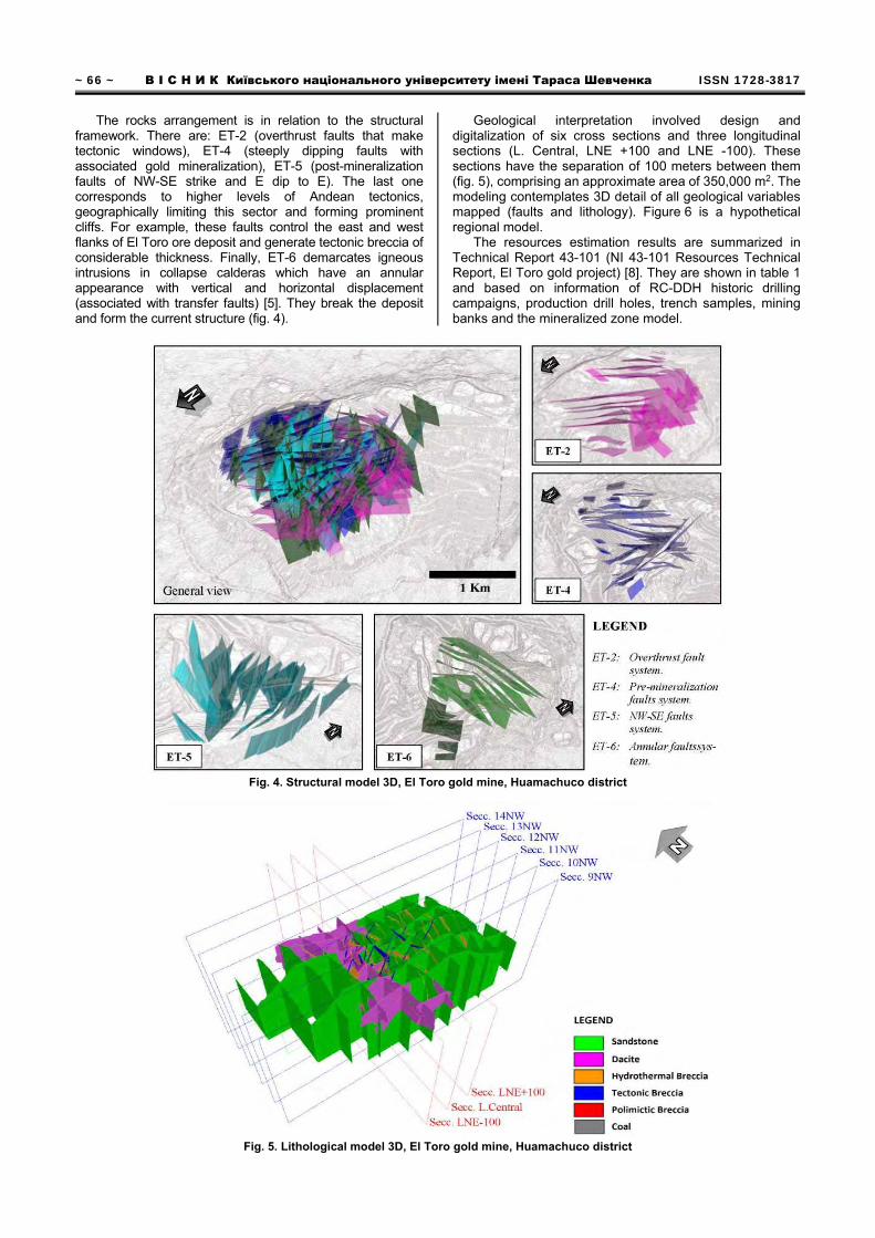
Geological interpretation involved design and digitalization of six cross sections and three longitudinal sections (L. Central, LNE +100 and LNE -100). These sections have the separation of 100 meters between them (fig. 5), comprising an approximate area of 350,000 m2. The modeling contemplates 3D detail of all geological variables mapped (faults and lithology). Figure 6 is a hypothetical regional model.
The resources estimation results are summarized in Technical Report 43-101 (NI 43-101 Resources Technical Report, El Toro gold project) [8]. They are shown in table 1 and based on information of RC-DDH historic drilling campaigns, production drill holes, trench samples, mining banks and the mineralized zone model.
Fig. 4. Structural model 3D, El Toro gold mine, Huamachuco district
Fig. 5. Lithological model 3D, El Toro gold mine, Huamachuco district
ISSN 1728–2713 ГЕОЛОГІЯ. 2(81)/2018 ~ 67 ~
Fig. 6. Hypothetical model regional, Huamachuco district
Table 1
The resources estimation 2014, El Toro gold mine Category Tonnage Au (g/t) Au (Ounces) Measured 5'660,000 0,36 65,000 Indicated 19'060,000 0,45 276,000
Cut off: 0,16 g/t Au; Estimate resources without dilution; Mineral resources restricted to an open pit with value of 1,265 $/Oz Based on the compilation, validation and interpretation
of RC and DDH drilling (16,000 m approx.), access and open pit development, transversal and longitudinal sections are used to define a geo-structural model that is an important support for developing an aggressive DDH and RC drilling Program (10,000 m of DDH drill and 15,000 m of RCD drill). The details are shown in fig. 8.
The main objectives of 2016-2017 Drilling program are: (1) to define areas of condemnation to develop operational infrastructures; and (2) to increase mineral resources. Exploratory campaign 2106-2017 has good expectations, some results of this exploratory campaign are show in fig. 9 (PE16-TO-DH0017 and PE17-TO-DH0024), where breccia and oxidized zones are observed.
Fig. 8. Drilling campaign 2016-2017 (DDH and RCH), El Toro gold mine
~ 68 ~ В І С Н И К Київського національного університету імені Тараса Шевченка ISSN 1728-3817
Fig 9. Drill core PE16-TO-DH0017 (left) and PE17-TO-DH0024 (right), El Toro gold mine
Regional exploratory expectations. The configuration
and the establishment of Peruvian deposits interrelate with the Andean mountain ridge course, defining twenty-four metallogenic belts [1]. The deposits of the northern Peru are mostly auriferous, including a great variety of mining occurrences, exhibiting from deep systems to apical levels, directly associated with intrusives or being housed in secondary structures.
Specifically, "XX metallogenic belt” (Cu-Mo-Au porphyry, Pb-Cu-Zn-Ag skarn and polymetallic deposits related to intrusives Miocenics), is formed by tectonic activity during upper Mesozoic to Cenozoic, which is associated with intensive igneous Miocene activity. It contributed to ore generation and formation of big gold deposits.
According to projection and based on the interpretation and correlation of structural styles, lithological domains, mineral occurrences configuration of approximately 1,500 km2 was limited. This preliminary interpretation is also based on analogical correlation with other mining districts with contemporary genesis and resources that would surpass in global thirty million gold ounces globally and consequently, it means increase in exploratory potential of resources in this region (fig. 10). It has been established by preliminary assessment that preponderant control mineralization is structural, with four regional tectonic events, which configure not only mineral occurrence but also geographic peculiarities. These traits are good exploration guides [9].
Fig. 10. The delimitation of El Toro-Altagracia mining district, Northern Peruvian
Список використаних джерел 1. Acosta J. Mapa Metalogenico del Peru / J. Acosta, J. Quispe, R. Rivera
et al. – Instituto geologico, minero y metalurgico del Peru, 2017. 2. Benavides V. Sistema Cretacico en el norte peruano / V. Benavides //
Museo Americano de Historia Natural. – 1956. – Bol. 108,4. – P. 353–494. 3. Broggi J. Geologia de los cuadrangulos del rio Chotano en Lajas / J. Broggi
// Sociedad Geologica del Peru. – 1942. – Bol. 12,1. – P. 5–23. 4. Cossio A. Geologia de los cuadrangulos de Santiago de Chuco y Santa
Rosa / A. Cossio– 1964. – Bol. 8. – P. 69.
5. Corbett G. Sistemas de oro-cobre en el borde pacifico suroeste / G. Corbett, T. Leach // Sociedad de Geologia Economica. – 1998. – Pub. Esp. 6.
6. Jacay J. Estratigrafia y sedimentologia del Jurasico, curso medio del valle Chicama y esbozo paleogeografico del Jurasico-Cretacico del norte peruano / J. Jacay // Tesis. Universidad Nacional Mayor de San Marcos. – 1992. – P. 166.
7. Laughlin D. Geologia y fisiografia de la cordillera peruana. Departamentos de Jun?n y Lima / D. Laughlin // Sociedad Geologica de America. – 1924. – Bol. 35, 3. – P. 591–632.
Legend Metallogenic belt XX (Cu-Mo-Au porphyry deposits, Pb-Cu-Zn-Ag
skarn deposits and polymetallic deposits related with Miocene intrusives. El Toro-Michiquillay metallogenic sub-belt.
El Toro-Altagracia mining district.
Volcanic and intrusives miocenic centers.
ISSN 1728–2713 ГЕОЛОГІЯ. 2(81)/2018 ~ 69 ~
8. SGS Geostat. NI 43-101 Reporte tecnico de recursos, Proyecto aurofero El Toro, 2014. – P. 83.
9. Villena H. El Toro – Altagracia, el nuevo distrito aurifero del norte peruano (Connotaciones geologicas y expectativas exploratorias) Region La Libertad, Peru / H. Villena, C. Salinas // Resumen tecnico XXXIII PERUMIN. – 2016. – P. 3–4.
10. Villena H. El Toro, Caracteristicas y evidencias de un gran yacimiento aurifero, Huamachuco, Region La Libertad, Peru. / H. Villena, C. Salinas // Resumen tecnico XXXIII PERUMIN. – 2016. – P. 1–5.
11. Wilson J. Estratigrafia Cretacica de los andes centrales de Peru / J. Wilson // AAPG. – 1963. – Bol. 47,1. – P. 1–34.
12. Wilson J. Geologia de los cuadrangulos de Mollebamba, Tayabamaba, Huaylas, Pomabamba, Carhuaz y Huari / J. Wilson, L. Reyes // Servicio de Geologia y Mineria. – 1967. – Bol.16. – P. 104.
Reference 1. Acosta, J., Quispe, J., Rivera, R., Valencia, M., Chirif, H., Huanacuni, D.,
Rodriguez, I., Villarreal, E., Paico, D., Santiesteban, A. (2017). Metalogenic Map of Peru. Geological, mining and metallurgical institute of Peru.
2. Benavides, V. (1956). Cretaceous system in northern Peru. American Museum of Natural History, 108, 4, 353-494.
3. Broggi, J. (1942). The geology of quadrangles: Chotano river en Lajas. Geologic Society of Peru, 12, 1, 5-23.
4. Cossio, A. (1964). The geology of quadrangles: Santiago de Chuco and Santa Rosa, 8, 69.
5. Corbett. G., Leach, T. (1998). Southwest Pacific Rim Gold-Copper Systems: Structure, alteration and mineralization. Society of economic Geologist. Sp. Pub. 6.
6. Jacay, J. (1992). Jurasic stratigraphy and sedimentology, Chicama valley and Jurasic-Cretasic paleographic outline of northern Peru. Thesis. San Marcos University National, 166.
7. Laughlin D. (1924). Geology and physiography of the Peruvian Cordillera. Departaments of Junin and Lima. Geological Society of America, 35, 3, 591-632.
8. SGS Geostat. (2014). NI 43-101 Resources Technical Report, El Toro gold project, 83.
9. Villena, H., Salinas, C. (2016). El Toro – Altagracia, The new gold district of north Peruvian (Geological Connotations and Exploratory Perspectives), La Libertad Region, Peru, Technical summary XXXIII PERUMIN, 3-4.
10. Villena, H., Salinas, C. (2016). El Toro, Characteristics and evidences of great gold deposit, Huamachuco, La Libertad Region, Peru. Technical summary XXXIII PERUMIN, 1-5.
11. Wilson, J. (1963). Cretaceous stratigraphy of Central Andes os Peru. AAPG, 47,1, 1-34.
12. Wilson, J., Reyes, L. (1967). The geology of quadrangles: Mollebamba, Tayabamaba, Huaylas, Pomabamba, Carhuaz and Huari. Geology and mining Service, 16, 104.
Н а ді й шл а д о р е дк о л ег і ї 13 . 0 8 . 17
Г. Вілена, голов. геолог E-mail: [email protected] CDC Gold, Los Andes Peru Gold Mining Company Відділ моделювання і мінеральних ресурсів 1420 La Encalada Str., Surco, Lima, Peru, 33
ЗОЛОТОРУДНЕ РОДОВИЩЕ "EL TORO" (ПЕРУ): ГЕОЛОГІЧНА ХАРАКТЕРИСТИКА І ПЕРСПЕКТИВИ
Епітермальне родовище золота Ель-Торо локалізоване в осадових породах нижньої крейди (формація Chimu), у регіоні La Libertad в
північній частині Перу, характеризується епізональною будовою. Рудний район El Toro-Altagracia, до якого приурочене родовище, витя-гнутий у північно-північно-західному напрямку, згідно з простяганням гірських хребтів Анд, більш ніж на 100 км при ширині до 25 км. Родовище приурочене до куполоподібної структури розміром 1,0 х 1,5 км, ядро купола представлене субвулканичною інтрузією дацит-андезитового складу, віком 18–20 млн років. Вмісні породи представлені пелітами, сланцями, вуглецевими сланцями формації Chicama, які підстеляються кварцовими смугастими пісковиками серії Goyllarisquizga. Виділяється чотири тектонічних фази (ET): ET-2 (форму-вання насувів), ET-4 (скиди північно-західного напрямку), ET-5 (круті розломи північно-західного напрямку) і ET-6 (кільцеві розломи). Міне-ралізація представлена переважно оксидами (до 80 %), пов'язана з осадовими породами, тектонічними, часто мінералізованими брекчі-ями, окисненими дацитами, в останніх розвивається також сульфідна і змішана мінералізація.
За результатами оціночних робіт (звіт NI 43-101, 2014 р.) розвідані запаси золота родовища становлять 65 000 унцій; попередньо розвідані запаси – 27 600 унцій, прогнозні ресурси – 398 000 унцій.
На основі інтерпретації та кореляції структури, літології цього і подібних рудних родовищ виділено новий рудний район El Toro-Altagracia площею близько 1500 км2, аналогічний за генезисом і ресурсами золота іншим відомим у регіоні золоторудним районам. Їх за-гальні ресурси перевищують 30 млн унцій золота.
Ключові слова: епітермальне родовище золота, мінералізація осадових відкладів, рудний район, літологічна і структурна інтерпре-тація, геологічне моделювання 3D.
Г. Вилена, глав. геолог E-mail: [email protected] CDC Gold, Los Andes Peru Gold Mining Company Отдел моделирования и минеральных ресурсов 1420 La Encalada Str., Surco, Lima, Peru, 33
ЗОЛОТОРУДНОЕ МЕСТОРОЖДЕНИЕ "EL TORO" (ПЕРУ): ГЕОЛОГИЧЕСКАЯ ХАРАКТЕРИСТИКА И ПЕРСПЕКТИВЫ
Эпитермальное месторождение золота Эль-Торо локализовано в осадочных породах нижнего мела (формация Chimu), в регионе La
Libertad в северной части Перу, характеризуется эпизональным строением. Рудный район El Toro-Altagracia, к которому приурочено месторождение, вытянут в северо-северо-западном направлении, согласно простиранию горных хребтов Анд, более чем на 100 км при ширине до 25 км. Месторождение приурочено к куполоподобной структуре размером 1,0 х 1,5 км, ядро купола представлено субвулкани-ческой интрузией дацит-андезитового состава, возрастом 18–20 млн лет. Вмещающие породы представлены пелитами, сланцами, углеродистыми сланцами формации Chicama, которые подстилаются кварцевыми полосчатыми песчаниками серии Goyllarisquizga. Выделяется четыре тектонические фазы (ET): ET-2 (формирование надвигов), ET-4 (сбросы северо-западного направления), ET-5 (кру-топадающие разломы северо-западного направления) и ET-6 (кольцевые разломы). Минерализация представлено преимущественно ок-сидами (до 80 %), связана с осадочными породами, тектоническими, часто минерализованными брекчиями, окисленными дацитами, в последних развивается также сульфидная и смешанная минерализация.
По результатам оценочных работ (отчет NI 43-101, 2014 г.) разведанные запасы золота месторождения составляют 65 000 унций; предварительно разведанные запасы – 27 600 унций, прогнозные ресурсы – 398 000 унций.
На основе интерпретации и корреляции структуры, литологии этого и подобных рудных месторождений выделен новый рудный район El Toro-Altagracia площадью около 1500 км2, аналогичный по генезису и ресурсам золота другим известным в регионе золоторудным районам. Их общие ресурсы превышают 30 млн унций золота.
Ключевые слова: эпитермальное месторождение золота, минерализация осадочных отложений, рудный район, литологическая и структурная интерпретация, геологическое моделирование 3D.