This bylaw has been consolidated for convenience only and includes all amendments to the text up to: April 19, 2018 AREA ‘F’ OFFICIAL COMMUNITY PLAN OKANAGAN LAKE WEST WEST BENCH OCP Bylaw No. 2460, 2008 – Regional District of Okanagan-Similkameen
Transcript
This bylaw has been consolidated for convenience only and includes all
amendments to the text up to: April 19, 2018
AREA ‘F’
OFFICIAL COMMUNITY PLAN
OKANAGAN LAKE WEST WEST BENCH
OCP Bylaw No. 2460, 2008 – Regional District of Okanagan-Similkameen
Electoral Area “F” Official Community Plan Bylaw No. 2460, 2008 2
Electoral Area “F” Official Community Plan Bylaw No. 2460, 2008 3
Regional District Okanagan-Similkameen
Okanagan Lake West / West Bench
Official Community Plan Bylaw No. 2460, 2008
TABLE OF CONTENTS
1.0 INTERPRETATION AND ADMINISTRATION ..................................................... 5
1.1 PURPOSE .......................................................................................................................... 5 1.2 INTERPRETATION ............................................................................................................. 5 1.3 ADMINISTRATION ............................................................................................................ 5 1.4 DEVELOPMENT APPROVAL INFORMATION ....................................................................... 6
2.0 OKANAGAN LAKE WEST / WEST BENCH CONTEXT ..................................... 7
3.0 OFFICIAL COMMUNITY PLAN MAP DESIGNATIONS ...................................... 9
Electoral Area “F” Official Community Plan Bylaw No. 2460, 2008 7
Acronyms used in this document
Agricultural Land Reserve ALR
Agricultural Land Commission ALC
Environmental Impact Assessment EIA
Environmentally Sensitive Area ESA
Environmentally Sensitive Development Permit ESDP
Official Community Plan OCP
Okanagan Shuswap Land & Resource Management Plan OSLRMP
Regional District Okanagan-Similkameen RDOS
Watercourse Development Permit WDP
Electoral Area “F” Official Community Plan Bylaw No. 2460, 2008 1
Regional District Okanagan-Similkameen Okanagan Lake West / West Bench Official Community Plan Bylaw No. 2460, 2008
A Bylaw to guide land use decisions within Electoral Area ‘F’ pursuant to Part 26 of the Local Government Act of British Columbia, R.S.B.C. 1996.ii
WHEREAS the Regional District Okanagan-Similkameen wishes to adopt an Official Community Plan pursuant to Part 26 of the Local Government Act;
AND WHEREAS the Regional Board may adopt an Official Community Plan by bylaw and each reading of the bylaw must receive an affirmative vote of a majority of all directors of the Regional Board who are entitled to vote on that bylaw;
AND WHEREAS after first reading of the bylaw the Regional Board shall, in sequence, examine the Official Community Plan in conjunction with its most recent capital expenditure program, the waste management plan, wastewater management plan, and economic strategy plan that is applicable in the RDOS to ensure consistency between them, in accordance with the Local Government Act;
AND WHEREAS if the Official Community Plan applies to land in an Agricultural Land Reserve established under Provincial Acts and Statutes, the Regional Board shall refer the Official Community Plan to the Province for comment;
AND WHEREAS the Regional Board has provided one or more opportunities for consultation with persons, organizations and authorities it considers affected in the development of the Official Community Plan in accordance with Section 879 of the Local Government Act;
AND WHEREAS the Regional Board of the RDOS has complied with all requirements of the Local Government Act, prior to adoption of this bylaw and Official Community Plan including all of the foregoing;
AND WHEREAS upon adoption of this bylaw, the Plan is an Official Community Plan of the RDOS;
NOW THEREFORE the Regional Board of the RDOS, in open meeting assembled, enacts as follows:
The Okanagan Lake West / West Bench Official Community Plan attached hereto as Schedules ‘A’, ‘B’, ‘C’, ‘D’, ‘E’, ‘F’, ‘G’ and ‘H’ and forming part of this bylaw is adopted as the Regional District of Okanagan-Similkameen, Okanagan Lake West / West Bench Official Community Plan.iii
The bylaw shall apply only to that portion of the RDOS shown outlined on the attached Schedule ‘B’ Official Community Plan Maps forming part of this bylaw.
If any statement, section, sub-section, clause, sub-clause or phrase of this bylaw and the Official Community Plan adopted by this bylaw is for any reason held to be invalid by a decision of a court of competent jurisdiction, the decision shall not affect the validity of the remaining portions of this bylaw and Official Community Plan. ii Amendment Bylaw No. 2483, 2010 – adopted April 7, 2011 iii Amendment Bylaw No. 2710, 2017 - adopted June 15, 2017.
Electoral Area “F” Official Community Plan Bylaw No. 2460, 2008 2
This bylaw may be cited for all purposes as the ‘Okanagan Lake West / West Bench Official Community Plan Bylaw No. 2460, 2008’.
Electoral Area “F” Official Community Plan Bylaw No. 2460, 2008 3
Transition
Electoral Area ‘F’ Okanagan Lake West / West Bench Rural Land Use Bylaw No. 1742, 1997, is repealed.
READ A FIRST TIME on the 17th day of July, 2008.
READ A SECOND TIME on the 17th day of July, 2008.
SECOND READING RESCINDED on the 21st day of August, 2008.
RE-READ A SECOND TIME on the 21st day of August, 2008.
PUBLIC HEARING held on the 2nd day of October, 2008.
READ A THIRD TIME on the 2nd day of October, 2008.
Approved by the Minister of Community Development this 28th day of October, 2008.
ADOPTED this 6th day of November, 2008.
Chair General Manager of Administration Services
Electoral Area “F” Official Community Plan Bylaw No. 2460, 2008 4
SCHEDULE ‘A’
Regional District Okanagan-Similkameen
Okanagan Lake West / West Bench
Official Community Plan Bylaw No. 2460, 2008
Electoral Area “F” Official Community Plan Bylaw No. 2460, 2008 5
1.0 INTERPRETATION AND ADMINISTRATION
The provisions of this Plan apply to all lands and surface of water within the Electoral Area ‘F’ identified on Schedule ‘B’ of this bylaw, and Map 1, General Context Map.
1.1 Purpose
The Okanagan Lake West / West Bench Official Community Plan is intended to ensure that decisions of the use and development of property within that part of the Electoral Area ‘F’ shown on Schedule ‘B’, are made with regard to land capabilities and constraints, growth trends, the interrelationship of land uses, and the aspirations of the people, for the benefit of the whole community. Further, the Plan is intended to:
.1 form the basis for regulatory land use bylaws, capital expenditures programming, and waste management;
.2 to provide guidance and information for private and public organizations and individuals.
1.2 Interpretation
An Official Community Plan means a community plan as referred to in the Local Government Act, and as adopted by the Regional Board of the Regional District Okanagan-Similkameen (hereafter referred to as the Regional Board), in accordance with the requirements of the Local Government Act.
1.3 Administration
.1 This Official Community Plan comes into effect as of the date of formal adoption by the Regional Board.
.2 The Zoning Bylaw will be the primary tool to regulate development, not the Official Community Plan. All rezoning proposals must be consistent with the intent of this Official Community Plan that serves as a policy foundation for the Zoning Bylaw.
.3 This Plan will be reviewed on a yearly basis and, in order that the document continues to accurately reflect the long-range planning objectives of the Naramata area, the Plan will undergo a comprehensive review every five to ten years.
.4 The Official Community Plan can only encourage senior levels of government to take action; it cannot force or require senior governments to act. Furthermore, although the Official Community Plan cannot commit the Regional Board to specific expenditures, the Regional Board cannot enact bylaws or undertake works that are contrary to it without amending the Plan.
Electoral Area “F” Official Community Plan Bylaw No. 2460, 2008 6
1.4 Development Approval Informationiv
This Plan Area is a development approval information area, and the Regional District may require development approval information for a Zoning Bylaw Amendment application, Development Permit application, and Temporary Use Permit application.
The objective in designating the Plan Area as a development approval information area is for the Regional District to obtain information from the applicant for the Regional District to gain a sound understanding of the anticipated impact of the proposed activity or development on the community and to make a well informed decision regarding such applications. Where deemed relevant, an applicant may be expected to provide information regarding:
.1 The impact of the proposed development with surrounding land uses.
.2 The consideration of public facilities such as schools, park land, public spaces, and/or amenities.
.3 The impact of the proposed development on groundwater quantity and quality, surface water generated by the proposed development, and the options for collection, storage, and dispersal of such drainage.
.4 The impact of the proposed development on the natural environment such as adjacent aquatic areas, vegetation, soils and erosion, geotechnical characteristics, topographical features, ecosystems and biological diversity, fish and wildlife, fish and wildlife habitat, environmentally sensitive features, and rare or endangered plant or animal species.
.5 The ability of the proposed development to provide on-site water and septic disposal or to connect to community services, if available.
.6 The impact of the proposed development on public infrastructure and community services such as water supply, sewage disposal, fire protection systems, and recycling.
.7 The aesthetic values of the proposed development such as visual character, integration with public areas and the natural environment, lighting, noise, and odour.
.8 The impact of proposed development on traffic volumes and roads.
.9 How the proposed development provides buffers for adjoining farming and rural areas to ensure no negative impact is caused by the proposal.
.10 The archaeological impact of a proposed development in areas identified to have high archaeological potential.
iv Amendment Bylaw No. 2570, 2012 – adopted January 24, 2013
Electoral Area “F” Official Community Plan Bylaw No. 2460, 2008 7
2.0 OKANAGAN LAKE WEST / WEST BENCH CONTEXT
The Electoral Area F planning area is bounded by the Regional District of Central Okanagan to the north; City of Penticton and I.R. 1 Penticton to the south; Lake Okanagan and the District of Summerland to the east; and Electoral Area ‘H’ to the west. Two primary and distinct areas comprise the settlement areas in Area F: the Sage Mesa and West Bench area; and the Faulder and Meadow Lake Valley area. Electoral Area F comprises an area of approximately 170 km2.
Most residential development has occurred in the vicinity of Faulder to the north and Westbench/Sage Mesa to the south. The Husula Highlands and Greata Ranch areas continue to have the highest development potential. Meadow Valley and Dean Road areas provide some additional opportunities for rural residential development, although these are limited by the predominance of Crown Land, limited water supply and agricultural activities. Ranching, forestry, mineral exploration and recreation are the principal activities occurring in the remainder of the planning area.
This Bylaw was prepared with due regard to land capabilities, growth trends, the need for public services and facilities, the concern and aspirations of the public and Provincial interests.
Electoral Area “F” Official Community Plan Bylaw No. 2460, 2008 8
Map 1 – General Context Map
Electoral Area “F” Official Community Plan Bylaw No. 2460, 2008 9
3.0 OFFICIAL COMMUNITY PLAN MAP DESIGNATIONS The future use and development of land within the Okanagan Lake West / West Bench area must be consistent with the overall pattern of land use depicted on Schedule ‘B’, and based on the following land use designations:
Rural Designations:
Resource Area
Agriculture
Large Holdings
Small Holdings
Residential Designations:
Low Density Residential
Medium Density Residential
Commercial Designation:
Commercial
Industrial Designation:
Industrial
Community Services and Administrative Designations:
Administrative, Cultural and Institutional
Parks, Recreation and Trails
Comprehensive Development Designation
Comprehensive Development
RA
AG
LH
SH
LR
MR
C
I
AI
PRv
CD The general types of uses encouraged in each land use designation are explained in subsequent sections of this Bylaw.
The Regional Board recognizes that some existing land uses do not conform to the designations shown on the Official Community Plan Maps. The intent of the Regional Board is not to change the uses of this land in the immediate future but to illustrate the preferred pattern of land use as redevelopment occurs while this Plan is in force.
v Amendment Bylaw No. 2710, 2017 - adopted June 15, 2017.
Electoral Area “F” Official Community Plan Bylaw No. 2460, 2008 10
4.0 OBJECTIVES
The Regional District Okanagan-Similkameen aims to achieve the goals set out for the Okanagan Lake West / West Bench area as a foundation for the objectives and policies of the Okanagan Lake West / West Bench Official Community Plan.
4.1 Objectives
The objectives of the Regional Board for the Electoral Area ‘F’ Rural Planning Area are to:
.1 Provide one simplified land use and subdivision regulations bylaw for the entire Electoral Area F, while recognizing the local characteristics of Area F;
.2 Provide the opportunity for limited new growth in the Rural Planning Area, which reflects the capabilities of the environment, protection from natural and man-made hazard conditions, utility and on-site servicing, and which respects surrounding land uses. New growth should sustain the rural character, agricultural areas, and resource areas;
.3 Help prevent the loss of life and damage to property from flooding, erosion, moderate or higher fire hazard, soil instability, landslide, and other potential hazards;
.4 Seek continuing cooperation with government agencies and the public in Bylaw review, amendment and implementation with a thorough review of the Bylaw at least once very five years;
.5 Encourage the preservation and enhancement of the natural resources for:
a) forestry;
b) agriculture, including livestock grazing;
c) fishery and wildlife habitat;
d) mineral and resource extraction; and
e) recreational and tourism purposes; while having regard for the visual impact on the landscape, natural and heritage features, environmentally sensitive areas, and surrounding land uses.
.6 Identify, protect and enhance riparian areas (e.g. watercourses, lakes, rivers, marshes, and riparian areas) as Watercourse Development Permit (WDP) Areas and terrestrial areas (significant grasslands, forests, cliffs, and major steep slope areas) as Environmentally Sensitive Development Permit (ESDP) Areas in order to maintain the natural ecosystems, environmental quality, and aesthetic appeal of the area;vi
vi Amendment Bylaw No. 2710, 2017 - adopted June 15, 2017.
Electoral Area “F” Official Community Plan Bylaw No. 2460, 2008 11
.7 Protect lands having significant recreational value and improve outdoor recreation opportunities while minimizing conflicts with adjacent land uses, the natural environment and resource areas;
.8 Encourage a limited amount of attractive and sensitive commercial recreational and tourism development which is in keeping with the needs of residents and visitors alike;
.9 Provide opportunities for future public facilities such as fire stations, schools and community and recreational facilities;
.10 Ensure that development and corresponding servicing requirements take place simultaneously and in accordance with sound land use planning principles;
.11 Promote a safe and efficient road network;
.12 Encourage agricultural practices to operate in an environmentally sustainable and sensitive manner;
.13 Plan an adequate delivery of water for domestic and agricultural irrigation needs for present and future requirements;
.14 Support the economic use of farmland and discourage its fragmentation; and
.15 Requires new development on parcels less than approximately 1 hectare to connect to a community sanitary sewer system.
Electoral Area “F” Official Community Plan Bylaw No. 2460, 2008 12
5.0 RESOURCE AREA 5.1 Background
For the purpose of this section, Resource Areas are described as large parcels of land, and includes both private and/or Crown land. Predominant uses include: forestry; agriculture, including livestock grazing; fishery and wildlife habitat; mineral, placer and aggregate extraction; community water sheds; recreation and tourism; large holdings, isolated farm units and ranch lands having a parcel size of 20 ha, or greater, or as approved by the Agricultural Land Commission on Land Reserve parcels.
5.2 Policiesvii
.1 The Province will be encouraged to practice integrated resource management, enforce the forest practice code, and to incorporate environmental protection measures to:
a) preserve natural meadows, wetlands and walk-in lakes;
b) preserve buffers near lakes and streams;
c) protect stream side vegetation, leavestrips, and greenbelts adjacent to all fish bearing and watershed watercourses;
d) regulate environmentally and/or visually sensitive logging practices such as, erosion control and soil stabilization measures; and
e) reduce and modify forest fuels adjacent to community areas.
The width of the required reserve, machine buffer, vegetation leavestrip, or greenbelt will be determined by the Province respecting the policies prescribed in the publication entitled: Land Development Guidelines for the Protection of Aquatic Habitat, or its equivalent.
.2 The Province is encouraged to continue using the Coordinated Resource Management Plan process as a method to resolve resource and land use issues. The Regional District supports the Summerland-Peachland Coordinated Resource Management Plan.
.3 The Province is encouraged to continue referrals of mineral exploration proposals involving surface disturbance to the Regional District as well as other regulatory agencies for review and comment. Areas having aggregate resources are identified for information purposes on Schedule ‘E’ of this Bylaw. The Province is encouraged to have due consideration for the impact of resource extraction activities on existing adjacent residential developments and infrastructure such as roads; and to not issue permits for mineral extraction and processing within 50.0 metres of Rural and Residential Designations.
vii Amendment Bylaw 2570, 2012 – adopted January 24, 2013
Electoral Area “F” Official Community Plan Bylaw No. 2460, 2008 13
.4 The Regional Board encourages the Provincial agencies to seek full community support before issuing licenses or permits for any development or activity within the Rural Planning Area.
.5 The Regional Board encourages the Provincial Government to give adequate notice to the Regional District and the adjacent rural community about applications for the lease or sale of Crown land, and to hold a public meeting in the adjacent rural community before a decision is made on such applications.
Electoral Area “F” Official Community Plan Bylaw No. 2460, 2008 14
6.0 AGRICULTURE 6.1 Backgroundviii
The Agriculture Designation includes the following designation categories: Agriculture One (AG1) and Agriculture Three (AG3), and includes all lands in the Agricultural Land Reserve.
6.2 Policiesix
.1 Agriculture is recognized as an important component of the local economy and in this regard the Regional Board supports the preservation and enhancement of farmland whether or not it is in the Agricultural Land Reserve.
.2 The Regional Board encourages the diversification of the agricultural industry and supports farm businesses such as agri-tourism, secondary agri-product development and agri-home based businesses.
.3 The Regional Board supports the concept of the “right to farm” legislation in all resource, agricultural and rural designations and will give due consideration to this concept in all bylaws and decisions affecting land use in the Rural Planning Area.
.4 The value and contribution of grazing lands to cattle operations is recognized. Traditional corridors utilized by cattle to gain access to range land will be protected wherever possible, and new development adjacent to Crown range will be assessed in terms of its impact on livestock grazing and may be required to provide fencing as part of rezoning or subdivision approval where the need has been demonstrated by a Provincial agency having jurisdiction.
.5 The consolidation of legal parcels which form part of the same farm unit is encouraged and subdivisions and consolidations which permit more efficient use of agricultural land are supported.
.6 Intensive agricultural operations in accordance with the relevant Provincial legislation are permitted.
.7 All Agricultural Land Reserve lands are shown on Schedule D. The Agricultural Land Reserve contains some marginal or non-agricultural land and, as some good capability lands are not in the Agricultural Land Reserve, a review of the Agricultural Land Reserve boundaries in the Rural Planning Area is warranted (e.g., Westbench and Dean Road). The Regional District suggests the Provincial Agricultural Land Commission carry out a review as time and funds permit and the Regional District will assist in this process.
.8 Where new development adjoins areas within the Agricultural Land Reserve, the Provincial Approving Officer may require the provision of buffers consistent with
viii Amendment Bylaw No. 2483, 2010 – adopted April 7, 2011 ix Amendment Bylaw No. 2570, 2012 – adopted January 24, 2013
Electoral Area “F” Official Community Plan Bylaw No. 2460, 2008 15
the buffer design guidelines of the Agricultural Land Commission set out in the document “ALR & Community Planning Guidelines”.
Electoral Area “F” Official Community Plan Bylaw No. 2460, 2008 16
7.0 RURAL HOLDINGS 7.1 Background x
The Rural Designation includes the following designation categories: Large Holdings (LH); Small Holdings Two (SH2); Small Holdings Three (SH3); Small Holdings Four (SH4); and Small Holdings Five (SH5). In most cases domestic water is supplied by individual wells or surface water, and sewage disposal is by on-site septic disposal systems.
7.2 Policies
.1 The following subdivision patterns are discouraged:
a) strip development along major roads;
b) lots which straddle watercourses or which require creek crossing to gain access to building sites;
c) lot patterns and shapes which do not respect the rural and natural conditions of the area; and
d) large subdivisions without road access.
.2 In order to prevent further strip development along Fish Lake Road and to protect the rural character, and natural conditions of the area, the Provincial Approving Officer will be requested to support guidelines which:
a) discourage subdivision which straddles watercourses or which requires creek-crossings to gain access to private lots;
b) encourage lot patterns and shapes which respect the rural and natural conditions of the area;
c) discourage any further panhandle lots on the westerly side of Fish Lake Road;
d) require perimeter stock-proof fencing of subdivisions and ensure that access to Crown Land is available; and
e) discourage subdivision of land in areas known to have topographic, hazard conditions or other physical constraints, especially those areas subject to rockfall hazard, land slide, moderate or higher fire hazard or soil stability.
.3 Future large holdings, small holdings and rural residential development will be assessed in accordance with the following criteria:
a) capability of handling on-site domestic water and sewage disposal for parcels greater than 1 hectare in area, or availability of community water or sewer;
b) capability of the natural environment and topography to accommodate additional development;
x Amendment Bylaw No. 2483, 2010 – adopted April 7, 2011
Electoral Area “F” Official Community Plan Bylaw No. 2460, 2008 17
c) impact on adjacent land use designations, and the character of the existing area;
d) location relative to existing roads and other community and essential services;
e) susceptibility to natural hazards including but not limited to, flooding, soil instability, rock fall or moderate or higher forest fire risk;
f) an environmental impact assessment where lands contain lakes, marsh lands, and watercourses; and
g) a visual impact assessment where development is proposed on hillsides and other visually sensitive areas.
.4 May request that the Regional Subdivision Approving Authority requires the developer to undertake a fire hazard risk assessment at the time of submitting a subdivision application where the Province indicates that a property may be subject to a moderate or higher fire risk. The Regional Board may require the same assessment during the land use designation amendment or development permit process. The assessment will provide a recommended fire hazard mitigation strategy, that will be submitted to both the RDOS and the Province, and is recommended to include, but is not limited to, the following:
a) incorporating fuel breaks adjacent to or on the rural or residential subdivisions;
b) establishing zones which are clear of debris, highly combustible material or trees around potential structures and homes as defined by the Province;
c) utilizing fireproofing techniques and fireproof materials in building design;
d) designing roads to provide evacuation routes and facilitate movement of fire fighting equipment;
e) ensuring all roads are named and signed;
f) availability of volunteer fire brigades and where appropriate fire protection districts;
g) availability of water supply facilities adequate for fire suppression;
h) provision of access to local water sources, lakes and streams as part of access requirements; and
i) establishment of setbacks of 30.0 metres abutting Crown Land.
.5 Where a subdivision abuts agricultural land or livestock grazing land, perimeter fencing of the subdivision is encouraged and may be required by those Provincial jurisdictions having authority.
.6 Duplex dwellings located in the RR1 designation which were approved for construction or constructed on or before the date of adoption of Bylaw 2460 will be permitted to continue the use and to rebuild dwellings destroyed by natural hazard or fire.
Electoral Area “F” Official Community Plan Bylaw No. 2460, 2008 18
Electoral Area “F” Official Community Plan Bylaw No. 2460, 2008 19
8.0 RESIDENTIAL 8.1 Background
The Residential Designation includes the following low density categories; Residential Single Family One (RS1), and Residential Single Family Two (RS2). The RS designations generally apply to existing residential subdivisions in the West Bench, Sage Mesa, and Husula Highlands areas, or lands previously designated as single family residential in a community plan. The RS2 Residential Designation will be curtailed to the established RS2 designated areas and the density will not exceed two dwelling units per 0.4 ha overall, subject to servicing requirements.
The Residential Designation also includes the higher density categories; Residential Multiple Family (RM1), and Integrated Housing (RM2). The medium and high density designations are specific to the Greata Ranch property.
8.2 Policies
.1 Future residential development will be assessed in accordance with the following criteria:
a) availability of community water or sewer when considering the creation of new parcels;
b) capability of the natural environment and topography to accommodate additional development;
c) impact on adjacent land use designations, and character of the existing area;
d) location relative to existing roads and other community and essential services;
e) susceptibility to natural hazards including, but not limited to, flooding, soil stability, land slide, rockfall, moderate or higher forest fire risk;
f) timing and staging of development;
.2 May request that the Regional Subdivision Approving Authority requires the developer to undertake a fire hazard risk assessment at the time of submitting a subdivision application where the Province indicates that a property may be subject to a moderate or higher fire risk. The Regional Board may require the same assessment during the land use designation amendment or development permit process. The assessment will provide a recommended fire hazard mitigation strategy, that will be submitted to both the RDOS and the Province, and is recommended to include, but is not limited to, the following:
a) incorporating fuel breaks adjacent to or on the rural or residential subdivisions;
b) establishing zones which are clear of debris, highly combustible material or trees around potential structures and homes as defined by the Province;
Electoral Area “F” Official Community Plan Bylaw No. 2460, 2008 20
c) utilizing fireproofing techniques and fireproof materials in building design;
d) designing roads to provide evacuation routes and facilitate movement of fire fighting equipment;
e) ensuring all roads are named and signed;
f) availability of volunteer fire brigades and where appropriate fire protection districts;
g) availability of water supply facilities adequate for fire suppression;
h) provision of access to local water sources, lakes and streams as part of access requirements; and
i) establishment of setbacks of 30.0 metres abutting Crown Land.
.3 The Regional Board supports the concept of cluster housing to concentrate residential units on a smaller portion of an overall building site so that the remainder of the site can be preserved as unbuilt open space for the conservation of Environmentally Sensitive Areas and Agricultural Lands or recreation/amenity space. The net density of a cluster development will be equivalent to a conventional development while preserving substantially more of the site as open space. To implement the cluster housing concept, the Board may consider, where appropriate, utilizing existing designations which incorporate the following criteria:
a) reduced grading and site disturbance, in response to the natural environment;
b) maintain the same overall site densities as existing Residential Designations while creating greater open spaces between development nodes and leaving more of the site undisturbed;
c) utilize shared driveways, parking and open space amenities to reduce site disturbance;
d) protect existing steep slopes, riparian areas and stream corridors;
e) utilization of community water and sewer systems;
f) respond to the capability of the natural environment and topography to accommodate the development;
g) reduced the impact on adjacent land use designations, and maintain the character of the existing area;
h) integrate the development into the existing road network and other community and essential services; and
i) respond to the potential susceptibility to natural hazards including but not limited to flooding, soil stability, land slides, rockfall, moderate or higher forest fire risk.
Electoral Area “F” Official Community Plan Bylaw No. 2460, 2008 21
.4 The Regional Board will review the need to provide more affordable and rental housing using secondary suites, within existing and new areas while maintaining the character of that area, subject to servicing requirements.
8.3 Vacation Rental Policiesxi
.1 Supports the provision of paid accommodation for visitors through the short-term rental of residences provided that community and neighbourhood residential needs and other land use needs can be addressed.
.2 Supports the use of a residence for short-term vacation rental where permitted by a Temporary Use Permit or rezoning. The Regional Board may use the following criteria to assess applications;
a) capability of accommodating on-site domestic water and sewage disposal;
b) mitigating measures such as screening and fencing;
c) provision of adequate off-street parking;
d) confirmation that the structure proposed for use as a vacation rental meets a minimum standard for health and safety; and
e) benefits that such accommodation may provide to the community.
xi Amendment Bylaw No. 2595, 2013 – adopted March 20, 2014
Electoral Area “F” Official Community Plan Bylaw No. 2460, 2008 22
9.0 COMMERCIAL 9.1 Background
The Commercial Designation includes the following designation categories: Neighbourhood Commercial (C3), Marina Commercial (C5) Tourist Commercial One (CT1), Tourist Commercial Two (Limited) (CT2), and Tourist Commercial Three (Limited) (CT3).
9.2 Policiesxii
.1 Local commercial establishments such as a convenience store/gas bar are supported in areas where they will serve the surrounding rural community and where they are located on network roads.
.2 The Regional Board encourages the diversification of the agricultural industry to support business expansions such as agri-tourism, secondary product development, and home occupation businesses.
.3 Commercial development on Highway 97 will be limited to those tourist commercial facilities currently established or designated at the time the Official Community Plan is adopted; and where redevelopment, expansion, or development occurs, it will be assessed to ensure the commercial development does not have a detrimental impact on the Provincial Highway network.
.4 Open space recreation and tourist commercial opportunities such as guest ranches, golf courses, campgrounds, and/or wilderness guide camps will be considered based on their individual merits providing they do not have a detrimental impact on the environment or surrounding land uses.
xii Amendment Bylaw No. 2570, 2012 – adopted January 24, 2013
Electoral Area “F” Official Community Plan Bylaw No. 2460, 2008 23
10.0 INDUSTRIALxiii 10.1 Background
There are currently no designated Industrial areas in the Plan Area, however, the principal industrial activity in the Plan Area is logging, which generally occurs on Crown lands that are subject to the Resource Area designation. Small-scale resource extraction also occurs within the Plan Area.
Limited and small-scale industrial home-occupations (e.g., small scale sawmilling) can occur in Resource Areas and Rural Holdings. Larger industrial activities, including light manufacturing and fabricating are encouraged to locate in designated, serviced industrial areas in the City of Penticton and District of Summerland, which are better suited to accommodate them.
Accordingly, the Regional District is not designating any areas for proposed industrial uses. The Regional District may consider designating land for proposed industrial uses on a case-by-case basis if or when demand warrants.
10.2 Objectives
.1 Support the City of Penticton and District of Summerland as the industrial centres for the larger area (i.e., outside of the Plan Area).
.2 Support small-scale home industry activities in Resource Areas and Rural Holdings where appropriate.
10.3 Policies
The Regional Board:
.1 Encourages larger-scale industrial and light manufacturing activities to locate in the City of Penticton or District of Summerland and other serviced and designated industrial areas in the Regional District.
.2 May consider designating land Industrial, where appropriate, on a case-by-case basis.
.3 May consider accommodating time limited industrial uses through Temporary Use Permits if compatible with adjacent uses.
xiii Amendment Bylaw No. 2783, 2018 – adopted April 19, 2018.
Electoral Area “F” Official Community Plan Bylaw No. 2460, 2008 24
11.0 ADMINISTRATIVE, CULTURAL AND INSTITUTIONAL 11.1 Background
The Administrative, Cultural and Institutional land use designation generally refers to public, non-profit or utility uses such as schools, churches, recreation facilities, community centres, public health facilities, community care facilities, fire halls, libraries, post offices, and local government and improvement district buildings. Cultural and historic sites are also included within this designation.
11.2 Community Services Policies
.1 When public facilities such as a fire hall are required, the sites will be selected in accordance with the following criteria:
a) suitability of location on a major network road;
b) proximity to any concentration of residential development;
c) adequacy of water supply;
d) other siting requirements and physical attributes.
.2 Possible future fire hall sites along Fish Lake Road and Husula Highlands access road will be investigated by the Regional Board for future acquisition through the Province.
.3 Improvements to existing community water and sewer systems may be required to accommodate the future growth potential of rural areas such as Faulder.
.4 Although the Rural Planning Area does not warrant public transit service at this time, the Regional District will continue to monitor conditions and have liaison with B.C. Transit regarding future ridership demand to such areas as the West Bench/Sage Mesa.
11.3 Heritage Resources Policies
.1 In cooperation with the Province, as well as other interested local parties, measures are supported to protect features and sites of paleontological, scenic, architectural, historic or archaeological significance in the Rural Planning Area.
Electoral Area “F” Official Community Plan Bylaw No. 2460, 2008 25
12.0 PARKS, RECREATION AND TRAILSxiv 12.1 Background
Parks are generally publicly owned areas that provide an opportunity for individuals to pursue leisure and recreation activities. In the Plan Area, parkland includes Crown land, land owned by the Regional District, land zoned for park purposes and land designated as park on a subdivision plan. Parkland also includes land or general areas that the Regional District may have an interest in for park in the future.
Some of the types of park and recreation facilities under the Parks, Recreation and Trails (PR) designation in the Plan Area include:
• Regional Parks: Selby, Mariposa and Bonin Parks are operated and maintained by the Regional District.
• Kettle Valley Railway (KVR) Trail: The sections of the KVR Trail that are publically owned and maintained by the Regional District are designated Parks, Recreation and Trails.
• Provincial Recreation Areas: Darke Lake Provincial Park, Enease Lakes Provincial Park, Kickininee Provincial Park, Okanagan Lake Park are provincially designated Recreation Areas.
• Other Recreation Areas: a small area of land at Greata Ranch and “Camp Boyle”, which is operated by The Boy Scouts of Canada, have been designated as Park.
The Plan Area also provides diverse recreation opportunities for a range of trail users. Local residents use the trail system for activities ranging from an evening stroll along the KVR to commuting to work from one community to another, to active motorized and non-motorized trail-based recreation. Visitors also frequent the Plan Area’s trails to participate in a wide range of activities from walking and backcountry hiking to cycle touring and off-road vehicle recreation.
Together, parks and trails provide a valued amenity for Plan Area residents and visitors and provide important environmental benefits. While the Plan Area includes three small regional parks, the need for additional community parks is moderated both by the area’s small population and the extensive opportunities available on Crown land, area lakes, and in provincial protected areas. It is also a challenge to provide community park services to areas with small, dispersed populations.
Provincial legislation authorizes the provision of land to the Regional District as parkland — equivalent in size to 5% of the parcel being subdivided. It is anticipated that acquisition of new land will be focused upon completion of the Kettle Valley Railroad (KVR) trail and improving Okanagan Lake access, although the Regional District will consider acquiring new parkland as opportunities arise.
xiv Amendment Bylaw No. 2710, 2017 - adopted June 15, 2017.
Electoral Area “F” Official Community Plan Bylaw No. 2460, 2008 26
In 2012, the Regional District adopted a Regional Trails Master Plan that defines future direction, policies, priorities, standards and actions for the Regional District and its partners with respect to existing and potential future linear parks and trails and support of a regional trail network. The plan provides the basic framework to define and guide regional trail development and management through to 2021.
12.2 Objectives
.1 Provide a level of parks and recreational opportunities that can meet the needs of local residents, within their ability and resources to pay for such facilities.
.2 Promote recreational opportunities that meet local needs and complement the natural environment and existing resources.
.3 Improve and maintain public access to park and recreation resources.
.4 Promote the development of an integrated trail and park system.
.5 Identify and work to acquire parks and recreation sites to meet the present and future needs of residents.
12.3 Policies
The Regional Board:
.1 Encourages that all new trail projects are designed and constructed using provincial best management practices, in order to minimize the impact on the natural environment.
.2 Seeks to mitigate existing and future conflicts between trail users, agricultural operators and rural landowners.
.3 Encourages trails proposed on agricultural lands, including those located within the ALR, to be developed using Ministry of Agriculture guidelines.
.4 Encourages tenure holders to preserve, steward and maintain trails to maintain the integrity of the larger trail system and the natural environments they traverse.
.5 Encourages the Province to undertake a backcountry recreation planning process.
.6 Encourages relevant provincial agencies and tenure holders to manage public access to the backcountry.
.7 Seeks to work with regional partners and local environmental organizations to support wildlife education programs to minimize wildlife/human conflicts on trails.
.8 Seeks to work with regional partners to ensure that trails within Plan Area boundaries include adequate parking, bear-proof garbage and recycling receptacles, and signage where feasible and appropriate.
.9 Support trail use guidelines that promote “leave no trace” trail use.
Electoral Area “F” Official Community Plan Bylaw No. 2460, 2008 27
.10 Encourages the School Districts to establish joint use agreements to support the multiple use of school and school grounds in the community, particularly the West Bench elementary school.
.11 Supports the Kettle Valley Railway right-of-way being preserved and utilized as a linear park and recreation corridor.
.12 Seeks to continue to work towards developing a comprehensive system of linear parks, trails and pedestrian linkages throughout the Plan Area to accommodate a variety of uses, including but not limited to: walking, running, bicycling, horseback riding and cross country skiing.
.13 Seeks to ensure that future linear parks, trails, and pedestrian linkages connect to existing and future parks, schools, Crown land, and natural open space, and allow for easy pedestrian access through residential areas.
.14 Seeks to continue to provide universal access to recreational amenities in the Plan Area, including parks, trails, facilities and programs.
.15 Strives to ensure that there are recreational opportunities that suit a variety of age groups and interests.
12.4 Parkland Dedication Policies:
The Regional Board:
.1 For the purposes of Section 510(2) of the Local Government Act, designates the entirety of the Electoral Area covered by this OCP as having future park potential.
.2 Recognises that the Plan Area is generally rural in nature, and that when land is acquired it should be focused upon lake accesses, greenways, and trails.
.3 May determine, in accordance with Section 510 of the Local Government Act, at the time of a subdivision to which Section 510 applies, whether the owner of land being subdivided must:
a) provide without compensation, park land in an amount equivalent to 5% of the land being proposed for subdivision and in a location acceptable to the Regional District; or
b) pay to the Regional District an amount that equals the market value of the land that may be required for park land purposes.
.4 May consider, when determining a potential park land dedication under Section 510 of the Local Government Act, the following policies:
a) proximity to settlement areas, other parks & trails, and bodies of water;
b) distance from environmental hazard areas;
c) average slope should be 10% or less;
d) adequate accessibility:
Electoral Area “F” Official Community Plan Bylaw No. 2460, 2008 28
i) vehicular ingress and egress should meet or exceed Ministry of Transportation standards;
ii) in the case of trails and pedestrian-access only parks, there should be various linkages to and from the trail or park, with at least one linkage wide enough to allow for maintenance vehicle access;
e) cultural or natural features of significance;
f) potential for additional dedication of parkland from subdivision applications of surrounding parcels; and
g) potential for recreation (active park), conservation (passive park) or enhancement of public access.
.5 Considers that park land proposals should provide a benefit for the community and those lands with no benefit to the community should not be accepted.
.6 Strongly prefers that land being considered for parkland be maintained in its natural state and should not be cleared. Cleared and disturbed lands should only be accepted where the proposed parkland is to be used for recreational uses which require cleared lands, or can be reclaimed for park purposes.
.7 Encourages developers to dedicate greater than 5% park land in areas where parkland is desired.
.8 Considers that if cash in-lieu is chosen at the time of subdivision for park acquisition and development in the Plan Area, the preference is that the benefits accrue to those communities from which the funds are received.
.9 Where environmentally sensitive areas or Critical Habitat for species at risk have been identified, encourages developers to donate such lands to a conservation organisation or the Regional District in addition to the parkland or cash in-lieu required by the Act.
Electoral Area “F” Official Community Plan Bylaw No. 2460, 2008 29
The South Okanagan-Similkameen is recognized as a region that combines a wide range of natural habitat areas with a large number of unique species, many of which are not found elsewhere in the province or in Canada. The area is also home to the largest number of endangered and threatened species of plants and animals in BC and Canada.
The variety of life (also called biodiversity) is very high in the South Okanagan-Similkameen, because of the region’s milder climates and diversity of landscapes. Species at risk are linked to human settlement areas and land use. As the Plan Area contains significant developed areas and a variety of land uses including recreation, agriculture, forestry areas and the like, it also contains a high number of species at risk.
The Plan Area itself is home to many unique environmental features, including the silt benches above Okanagan Lake and Trout Creek valley as well as various other lakes and streams important to biodiversity in the area.
Under the Local Government Act, the Regional District has the authority to establish Development Permit (DP) Areas in order to protect the natural environment, its ecosystems and biological diversity.
In order to protect important sensitive ecosystems and biological diversity including valuable habitat areas for wildlife and plant communities, the Regional District has implemented an Environmentally Sensitive Development Permit (ESDP) Area. These areas generally comprise privately held lands not in the Agricultural Land Reserve (ALR) that possess “high” and “very high” ecologically sensitive classifications as identified by the Keeping Nature in our Future: A Biodiversity Conservation Strategy for the South Okanagan-Similkameen (2012) prepared by South Okanagan Similkameen Conservation Program (SOSCP), and is described further in Section 17.2 of this Plan.
Other ecologically sensitive lands found on Crown land or privately held land in the ALR have not been formally designated as an ESDP Area but are equally sensitive and are shown on Schedule ‘H’ as an “Important Ecosystem Area” and is described further in Section 17.2 of this Plan.
As a local government listed under Section 3 of the Riparian Area Regulation, the Regional District has implemented a Watercourse Development Permit (WDP) Area designation in order to protect riparian areas; being lands within 30.0 metres of the high water mark of streams and ravines including lakes, watercourses and wetlands, and as described further at Section 17.3 of this bylaw.
For maps of development permit areas and other environmentally sensitive areas in the Plan Area see Schedule ‘H’ (Environmentally Sensitive Development Permit Area and
xv Amendment Bylaw No. 2710, 2017 - adopted June 15, 2017.
Electoral Area “F” Official Community Plan Bylaw No. 2460, 2008 30
Other Important Ecosystem Area) and Schedule ‘G’ (Watercourse Development Permit Areas).
13.1.1 Objectives - General
.1 Maintain and sustain a healthy environment by encouraging the enhancement of ecological systems and by protecting biodiversity.
.2 Integrate measures to sustain environmental quality and consider impacts on the environment in future land use decisions.
.3 Work with property owners and agents to inform and guide the design of development in a way that is sensitive to important landscape features such as watercourses, hillsides, and sensitive ecosystems of the Okanagan.
.4 Support efforts to protect source water quality and quality today and for future generations.
13.1.2 Policies - General
The Regional Board:
.1 Recognizes the importance of containing and controlling noxious weeds through the continued endorsement of weed prevention and control initiatives.
.2 Recognizes and encourages the educational and eco-tourism contribution toward protection of the community’s natural environment made by environmental organizations, and supports accommodating these uses with the necessary changes to the land use designations so long as the general intent of policies in this Plan are met.
.3 Requires that, where a proposed development affects land subject to an Environmentally Sensitive Development Permit Area, an Environmental Assessment (EA) be prepared by a Qualified Environmental Professional (QEP) in accordance with the policies outlined at Section 17.2 as well as relevant federal and provincial best management guidelines.
.4 Requires that EA reports prepared by QEPs be undertaken in accordance with the Regional District’s Development Procedures Bylaw.
.5 Supports the incorporation of traditional ecological knowledge in the stewardship of important foreshore, riparian, and terrestrial ecosystems, and will seek to work with the Penticton Indian Band, Osoyoos Indian Band, Upper Similkameen Indian Band and Lower Similkameen Indian Band to incorporate it where feasible, practical and appropriate.
13.2 Riparian and Foreshore Areas
Riparian areas are places under the influence of water. They surround and contain wetlands, ponds, permanent and intermittent creeks, springs, wet meadows, etc. The
Electoral Area “F” Official Community Plan Bylaw No. 2460, 2008 31
Plan Area includes one large lake, Okanagan Lake, and several smaller lakes including Darke Lake, Garnet Lake, and Eneas Lakes. The Plan Area also includes various streams including Trout Creek, and Eneas Creek among others.
The Plan Area is generally dry and riparian areas tend to be unusually productive and support a disproportionately high number of species. In addition, riparian and foreshores areas tend to have significant land use and development impacts. Most wetlands that once occurred in the Okanagan have been lost to infilling, development, roads, agriculture etc. Thus, the areas that remain are very important to retain. Many species and species at risk require riparian habitats for some part of their life cycle.
Activities in riparian areas have potential to impact water quality, affect erosion, damage fish habitat and impact habitat for species at risk.
Trees like Black Cottonwood that once were common in these areas have been removed and replaced with non-native trees or invasive trees like Russian Olive and Siberian Elm. Some limited areas of willow, birch, red osier dogwood and other shrubs remain in foreshore areas, but much of the developed area has been replaced by lawns and landscaped yards. Road construction near, or within riparian areas is also common. Agriculture impacts are significant and range from infilling to cultivation and livestock use.
Because riparian and foreshore areas are so strongly connected to both habitats for species at risk and water quality through groundwater/surface water, it is vital that land use practices protect riparian areas by retaining and restoring native species, and ecosystems. Natural riparian areas provide significant ecosystems benefits that costly water treatment and recovery planning for species at risk cannot replace.
Generally, land above the high water mark (natural boundary) is privately held and land below the high water mark belongs to the Crown and forms part of the water resource in the province. Land within 30.0 metres of the high water mark or a stream or a ravine is identified as being within a Watercourse Development Permit Area and any development within this area may require a Development Permit (see Section 17.3). Other activities that are subject to regulation include dock construction and modification, mooring buoy installation, and shoreline modifications (including sand, soil, vegetation removal, disturbance, and addition).
13.2.1 Objectives
.1 Foster community awareness of the importance and sensitivity of the riparian and foreshore environments in the Plan Area.
.2 Protect aquatic habitat areas and associated environmentally sensitive areas from negative impacts of development as identified in Schedule ‘H’ (Environmentally Sensitive Development Permit Area and Other Important Ecosystem Area) and Schedule ‘G’ (Watercourse Development Permit Areas).
Electoral Area “F” Official Community Plan Bylaw No. 2460, 2008 32
.3 Improve and better manage waterfront public access along the Okanagan Lake shoreline, while limiting the overall number of public access points.
.4 Minimize and avoid development in high hazard soil instability areas on the Okanagan Lake foreshore and riparian area.
.5 Encourage high quality lakeshore development that maintains the natural character of all lakes and sustains the sensitive riparian and foreshore ecosystems.
.6 Conserve, protect and enhance surface, ground and aquifer water sources in cooperation with provincial ministries, local water purveyors and landowners.
.7 Identify, manage and protect significant watercourses to maintain their natural habitat and environmental quality.
13.2.2 Policies
The Regional Board:
.1 Recognises riparian values and, in accordance with the provincial Riparian Area Regulation, has designated land within 30.0 metres of the high water mark of a stream or a ravine as a development permit area. Land designated as a Watercourse Development Permit Area shall be developed according to the guidelines outlined in Section 17.3 (Watercourse Development Permit Area) of this Plan, unless an exemption applies. The Watercourse Development Permit Area includes the lands within 30.0 metres of the high water mark of a stream or ravine identified on Schedule ‘G’.
.2 Encourages provincial and federal water and resource managers to protect and enhance water quality, base flows, natural drainage patterns, and continuous riparian corridors of sufficient width to accommodate the dynamic nature of the hydrologic system, to avoid and reduce flood damage, to avoid the need for channel stabilization, to avoid underground drainage systems, to avoid groundwater interruption, and to protect and sustain aquatic biota, important fish populations and habitats.
.3 Supports efforts that maintain appropriate riparian buffers, determined by qualified professionals that take into account processes of natural erosion, deposition and movement of natural stream boundaries, floodplain provisions and sensitive terrestrial habitats
.4 Continues to work with the Okanagan Basin Water Board (OBWB) to promote the shared water interests of Okanagan communities.
.5 Encourages and supports the analysis of ground water hydrology in areas with identified aquifers, and requires environmental assessments in advance of considering zoning amendments for uses such as heavy industrial, mining, fuel storage and/or sewage or waste containment.
Electoral Area “F” Official Community Plan Bylaw No. 2460, 2008 33
.6 Discourages development that will have a negative environmental impact on lake riparian and foreshore areas.
.7 Encourages the subdivision approving officer to ensure that public access to lakes is provided pursuant to Section 75 of the Land Title Act.
.8 Supports the use of Section 86 of the Land Title Act and Section 56 of the Community Charter to regulate development in a floodplain and provide for the safe use of the land for the intended purpose.
13.3 Terrestrial Areas
Terrestrial areas are simply described as the areas upland or beyond water. They include areas with grassland and shrub-steppe, sparsely vegetated, broadleaf woodlands, coniferous woodlands and old forest ecosystems. Many at risk species are found in terrestrial ecosystems in the Plan Area.
Like foreshore and riparian areas, terrestrial areas also contain areas sensitive to development and land use. Of the various ecosystem types, the grassland and shrub-steppe ecosystems are particularly sensitive to disturbance and subject to habitat loss through development, agriculture conversion, impacts from invasive plants, and habitat loss resulting from recreation use.
Significant proportions of sensitive terrestrial habitat have been provincially recognized and protected in the Plan Area and include: Brent Mountain Protected Area, Eneas Lakes Provincial Park and Darke Lake Provincial Park. The Nature Trust of BC and other conservation organizations have also purchased properties for habitat and terrestrial ecosystem conservation purposes.
13.3.1 Objectives
.1 Protect and steward sensitive and important terrestrial ecosystem areas as identified in Schedule ‘H’ (Environmentally Sensitive Development Permit Area and Other Important Ecosystem Area).
.2 Encourage provincial and federal governments, private organizations and private landowners to protect, enhance and manage critical habitat areas for species at risk in the Plan Area.
.3 Work cooperatively with regional partners and support rehabilitation, restoration and enhancement of wildlife habitats and environmentally sensitive areas that have been subject to negative impacts in the past.
.4 Encourage and facilitate linkages of protected habitat areas.
13.3.2 Policies
The Regional Board:
.1 Recognizes the values of environmentally sensitive lands and has on Schedule ‘H’:
Electoral Area “F” Official Community Plan Bylaw No. 2460, 2008 34
a) Designated these lands as an Environmentally Sensitive Development Permit Area pursuant to Section 488(1)(a) of the Local Government Act; or
b) Identified these lands as an “Important Ecosystem Area”.
.2 Requires that land designated as an Environmentally Sensitive Development Permit Area shall be retained in a natural state and not developed prior to the issuance of an Environmentally Sensitive Development Permit (ESDP) in accordance with the guidelines outlined at Section 17.2 of this Plan, unless an exemption applies.
.3 Considers that land identified as an “Important Ecosystem Area” should generally be retained in a natural state and, if a re-designation of the land under the OCP or a re-zoning of the land under the Zoning Bylaw is proposed, that these lands be considered for inclusion in the Environmentally Sensitive Development Permit Area in Schedule ‘H’.
.4 Encourages the parcel sizes of land designated as an Environmentally Sensitive Development Permit Area or identified as an Important Ecosystem Area on Schedule ‘H’ to remain as large as possible to protect these habitat areas.
.5 Will not support the re-designation of land under the OCP or the re-zoning of land under the Zoning Bylaw where it is determined that the proposed development is contrary to the ESDP Area Guidelines of this Plan and the impact cannot be mitigated to a level acceptable to the Regional Board.
.6 Will strive for development that avoids impacting important native species, habitats, ecosystems or sensitive areas and to retain important ecosystem features and functions. Responsiveness to this policy will be a very important consideration in the approval of an application.
.7 Encourage the protection, preservation, enhancement and management of sensitive ecosystems or land contiguous to sensitive ecosystems of private lands through the following methods:
a) donation of areas to the Regional District or provincial government;
b) donation of areas to a land trust or conservation organization;
c) introduction of conservation area designation and zoning;
d) creation of conservation covenants in favour of municipal, provincial government, private conservation organizations;
e) establishment of statutory right of ways under the Land Title Act for affected areas;
f) establishment of long-term leases for sensitive areas;
g) land stewardship and participation in conservation initiatives by the private landowner; or
h) consideration of alternative development standards.
Electoral Area “F” Official Community Plan Bylaw No. 2460, 2008 35
.8 Supports conserving, enhancing and promoting the protection of wildlife corridors and ecosystem connectivity with interfacing Crown lands.
.9 Encourages the use of native vegetation to restore disturbed sites. 13.4 Conservation Areas
For the purpose of protecting environmentally sensitive areas (ESAs), the Regional District may designate lands as Conservation Area (CA). The Conservation Area designation is applied to land that is preserved and protected for its unique natural value, land left in a natural or semi-natural state for the purpose of conserving plant life and providing habitat for wildlife or fish.
Conservation Area lands may include Crown land designated as an Ecological Reserve or Wildlife Management Areas, but is generally applied to private lands that have been acquired or donated for conservation purposes and which are held by an individual or an organisation, such as The Nature Trust of British Columbia or the Nature Conservancy of Canada. In the Plan Area, there are currently no lands that have been designated for conservation purposes.
For a map of Conservation Areas in the Plan Area see Schedule ‘B’ (Official Community Plan Map).
13.4.1 Objectives
.1 Protect and steward designated Conservation Areas in their natural or semi-natural state for the purpose of conserving plant life and providing habitat for wildlife or fish.
.2 Work with agencies and partners, including local First Nations to enhance, protect and interpret ecological systems and biodiversity in Conservation Areas.
.3 Work with property owners and agents to inform and guide the design of development in a way that is sensitive to adjacent or abutting Conservation Areas.
13.4.2 Policies
The Regional Board:
.1 Recognizes and encourages the educational and eco-tourism contributions toward protection of Conservation Areas made by environmental organizations, and supports accommodating these uses where they do not conflict with Conservation Area objectives.
.2 Supports the incorporation of traditional ecological knowledge in the stewardship of Conservation Areas, and will seek to work with local First Nations to incorporate it where feasible, practical and appropriate.
Electoral Area “F” Official Community Plan Bylaw No. 2460, 2008 36
14.0 HAZARD LANDS 14.1 Background
Hazard lands include, but are not limited to areas the RDOS has reason to believe are subject to natural hazards including flooding, mud flows, torrents of debris, erosion, rock fall, landslip, sink holes, avalanche and wildfire.
14.2 Hazard Lands Policies
.1 Development will be discouraged on land within the flood plain as defined in the Electoral Area ‘F’ Zoning Bylaw. Lands subject to a general susceptibility to flooding should, where possible, be used for open space, agricultural uses, or parks.xvi
.2 The Regional Board will require all new habitable development on existing parcels which are prone to flooding to be sited and constructed to standards consistent with applicable provincial flood hazard management guidelines.
.3 Development will be directed away from those lands which may have a potential natural hazard, soil instability, or have been identified as hazardous by the Regional District, or other agency having jurisdiction, specifically but not limited to, the lands identified in the West Bench/Sage Mesa Geological Hazards Review (1992).
xvi Amendment Bylaw No. 2483, 2010 – adopted April 7, 2011
Electoral Area “F” Official Community Plan Bylaw No. 2460, 2008 37
15.0 TRANSPORTATION 15.1 Background
The major road network plan has been developed by the Province in consultation with the Regional District based on transportation planning principles which consider existing and future land use and travel demands. The Province is the road authority in the Rural Planning Area.
15.2 Policies
.1 The need for improvements to existing roads, the protection of rights-of-way for future corridors and/or the construction of new major roads will be determined as a requirement of development approvals by the Province.
.2 The Province is encouraged to apply the following road safety and design policies:
a) future roads and alignments are to be designed with due consideration for the natural environment as well as existing and potential land uses;
b) high priority should be given to improving the safety of roads, particularly in residential areas. Factors to be considered include good siting distance at intersections, design features intended to reduce the risk of rockfall hazard, soil instability and water runoff;
c) offset intersections on major roads are to be avoided; and
d) proposed new roads are to be planned to avoid disruption of farming and fragmentation of agricultural land.
.3 Major roads through the Rural Planning Area are contiguous with the major road network identified in the Penticton and Summerland Major Street Network Plans.
Electoral Area “F” Official Community Plan Bylaw No. 2460, 2008 38
16.0 TEMPORARY USE PERMITSxvii 16.1 Background
Temporary Use Permits may be considered by the Regional Board to allow specific land uses to occur for a short period of time. The permit can contain very detailed requirements such as indicating the buildings that can be used, the time frame of the permit, and other conditions.
Such permits are provided at the discretion of the Regional Board and are only in effect for a limited period of time. They are not a substitute for a rezoning.
16.2 Objectives
.1 To avoid conflicts between different types of uses (i.e. residential, commercial and industrial).
.2 To provide for temporary approval of transitional uses, or uses where uncertainty exists respecting appropriateness or viability of the use, and where it is premature to decide upon rezoning and long-term land use patterns.
.3 To ensure that temporary use permits are not considered a substitute for a rezoning application.
.4 To consider allowing on-going short-term vacation rental uses on properties designated Residential through the issuance of Temporary Use Permits.xviii
16.3 Policies
The Regional Board’s policies are as follows:
.1 Land within all of the Land Use Designations in this OCP is designated under Section 920.2 of the Local Government Act as an area in which temporary use permits may be issued.
.2 The holding of a public information meeting may occur prior to the issuance of a Temporary Use Permit.
.3 Any proposed access to public roads must be reviewed and approved by the Ministry of Transportation and Infrastructure.
.4 In evaluating a Temporary Use Permit application submitted to the Regional District by the applicant, the Regional District may consider the following criteria:
a) the use must be clearly temporary or seasonal in nature;
b) compatibility of the proposal with adjacent uses;
xvii Amendment Bylaw No. 2570, 2012 – adopted January 24, 2013 xviii Amendment Bylaw No. 2595, 2013 – adopted March 20, 2014
Electoral Area “F” Official Community Plan Bylaw No. 2460, 2008 39
c) impact of the proposed use on the natural environment, including groundwater, wildlife, and all environmentally sensitive areas;
d) intensity of the proposed use;
e) opportunity to conduct the proposed use on land elsewhere in the community; and
f) the remedial measures to be carried out to mitigate any damage to the natural environment as a result of the temporary use.
.5 In issuing a Temporary Use Permit, the Regional District may specify conditions including, but not limited to:
a) the buildings to be used;
b) the area of use;
c) the hours of use;
d) appearance;
e) environmental protection measures, and
f) groundwater protection.
.6 In issuing a Temporary Use Permit for a short-term vacation rental, the Regional District may specify conditions, in addition to those listed under sub-section 16.3.5, including, but not limited to: xix
a) the provision of screening or fencing in order to address potential impacts or to address neighbour privacy issues;
b) the provision of the manager or owner`s contact information, as well as a copy of any issued Temporary Use Permit, to each neighbour whose property is located within 100 metres of the subject property;
c) the availability or accessibility by telephone of the manager or owner;
d) the posting of the following information:
i) the location of property lines by way of a map;
ii) any applicable Regional District noise bylaws;
iii) measures to address water conservation;
iv) fire safety regulations;
v) storage and management of garbage;
vi) septic system care; and
vii) control of pets (if pets are permitted) in accordance with the applicable Regional District bylaw.
xix Amendment Bylaw No. 2595, 2013 – adopted March 20, 2014
Electoral Area “F” Official Community Plan Bylaw No. 2460, 2008 40
e) a maximum accommodation of ten (10) persons, with an aggregate occupancy of two (2) persons per bedroom within a dwelling unit when such dwelling unit is being occupied as a vacation rental;
f) the provision of one (1) parking space for each bedroom available for vacation rental use;
g) the prohibition of the use of recreational vehicles or camping on the property or any use of accessory buildings for vacation rental occupancy;
h) confirmation from a qualified person that the building used for vacation rental meets a minimum standard for health and safety; and
i) other requirements that the Regional District Board may consider appropriate.
.7 As a condition of issuing a Temporary Use Permit, the Regional District may require the posting of a security so as to ensure compliance with the conditions of a permit.
Electoral Area “F” Official Community Plan Bylaw No. 2460, 2008 41
17.0 DEVELOPMENT PERMIT AREAS 17.1 Background
The OCP may designate development permit areas under the authority of Local government legislation. Unless otherwise specified, a development permit must be approved by the Regional Board prior to any development or subdivision of land within a designated development permit area. The purpose of acquiring a development permit is to ensure certain requirements are addressed towards the protection, restoration and preservation of the natural environment. Due to their significance and sensitivity, all watercourses and riparian areas in the RDOS have been designated as development permit areas.
The development permit areas designated for Okanagan Lake West/ West Bench include Watercourse Development Permit (WDP) areas.
17.2 Environmentally Sensitive Development Permit (ESDP) Areaxx
.1 Category
The Environmentally Sensitive Development Permit (ESDP) Area is designated pursuant to Section 488(1)(a) of the Local Government Act for the protection of the natural environment, its ecosystems and biological diversity.
.2 Area
The lands shown as Environmentally Sensitive Development Permit Area on Schedule ‘H’ are designated as an Environmentally Sensitive Development Permit Area.
.3 Justification
To regulate development activities within environmentally sensitive areas in order to protect important sensitive ecosystems and biological diversity including valuable habitat for endangered species of native, rare vegetation or wildlife, and provide wildlife corridors and secondary habitat.
.4 Background
The natural environment provides essential habitat and corridors for plants, fish, birds and other organisms. It also acts as a natural water storage, drainage and purifying system, which can help to protect private property from flooding or land loss due to watercourse erosion. Furthermore, as concerns over climate change grow, it should be recognized that functioning ecosystems are more efficient at consuming carbon dioxide as well as carbon storage. Vegetation adjacent to watercourses needs to remain in a largely undisturbed state in order to maintain a healthy environment and clean water.
xx Amendment Bylaw No. 2710, 2017 - adopted June 15, 2017.
Electoral Area “F” Official Community Plan Bylaw No. 2460, 2008 42
The south Okanagan-Similkameen area is considered one of the most ecologically diverse in British Columbia and Canada, and includes sensitive ecosystems which support a number of provincially Red and Blue-listed species (extirpated, endangered, threatened, and vulnerable) and federally listed Species at Risk. The ESDP Area is intended to protect habitat for endangered species of native, rare vegetation or wildlife, and provide wildlife corridors and secondary habitat within the Plan Area.
The ESDP Area is comprised of important habitat areas for wildlife and plant communities. Sensitive ecosystems in the area include grasslands, riparian areas, old forest, shrub-steppe, broadleaf woodland, coniferous woodland, wetlands, shallow soiled rock outcrops and ridges. It is the close proximity of these diverse habitats that contribute to a wide variety of species, both common and rare, that are found in this Electoral Area.
.5 Development requiring a permit
.1 A development permit is required, except where exempt under Section 17.6.8 (Exemptions), for development on lands within the ESDP area. Where not exempted, development requiring a development permit includes:
a) subdivision;
b) the construction of, addition to or alteration of a building or other structure; and
c) alteration of the land, including grading, removal of vegetation, deposit or moving of soil, paving, installation of drainage or underground services.
.6 Guidelines
.1 A Development Permit is required for development within an ESDP Area, and shall be in accordance with the following guidelines:
a) An Environmental Assessment (EA) Report, prepared in accordance with the requirements of the Regional District’s Development Procedures Bylaw, must be submitted to the Regional District in respect of the proposed development by a qualified environmental professional (QEP) that is a Registered Professional Biologist in British Columbia (RPBio) or team that shall include a RPBio under contract to the development applicant, and shall include:
i) An Ecological Assessment Phase including:
.1 background information;
.2 an ecological assessment;
.3 listing of rare and endangered species; and
.4 stratification and rating of Environmentally Sensitive Areas (ESAs).
ii) An Impact Assessment and Mitigation Phase including:
Electoral Area “F” Official Community Plan Bylaw No. 2460, 2008 43
.1 description of proposed development;
.2 assessment of potential impacts;
.3 short and long term impacts;
.4 cumulative and residual impacts;
.5 avoidance of ESAs;
.6 mitigation and compensation;
.7 security requirements;
.8 monitoring reports;
.9 accountability; and
.10 monitoring plan.
b) Development should be planned away from native trees and trees containing active nest sites or cavities. If removal of native trees cannot be avoided, mitigation should include restoration and replanting with equivalent native trees.
c) Habitat connectivity and the retention of connectivity corridors between sensitive ecosystems should be preserved. Wildlife crossings should be designed to protect continuity of wildlife corridors where these are interrupted by roadways.
d) Monitoring reports may be required to be submitted to the Regional District following the completion of a development in order to confirm the conditions of a development permit have been met.
e) The Regional District may incorporate any areas or measures identified in an EA to protect sensitive ecosystems from the effect of development as terms and conditions of the development permit.
.2 If an area of land is subject to additional Development Permit Area designations under Section 488(1)(a) of the Local Government Act, the Regional District requires that a single development permit application that combines the requirements of each Development Permit Area be submitted. The application will be assessed in accordance with the individual development permit guidelines for each applicable Development Permit Area under this bylaw and, if approved, issued under a combined development permit.
.7 Expedited Development Permit
.1 Despite sub-section 17.2.6.1(a), the Regional District may issue a development permit on the basis of a Rapid Environmental Assessment (REA) Report for development where:
Electoral Area “F” Official Community Plan Bylaw No. 2460, 2008 44
a) A REA, prepared in accordance with the Regional District’s Development Procedures Bylaw, has been submitted to the Regional District in respect of the proposed development by a qualified environmental professional (QEP) that is a Registered Professional Biologist in British Columbia or team that includes a Registered Professional Biologist in British Columbia (RPBio) under contract to the development applicant, and includes:
i) a site plan documenting, if applicable, the location and extent of Environmentally Valuable Resources (EVRs) occurring within 100 metres of the proposed footprint of the development.
ii) a completed Rapid Environmental Assessment Checklist signed and sealed by the responsible QEP indicating:
.1 there is no known occurrence of an EVR on or within 100 metres of the proposed footprint of the development; or
.2 known EVR occurrence(s) have been identified and:
a) measures have been prescribed to avoid impacts; or
b) acceptable restoration/mitigation have been prescribed.
iii) recommended avoidance or mitigation measures if known EVR occurrences have been identified.
b) If a QEP cannot certify the absence of EVRs or that impacts have been avoided or acceptably mitigated through a REA, an EA as outlined under sub-section 17.2.6.1(a) will be required.
c) The Regional District may incorporate any areas or measures identified in a REA to protect sensitive ecosystems from the effect of development as terms and conditions of the development permit.
.8 Exemptions
A development permit is not required for development within land in the ESDP area for:
.1 The construction, repair, maintenance or alteration of public utility works, including sanitary sewer, storm sewer, water, natural gas, cable, hydro-electric or telecommunications works, but excluding communication towers and antenna systems;
.2 the repair or maintenance of existing buildings and structures provided there are no additions or increases to the footprint of the building or structure;
.3 Residential development where a completed Building Permit application has been accepted by the Regional District, the proposed development does not exceed 50.0 m2 from the original footprint of the principal dwelling unit and the development comprises either:
Electoral Area “F” Official Community Plan Bylaw No. 2460, 2008 45
a) an alteration or addition to the original footprint of an existing principal dwelling unit; or
b) the construction of an accessory building or structure, provided a majority of the footprint of the accessory building or structure is not situated beyond 10.0 metres of a principal dwelling unit.
.4 works conducted in accordance with the Provincial FireSmart Manual, provided that all landscaping is conducted within 10.0 metres of an existing structure or building (existing on-site native plants which meet the FireSmart Manual guidelines are encouraged to be maintained as part of the landscaping);
.5 the construction, alteration, addition, repair, demolition and maintenance of buildings and structures to be used in relation to a farm use as defined in the Agricultural Land Commission Act on land located in the ALR and classified as “farm” under the Assessment Act;
.6 any farm use as defined in the Agriculture Land Commission Act on land located in the ALR;
.7 any farm use that is subject to an approved Environmental Farm Plan (EFP) through the Canada-British Columbia Environmental Farm Plan Program;
.8 the repair of existing fences;
.9 subdivisions that propose to:
a) consolidate existing parcels, including the consolidation of parts of a closed road to an existing parcel; or
b) alter parcel lines between two or more parcels where no additional parcels are created upon completion of the alteration.
Electoral Area “F” Official Community Plan Bylaw No. 2460, 2008 46
17.3 Watercourse Development Permit (WDP) Areaxxi
17.3.1 Category
The Watercourse Development Permit (WDP) Area is designated pursuant to Section 919.1(1)(a) of the Local Government Act, for the protection of the natural environment, its ecosystems and biological diversity.
17.3.2 Watercourse Development Permit Areaxxii
The lands within 30 metres of a stream or ravine including lands within 30 metres of a stream or a ravine shown as Watercourse Development Permit Area on Schedule ‘G’ are designated as a “Watercourse Development Permit Area”.
The definitions used in the Local Government Act and Provincial Riparian Areas Regulation (RAR) shall apply.
17.3.3 Justification
To regulate development activities within riparian assessment areas as a means to protect aquatic habitat, enhance, conserve and restore watercourses and their riparian areas.
17.3.4 Guidelines
.1 Where not exempt, development requiring a Development Permit includes any of the following associated with or resulting from residential, commercial or industrial activities or ancillary activities to the extent that they are subject to local government powers under Part 26 of the Local Government Act:
a) removal, alteration, disruption or destruction of vegetation;
b) disturbance of soils;
c) construction or erection of buildings and structures;
d) creation of non-structural impervious or semi-impervious surfaces;
e) flood protection works;
f) construction of roads, trails, docks, wharves and bridges;
g) provision and maintenance of sewer and water services;
h) development of drainage systems;
i) development of utility corridors;
j) subdivision as defined in Section 872 of the Local Government Act.
xxi Amendment Bylaw No. 2570, 2012 – adopted January 24, 2013. xxii Amendment Bylaw No. 2710, 2017 - adopted June 15, 2017.
Electoral Area “F” Official Community Plan Bylaw No. 2460, 2008 47
.2 A Development Permit is required for development within the WDP Area, and shall be in accordance with the following guidelines:
a) An Assessment Report must be submitted to the Regional District in respect of the proposed development by a QEP under contract to the development applicant, including:
i) certification that the professional is qualified to undertake the assessment and has used the appropriate assessment methods, all in accordance with the Provincial RAR;
ii) description and map of all pertinent aspects of the proposed development;
iii) confirmation of the boundaries of the RAA, and within that, the determined width of the Streamside Protection and Enhancement Area (SPEA);
iv) description of the natural features, functions and conditions in the riparian area that support fish life processes;
v) recommended measures necessary for conserving, restoring or enhancing the integrity of the riparian area; and
vi) professional opinion that either the development as proposed would not result in the Harmful Alteration, Disruption or Destruction (HADD) of fish habitat, or that no HADD would result if the recommended measures in the assessment report were implemented.
b) The Regional District may incorporate the SPEA determined by the QEP assessment report and any measures identified in the QEP assessment report necessary to protect the integrity of that area from the effect of the development as terms and conditions of the development permit.
17.3.5 Security and Environmental Monitors
Development Permits may include requirements for environmental monitoring where riparian areas must be protected, re mediation must be completed or where construction requires environmental controls. Environmental monitoring reports, when required, must be prepared by the QEP.
The Regional District Board may require security in accordance with Section 925 of the Local Government Act and any applicable Regional District Policies to correct a situation where:
.1 a condition in a permit respecting landscaping has not been satisfied;
.2 an unsafe condition has resulted as a consequence of contravention of a condition of a permit; or
Electoral Area “F” Official Community Plan Bylaw No. 2460, 2008 48
.3 damage to the natural environment has resulted as a consequence of a contravention of a condition in a permit.
Security shall be based on the estimated cost of any environmental controls, remediation works, landscape or other planting and monitoring as determined by a QEP and accepted by the Regional District.
17.3.6 Exemptions
A WDP is not required under this section for any of the following:
.1 The construction, repair, maintenance or alteration of any public structure, facility or land, including park land, open space, roads or trails;
.2 The construction, repair, maintenance or alteration of public utility works, including sanitary sewer, storm sewer, water, natural gas, cable, hydro-electric or telecommunications works;
.3 An area where the applicant can demonstrate that the conditions of the WDP Area have already been satisfied, or a development permit for the same area has already been issued in the past and the conditions in the development permit have all been met, or the conditions addressed in the previous development permit will not be affected;
.4 A letter is provided by a QEP confirming that there is no watercourse or riparian area as defined by the Riparian Areas Regulation on the parcel of land.
.5 The activity is limited to the environmentally sensitive removal of trees and shrubs designated as hazardous by a professional forester or professional biologist registered in British Columbia and certified by the Wildfire Danger Tree Committee for Danger Tree Assessment in Urban and Recreational Areas, in accordance with Provincial “Firesmart” standards or those trees and shrubs designated as host trees by the Sterile Insect Release Program as recommended in a report submitted to the Regional District.
.6 Environmentally sensitive removal of infested, diseased, or hazardous trees in accordance with Best Management Practices for Tree Topping, Limbing and Removal in Riparian Areas (Provincial Guidelines) as indicated in a report by a QEP or ISA certified Arborist with the provision of environmental monitoring to ensure the tree removal is carried out in accordance with the report recommendations.
.7 Development Permit provisions do not apply to activities such as gardening and yard maintenance activities within an existing landscaped area, such as mowed lawns, minor pruning of trees and shrubs, planting vegetation and minor soil disturbance that does not alter the general contours of the land.
.8 Development and land alteration proposals for which an authorization by DFO for HADD has been granted
Electoral Area “F” Official Community Plan Bylaw No. 2460, 2008 49
17.3.7 Variances to Protect the SPEA
The The Regional District encourages Development Variance Permit (DVP) applications for the relaxation of zoning (parcel line) setbacks on existing small lots in order to reduce impacts and preserve the SPEA.
17.3.8 Expedited Development Permit
In the following cases the Regional District may issue a development permit without the provision of an Assessment Report, and the Regional District may require security and environmental monitoring under Section 17.3.5:
.1 where the development applicant provides a sketch or plan prepared by a B.C. Land Surveyor or QEP indicating to the Regional District's satisfaction that no physical alteration of land is proposed within the Watercourse Development Permit Area or within any RAA within the Watercourse Development Permit Area, in which case the development permit must indicate by means of a sketch or plan the area of the land to which physical alterations are restricted;
.2 where the applicant proposes to reconstruct, repair, alter or add to an existing permanent building or other structure without increasing the footprint of the building or structure within any RAA or within a SPEA identified in a riparian area assessment previously provided to the Regional District, in which case the development permit must indicate by means of a sketch or plan the location and extent of the footprint;
.3 where the applicant proposes a subdivision of land that adjusts an interior lot line and each proposed lot provides, outside any RAA, a building envelope of sufficient area to permit the construction of a building of reasonable floor area complying with all building siting regulations applicable to the lot, in which case the development permit must indicate by means of a sketch or plan the proposed lot configuration and the location of the building envelope;
.4 where the applicant proposes a subdivision of land in which each proposed lot complies with the applicable minimum parcel area and width regulations exclusive of any area within the Watercourse Development Permit Area and no land alteration is proposed within that area, in which case the development permit must indicate by means of a sketch or plan the proposed subdivision layout and the area of the land to which physical alterations are restricted;
.5 where the applicant proposes a subdivision of land in respect of which no land alteration is proposed within any RAA, in which case the development permit must indicate by means of a sketch or plan the area of the land to which physical alterations are restricted; and
.6 where the applicant proposes to restore the natural environment based upon a planting plan completed by a QEP and submitted to the RDOS for approval.
Electoral Area “F” Official Community Plan Bylaw No. 2460, 2008 50
18.0 GREEN HOUSE GAS REDUCTIONxxiii 18.1 Background
The scientific community has a general consensus that the increasing emissions of human-caused greenhouse gases (GHG) are rapidly changing the earth’s climate. Greenhouse gases refer to any or all of carbon dioxide, methane, nitrous oxide, hydro fluorocarbons, perfluorocabrons, sulphur hexafluoride and any other substance prescribed by regulation. Globally, the impacts of climate change will be significant, and are already evident in some areas. Locally, the potential impacts and vulnerabilities are less well documented; however they are a growing concern. As one of 175 local governments that are signatory to the B.C. Climate Action Charter, the RDOS is committed to reducing GHGs and has agreed to take actions to achieve certain goals. In order to address growing concerns regarding climate change, B.C.’s Local Government Act was amended in 2008 to require all Official Community Plans to set targets for the reduction of greenhouse gases, as well as policies and actions to achieve the targets in accordance with Provincial Bills 44, 27, and the Climate Action Charter.
18.2 Objectives
.1 Understand the likely impacts and vulnerabilities of regional climate change within Electoral Area ‘F’.
.2 Reduce greenhouse gas emissions measurably within Electoral Area ‘F’.
.3 Achieve carbon neutral local government operations by 2012.
.4 Promote and provide community outreach and education related to Climate Change and reduction of Greenhouse Gas Emissions.
18.3 Policies
The Regional Board:
.1 Will work towards the target of reducing GHG emissions by 30% below 2007 levels by 2030.
.2 Will work with other agencies, stakeholders and the community to achieve emission reduction targets and energy conservation goals by encouraging:
a) the construction of energy efficient buildings;
b) improvements to the energy efficiency of existing buildings;
c) the increased use of alternative energies;
d) energy efficient developments;
e) improvements to alternative transportation amenities; xxiii Amendment Bylaw No. 2561, 2011 – adopted February 16, 2012
Electoral Area “F” Official Community Plan Bylaw No. 2460, 2008 51
f) the use of fuel-efficient vehicles;
g) reduction and diversion of waste from landfills;
h) maximizing value from agricultural wastes;
i) the development of more compact and complete communities;
j) the protection and restoration of natural areas and forest ecosystems; and
k) the protection of riparian areas and sensitive habitats.
.3 Will work towards a corporate GHG reduction strategy to achieve carbon neutral operations by 2012.
Electoral Area “F” Official Community Plan Bylaw No. 2460, 2008 52
19.0 COMPREHENSIVE DEVELOPMENTSxxiv 19.1 Comprehensive Developments – North Beach Estates
The North Beach Estates property (“the parcel”) is located at 506 North Beach Road, between the east side of Highway 97 and the west side of Okanagan Lake, adjacent to the Okanagan Lake Provincial Park, and is legally described as PID: 011-365-439, District Lot 2694, Osoyoos Division, Yale District, except: Plans 11635 and 13218 and 14500; That Part Which Lies to the West of the Most Westerly Boundary of the Highway as shown on Plan H578; and Plans H578, B3611 and KAP75221. The parcel contains 23 dwelling units, consisting of single detached dwellings, manufactured homes, and converted recreational vehicles.
Created in the 1960’s prior to the local government land use bylaws, the parcel presents several challenges, including, but not limited to, potential geotechnical hazards, riparian encroachment and servicing constraints.
This comprehensive development designation for the parcel represents the recognition of the residential use that has existed on the parcel since its creation several decades ago. The designation further aims to allow for the redevelopment of the historical lawful non-conforming uses of the parcel in order to improve building standards and public health and safety.
Use of the parcel will not exceed its current lawful non-conforming density. Future development should take all necessary measures, as recommended by qualified professionals, to protect the natural environment and to mitigate natural hazards.
19.2 Objectives
.1 To recognize the historical lawful non-conforming residential uses on the parcel without encouraging the expansion of those uses in the future.
.2 To protect and enhance the natural environment in all proposed development and redevelopment.
.3 To improve public safety by requiring the development of suitable mitigative measures, as recommended by a geotechnical engineer or geo-scientist, as part of all new development or redevelopment.
19.3 Policies
The Regional Board:
.1 Directs that development within the parcel shall be allocated approximately as: 1.63 hectares (ha) residential not exceeding 23 residential units (single detached dwellings or manufactured homes); and approximately 11.26 ha common property,
xxivAmendment Bylaw No. 2460.01 adopted September 16, 2010
Electoral Area “F” Official Community Plan Bylaw No. 2460, 2008 53
generally as set out on the Plan entitled “Sketch of Parcel and Share Lot Plan on Remainder of D.L. 2694, O.D.Y.D.” prepared by AM Surveying and Services Ltd. and dated February 10, 2009, a reduced copy of which is attached as Schedule ‘Y-2’ and forms a part of Bylaw No. 2460.01, and a full size copy of which is kept by the Corporate Officer with the original of this Bylaw.
.2 Encourages the incorporation of buffers, site planning, and building design to minimize the potential for conflict between adjacent land uses (both on- and off-site).
.3 Encourages the preservation and rehabilitation of environmentally sensitive lands as well as development that is sensitive to adjacent environmentally sensitive areas.
.4 Directs that, where development or redevelopment is proposed, suitable mitigative measures, as recommended by a geotechnical engineer or geo-scientist, are undertaken to reduce the risks to and increase the safety of current and future occupants of the parcel. Such mitigative measures are not to increase risk to other development on the parcel.
.5 Discourages any proposed subdivision of the parcel, except where all dwelling units on the parcel are connected to community water and community sewage disposal systems.
Electoral Area “F” Official Community Plan Bylaw No. 2460, 2008 54
20.0 IMPLEMENTATION 20.1 Introduction
The OCP sets out statements on the broad objectives, polices and directions for the Plan area, but does not provide the tools for implementing its policies. The RDOS has a number of tools and methods available for implementing the Plan. The purpose of this section is to set out specific steps the RDOS can take to implement this Plan. Some of the steps include refining the Plan; changing existing bylaws; adopting new bylaws; conducting studies to obtain more information and direction; and working closely with other jurisdictions and government agencies. Some of the specific steps are set out in the subsections below.
20.2 Refinements
The RDOS will consider refinements to this OCP. These refinements may include but are not limited to the following:
.1 coordination with the OSLRMP;
.2 changes resulting from various transportation planning initiatives; 20.3 Zoning Bylaw
The Zoning Bylaw sets out the density of development on a parcel of land, as well as specifying the permitted uses allowed. It also contains specific regulations that control the size, siting and various other details of development on a parcel of land. The Zoning Bylaw will be updated to ensure consistency with the OCP and to implement portions of the Plan.
20.4 Servicing Bylaw
The RDOS Servicing Bylaw sets out minimum standards for roads, sidewalks, curb and gutter, water systems, sewer systems, storm drainage, and street lighting. Subdivisions must meet these standards before they are approved. The Servicing Bylaw will need to be reviewed and amended where necessary to ensure that it works to implement various policies in the Plan, particularly with respect to servicing levels related to parcel sizes.
20.5 Other Agencies
The RDOS will work with Provincial, Federal and other agencies to help implement and complement portions of the Plan.
Electoral Area “F” Official Community Plan Bylaw No. 2460, 2008 55
20.6 Monitoring
The OCP should be monitored on an ongoing basis by the RDOS Board and the Okanagan Lake West / West Bench Advisory Planning Commission. The OCP should be revised when necessary to ensure it addresses current needs and aspirations of the community and reflects changing local and external conditions. In support of this initiative, the RDOS will monitor:
.1 population growth and demographic changes;
.2 land supply / demand;
.3 changing housing requirements;
.4 economic, social, and environmental factors; and
.5 refine or amend the Plan accordingly as resources permit.


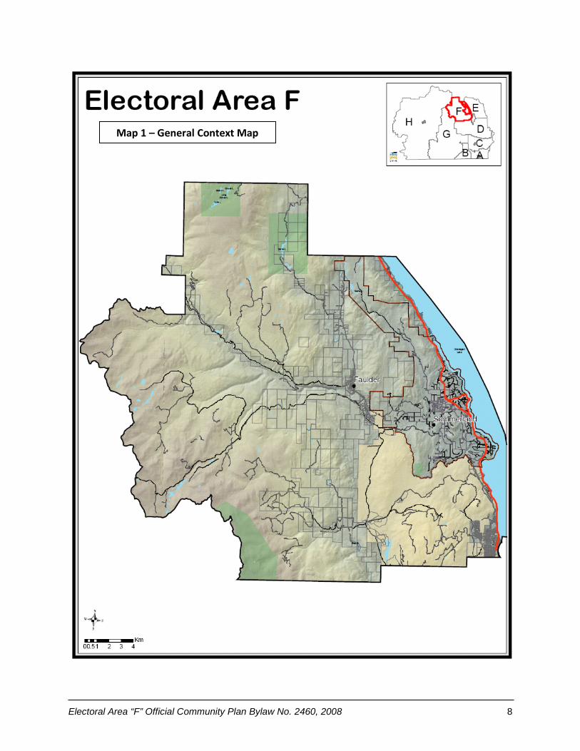
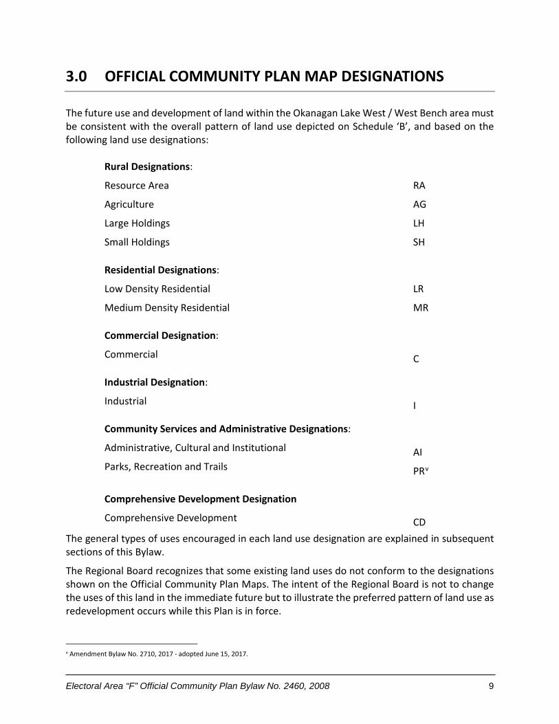


![REGIONAL DISTRICT OF NORTH OKANAGAN BYLAW No ...RDNO Electoral Area “F” Official Community Plan Bylaw No. 2702, 2016 [Schedule “A”] Page 7 Table 2 shows the median age of the](https://static.documents.pub/doc/80x56/602657925d7fa721982d491f/regional-district-of-north-okanagan-bylaw-no-rdno-electoral-area-aoefa-official.jpg)


