35
Tees Archaeology Elwick Village Building Recording The Elwick Village Atlas Project Hartlepool 2013 TA 14/01 OASIS ID 168754
| Date post: | 07-Mar-2018 |
| Category: |
Documents |
| Upload: | hoangquynh |
| View: | 219 times |
| Download: | 1 times |

Tees Archaeology
Elwick Village Building Recording
The Elwick Village Atlas Project
Hartlepool
2013
TA 14/01 OASIS ID 168754

Tees Archaeology

Tees Archaeology
Elwick Village Atlas
Building Recording Project
November 2013
Robin Daniels &
David Jones
TA 14/01
OASIS ID:
This volunteer based project was funded through the Limestone Landscapes, Landscape Partnership Project
© Tees Archaeology
Tees Archaeology, Sir William Gray House, Clarence Road, Hartlepool TS24 8BT
www.teesarchaeology.com

Tees Archaeology
Contents
List of Figures List of Maps Summary Acknowledgements Introduction Historical background Methodology of Survey Gazetteer of Buildings Recorded Bibliography Maps

Tees Archaeology
List of Figures 1 A medieval longhouse 2 Village Farm, No 3 the Green and White Barns 3 17th century doorway, No 3 the Green 4 North Farm, Nos 17 and 18 the Green 5 Chantry Cottage, 11 the Green 6 Methodist Church 7 School House 8 The Terrace 9 Nos 38 and 39 the Green 10 Nos 24 and 25 the Green
11 Council built houses, Nos 9 -19 North Lane
12 Nos 2-8 North Lane List of Maps 1 East end of Elwick 2 West end of Elwick 3 Easternmost end of Elwick

1
Summary This project has created a ‘snapshot in time’ record of the historic core of Elwick, recording the great variety of buildings in the village ranging from 17th century farmhouses to 19th century terraces and buildings of the mid 1960’s. While some buildings are of more historic value than others and some are valued more by locals it is only by viewing them as a whole that we can appreciate the overall character of a settlement. The project was carried out by local volunteers working with Tees Archaeology and has raised awareness of all aspects of the built heritage of the village and has hopefully encouraged local people to look again at buildings which are passed with barely a glance in everyday life. Acknowledgements This project could not have taken place without the funding from the Limestone Landscapes, Landscape Partnership scheme, which in turn is funded by the Heritage Lottery Fund. The work was carried by volunteers from Elwick and further afield, namely Joan Bradbury, Carey Ellison, Victoria Harrison, Sylvia Jobson, Kirsty Jones, Sandra Leonard, David Lewis, Hilary Thompson and Lorraine Watkinson their help is gratefully acknowledged, in particular thanks go to Brian Footitt and Minna Ireland for overseeing the logistical arrangements and providing the soup as well as carrying out recording. Joan Banks kindly commented on the text.

2
Introduction The purpose of this project was to create a snapshot in time of the historic core of the village of Elwick. Every building within this historic core was recorded whatever their date or historical importance. The intention being that the full character of the village would be captured. Unfortunately there was insufficient time available to include the church and hall in this episode of recording but it is hoped that local volunteers will complete the record in due course. The methodology is set out below and is one that has been used successfully with volunteers in both urban and rural settings. It enables the creation of a valuable archive about a settlement while raising the awareness of the historic environment with local people. It also encourages them to look more closely at buildings that they might walk past every day. It is not the purpose of this survey to investigate in detail the history of individual buildings but it may identify buildings that are worthy of more detailed examination. In addition to the building recording work a survey of the Geology of the village will allow a better understanding of the building materials used and how these changed over time. The building recording work at Elwick has been linked to a project led by Victoria Harrison and Sandra Leonard to examine the cartographic and other evidence for the development of the village. The building plots documented for that project have been cross referenced to the buildings survey providing a time depth to the records. The report below comprises a brief rehearsal of the historical background to the village and its building stock, a description of the methodology used in the survey and a gazetteer of all of the buildings recorded.

3
Historical Background Introduction The place name is first recorded in c.1150 and probably means the dairy farm of Ella which is an Old English personal name (Watts 2002, 39). The settlement is laid out from east to west across the contours of the land and running down to a stream, the Char Beck. Elwick Hall with adjoining fishponds and the church of St Peter are on the opposite, western side of the beck to the village with a steep hill separating them. The village of Elwick lies just inland from the medieval town of Hartlepool, our first known reference to the settlement occurs in c.1150 AD when a field, ‘Seflat’ is referred to (VCH Durham III 1928, 254). The manor of Elwick was granted by Robert de Brus to his daughter on her marriage to Ranulf, son of Ribald of Middleham at about the same time. The shape of the village has a plan which is typical of the medieval settlements of the north east of England comprising two rows of farmsteads either side of a village green with the fields laid out behind the village. This plan is typical of that used following the Norman Conquest and probably dates to the first half of the 12th century AD. The separation of the church and hall from the rest of the village is a quite common occurrence and emphasises the fact that the church would have been built as a private chapel of the lord of the manor, whose use by the villagers was incidental. The physical separation of the church and hall from the village took on a legal character when the parish of Elwick Hall was created some time in the medieval period. This separated these elements from the village which remained within the parish of Hart. The reason for this separation is unclear but it may have related to a division of the manor of Elwick. Elwick has been an agricultural settlement for most of its life and there are still two working farms within the village. It is only in the last century that buildings not related to the farming economy have been constructed as people began to live in the village and work elsewhere. The Buildings of Elwick Farmhouses The pre - dominant type of medieval farmhouse in northern England was the long-house. This was derived from Scandinavian practice and comprised a single long building split in two by a cross passage with people living to one side of the

4
cross passage and livestock to the other. The great advantage of this system was that it provided additional heating for the house. Not all the animals would be in the longhouse and there would be other buildings acting as barns and byres. The longhouse would usually be built using ‘crucks’, that is paired curving timbers which extended from the floor to
Fig 1: A Medieval Longhouse
the roof and provided the basic frame of the house. These timbers took all the weight of the house and the walling was purely infill to keep the weather out. Buildings could be lengthened by adding another pair of crucks to create an additional bay and walling could be replaced without worrying about the structural integrity of the building. In the medieval period most of the houses in Elwick would have been of this type. Such buildings began to be replaced from the 16th century onwards as stone was increasingly used for buildings and coal and purpose built fireplaces provided more heat. The successors to the longhouse derived their plan directly from it, even though animals were now removed from such direct contact with people. The new type of farmhouse is known as a ‘hearth-passage’ house. In these buildings the cross passage is kept, but on one side it has a solid wall with a fireplace which heated the main living room and entry into this living room was from a door off the cross passage. As time passed another room was added beyond the living room, ‘the parlour’ and this might be used as a bedroom or private room. Eventually a fireplace was built against the end wall of the parlour which was usually the end wall of the house. This was known as the ‘High’ end of the house To the other side of the cross passage and entered from it was the ‘Low’ house which would contain a kitchen, servants accommodation and other service rooms. Beyond this in a linear arrangement along the frontage were byres, barns and all the other ancillary buildings that accompanied a farm.

5
Fig 2: Village Farm, No3 the Green and White Barns
Village Farm (No 2 the Green), Elwick (C 11) with its associate range of buildings (No 3 the Green (C12) and White Barns (A 13)) is typical of this plan type. The dominance of the main farm building (No 2), the ‘High’ part of the complex is
clear. While the original entry to the complex was via the very nicely decorated 17th century doorway that is now the entry to No 3. From here one would have turned left into the main living room which has a heated parlour beyond. To the right of the cross passage is the service area (No3) and beyond that the much changed range of barns and byres (White Barns). The relative height of the roofs is one of the give aways as far as the relative importance of the buildings is concerned
Fig 3: 17th century doorway, No 3 the Green

6
The hearth passage plan and linear farm range was the dominant form in the area until the 19th century when the main farmhouse was frequently altered to provide sole access rather than shared access with the service quarters. The central doorway inserted into Village Farm (No 2 the Green) is a classic example of this. In some cases the main building was completely replaced with a state of the art 19th century building which looks slightly incongruous beside its more mundane and early component parts. This is the case at North Farm (18 The Green – A1) where the complex would originally have comprised 17 The Green (A2) on one side and the range of farm buildings to the other. The main building would always have been No 18, but the original late 17th or early 18th century building has been taken down and re-built or re-fronted with 19th century brick building inserted into the centre of the complex. The original cross passage door is marked by the small white doorway at the top of the flight of steps.
Fig 4: North Farm, Nos 17 and 18 the Green
Farm Cottages While the farmhouses mark the wealthier occupants of the village those who provided labour had much smaller accommodation, either living within the main farm complex or in small cottages. Relatively few of these small cottages survive and none are untouched by extensive modernisation, however their basic

7
character can still be seen at Elwick in Chantry Cottage, 11 The Green (C1) and at Churchside Cottage (A8)
Fig 5: Chantry Cottage, 11 the Green
19th Century Changes In the 19th century brick was used as a major building material for the first time, replacing local limestone and fieldstone. This also ushered in new types of buildings with the Methodist Church, the school and the short terrace on the south side of the Green.
Fig 6: Methodist Church Fig 7: School House

8
The terrace is interesting in that it brings an urban building form into the village, but it has been done with a degree of care and expense considering the amount of detailing with white brick that has been put into the buildings.
Fig 8: The Terrace
The Impact of the 20th century Elwick has an interesting variety of the architectural styles of the 20th Century. Innovations of the 20s and 30s One of the major innovations of the 1920s and 30s was the semi-detached house, a development of the 19th century terrace providing more privacy. The buildings were often slightly smaller than their 19th century predecessors and
often included aspects of either Art Deco or Art Nouveau design. Nos 37 -39 The Green fall into this category with Nos 37 and 38 comprising a semi-detached pair and No 39 a larger and more elaborate building that echoes the style of the smaller buildings next door.
Fig 9: Nos 38 and 39 the Green
A second innovation was the widespread adoption of the bungalow as opposed to the much lowlier single storey cottage. Bungalows were built from the 1920s onwards and seem to have appeared in Elwick from the 1920s. Both bungalows

9
and semi-detached houses are more typical of suburban settings than rural villages.
Fig 10: Nos 24 and 25 the Green
Post Second World War Local Authorities began to build housing from the 1890s onwards and this increased after the First World War, but the major increase occurred after the Second World War in a bid to replace bombed stock and to continue the programme of slum clearance started before the war.
The houses at Elwick were built in 1947 as part of this post war boom and are a relatively discrete component of the village. Their style is straightforward, copying layouts from the 1930s and with little decoration
Fig 11: Council built houses, Nos 9 -19 North Lane

10
Fig 12: Nos 2-8 North Lane
The group of houses built in 1965 on the east side of North Lane are stylistically quite distinct, demonstrating aspects of modernist design with large windows and asymmetrical designs , partially as a result of the local topography. They have a clear character which adds to the variety of the housing stock of the village, although being more suburban than rural in nature.
11
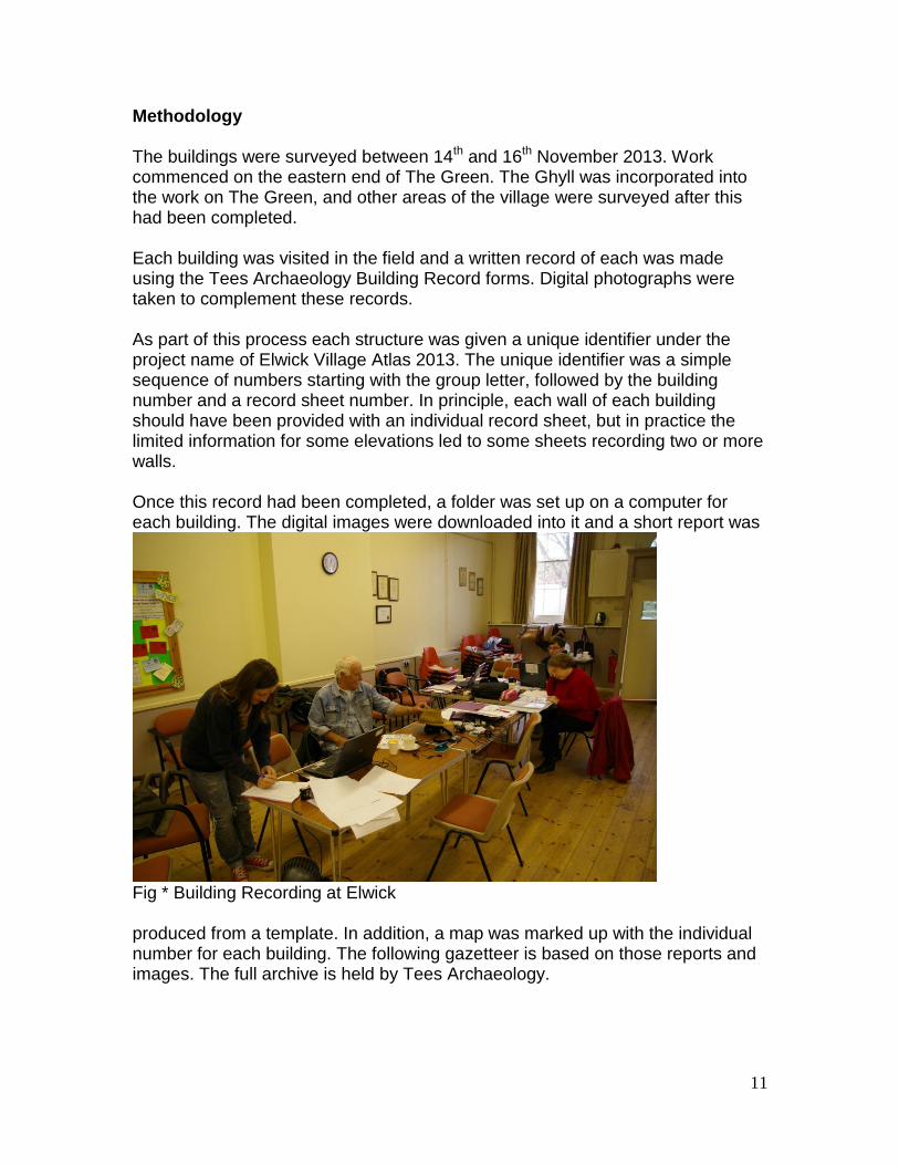
Methodology The buildings were surveyed between 14th and 16th November 2013. Work commenced on the eastern end of The Green. The Ghyll was incorporated into the work on The Green, and other areas of the village were surveyed after this had been completed. Each building was visited in the field and a written record of each was made using the Tees Archaeology Building Record forms. Digital photographs were taken to complement these records. As part of this process each structure was given a unique identifier under the project name of Elwick Village Atlas 2013. The unique identifier was a simple sequence of numbers starting with the group letter, followed by the building number and a record sheet number. In principle, each wall of each building should have been provided with an individual record sheet, but in practice the limited information for some elevations led to some sheets recording two or more walls. Once this record had been completed, a folder was set up on a computer for each building. The digital images were downloaded into it and a short report was
Fig * Building Recording at Elwick produced from a template. In addition, a map was marked up with the individual number for each building. The following gazetteer is based on those reports and images. The full archive is held by Tees Archaeology.

12
Gazetteer of Buildings Recorded The gazetteer starts on the north side of the village and runs from west to east and then crosses to the south side of the village and again runs from west to east.
Church Bank Hazel Bank Cottage, Church Bank (A17)
Three storey end-terrace house, rendered, with gabled slate roof. The building has been extended to the side to accommodate a double garage and additional living space above. One bay window to the ground floor at the front. The main door is to the left of the front elevation, with a further door to the right possibly leading to the back of the terrace.
Church Bank Cottage, Church Bank (A16)
Adjoins A17, with the same construction. The main entrance has a window set into the frame. The ground floor has a bay window. Steps lead down from the main door to the road.
Bee Cottage, Church Bank (A15)
Adjoins A16, with the same construction, except the roof, which is pan tiled. To the rear is a two storey extension with gabled roof of pan tiles. The roof line of this extension is lower than that of the rest of the house. The main entrance is to the east elevation. To the east is a garage built of rendered brick, with a flat bitumen roof.
North Side of the Green (from west to east) Belmont, 1 the Green (A14)
Two storey rendered stone house with gabled slate roof. The stone on the single storey wing extending to the rear has been left bare. There is a single storey extension to the west. Windows are generally small and set back from the wall, except for the ground floor

13
square bay window to the front. There are velux windows and a garden room to the rear. The garage, which is separate from the house, is also rendered with a gabled slate roof. There is a clock above the garage door, and a weather vane on the apex of the roof. Village Farm, 2 the Green (C11)
Two storey stone built farmhouse with gabled slate roof. The front door is central, and flanked by two windows of unequal size. A single-storey extension to the rear houses two rear doors under a hipped roof. The original windows in the building have been replaced.
3 The Green (C12) Adjoins C11. Stone built with wet dash covering and a gabled slate roof. The front door is at the west end of the front elevation, and there are three windows to the front. To the rear, the building projects northwards, with a small extension built to the west side of the projection. The rear of the property is faced in dressed stone, painted white. One window to the rear has a door lintel above, which is in line with the front door and suggests the former existence of a passage.
White Barns, the Green (A13) Adjoins C12. Brick built under render. The roof is slate, with four velux windows to the rear. The roof construction is unusual in that one segment is flattened, and appears to be made of a different material. The front door is set back from the main elevation wall.
Martindale House, 4 & 5 the Green (A12) Two storey rendered house, possibly stone built underneath. The roof is gabled and of pan tiles. A ridge in the render suggests that the house has been raised from a single-storey. There is a large bay window to the front, and windows either side of the main door. Above the door is a stone sundial. While built as one structure this was split into two in the 1960’s, the ‘low’ (right hand) end of the house is now part of No 5 (see below).
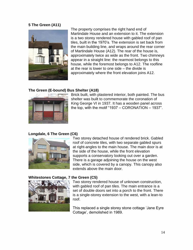
14
5 The Green (A11) The property comprises the right hand end of Martindale House and an extension to it. The extension is a two storey rendered house with gabled roof of pan tiles, built in the 1970’s. The extension is set back from the main building line, and wraps around the rear corner of Martindale House (A12). The rear of the house is, approximately twice as wide as the front. Two chimneys appear in a straight line: the rearmost belongs to this house, while the foremost belongs to A12. The roofline at the rear is lower to one side – the divide is approximately where the front elevation joins A12.
The Green (E-bound) Bus Shelter (A18)
Brick built, with plastered interior, both painted. The bus shelter was built to commemorate the coronation of King George VI in 1937. It has a wooden panel across the top, with the motif “1937 – CORONATION – 1937”.
Longdale, 6 The Green (C6)
Two storey detached house of rendered brick. Gabled roof of concrete tiles, with two separate gabled spurs at right-angles to the main house. The main door is at the side of the house, while the front elevation supports a conservatory looking out over a garden. There is a garage adjoining the house on the west side, which is covered by a canopy. This canopy also extends above the main door.
Whitestones Cottage, 7 the Green (C5)
Two storey rendered house of unknown construction, with gabled roof of pan tiles. The main entrance is a set of double doors set into a porch to the front. There is a single-storey extension to the west, with a lean-to roof. This replaced a single storey stone cottage ‘Jane Eyre Cottage’, demolished in 1989.

15
8 The Green (C4) Two storey rendered brick house, with gabled roof of pan tiles. The chimney stack protrudes from the west end of the building. A single storey extension protrudes from the front of the house, containing the main door, as well as an integral garage.
Potter’s Farm, 9 The Green (C3)
Two storey farmhouse of unknown construction under render, with a gabled roof of pan tiles. The roof to the rear is steeper than at the front, indicating that the front portion has been raised. The main door is in the centre of the front elevation. There is a farm building to the west, adjoining the main house, built of rendered stone with a roof of asbestos sheet.
Pathways, 10 the Green (C2)
Single storey house with dormer living space above, adjoins C3. Built of rendered brick, with a gabled roof of asbestos tiles. The main entrance is in the centre of the front elevation. All windows to the front are bay windows, with the dormer protruding much further from the house.
Chantry Cottage, 11 the Green (C1) Single storey building adjoins C2. Rendered, with a gabled roof of pan tiles. The gable end is somewhat higher than the roof, suggesting this house may once have been thatched. The main entrance is in the centre of the front elevation. This was originally two farm cottages (11 & 12 The Green) which were converted into one dwelling in the 1980's or 90s.
Holmlea, 14 the Green (A5) Two storey house, brick built and partly rendered, with a gabled roof of slate. The main entrance is in the centre of the front elevation, and has a pediment. There are several outbuildings associated with this house: a brick outhouse adjoins the next house (A4); a stone shed with tiled roof, of proportions indicative of a former barn which has been partially demolished; and a brick garage.

16
Wilton Cottage, 15 the Green (A4) Two storey rendered stone building, with single storey brick extension and gabled roof of pan tiles. The main door is in the side porch; however, steps towards the centre of the front elevation suggest the door was originally here. There is a bay window to the east, with a dormer above. The house has a separate garage, built of rendered
brick, with a gabled roof. 16 The Green (A3)
Two storey rendered house, with gabled roof of pan tiles. There is a single-storey porch to the east, with the main door to the south elevation of this. The chimney stack protrudes from the west side of the building, and flares at the bottom. To the east elevation of the porch, there is a cartwheel approximately in the centre of the wall.
17 The Green (A2)
Two storey rendered house, with gabled roof of pan tiles. The main entrance is via a porch to the front. To the west is a long, single-storey extension with a large window.
North Farm, 18 the Green (A1)
Two storey farmhouse. Adjoins A2, with identical construction for approximately the first five feet, after which the roof becomes higher and the walls are revealed to be brick. The higher roof section is gables, and of slate. A door in the rendered section leads to a farmyard. The main door is in the centre of the front elevation. The farm contains numerous outbuildings. Adjoining the east side of the farmhouse is a series of single storey, stone built barns. The far eastern end of this range has been raised, with a brick built section forming the top half of the eastern end. All of the barns have gabled roofs of pan tiles, with occasional clear tiles to provide

17
light. Behind these barns is a larger stone barn, with slit vent windows and a gabled roof of pan tiles. To the east of the farmyard is a brick building with an animal trap gate and gabled metal roof. To the rear of the farmyard is a large metal hay barn.
South Side of the Green (from west to east) 1 & 2 Mount Pleasant (D1)
A two storey rendered house with gabled slate roof comprising two properties. The main entrance to both is through a central open passage running between the two houses. Number 1 has bay windows which run from the ground to the eaves, while number 2 has a smaller bay window on the ground floor.
42 & 43 The Terrace, the Green (D2)
Two storey terrace of brick buildings with gabled slate roofs. To the ground floor, both houses have bay windows. There is white brick detail to the corners of the building, windows, doors and chimneys.
40 & 41 The Terrace, the Green (D3)
Two storey mid terrace houses, adjoining D2. Built of brick with a gabled roof of pan tiles. Number 40 is partially rendered. The main entrance of each house is set into the front elevation, with small window lights above. A third door indicates that number 40 was originally two properties. Each house has a bay window to the ground floor, with the probable site of the third now converted into a garage.

18
38 & 39 The Green (D4) Two storey mid terrace buildings, adjoining D3. Built of brick with a gabled roof of pan tiles. The windows to the first floor of both properties extend beyond the roofline, and so have small hipped canopies to cover them.
Westall, 37 the Green (D5)
Two storey end terrace building, adjoins D4. Built of brick with a hipped roof of flat clay tiles. The main door is set into a porch with two lights, and a sloping wall between the top of the porch and the roof. This wall is covered in decorative tiles. Bay windows to both floors are joined by a section of tiles, and there is a herringbone pattern of bricks beneath the ground floor bay.
Ivanhoe & Kelvin, 36 & 35 the Green (D6)
Two storey building, originally one storey built of stone, with a second storey added in brick. The front elevation is rendered, and the gabled roof is of pan tiles. The building has a single storey brick extension to the rear. Entrances at either end of the building serve as the main doors to each property.
McOrville Public House, the Green (D7)
Two storey rendered building adjoining D6, possibly stone built with a gabled roof of slate. There is a small porch to the front, housing the main entrance and a window. There is a brick built extension at the eastern end of the main building, the front of which is set back from the front of the main building. There is a bay window the full width of this extension, to the ground floor at the front, and the gable end of the extension
has white brick detailing. A series of brick-built outbuildings extends south of the extension. To the extreme south, a 20th century building shows the remains of a single door and some windows. The windows are blocked up, while the door now forms part of one of three double doors.

19
Elwick Post Office & Rudby House, the Green (D8) Two storey brick built house and shop, showing evidence of earlier construction in stone, and partially rendered. The gabled roof is of slate. The main entrances are via a door to the east of the front elevation, and a door in the shop front to the west. A third door, approximately in the centre of the front elevation, may lead to a central through passage. There is a Millennium clock above the Post Office
shop front. Both properties have outbuildings at right angles to the main building. These outbuildings are brick-built, with gabled roofs: the roof of the outbuilding to Rudby House is of slate, while that of the Post Office is metal. The Spotted Cow Public House, the Green (A10)
Adjoins D8. Rendered public house, with gabled roof of slate. From the front, the roof has two distinct sections, and is lower at the east end of the building. The main entrance to the front is a pedimented door, with two ancillary doors to the east. There is a double door to the rear, presumably to a storage space, and a single door from the main building into the beer garden. To the rear is a brick built extension, with a
flat roof. The Forge, 29 the Green, Elwick (A9)
Rendered house with gabled roof of pan tiles. The gable ends extend higher than the roofline, suggesting this house was once thatched. The main entrance is set into the centre of the front elevation. There are two separate extensions to the rear of the building: to the east, there is a single storey extension with a lean-to roof of pan tiles; and to the west, there is a two-storey extension with a gabled roof,
extending at right-angles to the main roof, also of pan tiles.

20
Manor Cottage, 28 the Green (C7) Two storey stone building, later rendered, with gabled roof of pan tiles. The building has three extensions: A porch to the front; a two storey extension to the rear; and a small porch to the rear. The latter has a flat roof, while the others have gabled roofs of pan tiles. There is an external, brick-built chimney stack to the west elevation.
27 the Green (C8)
Adjoins C7, with the same construction. The main entrance is to the west of the front elevation, and is slightly smaller than those around it. Above is a gap in the render, showing the underlying stonework, possibly with markings or carvings.
Pounder House, 26 the Green (C9)
Two storey rendered stone house with brick façade, with a gabled roof of slate, adjoining C8. The front portion of the house has been raised from a single storey, while the rear portion was two storeys on construction. A single storey extension to the east joins the main house onto a once separate garage. The house shares a chimney with number 27 (C8). There is a bay window to the ground floor, to the right of the main entrance. There is another bay window in the
extension to the east, to the rear of the house. Greenways, 25 the Green (C10)
Dormer bungalow built of brick, with gabled roof of flat clay tiles. There is a garage attached, which adjoins the garage of Pounder House (C9). To the front elevation are two bay windows to the ground floor. The main entrance is in the centre of the west elevation, and is

21
covered by a decorative canopy of wooden supports with flat tiles on the gabled roof. Hillcroft, 24 the Green (B9)
Brick built bungalow with gabled roof of concrete tiles. The building has been extended twice: a long extension has been built to the rear, at right angles to the main building; and a porch has been added to the front. The main entrance is in this porch. There is a bay window to the right of the porch. There is a separate garage.
The Croft, 23 the Green (B8)
Brick built bungalow, partially rendered to the front, with hipped roof of pan tiles. The main entrance is to the west elevation, within a recessed porch. There are two bay windows to the front. Above these, roughly central to the front elevation, is a double-cross motif. There is an external chimney stack to the rear of the east elevation. There is a garage adjoining the west wall, which also adjoins the east wall of B9. The garage protrudes beyond
the south elevation of this house. Women’s Institute Hall, the Green (B7)
Brick built Wesleyan Methodist chapel, converted for use by the Women’s Institute. The gabled roof is of pan tiles. The main entrance is a double door in the front elevation. Above this is a half-moon window with the Institute logo in stained glass. Towards the top of the front elevation is a large rectangular space surrounded by white bricks, which may have been the site of a dedication stone. Extending from approximately half way up the front
elevation to a point above the roofline is a flag pole. The building has a low brick built extension to the rear. Netherby Cottage, 22 the Green (B6)
Adjoins B7. Brick-built bungalow, partly rendered, with hipped roof of pan tiles. The main entrance is in a set-back porch with a brick pillar on the north-east corner. There is a bay window to the front. The building has been extended to the rear. A further extension has taken place to the west of this extension, being built of

22
brick with a flat roof. A rear porch has been added to this latter extension. There is an outhouse to the rear of the building. It is brick-built, with a roof of asbestos sheet. The Milking Parlour, Holme Farm, the Green (B5)
Two storey stone building, with gabled roof of pan tiles. The gable ends extend above the roofline, suggesting the roof was once thatched. The building has been extended to the west, in a single storey extension of stone. The main entrance is in the front elevation, to the east, and is a sliding door. There is a smaller door to the rear.
20 & 21 the Green (B4)
Two storey brick built houses, partially rendered, with gabled roofs of pan tiles. Each house has a bay window to the front elevation at ground floor level. The main entrances to the two properties are on the side elevations. There are two extensions to number 21, to the rear. One, on the rear elevation, is a single-storey extension with a lean-to roof, while the other, on the west elevation, is a flat roofed porch. A
boiler house has been added to the rear of the east elevation. Home Farm, the Green (B3)
Two storey rendered stone farmhouse, with gabled roof of slate. The main entrance is in the front elevation, slightly off centre, and adorned with a stone frame protruding from the main elevation. From the east elevation, it is clear that the present roof is higher than the original.
Sycamore House, the Green (B2)
Two storey brick building with gabled roof of pan tiles. The front elevation projects forwards at the east end, with the roof continuing in an unbroken line over this projection. In the corner where the projection meets the main elevation, there is a porch

23
containing the main entrance. There is a bay window to the front elevation, to the ground floor. Norse Cottage, the Green (B1)
Two storey rendered brick building, with gabled roof of slate. There is a projection to the east of the front elevation, with a bay window to the front. There is another bay window to the west of the front elevation. The main door is central, with a balcony over which extends from the projection to approximately the near side of the second bay window. This was built as a bungalow and had a
storey added in the 1960's.
South of the Green: The Ghyll It should be noted that, due to the lie of the land, all houses on The Ghyll are one storey higher at the rear than they are at the front. Floor numbers reflect the position of features as seen from one particular elevation, and do not necessarily correspond with the rest of the house. Lane House, the Ghyll (A6)
Three storey brick built house, with hipped roof of pan tiles. A small porch is set into one corner to the front, and contains the main entrance. There is a garage door to the east of the front elevation, with a gabled window protruding from the first floor, above. A long window to the west of this elevation provides light to both floors. To the west elevation, there is a patio area at first floor level, with an inset balcony on the second floor. To the rear, windows on the top
floor are covered by gabled eaves, as at the front. Fairways, the Ghyll (A7)
Three storey brick built house, with gabled roof of pan tiles. The front elevation has been extended at the south end, to incorporate a garage. The extension includes a section of roof, supported by a brick pillar, forming a porch. The main entrance is in the main elevation under this extended roof. Two dormer windows project from the first floor to the front, both with gabled eaves. This is mirrored to the rear on the second floor. The ground floor to the
rear extends from the main elevation and is covered by a lean-to roof of pan tiles.

24
Levendale, the Ghyll (A8)
Three storey brick built house, with gabled roof of pan tiles. The chimney stack protrudes from the south elevation. The main door is in the centre of the front elevation. To the rear, the second floor dormer windows have gabled eaves. The rear door is to the first floor, with steps leading down into the garden. There is a separate garage, connected to the main house by a garden wall.
North Lane Ivy Dene, North Lane (B11)
Single storey rendered cottage, with gabled roof of slate. The main entrance is set into an open fronted, gated porch in the centre of the front elevation. There is a garage built onto the south elevation.
9 – 19 North Lane (D9)
Crescent of six semi-detached two storey houses (numbers 9, 11, 13, 15, 17 and 19). All brick built, with gabled roofs of pan tiles. The main entrances are at either end of the front elevation of each building. There is one bay window per property to the ground floor of the front elevation. The two properties in each building share a chimney stack. All buildings have a two-storey extension to the rear, which has further been extended with a single
storey. Both extensions have flat roofs. 2 – 8 North Lane (B10)
Terrace of four two storey houses (numbers 2, 4, 6 and 8). Brick built with gabled roofs of flat clay tiles. The buildings are joined by single-storey projections to the side elevations. Each building has a full-width balcony to the west elevation.

25
Churchside Cottage (C13)
Single storey rendered brick building, with two gabled roofs of pan tiles, running parallel with a gully in between. The main entrance is in the front elevation, slightly right of centre, and is covered with a wooden canopy. There is an outbuilding attached to the main building to the east, constructed in the same style as the main building.
The Old School (C14)
Single storey brick building, with gabled roof of slate, with roof living space. There is a projection from the main front elevation at the west end. At the east end of the front elevation is a porch, containing the main entrance door. There is a lean-to projection to the front of the east elevation of the larger gabled projection. A flat roofed extension fills in the gap between this and the main elevation, and contains another entrance. There is a further lean-to
extension to the east elevation of the main building. Bibliography Page, W 1928 A History of Durham, Vol III, Victoria County History Watts, V 2002 A Dictionary of County Durham Place-Names

Map1: West end of Elwick, Hartlepool. Labels on buildings refer to record number used in gazetteer and for survey.

Map 2: East end of Elwick, Hartlepool. Labels on buildings refer to record number used in gazetteer and for survey.

Map3: Westernmost part of Elwick, Hartlepool. Labels on buildings refer to record number used in gazetteer and for survey.


www.teesarchaeology.com


