REMEDIAL ACTION REPORT - SOIL JUNE 2016 FORMER MORRIS CANAL (AOC-1) CHROMIUM SITE 121 (AOC-2) AND CHROMIUM SITE 207 (AOC-3) BERRY LANE PARK JERSEY CITY, NJ 07302 Table of Contents PREPARED FOR: JERSEY CITY REDEVELOPMENT AGENCY 66 YORK STREET JERSEY CITY, NJ 07302 PREPARED BY: DRESDNER ROBIN ONE EVERTRUST PLAZA SUITE 901 JERSEY CITY, NJ 07302 (201) 217-9200 PROJECT NO. B80-807
Transcript
REMEDIAL ACTION REPORT - SOIL JUNE 2016 FORMER MORRIS CANAL (AOC-1) CHROMIUM SITE 121 (AOC-2) AND CHROMIUM SITE 207 (AOC-3) BERRY LANE PARK JERSEY CITY, NJ 07302
Table of Contents
PREPARED FOR: JERSEY CITY REDEVELOPMENT AGENCY 66 YORK STREET JERSEY CITY, NJ 07302 PREPARED BY: DRESDNER ROBIN ONE EVERTRUST PLAZA SUITE 901 JERSEY CITY, NJ 07302 (201) 217-9200 PROJECT NO. B80-807
i
Table of Contents Case Inventory Document (provided loose and bound within report) Cover/Certification Form (provided loose and bound within report) Updated Receptor Evaluation Report Form (provided loose and bound within report) Remedial Action Report Form (provided loose and bound within report) Final Laboratory Data Deliverables Form (provided loose and bound within report) Alternative or New Remediation Standard and/or Screening Level Application Form (provided loose and bound within report) 1.0 INTRODUCTION ........................................................................................................................................... 1 2.0 BACKGROUND INFORMATION ................................................................................................................. 2
2.1 Environmental Setting ............................................................................................................................. 2 2.1.1 Project Area Location and Description ..................................................................................... 2 2.1.2 Surrounding Land Use .............................................................................................................. 3 2.1.3 Topography ............................................................................................................................... 3 2.1.4 Surface Water............................................................................................................................ 3 2.1.5 Regional Geology ...................................................................................................................... 3 2.1.6 Regional Soil ............................................................................................................................. 3 2.1.7 Regional Hydrogeology ............................................................................................................. 4 2.1.8 Regional Groundwater in Fill Deposits ..................................................................................... 4 2.1.9 Regional Groundwater in Native Unconsolidated Deposits ..................................................... 4 2.1.10 Regional Groundwater in the Stockton and Lockatong Formations (Bedrock) ....................... 4
3.0 APPLICABLE REGULATORY TIMEFRAMES ........................................................................................... 5 4.0 REGULATORY HISTORY ............................................................................................................................ 6 5.0 SITE INVESTIGATION WORKPLAN, SEPTEMBER 2010 ........................................................................ 7
6.2.1 Total and Hexavalent Chromium .............................................................................................. 9 6.2.2 Metals attributed to Chromate Chemical Production Waste (CCPW) Metals ......................... 9 6.2.3 Target Analyte List Metals ...................................................................................................... 10 6.2.4 Target Compound List Volatile Organics................................................................................ 10 6.2.5 Target Compound List Base Neutrals Acid Extractables and Pesticides, Polychlorinated
Biphenyls and Total Cyanide .................................................................................................. 10 6.3 Groundwater Investigation Procedures ................................................................................................ 11 6.4 Groundwater Investigation Results ...................................................................................................... 11
6.4.1 Target Compound List Volatile Organics and Base Neutral Acid Extractables .................... 11 6.4.2 Pesticides, Polychlorinated Biphenyls and Total Cyanide ..................................................... 12
6.5 Conclusions and Recommendations ................................................................................................... 12 6.5.1 Soil ........................................................................................................................................... 12
6.5.1.1 Historic Fill .................................................................................................................. 12 6.5.1.2 Hexavalent Chromium ............................................................................................... 12 6.5.1.3 Total Chromium and CCPW Metals .......................................................................... 12 6.5.1.4 Target Analyte List Metals ......................................................................................... 12 6.5.1.5 Target Compound List Volatile Organics, Base Neutrals Acid Extractables, Pesticides, Polychlorinated Biphenyls and Total Cyanide ..................................................... 13
6.6.1 Groundwater ............................................................................................................................ 13 6.6.1.1 Hexavalent Chromium and Total Chromium ............................................................ 13
ii
Table of Contents (continued)
6.6.1.2 Target Analyte List Metals ......................................................................................... 13 6.6.1.3 Target Compound List Volatile Organics .................................................................. 13 6.6.1.4 Pesticides ................................................................................................................... 13
7.0 REMEDIAL INVESTIGATION REPORT AND REMEDIAL ACTION WORKPLAN, FEBRUARY 2012 14
11.1 Usability of Laboratory Analytical Data ............................................................................................... 34 11.2 Data Quality Assessment.................................................................................................................... 34
12.0 DEVIATION AND VARIATIONS FROM THE TECHNICAL REGULATIONS/GUIDANCE ................. 36 13.0 CONCLUSIONS AND RECOMMENDATIONS ...................................................................................... 36 14.0 REFERENCES ......................................................................................................................................... 37
1.0 INTRODUCTION On behalf of the Jersey City Redevelopment Agency (JCRA), this Area of Concern (AOC) specific Remedial Action Report (RAR) for soil has been prepared by Dresdner Robin to present the New Jersey Department of Environmental Protection (NJDEP) approved remedial actions performed within and along the former Morris Canal (AOC-1) and Hudson County Chromium Site 121 (AOC-2) and Site 207 (AOC-3) which are located within the limits of the JCRA’s Berry Lane Park in Jersey City, New Jersey (“the Site”). A United States Geological Survey (USGS) map presenting the regional location of the Site is presented as Figure 1.
Site and remedial investigations of Chromium Chemical Production Waste (CCPW) were conducted by Dresdner Robin between late 2010 through the NJDEP’s approval of the Remedial Investigation Report and Remedial Action Workplan – Soil in February 2012. These investigations were overseen and approved by the NJDEP pursuant to a Memorandum of Agreement (MOA) executed between the NJDEP and the JCRA. The NJDEP Case Manager was Mr. Steve Kehayes of the Department of Brownfield Reuse. NJDEP approvals are included as Appendix A.
The purpose of this report is to present the remedial actions completed for CCPW related soil impacts associated with the former Morris Canal (AOC-1), Chromium Site 121 (AOC-2) and Chromium Site 207 (AOC-3) within Berry Lane Park. The extent of each of the AOCs are depicted on Figure 2. It should be noted that this document was reviewed by the Independent Technical Consultant appointed by the Court and any comments were incorporated prior to its submittal.
The remediation was performed in accordance with the NJDEP approved Remedial Action Workplan (RAW) dated February 2012. This RAR follows the format specified by the New Jersey Administrative Code (N.J.A.C.) 7:26E-5.7 of the NJDEP’s Technical Requirements for Site Remediation (May 7, 2012) and applicable guidance documents. It should be noted that this RAR for soil is being submitted as a standalone document with the understanding a separate RAR will be submitted in the future which addresses the remainder of the non-chromium related AOCs within the park. This future RAR will document the engineering and institutional controls implemented by the JCRA for non-chromium related soil impacts.
On July 20, 2012, a Licensed Site Remediation Professional (LSRP) was retained (Mr. John F. Tregidgo; LSRP ID No. 585012 [interim LSRP ID No. 535036]) by the JCRA to oversee the completion of the remedial actions for Program Interest No. 568229 as approved by the NJDEP. The LSRP Notification of Retention or Dismissal Form is included as Appendix B.
As part of this submission, the following documentation is provided both unbound at the front of this report, as well as included within the respective attachments of this report: a Case Inventory Document (Attachment A); Cover/Certification Form (Attachment B); Updated Receptor Evaluation Report Form (Attachment C); Remedial Action Report Form (Attachment D); Full Laboratory Data Deliverables Form (Attachment E) and a Alternative or New Remediation Standard and/or Screening Level Application Form (Attachment F).
2.0 BACKGROUND INFORMATION The proposed Berry Lane Park includes a collection of twelve (12) properties; a list of these properties addresses, block and lot and identification name is provided below:
Property No. Name Address Block Lot
1 65 Woodward Ave. 65 Woodward Ave. 19803 4, 5
2 948 Garfield Ave. 948 Garfield Ave. 19803 11
3 City of Jersey City 970, 972, 974, 976, 978, 980 and 984 Garfield Ave. 19803 16, 17, 18, 19, 20, 1
4Garfield Junk Yard (also known as
Chromium Site 121)958, 960, 964 and 966 Garfield Ave. 19803 12, 13, 14
5Hit or Miss (with a portion also
known as Chromium Site 207)942, 944 and 946 Garfield Ave. 19803 8, 9, 10, 21
6 MAOK 968 Garfield Ave. 19803 15
7 Purple Fish 990 Garfield Ave. 18901 1
8 1000 Garfield Ave. 1000 Garfield Ave. 18901 2
9 75 Woodward Ave. 75 Woodward Ave. 19803 3
18901 Portion of 18
1730110 (northern side of Communipaw Ave.)
12 Woodward Metals 125 Woodward Street 18901 18
1 Berry RoadFinch Oil10
Properties listed were previously investigated on behalf of the JCRA with the NJDEP reviewing and approving site specific Remedial Action Workplans for each. Please note that CCPW related investigations were not presented within these reports, but were presented within stand alone documents which are summarized in Sections 5 through 7 of this document. 2.1 Environmental Setting A description of the project area, surrounding land use, topography, soils, surface water, geology and hydrogeology for the Project Area and surrounding area is summarized below. 2.1.1 Project Area Location and Description Berry Lane Park is primarily located in a commercial/light industrial area of Jersey City, Hudson County, New Jersey and consists of an amalgamation of twelve (12) properties. A USGS map presenting the regional location of the project is presented as Figure 1; an aerial photograph identifying each parcel is presented as Figure 2. The limits of Berry Lane Park are broadly defined by the Hudson Bergen Light Rail Train (HBLRT) tracks to the south, Communipaw Avenue to the north, Garfield Avenue to the east and Woodward Street to the west. AOC-1 through AOC-3 are located entirely within the Berry Lane Park within the following Block and Lots.
Area of Concern Block Lot(s)
eastern portion of Lots 1 and 8 through 20
21
eastern portion of Lots 1 and 2
western portion of Lot 18 to the northern boundary of Lot 2
AOC-2 Chromium Site 121 19803 12 through 15
AOC-3 Chromium Site 207 19803 8 (excluding most southwest corner), 9, 10
19803
18901
AOC-1 Former Morris Canal
The extent of each of the AOCs is presented on Figure 2.
2.1.2 Surrounding Land Use This area of Jersey City is generally characterized as commercial and light industrial. Commercial properties and businesses, including warehousing and light manufacturing, are located to the north, east, and south of Berry Lane Park. Residences are located to the west, across Garfield Avenue, and to the east and north of the NJ Transit Light Rail. 2.1.3 Topography The USGS Topographic Map (Figure 1) presents the pre-remediation regional topography in the area. Berry Lane Park has little topographic relief, with ground surface elevation generally ranging from 12 to 16 feet above mean sea level (“msl”). 2.1.4 Surface Water There are no surface water bodies on or adjacent to the Site. The nearest water body is the Morris Bay, which is located approximately 4,500 feet to the east. The Site is not designated as wetlands and none were identified on or adjacent to the Site. According to NJDEP’s i-Map wetlands database, Disturbed Wetlands and Deciduous Wooded Wetlands exist approximately 3,500 feet south of the Site. Additionally, the Site is located within the 100-year floodplain boundary (Zone AH), which is defined as having flood
depths ranging from one (1) to three (3) feet.
2.1.5 Regional Geology The Site is located in the Piedmont Physiographic Province of New Jersey along the eastern edge of the Newark Basin. The Piedmont is described as a rolling plain which extends south and east from the southeastern edge of the New Jersey Highlands to the Hudson River, in the northern portion of New Jersey. The Newark Basin was formed during the Late Triassic and Early Jurassic periods and extends locally from the west of the first Watchung Mountain in northern central New Jersey to the Hudson River. The Triassic Newark Supergroup consists of non-marine sedimentary rocks and diabase intrusions. The Newark Supergroup is divided into three (3) formations on the basis of distinctive lithology: (1) the lower unit - the Stockton Formation, (2) the middle unit - Lockatong Formation, and (3) the upper unit - the Passaic Formation. The Bedrock Geology Map of Northern New Jersey, USGS 1996, indicates the bedrock at the Site is comprised of the Stockton and Lockatong Formations. The Stockton Formation is composed of light-gray, light-grayish-brown, yellowish-to-pinkish, or violet gray to reddish-purplish-brown sandstone, mudstone, silty mudstone, argillaceous siltstone and shale. The Lockatong Formation is composed of light to dark gray, greenish-gray and black dolomitic or silty argillite, mudstone, sandstone, siltstone and minor silty limestone. 2.1.6 Regional Soil Generally the subsurface conditions at the Site consist of the following strata listed in order of increasing depth:
• Fill Material: The thickness and composition of the fill material is variable. The fill material generally rest on top of marine deposits, glacial deposits and bedrock. The fill material could be composed by a mixture of cinders, sand and gravel with a trace of silt and clay, construction demolition debris (concrete, brick, glass, metal, etc.), wood, slag and miscellaneous debris. The fill was often placed to raise surface elevations above the existing water level in an effort to reclaim wetlands and flood prone areas for development. Deeply occurring subsurface fill is common in Jersey City.
• Natural Marine and Estuarine Marsh Deposits: Generally, these deposits are composed of organic silt and clay (clayey silt), fine sand, traces of shells, traces of wood and peat (meadow mat). These deposits can range in thickness from 20 to 40 feet and thickness varies regionally.
• Glacial Deposits (undifferentiated): The glacial deposits generally consist of a thin layer of glacial till
deposited on top of the bedrock. The glacial till comprises either brown or gray-brown coarse through fine sand and gravel with some silt and/or clayey silt with gravel and sand. The glacial deposits beneath the Project Area and its vicinity may not be continuous. According to the Glacial Map (Stanford, E.D. et al., New Jersey Geological Survey, 1990), the Project Area lies on lake-bottom sediment, which is composed of silty clay and fine sand that was deposited on the bottom of glacial lakes. The thickness of this geologic unit can be as much as 250 feet.
2.1.7 Regional Hydrogeology Groundwater at the Site occurs in three (3) general stratigraphic zones:
1. Non-native fill; 2. Unconsolidated native deposits including glacial silt, sand, gravel; and 3. Bedrock.
2.1.8 Regional Groundwater in Fill Deposits Groundwater in the fill is typically encountered between 3 to 13.5 feet below ground surface (bgs). In general, shallow groundwater flow patterns represent a subdued version of land surface topography. Variations from this can be attributed to factors such as heterogeneities in the fill, subsurface structures, exfiltration from and infiltration to subsurface utilities, spatially variable recharge due to the presence of impervious surfaces, and the former Morris Canal. 2.1.9 Regional Groundwater in Native Unconsolidated Deposits While there are some more permeable zones of sand and gravel in the intermediate zone, the aquifer below the meadow mat can be characterized as low to moderately permeable because of the high silt content. Observations of clay also support a lower permeability below the meadow mat.
Groundwater flow in the deep zone glacial deposits is controlled by primary permeability or flow through the interconnected pore spaces in the soil matrix. Groundwater moves most readily through the glacial deposits. Conceptually, in this stratum, groundwater flows horizontally but is influenced strongly by local recharge and discharge zones (i.e., drainage divides and surface water bodies, respectively). Regionally, glacial deposits can support water supply wells yielding up to 1,500 gpm (Geraghty, 1959).
2.1.10 Regional Groundwater in the Stockton and Lockatong Formations (Bedrock) The unconsolidated native deposits and the bedrock are part of a regional aquifer serving most of the industrialized sections of northern New Jersey. Hydrogeologic properties of the Stockton and Lockatong Formations are not well-documented, but are expected to be similar to the Passaic Formation which is well documented. The hydraulic properties of the bedrock aquifer (i.e., storage capacity and transmissivity) are due to secondary permeability, characterized by flow within fractures. The thickness of water-bearing zones is small, with estimates ranging from a few inches to 20 feet. Groundwater occurrence and flow is controlled either by the numerous vertical or near-vertical fractures (Herpers and Barksdale, 1951), or by major bedding partings and/or intensely fractured seams (Michalski, 1990). These formations exhibit an anisotropic flow pattern with preferential flow along the strike of the beds. Well yields range from several gallons to several hundred gallons per minute (“gpm”), with yields generally decreasing with depth. Groundwater in these formations occurs under both unconfined and confined conditions.
4.0 REGULATORY HISTORY A chronological summary of the various regulatory documents submitted and NJDEP responses associated with the remediation of the AOC-1: Former Morris Canal, AOC-2: Chromium Site 121 and AOC-3: Chromium Site 207 are as follows:
• Site Investigation Workplan, dated September 2010 • Site Investigation Report, dated February 2011 • NJDEP Site Investigation Report Approval, dated April 1, 2011 • Initial Receptor Evaluation Form, dated November 16, 2011 • Remedial Investigation Report and Remedial Action Workplan, dated February 2012 • NJDEP Remedial Investigation Report and Remedial Action Workplan Approval, dated February 10,
2012 • NJDEP Remedial Action Workplan Addendum Email, dated July 2012 • LSRP Notification of Retention or Dismissal, dated July 20, 2012 • Public Notification and Outreach, dated 8/29/2013
5.0 SITE INVESTIGATION WORKPLAN, SEPTEMBER 2010 A Site Investigation Workplan (SIW) was submitted to the NJDEP in September 2010. The report outlined the proposed site investigations of the AOC-1 Former Morris Canal. 5.1 Soil Investigation Approximately thirty-nine (39) soil borings were proposed to preliminarily characterize the portions of the former Morris Canal that fall within the limits of the JCRA’s Berry Lane Park. Borings were installed in a pattern of transects and single borings along and within the former Morris Canal. A minimum of eight (8) transects were proposed. Each transect was proposed to consist of either three (3) or five (5) borings; a single intermediate boring would be advanced between each transect. Transects were spaced approximately 150 feet apart along the former Morris Canal. Single intermediate soil borings was located at the midpoint between each set of transects to define soil impacts about every 75 feet along the length of the canal. Where possible, transect boring locations were positioned to target filled areas, areas potentially containing visible Chromate Chemical Production Waste (CCPW), and areas with previously detected hexavalent chromium exceedances. Proposed soil boring locations were presented in Figure 3 of the SIW provided as Appendix C. Five-boring transects - Three (3) borings were targeted for installation within the canal limits; the middle boring was located in the estimated approximate center of the canal. The remaining two (2) outer borings were installed just outside of the former canal to determine its horizontal limits. Borings were spaced approximately 15 feet apart within each 5-boring transect. If CCPW was observed in either outer boring, the transect was expanded and additional borings was installed during the same mobilization to complete horizontal delineation.
Three-boring transects - One (1) boring was installed in the approximate center of the former canal and two (2) borings were installed at the edges of the former canal to determine its horizontal limits. Borings were spaced approximately 30 feet apart within each 3-boring transect. If CCPW was observed in either outer borings, the transect was expanded and additional borings was installed during the same mobilization to complete horizontal delineation.
Single Intermediate borings - One boring was installed in the center of the former canal to evaluate the potential chromate waste impacts. If CCPW was observed in any of the single soil borings, that single boring location was expanded into a transect during the same mobilization to complete horizontal delineation. Soil borings were proposed to be advanced four (4) feet beyond the fill to native soil interface. If evidence of contamination existed within the native soils then the borings would be extended further to facilitate vertical delineation of contamination. Soil would be logged in two (2) foot intervals throughout the extent of the borings. A soil sample would be collected from within a discrete six (6) inch interval from within each two (2) foot interval biased towards contamination. At a minimum, it was anticipated that at least one (1) sample per four (4) feet of boring depth would be analyzed by a certified NJ Laboratory; the remaining samples would be placed on hold for conditional analysis. Soil samples would be analyzed for hexavalent chromium, Target Analyte List (TAL) metals, pH and oxidation-reduction potential (Eh). In addition, one (1) soil sample from the center boring of each 3-boring and 5-boring transect (i.e. a total of 8 samples) would be analyzed for Target Compound List/Target Analyte List plus Thirty (TCL/TAL+30). 5.2 Groundwater Investigation A piezometer was proposed within each transect to characterize the groundwater within the former Morris Canal. Piezometer locations within each transect were biased towards contamination; the screened interval of each piezometer was biased towards contamination and will not exceed five (5) feet in length. If contamination was not observed within the transect, the piezometer was installed in the center boring.
Low-flow sampling techniques would be used to purge and sample piezometers. A pump with dedicated tubing would be used to draw the purge water from the well and discharge the water into a 55-gallon drum. The wells would be purged until the appropriate indicator parameter readings stabilize. Samples would be collected directly from the dedicated Teflon tubing and Teflon bailers (VOCs) into laboratory-supplied bottleware. Well purging information and indicator groundwater parameter readings for pH, temperature, conductivity, ORP, DO, and turbidity would be recorded on field sampling logs. Observations of sheen and/or distinctive odors would also be recorded if encountered. Groundwater samples would be analyzed for TCL/TAL+30, hexavalent chromium, total chromium, pH and Eh.
6.0 SITE INVESTIGATION REPORT, FEBRUARY 2011 6.1 Soil Investigation Procedures Soil investigations were conducted between November 15 and 23, 2010 and December 6 and 9, 2010. Drilling was performed by EMC, Inc. of Randolph, New Jersey using direct-push methods with a dual tube setup. Rods were properly decontaminated between each boring with decontamination waste collected and stored within 55-gallon steel drums, pending offsite disposal. Thirty-eight (38) of the original thirty-nine (39) proposed boring locations were advanced. Soil boring MC-006X was not advanced as it was located within an automotive parts storage shed with no overhead clearance and questionable structural integrity. It was proposed that this boring be completed as part of the remedial investigation. No modification to transect locations as presented within the SIW were necessary with the exception of the transect MC-001 which was moved approximately 20 feet to the south, as a trailer filled with automotive parts could not be moved to gain access to the originally proposed location. The NJDEP case manager was notified of the minor modification to the proposed location. As the relocated transect served the same purpose as the originally proposed location the modification was judged acceptable. In addition to the borings proposed within the SIW, an additional nineteen (19) borings were advanced to further delineate the extent of the chromium contamination and the physical limits of the former Morris Canal. Soil borings were advanced a minimum of four (4) feet into native soil. If evidence of contamination existed within the native soils then borings were extended further to facilitate vertical delineation of contamination. Soil was logged in two (2) foot intervals throughout the extent of the borings. Soil samples were collected from within a discrete six (6) inch interval from within each two (2) foot interval biased towards contamination. At a minimum, one (1) sample per four (4) feet of boring depth were analyzed by Integrated Analytical Laboratories (IAL) a New Jersey Certified Environmental Testing Laboratory (Laboratory Certification ID No. 14751). The remaining samples were placed on hold for conditional analysis. The soil sample summary table and a figure providing the location of the soil borings is included within the SIR provided as Appendix D 6.2 Soil Investigation Results Laboratory results for soil samples collected as part of the site investigation were reviewed and compared with the NJDEP’s June 2008 (last amended November 4, 2009) Soil Remediation Standards (SRS) consisting of the Residential Direct Contact Soil Remediation Standard (RDCSRS) and Non-Residential Direct Contact Soil Remediation Standard (NRDCSRS) and the default Impact to Groundwater Soil Screening Levels (IGWSSL). The most stringent (non-residential) chromium soil cleanup criteria (“CrSCC”) of 20 mg/kg for hexavalent chromium, and the most stringent (residential) soil cleanup criteria of 120,000 mg/kg for trivalent chromium were utilized for soil delineation purposes pursuant to the Chromium Soil Cleanup Criteria (NJDEP, September 2008 revised April 2010). 6.2.1 Total and Hexavalent Chromium Review of the soil analytical results for hexavalent chromium identified concentrations ranging from 0.349 mg/kg to 29,200 mg/kg. It should be noted that concentrations of total chromium did not exceed the most stringent (residential) soil cleanup criteria of 120,000 mg/kg for trivalent chromium pursuant to the Chromium Soil Cleanup Criteria (NJDEP, September 2008 revised April 2010). 6.2.2 Metals attributed to Chromate Chemical Production Waste (CCPW) Metals Select metals (antimony, nickel, thallium and vanadium) traditionally attributed to impacts associated with CCPW were identified throughout the Site at concentrations which exceed the NJDEP’s RDCSRS,
NRDCSRS and/or IGWSSL. The range of the concentrations detected for each analyte are presented in the below table:
CONTAMINANT NJDEP RDCSRS (mg/kg)
NJDEP NRDCSRS
(mg/kg)
NJDEP IGWSSL (mg/kg)
MINIMUM CONCENTRATION
(mg/kg)
MAXIMUM CONCENTRATION
(mg/kg)
Antimony 31 450 6 0.372 109
Nickel 1600 23000 31 2.41 3140
Thallium 5 79 3 0.153 1.01
Vanadium 78 1100 NC 2.09 694
6.2.3 Target Analyte List Metals TAL metals, excluding metals attributed to CCPW, were identified throughout the Site at concentrations which exceed the NJDEP’s RDCSRS, NRDCSRS and/or IGWSSL. The range of the concentrations detected for each analyte are presented in the below table:
CONTAMINANT NJDEP RDCSRS (mg/kg)
NJDEP NRDCSRS
(mg/kg)
NJDEP IGWSSL (mg/kg)
MINIMUM CONCENTRATION
(mg/kg)
MAXIMUM CONCENTRATION
(mg/kg)
Aluminum 78000 NC 3900 571 49200
Arsenic 19 19 19 0.227 5.62
Barium 16000 59000 1300 8.29 3120
Beryllium 16 140 0.5 0.227 5.62
Cadmium 78 78 1 0.15 78.7
Cobalt 1600 590 59 2.16 200
Copper 3100 45000 7300 2.37 470
Manganese 11000 5900 42 6.06 3450
Lead 400 800 59 2.52 3180
Mercury 23 65 0.1 0.00702 5.5
Selenium 390 5700 7 1.17 10.2
Silver 390 5700 1 0.159 225
Zinc 23000 110000 600 14.3 27200
6.2.4 Target Compound List Volatile Organics Laboratory results for soil samples analyzed for TCL Volatile Organics+15 did not identify exceedances of the NJDEP’s RDCSRS, NRDCSRS and/or IGWSSL. 6.2.5 Target Compound List Base Neutrals Acid Extractables and Pesticides, Polychlorinated Biphenyls and
Total Cyanide Laboratory results for soil samples analyzed for TCL BNAs, TCL pesticides, PCBs and total cyanide did not identify exceedances of the NJDEP’s RDCSRS, NRDCSRS and/or IGWSSL.
6.3 Groundwater Investigation Procedures A piezometer was installed within each of the three (3) and five (5) boring transects to characterize the groundwater within the former Morris Canal. As the most significant chromium contamination was identified within the center (X) borings of each transect, piezometers constructed with a five (5) foot screen were generally installed across the upper five (5) feet of the saturated zone within these locations. Low-flow sampling techniques were used to purge and sample the piezometers. Samples were then collected directly from the dedicated Teflon tubing and Teflon bailers (VOCs) into laboratory-supplied bottle ware. Well purging information and indicator groundwater parameter readings for pH, temperature, conductivity, ORP, DO, and turbidity were recorded on field sampling logs. Observations of sheen and/or distinctive odors recorded if encountered. Groundwater samples were analyzed for TCL/TAL+30, hexavalent chromium, pH and Eh. 6.4 Groundwater Investigation Results The laboratory results were reviewed and compared with Ground Water Quality Standards (N.J.A.C. 7:9C) (last amended November 4, 2009) and as no standard existed for hexavalent chromium results were compared to the GWQS for total chromium. Review of the groundwater analytical results for hexavalent chromium identified concentrations ranging from 6,530 ug/L (MC-011X) to 336,000 ug/L (MW-001X). Concentration of total chromium in excess of the NJDEP’s GWQC ranged in concentration from 6,820 ug/L (MC-011x) to 339,000 ug/L (MC-001X) consistent with hexavalent chromium results. Select metals (antimony, nickel, thallium and vanadium) are traditionally attributed to impacts associated with CCPW. These metals were detected throughout the Site but not at concentrations which exceed the NJDEP’s GWQC. Excluding metals attributed to CCPW, select TAL metals (aluminum, arsenic, iron, lead, sodium) were identified within groundwater samples at concentrations which exceed the NJDEP’s GWQC. The concentration ranges for each analyte in relation to the NJDEP GWQC are presented in the below table:
CONTAMINANT NJDEP GWQC (ug/L)
MINIMUM CONCENTRATION
(ug/L)
MAXIMUM CONCENTRATION
(ug/L)
Aluminum 200 25.9 J 686
Arsenic 3 1.54 J 78
Iron 300 158 160000
Lead 5 0.968 J 253
Sodium 50000 72200 756000
6.4.1 Target Compound List Volatile Organics and Base Neutral Acid Extractables Review of the groundwater analytical results for Target Compound List Volatile Organics plus Ten (TCL VO+10) identified tetrachloroethene MC-01X and MC-03X at concentrations which marginally exceeded the NJDEP GWQC of 1 ug/L. No concentrations of TCL BNAs were identified above the NJDEP GWQC.
6.4.2 Pesticides, Polychlorinated Biphenyls and Total Cyanide Review of the groundwater analytical results for Polychlorinated Biphenyls (PCBs) and total cyanide did not identify concentrations which exceed the NJDEP’s GWQS.
Review of the groundwater analytical results for pesticides identified an exceedance of dieldrin in groundwater sample MC-015X and its replicate REP111610 at a concentration of 0.081 ug/L and 0.101 ug/L; respectively both exceed the NJDEP’s GWQS of 0.03 ug/L. 6.5 Conclusions and Recommendations 6.5.1 Soil 6.5.1.1 Historic Fill “Historic Fill” was present in every boring advanced throughout the former Morris Canal. The Historic fill was either underlain by CCPW or native soils. No further investigations of Historic Fill were recommended. The remediation of Historic Fill (AOC-4) will be presented within the Remedial Action Report prepared for non-chromium related Site impacts. 6.5.1.2 Hexavalent Chromium Hexavalent chromium was identified throughout the former Morris Canal at concentrations which exceed the most stringent chromium soil cleanup criteria (“CrSCC”) of 20 mg/kg. In accordance with the NJDEP TRSR, the hexavalent chromium was vertically delineated. Although horizontal delineation of the hexavalent chromium was largely completed, additional horizontal delineation was recommended at select locations to facilitate the development of a Remedial Action Workplan. Locations recommended for further horizontal delineation of hexavalent chromium included borings MC-001Z, MC-002Y, MC-003Y, MC-004Y, MC-006Y, MC-007W, MC-007Y, MC-008W, MC-008Y and MC-012W. Vertical and horizontal delineation of the hexavalent chromium previously detected within Berry Lane Park, “outside” of the limits of the former Morris Canal, was recommended. The locations include the following properties and borings:
6.5.1.3 Total Chromium and CCPW Metals Total Chromium and CCPW metals were detected throughout the former Morris Canal. In light of the extent of investigations that have been undertaken throughout the remainder of the Berry Lane Park Properties, which encompass the former Morris Canal, no further investigations of total chromium and CCPW Metals were recommended. 6.5.1.4 Target Analyte List Metals TAL Metals were detected throughout the former Morris Canal. In light of the extent of investigations that have been undertaken throughout the remainder of the Berry Lane Park Properties, which encompass the former Morris Canal, no further investigations of TAL Metals were recommended.
6.5.1.5 Target Compound List Volatile Organics, Base Neutrals Acid Extractables, Pesticides, Polychlorinated Biphenyls and Total Cyanide
TCL VO+10, TCL BNAs, pesticides, PCBs and total cyanide were not detected at concentrations exceeding the NJDEP SRS subsequently no further investigations were recommended for these parameters. 6.6.1 Groundwater 6.6.1.1 Hexavalent Chromium and Total Chromium Hexavalent chromium and total chromium were detected in the groundwater throughout the former Morris Canal at elevated concentrations. Delineation of the hexavalent chromium and total chromium impacts via the installation of permanent monitoring wells was recommended. However, taking into account that the likely remedial scenario for soil contamination would include extensive removal of contaminated soils, it was recommended that the remedial investigation of groundwater be postponed until after soil remedial actions was performed. To assess the extent of the impacts to Berry Lane Park properties that encompass the former Morris Canal, it was recommended that two (2) rounds of sampling be conducted from select monitoring wells in Berry Lane Park. 6.6.1.2 Target Analyte List Metals TAL metals were detected at elevated concentrations throughout the former Morris Canal. It should be noted that elevated concentrations of metals were also detected throughout the entirety of Berry Lane Park as a result of the widespread presence of Historic Fill. In light of the extent of the investigations that have been undertaken in Berry Lane Park, no further groundwater investigations of TAL metals were recommended. 6.6.1.3 Target Compound List Volatile Organics Tetrachloroethene (PCE) was detected at concentrations that marginally exceed the GWQC in piezometers MC01-1X and MC01-3X. Delineation of the PCE via the installation of permanent monitoring wells was recommended. However, taking into account that the likely remedial scenario for soil contamination will include extensive removal of contaminated soils from, it was recommended that remedial investigations of groundwater be postponed until after soil remedial actions are performed. 6.6.1.4 Pesticides Dieldrin was detected at concentrations that exceed the GWQC in piezometer MC-015X. Delineation of the Dieldrin via the installation of permanent monitoring wells is recommended. However, taking into account that the likely remedial scenario for soil contamination would include extensive removal of contaminated soils, it was recommended that remedial investigations of groundwater be postponed until after soil remedial actions were performed.
7.0 REMEDIAL INVESTIGATION REPORT AND REMEDIAL ACTION WORKPLAN, FEBRUARY 2012 7.1 Remedial Investigation Report Summary Soil and groundwater investigations were conducted in May and June 2011 the goal being to: 1) further delineate the extent of hexavalent chromium, 2) further delineate the extent of the Chromate Chemical Production Waste (CCPW) related metals antimony, nickel, thallium and vanadium, 3) to assess groundwater impacts, and 4) to further assess CCPW related contaminants at Chromium Site 121 (i.e. Property #4 and #6) and Chromium Site 207 (i.e. a portion of Property #5) as presented within AECOM’s June 2010 Draft Remedial Investigation Report prepared on behalf of PPG Industries, Inc. (PPG). The scope of work was developed to satisfy requirements of the NJDEP TRSR and those specifically outlined by the NJDEP in their Site Investigation Report (SIR) approval letter dated April 1, 2011. Sampling was performed in accordance with the NJDEP Field Sampling Procedures Manual revised April 30, 2009. Laboratory results for soil samples collected as part of the remedial investigation were reviewed and compared with the NJDEP’s June 2008 (last amended November 4, 2009) Soil Remediation Standards (SRS) consisting of the Residential Direct Contact Soil Remediation Standard (RDCSRS) and Non-Residential Direct Contact Soil Remediation Standard (NRDCSRS) and the default Impact to Groundwater Soil Screening Levels (IGWSSL). The most stringent (non-residential) chromium soil cleanup criteria of 20 mg/kg for hexavalent chromium, and the most stringent (residential) soil cleanup criteria of 120,000 mg/kg for trivalent chromium were utilized for soil delineation purposes pursuant to the Chromium Soil Cleanup Criteria (NJDEP, September 2008 revised April 2010). 7.1.2 Soil Investigation Procedures – Morris Canal Investigation Between May 9 and 18, 2011 drilling was performed by EMC, Inc. of Randolph, New Jersey using direct-push methods with a dual tube setup. Each soil core was field-screened with a properly calibrated photo ionization detector (PID). Samples were field-screened within each acetate macro-core liner immediately upon opening the soil core. 7.1.2.1 Hexavalent Chromium Delineation Results of the previous site investigation, presented in the Site Investigation Report (SIR) dated February 2011, identified ten (10) exterior transect borings with concentrations of hexavalent chromium in excess of the NJDEP Non-Residential Chromium Soil Cleanup Criteria of 20 mg/kg. In order to delineate these exceedances, two (2) step out borings spaced ten (10) feet apart were advanced at each of these ten (10) locations (i.e. a total of twenty (20) soil borings). Borings were extended vertically to predetermined sampling depth(s) consistent with the depths of the original exceedance(s). Soil samples were forwarded to Integrated Analytical Laboratories (IAL), a New Jersey Certified Environmental Testing Laboratory (Laboratory Certification ID No. 14751), and analyzed for hexavalent chromium, Eh and pH. Samples from the second step out boring were placed on hold pending the results of the first step out boring. 7.1.2.2 Chromate Chemical Production Waste (CCPW) Metals Results of the previous site investigations identified eight (8) exterior transect borings (MC-001Z, MC-002Y, MC-004W, MC-004Y, MC-006Y, MC-007Y, MC-010Y and MC-013U) with concentrations of CCPW related metals (antimony, thallium and vanadium) in excess of the NJDEP RDCSRS. Soil samples were solely analyzed for the specific CCPW metal requiring delineation. Samples from the second step out boring were placed on hold pending the results of the first step out boring. 7.1.2.3 Hexavalent Chromium Refinement Delineation Refinement of the hexavalent chromium delineation established during the previous site investigation was performed at seven (7) locations. A total of seven (7) borings were advanced, with boring placement determined based upon concentrations of hexavalent chromium, field observations and distance to nearest
sample with concentrations below 20 mg/kg. Soil samples were collected at one (1) location, MC_004XW, as no visible green grey mud was observed within the six (6) remaining locations. Samples from MC_004XW were forwarded to IAL for analysis of hexavalent chromium, Eh and pH. Boring locations where samples were collected are provided within the RIRRAW provided as Appendix E. 7.1.3 Soil Investigation Results – Morris Canal Investigation Results of the soil investigations were as follows:
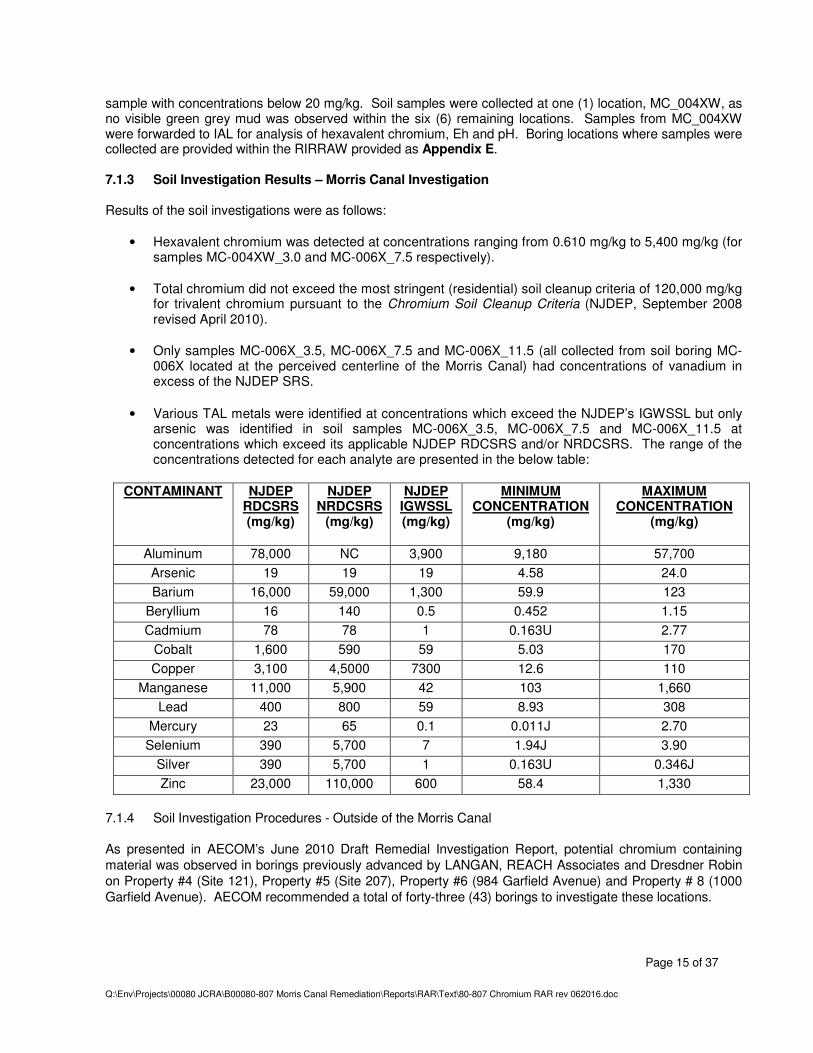
• Hexavalent chromium was detected at concentrations ranging from 0.610 mg/kg to 5,400 mg/kg (for samples MC-004XW_3.0 and MC-006X_7.5 respectively).
• Total chromium did not exceed the most stringent (residential) soil cleanup criteria of 120,000 mg/kg
for trivalent chromium pursuant to the Chromium Soil Cleanup Criteria (NJDEP, September 2008 revised April 2010).
• Only samples MC-006X_3.5, MC-006X_7.5 and MC-006X_11.5 (all collected from soil boring MC-
006X located at the perceived centerline of the Morris Canal) had concentrations of vanadium in excess of the NJDEP SRS.
• Various TAL metals were identified at concentrations which exceed the NJDEP’s IGWSSL but only arsenic was identified in soil samples MC-006X_3.5, MC-006X_7.5 and MC-006X_11.5 at concentrations which exceed its applicable NJDEP RDCSRS and/or NRDCSRS. The range of the concentrations detected for each analyte are presented in the below table:
CONTAMINANT NJDEP RDCSRS (mg/kg)
NJDEP NRDCSRS
(mg/kg)
NJDEP IGWSSL (mg/kg)
MINIMUM CONCENTRATION
(mg/kg)
MAXIMUM CONCENTRATION
(mg/kg)
Aluminum 78,000 NC 3,900 9,180 57,700
Arsenic 19 19 19 4.58 24.0
Barium 16,000 59,000 1,300 59.9 123
Beryllium 16 140 0.5 0.452 1.15
Cadmium 78 78 1 0.163U 2.77
Cobalt 1,600 590 59 5.03 170
Copper 3,100 4,5000 7300 12.6 110
Manganese 11,000 5,900 42 103 1,660
Lead 400 800 59 8.93 308
Mercury 23 65 0.1 0.011J 2.70
Selenium 390 5,700 7 1.94J 3.90
Silver 390 5,700 1 0.163U 0.346J
Zinc 23,000 110,000 600 58.4 1,330
7.1.4 Soil Investigation Procedures - Outside of the Morris Canal As presented in AECOM’s June 2010 Draft Remedial Investigation Report, potential chromium containing material was observed in borings previously advanced by LANGAN, REACH Associates and Dresdner Robin on Property #4 (Site 121), Property #5 (Site 207), Property #6 (984 Garfield Avenue) and Property # 8 (1000 Garfield Avenue). AECOM recommended a total of forty-three (43) borings to investigate these locations.
Dresdner Robin advanced twenty-five (25) of the forty-three (43) recommended borings. The remaining borings were not necessary as these locations were located within the perceived extent of the Morris Canal and had been investigated during the site investigation of the Morris Canal.
Soil borings were advanced a minimum of four (4) feet into native soil. If evidence of contamination existed within the native soils then the boring was extended further to facilitate vertical delineation of contamination. Soil was logged in two (2) foot intervals throughout the extent of the borings. Soil samples were collected from within a discrete six (6) inch interval from within each two (2) foot interval biased towards contamination. At a minimum, one (1) sample per four (4) feet of boring depth were analyzed. The remaining samples were placed on hold for conditional analysis.
At a minimum, one (1) sample per four (4) feet of boring depth was forwarded to IAL for analysis of TAL metals, hexavalent chromium, Eh and/or pH. The remaining samples were placed on hold for conditional analysis. A soil sample summary table, soil boring location figure and soil boring logs are included with the RIRRAW provided as Appendix E. 7.1.5 Soil Investigation Results - Outside of the Morris Canal Results of the soil investigations were as follows:
• Hexavalent chromium was detected at concentrations ranging from 0.829J mg/kg to 2.33 mg/kg (for samples 121-B6 and P6-B1_1.0 respectively).
• Detected concentration of total chromium ranged from 3.02 mg/kg to 26,100 mg/kg (for samples
207_B18_16.5 and 207_B19_1.0 respectively). It should be noted that concentrations of total chromium did not exceed the most stringent (residential) soil cleanup criteria of 120,000 mg/kg for trivalent chromium pursuant to the Chromium Soil Cleanup Criteria (NJDEP, September 2008 revised April 2010).
• Nickel, thallium and vanadium were identified at concentrations which exceed the NJDEP’s
RDCSRS, NRDCSRS and/or IGWSSL; but it should be noted nickel only exceeded the IGWSSL and thallium and vanadium the RDCSRS and/or IGWSSL. The range of the concentrations detected for each analyte are presented in the below table:
CONTAMINANT NJDEP
RDCSRS (mg/kg)
NJDEP NRDCSRS
(mg/kg)
NJDEP IGWSSL (mg/kg)
MINIMUM CONCENTRATION
(mg/kg)
MAXIMUM CONCENTRATION
(mg/kg)
Antimony 31 450 6 0.359J 1.14J
Nickel 1,600 23,000 31 1.24J 56.6
Thallium 5 79 3 0.172J 8.23
Vanadium 78 1,100 NC 10.2 141
• TAL metals, excluding metals attributed to CCPW, were identified throughout the Site at
concentrations which exceed the NJDEP’s RDCSRS, NRDCSRS and/or IGWSSL. The range of the concentrations detected for each analyte are presented in the below table:
7.1.6 Groundwater Investigation Procedures Two (2) rounds [May and June 2011] of low-flow sampling were conducted from existing monitoring wells (MW-3-1, MW-3-2, MW-4-1, MW-5-1, MW-5-2, MW-6-1, MW-7-1, MW-7-2, MW-8-1, MW-9-1, MW-10-1, and MW-12-1) in Berry Lane Park. Monitoring wells were selected based upon their location relative to the Morris Canal, Chromium Sites 121 and 207 and/or the previous piezometer locations MC01-1X and MC01-3X where concentrations of tetrachloroethene (PCE) was identified in excess of the NJDEP’s GWQS or piezometer location MC-015X where dieldrin was identified in excess of the NJDEP’s GWQS. All groundwater samples were analyzed for select TAL metals (total chromium, antimony, nickel, thallium, vanadium) and hexavalent chromium; select locations were additionally analyzed for tetrachloroethene (PCE) [MW-3-2, MW-4-1, MW-5-1, MW-9-1] and/or dieldrin [MW-7-2, MW-8-1, MW-10-1]. 7.1.7 Groundwater Investigation Results The laboratory results for the May and June 2011 sampling events were reviewed and compared with Ground Water Quality Standards (N.J.A.C. 7:9C) (last amended November 4, 2009). As no standard existed for hexavalent chromium, results were compared to the GWQS for total chromium. Review of the groundwater analytical results for total and hexavalent chromium identified concentrations in excess of 70 ug/L in only MW-8-1 and MW-5-2. It should be noted that both of these wells were located within chromium source material placed within the former Morris Canal. Select metals (antimony, nickel, thallium and vanadium), traditionally attributed to impacts associated with CCPW, one or more of these metals were detected within each of the monitoring wells during each of the two (2) sampling events but not at concentrations which exceed the NJDEP’s GWQC. Samples analyzed for tetrachloroethene did not exceed the NJDEP’s GWQC of 1 ug/L and concentrations of dieldrin marginally exceeded the NJDEP’s GWQC of 0.03 ug/L within MW-8-1 during the second sampling event.
Overall groundwater flow direction observed during both the May and June 2011 flows to the South-Southeast. Groundwater sample results for the May 2011 and June 2011 sampling events are presented on Table 4 and Table 5, respectively of the RIRRAW provided in Appendix E. The groundwater analytical results exceeding the NJDEP’s GWQS for the May and June 2011 sampling events are depicted on Figure 11 and Figure 12, respectively of the RIRRAW provided in Appendix E. 7.1.8 Conclusions and Recommendations 7.1.8.1 Soil A total of ninety-seven (97) soil borings were advanced during the site and remedial investigations.
• Hexavalent chromium in excess of 20 mg/kg was vertically and horizontally delineated and was present throughout the former canal. A single isolated hexavalent chromium hotspot was present on Chrome Site 121 (Property #4). No further investigation of hexavalent chromium in soil was warranted. Excavation and offsite disposal of all soil with hexavalent chromium exceeding 20 mg/kg is recommended.
• Total chromium was not identified in excess of 120,000 mg/kg at any location during the site and
remedial investigation therefore no further investigations of total chromium in soil was warranted.
• Thallium - Concentrations of thallium were detected during the remedial investigation in excess of the NJDEP SRS in two (2) samples (207-B5_9.5 and 207-B4_5.5) both locations are delineated through the use of existing soil data.
• Vanadium - Concentrations of vanadium were detected during the remedial investigation in excess of
the NJDEP SRS as follows:
• Chromium Site 121 – one (1) sample (121-B1_4.5); • Chromium Site 207 – four (4) samples (207-B9_1.0, REP050911-2 [collected with 207-
B9_1.0], 207-B18_1.0); and • Morris Canal – four (4) samples (MC-006X_3.5, MC-006X_7.5, MC-006X_11.5, REP051811-
1 [collected with MC-006X_11.5]).
With the exception of the vanadium delineation to the west of soil sample 121_B1_4.5, these locations are delineated through the use of existing soil data.
• Antimony – Concentrations of antimony were not detected during the remedial investigation in excess
of the NJDEP SRS, with the exception of soil samples MC-006X_3.5, MC-006X_7.5 and MC-006X_11.5 which exceed as a result of elevated Minimum Detection Limits (MDLs) due to sample dilution.
• Nickel - Concentrations of nickel were not detected during the remedial investigation in excess of the
NJDEP SRS. It was recommended that further delineation of vanadium at 121-B1_4.5 be conducted to the west. The typical remedial scenario to address contaminants at these concentrations is the installation and implementation of an engineering and institutional control (i.e. cap and deed notice).
• One or more TAL metals, unrelated to CCPW, were detected within each sample collected during the remedial investigation. In light of the extent of investigations that have been undertaken throughout the remainder of the Berry Lane Park properties no further investigations of TAL metals is recommended. It was recommended that these constituents be remediated via the installation and implementation of an engineering and institutional control (i.e.; cap and deed notice).
• To assess the extent of the impacts to Berry Lane Park properties that encompass the former Morris Canal, two (2) rounds of sampling were conducted from select monitoring wells in Berry Lane Park. Hexavalent chromium and total chromium were detected in the groundwater throughout the former Morris Canal at elevated concentrations. Further characterization of the groundwater in the former Morris Canal canal is warranted, however the existing data suggests that concentrations fall below GWQS less than 50 feet of the canal. Taking into account that the likely remedial scenario for soil contamination will include extensive removal of contaminated soils, it is recommended that further characterization of the groundwater in the former Morris Canal (including the installation of monitoring wells) be postponed until after soil remedial actions are performed.
• During the site investigation tetrachloroethene (PCE) was detected at concentrations that marginally
exceed the GWQS in piezometers MC01-1X and MC01-3X. Sample results collected in May and June 2011 from existing monitoring wells MW-5-1, MW-5-2 and MW-3-2 delineate the exceedance to the north and west. However, taking into account that the likely remedial scenario for soil contamination will include extensive removal of contaminated soils, it recommended that further groundwater delineation of PCE be postponed until completion of remedial action at which time permanent monitoring wells will be installed within the previous piezometer locations of MC-01-1X and MC-01-3X.
• During the site investigation dieldrin was detected at a concentration that exceeds the GWQS in
piezometer MC-015X. Sample collected during the May 2011 sampling event were compliant of GWQS but results from existing monitoring well MW-8-1 collected during the June 2011 sampling event marginally exceeded GWQS. Sample results collected in May and June 2011 from existing monitoring wells MW-7-2 and MW-10-1 delineate this exceedance to the south and east. However, taking into account that the likely remedial scenario for soil contamination will include extensive removal of contaminated soils, it recommended that further groundwater delineation be postponed until completion of remedial action at which time permanent monitoring wells will be installed within the previous piezometer locations of MC-015X.
7.2 Remedial Action Workplan Summary The RAW was submitted in February 2012 and was approved on February 10, 2012. It outlined five (5) principal components as follows:
• Delineation of Vanadium on Chrome Site 121; • Pre-Remediation Activities; • Remediation Activities; • Reuse of soil impacted with historic fill constituents, and • Engineering Control and Implementation of a Site wide Deed Notice to address reused soils.
A detailed description of each component of the remedial action is provided below. 7.2.1 Delineation of Vanadium on Chrome Site 121 Concentrations of vanadium identified in soil sample 121_B1_4.5 (located within Chrome Site 121) were proposed to be delineated to the west. It was proposed that this exceedance would be remediated via the installation and implementation of an engineering and institutional control (i.e. cap and deed notice).
7.2.2 Pre-Remediation Activities 7.2.2.1 Excavation Survey The horizontal limits of the proposed excavation area would be surveyed by a New Jersey licensed surveyor prior to the collection of in-situ waste classification samples and ultimately the excavation of contaminated soil. 7.2.2.2 In-Situ Waste Classification In-situ waste classification samples would be collected in order to facilitate direct load out of contaminated soil for transportation to the offsite disposal facility. Composite and/or discrete samples would be collected at a frequency which satisfies the requirements of the offsite disposal facility. 7.2.2.3 Monitoring Well Decommissioning Prior to soil remediation, existing groundwater monitoring wells located within or closely adjacent to the proposed excavation area would be abandoned in accordance with NJDEP TRSR by a New Jersey licensed well driller. 7.2.2.4 Permit Requirements/Approvals The JCRA and/or its subcontractors would obtain the required local, state and federal permits associated with the tasks described within this RAW. 7.2.2.5 Utility Clearance Prior to the start of any intrusive activities at the Site, a sub-surface utility clearance would be performed. 7.3.1 Remediation Activities 7.3.1.1 Dewatering Dewatering would be required during the excavation of contaminated soils which may accumulate in the excavation during the course of work. Water generated from dewatering was proposed to be: 1) treated by an onsite system to meet parameters established by the receiving authority and then discharged to the municipal combined sewer at a location agreed upon by the Jersey City Municipal Utility Authority (JCMUA), and/or 2) stored onsite in appropriate containers and transported offsite for disposal. 7.3.1.2 Excavation of Contaminated Soil An estimated 25,000 cubic yards of soil with hexavalent chromium exceeding 20 mg/kg was proposed to be excavated for offsite disposal. It should be noted that the estimated volume did not include overburden which was estimated at 8,500 cubic yards. The excavation would horizontally and vertically extend to compliant soil sample locations from previous investigations and from the northern property line of Block 1948 Lot 21D and the southern property line of Block 1948 Lot 4B. If during remediation visible CCPW was encountered above, below, or extending laterally further than anticipated, this material would be excavated and disposed as part of the remediation. Contaminated soil would be transported to an offsite disposal facility. 7.3.1.3 Soil Stockpiles If necessary, the excavated soil would be temporarily stockpiled on contaminated soil areas and covered to control dust and odors. Wet soils may be stabilized by combining contaminated dry soils.
7.3.1.4 Post Excavation Sampling The primary form of CCPW waste identified during the Site and Remedial Investigations was “green grey mud”, which was clearly visible in the field. As the extent of the hexavalent chromium was proposed to be excavated, the excavation would be visually inspected for signs of CCPW, subsequently a variance was requested relative to post excavation sample frequency. In lieu of post excavation samples, existing delineation samples would be used to demonstrate remediation had been completed. If during excavation activities, visible impacts were observed within the sidewalls or base of the excavation a soil sample may be collected and forwarded to a New Jersey certified environmental testing laboratory for analysis of total and hexavalent chromium and CCPW metals. If compliant this sample will serve as a post excavation sample. 7.3.1.5 Equipment Decontamination Prior to leaving the Site, all equipment, tools and vehicles that have come in contact with contaminated soil would be decontaminated to ensure that it is free of excess soil or contaminated fluids. 7.3.1.6 Soil Erosion and Sediment Control A soil erosion and sediment control plan would be prepared and submitted to the Soil Conservation District for approval. 7.3.1.7 Emissions Control A program to manage odor, dust emissions would be maintained during the soil excavation program and a detailed Perimeter Air Monitoring Plan, would be submitted to the NJDEP for approval prior to the commencement of remedial activities. 7.4.1 Proposed Reuse of Soil Impacted with Historic Fill Constituents It was recommended that overburden associated with the hexavalent chromium excavation, historic fill and/or concrete generated elsewhere within Berry Lane Park during site development, would be reused to backfill the excavation as well as to achieve project design elevations throughout the extent of Berry Lane Park.
8.0 REMEDIAL ACTION REPORT – SOIL 8.1 Description of Remedial Actions As presented within the RAW summary in Section 7.2 the proposed remedial action for the Site was comprised of five (5) principal components as follows:
• Delineation of Vanadium on Chrome Site 121; • Pre-Remediation Activities; • Remediation Activities; • Reuse of soil impacted with historic fill constituents; and • Engineering Control and Implementation of a Site wide Deed Notice to address reused soils.
A detailed discussion for each component of the remedial action is provided below. 8.2 Additional Delineation of CCPW Chromium Sites 121 and 207 Concentrations of vanadium were detected above the NJDEP RDCSRS on Chromium Site 121. It should be noted that in addition to vanadium, thallium concentrations were also identified at concentrations in excess of the NJDEP’s RDCSRS on Chromium Site 207 subsequently this location was concurrently delineated. 8.2.1 Sampling Procedures On July 18, 2012, under the oversight of Dresdner Robin, EMC, Inc. of Randolph, New Jersey advanced a total of eight (8) soil borings to delineate the extent of these exceedances. Probing was conducted using direct-push methods with a dual tube setup. The dual tube setup used two sets of probe rods to collect continuous soil cores. One set of drill rods was driven into the ground as an outer casing. These rods received the driving force from the hammer and provided a sealed hole from which soil samples could be recovered without the threat of cross contamination. The second, smaller set of rods was placed inside the outer casing. The smaller rods held a sample liner in place as the outer casing was driven the length of sampling interval. The small rods were then retracted to retrieve the filled liner. The macro-cores were collected continuously from the ground surface throughout the depth of the boring for visual inspection, geologic characterization, and the collection of samples. Rods were properly decontaminated between each boring. Samples were collected and forwarded to IAL for analysis of vanadium or thallium. 8.2.1.1 Vanadium Four (4) soil borings (121-B1-1 through 121-B1-4) were advanced to delineate the vanadium exceedance at soil boring 121-B1. Samples were collected at 4.5/5.0 and 8.0/8.5 feet below ground surface (ft bgs) which coincides with the depth of the previous exceedance as well as at a deeper sample to provide vertical delineation, if needed. Borings were advanced to ten (10) ft bgs. Samples were triggered for laboratory analysis as needed to complete the delineation. In total four (4) samples [121-B1-1-4.5-5.0, 121-B1-3-4.5-5.0, 121-B1-3-8.0-8.5, 121-B1-4-4.5-5.0] were analyzed for vanadium. Review of the analytical results for sample 121-B1-3-4.5-5.0 revealed vanadium was detected at 81.7 ppm, slightly above the NJDEP’s RDCSRS of 78 parts per million (ppm), therefore additional horizontal and vertical delineation was required at this location. The vertical sample at this location (121-B1-3-8.0-8.5) was triggered for analysis as well as the next step out sample to the south (121-B1-4-4.5-5.0). Results did not exceed the RDCSRS and/or NRDCSRS subsequently delineation was complete. A Sampling Summary is provided on Table 1, soil sample results are presented on Table 2 and soil boring locations and results for vanadium are presented on Figure 3.
8.2.1.2 Thallium Four (4) soil borings (207-B4-1, 207-B4-2, 207-B5-1 and 207-B5-2) were advanced to delineate the thallium exceedances at soil borings 207-B4 and 207-B5. Samples were collected at 5.5/6.0 ft bgs at soil borings 207-B4-1 and 207-B4-2 and 5.5/6.0 and 9.5/10 ft bgs at 207-B5-1 and 207-B5-2. Samples were triggered for laboratory analysis as needed to complete the delineation. In total two (2) samples [207-B5-1-9.5-10.0, 207-B4-1-5.5-6.0] were analyzed for thallium. Review of the thallium sample results revealed that there were no concentrations detected above the NJDEP’s RDCSRS of 5 ppm in either of the two samples collected. A Sampling Summary is provided on Table 1, soil sample results are presented on Table 3 and soil boring locations and results for thallium are presented on Figure 4. Boring logs are included as Appendix F. The results of the soil investigation determined that vanadium and thallium concentrations in excess of the NJDEP RDCSRS were limited to within the park boundaries. 8.3 Pre-Remediation Activities 8.3.1 Excavation Survey Prior to excavation activities, the horizontal limits of the proposed excavation area were surveyed by a Louis J. Weber Surveying & Associates, Inc. (Weber) of Sparta, New Jersey, a New Jersey Licensed Land Surveyor. Throughout the excavation activities vertical control of the remedial excavation was determined by CEI personnel using a laser level fixed by Weber at a known elevation. Using the laser, CEI personnel could compare the bottom elevation of the excavation with the bottom elevation of the remedial excavation as presented within the NJDEP approved RAW. Once it was determined that the excavation had met design depth, Weber would perform a survey of the base of the excavation and confirm design depths were met. 8.3.2 In-Situ Waste Classification The RAW stipulated that in-situ waste classification samples would be collected in order to facilitate direct load out of contaminated soil for transportation to an offsite disposal facility. In lieu of waste classification samples, soil and groundwater data generated as part of the site and remedial investigation were supplied to the disposal facility, Environmental Quality Company (EQ), for their review. EQ reviewed the dataset and provided four (4) Generator Approval Notifications. Two (2) for their EQ Detroit, Inc. (MID980991566) facility located at 1923 Frederick, Detroit, Michigan 48211 and two (2) for their Michigan Disposal Waste Treatment Plant (MID000724831) located at 49350 North I-94 Service Drive, Belleville, Michigan 48111. Each approval acknowledged their acceptance of the material and confirmed that their facility has appropriate permits provided by the federal and state regulatory agencies to properly transport, treat, and/or dispose of the waste material. The Approval Notifications are provided as Appendix G. 8.3.3 Monitoring Well Decommissioning Prior to soil remediation, groundwater monitoring wells MW-3-1, MW-3-2, MW-4-1, MW-5-1, MW-5-2, MW-6-1, MW-7-1, MW-8-1 were abandoned in accordance with NJDEP TRSR by Well Done of Budd Lake, New Jersey, a New Jersey licensed well driller. Well abandonment documentation is provided as Appendix H.
8.3.4 Permit Requirements/Approvals The JCRA and/or its subcontractor CEI obtained the required local, state and federal permits associated with the tasks described within this RAW. The following regional, state and municipal permits or notifications were obtained: Soil Erosion and Sediment Control (SESC) Plan Certification by Hudson-Essex-Passaic Soil Conservation District (HEPSCD); NJDEP approval of RAW; Municipal approvals by City of Jersey City including Road Opening Permit, Sidewalk Opening Permit, and Security Fence Permit; and Authorization from the City of Jersey Construction Official for construction trailers and associated utility hookups, and temporary mobile structures to support excavation work. 8.3.5 Utility Clearance Prior to the start of any intrusive activities at the Site, CEI conducted a utility mark out by contacting the New Jersey One Call at least 72 hours prior to conducting any intrusive activities. Marking paint, flags and/or stakes were used to clearly display the sub-surface utilities and structures. Existing utilities which required abandonment or re-location were addressed prior to any intrusive work. 8.4 Remediation Activities 8.4.1 Excavation of Contaminated Soil 8.4.1.1 Steel Sheeting The remedial excavation area was divided into four (4) equal parts with the use of interlocking steel sheeting which were installed around the perimeter of each cell. The cells were labeled 1 through 4 with Cell 1 on the most southern end and cell 4 on the most northern end of the former canal within the park boundaries. The sequencing of the cell installation was Cell 2, 3, 4 then 1 (with cell number IDs running numerically south to north). Interlocking steel sheeting was installed in accordance with a New Jersey Professional Engineer’s design which called for the sheeting to be driven to 42 feet below ground surface. The interlocks in the sheeting were sealed along the sides and the intermediate partitions to minimize the volume of water entering the cell from the sidewalls. The most northern and southern portions of the excavation limits (in Cells 4 and 1, respectively) called for sheeting to be installed and left in place. This sheeting had the common interlock seal welded and the driven interlock filled with sealant to create a waterproof wall. In addition, the northern and southern end walls extended 10 feet in the east and west direction beyond the proposed excavation width. The south end wall was designed taking into account the embankment from the railroad as well as railroad loading. Vibration monitoring was conducted prior to the start of sheeting installation and maintained during sheeting installation and removal to prevent damage to surrounding properties. Prior to sheeting installation a trench (referred to as a “pre-trench”) was excavated along the boundary of the proposed excavation in order to identify any subsurface obstructions (i.e.; concrete slabs) which would limit installation of the sheeting. The trench was excavated to approximately five (5) feet bgs. Excavated soils were visually screened for CCPW and returned back to the excavation in kind. Prior to removal exposed sheeting was pressure washed. Water generated during the decontamination was pumped into onsite vessels pending treatment. 8.4.1.2 Overburden Removal Once the sheeting was installed, the excavation of a cell began with the removal of the historic fill overburden material. This material was excavated with a hydraulic excavator and loaded into a truck that hauled it out of the cell to a designated stockpile area. Throughout the removal process a Dresdner Robin representative observed the process to confirm the excavation did not vertically extend into underlying CCPW. An estimated volume of 8,500 CYs of overburden was removed and stockpiled.
8.4.1.3 Source Removal Upon completion of the removal of the overburden soil, the excavation was horizontally and vertically extended to design depths. Two (2) excavators were utilized during this process. The first excavator was located within the cell and operated on top of the contaminated soil. It was primarily used to amend, stockpile and load-out soil. A second long arm excavator, equipped with a smooth blade grading bucket, excavated from the outside of the sheet line. This excavator would place excavated soil in reach of the first excavator for soil stockpiling, amendment and load-out. Excavation of each of the cells started along the southern sheet line and was performed in approximately twenty-five (25) foot long sections. Upon completion of a section, a berm (constructed with historic fill) was placed in the base of the excavation running east to west. It acted as a water stop to prevent contaminated liquids from entering into the freshly excavated area. An internal sump was installed at the deepest point in the section. Water generated as part of the dewatering process is further discussed in Section 8.4.3. Material designated for offsite disposal was transferred into trucks supplied by PPG Management who was responsible to coordinate the proper transportation and disposal of the material. WTS, Inc. was the Logistics Manager for the transport and disposal of 1,875 loads of solid waste generated from the remedial excavation program. WTS has provided certification that the process was completed in accordance with USEPA 40CFR Part 260 and NJDEP N.J.A.C. 7:26G-1 requirements. The transport and disposal utilized the United States Manifest System (40CFR Part 262 Part B) for the tracking of the waste. A certification by WTS regarding compliance with USEPA and NJDEP requirements is included with copies of the manifest documents as Appendix I. WTS records indicate that an estimated 47,898.5 tons of contaminated soil was transported for offsite disposal during the remediation of the former Morris Canal. Additional certification has been provided by the disposal facility US Ecology (EQ) of Livonia, Michigan which documents the receipt of the soils transported from Berry Lane Park. EQ’s certification is also provided within Appendix I. Figure 5 presents the bottom elevations of the final excavation which are based upon the As Built Bottom of Excavation Surfaces, Berry Lane Park, Jersey City, New Jersey provided by Louis J. Weber & Associates, Inc. As approved in the RAW existing in-situ delineation samples served as post-excavation samples but as a pre-cautionary measure confirmatory samples were collected and analyzed for hexavalent chromium, Eh and pH. Results of these samples are provided on Table 4 and presented on Figure 6. 8.4.2 Stockpiling, Amendment of CCPW Soil and Soil Load Out Excavated soils from within the cells were managed within the cells until loadout. Stockpiles of soil pending load-out or amendment were created on top of unexcavated areas and an excavator working within the cell would manage these soils. It was PPG’s experience that Green Grey Mud (GGM) had a tendency to hold moisture and although it may appear dry and suitable for shipment, during offsite transportation it could release free liquids which could leak from the trucks or railcars. Subsequently in order to minimize this from occurring, excavated material was amended prior to exportation from the Site. The three (3) primary amending agents utilized were:
The amendment process was conducted within the cell. It generally consisted of the introduction of the amendment agent and thorough mixing of the agent through the stockpile. The amount of amending agent and timeframe of mixing was dependent upon the moisture content of the soil and weather conditions. Once it
was determined by CEI that the soil had been sufficiently amended, several discrete samples were collected and a “shaker” test was performed. The “shaker” test was an informal way of mimicking the conditions experienced during transport in order to further evaluate the likelihood of free liquids being liberated. The process was conducted by placing the samples in a sealed paint can and shaking them with a commercial paint mixer/shaker for a minimum of three (3) minutes at which point they were evaluated. If the soil appeared wet or spread out in the base of the can, additional amendment was recommended. Approved soil was stockpiled separately and covered with polyethylene sheeting pending load out. Soil load out occurred along the sheet line where a plastic lined load out area was prepared. Prior to loading of soil into hauling trucks, liners were installed within the truck beds. These liners were installed once the truck entered the Site via the Berry Lane Road entrance. Liners were inspected prior to installation, upon completion of soil loading, and prior to the truck exiting the Site. Following liner installation, the haul trucks would proceed to the loading area along the sheet line. Trucks were loaded on a polyethylene lined area via an excavator situated within the cell. Soil which did not land in the truck bed but on the surrounding plastic were returned to the cell and the load out area was inspected for visual CCPW. Trucks were decontaminated following completion of loading and the liner was closed to limit fugitive soil from escaping from the truck bed during travel. Once the trucks left the decontamination area they would travel to the Site exit point on Berry Road where they would be tarped and then pass through a tire wash to remove any residual dirt and/or debris from truck tires prior to exiting the Site. These measures reduced the potential for tracking soil onto public roadways and were located in the same general area designated for the tracking pad on the soil erosion and sediment control plan. 8.4.3 Dewatering Water generated within the remedial excavation was pumped, using internal pumps, to one of two onsite 20,000-gallon holding tanks pending transport to 900 Garfield Avenue where it was treated with an onsite treatment system. Approximately 1,228,000 gallons of water was recovered and transported for treatment at 900 Garfield Avenue under the existing permits or for offsite disposal. Bill of Laden and disposal manifests documenting the transport of the material is provided at Appendix J. Consistent with the disposal of soils discussed in Section 8.4.1.3, WTS, Inc. was the Logistics Manager for the transport and disposal of thirty-three loads or 169,003 gallons of aqueous waste generated from the remedial excavation program. WTS has provided certification that the process was completed in accordance with USEPA 40CFR Part 260 and NJDEP N.J.A.C. 7:26G-1 requirements. The transport and disposal utilized the United States Manifest System (40CFR Part 262 Part B) for the tracking of the waste. A certification by WTS regarding compliance with USEPA and NJDEP requirements is included with copies of the manifest documents as Appendix J. Additional certification has been provided by the disposal facility US Ecology (EQ) of Livonia, Michigan which documents the receipt of the aqueous waste transported from Berry Lane Park. EQ’s certification is also provided within Appendix J. 8.5 Bedding Samples A granular material (aka "bedding material") was encountered at approximately three (3) to eight (8) feet bgs in the northeastern corner of Cell No. 2. It was described as “cemented” with a green/yellow precipitate observed on the surface of the material where it interfaced with the chromium impacted groundwater from within the canal. Laboratory results from one (1) of two (2) samples collected from the material reported concentrations of hexavalent chromium in excess of 20 mg/kg. It should be noted that the sample with the highest concentration was collected from material that exhibited the green/yellow precipitate. Review of historic maps indicated the presence of a tow path and rail road tracks within the area where the material was encountered. Rail road ties and lines were also encountered during pre-trenching and soil removal.
It was determined that removal of the impacted bedding material within the canal was necessary and given the “wicking” of contamination from the chromium impacted groundwater that in order to assure removal was complete samples would be collected vertically at a frequency of one (1) for every foot of bedding material and laterally at a frequency of one (1) every ten linear feet of bedding material and analyzed for hexavalent chromium. A memorandum documenting the above procedure was supplied to the NJDEP technical consultant prior to implementation. It should be noted that bedding material was encountered along the eastern sidewall of the Cells 1, 2, 3 and very limited within the most southern portion of Cell 4. The bedding material was not identified outside the limits of the cofferdam. The exact volume of bedding material removed is not known as it was immediately co-mingled with the remainder of the CCPW soil pending disposal. Soil sample results are provided on Table 5 and Figure 6. Please note that the bedding soil samples on Figure 6 are presented on insets due to the overall scale of the excavation and close relation of each sample to one another. 8.6 Removals Conducted Outside the Cells “Hot spot” removals were performed in cases where: 1) visual GGM was observed outside the proposed excavation, or 2) previous soil data indicated an exceedance. Excavated soil was placed within the contaminated cell (currently under excavation) for amendment and offsite disposal. 8.6.1 Chromium Site 121 “Hot Spot” Removal On February 20, 2013, CEI preformed a limited excavation in order to remove a previous exceedance of hexavalent chromium identified in soil sample P4-SB4(3.0-4.0) collected as part of the site investigation and later delineated during the remedial investigation by soil samples SB-121-B9 through SB-121-B12. The soil boring logs are provided in Appendix F. The proposed excavation was marked out in the field by Weber using New Jersey State Plane Coordinates obtained during the remedial investigation. Approximately 30 tons of excavated soil was placed within Cell No. 1, which was at the time under remediation. The excavation was approximately 10 feet wide by 10 feet long by 5 feet deep. The soil was than included within the amendment process and disposed with the other chromium impacted soil. Delineation samples served as sidewall post excavation samples. One (1) soil sample (121-BOTTOM) was collected from the base of the excavation at 5.0/5.5 ft bgs to document vertical compliance. The sample was forwarded to IAL for analysis of hexavalent chromium, Eh and pH. Results were complaint of non-residential chromium soil cleanup criteria of 20 mg/kg. Results are summarized on Table 6 and presented on Figure 7. As the material was co-mingled with the material generated from within the cells, the disposal documentation is provided collectively in Appendix I. 8.6.2 Western Edge of Cell No. 3 On August 22, 2012, during pre-trenching of the western sheet line of Cell No. 3, a thin ribbon of GGM was observed at approximately 4.0/5.0 feet bgs. The location was surveyed by Weber so that it could be revisited and remediated in the future. On November 20, 2012 and December 4, 2012, the location was located by Weber and CEI performed a “hot spot” soil removal. A limited excavation was advanced which measured approximately sixteen (16) feet long by eight (8) feet in wide and five (5) feet deep. The excavation was vertically extended to five (5) feet bgs. Approximately 38 tons of soil was excavated and placed within Cell No. 4, which was at the time under remediation. Post excavation sidewall soil samples (C3-N_4.5A, C3-S_4.5, C3-E_4.5, C3-W_4.5) were collected six inches from the base of the excavation (at 4.5/5.0 feet bgs) and one (1) bottom sample (C3-B_5.0) was collected (at 5.0/5.5 feet bgs). Results are summarized on Table 7 and the limits of the excavation and soil sample locations are presented on Figure 7. As the material was co-mingled with the material generated from within the cells, the disposal documentation is provided collectively in Appendix I.
8.7 Decontamination Prior to leaving the Site, equipment, tools and vehicles that had come in contact with contaminated soil was decontaminated to ensure that it is free of excess soil or contaminated fluids. Decontamination procedures included physical removal of packed soil and grit, pressure washer wash-down, scrubbing with water/mild soap solutions, and any other decontamination procedure necessary to prevent tracking or un-manifested conveyance of contaminated material from the Site. Vehicles and equipment was air dried prior to leaving the Site. Decontamination was performed on a temporary containment pad(s) designed and constructed to collect all runoff from the decontamination procedure. The decontamination pad was removed and disposed with the CCPW soil waste stream. Decontamination liquids were collected and disposed of in the same waste stream of the water recovered from the remedial excavation. 8.8 Emissions Control A detailed Site Specific Air Monitoring Plan (AMP) was submitted to the NJDEP for approval prior to the commencement of remedial activities. The plan included sampling and analysis for 8 hour integrated hexavalent chromium (Cr6) and total dust, as well as real time continuous monitoring for PM10 at nine (9) Air Monitoring Stations (AMS) (5 at the Site perimeter and 4 at the perimeter of the exclusion zone). In addition to the air monitoring conducted in accordance with the AMP, 24 hour Cr6 sampling with lab analysis was also conducted at two (2) fenceline stations. This program was designed to measure various aspects of air quality at the Site to ensure that remedial activities at the Site did not have an adverse effect on Site workers and the surrounding community. The AMP was reviewed by the Independent Technical Consultant appointed by the Court and comments provided to Dresdner Robin. Dresdner Robin provided comment and these comments were approved on May 11, 2012. Appendix K includes the AMP and NJDEP response to Dresdner Robin’s comments. Emilcott Associates of Morristown, New Jersey was contracted by the JCRA to implement the Site Specific AMP. Air sampling and monitoring was conducted between July 23, 2012 and February 26, 2013. Results indicate that the air sampling and monitoring program at Berry Lane Park, Sites 121 and 207, showed average Cr6 concentrations for each fenceline and exclusion zone AMS were well below the AAC of 49 ng/m3. The program shows the Cr6 concentrations, percent Cr6 in dust samples, and the short duration metrics demonstrate that the dust control measures were effective at maintaining concentrations of Cr6 in dust at the Site well below the AAC. These results indicate that dust generated at the Site contained very small percentages of Cr6 and did not generate an emission source of Cr6 sufficient to create potential offsite exposure to Cr6 at or exceeding the AAC. Emilcott’s Final Air Monitoring Report is provided as Appendix L. 8.9 Soil Reuse In accordance with the approved RAW, overburden soil generated from within the former Morris Canal excavation and historic fill material generated during site development elsewhere within Berry Lane Park were reused to backfill the excavation. Consistent with the depth historic fill was recorded during site and remedial investigations, historic fill soil was not placed below elevation 5.5. Please note that the reuse of Historic fill within the excavation meets the requirements as presented within Section 5.3 Exceptions for Historic Fill at SRP Redevelopment Sites of the NJDEP’s Fill Material Guidance for SRP Sites, dated April 2015 subsequently it is not considered an alternative fill material. The material will be remediated by the property owner via the implementation of an engineering and institutional control which will be presented within a future RAR prepared for AOC-4: Historic Fill.
8.10 Health and Safety Plan A site-specific Health and Safety Plan (HASP) was prepared by each of the major contractors (CEI, Dresdner Robin, EMILCOTT) for their employees. The HASPs set forth a detailed health and safety requirements necessary to protect nearby residents and workers involved in the remedial activities at the Site. 8.11 Deviation from the NJDEP Approved Remedial Action Workplan The NJDEP approved RAW proposed that CCPW related metals (nickel, vanadium and thallium) remain within Chromium Sites 121 and 207 at concentrations above the RDCSRS and/or NRDCRS and would be remediated via the implementation of an engineering and institutional control (i.e.; cap and deed notice) which would consist of a minimum of 24 inches of certified clean fill placed over a geotextile fabric. The concentrations of these contaminants within these two (2) sites were later evaluated in accordance with the NJDEP September 2012 Technical Guidance for the Attainment of Remediation Standards and Site-Specific Criteria, Version 1.0. Based on compliance averaging, and supported by groundwater sampling results, nickel, thallium, and vanadium contamination in soil on Chromium Sites 121 and 207 was determined not to be at levels which require soil containment or other remedial action, subsequently implementation of an engineering and institutional control was judged not warranted. The memorandum prepared by PPG’s technical consultant, AECOM, and entitled PPG Sites 121 and 207 (Berry Lane Park), Compliance Averaging Analysis - CCPW Impacts in Site Soils is provided as Appendix M.
It should be noted that an engineering control has been implemented at Chromium Sites 121 and 207 to address soil contamination associated with Historic Fill. Ongoing maintenance and monitoring associated with the engineering control is the responsibility of the property owner.
8.12 Site Restoration
The exact amount of certified clean fill used to backfill the excavation is not known but computer generated estimates calculate approximately 29,700 CYs (44,550 tons). The backfill was compacted in six inch lifts. Certified clean fill (referred to as Common Fill) was obtained from placed from the base of the excavation to elevation 5.5, in-situ backfill (i.e.: historic fill reuse soil) was placed from elevation 5.50 to 10.5 and imported clean fill (3/4 crushed stone) was placed from 10.50 to grade (which varied from 13.33 to 13.50). Certified clean fill met the requirements as set forth in the NJDEP’s Alternative and Clean Fill Guidance, dated 12/29/2011, version 2.0.
Sample frequency for the Common Fill was performed in accordance with the default frequency provided in Table 2 of the guidance. Samples were analyzed for Extractable Petroleum Hydrocarbons (EPH), Target Compound List, Target Analyte List plus Thirty (TCL/TAL+30). Upon receipt of the results they were compared to the NJDEP’s June 2008 (last amended May 7, 2012) Soil Remediation Standards (SRS). With the exception of one (1) sample, identified as CF-39, the soil was compliant of the NJDEP’s SRS. Concentrations of total lead were identified in sample CF-39 exceeding the NJDEP’s IGWSSL of 59 mg/kg. The sample was further analyzed in accordance with the NJDEP’s Guidance for the use of the Synthetic Precipitation Leaching Procedure to Develop Site Specific Impact to Ground Remediation Standards, dated June 2, 2008. Result of this analysis generated a Site Specific Impact to Ground Water Soil Remediation Standard (SSIGWSRS) of 90.6 mg/kg. This standard was solely applied to the Common Fill material. The NJDEP’s Alternative or New Remediation Standard and/or Screening Level Application Form is provided as Attachment F.
¾ inch crushed stone was imported from a virgin quarried source subsequently the material qualified for Section 6.3 - Clean Fill Testing Exceptions of the NJDEP’s Alternative and Clean Fill Guidance, dated 12/29/2011, version 2.0.
Please note that as it could not be determined which loads of certified clean fill were placed within the remedial excavation verse placed elsewhere within the park for construction of the remedial cap, the
complete inventory of shipping manifests for both common fill and ¾ inch crushed stone has been provided for completeness. Clean fill manifests and laboratory data supporting its compliance with the NJDEP’s Alternative and Clean Fill Guidance, dated 12/29/2011, version 2.0. are included as Appendix N.
8.13 Applicable Remediation Standards
The soil remediation standards that were applied to the remediation were the NJDEP’s June 2008 (last amended May 7, 2012) Soil Remediation Standards (SRS) consisting of the Residential Direct Contact Soil Remediation Standard (RDCSRS), Non-Residential Direct Contact Soil Remediation Standard (NRDCSRS), the default Impact to Groundwater Soil Screening Levels (IGWSSL) and the Site Specific Impact to Ground Water Soil Remediation Standard (SSIGWSRS) for total of lead. Pursuant to the Chromium Soil Cleanup Criteria (NJDEP, September 2008 revised April 2010) the most stringent (non-residential) chromium soil cleanup criteria of 20 mg/kg for hexavalent chromium was used.
8.14 Remedial Action Cost
The cost of the remedial action was approximately $16,000,000 to $18,000,000.
Quality Assurance/Quality Control sampling was performed to provide control over the collection of samples and the validity of analytical data. The sample analyses were performed in accordance with full laboratory data deliverables as needed. Analytical methods and quality assurance conform to the NJDEP’s Field Sampling Procedures Manual revised April 11, 2011. 9.1 Field Blanks Field blanks were collected by pouring demonstrated analyte free water through the sampling device (i.e., acetate sleeve for soil and teflon bailer for groundwater) so that the rinsate flowed directly into the empty sample containers. The demonstrated analyte free water originated from one common source and physical location within the laboratory and was the same as the method blank water used by the laboratory performing the analysis. The field blanks were analyzed for the same parameters as samples collected that particular day. The field blanks were maintained at 4
oC while on-site and during shipment.
9.2 Duplicate Samples Duplicate samples were collected to evaluate the laboratory’s performance by comparing analytical results of two (2) samples from the same location. The duplicate samples were analyzed for the same parameters as the samples analyzed that day. 9.3 Sampling Methods Soil samples were collected utilizing disposable plastic trowels. 9.4 Sample Storage, Handling and Preservation The sample containers were labeled with sample number, date, time of collection, analytical parameters, preservatives, site name and person or persons performing the sampling. The laboratory performing the analysis was responsible for preserving the sampling bottles prior to shipment into the field. Samples were kept cool at 4
oC and transported in coolers to the laboratory. Proper chain-of-custody documentation was
maintained, beginning with the laboratory’s release of the bottles. 9.5 Decontamination Procedures Since samples were collected utilizing a disposable sampling device (i.e., plastic trowel/scoop), no decontamination procedures were required. Plastic trowel/scoop was disposed with the CCPW waste stream. 9.6 Containers and Chain-of-Custody Procedures Clean sample containers were supplied by the laboratory for the sampling event(s). The appropriate preservatives were added to the sample bottles by the laboratory prior to shipment. The chain-of-custody accompanies the bottles during transportation from the laboratory to the field, sample collection, transportation back to the laboratory, analysis and final disposal of the sample. The chain-of-custody listed each of the individual sample containers and was signed by one of the sampling team members. Samples were stored on ice at 4
oC in a secure area until they are relinquished to an IAL courier for delivery to the laboratory.
9.7 Laboratory Data Deliverable Format In accordance with Appendix A of the NJDEP Technical Requirements for Site Remediation dated November 2009 last amended May 7, 2012, full laboratory data deliverables have been included for hexavalent chromium, pH and Eh. Reduced laboratory data deliverables have been included for all other analyses. Laboratory data packages are included as Appendix O and Electronic Data Deliverables are included as Appendix P.
9.8 Data Validation Validation of laboratory deliverables was performed by Environmental Quality Assurance, Inc. of Middletown, New York in accordance with appropriate NJDEP and EPA protocols. The data validation reports are included as Appendix Q.
10.0 UPDATED RECEPTOR EVALUATION Results of the Initial Receptor Evaluation did not identify sensitive receptors which warranted further investigation and/or mitigation. Re-evaluation of the Initial Receptor Evaluation did not identify new or unknown sensitive receptors which warranted investigation. The Updated Receptor Evaluation Form is included as Attachment C.
11.0 TECHNICAL OVERVIEW 11.1 Data Quality Assessment The field and laboratory data collected pursuant to the NJDEP-Approved RAW were reviewed for conformance with the NJDEP’s Technical Requirements for Site Remediation, N.J.A.C. 7:26E and the NJDEP’s Field Sampling Procedures Manual (August 2005). During the review process, field sampling documentation, Chain-of-Custody Forms, analytical methodology, detection limits, the results of field quality control samples, and laboratory QA documentation were reviewed to assess the overall reliability of the field and analytical data. As previous discussed validation of laboratory deliverables was performed by Environmental Quality Assurance, Inc. (EQA) of Middletown, New York in accordance with appropriate NJDEP and EPA protocols. Upon EQA’s review data several samples required qualification or were rejected but deemed usable. 11.2 Usability of Laboratory Analytical Data Data validation identified instances when soil sample results required qualification as the samples exhibited reducing characteristics which made them unlikely to support the presence of hexavalent chromium. This characteristic contributed to low spike recovery. The data was qualified or rejected but was judged to be usable as: 1) the samples were not required per the NJDEP approved Remedial Action Workplan but were collected as a precautionary measure and are presented for completeness not a regulatory requirement, and 2) the soil samples exhibited reducing matrices, based on the ORP characteristics, and were judged not to support the presence of hexavalent chromium (demonstrated via the low spike recoveries). It should be noted that soil samples C1-S260-2.0-3.0; C1-S270-3.0-4.0; and C1-S280-2.0-3.0 were rejected as the soil samples demonstrated oxidizing matrices but are presented for completeness. It should be noted that additional soil samples were collected within approximately ten feet to the north and south of these samples which fulfill the NJDEP’s post excavation soil sampling requirements of one (1) sample every 900 square feet.
12.0 DEVIATION AND VARIATIONS FROM THE TECHNICAL REGULATIONS/GUIDANCE There were no deviations or variations from the Technical Regulations/Guidance. The remedial action was performed in accordance with the NJDEP approved Remedial Action Workplan with the exception of the implementation of engineering and institutional control to address the nickel, thallium and vanadium exceedances on Chromium Sites 121 and 207. As presented in Section 8.11 based on compliance averaging, and supported by groundwater sampling results, nickel, thallium, and vanadium contamination in soil on Chromium Sites 121 and 207 was determined not to be at levels which require soil containment or other remedial action; subsequently, implementation of an engineering and institutional control was judged not warranted, but as previously mentioned, an engineering control has been implemented to remediate Historic Fill within Chromium Sites 121 and 207.
13.0 CONCLUSIONS AND RECOMMENDATIONS AOC-1: Former Morris Canal The remedial actions to address soil contamination associated with historically deposited CCPW waste within the former Morris Canal has been implemented; no further actions are warranted related to soils for this AOC. AOC-2: Chromium Site 121 and AOC-3: Chromium 207 Concentrations of vanadium and thallium were delineated within the Site. These contaminants were later evaluated in accordance with the NJDEP September 2012 Technical Guidance for the Attainment of Remediation Standards and Site-Specific Criteria, Version 1.0. Based the compliance averaging evaluation, and supported by groundwater sampling results (as presented within the memorandum prepared by PPG’s technical consultant, AECOM, and entitled PPG Sites 121 and 207 (Berry Lane Park), Compliance Averaging Analysis - CCPW Impacts in Site Soils) nickel, thallium, and vanadium contamination in soil on Chromium Sites 121 and 207 is not at levels which require soil containment or other remedial action, subsequently implementation of an engineering and institutional control is not warranted. No further actions are warranted related to soils for AOC-2: Chromium Site 121 and AOC-3: Chromium Site 207. Please note that engineering controls for non-chromium related soil impacts have been implemented and PPG has no ongoing maintenance and monitoring compliance obligations associated with these controls. The soil remediation for AOC-1: Former Morris Canal, AOC-2: Chromium Site 121 and AOC-3: Chromium Site 207 is complete; and “the Person Responsible for Conducting the Remediation” is requesting that the LSRP of Record for the Site issue a Soils Only Unrestricted Use Response Action Outcome (RAO) for these AOCs. It is recommended that completion of the groundwater remedial investigations be completed prior to the regulatory timeframe.
1. New Jersey Department of Environmental Protection (NJDEP), November 2009. Administrative Requirements for the Remediation of Contaminated Sites (ARRCS), N.J.A.C. 7:26C et. seq., adopted November 4, 2009, last amended May 7, 2012.
2. NJDEP, Groundwater Quality Standards, N.J.A.C. 7:9C, last amended July 22, 2010.
3. NJDEP, Remediation Standards, N.J.A.C. 7:26D et. seq., last amended May 7, 2012.
4. NJDEP, Chromium Soil Cleanup Criteria, September 2008 revised April 2010.
5. NJDEP, NJDEP Commissioner Jackson’s February 8, 2007 Memorandum Regarding Chromium Moratorium, February 2007.
6. NJDEP, Field Sampling Procedures Manual, August 2005 revised April 20, 2009.
7. NJDEP, Technical Requirements for Site Remediation, N.J.A.C. 7:26E-2.2 et. seq., date last amended May 7, 2012.
8. NJDEP Soil Cleanup Criteria, last revised May 1999.
9. NJDEP SRP Alternative and Clean Fill Guidance for SRP Sites, Updated December 29, 2011, Version 2.0
10. NJDEP SRP Remedial Action Permits for Soils Guidance, dated February 24, 2010, Version 0.0
11. Stanford, E.D. et al., New Jersey Geological Survey Glacial Map, 1990
12. USGS Bedrock Geology Map of Northern New Jersey, 1996
13. USGS, dated 2002, Jersey City-NJ-NY Jersey City Quadrangle. 7.5 Minute Series. Topographic Map
14. AECOM, 2010, Field Sampling Plan-Quality Assurance Field Sampling Plan / Quality Assurance Project Plan Non-Residential Chromium Sites, Hudson County, New Jersey.
15. AECOM, June 2010 Draft Remedial Investigation Workplan, Non-Residential Chromate Chemical Production Waste Sites, Sites 114, 121, 132, 133, 135, 137, 143, 186, 207 and Berry Lane Park Area Jersey City, New Jersey
16. Dresdner Robin, September 2010. Site Investigation Workplan, Morris Canal - Berry Lane Park, Jersey City, NJ 07302
17. Dresdner Robin, February 2011. Site Investigation Report, Morris Canal - Berry Lane Park, Jersey City, NJ 07302
18. Dresdner Robin, January 2012. Remedial Investigation Report and Remedial Action Workplan, Morris Canal, Chromium Sites 121 and 207- Berry Lane Park, Jersey City, NJ 07302
19. NJDEP September 2012 Technical Guidance for the Attainment of Remediation Standards and Site-Specific Criteria, Version 1.0
20. NJDEP’s Guidance for the use of the Synthetic Precipitation Leaching Procedure to Develop Site Specific Impact to Ground Remediation Standards, dated June 2, 2008