Page 1
Environmental Impact Assessment – Hydro-meteorology RST
CONTENTS
1 INTRODUCTION 1 2 PHYSIOGRAPHY 6 3 HYDRO-METEOROLOGY 8 4 SOIL 9 5 GEOLOGY AND SEISMICITY 9 6 LAND USE / LAND COVER 11 7 FOREST TYPES 12 8 VEGETATION STRUCTURE 14 9 FAUNAL ELEMENTS 20 10 AQUATIC ECFOLOGY AND WATER QUALITY 21 11 FISH AND FISHERIES 23 12 AIR ENVIRONMENT 24 13 SOCIO-ECONOMIC PROFILE 24 14 IMPACT ASSESSMENT AND EVALUATION 27 15 ENVIRONMENTAL MANAGEMENT PLAN 35
1
Page 2
Environmental Impact Assessment – Hydro-meteorology RST
LIST OF FIGURES
Figure 1 Location map of proposed Rangit – II HE Project Figure 2 Layout plan of Dam site showing main features of the proposed
Rangit – II HE Project Figure 3 Lay out plan of Power House area showing main features of the
proposed Rangit-II HE Project Figure 4 Drainage map of Rimbi khola catchment of the proposed Rangit – II
HE Project
2
Page 3
Environmental Impact Assessment – Hydro-meteorology RST
EXECUTIVE SUMMARY
1.0 INTRODUCTION The Himalayan State of Sikkim, which in 1975 has elected to join
the India Union is one of the most picturesque regions of Asia. The bowl like
mountain girdled state in the eastern Himalayas bordered on the west by Nepal,
on the north by Tibet, on the east by Bhutan and on the south by the Darjeeling
district of West Bengal lies between 27o to 28o north latitudes and 88o to 89o
east longitude. Sikkim is surrounded by important mountain ranges. The chola
range of mountains on its east forms the watershed between it and Bhutan on
one side and Chumbi valley of Tibet on the other. The well known Singalila ridge
separates Sikkim from Nepal. The northern boundary is formed by the convex
arch of the great Himalayan peaks.
The total geographical area of Sikkim state is about 7096 sq km,
The maximum horizontal length from north to south is about 112 km whereas the
maximum width from east to west is 90 km. The Tibetan Plateau on the north,
Nathula and other passes on the north-east, Bhutan on the south-east,
Darjeeling district of West Bengal on the south and Singalila range of Nepal on
the west from the boundaries of this picturesque Himalayan State. It is a hill-
state having no plain area. The altitude above mean sea level varies from 213m
in the south to about 8500m in the north-west. The Mount Kanchendzonga, the
third highest peak in the world iat an elevation of about 8598 m. adorns the state
with its beautiful range covered with shining snow. Gangtok, the capital is about
1677 m above mean sea level. The northern part of the state is cut into deep
escarpments. The northern part is not populated except in Lachung and Lachen
valleys. Southern Sikkim is, however, more open and fairly well cultivated.
3
Page 4
Environmental Impact Assessment – Hydro-meteorology RST
Sikkim is drained by large number of perennial rivers, which merge into
two prominent rivers, the Teesta and the Rangit. Rest of other streams eventually
joins one or the other. Rangit also joins the Teesta just near the boundary
between Sikkim and West Bengal.
The Rangit river and its tributaries originate in the Talung glacier in
West Sikkim and after flowing for about 60 km, joins Teesta below Malli near the
border of Sikkim with West Bengal. River Rangit is a major tributary of river
Teesta from the Western Sikkim.
Major tributaries of Rangit are Rathang Chhu, Rimbi Khola, Kalej
Khola, Ramam Khola and the little Rangit. The Rangit river in its early reaches
flows through very high valleys and steep slopes till it joins with Rathang Chhu
which originates from the Rathang glacier and is one of the major tributaries of
river Rangit. The slope of the river Rangit up to its confluence with Rathang Chhu
is of the order of 1 in 25. After the confluence, the river enters into somewhat
flatter area with a slope of 1 in 85. After joining Ramam Khola and little Rangit
near Naya Bazaar, the river enters the plains and widens out till it meets Teesta.
1.1 RANGIT – ii he Project
Rangit-II H.E. project is located on river Rimbi Khola, a tributary of
Rathong Chhu. Rathong Chhu and Rimbi Khola then meet to form Rangit river in
West Sikkim district. (Fig.1). The Rangit-III has been constructed by N.H.P.C. on
river Rangit. The confluence of Rathong Chhu and Rangit river is located
upstream of dam of Rangit H.E. project Stage-III which is under operation by
NHPC. The location of power house of Rangit Stage-II is proposed near Chong
jong village on left bank of Kalej Khola, which is about 11 km from Gyalzing. The
surge shaft is located near Linchyum village which is about 7km from Gyalzing
(Fig. 2 & 3). The salient features of the project are given in the Table – 1.
4
Page 5
Environmental Impact Assessment – Hydro-meteorology RST
Table 1.2 Salient features of the proposed Rangit-II H. E. project
1. LOCATION Country India
State Sikkim
District West Sikkim
River Rimbi Khola
River Basin Brahmaputra
Diversion site Longitude 88o 10’ 32’’E Latitude 27o 18’ 46’’N
Nearest airport Bagdogra – 145 km
Nearest rail head New Jalpaiguri (BG) – 130 km
2. TYPE OF PROJECT Type Run-of-River
Installed Capacity 66 MW (2x33)
Annual Energy Generation 296.21 MU (90% dependable year)
3. HYDROLOGY AND CLIMATE Catchment area (up to headworks) 120 sq km
Average yield 90% dependable 393 MCum
Maximum 1155 MCum
Maximum daily rainfall 363.9 mm
Minimum daily rainfall 9.8 mm
Maximum design flood 1152 cumec
Portable maximum flood 1152 cumec
Maximum/ Minimum temperature 30.5ºC / 6ºC
Seismic factors Horizontal direction 0.23 g
Vertical direction 0.15 g
4. DIVERSION ARRANGEMENT Diameter of Diversion tunnel 3.40 m
Tunnel length 120.57 m
5
Page 6
Environmental Impact Assessment – Hydro-meteorology RST
Open channel 118.73 m
5. DAM Type of Dam Concrete gravity dam
Height of Dam 40 m
Top level of Dam 1365 m
F.R.L 1360 m
M.D.D.L 1352 m
M.W.L 1362.5
Dead Storage Level 1340 m
Gross Storage Capacity 2.25 MCum
Live Storage (between FRL 0.223 MCum and MDDL)
Number of Spillways 3
Size of Spillway Gate 6.00m x 6.00 m
Crest Elevation (Sluice) 1340.00 m
Type of Sluice Gate Radial
Number of Overflow Bays 1
Size of (ungated) overflow Bay 6.00 m
Crest Elevation of ungated (Ogee 1360.5 m Spillway)
Length of the dam at top 96.22 m
Width of the dam at top 7.5 m
Free Board for FRL 3 m
Maximum Tail Water Level 1341 m
River Bed Level 1334 m
Expected Foundation Level 1325 m
Energy dissipation device Ski Jump Bucket
Intake Structure 1 No. with invert at El. 1343 m and of Size 3 m width and 6 m height
6. SUBMERGENCE Area under Submergence 4.0 Ha
Number of villages affected Fully Nil
Partially Nil
Number of families / persons to
6
Page 7
Environmental Impact Assessment – Hydro-meteorology RST
be rehabilitated
Urban Nil
Rural Nil
7. DESILTING CHAMBER Type Underground
Number of Desilting Chambers 1
Length (including transaction) 120.00 m
Width 7.00 m
Height (up to Hopper) 11.50 m
Size of silt particle to be removed 0.20 mm and above
Flow through Velocity 20.00 cm/sec.
Flushing out let at R.L. 1326
Length of flushing conduct 143.87 m
8. HEAD RACE TUNNEL Type of Head Race Tunnel Horse Shoe
Diameter of Head Race Tunnel 3.40 m (finished)
Length 5182 m
Slope 1 in 275
Design discharge 12.46 cumec
Number of intermediate Adits 1
9. SURGE SHAFT Type Vertical Shaft with riser
Size 10.00 m diameter
Maximum Upsurge Level 1374.00 m
Maximum Down Surge Level 1332.00 m
Top Elevation of Surge Shaft 1375.50 m
Bottom Elevation of Surge Shaft 1323.30 m
10. PENSTOCK Type Burried Inclined
No. of Penstock One-bifurcated into two
Diameter 1.70 m
Length of Penstock 1852.00 m
Thickness of Plates 10 mm to 34 mm 7
Page 8
Environmental Impact Assessment – Hydro-meteorology RST
11. POWER HOUSE Type of Power House Surface
Length of Power House 52.50 M
Width of Power House 16.00 m
Centre to centre spacing of units 17.50 m
Length of Service Bay 17.50 m
Distance between B line to C line 7.50 m
Distance between C line to D line 8.50 m
Centre Line of Turbine El. 734.00 m
Turbine Floor Level El. 737.00 m
Upper Generator Floor Level El. 742.00 m
Service Bay Level El. 747.00 m
Top Elevation of Roof Truss 763.50
No. of Units Two
Type of Turbine Pelton Wheel
Rated Unit Capacity 33 MW
Excitation System Static
Heaviest component to be 50 MT transported
Power House Crane 1 No. 125/ 25 T
Maximum Gross Head 626.00 m
Rated Net Head 600.00 m
Design Discharge 12.46 cumec
12. TAIL RACE CHANNEL Size of Tail Race Channel 170x2.00 m x 3.30 m
Length 50.00 m (Approx.)
Type Free Flow
Tail Race Bed Level 724.50 m
13. SWITCH YARD Location On the bank of Kalej Khola
Number of Bays 2
Size 80.00 m x 70.00 m
Voltage Level 132 KV
Type of Switchyard Outdoor
8
Page 9
Environmental Impact Assessment – Hydro-meteorology RST
14. CONSTRUCTION PERIOD 36 Months
15. PROJECT COST a) Total estimated cost at Jan.
2007 price level
i) Gross Rs. 358.63 crore
b) Civil works Rs. 166.29 crore
c) Electrical & Mechanical works Rs. 114.08 crore (including Transmission Lines)
d) Cost / MW Installed Rs. 5.43 crore
e) Cost of Energy Generation per Kwh at Bus bar for 90% dependable year
i) Tariff per unit for first year Rs. 2.57/ kWh (90% dependable year)
ii) Average (for 5 years) Rs. 2.47/ kWh
2.0 PHYSIOGRAPHY
The geographical area of the proposed Rangit-II hydroelectric
project site is spread in the Gyalzing subdivisions of West Sikkim. The proposed
dam is located on Rimbi Khola near Dharap village.
Rangit basin is a rectangular shaped basin in which majority of its
tributaries flow in canoe shaped basin. The drainage pattern in Rangit basin is
mostly dendritic, however, towards the mouth of the major tributaries, rectangular
drainage pattern is well observed, which indicates structural control on the
drainage network.
Rangit river originates as Rangit Chhu from 4,080m ridge dividing
watersheds of Rangit river and Talung Chhu (Fig. 3.1). Kayam Chhu, a major
tributary of Rangit Chhu, has its head water in Narsingh glacier at 5,825 m.
Rangit river meanders for a distance of 8.4 km up to the confluence of Barme
Chhu on the left bank. Then after flowing a distance of 3.8 km, the river is joined
by Rel Chhu on its right bank. Rel Chhu has its headwaters in Narsingh glacier. It
flows for 4 km up to 3,880 m where Leduwa Chhu, flowing 4.8 km from 4,900 m 9
Page 10
Environmental Impact Assessment – Hydro-meteorology RST
(also fed by Narsingh glacier), joins it on the right bank. Rel Chhu travels in
southward direction and receives water from a number of streams joining it on
either side before it confluences with Rangdong Chhu. After this confluence Rel
Chhu receives water from Nar Khola on its left bank at 1,300 m. From here
downstream, Rel Chhu exhibits distinct rectangular drainage pattern and joins
Rangit Chhu on its right bank. Rangit Chhu hereafter is known as Rangit river
and receives water from a number of streams like Chil Khola, Sangrung Khola
and Bania Khola. After their confluence, Rathong Chhu, the largest tributary of
Rangit river confluences with the river at 602 m on the right bank.
Rathong Chhu is comprised of two forks i.e. Prek Chhu and Chokchurang
Chhu. Prek Chhu originates from Jemathang (4,740 m) and its headwater lies in
Onglakthang glacier. It receives water from glacial lakes viz. Tikuchia Pokhari
(4,800 m), Chamliya Pokhari (4,600 m) and Sungmoteng Chho (4,280 m) located
on the lateral moraines lying on the left flank of Onglakthang glacier. Prek Chhu
flows 11.7 km up to 3840 m where it receives water from a stream named
Kokchhurong, which is fed by glacier at the base of Forked Peak (6,220 m). From
this confluence Prek Chhu flows 9.9 km up to 2,175 m where Chokchurang Chhu
confluences with it on the right bank. Chokchurang Chhu originates from East
Rathong glacier at 4,600 m from where it flows for 6.9 km up to 3,780 m where
Rungli Chhu (> 4,000 m) joins it on the right bank. From here the stream flows
1km up to 3,770 m and receives water from Tikip Chhu on its right bank. Then it
flows for another 2.3 km and receives water from Koklung Chhu which flows 7.2
km from its origin at 5,000 m on its right bank. From this confluence the river
flows 1.7 km where Gomathang Chhu confluences it on the right bank at 3140 m.
Gomathang Chhu has its headwaters in a glacial lake complex. Mujur Pokhari
(4,260 m), Simana Pokhari (4,540 m), Lachhmi Pokhari (4,320 m) and Thumlo
Jumle Pokhari (4,400 m) are some of the glacial lakes in this region that
contribute significantly to the discharge of Gomathang Chhu. Gomathang Chhu
after receiving water from Dhop Chhu on the right bank drains into Chokchurang
Chhu on its right bank at 3,140 m. After flowing 4.5 km from this confluence
10
Page 11
Environmental Impact Assessment – Hydro-meteorology RST
Chokchurang Chhu receives water from Baliajhore Chhu (4,300 m) on its right
bank at 2340 m and then flows 1.2 km to join Prek Chhu on its right bank at
2,175 m. From this confluence Prek Chhu travels 1.7 km up to 1,970 m and
receives water from Pongmirang Chhu on its right bank. Then the stream flows
down 11 km up to 920 m as Pathang Chhu where Phamarong Chhu flowing 7.5
km from 2,900 m joins it on the left bank near Pulung. Immediately downstream
of this point, Rimbi khola confluences with Pathang Chhu on the right bank at
907 m.
Rimbi Khola originates from Lachhmi Pokhari and Lam Pokhari lakes as
Chhinjyum Khola and drains the forested areas through Pale Khola on its left
bank and Longman Khola on its right bank (see Fig. 3.1). From this point, the
stream flows as Rimbi Khola and receives water from a number of streams like
Thar Khola, Heri Khola near village Rimbi, Nambu Khola and Lingsur Khola on
either side. After this confluence, it flows as Rathong Chhu. Rathong Chhu after
flowing 6.6 km joins Rangit river on its right bank at 602 m. From this confluence
Rangit river flows 3.9 km up to 499 m where Kalej Khola joins it on the right bank.
11
Kalej Khola originates from 3,898 m peak as Barmo Khola where Yam
Khola joins it on the right bank (see Fig. 3.1). Along its 34 km traverse in WE
direction, it receives water from a number of tributaries on either side. Mardom
Khola, Simpok Khola, Simchar Khola, Bega Khola, Dentam Khola, Hi Khola and
Rangsang Khola are some f the main streams that join Kalej Khola in this stretch.
Kalej Khola ultimately drains into Rangit river on its right bank at 499 m. Rangit
river flows 4.2 km up to 460 m where Rayong Khola joins it on the left bank.
Further downstream Rishi Khola joins it on the right bank at 421 m. From this
confluence downstream Rangit river receives water from Change Khola, Rinchhu
Khola and Roathok Khola. Ramam (or Rangbang) Khola is another tributary that
joins Rangit river on its right bank. Ramam Khola drains from forested areas
through smaller streams like Ribdi Khola, Riyong Khola and Rani Khola. After the
confluence of Rani Khola, Ramam Khola flows for another 10.8 km and joins
Rangit river. Rangit river changes its course towards east thereafter. After this
Page 12
Environmental Impact Assessment – Hydro-meteorology RST
the river is also known as Great Rangit river and defines the inter-state boundary
between West Bengal and Sikkim. Manpur Khola is only significant tributary on
its left bank in this stretch before Rangit river finally merges with Teesta river at
Melli Bazar. 3.0 HYDRO-METEOROLOGY
Rangit river and its tributaries originate in the Talung glacier in
West Sikkim and it flows for about 61 km before joining the Teesta near Melli at the
border of Sikkim with the West Bengal. Rimbi Khola at higher reaches flows
through high valleys and steep slopes till it joins with the Rothang Chhu, which
originates from Rathong glacier and is one of the major tributaries of the river
Rangit. The slope of river Rimbi Chhu up to its confluence with Rathong Chhu is of
the order of 1 in 25. The terrain is very steep and provides an excellent opportunity
for development of hydropower. The total catchment area of Rimbi Khola above
the proposed dam site is 120 sq km. The catchment is of small size and fan
shaped.
The climate in the region is fairly humid and moist. The steep
variation in altitude is mainly responsible for changes in climatic conditions and
aided by the complex topography. The area experiences frequent rainfall of
varying intensity and duration. The normal annual temperature is below 20oC.
In Rangit basin, monsoon normally sets in the third week of May
and withdraws in second week of October. The catchment being hilly and the
river flowing in steep gradient, hevy rain in upper and middle catchment has an
immediate effect of rendering the slopes to flash floods. The normal rainfall of
the Rangit basin is about 2,800m.
The West district has an opposite trend of the air temperature with
the minima observed during May to August. In the west District the maximum
temperature vary between 20-30°C throughout the year. The humidity ranges
12
Page 13
Environmental Impact Assessment – Hydro-meteorology RST
from 50 to 90% in a year. The maximum humidity is experienced in the months of
June to August.
Detailed hydrological studies for developing the water availability
series for Rangit-IV H.E. project have been carried out using the long term
observed 10-daily discharges for the period from 1976 to 2003 of Rangit-III H.E.
Project, which is under operation by NHPC.
After applying consistency checks for all these data sets different
synthetic flow series were derived from Rangit-II HEP using Rishi Khola, Rangit-
IV and Teesta-II datasets. A G&D site at dam site on Rimbi Khola river had been
set up and is under operation. The observed 10-daily flow data is available for
about two years for the period from Sep, 2004 to Oct, 2006. In absence of any
other long time data, this observed data for one hydrological year has been used
for consistency check of the transposed data sets.
The 50% dependable year (1993-94) had inflow of 320.6 Mcum and
the 90% dependable year (1985-86) had inflow of 243.33 Mcum. The dataset
also reveals that over the past 26 years the inflow in the basin has increased.
The water availability in the river is maximum during monsoon
period (June-Sept.). The maximum water flow is of the order of 80 cumec and
the minimum is about 10 cumec during this period. In the lean season the
maximum water flow is only 10 cumec.
4.0 SOIL
The soil in the catchment area is comprised of 13 soil series
associations belong to 13 soil families. Total area of the catchment is 12,0,12 ha,
in which soil series Lachung–Puchikongma–Byuma of Lithic Udorthents group is
most pre-dominant, covering about 26.6% of the total catchment (Fig. 5.1). This
association is very shallow, full of gravels and light in texture. In the lower
reaches Sajong-Tarnu series of Humic Dystrudepts group is dominant. It is
13
Page 14
Environmental Impact Assessment – Hydro-meteorology RST
developed on the granite gneiss and prone to the severe erosion. These soils are
marginally suitable for the terraced cultivation. The proposed dam site is located
on the Chongrang – Legship-Singgyang series of Entic Hapludolls. The soils are
coarse loamy, acidic and excessively drained. It requires proper conservation
measures and diversification of drainage lines to protect soils from landslides.
The stretch from proposed dam site to the power house site and 2-3 km
periphery was considered for the study of soils of project area (Fig.5.2). It covers
a total area of 9132 km. The soils of this area belong to 19 series of 12 families.
The entire head race tunnel passes through Maling – Rayong, Tumin-Phong-
Chautare, Singgyang-Maniram-Damthang, Chakung-Tumin-Sajong, Doling-
Khediand and Samdur-Khedi-Bhusuk series. The nature of these soils suggests
adequate measures for the conservation. The proposed power house is located
on the Dharamdin-Martam-Karfecter series of Fluventic Eutrudepts family. Soils
rare deep, fine texture with good water holding capacity.
5.0 GEOLOGY AND SEISMICITY
The project area is located in the Lesser Himalaya, characterized by
very rugged hills. The project area is also dissected by narrow ‘V’ shaped valleys
and escarpments. The Rimbi Khola is a perennial, rain and glacial fed river and is
one of the main tributary of Rangit river. It originates in Western Himalaya from the
glaciated slopes of Kabru and Khangchendznga ranges at about 6,500 m to 8,500
m. The drainage pattern in the project area is coarse dendritic with some of the
stream courses controlled by joints and fractures.
The project area is represented by Daling and Darjeeling Formations with
predominantly medium to high grade metamorphic group of rocks comprising
Biotite-Granite-Gneiss, Schists, and Phyllites & Quartzite. The Gneissic rocks
contain bands of quartz-felspathic and mafic rich minerals with intrusive bands of
pegmatite and some patches of Schist and Phyllites bands. Gneissic rocks
belonging to Central Crystalline Gneissic Complex (CCGC) of Proterozoic Age
14
Page 15
Environmental Impact Assessment – Hydro-meteorology RST
will be present at the dam and desilting sites. The HRT will pass through gneissic
rocks at the initial stage followed by Mica schist, Quartzite, Phyllites, and
Phyllites Quartzite of Daling Group. It is likely to cut across Main Central Thrust
(MCT). The Surge Shaft and Power House complex will be housed in Daling
Group of rocks.
The project area is mainly constituted by Darjeeling and Daling
Formations, predominantly medium to high grade metamorphic rocks like Biotite/
Granite Gneiss with inter bands of Quartzite, Schists and Phyllites. The intrusive
bands of Pegmatite and Quartz veins with variable thicknesses are seen along
and across the foliation.
The geology of the dam site comprises mainly of Biotite-
Granite-Gneiss rocks. These rocks generally trend from NE-SW to N70°E –
S70°W with variable dip amount of 30° to 45° towards NW to NNW direction. The
rocks out crops are distinctly visible on the left bank and in bottom section of both
the abutments in and around dam axis. Sound Gneissic rocks are expected in
the dam foundation and both the abutments of dam area.
Head Race Tunnel with about 5.2 km length and 3.4 m finished diameter
will be on right bank of Rimbi Khola and will pass through the hill with maximum
rock over burden depth of 825 m. Most of the tunnel is likely to be excavated in
‘Good’ Gneissic rocks along with zones of closely foliated ‘Fair to Poor’ Phyllites
and Schist rocks as well as jointed quartzite rocks. Small weak zones of crushed/
sheared materials are also expected intermittently.
The surge shaft is likely to be constructed in over burden material
underlain by Gneissic rocks. The alignment of Penstock is likely to follow the
gentler and stable hill slope.
15
Page 16
Environmental Impact Assessment – Hydro-meteorology RST
The surface power house is located on left bank of Kalej khola over
a large terrace deposits. The depth of terrace is likely to be shallow in power
house area with sound gneissic rock below it.
The area where Rangit Hydro Electric Project (Stage-II) is located
falls under active seismologic area. As such, seismological studies are required
to be carried out for finalization of designs for major Project Components. In
general Rangit-II HEP area falls within Himalayan Seismic Belt and lies in ZONE-
IV in Seismic Map as recommended by Indian Standard Code of Practice IS:
1893-1984.
6.0 LAND USE / LAND COVER Land use and land cover mapping of Rimbi Khola catchment up to
the proposed Rangit-II H.E. project dam site was carried out by standard methods
of analysis of remotely sensed data, followed by ground truth collection and digital
image processing of satellite data. For this purpose digital data on CDROMs was
procured from National Remote Sensing Agency, Hyderabad. Digital image
processing of the satellite data and the analysis of interpreted maps were carried
out at the Computer Centre at R.S. Envirolink Technologies using ERDAS Imagine
8.7 of Erdas Inc.
The study deals with the natural and managed ecosystems of
Rimbi Khola catchment which forms one of the major tributary catchments of
Teesta river basin in Sikkim in Eastern Himalaya. The region is characterized by
extensive Tropical moist deciduous and riverine semi-evergreen forest, Sub-
tropical broad-leaf hill forest, Temperate wet forest and Mixed coniferous forests.
Landslide activity at some regions also changes the landscape features.
Rimbi Khola catchment has a good forest cover. About 8094.95 ha
of the catchment area up to the proposed dam site is covered with forest. Of the
total forest land, major part (49.78%) is covered with open forest. Dense forest
covers only 17.56% of the total forest area of the total catchment up to the dam
16
Page 17
Environmental Impact Assessment – Hydro-meteorology RST
site. Alpine scrub covers 9.37% while 5.97% is under scrub of the total
catchment. A large part (11.17%) of the catchment is under barren/ rockyland
and snow/ glaciers covers very part on the above area (0.24 ha). There are few
lakes viz. Lachhami Pokhari, Lam Pokhari, Sukia Pokhari and Ghuniah Pokhari
are famous, covers only 0.16 ha of the catchment. About 4.49% of the catchment
area is under moraines cover. The settlements and cultivated land cover only
196.73 ha of the catchment (1.64%).
The land use/ land cover of different sub-watersheds was extracted
from the thematic land use/ land cover map prepared for the entire catchment.
These land use/ land cover layers were used for erosion mapping in different
sub-watersheds.
Rimbi Khola watershed comprising the project area i.e. area within
10 km radius of the project, has a good forest cover. Major part of the project
area along Rimbi Khola on higher elevations from the dam site up to the
proposed powerhouse site is covered with dense (14.11%) and open (41.44%)
forests (Fig.7.5). However, at lower elevations, there is concentration due to
human settlements all along the river valley as cultivation and settlement areas
(1022.62 ha; 11.13%) are mostly clustered near the floodplains and depositional
landforms. At the higher elevations, barren/ rockyland and moraines covers more
than 9.93%. All the area around the settlements is under intensive agriculture.
7.0 FOREST TYPES The forests present in the Rangit II project and adjoining area, have
been grouped into different forest types following the classification of Champion
& Seth (1968), Hajra & Das (1982), Negi, (1989, 1996), Hajra & Verma (1996),
Srivastva (1998). The major forest types found in this catchment are discussed
below.
17
Page 18
Environmental Impact Assessment – Hydro-meteorology RST
a) 3C/C3 b East Himalayan tropical moist deciduous forest
These low hill forests are found near the powerhouse site area and found
up to 900m elevation. The soil is well derained and rainfall is heavy up to 500cm
annually. The trees are mostly deciduous and become leafless during the hot
weather. The important tree associates include Albizia chinensis, Bombax ceiba,
Canarium strictum, Castanopsis indica, Duabanga grandiflora, Ficus
semicordata, Gynocardia odorata, Millettia glaucescens, Syzygium formosum,
Terminalia myriocarpa, Toona ciliata, etc. Shrubs are Abroma angusta,
Boehmeria macrophylla, Clerodendrum serratum, Dendrocalamus hookeri,
Lantana camara, Leea aequata, Musssaenda roxburghii, Rubus ellipticus and
Saurauia roxburghii. Epiphytes and climbers are abundant. Important twiners are
Bauhinia vahlii, Celastrus monospermuss, Cryptolepis buchanani, Dioscorea
bulbifera, Piper pedicellatum, Rhaphidophora decursiva and Stephania glabra.
Common epiphytic orchids include Bulbophyllum affine, Cymbidium elegans,
Dendrobium chrysanthum, Liparis dentata, etc. Some riverine semi-evergreen
trees such as Bischofia javanica, Oroxylum indicum, Rhus chinensis, etc also
occur along the river banks. The other riverine elements are tall grasses like
Imperata cylindrical, Phragmites australis, Saccharum spontaneum and
Thysanolaena latifolia.
b) 8B/C1 East Himalayan sub-tropical wet hill forest
These forests are found on hilly terrain between elevations of 900m and
1700m and formed of dominant evergreen species. At some places deciduous
species like Chir (Pinus roxburghii) is found as scattered tree in upper area. The
forest of this group can be divided into two sub-types according to rainfall. Warm
broad leaved hill forest occur at higher altitudes with low rainfall and contain a
mixture of evergreen and deciduous species viz., Alnus, Lyonia and Quercus.
This type of forest is observed along Rimbi Khola and Likon Khola in West
Sikkim. Cool broad leaved forest develops above the warm broad leaved forests.
This forest is more mixed forest in which Quercus spp. is less common and other
18
Page 19
Environmental Impact Assessment – Hydro-meteorology RST
trees like Litsea, Michelia, Persea, Phoebe, Schima, Semingtonia, etc. are more
abundant. This type of wetter cool broad leaved forest is found along Limni Nala
and Pailing areas. The drier type, cool broad leaved forest contains a dominance
of evergreen species like Lyonia, Quercus and Rhododendron. This type of forest
is found in upper reaches of Gyalzing, Pailing and Yoksum areas. Understorey is
dense mixed and formed by bamboos thickets, shrubs and climbers.
Predominant shrubs are Berberis asiatica, Brassiopsis mitis, Callicarpa arborea,
Eurya acuminata, Maesa chisia, Mussaenda roxburghii, Oxyspora paniculata,
Rhamnus nepalensis and Rubus ellipticus. Bryophytes, ferns and species of
orchids constitute epiphytic flora. Most of the trees of this forest are laden with
some epiphytic ferns such as Antrophym obovatum, Colysis pedunculata,
Polypodioides lachnopus and Pyrrotia obovata. Among climbers are species of
Cissus, Creptolepis, Dioscorea, Parthenocissus, Piper, Raphidophora and
Smilax. Some weeds like Ageratina adenophora and A. ligustrina grow profusely
in lower reach of the forest.
c) 11 B/C1 East Himalayan wet temperate forests
These forests are found between 1800m and 3000m elevations and
divided into three sub-types according to altitudinal zones. Towards higher
altitudes they merge with sub-alpine forests. The forests of this group are
comprised of following types:
d) 11B/C1a Lauraceous forest
This zone occurs between 1800 and 2100m elevations. The forests
are mixed evergreen with medium sized trees. There are many deciduous tree
species mixed with evergreen oaks and laurels. These forests are found in upper
ridges of Rimbi, Pailing and Yoksum areas. Acer campbellii, Betula alnoides,
Carpinus viminea, Castanopsis hystrix, Cinnamomum glanduliferum, Ilex dipyrena,
Litsea elongata, Michelia kisopa, Prunus nepalensis, Quercus thomsoniana,
Symplocos ramosissima, etc. are frequently met up to 2100m. The oaks and
19
Page 20
Environmental Impact Assessment – Hydro-meteorology RST
laurels are covered with many epiphytic mosses and ferns. Alnus nepalensis
grows mainly along streams and water courses in these forests. These forests are
very thick with abundant shrubs and climbers. The common epiphytic ferns on
trees are Lepisorus nudus, Microsorium membranaceum, Pyrrosia nuda and
Vittaria sikkimensis. Among shrubs are Berberis asiatica, Boehmeria macrophylla,
Debregeasia longifolia, Mahonia napaulensis, Rhamnus nepalensis, Rubus
ellipticus, etc.
e) 11B/C1b Buk oak forests
This zone occurs from 2100m to 2400m elevation and is dominated
by buk oak (Quercus lamellosa). Important associates of the tree canopy are
Acer campbellii, Betula alnoides, Castanopsis hystrix, Lithocarpus elegans,
Litsea doshia, Michelia velutina, Symplocos theifolia, etc. Shrubs are Berberis
asiatica, Merilopanax alpinus, Pieris formosa, Rhododendron arboreum, Rubus
niveus, Thamnocalamus aristatus and Viburnum erubescens. These forests are
found in upper ridges of Gezing, Pailing and Yoksum areas. Climbers are few
and are represented by species of Clematis, Parthenocissus, Rubus, Smilax, etc.
Epiphytes are abundant and are loaded on the trunks of trees and shrubs. The
common pteridophytic epiphytes are Colysis hemionitidea, Lepisorus
subconfluens, Pyrrosia manii and Vittaria sikkimensis.
f) 11B/C1c High level Oak forests
These forests occur between 2400m and 2700m elevations. Tree
canopy is comprised of Acer campbellii, Betula alnoides, Castanopsis tribuloides,
Lithocarpus pachyphylla, Quercus lamellosa, Rhododendron arboreum and
Taxus baccata. The shrubs are represented by species of Berberis, Cotoneaster,
Lonicera, Rhododendron, Salix and Viburnum. These forests are found above
Sarjon and Prek Chhu areas. Climbers are few and represented by species of
Clematis, Herpetospermum, Rubus and Smilax. There are some terrestrial ferns
like Athyrium, Dryopteris, Pteris and Selaginella on the ground floor. In addition
20
Page 21
Environmental Impact Assessment – Hydro-meteorology RST
to these, some interesting lichens which found on the bark of trees and on stones
are Parelia, Peltigera, Ramalina, Usnea, etc. Herbs are represented by
Aconogonum molle, Anaphalis busua, Anemone obtusiloba, Artemisia indica,
Carex baccans, C. filicina, Calamagrostis emodensis, Persicaria amplexicaule,
Ranunculus diffusus, Rumex nepalensis, etc.
g) 12/C3 East Himalayan mixed coniferous forests
The forests of this zone are dense evergreen, with predominating
oak and rhododendrons. Hemlock (Tsuga dumosa) makes appearance in the
upper reaches as a dominant tree species especially on the drier ridges above
2700m elevations. These forests are found in Bakhim and Tsoka areas. At the
higher elevations Hemlock gives way to Silver fir (Abies densa). Fir forest is
characterstic of the highest forest ridges and reached up to 3,600m. Apart from
conifers, some oak mixed deciduous tree species such as Acer, Betula,
Magnolia, Populus and Rhododendron are found in the forests. Undergrowth is
represented by some evergreen shrubs such as Berberis, Cotoneaster, Mahonia,
Rhododendron, Salix, Thamnocalamus and Viburnum. Most of the shrubs are
loaded with many epiphytic mosses and lichens. The common lichens include
Cladonia furcata, Parmelia wallichiana, Peltigera dolichorrhiza, Usnea baileyi,
etc.
h) 14/C2 East Himalayan Sub-alpine birch/fir forest
This sub-alpine forest is found above elevations of 3000m. These
are a typically dense growth of small crooked trees and some large shrubs.
Rhododendron spp. cover large areas in the forest. Important tree species in the
forest are Abies densa, Betula utilis, Magnolia campbellii, Rhododendron
thomsonii, R. lanatum, etc.
i) 15/C1 Birch / Rhododendron moist alpine scrub forest
21
Page 22
Environmental Impact Assessment – Hydro-meteorology RST
This is low evergreen forest dominated by Rhododendron and
some deciduous species. Important associates are Betula utilis, Rhododedron
lanatum, R. thomsonii, R. anthopgon, Sorbus foliolosa and Viburnum nervosum.
j) 15/C2 Deciduous alpine scrub
This is a low deciduous scrub formation forming a cover over gentle
alpine slopes. The climate is too cold and severe for tree growth. The scrubs
found just below the snowline are Betula utilis, Berberis umbellata, Rosa
macrophylla, Salix daltoniana, etc. There are some herbs which have very short
growing season along meadows.
k) 15/C3 Alpine pastures
These are meadows lying below the snowline where the tree lines
ends. The gentle mountain slopes or meadows are composed of many perennial
mesophytic herbs and some grasses. Important herbs are species of Aconitum,
Allium, Anemone, Caltha, Fragaria, Fritillaria, Geum, Gentiana, Juncus,
Potentilla, Primula, Ranunculus and Rheum.
8.0 VEGETATION STRUCTURE
Rangit-II H.E. Project area extends from Chungjong village (near
Kalej Khola) to Rimbi along the Rimbi Khola. In all 457 species of angiosperms
and gymnosperms were recorded from Rangit II project areas. Out of ca 17,500
flowering plant diversity in India and 4,500 species of flowering plants in Sikkim
Himalaya (Mudgal & Hajra, 1997; Singh & Chauhan, 1999), about 452 species of
angiosperms are harboured in Rangit II project area in the region between Kalej
Khola to Rimbi and Rimbi to Yoksum and Yoksum to Tsoka (along Rathong
Chhu and Prek Chhu) in the West Sikkim. About 110 families represented in
these areas 95 are dicots, 15 are monocots. The dicotyledons are represented
by 307 species belonging to 229 genera and 95 families, while the
22
Page 23
Environmental Impact Assessment – Hydro-meteorology RST
monocotyledons are represented by 15 families, 84 genera and 145 species.
Gymnosperms are represented by 3 families, 4 genera and 5 species.
No endemic species reported in the project area. However, during
the EIA study some local endemics as well as Eastern Himalayan endemics were
observed from the catchment area. Some species growing are Adgaria
darjeelensis, Angelica sikkimensis, Aster sikkimensis, Pimpinella wallichii and
Salvia sikkimensis.
No rare and endangered species reported in the area. However,
some of the plants observed in the surrounding area belonging to vulnerable
(VU) plant category are Panax sikkimensis and P. bipinnatifidus.
The diversity of vegetation in Rimbi and its adjacent areas was
assessed in terms of physiognomy of its floral elements. Some of the families
that showed diverse habit forms of trees, shrubs and climbers include
Euphorbiaceae, Fabaceae, Mimosaceae and Rosaceae.
The parasitic plant species belonged to families Cuscutaceae and
Loranthaceae. Cuscuta reflexa was found growing on wide range of hosts in the
area Loranthus odoratus and Scrulla elata were observed parasitic on
Lithocarpus elegans and Quercus leucotrichophora.
Many orchids such as Coelogyne nitida, Cymbidium elegans,
Dendrobium porphyrochilum and some pteridophytes like species of Colysis,
Lepisorus and Polypodioides were observed in this group. A large number of
non-vascular epiphytes such as lichens, a variety of mosses and ferns were also
cover large space on the bark of the trees in the forest.
The floral elements in Rangit-II project area were analysed for their
floristic similarities with other regions of the world and to find out the nature and
23
Page 24
Environmental Impact Assessment – Hydro-meteorology RST
composition of the flora. Floral elements from South East Asian region, which
included Myanmar, Thailand, Indo-China, Indonesia and Malaysia were found in
the tropical and subtropical forest of project area.
Sikkim is very rich in plant resources. Large numbers of wild plants
of medicinal value are distributed in the area altitudinally. Some of the herbs like
Achyranthes aspera, Acorus calamus, Artemisia indica, Bergenia ciliata,
Cissampelos pareira, Cyperus rotundus, Hedychium spicatum, Houttuynia
cordata, Oroxylum indicum, Viola betonicifolia, etc are quite common in tropical
and sub-tropical parts of project area. Angelica sikkimensis, Betula utilis,
Origanum vulgare, Panax sikkimensis, P. bipinnatifidus, Pleurospermum album,
Rubia manjith, Swertia agustifolia, etc are important medicinal plants of high
altitude zones.
The region is important for crop plants such as rice, finger millet,
maize, large cardmom, and many wild vegetables and fruits. Among wild food
plants include leaves and Young twigs of Aconogonum molle (Thotney), leaves
of Fagopyrum esculentum (Jungaly Phaper), Giradinia diversifolia (Bhangrey
Shisnu), tuber of Dioscorea glabra (Ban Tarul), young shoots of Dendrocalamus
hamiltonii (Tama), roots of Manihot esculenta (Semal tarul), flower bud of
Bauhinia purpurea (Koiralo), fruits of Persea robusta (Kawla), Ficus auriculata
(Kabra), Musa balbisiana (Ban Kera).
Some fodder trees like Bauhinia purpurea, Celtis tetrandra,
Debregeasia longifolia, Ficus auriculata and Morus alba are used in low altitude
areas. In upper areas few wild trees like Ilex, Quercus and small bamboos
(Thamnocalamus aristatus) are used for fodder.
In lower areas, the wood used for timber includes Bischofia
javanica, Castanopsis indica, Canarium strictum, Garuga pinnata, Schima
wallichii, Terminalia myriocarpa, Toona ciliata, etc. In addition to these, some tall
24
Page 25
Environmental Impact Assessment – Hydro-meteorology RST
bamboos like Bambusa tulda and Dendrocalamus hamiltonii are also used for
this purpose.
At higher altitudes oaks and conifers are used for the timber and
fuel wood purposes. Important timber yielding trees include Abies densa, Juglans
regia, Lithocarpus elgans, Quercus lamellosa and Tsuga dumosa.
25
8.1 VVVEEEGGGEEETTTAAATTTIIIOOONNN CCCOOOMMMPPPOOOSSSIIITTTIIIOOONNN IIINNN AAANNNDDD AAARRROOOUUUNNNDDD TTTHHHEEE PPPRRROOOJJJEEECCCTTT AAARRREEEAAA
8.1.1 Submergence Area
The dam site is located upstream of Rimbi village in the district of
West Sikkim. The area in the vicinity of proposed project comprised of fairly
dense mixed sub-tropical wet hill forest with few semi- evergreen riverine plant
species. The left bank of Rimbi Khola has sparse forest canopy interspersed with
agricultural fields. Albizia chinensis, Alnus nepalensis, Bischofia javanica,
Engelhardtia spicata, Erythrina arborescens, Ficus auriculata, Juglans regia,
Macaranga denticulata, Persea robusta, Schima wallichii, Toona ciliata, etc.
constitute the tree canopy. Second storey is comprised of some tall spreading
shrubs and bamboos. Brassiopsis mitis, Denrocalamus hamiltonii, Edgeworthia
gardneri, Mussaenda roxburghii, Neillia thyrsiflora, Oxyspora paniculata, Rubus
ellipticus, etc were noticed in the understorey. Climbers and epiphytes were few.
Cissus repens, Cryptolepis buchanani, Cuscuta reflexa, Porana racemosa,
Rhaphidophora glauca, Stephania elegans, etc are important trailing species.
Herbaceous flora was represented by some pteridophytic plants, grasses and
weeds. Among terrestrial pteidophytes are species of Adiantum, Athyrium,
Lygodium, Pteris and Selaginella. Angiospermic herbs include Ageratum
conyzoides, Ageratina adenophora, Artemisia indica, Arthraxon hispidus,
Capillipedium assimile, Commelina benghalensis, Galinsoga parviflora,
Hydrocotyle nepalensis, Impatiens hirsuta, Imperata cylindrica, Lecanthus
peduncularis, Oxalis corniculata, Physalis minima, Pilea scripta, Pogonatherum
paniceum, Saccharum spontaneum, Rumex nepalensis and Solanum nigrum.
Page 26
Environmental Impact Assessment – Hydro-meteorology RST
The vegetation of right bank is dense in comparision to the left
bank. Albizia chinensis, Alnus nepalensis, Altingia excelsa, Bauhinia purpurea,
Juglans regia, Persea robusta and Schima wallichii are important trees in the
canopy. Some terrestrial ferns and weeds are found abundantly in shaded and
damp areas. Second storey is also dense mixed and comprised of shrubs and
lianas. Brassiopsis mitis, Celastrus monospermus, Mussaenda roxburghii,
Oxyspora paniculata, Rhamnus paniculata, Saurauia nepalensis, etc. in the
under storey. Among herbs are Aconogonum molle, Ageratum conyzoides, Aster
mollisculus, Bidens bipinnatus, Carex baccans, Centella asiatica, Chenopodium
album, Cyperus rotundus, Digitaria ciliaris, Galium aprine, Impatiens exilis,
Persicaria barbata, Pilea scripta, Saccharum rufipilum and Thysanolaena latifolia.
8.1.2 Power House site
A surface powerhouse has been proposed on the left bank of Kalej
Khola near Chungjong village. Sparse tropical moist deciduous forest occurs in
the vicinity of powerhouse area. Important tree associates in the canopy include
Albizia chinensis, Alnus nepalensis, Bombax ceiba, Canarium strictum, Erythrina
arborescens, Ficus semicordata, Oroxylum indicum, Rhus chinensis, Schima
wallichii, etc. Second storey is also very sparse comprised of shrubs and small
trees like Ageratina ligustrina, Boehmeria macrophylla, Colebrookea oppositifolia,
Mussaenda roxburghii, Rubus ellipticus, etc. Climbers and epiphytes are few at
this bank. Cissus repens, Cissampelos pareira, Mimosa himalayana, Stephania
glabra, etc are found trailing on the trees in the forest. Among herbs are
Ageratum conyzoides, Arthraxon hispidus, Arundinella nepalensis, Bidens
bipinnatus, Dichanthium annulatum, Moghania fruticosa, Neyraudia arundinacea,
Paspalum paspalodes, Pilea scripta, Pogonatherum paniceum, Saccharum
spontaneum and Thysanolaena latifolia.
26
Page 27
Environmental Impact Assessment – Hydro-meteorology RST
8.2 Community Structure 8.2.1 Abundance and Density The maximum number of tree species were recorded at upper
stretch (left and right bank of dam sites) as compared to lower and middle
stretch (Powerhouse and Adit site).
On the Lower stretch (V1, powerhouse site, left bank of Kalej
Khola) the tree strata was dominated by Schima wallichii having maximum
density 700 plants ha-1) and frequency (40%). It was followed by Alnus
nepalensis having maximum density. The associated species in the tree layer
were Bombax ceiba, Albizia chinensis, canarium strictum, Bischofia javanica,
Ficus semicordata and Engelhardtia spicata. In the shrub layer Ageratina
ligustrina was found as most dominant species with high density. The dominance
of Ageratina ligustrina may be due to its non palatable nature and capability to
grow in open degraded areas. Other competing species in the understorey were
Mussaenda roxburghii, Colebrookea oppositifolia, Rubus ellipticus, Oxyspora
paniculata and Buddleja asiatica. The absence of saplings and seedlings of the
important species is attributed to high human encroachment in the area.
At the middle stretch (V2, Adit site, left bank of Limni Khola), the
tree strata was dominated by Alnus nepalensis. The associated species of the
tree layer were Engelhardtia spicata, Macaranga denticulata, Ostodes
paniculata, Ficus oligodon, Albizia chinensis, Juglans regia, Brassiopsis
glomerulata and Schima wallichii. No saplings and seedlings of the important
trees were recorded in the tree layer. In the shrub layer Dendrocalamus
hamiltonii was found as the most dominant species with high frequency and
density. Other competing species of the shrub strata were Boehmeria
27
Page 28
Environmental Impact Assessment – Hydro-meteorology RST
macrophylla, Dichroa febrifuga, Rubus ellipticus, Rhamnus purpurea, Brassiopsis
mitis and Leea aequata. On the upper stretch I (V3, Right bank of dam site), Juglans regia
was found as the most dominant tree species having maximum frequency and
density. The associated species of tree layer were Alnus nepalensis, Bauhinia
purpurea, Albizia chinensis, Persea robusta, Macaranga denticulata, Erythrina
arborescens, Oroxylum indicum, Schima wallichii and Ficus oligodon. No
saplings and seedlings of the important trees were recorded in the area.
Dendrocalamus hamiltonii was found as most dominant shrub species with high
density. Other competing species of shrub strata were Brassiopsis mitis,
Rhamnus purpurea, Mussaenda roxburghii, oxyspora paniculata and Celastrus
monospermus.
At the upper stretch II (V4, left bank of dam site), the tree strata
was dominated by Schima wallichii. The associated species of tree layer were
Ficus auriculata, F. virens, Albizia chinensis, Alnus nepalensis, Macaranga
denticulata, Persea robusta, Juglans regia, Castanopsis indica, Engelhardtia
spicata and Eurya acuminata. No saplings and seedlings of the important trees
were recorded in the area. Dendrocalamus hamiltonii was found as most
dominant shrub species in the understorey. Other competing species of shrub
strata were Neillia thyrsiflora, Brassiopsis mitis, Oxyspora paniculata, Mussaenda
roxburghii, Edgeworthia gardneri and Rubus ellipticus.
Across all the stretches the total tree density ranged from 2200 trees/ha at
upper stretch II (left bank of dam site) to 3000 trees/ha at lower stretch
(powerhouse site). The total absence of saplings and seedlings is attributed to
high encroachment of human settlements near the boundary of forests.
The total basal cover ranged from 2128.29 m2/ha at middle stretch (Adit
site) to 3793.01 m2/ha on lower stretch (powerhouse site). The lowest mean
28
Page 29
Environmental Impact Assessment – Hydro-meteorology RST
basal area (0.0778 m2/tree) were recorded for Alangium chinense at middle
stretch and the highest was shown by Ficus virens (3.0372 m2/tree) at the upper
stretch II. Juglans regia was the dominant species with an IVI of 102.72 at upper
stretch I, whereas Alnus nepalensis was the dominant species with an IVI of
89.65 at middle stretch (Adit site). Low total density and also low total basal
cover indicated greater disturbances at middle stretch (i.e. proposed Adit site).
Among herbs Bidens bipinnata was dominant species having maximum
density (2.3 plants m-2) at lower stretch (V1, powerhouse site). It was followed by
Cynodon dactylon, Saccharum spontaneum, Persicaria capitata, Paspalum
paspalodes, Oxalis corniculata, Digitaria ciliata, Euphorbia hirta, Artemisia indica,
Arthraxon hispidus, Eragrostis japonica, Juncus concinnus, Pogonatherum
paniceum and Conyza japonica in term of density. When abundance values were
considered, Saccharum spontaneum was recorded highest value (6.0), followed
by Bidens bipinnata (5.8), Cynodon dactylon (5.0) and Euphorbia hirta (4.0). As
per the IVI values, Bidens bipinnata was the dominant species (62.769) followed
by Saccharum spontaneum (47.100), Cynodon dactylon (24.514), Artemisia
indica (21.102), Paspalum paspalodes (20.205), Persicaria capitata (18.911),
Galinsoga parviflora (15.201), Digitaria ciliaris (14.556) and Oxalis corniculata
(14.772). The lowest IVI of 4. 476 was recorded in Gnaphalium affine.
At the middle stretch (V2, Adit site), out of 17 species, Bidens bipinnata
was the dominant species having maximum density (2.4 plants m-2). It was
followed by Thysanolaena latifolia, Oxalis latifolia, Eragrostis nigra, Ageratina
adenophora, Cyperus rotundus, Capillipedium assimile, Persicaria barbata and
Cyrtococcum accrescens in term of density. Thysanolaena latifolia was recorded
higest abundance value (20.0), followed by Bidens bipinnata (8.0) and Oxalis
latifolia (5.0). Maximum value of IVI was recorded in Thysanolaena latifolia
(60.853) followed by Bidens bipinnata (40.434), Ageratina adenophora (27. 626),
Eragrostis nigra (19.122), Capillipedium assimile (17.254) and Oxalis latifolia
(17.276). The minimum IVI of 5.70 was noted for Cyperus squarrosus.
29
Page 30
Environmental Impact Assessment – Hydro-meteorology RST
At the upper stretch I (i.e.V3, right bank of dam site), again 17 species of
herbs were recorded. Pilea umbrosa was found to be the dominant herb having
maximum density (4.6 plants m-2) and abundance (15.3). It was followed by
Ageratina adenophora, Pilea scripta, Aconogonum molle and Bidens bipinnata in
term of density. The frequency of occurrence was highest in Aconogonum molle
followed by Ageratina adenophora and Pilea umbrosa. As per IVI, Ageratina
adenophora was the dominant species (72.705) followed by Aconogonum molle
(60.720), Pilea umbrosa (42.696) and Pilea scripta (25.942). The lowest IVI of
4.755 was for Achyranthes aspera.
At the upper stretch II (V4, left bank of dam site) maximum number of
herbs (19) was recorded. Aster molliusculus was found to be the dominant herb
having maximum density (2.2 plants m-2). It was followed by Ageratum
conyzoides, Rumex nepalensis, Hydrocotyle nepalensis, Centella asiatica,
Galium aparine, Arthraxon hispidus, Commelina benghalensis and Colocasia
affinis in term of density. Hydrocotyle nepalensis recorded the highest
abundance value (8.5), followed by Bidens bipinnata (8.0), Centella asiatica
(7.5), Aster molliusculus (7.3) and Cynodon dactylon (7.0). Maximum vaue of IVI
was observed in Rumex nepalensis (30.570) followed by Ageratum conyzoides
(28.298), Colocasia affinis (23.112), Artemisia indica (22.340) and Aster
molliusculus (21.772). The lowest IVI of 4.136 was recorded in Gnaphalium
affine.
The analysis of distribution pattern of ground flora indicated that all
populations were contagiously distributed. The general preponderance of
contagious distribution in vegetation has also been reported by several other
workers (Kershaw, 1973; Singh and Yadava, 1974; Kunhikannnan et al., 1998).
b) Species Diversity
30
Page 31
Environmental Impact Assessment – Hydro-meteorology RST
The value of species diversity (H) in the tree stratum ranged from
1.930 at lower stretch (powerhouse site) to 2.311 at upper stretch II (left bank of
dam site). The species diversity for shrub strata ranged from 1.271 (middle
stretch) to 1.660 (upper stretch II). The diversity indice for shrubs were higher on
the upper stretch (dam site) as compared to middle and lower stretch. The value
of species diversity (H) in the herb layer ranged from 2.327 (upper stretch I) to
2.796 (upper stretch II).
9. FAUNAL ELEMENTS
The proposed hydro-electric project is located in the lower altitudes,
which is one of the densely populated areas in the Sikkim. The project area is
characterized by high hills with altitudes more than 1,300 m. The forest
comprises of Tropical moist deciduous in valleys and Sub-tropical broadleaved
forests at the higher elevations. During the field surveys about 37 common
species could be spotted. These species with their status and behavior are listed.
Of the 37 species, found in the vicinity of the project site (from powerhouse site
to barrage site) about 30 species are resident. However, many of them perform
vertical movement. A total of 5 species are altitudinal migrant (AM) while 2
species are winter visitors. On the basis of Wildlife Protection Act (1972) all
species of birds with the exception of Corvus splendens are placed in Schedule-
IV. Only two species viz. Aceros nipalensis and Pavo cristatus are found to be
threatened (Vulnerable) (ZSI, 1994).
31
A large number of species of birds (74%) are common resident (R) in the area
(Fig. 10.3). However, most of them are subject to altitudinal as well as horizontal
movement. The winter visitors (WV) and summer visitors (SV) to Himalaya
comprise about 8.5% and 5.5%, respectively of total species. About 7.5% bird
species perform altitudinal migration. In addition, local migrants and partial
migrants also constitute a small portion of bird species. Bubulcus ibis and
Cacomentis merulinus are only migratory birds (0.37%) in the catchment area.
The vagrant birds (Ardea goliath and Pluvialis apricaria) also comprise a small
Page 32
Environmental Impact Assessment – Hydro-meteorology RST
percentage (0.37%) of total species occurring in the region.
About 372 species reported from the catchment area are categorized in
Schedule-IV on the basis of Wildlife Protection Act (1972). About 12 species viz.
Creasted goshowk, Bersa, Eurasian sparrow hawk, Jorden’s baza, Black baza,
Himalayan monal, Sikkim blood pheasant, Blacknecked crane, etc. are
considered as Schedule-I. Only House crow is placed in Schedule-V. A total of
13 species of birds are threatened in the catchment (ZSI, 1994). The Black
necked crane is ‘critically endangered’ while the species like Shaheen falcon,
Tibetan snowcock, Himalayan monal and Great hornbill belong to ‘endangered
category’. The species with the exception of Great hornbill, are found in higher
altitudes of catchment. There are two ‘rare’ species while remaining 6 species
are categorized as ‘vulnerable’. The threatened species of Hornbills and Indian
pea-fowl occupy lower altitudes of catchments.
About 21 species belonging to 8 families have been recorded from
Sikkim (CISMHE, 2007). The Ranidae is the most dominant group of Amphibia
followed by Rhacophoridae. The altitudinal zone of 900 – 1,800 m is highly rich in
amphibian diversity, which harbour about 19 species.
Reptiles of the catchment are comprised of more than 60 species
belonging to 11 families viz. Testudinidae, Agamidae, Gekkonidae, Scincidae,
Anguidae, Varanidae, Typhlopidae, Boidae, Colubridae, Elapidae and Viperidae.
10. AQUATIC ECOLOGY AND WATER QUALITY
The present study was carried out for a proposed hydro-electric
project Rangit-II in West Sikkim district. A 40 m high concrete gravity dam is
proposed across the river Rimbi Khola at an elevation of 1334 m. Water from the
main river would be diverted through a 5.2 km long head race tunnel (HRT) into
Kalej Khola in another watershed. The major reduction in water discharge would
32
Page 33
Environmental Impact Assessment – Hydro-meteorology RST
occur from about 6 km river stretch of Rimbi Khola. Here, a major tributary
Lingsor Khola joins it from right bank. Thereafter, river traverses about 2 km and
joined by Pathang Chhu from right bank. It carries major discharge. After
confluence, it is popularly known as Rathang Chhu.
The samplings for the physical, chemical and biological
characteristics were carried out at proposed dam site in Rimbi Khola (W1), river
Rangit near confluence (W2) and Kalej Khola (W3) where water of Rimbi Khola
would join. The samples were retrieved from three locations at each site and
pooled.
Turbidity was recorded less than 10 ntu in winter and post-
monsoon season in all rivers but it increased in monsoon season vis-à-vis water
discharge. The temperature at Kalej Khola water was higher than that of Rimbi
Khola due to difference in altitudes. The pH of water ranged from 7.95 to 9.66 in
all the streams. Optimum concentration of dissolved oxygen was observed in
these rivers. Dissolved oxygen was directly correlated with water temperature. It
is lower during monsoon season when temperature is higher. River Rangit
recorded slightly higher electrical conductivity and total dissolved solids as
compared to that of Rimbi Khola and Kalej Khola. Similarly, higher alkalinities
were recorded in the river Rangit. The maximum alkalinity were recorded during
the winter season in all streams.
The water of all rivers is soft; total hardness ranging from 12.30 to
66.00 mg/l. River Rangit recorded higher hardness as compared to Rimbi Khola
and Kalej Khola. Calcium content was chief component of total hardness
comprising calcium hardness. Nutrients concentrations, viz. chloride, nitrate and
phosphate did not show a definite pattern temporally and spatially.
33
Page 34
Environmental Impact Assessment – Hydro-meteorology RST
River Rangit showed high conductance, TDS, hardness, alkalinity
and nutrient concentrations as compared to that of other streams, which can be
attributed to its larger catchment area of this stream.
10.2 Biological Characteristics Total coliforms were absent at the most of the sites. It was
observed from river Rangit in winter and Post-monsoon seasons while water
discharge was very low. The presence of colliforms in the river Rangit can be
coincided to with low water discharge and human settlement. Major water from
the main river channel is diverted through a head race tunnel of an existing dam.
Similarly, there are human settlements in the immediate vicinity of Kalej Khola.
Relatively, more intensive farming is practiced in these areas.
All the rivers were rich in the algal density in phytoplanktonic as
well as phytobenthic communities. Phytoplankton density ranged from 2034 to
111799 cells/lit with minimum in the river Rangit during monsoon season
The algal composition comprised of about 6 species of filamentous
algae and more than 60 species of diatoms, in which 46 diatom species were
common in planktonic and benthic forms. Rimbi Khola recorded 4 species of
chlorophyceae and 26 species of Bacillariophyceae. Chlorophyceae were
recorded. Aquatic community in Kalej Khola was comprised of 4 species of
Chlorophyceae. (Spirullina sp., Hormidium sp., Ulothrix sp.) and 33 species of
Bacillariophyceae.
The rivers are rich in the macro-invertebrates composition. Macro-
invertebrates densely ranged from 242-1265 individuals/m2 with maximum in
Kalej Khola.
11. FISH AND FISHERIES
34
Page 35
Environmental Impact Assessment – Hydro-meteorology RST
The present study was carried out for in the proposed hydro-electric
project area in West Sikkim. As water from the Rimbi Khola would be diverted
through a 5.2 km long head race tunnel (HRT) to Kalej Khola, an adjacent
watershed, the studies of fish and fisheries of both the streams i.e. Kalej Khola
and Rimbi Khola. Kalej Khola is right bank tributary of Rangit while river Rimbi
Khola is a left bank tributary of Rathong Chhu, which joins river Rangit on the
right bank at Legship town. Both streams are snowfed, harbouring cold water
fish. The river stretch of Kalej khola studied falls in the tropical zone while study
area of Rimbi Khola falls in tropical and sub-tropical zones as well.
Ichthyofauna comprised of about 20 species in Kalej Khola and 15 in
Rimbi Chhu belonging to Families Salmonidae, Cyprinidae, Sisoridae, Cobitidae
and Schilbeidae. Though, during the course of survey only 13 species could be
landed in both rivers. A total of 11 species were common in both streams. Exotic
trout (Salmo trutta fario) has earlier been introduced in the Rimbi Chhu (CISMHE,
2007), though, it could not be landed from the Rimbi Chhu during the survey.
Schizothorax richardsonii and Schizothoraicthys progastus were common
species in both streams and account for major capture fishery in this area (Plate
12.2). They were landed by the hooks. Acrossocheilus hexagonolepis was also
important species of Kalej Khola. It was not recorded from Rimbi Chhu. These all
species take upstream movement during the monsoon season. The species like
Garra, Glyptothorax, Nemacheilus, Crossocheilus are rarely found in the catch by
traditional method, therefore, they are not of fishery interest in these areas.
Caste nets and hooks are common fish gears used by the
fishermen in these streams. Cultural fisheries are totally absent in these areas
whereas capture fishery depends mainly on the Schizothorax richardsonii and
Schizothoraicthys progastus in Rimbi Khola and S. richardsonii, S. progastus and
Acrossocheilus hexagonolepis in Kalej Khola. Average catch per hour/fishermen
was observed to be 750 g approximately in both streams during winter season.
The maximum fishing activities occur from October to April. In monsoon season
35
Page 36
Environmental Impact Assessment – Hydro-meteorology RST
only hooks are used to land the fish. The average catch/fishermen/hour was
about 150 g.
At various sites in the West Sikkim, the ambient level of the SPM
ranged from a minimum of 89.6 µg/m3 to 120.15 µg/m3 at Gyalzing. Gyalzing, the
district head quarter of West Sikkim is the biggest and most busy town of West
Sikkim. The place also has more traffic than other places in the district. The
number of vehicles per hour at Gyalzing ranged from 43 to 49 in January, 2007.
At all the locations, the SPM level in the ambient air was quite lower then the
national standards level given by Central Pollution Control Board. The sources of
SPM in the region were mainly moving vehicles on the roads.
In the project area the average NO2 levels were negligible as
compared to the standards of CPCB. The level of NO2 in Gyalzing area ranged
from 1.7 to 6.41 µg/m3.
The main source of SO2 is fuel such as oils and coals. The levels
of sulphur dioxide in the region were low. At Gyalzing the observed levels of SO2
were quite lower than the standards given by CPCB.
The project area is almost like a silent zone. Except the gurgling
sound of Rimbi Khola and Rangit river, there is no significant noise generating
activity in the valley. Occasionally vehicles disturb the silence of the region. At
the riverbank near dam site, the sound levels ranged from a minimum of 59.6 to
78.8 dBA (day time observations).
13. SOCIO-ECONOMIC PROFILE
The West Sikkim is the second largest (1,166 sq km) among the
four districts and having the population of 1,23,256 persons according to Census
2001. The sex-ratio is 929. The district covers nearly 16% of the total land area
36
Page 37
Environmental Impact Assessment – Hydro-meteorology RST
of the state. The density of population in the district is 105 persons per sq km. It
consists of two sub-divisions, namely Gyalzing and Soreng.
13.1 Gyalzing Sub-Division
The villages where the families whose land or house is likely to be
affected by the proposed project activities have been categorized as affected
villages. A total 6 villages namely Yangthang, Lingchom, Nambu, Tapong, Darap
and Timrong are likely to be affected due to various components of proposed
Rangit-II H.E project. All the 6 villages come under the jurisdiction of District
West Sikkim under sub-division Gyalzing.
The total population of the affected villages, is comprised of 7213
which belong to 1379 households. The average family size is around 5 persons
per family. Out of the total population, the number of males and females is 3742
and 3471, respectively, which means that the number of females per 1000 males
is 928. The age group 0-6 yrs accounts for 16.22% of the total population. The
Scheduled Tribes population accounts for 10.51% and Scheduled Castes
account for only 3.33% of the total population. The affected villages are inhabited
mostly by the Hindu communities.
Total 64.50 ha of land is likely to be acquired by the project
authorities for the different components of the project viz. submergence, dam
structure, colonies and dumping areas, etc. It includes only 2.28 ha of forest land
and 59.34 ha of private and 2.88 ha of Govt. land would be acquired for the
different activities. Only 4.0 ha of area is likely to be submerged. The private
land is likely to be acquired which belong to 6 villages. Total 38.79 ha of land
would be acquired on lease while balance 25.71 ha is to be acquired
permanently.
37
Page 38
Environmental Impact Assessment – Hydro-meteorology RST
13.5 Project Affected Families
. Total population of the affected families, according to the survey, is
comprised of 1354 which belong to 145 surveyed households. The average
family size is around 9 persons per family. Out of the total population, the number
of males and females is 606 and 545, respectively, which means that the number
of females per 1000 males is 899. The age group 0-6 years account for 13.71%
of the total population. The population of Scheduled Tribes accounts for 93.55%
(1248) and Other Backward Classes and General account for 6.45% (86) of the
total population. There are no Scheduled Castes families among the project
affected families.
Average literacy rate among the surveyed PAFs is 57.09%. Among
the affected families. Darap village has maximum literacy (67.94%) while Tapong
(46.85%) has lowest literacy rate.
About 34.33% of the total population of affected families comes
under the workers category. The most of the working population is engaged in
agriculture (87.12%) followed by government sector (10.04%) and business
(1.97%). Only 0.87% people are pensioners including ex-service men and old
age citizens.
Village Timrong having highest working participation rate of around
44.52%. About 95.65% of the working population of village Timrong is engaged
in agriculture.
The livestock population in the affected families comprises of sheep, goats, cow,
bull and buffallo. The cows, bulls, goats and sheeps are main components of
livestock population. Cows are main source of milk in these villages.
38
Page 39
Environmental Impact Assessment – Hydro-meteorology RST
13.6 Public Perception About the Project
During field survey of the affected families of the Rangit-II H.E.
project it was observed that people are aware of the upcoming project. People
gave positive as well as negative opinions about the proposed project.
About 100% of the people surveyed feel that upcoming project
would bring development to their area as it would improve educational and
medical facilities, while 93% of the people also feel that it would increase better
transportation facility. Almost all the respondents suggested that their area can
become a tourist spot because of the dam and powerhouse and most of the
people are of the opinion that it would increase their welfare facilities and
development. On the other hand, 36% of people surveyed felt that irrigational
facilities would not improve because of this project.
Around 79% of the people surveyed informed that their agricultural
land will be lost due to acquisition and 79% of them feel that this will bring loss to
their agricultural crops and this will further lead to decrease in crop production.
According to 93% there would be an increase in population. Only 50% of the
people feel that they will not be paid adequate compensation. About 29%
residents surveyed feel that there would be more landslides and loss of their
natural water resources located in the project area.
One important aspect is displacement and relocation of the affected
families and is of great concern. About 57% of the people are ready for it while
43% of the people surveyed were still not in favour of displacement and
relocation.
39
Page 40
Environmental Impact Assessment – Hydro-meteorology RST
14. IMPACT ASSESSMENT AND EVALUATION
The environmental impacts of the proposed Rangit-II H.E. project
are being forecast in light of the activities that would be undertaken during the
construction of dam, coffer dam, drilling and blasting during tunneling for head
race tunnel, adits, roads, construction of permanent and temporary housing and
labour colonies, quarrying for construction material and dumping of muck
generated from various project works and other working areas. The likely impacts
have been considered on ecosystems, both aquatic and terrestrial, as a whole,
and also on individual critical species, if any. Impacts have also been assessed
on the geophysical environment of the area which may lead to serious negative
consequences. An attempt has also been made to understand the impact on the
sociological environment in terms of social and socio-economic structure of the
areas directly and/or indirectly concerned with the proposed project activities.
14.1 Impact on Terrestrial Environment (a) Impact of Acquisition of land for project components The proposed Rangit-II H.E. project involves construction of 40 m
high dam leading to submergence of about 4.0 ha of area near Rimbi village
which is mainly comprised of agricultural fields as well as degraded/ open
forests. In addition 60.05 ha of land, required for building and construction
purposes, has been marked for acquisition, which may lead to disruption of flora
and fauna due to these activities.
(b) Impact due to submergence
The dam site is located upstream of Rimbi village in the district of
West Sikkim. The area in the vicinity of proposed project comprised of fairly
dense mixed sub-tropical wet hill forest with few semi- evergreen riverine plant
species. The left bank of Rimbi Khola has sparse forest canopy interspersed with
40
Page 41
Environmental Impact Assessment – Hydro-meteorology RST
agricultural fields. Albizia chinensis, Alnus nepalensis, Bischofia javanica,
Engelhardtia spicata, Erythrina arborescens, Ficus auriculata, Juglans regia,
Macaranga denticulata, Persea robusta, Schima wallichii, Toona ciliata, etc.
constitute the tree canopy. Second storey is comprised of some tall spreading
shrubs and bamboos. Brassiopsis mitis, Denrocalamus hamiltonii, Edgeworthia
gardneri, Mussaenda roxburghii, Neillia thyrsiflora, Oxyspora paniculata, Rubus
ellipticus, etc were noticed in the understorey. Climbers and epiphytes were few.
Cissus repens, Cryptolepis buchanani, Cuscuta reflexa, Porana racemosa,
Rhaphidophora glauca, Stephania elegans, etc are important trailing species.
Herbaceous flora was represented by some pteridophytic plants, grasses and
weeds. Among terrestrial pteidophytes are species of Adiantum, Athyrium,
Lygodium, Pteris and Selaginella. Angiospermic herbs include Ageratum
conyzoides, Ageratina adenophora, Artemisia indica, Arthraxon hispidus,
Capillipedium assimile, Commelina benghalensis, Galinsoga parviflora,
Hydrocotyle nepalensis, Impatiens hirsuta, Imperata cylindrica, Lecanthus
peduncularis, Oxalis corniculata, Physalis minima, Pilea scripta, Pogonatherum
paniceum, Saccharum spontaneum, Rumex nepalensis and Solanum nigrum.
The vegetation of right bank is dense in comparison to the left
bank. Albizia chinensis, Alnus nepalensis, Altingia excelsa, Bauhinia purpurea,
Juglans regia, Persea robusta and Schima wallichii are important trees in the
canopy. Some terrestrial ferns and weeds are found abundantly in shaded and
damp areas. Second storey is also dense mixed and comprised of shrubs and
lianas. Brassiopsis mitis, Celastrus monospermus, Mussaenda roxburghii,
Oxyspora paniculata, Rhamnus paniculata, Saurauia nepalensis, etc. in the
under storey.
(c) Impact due to road construction The alignment of proposed has been planned keeping in mind the
stability and steepness of slopes, due to presence of steep slopes at some
places, the construction of roads would lead to minor slips and downhill
41
Page 42
Environmental Impact Assessment – Hydro-meteorology RST
movement of soil aggregates. Further, the removal of trees and disturbance of
slopes nearby the roads might result in erosion leading to formation of gullies,
etc. and landslides. (d) Impact due to Muck Disposal The project proposes to utilize only some part of the muck to be
generated as construction material in various project structures. Therefore, most
of the muck is proposed to be dumped at pre-identified locations. The dumping
sites are mostly located downstream of the proposed reservoir, therefore, no
negative impacts on the life of reservoir are foreseen due to this activity. The
muck is proposed to be dumped in an environmentally sound manner in pre-
identified dumping sites, which are proposed to be rehabilitated subsequently in
an environmentally sound manner for which appropriate environmental
management plan has been prepared. Generally during the construction phase
and also during the disposal of muck, there is a possibility of washing away of
this muck into the main river which might cause some negative impacts on the
aquatic ecosystem of the river.
(e) Anthropogenic pressure
The threat of habitat disturbance, degradation and fragmentation
may not only come from the constructional activities, but from the large labour
population that is generally employed in such developmental projects. The
presence of human population in large numbers in such areas is known to exert
tremendous pressure on the natural ecosystems around the project activity sites.
These pressures are foreseen in terms of increase in fuel-wood collection,
rearing of livestock and the grazing pressure on the surrounding natural forest
ecosystems, killing and poaching of animals for consumption and commerce,
pressure on medicinal plant species and other minor forest produce that are
critically endangered, degradation of habitat through tree felling and negative
42
Page 43
Environmental Impact Assessment – Hydro-meteorology RST
changes in aesthetic quality of landscape by overcrowding beyond its carrying
capacity.
Serious impacts outlined and envisaged above may not result at all the sites of
project activity as the labour intensive activities and labour and office colonies
are concentrated in areas away form pristine natural ecosystems.
f) Impacts on wildlife The present proposed project envisages a 40 m high dam, which would
result in inundation of only 4.0 ha of area and would not store large quantity of
water; therefore, serious negative impacts on migration and movement of fauna
are not envisaged. The proposed project site is not along the path of migratory
animals. The proposed project activities like drilling, blasting, etc. would lead to
increased noise levels in the area, which may cause disturbance to the wildlife in
the area. Therefore, project authorities would be advise to devise the activity
schedule keeping in mind the animal behaviour i.e. breeding season, etc.
14.2 Impact on Aquatic Environment The most obvious impact of hydro-electric projects in the upstream
inundation of terrestrial ecosystems and , in the river channel, the conversion of
lotic to lentic systems. They also alter the downstream flow regime.
Downstream of the dam, reduction in sediment load in the river can result
in increased erosion of river-banks and beds and loss of floodplains (through
erosion and decreased over-bank accretion). Removal of fine material may leave
coarser sediments that ‘armour’ the riverbed, protecting it from further scour. In
some circumstances, material entrained from tributaries cannot be moved
through the channel system by regulated flows, resulting in aggradations.
(b) Impact on Water Quality and Aquatic Biology
43
Page 44
Environmental Impact Assessment – Hydro-meteorology RST
The likely impacts on the water quality arise from inappropriate
disposal of muck, effluents from crushers and other sources and sewage from
labour camps and colonies.
The major impact on the water quality arises when the muck is disposed
along the river bank. The project authorities have identified suitable muck disposal
sites which are located near the river channel. The muck will essentially come from
the road-building activity, tunneling and other excavation works. The unassorted
waste going into the river channel will greatly contribute to the turbidity of water
continuously for long time periods. The high turbidity is known to reduce the
photosynthetic efficiency of primary producers in the river and as a result, the
biological productivity will be greatly reduced. Therefore, the prolonged turbid
conditions would have negative impact on the aquatic life.
The presence of labours and other work force, which are generally located
near the river bank would lead to deterioration of the water quality in the stream.
Therefore, in order to avoid any deterioration in water quality and subsequent
changes in the aquatic biota, project authorities propose to have a proper
sewage disposal system in and around various labour colonies to check the
discharge of waste and refuse into the river. In absence of such measures there
is bound to be deterioration in water quality and the subsequent changes in the
aquatic biota. The degradation in water quality will mainly arises from discharge
of waste and refuse into the river channel by the labour colonies and other
temporary human habitations. The increased organic content in the river waters
may result in eutrophication and change in the species composition.
If the human waste and refuse is directly drained into the river
channel, total coliforms and other disease causing micro-organisms may increase
leading to water borne diseases.
14.3 Impact on Human Environment
44
Page 45
Environmental Impact Assessment – Hydro-meteorology RST
a) Impact on Demography If the quantum of human population migrating from other areas is
greater than the local human population in the area it would result in
demographic changes and other repercussions that follow. Since the migrant
workforce is generally from the different regions, diverse ethnic and cultural
backgrounds and value systems, they are bound to affect the local socio-cultural
and value systems. In addition, these migrants might be the probable carriers of
new diseases hitherto unknown / unreported from the project area. Diseases like
AIDS, VDS, Malaria, Gastro-entireties, etc. are some of the potential risks to
human health. For these project authorities have proposed quarantine procedure
for screening and detecting such cases. In addition, the existing medical facilites
would also be strengthened and proper health delivery system to be proposed in
the project area.
14.4 Impact on Air Environment
The impact of the project would be restricted during the
construction period only. These are in the form of deterioration of ambient air
quality and increased noise levels. The higher noise levels during the
construction, would also lead to health problems, therefore, it is advisable to use
equipment that create minimum noise and vibrations.
The construction of road, drilling, etc. would lead to increase in SPM levels
in addition to increased NOx and SOx levels owing to increased traffic density in
the project area, pollution due to consumption of fuel in DG sets and other
construction equipment and emissions from crushers. Therefore, the project
authorities are advised to use sprinklers, etc. to control the SPM levels in the air.
14.5 Impact on Geophysical Environment
45
Page 46
Environmental Impact Assessment – Hydro-meteorology RST
The area lies in the seismically active Zone-V of the seismic zoning
map of India and has witnessed micro-seismic activity. From the spatial
disposition of the project area in the regional seismo-tectonic setup of Sikkim, it is
evident that the project area is very close to seismically active zone in the vicinity
of MCT. Therefore, it is essential to adopt suitable seismic coefficient in the
design for various appurtenant structures of the project. Suitable design for the
dam, tunnel, surge shaft and power house be adopted. The offices and colonies
will be suitably designed to withstand any future devastating earthquake.
14.6 Impacts in the Downstream Stretch
The downstream impacts may vary in their magnitude, they may be
beneficial or harmful and they may be different for different sectors viz. social,
economic, environmental etc.
a) Changes in Hydraulic Regime
The proposed project on Rimbi Khola near Rimbi has been
designed for a discharge of 12.46 cumec. Maximum water discharge in the 90%
dependable year is 25 cumec whereas minimum is 1.77 cumec. It has been,
therefore, recommended to maintain 10% of the minimum water discharge during
the lean period recorded in the 90% dependable year. This discharge however,
will be augmented by a number of streams that join Rimbi Khola in the
downstream stretch up to its confluence with Rathong Chhu. There a small
stretch of about 6 km only will be comparatively dry during the lean period /
season. Most of the streams joining Rimbi Khola are perennial.
b) Changes in water quality
46
The self purifying capability of running water is directly related to its
flow regime and water discharge. River regulation is able to alter the ecological
characteristics including its purifying capacity. Creation of a reservoir would lead
to desiltation, therefore, water in the downstream section would be less turbid
Page 47
Environmental Impact Assessment – Hydro-meteorology RST
with much lower water current velocity as compared to the normal velocity. The
shallowness of the water in this section during the lean season also leads to
increase the water temperature, thereby would affecting the dissolved oxygen
contents adversely. Dilution of organic pollutants, if any, also decreases and
results in increase in concentration of pollutants in the river channel.
c) Impacts on ground water
The recharge function of river is destroyed due to lower flows,
which would affect the ground water status. Moreover, tunnel alignment may also
affect the ground water recharge, resulting in the reduction of ground water
recharge and destruction and drying up of natural springs.
d) Fish and fisheries
Fishes, particularly brown trout has been observed in Rimbi Khola
and Kalej Khola, these species also be go up in Rimbi Khola. construction of dam
will hamper the local movement of these fishes in these two streams. Therefore,
in the EMP, the maintenance of small pools is recommended between the dam
site and powerhouse for survival, sustenance and movement of fishes in the river
by maintaining minimum required water discharge in the river during the lean
season.
e) Anthropogenic stresses on surface water quality
More than 300 labourers would likely to reside in the project area
for different project works. In the absence of proper sanitation and sewerage
facilities, river water would deteriorate due to lower flow rate. The reduced flow
leads to lower capacity of self purification and dilution of pollutants. Therefore, a
proper sewage disposal has been prepared to mitigate these impacts.
47
Page 48
Environmental Impact Assessment – Hydro-meteorology RST
f) Socio-economic Impacts
There are 7 Revenue villages in the 7.7 km downstream stretch of
Rimbi Khola between dam site and its confluence with Rathong Chhu which are
which are dependent upon river water directly and indirectly. Most of the villages
are on the right bank except Tarnu, Meli, Bajebung and Kendem. The population
of this stretch is 5197 living in 934 households. Darap is the largest village with a
population of 1398. During the surveys it was observed that people are not
dependent on Rimbi Khola for drinking water but use water for irrigation. The
local people are interested in commercial fishing. Though fishes are available in
the river and the catch is not sufficient for commercial exploitation.
14.7 Impacts during Construction
The impacts due to the construction of Rangit-II H.E. project and
powerhouse installation commence right from the start of exploration activities,
construction of adit tunnels, head race tunnels and approach roads, etc. may
continue up to generation of hydel power, with the nature and extent of impacts
varying throughout the stages of project development.
Activities like site preparation, approach roads, excavation, drilling,
blasting, foundation, tunneling, deployment of machinery, erection, transportation
and dumping are taken up during construction phase. The likely impacts on the
environment due to these activities are also listed. Tunneling and foundation
works will involve land excavation, filling and concrete works effecting
environment by noise and dust pollution. Structural, deployment of machinery,
approach roads construction and erection work will also result in dust, noise
pollution and vehicular traffic. Material handling and transportation may
significantly increase noise pollution.
48
Page 49
Environmental Impact Assessment – Hydro-meteorology RST
During the construction of tunnels, shaft and power house
installations, surface water (river / gad water) may get polluted due to the
generation of large quantities of suspended particulate matter at the time of
transportation of much and wastewater (sewage) coming from temporary
arrangements like offices, labour camp sheds etc.
The components of the project are mostly on agricultural land,
barren land and or underground and large area of cultivable land is required for
the project. The construction of the project facilities would involve deforestation.
Thus the danger of erosion and disturbance to hill slopes is high. The
construction of new roads and project components will involve felling of large
number of trees and huge deposition of excavated material in the river and
tributary streams would affect the environment adversely.
14.8 Impacts during Operation Only a small number of maintenance and operation staff will be
stationed in the area in a well planned colony with piped water supply and proper
sewerage treatment plant. In the operation phase, around 30 families (total
population of 150 persons) will be housed in the area. About 0.024 mld of
sewage will be generated. The total BOD will be to the order of about 9 kg / day.
It is proposed to provide adequate number of septic tanks and soak pits to
properly manage sewage and portable sewerage treatment plants are to be
provided wherever the concentration of construction population is high. Adequate
care will be taken to locate these structures so as there are no leaches from this
activity in natural water bodies.
14.9 Post Construction impacts The post-construction phase consists of a major activity i.e. effective
implementation of bringing the affected area to its original form as far as
possible. In this process the activities involved are dumping the left over solid
waste at suitable places and plantation of trees on the reclaimed area so as to
49
Page 50
Environmental Impact Assessment – Hydro-meteorology RST
attain its original form. The main activities that may cause environmental impact
on the surrounding environment during project completion are:
• Transportation of excessive solid waste material (muck)
• Dumping of solid waste material.
• Removal of temporary facilities, cleaning etc.
• During the project completion the likely potential environmental impacts
are due to dust and noise.
14.10 Positive Impacts
a) Positive Impacts on Socio-Economic Environment The following positive impacts are anticipated on the social-economic
environment of the local people of villages of project are during the project
construction and operation phases:
i) Expatriate constructors who would probably come from other parts
of the country would undertake construction activities.
ii) A number of marginal activities and jobs would be available to the
locals in the project improves the job opportunities during
construction phase.
iii) Education will receive a shot in the arm. The advantage of
education to secure jobs will quickly percolate through all sections
of the population and will induce people to get their children
educated.
iv) The availability of electricity to the rural areas will reduce the
dependence of the locals on alternative energy sources namely
forest.
v) With increased availability of electricity, small-scale and cottage
industries are likely to come up in the area.
vi) The proposed project site is well connected by road. Efforts to be
made to develop eco-tourism, which could earn additional revenue.
50
Page 51
Environmental Impact Assessment – Hydro-meteorology RST
b) Negative Impacts on Socio-Economic Environment Although, there are a number of positive impacts of the proposed project,
one major negative impact is identified i.e. there will be loss of land due to the
proposed project. None of the project affected families would become houseless
and landless due to the project.
15. ENVIRONMENTAL MANAGEMENT PLAN 15.1 Biodiversity Management Plan As the project is located in the vicinity of Buffer Zone-IV of
Khangchendzonga Biosphere Reserve, the construction activities would affect
the habitats of wildlife. Even though directly no rare or endangered plant or
animal species are likely to be affected by the project activities and
submergence, the existing natural ecosystems in areas constituting upstream
catchment of the proposed project especially the Buffer Zone area need
protection and further strengthening of conservation efforts. In order to ensure
proper implementation of conservation policies and measures additional funding
support will have to be provided to aid conservation efforts in the area. Since
most of these areas are administered by the State Forest Department, it will be
desirable to strengthen the existing set up of the Forest & Wildlife Department of
the state with clear mandate of ensuring safety and conservation of wildlife in the
region. In order to ascertain that there is enough interest and necessary funding
support for the activities related to management and conservation of terrestrial
ecosystems and various critical species, it is proposed to provide adequate
funding support for activities of conservation and management of critical and
important species and ecosystems in the region.
The specific issues discussed that are required to be dealt with are
described below:
i) Poaching has been one of the major cause for destruction of wildlife.
Besides poachers from the town and cities who kill these animals just
for the sake of fun. The poaching is to be checked by regular patrolling
51
Page 52
Environmental Impact Assessment – Hydro-meteorology RST
and deployment of anti-poaching parties and enforcement of the
Wildlife Protection Act of 1978.
ii) The project area catchment is under heavy grazing pressure and is
one of the main limiting factors for the wildlife because of following
effects of grazing on wildlife.
a) Interference
b) Reduction in food availability for herbivores
c) Disease propagation
d) Reduction in area of wilderness needed for the wildlife
15.1.1 Guidelines for Conservation of Biota
(i) Strict monitoring of labourers and associated workers for any activity
related to endangering the life or habitat of wild animals and birds.
(ii) Strict restrictions will be imposed on the workers at project sites to
ensure that they do not harvest any produce from the natural forests
and cause any danger or harm to the animals and birds in wild.
(iii) Minimum levels of noise during construction activities will be
maintained and only restricted/essential activities will be carried out at
night in areas where the project site is in the vicinity of animal/bird
habitats.
(v) The firewood to the labourers will be provided from plantations meant
for the purpose and/or the provision has been made for the supply of
the free subsidized kerosene/LPG from the depots being set up for this
purpose to avoid forest degradation and animal habitats.
(vi) The interference of human population would be kept to the minimum
and it would be ensured that the contractors do not set up labour
colonies in the vicinity of forests and wilderness areas.
52
Page 53
Environmental Impact Assessment – Hydro-meteorology RST
(vii) A mix of incentives for protection of wildlife and their habitats and strict
regulatory framework will be put in place to implement the conservation
effort.
(viii) The project authorities will be bound by the rules and regulations of the
Wildlife Protection Acts or any such agency of the State, which may
exist or will be promulgated from time to time for the preservation of
habitats and protection of wild animals.
53
111555...111...222 AAAccctttiiivvviiitttiiieeesss aaannnddd DDDeeevvveeelllooopppmmmeeennnttt w wwooorrrkkksss tttooo bbbeee uuunnndddeeerrrtttaaakkkeeennn
i) Augmentation of water supply facilities for bunds, check dams,
wells and for transportation of water, pumping of water, etc.
ii) Habitat improvement by way of plantation of trees, fodder plant
species, fire protection measures, prevention of soil erosion and
denudation of slopes; removal of weedy plant species.
iii) For the improvement of vigilance and measures to check poaching,
boundary demarcation, wireless and other equipment is required.
iv) Species Recovery Programme: Afforstation of endangered and
useful special would be given a thrust in he Biodiversity
Management plan. Afforestation using the rate and endangered as
well as less represented species of the concerned area will be the
primary objective under the afforestation programme. Improvement
of vigilance by procurement of field vehicle.
v) Conservation and eco-development efforts would be further
strengthened with the help of establishing an arboretum. Natural
Interpretation Centre, preparing a checklist of birds found in the
area, by creating a webside dedicated to eco-tourism and
Page 54
Environmental Impact Assessment – Hydro-meteorology RST
dissemination of printed material in the form of brochures and
pamphlets.
vi) Establishment of Arboretum: The forest of the state exhibits
diversified variety of flora and fauna and is a natural paradise for
nature lovers, conservationists, botanists, zoologists and
environmentalists. Sikkim being a high rainfall region
encompasses within its narrow belt, a luxuriant floristic composition
ranging from torpical screw pines to alpine primulas. There are
more thant 4000 species of flowering plants, 300 species of ferns
andits allies, 11 species of Oaks, 8 species of tree ferns and 22
species of Bamboos that grow at various altitudinal zones.
Therefore, it is imperative to develop and arboretum to augment the
conservation and information dissemination about rice and varied
flora of the state.
vii) Establishment of Nature Interpretation Centre (NIC) : Nature
interpretation is one of the many methods used to disseminate
quality information to the visitors in a way that it supports the better
management of the protected areas and encourages real
appreciation for the protected area.
viii) Preparation of Checklist of birds of the Area: This would include
preparation of checklist of birds of the project are and its
catchments and would specifically summarize threats of habitat
disturbances on birds in the region.
ix) Creation of Website to boost Eco-tourism: The state has great
potential for eco-tourism development. Therefore, Environment
Management Plan proposed to develop a website dedicated to
boost the ecotourism in the region.
54
Page 55
Environmental Impact Assessment – Hydro-meteorology RST
A provision of Rs.1081.89 lakhs has been made in Environment
Management Plan for biodiversity management and conservation.
55
111555...222 Action Plan for Catchment Area Treatment Plan
For the preparation of appropriate CAT plan, a detailed database
on natural resources, terrain characteristics, soil type, land use and land cover is
a pre-requisite. The terrain of free draining catchment of Rangit-II H. E. project is
characterized by steep to very steep slopes. The terrain and geology of the area
makes it susceptible to landslides and erosion. Bulk of the erosion takes place
due to scouring action of water and surface run-off. All these two factors are
responsible for soil erosion by way of sheet erosion, rill erosion, gully erosion,
bank erosion by streams, glacier erosion and landslides.
Therefore, catchment area treatment plan has been formulated with
the main objective of arresting soil erosion in the free draining catchment area up to
dam site. Based upon the topographic factors, soil type, climate, land use/
vegetation cover in the catchment area various measures, both engineering /
mechanical and biological are being proposed to be undertaken with the aim to
check the soil erosion, prevent / check siltation of reservoir and to maintain its
storage capacity in the long run. The engineering measures will comprise
construction of a number of check dams / walls, retaining walls, wire crates, etc. for
gully control, stabilization of flood prone nallahs, landslides/ slopes, river banks,
roads, etc.
15.2.1 Objectives
The Rangit-II H.E. project catchment area treatment plan has been prepared
with the following objectives:
Page 56
Environmental Impact Assessment – Hydro-meteorology RST
i) Checking soil erosion and land degradation by taking up adequate
and effective soil conservation measures in erosion prone areas (very
serve and serve).
ii) Rehabilitation of degraded forest areas through afforestation and
facilitating natural regeneration.
iii) Rehabilitation of degraded slopes and landslide prone areas.
15.2.2 Delineation of Sub-Watersheds
For the demarcation of sub-watersheds, hierarchical delineation system
developed by AIS & LUS (AIS&LUS Technical Bulletin 9) was followed. The
codification system as given in Watershed Atlas of India (AIS&LUS) was followed
for Teesta river watershed on 1:50,000 Survey of India toposheets. The sub-
watersheds of catchment of the proposed Rangit-II H.E. project on Rimbi Khola are
comprised of watersheds-3A1A7 (Rangit river). These are in turn part of Main Upper
Most Teesta to Manas confluence (3A1) of Brahmaputra Right Bank up to Lohit
confluence (3A) catchment as per the AISLUS, watershed Atlas of India. The sub-
watersheds in the catchment were named according to their parent watersheds i.e.
RrRk1-RrPk5 under Pale Khola sub-catchment in Teesta Lower sub-catchment as
per AISLUS, Watershed Atlas of India. The treatment plan has been limited to entire
catchment of Rangit-II H.E. project. Therefore, for the preparation of CAT paln, part
of Upper Most Teesta catchment (3A1 as per AISLUS) comprising the catchment
area was delineated into twenty eight sub-watersheds in Teesta Upper as per the
Watershed Atlas of India as cited earlier. In all, twenty eight sub-watersheds have
been delineated in the catchment area constituting an area of 11651.87 ha as per
the codification system as given in Watershed Atlas of India (AIS&LUS) on 1:50,000
Survey of India toposheets of the project area.
The areas in the different sub-watersheds of Rangit-II H.E. project that
require treatment were calculated from the composite erosion intensity unit map. For
56
Page 57
Environmental Impact Assessment – Hydro-meteorology RST
this a number of simple as well as complex spatial queries were run in a step-wise
manner using GIS software (combination of ArcGIS 9.1 & GeoMedia Professional
5.2). From these queries a thematic map of areas prone to erosion in the
entire free-draining catchment area was prepared. The area under different
erosion intensity categories is given in Table 2.8. From the thematic map of
erosion intensity, areas that require treatment measures were extracted with
the help of further spatial queries. Areas which were found inaccessible i.e.
areas with more than 45o (50%) slope and areas above 4,000 m where the
tree line starts with natural ecosystems with little human interference and
tree line were excluded to arrive at those areas where appropriate treatment
measures can be undertaken. Such areas were extracted for each individual
sub-watershed. Finally the area required for different treatment measures for
each sub-watershed was arrived at as follows. The entire area left after the
above mentioned spatial queries under very severe and severe erosion
intensity categories in all the sub-watersheds were included for treatment. In
all total area of 1469.86 ha would be taken up for treatment measures with
59.01 ha under very severe category and 1410.85 ha under severe erosion
intensity category. The total area earmarked for treatment comprises more
than 12.23% of the catchment area and 30.68% of the total area under very severe and severe categories in the catchment.
15.3 Fisheries Management
As the fishes will be affected by the change in the flow of the river
like habitat fragmentation and conversion of riverine lotic environment to semi-
lacustrine or lacustrine environment, appropriate management practices will be
required to sustain their population. These measures are construction of check
dams, maintenance of riffles and reservoir fishery.
15.4 Public Health Delivery System
57
Page 58
Environmental Impact Assessment – Hydro-meteorology RST
During the project construction period there will be further increase in the
population of this region, particularly around the project area. Around 350
workers will be coming from outside for the construction work. They will be
accompanied with families and children. The peak labour force during the
construction period will be around 1100. These migrant workers and their family
members may be the potential carriers of new diseases hitherto
unknown/unreported from the project area. Diseases like AIDS, VDS, malaria,
gastroenteritis, etc are some of the potential risks to human inhabitants of this
area. The present available health services in the area would be insufficient to
cater to such a vast influx of outside population in this area. Therefore it would be
mandatory for the project authorities and their contractors to have all the
labourers including their family members registered and quarantined, vaccinated
against common diseases like malaria, TB, etc. The project authorities will hold
screening camps for the labourers, where rapid blood tests will be conducted for
diseases like AIDS, TB, malaria, etc. Only after valid certification a labour or his
family members will be registered with the contractor. The project authorities
would ensure that the contractors follow this strict quarantine procedure and this
clause would be included in the award of the contract/works. Adequate medical
facilities would be provided by the project authorities for this purpose in addition
to upgradation and strengthening of existing medical facilities in the area.
15.5 Solid Waste Management
In India average solid waste generated per capita per day is
considered as 425 g (dry weight). Therefore, for about 1010 persons an
estimated amount of about 156.68 tonnes (0.425 kg x 1010 individuals x 365
days = 156676 kg) per annum of solid waste will be generated annually. This
waste would not be allowed to be dumped near any surface water body or a
stream. The solid waste will be collected in masonry vats of at least 25 cum
capacity constructed at suitable sites near the colony area. The garbage would
be transported to the landfill sites located at least 500m away from the colony
58
Page 59
Environmental Impact Assessment – Hydro-meteorology RST
area. The organic waste will be suitably processed to form compost, which can
be used as manure. In addition to the above mentioned activities, proper sanitary
facilities would also be provided at the labour colonies. There would be proper
water facilities for drinking and cleaning for all the inhabitants of the colony.
Septic tanks of appropriate size will be constructed. The wastewater generated
from the colonies will be collected and disposed in specifically designed soak
pits. The wastewater and sewage generated will not be allowed to flow into the
rivers and streams of the area. The sanitary facilities at the colonies should be of
standard municipal design for hill areas. One incineration is also proposed, which
should be installed at a where maximum garbage is dumped. Particular care
should be taken to burn the waste generated from the hospitals.
15.6 Forest Protection Plan During construction phase of the hydroelectric project, migration of
labour, quarrying activities, road development, etc. activities will be carried out.
The migrant labourers may use forest wood for the fuel purpose. This will create
biotic pressure on the forest. The quarrying and other construction activites will
result either in the modification or destruction of the existing landscale of the
area.
These are some of the following measures which will help in
minimizing pressure on fores.
• Energy Conservation Measures
Provision of free kitchen fuel like LPG and Kerosens, community
kitchen and efficient cooking facilities have been made in
Environment Management Plan. Captive fuel wood plantation of
59
Page 60
Environmental Impact Assessment – Hydro-meteorology RST
local species would also be done to minimize pressure for fuel
wood on forest.
• Landscaping and restoration of construction areas
The proposed Rangit – II HE Project would involve construction of
plant area, residential and labour colonies, some bridges and
access roads. These activities will result either in the modification
or destruction of the existing land scale of the area. Therefore,
revegetation through planting of trees, sowing of herbaceous plants
and plantation of avenue trees have been proposed.
• Green Belt Development
A green belt around the reservoir will be created to avoid erosion of
soil and prevention of land slips from the direct draining catchment into the
reservoir. Most of the area in the vicinity of proposed reservoir of Rangit-II H.E.
project is under dense to open forests. The creation of green belt on either side
of the reservoir will ensure protection of the reservoir area from any minor slips
due to fluctuation in the water level. The slopes on both the banks will be planted
with suitable tree species for creation of a green belt around the reservoir rim.
15.7 Muck Disposal – Relocation and Rehabilitation The total quantity / volume of material (muck) to be dug out or
excavated during the construction of various project components is estimates to
be 3,23,398 cubic meters. Of this excavated material, 1010,262 cubic meters will
be utilized for construction and the rest 2,22,135 (including 40% swell factor)
cubic meters of much will be required to be rehabilitated. Suitable engineering
and biological measures would be taken for the stabilization of dumped much.
The afforestation with suitable plant species of high ecological and economic
60
Page 61
Environmental Impact Assessment – Hydro-meteorology RST
value which can adapt to local habitat will be undertaken with 1500-2000 plants
per hectare depending upon the canopy cover required.
15.8 Disaster Management Plan
From the result it is evident that up to about 6 km d/s of the Rangit-
II dam, time required in reaching the flood wave elevation to the maximum is of
the order of few minutes. It hardly leaves any possibility of any rescue or
evacuation. Since the time available is very short, the Disaster Management Plan
should concentrate on preventive actions. The following measures have been
suggested to avoid the loss of lives and property.
• To establish an effective Dam Safety Surveillance and monitoring program
including rapid analysis and interpretation of instrumentation and
observation data; periodic inspection and safety reviews/evaluation by an
independent panel of experts.
• To formulate and implement an Emergency Action Plan to minimize to the
maximum extent possible, the probable loss of life and damage to
property in the event of failure of dam.
15.9 Environmental Monitoring Programme
61
Based on the findings of the Environmental Impact Assessment
study various Environmental Management Plans viz. Catchment Area Treatment,
Biodiversity Conservation & Management, Public Health Delivery System,
Fisheries Development, Relocation & Rehabilitation of Dumping Sites,
Landscaping and Restoration of Construction Area, Creation of Green Belt, etc.
have been proposed. In order to monitor and impact and efficacy of these plans a
number of parameters have been proposed during and after the completion of
the management plans.
Page 62
Environmental Impact Assessment – Hydro-meteorology RST
62
Page 63
Environmental Impact Assessment – Hydro-meteorology RST
15.11 COST FOR IMPLEMENTATION OF EMP
An amount of Rs. 1081.89 lacs has been allocated for the
implementation of different environment management plans. The summary of
total cost estimates for the execution of different plans is given in Table below.
Cost estimates for the implementation of EMP*
Sl.No. Plans Amount (Rs. in lacs)
1. Biodiversity Conservation Management Plan 151.50
2. Action Plan for Catchment Area Treatment 385.01
3. Fisheries Management 49.22
4. Public Health Delivery System 42.00
5. Solid Waste Management 59.80
6. Forest Protection Plan
Energy conservation measures 21.35 Landscaping and Restoration of construction areas 53.50 Creation of Greenbelt 2.22
7. Dumping Sites and Muck Disposal Plan 118.92
8. Disaster Management Plan 28.31
11. Resettlement and Rehabilitation Plan 144.96
12. Environmental Monitoring Programme 25.00
Total 1081.88
* The cost for Compensatory Afforestation and Net Present Value (NPV)
not included. The cost of land to be acquired is also not included.
63


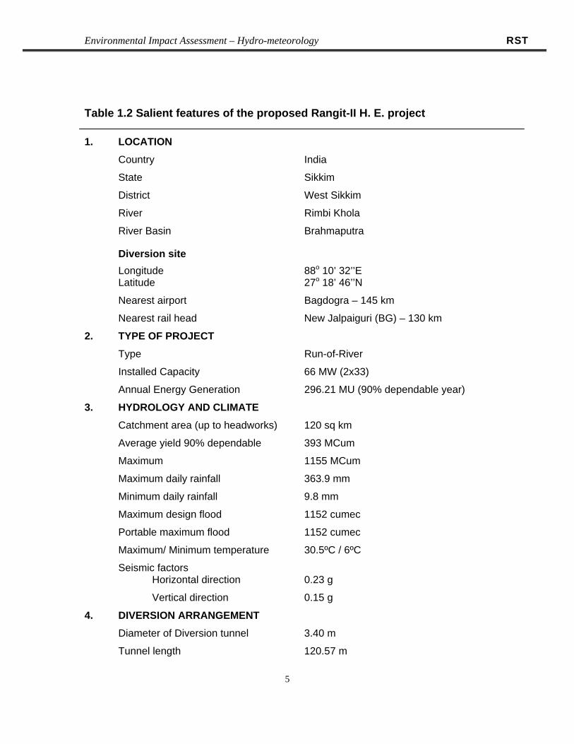


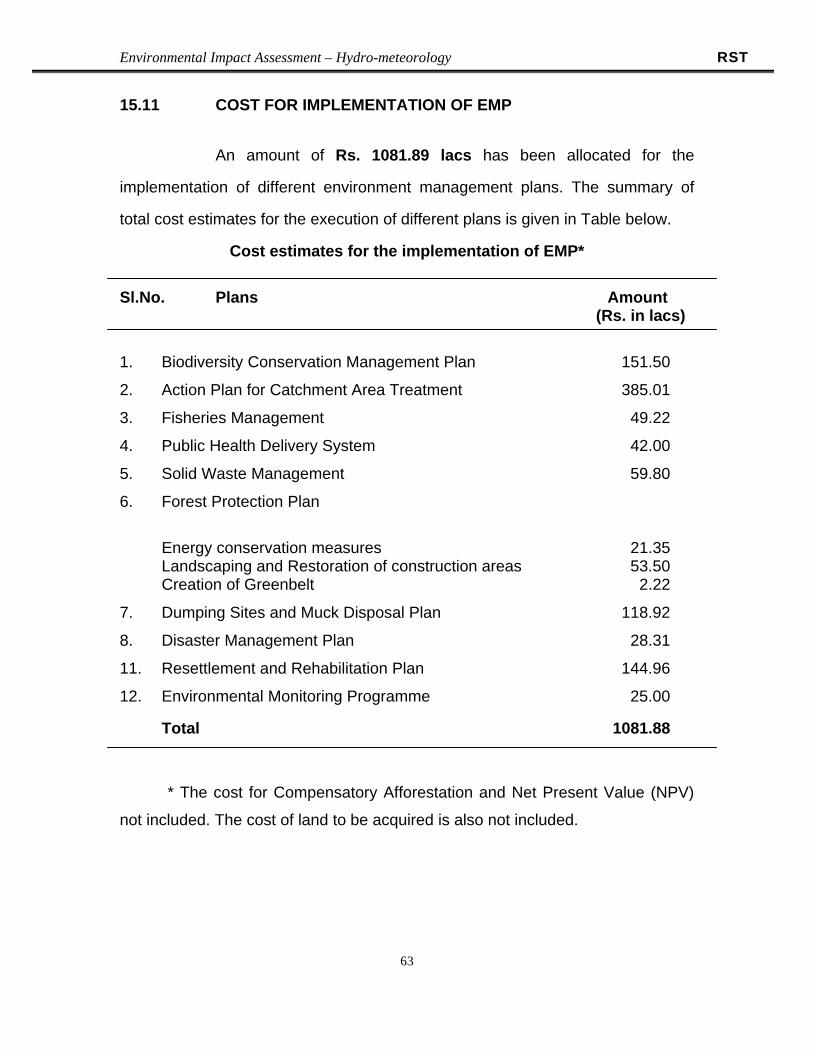


![TERMS OF REFERENCE [TOR] FOR EIA REPORTTERMS …€¦ · TERMS OF REFERENCE [TOR] FOR EIA REPORTTERMS OF ... FOR EIA REPORTTERMS OF REFERENCE [TOR] FOR EIA ... • A map covering](https://static.documents.pub/doc/80x56/5b948ee009d3f2e5688d16e3/terms-of-reference-tor-for-eia-reportterms-terms-of-reference-tor-for-eia.jpg)


