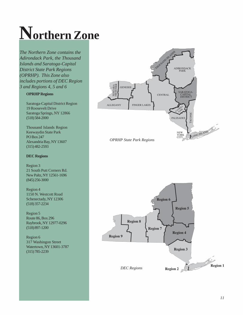
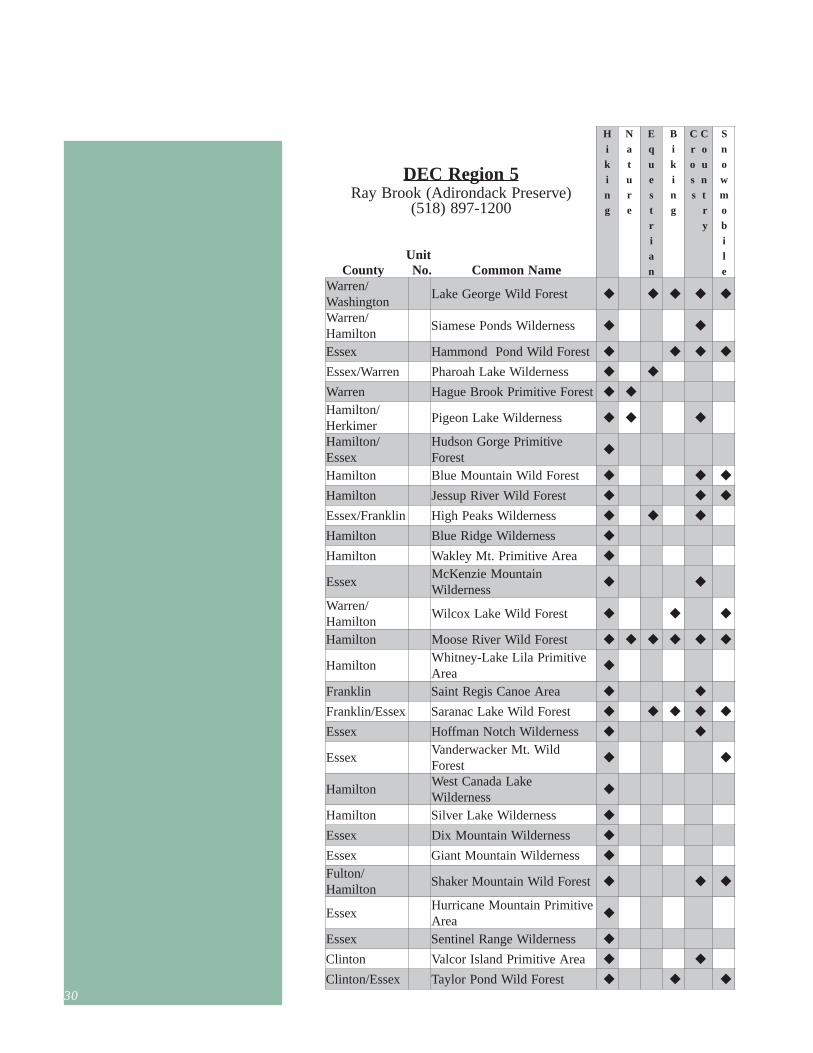
11 N orthern Zone The Northern Zone contains the Adirondack Park, the Thousand Islands and Saratoga-Capital District State Park Regions (OPRHP). This Zone also includes portions of DEC Region 3 and Regions 4, 5 and 6 OPRHP State Park Regions DEC Regions OPRHP Regions Saratoga-Capital District Region 19 Roosevelt Drive Saratoga Springs, NY 12866 (518) 584-2000 Thousand Islands Region Keewaydin State Park PO Box 247 Alexandria Bay, NY 13607 (315) 482-2593 DEC Regions Region 3 21 South Putt Corners Rd. New Paltz, NY 12561-1696 (845) 256-3000 Region 4 1150 N. Westcott Road Schenectady, NY 12306 (518) 357-2234 Region 5 Route 86, Box 296 Raybrook, NY 12977-0296 (518) 897-1200 Region 6 317 Washingon Street Watertown, NY 13601-3787 (315) 785-2239
Transcript
11
N
NNorthern ZoneThe Northern Zone contains theAdirondack Park, the ThousandIslands and Saratoga-CapitalDistrict State Park Regions(OPRHP). This Zone alsoincludes portions of DEC Region3 and Regions 4, 5 and 6
OPRHP State Park Regions
DEC Regions
OPRHP Regions
Saratoga-Capital District Region19 Roosevelt DriveSaratoga Springs, NY 12866(518) 584-2000
Thousand Islands RegionKeewaydin State ParkPO Box 247Alexandria Bay, NY 13607(315) 482-2593
DEC Regions
Region 321 South Putt Corners Rd.New Paltz, NY 12561-1696(845) 256-3000
Region 41150 N. Westcott RoadSchenectady, NY 12306(518) 357-2234
Region 5Route 86, Box 296Raybrook, NY 12977-0296(518) 897-1200
Region 6317 Washingon StreetWatertown, NY 13601-3787(315) 785-2239
12
State ParksNorthern Zone
12
13
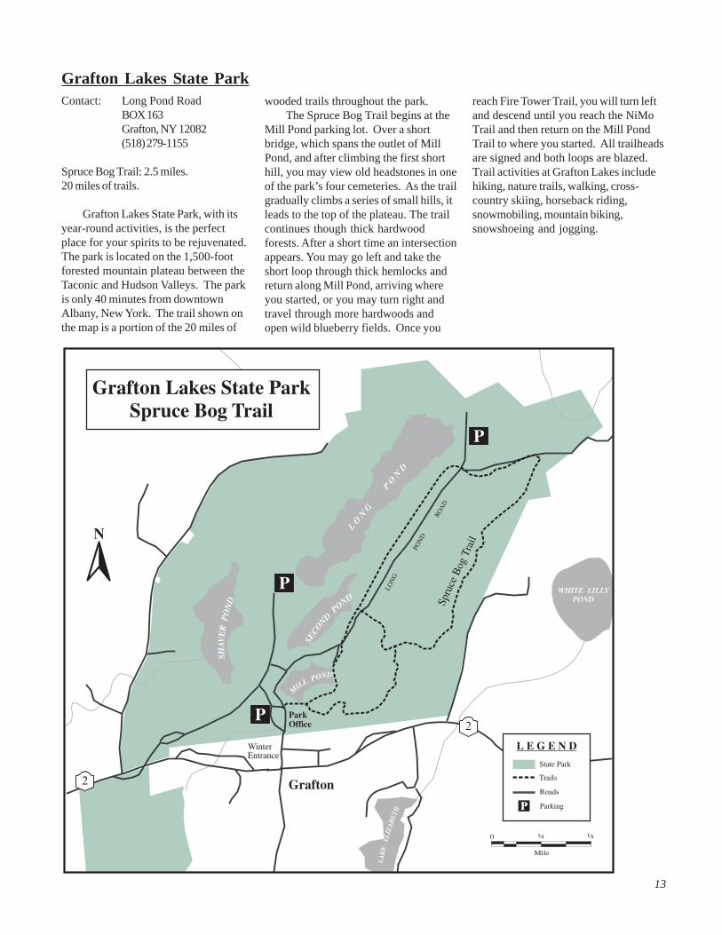
Grafton Lakes State ParkContact: Long Pond Road
BOX 163Grafton, NY 12082(518) 279-1155
Spruce Bog Trail: 2.5 miles.20 miles of trails.
Grafton Lakes State Park, with itsyear-round activities, is the perfectplace for your spirits to be rejuvenated.The park is located on the 1,500-footforested mountain plateau between theTaconic and Hudson Valleys. The parkis only 40 minutes from downtownAlbany, New York. The trail shown onthe map is a portion of the 20 miles of
wooded trails throughout the park.The Spruce Bog Trail begins at the
Mill Pond parking lot. Over a shortbridge, which spans the outlet of MillPond, and after climbing the first shorthill, you may view old headstones in oneof the park’s four cemeteries. As the trailgradually climbs a series of small hills, itleads to the top of the plateau. The trailcontinues though thick hardwoodforests. After a short time an intersectionappears. You may go left and take theshort loop through thick hemlocks andreturn along Mill Pond, arriving whereyou started, or you may turn right andtravel through more hardwoods andopen wild blueberry fields. Once you
reach Fire Tower Trail, you will turn leftand descend until you reach the NiMoTrail and then return on the Mill PondTrail to where you started. All trailheadsare signed and both loops are blazed.Trail activities at Grafton Lakes includehiking, nature trails, walking, cross-country skiing, horseback riding,snowmobiling, mountain biking,snowshoeing and jogging.
14
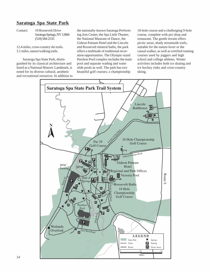
Saratoga Spa State Park
the nationally-known Saratoga Perform-ing Arts Center, the Spa Little Theater,the National Museum of Dance, theGideon Putnam Hotel and the Lincolnand Roosevelt mineral baths, the parkoffers a multitude of traditional recre-ation opportunities. The Olympic-sizedPeerless Pool complex includes the mainpool and separate wading and waterslide pools as well. The park has twobeautiful golf courses; a championship
18-hole course and a challenging 9-holecourse, complete with pro shop andrestaurant. The gentle terrain offerspicnic areas, shady streamside trails,suitable for the nature-lover or thecasual walker, as well as certified runningcourses used by joggers and highschool and college athletes. Winteractivities includes both ice skating andice hockey rinks and cross-countryskiing.
Contact: 19 Roosevelt DriveSaratoga Springs, NY 12866(518) 584-2535
Saratoga Spa State Park, distin-guished by its classical architecture andlisted as a National Historic Landmark, isnoted for its diverse cultural, aestheticand recreational resources. In addition to
15
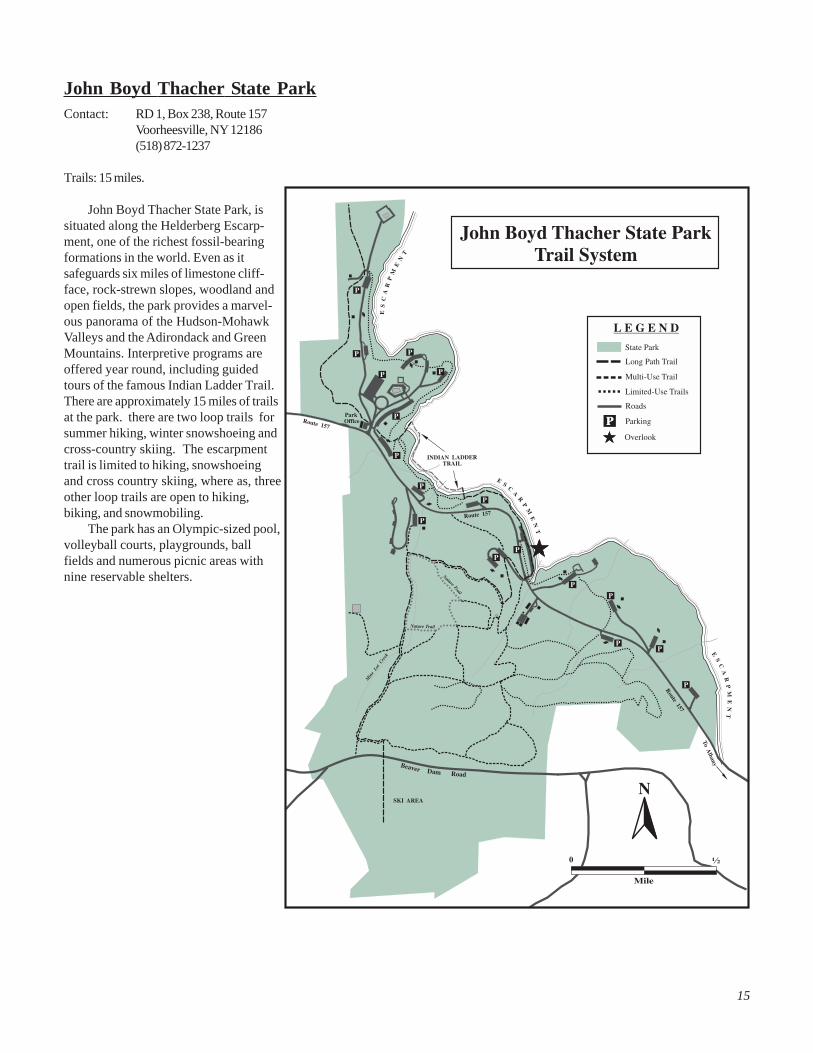
John Boyd Thacher State ParkContact: RD 1, Box 238, Route 157
Voorheesville, NY 12186(518) 872-1237
Trails: 15 miles.
John Boyd Thacher State Park, issituated along the Helderberg Escarp-ment, one of the richest fossil-bearingformations in the world. Even as itsafeguards six miles of limestone cliff-face, rock-strewn slopes, woodland andopen fields, the park provides a marvel-ous panorama of the Hudson-MohawkValleys and the Adirondack and GreenMountains. Interpretive programs areoffered year round, including guidedtours of the famous Indian Ladder Trail.There are approximately 15 miles of trailsat the park. there are two loop trails forsummer hiking, winter snowshoeing andcross-country skiing. The escarpmenttrail is limited to hiking, snowshoeingand cross country skiing, where as, threeother loop trails are open to hiking,biking, and snowmobiling.
The park has an Olympic-sized pool,volleyball courts, playgrounds, ballfields and numerous picnic areas withnine reservable shelters.
Robert Moses State Park is thesecond largest park in the ThousandIslands Region and is located partly onthe mainland and partly on Barnhart
Island. Visitors reach the park through atunnel under the Eisenhower Lock. Thepark is spacious, home to a large varietyof flora and fauna and offers a multitudeof recreational opportunities, includingwooded campsites and cabins, a marinaand boat launch, some of the bestfishing in the Northeast, picnic areas, aswimming beach, tennis courts and anature museum.
The nature trails at the museumoffer ample opportunity to explore avariety of habitats and ecosystems,
including fields, forests and wetlands.Along the trails, beautiful overlooksprovide picturesque viewing of the riverand its wildlife. The trails are rated forthe beginner and intermediate hiker.These trails are also used for cross-country skiing and snowshoeing inwinter.
17
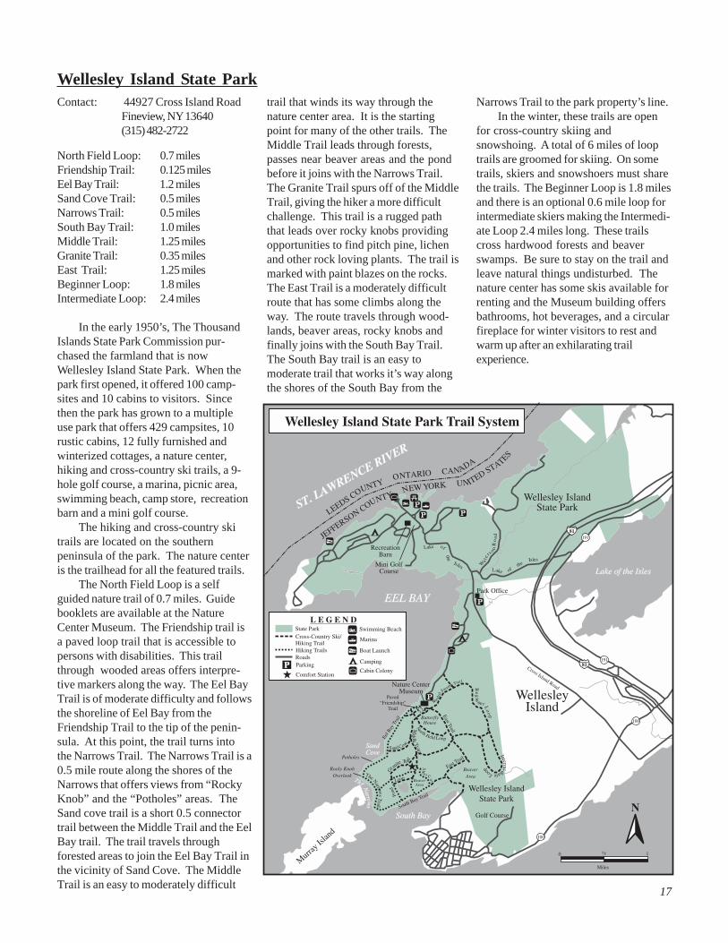
Wellesley Island State ParkContact: 44927 Cross Island Road
Fineview, NY 13640(315) 482-2722
North Field Loop: 0.7 milesFriendship Trail: 0.125 milesEel Bay Trail: 1.2 milesSand Cove Trail: 0.5 milesNarrows Trail: 0.5 milesSouth Bay Trail: 1.0 milesMiddle Trail: 1.25 milesGranite Trail: 0.35 milesEast Trail: 1.25 milesBeginner Loop: 1.8 milesIntermediate Loop: 2.4 miles
In the early 1950’s, The ThousandIslands State Park Commission pur-chased the farmland that is nowWellesley Island State Park. When thepark first opened, it offered 100 camp-sites and 10 cabins to visitors. Sincethen the park has grown to a multipleuse park that offers 429 campsites, 10rustic cabins, 12 fully furnished andwinterized cottages, a nature center,hiking and cross-country ski trails, a 9-hole golf course, a marina, picnic area,swimming beach, camp store, recreationbarn and a mini golf course.
The hiking and cross-country skitrails are located on the southernpeninsula of the park. The nature centeris the trailhead for all the featured trails.
The North Field Loop is a selfguided nature trail of 0.7 miles. Guidebooklets are available at the NatureCenter Museum. The Friendship trail isa paved loop trail that is accessible topersons with disabilities. This trailthrough wooded areas offers interpre-tive markers along the way. The Eel BayTrail is of moderate difficulty and followsthe shoreline of Eel Bay from theFriendship Trail to the tip of the penin-sula. At this point, the trail turns intothe Narrows Trail. The Narrows Trail is a0.5 mile route along the shores of theNarrows that offers views from “RockyKnob” and the “Potholes” areas. TheSand cove trail is a short 0.5 connectortrail between the Middle Trail and the EelBay trail. The trail travels throughforested areas to join the Eel Bay Trail inthe vicinity of Sand Cove. The MiddleTrail is an easy to moderately difficult
trail that winds its way through thenature center area. It is the startingpoint for many of the other trails. TheMiddle Trail leads through forests,passes near beaver areas and the pondbefore it joins with the Narrows Trail.The Granite Trail spurs off of the MiddleTrail, giving the hiker a more difficultchallenge. This trail is a rugged paththat leads over rocky knobs providingopportunities to find pitch pine, lichenand other rock loving plants. The trail ismarked with paint blazes on the rocks.The East Trail is a moderately difficultroute that has some climbs along theway. The route travels through wood-lands, beaver areas, rocky knobs andfinally joins with the South Bay Trail.The South Bay trail is an easy tomoderate trail that works it’s way alongthe shores of the South Bay from the
Narrows Trail to the park property’s line.In the winter, these trails are open
for cross-country skiing andsnowshoing. A total of 6 miles of looptrails are groomed for skiing. On sometrails, skiers and snowshoers must sharethe trails. The Beginner Loop is 1.8 milesand there is an optional 0.6 mile loop forintermediate skiers making the Intermedi-ate Loop 2.4 miles long. These trailscross hardwood forests and beaverswamps. Be sure to stay on the trail andleave natural things undisturbed. Thenature center has some skis available forrenting and the Museum building offersbathrooms, hot beverages, and a circularfireplace for winter visitors to rest andwarm up after an exhilarating trailexperience.
18
Point Au Roche State ParkContact: 19 Camp Red Cloud Rd.
This network of trails winds througha variety of habitats, from marshes toforests to the shores of Lake Champlain.The trails offer hiking, nature interpreta-tion/observation and cross-country
skiing opportunities to day users. TheNature Center hosts a number ofenvironmental and interpretive pro-grams, including guided nature interpre-tation hikes. The bike trail starts at thebathhouse and ends at the NatureCenter. In the winter, cross-country skirentals are available. All the trails areblazed. Marked interpretive trails thatprovide natural or cultural informationare planned for development within thepark.
Contact: Department ofEnvironmental ConservationRoute 86, PO Box 296Ray Brook, NY 12977(518) 891-1370
Blue Mountain Trail: 2.2 miles.Regionwide: 45 miles of trails.
The Blue Mountain Lake Region islocated within the Adirondack Park. On-site, the Blue Mountain Trail is markedwith round red disks. A large parkingarea for the trail is located on the eastside of Route 30/28N, 0.10 of a mile northof the Adirondack Museum in BlueMountain Lake. The trail to the summit
of Blue Mountain heads east from thetrailhead, starting along an old loggingroad on Finch-Pruyn Company, Inc.lands. The trail climbs 1,550 feet withmoderate to steep grades, ending at thefire tower. Good views are possible fromthe flat-topped summit.
22
Deer River Horse Trail
Contact: Department ofEnvironmental ConservationRoute 86, Box 296Ray Brook, NY 12977(518) 891-1370
The Deer River State Forest com-prises nearly 12,000 acres of land alongthe Deer River in northwestern FranklinCounty. These lands are administered bythe Department of Environmental Conser-vation and are managed to providecompatible multi-use benefits, including
public recreation.The Deer River Horse Trail consists
of a series of interconnecting loop trailswhich allow riders to select the distancethat suits them. In addition to markedtrails, there is a trailhead parking area,covered tie stalls, a water supply and pitprivies.
The trails traverse gently rolling hills.The type of forest you will see in this areais termed “northern hardwood,” with themajor species being sugar maple. You willalso find a sprinkling of red maple, beech
and black cherry throughout the forest.As you travel the CCC, Horse Barn andLucey trails, the trees become substan-tially larger. The forest in this area is stillthe northern hardwood composition. TheCCC trail segment is a section of accessroad built during the 1930’s by the CCC.The Conservation Truck Trail is the majoreast-west travel route through the DeerRun State Forest. At three locationsyou’ll find improved campsites, which areavailable for public use.
23
Greenwood Creek State Forest
Greenwood Creek past the falls,through hardwood and soft woodforests. Along the way, you can pauseto enjoy the serenity of an enclosedspring built in the 1930’s by the CivilianConservation Corps (CCC) and restoredin 1982 by the current YCC. The trailthen goes through a red pine plantationinto hardwoods, where it runs along theedge of a hardwood forest and red pinestand representing the unique aspectsof each forest type. The trail descendsto lower elevations, and again rises intohardwoods. At this point, the trail leadsyou along rock ridges where variousberry patches can be observed includ-ing raspberry, blueberry and shadberry
Contact: Department ofEnvironmental Conservation6739 U.S. Highway 11Potsdam, NY 13676(315) 265-3090
Nature Trail: 1.8 miles.
The Greenwood Creek State Forestis one of 43 forests in St. LawrenceCounty administered by the Departmentof Environmental Conservation (DEC).The forest consists of 1,009 acres whichwere purchased in five separate parcelsfrom 1933 to 1958. The trail was con-structed in 1981 by the Camp Fine YouthConservation Corps (YCC). It follows
(also known as Juneberry and service-berry.) Again, the trail declines into aspruce-fir wetland area, following a smallbrook which precedes the end of the trailat the picnic area.
A shorter trail is available for a morerelaxed day at Greenwood Creek StateForest. The 0.25-mile-long nature trailleads to an observation platform whichoffers a beautiful view of the GreenwoodCreek. Trout abound in this section ofthe creek and may provide an eveningmeal for the ambitious fisherman.
24
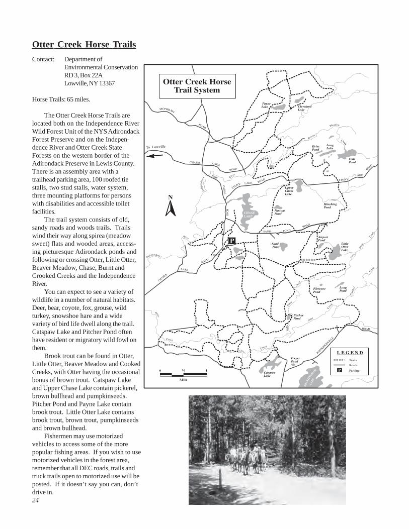
Otter Creek Horse Trails
Contact: Department ofEnvironmental ConservationRD 3, Box 22ALowville, NY 13367
Horse Trails: 65 miles.
The Otter Creek Horse Trails arelocated both on the Independence RiverWild Forest Unit of the NYS AdirondackForest Preserve and on the Indepen-dence River and Otter Creek StateForests on the western border of theAdirondack Preserve in Lewis County.There is an assembly area with atrailhead parking area, 100 roofed tiestalls, two stud stalls, water system,three mounting platforms for personswith disabilities and accessible toiletfacilities.
The trail system consists of old,sandy roads and woods trails. Trailswind their way along spirea (meadowsweet) flats and wooded areas, access-ing picturesque Adirondack ponds andfollowing or crossing Otter, Little Otter,Beaver Meadow, Chase, Burnt andCrooked Creeks and the IndependenceRiver.
You can expect to see a variety ofwildlife in a number of natural habitats.Deer, bear, coyote, fox, grouse, wildturkey, snowshoe hare and a widevariety of bird life dwell along the trail.Catspaw Lake and Pitcher Pond oftenhave resident or migratory wild fowl onthem.
Brook trout can be found in Otter,Little Otter, Beaver Meadow and CookedCreeks, with Otter having the occasionalbonus of brown trout. Catspaw Lakeand Upper Chase Lake contain pickerel,brown bullhead and pumpkinseeds.Pitcher Pond and Payne Lake containbrook trout. Little Otter Lake containsbrook trout, brown trout, pumpkinseedsand brown bullhead.
Fishermen may use motorizedvehicles to access some of the morepopular fishing areas. If you wish to usemotorized vehicles in the forest area,remember that all DEC roads, trails andtruck trails open to motorized use will beposted. If it doesn’t say you can, don’tdrive in.
25
Taconic Ridge State Forestand dates carved in nearby rocks. It willtake about 1 to 1.5 hours of easy hiking toreach this point. The Taconic Crest traileventually ends at a parking area on NYRoute 346 approximately 7.5 miles fromPetersburg Pass.
The trail to Berlin Mountain headsfrom the southwest corner of the Peters-burg Pass Scenic Area parking lotfollowing an old road along the westernslope of Ramier Mountain. About 0.25miles from the parking lot, the trail entersthe hardwood forest where a registrationbox is located. The trail continues south,where it eventually reaches the crossingof the old Boston- Albany Post Road atBerlin Pass.
After crossing the old road, the trailfollows a woods road to the summit ofBerlin Mountain. The summit is thehighest point on the trail at 2,798 feet.This is approximately 2.67 miles from theparking lot on Route 2. Allow 1.5 to 2hours to reach this point. From thesummit, there are good views in alldirections, especially of Mt. Greylock inMassachusetts to the east.
From Berlin Mountain, the TaconicCrest trail continues approximatelyanother 19 miles south, eventually endingat NYS Route 20 between Pitsfield, MAand Lebanon Springs, NY.
Contact: Department ofEnvironmental Conservation1150 N. Westcott Rd.Schenectady, NY 12306(518) 357-2066
Taconic Crest Trail: 36 miles.
The Taconic Ridge State Forest islocated along the borders of New York,Massachusetts and Vermont. The areacontains approximately 6,000 acres ofState Forest land and 5,500 acres of NYSConservation Easement land, andprovides opportunities for excellent viewsof the Taconic Range, Mount Greylockand Berlin Mountain. The Taconic CrestTrail crosses the property from it’s northterminus on NY Route 348, across thePetersburg Pass Scenic Area on NY Route2 and south to NY Route 20 BetweenPitsfield, MA and Lebanon Springs, NY.
The trail runs for approximately 36miles, following the ridge of the TaconicRange on the New York-Massachusettsborder. The trail crosses three states—New York, Vermont and Massachusetts.White, diamond-shaped metal markersdesignate the trail route. Most of the trailis on State Open Space protected lands;however, some segments may still crossprivate property. Keep this in mind andplease respect the rights of the ownersand obey any posted signs. Twosegments of the trail are described here.
From the parking area heading north,the trail crosses Route 2 to wind its waythrough northern hardwoods. Occasionalopenings provide good views of themountains and surrounding countryside.The US Geological Survey map hasdesignated this area “the white rocks”because of the occurrence of chunks ofmilky quartz which are scattered throughthe woods.
After a short uphill climb from NYRoute 2, the trail crosses into the HopkinsMemorial Forest of Williams College forroughly one mile. Only foot traffic isallowed on this section of the trail as itcrosses Hopkins Memorial Forest. Nowheeled uses are allowed.
Approximately 2.5 miles north of theparking lot on Route 2, a short spur trailleads to the “snow hole.” The snow holeis a deep stone crevasse which has beenknown to contain ice or snow for most ofthe year. This site has been known forover 100 years as evidenced by names
26
Trails in the Lake George Region
are recommended.Crowning beautiful Lake George on
its eastern side, the rocky and formi-dable Black Mountain rises from thewater’s edge. No vacationer in the LakeGeorge Region should miss the awe-inspiring view from this mountain top.Lake Champlain, the Green Mountainsof Vermont and Lake George and itsislands, the Hudson Valley and all thehigh Adirondack peaks are spread outin one glorious panorama.
This 2.75-mile red-marked trailstarts from Black Mountain Point, abouttwo miles north of Glen Island head-quarters on the east shore. It isaccessible by boat only. The first 1.25miles to Black Mountain Brook are not
difficult. At this point you will find thelast dependable water supply. The next0.25 miles follows the brook to thebeginning of the Zig Zag and a steepone-mile climb to the fire observationtower. There is a marked approach toBlack Mountain from the east on PikeBrook Road south of Huletts Landing.By this route, you may drive your car towithin two miles of the tower. The climbfrom there is easier, but still challeng-ing. This trail is also marked with redmarkers.
Contact: Department ofEnvironmental ConservationP.O. Box 220Warrensburg, NY 12885(518) 623-3671
Prospect Mountain: 1.63 miles.Tongue Mountain Range: 15.3 miles.Black Mountain Fire Tower: 2.75 miles.Regionwide: 50 miles of trails.
One of the most satisfying andrewarding recreational pursuits availableto the vacationer is the challenge ofclimbing the numerous mountainsoverlooking Lake George and thesurrounding area, and traveling theforest trails to remote mountain ponds.
A system of trails has been devel-oped by DEC to provide you with anopportunity to reach and enjoy theprincipal points of interest in the LakeGeorge Region. The 1.63 mile-longProspect Mountain Trail leads to thesummit of Prospect Mountain. To reachthe trail from Lake George Village, turnleft onto Mountcalm Street. At SmithStreet, turn south 0.5 blocks to the signindicating the start of the trail, where thetrail crosses the Northway on anelevated walkway. The climb to thesummit is not easy, but it is rewarding.The trail follows, in part, the roadbed ofan old funicular railway that served aonce-thriving summer hotel on themountain.
The Tongue Mountain Range trailsystem contains over 18 miles of foottrails, most of them located on the highridges and affording many fine views ofthe surrounding territory. The mostpopular section of the system followsthe ridge of Tongue Mountain 10 milesfrom the lake to Route 9N, 12.2 milesnorth of Bolton Landing. Land accessto the trail system is either throughClay Meadow or the summit of TongueMountain Highway; or, by water, via thepoint of the tongue and Five Mile Point
A word of caution is due regardingthe hazard of rattlesnakes in the area.The situation is not dangerous as longas ordinary precautions are observed.The wearing of high boots and carewith the use of hands when climbing