208
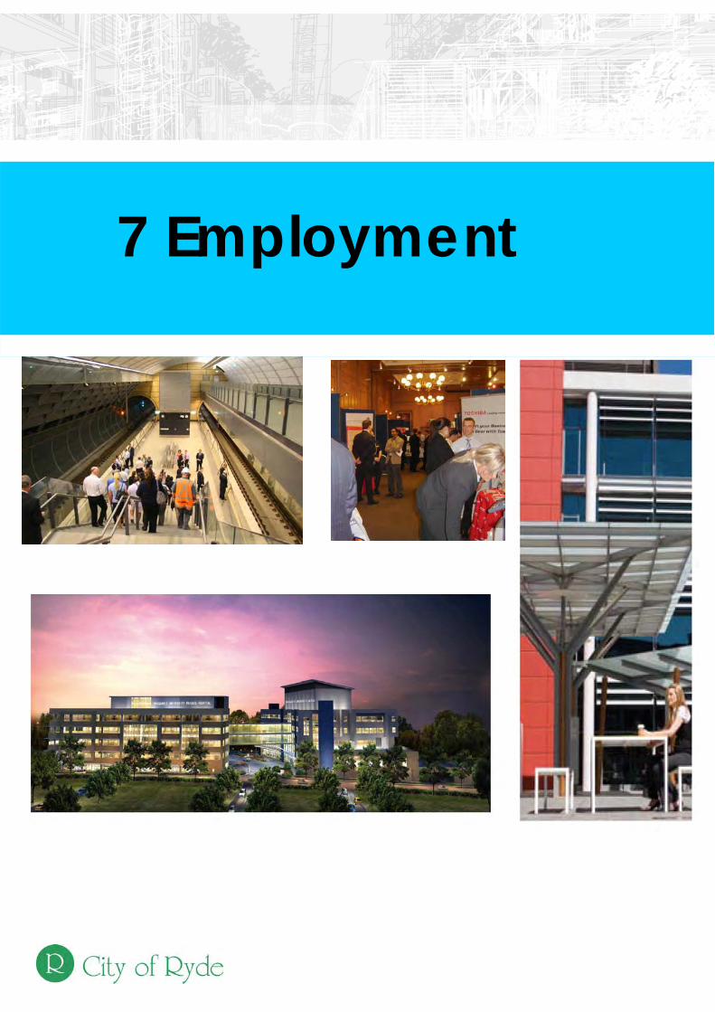
7 Employment
7 Employment

City of Ryde Local Planning Strategy - Employment
7-4

City of Ryde Local Planning Strategy - Employment
7-1
Contents
7.1 Introduction 7-37.1.1 Study Purpose………………………………………..………………. 7-57.1.2 Study Area……………………………………………………….…….. 7-57.1.3 Historical Context …………………………………………………….. 7-57.1.4 Methodology…………………………………………………………... 7-67.2 Strategic Planning Context 7-97.2.1 State and Regional Policies ….………………………………….…. 7-117.2.2 Local Context..…………………………………………………….…... 7-137.2.3 Planning Provisions………..………………………………………… 7-147.3 Existing Characteristics – A Snap Shot 7-177.3.1 Employment Profile Demographic…………………………………… 7-197.3.2 Employment Areas – Existing Situation ……………………………. 7-227.4 Analysis and Discussion 7-317.4.1 Key Employment sectors…………………………………………….. 7-337.4.2 Employment Self Sufficiency………………………………………… 7-357.4.3 Industrial, Retail and Commercial – Analysis……………………… 7-367.4.4 Victoria Road Economic Corridor…………………………………… 7-397.4.5 Employment Target…………………………………………………… 7-407.5 Key Findings and Directions 7-437.5.1 Key Findings ………………………………………………………….. 7-457.5.2 Directions………………………………………………………………. 7-467.6 Strategy and Recommendations 7-477.6.1 The Strategy…………………………………………………………… 7-497.6.2 Recommendations……………………………………………………. 7-507.7 Response to the Metropolitan Strategy 7-517.7.1 Response to the Metropolitan Strategy – Economy and
Employment……………………………………………………………. 7-53
Appendix A – Employment and Centres Study………………… 7-58

City of Ryde Local Planning Strategy - Employment
7-2

City of Ryde Local Planning Strategy - Employment
7-3
7.1 Introduction

City of Ryde Local Planning Strategy - Employment
7-4

City of Ryde Local Planning Strategy - Employment
7-5
7.1.1 Study Purpose The Employment Study is to guide the development of planning strategies and controls that will support employment. The Study is a component of the Local Strategy that will inform the comprehensive Local Environmental Plan (LEP) for the City. This Study is based upon research findings and recommendations contained in the study prepared by the planning consultants Mecone entitled, ‘Employment and Centres Study’ October 2009. The scope of the Study includes -
• Providing understanding of the economic profile of the City of Ryde; • Consideration of supply and demand data relating to economic/employment
activities; • Suggesting land use planning and development directions and other
economic development opportunities and actions; • Supporting information and recommendations for the City of Ryde Local
Planning Strategy and comprehensive LEP. 7.1.2 Study Area The Study area is the whole of the City Local Government area. 7.1.3 Historical Context
The City of Ryde is a predominantly residential LGA in northern Sydney between 8 and 15 kilometres north-west of the Sydney GPO. Business activity tends to be concentrated within and around the City’s town centres located on road/rail corridors and at transport nodes. While early residential development in Ryde dates from the late nineteenth century, with the opening of the railway line to Hornsby, the most significant periods of development in the City have been in the interwar and post-war period.
Initial development was focussed around railway stations, tram routes and along the Parramatta River and spread as car ownership increased and infrastructure (especially roads and bridges) improved. By the 1980s, few areas remained for green field residential development and greater rates of infill and redevelopment began. This is a process that has continued to the current time, with redevelopment of older industrial areas along the Parramatta River such as Meadowbank and Putney.
The population of Ryde is currently over 100,000 people and has been steadily growing in the last five years, after two decades of relative stagnation and minimal population growth.
Many parts of the Ryde LGA have historically been occupied by industry. For example in the 1920’s Harold Meggitt’s linseed oil extraction plant at Gladesville was used to manufacture paint and varnish, and across the Parramatta River at Rhodes the State Timber Yards and Darling Flour Mills were located as major employers for Ryde residents. A E Primrose & Company started business under the name Gladesville Timber Yard in 1922

City of Ryde Local Planning Strategy - Employment
7-6
which locals welcomed believing that the Parramatta River should be developed as a second Clyde. Union Carbide was established on the Parramatta River close to Ryde in 1928 and during WW2 produced the pesticide DDT. ICI Chemicals south of Union Carbide manufactured products used in Berger paints and polyester resins – this site was remediated following contamination with lead. In 1943 Slazenger’s, known for sporting goods manufacturing, began production at Putney on the Parramatta River by building ship hulls, other small craft and later motor scows for the 2nd World War. In the 1950’s CSIRO was established at North Ryde and supported manufacturing and other local primary industries. The mass consumer market emerged at this time and Hoover came to Meadowbank in 1953, taking over an expanding and already existing factory – it produced washing machines, vacuum cleaners and floor polishes for the local and national markets. In 1963 the decision was made to build Macquarie University at North Ryde and surrounding land was rezoned for residential and industrial uses. The concept for the university was based on the Stanford University model, to support interaction between industries and the University. In 1957 Top Ryde Shopping Centre, the first such centre to be built in NSW and second in Australia, opened based on the American shopping mall model. The centre included some big name city stores which were now decentralising into the suburbs. The redevelopment of the centre commenced in 2007. The Macquarie Shopping Centre opened 12 years later and in 2008 had development approval for retail expansion, including a second major department store.
Due to a declining traditional industrial base and changing employment patterns centres such as Meadowbank are transforming into more sustainable neighbourhoods that support mixed uses of residential, commercial and retail. Industries from this area have moved west for cheaper and larger land parcels, as well as the benefits of major road infrastructure to enable easier cross- regional access and logistics management. In the last decade a number of town centres within the City have commenced a process of transformation with the review and implementation of planning controls and public domain improvements, which support a business, retail and residential community. An example of such a transformation has occurred in West Ryde with the opening of the Market Place Shopping Centre and the City of Ryde Library. and Eastwood is also developing a strong restaurant sector. Revitalisation has also occurred in a number of Ryde’s small and neighbourhood centres. These local centres have services such as chemists and news agents. Small centres that have notable vibrancy are Putney, Cox’s Road, Midway and Sager Place. 7.1.4 Methodology This Study has been compiled on the research, findings and recommendations of the Employment and Centres Study October 2009 undertaken by Mecone (planning Consultancy) for the City of Ryde.
The Employment and Centres Study undertook the following:
City of Ryde Local Planning Strategy - Employment
7-7
- Reviewed State and Regional Plans and policies with regard to their impact on employment issues in Ryde;
- An audit of all centres and employment areas to validate the size and land uses in each centre;
- Reviewed local planning policies and programs and their impact on employment opportunities in the City;
- Assessment of the supply and demand issues of the industrial, retail and commercial sectors based upon development capacity provided through planning controls, development activity in the City (DA approvals) and research on market activity, other indicators and trends undertaken by the Department of Planning and the Property Council; and
- Identified sub-regional and regional trends relating to retail, commercial and industrial activities.
The term employment lands used in this study is land within the City that is used for employment activities and includes, town centres, small/neighbourhood centres and industrial areas.

City of Ryde Local Planning Strategy - Employment
7-8
City of Ryde Local Planning Strategy - Employment
7-9
7.2 Strategic Planning context

City of Ryde Local Planning Strategy - Employment
7-10

City of Ryde Local Planning Strategy - Employment
7-11
This section of the Study provides an overview of the State, Regional and local planning strategies and programs. The overview focuses on elements of these strategies and programs that relate to employment and economic activity. 7.2.1 State and Regional Policies Metropolitan Strategy The City of Cities: A Plan for Sydney’s Future was released by the State Government in 2005 to plan for Sydney’s future growth to 2031. The Strategy is based on four aims:
• enhance liveability, • strengthen economic competitiveness, • ensure fairness, protect the environment, and • improve governance.
The Metropolitan Strategy Review – Sydney Towards 2036 (a discussion paper) was undertaken by NSW Planning in 2010. The strategy indicates that by 2036 the City will need to cater for:
• 1.7 million additional people, • Additional 770,000 dwellings, • Additional 760,000 jobs, • 7,500 hectares industrial land (figure estimate for 2031), • 6.8 sq m office space(figure estimate for 2031), and • 3.7 million sq m of retail space(figure estimate for 2031).
The Review has 9 proposed directions to guide the development of Sydney to 2036. The two key directions relating to employment are:
• More jobs in the Sydney region – boost job growth by providing a good supply of land for employment, and
• Growing Sydney’s value – increase diversity of employment to strengthen local economies and provide a wider range of jobs close to home.
For the Ryde LGA, the Metropolitan Strategy identifies Macquarie Park as part of the ‘global economic corridor’ and has identified it as a ‘Specialised Centre’. Macquarie Park will continue to evolve as the leading national technology park with jobs growth, local and international investment and improving transport accessibility. Draft Inner North Sub-region Subregional Strategy – (INSS) The Draft Subregional Strategy - Inner North Subregion July 2007 (Draft INSS) is part of the implementation of the City of Cities: A Plan for Sydney’s Future (Metropolitan Strategy). The preparation and implementation of the Inner North Strategy is a key step in translating the Metropolitan Strategy to the local level. The Inner North Strategy applies to the Council areas of Ryde Hunter Hill, Mosman, Lane Cove, Willoughby and North Sydney. The draft Strategy establishes Key Directions and Key Actions which set a framework in which the strategy can achieve its aims and objectives. For the Inner North Sub-region, the Draft INSS identifies a capacity target of 60,100 jobs by 2031, out of which 21,000 need to be created within the Ryde LGA.

City of Ryde Local Planning Strategy - Employment
7-12
The Draft INSS describes broad directions for economic growth and provides a series of objectives and actions to support economic growth and prosperity as it relates to the ‘Global Economic Corridor’. The subregion is identified as having a higher percentage of employees in property and business services that the Sydney area. Other important employment sectors includes: health and community services and wholesale trades. The draft strategy identifies the following two areas of strategic employment lands:
- West Ryde – ( Local Industry) a smaller industrial area of 7 hectares providing local industry – automotive-related businesses and
- The former ADI site (Local Industry - Maritime) – a small waterfront industrial area of 1.5 ha which has historically supported working harbour activities and is currently used for boat repair facilities. A master plan has been adopted for the site proposing maritime related activities.
The Draft INSS proposed the above sites should be retained for industrial purposes.
NSW Planning have indicated that the draft INSS will be reviewed in line with the metropolitan Strategy review 2010. The City of Ryde provided a response to the Inner North Subregion, Draft Subregional Strategy (Draft INSS) in 2007. The key proposed recommendations outlined in the response, relating to employment, centres and corridors include:
1) The Draft INSS should recognise the potential growth in the Ryde LGA which far exceeds the Department of Planning (DoP) targets;
2) The Draft INSS should recognise the need for additional investment in essential services and infrastructure to cater for the potential growth;
3) The Draft INSS should emphasise the importance of the Macquarie Park Corridor and its transition from being a car dependent commercial centre to a vibrant, public transport orientated mixed used centre;
4) The Draft INSS should meet the needs of start-up businesses, professional suites, retail, service sector and creative industries;
5) Top Ryde should be identified as a ‘Major Centre’ due to increased employment;
6) West Ryde should be identified as a ‘Town Centre’ due to potential increase in employment and population.
NSW State Plan Local Councils, the DoP and this study are required to have regard to the strategies established by the NSW State Plan, launched in 2006. The Plan gives recognition to the NSW Government’s role to provide policies and infrastructure that offer support for an attractive and competitive business environment. The Plan’s priorities that are relevant to the City of Ryde’s employment and economic growth include; NSW Open for Business:
• increasing business investment, • maintaining and investing in infrastructure to support the economy, • cutting red tape, • increasing participation in education and training, and
City of Ryde Local Planning Strategy - Employment
7-13
• helping to maintain the State’s AAA credit rating. Improved Urban Environments:
• creating jobs closer to home, • improving housing affordability, and • improving the efficiency of the road network.
Healthy Communities:
• a high quality public transport system. 7.2.2 Local Context The City of Ryde has undertaken and implemented a number of key strategies that foster and support employment activities within the City. The key documents are: Urban Village Strategy 1998 The City of Ryde commenced the Urban Village Strategy during the mid 1990’s. The key aspect of Ryde’s urban village policy is to steer population and employment growth into existing commercial and employment centres, which are accessible to high frequency public transport. The urban village study defined an urban village as follows:
“… an urban precinct located around a high frequency public transport node or interchange incorporating:
A mix of land uses, including retail, commercial, employment, residential and leisure;
Attractive and well used public spaces;
A safe and convenient pedestrian environment; and
Urban design elements which promote community pride and identity. The Urban Village policy set out to achieve a range of recommendations which have been generally identified below:
Total communities - a range of housing types with access to work, opportunities for business and the provision of a range of services in centres.
Sustainable communities – increased public transport use, higher development densities located at public transport nodes and energy efficient buildings.
Redevelopment and renewal ethos – permit additional floor space in return for the provision of community benefits such as public domain improvements. Build working partnerships with stakeholders to achieve the goals of the Strategy.
Economic Development Strategy 2009-2014 The City of Ryde Economic Development Strategy (EDS) was prepared during 2008 in order to provide a framework to guide and support business development and give greater recognition to sustainable economic development. The Strategy was launched by Council in early 2009.

City of Ryde Local Planning Strategy - Employment
7-14
The aims of the EDS are to:
Facilitate the collaboration of economic development between all levels of
government, business and the local community; Retain and increase the diversity of local businesses; Provide information and services to support businesses - such as events and
networking opportunities; Assist in identifying and attracting new business investment, sector clusters
and employment growth; and Identify opportunities for marketing, promotion and branding of business
activities in the City’s centres. The Strategy’s framework will guide economic development within the City until 2014. The framework is based around 3 themes, a series of supporting strategies and an action plan, which have been endorsed by the community. The themes are: Marketing the City, Employment Generation and Building Partnerships.
The EDS is supported by an implementation plan, which outlines the priority actions and activities that will be undertaken each year over the life of the plan. Employment and Centre Study October 2009 The Employment and Centre Study was undertaken during 2009 with the purpose of:
Providing an understanding of the economic profile of the City of Ryde based on existing studies.
Compiling and analysing key supply and demand data placing the City of Ryde in its regional economic context.
Providing land use planning directions on the above data.
Preparing a report containing the study findings.
The research, findings and recommendation of this Study have informed the preparation of this report. 7.2.3 Planning Provisions The Planning Instruments governing the City of Ryde and the elements of these plans that impact on employment activity are outlined below. Environmental Planning and Assessment Act 1979 This Act, through its provisions and directions has a significant impact on the economy and employment activities, however the key policy and directions that impact the City of Ryde are: State Environmental Planning Policies:
• SEPP 22 - Shops and commercial premises 1987 • SEPP – Major Development 2005 • SEPP – Infrastructure 2007

City of Ryde Local Planning Strategy - Employment
7-15
• SEPP - Exempt and Complying 2008 Ministerial directions – issues and directions that are relevant to planning authorities when preparing a planning instrument:
• Business Zones - This direction relates to the protection of land zoned for business activities and the uses permissible in the zone.
• Industrial Zones - This direction relates to the protection of land zoned for industrial activities and the uses permissible in the zone.
City of Ryde Local Environmental Plan 2010 The local environmental plan provides the planning, land use and built form provisions that guide growth and development activity within the City. The provisions supporting the economy and employment activity are:
• Zoning and land use table – the business and industrial zones, and • Local provisions guiding development within the town centres. Such provisions are
aimed at providing opportunities for growth and revitalisation.

City of Ryde Local Planning Strategy - Employment
7-16

City of Ryde Local Planning Strategy - Employment
7-17
7.3 Existing characteristics – a snapshot

City of Ryde Local Planning Strategy - Employment
7-18

City of Ryde Local Planning Strategy - Employment
7-19
This section provides an overview of the characteristics of the City. The focus of the overview is:
• A demographic profile – providing detail on employment characteristics, and • A description and the characteristics of the employment areas in the City
7.3.1 Employment Profiles Demographic As indicated in Table 1 below, there has been a 5% population increase within Ryde LGA over the past decade, from 91,783 in 1996 to 96,764 in 2006. This represents an approximate annual growth rate of 0.52%. This population growth has been accompanied by a 5% increase in the number of employed workers living within Ryde LGA between the same period. The total number of unemployed persons has dropped slightly from 2,465 (5.3%) in 1996 to 2,332 (4.7%) in 2006, which is below the Sydney Metropolitan average of 6.1% (2006). Labour force participation rates have remained fairly consistent at around 51-52% between 1996 and 2006, which is lower than Sydney-wide averages.
Table 1. Employment Profile City of Ryde LGA (1996-2006)
1996 2001 2006 Total Persons 91,783 94,243 96,764 Total Persons Aged 18+ 72,302 74,997 77,604 Total Employed 44,431 46,729 46,769 Total Unemployed 2,465 2,214 2,332 Total Labour Force 46,896 48,943 49,101 Proportion of Population Aged 18+ 79% 80% 80% Labour force participation 51% 52% 51% Proportion of Labour Force Employed 94.7% 94.7% 95.3% Unemployment Rate 5.3% 5.3% 4.7%
Source: ABS Census 2006
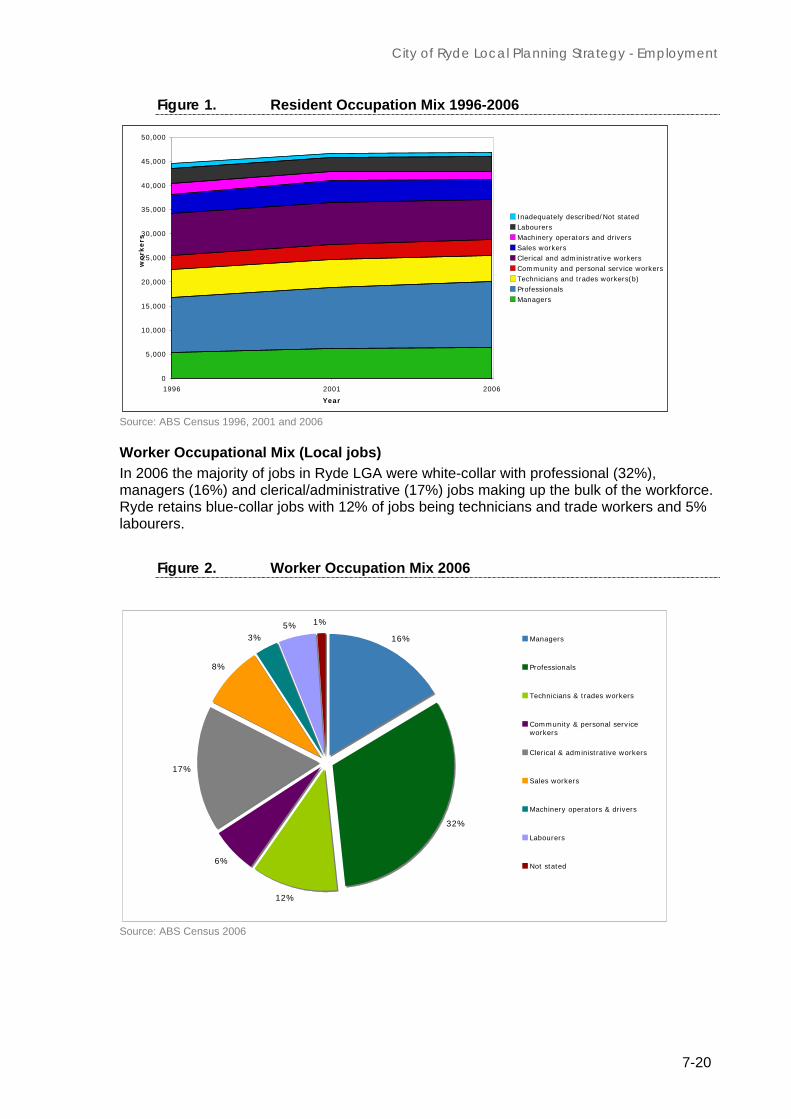
Residents Occupational Mix Figure 1 below indicates the employment profile of City of Ryde residents between 1996 and 2006. There has been a steady increase in the proportion of residents in white-collar employment within Ryde LGA between 1996 and 2006, whilst the proportion of blue-collar workers has declined slightly over the same period. The proportion of residents in service related employment has remained fairly consistent over the 10 year period. These statistics show that the resident labour force is becoming more involved in white-collar employment than blue or service related employment.
City of Ryde Local Planning Strategy - Employment
7-20
Figure 1. Resident Occupation Mix 1996-2006
0
5,000
10,000
15,000
20,000
25,000
30,000
35,000
40,000
45,000
50,000
1996 2001 2006
Year
wo
rkers
Inadequately described/Not statedLabourersMachinery operators and driversSales workersClerical and administrative workersCommunity and personal service workersTechnicians and trades workers(b)ProfessionalsManagers
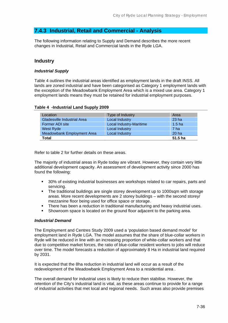
Source: ABS Census 1996, 2001 and 2006 Worker Occupational Mix (Local jobs) In 2006 the majority of jobs in Ryde LGA were white-collar with professional (32%), managers (16%) and clerical/administrative (17%) jobs making up the bulk of the workforce. Ryde retains blue-collar jobs with 12% of jobs being technicians and trade workers and 5% labourers.
Figure 2. Worker Occupation Mix 2006
16%
32%
12%
6%
17%
8%
3%5% 1%
Managers
Professionals
Technicians & trades workers
Community & personal serviceworkers
Clerical & administrative workers
Sales workers
Machinery operators & drivers
Labourers
Not stated
Source: ABS Census 2006

City of Ryde Local Planning Strategy - Employment
7-21
Where do workers come from? Of relevance is where people come from to work in Ryde. Most workers either reside in Ryde or travel from the west and north west to access employment in the area with the most popular LGAs (outside of Ryde) being Hornsby, Baulkham Hills and Parramatta.
Figure 3. Where Ryde workers live
13,169
5,460
4,243 4,174
3,1592,501
1,655 1,519 1,408 1,353
19,673
0
5,000
10,000
15,000
20,000
25,000
Ryde (C) Hornsby (A) Parramatta(C)
BaulkhamHills (A)
Blacktown(C)
Ku-ring-gai(A)
Warringah(A)
Canada Bay(A)
Sydney (C) Willoughby(C)
Other areas
Source: ABS Census 2006 Business Profile
There is estimated to be over 13,000 businesses operating in Ryde across a range of industry sectors. This range of businesses includes major corporate sector companies such as Optus currently with 6,500 employees, Foxtel with 1600 employees and Macquarie University having over 5,000 teaching / administrative staff in 2008.
The majority of businesses are in the small to medium size range, usually up to 300 employees and specializing in sectors such as: information and digital technology, pharmaceuticals, biomedical, research and development. Retail employment in all centres is significant, with concentrations of specialist retail employees employed at the regional centres - Macquarie Shopping Centre and Top Ryde City.
An emerging ‘creative industries sector cluster’ is represented by companies such as McGraw Hill( printing and publishing) , Aristocrat (digital gaming and associated technologies), FOXTEL (film , television production, global broadcasting) and MIX106.5FM (major commercial and community radio stations).
TAFE NSW at Ryde and Meadowbank and the Ryde and Macquarie hospitals are also major specialist local employers associated with tertiary education and medical / health services, with occupations represented from a wide range of white collar technical, research and professional groups.

City of Ryde Local Planning Strategy - Employment
7-22
7.3.2 Employment Areas - Existing Situation An over view of the character of the land that permits employment activities within the City are outlined in Table 2 (located at the end of this part) and is outlined as follows: Specialised Centre - Macquarie Park – North Ryde
Macquarie Park – North Ryde and Macquarie University are described as a ‘Specialist Centre’ according to the Inner North Subregion Draft Subregional Strategy (lNSS) classification and contributes to the northern part of NSW’s ‘Global Economic Corridor’. This area contains small to medium businesses (SMEs) and major businesses, combining commercial uses and their head office locations for high tech digital, IT&T, pharmaceuticals, biomedical services, media and research and export development business sectors. (Examples include Sony, Microsoft, Honeywell, Novartis, Johnson and Johnson, McGraw-Hill, Toshiba and Fujitsu). Many of these businesses are sub-branches of national or global networks and have an international business focus. Such businesses attract white collar workers for specialist jobs from across the metropolitan region.
The Metropolitan Strategy – Global Arc The Draft INSS states that the corridor currently contains approximately 800,000 sq.m of employment land uses and around 32,200 jobs and is the third largest business district in the Metropolitan Region, after the Sydney CBD and North Sydney. In the last 15 – 20 years the area has experienced rapid employment growth of between 800 and 1000 jobs each year and a doubling of floor space.

City of Ryde Local Planning Strategy - Employment
7-23
The continued development and intensification at Macquarie Park is planned to support a vibrant mixed use centre due to its large employment base. If growth expectations are met, Macquarie Park will become the 4th largest business district in the country, larger than Perth and Adelaide. It is currently larger than Parramatta and North Sydney in terms of commercial floor space provision. As part of the Corridor, Macquarie University has had recent DA approval for over $1 billion in development (mostly commercial and R&D). Several more growth stages of the university will include over 600,000sqm for the accommodation of up to 55,000 Macquarie University staff and students by 2031. In 2031 Ryde Council estimates a combined total of 160,000 workers (white collar technical and R&D professionals and administrative employees) students and other university related employees. Macquarie University Hospital 2010
Industrial Areas - Gladesville and West Ryde
Within the Gladesville and West Ryde centres industrial areas, the business focus is primarily on local level business services such as smash repairs, storage, light engineering, printing, small scale logistics and showrooms. The businesses are usually small employing between 5 and 40 blue-collar workers. With the demand for industrial uses likely to reduce then stabilise, the Employment and Centres Study 2009 identifies that for future demand / need for industrial land in Ryde LGA there has been a shift away from blue to white collar jobs. In 1991 for example, white collar jobs were 37 per cent of the workforce, which by 2001 had increased to a much larger 49 per cent. Hence the conclusion of the reduced need for additional ‘traditional’ industrial land in Ryde and the need for non industrial uses such as creative - based industries. Meadowbank The Meadowbank Employment Area began its transformation from an industrial area comprising manufacturing/auto activities to a residential/commercial area in the late 1990s. The transition occurred as a result of a new set of planning controls that reflected the emergence of the Parramatta River as a residential and commercial corridor - a development trend that was occurring in Rhodes, Cabarita and elsewhere along the river.

City of Ryde Local Planning Strategy - Employment
7-24
The transition of the areas was a reaction to the relocation, down scaling and closure of heavy industrial activities within the inner ring suburbs. This issue is addressed in the Employment and Centres Study 2009. Today, the area has approximately 500 residential units, a retail focus near the station and upgraded public domain network. A range of employment and light industrial activities, such as auto repair activities, continue to operate. The revision of the planning controls in 2008, once in place, will continue its growth as a residential area. Town Centres The implementation of the Urban Villages Policy in the late 1990s was the trigger to commence a planning program that would provide opportunities to concentrate a mix of high density residential and employment land uses within the City’s town centres. These land uses would be supported by good public transport and a functional public domain network. A review of the planning framework for the 4 town centres has been undertaken and implemented to enable revitalisation. However in a number of the centres the redevelopment has been ad hoc and concentrated on the larger sites. Examples include West Ryde Marketplace and Top Ryde City. Recent approvals have been given for the redevelopment of the Eastwood Shopping Centre and the development of the Anthony Road Car Park site (West Ryde) as a mixed use development. While the reasons for the “slowness” in redevelopment within the centres has not been fully researched it can be attributed to small allotments, fragmented ownership, access/capacity of the local/major road network and market demand. In an attempt to address these issues a program has commenced to review the planning provisions for Eastwood and West Ryde. Smaller Centres Smaller centres in Ryde are scattered in the middle of the City and provide a wide variety of other employment – generating land uses including retail, small scale manufacturing and commercial/ office activities. Some smaller local convenience and retail strip shopping centres remain viable and profitable. These areas are generally located in neighbourhoods with good public and pedestrian transport connections and include such centres as Boronia Park, Putney, Sager Place and Blenheim Road. Further information on the role and contribution of the smaller centres is described in the Small Centres Study 2009.

City of Ryde Local Planning Strategy - Employment
7-25
Table 2. Employment Lands - An Overview
This table provide a description of the City’s industrial areas and the town, small and neighbourhood centres
Industrial Areas Total Size (Land Area)
(Ha)
Land Use LEP 2010 - Zoning
Gladesville 23 Mainly automotive and business trades Light Industrial IN2
Meadowbank Employment Area
20 Automotive, light engineering and business trades Mixed Use - B4
Meadowbank – Former ADI Site
1.5 Maritime and light engineering Industrial Waterfront - IN4
West Ryde 7 Local industry mainly automotive related businesses Light Industrial IN2

City of Ryde Local Planning Strategy - Employment
7-26
Centres Overview - Town, small and neighbourhood centres
Centre Total Size (m2)
Land Uses Urban Form LEP 2010 -Zoning
Eastwood Existing Commercial – 37,024 sqm Retail - 46,445 sqm *Based on Eastwood Commercial Centre and Planning Study and Masterplan by ERM and Hirst Consulting, October 1998 Shopping centre – 14,700sqm Strip Retail – 31,745sqm Proposed (DA approved floor space) Commercial – 2,000 sqm Retail - Shopping centre redevelopment 15,200sqm resulting in 500sqm of additional retail floor space.
General Land uses Large shopping centre Small retail Professional services Government services Specific Land Uses Retail strip shopping and specialty stores, banks, restaurants, cafes, small food i.e. butchers, grocers, professional services, goods and services, etc
Strip retail dominated by double storey development Mainly double storey development with retail frontage with the exception of a number of sites – being the Eastwood shopping centre and commercial buildings located in Rowe Street East. The Rowe Street mall is a dominant feature that assists in guiding the function of the Centre The function and identity of the Centres are affected by the railway line
B4
Ryde Existing Commercial - 11,800 Retail - 10,621 (excluding previous shopping centre of approx. 7,000sqm) † Proposed (DA approved floor space)
General Large retail Professional services Government community services Local government Small retail Specific Land uses A mix of retail uses provided within
Mainly double storey development with retail frontage within the exception of the new Top Ryde development, Heritage precinct, School, park and shopping centre Top Ryde City will be introducing 17 storeys within the Centre. The built form adjoining the Centres s 3 – 4
B4 ,SP2 and RE1

City of Ryde Local Planning Strategy - Employment
7-27
Centre Total Size (m2)
Land Uses Urban Form LEP 2010 -Zoning
Commercial – additional 10,000 – 40,000 sqm* Shopping centre and Strip Retail – additional 65,000sqm
the shopping centre (currently under construction) Strip retail - Services, Post office, Small retail, chemist, real estate, small food, restaurant
storey flat buildings. The Heritage precinct is dominated by St Anne’s Church and The Parsonage.
Gladesville Existing Commercial - Approx 8,500 Retail - Approx. 14,000 † Proposed - Draft planning instrument Commercial - additional not available. Retail – approximately 2,000.
General Small retail Restaurants/ food outlet Activities supporting the motor vehicle eg car wash, repair workshops Specific Land Uses Sport stores, commercial office space, real estate, Cafes, restaurants, hair and beauty shop, medical (chiropractor), newsagency, chemist, automotive, Household goods and appliances, photographic stores,
The general built form consists of one to two level buildings with limited public domain Linear shopping strip – Large sites- servicing drive in activities. The function and identity of the Centre is divided by Victoria Road – being the volume of traffic and the ease at which pedestrians can move around the Centre. Heritage - building and significant facades - from the late 19th Century. The centre is covered by a draft heritage conservation area
B4, B6 and SP2
West Ryde Existing Commercial – Not available Retail - Approx. 7,500 (including supermarket centre) ^ Proposed Commercial – Not available Retail - Approx. 5,000
General Retail Community/ local government activities Residential Specific Land Uses
The predominant urban form is two storey development of older stock. West Ryde Market Place single storey development with small plaza area. At grade car park sites on Anthony Road has approval for a 7 storey mixed use development
B4 and SP2

City of Ryde Local Planning Strategy - Employment
7-28
Centre Total Size (m2)
Land Uses Urban Form LEP 2010 -Zoning
Supermarket Small retail and convenience stores, Petrol Stations, handyman store, Hotel, Small retail in a small arcade
Strip shopping centres along Victoria Road – 2- 3 storey row shops with the larger sites comprising commercial building and petrol stations on the edges of the Centre. Residential towers at the rail way station - visually dominate the skyline of the centre The rail splits the centre and its function On the eastern side of the centre are shops, services and the RSL Club servicing the local communities’ needs. The 2 storey shops on Ryedale Road are within a Heritage conservation area.
Cox’s Road Commercial – Not available Retail – Approx. 2,500
Small local retail – Local Services -hairdresser, beauty shop, travel agency Small food - restaurant, cafés, bakery store Community - library , schools
The built form is generally double storey shop front style development of an older stock.
B1 and SP2
Meadowbank
Commercial – Not available Retail - approximately 10,000
Retail – Small Supermarket, Small food -café Local services
Two new residential development of between 4 – 7 storeys. The area also comprises a number of industrial buildings that are 1 -2 storey. Strip centre – comprising 2 storey development with shop fronts and retail on the ground floor Ground and sub floor within the multi storey residential development
B4
Midway Commercial - Approx 500 Retail - Approx. 1000
Retail – Small Supermarket Retail – Petrol Station, automotive Small food - delicatessen
The built form is generally single to two storey development in amongst low density development
B1

City of Ryde Local Planning Strategy - Employment
7-29
Centre Total Size (m2)
Land Uses Urban Form LEP 2010 -Zoning
Local Services and commercial offices
Putney Commercial - Not available
Retail - Approx. 1,000
Retail - Small Supermarket Retail – Petrol Station Small food - cafes Local services - Tab
A small village generally made up of one to two storeys. The centre is surrounded by low scale residential development.
B1
Blenheim Road
Commercial - Not available Retail - Approx. 1,000
Small food - cafes Local services hairdresser, beauty shop, petrol station, café, newsagency, pharmacy, bottle shop Community – baby health
All single storey development. Low density surrounded by low density residential development
B1
Fiveways Commercial - Not available Retail - Approx. 1,000
Small food restaurant, cafe Local services –petrol station, , newsagency, pharmacy, bottle shop
All single to double storey development surrounded by low density residential development.
B1
Pittwater Road
Commercial - Not available Retail - Approx. 1,000
Small food – restaurant, metro supermarket Local services –, , automotive tyre shops, creative framing store, medical, , café
All single to double storey development surrounded by low density residential development. A large vacant site
B1
Trafalgar Place
Commercial - Not available Retail - Approx. 500
Small food - Café, small take away/restaurant, small supermarket, Local services - bottle shop, newsagency, chemist, sports
Two storey development – U shaped built form and active plaza.
B1

City of Ryde Local Planning Strategy - Employment
7-30
Centre Total Size (m2)
Land Uses Urban Form LEP 2010 -Zoning
centre, North Ryde/ Macquarie Park Corridor
Existing Commercial - 756,000 ^ Retail - 85,463 * Proposed Commercial – 82,000 ° Retail – 32,000 ( shopping centre)
High tech – electronic, computer, pharmaceutical and educational, Macquarie Centre Retail
SP2, B3, B4 and B7
Mecone - Employment and Centres Study 2009

City of Ryde Local Planning Strategy - Employment
7-31
7.4 Analysis and discussion

City of Ryde Local Planning Strategy - Employment
7-32

City of Ryde Local Planning Strategy - Employment
7-33
This section provides a broad analysis of the employment sectors within the City 7.4.1 Key Employment Sectors
The following industry sectors in Ryde have been identified as having at or above metropolitan average proportion of jobs. These include a range of small to medium businesses, as well as large corporate business entities:-
• Retail, Retail jobs are spread throughout all centres with concentrations associated with the major two shopping centres being The Macquarie Shopping Centre and Top Ryde City;
• Finance and Insurance services - Aussie, NRMA, Banks, Credit Unions, consultancies, Jobs from these sectors are spread relatively evenly throughout the LGA centres with concentrations in Town Centres (Eastwood, West Ryde, Gladesville) and clustered in major shopping centres – Macquarie Shopping Centre and Top Ryde City once construction is complete;
• Professional, scientific and technical services – CSIRO, Leading white collar sectors for the LGA concentrated at Macquarie Park – North Ryde, other smaller concentrations in Gladesville, Meadowbank;
• Administrative and support services, - community services, Concentrations in conjunction with Town Centres, Top Ryde, Macquarie Park;
• Education and training – University, TAFE NSW, Macquarie Community College, NSW Dept Education & Training Areas of high representation include Ryde, Meadowbank, and Macquarie Park;
• Health care and social assistance – Ryde Hospital, Salvation Army, Centre Link, NFP general, Areas of concentration include – North Ryde, Top Ryde, Eastwood and Gladesville.
Table 3 - ANZIC Industry Jobs 2009 – Ryde The Australian and New Zealand Standard Industrial Classification ( ANZIC) figures outlined in table 3 indicate that the proportion of residents in white-collar employment in the Ryde LGA between 1996 and 2006 has been driven by the growth and development in the Macquarie Park – North Ryde corridor as referred to earlier in this Study Report. Over the same period the proportion of blue-collar workers has declined. The proportion of residents in service-related employment has remained fairly consistent over this 10 year period. Trends suggest that the resident labour force will continue to be employed in white-collar, professional employment, rather than blue collar trades or services-related employment.

City of Ryde Local Planning Strategy - Employment
7-34
ABS Census 2006
Home based (Micro)business
Home-based business is one of the fastest growing sectors in the NSW economy, making up about two-thirds of the State’s small businesses. Home-based business in Ryde is becoming popular and there is increasing community interest to work from home, to reduce overheads and costs. Home-based businesses are as varied as, small scale production, digital design and computer support services, professional services such as, accounting, financial planning, health and well being and on-line product sales. It is estimated that there are over 3,000 local home-based businesses.
Given the importance of home – based business (home industry / home business –definition from Ryde LEP 2008) consideration needs to be given to providing greater opportunities for home based business throughout the LGA. The Employment Study identifies Small office / home office (SOHO) development as ‘a style of mixed use development that supports white – collar home based business’ and combining working and living space in a single tenancy. Home based businesses and SOHO operate successfully with Broadband access and other local support services such as on-going Council and stakeholder business advice services. SOHO development has been successfully developed in other states and locally in the City of Sydney’s Green Square Urban Renewal Area.
Operating a business from home has also become increasingly common, as a result of the digital revolution, outsourcing, overall trends to self-employment and the growth of service sector industries. Apart from the economic value of this growth trend, local communities experience associated social and environmental - related benefits. It is considered that if there is amenity - related issues, these can be resolved by Council reviewing the appropriate land use table and development standards in Draft LEP 2008.
ANZIC Industry number Ryde %
Sydney Statistical Division %
Agriculture, Forestry & Fishing 89 0.2 0.5Mining 42 0.1 0.2Manufacturing 3,574 7.6 9.7Electricity, Gas, Water and Waste Services 377 0.8 0.8Construction 2,701 5.8 7.1Retail Trade 4,792 10.2 10.5Wholesale Trade 3,091 6.6 5.5Accommodation and Food Services 2,801 6 6.1Transport, Postal and Warehousing 1,703 3.6 5.4Information Media and Telecommunications 1,684 3.6 3Financial and Insurance Services 3,175 6.8 6.4
Rental, Hiring and Real Estate Services 833 1.8 1.8Professional, Scientific and Technical Services 5,235 11.2 8.9Administrative and Support Services 1,706 3.6 3.4Public Administration and Safety 2,284 4.9 5.6Education and Training 3,881 8.3 7.2Health Care and Social Assistance 5,157 11 9.9Arts and Recreation Services 584 1.2 1.4Other Services 1,861 4 3.8
Inadequately described or Not stated 1,198 2.6 2.8Total 46,768 100

City of Ryde Local Planning Strategy - Employment
7-35
Industry/Innovation Clustering and Business Improvement Districts
Ryde Council supports the approach proposed by the Draft INSS to encourage clustering of business activities around ‘magnet infrastructure’ (heavy rail, major roads) to investigate further opportunities for innovation clusters. Generally, clusters are concentrations of similar, inter-connected businesses, working in a particular industry or geographic area. The new Macquarie University hospital, for example, is attracting interest from biomedical companies and medical device companies who can supply products and services to the hospital when it opens in 2010. Cluster enterprises share common business objectives and outcomes and encompass linked industries which are important to competition. Ryde Council has held discussions with the NSW Department of Industry and Investment which provides Councils’ dollar for dollar funding for cluster identification and research.
The City of Ryde Economic Development Strategy 2009 – 2014 also explains that Ryde LGA contains potential significant clusters associated with Macquarie University, two TAFE NSW colleges, scientific research facilities linked to the CSIRO and leading health, pharmaceutical and IT&T industries. There are also over 30 primary and secondary schools. Ryde Council has been working to foster the establishment of Ryde as a ‘Education centre of excellence’, particularly in relation to the role of Macquarie University.
7.4.2 Employment Self Sufficiency The Ryde LGA in 2006 contained 124 jobs for every 100 workers. This figure, shown below increased over the 2001 to 2006 period, is now approaching the ‘employment self sufficiency rate’ of the broader Inner North Subregion, which includes the North Sydney CBD.
Figure 4 - Ryde and Inner North Subregional Employment Self Sufficiency – 2001-2006
112%
135%124%
132%
0%
20%
40%
60%
80%
100%
120%
140%
160%
Ryde Inner North Region20012006
Source: ABS Census 2001 and 2006
City of Ryde Local Planning Strategy - Employment
7-36
7.4.3 Industrial, Retail and Commercial - Analysis The following information relating to Supply and Demand describes the more recent changes in Industrial, Retail and Commercial lands in the Ryde LGA. Industry Industrial Supply Table 4 outlines the industrial areas identified as employment lands in the draft INSS. All lands are zoned industrial and have been categorised as Category 1 employment lands with the exception of the Meadowbank Employment Area which is a mixed use area. Category 1 employment lands means they must be retained for industrial employment purposes.
Table 4 -Industrial Land Supply 2009
Location Type of Industry Area Gladesville Industrial Area Local Industry 23 ha Former ADI site Local Industry-Maritime 1.5 ha West Ryde Local Industry 7 ha Meadowbank Employment Area Local Industry 20 ha Total 51.5 ha
Refer to table 2 for further details on these areas. The majority of industrial areas in Ryde today are vibrant. However, they contain very little additional development capacity. An assessment of development activity since 2000 has found the following:
30% of existing industrial businesses are workshops related to car repairs, parts and servicing.
The traditional buildings are single storey development up to 1000sqm with storage areas. More recent developments are 2 storey buildings – with the second storey/ mezzanine floor being used for office space or storage.
There has been a reduction in traditional manufacturing and heavy industrial uses. Showroom space is located on the ground floor adjacent to the parking area.
Industrial Demand The Employment and Centres Study 2009 used a ‘population based demand model’ for employment land in Ryde LGA. The model assumes that the share of blue-collar workers in Ryde will be reduced in line with an increasing proportion of white-collar workers and that due to competitive market forces, the ratio of blue-collar resident workers to jobs will reduce over time. The model forecasts a reduction of approximately 8 Ha in industrial land required by 2031. It is expected that the 8ha reduction in industrial land will occur as a result of the redevelopment of the Meadowbank Employment Area to a residential area . The overall demand for industrial uses is likely to reduce then stabilise. However, the retention of the City’s industrial land is vital, as these areas continue to provide for a range of industrial activities that met local and regional needs. Such areas also provide premises

City of Ryde Local Planning Strategy - Employment
7-37
that are often affordable to purchase or rent and such spaces support emerging businesses. Areas in the City that also provide this opportunity are along Victoria Road adjoining the edge of town centres. Retail Retail Supply Table 5, based on 2005 figures, provides an overview of the supply of retail floor space within Ryde’s centres. Table 5 – Existing Supply - Retail in Centres
Centre/Location Existing (sqm) Comments Eastwood 32,300 Ryde 67,800 Includes Top Ryde
City of 65,000sqm Gladesville 14,300 West Ryde 17,900 Meadowbank 10,000 Include 1200 sqm
outside the Water Point development-
Macquarie Park 94,000 Includes Macq Centre 88088 sqm-
Other Centres 4,500 Approximation of sqm in small and neighbourhood centres
TOTAL 240,700 Source: Ibecon Economic Report submitted with the development application for Top Ryde Shopping Centre - 2006 This figure is to be considered in relation to the additional retail floor space resulting from recent development approvals including Anthony Road West Ryde (4,000sqm) Eastwood Centre (500sqm additional retail floor space) and the Macquarie Shopping Centre (32,000sqm). These developments will result in an additional 36,500 sqm of retail space Retail Demand The information outlined above indicates that Ryde has a supply of 277,000 sqm of retail floor space. The Department of Planning’s Draft Centres Policy 2009 applies a retail demand figure of 2m2 of retail floor space per person to address the demand requirements of a population. Using this figure and with a population of approximately 100,000, the City requires 200,000sqm of retail floor space. As illustrated by the information above the City meets this demand. By 2031 it is anticipated that the City’s population will have increased between 17,000 and 25,000 persons – resulting in a population of between 117, 000 and 125,000. Using the retail demand figure of 2m2 per person, the City would require 250,000 sqm of retail floor space. With the development of the major shopping centres of Macquarie Centre, Eastwood Centre and the new development in West Ryde the retail demands of the City will be met. It is also reasonable to assume that further retail development activity will occur in the following centres:

City of Ryde Local Planning Strategy - Employment
7-38
Macquarie Park Corridor in the Delhi Road area and within the 3 station precincts. Redevelopment of the small centres such as Cox’s Road, Fiveways and Putney.
Master planning work to identify opportunities in these centres is currently being undertaken.
Top Ryde City 2009 Eastwood Mall 2009
Commercial Commercial Supply Table 6 provides the supply of commercial floor space (Gross Floor Area) within Ryde LGA based on the potential capacity available under the current planning framework. In summary, there is 938,000sqm of existing commercial floor space and floor space opportunities under the existing planning controls within Ryde LGA.
Table 6 Supply of Commercial Space – based on the Planning Controls
Centre/Location Existing (sqm) Eastwood 39,000 Ryde 50,000 Gladesville 38,000 West Ryde 4,000 Meadowbank 7,000 Macquarie Park/North Ryde 800,000 TOTAL 938,000
Source: City of Ryde Centres and Corridors Strategy 2010 With regard to the total commercial floor space within North Ryde - Macquarie Park there was approximately 526,000sqm in 2004/2005, growing to just under 684,000sqm in 2007/2008, representing an increase of 30%. As at January 2009, the total commercial stock within North Ryde stood at almost 756,000sqm; a substantial increase of 72,000sqm. The majority of office space in North Ryde is within Macquarie Park, with approximately 650,000sqm of floor space (Knight Frank 2008, CBRE 2008). Approximately 216,000sqm of floor space entered the Macquarie Park market between 2003 and 2008, with 112,000sqm alone being completed in 2007. Commercial Demand Research for this Study found that there was not a standard figure that could be applied to determine the demand for commercial floor space in relation to the needs of an increasing population. However it is acknowledged that the City has achieved employment self sufficiency (refer to section 4.2) mainly through the commercial sector and it is anticipated that the future supply of commercial floor space will be provided mainly in Macquarie Park.
City of Ryde Local Planning Strategy - Employment
7-39
The Employment and Centres Study 2009 describes Macquarie Park as the pre-eminent commercial centre in Ryde and one of Sydney’s largest commercial areas. The continued development and intensification in this centre is likely to continue over time and this trend is in line with recent development trends and the capacity of the Macquarie Park – North Ryde and Top Ryde areas as commercial centres. The future growth in white-collar jobs in Macquarie Park alone is likely to outpace population growth. The potential for a commercial corridor elsewhere is broadly based around Victoria Road as outlined below (section 4.4). A Victoria Road economic corridor would not directly compete with the Macquarie Park – North Ryde corridor, being a lower rent and more service/light industrial-oriented area. However, there is the potential for this corridor to differentiate itself through the encouragement of start up businesses, SOHO provision associated with creative industries and support services for businesses in Macquarie Park and Parramatta. 7.4.4 Victoria Road Economic Corridor A long Victoria Road in areas adjoining the centres and the industrial areas there is a potential corridor of economic activity. This potential corridor is referenced in the Inner North Subregional Strategy. The corridor has been identified as an area of Ryde which would allow emerging businesses and industries to take advantage of cheaper land prices and rents. The outcome would be to encourage a broader range of uses including the creative industries sector. These areas provide low cost accommodation for a range of local and regional services, including start-up offices, light industrial, showrooms, building supplies and retail. As a key corridor detailed in the Centres and Corridors Study, the Victoria Road Corridor runs through West Ryde, Gladesville and two industrial precincts identified as strategic employment lands in the Inner North Subregional Strategy.

City of Ryde Local Planning Strategy - Employment
7-40
MECONE – Extent of Victoria Road Economic Corridor 7.4.5 Employment Target The Metropolitan Strategy 2005 and the Inner North Draft Sub Regional Strategy requires the City of Ryde to cater for an additional 21,000 workers by 2031. Table 7 outlines the City of Ryde S94 Contributions Plan 2007 overall forecast growth of Ryde’s centres. The majority of employment growth is forecast to occur in white-collar employment located in the Macquarie Park - North Ryde corridor. Table 7 - City of Ryde S94 Contributions Plan 2007 - Growth Forecast
2004 2014 2024 2034
Gross Floor
Area Workers Gross Floor
Area Workers Gross Floor
Area Workers Gross Floor
Area Workers Macquarie
Park Corridor 800,000 40,000 950,000 47,500 1,100,000 55,000 1,250,000 62,500 Ryde Town
Centre 23,000 690 35,000 1,050 105,000 3,150 115,000 3,450 Eastwood
Village 830 2,921 90,000 3,157 97,000 3,395 97,000 3,395 West Ryde
Village 12,000 357 19,000 580 22,000 670 24,000 730 Gladesville
Village 21,000 774 23,000 849 31,000 1,174 40,000 1,500

City of Ryde Local Planning Strategy - Employment
7-41
Meadowbank Employment
Area 151,000 2,302 176,000 3,235 200,000 4,168 200,000 4,168 Gladesville
Industrial Area 240,000 2,400 239,000 2,390 239,000 2,390 239,000 2,390
1,247,830 49,444 1,532,000 58,761 1,794,000 69,947 1,965,000 78,133 Source: City of Ryde S94 Contributions Plan 2007 The table indicates that over 28,600 jobs will be provided in the City as a result of development within the Centres and industrial areas. In 2007 Macro Plan, a planning consultancy undertook an assessment of jobs growth in the City, as part of the employment lands assessment undertaken for the Meadowbank Master plan. This assessment indicated that the growth of the commercial /office sector between 2004 - 2031 would result in the creation of 39,000 jobs. The main growth area would be the Macquarie Park Corridor. Considering of both set of figures it is apparent that the City will meet the target of 21,000 additional jobs by 2031.

City of Ryde Local Planning Strategy - Employment
7-42

City of Ryde Local Planning Strategy - Employment
7-43
7.5 Key findings and directions

City of Ryde Local Planning Strategy - Employment
7-44

City of Ryde Local Planning Strategy - Employment
7-45
This section provides an outline of the key issues relating to employment land within the City over the 5 years to 2015. The issues are based on the economic analysis and findings contained within the Employment and Centres Study 2009. 7.5.1 Key Findings The economic analysis from the Study indicates the following key findings regarding future occupations and employment growth in Ryde:
• There will be significant jobs growth in white-collar occupations.
Employment growth in Ryde will outstrip population growth primarily driven by white-collar jobs growth in Macquarie Park and to a lesser degree in Ryde Town Centre.
Over the period to 2031 it is forecast that the need for commercial space will increase while the need for industrial land will decrease from 49 Ha to 41 Ha.
• There are an increasing proportion of white-collar jobs in Ryde compared to
resident workers and this trend will continue.
Ryde provides approximately 1.24 white-collar jobs for every white-collar worker residing in the City. This high white-collar self sufficiency is due to the major employment role of the Macquarie Park/North Ryde corridor. With the forecast growth of Macquarie Park and North Ryde it is likely that there will be a higher proportion of white-collar jobs in Ryde over time.
• The employment target and current growth projections will be accommodated.
While research has not been undertaken to test the ultimate development capacity of planning controls, The City of Ryde Centres and Corridors Study has advised that the growth figures as outlined in section 4.5 can be achieved within the current planning framework. This is mainly because there is significant latent capacity in the Macquarie Park/North Ryde area, where the majority of growth is projected to occur. However further consideration could be given to introducing planning provisions that would encourage a building typology in the town and small centres that would assist the growing home based business sector and small businesses.
• Industrial Land requirements will stabilise.
With population growth the demand for activities such as automotive repairs, domestic storage, plumbing supplies and light engineering may increase. However, Ryde’s industrial areas are at a comparative disadvantage when compared to competing industrial areas in Western Sydney. These areas are better located in terms of freeway standard access and are relatively cheaper and closer to their labour market. This has lead to increasing industrial vacancies in areas such as Meadowbank. However there is a need to retain the industrial zoned land as these areas provide local services, and in time create opportunities for emerging businesses due to affordable accommodation and proximity to centres such as Macquarie Park and Parramatta.

City of Ryde Local Planning Strategy - Employment
7-46
While expanding the physical area of the industrial land is not required, a future study to review the current planning controls such as height and floor space ratios may assist in retaining these areas as viable employment lands.
• Ryde has adequate regional and sub-regional shopping services. However,
there is a spatial imbalance and there may be the opportunity to expand centres in the north-eastern part of Ryde.
Ryde has adequate retail services to meet its residents shopping needs with projected supply. The majority of retail is however located in a few large centres servicing catchments broader than the City of Ryde. There may be the opportunity to expand centres or create new retail centres that are well located and that service the needs of workers or broader retail catchment areas. North Ryde at Delhi Road (North Ryde Railway Station) and Cox’s Road are potential locations for such a centre.
7.5.2 Key Directions The following directions would assist in addressing the issues outlined above:
Explore the implementation of planning controls to support flexible work/home arrangements and small businesses provided through development styles such as Small Office/Home Office (SOHO) and dual key apartments (a self contained unit within an apartment that can be used as office accommodation) within the town centres and small centres.
Work with the key land owner (being the State Government) in the Delhi Road area
regarding the development of a retail precinct as part of the master planning process.
Undertake a study of the industrial areas within the City to identify strategies and recommendations to maintain these areas as viable employment lands
Economic and employment activity to continue along the Victoria Road
Corridor –in particular in areas adjoining the town centres and industrial areas.
Macquarie Park Corridor continues to be developed into a premium business
location through the implementation of the current planning framework

City of Ryde Local Planning Strategy - Employment
7-47
7.6 Strategy and Recommendations

City of Ryde Local Planning Strategy - Employment
7-48

City of Ryde Local Planning Strategy - Employment
7-49
7.6.1 The Strategy The Strategy is to guide the future of employment in the City of Ryde and is described as a series of Principles, Directions and Actions as identified below. Consideration of the Employment Principles, Directions and Actions should be viewed in the context of the other six studies prepared as background to the Local Strategy. , PRINCIPLE P1 Meet the employment target set by the Metropolitan Strategy and draft Inner
North Subregional Strategy
DIRECTION D1 Demonstrate how the employment target can be met by recent and current
planning D2 Protect and enhance employment opportunities ACTIONS Maintain existing zones and land uses in centres that currently provide
employment. Retain existing industrial zones at West Ryde and Gladesville Undertake a study of the industrial areas within the City to identify strategies and
recommendations to maintain these areas as viable employment lands.
Enable economic and employment activity to continue along the Victoria Road Corridor – in particular in areas adjoining the town centres and industrial areas.
DIRECTION D3 Support home – industries and home - businesses throughout the LGA ACTIONS Investigate controls to encourage small office – home office ‘SOHO development’
in and around all commercial centres. PRINCIPLE P2 Recognise and support Macquarie Park as a specialised centre and the
major employment area DIRECTION D4 Support the role of Macquarie Park – North Ryde as a premium location for
globally competitive businesses, as part of the NSW Metropolitan Strategy ‘Global Economic Corridor’
D5 Support the role of Macquarie Park as a major commercial centre ACTIONS Continues to develop Macquarie Park Corridor as a premium business location
through the implementation of the current planning framework.
PRINCIPLE P3 Support and enhance centres as important areas for business and
City of Ryde Local Planning Strategy - Employment
7-50
employment DIRECTION D6 Make centres vibrant and attractive areas people want to live, work and visit ACTIONS Continue the program of public domain upgrades for all centres to improve
attractiveness and appeal for business owners / tenants and customers. Renew small and neighbourhood centres – as per the recommendations outlined
within Small Centres Studies. 7.6.2 Recommendations Recommendations: This Study recommended the following: LEP 2011 No LEP amendments recommended. DCP No DCP amendments recommended. Others
Develop planning controls and guidelines to support flexible work/home
arrangements. Undertake a study of the industrial areas within the City to develop strategies and
recommendations to maintain these areas as viable employment lands. Explore with the key land owners (being the State Government) in the Delhi Road
area developing a retail precinct as part of the master planning process.

City of Ryde Local Planning Strategy - Employment
7-51
7.7 Response to the Metropolitan Strategy

City of Ryde Local Planning Strategy - Employment
7-52

City of Ryde Local Planning Strategy - Employment
7-53
7.7.1 Response to the Metropolitan Strategy - Economy and Employment
This section provides an outline of how the City of Ryde is responding to the economy and employment direction outlined in the Metropolitan Strategy and Inner North Sub Region - Draft Sub Regional Strategy (IN).
NO. DIRECTIONS AND ACTIONS CITY OF RYDE RESPONSE
A ECONOMY AND EMPLOYMENT A1 PROVIDE SUITABLE COMMERCIAL SITES AND EMPLOYMENT LANDS IN STRATEGIC
AREAS A1.1 PROVIDE A FRAMEWORK FOR ACCOMMODATING JOBS ACROSS THE CITY IN
A1.1.1
Inner North local councils to prepare Principle LEPs which will provide sufficient zoned commercial and employment land to meet their employment capacity targets.
City of Ryde can meet DoP employment capacity target of 21,000 (2031) within the current and planning framework.
IN
A1.1.2
The Department of Planning is to provide councils with Local Government Area employment capacity targets.
The employment target for the City of Ryde is 21,000.
A1.2 PLAN FOR SUFFICIENT ZONED LAND AND INFRASTRUCTURE TO ACHIEVE EMPLOYMENT CAPACITY TARGETS IN EMPLOYMENT LANDS
A1.3 ENGAGE WITH INDUSTRY REGARDING EMPLOYMENT LAND STOCK A1.4 CONTAIN THE REZONING OF EMPLOYMENT LANDS TO RESIDENTIAL ZONINGS ACROSS SYDNEY

City of Ryde Local Planning Strategy - Employment
7-54
NO. DIRECTIONS AND ACTIONS CITY OF RYDE RESPONSE IN
A1.4.1 The Department of Planning to complete a metropolitan and subregional review of Employment Lands, prior to considering any significant rezoning of employment lands to non- employment uses within the Inner North Region.
A response is not required.
A1.5 PROTECT AND ENHANCE EMPLOYMENT LANDS OF STATE SIGNIFICANCE IN
A1.5.1
The Department of Planning to investigate measures to protect and enhance State significant employment lands.
A response is not required.
A1.6 IMPROVE PLANNING DELIVERY OF EMPLOYMENT LANDS A1.7 MONITOR DEMAND AND SUPPLY OF EMPLOYMENT LANDS IN
A1.7.1
Establishment of an Employment Land Program in parallel with the Metropolitan Development Program and under the Sydney Land Supply Program will allow supply and update of employment lands in the Inner North Subregion to be monitored.
A response is not required.
A1.8 ESTABLISH A FRAMEWORK FOR DEVELOPMENT OF BUSINESS PARKS IN
A1.8.1
State Government and the City of Ryde to encourage greater use of public transport for Macquarie Park Specialised Centre with the opening of the Epping - Chatswood Rail Link.
The current and proposed planning framework and the transport infrastructure are aimed at encouraging a greater use of public transport and a reduction in private car usage in the Centre.
A1.9 FACILITATE THE USE OF OLD INDUSTRIAL AREAS IN
A1.9.1
Willoughby Council and the Department of Planning to implement its review of planning controls for the Artarmon Industrial Area to enable higher intensity employment uses in areas of good public transport access.
A response is not required.
N
A1.9.2
The Department of Planning to work with councils in identifying and implementing measures to manage interface issues between industrial and residential land uses.
A response is not required.

City of Ryde Local Planning Strategy - Employment
7-55
NO. DIRECTIONS AND ACTIONS CITY OF RYDE RESPONSE
A2 INCREASE INNOVATION AND SKILLS DEVELOPMENT A2.1 ESTABLISH A FRAMEWORK TO SUPPORT INNOVATION ACROSS SYDNEY IN
A2.1.1
The Department of State and Regional Development will work with other Government agencies and industries to achieve the policy goals for innovation in the sectors identified in the NSW Statement on Innovation.
A response is not required.
A2.2 STRENGTHENING INDUSTRY CLUSTERS IN
A2.2.1
The Department of State and Regional Development will participate in programs to better understand the drivers of opportunities for business clustering.
A response is not required.
IN
A2.2.2
The State Government to implement the expansion of Royal North Shore Hospital and Macquarie University as major projects.
A response is not required.
Note: Macquarie University has been accepted by the Department of Planning as a Major Project.
A2.3 SUPPORT MAGNET INFRASTRUCTURE IN
A2.3.1
The Department of State and Regional Development will continue to undertake programs that encourage clustering of business activities around magnet infrastructure.
A response is not required.
A2.4 UTILISE LOCAL ASSETS TO ENCOURAGE LEARNING AND INNOVATION A2.5 PROMOTE LEARNING CITY INITIATIVES IN SELECTED CENTRES IN
A2.5.1 The Department of State and Regional Development to work with councils, educators, Royal North Shore Hospital and research institutes to identify opportunities to strengthen linkages between these organisations, and to promote the further development of a ‘learning city’.
A response is not required.

City of Ryde Local Planning Strategy - Employment
7-56
NO. DIRECTIONS AND ACTIONS CITY OF RYDE RESPONSE
A3 IMPROVE OPPORTUNITIES AND ACCESS TO JOBS FOR DISADVANTAGED COMMUNITIES
A3.1 EMBEDDED SKILLS DEVELOPMENT IN MAJOR REDEVELOPMENT PROJECTS IN
A3.1.1 The Department of Planning and Department of Education and Training to prepare guidelines for agencies and local councils to decide when and how skills development components can be incorporated in projects.
A response is not required.
A3.2 INTEGRATION OF EMPLOYMENT AND HOUSING MARKETS A3.3 ENCOURAGE EMERGING BUSINESSES IN
A3.3.1
Local government to investigate strategies to ensure sufficient zoned land to enable the provisions of comparatively low cost premises for start up businesses.
The Local Strategy and LEP2011 propose to retain the current extent of industrial land (Zones IN2 and IN4) and the extent of Zone B1Neighbourhood Business. These zones support start up businesses.
IN
A3.3.2
The Department of State and Regional Development to continue to support business start up and expansion.
A response is not required.

City of Ryde Local Planning Strategy - Employment
7-57
Appendix A
Employment and Centres Study October 2009

1
Employment and Centres Study City of Ryde
October 2009

Signed*
………………………………………...………………………………………...………………………………………...………………………………………...
DATE: DATE: DATE: DATE: …………………………2009
* This document is for discussion purposes onlydiscussion purposes onlydiscussion purposes onlydiscussion purposes only unless signed and dated by the persons
identified. This document has been reviewed by the Project Manager.
CONTACT
Mecone Mecone Mecone Mecone
PO Box 357,
Bondi Junction,
NSW 1355
www.mecone.com.au
© Mecone
All Rights Reserved. No part of this document may be reproduced, transmitted, stored in a retrieval system, or translated into any
language in any form by any means without the written permission of Mecone.
All Rights Reserved. All methods, processes, commercial proposals and other contents described in this document are the
confidential intellectual property of Mecone and may not be used or disclosed to any party without the written permission of
Mecone.
Report AuthorsReport AuthorsReport AuthorsReport Authors
Ben Hendriks
Michael Gheorghiu

iii
Executive Summary................................................................................. v
1 Introduction........................................................................................ 1
1.1 Purpose .......................................................................................................................1
1.2 Report Scope...............................................................................................................1
1.3 Report Structure ..........................................................................................................1
1.4 Key Data Sources........................................................................................................1
1.5 Limitations....................................................................................................................2
2 Policy and Literature Review............................................................. 3
2.1 State and Regional Policies.........................................................................................3
2.2 City of Ryde Urban Villages Policy ..............................................................................7
2.3 Existing Transport Infrastructure ...............................................................................10
2.4 Global Arc ..................................................................................................................11
2.5 Other Literature Reviewed .........................................................................................13
3 The Role of Centres and Employment Areas in Ryde ................... 14
3.1 LGA Description ........................................................................................................14
3.2 Description of Centres and Employment Areas .......................................................20
4 Economic Assessment.................................................................... 30
4.1 Employment Profile ...................................................................................................30
4.2 Industrial Assessment ...............................................................................................35
4.3 Retail Assessment .....................................................................................................38
4.4 Commercial Assessment ..........................................................................................40
4.5 Sub-regional and Regional Development Trends.....................................................44
4.6 Infrastructure Drivers of Demand ..............................................................................45
4.7 Spatial implications of Economic Assessment .........................................................46
4.8 Key Findings and Directions .....................................................................................49
5 Potential Employment Planning Initiatives ..................................... 51
5.1 Small business “Annex” and “Precinct” ....................................................................51
5.2 Home Based Business and SOHO Development ....................................................51
5.3 Commercial and Retail Centres ................................................................................52
5.4 Employment Areas ....................................................................................................52
5.5 Creative Industries.....................................................................................................54
5.6 Case Studies .............................................................................................................54
6 Recommendations .......................................................................... 64
6.1 Governance and Economic Development................................................................64
6.2 Statutory Planning .....................................................................................................64
6.3 Strategic and Spatial Planning Recommendations ..................................................67
TABLE OF CONTENTS

Appendices............................................................................................ 70
Appendix A – Literature Review ........................................................................................70
Appendix B – Draft LEP 2008 zone Objectives and Permissible Uses............................82
Appendix C - Zone Conversion.........................................................................................89
Appendix D- Centre and Employment Area Planning Assessments .............................101
Appendix E – Creative Industry Paper ............................................................................135
Table 1. Review of Urban Village Strategy ............................................................8 Table 2. Population Forecast (2006-2031) Ryde LGA and Suburbs ..................19 Table 3. Industrial Land Use Review ...................................................................22 Table 4. Commercial and Retail Centres Land Use and Planning Review ........24 Table 5. Employment Profile City of Ryde LGA (1996-2006)..............................30 Table 6. ANZIC Industry Jobs 2006.....................................................................31 Table 7. Employment Land Supply 2009 ............................................................35 Table 8. Potential Future Industrial Land Requirement.......................................36 Table 9. Industrial Proposals 2009 ......................................................................37 Table 10 Retail Existing and Proposed 2009 .....................................................38 Table 11. Recently Approved Retail Development..............................................39 Table 12. Recently Approved Mixed Use Development .....................................39 Table 13. Potential Retail Activity .........................................................................40 Table 14. Potential Mixed Use Activity.................................................................40 Table 15. Estimated Existing and Proposed Supply of Commercial Space ......41 Table 16. Potential Future Commercial Floor Space Requirements ..................42 Table 17. Recent Commercial Development Approvals.....................................42 Table 18. Mooted Commercial Development .....................................................43 Table 19. Forecast Vacancy Rates – North Ryde Macquarie Park.....................43 Table 20. Forecast Spatial Distribution of Employment in Ryde 2004-2034......48 Table 21. Planning Recommendations and Implications for Draft LEP/DCP.....65
Figure 1. Ryde Transport Infrastructure and Linkages........................................11 Figure 2. Sydney’s Global Arc .............................................................................12 Figure 3. Spatial overview of Ryde ......................................................................16 Figure 4. Ryde in Regional Context .....................................................................18 Figure 5. Population Density 2006.......................................................................20 Figure 6. Resident Occupation Mix 1996-2006...................................................32 Figure 7. Worker Occupation Mix 2006 ...............................................................32 Figure 8. Where Ryde workers live ......................................................................33 Figure 9. Ryde and Inner North Subregional Employment Self Sufficiency – 2001-2006 ............................................................................................................34 Figure 10. Employment Self Sufficiency By Occupation.....................................34 Figure 11. Spatial Implications of Policy and Planning Recommendations.......69
List of Tables and Figures

v
Executive SummaryExecutive SummaryExecutive SummaryExecutive Summary Study PurposeStudy PurposeStudy PurposeStudy Purpose
1. Mecone was engaged by the City of Ryde in March 2009 to undertake an Employment and Centres Study for the Local Government Area of Ryde.
2. The primary objectives of the study were to:
a. Provide an understanding of the economic profile of the City of Ryde based on existing studies.
b. Compile and analysis key supply and demand data placing the City of Ryde in its regional economic context.
c. Provide land use planning directions on the above data.
d. Prepare a report containing the study findings.
Policy and Literature ReviewPolicy and Literature ReviewPolicy and Literature ReviewPolicy and Literature Review
3. Mecone has undertaken a review of literature and policy relating to Ryde.
4. It is clear from the policy and literature review that Ryde and Macquarie Park in particularly, play a highly important role in Sydney’s employment makeup.
5. The most important document guiding the growth of Ryde is the Draft Inner North Sub-regional Strategy. The draft Strategy establishes capacity targets to 2031. For the Inner North subregion, the Strategy identifies a capacity target of 60,100 jobs, out of which 21,000 will be created within Ryde LGA.
The Role of Centres and Employment Areas in RydeThe Role of Centres and Employment Areas in RydeThe Role of Centres and Employment Areas in RydeThe Role of Centres and Employment Areas in Ryde
6. Mecone compiled all available data on land uses and sizing of centres and employment areas in Ryde. An audit of all centres and employment areas was undertaken to validate the size and land uses in each centre.
7. The assessment of centres has fed into the supply assessment within the economic assessment of the report.
8. Mecone considers there are three key employment areas in Ryde:
a. Macquarie Park/North Ryde corridor as the sub-regions most important commercial office centre.
b. Smaller centres providing local retail and commercial needs.
c. The Victoria Road corridor which could grow into a “creative industry” corridor containing:
i. Gladesville Centre;
ii. Top Ryde;
iii. Meadowbank;
iv. The Gladesville and West Ryde industrial areas; and
v. West Ryde Centre.

9. Mecone also reviewed the draft controls within Draft Ryde Local Environmental Plan 2008. This assessment shows that as a conversion exercise there are no issues with the proposed draft zones for employment areas/centres.
Economic AssessmentEconomic AssessmentEconomic AssessmentEconomic Assessment
10. Mecone undertook an economic assessment of:
a. Employment in Ryde.
b. Supply and demand for retail uses.
c. Supply and demand for industrial uses.
d. Supply and demand for commercial uses.
e. Infrastructure Drivers of demand.
11. The key findings of the economic assessment are:
a. There will be significant jobs growth in white-collar occupations (of up to 100%) to 2031 with a stabilisation of blue-collar occupations. Floor space requirements could approach 1,600,000 sq.m for commercial space alone (up from approximately 800,000 sqm currently).
b. Draft Planning controls can accommodate current growth projections, with the majority of growth forecast to occur in Macquarie Park were there is significant unrealised capacity.
c. There are an increasing proportion of white-collar jobs in Ryde compared to resident workers and this trend will continue with up to two white-collar jobs for every resident worker in Ryde. This means more people will commute to Ryde to access jobs.
d. The growth in employment is likely to have significant transport implications particularly from the Western suburbs and Inner West.
e. Industrial land requirements will reduce then stabilise over time which is in line with the redevelopment of Meadowbank and potentially parts of the former ADI site as a mixed use precinct and retention of other industrial areas.
f. Ryde has adequate regional and sub-regional shopping services, however, there is a spatial imbalance and there may be the opportunity to expand centres in the north-eastern part of Ryde including North Ryde and Cox’s Road.
Potential Local Employment Planning InitiativesPotential Local Employment Planning InitiativesPotential Local Employment Planning InitiativesPotential Local Employment Planning Initiatives
12. Based on the economic analysis Mecone has identified the following potential local employment generating initiatives for Ryde:
a. Consider the establishment of small business “start-up areas”.
b. Encourage and provide controls for home Based Business and SOHO Development.
c. Provide a range of measures for commercial and retail centres including a review of floor space ratio and height controls in small centres to encourage vibrant mixed use centres.

d. Undertake a Masterplanning assessment to establish the potential development of the Cox’s Road Centre and Delhi Road into larger centres.
e. Review development controls in West Ryde Industrial area to explore:
i. Greater FSR; and
ii. Allow for creative industries within the land use table.
f. Consider implementing the draft policy controls to the MEA.
g. Explore the creation of an Enterprise Corridor in the vicinity of Gladesville Industrial Estate.
h. Explore measures to encourage Creative Industries.
13. In addition to these initiatives Mecone has identified six case study areas that typify some of the suggestions made in this chapter.
RecommendatiRecommendatiRecommendatiRecommendations ons ons ons
14. In order to implement the potential initiatives identified in this report, Mecone has prepared a range of governance and planning recommendations for the City of Ryde’s consideration.
15. Governance recommendations include:
a. Pursue grants and support programs for small business.
b. Continue public domain improvements.
c. Encourage start-up businesses.
d. Build dialogue with Government and business to assist and foster relationships.
e. Explore a regional approach to preparation of a ‘Creative Industry cluster strategy’.
16. The study makes a range of statutory planning recommendations to meet the following aims:
a. To revitalise small centres and provide greater local employment service opportunities to residents where appropriate.
b. To provide higher level of amenity and services such as shopping and entertainment to workers in key employment areas.
c. Allow for start up businesses and work from home space.
d. To revitalise employment areas to address changes in market preferences for employment space. This is to include more flexible space in centres and industrial areas – SOHO and Duel Key apartment provision.
17. The strategic and spatial planning recommendations include:
a. Undertake a detailed evaluation of the transport implications of the growth in employment in the LGA on transportation systems linking Ryde with Sydney Metropolitan Region.

b. Undertake an assessment of the increased development potential for Cox’s Road and Delhi Road (at North Ryde Station) to be designated as “Town Centres”.
c. In future strategic plans identify the area along Victoria Road (including Meadowbank) as a potential corridor of economic activity.
d. Work towards avenues for the evolution of Ryde into a future Major Centre.
e. Maintain industrial land supply.

1 of 142
1111 IntroductionIntroductionIntroductionIntroduction
1.11.11.11.1 PurposePurposePurposePurpose
Mecone was engaged by the City of Ryde Council to undertake an employment and centres study (the study) to assist the City of Ryde in developing planning strategies and controls for its centres and employment areas.
1.21.21.21.2 Report ScopeReport ScopeReport ScopeReport Scope
The primary objectives of the study were to:
� Provide an understanding of the economic profile of the City of Ryde based on existing studies.
� Compile and analyse key supply and demand data placing the City of Ryde in its regional economic context.
� Provide land use planning directions on the above data.
� Prepare a report containing the study findings
1.31.31.31.3 Report StructureReport StructureReport StructureReport Structure
The study is structured into six chapters: 1. Introduction.
2. Policy and Literature Review (including state, regional and local policies, and a
review of relevant literature.
3. The Role of Centres and Employment Areas in Ryde (including LGA description,
spatial overview, description of centres, existing hotspots and clusters, and other
employment generators.
4. Economic Assessment (including industrial, retail and commercial supply and
demand analyses.
5. Potential Local Employment Planning Initiatives.
6. Recommendations (including governance and economic development, statutory
planning and strategic planning.
1.41.41.41.4 Key Data SourcesKey Data SourcesKey Data SourcesKey Data Sources
This study draws on a wide range of information sources, including:
� NSW Department of Planning, Draft Subregional Strategy – Inner North Subregion
� MacroPlan Australia 2007 , Final Report – Employment Land Assessment,
Meadowbank Employment Area

2 of 142
� The Northern Sydney Regional Organisation of Councils Strategy
� City of Ryde Urban Village Policy
� City Vision 2022 and 2006 City Vision Follow Up Study
� Integrated Transport and Land Use Strategy 2007
� Gladesville Masterplan & DCP Commercial Assessment of Proposals 2006
� Gladesville Town Centre & Victoria Road Economic Development Strategy, L
MacDonald CoR 2008.
� Sydney Suburban Centres & Office Parks 2005-2019 – BIS Shrapnel 2005
� Top Ryde Shopping Centre Triple Bottom Line Assessment - MacroPlan 2006
� Top Ryde Redevelopment Options – Economic Appraisal 2005 IBECON & JBA
Urban Planning
� NSW Department of Planing 2009 – Draft Centres Policy
� City of Ryde Submission on Draft Inner North Subregional Strategy - Don Fox
Planning 2007
1.51.51.51.5 LimitationsLimitationsLimitationsLimitations
This report is prepared on the instructions of the party to whom it is addressed and is thus not suitable for the use other than that by that party. As the report involves future forecasts, it can be affected by a number of unforeseen variables. It represents for the party to whom or which it is addressed the best estimates of Mecone, but Mecone can give no assurance that any forecasts will be achieved.

3 of 142
2222 Policy Policy Policy Policy and Literature Reviewand Literature Reviewand Literature Reviewand Literature Review
2.12.12.12.1 State and Regional PoliciesState and Regional PoliciesState and Regional PoliciesState and Regional Policies
Metropolitan Strategy The City of Cities: A Plan for Sydney’s Future (Metropolitan Strategy) was released in 2005 to plan for Sydney’s future growth to 2031. It is based on five aims: enhance liveability, strengthen economic competitiveness, ensure fairness, protect the environment, and improve governance. The Metropolitan Strategy focuses on seven key strategies - Economy and Employment; Centres and Corridors; Housing; Transport; Environment and Resources; Parks and Public Places; and Governance and Implementation. The Metropolitan Strategy will cater for an additional 1.1 million people by 2031 by planning for an extra 640,000 dwellings, 500,000 jobs, 7,500 hectares of industrial land, 6.8 million sqm of office space, and 3.7 million sqm of retail space. Specifically relating to Ryde LGA, the Metropolitan Strategy identifies Macquarie Park as a growing business park that represents an industry cluster for information and communication technology industries, as part of the global economic corridor. Specifically, Macquarie Park is identified as a ‘Specialised Centre’ which is defined as containing ‘major airports, ports, hospitals, universities, research and business activities that perform vital economic and employment roles across the metropolitan area’. The Metropolitan Strategy has been the foundation for the development of subregional strategies for each of Sydney’s subregions. The draft Inner North Subregion, which included Ryde LGA, is described below. Draft Inner North Subregional Strategy The draft Subregional Strategy - Inner North Subregion (Draft INSS) is part of the implementation of the City of Cities: A Plan for Sydney’s Future (Metropolitan Strategy). The preparation and implementation of the Inner North Strategy is a key step in translating the Metropolitan Strategy to the local level. The Inner North Strategy recognises and addresses issues beyond individual local government areas. The draft Strategy establishes Key Directions and Key Actions which set a framework in which the strategy can achieve its aims and objectives. Similar to the broader Metropolitan Strategy, the draft Strategy addresses the following subject areas:
� Economy and Employment;
� Centres and Corridors;
� Housing;
� Transport;
� Environment, Heritage and Resources;
� Parks, Public Places and Culture; and

4 of 142
� Implementation and Governance.
Economy and Employment Economy and Employment Economy and Employment Economy and Employment Relating to the economy and employment, the draft Strategy establishes capacity targets to 2031. For the Inner North subregion, the Strategy identifies a capacity target of 60,100 jobs, out of which 21,000 will be created within Ryde LGA. Further, the draft Strategy identifies the following:
� That the Inner North Subregion contains a significant knowledge infrastructure.
� The key corridor in the subregion is from North Sydney to Macquarie Park which is part of the ‘Global Arc’.
� This subregion has a higher percentage of employees in property and business services, equating to 26%. Other sectors (by total employment) include retail, health and community services, and wholesale trade sectors.
� The draft Strategy identifies strategic employment lands within the subregional area which includes:
o West Ryde (Local Industry): a smaller industrial area of seven hectares providing local industry, especially automotive related businesses.
o Former ADI site, Ryde (Local Industry–Maritime): a small waterfront industrial area (1.5 hectares) which has historically supported working harbour activities and is currently used for boat repair facilities. A masterplan has been adopted for the site proposing maritime related activities.
The draft Strategy identifies the above sites to be retained for industrial purposes. The draft Strategy also states that ‘the Inner North Subregion is a relatively old, established part of the Sydney Region, where there is scarce underutilised land. The Subregion has experienced one of the highest rates of rezoning of Employment Lands over the last 19 years. Between 1987 and 2006 around 187 hectares of industrial land stock has been rezoned to other uses (see Table 6). The majority of the rezoning over this period relates to change of zoning of Macquarie Park from industrial to business zoning in January 2006, as it transitions from a traditional industrial area to a Specialised Centre.”
The draft Strategy states that preliminary findings from investigations on future demand for employment lands is set to continue to be strong to 2031.
Centres and CorridorsCentres and CorridorsCentres and CorridorsCentres and Corridors
Ryde is recognised as a ‘Town Centre’ and West Ryde as a ‘Village’ in the Metro Strategy. The Ryde Town Centre is located along Blaxland Road and Devlin Street. The centre has a predominant retail focus which includes Top Ryde. There are currently 3,500 jobs and 250,000m2 of mixed used residential, commercial and retail space in Ryde Town Centre.
The definition of ‘Town Centre’ and ‘Village’ is provided below:
� Town Centre, containing a radius of 800m, has one or two supermarkets, community facilities, medical centre, schools, etc. A Town Centre contains between 4,500 and 9,500 dwellings, and is usually a residential origin rather than employment destination.

5 of 142
� Village, containing a radius of 600m, generally has a strip of shops and surrounding residential area within a 5 to 10 minute walk. A Village typically contains a small supermarket, hairdresser, and take–away food shops, in addition to between 2,100 and 5,500 dwellings.
In addition to Town Centres and Villages, the draft Strategy identifies a number of Small Villages and Neighbourhood Centres within Ryde LGA:
� Small Village, containing a radius of 400m, is generally characterised by a small strip of shops and an adjacent residential area within a 5 to 10 minute walk. A small village contains between 800 and 2,700 dwellings. Within Ryde LGA, the draft Strategy identifies Meadowbank, Coxs Road, North Ryde and Midway as Small Villages.
� Neighbourhood Centre, containing a radius of 150m, is generally characterised by one or a small cluster of shops and services. A Neighbourhood Centre contains between 150 and 900 dwellings. The draft Strategy identifies a number of Neighbourhood Centres within Ryde LGA: o Agincourt Road, Marsfield o Allars Street, Denistone West o Avon Road, North Ryde o Badajoz Road, Ryde o Balaclava/Epping Road, Marsfield o Blaxlands Corner o Blenheim Road, North Ryde o Callaghan Road, Ryde o Cobham Avenue, Melrose Park o David Avenue, North Ryde o Denistone Station o Doig Avenue, Denistone East o East Ridge o Fiveways, Eastwood o Flinders Road, North Ryde o High Street, Gladesville o Khartoum Road, Macquarie Park o Pittwater Road, Gladesville o Quarry Road, Ryde o Tennyson Road, Tennyson Point o Trafalgar Place, Macquarie Park o Watts Road, Ryde
HousingHousingHousingHousing
The housing target included in the draft Strategy for the Inner North Subregion to 2031 is 30,000 additional dwellings, whilst the housing target for Ryde LGA is 12,000 new dwellings by 2031.
The average age of residents in Ryde is 36.6 years and it is estimated that there will be over 21,000 seniors living in the subregion. The average household size is 2.3 people, which is below the Sydney average of 2.7.
Council’s Response to Draft Inner North Subregional StrategyCouncil’s Response to Draft Inner North Subregional StrategyCouncil’s Response to Draft Inner North Subregional StrategyCouncil’s Response to Draft Inner North Subregional Strategy City of Ryde Council provided a strategic urban planning assessment and response to the Inner North Subregion, Draft Subregional Strategy (Draft INSS).

6 of 142
In regards to employment, centres and corridors it was found that the Draft INSS is deficient in capturing the future potential of the Ryde LGA. The key proposed recommendations outlined in the response, in regards to employment, centres and corridors include:
1) The Draft INSS should recognise the potential growth in the Ryde LGA which out far exceeds DoP targets;
2) The Draft INSS should recognise the need for additional investment in essential services and infrastructure to cater for the potential growth; and
3) The Draft INSS should emphasise the importance of the Macquarie Park Corridor and its transition from being a car dependent commercial centre to a vibrant, public transport orientated mixed used centre.
4) The Draft INSS should meet the needs of start-up businesses, professional suites, retail, service sector and creative industries.
5) Further study is required by Council into the appropriateness of key centres as part of the City of Ryde Local Strategy.
6) The Draft INSS be amended to identify the former ADI site in Putney for open space and residential uses with a small scale boat repair facility.
7) The Draft INSS to include West Ryde and the West Ryde employment lands as part of an Enterprise Corridor that stretches from Gladesville to West Ryde centre.
8) Top Ryde should be identified as a ‘Major Centre’ due to increased employment.
9) West Ryde should be identified as a ‘Town Centre’ due to potential increase in employment and population.
A detailed review of the response as prepared by Don Fox Planning is prepared in Appendix A – Literature Review.
NSROC Strategy 2006-2031
The Northern Sydney Regional Organisation of Councils Strategy (NSROC Strategy) establishes housing, employment and infrastructure targets for the Northern Sydney region to the year 2031. The NSROC Strategy has been developed by the councils of Hornsby, Hunters Hill, Lane Cove, North Sydney, Ryde, Willoughby and Ku-ring-gai as a response to the Metropolitan Strategy process. It contains planning policies for the region, in addition to a number of major infrastructure requirements to facilitate sustainable population growth.
Relating to Ryde LGA, the NSROC Strategy identifies the following key directions and targets:
� An additional 15,000 people, 9,000 dwellings and 33,000 jobs by 2031;
� Macquarie Park’s role within the Global Arc and its transformation into an urban centre that focuses around public transport;

7 of 142
� Macquarie Park and Ryde as ‘Major Centres’ for retail, office and cultural services which are serviced by major transport corridors;
� Eastwood and West Ryde as ‘Town Centres’;
� The upgrade of the Ryde Rehabilitation Hospital;
� New train station at Macquarie Park.
2.22.22.22.2 City of Ryde City of Ryde City of Ryde City of Ryde Urban Villages PolicyUrban Villages PolicyUrban Villages PolicyUrban Villages Policy
2.2.12.2.12.2.12.2.1 Urban Village Study 1995Urban Village Study 1995Urban Village Study 1995Urban Village Study 1995
The catalyst for the City of Ryde preparing further studies or master plans on key centres including Eastwood, Gladesville, Meadowbank Employment Area, Macquarie Park, Ryde and West Ryde derives from the Ryde Urban Villages studies conducted in 1995.
Ryde City Council engaged a number of consultants to undertake an ‘urban village’ study of Ryde, which was supported by key technical studies. The studies sought to identify the function and development of an urban village within Ryde. Council’s objectives for preparing the study was to respond to the community’s aspirations for an urban form which addresses the following issues; safety, identity, accessibility, economic vitality and liveability. The key aspect of Ryde’s urban village policy is to steer population and employment growth into existing commercial and employment centres, which are accessible to high frequency public transport. The urban village study defined an urban village as follows:
“… an urban precinct located around a high frequency public transport node or interchange incorporating:
� A mix of land uses, including retail, commercial, employment, residential and leisure;
� Attractive and well used public spaces;
� A safe and convenient pedestrian environment; and
� Urban design elements which promote community pride and identity. The Urban Village policy set out to achieve a range of recommendations which have been generally identified below.
� A definition for urban villages which draws upon, but is not limited to the principles of environment sustainability, relationship between land uses, access to transport, amenity and sense of community and place.
� Creation of two networks of urban villages, which are integrated through local transport services.
� Reinforcement of Ryde River Network to link Top Ryde, West Ryde and Meadowbank. In turn linking these centres to Parramatta.
� The Macquarie Network, linking Macquarie University, Macquarie Retail centre and North Ryde.

8 of 142
� Implementation of strategies for developing each of the centres including design envelopes, explore partnership approach between stakeholders and Council in order to realise an outcome and develop a process which incorporates Council’s decision making.
� Better integrate plans made under relevant legislation to address opportunities around development activities, and better integration of Council’s asset management plan, Section 94 plan, etc. with the strategies identified in the study.
Mecone has provided an assessment of the planning and development strategy for these centres and comment on the current status:
Table 1.Table 1.Table 1.Table 1. Review of Urban VillagReview of Urban VillagReview of Urban VillagReview of Urban Village Strategy e Strategy e Strategy e Strategy
CentreCentreCentreCentre Proposed Centre Features in Urban Village StudyProposed Centre Features in Urban Village StudyProposed Centre Features in Urban Village StudyProposed Centre Features in Urban Village Study CommentCommentCommentComment
Parkland network to form the focus for the Meadowbank basin with water quality basins and a high proportion of natural foreshore.
Yes, has been achieved
Waterfront retail and commercial with housing above major public spaces on the promontories.
Yes generally achieved
Large floor offices back from the water with landscape courtyards in the longer term.
Yes – planning controls allow this development
High density medium rise waterfront housing Yes however there is still further capacity for increasing density
Meadowbank TAFE integrated into open space network and with possible associated student housing
Yes partly achieved
Meadowbank
Meadowbank rail station Upgrade of the area around the station achieved
Public town square and plaza part serving as detention basin as the main focus for the redevelopment
Town Square Provided, infrastructure addressed drainage issues
New supermarkets and retail with shops below, existing shops retained in immediate term, discount department store and housing overlooking the main square in the longer term
Approved in 2007 and currently being developed
Traffic calmed roads to serve as priority routes for PPT and pedestrian
Yes achieved
Increased housing density and home offices Planning Controls allow for this
West Ryde
Large floor offices in longer term Planning Controls allow for this

9 of 142
CentreCentreCentreCentre Proposed Centre Features in Urban Village StudyProposed Centre Features in Urban Village StudyProposed Centre Features in Urban Village StudyProposed Centre Features in Urban Village Study CommentCommentCommentComment
Open space network The creation of an open space network is currently being explored
PPT link to Meadowbank, Top Ryde and Eastwood Being explored in the 2009 review of planning controls
West Ryde transport interchange Being explored in the 2009 review of planning controls
Long term new commercial market square to front traffic calmed Tucker Street
Achieved – permitted under the planning controls
Integrated open space network to include school grounds, Ryde park and extending to Lane Cove River
Potentially as part of Top Ryde development
Blaxland Road traffic calmed to create a priority route for PPT and pedestrian cyclists possible after Devlin Street overpass
Alternative solutions achieved
Historic precinct with sympathetic small office and housing
Planning Controls allow for this
Council offices set in parkland offering magnificent setting for sunset performances screened from Devlin Street
Alternative options for this site being explored
Top Ryde
Macquarie Network
Create a civic centre for the network based on Macquarie Station
Civic space/open space identified in the planning controls
Centre should be a mixed use development, combining retail small business commercial, residential, office, community and recreational spaces
Yes, included in planning controls
Development of Waterloo road as a major commercial-retail-residential spine linking the University, the Macquarie Shopping Centre, and proposed rail station
Alternative outcome for Waterloo Road are outlined within the planning controls
Encourage higher density housing development Yes – within parts of the corridor

10 of 142
2.2.22.2.22.2.22.2.2 Urban Urban Urban Urban Revitalisation Fact SheetRevitalisation Fact SheetRevitalisation Fact SheetRevitalisation Fact Sheet
The Urban Revitalisation Fact Sheet published by the City of Ryde in August 1998 identifies that:
“The (Urban Village) strategy is designed to create centres which:
� Have a mix of land uses with easy access to public transport
� Are vibrant, viable and profitable cent res of business
� Are specifically designed for the use and enjoyment by pedestrians
� Allow for convenient access between work, home, shopping and leisure
� Have attractive parks, spaces and footpaths which are well used
� Contains new development which incorporates ecologically sustainable development principles.”
The fact sheet identifies that the Urban Villages study has in most part been successful in identifying important centres, the function of these centres, key issues impacting on the performance of the identified centres and establishing a vision for the future role and function of the relevant centres.
2.32.32.32.3 Existing Transport InfrastructureExisting Transport InfrastructureExisting Transport InfrastructureExisting Transport Infrastructure
The City of Ryde is linked into the broader Sydney Metropolitan region by both road and public transport infrastructure from all directions. These linkages are one of the primary drivers of demand for employment development in the City of Ryde. Section 4.6 of this report outlines in more detail the role of new infrastructure as a driver of demand in Ryde. The following is an outline of the main transport linkages to and within Ryde (as shown in Figure 1): RoadsRoadsRoadsRoads
� Victoria Road, the primary east west southern spine road provides the primary access to the Sydney CBD and eastern suburbs to the east and Parramatta and the Western suburbs to the west.
� M2 Motorway provides the primary linkage to the North West of Sydney � Lane Cove Tunnel provides the primary linkage to the CBD � Delhi Road � Epping Road � Metroad 7 – Ryde Road/Lane Cove Road/Monavale Road/Church Street
provides primary access to the Northern Beaches and North Shore to the north and Strathfield and the Southern suburbs to the south.
RailRailRailRail The City of Ryde contains two railway lines the Northern Line and the Epping to Chatswood Rail Link. The Main North Line links suburbs on the Western fringe of Ryde including Eastwood, West Ryde and Meadowbank with the upper North Shore and CBD.

11 of 142
The Epping to Chatswood Line links the Macquarie Park area with the North Shore and Sydney CBD and Hornsby. Through interchanges at Chatswood and Epping further links are available to the north and south. BusesBusesBusesBuses The City of Ryde has a multitude of bus services. . . . These services generally link Ryde with other main centres via the primary road linkages out lined above. Main service lines include series 200 buses to North Sydney and the CBD and series 500 buses to the Sydney CBD and Parramatta via Victoria Road. Ferry ServicesFerry ServicesFerry ServicesFerry Services Meadowbank and Putney have ferry services to the CBD and Parramatta.
Figure 1.Figure 1.Figure 1.Figure 1. Ryde TrRyde TrRyde TrRyde Transport Infrastructure and Linkagesansport Infrastructure and Linkagesansport Infrastructure and Linkagesansport Infrastructure and Linkages
Source: Map prepared by Mecone
2.42.42.42.4 Global Arc Global Arc Global Arc Global Arc
The Metropolitan Strategy identifies the ‘Global Economic Corridor’ or ‘Global Arc’ as containing significant industry clusters of business and financial services, information technology industries, and transport and multimedia companies. The ‘Global Arc’ links Macquarie Park, Chatswood, St Leonards, North Sydney, Sydney City, Pyrmont-

12 of 142
Ultimo, and major research, health and education establishments with Sydney Airport and Port Botany.
The ‘Global Arc’ contains 40% of total employment within Sydney, with over 75% of all IT and telecommunications jobs located within the corridor. The ‘Global Arc’ has become the preferred location for major business headquarters, and is fully serviced by heavy rail and major bus routes.
Macquarie Park in Ryde forms the North Western extent of the “Global Arc”.
Figure 2.Figure 2.Figure 2.Figure 2. Sydney’s Global ArcSydney’s Global ArcSydney’s Global ArcSydney’s Global Arc
Source: Map prepared by Mecone

13 of 142
2.52.52.52.5 Other Literature ReviewedOther Literature ReviewedOther Literature ReviewedOther Literature Reviewed
In addition to the above policy and key State and regional strategic planning documentation, Mecone has undertaken a detailed literature review of recent land use and employment documentation for Ryde. The detailed review is found in Appendix A.

14 of 142
3333 The Role of Centres and Employment Areas in The Role of Centres and Employment Areas in The Role of Centres and Employment Areas in The Role of Centres and Employment Areas in
RydeRydeRydeRyde
3.13.13.13.1 LGA DescriptLGA DescriptLGA DescriptLGA Descriptionionionion
3.1.13.1.13.1.13.1.1 LGA Spatial OverviewLGA Spatial OverviewLGA Spatial OverviewLGA Spatial Overview
The Ryde LGA is bounded by Parramatta City Council to the west, Hunters Hill Council to the east, Hornsby Council and Ku-Ring-Gai Council to the north and the Parramatta River to the south. The Lane Cove River also borders the LGA to the east and is one of the key topographic features which define the boundary of the LGA. The main land use in Ryde is for residential housing purposes. Land use information from the most recent census in 2006 identifies that Ryde had 39,998 dwellings of which most were separate detached houses. The total quantum of detached dwellings equated to approximately 55% of the total housing mix. Other common types of housing included walk-up flats/units and townhouses or semi-detached housing. The Macquarie Corridor is an important part of Sydney’s ‘Global Arc’ as identified in the City of Cities – Sydney Metropolitan Strategy (Metro Strategy). Other land uses in the Macquarie Park corridor include institutional and research including Macquarie University. Many other educational and special uses are located in Ryde, including the Ryde and Meadowbank Colleges of TAFE, the CSIRO, Ryde and Macquarie Hospitals and the New South Wales Corrective Services Academy. Ryde also provides for a variety of other land uses including retail, manufacturing, commercial, industrial and institutional. The main areas for retail land uses are generally located in Eastwood, West Ryde, Gladesville and the Macquarie Centre. The Ryde centre is currently undergoing redevelopment and will be home to the ‘Top Ryde City’ complex. The predominant area for commercial land use is in the Macquarie Park Corridor. Industrial land uses in Ryde are mainly found near Gladesville, Meadowbank and West Ryde. However, the North Ryde industrial area includes technology-oriented land uses and is the most important employment area within the city as part of the Macquarie Park corridor.
3.1.23.1.23.1.23.1.2 Significant CentresSignificant CentresSignificant CentresSignificant Centres
Macquarie ParkMacquarie ParkMacquarie ParkMacquarie Park Macquarie Park is located within the Macquarie Park Corridor (MPC). The MPC is an important part of the Sydney’ ‘Global Arc’ as identified in the City of Cities – Sydney Metropolitan Strategy (Metro Strategy). Land uses in the MPC include institutional and research including Macquarie University and the CSIRO. The centre/corridor houses some of the most prominent companies in media, IT, pharmaceuticals and health.

15 of 142
The corridor, containing around 900,000 sq.m of employment uses is the third largest business district in the Metropolitan Region after the Sydney CBD and North Sydney. Macquarie Park is planned to become a vibrant mixed use centre due to its significant employment base and new rail linkages. The Draft INSS identifies Macquarie Park as a Specialised Centre with the potential to accommodate up to 23,000 new jobs by 2031. Further, draft comprehensive Local Environmental Plan (LEP) and supporting Development Control Plan (DCP) 2008 contain new controls for the Macquarie Park Area. The City of Ryde’s vision for the Macquarie Park corridor is:
Macquarie Park will mature into a premium location for globally competitive businesses with strong links to the university and research institutions and an enhanced sense of identity. The corridor will be characterised by a high quality, well designed, safe and liveable environment that reflects the natural setting, with three accessible and vibrant railway station areas providing focal points. Residential and Business areas will be better integrated and an improved lifestyle will be forged for all those who live work and study in the area”
Strengthening this transition further is MPC’s significant public transport links including the Chatswood to Epping railway line and various bus routes to the Sydney CBD and North Sydney.
Ryde Ryde Ryde Ryde The Ryde centre is at a junction of the two important strategic corridors; the east-west corridor and the north-south corridor. The east-west corridor stretches from Gladesville to Parramatta, whereas the north-south corridor is anchored by Macquarie Park and Homebush Bay. Land uses in Ryde consist of the shopping, community facilities, churches, active public open space and the City of Ryde Council Civic Centre. Ryde is also the location of the future ‘Top Ryde’ shopping centre. Top Ryde is currently under development and includes 17 storeys of mixed use development with residential apartments, retail, outdoor dining, supermarkets, commercial office space, community facilities, cinemas, public plaza and a 2000 seat church auditorium. The Draft INSS as part of the Metro Strategy identifies Ryde as a ‘Town Centre’ with the potential to house up to 9,000 dwellings and having strong transportation links. The development of ‘Top Ryde’ will contribute significantly to achieving the centres potential for providing mixed uses and will cement the centre’s potential in becoming a Major Centre.

16 of 142
Figure 3.Figure 3.Figure 3.Figure 3. Spatial overview of RydeSpatial overview of RydeSpatial overview of RydeSpatial overview of Ryde
Source: Map prepared by Mecone

17 of 142
3.1.33.1.33.1.33.1.3 LGA in its Regional CLGA in its Regional CLGA in its Regional CLGA in its Regional Contextontextontextontext
Ryde has an area of approximately 41 square km and is located approximately 12km west of the Sydney Central Business District (CBD) and 9km east of the Parramatta CBD. Important centres in Ryde’s regional context include:
– Sydney CBD (6,500,000 sq.m serving 335,000 workers
– Rhodes (79,000 sq.m of office floorspace - serving 4,000 workers);
– Olympic Park / Australia Centre (39,000 sq.m of office floorspace - serving 1,950 workers); and
– Norwest (115,000 sq.m of office floorspace, serving 5,750 workers.
– Parramatta (800,000 sq.m serving 40,000 workers)
– Chatswood (330,000 sq.m serving 23,000 workers)
– North Sydney(1,000,000 sq.m serving 50,000 workers)
– St Leonards (520,000 sq.m serving 26,000 workers)
Key important category 1 employment lands in the region include the following:
– Silverwater (industrial - 152 ha);
– Parramatta Road, Corridor (industrial – 122.6 ha);
– Clyburn (industrial – 43.5 ha);
– Rydalmere (industrial – 110.5 ha);
– Camellia/Rosehill (industrial – 264.1 ha);
– Homebush Bay (industrial – 49.8 ha);
– Clyde (industrial – 25.2 ha);
– Ermington (industrial – 46.3 ha)
– Land Cove West (industrial – 56 ha); and
– Artarmon (industrial – 60ha). The above employment lands were sourced from the Metropolitan Strategy 2005. The above list is not exhaustive and all inclusive of the employment lands identified in the Metropolitan Strategy. Only the main sites, in close proximity were listed and identified in Figure 4, Ryde its Regional Context.

18 of 142
Figure 4.Figure 4.Figure 4.Figure 4. Ryde in Regional ContextRyde in Regional ContextRyde in Regional ContextRyde in Regional Context
Source: Map prepared by Mecone

19 of 142
3.1.43.1.43.1.43.1.4 Population Population Population Population
Population GrowthPopulation GrowthPopulation GrowthPopulation Growth Profile ID has forecast population growth for Ryde Local Government at the LGA and suburb level up to 2031. Overall population growth is forecast to rise by an average annual rate of 0.6% which is below the Sydney forecast average growth rate of almost 1% (Metropolitan Strategy). It should be noted that significant growth is forecast to occur in the following suburbs:
� Macquarie Park- 2.23% per annum (P/A)
� Meadowbank – 0.65% P/A
� Ryde (south) – 2.77% P/A
� Top Ryde - 1.51% P/A
Table 2.Table 2.Table 2.Table 2. Population Forecast (2006Population Forecast (2006Population Forecast (2006Population Forecast (2006----2031) Ryde LGA and Suburbs2031) Ryde LGA and Suburbs2031) Ryde LGA and Suburbs2031) Ryde LGA and Suburbs
Source: Profile ID 2009
Population DensityPopulation DensityPopulation DensityPopulation Density Figure 3 shows the current population density in Ryde. Density throughout Ryde is generally low with the exception of Top Ryde, Meadowbank, Eastwood and parts of Macquarie Park.
Suburb 2006 2016 2031 number
average
annual %
change
Denistone - Denistone East
- Denistone West 6,557 6,751 6,965 408 0.24
Eastwood 12,437 13,041 14,197 1,760 0.53
Gladesville - Tennyson
Point 10,118 10,596 10,777 659 0.25
Macquarie Park 6,018 7,106 10,440 4,422 2.23
Marsfield 12,224 12,062 12,190 -34 -0.01
Meadowbank - Melrose
Park 4,302 5,200 5,063 761 0.65
North Ryde - East Ryde -
Chatswood West 13,379 12,792 12,691 -688 -0.21
Putney 4,174 4,207 4,240 66 0.06
Ryde (Field Of Mars) 6,288 6,380 6,677 389 0.24
Ryde (Santa Rosa) 5,522 5,595 5,499 -23 -0.02
Ryde (South) 3,950 5,796 7,814 3,864 2.77
Ryde (Top Ryde) 4,669 5,073 6,798 2,129 1.51
West Ryde 11,646 12,975 14,146 2,500 0.78
Ryde (Suburb Total) 20,429 22,844 26,788 6,359
City of Ryde 101,284 107,574 117,497 16,213 0.6

20 of 142
Figure 5.Figure 5.Figure 5.Figure 5. Population Density 2006 Population Density 2006 Population Density 2006 Population Density 2006
Source: ProfileD 2006
3.23.23.23.2 Description of Centres and Employment AreasDescription of Centres and Employment AreasDescription of Centres and Employment AreasDescription of Centres and Employment Areas
Mecone has undertaken a review of industrial lands and commercial and retail centres in the Ryde LGA. The review was based upon site visits and literature pertaining to land uses in Ryde, including:
� Draft Subregional Strategy, Inner North Subregion - NSW Department of Planning, July 2007;
� Ryde Urban Villages Feasibility Study, Final Report - City of Ryde, April 1995;
� Meadowbank Employment Area Masterplan, Prepared for City of Ryde – MacroPlan Australia, August 2007;

21 of 142
� Meadowbank Employment Area Masterplan - City of Ryde, 17 April 2007.
� Sydney Suburban Centres & Office Parks 2005-2019 – BIS Shrapnel, May 2005;
� Top Ryde Shopping Centre Triple Bottom Line Assessment – MacroPlan Australia, January 2006;
� Top Ryde Redevelopment Options – Economic Appraisal 2005 IBECON & JBA Urban Planning;
� Gladesville Town Centre & Victoria Road Economic Development Strategy - L MacDonald, City of Ryde 2008.
The following assessments are a summary of Appendix D which contains a detailed assessment of all centres, employment areas and planning controls (current and draft).
3.2.13.2.13.2.13.2.1 Employment Land ReviewEmployment Land ReviewEmployment Land ReviewEmployment Land Review
Generally, Ryde’s employment areas remain vital and active with the exception of Meadowbank which is evolving into a mixed use precinct. Draft planning controls in LEP 2008 are considered to be appropriate an all areas reviewed. The outcome of the review is presented in Table 2 below.
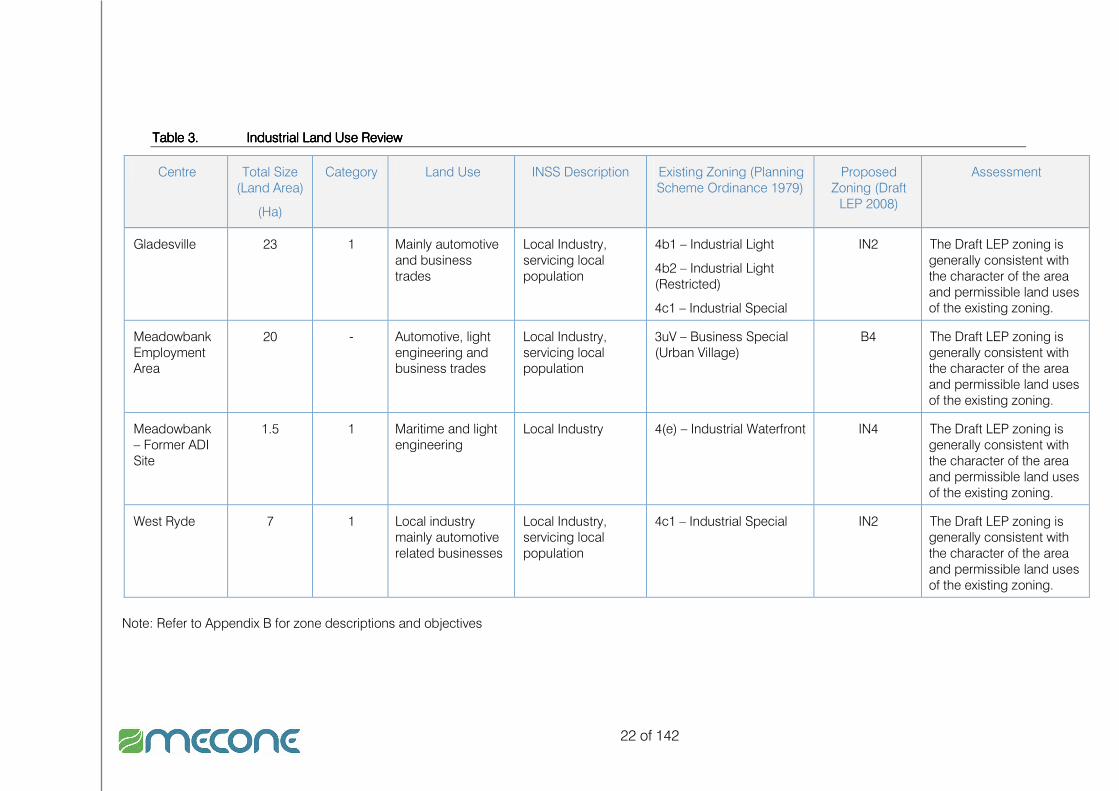
22 of 142
Table 3.Table 3.Table 3.Table 3. Industrial Land Use Review Industrial Land Use Review Industrial Land Use Review Industrial Land Use Review
Centre Total Size (Land Area)
(Ha)
Category Land Use INSS Description Existing Zoning (Planning Scheme Ordinance 1979)
Proposed Zoning (Draft LEP 2008)
Assessment
Gladesville 23 1 Mainly automotive and business trades
Local Industry, servicing local population
4b1 – Industrial Light
4b2 – Industrial Light (Restricted)
4c1 – Industrial Special
IN2 The Draft LEP zoning is generally consistent with the character of the area and permissible land uses of the existing zoning.
Meadowbank Employment Area
20 - Automotive, light engineering and business trades
Local Industry, servicing local population
3uV – Business Special (Urban Village)
B4 The Draft LEP zoning is generally consistent with the character of the area and permissible land uses of the existing zoning.
Meadowbank – Former ADI Site
1.5 1 Maritime and light engineering
Local Industry 4(e) – Industrial Waterfront IN4 The Draft LEP zoning is generally consistent with the character of the area and permissible land uses of the existing zoning.
West Ryde 7 1 Local industry mainly automotive related businesses
Local Industry, servicing local population
4c1 – Industrial Special IN2 The Draft LEP zoning is generally consistent with the character of the area and permissible land uses of the existing zoning.
Note: Refer to Appendix B for zone descriptions and objectives

23 of 142
3.2.23.2.23.2.23.2.2 Commercial and RetailCommercial and RetailCommercial and RetailCommercial and Retail
This review leads Mecone to conclude that there are three key employment centres in Ryde:
� Macquarie Park/North Ryde corridor as the sub-regions most important commercial office centre.
� Smaller centres providing local retail and commercial needs.
� The Victoria Road corridor which could grow into a “creative industry” corridor containing:
o Gladesville Centre.
o Top Ryde.
o Meadowbank.
o The Gladesville and West Ryde industrial areas.
o West Ryde Centre.
o Eastwood.
The outcome of the review is presented in Table 3 below. Draft planning controls for centres were considered appropriate in all cases.

24 of 142
Table 4.Table 4.Table 4.Table 4. Commercial and Retail Centres Land Use and Planning Review Commercial and Retail Centres Land Use and Planning Review Commercial and Retail Centres Land Use and Planning Review Commercial and Retail Centres Land Use and Planning Review
CentreCentreCentreCentre Total SizeTotal SizeTotal SizeTotal Size
(m (m (m (m2222))))
Land UsesLand UsesLand UsesLand Uses Existing Zoning (Planning Existing Zoning (Planning Existing Zoning (Planning Existing Zoning (Planning Scheme Ordinance 1979)Scheme Ordinance 1979)Scheme Ordinance 1979)Scheme Ordinance 1979)
Proposed Proposed Proposed Proposed ZoningZoningZoningZoning
(Draft LEP 2008)(Draft LEP 2008)(Draft LEP 2008)(Draft LEP 2008)
AssessmentAssessmentAssessmentAssessment
Town CentreTown CentreTown CentreTown Centre
Eastwood Existing Commercial – 37,024 sqm Retail - 46,445 sqm *Based on Eastwood Commercial Centre and Planning Study and Masterplan by ERM and Hirst Consulting, October 1998 Shopping centre – 14,700sqm
Strip Retail – 31,745sqm
Proposed (DA approved floor space)
Commercial – 2,000 sqm Shopping centre redevelopment 15,200sqm resulting in 500sqm additional. †
† Eastwood EIA, Pitney Bowes Nov 2007, Table 3.1, pp.30
Commercial floorspace, shopping centre and strip retail
Please note that the proposed Eastwood shopping centre redevelopment will add 500sqm of retail to the centre
2(c5) Residential 3(uv) Business Special (Urban Village) 5(a) Special Uses
B4 The Draft LEP zoning is generally consistent with the character of the area and permissible land uses of the existing zoning.
Ryde Existing
Commercial - 11,800
Retail - 10,621 (excluding previous shopping centre of approx. 7,000sqm) †
Large shopping centre (currently under construction)
Strip retail -
Services, Post office,
Small retail, chemist, real
3(tc) Top Ryde Shopping Centre
B4 with one area SP2
The Draft LEP zoning is generally consistent with the character of the area and permissible land uses of the existing zoning. The Draft LEP zoning promotes mixed development which responds

25 of 142
CentreCentreCentreCentre Total SizeTotal SizeTotal SizeTotal Size
(m (m (m (m2222))))
Land UsesLand UsesLand UsesLand Uses Existing Zoning (Planning Existing Zoning (Planning Existing Zoning (Planning Existing Zoning (Planning Scheme Ordinance 1979)Scheme Ordinance 1979)Scheme Ordinance 1979)Scheme Ordinance 1979)
Proposed Proposed Proposed Proposed ZoningZoningZoningZoning
(Draft LEP 2008)(Draft LEP 2008)(Draft LEP 2008)(Draft LEP 2008)
AssessmentAssessmentAssessmentAssessment
Proposed (DA approved floor space)
Commercial – additional 10,000 – 40,000 sqm* Shopping centre and Strip Retail – additional 78,000sqm
* Top Ryde Shopping Centre, TPL Macroplan Jan 2006 † Eastwood EIA, Pitney Bowes Nov 2007, Table 3.1, pp.30
estate, small food
better to the potential growth of the centre.
VillageVillageVillageVillage
Gladesville Existing
Commercial - Approx 8,500
Retail - Approx. 14,000 †
† Gladesville Town Centre and Victoria Road Corridor, City of Ryde, Dec 2008, Section 4
Retail - Small Supermarket
Retail – Petrol Station
Small food
Services
2(a) Residential 2(c5) Residential 3(a) Business General 3(c1) Business (Automotive) 3(c2) Business (Automotive – Special) 4(b2) Industrial Light (Restricted)
5(a) Special Uses
B4, B6 and SP2 The Draft LEP zoning is generally consistent with the character of the area and permissible land uses of the existing zoning. However, the Draft LEP provides a clearer regime and better structure for the zoning pattern within the centre. This regime better encourages future development and potential business investment.
West Ryde Existing
Commercial – NA
Retail - Approx. 7,500 (including supermarket centre) ^
Supermarket
Small retail and convenience stores, Petrol Stations, handyman store,
2(c5) Residential 3(c1) Business (Automotive) 3(uv) Business Special (Urban Village) 4(c1) Industrial Special
B4 and SP2 The Draft LEP zoning is generally consistent with the character of the area and permissible land uses of the existing zoning. However, the

26 of 142
CentreCentreCentreCentre Total SizeTotal SizeTotal SizeTotal Size
(m (m (m (m2222))))
Land UsesLand UsesLand UsesLand Uses Existing Zoning (Planning Existing Zoning (Planning Existing Zoning (Planning Existing Zoning (Planning Scheme Ordinance 1979)Scheme Ordinance 1979)Scheme Ordinance 1979)Scheme Ordinance 1979)
Proposed Proposed Proposed Proposed ZoningZoningZoningZoning
(Draft LEP 2008)(Draft LEP 2008)(Draft LEP 2008)(Draft LEP 2008)
AssessmentAssessmentAssessmentAssessment
Proposed
Commercial – NA
Retail - Approx. 12,000 #
^ Eastwood EIA, Pitney Bowes Nov 2007, Table 3.1, pp.29 # Eastwood EIA, Pitney Bowes Nov 2007, pp.26
Vacant theatre and arcade
Small retail in a small arcade
5(a) Special Uses Draft LEP provides a clearer regime and better structure for the zoning pattern within the centre.
Small VillageSmall VillageSmall VillageSmall Village
Cox Road Commercial
NA
Retail
Approx. 2,500
Small local retail – hairdresser, beauty shop, restaurant, video store, café, travel agency, bakery store and pastry store. The centre has a small mall with a Franklins and other small retail stores
2(a) Residential 3(d1) Business Neighbourhood 5(a) Special Uses
B1 and SP2 The Draft LEP zoning is generally consistent with the character of the area and permissible land uses of the existing zoning. However, it provides a little broader land uses in regards to the business zone.
Meadowbank Commercial
Commercial
NA
Retail
< 10,000
Retail – Small Supermarket, small food and services
Strip and development
2(a) Residential 3(uv) Business Urban Village 5(a) Special Uses
B4 The Draft LEP zoning is generally consistent with the character of the area and permissible land uses of the existing zoning.
Midway Commercial
Approx 500
Retail
Approx. 2,500
Retail – Small Supermarket
Retail – Petrol Station, automotive
Small food
Services and commercial offices
2(a) Residential I.D.O No.26
B1 The Draft LEP zoning is generally consistent with the character of the area and permissible land uses of the existing zoning. However, it provides for broader land uses in regards to the business zone.

27 of 142
CentreCentreCentreCentre Total SizeTotal SizeTotal SizeTotal Size
(m (m (m (m2222))))
Land UsesLand UsesLand UsesLand Uses Existing Zoning (Planning Existing Zoning (Planning Existing Zoning (Planning Existing Zoning (Planning Scheme Ordinance 1979)Scheme Ordinance 1979)Scheme Ordinance 1979)Scheme Ordinance 1979)
Proposed Proposed Proposed Proposed ZoningZoningZoningZoning
(Draft LEP 2008)(Draft LEP 2008)(Draft LEP 2008)(Draft LEP 2008)
AssessmentAssessmentAssessmentAssessment
Putney Commercial
NA
Retail
Approx. 1,000
Retail - Small Supermarket
Retail – Petrol Station
Small food
Services, Tab
2(a) Residential 3(d1) Business Neighbourhood
B1 The Draft LEP zoning is generally consistent with the character of the area and permissible land uses of the existing zoning. However, it provides a little broader land uses in regards to the business zone.
Neighbourhood CentreNeighbourhood CentreNeighbourhood CentreNeighbourhood Centre
Cutler Parade
Commercial
NA
Retail
Approx. 1,000
Small local retail – hairdresser and beauty shop, restaurant, petrol station, café, newsagency, pharmacy, bottle shop
2(a) Residential 3(d1) Business Neighbourhood 5(a) Special Uses
B1 The Draft LEP zoning is generally consistent with the character of the area and permissible land uses of the existing zoning. However, it provides a little broader land uses in regards to the business zone.
Fiveways Commercial
NA
Retail
Approx. 1,000
Small local retail – restaurant, petrol station, café, newsagency, pharmacy, bottle shop
2(a) Residential 3(d1) Business Neighbourhood 6(a) Open Space Recreational Existing
B1 The Draft LEP zoning is generally consistent with the character of the area and permissible land uses of the existing zoning. However, it provides a little broader land uses in regards to the business zone.
Pittwater Road
Commercial
NA
Retail
Approx. 1,000
Small local retail – hairdresser, beauty shop, restaurant, automotive tyre shops, creative framing store, medical, metro supermarket, café
2(a) Residential 3(d1) Business Neighbourhood
B1 The Draft LEP zoning is generally consistent with the character of the area and permissible land uses of the existing zoning. However, it provides a little broader land

28 of 142
CentreCentreCentreCentre Total SizeTotal SizeTotal SizeTotal Size
(m (m (m (m2222))))
Land UsesLand UsesLand UsesLand Uses Existing Zoning (Planning Existing Zoning (Planning Existing Zoning (Planning Existing Zoning (Planning Scheme Ordinance 1979)Scheme Ordinance 1979)Scheme Ordinance 1979)Scheme Ordinance 1979)
Proposed Proposed Proposed Proposed ZoningZoningZoningZoning
(Draft LEP 2008)(Draft LEP 2008)(Draft LEP 2008)(Draft LEP 2008)
AssessmentAssessmentAssessmentAssessment
uses in regards to the business zone.
Trafalgar Place
Commercial
NA
Retail
Approx. 1,000
Café, newsagency, chemist, sports centre, small take away/restaurant, small supermarket, bottle shop
I.D.O No.24
B1 The Draft LEP zoning is generally consistent with the character of the area and permissible land uses of the existing zoning. However, it provides for broader land uses in regards to the business zone.
Specialised CentreSpecialised CentreSpecialised CentreSpecialised Centre
North Ryde/ Macquarie Park Corridor
Existing
Commercial - 756,000 ^
Retail - 85,463 *
Proposed
Commercial – 82,000 °
Retail - NA
^ Property Council of Australia 2009
* Top Ryde Shopping Centre, TPL Macroplan Jan 2006
° Property Council of Australia 2009
High tech – electronic, computer, pharmaceutical and educational, Macquarie Centre Retail
2(c4) Residential 2(d1) Residential 2(d2) Residential 2(d3) Residential 2(d5) Residential 2(d6) Residential 2(d7) Residential 3(f) Business Special (Research and Development) 3(g) Business Special (Employment) 3(h) Business Special (Mixed Activity) 4(d) Industrial Special (University) 5(c) Special Uses (University)
SP2, B3, B4 and B7
The zoning regime in the Draft LEP allows for generally the same land sues as the existing zoning. However, the consolidation of land uses provides for a clearer pattern of development.

29 of 142
3.2.33.2.33.2.33.2.3 Draft LEP 2008 ReviewDraft LEP 2008 ReviewDraft LEP 2008 ReviewDraft LEP 2008 Review
Mecone has also reviewed the existing and proposed zoning regime and key urban planning controls including floor space ratio and height controls, for the centres tabled above in order to identify any inconsistencies or future limitations to the function of centres. The review found that the proposed zoning regime under the Draft Local Environmental Plan 2008 does not create any significant limitations to the functioning and nature of the centre. The following more detailed planning control reviews were undertaken:
� List of objectives and permissible uses for all new zones at Appendix B � A Comparison of current zones and proposed zones under the draft LEP 2008 � A detailed planning assessment of all centres and employment areas in Ryde.
The result of these assessments is that in all cases we consider the conversion of zones to be appropriate and will not prejudice development of these areas in the future. It should be noted that however, the following sections of this study contain directions and recommendations that will have zoning and planning control implications for draft LEP 2008 and draft DCP 2008.

30 of 142
4444 Economic AssessmentEconomic AssessmentEconomic AssessmentEconomic Assessment
4.14.14.14.1 Employment Profile Employment Profile Employment Profile Employment Profile
4.1.14.1.14.1.14.1.1 ProfileProfileProfileProfile
As indicated in Table 1 below, there has been a 5% population increase within Ryde LGA over the past decade, from 91,783 in 1996 to 96,764 in 2006. This represents an approximate annual growth rate of 0.52%. This population growth has been accompanied by a 5% increase in the number of employed workers living within Ryde LGA between the same period. The total number of unemployed persons has dropped slightly from 2,465 (5.3%) in 1996 to 2,332 (4.7%) in 2006, which is below the Sydney Metropolitan average of 6.1% (2006). Labour force participation rates have remained fairly consistent at around 51-52% between 1996 and 2006, which is lower than Sydney-wide averages.
Table 5.Table 5.Table 5.Table 5. Employment Profile City of Ryde LGA (1996Employment Profile City of Ryde LGA (1996Employment Profile City of Ryde LGA (1996Employment Profile City of Ryde LGA (1996----2006200620062006))))
1996199619961996 2001200120012001 2006200620062006
Total Persons 91,783 94,243 96,764
Total Persons Aged 18+ 72,302 74,997 77,604
Total Employed 44,431 46,729 46,769
Total Unemployed 2,465 2,214 2,332
Total Labour Force 46,896 48,943 49,101
Proportion of Population Aged 18+ 79% 80% 80%
Labour force participation 51% 52% 51%
Proportion of Labour Force Employed 94.7% 94.7% 95.3%
Unemployment Rate 5.3% 5.3% 4.7%
Source: ABS Census 2006
4.1.24.1.24.1.24.1.2 ANZANZANZANZSSSSIC Industry JobsIC Industry JobsIC Industry JobsIC Industry Jobs
Industries are classified by grouping businesses which carry out similar productive activities. The 2006 Australian and New Zealand Standard Industrial Classification (ANZSIC) provides the current framework for industry classification in Australia. Table 6 provides the industries for workers in Ryde and illustrates the following industries in Ryde have at or above Metropolitan average proportion of jobs:
� Wholesale trades, � Finance and Insurance services, � Professional, scientific and technical services, � Administrative and support services, � Education and training, � Health care and social assistance.

31 of 142
Table 6.Table 6.Table 6.Table 6. ANZIC Industry Jobs 2006ANZIC Industry Jobs 2006ANZIC Industry Jobs 2006ANZIC Industry Jobs 2006
Source: ABS Census 2006
4.1.34.1.34.1.34.1.3 Residents Occupational MixResidents Occupational MixResidents Occupational MixResidents Occupational Mix
Figure 2 below indicates the employment profile of City of Ryde residents between 1996 and 2006. There has been a steady increase in the proportion of residents in white-collar employment within Ryde LGA between 1996 and 2006, whilst the proportion of blue-collar workers has declined slightly over the same period. The proportion of residents in service related employment has remained fairly consistent over the 10 year period. These statistics show that the resident labour force is becoming more involved in white-collar employment than blue or service related employment.
ANZIC Industry number Ryde %
Sydney
Statistical
Division %
Agriculture, Forestry & Fishing 89 0.2 0.5
Mining 42 0.1 0.2
Manufacturing 3,574 7.6 9.7
Electricity, Gas, Water and Waste
Services 377 0.8 0.8
Construction 2,701 5.8 7.1
Retail Trade 4,792 10.2 10.5
Wholesale Trade 3,091 6.6 5.5
Accommodation and Food Services 2,801 6 6.1
Transport, Postal and Warehousing 1,703 3.6 5.4
Information Media and
Telecommunications 1,684 3.6 3
Financial and Insurance Services 3,175 6.8 6.4
Rental, Hiring and Real Estate Services 833 1.8 1.8
Professional, Scientific and Technical
Services 5,235 11.2 8.9
Administrative and Support Services 1,706 3.6 3.4
Public Administration and Safety 2,284 4.9 5.6
Education and Training 3,881 8.3 7.2
Health Care and Social Assistance 5,157 11 9.9
Arts and Recreation Services 584 1.2 1.4
Other Services 1,861 4 3.8
Inadequately described or Not stated 1,198 2.6 2.8
Total 46,768 100

32 of 142
Figure 6.Figure 6.Figure 6.Figure 6. Resident Occupation Mix 1996Resident Occupation Mix 1996Resident Occupation Mix 1996Resident Occupation Mix 1996----2006 2006 2006 2006
0
5,000
10,000
15,000
20,000
25,000
30,000
35,000
40,000
45,000
50,000
1996 2001 2006
Year
workers
Inadequately described/Not stated
Labourers
Machinery operators and drivers
Sales workers
Clerical and administrative workers
Community and personal service workers
Technicians and trades workers(b)
Professionals
Managers
Source: ABS Census 1996, 2001 and 2006
4.1.44.1.44.1.44.1.4 Worker Occupational Mix (Local jobs)Worker Occupational Mix (Local jobs)Worker Occupational Mix (Local jobs)Worker Occupational Mix (Local jobs)
In 2006 the majority of jobs in Ryde LGA were white-collar with professional (32%), Managers (16%) and Clerical/administrative (17%) jobs making up the bulk of the workforce. Ryde retains some small blue-collar jobs with 12% of jobs being technicians and trade workers and 5% labourers.
Figure 7.Figure 7.Figure 7.Figure 7. Worker Occupation Mix 2006 Worker Occupation Mix 2006 Worker Occupation Mix 2006 Worker Occupation Mix 2006
16%
32%
12%
6%
17%
8%
3%
5% 1%
Managers
Professionals
Technicians & trades workers
Community & personal serviceworkers
Clerical & administrative workers
Sales workers
Machinery operators & drivers
Labourers
Not stated
Source: ABS Census 2006
4.1.54.1.54.1.54.1.5 Where do workers come from?Where do workers come from?Where do workers come from?Where do workers come from?
Of relevance is where people come from to work in Ryde. While the LGA and Macquarie Park is described as being part of the “global economic arc” running

33 of 142
between Sydney Airport and Ryde including the Sydney and North Sydney CBD’s, most workers either reside in Ryde or travel from the west and north west to access employment in the area with the most popular LGAs (outside of Ryde) being Hornsby, Parramatta, Baulkham Hills and Parramatta.
Figure 8.Figure 8.Figure 8.Figure 8. Where Ryde workers live Where Ryde workers live Where Ryde workers live Where Ryde workers live
13,169
5,460
4,243 4,174
3,159
2,501
1,655 1,519 1,408 1,353
19,673
0
5,000
10,000
15,000
20,000
25,000
Ryde (C) Hornsby (A) Parramatta
(C)
Baulkham
Hills (A)
Blacktown
(C)
Ku-ring-gai
(A)
Warringah
(A)
Canada Bay
(A)
Sydney (C) Willoughby
(C)
Other areas
Source: ABS Census 2006
4.1.64.1.64.1.64.1.6 Employment Self SufficiencyEmployment Self SufficiencyEmployment Self SufficiencyEmployment Self Sufficiency
Employment self-sufficiency represents the ratio of jobs within an area to the number of workers. Ryde LGA in 2006 contained 124 jobs for every 100 workers. This figure increased over the 2001 to 2006 period. The figure is now approaching the employment self sufficiency rate of the broader Inner North Subregion which includes the North Sydney CBD.
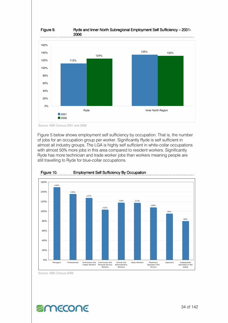
34 of 142
Figure 9.Figure 9.Figure 9.Figure 9. Ryde and Inner North Subregional Employment Self Sufficiency Ryde and Inner North Subregional Employment Self Sufficiency Ryde and Inner North Subregional Employment Self Sufficiency Ryde and Inner North Subregional Employment Self Sufficiency –––– 2001 2001 2001 2001----
2006 2006 2006 2006
112%
135%
124%132%
0%
20%
40%
60%
80%
100%
120%
140%
160%
Ryde Inner North Region
2001
2006
Source: ABS Census 2001 and 2006
Figure 5 below shows employment self sufficiency by occupation. That is, the number of jobs for an occupation group per worker. Significantly Ryde is self sufficient in almost all industry groups. The LGA is highly self sufficient in white-collar occupations with almost 50% more jobs in this area compared to resident workers. Significantly Ryde has more technician and trade worker jobs than workers meaning people are still travelling to Ryde for blue-collar occupations.
Figure 10.Figure 10.Figure 10.Figure 10. Employment Self Sufficiency By OccupationEmployment Self Sufficiency By OccupationEmployment Self Sufficiency By OccupationEmployment Self Sufficiency By Occupation
149%
135%
127%
103%
118% 117%
108%
95%
80%
0%
20%
40%
60%
80%
100%
120%
140%
160%
Managers Professionals Technicians and
Trades Workers
Community and
Personal Service
Workers
Clerical and
Administrative
Workers
Sales Workers Machinery
Operators And
Drivers
Labourers Inadequately
described or Not
stated
Source: ABS Census 2006

35 of 142
4.24.24.24.2 Industrial AssessmentIndustrial AssessmentIndustrial AssessmentIndustrial Assessment
4.2.14.2.14.2.14.2.1 SupplySupplySupplySupply
The draft Inner North sub-regional strategy identifies the following employment areas in Ryde. All are zoned for industrial and have been categorised as Category 1 employment lands with the exception of the Meadowbank Employment Area which is a mixed use area. Category 1 employment lands means they must be retained for industrial employment purposes.
Table 7.Table 7.Table 7.Table 7. Employment Land Supply 2009Employment Land Supply 2009Employment Land Supply 2009Employment Land Supply 2009
Location Type of Industry Area
Gladesville Industrial Area Local Industry 23 ha
Former ADI site Local Industry-Maritime 1.5 ha
West Ryde Local Industry 7 ha
Meadowbank Employment Area Local Industry 20 ha
TotalTotalTotalTotal 51.5 ha 51.5 ha 51.5 ha 51.5 ha Source: Draft Inner North Sub-regional Strategy
As at December 2008, there was approximately 50,000sqm of industrial floor space under construction within the North region of Sydney, which includes Ryde LGA (CBRE 2008). Between 2008 and 2010, it is forecast that approximately 96,000sqm of additional industrial floor space will come online within the Northern region (CBRE 2008). Industrial CapacityIndustrial CapacityIndustrial CapacityIndustrial Capacity This study has not assessed the capacity of industrial areas. However, in our observation we note that the majority of industrial areas in Ryde are vibrant and contain very little additional development capacity. The exception to this is the Meadowbank Employment Area that contains significant areas of vacant employment land and buildings.
4.2.24.2.24.2.24.2.2 Demand Demand Demand Demand
Mecone has prepared a population based demand model for employment land in Ryde LGA. Meadowbank has been included in the assessment as it retains elements of its industrial past. The model assumes that the share of blue-collar workers in Ryde will be reduced in line with an increasing proportion of white-collar workers. It also assumes due to competitive market forces outlined below the ratio of blue-collar resident workers to jobs will reduce over time. The model forecasts a reduction of approximately 8 Ha in industrial land required by 2031. It should be noted that the Meadowbank Employment Area is included in these calculations and Mecone expects the reduction in industrial land requirements will be wholly absorbed by the redevelopment of the Meadowbank Employment Area.

36 of 142
Table 8.Table 8.Table 8.Table 8. Potential Future Industrial Land RequirementPotential Future Industrial Land RequirementPotential Future Industrial Land RequirementPotential Future Industrial Land Requirement
2006200620062006 2016201620162016 2031203120312031
Population 101,284 107,574 117,497
Participation Rate 51% 51% 51%
Total Employed 51,655 54,863 59,923
Resident Blue-collar worker Share 20% 19% 18%
Resident Blue-collar workers 10,124 10,424 10,786
Industrial land Requirement (50.5 sq.m per job) sq.m 511,280 526,408 544,704
Blue-collar self containment 0.96 0.86 0.76
Potential Land Requirements (sq.m)Potential Land Requirements (sq.m)Potential Land Requirements (sq.m)Potential Land Requirements (sq.m) 490,828490,828490,828490,828 454545452,7112,7112,7112,711 413,975413,975413,975413,975
HaHaHaHa 49494949 45454545 41414141 Source: Mecone 2009
Although Meadowank is 20 Ha in size much of this land has been developed for residential uses in recent years. MacroPlan in its 2007 study on Meadowbank estimated the urban renewal of the area would generate more jobs than currently exist in the area. MacroPlan in 2007 identified between 80,000 to 100,000 sq.m of potential employment floor space. This would be made up of approximately 10,000 sq.m of retail uses close to the station, with the remainder commercial uses along Church Street and ground level cafés and retail along Porter Street. This trend is also evident on the Victoria Road corridor part of the Gladesville Industrial area. Discussions with local real estates agents indicate there is difficulty leasing joint commercial warehouse premises in the area. This is because demand for commercial premises and warehouse premises are often distinct in this area. While the overall demand for industrial uses is likely to reduce then stabilise, with the right economic development strategies industrial areas will be needed to accommodate the demands of emerging industries. These may include creative industries sectors. Mecone has prepared a creative industries paper at Appendix E of this report which outlines the potential for creative industries to be located in Ryde. In terms of future demand/need for industrial land within Ryde LGA, there has been a considerable shift away from blue-collar related jobs towards white-collar jobs between 1991 and 2001. In 1991, white-collar jobs represented 37% of the total workforce in Ryde. By 2001, this figure had increased to 49% (MacroPlan Australia 2007). This indicates a reduced need for additional traditional industrial land within Ryde. Further to the above, the recent changes to planning controls for Meadowbank Employment Area will most likely see a shift from traditional industrial uses to residential and mixed use. In addition, Macquarie Park/North Ryde is attracting mainly commercial office, retail and hi-tech uses, further resulting in the reduced need for additional industrial land within Ryde LGA.

37 of 142
Development PipelineDevelopment PipelineDevelopment PipelineDevelopment Pipeline Whilst there have been no major industrial development applications approved by Ryde Council over the past 2 years, BCI data indicate limited recent industrial building activity:
Table 9.Table 9.Table 9.Table 9. Industrial Proposals 2009Industrial Proposals 2009Industrial Proposals 2009Industrial Proposals 2009
Proposal Address Stage Capital Cost
Central Sydney Boatyard – Marina, boating facility and storage
20 Waterview St Putney NSW Concept $20m
6 industrial units 18 Constitution Rd Meadowbank Design $0.7m Source: BCI 2009
In addition to the above, the first stage of the new headquarters of Cochlear is scheduled for completion in February 2010. This will comprise a research, manufacturing, warehousing and administrative facility, containing approximately 24,000sqm of floor space which is to be located within the southern precinct of the Macquarie University Campus (PRP Australia 2008). PricesPricesPricesPrices Recent industrial sales activity in North Ryde indicates that building prices are averaging around $2,500 per sqm (PRP Australia 2008). This is fairly consistent with average capital values of A-grade industrial space in the North sector of Sydney, which is $2,245/sqm for unit estates; $2,417/sqm for hi-tech; and $2,057/sqm for warehouses (CBRE 2008). Figures produced by Knight Frank (2008) also have similar values, with Business Space Prime Industrial having average capital values of $2,400/sqm; traditional prime of $2,000/sqm, and traditional secondary of $1,850/sqm. It is important to note that these industrial land prices are considerably higher compared to other regions in Sydney. For example, average industrial land prices in Sydney’s North West subregion was $621/sqm in 2007; $572/sqm in the South West subregion; and $967/sqm in the West Central subregion (Jones Lang LaSalle, MacroPlan Australia 2008). Given North Ryde’s average industrial prices of $2,500/sqm, it is clear that there is pressure to accommodate non-industrial, higher yielding land uses (such as commercial, retail and residential), whilst traditional industrial uses are being attracted towards the outer Sydney suburbs, due to relatively cheaper land that is supported by excellent transport and freight infrastructure. Mecone was not able to find pricing industrial pricing data specific to the Gladesville/West Ryde area.

38 of 142
4.34.34.34.3 Retail AssessmentRetail AssessmentRetail AssessmentRetail Assessment
4.3.14.3.14.3.14.3.1 SupplySupplySupplySupply
The following table provides the existing and proposed supply of retail floor space within Ryde LGA. In summary, there is 184,029sqm of existing retail floor space within Ryde LGA, with 70,500sqm proposed.
Table 10.Table 10.Table 10.Table 10. Retail Existing and Proposed 2009Retail Existing and Proposed 2009Retail Existing and Proposed 2009Retail Existing and Proposed 2009
Centre/Location Existing (sqm) Proposed (sqm)
Eastwood 46,445 500
Ryde 10,621 78,000
Gladesville 14,000 -
West Ryde 7,500 5,000
Cox Road 2,500 -
Meadowbank 10,000 -
Midway 2,500 -
Putney 1,000 -
Cutler Parade 1,000 -
Fiveways 1,000 -
Pittwater Road 1,000 -
Trafalgar Place 1,000 -
Macquarie Park 85,463 -
TOTALTOTALTOTALTOTAL 184,029184,029184,029184,029 83,50083,50083,50083,500 Source: Mecone 2009, various (refer to table 3), development application information City of Ryde,
4.3.24.3.24.3.24.3.2 DemandDemandDemandDemand
The Department of Planning uses a figure of 2 sq.m of retail space per person to calculate indicative future retail need (Department of Planning draft Centres Policy 2009). Based on this figure the retail need in Ryde currently would stand at 203,000 sqm and by 2031 in line with population growth would rise to 235,000 sq.m. Given that approvals combined with estimated retail floor space of 267,529 sq.m, there will be adequate supply of retail uses to service the location population of the Ryde LGA in this period. It should be noted, however, that retail catchments do not generally correspond with council borders. Furthermore, the above assessment does not include the significant number of workers in Ryde. Therefore, there it is likely there will be demand to expand some retail centres that service a broader area. Such centres would be those which are well served by transport links connecting to catchments outside Ryde. North Ryde in the Vicinity of Delhi Road and North Ryde Station is identified by Mecone as one such potential centre. Development PipelineDevelopment PipelineDevelopment PipelineDevelopment Pipeline Approved Development The following table lists the major approved retail development applications within the City of Ryde from May 2007 to December 2008:

39 of 142
Table 11.Table 11.Table 11.Table 11. Recently Approved Retail Development Recently Approved Retail Development Recently Approved Retail Development Recently Approved Retail Development
Proposal Address Date Approved
Capital Cost
Demolition, reconstruction of Eastwood Shopping Centre and neighbouring land (13,500sqm retail, 1,600sqm commercial)
Eastwood Shopping Centre 2/10/07 $54m
Top Ryde Shopping Centre Redevelopment – major works
Top Ryde Shopping Centre 8/5/07 $327m
Top Ryde Shopping Centre Redevelopment – early works
Top Ryde Shopping Centre 8/5/07 $40m
Source: City of Ryde 2009
The above indicates that the major retail developments within the City of Ryde over the past few years have been associated with the Top Ryde and Eastwood Shopping Centre developments. It should be noted that there have been several major mixed-use development approvals over the same period which have comprises residential, commercial and/or retail uses:
Table 12.Table 12.Table 12.Table 12. Recently Approved Mixed Use DevelopmentRecently Approved Mixed Use DevelopmentRecently Approved Mixed Use DevelopmentRecently Approved Mixed Use Development
Proposal Address Date Approved
Capital Cost
Construction of 3 storey mixed retail and residential development.
126-128 Pittwater Rd Gladesville 15/7/08 $5m
Erection of a seven storey building of mixed retail, commercial and residential use with five basement levels and the provision of a village square on the area adjoining the building, landscaping and associated road works, and erection of a four storey building to house community services and some retail floor space above two basement car parking levels
West Ryde Urban Village 11/12/07 $106m
Construction of mixed residential/commercial development, comprising of 24 dwellings, 3 commercial suites and basement parking for 61 vehicles
80 Belmore Street & 2-4 Porter Street Ryde
8/8/07 $8m
Mixed commercial/residential development
15 - 19 Angas Street Meadowbank 17/7/07 $11m
New 5 storey mixed commercial/residential building comprising ground floor retail space, 24 apartments (3 x 1 bedroom, 16 x 2 bedroom & 5 x 3 bedroom) and car parking for 56 vehicles
43-49 Blaxland Road Ryde 1/5/07 $7m
Source: City of Ryde 2009

40 of 142
Potential Development Activity A search of BCI data indicates the following recent retail building activity:
Table 13.Table 13.Table 13.Table 13. Potential Retail ActivityPotential Retail ActivityPotential Retail ActivityPotential Retail Activity
Proposal Address Stage Capital Cost
Honda Eastwood – Motor Showroom
601-607 Blaxland Rd Eastwood Design $6m
Source BCI 2009
In addition to the above, the following recent mixed-use building activity was identified through BCI:
Table 14.Table 14.Table 14.Table 14. Potential Mixed Use ActivityPotential Mixed Use ActivityPotential Mixed Use ActivityPotential Mixed Use Activity
Proposal Address Stage Capital Cost
Delphi Road Station Redevelopment – 4 buildings containing offices and shops
27-37 Delhi Rd Lot 16 DP1043038 North Ryde
Design $45m
9-storey building containing shops, offices and a cafe
80 Waterloo Rd Macquarie Park Design $44m
10-storey mixed use, residential and commercial/retail
7-9 Rutledge St Trelawney St Eastwood
Design $15m
Mixed use residential and commercial/office
34 Herbert St West Ryde Design $2m
Source: BCI 2009
PricesPricesPricesPrices The average price of a single shop within Eastwood town centre has increased from $630,000 in 1996 to $1,250,000 in 2008, almost doubling over the 12 year period. Rental prices for retail space along Victoria Road, Gladesville average between $300-$440/sqm. In Top Ryde, rental prices for older retail stock average between $150-$350/sqm, whilst newer retail space averages about $600/sqm. The completion of the Top Ryde centre will likely see retail rents of similar levels ($600/sqm). Specific retail pricing data for the Gladesville and West Ryde areas was not available for this study.
4.44.44.44.4 Commercial AssessmentCommercial AssessmentCommercial AssessmentCommercial Assessment
4.4.14.4.14.4.14.4.1 SupplySupplySupplySupply
The following table provides the existing and proposed supply of commercial floor space (Gross Floor Area) within Ryde LGA. In summary, there is 816,324sqm of existing commercial floor space within Ryde LGA, with 144,240sqm proposed which includes approved but not constructed development and mooted development.

41 of 142
Table 15.Table 15.Table 15.Table 15. Estimated Existing and Proposed Supply of Commercial Space Estimated Existing and Proposed Supply of Commercial Space Estimated Existing and Proposed Supply of Commercial Space Estimated Existing and Proposed Supply of Commercial Space
Centre/LocationCentre/LocationCentre/LocationCentre/Location Existing (sqm)Existing (sqm)Existing (sqm)Existing (sqm) Proposed (sqm)Proposed (sqm)Proposed (sqm)Proposed (sqm)
Eastwood 37,024 2,000
Ryde 11,800 25,000
Gladesville 8,500
West Ryde 6,500
Cox Road
Meadowbank
Midway 500
Putney
Cutler Parade
Fiveways
Pittwater Road
Trafalgar Place
Macquarie Park/North Ryde
756,000 82,000 (projected – note this is not ultimate capacity)
TOTALTOTALTOTALTOTAL 816,324816,324816,324816,324 109,000109,000109,000109,000 Source: Mecone 2009, various (refer to table 3), development application information City of Ryde, PCA Office Markets Report 2009
The total commercial floor space within North Ryde was approximately 526,000sqm in 2004/2005, growing to just under 684,000sqm in 2007/2008, representing an increase of 30% (Property Council of Australia 2009). As at January 2009, the total commercial stock within North Ryde stood at almost 756,000sqm; a substantial increase of 72,000sqm (Property Council of Australia 2009). The majority of office space in North Ryde is within Macquarie Park, with approximately 650,000sqm of floor space (Knight Frank 2008, CBRE 2008). Approximately 216,000sqm of floor space entered the Macquarie Park market between 2003 and 2008, with 112,000sqm being completed alone in 2007.
4.4.24.4.24.4.24.4.2 DemandDemandDemandDemand
Mecone has calculated the indicative need for commercial floor space based on population growth up to 2031. The demand model assumes an increasing proportion of white-collar workers residing in Ryde as well as a growth in white-collar employment that outstrips population growth. This is in line with recent trends and the capacity of the North Ryde and Top Ryde areas as commercial centres. The analysis indicates that office space needs are generally in line with supply and that demand (as determined by population growth) for commercial office space will rise in the future. Future growth of white-collar jobs is likely to outpace population growth due to the on-going growth of the Macquarie Park/North Ryde corridor.

42 of 142
Table 16.Table 16.Table 16.Table 16. Potential Future Commercial Floor Space RequirementsPotential Future Commercial Floor Space RequirementsPotential Future Commercial Floor Space RequirementsPotential Future Commercial Floor Space Requirements
2006200620062006 2016201620162016 2031203120312031
Population 101,284 107,574 117,497
Participation Rate 51% 51% 51%
Total Employed 51655 54863 59923
White-collar worker Share 50% 52% 54%
White-collar resident workers 25,827 28,529 32,359
Office Floor Space Requirement (25 sq.m per job) (sq.m) 645,686 713,216 808,967
White-collar self containment 1.24 1.6 2
Potential floor Space Potential floor Space Potential floor Space Potential floor Space Requirements (Sq.m)Requirements (Sq.m)Requirements (Sq.m)Requirements (Sq.m) 800,650800,650800,650800,650 1,141,1451,141,1451,141,1451,141,145 1,1,1,1,617,934617,934617,934617,934
Source: Mecone 2009, ABS 2009
Development PipelineDevelopment PipelineDevelopment PipelineDevelopment Pipeline The following table lists the major approved commercial/office development applications within the City of Ryde from May 2007 to December 2008:
Table 17.Table 17.Table 17.Table 17. Recent Commercial Development ApprovalsRecent Commercial Development ApprovalsRecent Commercial Development ApprovalsRecent Commercial Development Approvals
ProposProposProposProposalalalal AddressAddressAddressAddress Date Date Date Date ApprovedApprovedApprovedApproved
Capital Capital Capital Capital Cost Cost Cost Cost
Construction of 4 new commercial buildings.
27-37 Delhi Rd North Ryde 17/9/08 $45m
Construction of 2 new commercial/retail buildings.
39 Delhi Rd North Ryde 5/6/08 $85m
Commercial development comprising three office buildings, basement car parking and public open space
84-92 Talavera Road Macquarie Park
4/12/07 $71m
Mixed use development- commercial office and retail development comprising 3 buildings.
271 Lane Cove Road Macquarie Park
10/9/07 $80m
Construction of a commercial building
6 - 8 Giffnock Avenue & 85 Epping Road & 376 Lane Cove Road Macquarie Park
20/6/07 $22m
Construction of a new commercial building and proposed subdivision
4 Eden Park Drive Macquarie Park 5/6/07 $43m
Demolition and construction of new multi-level (max 7 storey) commercial office building
67-75 Epping Road, Macquarie Park 15/5/07 $19m
Source: City of Ryde 2009

43 of 142
A search of BCI data indicates the following recent commercial/office building activity:
Table 18.Table 18.Table 18.Table 18. Mooted Commercial DevelopmentMooted Commercial DevelopmentMooted Commercial DevelopmentMooted Commercial Development
ProposalProposalProposalProposal AddressAddressAddressAddress StageStageStageStage Capital Capital Capital Capital Cost Cost Cost Cost
Macquarie View Estate – 6 storey office building
112 Talavera Rd Macquarie Park Design 37m
Pinnacle Office Park – offices, child care, cafe
6-8 Giffnock Ave Macquarie Park Concept $22m
7 storey office building 4 Eden Park Rd Macquarie Park Design $45m
Commercial building 16 Byfield St Macquarie Park Concept $50m
Stage 4 Top Ryde – two office buildings
Devlin St Ryde Concept $7m
Despite the above, construction within Macquarie Park is expected to slow over the next 5 years. This will be as a result of private developers vying for pre-commitments to secure capital for large-scale projects, and will likely contain vacancy rates (CBRE 2008). Prices Prices Prices Prices Rental prices in North Ryde have experienced steady growth between 2004 and 2008, increasing by 5% during the period, with average rentals ranging between $355 - $385 per sqm in 2008 (Knight Frank 2008). Prices have remained consistent since 2008, with gross rents averaging $360 per sqm for prime commercial space and $315 per sqm for secondary commercial space in January 2009 (Property Council of Australia 2009). Gross rents for commercial space are projected to remain static to January 2010. As indicated in the table below, vacancy rates are expected to decline significantly:
Table 19.Table 19.Table 19.Table 19. Forecast Vacancy Rates Forecast Vacancy Rates Forecast Vacancy Rates Forecast Vacancy Rates –––– North Ryde Macquarie Park North Ryde Macquarie Park North Ryde Macquarie Park North Ryde Macquarie Park
Direct Vacancy Total Vacancy
July 2009 9.2% 11.5%
January 2010 6.6% 9.4%
July 2010 2.5% 4.6% Source: Property Council of Australia 2009
The declining vacancy rates indicate that there is limited new speculative development occurring within North Ryde, whilst the static commercial rental prices show that North Ryde will continue to be an affordable alternative to the Sydney CBD. Here, average gross rents for commercial floor space in North Ryde/Macquarie Park market is 35% cheaper than similar premises in North Sydney, and 55% cheaper than the Sydney CBD (Knight Frank 2009). In 2008, rents for A-grade office space in Macquarie Park averaged $302 per sqm, up 3% from 2007. Rents for B-grade office space were $276 per sqm, up 3% on the previous year. These factors reflect a strong demand for commercial floor space within North Ryde. In the last quarter of 2008, over 58,000 sqm of office floor space was taken up by the

44 of 142
market in North Ryde, furthering its growth as an important commercial centre, both on a regional and national scale (CBRE 2009). In terms of commercial sale prices, capital values in 2007 average $4,400 per sqm for Macquarie Park/North Ryde, an increase of approximately 12% from the previous year (Knight Frank 2008). Capital returns for the Macquarie Park/North Ryde office market have averaged just under 13% for most of the past decade, outperforming non-CBD Sydney and North Sydney markets (Knight Frank 2008).
4.54.54.54.5 SubSubSubSub----regionalregionalregionalregional and Regional Development Trends and Regional Development Trends and Regional Development Trends and Regional Development Trends
Industrial Industrial Industrial Industrial There is currently approximately 50,000sqm of industrial floor space under construction within the Sydney North subregion, which includes Ryde LGA (CBRE 2008). Over the next few years it is projected that new development will likely comprise industrial units and warehousing, with high-tech development being focused in the North Ryde/Macquarie Park area. Within the North Shore (which includes North Ryde), rents for hi-tech industrial ranged between $295 and $320 per sqm, whilst prime and secondary industrial rentals ranged from $130 to $180 per sqm in December 2008 (Savills 2009). This is lower than asking rents in Ryde (see above). In terms of capital values, A and B grade warehouses stood at an indicative $2,057 per sqm and $1,767 per sqm respectively, whilst A and B grade industrial units were $2,245 per sqm and $1,696sqm respectively (CBRE 2008). However capital values for hi-tech industries ranged between $4,000 and $5,000 per sqm in 2008 (Savills 2009). This is generally on par with prices in Ryde. Industrial land values for the December quarter of 2008 remained steady at $633 per sqm for 0.25 hectare lots within the Sydney North subregion, whilst values for 1.6 hectare lots fell by 5.7% to $625 per square metre (CBRE 2009). However, secondary industrial land values were considerably lower, averaging $350 per sqm in the December quarter of 2008 (Savills 2009). Industrial land values in the North region in the fourth quarter of 2008 were between $400-$1000/sqm for small sites, and $300-$1,100/sqm for larger sites (CBRE 2008). Industrial land in Ryde tends to be at the upper range of these land prices. At November 2008, there was approximately 88,000sqm of confirmed industrial floor space at pre-construction development stages (CBRE 2008). Almost 70% of this amount (approximately 61,000sqm) is DA approved, with 12.6% on hold and 18% still with Council (CBRE 2008). Commercial Commercial Commercial Commercial An additional 40,000sqm of commercial floor space was to be brought online within the North Shore during 2008, mainly in Chatswood and North Sydney (CBRE 2008). Commercial vacancy rates will continue to fall within the North Shore, reflecting higher absorption and pre-commitments. Indicative rents for commercial properties within the North Shore stood at $459 per sqm in 2008, up 6.7% on the previous year (CBRE

45 of 142
2008). These tend to be higher than Ryde, but are influenced by rental prices in North Sydney which tend to be closer to Sydney CBD levels. RetailRetailRetailRetail Relating to the regional shopping centres in Sydney (which include Macquarie Park), average face rents in the fourth quarter of 2008 stood at between $1,000 and $3,250/sqm (CBRE 2008). According to Knight Frank, average rents for super/major regional shopping centres (such as Macquarie Park) were between $1,200sqm to $3,200sqm in 2008, mirroring the figures produced by CBRE.
4.64.64.64.6 Infrastructure Drivers of DemandInfrastructure Drivers of DemandInfrastructure Drivers of DemandInfrastructure Drivers of Demand
Infrastructure is a significant driver of demand for employment space. The following lists the major infrastructure projects currently proposed or recently completed for Ryde: Public TransportPublic TransportPublic TransportPublic Transport There have been a number of completed and proposed infrastructure projects and upgrades that will have a positive impact in demand in the City of Ryde. These are outlined as follows: EppiEppiEppiEpping to Chatswood Railway Lineng to Chatswood Railway Lineng to Chatswood Railway Lineng to Chatswood Railway Line The Epping to Chatswood Railway line commenced operations in February 2008. With additional stops at Macquarie University, Macquarie Park and North Ryde the railway represents a significant improvement in the accessibility of the North Ryde/Macquarie Park area. North West MetroNorth West MetroNorth West MetroNorth West Metro The North West was proposed and later postponed by the State Government in 2008. The North West Metro is an extension of the planned CBD Metro and will service the centres of Gladesville, Ryde and Denistone East. No delivery date has been programmed for this infrastructure. Strategic Bus CorridorsStrategic Bus CorridorsStrategic Bus CorridorsStrategic Bus Corridors The RTA’s Strategic Bus Network identifies 43 strategic bus corridors throughout Sydney. A number of strategic bus corridors will run through Ryde LGA. These include No 6 - Castle Hill to City (via Macquarie Park); No 9 – Parramatta to City via Macquarie Park; No 39 – Burwood to Macquarie; and No 10 – Parramatta to City (via Ryde). These strategic bus corridors, whilst yet to be finalised, will enhance the accessibility of Ryde LGA for residents and workers, resulting in a positive stimulus for demand within the LGA.

46 of 142
Northern Rail Freight CorridorNorthern Rail Freight CorridorNorthern Rail Freight CorridorNorthern Rail Freight Corridor The Northern Sydney Freight Corridor is planned to involve network improvements such as grade separation, amplification and bi-directional passing loops at different points in the rail corridor between North Strathfield and Broadmeadow, in order to separate freight and suburban passenger services. It is envisaged that the project will improve the performance of the north-south rail corridor by reducing delays caused by freight and passenger services competing for available track capacity. RoadsRoadsRoadsRoads Lane Cove Tunnel The Lane Cove Tunnel connecting the Gore Hill Freeway with the M2 was opened in 2006. The tunnel toll road greatly improves road access to the CBD and Inner North. Associated with the Lane Cove Tunnel are bus lane upgrades along Epping Road that F3 to M2 Connection The State Government has identified the F3 (Sydney to Newcastle Freeway) as a priority project. A feasibility was undertaken in 2003 with the preferred option providing a link generally running under Pennant Hills Road. The connection would greatly improve road connectivity to Ryde from the northern suburbs of Sydney, the Central Coast and Newcastle. OtherOtherOtherOther Macquarie University Private Hospital
A new $80m private hospital is being built in the Macquarie University Research Park. The new hospital will complement existing teaching and research services at the University and will be a high quality facility for referral by general practitioners and specialists. The hospital will also include clinical teaching and research space.
4.74.74.74.7 Spatial implications of Economic Assessment Spatial implications of Economic Assessment Spatial implications of Economic Assessment Spatial implications of Economic Assessment
Table 20 sets out the forecast growth of Ryde’s centres as contained in the City of Ryde S94 Contributions Plan. The majority of growth is forecast to occur in white-collar employment located in the Macquarie Park Area. Chapter 6 of this report deals specifically with the strategy and spatial planning recommendations of this study. Mecone also sees the potential for a second activity corridor in centres located along Victoria Road. This corridor would take advantage of cheaper land prices and rents encourage a broader range of uses including creative industries, Chapter 6.3 of this report provides an employment strategic plan for Ryde that sets out the proposed spatial distribution of employment in Ryde into the future.

47 of 142
Industrial Industrial Industrial Industrial While demand for industrial land is not expected to increase to 2031 it will be important to retain all current industrial land except for Meadowbank Employment Area and potentially parts of the former ADI site at Putney. The Meadowbank Employment Area, being a mixed use zone, has declined in importance in recent years and is expected to redevelop as a mixed use zone containing residential white-collar and service related jobs in the future. The City of Ryde has historically sought to reduce the industrial nature of the former ADI site due to its incompatibility with surrounding land uses and desire to extend public foreshore access. Mecone does not consider the loss of all or parts of this area, being 1.5 Ha in size, to have major implications for industrial land supply in the LGA. Gladesville Industrial Area should be maintained as an industrial area, albeit with some relaxation along Victoria Road to allow a broader range of enterprises in line with the Enterprise Corridor zoning. RetailRetailRetailRetail At a broad level the supply of retail uses meets demand in the City of Ryde. The majority of retail uses, however, are within large scale shopping centres that have a broader catchment than just the City of Ryde. This trend will continue with the development of the Top Ryde Centre and West Ryde. These centres will serve a retail catchment beyond the City of Ryde. In a spatial sense there appears to be a lack of retail uses in the north eastern part of the LGA. It is evident that centres such as Cox’s Road trade very well and may have the capacity for further expansion. Given the majority of existing retail uses in Ryde currently serve a more sub-regional role coupled with the spatial unbalance of retail services in Ryde there may be the opportunity to provide more retail uses in centres such as Cox’s Road and North Ryde/Delhi Road (around the North Ryde railway station). CommercialCommercialCommercialCommercial Macquarie Park is the pre-eminent commercial centre in Ryde and one of Sydney’s largest commercial areas. The continued development and intensification of this area is likely to continue over time. Mecone sees the potential for another strong commercial corridor in the City of Ryde broadly based around Victoria Road. The Victoria Road corridor would not directly compete with the Macquarie Park corridor being a lower rent and more service/industrial oriented area. There is the potential for this corridor to differentiate itself through the encouragement of start up businesses, creative industries and back of house services. In this sense it would play a similar role to the Southern Industrial Area of Sydney in relation to the Sydney CBD.

48 of 142
Table 20.Table 20.Table 20.Table 20. Forecast Spatial Distribution of Employment in Ryde 2004Forecast Spatial Distribution of Employment in Ryde 2004Forecast Spatial Distribution of Employment in Ryde 2004Forecast Spatial Distribution of Employment in Ryde 2004----2034203420342034
Source: City of Ryde S94 Plan 2007
2004200420042004 2014201420142014 2024202420242024 2034203420342034
GFAGFAGFAGFA WorkersWorkersWorkersWorkers GFAGFAGFAGFA WorkersWorkersWorkersWorkers GFAGFAGFAGFA WorkersWorkersWorkersWorkers GFAGFAGFAGFA WorkersWorkersWorkersWorkers
Macquarie Park Corridor 800,000 40,000 950,000 47,500 1,100,000 55,000 1,250,000 62,500
Ryde Town Centre 23,000 690 35,000 1,050 105,000 3,150 115,000 3,450
Eastwood Village 830 2,921 90,000 3,157 97,000 3,395 97,000 3,395
West Ryde Village 12,000 357 19,000 580 22,000 670 24,000 730
Gladesville Village 21,000 774 23,000 849 31,000 1,174 40,000 1,500
Meadowbank Employment Area 151,000 2,302 176,000 3,235 200,000 4,168 200,000 4,168
Gladesville Industrial Area 240,000 2,400 239,000 2,390 239,000 2,390 239,000 2,390
1,247,8301,247,8301,247,8301,247,830 49,44449,44449,44449,444 1,532,0001,532,0001,532,0001,532,000 58,76158,76158,76158,761 1,794,0001,794,0001,794,0001,794,000 69,94769,94769,94769,947 1,965,0001,965,0001,965,0001,965,000 78,13378,13378,13378,133

49 of 142
4.84.84.84.8 Key Findings and DirectionsKey Findings and DirectionsKey Findings and DirectionsKey Findings and Directions
The economic analysis indicates the following key findings in regard to employment in Ryde: 1.1.1.1. There will be significant jobs growth in whiteThere will be significant jobs growth in whiteThere will be significant jobs growth in whiteThere will be significant jobs growth in white----collar occupationscollar occupationscollar occupationscollar occupations Employment growth in Ryde will outstrip population growth primarily driven by white-collar jobs growth in Macquarie Park and to a lesser degree Ryde. Over the period to 2031 Mecone forecasts the need for commercial space to increase from 800,650 sq.m to 965,966 sq.m while the need for industrial land is forecast to decrease from 49 Ha to 41 Ha.
2.2.2.2. Draft Planning controls can accommodate current growth projectionsDraft Planning controls can accommodate current growth projectionsDraft Planning controls can accommodate current growth projectionsDraft Planning controls can accommodate current growth projections
While this study has not tested the ultimate development capacity of planning controls Council have advised that the growth figures as outlined in table 20 can be absorbed within the draft LEP 2008 controls. This is because there is significant latent capacity in the Macquarie Park/North Ryde area where the majority of growth is projected to occur.
3.3.3.3. There There There There aaaarererere an increasing proportion of white an increasing proportion of white an increasing proportion of white an increasing proportion of white----collar jobs in Ryde compared to collar jobs in Ryde compared to collar jobs in Ryde compared to collar jobs in Ryde compared to
resident workers and this trend will continueresident workers and this trend will continueresident workers and this trend will continueresident workers and this trend will continue
Ryde provides approximately 1.24 white-collar jobs for every white-collar worker residing in the City. This high white-collar self sufficiency is due to the major employment role of the Macquarie Park/North Ryde corridor. With the forecast growth of Macquarie Park and Ryde it is likely that there will be higher proportion of white-collar jobs in Ryde over time.
4.4.4.4. The growth in employment is likeThe growth in employment is likeThe growth in employment is likeThe growth in employment is likely to have significant transport implicationsly to have significant transport implicationsly to have significant transport implicationsly to have significant transport implications A high and increasing proportion of workers accessing jobs in Ryde will live outside the LGA. With the projected increase in floor space and jobs in Macquarie Park and North Ryde, there will be at least a 75% increase in the number of non-residential workers commuting to Ryde. The majority of workers accessing employment at Ryde and not residing in the LGA are from the western and northern suburbs. This has important implications for future transport links, particularly those to the western suburbs and to the CBD via Victoria Road. 5.5.5.5. Industrial Land requirements will stabilise Industrial Land requirements will stabilise Industrial Land requirements will stabilise Industrial Land requirements will stabilise
Ryde’s industrial areas are at a comparative disadvantage when compared to competing industrial areas in Western Sydney. These areas are better located in terms of freeway standard access with relatively cheaper and closer to their labour market. This has lead to increasing industrial vacancies in areas such as Meadowbank.

50 of 142
This trend appears to be also impacting on the Victoria Road part of the Gladesville Industrial estate. There is evidence of demand for commercial space without associated industrial space.
5. Ryde has adequate regional and sub5. Ryde has adequate regional and sub5. Ryde has adequate regional and sub5. Ryde has adequate regional and sub----regional shopping services, however, there is regional shopping services, however, there is regional shopping services, however, there is regional shopping services, however, there is a spatial imbalance and there may be the oppora spatial imbalance and there may be the oppora spatial imbalance and there may be the oppora spatial imbalance and there may be the opportunity to expand centres in the northtunity to expand centres in the northtunity to expand centres in the northtunity to expand centres in the north----eastern part of Ryde eastern part of Ryde eastern part of Ryde eastern part of Ryde
Ryde has adequate retail services to meet its residents shopping needs with projected supply to be 34% greater than required to meet the retailing needs of the local population. The majority of retail is however located in a few large centres servicing catchments broader than the City of Ryde. Moreover, there is a spatial imbalance with the north-eastern corner of Ryde.
Mecone believes there may be scope to expand or create new retail centres that are well located and that service the needs of workers or broader retail catchment areas. North Ryde at Delhi Road (North Ryde Railway Station) and Cox’s Road is a potential location for such a centre.

51 of 142
5555 Potential Employment Planning InitiativesPotential Employment Planning InitiativesPotential Employment Planning InitiativesPotential Employment Planning Initiatives This chapter builds on the key findings of Chapter 4 and recommends potential employment planning initiatives that could be pursued by the City of Ryde to ensure its on-going economic vitality.
5.15.15.15.1 Small business “Annex” and “Precinct”Small business “Annex” and “Precinct”Small business “Annex” and “Precinct”Small business “Annex” and “Precinct”
Mecone has reviewed the potential for a business incubator(s) within Ryde. Business Incubators are an economic development facility that assist in the development of new business through the provision of business space, resources advice and grants/finance. They have proven to be one of the most effective techniques for creating employment and developing local economies. A variation of the business incubator could be a small business annex and precinct. The concept would require the cooperation of all levels of Government and local land owners and businesses. The incubator annex and precinct could include the following features:
- Located in lower than average commercial rental area to allow small business to
grow economically, - Agreement amongst local businesses/landowners that the area will encourage
and support new start up businesses, - Business mentoring programmes - Potential tax inceptives at State and Federal level, - Potential rates assistance at local level, - Assistance with grants and financing, - Planning incentives such as inclusionary zoning to encourage new developments
to include space for start up enterprises.
5.25.25.25.2 Home Based Business and SOHO Development Home Based Business and SOHO Development Home Based Business and SOHO Development Home Based Business and SOHO Development
Home-based businesses are an important sector of the Australian business community, with nearly one million people operating a business at or from home. Home based businesses are successful in allowing small and start up enterprises to grow without incurring the costs of rental accommodation. Recognising the importance of home based businesses, the City of Ryde could consider the development of a strategy to cater to those residents who choose to work from their homes. This includes the delivery of telecommunication services, such as broadband and the possibility of business support services in the form of an incubator. Home based business could link into any future business incubator annex that allow the coordination of shared services and use of facilities, provision of business advice and assistance to member companies, recruitment and facilitation of the involvement of business mentors, client selection and graduation process, monitoring and evaluation of incubators and member companies' performance and reporting on program operations and activities.

52 of 142
Small office/home office (SOHO) development is a style of mixed-use development that supports white-collar home based business. SOHO Development incorporates working and living space in a single tenancy. This development type has been successfully developed in the City of Sydney’s Green Square Urban Renewal Area. Key characteristics of SOHO development that should be incorporated into development controls include:
� Separate entrance for office and living parts of the tenancy,
� Broadband connectivity,
� Easy on-street access to offices,
� Potential for customer/client parking.
5.35.35.35.3 Commercial and Retail Centres Commercial and Retail Centres Commercial and Retail Centres Commercial and Retail Centres
The City of Ryde has 14 designated commercial centres. A detailed assessment of Ryde’s commercial centres is within Table 3 of this study. The majority of these are smaller centres defined by the Department of Planning as either “Small Villages” or “neighbourhood Centres”. These centres have limited redevelopment potential apart from consolidating their local centre role through local scale retail and commercial development and some higher density housing. The higher scale centres have greater redevelopment potential which is currently driving the majority of commercial development activity in Ryde. Chapter 3.2 of this report includes a detailed review of the nature of centres in Ryde. Based on this section and the economic assessment, the following key initiatives are recommended: � Review residential floor space ratio and height controls in small centres to
encourage vibrant mixed use centres. � Undertake a detailed economic assessment for the potential development of the
Cox’s Road Centre and North Ryde into larger centres. � Investigation of controls to encourage SOHO development in all centres. � Continue to pursue with the Department of Planning Ryde being identified as a
Major Centre in its final Inner North Subregional Strategy.
5.45.45.45.4 Employment Areas Employment Areas Employment Areas Employment Areas
A detailed assessment of employment areas is at Chapter 3.2 of this study. Based on this and the economic assessment within this study Mecone has identified a number of initiatives that may assist in the on-going viability of Ryde industrial employment areas including:

53 of 142
Retention of all industrial areas (with the exception of Meadowbank which is a Retention of all industrial areas (with the exception of Meadowbank which is a Retention of all industrial areas (with the exception of Meadowbank which is a Retention of all industrial areas (with the exception of Meadowbank which is a designated mixed use areadesignated mixed use areadesignated mixed use areadesignated mixed use area and former ADI site if used for other purposes and former ADI site if used for other purposes and former ADI site if used for other purposes and former ADI site if used for other purposes).).).). As illustrated in the economic assessment Ryde’s industrial areas remain robust with the exception of Meadowbank. Modelling indicates there will be a reduced need for Meadowbank as an industrial area but other areas should be retained. Ryde Council has stated its intention that the ADI site at Putney should be developed in a more consistent manner with surrounding land uses, and the approved master plan is not in line with these uses or market needs. Mecone considers the loss of industrial uses in this location to be of minor implications. It should be noted that it is recommended that the Gladesville industrial area along Victoria Road be investigated for an Enterprise Corridor zoning. We consider this zoning to allow this area to remain primarily industrial in nature. Review permissible densities within Review permissible densities within Review permissible densities within Review permissible densities within West Ryde Industrial area with higher permissible West Ryde Industrial area with higher permissible West Ryde Industrial area with higher permissible West Ryde Industrial area with higher permissible FSR and allowance for creative industries.FSR and allowance for creative industries.FSR and allowance for creative industries.FSR and allowance for creative industries. West Ryde, being located between the West Ryde Town Centre and TAFE, as well as being a short walk to West Ryde Train Station, should be retained as an industrial area but revitalised to allow for a greater mix of industrial uses such as high tech, warehousing and ancillary office and creative industries such as media. Current floor space ratios of 1:1 should be reviewed. Implement draft planning controls for thImplement draft planning controls for thImplement draft planning controls for thImplement draft planning controls for the Meadowbank Employment Areae Meadowbank Employment Areae Meadowbank Employment Areae Meadowbank Employment Area Draft planning controls have been developed for the Meadowbank Employment Area that will increase the amount of permissible residential development while also increasing the number of people employed in the area. Rezone GladRezone GladRezone GladRezone Gladesville Industrial Estate on Victoria Road to an “enterprise corridor”esville Industrial Estate on Victoria Road to an “enterprise corridor”esville Industrial Estate on Victoria Road to an “enterprise corridor”esville Industrial Estate on Victoria Road to an “enterprise corridor” It is evident that the Gladesville industrial estate adjacent to Victoria Road has become run down with increasing rates of vacancies. Moreover, discussions with local real estate agents indicate that the demand for commercial space in this area is separate from warehousing space. Mecone recommends Council investigates the use of the Enterprise Corridor Zone B6 in this area. The Enterprise Corridor Zone is provides for both industrial and commercial uses. The area could still be considered as an industrial area but the zone would allow it to evolve over time. The standard Local Environmental Plan Instrument permits the following uses in the B6 Enterprise Corridor Zone:
Business premises; Community facilities; Hotel or motel accommodation; Landscape and garden supplies; Light industries; Passenger transport facilities; Timber and building supplies; Warehouse or distribution centres
Mecone suggests that residential uses be identified as a prohibited use in the zone.

54 of 142
5.55.55.55.5 Creative Industries Creative Industries Creative Industries Creative Industries
Ryde currently has a strong presence in the following sectors of the economy, which include:
� Wholesale and trade;
� Financial and Insurance services;
� Professional, Scientific and Technical Services;
� Education and Training; and
� Health Care and Social Assistance.1 These are traditional components of an economy, however we suggest that in order to strengthen and broaden Ryde’s economic base there is the potential to encourage the growth of ‘Creative Industries’. Mecone has prepared a Creative Industries paper at Appendix E to this report. The Creative Industries Paper identifies four key categories in which creative industries can be defined, including Fringe, Renewal, Exec and Village. It also identifies centres in Ryde which have specific attributes where creative industries are either best located or where they can potentially take root. In addition, it is recognised that existing planning controls have the potential to accommodate and provide opportunities for creative industries in a number of areas throughout the Ryde LGA. A strategy for promoting creative industries may be to conduct a marketing campaign for one particular area of Ryde. This could be one way to raise awareness of business interest in this sector and ascertain its potential for growth.
5.65.65.65.6 Case StudiesCase StudiesCase StudiesCase Studies
Mecone has investigated a number of existing employment areas and centres that may act as a guide for the on-going development and renewal of Ryde's employment areas. The areas and developments selected from elsewhere in Sydney have encouraged smaller start up businesses and provide space for creative industries. The investigation was undertaken by site visit, search on the internet and discussion with real estate agents where relevant. The following case studies have been reviewed and presented in tables below with accompanying images.
1 Definitions of industries as per ANZIC

55 of 142
5.6.15.6.15.6.15.6.1 Varsity Lakes Varsity Lakes Varsity Lakes Varsity Lakes –––– Gold Coast Gold Coast Gold Coast Gold Coast
Varsity Lakes Varsity Lakes Varsity Lakes Varsity Lakes –––– Varsity Central Varsity Central Varsity Central Varsity Central
SizeSizeSizeSize Land UsesLand UsesLand UsesLand Uses FeaturesFeaturesFeaturesFeatures
Varsity Lakes will cover 343 hectares comprising approximately 3,000 dwellings with a population of approximately 7,800. The current population is approximately 6,388.
In addition, there will be a population of more than 4,500 business owners and employees and up to 100,000sqm of commercial space within Varsity Central.
Residential component
Commercial component – Varsity Central
Residential and commercial development between Bond University and new Gold Coast Railway Line.
Good example of transit oriented development.

56 of 142
Varsity Lakes Varsity Lakes Varsity Lakes Varsity Lakes –––– Varsity Central Varsity Central Varsity Central Varsity Central

57 of 142
5.6.25.6.25.6.25.6.2 Sydney Corporate ParSydney Corporate ParSydney Corporate ParSydney Corporate Park, 182 k, 182 k, 182 k, 182 ----190 Bourke Road, Botany190 Bourke Road, Botany190 Bourke Road, Botany190 Bourke Road, Botany
Industrial Industrial Industrial Industrial –––– Business Park Business Park Business Park Business Park
SizeSizeSizeSize Land UsesLand UsesLand UsesLand Uses FeaturesFeaturesFeaturesFeatures
Large industrial site.
Land uses include media and printing firm (Fairfax), café, sport centre, function centre, distribution, marketing and merchandising.
Close to major employment lands.
Close to major roads.

58 of 142
5.6.35.6.35.6.35.6.3 Varsity Lakes, Gold CoastVarsity Lakes, Gold CoastVarsity Lakes, Gold CoastVarsity Lakes, Gold Coast
MidwayMidwayMidwayMidway
SizeSizeSizeSize Land UsesLand UsesLand UsesLand Uses FeaturesFeaturesFeaturesFeatures
Upon completion Varsity Lakes will cover 343 hectares comprising approximately 3,000 dwellings with a population of approximately 7,800. The current population is approximately 6,388.
In addition, there will be a population of more than 4,500 business owners and employees and up to 100,000sqm of commercial space within Varsity Central.
Residential and major town centre
Considered good example of Transit Oriented Major Centre re-development
Varsity Central is a vital part of the Gold Coast City Council’s key economic development project, the Pacific Innovation Corridor (PIC).
This initiative aims to:
� Cluster related firms and industry sectors within highly serviced locations; and
� Support each location with a high-speed, low-cost telecommunications infrastructure to keep them competitive.

59 of 142
5.6.45.6.45.6.45.6.4 Danks Street, WaterlooDanks Street, WaterlooDanks Street, WaterlooDanks Street, Waterloo
Danks StreetDanks StreetDanks StreetDanks Street
SizeSizeSizeSize Land UsesLand UsesLand UsesLand Uses FeaturesFeaturesFeaturesFeatures
Strip – 2-3,000 sq.m
Renovated industrial buildings to accommodate mixed uses.
Land uses include architecture firms, art galleries, cafes, specialty furniture stores, specialty collector stores.
Close to major employment lands.
Close to major roads.
Near newly redeveloped residential areas.

60 of 142
Danks StreetDanks StreetDanks StreetDanks Street

61 of 142
5.6.55.6.55.6.55.6.5 Alexandria Creative Park Alexandria Creative Park Alexandria Creative Park Alexandria Creative Park –––– 41 Bourke Road, Alexandria 41 Bourke Road, Alexandria 41 Bourke Road, Alexandria 41 Bourke Road, Alexandria
Alexandria Creative ParkAlexandria Creative ParkAlexandria Creative ParkAlexandria Creative Park
SizeSizeSizeSize Land UsesLand UsesLand UsesLand Uses FeaturesFeaturesFeaturesFeatures
Approx. 4,000 sq.m
Renovated and redeveloped industrial site.
Land users includes media firm.
Close to major employment lands
Close to major roads
Near newly redeveloped residential areas.

62 of 142
Alexandria Creative ParkAlexandria Creative ParkAlexandria Creative ParkAlexandria Creative Park

63 of 142
5.6.65.6.65.6.65.6.6 Australian Technology Park, AlexandriaAustralian Technology Park, AlexandriaAustralian Technology Park, AlexandriaAustralian Technology Park, Alexandria
Australian Technology ParkAustralian Technology ParkAustralian Technology ParkAustralian Technology Park
SizeSizeSizeSize Land UsesLand UsesLand UsesLand Uses FeaturesFeaturesFeaturesFeatures
10Ha Renovated and redeveloped industrial site.
Land uses include media and IT firms.
Close to major employment lands
Close to major roads
Near newly redeveloped residential areas.
Close to public transport.

64 of 142
6666 RecommendationsRecommendationsRecommendationsRecommendations The following sections outline the key recommendations of the study. More detailed explanation of each recommendation can be found within the relevant part of the study.
6.16.16.16.1 Governance and Economic DevelopmentGovernance and Economic DevelopmentGovernance and Economic DevelopmentGovernance and Economic Development
Mecone recommends the City of Ryde pursue the following governance and economic development actions: Encourage StartEncourage StartEncourage StartEncourage Start----up Busup Busup Busup Businessinessinessiness in appropriate areasin appropriate areasin appropriate areasin appropriate areas
Mecone recommends Council investigates further the potential for a small business areas and a raft of measures as outlined in Chapter 5 to encourage and support start up businesses in specific areas.
Grants and Support Programs Grants and Support Programs Grants and Support Programs Grants and Support Programs
Potential to investigate NSW State Government Grants and Support Programs as NSW/Sydney has been designated as the Centre of Excellence for Creative Industries by the Federal Government.
Public Domain Improvements Public Domain Improvements Public Domain Improvements Public Domain Improvements
Currently being undertaken throughout Ryde centres to improve the public domain for customers, residents and the business community – e.g. include Top Ryde, Eastwood, West Ryde, Putney, Fiveways and other key centres.
BuildBuildBuildBuild Dialogue with Government and business Dialogue with Government and business Dialogue with Government and business Dialogue with Government and business
This provides ongoing referrals for Ryde based businesses as part of the Ryde Economic Development Strategy – examples include NSW State and Regional Development, Enterprise Connect, Business Enterprise Centre – North.
“Creative Industry and Cluster Strategy” “Creative Industry and Cluster Strategy” “Creative Industry and Cluster Strategy” “Creative Industry and Cluster Strategy”
This area of study can in the future be pursued through the Ryde Arts Framework, Economic Development Strategy and perhaps jointly with NSROC Councils to gauge the interest and extent of this sector for Ryde and the region. NSW State Government is currently involved in researching this sector as part of the recently released NSW Creative Industries Strategy.
6.26.26.26.2 Statutory PlanningStatutory PlanningStatutory PlanningStatutory Planning
The following table collates all statutory planning recommendations of this study that have statutory planning implications. A more detailed explanation of each recommendation can be found in the relevant study section identified in Table 21. The majority of the recommendations would require some level of further investigations or discussions with the Department of Planning.

65 of 142
Table 21.Table 21.Table 21.Table 21. Planning Recommendations and ImPlanning Recommendations and ImPlanning Recommendations and ImPlanning Recommendations and Implications for Draft LEP/DCPplications for Draft LEP/DCPplications for Draft LEP/DCPplications for Draft LEP/DCP
AimAimAimAim RecommendationRecommendationRecommendationRecommendation Centre/Employment AreaCentre/Employment AreaCentre/Employment AreaCentre/Employment Area Study Study Study Study Reference Reference Reference Reference
Statutory Planning Implications Statutory Planning Implications Statutory Planning Implications Statutory Planning Implications
To revitalise local centres and provide greater local employment service opportunities to residents
Investigate the potential for small centres intensification
Midway Putney Cutler Parade Fiveways Pittwater Road Trafalgar Place
S3.2, S5.2
- Potential increased residential Floor Space Ratio controls in centres
- Potential increased height controls in centres
Waterloo Road, between Macquarie University and Macquarie Park Stations
S5.3
North Ryde Station S4.7, S5.3
To provide higher level of amenity and services such as shopping and entertainment to workers in key employment areas.
Prepare planning controls and investigate incentives for the establishment of new activity centres and strips Along Porter Street,
Foreshore areas and Railway Parade in Meadowbank
S5.3
- DCP level controls to require a mix of uses particularly at ground level.
- Develop consistent planning approach across the LGA for activation of Streets
Allow for start up businesses and work from home space
Investigate controls to encourage home based businesses such as SOHO development in and around centres
All commercial centres except Macquarie Park/North Ryde
S5.2 - Development of detailed planning controls to ensure appropriate design buildings for home businesses.
- Investigate the potential to exclude floor space for provision of SOHO when calculating gross floor area.
To revitalise employment areas to address changes in market preference for employment
Commence investigations into the rezoning of lots fronting Victoria Road at the Gladesville Industrial area to allow for a
Gladesville industrial area fronting Victoria Road
S4.2, S4.7, S4.8, S5.4
- Undertake discussions with the Department of Planning to explore Enterprise Corridor along Victoria Road at Gladesville

66 of 142
AimAimAimAim RecommendationRecommendationRecommendationRecommendation Centre/Employment AreaCentre/Employment AreaCentre/Employment AreaCentre/Employment Area Study Study Study Study Reference Reference Reference Reference
Statutory Planning Implications Statutory Planning Implications Statutory Planning Implications Statutory Planning Implications
broader range of uses while retaining the industrial nature of the area.
Meadowbank S4.8, S5.3
- Adoption of draft DCP - Increased heights and FSRs in LEP.
Implement previous strategic planning advice on future land use within the Meadowbank Employment Area as outlined in the MacroPlan Employment Study 2007
Meadowbank Employment Area
S4.8, S5.3
- Give consideration to zoning lots fronting Church Street at Meadowbank as commercial (potentially B5 Business Development)
space
Consider smaller marine related precinct with remainder of area developed for residential and open space purposes
Former ADI site S5.4 - Consider rezoning area to permit residential uses.
Encourage creative industries
Investigate opportunities to allow development controls to encourage more unique and distinctive building design for the creative industry.
West Ryde (east of station) West Ryde Industrial Gladesville
S5.5 - Undertake urban design review of potential creative industry spaces.
- Develop new DCP controls for creative spaces.

67 of 142
6.36.36.36.3 Strategic and Spatial Planning RecommendationsStrategic and Spatial Planning RecommendationsStrategic and Spatial Planning RecommendationsStrategic and Spatial Planning Recommendations
Mecone recommends the City of Ryde pursue the following strategic and spatial planing actions as presented in Figure 11 overleaf. While the majority of the recommendations will have strategic planing implications, given their strategic and long term nature is it suggested these be addressed in the development of the Ryde Local Strategy in the first instance. Undertake a detailed assessment of the transport implications of the growth in Undertake a detailed assessment of the transport implications of the growth in Undertake a detailed assessment of the transport implications of the growth in Undertake a detailed assessment of the transport implications of the growth in employment in the LGA on transportation systems linking Ryde with Sydney employment in the LGA on transportation systems linking Ryde with Sydney employment in the LGA on transportation systems linking Ryde with Sydney employment in the LGA on transportation systems linking Ryde with Sydney Metropolitan Region.Metropolitan Region.Metropolitan Region.Metropolitan Region. As outlined in chapter 4.8 of this study the number of employees accessing jobs from outside of Ryde is projected to rise by approximately 100% by 2031. This is likely to have impacts on connecting transport infrastructure. Undertake an assessment of the potential for Cox’s Road and North Ryde to be Undertake an assessment of the potential for Cox’s Road and North Ryde to be Undertake an assessment of the potential for Cox’s Road and North Ryde to be Undertake an assessment of the potential for Cox’s Road and North Ryde to be identified as higher ordidentified as higher ordidentified as higher ordidentified as higher order centreser centreser centreser centres As outlined in chapter 4.7 of this study Ryde is well catered for in terms of sub-regional/regional shopping centres. There is a spatial imbalance, however, in the location of retail with the north-eastern parts of Ryde relatively less well serviced in regard to retail uses. Identify Ryde as a “Major Centre”Identify Ryde as a “Major Centre”Identify Ryde as a “Major Centre”Identify Ryde as a “Major Centre” Mecone’s assessment supports the notion of Ryde being identified as a major centre in the final Inner North Subregional Strategy. The centre is forecast to grow to 115,000 sq.m made up of 88,000 sq.m of retail and 27,000 sq.m of commercial uses. The centre is expected to employ around 3,450 workers. This scale of centre compares to other designated Major Centres such as Blacktown, Kogarah and Castle Hills. In future strategic plans iIn future strategic plans iIn future strategic plans iIn future strategic plans identify the area along Victoria Road (including Meadowbank) dentify the area along Victoria Road (including Meadowbank) dentify the area along Victoria Road (including Meadowbank) dentify the area along Victoria Road (including Meadowbank) as a separate corridor of economic activityas a separate corridor of economic activityas a separate corridor of economic activityas a separate corridor of economic activity As recommended by chapter 4.8 of this report, Victoria Road between Gladesville and West Ryde as the potential to grow into an important economic corridor. While the corridor would not compete with the Macquarie Park corridor it could provide back end support industries in a similar fashion to the role of the southern industrial area and Sydney CBD. In order for this to occur Mecone has recommended a range of planning measures including implementation of the draft Meadowbank Employment Area controls as well as increasing floor space ratios in West Ryde and zoning the strip industrial strip west of Gladesville to an Enterprise Corridor.

68 of 142
Maintain inMaintain inMaintain inMaintain industrial land in Rydedustrial land in Rydedustrial land in Rydedustrial land in Ryde As outlined in chapter 4.8 of this report, the need for blue-collar employment land is likely to stabilise to 2031. We recommend that with the development of Meadowbank, other areas are retained for primarily industrial purposes.

69 of 142
Figure 11.Figure 11.Figure 11.Figure 11. Spatial Implications of Policy and Planning Recommendations Spatial Implications of Policy and Planning Recommendations Spatial Implications of Policy and Planning Recommendations Spatial Implications of Policy and Planning Recommendations
Source: Map prepared by Mecone

70 of 142
AppendicesAppendicesAppendicesAppendices
Appendix A Appendix A Appendix A Appendix A –––– Literature Review Literature Review Literature Review Literature Review
City of Ryde – Land Use and Employment Study Literature Review
1. Purpose The aim of the review is to identify outcomes from previous studies that were undertaken in relation to land uses and employment in the City of Ryde. Further, the review has been undertaken in order to better understand the land use and employment issues that the Ryde Local Government Area is currently faced with. In addition, the review aims to identify any issues and trends for future land uses and employment in Ryde.
2. Material The documents reviewed included:
1) City Vision 2022 and 2006 City Vision Follow Up Study;
2) Integrated Transport and Land use Strategy 2007;
3) Sydney Suburban Centres & Office Parks 2005-2019 – BIS Shrapnel 2005;
4) Employment Land Assessment – Meadowbank Employment Area MacroPlan 2007;
5) Top Ryde Shopping Centre Triple Bottom Line Assessment - MacroPlan 2006;
6) Top Ryde Redevelopment Options – Economic Appraisal 2005 IBECON & JBA Urban Planning; and
7) Gladesville Town Centre & Victoria Road Economic Development Strategy, MacDonald, L., City of Ryde 2008.
3. Review 3.1 City Vision Follow Up Study The aim of the study was to survey the community on the City of Ryde Vision document. City of Ryde conducted the study by consulting 605 residents over the telephone and by providing an online survey. City of Ryde received 113 questionnaires from the online survey.
The main comments and issues raised from the surveys included:
1) Residents chose to live in the area because it is perceived to be convenient and centrally located, and provides affordable housing. Older residents identified the same issues for living in the area, however the length of time in which they have resided in Ryde dictates they continual stay.
2) Residences’ likes include convenience, access to parks, quiet, access to public transport and shopping.
71 of 142
3) Residents would like to see less traffic, better shopping, less higher density housing, better public transport and more greens areas.
4) The highest priorities of residents are safety, cleanliness and the ‘greening’ of the LGA i.e. more parks, etc.
5) In regards to Council issues infrastructure and managing the natural environment are the most important issues to residents.
6) Residents would like to see more funding for parks, libraries and a re-evaluation of funds.
7) Online survey found that response varied from telephone consultation, where respondents liked living in Ryde for parks and foreshore less than good public transport, i.e. public transport and shopping were less important.
8) As per Figure 1 the most important issue was ‘central/convenient location’. The least important issue was ‘near school/good schools’.
9) In addition, the issue of ‘central/convenient location’ was also the best means of describing the area and what residents most liked about the area.
10) When residents where asked what they would change most said ‘nothing, keep as it is’ however, the second most responded issue was ‘better pubic transport’. Generally, the survey identifies that the land uses provided in Ryde meet the expectations and needs of the community.
3.2 Integrated Transport and Land use Strategy 2007; PBAI, 2007, Integrated Transport and Land Use Strategy - City Wide Strategy Report, Peter Brett Associates
In August 2007, PBAI Australia completed a city wide Integrated Transport and Land Use Strategy for the City of Ryde (CoR). The objectives of the strategy are listed below. The strategy on page states:
1) To achieve a more sustainable, accessible, amenable, equitable, safe and integrated transport and land use system which balances social, environmental, health, economic and strategic objectives;
2) To reduce car dependency, the growth in vehicle kilometres (VKT) travelled and greenhouse gas emissions;
3) To increase the share of trips made by public transport, walking and cycling and reduce the number of trips made by private vehicles; and
4) To provide a long term vision for the CoR and a series of City wide and centre based actions which Council can implement or lobby for in order to satisfy these objectives.
In order to achieve the objectives the strategy on page 1-2 outlines a number of commitments, including:
1) The CoR will pursue actions and activities that increase the percentage and absolute number of trips with an origin and/or destination in Ryde made by public transport, walking and cycling;
2) The CoR will actively develop local connections to facilitate movement within Ryde LGA;
3) The CoR will seek opportunities to reduce the need for travel within Ryde by residents and employees of local businesses;
4) The CoR will pursue actions, including in partnership with others, to improve connections between Ryde and external trip attractors and generators;

72 of 142
5) The CoR will actively advocate for and support regional transport links that reduce car dependency; and
6) The CoR will pursue land uses and development activities that support the Strategy’s objectives.
The strategy has been adopted by Council to assist Council meet its Emission Reduction Goals. The strategy and Council have identified and established actions around integrated transport and land use in order to encourage better connectivity between the six key employment areas in Ryde which include Macquarie Park, Eastwood Town Centre, West Ryde Town Centre, Meadowbank, Ryde Town Centre and Gladesville. The actions as identified on page 1-3 of the Strategy include:
� A1 – Public Transport, Community Transport, Personal Public Transport and Taxi Actions;
� A2 – Walking and Cycling Actions;
� A3 – Road Management Actions;
� A4 – Integrated Land Use Planning Actions; and
� A5 – Travel Demand Management.
The key land uses trends affecting transport in Ryde are:
� Major jobs growth in the CBD, Lower North Shore and CBD-Airport corridor,
� Rapid, major jobs growth in Macquarie Park,
� Jobs and other growth in Sydney Olympic Park/Rhodes, Parramatta and Burwood,
� Potential new Westmead-Parramatta-Sydney Olympic Park/Rhodes-Ryde-Macquarie Park economic corridor,
� Residential growth in the Inner North, including Ryde, and Central West, and
� Major residential growth in the North West.
Interesting points identified in Strategy include:
� Page 1-4 The strategy identifies targets set CoR for future transportation:
� Table 2.1 Journey-to-work modal split targets - Decrease in car driver use (for 2011), with a corresponding increase in use of non-car modes (based on 2001 Census data).
� Table 2.2 All-trips modal split targets - 10% decrease in car driver use (for 2011), with a corresponding increase in use of non car modes (based on 2001 Census and HTS data).
� Page 1-9, The Strategy identifies that ‘Ryde’s transport challenges are primarily a (Figure 3.1) function of its along the key transport corridors connecting major growth centres with the CBD and global arc’ The new Chatswood to Epping railway will assist in movement of workers to and from key employment areas. However, transport links to Parramatta and the western suburbs (where generally more of Ryde’s employees come from) is poor compared to transport connections to the Sydney CBD. Currently, under the existing transport infrastructure it is believed that Ryde’s short term response to transport issues is limited. However, the Strategy sets a good framework for future transport management.
3.3 Draft Subregional Strategy - Inner North Subregional The Draft Subregional Strategy - Inner North Subregional (Inner North Strategy) is part of the implementation of the City of Cities: A Plan for Sydney’s Future (Metropolitan Strategy). The preparation and implementation of the Inner North Strategy is a key step in translating the Metropolitan Strategy to the local level. The Inner North Strategy recognises and addresses

73 of 142
issues beyond individual local government areas. The draft Strategy establishes Key Directions and Key Actions which set a framework in which the strategy can achieve its aims and objectives. Similar to the broader Metropolitan Strategy, the draft Strategy addresses the following subject areas:
� Economy and Employment;
� Centres and Corridors;
� Housing;
� Transport;
� Environment, Heritage and Resources;
� Parks, Public Places and Culture; and
� Implementation and Governance. Economy and Employment In regards to the economy and employment focus area the Strategy establishes capacity targets to 2031. The targets are as follows:
� Employment capacity target to 2031
� Total for Inner North – 60,100
� Total for Ryde – 21,000 The Strategy identifies the following;
That the Inner North Subregion contains a significant knowledge infrastructure.
The key corridor in the subregion is from North Sydney to Macquarie Park which is part of the ‘Global Arc’.
This subregion has a higher percentage of employees in property and business services, equating to 26%. Other sectors (by total employment) include retail, health and community services, and wholesale trade sectors.
The INSS identifies strategic employment lands within the subregional area which includes:
West RydeWest RydeWest RydeWest Ryde (Local Industry) is a smaller industrial area of seven hectares providing local industry, especially automotive related businesses.
Former ADI site, RydeFormer ADI site, RydeFormer ADI site, RydeFormer ADI site, Ryde (Local Industry–Maritime) is a small waterfront industrial area (1.5 hectares) which has historically supported working harbour activities and is currently used for boat repair facilities. A masterplan has been adopted for the site proposing maritime related activities.
Table 5 on page 26 of the INSS indentifies the above sites to be retained for industrial purposes. The INSS also states that:
“Recent and Future Trends in the Supply of Employment Lands“Recent and Future Trends in the Supply of Employment Lands“Recent and Future Trends in the Supply of Employment Lands“Recent and Future Trends in the Supply of Employment Lands
The Inner North Subregion is a relatively old, established part of the Sydney Region, where there is scarce underutilised land. The Subregion has experienced one of the highest rates of rezoning of Employment Lands over the last 19 years. Between 1987 and 2006 around 187 hectares of industrial land stock has been rezoned to other uses (see Table 6). The majority of the rezoning over this period relates to change of zoning of Macquarie Park from industrial to business zoning in January 2006, as it transitions from a traditional industrial area to a Specialised Centre.”

74 of 142
The INSS states that preliminary findings from investigations on future demand for employment lands is set to continue to be strong to 2031.
Centres and Corridors
Ryde is recognised as a ‘Town Centre’ and West Ryde as a ‘Village’ in the Metro Strategy.
The Ryde Town Centre is located along Blaxland Road and Devlin Street. The centre has a predominant retail focus which includes Top Ryde. There are currently 3,500 jobs and 250,000m2 of mixed used residential, commercial and retail space in Ryde Town Centre.
Definition of ‘Town Centre’ and ‘Village’ is provided below.
Town Centre, Radii Town Centre, Radii Town Centre, Radii Town Centre, Radii ----800m800m800m800m
Town Centres have one or two supermarkets, community facilities, medical centre, schools, etc. Contain between 4,500 and 9,500 dwellings. Usually a residential origin than employment destination.
Village, Radii Village, Radii Village, Radii Village, Radii –––– 600m 600m 600m 600m
A strip of shops and surrounding residential area within a 5 to 10 minute walk contains a small supermarket, hairdresser, take–away food shops. Contain between 2,100 and 5,500 dwellings.
The INSS identifies a few ‘Small Village’ including Meadowbank, Coxs Road, North Ryde and Midway, Ryde. The definition of ‘Small Villages’ is:
Small Village, Radii Small Village, Radii Small Village, Radii Small Village, Radii –––– 400m 400m 400m 400m
A small strip of shops and adjacent residential area within a 5 to 10 minute walk. Contain between 800 and 2,700 dwellings.
The Strategy also recognises and identifies a number of neighbourhood centres, including:
Agincourt Road, Marsfield
Allars Street, Denistone West
Avon Road, North Ryde
Badajoz Road, Ryde
Balaclava/Epping Road, Marsfield
Blaxlands Corner
Blenheim Road, North Ryde
Callaghan Road, Ryde
Castle Cove
Cobham Avenue, Melrose Park
David Avenue, North Ryde
Denistone Station
Doig Avenue, Denistone East
East Ridge
Fiveways, Eastwood
Flinders Road, North Ryde
High Street, Gladesville
Khartoum Road, Macquarie Park
Pittwater Road, Gladesville
Quarry Road, Ryde
Tennyson Road, Tennyson Point
Trafalgar Place, Macquarie Park
Watts Road, Ryde
Definition of ‘Neighbourhood Centre’ is provided below.
Neighbourhood Centre, Radii Neighbourhood Centre, Radii Neighbourhood Centre, Radii Neighbourhood Centre, Radii –––– 150m 150m 150m 150m
One or a small cluster of shops and services. Contain between 150 and 900 dwellings.

75 of 142
Housing
The housing target included in the Strategy for the Inner North Subregion to 2031 is 30,000 additional dwellings.
The housing target for Ryde is 12,000 new dwellings by 2031.
The average age of residents is 36.6 years.
It is estimated that there will be over 21,000 seniors living in the subregion.
The average household size is 2.3 people, which is below the Sydney average of 2.7.
3.4 Final Draft (Revised 19.12.06), SPC 1 September 2006 Gladesville Masterplan & DCP Commercial Assessment of Proposals Prepared by Sphere Property Corporation November 2006
Ryde City Council engaged Sphere Property Corporation to prepare a “Master Plan Economic Sustainability” report as part of the previous draft master planning process for Gladesville. The report investigated six key sites providing advice on “Floor Space that would be required to achieve viability for re-development”.
The results listed in the report included:
� Land values along Victoria Road varied from $2,000 per sq m for vacant land or similar property to $3,500 per sq m of land for “improved” sites (i.e. including buildings).
� FSR targets were originally set for between 2:1 and 3:1 but the “Sustainable” FSR outcomes from the Hill PDA study were from 2.5:1 to 3.8:1. In fact five of the results were around 3:1 or above.
� SPC’s inspection of the town centre from a property condition perspective yielded the following results:
� The Victoria Road frontage, especially retail premises, was in need of upgrading as envisaged in the master plan in order to attract custom, property investors and to maintain values.
� There was a noticeable level of vacancy in shops and offices which diminished the general town centre environment to users and owners.
� Property values for single shops remains at a high level.
� Commercial office property in larger buildings continued to under perform based on vacancies and rents.
3.5 Gladesville Town Centre and Victoria Road Corridor – Economic Development Strategy, December 2008 – Lexie MacDonald City of Ryde
The study identifies that demand for office space is strong due to demand for office space outside the LGA.
The following tables are presented in the report.
Table below identifies development potential as affected by Draft LEP and Draft DCP.
Anticipated DeliveryAnticipated DeliveryAnticipated DeliveryAnticipated Delivery TimeframeTimeframeTimeframeTimeframe AnticipatedAnticipatedAnticipatedAnticipated
Nett increaseNett increaseNett increaseNett increase
m2
TotalTotalTotalTotal
m2
Existing planning Controls *2,000 *22,650*22,650*22,650*22,650
Proposed planning controls
10 year timeframe
12,350 33333333,000,000,000,000

76 of 142
Anticipated DeliveryAnticipated DeliveryAnticipated DeliveryAnticipated Delivery TimeframeTimeframeTimeframeTimeframe AnticipatedAnticipatedAnticipatedAnticipated
Nett increaseNett increaseNett increaseNett increase
m2
TotalTotalTotalTotal
m2
Proposed planning controls
20 years
32,350 53,00053,00053,00053,000
DwellingsDwellingsDwellingsDwellings
Existing Planning Controls Nil 50 50 50 50
Proposed planning controls
10 years
750 800 800 800 800
Proposed planning controls
20 years
1000 1800180018001800
Table A1 below identified employment trends and capacity.
This table identifies office floor space capacity for emerging suburban office locations near to Gladesville.
The table below identifies estimated office space, business parks and emerging suburban locations.

77 of 142
The report states that:
“Based on the potential floor space in the Draft Gladesville DCP and LEP it is anticipated that there will be 1050 direct new jobs created through the regeneration of the Gladesville / Victoria Road Corridor.”
Table 5 identifies the total retail floor space as follows:
Sub-Regional: Top Ryde – 17,621m2
Neighbourhood: West Ryde – 6,261m2
The report states that:
“Under the provisions of the draft Gladesville LEP and DCP, retail floor space is anticipated to increase by 6,500m2 in the Ryde LGA parts of the study area”
The information presented suggests that Ryde will continue to provide more space for employment and has capacity to accommodate employment growth. Key centre for employment growth is still Macquarie Park corridor.
3.6 Sydney Suburban Centres and Office Parks 2005 – 2019 – BIS Shrapnel
The report covers the projected capacity and market position of providing office space in suburban centres. The report states the following:
We are forecasting a solid cyclical upswing over the coming 2.5 to 3 years, followed by a sharp downturn (from 2005).
Nonetheless, we remain concerned about the strength of Sydney’s employment growth, which has been lagging the other state capitals. Underlying demand remains relatively weak due to sluggish employment growth in the main office employing sectors.
But while the weakness in employment growth has delayed the recovery in demand, we stand by our outlook for the remainder of the decade. And this means that all property strategy needs to be formulated around the forecast cyclical market movements.
The study goes on to state that:

78 of 142
In 2006 and 2007, space will become tight in the CBD and major North Shore markets. Many resident tenants will be forced to look for alternative accommodation as they face the simultaneous problems of lack of expansion space and rents that exceed their budgets.
Current supply and future development potential
In regards to the availability of office floor space and Ryde’s position in the market the study identifies that:
In its first survey of the North Ryde office market in December 2004, the Property Council of Australia put total floorspace at 531,000 square metres. This included all office space in the market, not just buildings whose share of office space was larger than 50 per cent. Our previous estimate of ‘stand alone office space’ was 370,000 square metres.
As such, we expect the character of the North Ryde market to change from a business park to a major office precinct. It will develop the critical mass and density required to take on a dynamic of its own, while it will grow into Sydney’s—and Australia’s—largest suburban office market.
Generally, the comments made in the study have been accurate. Since the study was written the market has been tight and has weakened dramatically due the global economic slowdown. However, it predicts that North Ryde (Macquarie Park) will become Sydney’s if not Australia’s largest suburban office market. This claim cannot be substantiated due to the economic slowdown.
3.7 Gladesville Masterplan and DCP, Commercial Assessment of Proposals – Sphere Property
The Study identifies development sites and additional floor space to Ryde, including:
Key Blocks
1. Monash Road
2. Primrose Hill
Site Area – 11,790m2
GFA – 28,296sqm
FSR – 2.4:1
Approx. # apart – 200
Car spaces (SPC proposed) - 355
3. Council Car Park
Option 1
Block area – 3,626 sqm
GFA – 8,700sqm
FSR – 2.4:1
Apart – 60
Car space - 113
Recommended for sake or land swap
4. Coulter Street
Area – 3,946sqm
5. Wharf Road

79 of 142
Area – 3,571 sqm
GFA (new) – 7354 sqm
GFA (exist) – 1,687 sqm
FSR – 2.6:1
6. Cowell-Massey Street
Area 21A – 9,776 sqm Area 21B – 6,485 Area 21C - 836
GFA – 31,742 sqm 15,928 sqm 1,878 sqm
FSR – 2.8:1 2.45:1 2.2:1
This identifies that there is activity for smaller development which may provide space for employment.
3.8 Top Ryde Shopping Centre, Triple Bottom Line – Macroplan January 2006 The proposed Top Ryde re-development includes:
� An increase in retail floorspace of 65,000m2.
� The provision of recreation facilities and social services including child care, gym, bowling, function centre and a live theatre.
� The supply of between 35,000 and 65,000 m2 of residential units housing between 800 and 1,500 residents; and
� A commercial / office supply of between 15,000 and 25,000m2.
The report states that:
“MacroPlan’s previous retail trade assessment revealed that the Top Ryde Shopping Centre can be expanded in a way that will not unduly damage trade at other centres and that will allow sustainable residential and commercial development.”
3.9 Final Report – Employment Land Assessment, Meadowbank Employment Area, Macroplan August 2007 The report identifies that there is an excess of job opportunities in Ryde over the period to 2031. There are more job opportunities in Ryde than there are residents, in particular there are more white-collar job opportunities than there are white-collar employees in Ryde. The demand for office floorspace will potentially grow faster than the City of Ryde’s white-collar worker population.
It is projected that to 2031, there will be an increase in office floorspace. In 2007, it was estimated that there was 176,000m2 of retail floorspace supplied in Eastwood, Top Ryde, West Ryde, Gladesville and Macquarie Centre. It is estimated that Top Ryde will add up to 65,000m2 of retail floorspace. There are an estimated 100,000 residents in Ryde, based on this population there is approximately 1.7m2 of retail floorspace per person. Potential increase in population would also increase demand for neighbourhood centres. Industry is divided in Ryde with a clear contrast between north and south Ryde including:

80 of 142
� North Ryde and Macquarie Park industry focused on high tech - electronic, computer, educational and pharmaceutical products; and
� Meadowbank, Gladesville and West Ryde focused on motor body repairs and light engineering.
The study states that there is a trend for an increase in white-collar employment in the City of Ryde and a trend away from industrial blue-collar type jobs.
The report also identified the following.
Potential increase of 891,000 m2 in the office floorspace in the centres listed above.
The report also identifies the following:
The suburban office market is an emerging segment throughout Australia.
Ryde’s competitiveness as a location for commercial floorspace is driven by its collocation to major road and rail infrastructure and the high number of resident workers with professional skills.
This analysis shows there is ample supply of employment generating lands throughout the Ryde LGA.
With further expansions expected at Top Ryde and Macquarie Centre, this assessment shows that there is an adequate supply of retail floorspace offer at the major-regional and regional retail hierarchy in the City of Ryde relative to the resident expenditure pool.
In regards to Meadowbank, the report identifies:
The only role for the Meadowbank Employment Area with regard to retail floorspace should be the supply of a neighbourhood style shopping centre.
Top Ryde
Plans include a “self-contained village” and 120,000 m2 of mixed use development (i.e. retail, office, apartments, community facilities). The office development is likely to add approximately 15,000m2 -25,000m2 of office floorspace to the Ryde market.
The redevelopment of Top Ryde Shopping Centre will include a retail component proposed to be a likely increase of approximately 67,500m2 retail floorspace. This could create over 2,500 jobs in retail alone
LocationLocationLocationLocation Size of oSize of oSize of oSize of officer floorspace fficer floorspace fficer floorspace fficer floorspace (m(m(m(m2222))))
Number of workersNumber of workersNumber of workersNumber of workers
North Ryde 541,000 27,000
Rhodes 79,000 4,000
Olympic Park/Australia Centre
39,000 1,950
Norwest 115,000 5,750

81 of 142
.
The size of retail centres in the Ryde LGA is listed below.
Centre Name Total Retail Area (m2)
Super Regional
Westfield Parramatta 118,240
Macquarie Centre 85,431
Major Regional
Westfield Chatswood 69,746
Westfield Burwood 56,204
Regional
Chatswood Chase 49,398
Sub Regional
Carlingford Court 29,500
Rhodes 22,500
Top Ryde 17,621
Eastwood 8,570
Neighbourhood
West Ryde 6,261
Gladesville 5,066
Eastwood Village 3,515
Square
Total 472,052

82 of 142
Appendix B Appendix B Appendix B Appendix B –––– Draft LEP 2008 zone Objectives and Permissible Uses Draft LEP 2008 zone Objectives and Permissible Uses Draft LEP 2008 zone Objectives and Permissible Uses Draft LEP 2008 zone Objectives and Permissible Uses
Residential
Ryde Draft LEP 2008
Zone Permissible Uses Objectives
R1 Dwellings, boarding houses, car parks, child care centres, community facilities, home industries, home
businesses, hotels, multi-dwelling, neighbourhood
shops, office premises, places of worship,
recreational area, residential care facilities,
residential flat buildings, roads, semis, seniors, shop
top housing
� To provide for the housing of the community. � To provide for a variety of housing type and densities.
� To enable other land uses that provide facilities or services to meet
the day to day needs of residents.
R2 B+B, business signs, child care centres, community
facilities, dual occupancies, dwelling houses, educational establishments, group homes, health
consulting rooms, hospitals, multi-dwelling, places
of worship, public utility, recreation areas residential
care facilities, roads
� To provide for the housing needs of the community within a low
density residential environment. � To enable other land uses that provide facilities or services to meet
the day to day needs of residents.
� To allow dual occupancy (attached) and multi dwelling housing
(attached) development.
� To ensure that the general low density nature of the zone is
retained and dual occupancy (attached) and multi dwelling
housing (attached) do not significantly alter the character of a
location or neighbourhood. � To ensure that new development complements or enhances the
local streetscape.

83 of 142
Ryde Draft LEP 2008
Zone Permissible Uses Objectives
� To maintain on sites with varying topography the two storey
pitched roof from character of dwelling houses and dual
occupancy (attached) developments.
� To ensure that the land uses are compatible with the character of the area and responsive to community needs.
R3 Attached dwellings, B+B, boarding houses,
business signs, child care centres, community
facilities, dual occupancies, dwelling houses,
educational establishments, group homes, health
consulting rooms, hospitals, multi-dwelling, places
of worship, public administration, public utility,
recreation areas residential care facilities, roads
� To provide for the housing needs of the community within a
medium density residential environment.
� To provide a variety of housing types within a medium density
residential environment.
� To enable other land uses that provides facilities or services to
meet the day to day needs of the residents.
� To encourage revitalisation, rehabilitation, and redevelopment of
residential areas while ensuring that dwelling types do not adversely affect the amenity of the locality.
R4 B+B, boarding houses, business signs, child care
centres, community facilities, dual occupancies,
dwelling houses, educational establishments, group
homes, health consulting rooms, hospitals, multi-
dwelling, places of worship, public administration,
public utility, recreation areas residential care
facilities, roads, Serviced apartments, shop top
housing
� To provide for the housing needs of the community within a high
density residential environment.
� To provide a variety of housing types within a high density
residential environment.
� To enable other land uses that provides facilities or services to
meet the day to day needs of the residents.
� To allow high density development around transport nodes and
commercial and retail centres. � To encourage revitalisation, rehabilitation, and redevelopment of
residential areas while ensuring that building design does not
adversely affect the amenity of the locality.

84 of 142
Ryde Draft LEP 2008
Zone Permissible Uses Objectives
Business
B1 business signs, business premises, child care
centres, community facilities, depots, entertainment
facilities, industrial retail outlets, light industry,
neighbourhood shops, public administration, public utility, recreation areas, retail (other than pubs),
roads, self storage units, service stations, shop top
housing, storage premises, wholesale supplies
� To provide a range of small-scale retail, business and community
uses that serve the needs of people who live or work in the
surrounding neighbourhood.
� To ensure that the development does not have an adverse impact on the amenity of the local residents.
B3 business signs, business premises, child care
centres, community facilities, depots, entertainment
facilities, hotel, motel, hospitals, function centre,
information and education, passenger transport
facilities, industrial retail outlets, light industry,
neighbourhood shops, public administration, public
utility, registered clubs, recreation areas, retail (other than pubs), roads, research station, self storage
units, service stations, serviced apartments, shop
top housing, storage premises, wholesale supplies
� To provide a range of retail, business, office, entertainment,
community and other suitable land uses that serve the needs of
the local and wider community.
� To encourage appropriate employment opportunities in accessible
locations.
� To maximise public transport patronage and encourage walking
and cycling. � To ensure the zone is characterised by high quality well-designed
buildings that enhance and encourage a safe environment.
� To encourage industries involved in scientific research and
development.
B4 business signs, business premises, child care
centres, community facilities, entertainment facilities,
hotel, motel, hospitals, function centre, information
and education, registered clubs, passenger
transport, registered clubs, recreation areas, retail,
roads, shop top housing, seniors housing, other development not listed in 2 or 4)
� To provide a mixture of compatible land uses.
� To integrate suitable business, office, residential, retail and other
development in accessible locations so as to maximise public
transport patronage and encourage walking and cycling.
� To create vibrant, active and safe communities and economically
sound employment centres. � To create safe and attractive environments for pedestrians.
� To recognise topography, landscape setting and unique location
in design and land use.

85 of 142
Ryde Draft LEP 2008
Zone Permissible Uses Objectives
B5 business signs, business premises, car parks, child
care centres, hotel, motel, industrial retail outlets,
light industry, public administration, public utility,
passenger transport, recreation areas, retail (other than pubs), roads, service stations, serviced
apartments, take away food or drink, hire premises,
warehouse or distribution, vehicle repair
� To enable a mix of business and warehouse uses, and specialised
retail uses that require a large floor area, in location that are close
to, and that support that viability of, centres.
B7 business signs, business premises, child care
centres, educational, hotel, motel, function centres,
hospitals, industrial retail outlets, light industry,
neighbourhood shops, public administration, public
utility, passenger transport, recreation areas, retail
(other than pubs), registered clubs, research station, roads, restaurants, warehouse or distribution
� To provide a range of office and light industrial uses.
� To encourage employment opportunities.
� To enable other land uses that provide facilities or services to meet
the day to day needs of workers in the area.’
� To ensure the zone is characterised by a high quality well-
designed and safe environment that reflects its natural setting. � To provide a zone with strong links to the Macquarie University
and research institutions and an enhanced sense of identity.
� To encourage industries involved in scientific research or
development.
Industrial
IN2 business signs, caretaker residents, car parking,
child care centres, community facilities, depots,
industrial retail outlets, light industry, neighbourhood
shops, public administration, public utility, passenger transport, recreation areas, pubs,
research station, sex service premises, service
� To provide a wide range of light industrial, warehouse and related
land uses.
� To encourage employment opportunities and support the viability
of centres. � To minimise any adverse effect of industry on other land uses.
� To enable other land uses that provide facilities or services to meet

86 of 142
Ryde Draft LEP 2008
Zone Permissible Uses Objectives
station, transport depots, roads, restaurants,
warehouse or distribution, vehicle repairs, waste and
resource management
the day to day needs of workers in the area.
� To provide for suitable industrial activities in order to increase local
employment opportunities and to service the needs of the local
population. � To enhance the amenity of local areas through better building
design, reduced hard-paved surface and landscaping.
IN4 Boat launching ramps, boat repairs, business signs,
industrial retail, industries, jetties, light industry,
public utility, recreation areas, roads
� To retain and encourage waterfront industrial and maritime
activities.
� To identify sites for maritime purposes and for activities that
require direct waterfront access.
� To ensure that development does not have an adverse impact on
the environmental and visual qualities of the foreshore.
� To encourage employment opportunities. � To minimise any adverse effect of development on land uses in
other zones.
Special Uses
SP1 Development for the purposes identified on Draft
LEP 2008 Map.
� To provide for special land uses that is not provided for in other
zones.
� To provide for sites with special natural characteristics that is not
provided for in other zones.
� To facilitate development that is in keeping with the special
characteristics of the site or its existing or intended special use, and that minimise any adverse impact on surrounding.

87 of 142
Ryde Draft LEP 2008
Zone Permissible Uses Objectives
SP2 Development for the purposes identified on Draft
LEP 2008 Map, generally public utility, recreational
undertakings and roads.
� To provide for infrastructure and related uses
� To prevent development that is not compatible with or that may
detract from the provision of infrastructure.
� To ensure the orderly development of the land. � To ensure that development does not have an adverse effect on
nearby land.
Recreational and Open Space
RE1 Business signs, community facilities, environmental
facilities, jetties, kiosks, recreational area,
recreational facilities, restaurants, roads, water
recycling facilities, water treatment plants
� To enable land to be used for public open space or recreational
purposes.
� To provide a range of recreational settings and activities and
compatible land uses.
� To protect and enhance the natural environment for recreational
purposes.
� To enable related uses that will encourage the enjoyment for recreational purposes.
� To provide adequate open space areas to meet the existing and
future needs of the residents of Ryde.
Recreational and Open Space
RE2 Business signs, community facilities, environmental
facilities, jetties, kiosks, recreational area,
recreational facilities, registered clubs, restaurants,
roads, water recycling facilities
� To enable land to be used for private open space or recreational
purposes.
� To provide a range of recreational settings and activities and
compatible land uses.
� To protect and enhance the natural environment for recreational
purposes. � To ensure that the use and development of the land does not have
an adverse effect on the amenity of the locality.

88 of 142
Ryde Draft LEP 2008
Zone Permissible Uses Objectives
National Parks and Nature Reserves
E1 NIL � To enable the management and appropriate use of land that is
reserved under the National Parks and Wildlife Act 1974 or that is
acquired under Part 11 of the Act.
� To enable uses authorised under the National Parks and Wildlife Act 1974.
� To identify land that is to be reserved under the National Parks and
Wildlife Act 1974 and to protect the environmental significance of
that land.

89 of 142
Appendix C Appendix C Appendix C Appendix C ---- Zone Conversion Zone Conversion Zone Conversion Zone Conversion
In undertaking the City of Ryde Employment and Centres Study we have conducted an audit the existing zones in the Ryde Planning
Scheme Ordinance and the Draft local Environmental Plan 2008 (Draft LEP 2008). Table 1 identifies all the zones as they are listed in the relevant documents. Table 2 is an audit of the permissible developments within those zones. Please note that the structure of Table 2
does not presume a direct correlation between a zone in the Draft LEP 2008 and the Planning Scheme Ordinance as they are presented in
the same row. Each zone and the permissible uses within the zone, in each Environmental Planning Instrument should be read in isolation
under each land use category for example ‘Residential’. However, an assessment has made under each Land Use category which is
provided in the ‘assessment’ column. It is obvious to point out that the Draft LEP 2008 (under the direction of the Standard Instrument
(Local Environment Plan) Order 2006) has consolidated many zones that currently appear in the Planning Scheme Ordinance.
Table 1 – List of Land Use Zones in relevant EPIs
Draft LEP 2008 Planning Scheme Ordinance
Residential Zones
R1 General Residential
R2 Low Density Residential
R3 Medium Density Residential
R4 High Density Residential
Business Zones
B1 Neighbourhood Centre B3 Commercial Core
B4 Mixed Use
B5 Business Development
B7 Business Park
Industrial Zones
IN2 Light Industrial
IN4 Working Waterfront
Special Purpose Zones
Residential
2(a) Residential A
2(a1) Residential A1
2(b1) Residential B1
2(b2) Residential B2
2(c1) Residential C1
2(c2) Residential C2 2(c3) Residential C3
2(c4) Residential C4
2(c5) Residential C5
2(d1) Residential D1
2(d2) Residential D2
2(d3) Residential D3
2(d4) Residential D4
2(d5) Residential D5

90 of 142
Draft LEP 2008 Planning Scheme Ordinance
SP1 Special Activities
SP2 Infrastructure
Recreation Zones RE1 Public Recreation
RE2 Private Recreation
Environmental Protection Zones
E1 National Parks and Nature Reserves
2(d6) Residential D6
2(d7) Residential D7
2(e) Residential E Business
3(a) General
3(b) Commercial
3(c1) Automotive
3(c2) Automotive - Special
3(d1) Neighbourhood
3(d2) Neighbourhood
3(d3) Neighbourhood
3(e) Special 3(f) Special (Research)
3(g) Special (Employment)
3(h) Special (Mixed Activity)
(tc) Town Centre
(uv) Urban Village
Industrial
4(a) General
4(b1) Light 4(b2) Light (Restricted)
4(c1) Special
4(c2) Special (Restricted)
4(d) Special (University)
4(e) Waterfront
Special Uses
5(a)
5(b) Railways
5(c) University Open Space

91 of 142
Draft LEP 2008 Planning Scheme Ordinance
6(a) Recreation Existing
6(b) Recreation Private
6(c) Recreation Proposed

92 of 142
Table 2 – Audit of Land Use Zones in relevant EPIs
Residential
Ryde Draft LEP 2008 Ryde Planning Scheme Ordinance
Zone Description Zone Description Assessment
R1 Dwellings, boarding houses,
car parks, child care centres, community facilities, home
industries, home businesses,
hotels, multi-dwelling,
neighbourhood shops, office
premises, places of worship,
recreational area, residential
care facilities, residential flat
buildings, roads, semis,
seniors, shop top housing
2A Dwellings, car parks, child care
centres, community facilities, home industries, home businesses, hotels,
multi-dwelling, office premises, places
of worship, recreational area,
residential care facilities, roads,
semis, seniors, shop top housing
R2 B+B, business signs, child care centres, community
facilities, dual occupancies,
dwelling houses, educational
establishments, group
homes, health consulting
rooms, hospitals, multi-
dwelling, places of worship,
public utility, recreation areas
residential care facilities, roads
2(a1) B+B, dwelling houses, residential flat buildings, Class A and B, swimming
pools and ancillary buildings
R3 Attached dwellings, B+B,
boarding houses, business
signs, child care centres,
2(b1) B+B, child care centres, community
facilities, dwelling houses,
educational establishments, hospitals,
The Draft LEP 2008
captures all of the land uses permissible
within the Planning
Scheme Ordinance
for residential land
uses.
The Planning Scheme
Ordinance provided
many zones with very little difference
between the zone
characteristics.
The Draft LEP zones
allow for a clearer
framework for defining
zones and their
permissible land uses.

93 of 142
Ryde Draft LEP 2008 Ryde Planning Scheme Ordinance
Zone Description Zone Description Assessment
community facilities, dual
occupancies, dwelling
houses, educational
establishments, group homes, health consulting
rooms, hospitals, multi-
dwelling, places of worship,
public administration, public
utility, recreation areas
residential care facilities,
roads
utility installations, open space,
residential flat buildings Class A and
B, units for seniors, urban housing,
scout hall, swimming pool, places of worship
R4 B+B, boarding houses,
business signs, child care
centres, community facilities, dual occupancies, dwelling
houses, educational
establishments, group
homes, health consulting
rooms, hospitals, multi-
dwelling, places of worship,
public administration, public
utility, recreation areas residential care facilities,
roads, Serviced apartments,
shop top housing
2(b2) B+B, child care centres, community
facilities, dwelling houses,
educational establishments, hospitals, utility installations, open space,
residential flat buildings Class A and
B, units for seniors, urban housing,
scout hall, swimming pool, places of
worship
2(c1) Bed and breakfast, establishments;
boarding
houses; child care centres; dwelling-
houses*; educational establishments;
hospitals; open space; places of

94 of 142
Ryde Draft LEP 2008 Ryde Planning Scheme Ordinance
Zone Description Zone Description Assessment
public worship; professional
consulting rooms; residential flat
buildings; scout halls; swimming
pools ancillary to dwellings*; utility installations (other than gas holders
or generating works).
2(c2)
– 2(e)
Generally similar to above with minor
changes in land use
Business
B1 business signs, business
premises, child care centres,
community facilities, depots,
entertainment facilities,
industrial retail outlets, light
industry, neighbourhood
shops, public administration, public utility, recreation areas,
retail (other than pubs),
roads, self storage units,
service stations, shop top
housing, storage premises,
wholesale supplies
3(a) business signs, business premises,
child care centres, community
facilities, neighbourhood shops,
public administration, public utility,
recreation areas, retail (other than
pubs), roads, self storage units,
service stations, shop top housing, storage premises,
B3 business signs, business
premises, child care centres,
community facilities, depots,
3(b) Boarding-houses; clubs; commercial
premises other than those used for
rag collecting and dealing; **; home
The Draft LEP 2008
captures all of the
land uses permissible
within the Planning
Scheme Ordinance
for business land
uses.
The Planning Scheme
Ordinance provided
many zones with a
specific land use
purpose.
The Draft LEP zones
allow for a clearer framework for defining

95 of 142
Ryde Draft LEP 2008 Ryde Planning Scheme Ordinance
Zone Description Zone Description Assessment
entertainment facilities, hotel,
motel, hospitals, function
centre, information and
education, passenger transport facilities, industrial
retail outlets, light industry,
neighbourhood shops, public
administration, public utility,
registered clubs, recreation
areas, retail (other than
pubs), roads, research
station, self storage units, service stations, serviced
apartments, shop top
housing, storage premises,
wholesale supplies
industries; hospitals *; open space;
parking; public buildings; hotels;
motels; refreshment rooms*;
residential flat buildings**; service stations; shops*; storage yards*;
Telecommunications facilities***;
utility installations (other than gas
holders or generating works).
B4 business signs, business
premises, child care centres,
community facilities,
entertainment facilities, hotel,
motel, hospitals, function centre, information and
education, registered clubs,
passenger transport,
registered clubs, recreation
areas, retail, roads, shop top
housing, seniors housing,
other development not listed
in 2 or 4)
3(c1) Auto electrician’s work shops;
automotive spare parts sales; car
battery supplies and repairs; car
repair stations; car washing stations;
drive-in takeaway food shops; motels; motor showrooms; open space;
parking; purposes included in
Schedule 10; service stations;
telecommunication facilities**; tyre
sales; utility installations (other than
gas holders or generating works).
zones and their
permissible land uses.
In addition, the zoning regime in the Draft
LEP better
accommodates
businesses within the
zones, i.e. it is less
restrictive. The zones
permissible uses in
the Draft LEP provide flexibility which is
extremely important in
addressing the future
needs of the
community and use of
those lands.
Therefore, it can be
said that the new
zoning regime encourages
employment.

96 of 142
Ryde Draft LEP 2008 Ryde Planning Scheme Ordinance
Zone Description Zone Description Assessment
B5 business signs, business
premises, car parks, child
care centres, hotel, motel,
industrial retail outlets, light industry, public
administration, public utility,
passenger transport,
recreation areas, retail (other
than pubs), roads, service
stations, serviced apartments,
take away food or drink, hire
premises, warehouse or distribution, vehicle repair
3(c2) Motels; motor showrooms;
telecommunication facilities*; open
space; utility installations (other than
gas holders or generating works).
B7 business signs, business premises, child care centres,
educational, hotel, motel,
function centres, hospitals,
industrial retail outlets, light
industry, neighbourhood
shops, public administration,
public utility, passenger
transport, recreation areas, retail (other than pubs),
registered clubs, research
station, roads, restaurants,
warehouse or distribution
3(d1), (d2),
(d3)
Child care centres *; commercial premises (other than rag collecting
and dealing premises); drainage;
dwellings attached to and used in
conjunction with commercial
premises; open space; places of
assembly*; public buildings;
purposes referred to in Schedule 2;
roads; shops (other than those referred to in Column III); storage
yards; telecommunications
facilities***; utility installations (other
than gas holders or generating
works).
3(e1),
(f)
Restaurant and reception centre and
any purpose ordinarily incidental or
subsidiary thereto.

97 of 142
Ryde Draft LEP 2008 Ryde Planning Scheme Ordinance
Zone Description Zone Description Assessment
3(g) Any purpose which involves (as an
integral aspect of the purpose) the
carrying out of scientific research and
development on land within this zone or within Zone No 5 (c); child care
centres; community services;
commercial premises; film and
television schools; hospitals; hotels;
industries referred to in Schedule 6;
laboratories; light industry; open
space; public buildings; purposes set
out in Schedule 12; research establishments; recreation areas;
refreshment rooms; roads; serviced
apartments; shops (not exceeding
250 m2); taverns; telecommunication
facilities; universities; utility
installations (other than gas holders
or generating works); warehouses.
3(h) Special mixed activity (generally
similar to above permissible uses)
3(tc) Town centre (generally similar to
above permissible uses)
3(uv) Urban village (generally similar to above permissible uses)

98 of 142
Ryde Draft LEP 2008 Ryde Planning Scheme Ordinance
Zone Description Zone Description Assessment
Industrial
IN2 business signs, caretaker
residents, car parking, child
care centres, community
facilities, depots, industrial
retail outlets, light industry, neighbourhood shops, public
administration, public utility,
passenger transport,
recreation areas, pubs,
research station, sex service
premises, service station,
transport depots, roads,
restaurants, warehouse or distribution, vehicle repairs,
waste and resource
management
4(a) business signs, caretaker residents,
car parking, child care centres,
community facilities, dwelling houses,
depots, industrial retail outlets, light
industry, neighbourhood shops, public administration, public utility,
passenger transport, recreation
areas, pubs, research station, sex
service premises, service station,
transport depots, roads, restaurants,
warehouse or distribution, vehicle
repairs, waste and resource
management
IN4 Boat launching ramps, boat
repairs, business signs,
industrial retail, industries,
jetties, light industry, public
utility, recreation areas, roads
business signs, caretaker residents,
car parking, child care centres,
community facilities, dwelling houses,
depots, industrial retail outlets, light
industry, neighbourhood shops,
public administration, public utility,
passenger transport, recreation areas, pubs, research station, sex
service premises, service station,
transport depots, roads, restaurants,
The Draft LEP 2008
captures generally all
of the land uses
permissible within the
Planning Scheme Ordinance for
industrial land uses.
There is little
difference between
the Planning Scheme
Ordinance and the
Draft LEP for industrial land uses.

99 of 142
Ryde Draft LEP 2008 Ryde Planning Scheme Ordinance
Zone Description Zone Description Assessment
warehouse or distribution, vehicle
repairs, waste and resource
management
Special Uses
SP1 Development for the purposes identified on Draft
LEP 2008 Map.
5(a) Any purpose ordinarily incidental or subsidiary to a purpose referred to in
Column III; drainage; open space;
roads; telecommunications facilities*;
utility installations (other than gas
holders or generating works).
5(b) Railways
SP2 Development for the
purposes identified on Draft
LEP 2008 Map, generally public utility, recreational
undertakings and roads.
5(c) University
The Draft LEP 2008 captures generally all
of the land uses
permissible within the
Planning Scheme
Ordinance for special
land uses.
There is little
difference between the Planning Scheme
Ordinance and the
Draft LEP for special
land uses.

100 of 142
Ryde Draft LEP 2008 Ryde Planning Scheme Ordinance
Zone Description Zone Description Assessment
Recreational and Open Space
RE1 Business signs, community
facilities, environmental
facilities, jetties, kiosks,
recreational area, recreational
facilities, restaurants, roads, water recycling facilities,
water treatment plants
6(a) Community facilities; recreation
areas; refreshment rooms; buildings
for the purposes of landscaping,
gardening or bushfire hazard
reduction; telecommunications facilities*.
RE2 Business signs, community
facilities, environmental
facilities, jetties, kiosks,
recreational area, recreational
facilities, registered clubs,
restaurants, roads, water
recycling facilities
6(b) Clubs; community facilities; recreation
areas; refreshment rooms; buildings
for the purposes of landscaping,
gardening or bushfire hazard
reduction; telecommunications
facilities*.
6(c) Community facilities; recreation
areas; refreshment rooms; buildings for the purposes of landscaping,
gardening or bushfire hazard
reduction; telecommunications
facilities*.
The Draft LEP 2008
captures generally all
of the land uses
permissible within the Planning Scheme
Ordinance for
recreational and open
space land uses.
There is little
difference between
the Planning Scheme Ordinance and the
Draft LEP for
recreational and open
space land uses.

101 of 142
AppeAppeAppeAppendix Dndix Dndix Dndix D---- Centre and Employment Area Planning Centre and Employment Area Planning Centre and Employment Area Planning Centre and Employment Area Planning
AssessmentsAssessmentsAssessmentsAssessments
Town CentreTown CentreTown CentreTown Centre
Eastwood Shopping Centre Location Located on the far western boundary of the Ryde LGA and Inner North
Subregion, the centre is situated along a railway line
Size Existing Commercial – 37,024 sqm Retail - 46,445 sqm
- Shopping centre – 14,700sqm
- Strip Retail – 31,745sqm
*Based on Eastwood Commercial Centre and Planning Study and Masterplan by ERM and Hirst Consulting, October 1998
Proposed Commercial – 2,000 sqm Retail - Shopping centre redevelopment 15,200sqm, resulting in 500sqm additional. †
† Eastwood EIA, Pitney Bowes Nov 2007, Table 3.1, pp.30
General Land uses
Large shopping centre Small retail Professional services Government services
Specific Land Use Mix
Retail strip shopping and specialty stores, banks, restaurants, cafes, small food i.e. butchers, grocers, professional services, goods and services, etc
Urban Form Strip retail dominated by double storey development Mainly double storey development with retail frontage within the exception of the new Top Ryde development
Inner North Subregional Strategy
The centre is identified as a town centre which is defined as having one or two supermarkets, community facilities, medical centre, schools, etc. The strategy also defines a town centre as having 4,500 and 9,000 dwellings and usually a residential origin than an employment destination.
Current Masterplan
Yes
Other Relevant EPIs, Controls, Plans and Policies
Planning Scheme Ordinance 1979 2(c5) Residential 3(uv) Business Special (Urban Village) 5(a) Special Uses Draft Ryde LEP 2008 Zone B4 – Mixed Use R2 – Low Density Residential R4 – High Density Residential SP2 - Infrastructure
FSR Predominately not designated.
Building height L – 11.5 m O – 15.5 m R1 – 21.5 m P – 18.5 m U2 – 30.5

102 of 142
Eastwood Shopping Centre
Figure 1: Draft LEP zone map Heritage There are some heritage items in the centre.
Map
Figure 2: Eastwood Centre – East Side
Figure 3: Eastwood Centre – West Side Source: Google Earth

103 of 142
Eastwood Shopping Centre Creative Cluster Attributes
- Close to public transport. - Close to Ryde Council building - Good pedestrian links - Potential to accommodate affordable housing - Active streets - Close to a variety of services - Close to and within major employment area
Development potential
Older stock development. It is a very functional centre which has significant development potential.
Ryde Commercial Centre Location The centre is located predominately around the intersection of Devlin Street and
Blaxland Road. The centre is also known as Top Ryde which is the main shopping centre (currently being constructed). The City of Ryde Council offices are located within this centre.
Size Existing Commercial – 11,800 sqm Retail - Approximately 10,621 sqm + (excluding previous shopping centre of approx. 7,000sqm) + Eastwood EIA, Pitney Bowes Nov 2007
Proposed Commercial – Additional 25,000 sqm Retail – Additional 78,000 sqm +
(including shopping centre and strip retail) + Eastwood EIA, Pitney Bowes Nov 2007, Table 3.1, pp.30
Land uses Large retail Professional services Government community services Small retail
Specific Land Use Mix
Hairdresser, beauty shop, restaurant, video store, café, travel agency, bakery store and pastry store, supermarket, real estate, legal services, post office, specialty small retail, chemist, specialty small food
Urban Form Mainly double storey development with retail frontage within the exception of the new Top Ryde development
Inner North Subregional Strategy
The centre is identified as a town centre which is defined as having one or two supermarkets, community facilities, medical centre, schools, etc. The strategy also defines a town centre as having 4,500 and 9,000 dwellings and usually a residential origin than an employment destination.
Current Masterplan
Yes
Other Relevant EPIs, Controls, Plans and Policies
Planning Scheme Ordinance 1979 3(tc) Top Ryde Shopping Centre

104 of 142
Ryde Commercial Centre Draft Ryde LEP 2008 Zone B4 – Mixed Use
FSR Not designated
Building height control The height control in the centre is mainly as follows: L – 11.5 O – 15.5 M – 12.5 P – 18.5 N - 14
Figure 1: Draft LEP zone map Heritage There are a number of heritage items in the centre.
Map
Figure 1 – Ryde centre north of Blaxland Road

105 of 142
Ryde Commercial Centre
Figure 2 – Ryde centre south-west of Blaxland Road Source: Google Earth
Creative Cluster Attributes
- Close to public transport. - Close to Ryde Council building - Good pedestrian links - Potential to accommodate affordable housing
- Active streets - Close to a variety of services - Close to and within major employment area
Development potential
The Top Ryde shopping is currently being developed which is thought to stimulate future employment and development in the centre. There is potential for some short term development potential especially that it has been identified that there are some vacant properties within the centre. However, there is medium to long term development potential due to planning controls which allow for significant planning uplift.
VillageVillageVillageVillage
Gladesville Commercial Centre Location The centre is located along Victoria around the intersection of Pittwater Road and
Victoria Road. The centre extends to the north and south from the Pittwater Road intersection for approximately 500m in either direction.
Size Existing Total estimated size of the centre is 16,000 – 18,000 sqm Commercial - 8,500 sqm Retail - Approximately 14,000 sqm
Proposed Commercial - NA sqm Retail - Approximately 16,600 sqm * *Gladesville Town Centre & Vic Rd Corridor, Economic Development Strategy, CoR Dec 2008
General Land uses
Retail - Small and medium Supermarket Retail – Petrol Station Small food Retail specialty stores – fashion, etc,
− Household goods
− Small/Medium building plant equipment hire, purchase
− Recreational/Sport equipment goods, (e.g. fishing)

106 of 142
Gladesville Commercial Centre − Business, Professional Services
Specific Land Use Mix
Sport stores, commercial office space, real estate, Cafes, restaurants, hair and beauty shop, medical (chiropractor), newsagency, chemist, automotive, Household goods and appliances, photographic stores,
Urban Form The general built form consists of one to two level buildings with poor public domain.
Inner North Subregional Strategy
The centre is identified as a village which is defined as having approximately a 600m radius, being a small supermarket strip adjacent to residential within 5 to 10 minute walk.
Current Masterplan
Yes. Gladesville Town Centre and Victoria Road, Draft Master Plan Report, Prepared by Ryde City Council, Hunters Hill Council and Annand Alcock Urban Design
Other Relevant EPIs, Controls, Plans and Policies
Planning Scheme Ordinance 1979 2(a) Residential 2(c5) Residential 3(a) Business General 3(c1) Business (Automotive)
3(c2) Business (Automotive – Special) 4(b2) Industrial Light (Restricted) 5(a) Special Uses
Draft Ryde LEP 2008 Zone R2 – Low density residential R4 – High density residential B4 – Mixed use B6 – Enterprise corridor RE1 – Public recreation SP2 - Infrastructure
FSR T1 – 2.0:1 T2 – 2.4:1 U3 – 2.7:1 V – 3.0:1
Figure 1: Gladesville centre north

107 of 142
Gladesville Commercial Centre
Figure 2: Gladesville centre middle and south Building height control Surrounding heights controls include: J – 9.5 L – 11.5 N - 12 M - 13 O1 - 15
O2 - 16 Q - 19 R - 22 T - 25 U - 33
Heritage There are a number of heritage items and heritage conservation areas in Gladesville along Victoria Road, including Victoria Road itself in accordance with Draft LEP 2008.

108 of 142
Gladesville Commercial Centre Map
Figure 3: Northern section
Figure 4: North/middle section

109 of 142
Gladesville Commercial Centre
Figure 5: Middle/South section
Figure 6: Southern section Source: All images from Google Earth

110 of 142
Gladesville Commercial Centre Creative Cluster Attributes
- Location to public transport. - Mixed used rezoning regime is attractive for creative uses. - Potential to increase or stimulate activity in well designed public spaces. - A variety of cafes and specialty stores. - Good links to major employment areas. - Potential to provide affordable housing around future mooted transport
upgrades. - Good pedestrian links.
Development potential
The centre is ripe for development with poor public domain and older stock buildings.
West Ryde Centre Location The centre is located off Victoria Road with the main area of activity on the
northern side of Victoria Road. In particular, the section to the west of the train line on the northern side is generally more functional.
Size Existing Commercial – NA sqm Retail - Approximately 7,500 sqm + Industrial – TBC sqm + Eastwood EIA, Pitney Bowes, Nov 2007, Table 3.1, pp.29
Proposed
Commercial – NA
Retail - Approx. 12,000 #
# Eastwood EIA, Pitney Bowes Nov 2007, pp.26
Land uses Northern side of Victoria Road West Supermarket Small retail and convenience stores, Petrol Stations, handyman store, Vacant theatre and arcade Small retail in a small arcade East Small local shops, retail, newsagency, cafes, Southern side of Victoria Road West Some vacant stores, retail and convenience East Generally light industrial and warehouse including: Smash repairs and automotive, packaging, rental units, small scale manufacturing, stationery supply and creative store
Urban Form The predominant urban form is two storey development of older stock.
Inner North Subregional Strategy
The centre is identified as a village which is defined as having approximately a 600m radius, being a small supermarket strip adjacent to residential within 5 to 10 minute walk.

111 of 142
West Ryde Centre Current Masterplan
Yes
Other Relevant EPIs, Controls, Plans and Policies
Planning Scheme Ordinance 1979 2(c5) Residential 3(c1) Business (Automotive) 3(uv) Business Special (Urban Village) 4(c1) Industrial Special 5(a) Special Uses Draft Ryde LEP 2008 Zone B4 – Mixed Use R4 – High Density Residential IN2 – Light Industrial SP2 - Infrastructure
FSR I – 0.75:1 N – 1.0:1 P – 1.25:1
Building height control L – 11.5 m U4 – 33.5 m O - 15.5 m
Figure 1: West Ryde north
Figure 2: West Ryde middle and south Heritage There are some heritage items within the centre and designated conservation zones.

112 of 142
West Ryde Centre Map
Figure 3: West Ryde Centre Source: Google Earth
Creative Cluster Attributes
- Close to public transport. - Close to Ryde Council building - Good pedestrian links - Potential to accommodate affordable housing - Active streets - Close to a variety of services - Close to and within major employment area
Development potential
Short term redevelopment potential is limited Medium to long term potential is much higher with potential consolidation of lands. The area is ripe for development.
Small VillageSmall VillageSmall VillageSmall Village
Cox’s Road Shops Location Along Coxs Road, east of Lane Cove Road.
Size Existing Commercial – N/A sqm Retail – 2,500 sqm
Proposed N/A
General Land uses
The centre/strip is functional and includes mainly small local retail land uses. - Retail - Small Supermarket - Small food
Specific Land Use Mix
Hairdresser, beauty shop, restaurant, video store, café, travel agency, bakery store and pastry store. The centre has a small mall with a supermarket and other small retail speciality stores.
Urban Form The built form is generally double storey shop front style development of an older stock.

113 of 142
Cox’s Road Shops Inner North Subregional Strategy
The centre is identified as a small village which is defined as having approximately a 400m radius, being a small strip adjacent to residential within 5 to 10 minute walk.
Current Masterplan
No
Other Relevant EPIs, Controls, Plans and Policies
Planning Scheme Ordinance 1979 2(a) Residential 3(d1) Business Neighbourhood 5(a) Special Uses Draft Ryde LEP 2008 Zone R2 – Low Density Residential B1 – Neighbourhood Centre RE2 – Private Recreation SP2 – Infrastructure
FSR D – 0.5:1
Building height Building Height Control – 9.5 metres
Figure 1: Draft LEP zone map

114 of 142
Cox’s Road Shops Map
Figure 2: Cox Road Centre Source: Google Earth
Creative Cluster Attributes
Limited due to size and availability of services. However, small community based development might be an attractor for specialist artisan or creative service e.g. small architect firm, web designer, etc.
Development potential
Any development potential is thought to be in the long term only. The centre is embedded within a low density, low rise residential development area.
Meadowbank Commercial Centre Location There are two areas of shopping in Meadowbank. The main area is located
underground in the new residential developments near the foreshore. The other area is located near the train station as strip retail shopping.
Size Existing Total estimated size of the centre is <10,000 sqm Commercial - NA sqm Retail - <10,0000 sqm
Proposed Commercial - NA sqm Retail – NA sqm
General Land uses
Retail - Small Supermarket Retail – Petrol Station Small food Services, Real Estate
Specific Land Use Mix
Café, small restaurant, real estate, newsagency, hairdresser, pastry store, bakery Franklins and Coles Green grocer
Urban Form The scale of the urban form varies from the foreshore to Constitution Road with three to four storeys up to eight storey apartment blocks. The surrounding residential development beyond Constitution Road and Bowden Street is generally single or double storey detached housing. The area also includes warehouses and a TAFE.
Inner North Subregional Strategy
The centre is identified as a small village which is defined as having approximately a 400m radius, being a small strip adjacent to residential within 5 to 10 minute walk.

115 of 142
Meadowbank Commercial Centre Current Masterplan
No
Other Relevant EPIs, Controls, Plans and Policies
Planning Scheme Ordinance 1979 2(a) Residential 3(uv) Business Urban Village 5(a) Special Uses Draft Ryde LEP 2008 Zone R4 – High density B4 – Mixed use
FSR Not designated.
Building height control Mainly includes: M – 12.5 O – 15.5
Figure 1: Draft LEP zone map Heritage Heritage item is located on Railway Road near train station.

116 of 142
Meadowbank Commercial Centre Map
Figure 2: Meadowbank Centre North of Constitution Road
Figure 3: Meadowbank Centre South of Constitution Road Source: Google Earth
Creative Cluster Attributes
- Location to public transport. - Limited mixed used rezoning regime which is attractive for creative uses. - Potential to increase or stimulate activity in well designed public spaces. - Good pedestrian links.
Development potential
Some redevelopment of the Meadowbank area has occurred specifically for residential land use purposes. The development of greater density residential development has also introduced some retail development. There is potential in the medium to long term for further residential development and planning up lift.

117 of 142
Midway Shops Location Located off Quarry Road towards Lane Cove Road.
Size Existing Commercial – 500 sqm Retail – 2,500 sqm
Proposed Commercial – NA sqm Retail – NA sqm
General Land uses
Retail - Small Supermarket Retail – Petrol Station, automotive Small food Services and commercial offices
Specific Land Use Mix
Cafes, restaurants, hair and beauty shop, newsagency, chemist, automotive
Urban Form The built form is generally single to two storey development in amongst low density development.
Inner North Subregional Strategy
The centre is identified as a small village which is defined as having approximately a 400m radius, being a small strip adjacent to residential within 5 to 10 minute walk.
Current Masterplan
No
Other Relevant EPIs, Controls, Plans and Policies
Planning Scheme Ordinance 1979 2(a) Residential I.D.O No.26 Draft Ryde LEP 2008
Zone B1 – Neighbourhood Centre R2 – Low Density Residential
FSR A4 – 0.35:1
Building height Not designated.
Figure 1: Draft LEP zone map

118 of 142
Midway Shops Heritage No heritage items.
Map
Figure 2: Midway centre Source: Google Earth
Creative Cluster Attributes
Limited due to size and availability of services. However, small community based development might be an attractor for specialist artisan or creative service e.g. small architect firm, web designer, etc.
Development potential
A new development is located at the centre in amongst some older stock buildings. Potential development is limited in the short and medium term. However, given potential future usage of the centre the northern portion of the centre may undergo redevelopment.
Putney Shops Location Corner of Morrison Road and Charles Street, Putney.
Size Existing Commercial – N/A sqm Retail – Approx. 1,000 sqm
Proposed Commercial – N/A sqm Retail – N/A sqm
General Land uses
Retail - Small Supermarket Retail – Petrol Station Small food Services, Tab
Specific Land Use Mix
Hairdresser, beauty shop, restaurant, video store, café, travel agency, bakery store and pastry store. The centre has a small mall with a Franklins and other small retail speciality stores.

119 of 142
Putney Shops Urban Form A small village generally made up of one to two storeys.
The centre is surrounded by low scale residential development.
Inner North Subregional Strategy
The centre is identified as a small village which is defined as having approximately a 400m radius, being a small strip adjacent to residential within 5 to 10 minute walk.
Current Masterplan
No
Other Relevant EPIs, Controls, Plans and Policies
Planning Scheme Ordinance 1979 2(a) Residential 3(d1) Business Neighbourhood Draft Ryde LEP 2008 Zone B1 – Neighbourhood Centre R2 – Low Density Residential
FSR D – 0.5:1
Building height Not designated.
Figure 1: Draft LEP zone map

120 of 142
Putney Shops Map
Figure 2: Putney Centre Source: Google Earth
Creative Cluster Attributes
Limited due to size and availability of services. However, small community based development might be an attractor for specialist artisan or creative service e.g. small architect firm, web designer, etc.
Development potential
Short term limited. Potential uplift in the long term.
Neighbourhood CentreNeighbourhood CentreNeighbourhood CentreNeighbourhood Centre
Cutler Parade Shops Location The centre is located at the intersection of Badajoz Road and Coxs Road.
Size Existing Total estimated size of the centre is 1,500 sqm Commercial – N/A sqm Retail – Approx. 1,000 sqm
Proposed N/A
General Land uses
- Retail - Small Supermarket - Retail – Petrol Station - Small food
Specific Land Use Mix
hairdresser and beauty shop, restaurant, video store, bakery, café, newsagency, pharmacy, bottle shop
Urban Form All single storey development. Low density surrounded by low density residential development.
Inner North Subregional Strategy
The centre is identified as a neighbourhood centre having one or a small cluster of shops and services within a 150m radius.

121 of 142
Cutler Parade Shops Current Masterplan
No
Other Relevant EPIs, Controls, Plans and Policies
Planning Scheme Ordinance 1979 2(a) Residential 3(d1) Business Neighbourhood 5(a) Special Uses Draft Ryde LEP 2008 Zone R2 – Low Density Residential B1 – Neighbourhood Centre SP2 - Infrastructure
FSR D – 0.5:1
Figure 1: Draft LEP zone map
Map
Figure 2: Cutler Parade centre Source: Google Earth

122 of 142
Cutler Parade Shops Creative Cluster Attributes
Limited due to size and availability of services. However, small community based development might be an attractor for specialist artisan or creative service e.g. small architect firm, web designer, etc.
Development potential
Any development potential is thought to be in the long term only. The centre is embedded within a low density, low rise residential development area.
Fiveways Shops Location Located at the intersection of Balaclava and North Road north-east of the
Eastwood centre. Balaclava Road extends to Epping Road and Macquarie University.
Size Existing Total estimated size of the centre is 1500 sqm Commercial - N/A sqm Retail –Approx. 1,000 sqm
Proposed N/A
General Land uses
- Retail - Small Supermarket - Retail – Petrol Station - Small food - Auto Services
Specific Land Use Mix
Cafes, restaurants, hair and beauty shop, medical (chiropractor), newsagency, chemist, automotive
Urban Form All single to double storey development. Low density surrounded by low density residential development.
Inner North Subregional Strategy
The centre is identified as a neighbourhood centre having one or a small cluster of shops and services within a 150m radius.
Current Masterplan
No
Other Relevant EPIs, Controls, Plans and Policies
Planning Scheme Ordinance 1979 2(a) Residential 3(d1) Business Neighbourhood 6(a) Open Space Recreational Existing Draft Ryde LEP 2008 Zone R2 – Low Density Residential B1 – Neighbourhood Centre
FSR D – 0.5:1
Building Height Surrounded by 9.5 metre height control on residential areas.

123 of 142
Fiveways Shops
Figure 1: Draft LEP zone map Heritage North Road is a heritage item in accordance with Draft LEP 2008.
Map
Figure 2: Fiveways centre Source: Google Earth
Creative Cluster Attributes
Limited due to size and availability of services. However, small community based development might be an attractor for specialist artisan or creative service e.g. small architect firm, web designer, etc.
Development potential
There is limited short term development potential due to potential frequency of usage and functionality.

124 of 142
Pittwater Road Shops Location The centre is located around the intersection of Pittwater Road and Thompson
Street, north of Ryde Road and approximately 1.5km from Victoria Road.
Size Existing Total estimated size of the centre is 1500 sqm Commercial - N/A sqm Retail – 1,000 sqm
Proposed Commercial - NA sqm Retail – NA sqm
General Land uses
Small retail
Specific Land Use Mix
The centre/strip is functional and includes the following types of land uses: Small local retail – hairdresser, beauty shop, restaurant, automotive tyre shops, creative framing store, medical, metro supermarket, café
Urban Form All single to double storey development. Low density surrounded by low density residential development.
Inner North Subregional Strategy
The centre is identified as a neighbourhood centre having one or a small cluster of shops and services within a 150m radius.
Current Masterplan
No
Other Relevant EPIs, Controls, Plans and Policies
Planning Scheme Ordinance 1979 2(a) Residential 3(d1) Business Neighbourhood Draft Ryde LEP 2008 Zone B1 – Neighbourhood Centre
FSR D – 0.5:1
Building height Not designated.
Figure 1: Draft LEP zone map

125 of 142
Pittwater Road Shops Map
Figure 2: Pittwater Road centre Source: Google Earth
Creative Cluster Attributes
Limited due to size and availability of services. However, small community based development might be an attractor for specialist artisan or creative service e.g. small architect firm, web designer, etc.
Development potential
Any development potential is thought to be in the long term only. The centre is embedded within a low density, low rise residential development area.
Trafalgar Place Shops – Macquarie Park General Description And Location
North of Epping Road near Macquarie University and Macquarie Park.
Size Existing Commercial – N/A sqm Retail – 1,000 sqm
Proposed Commercial – N/A sqm Retail – N/A sqm
General Land Uses
Small retail Leisure and recreational
Specific Land Use Mix
Café, newsagency, chemist, sports centre, small take away/restaurant, small supermarket, bottle shop
Urban Form Single row, double storey development
Inner North Subregional Strategy
The centre is identified as a neighbourhood centre having one or a small cluster of shops and services within a 150m radius.
Current Masterplan
TBC if part of Macquarie University Master Plan or within Macquarie Park Corridor Master Plan.
Other Relevant EPIs, Controls,
Planning Scheme Ordinance 1979 I.D.O No.24

126 of 142
Trafalgar Place Shops – Macquarie Park Plans and Policies
Draft LEP 2008 Zone B1 – Neighbourhood Centre
FSR D – 0.5:1
Building height Not designated.
Figure 1: Draft LEP zone map
Map
Figure 2: Trafalgar Place centre Source: Google Earth
Creative Cluster Attributes
Limited due to size and availability of services. However, small community based development might be an attractor for specialist artisan or creative service e.g. small architect firm, web designer, etc.
Development Potential
Any development potential is thought to be in the long term only. The centre is embedded within a low density, low rise residential development area.

127 of 142
Specialised CentreSpecialised CentreSpecialised CentreSpecialised Centre
North Ryde and Macquarie Park Corridor General Description And Location
Located in the north of Ryde LGA and the Inner North Subregion. The corridor is part of the ‘Global Arc’ which extends from the Airport in Botany Bay to Macquarie Park.
Size Existing Commercial – 756,000 sqm* Retail – 85,463 # *Property Council of Australia 2009 # Employment Land Assessment, Meadowbank Employment Area, Macroplan August 2007
Proposed Commercial – 82,000 * Retail – NA sqm *Property Council of Australia 2009
Land uses Large Shopping centre with specialised stores i.e. Macquarie Centre. Significant commercial employment lands for high tech, pharmaceutical, media and IT services and educational facilities.
Urban Form Large shopping centre complex, dense commercial layout with high rise style developments.
Inner North Subregional Strategy
The corridor is identified as a specialised centre in the Strategy which is defined as a centre which includes
Current Masterplan
Yes
Other Relevant EPIs, Controls, Plans and Policies
Planning Scheme Ordinance 1979 2(c4) Residential 2(d1) Residential 2(d2) Residential 2(d3) Residential 2(d5) Residential 2(d6) Residential 2(d7) Residential
3(f) Business Special (Research and Development) 3(g) Business Special (Employment) 3(h) Business Special (Mixed Activity) 4(d) Industrial Special (University) 5(c) Special Uses (University)
Draft LEP 2008 Zone B3 – Commercial Core B4 – Mixed Use B7 – Business Park SP2 - Infrastructure
FSR N – 1.0:1 S – 1.5:1 T – 2.0:1 V – 3.0:1
Building Height O – 15.5 m R1 – 21.5 m T2 – 27.5 m U1 – 30 m U4 – 33.5 m V – 37 m
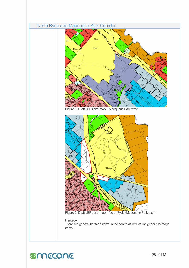
128 of 142
North Ryde and Macquarie Park Corridor
Figure 1: Draft LEP zone map – Macquarie Park west
Figure 2: Draft LEP zone map – North Ryde (Macquarie Park east) Heritage There are general heritage items in the centre as well as indigenous heritage items.

129 of 142
North Ryde and Macquarie Park Corridor Map
Figure 3: Macquarie Park west
Figure 4: North Ryde (Macquarie Park east) Source: Google Earth
Creative Cluster Attributes
- Close to public transport. - Close to Ryde Council building - Good pedestrian links - Potential to accommodate affordable housing - Active streets - Close to a variety of services - Close to and within major employment area

130 of 142
North Ryde and Macquarie Park Corridor - The centre has already gone through a major redevelopment and renewal. Most
services are IT professional which comes under the banner of IT, Media creative industries. However, due to established land uses a variety of expected creative industries to utilise area is limited.
Development Potential
The centre has undergone significant development.
IndustrialIndustrialIndustrialIndustrial
Gladesville Industrial Zone Location The Victoria Road employment area is made of properties along Victoria Road
which are for commercial/industrial land uses and a cluster of industrial lands between Victoria and Higginbotham Road.
Size Existing Industrial - 23 sqm
Proposed N/A
Land uses Category 1 Employment Land The industrial lands between Victoria Road and Higginbotham Road includes the following: Sydney Buses bus depot, automotive repairs, car hire, timber yard, etc Along Victoria Road there are a number of different businesses which include the following:
Specific Land Use Mix
As above.
Urban Form The built form consists of large warehouse development.
Inner North Subregional Strategy
The strategy identifies the area is being a potential corridor, having local industry but having strategic lands for industrial purposes.
Current Masterplan
No
Other Relevant EPIs, Controls, Plans and Policies
Planning Scheme Ordinance 1979 4(b2) Industrial Light (Restricted) 4(c) Industrial Special Draft Ryde LEP 2008 Zone IN2 – Light Industrial
FSR N – 1.0:1
Building height Not designated

131 of 142
Gladesville Industrial Zone
Figure 1: Draft LEP zone map Heritage No heritage items on the site.
Map
Figure 2: Victoria Road north

132 of 142
Gladesville Industrial Zone
Figure 3: Victoria Road south Source: Google Earth
Creative Cluster Attributes
- Close to public transport. - Close to Ryde Council building - Good pedestrian links - Potential to accommodate affordable
housing
- Active streets - Close to a variety of services - Close to and within major
employment area
Development potential
There is limited development potential. These lands are identified as strategic employment lands in the INSS.
West Ryde Industrial Zone Location The site is located off Victoria Road and is bounded by Hermitage Road, Rhodes
Street, Mellor Street and Victoria Road. Located to the south of the site is A TAFE and to the west a Sydney Water pumping station.
Size Existing Industrial - 7 sqm
Proposed N/A
Land uses Category 1 Employment Land The industrial lands includes the following land uses: automotive repairs, motor body shop works, storage, distribution businesses, small and light manufacturing, goods wholesalers, art suppliers.
Specific Land Use Mix
As above.
Urban Form The built form consists of large warehouse development.

133 of 142
West Ryde Industrial Zone Inner North Subregional Strategy
The strategy identifies the area is being a potential corridor, having local industry but having strategic lands for industrial purposes.
Current Masterplan
No
Other Relevant EPIs, Controls, Plans and Policies
Planning Scheme Ordinance 1979 4(b2) Industrial Light (Restricted) 4(c) Industrial Special Draft Ryde LEP 2008 Zone IN2 – Light Industrial
FSR N – 1.0:1
Building height Not designated
Figure 1: Draft LEP zone map Heritage No heritage items on the site.

134 of 142
West Ryde Industrial Zone Map
Figure 2: West Ryde industrial Source: Google Earth
Creative Cluster Attributes
- Close to public transport. - Close to Ryde Council building - Good pedestrian links - Potential to accommodate affordable housing - Active streets - Close to a variety of services - Close to and within major employment area
Development potential
There is limited development potential. These lands are identified as strategic employment lands in the INSS.
135 of 142
Appendix E Appendix E Appendix E Appendix E –––– Creative Industry Paper Creative Industry Paper Creative Industry Paper Creative Industry Paper
Creative Industries PaperCreative Industries PaperCreative Industries PaperCreative Industries Paper
The information provided in this paper is a general overview on the potential to identify and capture creative industries in Ryde. It is recommended that Council prepare a detailed economic strategy on creative industries and that the information presented in the Ryde Creative Industry Paper be utilised as a framework for such a strategy. Mecone has undertaken an assessment of potential opportunities for creative industry clustering in the City of Ryde. The assessment firstly aimed to identify whether such specific ‘creative’ type land uses or clusters currently exist in the LGA. The term creative industry has become widely used in the last in decade. This is in most part due to the change in the economic make-up of developed nations, where once the economy was dominated by companies such as car makers and other large manufacturers. New businesses that have had an impact on the economy recently include, for example software developers and video game developers. Therefore, in recent years developed nations have acknowledged the direct and indirect benefits that creative industries bring to all levels of the economy. In order to better understand which creative industries exist in Ryde we have researched the definition of creative industries and clustering. The definition adopted for this study is the Australian Research Centre (ARC), Centre of Excellence for Creative Industries and Innovations’ (CCI) definition of creative industries which is “…specialist Creative Industries comprise a set of interlocking sectors of the economy focused on extending and exploiting symbolic cultural products to the public such as the arts, films, interactive games, or providing business-to-business symbolic or information services in areas such as architecture, advertising and marketing, design, as well as web, multimedia and software development. Most often Creative production delivers unique or customised products from incomplete or abstract specifications received either from a client or derived from a desire for personal, artistic exploration.” Industry is traditionally separated into three sectors, which include:
Primary – Extracting raw or natural materials from environment for example mining, agriculture.
Secondary – The output from primary industry is manufactured into products. Hence, industries include but not limited to construction and manufacturing for example car makers.
Tertiary – This sector is also known as the service sector. This relates to such industries for example professional consulting, distribution and health industries. Generally, considered to be a sector where information is exchanged.
The Australian and New Zealand Standard Industrial Classification, 1993 (ANZSIC) defines all industries that may fall under the three traditional industry sectors, which includes:

136 of 142
� Agriculture, Forestry and Fishing;
� Mining;
� Manufacturing;
� Electricity, Gas, Water and Waste Services;
� Construction;
� Retail Trade;
� Wholesale Trade;
� Accommodation and Food Services;
� Transport, Postal and Warehousing;
� Information Media and Telecommunications;
� Financial and Insurance Services;
� Rental, Hiring and Real Estate Services;
� Professional, Scientific and Technical Services;
� Administrative and Supportive Services;
� Public Administration and Safety;
� Education and Training;
� Health Care and Social Assistance;
� Arts and Recreation Services;
� Other services; and
� Inadequately described or not stated. Under the definition provided the ARC creative industries fall within a number of the above categories. In addition, they are more polarised in regards to the traditional industry sectors crossing between secondary and tertiary sectors readily. Therefore, based on this definition and the industries identified in the Creative Industries Mapping Document 1998, prepared by the United Kingdom (UK) Department for Culture, Media and Sport, which included advertising, antiques, architecture, crafts, design, fashion, film, leisure software, music, performing arts, publishing, software and TV and radio, Mecone has developed the ‘Creative Industries Kaleidoscope‘ chart below.

137 of 142
Figure 1 Figure 1 Figure 1 Figure 1 ---- Creative Industries Kaleidoscop Creative Industries Kaleidoscop Creative Industries Kaleidoscop Creative Industries Kaleidoscopeeee
The Creative Industries Kaleidoscope above, categories the industries into spatial
themes. The categories have then been reviewed to determine what attributes they
exhibit that stands them apart. The attributes of each category have been identified in
Table 1Table 1Table 1Table 1 below.
Table 1 – Location Attributes of Creative Industry Categories
CategoryCategoryCategoryCategory Location AttributeLocation AttributeLocation AttributeLocation Attribute
Fringe Activities in this category tend to be located within areas of low rents. Can be located near higher educational institutions. Tend to be located within or near a broad variety of residential type of accommodation including terrace, warehouse, boarding houses and apartments. Area tends to appear under-utilised with older stock properties.

138 of 142
CategoryCategoryCategoryCategory Location AttributeLocation AttributeLocation AttributeLocation Attribute
Exec Located in areas of high concentration of media, IT, advertising industries. Well located in relation to public transport. Provide after hours services and activities including restaurants, cafes, bars etc
Renewal Area tends to have undergone some redevelopment. Former uses no longer economic e.g. industrial uses converting to commercial or residential
Village Development in these areas tends to be low to medium scale. Local scale centres
In light of the Creative Industries Kaleidoscope and the attributes table above, the study has found that Ryde exhibits employment and land use potential for a range of creative industries. Importantly, the study has identified that there are a number of existing businesses which create employment in creative industries. An example of this is Macquarie Park/North Ryde which generally falls into the category of ‘Exec’. The Macquarie Park/North Ryde centre includes large businesses in media and IT. However, it can also cross into the other categories as land uses include large educational and institutional organisations. Based on the definition of creative industries, the Creative Industry Kaleidoscope and the attributes identified in Table 1, we have undertaken an assessment of the attributes of each category against the centres in Ryde that are most likely to accommodate future creative industries. Table 2 below provides the assessment. Table 2 – Centres in their Creative Industry Categories
CentresCentresCentresCentres Creative Creative Creative Creative CategoryCategoryCategoryCategory
DescriptionDescriptionDescriptionDescription
Ryde Village Land south-west of Blaxland Road, surrounding Top Ryde development identified as suitable for potential creative industry. Low to medium scale development. Potentially lower rents than Top Ryde. Cafes, medium size businesses can reinforce existing land uses.
Eastwood Village Renewal
Eastern side of railway station. Medium scale development. Western side of railway station includes redevelopment of Eastwood shopping centre. Low scale development to the west of the mall along Rowe Street. Cafes, medium size businesses, and boutique stores can reinforce existing land uses on both sides. Potential redevelopment of centre can see increase population.

139 of 142
CentresCentresCentresCentres Creative Creative Creative Creative CategoryCategoryCategoryCategory
DescriptionDescriptionDescriptionDescription
Gladesville Village Fringe Renewal
Potential for Gladesville Centre to be amalgamated with enterprise corridor to the north west of the centre. Centre offers great opportunity for existing land uses to be reinforced with cafes, medium size businesses, boutique stores, small design firms and art galleries or artist spaces. Current development along centre generally low to medium scale. Potential redevelopment of centre can see increase population.
West Ryde Village Fringe Renewal
Eastern side of railway station is currently low to medium scale development, mainly cafes, commercial land uses. Potentially lower rents in comparison to western side of railway station. Centre offers great opportunity for existing land uses to be reinforced with cafes, medium size businesses, boutique stores, small design firms and art galleries or artist spaces.
Meadowbank Centre
Renewal Village
Centre near train station is low scale development with potential to expand existing land uses to include more cafes, small businesses and other mixed uses. Potential for redevelopment to increase population of centre. Location to station and link to waterway and good pedestrian links offer good opportunities to increase activity. Potentially lower rents compared to retail and residential area near waterway is an attractive prospect.
North Ryde/Macquarie Park
Exec The centre is newly redeveloped. Land uses include commercial, educational and institutional. A creative industry hub for media and IT, however the centre has potential for village creative activities. High rents may limit ability for smaller businesses to be accommodated.
Gladesville Industrial Area (Victoria Road Corridor)
Renewal Potential for the industrial area as part of enterprise corridor to be amalgamated with Gladesville Centre. Industrial area includes a mix of large warehouse buildings and medium to small strata industrial type units. Smaller strata units offer opportunities for boutique furniture and design workshops.

140 of 142
CentresCentresCentresCentres Creative Creative Creative Creative CategoryCategoryCategoryCategory
DescriptionDescriptionDescriptionDescription
West Ryde Industrial Area
Fringe Renewal
Proximity to West Ryde centre, TAFE offers medium to long term opportunities for artist spaces. Currently area includes a mix of large warehouse buildings and medium to small strata industrial type units, which includes retail warehouse art supplies and printing uses. Smaller strata units offer opportunities for boutique furniture and design workshops.
Meadowbank Employment Area
Renewal Fringe
Warehouse, industrial type development offer opportunities for lower rents and larger spaces for boutique furniture and design workshops or stores. Area similar to West Ryde having a mix of large warehouse buildings and medium to small strata industrial type units.


