Geospatial Technologies for Decentralised Planning and Governance National Remote Sensing Centre Panchayats Empowering Institutions and Stakeholders for Spatial Planning nrsc Nagaraja Ravoori, Project Director, SIS-DP Chief General Manager, RC, NRSC
Transcript
Geospatial Technologies for Decentralised Planning and Governance
Nat
ion
al R
emo
te S
ensi
ng
Cen
tre
P a n c h a y a t s
Empowering Institutions and Stakeholders for Spatial Planning
nrsc
Nagaraja Ravoori, Project Director, SIS-DP
Chief General Manager, RC, NRSC
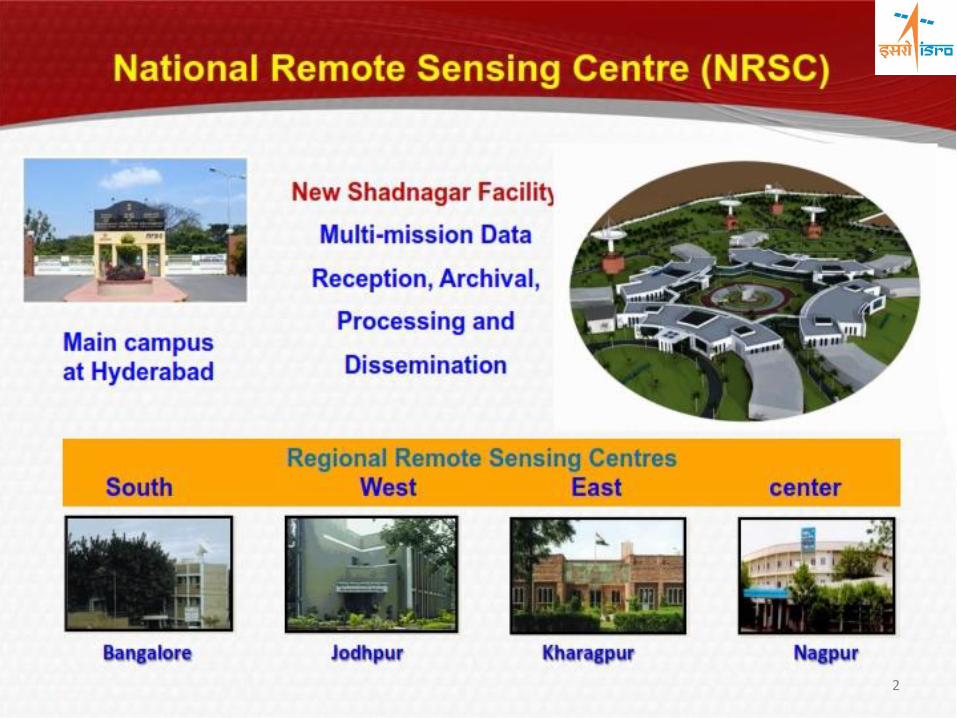
2
2003
RESOURCESAT-1
LISS 3; LISS 4; AWiFS
2007/08/10 CARTOSAT-2/2A/2B
PAN
2005
CARTOSAT-1
STERO PAN, F/A
2013
SARAL
Aros, Altica
2013
INSAT- 3D
Imager, Sounder
2009 OCEANSAT-2
OCM , SCAT
ROSA
2011 RESOURCESAT-2
LISS 3; LISS 4; AWiFS
2011
Megha Tropiques MADRAS, SAPHIR
SCaRaB
Currently operational EO missions
2009 RISAT-2 X-SAR
3
2011 RESOURCESAT-2
LISS 3; LISS 4; AWiFS
2015
LANDSAT-7
Future Missions:
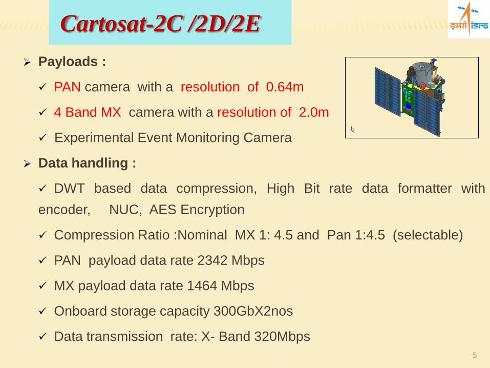
Cartosat-2C/2D/2E
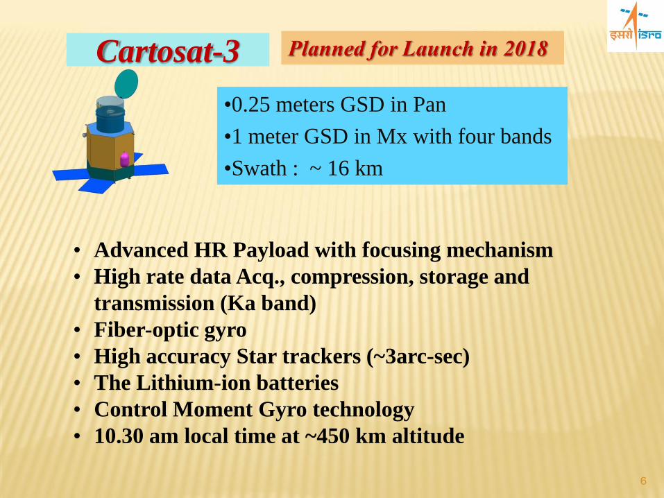
Cartosat-3, 3A & 3B - Sub meter PAN, Mx & IR
RISATs: RISAT-1A & 1B, 2A
NISAR
GISats : HR Missions from Geo orbit
4
Payloads :
PAN camera with a resolution of 0.64m
4 Band MX camera with a resolution of 2.0m
Experimental Event Monitoring Camera
Data handling :
DWT based data compression, High Bit rate data formatter with
encoder, NUC, AES Encryption
Compression Ratio :Nominal MX 1: 4.5 and Pan 1:4.5 (selectable)
Refinement of beat-map sketches using HRSI/Infrastructure details
Final GIS Map of Beat areas Beat Boundaries sketch Refinement using HRSI/Maps
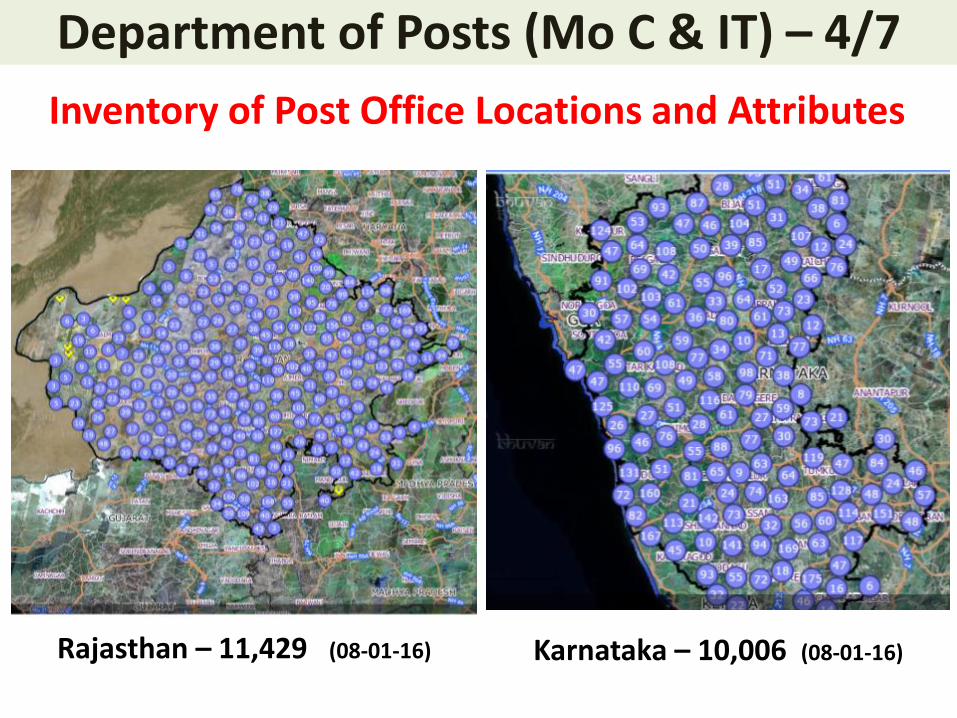
Department of Posts (Mo C & IT) – 5/7
Department of Posts Way Forward
• Completion of Post Office Inventory • Development/Testing of mobile app for post man/van delivery services • Beat map Refinement – Rural
• Integration of village boundaries • Procurement of details • Finalization of beat boundaries • Validation and Updation
• Beat map Refinement – Urban • Refinement of beat boundaries using HRSI/Road layers • Pilot study completed in Jodhpur town • Capacity Building of Postal department officials
User Agency: MNCFC, Ministry of agriculture Satellite data Resourcesat LISS-IV and Cartosat-1 Plantations Type Mango, Banana and citrus Study Area: Future Scope Based on the results study will be extended to National level. Deliverables Horticultural crop map District-wise crop acreage estimation.
Objectives:
o Area assessment and production forecasting of major horticultural crops in selected districts in peninsular India
o Geospatial Applications for Horticultural Development and Management Planning o Detailed scientific field level studies for developing technology for crop identification,
yield modelling and disease assessment
User Agency Ministry of Commerce Satellite data Resourcesat LISS-IV and Cartosat-1 Plantations Type Rubber, Coffee and Tea Study Area: Coffee: (Karnataka, Kerala & Tamilnadu). Tea ( Phase-1 in Assam & West Bengal completed. Phase-2 initiated for Karnataka Tamilnadu and Kerala) Rubber ( Tripura completed) Future Scope Based on the results study will be extended to National level. Deliverables Taluq-wise crop acreage estimates MIS package for visualization and querying
Objectives: o Inventory of commercial plantations for generation plantation map of the country o Site-suitability analysis for extension of plantations for expansion of area under
commercial plantation crops o Generation of MIS package and Interface with Bhuvan geoportal for easy
accessibility of information
National Level Inventory and Monitoring of Plantations Horticultural Plantations (CHAMAN) Commercial Plantations
Coffee Rubber Banana Citrus
The Project at national level covers 3 fruit crops(mango, banana, citrus), 3 vegetable crops(potato, onion and tomato) and 1 spice crop(chillies) in about 100+ districts of 12 states
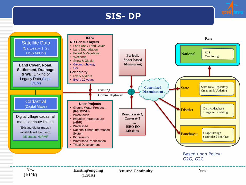
Goal: Empowering the Panchayati Raj Institutions (PRIs) and the Stakeholders
with Space Based Information Support for Decentralized Planning and Governance in the country.
Objective 1
To generate and provide ‘Satellite Image Maps’ for the entire country as base for decentralized planning.
National Remote Sensing Centre P a n c h a ya t s National Remote Sensing Centre
CADASTRAL OVERLAY STATUS
STATE Number of
Villages – Total
Number of Villages
– Overlaid
Percentage of
Villages
Andhra Pradesh 17385 12580 72.36
Assam 21225 18409 86.73
Haryana 7094 7030 99.09
Kerala 1593 1092 68.55
Telangana 10932 9350 85.53
West Bengal 4028 / 40203 2500 62.06
TOTAL 62229 50961 81.89
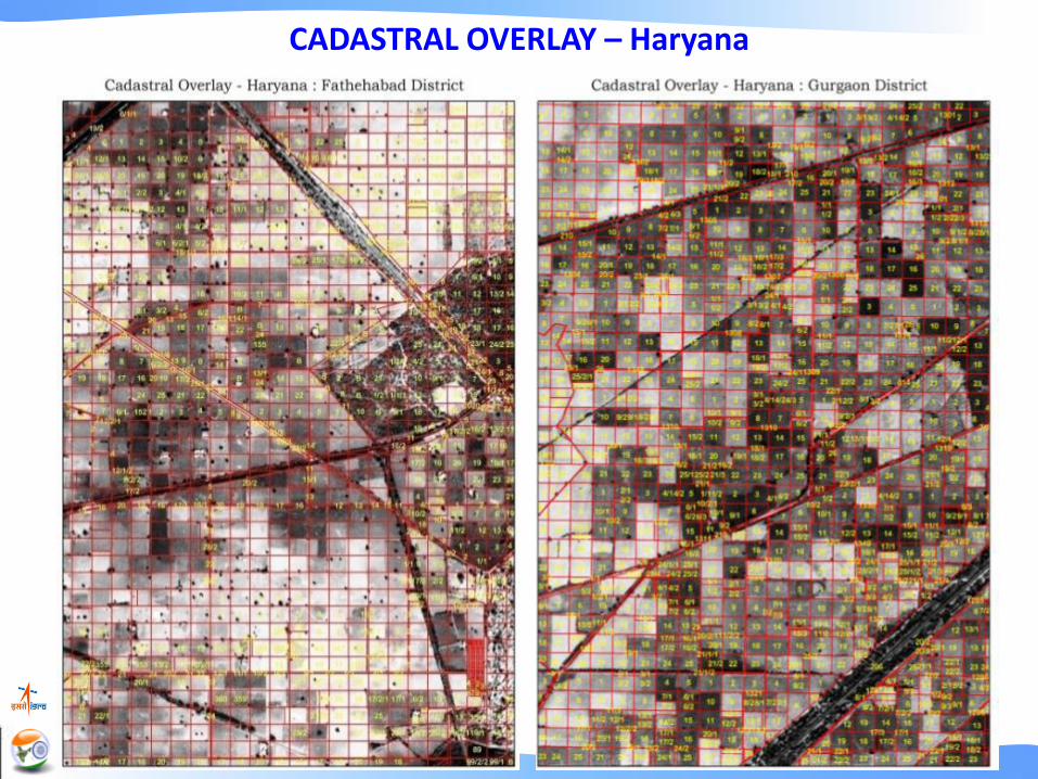
Haryana
Hampapuram Village - Raptadu Mandal Anantapur District - Andhra Pradesh
Khandam Boundary
Parcel Boundary
National Remote Sensing Centre P a n c h a ya t s National Remote Sensing Centre
CADASTRAL OVERLAY – Andhra Pradesh
National Remote Sensing Centre P a n c h a ya t s National Remote Sensing Centre
CADASTRAL OVERLAY – Telangana
National Remote Sensing Centre P a n c h a ya t s National Remote Sensing Centre
CADASTRAL OVERLAY – Haryana
National Remote Sensing Centre P a n c h a ya t s National Remote Sensing Centre
CADASTRAL OVERLAY – Kerala
National Remote Sensing Centre P a n c h a ya t s National Remote Sensing Centre
CADASTRAL OVERLAY – Assam and West Bengal
Panchayat Portal
http://bhuvan-panchayat.nrsc.gov.in/
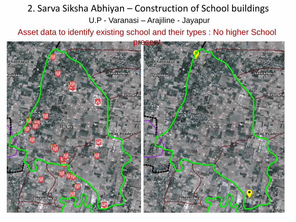
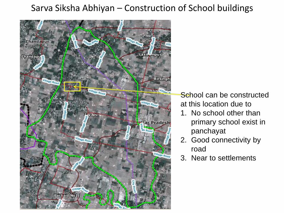
Cadastral Map of Jayapur Panchayat Overlaid on High
Resolution Satellite Image (2.5m)
Enabling Environment – Bhuvan Panchayat Portal
MODULES
• Area selection
• Area Profile Report
• Asset Mapping
• Activity Planning
• Implementation & Monitoring
• Download Reports
FEATURES
• Planning window for citizens & PRI
• Inventory of Assets across the Nation
• Planning option from 17 CSS and other Schemes
• Dissemination of spatial & non-spatial information
Integration of schemes:
- Saansad Aadarsh Gram Yojana (SAANJHI)
- Backward Regions Grant Fund (BRGF)
Assets Mapped through Mobile app for Jayapur Panchayat,
Varanasi
adopted by Prime Minister Shri Narendra Modi under SAANJHI
Mobile App for Asset
Mapping
Bhuvan Panchayat Portal Release :
- Ver 1.0 released on March 2014
- Ver 2.0 released on November 2014
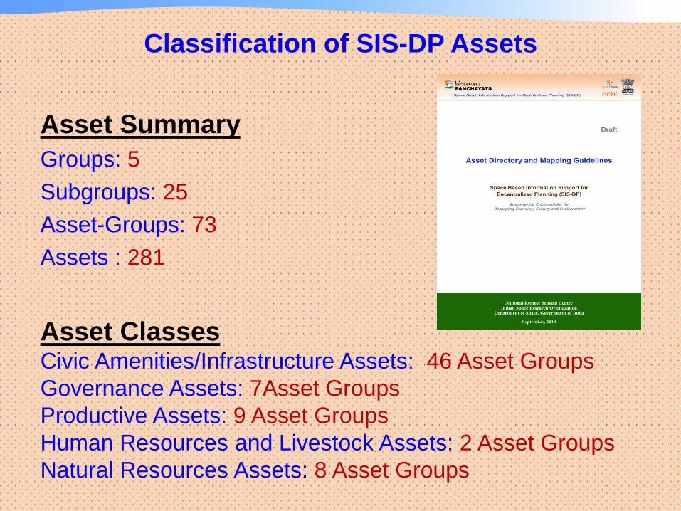
Classification of SIS-DP Assets
Asset Summary
Groups: 5
Subgroups: 25
Asset-Groups: 73
Assets : 281
Asset Classes Civic Amenities/Infrastructure Assets: 46 Asset Groups
Governance Assets: 7Asset Groups
Productive Assets: 9 Asset Groups
Human Resources and Livestock Assets: 2 Asset Groups
Natural Resources Assets: 8 Asset Groups
Area Profile and Resource Inventory
This information provides an overview of an area under eight heads: 1. Identification details 2. Major Issues and Constraints in the area 3. Priorities of the area 4. Ongoing Projects 5. Village & Town Directory: 2011 6. House Listing & Housing Census Schedule: 2011 7. Assets - Natural resource assets, Productive assets, Civic amenities /Infrastructure, Human resource & livestock assets, Governance assets 8. Mapping of Vulnerable areas / Groups / Assets
Assets, Attributes • Non-spatial data: General Village/Block/District
Characteristics, Meteorological data, Census 2011 amenities and village & town directory, Major issues of the village
• Asset mapping: asset mapping using point, line & polygon, attribute editing, uploading photographs of assets.
• Activity Planning & monitoring: 29 activities, Planning using spatial & non-spatial data, finding an existing scheme, monitoring the progress of an activity
• Availability of different Schemes • Profile of the area • Panchayat & citizen login • Share views
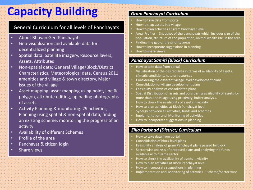
General Curriculum for all levels of Panchayats
• How to take data from portal • How to map assets in a village • How to plan activities at gram Panchayat level • Area Profiler - Snapshot of the panchayats which includes size of the
population, structure of the population, animal wealth etc. in the area • Finding the gap or the priority areas • How to incorporate suggestions in planning • How to share views
• How to take data from portal • Visualization of the desired area in terms of availability of assets,
climatic conditions, natural resources • Considering the different village level development plans • Consolidation of village development plans • Feasibility analysis of consolidated plans • Spatial Distribution of assets and considering availability of assets for
more than one village using proximity, buffer analysis. • How to check the availability of assets in vicinity • How to plan activities at Block Panchayat level • Synergy between all activities, funds and schemes • Implementation and Monitoring of activities • How to incorporate suggestions in planning
Panchayat Samiti (Block) Curriculum
• How to take data from portal • Consolidation of block level plans • Feasibility analysis of gram Panchayat plans passed by block • Sector wise analysis of proposed plans and analyzing the funds
available within same sector • How to check the availability of assets in vicinity • How to plan activities at Block Panchayat level • How to incorporate suggestions in planning • Implementation and Monitoring of activities – Scheme/Sector wise
Zilla Parishad (District) Curriculum
Gram Panchayat Curriculum
National Remote Sensing Centre
Scale of Operation
Number of Elected Representatives in the three tiers Panchayats