DOT/FAA/RD-93/33 Project Report ATC-205 Encoding Approaches for Data Link Transmission of Weather Graphics J. L. Gertz R. D. Grappel 10 December 1993 Lincoln Laboratory MASSACHUSETTS INSTITUTE OF TECHNOLOGY LEXINGTON, MASSACHUSETTS Prepared for the Federal Aviation Administration, Washington, D.C. 20591 This document is available to the public through the National Technical Information Service, Springfield, VA 22161
Transcript
DOT/FAA/RD-93/33
Project ReportATC-205
Encoding Approaches for Data Link
Transmission of Weather Graphics
J. L. Gertz
R. D. Grappel
10 December 1993
Lincoln Laboratory MASSACHUSETTS INSTITUTE OF TECHNOLOGY
LEXINGTON, MASSACHUSETTS
Prepared for the Federal Aviation Administration, Washington, D.C. 20591
This document is available to the public through
the National Technical Information Service, Springfield, VA 22161
This document is disseminated under the sponsorship of the Department of Transportation in the interest of information exchange. The United States Government assumes no liability for its contents or use thereof.
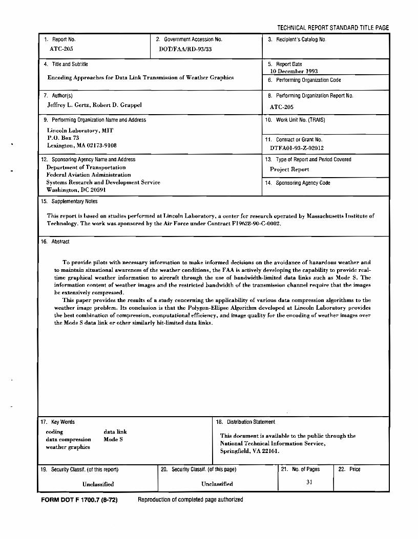
1. Report No.
ATC-205
4. Title and Subtitle
2. Government Accession No.
DOTIFAAJRD-93/33
TECHNICAL REPORT STANDARD TITLE PAGE
3. Recipient's Catalog No.
5. Report Date10 December 1993
Encoding Approaches for Data Link Transmission of Weather Graphics
7. Author(s)
Jeffrey L. Gertz, Robert D. Grappel
9. Performing Organization Name and Address
Lincoln Laboratory, MITP.O. Box 73Lexington, MA 02173-9108
12. Sponsoring Agency Name and AddressDepartment of TransportationFederal Aviation AdministrationSystems Research and Development ServiceWashington, DC 20591
15. Supplementary Notes
6. Performing Organization Code
8. Performing Organization Report No.
ATC-205
10. Work Unit No. (TRAIS)
11. Contract or Grant No.
DTFAOI-93-Z-02012
13. Type 01 Report and Period Covered
Project Report
14. Sponsoring Agency Code
This report is based on studies performed at Lincoln Laboratory, a center for research operated by Massachusetts Institute ofTechnology. The work was sponsored by the Air Force under Contract FI9628-90-C-0002.
16. Abstract
To provide pilots with necessary information to make informed decisions on the avoidance of hazardous weather andto maintain situational awareness of the weather conditions, the FAA is actively developing the capability to provide realtime graphical weather information to aircraft through the use of bandwidth-limited data links such as Mode S. Theinformation content of weather images and the restricted bandwidth of the transmission channel require that the imagesbe extensively compressed.
This paper provides the results of a study concerning the applicability of various data compression algorithms to theweather image problem. Its conclusion is that the Polygon-Ellipse Algorithm developed at Lincoln Laboratory providesthe best combination of compression, computational efficiency, and image quality for the encoding of weather images overthe Mode S data link or other similarly bit-limited data links.
17. Key Words
codingdata compressionweather graphics
data linkModeS
18. Distribution Statement
This document is available to the public through theNational Technical Information Service,Springfield, VA 22161.
19. Security Classif. (of this report)
Unclassified
FORM DOT F 1700.7 (8-72)
20. Security Classif. (of this page)
Unclassified
Reproduction of completed page authorized
21. No. of Pages
31
22. Price
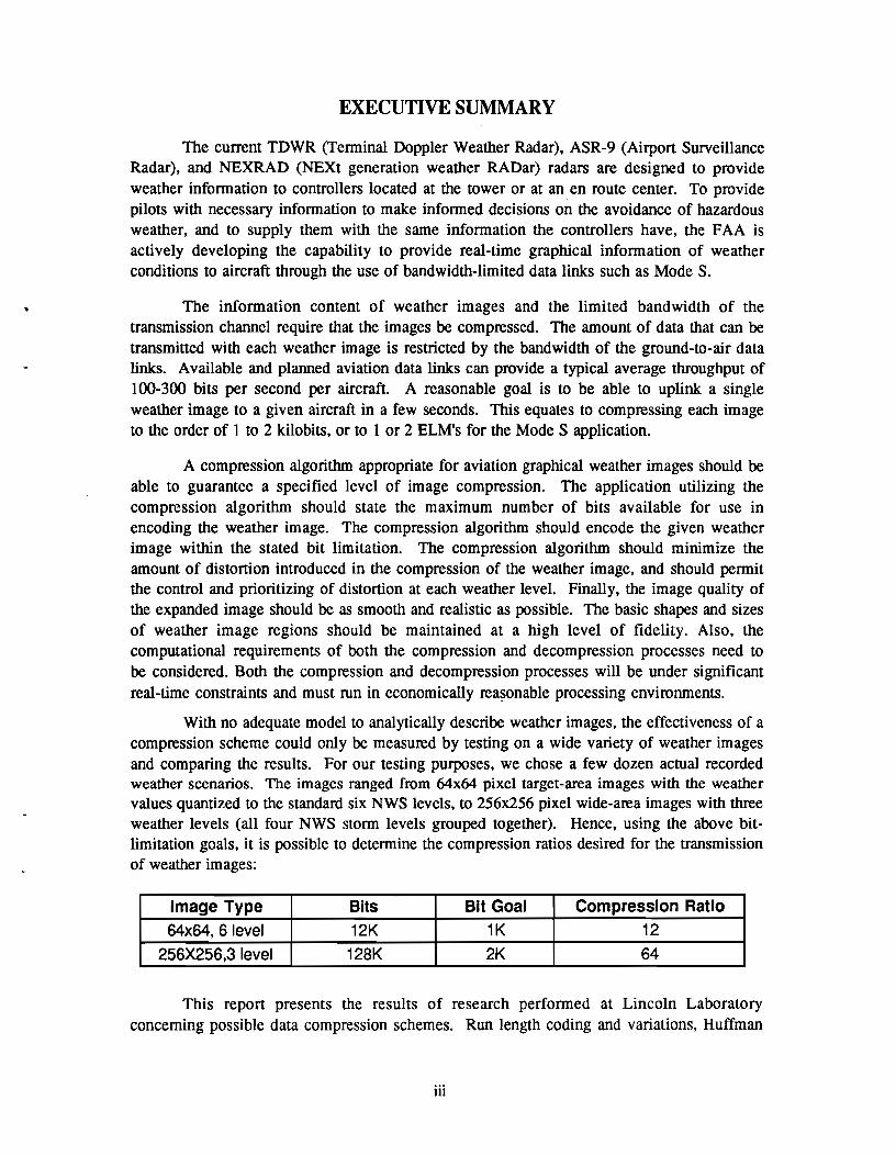
EXECUTIVE SUMMARY
The current TDWR (Tenninal Doppler Weather Radar), ASR-9 (Airport SurveillanceRadar), and NEXRAD (NEXt generation weather RADar) radars are designed to provideweather infonnation to controllers located at the tower or at an en route center. To providepilots with necessary infonnation to make infonned decisions on the avoidance of hazardousweather, and to supply them with the same infonnation the controllers have, the FAA isactively developing the capability to provide real-time graphical infonnation of weatherconditions to aircraft through the use of bandwidth-limited data links such as Mode S.
The information content of weather images and the limited bandwidth of thetransmission channel require that the images be compressed. The amount of data that can betransmitted with each weather image is restricted by the bandwidth of the ground-to-air datalinks. Available and planned aviation data links can provide a typical average throughput of100-300 bits per second per aircraft. A reasonable goal is to be able to uplink a singleweather image to a given aircraft in a few seconds. This equates to compressing each imageto the order of 1 to 2 kilobits, or to 1 or 2 ELM's for the Mode S application.
A compression algorithm appropriate for aviation graphical weather images should beable to guarantee a specified level of image compression. The application utilizing thecompression algorithm should state the maximum number of bits available for use inencoding the weather image. The compression algorithm should encode the given weatherimage within the stated bit limitation. The compression algorithm should minimize theamount of distortion introduced in the compression of the weather image, and should permitthe control and prioritizing of distortion at each weather level. Finally, the image quality ofthe expanded image should be as smooth and realistic as possible. The basic shapes and sizesof weather image regions should be maintained at a high level of fidelity. Also, thecomputational requirements of both the compression and decompression processes need tobe considered. Both the compression and decompression processes will be under significantreal-time constraints and must run in economically rea~onable processing environments.
With no adequate model to analytically describe weather images, the effectiveness of acompression scheme could only be measured by testing on a wide variety of weather imagesand comparing the results. For our testing purposes, we chose a few dozen actual recordedweather scenarios. The images ranged from 64x64 pixel target-area images with the weathervalues quantized to the standard six NWS levels, to 256x256 pixel wide-area images with threeweather levels (all four NWS stonn levels grouped together). Hence, using the above bitlimitation goals, it is possible to determine the compression ratios desired for the transmissionof weather images:
Image Type Bits Bit Goal Compression Ratio64x64, 6 level 12K 1K 12
256X256,3 level 128K 2K 64
This report presents the results of research performed at Lincoln Laboratoryconcerning possible data compression schemes. Run length coding and variations, Huffman
iii
coding, variable-to-block coding, vector quantization, contour coding, shape fitting, fractals,and other new compression techniques were all considered, along with the Weather-Huffman(W-H) and Polygon-Ellipse (P-E) algorithms developed at Lincoln Laboratory. Pre-filteringof weather maps prior to compression was also addressed in each case.
The average compression results were as follows:
Table 1. Average Compression Ratios For Various Algorithms
It is clear from these results that only the Weather-Huffman and Polygon-EllipseAlgorithms provide the desired degree of compression when a bit limit is imposed. ThePolygon-Ellipse Algorithm was identified as the preferred approach because it is able to
1. provide less distortion in general,
2. present a more easily interpreted picture, as it is smoother and less blocky,
3. provide weather level distortion priorities ~ore accurately, and
4. scale to different image dimensions more easily.
In conclusion, the Polygon-Ellipse algorithm has significant potential for theencoding of weather images over the Mode S data link or other similarly bit-limited datalinks. Further research needs to be done to study the effects of weather image compressionon a pilot's situational awareness.
iv
TABLE OF CONTENTS
Executive Summary .iii
List of illustrations vii
List of Tables vii
1. INTRODUCfION 1
2. THE COMPRESSION PROBLEM 3
2.1 ONE-DIMENSIONAL IMAGE COMPRESSION ,A
2.1.1 Runlength Coding 9
2.1.1.1 Runlength Variations 9
2.1.1.2 Huffman Coding 9
2.1. 1.3 Variable-To-Block Coding 10
2.1.2 Isolated Pixel Removal l 0
2.2 TWO-DIMENSIONAL IMAGE COMPRESSION 10
2.2.1 Vector Quantization 11
2.2.2 Contour Coding 11
2.2.3 Representation by Simple Shapes 12
2.2.3.1 The Polygon-Ellipse Compression Scheme 12
3. RESULTS ON SAMPLE WEATHER IMAGES .13
4. MODERN COMPRESSION TECHNIQUES 19
5. CONCLUSION 21
REFERENCES , 23
v
FigureNo.
1
2
3
4
LIST OF ILLUSTRATIONS
Page
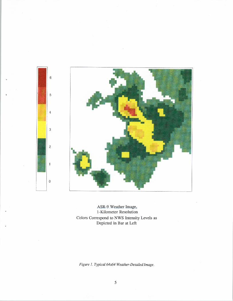
Typical 64x64 Weather-Detailed Image 5
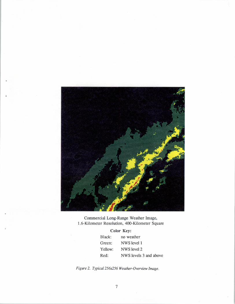
Typical 256x256 Weather-Overview Image 7
Polygon-Ellipse Compression of 64x64 Images 15
Polygon-Ellipse Compression of 256x256 Images 17
LIST OF TABLES
TableNo. Page
1 Average Compression Ratios for Various Algorithms 13
vii
L INTRODUCfION
The current TDWR (Terminal Doppler Weather Radar), ASR-9 (Airport SurveillanceRadar), and NEXRAD (NEXt generation weather RADar) radars are designed to provideweather information to controllers located at the tower or at an en route center. TheIntegrated Terminal Weather System (ITWS) and the Aviation Weather Products Generator(AWPG) will provide ground personnel with further weather information - much of it ingraphical form. Pilots lacking airborne weather avoidance equipment currently rely onverbal exchanges with controllers or flight service personnel to develop awareness of theweather situation. Onboard weather avoidance equipment has range and weather penetrationlimitations and may not provide a sufficiently accurate picture of the weather. Access toground-based, graphical weather information transmitted via data link has the potential togreatly improve a pilot's weather situational awareness.
To provide pilots with this information, the FAA is actively developing the capabilityto provide real-time graphical information of hazardous weather conditions to aircraft by useof data links such as the Mode S data link. This paper describes a study performed todetermine how effectively graphical weather images could be compressed for effectivetransmission given the bandwidth limitations of ground-to-air aviation data links. Section 2states the goals of weather image compression. Section 2.1 describes a number of onedimensional compression techniques, while Section 2.2 describes two-dimensionalcompression techniques. Section 3 gives the measured compression performance for thetested algorithms. Section 4 discusses some additional compression techniques includingfractals. Finally, Section 5 states the conclusions of this report.
1
2. THE COMPRESSION PROBLEM
The information content of weather images and the limited bandwidth of thetransmission channel require that the images be compressed. The amount of data that can betransmitted with each weather image is restricted by the bandwidth of the ground-to-air datalinks. Available and planned aviation data links can provide a typical average throughput of100-300 bits per second per aircraft. A reasonable goal is to be able to uplink a singleweather image to a given aircraft in a few seconds. This equates to compressing each imageto the order of 1 to 2 kilobits, or to 1 or 2 Extended Length Messages (ELMs) for theMode S application.
The importance and content of information within the images is suited to the spatialand temporal resolution of the data, making compression a difficult task. A compressionalgorithm appropriate for aviation graphical weather images should be able to guarantee aspecified level of image compression. The application utilizing the compression algorithmwill state the maximum number of bits available for use in encoding the weather image. Thecompression algorithm should encode the given weather image within the stated bit limitation.The compression algorithm should minimize the amount of distortion introduced in thecompression of the weather image, and should permit the control and prioritizing ofdistortion at each weather level. Finally, the image quality of the expanded image should beas smooth and realistic as possible. The basic shapes and sizes of weather image regionsshould be maintained at a high level of fidelity. Also, the computational requirements ofboth the compression and decompression processes need to be considered. Both thecompression and decompression processes will be under significant real-time constraints andmust run in economically reasonable processing environments.
With no adequate model to analytically describe weather images, the effectiveness of acompression scheme could only be measured by testing on a wide variety of weather imagesand comparing the results. For our testing purposes, we chose a few dozen actual recordedweather scenarios. The images ranged from 64x64 pixel target-area images with the weathervalues quantized to the standard six NWS levels, to 256x256 pixel wide-area images with threeweather levels (all four NWS storm levels grouped together). Hence, using the above bitlimitation goals, it is possible to determine the compression ratios desired for the transmissionof weather images:
Image Type Bits Bit Goal Compression Ratio64x64, 6 level 12K 1K 12
256X256,3 level 128K 2K 64
This report presents the results of research performed at Lincoln Laboratoryconcerning possible data compression schemes. Runlength coding and variations, Huffmancoding, variable-to-block coding, vector quantization, contour coding, shape fitting, fractals,and other new compression techniques were all considered, along with the Weather-Huffman(W-H) and Polygon-Ellipse (P-E) algorithms developed at Lincoln. Pre-filtering of weathermaps prior to compression was also addressed in each case. The compression ratios of a
3
number of these algorithms for dealing with graphical weather images will be given inSection 3 of this report.
Typical 64x64 and 256x256 graphical weather images are presented in Figures I and2, respectively. The former image is a detailed look at a severe weather region derived froman ASR-9 radar where each pixel is one kilometer in extent, while the latter image is anoverview of a storm system derived from a commercial weather vendor where each pixel isapproximately 1.6 kilometers in extent.
2.1 ONE-DIMENSIONAL IMAGE COMPRESSION
The term "one-dimensional compression" refers to those routines that act upon thedata as a stream of serial values. This serial stream may be generated simply by rasterscanning, or by more complex space filling curves such as a Hilbert Curve.
One-dimensional coding algorithms have a number of features that appear to makethem attractive for the encoding of weather images. The most desirable feature is theproperty that they can be made to be information-Iossless; that is, the decoded image will bean exact replica of the original image. Besides being information lossless, they also tend tobe simple to implement on both the encoding and decoding end, their performance can bepredicted and bounded, and they are readily available and well documented.
Several types of one-dimensional coding schemes for the compression of weatherhave been considered. Some are variations on runlength coding, while others are forms ofvariable-to-block codes.
2.1.1 Runlength Coding
The simplest of the codes studied, and the one serving as a reference for the others, isstraight runlength coding. This coding scheme is performed by scanning an image todetermine how many successive values occur prior to each transition between levels. Theencoded information consists of the value of the new level (or change in level) and thenumber (runlength) of successive elements with that value. In its most basic implementation,runlength encoding requires that the coded words consist of log(M) bits to represent theweather level plus 10g(L) bits to represent the runlength count, where:
logO = base-2 logarithm
M = number of quantized weather levels
L = longest represented runlength (chosen to be I row of the image)
While runlength encoding is efficient for images consisting of long runs, it loses itseffectiveness when short runs exist. In fact. in regions of an image that lack large runs ofconsecutive pixels, runlength coding will actually expand the number of bits required.
4
6
5
4
3
2
o
ASR-9 Weather Image,I-Kilometer Resolution
Colors Correspond to NWS Intensity Levels asDepicted in Bar at Left
To overcome runlength encoding's drawback when short runs occur, numerousvariations have been developed. One commonly used method, Select, presents short runs inan unencoded form. An improved method, developed at Lincoln Laboratory, is namedLong/Short. This approach uses short codewords for short runs and full-length codewordsfor longer runs. For example, 3-bit words might be used for runs up to 8, and 8-bit words forthe remaining runs up to 256; a single bit preceding each word specifies the length. Thelength of the short codewords is chosen to be optimal for each image, and the selected valueis included as the first 3 bits of the transmitted message.
2.1.1.2 Huffman Coding
Theory tells us that if successive runlengths are iridependent random variables, thenthe most efficient codes should be entropy codes. Entropy codes are those whose wordlengths are based on the frequency of occurrence of a symbol. The most efficient of thesecodes is the Huffman code. Huffman coding is a variable encoding algorithm where codewords are assigned based on runlength probability. This code assignment is optimal in thesense that the average number of bits required to transmit information is minimal subject tothe constraint that no code word is the prefix of any other code word, allowing the receivedsequence to be uniquely decodable. Huffman coding of the runlengths, although optimal,loses some of its attractiveness due to the overhead associated with the transmission of thecode table to the decoder.
In addition to the decoding table problem, the Huffman algorithm produces somevery long codewords due to the need to assign a unique codeword to every combination oflevel and length. These problems have been circumvented at Lincoln by modifying theHuffman coding procedure to create the Weather-Huffman Algorithm [1]. This algorithmre-uses codewords; in fact each short codeword can be used once for each image level. Inaddition, the decoding table is itself compressed by numerous special techniques. The resulthas been that the Weather-Huffman Algorithm, with its table, requires far fewer bits than thenormal Huffman approach without its table.
The Weather-Huffman Algorithm includes mechanisms to reduce the bit transmissionrequirement to meet any pre-specified limit. This is useful when it is desired to constrain theentire weather image to a preset number of bits.
2.1.1.3 Variable-To-Block Coding
Adaptive variable-to-block codes constrain each output codeword to be a fixedlength. Depending on the parameters of the particular code and the statistics of the source,variable numbers of the source pixels will be encoded in the fixed output block code. Muchlike runlength coding, the length of source code represented by each codeword is dependenton the redundancy of the source, yet unlike runlength coding the redundancy is not restrictedto consecutive identical pixels.
The two specific codes of this type that have been studied are Lempel-Ziv and Welch(which is a variation on the Lempel-Ziv scheme). The Lempel-Ziv code describes a segmentof source symbols by relating it to what it has in common with symbols that have alreadybeen encoded. The more the pre- and post-encoded blocks have in common, the more
9
symbols that can be contained in each encoded block. A variation on the basic Lempel-Zivcode is Welch's code. With Welch, code words are created and placed in a table as newpatterns manifest themselves in the code.
2.l.2 Isolated Pixel Removal
When the Hilbert scan is used on a weather image (rather than the usual raster scan),the most common runlength tends to be one. By removing single isolated pixels between tworuns of the same level, Le., by converting 00010000 to 00000000, significantly greatercompression can be attained by all runlength techniques. The resulting image distortion isgenerally negligible.
2.2 TWO-DIMENSIONAL IMAGE COMPRESSION
Weather images have a two-dimensional structure to their content, and highercompression ratios can be obtained by fully exploiting this structure. By removing theprocess of converting the image from a two to a one-dimensional source, and insteadoperating directly on the two-dimensional image, algorithms have been developed that greatlyincrease compression. Besides operating in two dimensions, the requirement that noinformation be lost in encoding has also been removed in a further attempt to improvecompression results. Of course, this action will require that compression be weighted againstdistortion when judging the results.
The two-dimensional coding algorithms rely on using descriptors of the images in theplane in order to effect compression. If the image to be described is a very complex one,very little compression can be effected unless image "simplification" is first applied.Simplification, in this context, refers to the removal of isolated non-connected cells, themerging together of closely spaced cells to create large connected regions, and the smoothingof region boundaries. Once the images have been filtered to a set of representative connectedregions, compression can be realized by efficiently encoding the contours of the differentweather regions, or by fitting shapes to the regions.
A further advantage of these codes (most especially the contour and shape fittingcodes) is that the number of bits produced in the encoding need not be specifically tied to theinformation content of the weather image. That is, provisions in the algorithms can bestipulated that would reduce each image to a predetermined bit level.
2.2.1 Vector Quantization
Vector quantization is the mapping of a block of image samples into one of a finiteset of representative vectors, followed by the transmission of a codeword that identifies thevector. To increase compression and keep the processing simple. not all possible sampleblocks are assigned unique code words; instead code-words are assigned to a subset ofpossible blocks and a minimum mean-squared error (MSE) criteria is used for the assignmentof codewords to the remaining blocks. It is easy to see the direct tradeoff that can be madebetween compression and distortion.
10
This approach was found to be unacceptable for the weather image problem. Even ablock as large as 4x4 pixels, represented as a single solid weather level, which would severelydistort the weather image, produces over 8000 bits for the 256x256 images.
2.2.2 Contour Coding
Within any single weather display there will exist a number of connected weatherregions. The information about these weather regions consists of their intensity level andtheir location within the image. By converting the separate weather regions into onedimensional sequences of contour points (each point consisting of an x and y location), andthen by processing these sequences. compression may by realized.
The easiest method of encoding the set of x and y contour points is by coding thedifference between samples. Due to the nature of a contour, the difference between any twoadjacent x or y contour point can be represented by only three bits, used to describe the eightpossible directions of movement (North, South, East, West, Northeast, Southeast, Southwestand Northwest).
To add further to the compression, there is the possibility of reducing the number ofpoints in the contour set. One such technique reduces the set by removing the points that lieon a straight line connecting break points; the reduction technique is optimized by pickingthe end points to be as far apart as possible. Further reduction can be realized by removingpoints that lie some pre-specified tolerance away from a straight line. The larger thetolerance level, the more points removed, the greater the compression, and the greater thedistortion. The contour is reconstructed by returning removed points by linear interpolation.
2.2.3 Representation by Simple Shapes
The final method of compression is shape representation. With this method an areaof weather is represented by a simple shape. or a collection of shapes, and then encoded as theset of descriptors of these shapes. Reconstruction is then a simple task of displaying,according to their descriptors, the representative shapes.
The most obvious shape chosen as a means of representing weather is the ellipse. Theellipse not only matches many real weather patterns but also is a shape that is easily extractedfrom a connected weather region. By altering an ellipse's descriptors - size, center,eccentricity, and orientation - any smooth object within the plane, from lines to circles, canbe represented by an ellipse.
2.2.3.1 The Polygon-Ellipse Compression Scheme
The Polygon-Ellipse Algorithm [1] (Patent Pending) developed at LincolnLaboratory takes the best facets of the contour coding and shape fitting approaches, adds newwrinkles, and produces an all-encompassing approach to compressing weather images withina pre-specified bit limitation. Some of the characteristics of this approach are:
1. the most critical weather levels are most faithfully represented when distortion isrequired.
2. the parameter change that produces the minimum distortion possible is selectedat each bit-reduction step.
11
3. bit-reduction techniques are used to encode shape parameters so that the mostpossible parameters can be utilized within the bit limitation.
4. weather "holes," or areas of light weather within a storm contour, aremaintained, a drawback of other shape-fitting approaches.
The basic approach of the Polygon-Ellipse Algorithm is to represent elliptical weatherregions by ellipses, and other regions by polygons that follow their contour. When bitlimitation requires distortion, two processes occur in parallel: more regions are classified aselliptical, and fewer vertices are used to define the contouring polygons.
12
3. RESULTS ON SAMPLE WEATHER IMAGES
Several of the standard and new compression techniques were tested on a set ofsample weather images. Both the actual images, and the isolated-point-removed images wereencoded. The Hilbert scan was assumed in each case, as it improves results in all cases overthe raster scan. The average compression results were as follows:
Table 1. Average Compression Ratios For Various Algorithms
GOAL
64x64
12.0
64x64filtered
12.0
256x256
64.0
256x256filtered
64.0
runlength
long/short
Huffman (with table)
Lempel-Ziv
Weather-Huffman (W-H)
W-H (bit-limited)Polygon-Ellipse (P-E)
P-E (bit-limited)
2.0 4.0 4.0 7.5
2.5 5.0 6.0 10.53.0 4.5 6.0 9.0
3.0 4.5 6.0 8.04.5 7.5 8.0 12.0
4.0 5.0 7.0 11.0
It is clear from these results that only the Weather-Huffman and Polygon-EllipseAlgorithms provide the desired degree of compression when a bit limit is imposed. It isinteresting to note that even without a bit limit, these algorithms provide better compressionthan any of the other alternatives. The Polygon-Ellipse Algorithm was identified as thepreferred approach because it is able to
1. provide less distortion in general,
2. present a more easily interpreted picture, as it is smoother and less blocky,
3. provide weather level distortion priorities more accurately, and
4. scale to different image dimensions more easily.
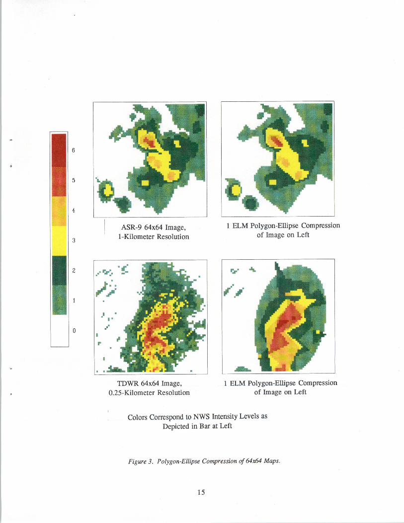
The results of applying the Polygon-Ellipse Algorithm to some sample 64x64 and256x256 weather images are presented by Figures 3 and 4, respectively. The weather imagesin the top row of Figure 3 were recorded from an ASR-9 radar and each pixel is onekilometer in extent. The weather images in the bottom row of Figure 3 were recorded from aTDWR radar and each pixel is 0.25 kilometers in extent. The weather images in Figure 4were recorded from a commercial weather image vendor and each pixel is approximately1.6 kilometer in extent. These figures illustrate the low levels of distortion that result evenwhen complex images are to be compressed to lK or 2K bits, respectively. The use ofellipses when appropriate and polygons at other times is clearly shown by these examples.
13
......
1 ELM Polygon-Ellipse Compressionof Image on Left
ASR-9 64x64 Image,1-Kilometer Resolution3
2 ..-r,:..... .......-
;;.: ", ,..•• ••.
0 ."r
5
6
4
..
TDWR 64x64 Image,O.25-Kilometer Resolution
1 ELM Polygon-Ellipse Compressionof Image on Left
Colors Correspond to NWS Intensity Levels asDepicted in Bar at Left
Figure 3. Polygon-Ellipse Compression of 64:x64 Maps.
In recent years, many new compression techniques have come on the scene with greatpublicity (for example, see [2]). The best known examples are fractals, wavelets, and cosinetransforms. Fractal compression techniques can produce typical compression ratios of over100-1, with maximum compression ratios approaching 1000-1. Cosine transform andwavelet techniques are typically used at compression ratios of 10-1 up to 25-1, since they canhave significant image distortion at higher compression ratios. All of these techniques sharetwo main characteristics: they are computer intensive, and they are meant to compress megabit, highly redundant graphical images such as television pictures. Weather images,unfortunately, do not match the intended audience of these approaches.
Image compression techniques using fractals, wavelets, or the cosine transformationrequire extensive computational capabilities or special-purpose hardware in order to achievenear real-time performance. For instance, the compression processing of a single imageusing the fractal technique might take several minutes---compared to the few secondsrequired for the Polygon-Ellipse or Weather-Huffman compression algorithms. In additionto the ground processing required, the computer onboard an aircraft might require as muchas a minute to decode images compressed with some of these techniques - compared to thetens of milliseconds required by the Polygon-Ellipse or Weather-Huffman decompressionalgorithms. Reference [3] describes an implementation of fractal image compression forcomplex images that achieves 100-1 compression ratios running on a high-performancepersonal computer. The fractal compression of a single graphical image requires 8 minutes,and the decompression processing requires 7 seconds. [3] also describes a cosine-transformimage compression implementation using the Joint Photographic Experts Group (JPEG)algorithm. The JPEG compression of a single image required 41 seconds, with thedecompression processing also requiring 41 seconds for a single graphical image. Clearlythis load and this delay would be unacceptable for real-time aviation use.
It appears that none of these new image compression techniques is currentlyappropriate for the task of compressing graphical weather images for real-time data linktransmission. Wavelet and cosine transform compression do not typically obtain thenecessary compression ratio and image quality for large-scale weather images, and they lackthe ability to directly apply a bit-limit or impose distortion priorities to weather levels. Fractalcompression can in some cases approach the desired compression ratios and image quality,but is too computationally inefficient for a real-time implementation in contemporary groundsystems and avionics.
19
5. CONCLUSION
This report has illustrated the measured compression performance for a number ofalgorithms used to compress graphical weather images (see Table 1). Some of thesealgorithms were standard compression methods, while others were specially developed for thecase of graphical weather images. Of these algorithms, only the Polygon-Ellipse andWeather-Huffman achieved the desired compression ratio necessary for effective use of therestricted-bandwidth aviation data links while also being computationally efficient. ThePolygon-Ellipse algorithm is preferred over the Weather-Huffman algorithm because it
1. provides less distortion in general,
2. provides a smoother and less blocky image,
3. provides weather level distortion priorities more readily, and
4. scales to different image dimensions more easily.
In conclusion, the Polygon-Ellipse algorithm has significant potential for theencoding of weather images over the Mode S data link or other similarly bit-limited datalinks. Further research needs to be done to study the effects of weather image compressionon a pilot's situational awareness.
21
REFERENCES
1. Gertz, Jeffrey L., "Weather Map Compression for Ground to Air Data Links,"
Proceedings of the Aeronautical Telecommunications Symposium on Data Link
Integration, May 15-17, 1990, pages 131-140.
2. Proceedings of the DCC '92 Data Compression Conference, Edited by James A. Storer
and Martin Cohn, IEEE Computer Society Press, 1992.