This article was downloaded by: [Laurentian University] On: 08 September 2013, At: 14:13 Publisher: Taylor & Francis Informa Ltd Registered in England and Wales Registered Number: 1072954 Registered office: Mortimer House, 37-41 Mortimer Street, London W1T 3JH, UK Energy Sources Publication details, including instructions for authors and subscription information: http://www.tandfonline.com/loi/ueso19 Energy and Water Potential of the Southeastern Anatolia Project (GAP) Kamil Kaygusuz Published online: 29 Oct 2010. To cite this article: Kamil Kaygusuz (1999) Energy and Water Potential of the Southeastern Anatolia Project (GAP), Energy Sources, 21:10, 913-922, DOI: 10.1080/00908319950014281 To link to this article: http://dx.doi.org/10.1080/00908319950014281 PLEASE SCROLL DOWN FOR ARTICLE Taylor & Francis makes every effort to ensure the accuracy of all the information (the “Content”) contained in the publications on our platform. However, Taylor & Francis, our agents, and our licensors make no representations or warranties whatsoever as to the accuracy, completeness, or suitability for any purpose of the Content. Any opinions and views expressed in this publication are the opinions and views of the authors, and are not the views of or endorsed by Taylor & Francis. The accuracy of the Content should not be relied upon and should be independently verified with primary sources of information. Taylor and Francis shall not be liable for any losses, actions, claims, proceedings, demands, costs, expenses, damages, and other liabilities whatsoever or howsoever caused arising directly or indirectly in connection with, in relation to or arising out of the use of the Content. This article may be used for research, teaching, and private study purposes. Any substantial or systematic reproduction, redistribution, reselling, loan, sub-licensing, systematic supply, or distribution in any form to anyone is expressly forbidden. Terms & Conditions of access
Transcript
This article was downloaded by: [Laurentian University]On: 08 September 2013, At: 14:13Publisher: Taylor & FrancisInforma Ltd Registered in England and Wales Registered Number:1072954 Registered office: Mortimer House, 37-41 Mortimer Street,London W1T 3JH, UK
Energy SourcesPublication details, including instructions forauthors and subscription information:http://www.tandfonline.com/loi/ueso19
Energy and Water Potentialof the SoutheasternAnatolia Project (GAP)Kamil KaygusuzPublished online: 29 Oct 2010.
To cite this article: Kamil Kaygusuz (1999) Energy and Water Potential of theSoutheastern Anatolia Project (GAP), Energy Sources, 21:10, 913-922, DOI:10.1080/00908319950014281
To link to this article: http://dx.doi.org/10.1080/00908319950014281
PLEASE SCROLL DOWN FOR ARTICLE
Taylor & Francis makes every effort to ensure the accuracy of allthe information (the “Content”) contained in the publications on ourplatform. However, Taylor & Francis, our agents, and our licensorsmake no representations or warranties whatsoever as to the accuracy,completeness, or suitability for any purpose of the Content. Anyopinions and views expressed in this publication are the opinions andviews of the authors, and are not the views of or endorsed by Taylor& Francis. The accuracy of the Content should not be relied upon andshould be independently verified with primary sources of information.Taylor and Francis shall not be liable for any losses, actions, claims,proceedings, demands, costs, expenses, damages, and other liabilitieswhatsoever or howsoever caused arising directly or indirectly inconnection with, in relation to or arising out of the use of the Content.
This article may be used for research, teaching, and private studypurposes. Any substantial or systematic reproduction, redistribution,reselling, loan, sub-licensing, systematic supply, or distribution in anyform to anyone is expressly forbidden. Terms & Conditions of access
Energy and Water Potential of th e( )Southeastern An atolia Project GAP
ÇKAMIL KAYGUSUZ
Department of Chemistry
Karadeniz Technical Unive rsity
Trabzon, Turkey
This article gives an overview of energy and water potential of the Southeastern( )Anatolia Project G AP in Turkey. This integrated socioeconom ic developm ent
project is one of the largest of its kind in the world. The G AP region is rich in water
and soil resources. The Euphrates and Tigris Rivers represent over 28% of the
n ation’ s water supply by rivers, and the econom ically irrigatable areas in the region
m ake up 20% of those for the en tire country. On the other hand, the G AP region is
the richest region of the country in term s of its hydroelectric potential as well as its
oil and asphalt reserves. The G AP region has a 22% share of the country’ s total
hydroelectric potential, with plans for 22 dam s and 19 hydropower plants. Once
completed, 27 billion kWh of electricity will be generated. In addition to this
hydropower and oil potential, the G AP region is also the richest region of Turkey as
far as solar energy production is concerned. In meeting the energy requ irem ents of
the developing regions worldwide and in Turkey, solar energy is being taken into
account as an important renewable source of energy.
s .Keywords ene rgy and water potential, Southe astern Anatolia Project GAP
Energy cannot be separate from matte r, and all mate rial phenomena are associ-
ated with energy. Energy is the re fore e ssential to life , and the quantity of energy
consumed per capita can be used as one indicator of a country’ s leve l of deve lop-
ment. The major incre ase in the pre sent century in ene rgy consumption is due to
the use of fossil fuels, which also have an impact on the environment. No thought
was given to this in the past, but today it is being included in ene rgy planning
s .activitie s Kle inpete r, 1995 .
Turkey is an ene rgy-importing country; more than half of the ene rgy require -
ment has been supplied by imports. Oil has the bigge st share in total primary
energy consumption. Because of the dive rsification e fforts of energy sources, use of
natural gas, which was newly introduced into the Turkish economy, has been
growing rapidly. Therefore the Turkish ene rgy policy is mainly concentrated on
assurance of energy supply that is re liable , sufficient, time ly, economical, environ-
mentally sound, and supporting and oriented toward targe ted growth and social
deve lopments. The government focused its e fforts on improvement in domestic
production by utilizing public, private, and fore ign utilitie s and incre asing e fficiency
by rehabilitation and acce le ration of existing construction programs to initiate new
inve stments.
Received 7 May 1998; accepted 16 June 1998.ÇAddress correspondence to Dr. Kamil Kaygusuz, Department of Chemistry, Karadeniz
Energy and Water Potential of Southeastern Anatolia Project 919
prevailing in this region, contour lines have the form of concentric circle s from
June to September. For July, 13 hours and 26 min of m aximum bright sunshine was
s 2 .obse rved. About 6.4 kWh r m d of m aximum total solar radiation is also obse rved
in June. These solar radiation value s are sufficient for he ating and hot water
purpose s in the region.
In order to estim ate of total solar radiation from bright sunshine hours given
by the State Meteorological Station for the GAP region, we used the following
È s .equation given by O ge lm an e t al. 1984 , and obtained results are given in Table 4:
2s . s . s .H r H s 0 .195 q 0 .676 n rN y 0 .142 n r N 10
where H r H is the ratio of the monthly ave rage daily te rrestrial radiation to that0
of extrate rre strial radiation and n rN is the ratio of the monthly average daily
bright sunshine hours to the monthly average day length.
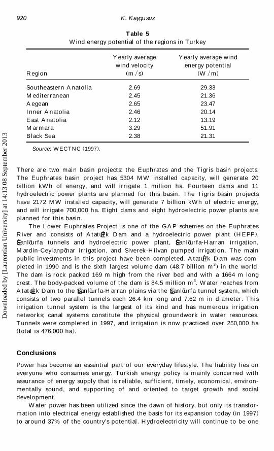
Southeaste rn Anatolia is also one of the richest regions of Turkey as far as
s .theoretical wind energy potential Table 5 . Ye arly average wind ene rgy potential
of the GAP region is 29.33 W rm2.
Water Potential of the GAP
The GAP are a is rich in wate r resource s. The Euphrates and Tigris Rive rs
represent ove r 28% of the country’ s river wate r supply and the economically
irrigatable are as in the region make up 20% of those for all of Turkey. The
deve lopment of the region was originally planned as re lating to its wate r resource s,
which were later combined in a comprehensive water and land resource s deve lop-
Ès .ment package Unver, 1997 . For this purpose , 12 groups of projects were planned
on the Euphrate s and Tigris Rive rs and the ir branche s by the General Dire ctorate
s .of State Hydraulic Works 1997 , as given in Table 6.
The package included the construction of 22 dams, 19 hydroe lectric powe r
plants, and irrigation facilitie s to se rve 1.7 million ha. The total installed capacity of
the powe r plants is 7500 MW , with an annual production of ove r 27 billion kWh.
Table 4
Solar energy potential of the regions in Turkey
Total solar Total bright
energy sunshine hours2s . s .Region kWh r m yr hour ryr
Southe astern Anatolia 1460 2993
Medite rrane an 1390 2956
Aege an 1304 2738
Inner Anatolia 1314 2628
E ast Anatolia 1365 2664
Marmara 1168 2409
Black Se a 1120 1971
Ave rage for Turkey 1311 2640
s .Source: WECTNC 1997 .
Dow
nloa
ded
by [
Lau
rent
ian
Uni
vers
ity]
at 1
4:13
08
Sept
embe
r 20
13
K. Kaygu suz920
Table 5
Wind energy potential of the regions in Turkey
Yearly ave rage Yearly average wind
wind ve locity ene rgy potential
s . s .Region m r s W r m
Southeaste rn Anatolia 2.69 29.33
Mediterranean 2.45 21.36
Aege an 2.65 23.47
Inner Anatolia 2.46 20.14
E ast Anatolia 2.12 13.19
Marmara 3.29 51.91
Black Se a 2.38 21.31
s .Source: WECTNC 1997 .
There are two main basin proje cts: the Euphrate s and the Tigris basin projects.
The Euphrates basin project has 5304 MW installed capacity, will ge nerate 20
billion kWh of ene rgy, and will irrigate 1 million ha. Fourte en dams and 11
hydroe le ctric powe r plants are planned for this basin. The Tigris basin proje cts
have 2172 MW installed capacity, will gene rate 7 billion kWh of electric energy,
and will irrigate 700,000 ha. Eight dams and e ight hydroe le ctric power plants are
planned for this basin.
The Lower Euphrates Proje ct is one of the GAP schemes on the Euphrate s
s .River and consists of Ataturk Dam and a hydroe le ctric power plant HEPP ,ÈSË anlõ urfa tunnels and hydroelectric power plant, SË anlõ urfa-Harran irrigation,
Mardin-Ceylanpõ nar irrigation, and Sive rek-Hilvan pumped irrigation. The m ain
public inve stments in this proje ct have been completed. Ataturk Dam was com-Ès 3.ple ted in 1990 and is the sixth largest volume dam 48.7 billion m in the world.
The dam is rock packed 169 m high from the river bed and with a 1664 m long
cre st. The body-packed volume of the dam is 84.5 million m3. W ate r re aches from
Ataturk Dam to the SË anlõ urfa-H arran plains via the SË anlõ urfa tunne l system, whichÈconsists of two paralle l tunne ls e ach 26.4 km long and 7.62 m in diameter. This
irrigation tunne l system is the largest of its kind and has numerous irrigation
ne tworks; canal systems constitute the physical groundwork in wate r resource s.
Tunne ls we re comple ted in 1997, and irrigation is now practiced ove r 250,000 ha
s .total is 476,000 ha .
Con clus ions
Powe r has become an essential part of our eve ryday lifestyle . The liability lies on
everyone who consumes energy. Turkish energy policy is mainly concerned with
assurance of energy supply that is re liable , sufficient, time ly, economical, environ-
mentally sound, and supporting of and oriented to target growth and social
deve lopment.
W ate r power has been utilized since the dawn of history, but only its transfor-
s .mation into e le ctrical energy e stablished the basis for its expansion today in 1997
to around 37% of the country’ s potential. Hydroelectricity will continue to be one
Dow
nloa
ded
by [
Lau
rent
ian
Uni
vers
ity]
at 1
4:13
08
Sept
embe
r 20
13
Energy and Water Potential of Southeastern Anatolia Project 921
Table 6
W ater and land resources deve lopment proje cts in the GAP region
Capacity Production Irrigation Present
s . s . s .Project MW GW are a ha stage
Karakaya Dam and HEPP 1,800 7,354 OP
Lower Euphrates Project
Ataturk Dam and HEPP 2,400 8,900 OPÈSË anlõ urfa HEPP 50 124 UC
SË anlõ urfa irrigation tunne ls 476,000 UC
Siverek-Hilvan pumped irrigation 160,000 E
Bozova pumped irrigation 70,000 E
Border Euphrates Project
Birecik Dam and HEPP 852 3,168 UC
KarkamisË Dam and HEPP 180 652 DD
SurucË -Baziki plain irrigation 146,500 E
Adõ yaman-Kahta Project
Adõ yaman-Goksu Dam and irrigation 7 43 71,600 FSÈCË amgazi Dam and irrigation 7,430 UC
KocË alõ Dam and HEPP 40 120 21,605 MPBuyukcË ay Dam, HEPP, and irrigation 30 84 12,322 MPÈ ÈKahta Dam and HEPP 75 171 MP
Pumped irrigation from Ataturk Dam 29,599 MPÈGaziantep Project
Hancagõ z Dam and irrigation 7,330 OPÆKayacõ k Dam and irrigation 14,740 UC
Pumped Irrigation from Birecik Dam 66,000 FS
Dicle -Kralkõ zõ Project
Kralkõ z õ Dam and HEPP 94 146 UC
Dicle Dam and HEPP 110 298 UC
Dicle Right Bank gravity irrigation 54,280 UC
Dicle Right Bank pumped irrigation 75,870 UC
Batman Project
Batman Dam and HEPP 198 483 UC
Batman Left Bank gravity irrigation 9,570 UC
Batman Left Bank pumped irrigation 9,180 FS
Batman Right Bank gravity irrigation 18,600 DD
Batman-Silvan Project
Silvan Dam and HEPP 150 623 E
Kayser Dam and HEPP 90 341 E
Dicle Left Bank gravity irrigation 250,000 E
Garzan Project
Garzan Dam and HEPP 90 315 E
Garzan Irrigation 60,000 E
Ilõ su Dam and HEPP 1,200 3,830 DD
Cizre Project
Cizre Dam and HEPP 240 1,208 DD
Nusaybin Cizre Irrigation 89,000 E
s .Source: State Hydraulic Works 1997 .
OP, in operation; UC, under construction; E, exploration; DD, detailed design comple ted;FS, fe asibility study; MP, master plan; HEPP, hydroelectric power plant.
Dow
nloa
ded
by [
Lau
rent
ian
Uni
vers
ity]
at 1
4:13
08
Sept
embe
r 20
13
K. Kaygu suz922
of the most e ffe ctive options because of the ze ro emissions involved and because it
is a domestic ene rgy source . O n the othe r hand, wate r is one of the most valuable
re sources and a limiting factor for crop production. Agricultural crops are major
consumers of wate r. Agriculture , with its social and economic aspects, has a
dominant role in the nation’ s life in Turkey. It accounts for about 20% of gross
domestic product, 10% of exports, and 47% of civilian employment.
The GAP proje ct is one of the largest powe r ge nerating, irrigation, and
deve lopment projects of its kind in the world, cove ring 3 million ha of agricultural
land. This is over 10% of the cultivatable land in Turkey; the land to be irrigated is
more than half of the presently irrigated area in Turkey. The GAP project on the
Euphrates and Tigris Rive rs encompasse s 20 dams and 17 hydroele ctric powe r
plants. When all proje cts are comple ted, 55 billion kWh of e le ctricity will be
gene rated annually, which is 45% of the total e conomically exploitable hydroelec-
tric potential.
As a multipurpose regional deve lopment project, the implementation of the
GAP will be carried out as scheduled. The environmental impact asse ssment
studies for the GAP will be put into e ffe ct. Similar studie s for other regions will be
carried out when required. In the GAP region, on farms, deve lopment work will be
completed before the irrigation projects. Me anwhile , the farmers of the region will
be imparted extension service s, especially training and land consolidation, together
with irrigation activities, which will be handled on a faster pace. The urban
infrastructure in the GAP region, e specially the issue s of municipal water and
sewage, will be worked out.
Referen ces
Kaygusuz, K. 1997. Energy, water and environment in Turkey. Energy Sources 19: 917 ] 930.
Kle inpe ter, M. 1995. Energy planning and policy. New York: John Wiley.ÈO gelman, H., A. Ecevit, and E. TasË demiroglu. 1984. A new method for estimating solarÆ
radiation from bright sunshine data. Solar Energy 33: 619 ] 625.
Polatoglu, A. 1995. Southeaste rn Anatolia Project and administrative organization. METUÆs .Studies in Development 22 2 : 191 ] 206.
State Hydraulic Works. 1996. Statistical Bulle tin with Map, 1997. Ankara, Turkey.
State Meteorological Institute. 1989. Meteorological bu lletin . Ankara, Turkey.
State Planning O rganization. 1989. Sixth five-year developm ent plan 1990 ] 1994. Ankara,
Turke y.
State Planning O rganization. 1995. Seventh five-year development plan 1996 ] 2000 . Ankara,
Turke y.
s .Tekinel, O . 1992. Southeastern Anatolia Project G AP and its possible effects on Turkish
agriculture, 1 ] 11. Adana, Turkey: University of CË ukurova.
Turkish Pe troleum Corporation. 1996. Annu al report. Ankara, Turkey.È s . s .Unver, O . 1997. Southeaste rn Anatolia Project GAP . Water Resources Developm ent 13 4 :
453 ] 483.
United Nations. 1996. World econom ic and social survey. New York.
s .World Energy Council Turkish National Committee WECTNC . 1997. Energy statistics 1996