Uixlrlct I 1625 N. French Dr.. Hobbs. NM 88240 Phone: (575) 393-6161 Fax: (575) 393-0720 ItotriclU 811 S. Irini Si.. Artesia. NM 882)0 Phone: (575) 748-1283 Fax: (575) 748-9720 District 111 1000 Rio Drams Road. Azlec. NM 87410 Phone: (505) 334-6173 Fax: (505) 334-6170 District IV 1220 S. Si. Francis Dr.. Sami Fe. NM 87505 Phone: (505) 476-3460 Fax: (505) 476-3462 HOBBS OCB FEB 0 5 2014 State of New Mexico Energy Minerals and Natural Resources Oil Conservation Division 1220 South St. Francis Dr. Santa Fe, NM 87505 Form C-I0I Revised July IS. 2013 □amended report APPLICATION FOR PERMIT TO DRILL, RE-ENTER, DEEPEN, PLUGBACK, OR ADD A ZONE ‘ Operator Name and Address HARVEY II. YAT1IS Qs<D P.OBOX 1933 ROSWELL N.M 88202 " OGR1D Number . 10179 ■' Al’I Number ‘»“^355<r - J' Property Name airstrip 31 State com “■ Well No. 2H 7- Surface Location UI.- l-oi ScCciion 'township Range Lei Idn Feet (him N/S Line • Feet From EAVUnc County M 31 IS S 35 E 4 tier SOUTH - 330' WEST IXA 1 Proposed Bottom Hole Location UL-Loi Section Township Range I_cjt Idn Feet from • N/S Line Feet From EAVLine County D 31 IS S 35 E 1 330' NORTH 710' WEST LEA 9- Pool Information Pool Code 960 Pool Naim AIRSTRIP: BONE SPRING Additional Well Information "■ Work Type 12. Well Type 15 Cahle/Roiary 14 Lease Type 15 Ground Level Elevation NEW HRI fi OIL ROTARY STATE 394H' la Multiple Proposed Depth ls Fornation ” Contractor ^ Spud Date N TVD 10.9807 MD 15,185' 3rd BONE SPRING 5/15/14 Depth to Ground water 60' Distance from nearest fresh water well Distance lo nearest surface water ^ We will be using a closed-loop system in lieu of lined pits 2I- Proposed Casing and Cement Program Type Hole Size Casing Si/e Casing Weight/ft Setting Depth Sacks of Cement Estimated TOC SURE 17.5 • 13.375 43# 1945 1600 SURF INT 12.25 9.625 36# 3840 1100 SURF PROD 8.75 5.5 17# 15,185 2700 2950 Casing/Cement Program: Additional Comments Plan to drill 17 ■/:" lo 1945' uses fresh water, run 13 3/8” 54.5# J-55 csg and emt back to surf. Drill 12 '/*' hole to 3840' with brine, run 9 5/8” 36# J-55 cgs and emt back to surf. [Drill 7 7/8” curve and lateral with eul brine to MD depth of approx. 15,185. Run 5 !A" 17* PI 10 esg and emt and emt back to 3600' in two stage. Set DVtool @ 9950'+/- NMOCD Case No. 15363 21 Proposed Blowout Prevention Program Type Working Pressure Test Pressure DOUBLE RAM 5(XX)P.S1 3000PSI Hearing: SEP 29, 2015 Jalapeno EX ^ I hereby certify that the information given above is true and complete to the best of my knowledge and belief. 1 further certify that# have complied with 19.15.14.9 (A) NMAC □ and/or 19.15.14.9 (B) NMi^C Qjif appjkable. Signature: fag/ OIL CONSERVATION DIVISION j Approved By: j Printed name: Keith Cannon Title ^ | Title: Drilling Superintendent Approved Date: //fc Expiration Date: f) '7-/’2-£ //£ E-mail Address: [email protected]Date: /-."?/'/ </ Phone: S73‘ &JL3- CC&/ | Conditions of Approval Attached FEB &7.20^
Transcript
Uixlrlct I
1625 N. French Dr.. Hobbs. NM 88240
Phone: (575) 393-6161 Fax: (575) 393-0720
ItotriclU811 S. Irini Si.. Artesia. NM 882)0
Phone: (575) 748-1283 Fax: (575) 748-9720
District 111
1000 Rio Drams Road. Azlec. NM 87410
Phone: (505) 334-6173 Fax: (505) 334-6170
District IV1220 S. Si. Francis Dr.. Sami Fe. NM 87505
Phone: (505) 476-3460 Fax: (505) 476-3462
HOBBS OCB
FEB 0 5 2014
State of New Mexico
Energy Minerals and Natural Resources
Oil Conservation Division
1220 South St. Francis Dr.
Santa Fe, NM 87505
Form C-I0I
Revised July IS. 2013
□amended report
APPLICATION FOR PERMIT TO DRILL, RE-ENTER, DEEPEN, PLUGBACK, OR ADD A ZONE‘ Operator Name and Address
HARVEY II. YAT1IS Qs<D
P.OBOX 1933ROSWELL N.M 88202
" OGR1D Number .
10179
■' Al’I Number
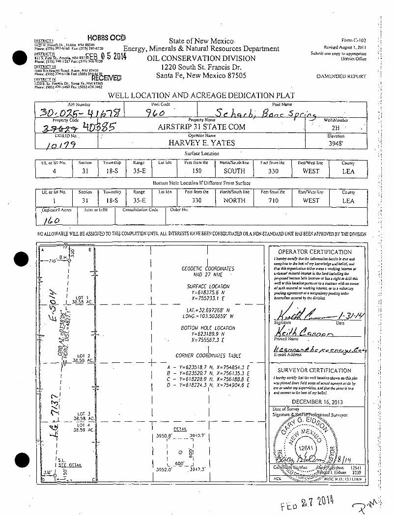
‘»“^355<r - J' Property Nameairstrip 31 State com
“■ Well No.2H
7- Surface Location
UI.- l-oi ScCciion 'township Range Lei Idn Feet (him N/S Line • Feet From EAVUnc County
M 31 IS S 35 E 4 tier SOUTH - 330' WEST IXA
1 Proposed Bottom Hole Location
UL-Loi Section Township Range I_cjt Idn Feet from • N/S Line Feet From EAVLine County
D 31 IS S 35 E 1 330' NORTH 710' WEST LEA
9- Pool Information
Pool Code
960
Pool Naim
AIRSTRIP: BONE SPRING
Additional Well Information"■ Work Type 12. Well Type 15 Cahle/Roiary 14 Lease Type 15 Ground Level Elevation
NEW HRI fi OIL ROTARY STATE 394H'la Multiple Proposed Depth ls Fornation ” Contractor ^ Spud Date
N TVD 10.9807 MD 15,185' 3rd BONE SPRING 5/15/14
Depth to Ground water 60' Distance from nearest fresh water well Distance lo nearest surface water
^ We will be using a closed-loop system in lieu of lined pits
2I- Proposed Casing and Cement Program
Type Hole Size Casing Si/e Casing Weight/ft Setting Depth Sacks of Cement Estimated TOC
SURE 17.5 • 13.375 43# 1945 1600 SURF
INT 12.25 9.625 36# 3840 1100 SURF
PROD 8.75 5.5 17# 15,185 2700 2950
Casing/Cement Program: Additional Comments
Plan to drill 17 ■/:" lo 1945' uses fresh water, run 13 3/8” 54.5# J-55 csg and emt back to surf. Drill 12 '/*' hole to 3840' with brine, run 9 5/8” 36# J-55 cgs and emt back to
surf. [Drill 7 7/8” curve and lateral with eul brine to MD depth of approx. 15,185. Run 5 !A" 17* PI 10 esg and emt and emt back to 3600' in two stage. Set DVtool @
9950'+/-
NMOCD Case No. 15363
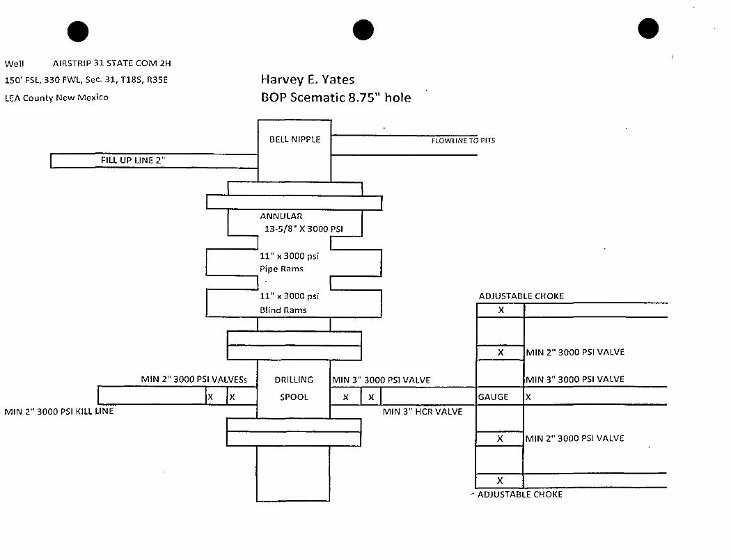
21 Proposed Blowout Prevention Program
Type Working Pressure Test Pressure
DOUBLE RAM 5(XX)P.S1 3000PSI
Hearing: SEP 29, 2015
Jalapeno EX
^ I hereby certify that the information given above is true and complete to the
best of my knowledge and belief.
1 further certify that# have complied with 19.15.14.9 (A) NMAC □ and/or
PREPARED TO STOP" signs shall remain in place from the time consfa/ction starts until it is completed.
“FLAGMAN AHEAD* signs will be in place during the hours construction men and equipment ore working. A flogman will be on duty all the time that construction men and/or equipment are working.Signs will be' 48 x48" fn size. Color will be black on orange and will meet (he reflective quality specified in the New Mexico Stofe Higfiwoy & Transportation Standard Specifications.
40 40
Sco/e: I ~=4Q'
PROVIDING SUlrVLYING SfHVICt'S SINCE 1945
JOHN WEST SURVEYING COMPANY
*12 N. DAL PASO HOBBS. N.M. 882*0
(575) JQJ-Jl 17 www.jw,
HARVEY E. YAEES
A PROPOSED ROAD TURN OUT ON ST. HIGHWAY #529
LOCA TED IN SECTION 31.TOWNSWr 18 SOUTH, RANGE 35 EAST, N.M.P.M.
LEA COUNTY, NEW MEXICOSurvey Dote: 12/16/13 |
■th> JUo- N°-: 13111091 Hev: .CAD Dote: 1/6/1*
Rel. W.O.:
Drown Gy: ACK
~ | Sheet 1 ol 1*
(d) Anjslico\20l J\Nodel one Coismon Permian, LLC\Wells\«.M
date
tno/u
hevcoHORIZONTAL WORKSItEGT
wen. Nome: AirjCnp 31 Slals Com #2H
. SURFACE LOCATION: 1
sec TOYTNSH1P KANOS
IFACET BERTH:
TAROFT ANGLE:
PLANNED MJ LFNGTH:
PVANNtOKOR:
50FSL330 FWL
31 IBS 3£E
10510 nTVDOTO3.7 DECREES
4800 ft
1QQ80 n rvo
countv: Lep STATE: NM
foamation: Bone Sprtno 3rd Sd MAXIMUM ROB: 10 OEOT1M ft
150' FSL, 330 FWL, Sec. 31, T18S, R35E Harvey E. Yates
BOP Scematic 8.75" holeLEA County New Mexico
AIRSTRIP 31 STATE COM #2H
3000 psl BOP Manifold System
HARVEY E. YATES
P.O. BOX 1936
ROSWELL N.M. 88202
(575) 623-6601 (Office)
(575) 624-5321 (Fax)
1/31/2014
Mr. Paul Kautz
Disirict 1 Geologist
New Mexico Oil and Gas Division
1625 N. French Drive
Hobbs N.M 88240
Re: AIRSTRIP 31 STATE COM 2H
150’ FSL & 330’ FWL
Unit Letter M, Sec. 31, T18S, R35E
LEA, NM
Rule 118 H2S Exposure
Dear MR Kautz
Harvey E. Yates, have evaluated this well and we do not expect to encounter hydrogen sulfide.
However, we will employ a third party monitoring system. We will begin monitoring prior to
drilling out the intermediate casing and will continue monitoring the remainder of the well.
Please contact me if you have any additional questions.
Keith Cannon
Drilling Superintendent
Hydrogen Sulfide Drilling Operations Plan Harvey E. Yates
Airstrip 31 State Com 2H UNIT M, 560 31,1188, R35E
150’ FSL&330’ FWL Lea Co. N.M.
1. Company and contract personnel admitted on location should be trained by a qualified H2S safety instructor to the recognize and handle following:
A. Characteristics of H2$ gasB. Physical effects and hazardsC. Proper use of safety equipment and life support systemsD. Principle and operation of H2S detectors, warning system and briefing knowledgeE. Evacuation procedure, routes and first aid supportF. Proper use of 30 minutes Pressure-on-Demand Air Pack
2. H2S Detection and Alarm SystemsA. H2S detectors and audio alarm system to be located at bell nipple, end of blooie line (mud pit) and on
derrick floor or doghouse
3. Windsock and/or Wind StreamersA. Windsock at mud pit area (high enough to be visible)B. Windsock at briefing area (high enough to be visible)C. Windsock at location entrance
4. Condition Flags and SignsA. H2$ warning signs on lease access road into locationB. Flags displayed on sign at location entrance
1. Green flag indicates “Normal Safe Conditions1’2. Yellow Flag indicates “Potential Pressure and Danger1’3. Red Flag indicates “Danger - H2S Present in High Concentrations" admit only emergency personnel
5. Well Control EquipmentA. See Exhibit #5.
6. CommunicationA. While working under masks chalkboards will be used for communicationB. Hand signals v/ill be used where chalk board is inappropriateC. Two -way radios or cell phones used to communicate off location or minimally in Drilling Foreman’s
trailer or living quarters
7. Drillstsm TestingA. Exhausts wateredB. Flare line equipped with electric Igniter/propane pilot light in case gas reaches surfaceC. If location near dwelling closed DST will be performed
8. Drilling Supervisor required to be familiar with effects of H2S on tubular goods/mechanical equipment
9. If H2S encountered, mud system shall be addressed to maintain control of formation, A mud gas separator will
be brought into service along with H2S scavengers, if necessary.
800-256-9688 or 281-931-8884 915-699-0139 or 915-563-3356 575-746-3569575-392-5556
New Mexico Emergency Response Commission (Santa Fe) 505-476-960024 Hour 505-827-9126
New Mexico State Emergency Operations Center 505-476-9635
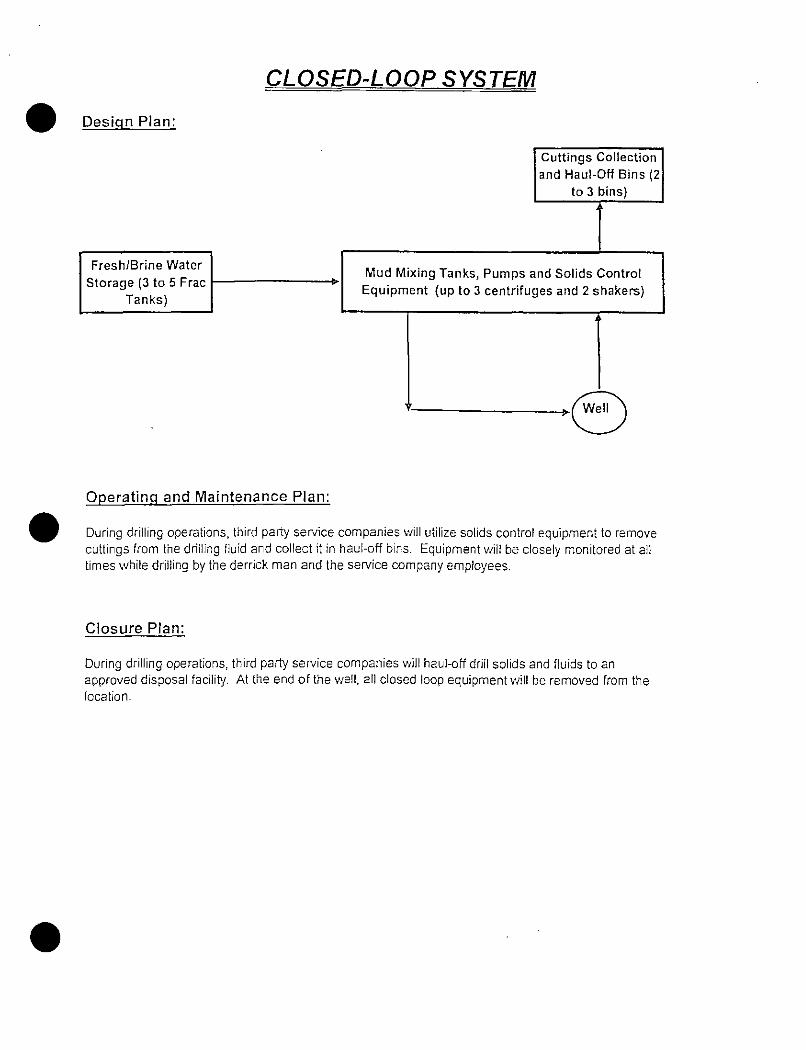
CLOSED-LOOP SYSTEM
Design Plan:
Operating and Maintenance Plan:
During drilling operations, third party service companies will utilize solids control equipment to remove cuttings from the drilling fluid and collect it in haul-off bins. Equipment will be closely monitored at all times while drilling by the derrick man and the sen/ice company employees.
Closure Plan:
During drilling operations, third party service companies v/ill haul-off drill solids and fluids to an approved disposal facility. At the end of the well, all closed loop equipment will be removed from the location.
HOBBS OGS>district i(625 N French Ui.. Ilobla NMBSJdO I’tione: (575) 393-6161 l-a*-. (575) 393-0720
FROM THE INTERSECTION OF US HWY 62-180 AND ST. HVFf 1529, GO WEST ON ST. H’.YY §529 FOR APPROX. 7.) MILES. THE LOCATION IS NORTH OF RIGHT OF WAY FENCE APPROX. 160 FEET.
f J PROVIDING SURVEYING SERVICES "\
SINCE 1946
JOHN WEST SURVEYING COMPANY
412 N. DAL FASO HOBBS. N.M. 83240
^ V, 1 (375) 39J-3U7 www.jwsc.bi2 j
(c) Anjelica\2013\Nodel and Cussrccn Permtcn, LLC\Weils\N.y
100 100 200 Fest
Scale:! "=100'
AIRSTRIP31 STATE COM#2H WELL LOCATED 150 FEET FROM THE SOUTH LINE
CONTOUR INTERVAL:IRON HOUSE DRAY/, NM - W IRON HOUSE WELL NM - /O'
DIRECTIONS TO AIRSTRIP 3! STATE COM §2H:
FROM THE INTERSECTION OF US HY/Y 62- 180 AND ST. H'HY if529, CO WEST ON ST. HW §529 FOR APPROX. 7.) MILES. THE LOCATION IS NORTH OF RIGHT OF WAY FENCE APPROX. ISO FEET.
U.S.G.S. TOPOGRAPHIC MAP
IRON HOUSE DRAW, N.M.
PROVIDING SURVEYING SERVICES ^
SINCE 1346
| JOHN WEST SURVEYING COMPANY
■M2 N. DAL PASO H033S, AJ.M. 33240
(575) 393-3117 WWM.jiVSZ.blZ J
NO
RT
H
VICINITY MAP
SCALP 1" = 2 MILES DRIVING ROUTE: SEE LOCATION VERIFICATION MAP
SEC. 31 VHP. IS-S RCE. 35-E
SURVEY N.M.P.M.
COUNTY LEA STATE NEW MEXICO
DESCRIPTION 150' FSI A 350’ FV/l
ELEVATION 3948'
OPERATOR HARVEY E YATES
LEASE AIRSTRIP 3) STATE COM
providing Surveying services >
SINCE 1545
JOHN WEST SURVEYING COMPANY
412 N. DAL PASO H0B3S, NM. 88240
(575) 393-31 !7 wwivjwsc.bi? j
2/24/2015 C-145
oistrkn1625 N. French Of.. Hobbs, NM 88240 Phone:(575)393-6161 Fax:(575)393-0720
District II611 S. Firel SV, Artesta. NM 80210 Phone:(575) 748-1283 Fax:(575) 748-9720 District 111
1000 R» Brazos Rd.. Aztec. NM 37410 Phone:(505)334-6178 Fax:(505) 334-6170 District tV
1220 S. St Francis Dr.. Santa Fe, NM 87505 Phone:(505)476-3470 Fax:(505)476-3462
State of New Mexico Energy, Minerals and Natural
ResourcesOil Conservation Division
1220 S. St Francis Dr. Santa Fe, NM 87505
Change of Operator
Form C-145 August 1. 2011
Penrit 198879
HOBBS OCD
MR 1 2 20*
RECEIVED
Previous Operator Information
OGRlD: 1Q179___________________
Name: HARVEY E YATES CO
Address: PQ BOX 1933
City, State. Zip: ROSWELL .NM 88202
New Operator Information
ERedive Date: [Effective on the date of approval by the OCD
OGRlD: 228937
Name: MATADOR PRODUCTION COMPANY
Address: One Lincoln Centre
5400 LBJ Freeway, Ste 1500
City, state. Dallas, IX 75240Zip: ---------------------------------------------------------
I hereby certify that the rules of the Oil Conservation Division have been complied with and that the information on this form and the certified list
of wells is true to the best of my knowledge and belief.
Additionally, by signing below, MATADOR PRODUCTION COMPANY certifies that it has read and understands the following synopsis of
applicable rules.
PREVIOUS OPERATOR certifies that all below-grade tanks constructed and installed prior to June 16,2008 associated with the selected wells
being transferred are either (1) in compliance with 19.15.17 NMAC, (2) have been closed pursuant to 19.15.17.13 NMAC or (3) have been
retrofitted to comply with Paragraphs 1 through 4 of 19 15.17.11(1) NMAC.
MATADOR PRODUCTION COMPANY understands that the OCD's approval of this operator change:
1. constitutes approval of the transfer of the permit for any permitted pit, below-grade tank or closed-loop system associated with the
selected wells; and2. constitutes approval of the transfer of any below-grade tanks constructed and installed prior to June 16,2008 associated with the
selected wells, regardless of whether the transferor has disclosed the existence of those below-grade tanks to the transferee or to the
CCD. and regardless of whether the below-grade tanks are in compliance with 19.15.17 NMAC.
As the operator of record of wells in New Mexico, MATADOR PRODUCTION COMPANY agrees to the following statements:
1.1am responsible for ensuring that the wells and related facilities comply with applicable statutes and rules, and am responsible for all
regulatory filings with the OCD. lam responsible forknowing all applicable statutes and rules, not just the rules referenced in this list. I understand that the OCD's rules are available on the OCD website under “Rules," and that the Water Quality Control Commission rules are available on the OCD website on the “Publications" page.
2. I understand that if I acquire wells from another operator, the OCD must approve the operator change before I begin operating those
wells. See 19.15.9.9.B NMAC. I understand that if I acquire wells or facilities subject to a compliance order addressing inactive wells or environmental cleanup, before the OCD will approve the operator change it may require me to enter into an enforceable agreement to
return those wells to compliance. See 19.15.9.9.C(2) NMAC.
3. I must file a monthly C-115 report showing production for each non-plugged well completion for which the OCD has approved an
allowable and authorization to transport, and injection for each injection well. See 19.15.7.24 NMAC. (understand that the OCD may
cancel my authority to transport from or inject into all the wells! operate if l fail to file C-115 reports. See 19.15.7.24.C NMAC.
4. I understand that New Mexico requires wells that have been inactive for certain lime periods to be plugged or placed on approved
temporary abandonment See 19.15.25.8 NMAC. I understand the requirements for plugging and approved temporary abandonment in19.15.25 NMAC. I understand that! can check my compliance with Ihe basic requirements of19.15.25.8 NMAC by using the “Inactive
Well List” on OCD's website.
5. I must keep current with financial assurances forwei! plugging. I understand that New Mexico requires each state or fee well that has
been inactive for more than two years and has not been plugged and released to be covered by a single-well financial assurance,
even if the well is also covered by a blanket financial assurance and even if the well is on approved temporary abandonment status.
See 19.15.8.9.C NMAC. I understand that I can check my compliance with the single-well financial assurance requirement by using the
“Inactive Well Additional Financial Assurance Report" on the OCD's website.
6. I am responsible for reporting releases as defined by 19.15.29 NMAC. I understand the OCD will look to me as the operator of record to
take corrective action for releases at my wells and related facilities, including releases that occurred before I became operator of
record.
7. t have read 19.15.5.9 NMAC, commonly known as ‘Part 5.9," and understand that to be in compliance with its requirements I must have
the appropriate financial assurances in place, comply with orders requiring corrective action, pay penalties assessed by the courts or
agreed to by me in a settlement agreement, and not have too many wells out of compliance with the inactive well rule (19.15.25.8
NMAC). If I am in violation of Part 5.9.1 mav not be allowed to drill, acquire or produce any additional wells, and will not be able to
cblain any new injection permits. See 19.15.16.19 NMAC. 19.15.26.8 NMAC. 19.15.9.9 NMAC and 19.15.14.10 NMAC. If I am in
violation of Pari 5.9 the OCD mav, after notice and hearing, revoke mv existing injection permits. See 19.15.26.8 NMAC.
8. For injection wells, I understand that I must report injection on my monthly C-115 report and must operate my wells in compliance with
19.15.26 NMAC and the terms of my injection permit, (understand that I must conduct mechanical integrity tests on my injection wells at
least once every five years. See 19.15.26.11 NMAC. I understand that when there is a continuous one-year period of non-injection into
ail wells in an injection or storage project or into a saltwater disposal well or special purpose injection well, authority for that injection
automatically terminates. See 19.15.26.12 NMAC. I understand that if I transfer operation of an injection well to another operator, the
OCD must approve the transfer of authority to inject, and the OCD may require me to demonstrate the well's mechanical integrity prior
to approving that transfer. See 19.15.26.15 NMAC.
9. I am responsible for providing the OCD with my current address of record and emergency contact information, and I am responsible for
updating that information when it changes. See 19.15.9.8.C NMAC. I understand that I can update that information on the OCD's
website under “Electronic Permitting.”
10. If I transfer well operations to another operator, the OCD must approve the change before the new operator can begin operations. See 19.15.9.9.B NMAC. I remain responsible for the wells and related facilities and all related regulatory filings until the OCD approves the
operator change. I understand that the transfer will not relieve me of responsibility or liability for any act or omission which occurred while loperated the wells and related facilities.
NMOCD ApprovalElectronic Signature: Randv Dade. District 2
Date: March 12. 2015
* n tnn rm-
District)13C5 N. F.-i-ch Cl.. Metis. NM ~12&Fre.’.t:{!71) 3(3-313! rix:(J7J) 2iK’
District II
911 S. Frst St. Ar«» ».N\1SS2ia IPrortCTf) 743-i:33 Fax;(J7S)74^-67;IDistrict IIIi:-;0 F.io =rsz:» =d„ A-tt. NV 37413P.-»fi«:(!CEj 324-3173 Fj;c(S:5) 32-H1
District IV1i:OS.Sl=r»re*Er, Ssr.-j Ft. flM 37!
r.-sr«:('Cf i 474-24TC Fjt(*C!) 47?-24(
State of New Mexico Energy, Minerals and Natural Resources
Oil Conservation Division 1220S. St Francis Dr.Santa Fe, NM 87505
Carr/reru
F&rrr.t U537&
CHANGEOP COMMENTSCcerjxr. CC-=.C:
HARVEY E YATES CO 10179FO 50X 193-3ROSWELL, NM 53202 155379
F«rrr.: T/ct:
ChanqeOo
Comments
Ccrfrsr; Camrrart SitsDirk Will ce effectivr on March 1, 2015 1/27,2015
Submit 3 Copies To Appropriate DJrta^g QGDStatC of New MexicoDistrict I n! ^ ^ Energy, Minerals and Natural Resources
1625 N. French Dr,. Hobbs, NM8S240 OftlS
1301 W. Grand Ave.. Artssia. NM SS2^^ ' OIL CONSBRVA 1 ION DIVISION
Dl^^sl !|i /r-l»320 South St. Francis Dr.1000l{nnmrosRd..Azicc.NM874l^cpP\\/r:lX ^Diyjitfttv RfcU*-»v u Santa Fe, NM 875051220 S. St. Francis Dr.. Santa he, NM
87505
Form C-103Mav 27. 2004
WELL API NO.30-025-41678
5. Indicate Type of LeaseSTATE fxl FEE fl
6. State Oil Sc Gas Lease No.
SUNDRY NOTICES AND REPORTS ON WELLS(DO NOT USE THIS FORM FOR PROPOSALS TO DRILL OR TO DEEPEN OR PLUG BACK. TO A
DIFFERENT RESERVOIR. USE’APPLICATION FOR PERMIT’(FORM C-101) FOR SUCH
PROPOSALS.)
1. Type of Well: Oil Well 0 Gas Well □Other
7. Lease Name or Unit Agreement Name
Airstrip 31 State Com
8. Well Number
2. Name of OperatorMatador Production Company
9. OGKIDNumber228937
3. Address of Operator PO BOX 1936
ROSWELL NM 88202-1936 575/623-6601
I0. Pool name or Wildcat
Airstrip; Bone Springs
4. Wei! Location
Unit Letter M ; 150 feet from the SOUTH line and 330 feet from the Was! line
Section 31 Township 18S Range 35E NMPM County Lea
wmmsmim ... ....................wsmmmsI'if nr Hclou'-rritdit Tank Annticniiun 1 1 nr dnciirc t j
ante from nciirest surface writer
iislruciioit Material
Pit tvnc Dcnlti to Groundwater Distunes from nearest fresh water wet! 13b
Pit 1 .incr Thickness mil tlcloH'-GrudcTmik: Volume bbU; C<
12. Check Appropriate Box to Indicate Nature of Notice, Report or Other Data
NOTICE OF INTENTION TO: SUBSEQUENT REPORT OF:PERFORM REMEDIAL WORK □ PLUG AND ABANDON □ REMEDIAL WORK □ ALTERING CASING □TEMPORARILY ABANDON □ CHANGE PLANS □ COMMENCE DRILLING OPNS.Q PANDA □PULL OR ALTER CASING □ MULTIPLE COMPL □ CASING/CEMENT JOB □
OTHER: Well Name Change a OTHER: □13. Describe proposed or completed operations. (Clearly state ail pertinent details, and give pertinent dates, including estimated date
of starting any proposed work). SEE RULE 1103. For Multiple Completions: Attach wellbore diagram of proposed completion
or rccomplclion.
E-PERMITTING INT to PA.
[ hereby certify that t^rtfTTTrbrmation above is true and complete to the best of my knowledge and belief. ! further certify th:ii any pit or below-- ^rnde lank has bccn/wifl he ciAsEriicted nr dused nccortJin£jy NMOCD guidelines Q, it general permit Q or an (attached) alternative OCD-npprovcd plan Q. ’
suhnj. 3 Copies TnApp^riagg^, qCQ State of New Mexico FormC-103
District i nvw Energy, Minerals and Natural Resources _M.iy 27,2004
1625 N. French Dr., Hobbs. NM 83240
1301 W. Grand Avc.. Artcsil^hl! OIL CONSERVATION DIVISION
Phtrici in __ 1220 South St. Francis DrIOOORioDra«sRd.,A2tcti4tfM.SWEI\/PD „ ^District IV RfcCfcl * DU Santa NM g7505
1220 S. Si. Francis Qr„ Santa Fc.NM87505
WELL API NO.30-025-41678
5. Indicate Type of LeaseSTATE [7] FEE fl
6. State Oil & Gas Lease No.
SUNDRY NOTICES AND REPORTS ON WELLS(DO NOT USE THIS FORM FOR PROPOSALS TO DRILL OR TO DEEPEN OR PLUG PACK TO A DIFFERENT RESERVOIR. USE “APPLICATION FOR PERMIT* (FORM C-101) FOR SUCH PROPOSALS.)1. Type of Well: Oil Well QD Gas Well □ Other
7. Lease Name or Unit Agreement Name
Airstrip 31 18 35 RN State Com
S. Well Number #20lH
2. Name of OperatorMatador Production Company
9. OGRJD Number228937
3. Address of Operator po BOX 1936
ROSWELL NM 83202-1336 575/623-6601
10. Pool name or Wildcat
Airstrip; Bone Springs
4. Well Location
Unit Letter hi • 150' feet from the SOUTH line and 330 feet from the West line
Section 31 Township 18S Range 35E NMPM County Lea
mpNMMm 1 ] ■Eievati0" ̂ ^ *** “*)
3953'Pit or ndc>w*»»rml« Tank AtmticHlion 1 1 or Closure j J
rince from nearest surface water
nslruction Material
Pit tvne Death In Groundwater Distance from nearest fresh water well Di.s
Pit Liner Thickness: mil llclow-C.radeTanlt: Volume hbls: Cc
12. Check Appropriate Box to indicate Nature of Notice, Report or Other Data
NOTICE OF INTENTION TO: PERFORM REMEDIAL WORK □ PLUG AND ABANDON Q
TEMPORARILY ABANDON □ CHANGE PLANS 0
PULL OR ALTER CASING □ MULTIPLE COMPL Q
SUBSEQUENT REPORT OF:
REMEDIAL WORK □ ALTERING CASING □
COMMENCE DRILLING OPNS.D PANDA Q
CASING/CEMENT JOB □
OTHER: Change of formation OTHER: □
13. Describe proposed or completed operations. (Clearly stale all pertinent details, and give pertinent dates, including estimated date
of starting any proposed work). SEE RULE II03. For Multiple Completions: Attach wellbore diagram of proposed completion
or recompletion.
Note: change of formation being Airstrip; Wollcamp (970) Sec attached C-102.
OF£B. OG^D
p^OP£RTV
POOL COOS.—
date —
am-
I hereby certify that tkSTiTformation above is true and complete to the best of my knowledge and belief. I further certify that any pit or bclow-
grade lanh has beeii/wift he dxytriicteU or closed according to NMOCD guiiiclittcs O, a general permit 0 or an (attached) alternative OCD-npprovcd plnu Q.
SIGNATUI
Type ov print name
For State Use Only
APPROVED BY:__________Conditions of Approval (iPar#):


![ays If - ocdimage.emnrd.state.nm.usocdimage.emnrd.state.nm.us/Imaging/FileStore/santafeadmin/ao/30… · [D] Other: Specify POOL:CUU0PA BLOFF, NOTIFICATIONREQUIRED TO: - Check Those](https://static.documents.pub/doc/80x56/601bea9bb80c5043ab6ae9d3/ays-if-d-other-specify-poolcuu0pa-bloff-notificationrequired-to-check.jpg)


![4 - Engineering Bureau - ADMINISTRATIVE APPLICATION …ocdimage.emnrd.state.nm.us/imaging/filestore/SantaFeAdmin/AO/... · [3] [A] Check One Only for [B] or [C] ... (Start/Resume)](https://static.documents.pub/doc/80x56/5c8ce0e009d3f236358c9934/4-engineering-bureau-administrative-application-3-a-check-one-only-for.jpg)