21
Engineering Surveying -1 CE212 Chain Survey Lecture 2016, September 26-27 Muhammad Noman

Engineering Surveying -1 CE212Chain Survey
Lecture 2016, September 26-27
Muhammad Noman

Chain Survey
Chain survey is the simplest method of surveying. In this survey only measurements are taken in the field, and the rest work, such as plotting calculation etc. are done in the office. This is most suitable adapted to small plane areas with very few details. If carefully done, it gives quite accurate results. The necessary requirements for field work are: chain, tape, ranging rod, arrows and some time cross staff.
Purpose of Land Surveying
• Used for the exact description of the boundaries of a piece of land (Cadastral Survey).
• Used to determine the area.
• Used for making plan.
• To re-establish the boundaries of a piece of land which is already surveyed.
• To divide a piece of land.
General Methods of Land Surveying
• Triangulation
• Traversing
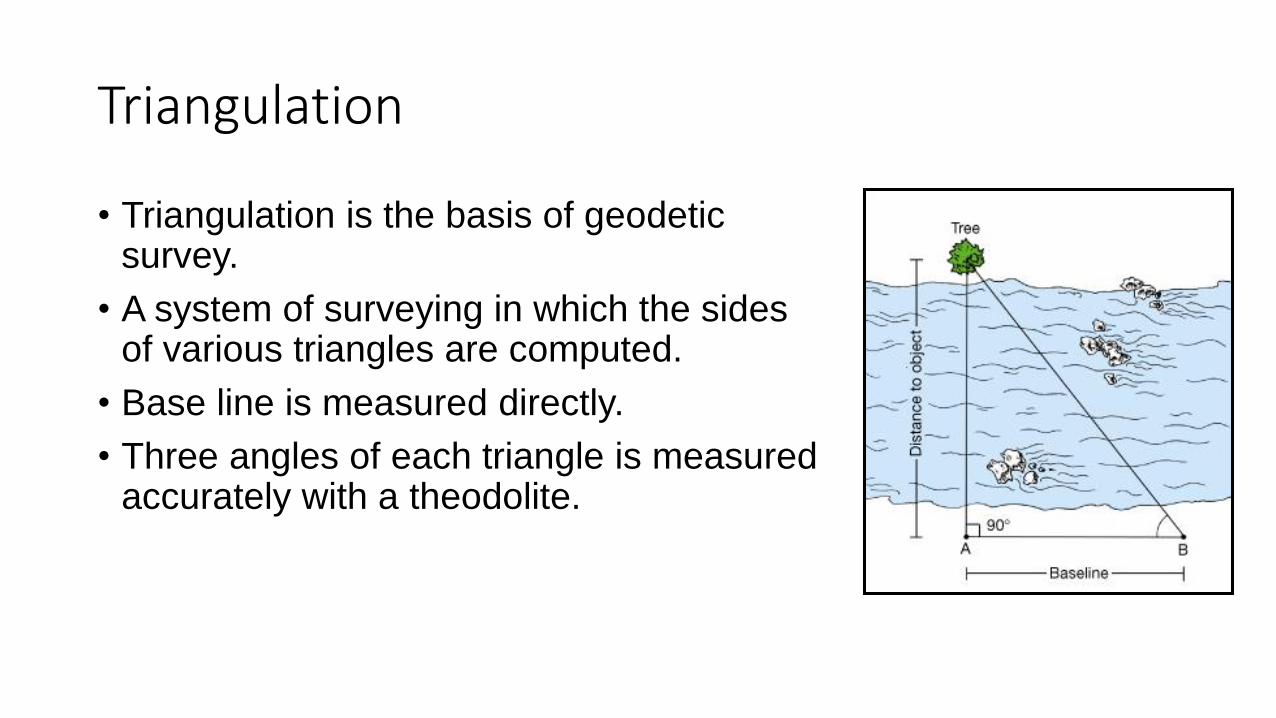
Triangulation
• Triangulation is the basis of geodetic survey.
• A system of surveying in which the sides of various triangles are computed.
• Base line is measured directly.
• Three angles of each triangle is measured accurately with a theodolite.

Well Conditioned Triangles
• In chain surveying, a NETWORK of TRIANGLES is preferred
• The triangle should be well conditioned
• The triangles in which no angle is smaller than 30 degrees of larger than 120 degrees is called well condition triangle

Survey Stations
Survey stations are of two kinds:
i. Main station
ii. Subsidiary or tie station
i. Main Station:
• Main stations are the ends of the survey lines, which commands the boundaries of the survey.
• The lines joining the main stations are called main survey lines or the chain lines.
Subsidiary or Tie Station:
• These are points selected on the main survey lines, where it is necessary to locate the interior details such as fences, hedges, buildings etc.
• A tie line joints, fixed points on the main survey lines.
• It helps in checking the accuracy of surveying and to locate the interior details.
• The position of each tie line should be close to some features such as paths, building etc.

Base line and Check line
Base Line:
It is the main and longest line, which passes approximately through the centre of the field.
All other measurements to show the details of the work are taken with respect to this line.
Check Line:
It is also called as proof line.
It is a line joining the apex of a triangle to some fixed points on any two sides of a triangle.
It is measured to check the accuracy of the frame work.
The length of a check line, as measured on the ground should agree with its length on the plan.

OffsetsThese are the lateral measurements from the base line to fix the positions of different objects.
These are generally set at right angle.
It can also be drawn with the help of a tape.
There are two kinds of offsets:
The measurements are taken at right angle to the survey line called perpendicular or right angled offsets. The measurements which are not made at right angles to the survey line are called oblique offsets or tie line offsets.

Procedure of Chain Survey
Reconnaissance:
The preliminary inspection of the area to be surveyed is called reconnaissance.
The surveyor inspects the area to be surveyed and prepares a hand sketch called index sketch or key plan.
It shows all the principle features of the area such as roads, buildings and nallas etc.

Marking station
• The surveyor fixes up the required number of stations at places from where max. detail can be obtained.
• Then he selects the way for passing the main line, which should be clear and horizontal as possible and should pass approximately through the centre of the area.
• Then ranging rods are fixed on the stations.
• After fixing the ranging rods, chaining should be started.
• Make ranging wherever necessary.
• Measure the chainage and offset.
• Enter the data in the field book.

Obstacles
Various obstacles are met with while chaining such as woods, hills, ponds, rivers etc.
• There are three types of obstacles
1. Chaining free, vision obstructed
2. Chaining obstructed, vision free
3. Chaining and vision both obstructed

Chaining free, vision obstructed
In this type the ends of a line are not inter-visible . e.g. rising ground or a hill intervening
There are two cases
a. Both ends may be visible from intermediate points on the line.
This is done by reciprocal ranging
Let A and B are two stations with rising ground or hill between them
Now make two other intermediate station C and D in between A and B such that chainman at station C can see both D and B
Similarly chainman at station D can see both A and C
The two chainman then proceed to line in each other alternately
They will change their position until they come in the same line AB exactly
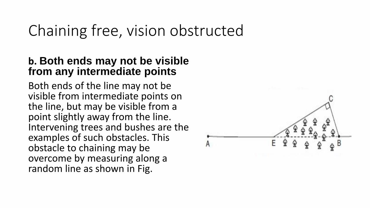
Chaining free, vision obstructed
b. Both ends may not be visible from any intermediate points
Both ends of the line may not be visible from intermediate points on the line, but may be visible from a point slightly away from the line. Intervening trees and bushes are the examples of such obstacles. This obstacle to chaining may be overcome by measuring along a random line as shown in Fig.

Chaining obstructed but vision free

a.
Select two convenient points A and B on the chain line PR on either side of the obstacle .
Erect AC and BD by the (3,4,5) method or by optical square.
Measure the length CD.
AB = CD

b.
Select A and B on either side of the obstruction.
Set out perpendicular AC of such length that CB clears the obstacle and measure AC and CB .
AB = (BC2 - AC2)1/2

c.
Set out AC and BC such that it clear the obstacle.
<C = 900
Measure AC and CB. Then
AB = ( AC2 + CB2 ) 1/2

Thank you


