1 Planning Department Environment & Mobility Planning Division SUBJECT: BAHIA RESORT HOTEL LEASE AMENDMENT The proposed LEASE AMENDMENT would allow for an expansion to the leasehold boundary and expansion of the Hotel’s water lease area. Consistent with the Mission Bay Park Master Plan, the Lease Amendment would allow for the redevelopment of: (i) the Bahia Resort Hotel increase up to 600 rooms; (ii) expanded leasehold toward the point of the Bahia Point peninsula, no further than the south curb of the north parking area, and shifted eastward in some areas; and (iii) the two-acre increase in the leasehold that would allow construction of up to forty-one (41) new wet slips, subject to all applicable City permits (Refer to Mission Bay Park Master Plan Update 2002, Section IV, Land Use, Subsection 17 and Section V, Water Use). The conceptual development plan included as an attachment to the Lease Amendment illustrates the removal of existing buildings, with the exception of the two tower hotel elements, and construction of new hotel facilities at the location of the existing Bahia Resort Hotel. The hotel currently provides 315 hotel rooms. The proposed project would demolish 166 existing hotel rooms and leave the remaining 149 hotel rooms in place. It would also construct 451 new hotel rooms within ten new buildings, resulting in a total of up to 600 hotel rooms (149 existing rooms to remain plus 451 new rooms), which is the maximum allowed for Bahia Point in the Mission Bay Park Master Plan Update. The future development allowed with the lease amendment would include the removal of an existing surface park access roadway and parking, installation of a continuous, unrestricted ten-foot wide pedestrian and bicycle access path around the entire Bahia Point, installation and replacement of landscaping and onsite drainage facilities consistent with current stormwater regulations, and relocation of an existing restroom facility. A total of approximately 710 parking spaces would be provided to service the renovated and expanded Bahia Resort Hotel and would be located in a new parking garage with up to three, above- grade levels, located in the southern portion of the project site. Onsite mature trees and vegetation along West Mission Bay Drive would be retained to provide for screening of the new structure from the public rights-of-way. The proposed project would also provide approximately 273 public parking spaces by reconfiguring, expanding, and creating new paved areas for public parking. Three expanded public parking areas within existing parking lots would be provided in the same area (western portion) of Mission Bay, within walking distance, outside the Bahia Hotel leasehold area. Following the completion of the Lease Amendment, redevelopment of the hotel would require a Coastal Development Permit issued by the California Coastal Commission and subsequent ministerial permits issued by the City of San Diego’s Development Services Department. Implementation of the water lease area for an increase of up to 41 boat slips would be subject to future discretionary action related to the project impacts on Environmentally Sensitive Lands (ESL), requiring subsequent environmental review. Detailed review of the new physical improvements within the water leasehold ADDENDUM TO ENVIRONMENTAL IMPACT REPORT N0. 91-0898 SCH No. 93041010
Transcript
1
Planning Department Environment & Mobility Planning Division SUBJECT: BAHIA RESORT HOTEL LEASE AMENDMENT The proposed LEASE AMENDMENT would allow for an expansion to the leasehold boundary and expansion of the Hotel’s water lease area. Consistent with the Mission Bay Park Master Plan, the Lease Amendment would allow for the redevelopment of: (i) the Bahia Resort Hotel increase up to 600 rooms; (ii) expanded leasehold toward the point of the Bahia Point peninsula, no further than the south curb of the north parking area, and shifted eastward in some areas; and (iii) the two-acre increase in the leasehold that would allow construction of up to forty-one (41) new wet slips, subject to all applicable City permits (Refer to Mission Bay Park Master Plan Update 2002, Section IV, Land Use, Subsection 17 and Section V, Water Use). The conceptual development plan included as an attachment to the Lease Amendment illustrates the removal of existing buildings, with the exception of the two tower hotel elements, and construction of new hotel facilities at the location of the existing Bahia Resort Hotel. The hotel currently provides 315 hotel rooms. The proposed project would demolish 166 existing hotel rooms and leave the remaining 149 hotel rooms in place. It would also construct 451 new hotel rooms within ten new buildings, resulting in a total of up to 600 hotel rooms (149 existing rooms to remain plus 451 new rooms), which is the maximum allowed for Bahia Point in the Mission Bay Park Master Plan Update. The future development allowed with the lease amendment would include the removal of an existing surface park access roadway and parking, installation of a continuous, unrestricted ten-foot wide pedestrian and bicycle access path around the entire Bahia Point, installation and replacement of landscaping and onsite drainage facilities consistent with current stormwater regulations, and relocation of an existing restroom facility. A total of approximately 710 parking spaces would be provided to service the renovated and expanded Bahia Resort Hotel and would be located in a new parking garage with up to three, above-grade levels, located in the southern portion of the project site. Onsite mature trees and vegetation along West Mission Bay Drive would be retained to provide for screening of the new structure from the public rights-of-way. The proposed project would also provide approximately 273 public parking spaces by reconfiguring, expanding, and creating new paved areas for public parking. Three expanded public parking areas within existing parking lots would be provided in the same area (western portion) of Mission Bay, within walking distance, outside the Bahia Hotel leasehold area. Following the completion of the Lease Amendment, redevelopment of the hotel would require a Coastal Development Permit issued by the California Coastal Commission and subsequent ministerial permits issued by the City of San Diego’s Development Services Department. Implementation of the water lease area for an increase of up to 41 boat slips would be subject to future discretionary action related to the project impacts on Environmentally Sensitive Lands (ESL), requiring subsequent environmental review. Detailed review of the new physical improvements within the water leasehold
ADDENDUM TO ENVIRONMENTAL IMPACT REPORT N0. 91-0898 SCH No. 93041010
2
are not analyzed within this document, and would be analyzed at such a time development is proposed. The existing and proposed amended leasehold is within the Coastal Height Limitation Overlay Zone, the Coastal Overlay Zone (Coastal Commission Approval), the Parking Overlay Zone (Coastal and Beach Impact Areas), the Residential Tandem Parking Overlay Zone, the Transit Area Overlay Zone, the Federal Aviation Administration (FAA) Part 77 Notification Area, and the Mission Beach Community Plan and Local Coastal Program Area. [LEGAL DESCRIPTION: Portion of the Tidelands and Submerged Lands of Mission Bay (False Bay), Miscellaneous Map No. 36; and a portion of Islands No. 2, Miscellaneous Map No. 72]. I. PROJECT DESCRIPTION
The proposed Lease Amendment is a discretionary action of the City, and is the proposed “Project” as defined under the California Environmental Quality Act (CEQA), analyzed within this Addendum to the Mission Bay EIR. The Lease Amendment would expand the leasehold boundary and expansion of the Hotel’s water lease area consistent with the Mission Bay Master Plan, as updated in 2002. A conceptual development plan for the Bahia Resort Hotel is included as an attachment to the lease amendment. At this time, there is no proposal for the development of the expanded water lease area. However, consistent with the existing Mission Bay Park Master Plan, up to forty-one (41) new wet slips and the addition of a new/extended boat dock may be constructed in the future, with further discretionary review subject to the receipt of all applicable City permits, including a Site Development Permit (SDP), for impacts to Environmentally Sensitive Lands (ESL). Following the completion of the Lease Amendment, redevelopment of the hotel would require a Coastal Development Permit issued by the California Coastal Commission and subsequent ministerial permits issued by the City of San Diego’s Development Services Department. Implementation of the water lease area for an increase of up to forty-one (41) boat slips would be subject to future discretionary actions related to the project impacts on Environmentally Sensitive Lands (ESL), requiring subsequent environmental review. Detailed review of the new physical improvements within the water leasehold are not analyzed within this document, and will be analyzed at such a time development is proposed. Mission Bay Park Master Plan Update The Bahia Resort Hotel is located on Bahia Point within the Mission Bay Park (Park) Master Plan Update (Master Plan) area. The Master Plan provides policies and recommendations for public and private uses with the Park, including private leasehold areas such as the Bahia Resort Hotel, and includes criteria for the redevelopment of the existing Bahia Resort Hotel. Based on Recommendation Number 17 in the Master Plan, the following criteria should guide the lease amendment and precise redevelopment plan for Bahia Point: • The demand to maintain public parking shall be a priority of any redevelopment plan. Any net loss of
public parking resulting from a lease expansion and/or relocation shall be mitigated by increasing parking lot capacity at Bonita Cove, Ventura Cove and, if necessary, other areas in the western half of Mission Bay.
• On-site parking for all hotel employees and guests within the hotel's leasehold shall be provided. • Nothing in this plan shall be construed to allow development or the closure of public rights-of-way in a
manner inconsistent with statutory or constitutional law.
3
• Access needs for small water craft users and the use of traditional picnic areas along the eastern shoreline shall be preserved as part of the specific redevelopment plan.
• An adequate public use zone should be maintained in accordance with the Design Guidelines taking into account the narrowness of the peninsula.
• A 10-foot wide continuous pedestrian and bicycle access around Bahia Point shall be made part of any redevelopment effort of the Bahia Hotel in accordance with the Design Guidelines.
• A minimum 20-foot grass strip along the eastern side of the peninsula shall remain. • To mitigate the loss of any lawn area at Bahia Point, a minimum 20-foot wide grass strip shall replace
beach along the length of Ventura Cove, adjacent to the parking lot, for approximately 400 feet. In addition, an approximate 50-foot by 100-foot lawn area for bocce ball and other recreational uses shall be added north of the entrance to the Ventura Cove parking lot, adjacent to the beach.
• A seasonal accessible-walkway-for-all shall be installed at Ventura Cove to the beach and the Bahia Hotel's expansion plan shall comply with the Americans with Disabilities Act.
• Any other public facilities, including all public parking removed from Bahia Point, shall be fully mitigated in the vicinity of Bahia Point at the time of, or prior to, redevelopment.
The Master Plan also includes recommendations for the expansion of the Hotel’s day-use boat slips by two acres, with future construction of a new/extended dock and up to forty-one (41) boat slips. The expansion of the water lease area would be subject to a future discretionary action, including a Site Development Permit, due to presence of Environmentally Sensitive Lands (i.e., eel grass beds), for a new boat dock to provide for additional day-use boat slips. This process would require subsequent environmental review. The property applicant/lessee, Evans Hotels, proposes renovation and expansion of the Bahia Resort Hotel in accordance with these above criteria and recommendations of the Master Plan. Conceptual Development Plan The conceptual development plan included as an attachment to the Lease Amendment illustrates the removal of existing buildings, with the exception of the two tower hotel elements, and construction of new hotel facilities at the location of the existing Bahia Resort Hotel. The hotel currently provides 315 hotel rooms. The proposed project would demolish 166 existing hotel rooms and leave the remaining 149 hotel rooms in place. It would also construct 451 new hotel rooms within ten new buildings, resulting in a total of up to 600 hotel rooms (149 existing rooms to remain plus 451 new rooms), which is the maximum allowed for Bahia Point in the Mission Bay Park Master Plan Update. The future development permitted with the lease amendment would include the removal of an existing surface park access roadway and parking, an increase in the amount of grass areas on Bahia Point accessible to the public, provision of a continuous, unrestricted ten-foot wide pedestrian and bicycle access path around the entire Bahia Point, installation and replacement of landscaping and onsite drainage facilities consistent with current stormwater regulations, relocation and expansion of an existing restroom facility in the southeast portion of the peninsula, and addition of a boat dock to accommodate approximately 18 additional watercraft. A total of approximately 710 parking spaces would be provided in a new parking garage with up to three, above-grade levels to serve the renovated and expanded Bahia Resort Hotel, located in the southern portion of the project site. Onsite mature trees and vegetation along West Mission Bay Drive would be retained to provide screening of the new structure from the public rights-of-way. The proposed project would also provide approximately 273 public parking spaces by reconfiguring, expanding, and creating new paved areas for public parking. Three expanded public parking areas
4
within existing parking lots would be provided in the same area (western portion) of Mission Bay, within walking distance, outside the Bahia Hotel leasehold area. See Figure 1, Lease Amendment: Bahia Resort Hotel Conceptual Development Plan, for a conceptual development plan of the proposed redevelopment. A detailed description of the project’s various elements and features is provided below. Proposed City Lease Amendment In accordance with the adopted Master Plan, the Bahia Resort Hotel is allowed to increase its leasehold by a maximum of one-acre, or 43,560 square feet. This maximum increase would result in a maximum leasehold area of 627,332 square feet (14.4 acres). The Lease Amendment would result in a reconfiguration of the City lease boundary, increasing the leasehold area by approximately one acre, or 43,560 square feet, bringing the total proposed leasehold to a maximum of 627,332 square feet (14.4 acres). The new leasehold area would run along West Mission Bay Drive on the south in the same manner as the current leasehold. On the west, the leasehold boundary would run along the eastern side of the proposed pedestrian and bicycle access path. On the north, the leasehold boundary would terminate at the expansion plan limit line, as identified in the Master Plan. On the east, the leasehold boundary would be along the western side of Gleason Drive and the proposed parking lot, and along the western boundary of the proposed pedestrian and bicycle access path. All beach areas (essentially all lands on the bay-side of the proposed pedestrian and bicycle access path) would be removed from the leasehold boundary. The existing City lease would be amended to reflect the leasehold expansion and conceptual Development Plan. Redevelopment of the hotel would require a Coastal Development Permit issued by the California Coastal Commission and subsequent ministerial permits issued by the City of San Diego’s Development Services Department. Proposed Recreational Amenities Consistent with recommendations in the Master Plan Update, the Bahia Resort Hotel Lease Amendment project would improve and increase recreational amenities available to the public. Presently, there is no continuous access around Bahia Point for walkers or bicyclists. A continuous, unrestricted ten-foot wide pedestrian and bicycle access path would be provided around the entire Bahia Point, connecting the path along the bay in accordance with the Master Plan. Further, this connection would provide separation between recreational users and West Mission Bay Drive, where high traffic volumes presently exist during peak summer months and daily peak hours. The current grass areas in the eastern and northern portions of the site would remain with a 20-foot wide grass strip along the length of Ventura Cove (approximately 400 feet). An additional grass strip would be provided along Santa Barbara Cove, creating a continuous 20-foot wide grass strip area around the entire perimeter of the peninsula. An open grass area would remain in the northern portion of the peninsula, to the north of the amended leasehold boundary. Additionally, a 50-foot by 100-foot lawn area would be added in the portion of the project site roughly east of Gleason Road and north of West Mission Bay Drive. This area would allow for passive recreation. The existing restroom facility would be relocated to this area, as well, with paddle board/kayak lockers and other water sport rentals. The boat dock, which would be a future phase of the project, would be expanded to provide an additional dock, accommodating approximately 18 additional watercraft.
5
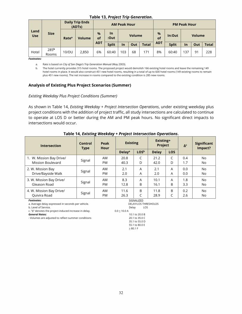
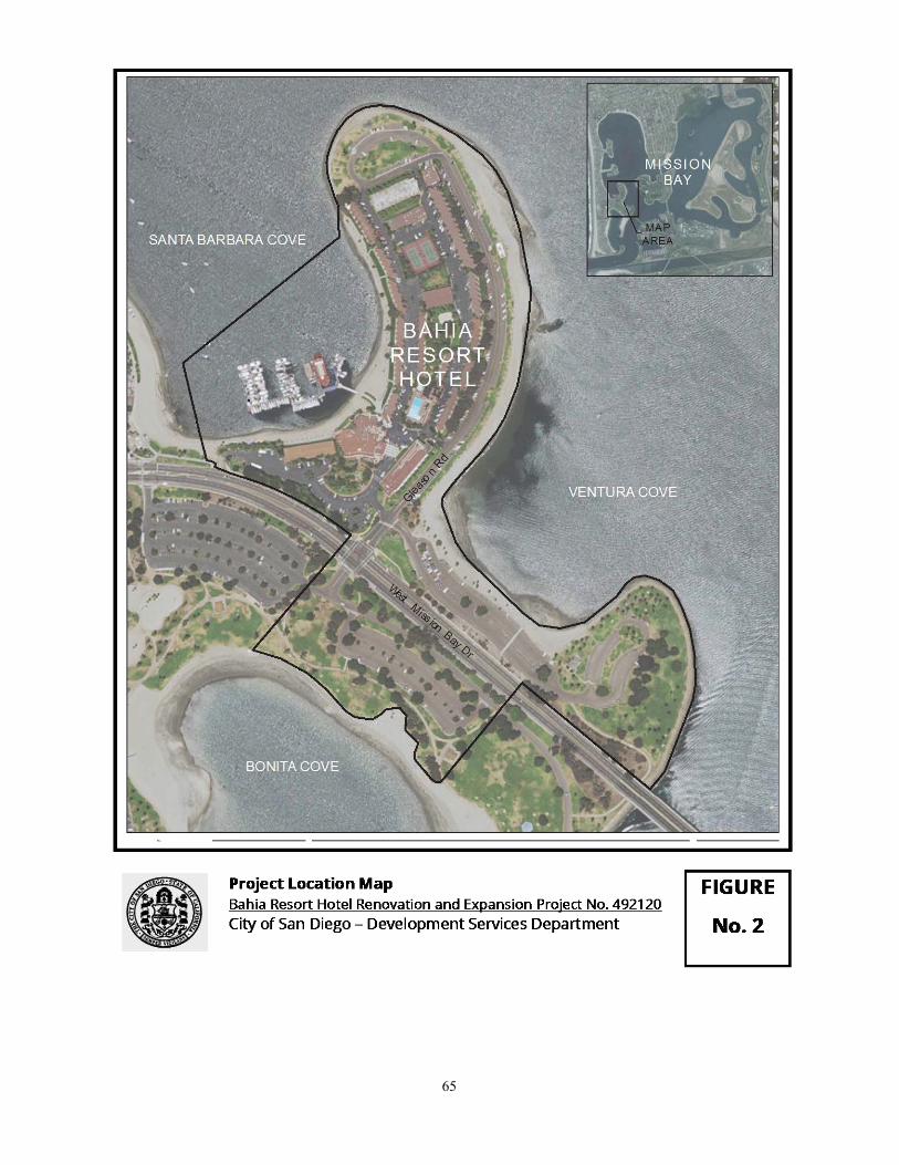
Proposed Public Parking Currently, there are 270 public parking spaces on Bahia Point. The proposed Lease Amendment would allow for the Bahia Resort Hotel to remove existing parking along an existing surface park access roadway and parking along the northern and eastern perimeter of Bahia Point. Public parking would be replaced by reconfiguring, expanding, and creating new paved areas for approximately 273 public parking spaces in accordance with the Master Plan. Three expanded public parking areas within existing parking lots would be provided in the same area (western portion) of Mission Bay, within walking distance of the Bahia Resort Hotel, though outside of the amended leasehold area. II. ENVIRONMENTAL SETTING In 1944, a San Diego Chamber of Commerce committee recommended developing Mission Bay into a tourist attraction, as part of an overall effort to diversify the City’s economy. In 1945, approximately 2,900 acres of land within Mission Bay Park was granted to the City by a State Tidelands Grant. Beginning in 1946, dredging operations commenced in order to transform the area as a whole into a harbor for small boats, recreational activities for aquatic sports, and commercial areas for resort hotels, motor hotels, motels, trailer parks, and food establishments. These dredging efforts continued until the mid-1960s. In March of 1953, Mr. William Evans announced that construction had started on a planned 302-unit resort hotel on 12 acres of land leased from the City on Gleason Point. Evans named the development the “Bahia Hotel,” now known as the Bahia Resort Hotel. The Bahia Resort Hotel is an existing hotel located at 998 West Mission Bay Drive, San Diego, and is currently developed with 315 rooms. The site is situated north of West Mission Bay Drive on a peninsula (Bahia Point) that separates Santa Barbara Cove and Ventura Cove in the Mission Bay Park Master Plan Area of the City of San Diego. Guest rooms are accommodated in one- and two-story buildings that are located along the east and west sides of the peninsula, as well as a five-story tower at the south end of the peninsula and a four-story tower at the north end of the peninsula. (See Figure 2, Project Location Map.) The Mission Beach community exists directly west of the existing Bahia Resort Hotel leasehold. This area consists of a mix of residential dwellings (single-family residences and multi-family structures), as well as commercial buildings. In recent years, there has been an increase in new development with the construction of new larger residential homes and the remodeling of existing homes in close proximity to the Bahia Resort Hotel. To the east of the leasehold is Mission Bay, Mission Bay Park, and public lands. These areas include open space and provide for a number of different recreational uses. Mission Bay Park contains approximately 200 acres of developed public parks, parking facilities, slips for over 2,500 pleasure boats, and 1,500 dry boat storage spaces. Through City lease arrangements, commercial establishments provide various services to Park visitors. Among 19 major commercial lessees on Mission Bay are five hotels, ten smaller pleasure boat marinas, a campground and golf course, and the 150-acre Sea World Aquatic Theme Park. III. PROJECT BACKGROUND The Bahia Resort Hotel is located on Bahia Point in Mission Bay Park and is subject to the Mission Bay Park Master Plan Update. The Mission Bay Park Master Plan Update was adopted in 1994, and includes a description of the expansion of the Bahia Resort Hotel to up to 600 guest rooms with specific criteria to be applied to expansion of the Hotel (Mission Bay Park Master Plan Update Recommendation No. 17), as well as expansion of boat slips at the Hotel.
6
An EIR was prepared for the 1994 Master Plan Update, which included analysis of an expansion to the Bahia Resort Hotel to 600 guest rooms and additional area for boat slips. The Mission Bay Master Plan Update EIR was prepared, certified, and approved on May 11, 1994. Renovation and expansion of the Bahia Resort Hotel and a lease amendment to increase the land and water leaseholds as evaluated in the 1994 EIR, is proposed by the applicant/lessee, Evans Hotels. This Bahia Resort Hotel Lease Amendment Addendum to the 1994 EIR addresses the expansion of the leasehold, as well as the conceptual development plan for the expansion and renovation of the existing Bahia Resort Hotel consistent with the 1994 Master Plan Update and environmental analysis contained within the 1994 EIR. The Master Plan Update was adopted by the City Council in 1994 (Resolutions R-284398, R-284399, R-284400) and was subsequently revised in 1995 (Resolution R-286199) and 1997 (Resolution R-288657) in response to modifications required by the California Coastal Commission. The Coastal Commission modifications included provisions related to Bahia Point. In its Revised Findings dated July 21, 1995 and Revised Findings dated January 15, 1997, the Coastal Commission stated that its local coastal program approval process had been found by the Resources Agency to be functionally equivalent to the EIR process and no significant environmental impacts would occur if the modifications were adopted by the City. In 2002, the Sea World Master Plan was adopted as an Addendum to the Mission Bay Park Plan Master Plan Update (Resolutions R-2003-22, R-2003-48, R-2003-55). The SeaWorld Master Plan Final EIR dated June 5, 2001 (LDR No. 99-0618; SCH No. 1984030708) was certified by the City Council July 10, 2001 (Resolution R-295138). That EIR did not identify any impacts related to Bahia Point. IV. ENVIRONMENTAL DETERMINATION The City previously prepared and certified the Mission Bay Park Master Plan Update Environmental Impact Report (EIR) No. 91-0898/SCH No. 93041010 as well as other Resolutions R-284398, R-284399, R-284400, R-286199, R-288657, R-2003-22, R-2003-48, R-2003-55 and R-295138, referenced in Section III, Project Background. Based on all available information in light of the entire record, the analysis in this Addendum, and pursuant to Section 15162 of the State CEQA Guidelines, the City has determined the following:
• There are no substantial changes proposed in the project which will require major revisions of the previous environmental document due to the involvement of new significant environmental effects or a substantial increase in the severity of previously identified significant effects;
• Substantial changes have not occurred with respect to the circumstances under which the project is undertaken which will require major revisions of the previous environmental document due to the involvement of new significant environmental effects or a substantial increase in the severity of previously identified significant effects; and
• There is no new information of substantial importance, which was not known and could not
have been known with the exercise of reasonable diligence at the time the previous environmental document was certified as complete or was adopted, that shows any of the following:
7
a. The project will have one or more significant effects not discussed in the previous environmental document;
b. Significant effects previously examined will be substantially more severe than shown in the previous environmental document;
c. Mitigation measures or alternatives previously found not to be feasible would in fact be
feasible, and would substantially reduce one or more significant effects of the project, but the project proponents decline to adopt the mitigation measure or alternative; or
d. Mitigation measures or alternatives which are considerably different from those analyzed
in the previous EIR would substantially reduce one or more significant effects on the environment, but the project proponents decline to adopt the mitigation measure or alternative.
Based upon a review of the proposed Lease Amendment, the current Project under CEQA, none of the situations described in Sections 15162 and 15164 of the State CEQA Guidelines apply. No changes in circumstances have occurred, and no new information of substantial importance has manifested, which would result in new significant or substantially increased adverse impacts as a result of the project. Therefore, this Addendum has been prepared in accordance with Section 15164 of the CEQA State Guidelines. Public review of this Addendum is not required per CEQA. An EIR was prepared for the Master Plan Update and certified by the San Diego City Council in 1994 (1994 EIR). The 1994 EIR analyzes the following issue areas:
• Land Use • Recreational Resources • Biological Resources • Hydrology/Water Quality
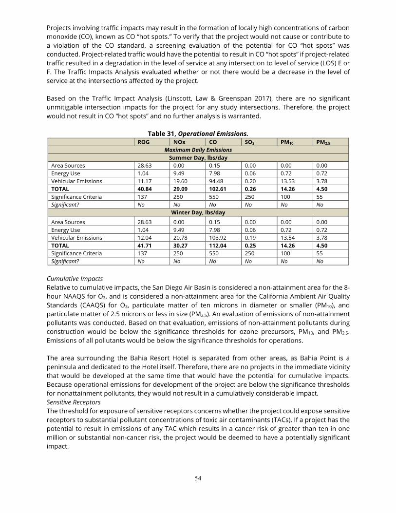
• Circulation/Traffic • Public Safety • Public Services • Air Quality
The 1994 EIR found that the Master Plan Update would result in significant environmental impacts associated with Biological Resources, Hydrology/Water Quality (dredging), and Circulation/Traffic. Relative to Public Services, the 1994 EIR required that, prior to implementation of any project that significantly increases the number of guest residences or parking spaces in the Park, the project’s effect on police and fire services in the Park be considered to determine if additional police officers, fire personnel, or equipment (e.g., squad cars) would be necessary to maintain adequate levels of service. A Mitigation Monitoring and Reporting Program (MMRP) was adopted that contains mitigation measures required to reduce potential environment impacts associated with Biological Resources to below a level of significance. A Statement of Overriding Considerations was adopted for the project in concert with certifying the 1994 EIR for unavoidable impacts relative to traffic. This Addendum supplements information provided in the Mission Bay Park Master Plan Update EIR (DEP No. 91-0898 / SCH No. 93041010) to further describe development on Bahia Point as it relates to the Bahia Resort Hotel and includes the impact analysis necessary to demonstrate impacts associated with the Bahia Resort Hotel Lease Amendment are consistent with the previously certified Mission Bay Park Master Plan Update EIR. V. IMPACT ANALYSIS
8
Land Use 1994 EIR The Master Plan Update consists of an approved development plan for Mission Bay Park to sustain the diversity and quality of the Park’s recreation uses, which protect and enhance the aquatic environment. The Master Plan Update allows for the expansion of hotel uses. Specific to the Bahia Resort Hotel Lease Amendment, the Master Plan Update allows up to 600 hotel rooms at Bahia Point. The 1994 EIR determined that the Master Plan Update would result in beneficial effects on land use. The Master Plan Update increased the amount of regional parkland by approximately 50 percent to accommodate future demand for this use. It also increased the amount of neighborhood, commercial, and habitat-related recreational uses. Fully implemented, the Master Plan Update would provide approximately two-thirds of a mile of additional shoreline, increasing waterfront opportunities; it would preserve, enhance, and increase the total acreage devoted to natural habitat within Mission Bay Park; and it would facilitate the correction of existing erosion and sand accumulation problems. Greater separation between incompatible recreational water uses (e.g., swimmers, personal watercraft, and boats), as called for in the Master Plan Update, provides for greater safety for the recreational user. The 1994 EIR determined that no significant land use impacts would occur. The 1994 EIR found that the Master Plan Update could result in a net loss of approximately ten acres of planned wetlands or may result in a net increase of 25 acres of planned wetlands. The 1994 EIR concluded that this would not be a significant impact associated with land use because the wetlands creation proposed under the Master Plan Update likely would be of higher quality due to its proximity to the Natural Resource Management Plan for the Park. Proposed Project According to the Master Plan, the project site’s land use designation is Lease Development. The Master Plan encourages the redevelopment of underutilized existing lease areas, including the Bahia Resort Hotel. The Bahia Resort Hotel Lease Amendment would be consistent with the Master Plan and would allow the expansion of hotel uses on Bahia Point. Furthermore, the Lease Amendment would be consistent with the Master Plan Update’s specific recommendation for the Hotel. Table 1, Project Consistency with Mission Bay Park Master Plan Update, includes the Master Plan’s recommendations and summarizes the Lease Amendment conformance with the plan. The Master Plan Update also includes recommendations for the expansion of the water lease area by two acres. Therefore, the project is consistent with the Master Plan Update’s recommendation with regard to increasing the water lease expansion area. The City of San Diego General Plan (2008) establishes regional planning and smart growth principles intended to preserve remaining natural open space and create focused villages. The General Plan designates Mission Bay Park as a Resource Based Park. General Plan Elements applicable to the proposed project’s land use are: Land Use and Community Planning Element, Recreation Element, Conservation Element, and Urban Design Element.
9
• Land Use and Community Planning Element. This element designates the site for Park, Open Space, & Recreation. The proposed project is an allowed use within this designation.
• Recreation Element. The project would promote the Recreation Element policies for a sustainable park and recreation system by expanding recreational amenities available to the public consistent with the Recreation Element.
• Conservation Element. The project would be consistent with the most recent Title 24 standards. The project would replace existing buildings that are not constructed with the same standards with new construction. The project would be consistent with the Conservation Element.
• Noise Element. The project would be consistent with all City noise ordinances. The project would be consistent with the Noise Element.
Bahia Resort Hotel Lease Amendment project would be consistent with the goals and policies of the City of San Diego General Plan.
Table 1. Project Consistency with the Mission Bay Park Master Plan Update
Master Plan Recommendation (pages 46 and 48) Project Consistency
17. Bahia Hotel: 600-room resort hotel. In accordance with the objective of intensifying existing leaseholds, the Bahia Hotel lease, at the lessee’s option, should be expanded towards the point of the peninsula, no further than the south curb at the north parking area, and shifted eastward in some areas. Such an expansion and shift could potentially permit the addition of 120 hotel rooms to the complex, above and beyond the current 484-room redevelopment plans. The following criteria should guide the precise redevelopment plan for Bahia Point:
The proposed City Lease Amendment would allow for a total of 600 hotel rooms. The Bahia Resort Hotel property currently occupies the width of the peninsula, so an eastward shift is not possible. However, development would extend toward the point of the Bahia Point peninsula, to the Mission Bay Park Master Plan expansion plan limits.
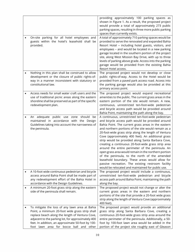
• The demand to maintain public parking shall be a priority of any redevelopment plan. Any net loss of public parking resulting from a lease expansion and/or relocation shall be mitigated by increasing parking lot capacity at Bonita Cove, Ventura Cove and, if necessary, other areas in the western half of Mission Bay.
Currently, there are 270 public parking spaces on Bahia Point. Public parking currently located along the east and north sides of the peninsula would be removed by the development under the proposed Lease Amendment. Those spaces would be replaced by reconfiguring, expanding, and creating new areas for public parking in accordance with Master Plan. Three public parking lots would be provided outside the Bahia Hotel leasehold area. An off-site lot would be provided at Bonita Cove as a western extension of the existing public parking lot and would provide approximately 86 spaces. The Ventura Cove parking area would be reconfigured for more efficient parking, providing approximately 87 spaces. Adjacent to the Bahia Resort Hotel leasehold area, public parking would be provided in a new, off-site parking lot at the northern terminus of Gleason Road,
10
providing approximately 100 parking spaces as shown in Figure 1. As a result, the proposed project would provide a total of approximately 273 public parking spaces, resulting in three more public parking spaces than currently exists.
• On-site parking for all hotel employees and guests within the hotel's leasehold shall be provided.
A total of approximately 710 parking spaces would be provided to serve the renovated and expanded Bahia Resort Hotel – including hotel guests, visitors, and employees – and would be located in a new parking garage located in the southern portion of the project site, along West Mission Bay Drive, with up to three levels of parking above grade. Access into the parking garage would be provided from the existing Bahia Resort Hotel access.
• Nothing in this plan shall be construed to allow development or the closure of public rights-of-way in a manner inconsistent with statutory or constitutional law.
The proposed project would not develop or close public rights-of-way. Access to the Hotel would be provided from a paved park access road. Access into the parking garage would also be provided at this primary access point.
• Access needs for small water craft users and the use of traditional picnic areas along the eastern shoreline shall be preserved as part of the specific redevelopment plan.
The proposed project would expand recreational amenities to the public. The current grass areas in the eastern portion of the site would remain. A new, continuous, unrestricted ten-foot-wide pedestrian and bicycle access path would be provided around Bahia Point, maintaining the path along the bay.
• An adequate public use zone should be maintained in accordance with the Design Guidelines taking into account the narrowness of the peninsula.
A continuous, unrestricted ten-foot-wide pedestrian and bicycle access path would be provided around Bahia Point. The current grass areas in the eastern and northern portions of the site would remain as a 20-foot-wide grass strip along the length of Ventura Cove (approximately 400 feet). An additional grass strip would be provided along Santa Barbara Cove, creating a continuous 20-foot-wide grass strip area around the entire perimeter of the peninsula. An open grass area would remain in the northern portion of the peninsula, to the north of the amended leasehold boundary. These areas would allow for passive recreation. The existing restroom facility would be relocated and maintained for public use.
• A 10-foot wide continuous pedestrian and bicycle access around Bahia Point shall be made part of any redevelopment effort of the Bahia Hotel in accordance with the Design Guidelines.
The proposed project would include a continuous, unrestricted ten-foot-wide pedestrian and bicycle access path around Bahia Point, maintaining the path along the bay.
• A minimum 20-foot grass strip along the eastern side of the peninsula shall remain.
The proposed project would not change or alter the current grass areas in the eastern and northern portions of the site that provide a 20-foot wide grass strip along the length of Ventura Cove (approximately 400 feet).
• To mitigate the loss of any lawn area at Bahia Point, a minimum 20-foot wide grass strip shall replace beach along the length of Ventura Cove, adjacent to the parking lot, for approximately 400 feet. In addition, an approximate 50-foot by 100-foot lawn area for bocce ball and other
The proposed project would provide an additional grass strip along Santa Barbara Cove, creating a continuous 20-foot-wide grass strip area around the entire perimeter of the peninsula. Additionally, a 50-foot by 100-foot lawn area would be added in the portion of the project site roughly east of Gleason
11
recreational uses shall be added north of the entrance to the Ventura Cove parking lot, adjacent to the beach.
Road and north of West Mission Bay Drive.
• A seasonal accessible-walkway-for-all shall be installed at Ventura Cove to the beach and the Bahia Hotel's expansion plan shall comply with the Americans with Disabilities Act.
The proposed project would include a continuous, unrestricted ten-foot-wide pedestrian and bicycle access path around Bahia Point connecting with the beach area at Ventura Cove that would comply with the Americans with Disabilities Act.
• Any other public facilities, including all public parking removed from Bahia Point, shall be fully mitigated in the vicinity of Bahia Point at the time of, or prior to, redevelopment.
Some public parking currently located along the east and north sides of the peninsula would be displaced by the proposed project. Those spaces would be replaced by reconfiguring, expanding, and creating new areas for public parking in accordance with the Master Plan Update. Three public parking lots would be provided outside the Bahia Hotel leasehold area. An off-site lot would be provided at Bonita Cove as a western extension of the existing public parking lot and would provide approximately 86 spaces. The Ventura Cove parking area would be reconfigured for more efficient parking, providing approximately 87 spaces. Adjacent to the Bahia Resort Hotel leasehold area, public parking would be provided in a new, off-site parking lot at the northern terminus of Gleason Road, providing 100 parking spaces. As a result, the proposed project would provide a total of approximately 273 public parking spaces – a gain of three public parking spaces more than currently exists.
Mission Bay Park Recommendation: Aquatic Orientation (Page 36) Project Consistency
Primary Zone: 300-foot depth is established in the Design Guidelines component of Mission Bay Park Master Plan as the primary zone of water influence. Within this zone, priority should be given to passive recreation uses or uses compatible with the water setting. Conversely, land uses which restrict public access and enjoyment of the shore should be discouraged and avoided to the greatest extent possible.
The primary zone would be enhanced. The 20-foot wide grass strips that run along the length of Ventura Cove (approximately 400 feet) would be replaced with new grass. The project would add an additional grass strip along Santa Barbara Cove, creating a continuous 20-foot wide grass strip area around the entire Bahia Point peninsula. The project would also provide a continuous, unrestricted ten-foot wide pedestrian and bicycle access path around the entire Bahia Point. A new 50-foot by 100-foot lawn area is proposed to be added in the portion of the Bahia Resort Hotel property roughly east of Gleason Road and north of West Mission Bay Drive. This lawn area would allow for passive recreational uses. The project would relocate the existing public restroom building located in the northeastern portion of the Bahia Point peninsula to the area within the Bahia Resort Hotel property roughly east of Gleason Road and north of West Mission Bay Drive. That public amenity would be enhanced with paddle board/kayak lockers and possible water sport rentals.
12
California Coastal Act Sea Level Rise Policy Guidance Adopted in 2015 by the California Coastal Commission (CCC), the Sea Level Rise Policy Guidance provides a framework for addressing sea-level rise in Coastal Development Permits. The guidance provides principles for addressing sea-level rise in the coastal zone, an overview of the science behind sea-level rise as well as a description of the potential consequences, and an outline of the steps for addressing sea-level rise in Coastal Development Permits. In response to evolutions in sea level rise science and statewide guidance, the CCC issued the Sea-Level Rise Guidance 2018 Update in July 2018 (CCC, 2018). In particular, the 2018 Update recommends use of the 2018 California Ocean Protection Council (OPC) Sea Level Rise Guidance. With respect to coastal resources, sea-level rise increases the risk of flooding, coastal erosion, and saltwater intrusion into freshwater supplies, which have the potential to threaten many of the resources that are integral to the California coast, including coastal development, coastal access and recreation, habitats (e.g., wetlands, coastal bluffs, dunes, and beaches), water quality and supply, cultural resources, community character, and scenic quality. The Bahia Hotel Sea Level Rise Study Update (SLR Study) was prepared by ICF (September 2018) for the proposed project. The SLR Study is a standalone technical study to inform the project. The SLR Study includes the latest methodology and sea-level rise projections used by the OPC Sea Level Rise Guidance (OPC, 2018). The report provides a planning-level sea-level rise analysis suitable for evaluation of the project at the plan level. Additional analysis at the site design and engineering level will be required prior to submission to the CCC for approval. After analyzing the extent to which sea-level rise could inundate the Bahia Resort property, recommendations on climate change adaptation techniques were identified to lessen the impacts to the resort. These include infrastructure and operational adjustments, as well as flexible adaptation pathways so the hotel can adjust their actions as necessary according to changing conditions and climate projections. The SLR Study recommends that the Bahia Resort consider developing an overall program that seeks to integrate the multiple mitigation strategies outlined in the study, including those focused on operation, design, and future adaptation. Based on the foregoing analysis and information, there is no evidence that the changes to the project require a major change to the Mission Bay Park Master Plan Update EIR. The project would not result in any new significant impacts or a substantial increase in the severity of impacts from those described in the 1994 EIR.
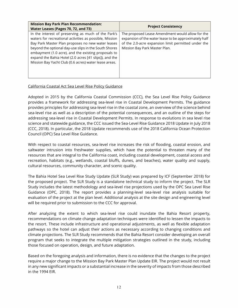
Mission Bay Park Plan Recommendation: Water Leases (Pages 70, 72, and 73) Project Consistency
In the interest of preserving as much of the Park’s waters for recreational activities as possible, Mission Bay Park Master Plan proposes no new water leases beyond the optional day-use slips in the South Shores embayment (1.0 acre), and the existing proposals to expand the Bahia Hotel (2.0 acres [41 slips]), and the Mission Bay Yacht Club (0.6 acres) water lease areas.
The proposed Lease Amendment would allow for the expansion of the water lease to be approximately half of the 2.0-acre expansion limit permitted under the Mission Bay Park Master Plan.
13
Recreational Resources 1994 EIR The 1994 EIR found that the Master Plan Update would result in increased recreational opportunities throughout Mission Bay Park through implementation of the “Parks within a Park” planning concept. The Master Plan Update includes guidelines and specific measures directed at yielding the “maximum sustainable benefit” for the Park’s limited resources. The Master Plan organizes the Park according to “regions” of compatible uses, an approach which creates distinctive recreation area with the Park referred to as the “Parks within a Park” concept in the Master Plan Update. The four recreational regions described in the Master Plan are:
• Regional-oriented recreation refers to regional parkland activities such as group picnicking, bicycling, and attendance of special events, such as the Over-the-Line tournament.
• Neighborhood-oriented recreation refers to more local recreation, including facilities like game courts and children's play areas.
• Commercial-oriented recreation refers to resort hotels, Sea World, and other commercial
operations, such as recreational vehicle camping.
• Habitat-oriented recreation refers to wetland and upland habitats serving more passive activities, including trails for hiking and jogging, or wetland areas for rowing and canoeing. Pedestrian and bicycle paths are common to all areas. These paths are viewed as the essential common thread that will bind the Park into a single recreational fabric.
Most applicable to the proposed project would be Regional-oriented recreation, relative to bicycling, and Commercial-oriented recreation, relative to resort hotels, as well as the Master Plan Update’s focus on pedestrian and bicycle paths that are the essential common thread that will bind the Park into a single recreational fabric. Relative to water recreation, the Master Plan Update calls for expansion of boat slips at the Bahia Resort Hotel for day-use watercraft through a two-acre expansion of the water lease area for the Hotel. The Master Plan Update identifies and responds to new and anticipated future demand placed on the recreational resources of Mission Bay Park and recognizes that a balanced approach between recreation, the environment, and commerce is necessary to ensure the diversity and quality of recreation in Mission Bay Park. The 1994 EIR found that implementation of the Master Plan Update would result in overall improvements to recreational resources in Mission Bay Park with all identified existing recreational uses and desired water-oriented recreational uses provided for through implementation of the Master Plan Update. Therefore, there was no adverse, significant impacts to recreational resources. Proposed Project The proposed Bahia Resort Hotel Lease Amendment project would be consistent with all recreational recommendations in the Master Plan Update. Specifically, as addressed under Land Use above, the proposed project would expand recreational amenities available to the public. The current grass areas
14
in the eastern and northern portions of the site would remain with a 20-foot-wide grass strip along the length of Ventura Cove (approximately 400 feet). An additional grass strip would be provided along Santa Barbara Cove, creating a continuous 20-foot-wide grass strip area around the entire perimeter of the peninsula. An open grass area would remain in the northern portion of the peninsula, to the north of the amended leasehold boundary. Additionally, a 50-foot by 100-foot lawn area would be added in the portion of the project site roughly east of Gleason Road and north of West Mission Bay Drive. This area would allow for passive recreation. The existing restroom facility would be relocated to this area, as well, with paddle board/kayak lockers and other water sport rentals. Relative to pedestrian and bicycle paths, currently a pedestrian and bicycle path exists along the south side of the Bahia Resort Hotel property, which runs roughly parallel to West Mission Bay Drive and is accommodated primarily within existing contiguous sidewalks along the roadway in the project vicinity. West of the project site, this path separates from the street and runs along the sand, creating a boardwalk of sorts. The proposed project would provide a continuous, unrestricted ten-foot-wide pedestrian and bicycle access path around Bahia Point, maintaining the path along the bay and providing an alternate route for users and away from the busy roadway of West Mission Bay Drive. The Bahia Resort Hotel provides boat rentals on two docks located within Santa Barbara Cove, accommodating approximately 70 private and for-rent watercraft of all types. Additionally, this marina accommodates hotel guests who bring their own personal watercraft. The water lease expansion would accommodate additional water recreation area. Based on the foregoing analysis and information, there is no evidence that the changes to the project require a major change to the Mission Bay Park Master Plan Update EIR. The project would not result in any new significant impacts or a substantial increase in the severity of impacts from those described in the 1994 EIR result. Biological Resources
1994 EIR Mission Bay Park contains a wide variety of habitat types, including marine, wetland, and terrestrial. Relative to biological resources at the Bahia Resort Hotel site, the Master Plan Update and 1994 EIR show existing eel grass beds around most of Bahia Point. No wetland or terrestrial habitats are shown in the Master Plan Update and 1994 EIR for Bahia Point. The 1994 EIR determined that direct and indirect effects would occur with implementation of the Master Plan Update. Impacts to sensitive species and associated habitat would be significant and require mitigation. Relative to eelgrass habitat, the 1994 EIR identified impacts associated with shoreline treatment from dredging that would result in loss of eelgrass habitat, as well as the possibility for indirect impacts from short-term sedimentation and turbidity generated by dredging activities, the shading of eelgrass beds by dredge equipment, and impacts to marine water quality. Implementation of the mitigation measures identified in the 1994 EIR would reduce these impacts to below a level of significance. The potential for indirect impacts to eelgrass from beach construction and maintenance was also identified. These impacts would be reduced to below a level of significance with the implementation of mitigation measures identified in the 1994 EIR. Relative to impacts on eelgrass, the 1994 EIR identified the following mitigation measures to reduce impacts to eelgrass to below a level of significance.
15
Shoreline Treatment Dredging The recent “Southern California Eelgrass Mitigation Policy” was adopted on July 31, 1991, and revised on August 25, 1992, by the United States Fish and Wildlife Service (USFWS), National Marine Fisheries Service (NMFS), and CDFG, and endorsed by the Environmental Protection Agency. Appendix E-2 [of the 1994 EIR] contains the “Southern California Eelgrass Mitigation Policy”. This recent policy requires a replacement ratio of 1.2 to 1 as a result of damage or loss to existing eelgrass resources. That is, for each square foot of adversely impacted habitat, 1.2 square feet of new suitable habitat, vegetated with eelgrass, must be created. This ratio replaces the previous 1:1 ratio required for the NRMP for eelgrass replacement. Total effects of the proposed Mission Bay Park Master Plan Update on eelgrass habitat are unknown at this time. However, prior to project level dredging, an assessment of existing eelgrass beds shall be taken to be used as a baseline for determining habitat loss after construction. A mitigation plan, including a five-year eelgrass monitoring and maintenance program shall be implemented. In addition to the “Southern California Eelgrass Mitigation Policy” mitigation measures, the following requirements and guidelines shall be incorporated into the impact analysis and mitigation planning for any proposed project in Mission Bay Park, including City and private developer-sponsored projects.
• No in-water construction or dredging shall be permitted in Mission Bay or the Flood Control Channel from April 1 through September 15, the California least tern breeding season. If in-water construction is required during this time, exceptions are possible upon approval by the City, CDFG, and USFWS. Any exception would have to meet the following criteria to preserve least tern nesting and foraging: use of silt curtains or similar devices around in-water construction activity; use of noise reduction or low noise equipment; and use of timing and location restrictions on activity to avoid interfering with breeding sites or major least tern foraging areas.
• No net loss of eelgrass meadows is acceptable. A 1.2:1 replacement ratio is required for impacts to eelgrass habitat as delineated in the recent “Southern California Eelgrass Mitigation Policy”, adopted on July 31. 1991, and revised on August 25, 1992, by the USFWS, National Marine Fisheries Service (NMFS), and CDFG, and endorsed by the Environmental Protection Agency.
• New sand beaches below MLLW shall be replanted with eelgrass whenever the slope is changed by maintenance activities and eelgrass beds are impacted.
• Replanting shall occur during low energy tides (late summer to early fall). Replanting of eelgrass is not considered to be in-water construction.
• Any construction or dredging project in the Bay or Flood Control Channel shall require that adjacent restricted areas be buoyed off prior to the start of activity. This is to limit the extent of direct impacts to existing eelgrass.
• Any construction or dredging project disturbing the substrate in the Bay or the Flood Control Channel shall use silt curtains or similar devices around disturbance areas. This would limit any adverse water quality impacts to the immediate construction area, thereby reducing impacts to eelgrass and foraging birds.
• All dredging impacts to marine habitat shall require a replacement ratio of 1:1. Loss of eelgrass habitat shall require a replacement ratio of 1.2:1. Impacts from maintenance dredging shall require a one-time mitigation for lost resources. Subsequent maintenance dredging for the original location, which has already mitigated the impact, would not require additional mitigation each time it is dredged.
16
• All dredging activities shall comply with permit conditions of the U.S. Army Corps of Engineers, Regional Water Quality Control Board, State Lands Commission and California Coastal Commission. Permits issued by these agencies may specify additional requirements for timing of in-water construction, spoil disposal methods, and dredge sediment material testing.
• Barges shall not be permitted to shade an eelgrass bed for more than five (5) consecutive days. In addition, construction contractors shall avoid anchoring barges in eelgrass beds to maximize extent feasible.
• Sand of acceptable quality to allow reuse that is retrieved in dredging operations shall be stockpiled on a non-sensitive, designated site on Fiesta Island upon approval of the City and Coastal Commission. This sand shall be used subsequently for beach replenishment, if it is of the proper grain size for beach stabilization. If room is not available on Fiesta Island, other arrangements for dredge spoil disposal will need to be made and approved by the City and other appropriate resource agencies.
• If sand/sediment is determined through testing by a qualified expert to be unclean, to contain toxic material, or to be of poor quality, it shall be transported to a permitted landfill or otherwise used appropriately, rather than stockpiled for future beach replenishment. Sand containing toxic material shall be taken only to a landfill qualified to handle toxic material.
• Estimated impacts to eelgrass beds created by turbidity and anchor placement resulting from dredging shall be validated by a dive before dredging and a diver after dredging is complete. Impacts shall be mitigated per the requirements of the Southern California Eelgrass Mitigation Policy.
• Monitoring the success of eelgrass mitigation projects shall be required for a period of five years. Monitoring activities shall determine the percent coverage and density of plants at the transplant site and shall be conducted at 3, 6, 12, 24, 36, 48, and 60 months after completion of the transplant (National Marine Fisheries Service, 1991).
• Criteria for determination of transplant success shall be based upon a comparison of vegetation coverage (area) and density (turions per square meter) between the project and mitigation sites (National Marine Fisheries Service, 1991).
The 1994 EIR also showed that the Master Plan Update included improvements to biological resources from wetland construction and the increase of coastal salt marsh habitat. The Master Plan Update was also found to result in improvements to sensitive species including Nuttall’s lotus, Belding’s savannah sparrow, light-footed clapper rail, and shorebirds. The 1994 EIR found the potential for significant impacts to the California least tern through the loss of the historic Stony Point and Cloverleaf least tern breeding areas. Mitigation measures created new breeding areas in Mission Bay Park and reduced the impacts to less than significant. The proposed project would not affect these resources. Proposed Project A Biological Resource Letter Report was prepared by Merkel & Associates, Inc. (July 27, 2015, updated February 1, 2018) for the proposed Bahia Resort Hotel Lease Amendment project. A copy of this report can be found in Appendix A of this addendum. Bahia Point consists of the existing Bahia Resort Hotel, ornamental grass and planting, and parking areas. The point is surrounded along the east, north, and west sides by Mission Bay. Santa Barbara Cove borders the western shoreline of Bahia Point and contains docks for small boats and for the Bahia Belle sternwheeler. Ventura Cove borders the eastern shoreline of Bahia Point. In addition to Bahia Point, the study area includes several parking lots and grassy recreation areas of Mission Bay Park to the east and south of the Bahia Resort Hotel that would be re-configured as part of proposed
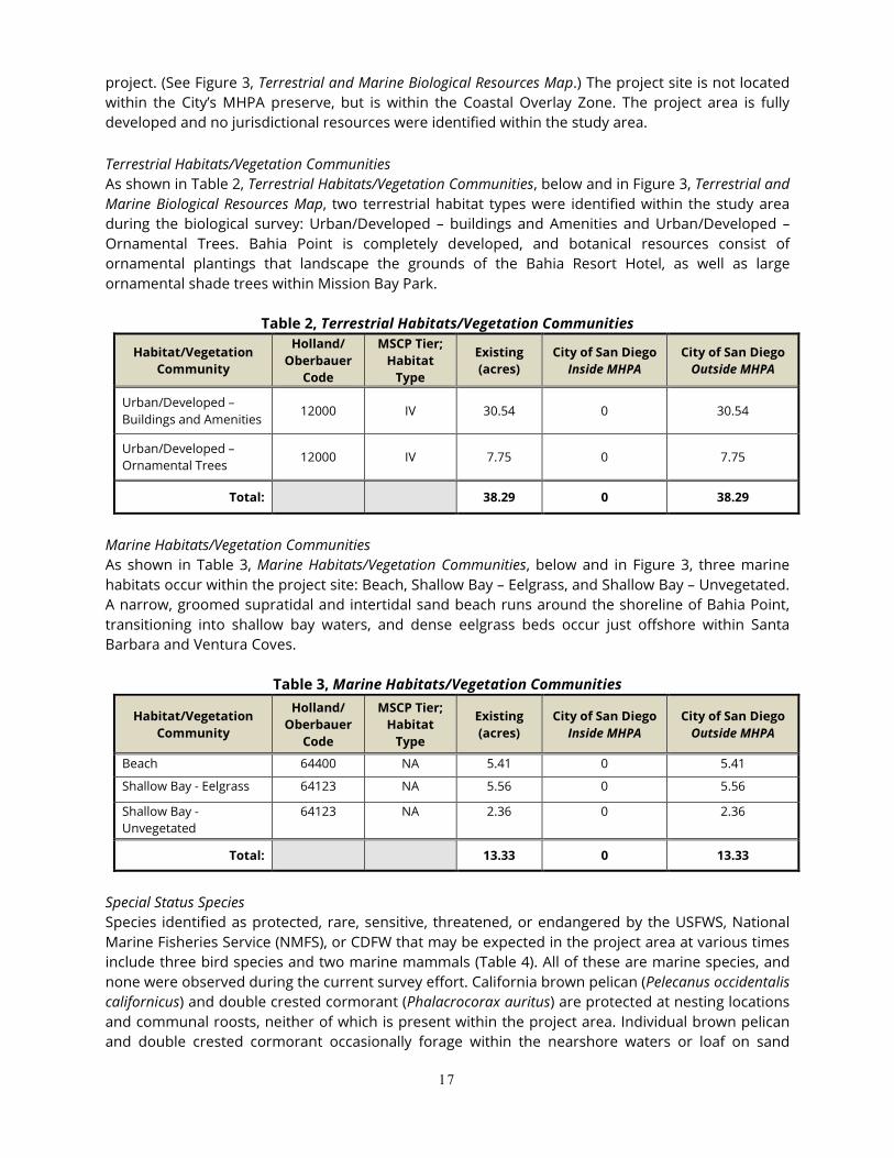
17
project. (See Figure 3, Terrestrial and Marine Biological Resources Map.) The project site is not located within the City’s MHPA preserve, but is within the Coastal Overlay Zone. The project area is fully developed and no jurisdictional resources were identified within the study area. Terrestrial Habitats/Vegetation Communities As shown in Table 2, Terrestrial Habitats/Vegetation Communities, below and in Figure 3, Terrestrial and Marine Biological Resources Map, two terrestrial habitat types were identified within the study area during the biological survey: Urban/Developed – buildings and Amenities and Urban/Developed – Ornamental Trees. Bahia Point is completely developed, and botanical resources consist of ornamental plantings that landscape the grounds of the Bahia Resort Hotel, as well as large ornamental shade trees within Mission Bay Park.
Marine Habitats/Vegetation Communities As shown in Table 3, Marine Habitats/Vegetation Communities, below and in Figure 3, three marine habitats occur within the project site: Beach, Shallow Bay – Eelgrass, and Shallow Bay – Unvegetated. A narrow, groomed supratidal and intertidal sand beach runs around the shoreline of Bahia Point, transitioning into shallow bay waters, and dense eelgrass beds occur just offshore within Santa Barbara and Ventura Coves.
Table 3, Marine Habitats/Vegetation Communities
Habitat/Vegetation Community
Holland/ Oberbauer
Code
MSCP Tier; Habitat
Type
Existing (acres)
City of San Diego Inside MHPA
City of San Diego Outside MHPA
Beach 64400 NA 5.41 0 5.41
Shallow Bay - Eelgrass 64123 NA 5.56 0 5.56
Shallow Bay - Unvegetated
64123 NA 2.36 0 2.36
Total: 13.33 0 13.33
Special Status Species Species identified as protected, rare, sensitive, threatened, or endangered by the USFWS, National Marine Fisheries Service (NMFS), or CDFW that may be expected in the project area at various times include three bird species and two marine mammals (Table 4). All of these are marine species, and none were observed during the current survey effort. California brown pelican (Pelecanus occidentalis californicus) and double crested cormorant (Phalacrocorax auritus) are protected at nesting locations and communal roosts, neither of which is present within the project area. Individual brown pelican and double crested cormorant occasionally forage within the nearshore waters or loaf on sand
18
beaches adjacent to Bahia Point. However, these species are opportunistic in their loafing and foraging activities are not dependent upon the project area for essential biological activities. California least terns (Sternula antillarum browni) do occasionally forage within the project area during summer months. The nearest least tern nesting colonies are located at Mariner’s Point, approximately 0.6 mile to the south of the project site, and Fiesta Island, approximately 1.0 mile to the east of the project site. This species makes opportunistic use of the bay shallows to forage for small fish.
Table 4, Special Status Species Observed or Expected to Occur within the Project Site
Common Name Scientific Name Status Occurrence at Project Site
California Brown Pelican Pelecanus occidentalis californicus CDFG FP Uncommon
California Least Tern Sternula antillarum browni SE, FE Likely*
Harbor Seal Phoca vitulina MMPA Uncommon
California Sea Lion Zalophus californianus MMPA Uncommon
SE – State Endangered; FE- Federally Endangered; FT – Federally Threatened; CDFW SSC- CDFW Species of Special Concern;
CDFW-FP – CDFW Fully Protected Species; CDFW-WL- CDFW Watch List; MMPA – species protected by the Marine Mammal
Protection Act
Other special status species that have a low to moderate potential to occur on the study area, based on the presence of suitable habitat, include marine mammals, specifically California sea lion (Zalophus californianus) and harbor seal (Phoca vitulina). Disturbance of these species is prohibited under the Marine Mammal Protection Act (MMPA). No breeding, haul out, or loafing areas for these marine mammals occur within the project area. California sea lion and harbor seal forage throughout Mission Bay, but are mainly observed near the entrance to the bay and adjacent to fishing docks and landings (such as Quivira Basin and along Dana Landing). As such, they are uncommon visitors to the project area. Jurisdictional Wetlands No wetlands were identified within the project study area. Mission Bay is considered a traditionally navigable water under the Rivers & Harbors Act (R&HA) and waters of the U.S. under the Clean Water Act (CWA). Wildlife Movement and Nursery Sites The project site is on a peninsula surrounded on three sides by the waters of Mission Bay. While migratory birds may stop briefly in the large ornamental trees planted at Bahia Point and Ventura Cove, the project site is not considered to be within a wildlife corridor. Eelgrass is considered to be an important nursery habitat for several fish species and is considered to be Essential Fish Habitat (EFH) and a Habitat Area of Particular Concern (HAPC) under the Magnuson-Stevens Fisheries Conservation and Management Act, as well as a Special Aquatic Site under the Clean Water Act. Impact Analysis Terrestrial Habitats/Vegetation Communities Based on the Biological Resource Letter Report, the project would not result in significant impacts to upland habitats, as the project site is completely developed (See Table 5, Terrestrial Habitats/Vegetation Communities: Impacts and Mitigation). However, the project would result in direct impacts to urban/developed lands (Tier IV habitat types) as a result of demolition of existing structures and
19
facilities, and construction of the proposed project. For the purpose of this analysis, all habitats inside the new leasehold area are considered to be impacted. This would include several large stands of mature ornamental trees, including those that border Gleason Road along the east side of Bahia Point. Other impacts to developed lands (grass turf and ornamental trees) would occur in the locations of the new parking areas on Bahia Point and south of West Mission Bay Drive adjacent to Bonita Cove. Impacts to urban/developed lands would be considered less than significant under CEQA since these habitats are not regionally considered to have high conservation value requiring mitigation.
Table 5. Terrestrial Habitats/Vegetation Communities: Impacts and Mitigation
Habitat/ Vegetation Community
MSCP Tier; Habitat
Type
Total in Study Area
(acres)
Impacts inside MHPA
(acres)
Impacts outside MHPA
(acres)
Mitigation Ratio1
Mitigation Required
(acres)
Urban/Developed – Buildings and Amenities
Tier IV; Upland
30.54 0 15.11 0:1 0
Urban/Developed – Ornamental Trees
Tier IV; Upland
7.75 0 4.33 0:1 0
Total: 38.29 0 19.44 - 0
1Mitigation ratios for upland habitats are based on the City’s Biology Guidelines (City 2012a). Marine Habitats/Vegetation Communities Figure 4, Eelgrass Survey Map, shows the location of eelgrass proximate to the project site. The implementation of the water lease expansion is subject to future discretionary action, and would result in direct impacts to eelgrass habitat due to construction of a new dock and boat slips, as shown in Table 6, Marine Habitats/Vegetation Communities: Impacts and Mitigation. Construction would result in impacts to approximately 14,838 square feet (0.34 acre) of eelgrass as a result of direct shading from the constructed dock and occupied slips. According to the Southern California Eelgrass Mitigation Policy (SCEMP,) impacts would require mitigation at a 1.2:1 ratio. In addition to direct impacts from shading of proposed dock and docked vessels, the new parking structure proposed for the project has potential to shade eelgrass along the shore. An eelgrass shading analysis was conducted and the results indicate that the current shoreward boundary of the eelgrass bed in Santa Barbara Cove is bayward, or outside of, the maximum shadow estimated for the proposed parking structure. As a result, the parking structure is not expected to shade the existing eelgrass resources and is not anticipated to have an adverse impact on eelgrass growth or coverage.
20
Table 6. Marine Habitats/Vegetation Communities: Impacts and Mitigation
Habitat/Vegetation Community
Total in Study Area
(acres) Impacts Area of Bay
Coverage2 Pile
Count3 Mitigation
Ratio1
Mitigation Required
(acres)
Beach 5.41 1.16 0:1 0
Shallow Bay -Eelgrass 5.56 0.34 1.2:1 0.41
Shallow Bay - Unvegetated 2.36 0.03 0:1 0
Other Impacts
Bay Coverage 0.37 1:1 0.37
New Pilings (count) 14
Total: 13.33 1.53 0.37 14 - 0.78 1Mitigation ratios for eelgrass habitat is based on the Southern California Eelgrass Mitigation Policy (NMFS 1991, rev 11) 2Bay coverage is defined as the amount of bay surface area covered by in-water structures, and is considered a reduction of foraging habitat available to aerial fish foraging birds. 3New piling count is an estimate based on existing docks
Bay Fill, Bay Coverage, and Pilings The proposed project would result in an increase in bay surface area coverage of approximately 14,838 square feet (0.34 acre), and an increase of approximately 14 piles. Bay coverage would be from the construction of new dock and boat slips. Increased bay surface area, or bay coverage, is considered to be a significant impact, as it removes a portion of the functionality of affected bay habitats, through decreased forage opportunities for some avian species as well as through decreased productivity in shaded waters. Special Status Species There were no sensitive species observed within the project site during the field surveys. The project site does not feature unique or rare habitats whose alteration would significantly impact sensitive species in the area. Sensitive bird species that occasionally occur on the project site are the California brown pelican, double-crested cormorant, and California least tern. The California brown pelican and double-crested cormorant are both fish foragers and permanent loss of shallow bay foraging area resulting from increased bay coverage would reduce the area available for foraging within Mission Bay. This loss is partially offset by the fact that structures in Mission Bay, including docks and pilings, tend to aggregate fish and increase foraging opportunity along the periphery of the structures. Based on this factor, impacts of the proposed project on California brown pelican and double-crested cormorant are not considered to be significant. California least tern nests were observed within Mission Bay (with the closest nesting sites 0.6 mile to the south of the project site at Mariner’s Point, and 1.0 mile to the east of the project site at Fiesta Island) and are seasonally present within Mission Bay between the months of April and October. Permanent loss of shallow bay habitat resulting from increased bay coverage is potentially significant. Temporary turbidity and noise from construction of the new dock and installation of piles could potentially disturb foraging California least terns. The loss of forage habitat due to increased bay coverage may be mitigated by enhancement of fish productivity or foraging efficiency in other areas of the bay. The following mitigation measure would be implemented: the contractor shall schedule and complete all in-water construction activity outside of the nesting season for the California least tern. Potential impacts to California least tern would be reduced to less than significant with
21
implementation of mitigation measures for bay coverage impacts provided in the MMRP for the proposed Bahia Lease Amendment project. Harbor seals and California sea lions are observed commonly in Mission Bay adjacent to the entrance channel, near bait barges, and near fishing docks and landings. Marine mammals would be expected to leave the site for adjacent waters if disturbed by project work; thus, it is not expected that any harm would occur to marine mammals. However, the MMPA prohibits “take” of marine mammals. The definition of take under the MMPA, like that of the Endangered Species Act, includes “harassment.” For this reason, a potentially significant impact to marine mammals could occur if mammals are disturbed during construction activities, even if they are not harmed by the activities. Potential impacts to marine mammals would be reduced to a less than significant level with implementation of the mitigation measures identified in the MMRP for the proposed Bahia Lease Amendment project. Jurisdictional Wetlands The proposed project would not result in impacts to jurisdictional wetlands since none occur within the project area. Wildlife Movement and Nursery Sites Impacts to eelgrass habitat are described above. No other nursery or wildlife corridors occur within the project area. Regulatory Requirements for Proposed Project The proposed project would comply with the Southern California Eelgrass Mitigation Policy (SCEMP) as administered by the USFWS, NMFS, and CDFW. The project would also comply with the recently adopted but not fully implemented CEMP. In addition, the proposed project would comply with the Caulerpa Control Protocol (CCP), which call for performance of a survey for Caulerpa (seaweed) prior to any bottom-disturbing activities (e.g. pile driving). The project would require a Coastal Development Permit (CDP) from the California Coastal Commission (CCC) for re-development of the Bahia Resort Hotel and facilities within the Coastal Zone. The project would also comply with the United States Army Corps of Engineers (USACE) Section 404 of the CWA, and Section 10 of the Rivers and Harbors Act, and with the requirements of Section 305(b)(2) of the Magnuson-Stevens Fishery Conservation and Management Act. An EFH Assessment would be required for this project. Implementation of the water lease area would be subject to future discretionary action, including a Site Development Permit requiring subsequent environmental review. Nesting birds may be present within the study area, and the proposed project includes removal of large stands of ornamental trees and shrubs that may serve as nesting habitat. If construction of the proposed project would occur during the migratory bird breeding season (generally defined as January 15 – September 15), a pre-construction survey for active migratory bird nests shall be conducted within approximately 48 to 72 hours prior to the start of construction. If an active migratory bird nest is found, then all construction activities undertaken for the project would comply with regulatory requirements of the Federal Migratory Bird Treaty Act (MBTA) and FCG §3503 and §3513. The project would avoid impacts to active migratory bird nests (if present at the time of construction) under the MBTA and/or Fish and Game Code (FGC) Sections 3503 and 3513 through implementation of nesting season surveys to ensure absence of nests prior to removing trees.
22
Cumulative Impacts The Multiple Species Conservation Plan (MSCP) is designed to identify lands that shall conserve habitat for Federal and State endangered, threatened, or sensitive species. The MSCP is a plan and a process for the local issuance of permits under the Federal and State Endangered Species Act for impacts to threatened and endangered species. Also included in the MSCP are implementation strategies, preserve design, and management guidelines. The City of San Diego prepared a subarea preserve plan to guide implementation of the MSCP Plan within its corporate boundaries. The MSCP was designed to compensate for the loss of biological resources throughout the program’s region; therefore, per the City’s Guidelines for Conducting Biological Surveys (2002), projects that conform to the MSCP would not result in cumulatively considerable impacts for those biological resources adequately covered by the program. The project site does not support regionally-sensitive terrestrial vegetation and has been designed to avoid impacts to regionally-sensitive biological resources including migratory birds. The project would mitigate potential impacts to eelgrass resources and to sensitive avian and mammal species in conformance with the City of San Diego MSCP Subarea Plan and Biology Guidelines, the SCEMP, and the Mission Bay Park Master Plan Update as described below. Thus, the project would not result in cumulatively significant impacts. Site-specific biological resources mitigation measures related to eelgrass, bay coverage, special status species, and marine mammals are identified in the MMRP for the proposed Bahia Lease Amendment project. Based on the foregoing analysis and information, there is no evidence that the changes to the project require a major change to the Mission Bay Park Master Plan Update EIR. The project is consistent with all 1994 EIR mitigation measures relevant to the project for Shoreline Treatment (eelgrass). The project would adhere to the SCEMP as required by the 1994 EIR mitigation. The project includes mitigation measures for bay coverage, special status species, and marine mammals; which align with the requirements and guidelines listed in the 1994 EIR mitigation measures. The project would not result in any new significant impacts or a substantial increase in the severity of impacts from those described in the 1994 EIR result. Hydrology/Water Quality 1994 EIR As stated in the 1994 EIR, water quality in Mission Bay is influenced by storm water runoff, recreational uses of Mission Bay, and lack of tidal flushing in the eastern portions of Mission Bay. Poor water quality in Mission Bay is the result of bacterial contamination from nonpoint source storm water runoff and the lack of tidal flushing to remove bacteria, as well as gasoline, motor oil, and turbidity from motorized boats, and urban runoff and other pollutants, such as eroded sediments, insecticides, herbicides, and heavy metals form urban/landscape runoff. The 1994 EIR evaluated project-specific impacts to hydrology and water quality primarily with regards to the Mission Bay Sewer Interceptor System as a means of controlling nonpoint source pollutants, tidal flushing, new tidal gates, and new channels, and creating new marsh land to provide natural filtration of storm water entering Mission Bay. The 1994 EIR determined that the Master Plan would not affect the hydraulic capacity of the Rose Canyon Creek or Tecolote Creek and, therefore, no upstream flooding would be expected and impacts relative to flooding would be less than significant.
23
Dredging activities associated with the Master Plan Update were found to result in significant short-term adverse impacts to water quality in Mission Bay. The 1994 EIR includes mitigation measures for impacts associated with biological resources to mitigate short-term water quality impacts due to dredging to below a level of significance. Proposed Project The project proposes the enhancement and expansion of an existing hotel location at Bahia Point. As part of the project, a Storm Water Quality Control Management Plan would be prepared and Best Management Practices would be implemented in accordance with City and State regulations to ensure that the proposed project would not generate significant nonpoint source pollutants and would not affect tidal flushing, new tidal gates, and new channels. Additionally, the proposed project would not create new marsh land to provide natural filtration of storm water entering Mission Bay and does not affect the hydraulic capacity of the Rose Canyon Creek or Tecolote Creek. The project does not propose any dredging activities at this time. However, the proposed lease amendment would expand the project area to include areas that may involve dredging at a later time. Applicable to the proposed project, the Master Plan Update requires that new development or redevelopment shall be sited and designed to protect water quality and minimize impacts to coastal waters by incorporating measures such as protection areas that provide important water quality benefits; limiting increase in the amount of impervious surfaces; limiting land disturbance activities such as clearing and grading and cut-and-fill to reduce erosion and sediment loss; and limiting disturbance of natural drainage features and vegetation. Additionally, the Master Plan states that new development or redevelopment must be designed to minimize, to the extent practicable, the introduction of pollutants that may result in significant impacts from site runoff from impervious areas. New development or redevelopment shall be sited and designed to minimize impacts to water quality from increased runoff volumes and nonpoint source pollution. To meet the requirement to minimize pollutants, new development or redevelopment shall incorporate a BMPs or a combination of BMPs best suited to reduce pollutant loading to the maximum extent practicable, during construction and post construction. Since the time of Master Plan Update approval and certification of the 1994 EIR, storm water regulations have become more stringent, further reducing adverse impacts from storm water runoff associated with private development. Provided below is a summary of the pertinent regulations that would apply to the Bahia Resort Hotel Lease Amendment project. Regional MS4 Permit The California Regional Water Quality Control Board, San Diego Region (San Diego Water Board) regulates discharges from Phase I municipal separate storm sewer systems (MS4s) in the San Diego Region under the Regional MS4 Permit. The Regional MS4 Permit covers 39 municipal, county government, and special district entities (referred to jointly as Co-permittees) located in San Diego County, southern Orange County, and southwestern Riverside County who own and operate large MS4s which discharge storm water (wet weather) runoff and non-storm water (dry weather) runoff to surface waters throughout the San Diego Region. The Regional MS4 Permit, Order No. R9-2013-001, was adopted on May 9, 2013 and initially covered the San Diego County Co-permittees. Order No. R9-2015-001 was adopted on February 11, 2015, amending the Regional MS4 Permit to extend coverage
24
to the Orange County Co-permittees. Finally, Order No. R9-2015-0100 was adopted on November 18, 2015, amending the Regional MS4 Permit to extend coverage to the Riverside County Co-permittees. The San Diego Regional Municipal Storm Water Permit (Order R9-2013-0001 [as amended by Order R9-2015-0001]) (Municipal Permit; RWQCB 2013) regulates the conditions under which storm water and non-storm water discharges into and from municipal separate storm water systems (MS4s) are prohibited or limited. The 18 cities, County of San Diego government, County of San Diego Regional Airport Authority, and San Diego Unified Port District each owns or operates an MS4, through which it discharges storm water and non-storm water into waters of the U.S. within the San Diego region. These entities are the County of San Diego Co-permittees (Co-permittees) which, along with the applicable Orange County and Riverside County Co-permittees, are subject to the requirements of the Municipal Permit. The region-wide NPDES permit (commonly referred to as the Regional MS4 Permit) sets the framework for responsible agencies to implement a collaborative watershed-based approach to restore and maintain the health of surface waters. The Municipal Permit requires that the Co-permittees develop a Water Quality Improvement Plan (WQIP) for each of the ten Watershed Management Areas (WMAs) in the San Diego region. These plans identify the highest priority water quality conditions within each watershed and specific goals, strategies, and schedules to address those priorities, including numeric goals and action levels, and requirements for water quality monitoring and assessment. In 2015, the City of San Diego and the California Department of Transportation (Caltrans) developed the Mission Bay/La Jolla WQIP. The WQIP is a requirement of updated storm water regulations adopted by the Regional Water Quality Control Board (Regional Board) according to Order No. R9-2013-0001, as amended by Order Nos. R9 2015-0001 and R9-2015-0100. The ultimate goal of the WQIP is to protect, preserve, enhance, and restore water quality of receiving water bodies. Improvements in water quality as presented in the WQIP will be accomplished through an adaptive planning and management process that identifies the highest priority water quality conditions within the watershed and implements strategies to address them. The Regional Board issued an acceptance letter for the Mission Bay/La Jolla WQIP. The Mission Bay/La Jolla WQIP includes a suite of municipal nonstructural and structural BMP approaches to address priority pollutants. The permit requires the development and implementation of BMPs in development planning and construction of private and public development projects. Development projects are also required to include BMPs to reduce pollutant discharges from the project site in the permanent design. BMPs associated with the final design are described in the Model Standard Urban Stormwater Mitigation Plan. In addition, the City of San Diego’s Storm Water Standards manual, revised January 2012, applies to any project requiring permit approval. San Diego Municipal Code, Section 43.03 The City enacted San Diego Municipal Code Section 43.03 entitled “Stormwater Management and Discharge Control” in 1993 to make it unlawful for any person to discharge non-storm water into the City’s storm water conveyance system. In 1999, the City Council changed the policy in directing the Stormwater Pollution Prevention Plan to implement an administrative civil penalties and citation process. The City revised the storm water ordinance in 2001 to be consistent with the current Municipal Stormwater Permit and moved sections of the ordinance pertaining to development into the Land Development Code (grading and drainage regulations).
25
San Diego Municipal Code, Section 142.0131 The City’s grading ordinance requires grading plans to be designed and implemented in conformance with applicable City Council policies and the standards established in the Land Development Code. The Land Development Code includes requirements for erosion control, drainage, and landscaping. The implementation of the development plan would be required to adhere to all applicable Federal, State, and local regulations directed at managing storm water runoff and controlling urban pollutants from entering Mission Bay. By successfully complying with these requirements, impacts associated with construction- and operation-related impacts (i.e., surface water quality and water quality standards) would be avoided through implementation of low impact design (LIDs) and/or structural BMPs. Water-quality benefits would be provided through LID designs and BMPs, source controls, and treatment controls. The project would provide appropriate source control, site design, and treatment-control BMPs as required by the City’s Storm Water Standards during construction and during operation of the project. In this manner, the project would be in compliance with recommendations of the Master Plan Update. To avoid potential short-term impacts associated with future dredging in the expanded project area allowed under the proposed lease amendment, several programmatic mitigation measures from the 1994 EIR related to hydrology/water quality have been included in the MMRP for the proposed the Bahia Lease Amendment project. Implementation of these measures would mitigate short-term water quality impacts due to future project-related dredging to below a level of significance. Therefore, significant water quality impacts would not occur. Based on the foregoing analysis and information, there is no evidence that the changes to the project require a major change to the Mission Bay Park Master Plan Update EIR. The project would not result in any new significant impacts or a substantial increase in the severity of impacts from those described in the 1994 EIR result. Circulation/Traffic 1994 EIR Circulation The Bahia Resort Hotel is located on West Mission Bay Drive within the Master Plan Update area. Gleason Road, which intersects with West Mission Bay Drive, is located on the east side of the Hotel and provides public access to Bahia Point. The traffic analysis contained in the 1994 EIR focuses on the following intersections and potential for impacts resulting from implementation of the Master Plan Update.
• Clairemont Drive/East Mission Bay Drive – As a result of the peak period Saturday traffic volumes, operations at this intersection would drop from LOS C to LOS D with implementation of the Master Plan Update. This level of service is considered acceptable, and significant impacts were not identified.
• East Mission Bay Drive/Pacific Highway/Sea World Drive – The Master Plan Update includes an expansion of South Shores and Fiesta Island facilities that results in an increase to peak season weekend traffic and peak period Saturday traffic on Sea World Drive. Peak season Saturday traffic would exacerbate the current LOS F at this intersection and would be regarded as a
26
significant traffic impact. Improvements contained in the Master Plan Update would improve this intersection to LOS E.
• West Mission Bay Drive/Mission Boulevard – This intersection was found to represent the
greatest capacity constraint within the Park. Implementation of the Master Plan would result in the level of service at this intersection remaining at LOS F. The 1994 EIR found that the Master Plan Update would not include any actions that would result in increased traffic at this intersection. Therefore, implementation of the Master Plan Update would not significantly increase delay times at this intersection, and impacts would not be significant.
• Vacation Isle/Ingraham Street – This signalized intersection was found to operate at acceptable
levels of service, both weekdays and weekends, in the 1994 EIR. Delays at this intersection indicated availability of excess capacity. However, the 1994 EIR noted that the northbound left turn movement along with the eastbound and westbound left/through movements were operating at an unacceptable level of service, stating that any increase activity on Vacation Isle would result in impacts at this intersection. According to the 1994 EIR, if the intersection were to be removed and a median divider be placed on Ingraham Street so as to restrict all left-turn movements, as well as eastbound and westbound through movements, significant capacity would be added.
The 1994 EIR concludes that, from a traffic capacity perspective and as a whole, the Park is at capacity during the peak season on both weekday and weekend peak periods due to operation failures at the intersection of West Mission Bay Drive/Mission Boulevard and the weekend peak period failure of the Sea World Drive/East Mission Bay Drive/Pacific Highway intersection. When assessed in terms of individual activity areas, a more optimistic carrying capacity scenario exists. This is due to the fact that many sectors of the Park can be reached without having to travel on Mission Boulevard/West Mission Bay Drive segment or the Sea World Drive segment. For the remaining network links, there was an excess in capacity of approximately ten percent, or 12,000 vehicles at the time the Master Plan Update was prepared. This excess capacity is based on existing roadway geometrics and the expected directional distribution and through-trip mix of future traffic. Mitigation measures were identified to reduce impacts, including improvements to the roadway in the southeastern portion of the Park to improve circulation. While implementation of these improvements would improve the operation of the East Mission Bay/Sea World Drive intersection from LOS F to LOS E during peak traffic periods (i.e., summer weekend afternoons), significant traffic impacts would still occur at this location. The Master Plan Update also addressed impacts at freeway interchange ramps and noted the need to complete two remaining interchange ramps between Interstates 5 (I-5) and 8 (I-8) at the southbound ramp from I-5 west to I-8 and the eastbound ramp from I-8 to I-5. Improvements at these ramps would remove congestion from other freeway interchanges and local streets and would reduce the level of commuter traffic from Park roads. The 1994 EIR states that expansion of the I-5/Sea World Drive freeway ramps would mitigate off-site significant impacts at I-5. However, this improvement would not mitigate significant on-site impacts within the Park. The provision of the missing southbound I-5 to westbound I-8 and westbound I-8 to northbound I-5 freeway connectors would be required to mitigate both the on-site impact (East Mission Bay Drive/Sea World Drive intersection) and off-site impacts during peak traffic periods. With the Master Plan Update’s improvements and without freeway improvements, the East Mission Bay Drive/Sea World Drive intersection would operate at LOS E. Providing freeway improvements is not proposed by the Master Plan Update because it was found
27
that those improvements would not be feasible. Therefore, peak traffic impacts at the intersection of East Mission Bay Drive and Sea World Drive were concluded to be significant and unavoidable, and a Statement of Overriding Considerations was adopted for the project with regard to this impact. The 1994 EIR found that impacts to the intersections of Clairemont Drive and East Mission Bay Drive, West Mission Bay Drive and Mission Boulevard, and Vacation Isle Road and Ingraham Street would be below a level of significance. Impacts at the intersection of East Mission Bay Drive and Sea World Drive were found to be significant. All other roads and intersections were found to not experience any significant impacts. Parking The 1994 EIR also evaluated parking impacts. The Master Plan Update is expected to produce a peak event parking demand of 11,801 spaces to serve the land-based regional recreational needs of the Park plus an additional 105 spaces for water-craft based recreational purposes. At the time that the Master Plan Update was prepared, there was a deficiency of parking in the Park. The Master Plan Update includes recommendations to increase parking at Fiesta Island/South Shores, as well as an overflow parking facility at the eastern end of South Shores, providing for a potential surplus of about 355 spaces. The 1994 EIR concludes that the Master Plan Update provides adequate parking for future peak events. Therefore, parking impacts would not be significant. Proposed Project The 1994 EIR noted that specific development projects included within the proposed Master Plan Update would be subject to additional traffic analysis prior to final approval. Therefore, a Transportation Impact Analysis (TIA) was prepared by Linscott, Law & Greenspan, Engineers (October 16, 2017) for the proposed Bahia Resort Hotel Lease Amendment project. The TIA is included in Appendix B. The City requires that “peak season” traffic counts be used in analyses in the beach areas, since these areas are substantively affected by seasonal variation. Recent peak season weekday average daily traffic (ADT) volumes at two of four study area street segments, as well as weekday peak hour intersection volumes at two of four study area intersections, were obtained as part of the TIA. The counts were conducted during August 2016. To develop peak season traffic volumes for the remaining two (2) intersections and two (2) street segments, weekday and Saturday street segment ADT and peak hour intersection counts for all locations during March 2017 (off-peak season) were collected. Weekday morning and afternoon peak hours are the highest for consecutive 15-minute periods between 7 AM – 9 AM and 4 PM – 6 PM, based on typical commuter hours. Saturday PM peak hours are the highest four consecutive 15-minute periods between 2 – 4 PM based on local conditions as observed in daily traffic counts. The TIA evaluated the project’s potential impacts at four intersections and four street segments. Intersections: 1. West Mission Bay Drive/Mission Boulevard 2. West Mission Bay Drive/Bayside Walk 3. West Mission Bay Drive/Gleason Road 4. West Mission Bay Drive/Quivira Road
28
Street Segments: 1. Mission Boulevard to Bayside Walk 2. Bayside Walk to Gleason Road 3. Gleason Road to Quivira Road 4. Quivira Road to Ingraham Street Existing Weekday Conditions (Summer) Table 7, Existing Weekday Intersection Operations, summarizes the existing weekday intersection operations adjusted for summer conditions. Table 7 shows that study area intersections are calculated to currently operate at LOS D or better under existing weekday conditions, with three of four intersections operating at LOS C or better.
1. W. Mission Bay Drive/Mission Boulevard Signal AM PM
20.8 40.3
C D
2. W. Mission Bay Drive/Bayside Walk
Signal AM PM
2.1 2.0
A A
3. W. Mission Bay Drive/Gleason Road
Signal AM PM
8.3 12.8
A B
4. W. Mission Bay Drive/Quivira Road Signal AM PM
11.6 26.3
B C
Footnotes: SIGNALIZED a. Average delay expressed in seconds per vehicle DELAY/LOS THRESHOLDS b. Level of Service Delay LOS General Notes: 0.0 < 10.0 A Volumes are adjusted to reflect summer conditions. 10.1 to 20.0 B 20.1 to 35.0 C 35.1 to 55.0 D 55.1 to 80.0 E > 80.1 F Table 8, Existing Weekday Street Segment Operations, shows that all of the study area segments are calculated to operate at LOS D or better under existing conditions except for the following segment:
• W. Mission Bay Drive from Quivira Road to Ingraham Street – LOS E
Table 8, Existing Weekday Street Segment Operations.
Street Segment Functional Classification
Capacity (LOS E)a ADTb LOSc V/Cd
W. Mission Bay Drive
1. Mission Boulevard to Bayside Walk 4-Lane Major Arterial 40,000 30,730 D 0.768
2. Bayside Walk to Gleason Road 4-Lane Major Arterial 40,000 30,640 D 0.766
3. Gleason Road to Quivira Road 4-Lane Major Arterial 40,000 32,700 D 0.818
4. Quivira Road to Ingraham Street 4-Lane Major Arterial 40,000 38,210 E 0.955 Footnotes: a. Capacities based on City of San Diego Roadway Classification Table. b. Average Daily Traffic Volumes. c. Level of Service d. Volume to Capacity.
General Notes: -Bold typeface indicates segments operating at LOS E or worse. -Volumes are adjusted to reflect summer conditions.
29
Table 9, Existing Weekday Arterial Operations, shows the results of the Existing Weekday Highway Capacity Manual (HCM) arterial analysis. The overall West Mission Bay Drive Arterial corridor operates at LOS C in both directions under existing weekday AM/PM peak hour conditions.
Table 9, Existing Weekday Arterial Operations
Street Segment Dir. Existing
AM PM Speeda LOSb Speed LOS
W. Mission Bay Drive
1. Mission Blvd to Bayside Walk EB WB
18.5 7.9
D F
15.3 7.2
E F
2. Bayside Walk to Gleason Road EB WB
19.4 23.8
D C
15.5 20.9
E D
3. Gleason Road to Quivira Road EB WB
33.3 38.2
B A
30.7 35.7
B A
Entire Corridor Operations: EB WB
27.6 25.2
C C
24.1 23.1
C C
Footnotes: a. Speed in miles per hour b. Level of Service General Notes: Volumes are adjusted to reflect summer conditions
Existing Saturday Conditions (Summer) Table 10, Existing Saturday Intersection Operations, shows that the study area intersections are calculated to currently operate at LOS D or better under existing Saturday conditions, with three of four intersections operating at LOS C or better.
1. W. Mission Bay Drive/Mission Boulevard Signal PM 38.8 D
2. W. Mission Bay Drive/Bayside Walk Signal PM 2.3 A
3. W. Mission Bay Drive/Gleason Road Signal PM 25.2 C
4. W. Mission Bay Drive/Quivira Road Signal PM 25.1 C Footnotes: SIGNALIZED a. Average delay expressed in seconds per vehicle DELAY/LOS THRESHOLDS b. Level of Service Delay LOS 0.0 < 10.0 A Volumes are adjusted to reflect summer
conditions. 10.1 to 20.0 B 20.1 to 35.0 C 35.1 to 55.0 D 55.1 to 80.0 E > 80.1 F
30
Table 11, Existing Saturday Street Segment Operations, shows all four study area street segments along W. Mission Bay Drive are calculated to exceed capacity and operate at LOS F under Existing Saturday Conditions.
Table 11, Existing Saturday Street Segment Operations.
Street Segment Functional Classification
Capacity (LOS E)a
ADTb LOSc V/Cd
W. Mission Bay Drive
1. Mission Boulevard to Bayside Walk 4-Lane Major Arterial 40,000 43,520 F 1.088
2. Bayside Walk to Gleason Road 4-Lane Major Arterial 40,000 44,560 F 1.114
3. Gleason Road to Quivira Road 4-Lane Major Arterial 40,000 49,390 F 1.235
4. Quivira Road to Ingraham Street 4-Lane Major Arterial 40,000 56,940 F 1.424 Footnotes: a. Capacities based on City of San Diego Roadway Classification Table. b. Average Daily Traffic Volumes. c. Level of Service d. Volume to Capacity. General Notes: Bold typeface indicates segments operating at LOS E or worse. Volumes are adjusted to reflect summer conditions.
Table 12, Existing Saturday Arterial Operations, shows the results of the existing Saturday HCM arterial analysis. The overall West Mission Bay Drive arterial corridor operates at LOS C in both directions under existing Saturday PM peak hour conditions.
Table 12, Existing Saturday Arterial Operations
Street Segment Dir. Existing
PM Speeda LOSb
W. Mission Bay Drive 1. Mission Blvd to Bayside Walk EB
WB 12.6 7.4
F F
2. Bayside Walk to Gleason Road EB WB
13.4 19.4
E D
3. Gleason Road to Quivira Road EB WB
32.9 33.4
B B
Entire Corridor Operations: EB WB
23.2 22.3
C C
Footnotes: a. Speed in miles per hour b. Level of Service General Notes: Volumes are adjusted to reflect summer conditions.
31
Trip Generation/Distribution The project’s weekday daily (24-hour) and peak-hour trip generation were calculated using the City of San Diego’s published rates for “Hotel (w/convention facilities/restaurant)” land uses with a rate of ten trips/room. The Bahia Resort Hotel is marketed as a “resort hotel”, and the Mission Bay Park Plan describes the Bahia Hotel as a resort hotel. The Bahia Resort Hotel lease calls for the operation of a “resort hotel” including hotel rooms; restaurants; convention and conference rooms; banquet rooms and catering facilities; cocktail lounges; coffee shops; gift shops; spa and fitness facilities; personal services; and sales of clothing, jewelry and novelties. The project’s prime location along Mission Bay, within walking distance to various parks and amenities, as well as to Mission Beach and the Pacific Ocean, indicates that it is operating as a resort hotel. “Hotel” land use descriptions (resort or other) include ancillary uses, such as restaurant/banquet facilities, conference rooms, retail and service amenities such as boutique shops, spas and salons. These amenities are open to the public, but are largely (if not exclusively) used by patrons of the hotel. In the case of the Bahia Hotel, a number of ancillary uses commensurate with a resort hotel are proposed as described above, including an expansion of the existing boat docks, replacing the existing restaurant with a new restaurant space, small visitor-oriented retail space, and conference room/special event space. The existing boat docks would be expanded to add a new dock that would accommodate an additional 18 slips. These will be open to the public, although it is important to note that there are no boat launching facilities, bait/tackle/fuel/equipment sales, or other “marina” uses proposed with the additional slips. Based on the utilization of the existing docks, these additional slips will likely be leased long-term to private owners who only occasionally use their boats, and therefore do not make regular trips to the facility. The applicant has indicated that it is not uncommon for slips’ lessees to live outside of San Diego County altogether. Thus, the additional slips, are not anticipated to generate regular traffic in-and-of themselves. The Bahia Resort Hotel currently includes a restaurant, visitor retail sales, and conference meeting rooms/space. The proposed renovation project would expand these services commensurate with the increase in guest rooms. The ancillary uses would continue to primarily serve guests at the hotel; and the conference/meeting space would be available to serve group meetings, special events (such as weddings), and conferences – as is the case today. As such, they would be an integral component of the resort hotel and would not create unique destinations that would attract substantial off-property customers. The project is calculated to generate approximately 2,850 ADT with 103 inbound/68 outbound trips during the AM peak hour and 137 inbound/91 outbound trips during the PM peak hour. (See Table 13, Project Trip Generation.) This trip generation summary is used in both the weekday and Saturday analyses.
a. Rate is based on City of San Diego’s Trip Generation Manual (May 2003). b. The hotel currently provides 315 hotel rooms. The proposed project would demolish 166 existing hotel rooms and leave the remaining 149
hotel rooms in place. It would also construct 451 new hotel rooms, resulting in a total of up to 600 hotel rooms (149 existing rooms to remain plus 451 new rooms). The net increase in rooms compared to the existing condition is 285 new rooms.
Analysis of Existing Plus Project Scenarios (Summer) Existing Weekday Plus Project Conditions (Summer) As shown in Table 14, Existing Weekday + Project Intersection Operations, under existing weekday plus project conditions with the addition of project traffic, all study intersections are calculated to continue to operate at LOS D or better during the AM and PM peak hours. No significant direct impacts to intersections would occur.
Footnotes: SIGNALIZED a. Average delay expressed in seconds per vehicle. DELAY/LOS THRESHOLDS b. Level of Service. Delay LOS c. ”∆” denotes the project-induced increase in delay. 0.0 < 10.0 A General Notes: 10.1 to 20.0 B - Volumes are adjusted to reflect summer conditions 20.1 to 35.0 C 35.1 to 55.0 D 55.1 to 80.0 E > 80.1 F
33
Table 15, Existing Weekday + Project Street Segment Operations, shows that with the addition of project traffic, all study area street segments continue to operate at LOS D or better, except for the following:
• West Mission Bay Drive: Quivira Road to Ingraham Street – LOS F
The increase in V/C ratio on the segment listed above exceeds the 0.01 increase allowed by City of San Diego significance criteria for LOS F-operating segments. As the subject segment is constructed to its ultimate classification, an HCM arterial analysis was conducted to determine if this constitutes a significant impact. As seen in Table 15, Existing Weekday +Project Street Segment Operations, segment No. 4 (Quivira Road to Ingraham Street) is shown to operate at LOS E on a daily basis. The project contribution in V/C exceeds the allowable threshold, representing a potentially significant impact.
Table 15, Existing Weekday + Project Street Segment Operations.
Street Segment Capacity (LOS E)a
Existing Existing+ Project ∆e Sig?
ADTb LOSc V/Cd ADT LOS V/C W. Mission Bay Drive
1. Mission Boulevard to Bayside Walk
40,000 30,730 D 0.768 31,471 D 0.787 0.019 No
2. Bayside Walk to Gleason Road 40,000 30,640 D 0.766 31,381 D 0.785 0.019 No
3. Gleason Road to Quivira Road 40,000 32,700 D 0.818 34,752 D 0.869 0.051 No
4. Quivira Road to Ingraham Street
40,000 38,210 E 0.955 40,148 F 1.004 0.049 Yesf
Footnotes: a. Capacities based on City of San Diego Roadway Classification Table. b. Average Daily Traffic Volumes. c. Level of Service d. Volume to Capacity e. “∆” denotes the project-induced increase in V/C. f. Exceeds V/C significance threshold, however based on HCM arterial analysis no significant impact is calculated. General Notes:- Volumes are adjusted to reflect summer conditions.
Table 16a, Existing Weekday + Project Arterial Operations (AM Peak), shows the AM arterial operations. This table shows LOS D or better operations along the overall West Mission Bay Drive corridor. One individual segment is calculated to operate at LOS F, with a change in running speed of 0.0 MPH due to the Project, which is less than the 0.5 MPH allowable for LOS F-operating segment. As this is less than the allowable decrease, and the overall arterial and adjacent intersections operate at LOS D or better during peak hours, and West Mission Bay Drive is built to its ultimate classification as a Four-Lane Major Arterial, no significant direct impacts were calculated with the addition of project traffic to study area street segments.
Speeda LOSb Speed LOS Speed LOS Sig? W. Mission Bay Drive
1. Mission Blvd to Bayside Walk
EB WB
18.5 7.9
D F
18.5 7.8
D F
0.0 (0.1)
D F
No No
2. Bayside Walk to Gleason Road
EB WB
19.4 23.8
D C
18.5 23.8
D C
(0.9) 0.0
D C
No No
3. Gleason Road to Quivira Road
EB WB
33.3 38.2
B A
33.2 36.4
B A
(0.1) (1.8)
B A
No No
Entire Corridor Operations:
EB WB
27.6 25.2
C C
27.3 24.5
C C
(0.3) (0.7)
C C
No No
Footnotes: a. Speed in miles per hour. b. Level of Service. General Notes: - Volumes are adjusted to reflect summer conditions.
Table 16b, Existing Weekday + Project Arterial Operations (PM Peak), shows the PM arterial operations. This table shows LOS D or better operations along the overall West Mission Bay Drive corridor. Two individual segments are calculated to operate at LOS E or F, with a change in running speed of less than 1.0 MPH (LOS E) and less than 0.5 MPH (LOS F) due to the project. As this is less than the allowable decreases, and the overall arterial and adjacent intersections operate at LOS D or better during peak hours, and West Mission Bay Drive is assumed to be currently built to its ultimate classification as a four-lane major arterial, no significant direct impacts were calculated with the addition of project traffic to study area street segments.
Speeda LOSb Speed LOS Speed LOS Sig? W. Mission Bay Drive
1. Mission Blvd to Bayside Walk
EB WB
15.3 7.2
E F
15.3 7.1
E F
0.0 (0.1)
E F
No No
2. Bayside Walk to Gleason Road
EB WB
15.5 20.9
E D
15.3 20.9
E D
(0.2) 0.0
E D
No No
3. Gleason Road to Quivira Road
EB WB
30.7 35.7
B A
30.2 32.9
B B
(0.5) (2.8)
B B
No No
Entire Corridor Operations:
EB WB
24.1 23.1
C C
23.9 22.1
C C
(0.2) (1.0)
C C
No No
Footnotes: a. Speed in miles per hour. b. Level of Service. General Notes: -Volumes are adjusted to reflect summer conditions.
35
Existing Saturday Plus Project Conditions (Summer) Table 17, Existing Saturday + Project Intersection Operations, summarized the existing Saturday plus project intersection operations. With the addition of project traffic, all study area intersections are calculated to continue to operate at LOS D or better during the PM peak hour. No significant direct intersection impacts would occur.
2. W. Mission Bay Drive/Bayside Walk Signal PM 2.3 A 2.3 A 0.0 No
3. W. Mission Bay Drive/Gleason Road
Signal PM 25.2 C 31.0 C 5.8 No
4. W. Mission Bay Drive/Quivira Road Signal PM 25.1 C 29.3 C 4.2 No
Footnotes: SIGNALIZED a. Average delay expressed in seconds per vehicle. DELAY/LOS THRESHOLDS b. Level of Service. Delay LOS c. “ ∆” denotes the project-induced increase in delay. 0.0 < 10.0 A General Notes: 10.1 to 20.0 B - Volumes are adjusted to reflect summer conditions. 20.1 to 35.0 C 35.1 to 55.0 D 55.1 to 80.0 E > 80.1 F
Table 18, Existing Saturday + Project Street Segment Operations, summarizes the existing Saturday plus project street segment operations. With the addition of project traffic, all study area street segments continue to operate at LOS F. The increase in V/C ratio exceeds the 0.01 increase allowed by City of San Diego significance criteria for all four LOS F-operating segments. As the segments listed above are assumed to be currently built to their ultimate classification, a peak hour arterial analysis was conducted to determine if this constitutes a significant impact. As seen in Table 18, all study area segments are calculated to operate at LOS F on a daily basis. The project contribution in V/C exceeds the allowable threshold on all four segments, representing potentially significant impacts.
36
Table 18, Existing Saturday + Project Street Segment Operations.
Street Segment Capacity (LOS E)a
Existing Existing+ Project ∆e Sig?
ADTb LOSc V/Cd ADT LOS V/C 1. Mission Boulevard to Bayside Walk
40,000 43,520 F 1.088 44,261 F 1.107 0.019 Yesf
2. Bayside Walk to Gleason Road 40,000 44,560 F 1.114 45,301 F 1.133 0.019 Yesf
3. Gleason Road to Quivira Road 40,000 49,390 F 1.235 51,442 F 1.286 0.051 Yesf
4. Quivira Road to Ingraham Street
40,000 56,940 F 1.424 58,878 F 1.472 0.049 Yesf
Footnotes: a. Capacities based on City of San Diego Roadway Classification Table. b. Average Daily Traffic Volumes. c. Level of Service d. Volume to Capacity e. “∆” denotes the project-induced increase in V/C. f. Exceeds V/C significance threshold, however, based on HCM arterial analysis no significant impact is calculated. General Notes: -Volumes are adjusted to reflect summer conditions.
Table 19, Existing Saturday + Project Arterial Operations, shows the PM arterial operations. This table shows LOS D or better operations along the overall West Mission Bay Drive corridor. Two individual segments are calculated to operate at LOS E or F, with a change in running speed of less than 1.0 MPH (LOS E) and less than 0.5 MPH (LOS F) due to the project. As this is less than the allowable decreases, and the overall arterial and adjacent intersections operate at LOS D or better during peak hours, and West Mission Bay Drive is assumed to be currently built to its ultimate classification as a four-lane major arterial, no significant direct impacts were calculated with the addition of project traffic to the study area street segments.
Street Segment Dir. Existing Existing + Project Change in Speed with
Project PM PM Speeda LOSb Speed LOS Speed LOS Sig?
W. Mission Bay Drive
1. Mission Blvd to Bayside Walk
EB WB
12.6 7.4
F F
12.6 7.3
E F
0.0 0.1
F F
No No
2. Bayside Walk to Gleason Road
EB WB
13.4 19.5
E D
13.2 19.5
E D
0.2 0.0
E D
No No
3. Gleason Road to Quivira Road
EB WB
32.9 33.4
B B
32.3 31.0
B B
0.6 2.4
B B
No No
Entire Corridor Operations:
EB WB
23.2 22.3
C C
22.9 21.4
C D
0.3 0.9
C D
No No
Footnotes: a. Speed in miles per hour. b. Level of Service. General Notes: - Volumes are adjusted to reflect summer conditions.
37
Cumulative Projects Cumulative projects are other projects in the study area that are expected to be constructed and occupied between the date of existing data collection and the time of the Project’s expected opening. The Mission Bay community is largely built out, with nominal infill development occurring. Therefore, cumulative traffic from nearby development is minimal. However, two cumulative projects were identified in consultation with City staff to be included in the analysis of the near-term (existing + cumulative project) scenarios. The Mission Beach Residences project is located north of West Mission Bay Drive, east of Mission Boulevard. This cumulative project proposes to develop 51 total units comprised of one single family unit, four duplex, 30 triplex, and 16 four-plex units. The total project is calculated to generate 318 ADT with 26 total AM peak hour trips (6 inbound /20 outbound) and 32 total PM peak hour trips (22 inbound/ 10 outbound). A traffic study was completed for the Project by Urban Systems Associates in 2016. The Santa Barbara Place Residences project is also located north of West Mission Bay Drive, east of Mission Boulevard. This cumulative project proposes to develop 12 four-plex units, which are calculated to generate 72 ADT with 6 total AM peak hour trips (1 inbound/ 5 outbound) and 7 total PM peak hour trips (5 inbound/ 2 outbound). A traffic study was completed for the Project by Urban Systems Associates in 2016. These cumulative projects generate a total of 390 daily trips. Analysis of Near-Term Scenarios (Summer) Near-Term Weekday Conditions (Summer) Table 20, Near-Term Weekday Intersection Operations, summarizes study area intersection operations under existing weekday plus cumulative project with project conditions. As seen in Table 20, with the addition of project traffic, all study area intersections continue to operate at acceptable LOS D or better during AM and PM peak hours.
Footnotes: SIGNALIZED a. Average delay expressed in seconds per vehicle. DELAY/LOS THRESHOLDS b. Level of Service. Delay LOS c. “∆” denotes the project-induced increase in delay. 0.0 < 10.0 A General Notes: 10.1 to 20.0 B -Volumes area adjusted to reflect summer conditions 20.1 to 35.0 C 35.1 to 55.0 D 55.1 to 80.0 E > 80.1 F
38
Table 21, Near-Term Weekday Street Segment Operations, summarizes daily street segment operations under existing weekday plus cumulative projects with project analysis. As seen in Table 21, with the addition of project traffic, all study area street segments operate at acceptable LOS D, except the following:
• No. 3, West Mission Bay Drive: Gleason Road to Quivira Road- LOS E • No. 4, West Mission Bay Drive: Quivira Road to Ingraham Street – LOS F
The project-related increase in V/C ratio on the segments listed above exceeds the increase allowed by City of San Diego significance criteria. As the subject segments are constructed to their ultimate classification, an HCM arterial analysis is conducted to determine if this constitutes a significant impact. As seen in Table 21, Near-Term Weekday Street Segment Operations, segment Nos. 3 and 4 (Gleason Road to Quivira Road, and Quivira Road to Ingraham Street) are calculated at LOS E/F on a daily basis, respectively. The project contribution in V/C exceeds the allowable threshold, representing a potentially significant impact.
Table 21, Near-Term Weekday Street Segment Operations.
Street Segment Capacity (LOS E)a
Near-Term Near-Term + Project ∆e Sig?
ADTb LOSc V/Cd ADT LOS V/C W. Mission Bay Drive
1. Mission Boulevard to Bayside Walk
40,000 31,003 D 0.775 31,744 D 0.794 0.019
No
2. Bayside Walk to Gleason Road
40,000 30,913 D 0.773 31,654 D 0.791 0.018 No
3. Gleason Road to Quivira Road
40,000 32,973 D 0.824 35,025 E 0.876 0.052 Yesf
4. Quivira Road to Ingraham Street
40,000 38,483 E 0.962 40,421 F 1.011 0.049 Yesf
Footnotes: a. Capacities based on City of San Diego Roadway Classification Table. b. Average Daily Traffic Volumes. c. Level of Service d. Volume to Capacity e. “∆” denotes the project-induced increase in V/C. f. Exceeds V/C significance threshold, however, based on HCM arterial analysis no significant impact is calculated. General Notes: - Volumes area adjusted to reflect summer conditions.
Table 22a, Near-Term Weekday Arterial Operations, shows the AM arterial operations. This table shows LOS D or better operations along the overall W. Mission Bay Drive corridor. One individual segment is calculated to operate at LOS F, with a change in running speed of 0.0 MPH due to the project, which is less than the 0.5 MPH allowable for LOS F-operating segments. As this is less than the allowable decrease, and the overall arterial and adjacent intersections operate at LOS D or better during peak hour, and West Mission Bay Drive is assumed to be currently built to its ultimate classification as a four-lane major arterial, no significant cumulative impacts were calculated with the addition or project traffic to study area street segments.
Footnotes: a. Speed in miles per hour. b. Level of Service. General Notes: - Volumes are adjusted to reflect summer conditions.
Table 22b, Near-Term Weekday Arterial Operations (PM peak hour), shows the PM arterial operations. This table shows LOS D or better operations along the overall West Mission Bay Drive corridor. Two individual segments are calculated to operate at LOS E or F, with a change in running speed of less than 1.0 MPH (LOS E) and less than 0.5 MPH (LOS F) due to the project. As this is less than the allowable decreases, and the overall arterial and adjacent intersections operate at LOS D or better during peak hours, and West Mission Bay Drive is assumed to be currently built to its ultimate classification as a four-lane major arterial, no significant cumulative impacts were calculated with the addition of project traffic to study area street segments.
Footnotes: a. Speed in miles per hour. b. Level of Service. General Notes: -Volumes are adjusted to reflect summer conditions.
40
Near-Term Saturday Plus Project Conditions (Summer) Table 23, Near-Term Saturday Intersection Operations, summarizes study area intersection operations with the addition of cumulative projects traffic to existing Saturday as well as near-term Saturday plus project conditions. As seen in Table 23, with the addition of project traffic, all study area intersections continue to operate at acceptable LOS D or better during the PM peak hour.
Footnotes: SIGNALIZED a. Average delay expressed in seconds per vehicle. DELAY/LOS THRESHOLDS b. Level of Service. Delay LOS c. “ ∆” denotes the project-induced increase in delay. 0.0 < 10.0 A General Notes:. 10.1 to 20.0 B - Volumes are adjusted to reflect summer conditions 20.1 to 35.0 C 35.1 to 55.0 D 55.1 to 80.0 E > 80.1 F
Table 24, Near-Term Saturday Street Segment Operations, summarizes daily street segment operations with the addition of cumulative projects traffic to existing Saturday traffic as well as under near-term Saturday plus project conditions. With the addition of project traffic, all study area street segments would continue to operate at LOS F with the project-related increase in V/C ratio exceeding the 0.01 increase allowed at each location. As these street segments are assumed to be currently built to their ultimate classification, an HCM arterial analysis was conducted to determine if this constitutes a significant impact. As seen in Table 24, all study area street segments are calculated at LOS F on a daily basis. The project contribution in V/C exceeds the allowable threshold for all four segments, representing potentially significant impacts.
41
Table 24, Near-Term Saturday Street Segment Operations.
Street Segment Capacity (LOS E)a
Near-Term Near-Term + Project ∆e Sig?
ADTb LOSc V/Cd ADT LOS V/C
1. Mission Boulevard to Bayside Walk
40,000 43,793 F 1.095 44,534 F 1.113 0.018 Yesf
2. Bayside Walk to Gleason Road
40,000 44,833 F 1.121 45,574 F 1.139 0.018 Yesf
3. Gleason Road to Quivira Road
40,000 49,663 F 1.242 51,715 F 1.293 0.051 Yesf
4. Quivira Road to Ingraham Street
40,000 57,213 F 1.430 59,151 F 1.479 0.049 Yesf
Footnotes: a. Capacities based on City of San Diego Roadway Classification Table. b. Average Daily Traffic Volumes. c. Level of Service d. Volume to Capacity e. “∆” denotes the project-induced increase in V/C. f. Exceeds V/C significance threshold, however, based on HCM arterial analysis no significant impact is calculated. General Notes: - Volumes are adjusted to reflect summer conditions.
Table 25, Near-Term Saturday Arterial Operations (PM Peak Hour), shows the PM arterial operations. This table shows LOS D or better operations along the overall West Mission Bay Drive corridor. Two individual segments are calculated to operate at LOS E or F, with a change in running speed of less than 1.0 MPH (LOS E) and less than 0.5 MPH (LOS F) due to the project. As this is less than the allowable decreases, and the overall arterial and adjacent intersections operate at LOS D or better during peak hours, and West Mission Bay Drive is built to its ultimate classification as a four-lane major arterial, no significant cumulative impacts were calculated with the addition of project traffic to study area street segments.
Footnotes: a. Speed in miles per hour. b. Level of Service. General Notes: -Volumes are adjusted to reflect summer conditions
42
Long Term (Year 2035) Conditions Year 2035 Conditions The City of San Diego utilizes the Series 12 regional traffic model prepared by SANDAG for the Long-Term (Year 2035) analysis. Year 2035 roadway conditions are assumed to be identical to existing conditions. The study area roadways are assumed to be currently built to their ultimate classifications. Year 2035 Traffic Volumes The Project lies in the SANDAG Model’s Traffic Analysis Zone (TAZ) number 3,038. TAZs are geographic areas for which land uses are identified and summarized. The traffic model only produces weekday volumes; therefore, all long-term analyses are for weekday-only time periods. Table 26, Year 2035 (Horizon Year) Intersection Operations, summarizes the Year 2035 without project peak hour intersection operations and the Year 2035 with project peak hour intersection operations. As seen in Table 26, all study area intersections are calculated to operate at LOS D or better during AM and PM peak hours.
Table 26, Year 2035 (Horizon Year) Intersection Operations.
Intersection Control
Type Peak Hour
Year 2035 Year 2035+ Project ∆c
Significant Impact?
Delaya LOSb Delay LOS 1. W. Mission Bay Drive/Mission Boulevard
Signal AM PM
24.7 45.1
C D
25.2 46.8
C D
0.5 1.7
No No
2. W. Mission Bay Drive/Bayside Walk Signal AM PM
2.1 2.0
A
A
2.1 2.0
A A
0.0 0.0
No No
3. W. Mission Bay Drive/Gleason Road
Signal AM PM
8.6 13.4
A B
10.5 17.3
B B
1.9 3.9
No No
4. W. Mission Bay Drive/Quivira Road Signal AM PM
13.9 40.4
B D
14.1 43.6
B D
0.2 3.2
No No
Footnotes: SIGNALIZED a. Average delay expressed in seconds per vehicle. DELAY/LOS THRESHOLDS b. Level of Service. Delay LOS c. “ ∆” denotes the project-induced increase in delay. 0.0 < 10.0 A 10.1 to 20.0 B 20.1 to 35.0 C 35.1 to 55.0 D 55.1 to 80.0 E > 80.1 F
Table 27, Year 2035 (Horizon Year) Street Segment Operations, summarizes the Year 2035 without project daily street segment operations and the Year 2035 with Project daily street segment operations. As seen in Table 27, two of the study area street segments operate at acceptable LOS D, while the following two operate at worse than LOS D:
• No. 3, West Mission Bay Drive: Gleason Road to Quivira Road – LOS E • No. 4, West Mission Bay Drive: Quivira Road to Ingraham Street – LOS F
43
The project-related increase in v/c ratio on the segment listed above exceeds the 0.02 increase allowed by City of San Diego significance criteria. As the subject segment is constructed to its ultimate classification, an HCM arterial analysis is conducted to determine if this constitutes a significant impact. As seen in Table 27, segment No. 3 (Gleason Road to Quivira Access) and No. 4 (Quivira Road to Ingraham Street) are calculated to operate at LOS E and LOS F, respectively on a daily basis. The project contribution exceeds the allowable thresholds, which represents potentially significant impacts.
Table 27, Year 2035 (Horizon Year) Street Segment Operations.
Street Segment Capacity (LOS E)a
Year 2035 (Horizon Year) Year 2035 (Horizon Year) + Project ∆e Sig?
ADTb LOSc V/Cd ADT LOS V/C
1. Mission Boulevard to Bayside Walk
40,000 32,107 D 0.803 32,848 D 0.821 0.018
No
2. Bayside Walk to Gleason Road
40,000 32,107 D 0.803 32,848 D 0.821 0.018 No
3. Gleason Road to Quivira Road
40,000 34,850 D 0.871 36,902 E 0.923 0.052 Yesf
4. Quivira Road to Ingraham Street
40,000 43,603 F 1.090 45,540 F 1.139 0.049 Yesf
Footnotes: a. Capacities based on City of San Diego Roadway Classification Table. b. Average Daily Traffic Volumes. c. Level of Service d. Volume to Capacity e. “∆” denotes the project-induced increase in V/C. f. Exceeds V/C significance threshold, however, based on HCM arterial analysis no significant impact is calculated. General Notes: -Volumes are adjusted to reflect summer conditions.
Table 28a, Year 2035 with Project Arterial Operations (AM Peak Hour), shows the AM arterial operations. This table shows LOS D or better operations along the overall West Mission Bay Drive corridor. One individual segment is calculated to operate at LOS F, with a change in running speed of 0.0 MPH due to this project, which is less than the 0.5 MPH allowable for LOS-F operating segments. As this is less than the allowable decrease, and the overall arterial and adjacent intersections operate at LOS D or better during peak hours, and West Mission Bay Drive is assumed to be currently built to its ultimate classification as a four-Lane Major Arterial, no significant cumulative impacts would occur with the addition of project traffic to study area street segments.
44
Table 28a, Year 2035 Arterial Operations (AM Peak Hour).
Street Segment Dir.
Year 2035 Year 2035 with
Project Change in Speed
with Project
AM AM
Speeda LOSb Speed LOS Speed LOS Sig?
W. Mission Bay Drive 1. Mission Blvd to Bayside Walk EB
WB 18.5 7.4
D F
18.5 7.4
D F
0.0 0.0
D F
No No
2. Bayside Walk to Gleason Road EB WB
19.4 23.8
D C
18.5 23.8
D C
(0.9) 0.0
D C
No No
3. Gleason Road to Quivira Road EB WB
32.1 38.2
B A
32.0 35.6
B A
(0.1) (2.6)
B A
No No
Entire Corridor Operations: EB WB
27.0 24.6
C C
26.7 23.8
C C
(0.3) (0.8)
C C
No No
Footnotes: a. Speed in miles per hour. b. Level of Service. General Notes: -Volumes are adjusted to reflect summer conditions.
Table 28b, Year 2035 Arterial Operations (PM Peak Hour), shows the PM arterial operations. This table shows LOS D or better operations along the overall West Mission Bay Drive corridor. Two individual segments are calculated to operate at LOS E or F, with a change in running speed of less than 1.0 MPH (LOS E) and less than 0.5 MPH (LOS F) due to the project. As this is less than the allowable decreases, and the overall arterial and adjacent intersections operate at LOS D or better during peak hours, and West Mission Bay Drive is assumed to be currently built to its ultimate classification as a four-lane major arterial, no significant cumulative impacts would occur with the addition of project traffic to study area street segments.
Table 28b, Year 2035 Arterial Operations (PM Peak Hour).
Street Segment Dir.
Year 2035 Year 2035 with
Project Change in Speed
with Project
PM PM
Speeda LOSb Speed LOS Speed LOS Sig?
W. Mission Bay Drive 1. Mission Blvd to Bayside Walk EB
WB 15.2 6.7
E F
15.2 6.6
E F
0.0 (0.1)
E F
No No
2. Bayside Walk to Gleason Road EB WB
15.3 20.9
E D
14.7 20.9
E D
(0.6) 0.0
E D
No No
3. Gleason Road to Quivira Road EB WB
27.1 35.4
C A
26.2 32.7
C B
(0.9) (2.7)
C B
No No
Entire Corridor Operations: EB WB
22.4 22.4
C C
21.7 21.5
D D
(0.7) (0.9)
D D
No No
Footnotes: a. Speed in miles per hour. b. Level of Service. General Notes: -Volumes are adjusted to reflect summer conditions.
45
Conclusion The project is calculated to add 2,850 ADT to the local circulation system, with 103 inbound/68 outbound trips during the AM peak hour and 137 inbound/91 outbound trips during the PM peak hour. The project’s V/C contribution exceeds the allowable thresholds for several segments of West Mission Bay Drive in the near-term and long-term conditions for LOS E or worse operations. As West Mission Bay Drive is fully built to its ultimate classification, and the intersections along the corridor are calculated to operate at acceptable LOS D or better operations with project traffic, City practice allows for an HCM Arterial analysis to be applied to the segments to confirm if in fact a segment impact occurs. Based on the results of the alternative HCM Arterial analysis, no direct or cumulative impacts are identified. Any changes to the proposed project shall be subject to an additional traffic analysis prior to final approval. To avoid potential impacts associated with changes to the project, this mitigation measure has been included in the project-specific MMRP for the Bahia Lease Amendment project. Parking With regards to parking, as stated above, overall, the Master Plan Update would provide for a surplus of parking. Specific to the Bahia Resort Hotel, the Master Plan specifically states that “Some existing parking spaces are proposed to be deleted in Bahia Point, to exercise a shift and potential expansion of the Bahia Hotel lease.” The Master Plan Update includes within its recommendations for Bahia Resort Hotel the following: • The demand to maintain public parking shall be a priority of any redevelopment plan. Any net loss of
public parking resulting from a lease expansion and/or relocation shall be mitigated by increasing parking lot capacity at Bonita Cove, Ventura Cove and, if necessary, other areas in the western half of Mission Bay.
• On-site parking for all hotel employees and guests within the hotel's leasehold shall be provided. A total of 710 parking spaces would be provided to serve the renovated and expanded Bahia Resort Hotel and would be located in a new parking garage located in the southern portion of the project site, along West Mission Bay Drive with three levels of parking above grade and one-half level of parking below grade. As stated previously in this Addendum, the proposed Bahia Resort Hotel Lease Amendment project would result in providing approximately 273 public parking spaces, where currently 270 public parking spaces exist on Bahia Point. Some public parking currently located along the east and north sides of the peninsula would be displaced by the proposed project. Those spaces would be replaced by reconfiguring, expanding, and creating new areas for public parking in accordance with the Master Plan Update. Three public parking lots would be provided outside the Bahia Hotel leasehold area. An off-site lot would be provided at Bonita Cove as a western extension of the existing public parking lot and would provide approximately 86 spaces. The Ventura Cove parking area would be reconfigured for more efficient parking, providing approximately 87 spaces. Adjacent to the Bahia Resort Hotel leasehold area, public parking would be provided in a new, off-site parking lot at the northern terminus of Gleason Road, providing 100 parking spaces. As a result, the proposed project would provide a total of approximately 273 public parking spaces – a gain of three public parking spaces more than currently exists.
46
Based on the foregoing analysis and information, there is no evidence that the changes to the project require a major change to the Mission Bay Park Master Plan Update EIR. The project would not result in any new significant impacts nor would a substantial increase in the severity of impacts from that described in the 1994 EIR result. Public Safety 1994 EIR The 1994 EIR addresses Public Safety relative to Water Safety, Land-based Safety, and the Mission Bay Landfill and found that implementation of the Master Plan Update would result in an increase in public safety throughout Mission Bay Park. The Master Plan Update includes measures that would reorganize recreational activities to congregate compatible and separate incompatible activities, both on land and water. Implementation of the Master Plan Update was found to result in an overall improvement to public safety at Mission Bay Park. Management strategies included in the Master Plan Update for water use are based on established “safe” capacities for the individual recreational activities that would be accommodated at Mission Bay Park. Water-use capacities would be regulated by limiting the number and location of boat ramps and related boat trailer parking spaces provided in the Park. No new slip or mooring areas are recommended in the Master Plan Update with the exception of expanding the current wet slips at the Bahia Resort Hotel, the Princess Resort, and the Mission Bay Yacht Club; and the provision of up to 24 wet slips at the South Shores embayment as part of a new dock area for the Ski Club, if that is relocated. With regard to Land-Based Activity, the Master Plan Update includes pedestrian/bicycle path improvements around the Park consisting of a clearly marked walkway and a bicycle/skating way. To accommodate the higher speeds of touring cyclists and skaters, the Master Plan Update provides for dedicated bicycle lanes on Park roads to the extent possible. The Master Plan Update identifies “Key Linkage Improvements” as a grade-separated pathway to the entrance to Sea World, a pedestrian/bicycle bridge over Rose Creek, a path over Ingraham Street bridge, and widening the East Mission Bay Drive bridge to accommodate a pedestrian/bicycle path. In addition to the path linkage improvements, the Master Plan Update recommends that a continuous, unrestricted pedestrian and bicycle path be pursued around Bahia Point. The Master Plan Update also calls for roadway improvements to be implemented throughout the Park to provide a safer and more effective circulation system and include provisions for emergency access. (See Circulation/Traffic, above, for a discussion of the Master Plan’s proposed roadway improvements.) The Mission Bay Landfill was found to not be a public health or safety risk. Re-use of the landfill area for Mission Bay Park use could require additional monitoring and protection mechanisms (e.g., gas extraction systems) as required by the landfill closure process. Any additional measure would help increase the safety of the Mission Bay Park users and the health of Mission Bay. The EIR found that no significant impacts would result from the Master Plan Update.
47
Proposed Project The Bahia Resort Hotel Lease Amendment project would not have a significant adverse effect on public health or safety. The implementation of the project would add a continuous, unrestricted ten-foot-wide pedestrian and bicycle access path around Bahia Point, maintaining the path along the bay and providing separation between users and the busy roadway of West Mission Bay Drive, consistent with recommendations of the Master Plan Update. The addition of this pedestrian/bicycle path would benefit public safety at Mission Bay Park. The Master Plan Update also includes recommendations for the expansion of the Hotel’s day-use boat slips by two acres, and the 1994 EIR addresses the addition of new boat slips at the Hotel. Consistent with the Master Plan and the 1994 EIR, the project proposes an additional boat dock to accommodate boat slips in Mission Bay. The boat dock would be constructed west of the existing boat docks/slips and would provide slips for approximately 18 additional watercraft. The construction of the boat dock and wet slips would require the approval of future discretionary actions and environmental review, however as discussed above under Biological Resources, the new boat dock would impact eelgrass in this portion of Mission Bay. Mitigation measures would be implemented to reduce impacts to eelgrass to below a level of significance, in accordance with the 1994 EIR. Based on the foregoing analysis and information, there is no evidence that the project requires a major change to the Mission Bay Park Master Plan Update EIR. The project would not result in any new significant impacts nor would a substantial increase in the severity of impacts from that described in the 1994 EIR result. Public Services 1994 EIR Public Services addressed in the 1994 EIR include the Mission Bay Boating Safety Unit, Police Protection and Fire Protection. Mission Bay Boating Safety Unit Water safety is the priority of the Mission Bay Boating Safety Unit of the Harbor Patrol. The 1994 EIR evaluated impacts to public services and found that no significant impacts were identified for Harbor Patrol. Police Protection The 1994 EIR evaluated impacts to police services and found that the number of officers assigned to Mission Bay Park for Police Harbor Patrol and Land Patrol duties is a function of park use and identified problems and personnel availability. Adoption and implementation of the Master Plan Update was found to result in a separation of incompatible water and land uses, closure of certain Mission Bay Park areas at night, and implementation of functional lighting to deter crime. All of these measures were found to reduce problems in Mission Bay Park, and, therefore, reduce the need for police officers. The City of San Diego Police Department expressed concerns that the additional 350 to 950 hotel rooms and 7,500 parking spaces would result in an increase in average daily trips on Mission Bay Park roads and daily visitors to Mission Bay Park. The Police Department felt this could result in an increased need for police officers to patrol parking lots for gang-related activities, unlawful lodgers, vehicle thefts, and transient-related crimes.
48
The 1994 EIR determined that it would be speculative to address impacts to police services because police staffing is determined based on needs throughout the City of San Diego; future police department staffing levels cannot be predicted. Therefore, the significance of impacts to police service was not able to be determined by the 1994 EIR. Nonetheless, the 1994 EIR concluded that no significant impacts are anticipated. Fire Protection The 1994 EIR evaluated impacts to fire protection services and found that the City of San Diego Fire Department was able to maintain adequate response times within the project area, considering the new structures proposed by the Master Plan Update, which includes expansion of the Bahia Resort Hotel. Existing capital facilities and staffing (fire stations, fire trucks, and personnel) were found to be adequate to meet the anticipated demand for fire protection associated with implementation of the Master Plan Update. The 1994 EIR states that the methods of providing fire protection services to special events and fire truck access were not fully defined by the Master Plan Update. The Master Plan Update states that “the ultimate design of the Park roads must recognize emergency vehicle access needs”. The Fire Department determined that it would like to review all future roadway improvements to assure that emergency services could be provided. Because the methods of providing fire protection service to special events and fire truck access were not fully defined, the 1994 EIR determined that it would be speculative to address impacts to fire services. Therefore, the significance of impacts for fire services was not able to be determined by the 1994 EIR. The 1994 EIR concluded that no significant impacts are anticipated, but also stated that it was not possible to predict Master Plan Update impacts to police and fire services at the time the EIR was written. The EIR includes the following programmatic measures for future roadway improvements and projects that increase the number of guest residences or parking spaces within the Park, respectively.
• The Fire Department shall be provided adequate review of all future Master Plan Update roadway improvements to ensure that emergency access is provided. Evidence of the Fire Department’s approval of the roadway improvement plans shall be provided to the City of San Diego Planning Department prior to funding authorization for the roadway improvement.
• Prior to implementation of any project that significantly increases the number of guest residences or parking spaces in the Park, that project’s effect on police and fire services in the Park shall be considered to determine if additional police officers, fire personnel, or equipment (e.g., squad cars) would be necessary to maintain adequate levels of service. The number of police officers/fire personnel needed, any equipment needed, and a mechanism to provide the needed police officers/fire personnel and equipment will be identified. This analysis shall be part of the subsequent environmental review that will be required for each Master Plan Update implementing activity and shall be subject to all applicable public and City departmental review.
49
Proposed Project Police Protection The Bahia Resort Hotel is located within the service area of the City of San Diego Police Department, within Beat 121 of the Mission Beach area of the Department’s Northern Division. The Northern Division serves a population of 225,234 people; encompasses 41.3 square miles; and serves the neighborhoods of Torrey Pines, University City, La Jolla, North Clairemont, Clairemont Mesa East, Clairemont Mesa West, Bay Ho, Bay Park, Pacific Beach, Mission Beach, and Mission Bay Park. The Northern Division’s office is located approximately 7.3 miles northeast of the project sites, at 4275 Eastgate Mall. An additional Pacific Beach storefront is located at 4439 Olney Street, 2.1 miles northeast of the project site. Response times for Police Beat 121 are compared to General Plan goals, San Diego Police Department Goals, and Citywide averages in Table 29, Police Beat 121 Call Priority Response Times. As indicated in Table 29, in 2013, the response times for all call priority levels in the project area do not meet the General Plan response-time guidelines or police department goals. Priority E (Emergency) call response time goals were only exceeded by 0.4 minute on average, while Priority 4 call response times were exceeded by over 50 minutes on average. The Police Department is, however, meeting the citywide goal of 1.48 officers per 1,000 persons.
Within 7 minutes Within 7 minutes 7.4 minutes 6.6 minutes
Priority 1 – Serious crimes in progress/Potential for injury
Within 12 minutes Within 14 minutes 13.5 minutes 11.7 minutes
Priority 2- Less serious crimes with no threat to life
Within 30 minutes Within 27 minutes 30.7 minutes 27.4 minutes
Priority 3- Minor crimes/requests that are not urgent
Within 90 minutes Within 70 minutes 97.6 minutes 68.9 minutes
Priority 4- Minor requests for police service
Within 90 minutes Within 70 minutes 121.2 minutes 70.9 minutes
Sources: 1 City of San Diego 2008. 2 San Diego Police Department 2014b.
The Bahia Resort Hotel Lease Amendment project would add new guest rooms at the existing Bahia Resort Hotel, increasing the need for police services. The hotel currently provides 315 hotel rooms. The proposed project would demolish 166 existing hotel rooms and leave the remaining 149 hotel rooms in place. It would also construct 451 new hotel rooms within ten new buildings, resulting in a total of up to 600 hotel rooms (149 existing rooms to remain plus 451 new rooms). The net increase in hotel units compared to the existing condition would be 285 hotel rooms. This increase is not anticipated to place a substantial increase in demand on police personnel or facilities such that a construction of new facilities would be required. Additionally, there are currently no plans for an additional police substation in the Mission Beach area. The proposed project would be required to implement the programmatic mitigation measure identified in the 1994 EIR related police protection services. This measure requires the project to consider its
50
effects on police protection services as a result of the increase in the number of guest residences or parking spaces within Mission Bay Park. To avoid potential impacts associated with police protection services, the 1994 EIR mitigation measure related to police protection services has been modified to specifically address the proposed project and is included in the project-specific MMRP for the Bahia Lease Amendment project. With implementation of this mitigation measure, no adverse impacts to police protection services would occur. Fire Protection The proposed project is located within the service area of the City of San Diego Fire-Rescue Department. Fire Station 21 is the closest fire station to the project site, located approximately 1.4 miles northwest of the project site at 750 Grand Avenue in Pacific Beach. The next closest station to the project site is Station 15, approximately 1.8 miles south of the sites at 4711 Voltaire Street. There are two additional fire stations in the general vicinity of the Bahia Resort Hotel: Station 22 approximately 3.4 miles south of the site at 1055 Catalina Boulevard, and Station 16, located approximately 4.4 miles northeast at 2110 Via Casa Alta. In 2009, for priority serious medical incidents, the fire dispatch receipt of call to first unit arrived occurred within eight minutes and 50 seconds approximately 90 percent of the time. This is two minutes and 50 seconds over the City goal. Also in 2009, effective response force was provided within 15 minutes approximately 90 percent of the time. This is five minutes over the City goal (Citygate Associates 2011). In order to offset these inconsistencies with the City’s goals for fire response, there are preliminary plans regarding a new fire station at the old Mission Bay Hospital site. The proposed fire station site is approximately 2.5 miles northeast of the project site, on the northeast corner of San Diego Bay. This new fire station is proposed in response to increasing housing density in this area; the station is planned but not yet funded, with no clear completion date. Renovation and expansion of the Bahia Resort Hotel would be required to meet site design and construction design standards of the City of San Diego Fire-Rescue Department with respect to assuring adequate safety from fire hazards. Such provisions include: fire access designed to support loads and clearance of fire apparatus, fire access roadway signs and red curbs, three-foot clear space around fire hydrants, and installation of automatic fire sprinklers. The proposed project would be required to implement the programmatic mitigation measures identified in the 1994 EIR related to fire protection services. The measures require Fire Department review of future roadway improvements and consideration of the project’s effects on fire protection services from the proposed increase in the number of guest residences or parking spaces within Mission Bay Park. To avoid potential impacts associated with fire protection services, the 1994 EIR mitigation measures related to fire protection services have been modified to specifically address the proposed project and are included in the project-specific MMRP for the Bahia Lease Amendment project. With implementation of these measures, no adverse impacts associated with fire protection services would occur. Based on the foregoing analysis and information, there is no evidence that the changes to the project require a major change to the Master Plan Update EIR. The project would not result in any new significant impacts nor would a substantial increase in the severity of impacts from that described in the 1994 EIR result.
51
Air Quality 1994 EIR The 1994 EIR evaluated air quality impacts and addressed the potential for air quality impacts associated with construction-related emissions of particulates from construction equipment, and project-generated traffic associated with implementation of the Master Plan Update. The EIR determined that the Mission Bay Park Master Plan Update would result in construction-related emissions of particulates and “tail pipe” emissions from construction equipment. Because dust control measures during grading operations would be regulated in accordance with the rules of the San Diego Air Pollution Control District, and since construction would be a one-time, short-term activity, air quality impacts due to construction of the projects associated with the Master Plan Update were found to not be significant. Additionally, the 1994 EIR evaluated air quality impacts due to vehicular emissions (operation). The EIR found that the number of visitors to Mission Bay Park was not expected to be substantially affected by the Master Plan Update, but their destinations within Mission Bay Park would be changed. In particular, the Master Plan Update focuses on regional park uses and associated traffic in the southeastern areas of the Mission Bay Park and could cause additional peak traffic delays of over one minute at the intersection of Sea World Drive and East Mission Bay Drive, as described above under Circulation/Traffic. This intersection was already operating at LOS F during peak season weekend afternoon and, therefore, an air quality model was run to determine if the additional delay would cause a local exceedance of State or Federal carbon monoxide (CO) standard. The modeling reports found that the worst-case, highest-hourly CO concentrations were 17 parts per million. This concentration was well below the State and Federal hourly standards at the time. Therefore, standards were found not to be exceeded, and air quality impact associated with the Master Plan Update were determined not significant. Proposed Project Scientific Resources Associated (SRA) prepared an Air Quality Technical Report for Bahia Resort Hotel Lease Amendment project (January 29, 2018). This analysis utilized the City of San Diego Significance Determination Thresholds (2011) to determine project impacts. The Air Quality Technical Report is included as Appendix C to this Addendum. The Bahia Resort Hotel Lease Amendment project would result in both construction and operational air emissions. Construction impacts include emissions associated with the construction of the project. Operational impacts include emissions associated with the project, including traffic, at full buildout. The following sections present the analysis of air quality impacts based on the Air Quality Technical Report prepared for this project and the City’s Significance Determination Thresholds. Consistency with the RAQS and SIP The State Implementation Plan (SIP) is the document that sets forth the State’s strategies for attaining and maintaining the National Ambient Air Quality Standards (NAAQS). The San Diego Air Pollution Control District (SDAPCD) is responsible for developing the San Diego portion of the SIP, and has developed an attainment plan for attaining the 8-hour NAAQS for ozone (O3). The Regional Air Quality Strategy (RAQS) sets forth the plans and programs designed to meet the State air quality standards. Through the RAQS and SIP planning processes, the APCD adopts rules, regulations, and programs designed to achieve attainment of the ambient air quality standards and maintain air quality in the San Diego Air Basin (SDAB). Conformance with the RAQS and SIP determines whether a project will
52
conflict with or obstruct implementation of the applicable air quality plans. Projects that propose development that is consistent with the growth anticipated by the General Plan would be consistent with the RAQS and SIP. The project is consistent with the land use at the site and would continue to operate a resort hotel. The renovation and expansion would improve the project facilities, and would be consistent with the uses identified in the Master Plan Update. Accordingly, the project is consistent with the City’s General Plan and would, therefore, be consistent with the RAQS and SIP. The proposed project would not conflict with or obstruct implementation of the RAQS or SIP, and would not result in a significant impact. Construction Impacts Emissions from the construction of the project were estimated using the CalEEMod Model (ENVIRON 2013), Version 2013.2. The CalEEMod Model provides default assumptions regarding horsepower rating, load factors for heavy equipment, and hours of operation per day. Construction calculations within the CalEEMod Model utilize the number and type of construction equipment to calculate emissions from heavy construction equipment. In addition to calculating emissions from heavy construction equipment, the CalEEMod Model contains calculation modules to estimate emissions of fugitive dust, based on the amount of earthmoving equipment or surface disturbance required; emissions from heavy-duty truck trips or vendor trips during construction activities; emissions from construction worker vehicles during daily commutes; and emissions of Reactive Organic Gas (ROG) during application of architectural coatings. As part of the project design features, it was assumed that standard dust control measures (watering three times daily; reducing speeds to 15 mph on unpaved surface) and architectural coatings that comply with SDAPCD Rule 67.0 [assumed to meet a volatile organic compound (VOC) content of 100 g/l for interior painting and 150 g/l for exterior painting] would be used during construction. Table 30, Estimated Maximum Daily Construction Emissions, provides the detailed construction emission estimates as calculated with the CalEEMod Model. As shown in Table 30, emissions of criteria pollutants during construction would be below the thresholds of significance for all project construction phases for all pollutants. Project criteria pollutant emissions during construction would be temporary and are less than significant.
53
Table 30, Estimated Maximum Daily Construction Emissions. Emission Source ROG NOx CO SO2 PM10 PM2.5 Demolition Fugitive Dust - - - - 0.81 0.12 Off-Road Equipment 4.29 45.66 35.03 0.04 2.29 2.14 On-Road Emissions 0.19 2.66 1.90 0.01 0.20 0.08 Worker Trips 0.05 0.06 0.67 0.00 0.12 0.03 Subtotal 4.53 48.38 37.60 0.05 3.42 2.37 Significance Criteria 137 250 550 250 100 55 Significant? No No No No No No Grading Fugitive Dust - - - - 2.76 1.33 Off-Road Equipment 6.48 74.81 49.14 0.06 3.58 3.30 Worker Trips 0.07 0.08 0.89 0.00 0.17 0.04 Subtotal 6.55 74.89 50.03 0.06 6.51 4.67 Significance Criteria 137 250 550 250 100 55 Significant? No No No No No No Building Construction Off-Road Equipment 3.42 28.51 18.51 0.03 1.97 1.85 Vendor Trips 1.80 16.40 19.24 0.04 1.40 0.56 Worker Trips 1.55 1.82 19.82 0.05 3.67 0.99 Subtotal 6.76 46.73 57.57 0.12 7.04 3.40 Significance Criteria 137 250 550 250 100 55 Significant? No No No No No No Paving Asphalt Offgassing 0.03 - - - - Off-Road Equipment 1.91 20.30 14.73 0.02 1.14 1.05 Worker Trips 0.05 0.06 0.61 0.00 0.12 0.03 Subtotal 1.99 20.36 15.34 0.02 1.26 1.08 Significance Criteria 137 250 550 250 100 55 Significant? No No No No No No Architectural Coatings Application Architectural Coatings 50.77 - - - - - Off-Road Equipment 0.33 2.19 1.87 0.00 0.17 0.17 Worker Trips 0.28 0.33 3.60 0.01 0.74 0.20 Subtotal 51.38 2.52 5.47 0.01 0.91 0.37 Significance Criteria 137 250 550 250 100 55 Significant? No No No No No No MAXIMUM DAILY EMISSIONSa 59.54 121.62 107.60 0.18 13.54 8.07 Significance Criteria 137 250 550 250 100 55 Significant? No No No No No No a Maximum daily VOC emissions occur during simultaneous architectural coatings application and building construction. Maximum daily PM10 and PM2.5 emissions occur during grading, paving and demolition. Maximum emissions of other criteria pollutants occur during building construction.
Operational Impacts Operational impacts associated with the Bahia Resort Hotel Lease Amendment project would include impacts associated with vehicular traffic, as well as area sources such as energy use, landscaping, consumer products use, and architectural coatings use for maintenance purposes. Table 31, Operational Emissions, presents the results of the emission calculations, in lbs/day, for the Bahia Resort Hotel Lease Amendment project. Based on the estimated emissions associated with project operations, the emissions of all criteria pollutants are below the significance thresholds for the project. Impacts would be less than significant.
54
Projects involving traffic impacts may result in the formation of locally high concentrations of carbon monoxide (CO), known as CO “hot spots.” To verify that the project would not cause or contribute to a violation of the CO standard, a screening evaluation of the potential for CO “hot spots” was conducted. Project-related traffic would have the potential to result in CO “hot spots” if project-related traffic resulted in a degradation in the level of service at any intersection to level of service (LOS) E or F. The Traffic Impacts Analysis evaluated whether or not there would be a decrease in the level of service at the intersections affected by the project. Based on the Traffic Impact Analysis (Linscott, Law & Greenspan 2017), there are no significant unmitigable intersection impacts for the project for any study intersections. Therefore, the project would not result in CO “hot spots” and no further analysis is warranted.
Table 31, Operational Emissions. ROG NOx CO SO2 PM10 PM2.5
Maximum Daily Emissions Summer Day, lbs/day
Area Sources 28.63 0.00 0.15 0.00 0.00 0.00 Energy Use 1.04 9.49 7.98 0.06 0.72 0.72 Vehicular Emissions 11.17 19.60 94.48 0.20 13.53 3.78 TOTAL 40.84 29.09 102.61 0.26 14.26 4.50 Significance Criteria 137 250 550 250 100 55 Significant? No No No No No No
Winter Day, lbs/day
Area Sources 28.63 0.00 0.15 0.00 0.00 0.00 Energy Use 1.04 9.49 7.98 0.06 0.72 0.72 Vehicular Emissions 12.04 20.78 103.92 0.19 13.54 3.78 TOTAL 41.71 30.27 112.04 0.25 14.26 4.50 Significance Criteria 137 250 550 250 100 55 Significant? No No No No No No
Cumulative Impacts Relative to cumulative impacts, the San Diego Air Basin is considered a non-attainment area for the 8-hour NAAQS for O3, and is considered a non-attainment area for the California Ambient Air Quality Standards (CAAQS) for O3, particulate matter of ten microns in diameter or smaller (PM10), and particulate matter of 2.5 microns or less in size (PM2.5). An evaluation of emissions of non-attainment pollutants was conducted. Based on that evaluation, emissions of non-attainment pollutants during construction would be below the significance thresholds for ozone precursors, PM10, and PM2.5. Emissions of all pollutants would be below the significance thresholds for operations. The area surrounding the Bahia Resort Hotel is separated from other areas, as Bahia Point is a peninsula and dedicated to the Hotel itself. Therefore, there are no projects in the immediate vicinity that would be developed at the same time that would have the potential for cumulative impacts. Because operational emissions for development of the project are below the significance thresholds for nonattainment pollutants, they would not result in a cumulatively considerable impact. Sensitive Receptors The threshold for exposure of sensitive receptors concerns whether the project could expose sensitive receptors to substantial pollutant concentrations of toxic air contaminants (TACs). If a project has the potential to result in emissions of any TAC which results in a cancer risk of greater than ten in one million or substantial non-cancer risk, the project would be deemed to have a potentially significant impact.
55
Air quality regulators typically define sensitive receptors as schools (Preschool-12th Grade), hospitals, resident care facilities, day-care centers, or other facilities that may house individuals with health conditions that would be adversely impacted by changes in air quality. Residential land uses may also be considered sensitive receptors. The nearest sensitive receptors to the site are residences located along Bayside Walk to the west of the Hotel, across Santa Barbara Cove. The nearest residence is located approximately 400 feet west of the resort property. Emissions of TACs are attributable to temporary emissions from construction emissions, and minor emissions associated with diesel truck traffic used for deliveries at the site. Truck traffic may result in emissions of diesel particulate matter, which is characterized by the State of California as a TAC. Certain types of projects are recommended to be evaluated for impacts associated with TACs. In accordance with the South Coast Air Quality Management District’s (SCAQMD) “Health Risk Assessment Guidance for Analyzing Cancer Risks from Mobile Source Diesel Idling Emissions for CEQA Air Quality Analysis” (SCAQMD 2003), projects that should be evaluated for diesel particulate emissions include truck stops, distribution centers, warehouses, and transit centers, which diesel vehicles would utilize and which would be sources of diesel particulate matter from heavy-duty diesel trucks. The Bahia Resort Hotel Lease Amendment project would not attract a disproportionate amount of diesel trucks and would not be considered a source of TAC emissions. Based on the CalEEMod Model, heavy-duty diesel trucks would account for only 0.9 percent of the total trips associated with the project. Impacts to sensitive receptors from TAC emissions would therefore be less than significant. Objectionable Odors Relative to objectionable odors, project construction could result in minor amounts of odor compounds associated with diesel heavy equipment exhaust. These compounds would be emitted in various amounts and at various locations during construction. Sensitive receptors located in the vicinity of the construction site include residences to the west of the site. Odors are highest near the sources and would quickly dissipate offsite; any odors associated with construction would be temporary. The Bahia Resort Hotel Lease Amendment project would not be considered a source of objectionable odors. Thus, the potential for odor impacts associated with the project is less than significant. Project Design Features Standard best management practices to reduce construction emissions will be employed during construction and operation of the project. The project is subject to the requirements of San Diego APCD Rule 55, which requires that no visible dust be present beyond the site boundaries. Standard dust control measures will be employed during construction. These standard dust control measures include the following:
• Water active grading sites a minimum of three times daily • Apply soil stabilizers to inactive construction sites • Replace ground cover in disturbed areas as soon as possible • Control dust during equipment loading/unloading (load moist material, ensure at least 12
inches of freeboard in haul trucks) • Water unpaved roads a minimum of three times daily
These dust control measures would reduce the amount of fugitive dust generated during construction. In addition to dust control measures, architectural coatings applied to interior and exterior surfaces will be required to meet the ROG limitations of SDAPCD Rule 67.0, which limits the ROG content of most coatings to 150 grams/liter. Coatings will also be applied using high volume, low pressure spray equipment to reduce overspray to the extent possible.
56
Operational emissions would be below the significance thresholds for all pollutants. Air quality impacts are less than significant, and no mitigation measures are required. Based on the foregoing analysis and information, there is no evidence that the changes to the project require a major change to the Mission Bay Park Master Plan Update EIR. The project would not result in any new significant impacts or a substantial increase in the severity of impacts from those described in the 1994 EIR result. Noise 1994 EIR Noise impacts were determined to not have the potential for significant environmental impacts and are therefore summarized in the Effects Found Not to Be Significant section of the 1994 EIR. Construction of the facilities associated with the proposed Master Plan Update would be accomplished in compliance with the City of San Diego’s Noise Ordinance, Section 59.5.0404, Subsection B. Construction-related noise impacts would be temporary in nature and would not exceed the limits set forth in the Noise Ordinance. Existing noise emitting sources would be concentrated away from residential areas and Mission Bay High School, thereby reducing existing noise impacts to these uses. Proposed Project A Noise Analysis Report was prepared for the Bahia Resort Hotel Lease Amendment project by dBF Associates, Inc. (January 30, 2018). That study is included as Appendix D to this Addendum. The primary source of noise in the vicinity of the project site is vehicular traffic on West Mission Bay Drive. Noise from San Diego International Airport (SDIA) is audible on-site, but the project is located outside of the 60 A-weighted decibel (dBA) community noise equivalent level (CNEL) noise contour. Noise from SDIA operations is not a substantial factor at the project site. The noise environment at the project site after redevelopment would continue to be dominated by vehicular traffic on West Mission Bay Drive. The Federal Highway Administration (FHWA) Traffic Noise Model (TNM) version 2.5 was used to estimate traffic noise levels on the project site. The modeling effort considered roadway alignments, estimated average vehicle speed, peak-hour traffic volume, and vehicle mix. Agencies such as the City of San Diego consider the peak-hour sound level to be reasonably equivalent to the CNEL for vehicular traffic. Future exterior traffic noise levels on the project site would be as high as 65 dBA CNEL at the building façade closest to West Mission Bay Drive, and would reduce to below 60 dBA CNEL in the areas further from the roadway. Project Generated Noise Rearrangement of the HVAC system to accommodate the new buildings would be the only new on-site noise source as a result of the proposed project. Off-site vehicular traffic noise would also increase as a result of the project. The applicable hourly sound level limits at or beyond the property line of the property producing the noise is a function of the land use and the time of day. The sound level limit at a location on a boundary between two land use districts is the arithmetic mean of the respective limits for the two districts. The
57
project site consists of recreational/commercial land uses. Therefore, the permitted sound level limit is 65 dBA equivalent continuous sound level (Leq) between 7:00 a.m. and 7:00 p.m. and 60 dBA Leq between 7:00 p.m. and 7:00 a.m. Heating, Ventilation, and Air Conditioning Equipment The Heating, Ventilation, Air Conditioning (HVAC) equipment would be either rooftop- or ground-mounted adjacent to the buildings. HVAC equipment would produce a noise level of 60 dBA Leq at a distance of approximately six feet. Because the distance from all new and existing buildings to the property line is greater than five feet, noise from HVAC equipment would comply with the City of San Diego Noise Ordinance sound level limits. The project would not result in noise impacts from the HVAC equipment. Off-site Vehicular Traffic An analysis was conducted of the project’s effect on traffic noise conditions. Without project traffic, the sound level at 50 feet from the centerline of West Mission Bay Drive current exceeds 65 dBA CNEL. The addition of project traffic on West Mission Bay Drive could increase the sound level by less than 0.5 dBA. Because sound level variances of less than 3.0 are not detectable by the typical human ear, no impacts from off-site project vehicular traffic noise would result. Construction Noise Construction of the project would generate a temporary increase in noise in the project area. Construction of the project is expected to take approximately two years. Construction activity and delivery of construction materials and equipment would be limited to daytime hours (between 7:00 a.m. and 7:00 p.m.), Monday through Saturday. The project would implement conventional construction techniques and equipment. Standard equipment such as scrapers, graders, backhoes, loaders, tractors, cranes, and miscellaneous trucks would be used for construction of most project facilities. Sound levels of typical construction equipment range from approximately 65 dBA to 95 dBA at 50 feet from the source. Acoustical calculations were performed to estimate worst-case noise from construction activity. Residences are located approximately 350 to 1,000 feet to the west of the project site. It was assumed that one bulldozer, one scraper, one backhoe, one water truck, and one roller would operate continuously throughout the project site. No correction was applied for downtime associated with equipment maintenance, breaks, or similar situations. The calculations assumed point source acoustical characteristics. Using standard point source calculations, a combined level of 91 dBA at 50 feet would attenuate to approximately 65 dBA to 74 dBA at residences to the west. Construction activity would occur during allowable times and generate sound levels below 75 dBA Leq (12 hours). Construction of the project would comply with the 75 dBA Leq (12 hours) noise limit at residential zones in Section 59.5.404 of the City of San Diego Municipal Code. The project would not result in significant noise impacts associated with construction. Without noise attenuating measures, interior noise levels in habitable rooms of the hotel could exceed the City of San Diego General Plan Noise Compatibility Guidelines requirement of 45 dBA CNEL. Upon application for a building permit, an interior noise analysis would be required to be approved by the City’s Building Inspection Department. This interior noise analysis must identify the sound transmission loss requirements for building façade elements (windows, walls, doors, and exterior wall assemblies) necessary to limit interior noise in habitable rooms to 45 dBA CNEL or below. Upgraded windows and/or doors with Sound Transmission Class (STC) ratings of 28 or higher may be necessary. If the interior noise limit can be achieved only with the windows closed, the building design must include mechanical ventilation that meets California Building Code (CBC) requirements. With the
58
implementation of the findings of the interior noise analysis, the interior noise levels in habitable rooms would be 45 dBA CNEL or below and comply with the City of San Diego General Plan Noise Compatibility Guidelines requirement. Based on the foregoing analysis and information, there is no evidence that the changes to the project require a major change to the Mission Bay Park Master Plan Update EIR. The project would not result in any new significant impacts or a substantial increase in the severity of impacts from those described in the 1994 EIR result. Cultural Resources 1994 EIR Cultural Resources were determined to not have the potential for significant environmental impacts and are, therefore summarized in the Effects Found Not to Be Significant Section of the 1994 EIR. Impacts to cultural and paleontological resource would not be expected to occur because the filling and dredging associated with the development of the Park since the 1940s would have already disturbed any cultural or paleontological resources. Proposed Project A Historical Resource Technical Report was prepared for the project by Scott A. Moomjian (December 2014). That report is included as Appendix E to this Addendum. The Bahia Resort Hotel was originally constructed as the Bahia “Motor” Hotel in 1953. Between 1953-1985 the property grew as new hospitality buildings and structures were developed and constructed on site. Most of the earlier buildings tended to reflect a Modern Contemporary style of architecture; more recent buildings reflect a Spanish Eclectic influence. From the 1950s through the 1980s, all of the buildings were essentially modernized and updated through various modifications and alterations. Today, there are largely nine buildings, or groups of buildings, that comprise the Bahia Resort Hotel. In their current appearance, the buildings, as well as the overall site, do not retain a sufficient degree of original integrity. Historical research indicates that the property is not historically and/or architecturally significant. The property is not associated with any important events or individuals at the local, state or national levels; does not embody the distinctive characteristics of a style, type, period, or method of Modern Contemporary or Spanish Eclectic construction; and does not represent the notable work of a “master” architect, builder, or craftsman, or important, creative individual. The Historic Resource Technical Report concludes the resource is not significant under any designation criteria and Historic Resources staff concur with the report's conclusion that the property is not eligible for designation under any Historic Resources Board Criteria. Staff’s determination is good for five years from January 18, 2017, unless new information is provided that speaks to the property's eligibility for designation.
59
As a property which is not historically or architecturally significant under local, state, or national significance criteria, it is not eligible for listing in the National Register of Historic Places, the California Register of Historical Resources, the California Historic Resources Inventory, or the San Diego Historical Resources Board Register. Thus, the proposed Bahia Resort Hotel Lease Amendment project would not result in significant impacts to cultural resources. No impacts would occur. Based on the foregoing analysis and information, there is no evidence that the changes to the project require a major change to the Mission Bay Park Master Plan Update EIR. The project would not result in any new significant impacts or a substantial increase in the severity of impacts from those described in the 1994 EIR result. VI. MITIGATION, MONITORING, AND REPORTING PROGRAM (MMRP)
INCORPORATED INTO THE PROJECT The proposed Bahia Resort Hotel Lease Amendment project is consistent with the Mission Bay Park Master Plan and would not result in any new impacts or a substantial increase in the severity of impacts from what is presented in the 1994 EIR. The project-specific Biological Resources Letter Report prepared by Merkel & Associates identifies mitigation measures required for the redevelopment permitted with the Lease Amendment, as well as disclosure of the potential impacts and necessary mitigation for the possible construction of the boat slips within the expanded water lease area. Additional analysis to update these impacts and mitigation quantities within the expanded water lease area may be necessary at the time a proposal and application are submitted for this individual project. The proposed project would result in potential biological resources impacts to eelgrass, bay coverage, the California least tern, and marine mammals. In addition, the proposed project would be required to implement mitigation measures related to potential circulation/traffic impacts and public services (police and fire protection) impacts. The following mitigation measures identified in the MMRP for the proposed Bahia Lease Amendment project shall be made a requirement of project implementation. A. Biological Resources Eelgrass To mitigate potential impacts to eelgrass to a less than significant level, the following measures would apply:
A.1: The project shall conform to the requirements of the Southern California Eelgrass Mitigation Policy (SCEMP). The construction of the new dock and boat slips is anticipated to result in an impact to eelgrass of 0.34 acre, requiring 0.41 acre of mitigation, in accordance with the 1.2:1 mitigation ratio set forth under the SCEMP. There are no opportunities to perform required mitigation within the existing or expanded leasehold area for the Bahia Resort Hotel. As such, compensatory mitigation will require a separate agreement with the City of San Diego for a mitigation location elsewhere in Mission Bay. Several opportunities to enhance and restore eelgrass currently exist in Mission Bay. Mission Bay has experienced years of sedimentation at specific locations, resulting in shoals that have become navigation hazards and buried eelgrass habitat as they have built to intertidal elevations. Several of these locations are of an appropriate size to meet the mitigation need for the proposed project. These include, but are not limited to, two storm drains in the Crown Point Shores area adjacent to the Northern Wildlife Preserve, within Bonita Cove, within South Cove, and along the southeast and northwest corners of Ventura Cove. Mitigation at any of these locations would
60
require removal of sediment and restoration of eelgrass. The causes of sedimentation at each site vary and are a combination of bay hydrodynamics, sediment characteristics, and manufactured conditions (such as presence of storm drains that cause sedimentation in low intertidal and shallow subtidal bay waters). As such, mitigation would require not only sediment removal and eelgrass restoration, but also removal of the conditions that cause continued sedimentation. For example, work completed in Ventura Cove would require replacement and extension of existing storm drains so that runoff no longer drains onto intertidal beach, eroding sand into adjacent eelgrass beds.
In accordance with the requirements of the SCEMP, a pre-construction eelgrass survey shall be completed by a qualified biologist within 60 days prior to initiation of demolition or construction activities at the site. This survey shall include both area and density characterization of the beds. A post-construction survey shall be performed by a qualified biologist within 30 days following project completion to quantify losses to eelgrass habitat. Impacts shall then be determined from a comparison of pre- and post-construction survey results. Required mitigation for impacts to eelgrass shall be determined in accordance with the SCEMP. Following the post-construction survey, a final mitigation planting plan shall be developed and implemented consistent with the SCEMP.
Bay Coverage
A.2: The construction of the new dock and boat slips would result in an increase of 0.34 acre of bay coverage. The bay coverage impact shall be offset at a 1:1 area-based mitigation ratio in accordance with the following options:
• Removal of similar bay covering structures (e.g. dock removal);
• Removal of upland fills from the bay (expanding the bay area);
• Creation of eelgrass habitat and/or reef structures (where appropriate) in presently unvegetated bottom areas to increase function of equivalent area as that shaded;
• Purchase of credits from a mitigation bank (for fill removal or enhancement such as eelgrass); and/or
• Removal of non-functional riprap or debris from intertidal or shallow subtidal habitat in the bay to improve suitability for use by birds and fish.
Bay coverage mitigation may be combined with the eelgrass mitigation described above, with the expansion of selected eelgrass mitigation site(s) to fulfill both eelgrass and bay coverage mitigation needs.
California Least Tern
A.3: The contractor shall schedule and complete all in-water construction activity outside of the nesting season (April 1 – September 15) for California least tern.
Marine Mammals A.4: If piles are impact driven, a City-approved marine biological monitor shall monitor for the presence of marine mammals during in-water construction work. In the event that marine mammals are present within 500 feet of the work, impact pile driving shall be delayed until mammals are no longer present.
61
1. To avoid deleterious injuries to marine mammals potentially affected by high energy noise generated by impact driving of piles, the contractor shall strike the first pile drive a few times and delay for a period of two minutes prior to commencing the completion of driving. If pile driving ceases for a period of greater than one-half hour, the contractor shall repeat the striking delay process.
2. Construction vessel traffic shall maintain no wake speed.
B. Hydrology/Water Quality
In addition to implementation of measures A.1- A.4 above, future dredging-related impacts shall be mitigated through implementation of the following measures from the Mission Bay EIR.
B.1: No in-water construction or dredging shall be permitted in Mission Bay or the Flood Control Channel from April 1 through September 15, the California least tern nesting season. If in-water construction is required during this time, exceptions are possible upon approval by the City, the California Department of Fish and Wildlife, and the U.S. Fish and Wildlife Service. Any exception would have to meet the following criteria to preserve least tern nesting and foraging: use of silt curtains or similar devices around in-water construction activity; use of noise reduction or low noise equipment; and use of timing and location restrictions on activity to avoid interfering with breeding sites or major least tern foraging areas.
B.2: New sand beaches below mean lower low water (MLLW) shall be replanted with eelgrass whenever the slope is changed by maintenance activities and eelgrass beds are impacted.
B.3: Replanting shall occur during low energy tides (late summer to early fall).
B.4: Any construction or dredging project in the Bay or the Flood Control Channel shall require that adjacent restricted areas be buoyed off prior to the start of activity. This is to limit the extent of direct impacts to existing eelgrass.
B.5: Any construction or dredging project disturbing the substrate in the Bay or the Flood Control Channel shall use silt curtains or similar devices around disturbance areas. This would limit any adverse water quality impacts to the immediate construction area, thereby reducing impacts to eelgrass and foraging birds.
B.6: All dredging impacts to marine habitat shall require a replacement ratio of 1:1. Loss of eelgrass habitat shall require a replacement ratio of 1.2:1. Impacts from maintenance dredging shall require a one-time mitigation for lost resources. Subsequent maintenance dredging for the original location, which has already mitigated the impact, would not require additional mitigation each time it is dredged.
B.7: All dredging activities shall comply with permit conditions of the U.S. Army Corps of Engineers, Regional Water Quality Control Board, State Lands Commission, and California Coastal Commission. Permits issued by these agencies may specify additional requirements for timing of in water construction, spoil disposal methods, and dredge sediment material testing.
B.8: Barges shall not be permitted to shade an eelgrass bed for more than five days. In addition, construction contractors shall avoid anchoring barges in eelgrass beds to the maximum extent feasible.
B.9: Sand of good quality retrieved in dredging operations shall be stockpiled on a non-sensitive, designated site on Fiesta Island upon approval of the City and California Coastal Commission. This sand shall be used subsequently for beach replenishment, if it is of the
62
proper grain size for beach stabilization. If room is not available on Fiesta Island, other arrangements for dredge spoil disposal will need to be made and approved by the City and other appropriate resource agencies.
B.10: If sand/sediment is determined through testing by a qualified expert to be unclean, to contain toxic material, or to be of poor quality, it shall be transported to a permitted landfill or otherwise used appropriately, rather than stockpiled for future beach replenishment. Sand containing toxic material shall be taken only to a landfill qualified to handle toxic material.
B.11: Estimated impacts to eelgrass beds created by turbidity and anchor placement resulting from dredging shall be validated by a dive before dredging and a dive after dredging is complete. Impacts shall be mitigated per the requirements of the SCEMP.
B.12: Monitoring the success of eelgrass mitigation projects shall be required for a period of five years. Monitoring activities shall determine the percent coverage and density of plants at the transplant site and shall be conducted at 3, 6, 12, 24, 36, 48, and 60 months after completion of the transplant (National Marine Fisheries Service, 1991).
B.13: Criteria for determination of transplant success shall be based upon a comparison of vegetation coverage (area) and density (turions per square meter) between the project and mitigation sites (National Marine Fisheries Service, 1991).
C. Circulation/Traffic
C.1: Any changes to the Project shall be subject to additional traffic analysis prior to final approval.
D. Public Services
D.1: The Fire Department shall be provided an adequate review of any changes to Project roadway improvements to ensure that emergency access is provided. Evidence of the Fire Department's approval of the roadway improvement plans shall be provided to the City of San Diego Planning Department prior to funding authorization for the roadway improvement.
D.2: Prior to implementation of any change to the Project that significantly increases the number of guest residences or parking spaces in the Park, that project’s effect on police and fire services in the Park shall be considered to determine if additional police officers, fire personnel, or equipment (e.g., squad cars) would be necessary to maintain adequate levels of service. The number of police officers/fire personnel needed, any equipment needed, and a mechanism to provide the needed police officers/fire personnel and equipment will be identified. This analysis shall be part of the subsequent environmental review that will be required for each Master Plan Update implementing activity and shall be subject to all applicable public and City departmental review.
63
VII. SIGNIFICANT UNMITIGATED IMPACTS The Mission Bay Park Master Plan Update EIR No. 91-0898 SCH No. 93041010 indicated that direct significant impacts to the following issues would be substantially lessened or avoided if all the proposed mitigation measures recommended in the EIR were implemented: biological resources, water quality, and public services. The 1994 EIR concluded that significant impacts related to circulation/traffic would not be fully mitigated to below a level of significance. With respect to cumulative impacts, implementation of the Master Plan Update would result in significant circulation/traffic impacts, which would remain significant and unmitigated. Because there were significant unmitigated impacts associated with the original project approval, the decision maker was required to make specific and substantiated "CEQA Findings" which stated: (a) specific economic, social, or other considerations which make infeasible the mitigation measures or project alternatives identified in the FEIR, and (b) the impacts have been found acceptable because of specific overriding considerations. Given that there are no new or more severe significant impacts that were not already addressed in the previous certified EIR, new CEQA Findings and/or Statement of Overriding Considerations are not required. The proposed project would not result in any additional significant impacts nor would it result in an increase in the severity of impacts from that described in the previously certified EIR. VIII. CERTIFICATION Copies of the addendum, the EIR, the Mitigation Monitoring and Reporting Program and associated project-specific technical appendices, if any, may be reviewed by appointment in the office of the Planning Department, or purchased for the cost of reproduction.
November 20, 2018 Date of Final Report
Attachments: Figure 1: Lease Amendment: Bahia Resort Hotel Conceptual Development Plan Figure 2: Project Location Map Figure 3: Terrestrial and Marine Biological Resources Map Figure 4: Eelgrass Survey Map Environmental Impact Report No. 91-0898 / SCH No. 93041010