Page 1
United States Department of Agriculture Forest Service September 2017
Environmental Assessment
Fremont County Solid Waste Transfer Site Project
Ashton/Island Park Ranger District, Caribou-Targhee National Forest Fremont County, Idaho
For Information Contact: Mark Bingman PO Box 858
Ashton, ID 83420 208-652-1228
[email protected]
Page 2
In accordance with Federal civil rights law and U.S. Department of Agriculture (USDA) civil rights regulations and policies, the USDA, its Agencies, offices, and employees, and institutions participating in or administering USDA programs are prohibited from discriminating based on race, color, national origin, religion, sex, gender identity (including gender expression), sexual orientation, disability, age, marital status, family/parental status, income derived from a public assistance program, political beliefs, or reprisal or retaliation for prior civil rights activity, in any program or activity conducted or funded by USDA (not all bases apply to all programs). Remedies and complaint filing deadlines vary by program or incident.
Persons with disabilities who require alternative means of communication for program information (e.g., Braille, large print, audiotape, American Sign Language, etc.) should contact the responsible Agency or USDA’s TARGET Center at (202) 720-2600 (voice and TTY) or contact USDA through the Federal Relay Service at (800) 877-8339. Additionally, program information may be made available in languages other than English.
To file a program discrimination complaint, complete the USDA Program Discrimination Complaint Form, AD-3027, found online at http://www.ascr.usda.gov/complaint_filing_cust.html and at any USDA office or write a letter addressed to USDA and provide in the letter all of the information requested in the form. To request a copy of the complaint form, call (866) 632-9992. Submit your completed form or letter to USDA by: (1) mail: U.S. Department of Agriculture, Office of the Assistant Secretary for Civil Rights, 1400 Independence Avenue, SW, Washington, D.C. 20250-9410; (2) fax: (202) 690-7442; or (3) email: [email protected] .
USDA is an equal opportunity provider, employer and lender.
Page 3
Draft Environmental Assessment Fremont County Solid Waste Transfer Site Project
Table of Contents
Summary .......................................................................................................................................... i
Chapter 1 - Introduction ................................................................................................................ 1
Document Structure .....................................................................................................................1
Background ..................................................................................................................................1
Purpose and Need for Action .......................................................................................................2
Proposed Action ...........................................................................................................................5
Decision Framework ....................................................................................................................5
Management Direction Relative to the Analysis Area .................................................................5
Public Involvement ......................................................................................................................6
Issues ............................................................................................................................................6
Chapter 2 - Alternatives, including the Proposed Action ........................................................... 7
Alternatives ..................................................................................................................................7
Alternative 1................................................................................................................ 7
Alternative 2................................................................................................................ 7
Alternatives Considered but Eliminated from Detailed Study ...................................................12
Comparison of Alternatives .......................................................................................................12
Chapter 3 - Environmental Consequences ................................................................................. 13
VEGETATION RESOURCES ..................................................................................................13
Existing Conditions ................................................................................................... 13
Environmental Effects .............................................................................................. 15
WILDLIFE RESOURCES .........................................................................................................15
Existing Conditions ................................................................................................... 15
Environmental Effects .............................................................................................. 16
CULTURAL RESOURCES ......................................................................................................26
Existing Conditions ................................................................................................... 26
Environmental Effects .............................................................................................. 27
RECREATIONAL ACCESS .....................................................................................................27
Existing Conditions ................................................................................................... 27
Environmental Effects .............................................................................................. 28
ECONOMIC IMPACTS ............................................................................................................28
Existing Conditions ................................................................................................... 28
Environmental Effects .............................................................................................. 28
WATER QUALITY AND HYDROLOGY ...............................................................................29
Existing Condition .................................................................................................... 29
Environmental Effects .............................................................................................. 30
SOILS ........................................................................................................................................31
Regulatory Framework ............................................................................................. 31
Existing Conditions ................................................................................................... 32
Environmental Effects .............................................................................................. 32
Chapter 4 - Consultation and Coordination .............................................................................. 33
Page 5
Draft Environmental Assessment Fremont County Solid Waste Transfer Site Project
i
SUMMARY
The Caribou-Targhee National Forest received a proposal from Fremont County to
authorize construction of a Solid Waste Transfer Site Project at the Island Park Landfill.
The project area is 9.1 acres and located directly east of the Island Park Landfill within
the Ashton/Island Park Ranger District, Caribou-Targhee National Forest, Idaho. The
special use permit would be issued for a ten-year term.
This Proposed Action is needed to improve solid waste management and provide a
recycling center for Fremont County as the populations and tourism increase in the
region. The Proposed Action may include clearing and grubbing, placement of concrete
footings and metal buildings, and constructing approximately 1,800 feet of new interior
access roadways on 4.6 acres of the 9.1 acre site. In addition to the Proposed Action, the
Forest Service also evaluated the No Action Alternative.
Based upon the effects of the Proposed Action Alternative, the responsible official will
decide whether or not to issue a special use permit to Fremont County to construct the
Solid Waste Transfer Site Project at the Island Park Landfill.
Page 7
Draft Environmental Assessment Fremont County Solid Waste Transfer Site Project
1
CHAPTER 1 - INTRODUCTION
Document Structure ______________________________
The Forest Service has prepared this Environmental Assessment in compliance with the
National Environmental Policy Act (NEPA) and other relevant Federal and State laws
and regulations. This Environmental Assessment discloses the direct, indirect, and
cumulative environmental impacts that would result from the Proposed Action and
alternatives. The document is organized into four parts:
Introduction: The section includes information on the history of the project proposal,
the purpose of and need for the project, and the agency’s proposal for achieving that
purpose and need. This section also details how the Forest Service informed the
public of the proposal and how the public responded.
Comparison of Alternatives, including the Proposed Action: This section provides a
more detailed description of the agency’s Proposed Action as well as alternative
methods for achieving the stated purpose. These alternatives were developed based on
significant issues raised by the public and other agencies. Finally, this section
provides a summary table of the environmental consequences associated with each
alternative.
Environmental Consequences: This section describes the environmental effects of
implementing the Proposed Action and No Action alternatives. This analysis is
organized by resources area; existing conditions are described first followed by the
effects of each alternative. Within each section, the affected environment is described
first, followed by the effects of the No Action Alternative that provides a baseline for
evaluation and comparison of the other alternatives that follow.
Agencies and Persons Consulted: This section provides a list of preparers and
agencies consulted during the development of the environmental assessment.
Additional documentation, including more detailed analyses of project-area resources, may
be found in the project planning record located at the Ashton/ Island Park Ranger District
Office in Ashton, Idaho.
Background _____________________________________
Fremont County constructed a sanitary landfill, the Island Park Landfill, on National
Forest lands to serve the Island Park area in 1974. The county operates and maintains the
landfill under the terms and conditions of a USFS special use permit (Permit # AIP808).
After 40 plus years of operation, the landfill has started to reach its capacity, and the
county does not believe it can reform the existing site to meet the demand for waste
disposal.
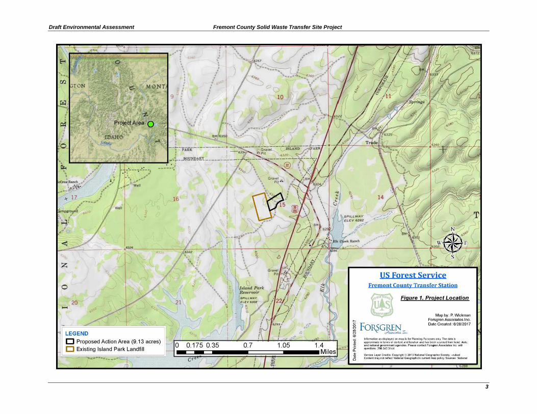
The landfill is located on National Forest System lands administered by the Ashton/Island
Park Ranger District of the Caribou-Targhee National Forest in the W ½, Section 15,
Township 13 North, Range 43 East, Boise Meridian, Fremont County, Idaho. Existing
improvements on the 20-acre site include an office, storage building, transfer station
Page 8
Fremont County Solid Waste Tranfer Site Project Draft Environmental Assessment
2
dock, entrance station building, three gas monitoring wells, three ground water
monitoring wells, one culinary well, and a perimeter fence with an electric fence. The
fences prevent access to the site by bears. The landfill has a gated road that allows access
during hours of operation. This gate is at Yale-Kilgore Road and is locked after hours.
In Fall 2016, the Ashton/Island Park Ranger District received a request for a special use
permit from Fremont County for the new Solid Waste Transfer Site Project (Figures 1
and 2). The project would weigh and collect the waste in Fremont County and transport it
to a disposal site in Jefferson County, Idaho.
Since soil instability precludes building the new project on lands already used at the
landfill site, the county has requested authorization to build the new facility on a 9.1 acre
piece of mostly undeveloped land. The site is partially covered with trees and has a power
line than runs north/south through the site along with an undesignated snowmobile trail.
The new project would include a 60-foot by 60-foot scale/administration building, a 60-
foot by 60-foot recycling center, a 75-foot by 75-foot transfer station, and associated
interior roads. As per forest handbook direction, the new permit would be issued for a
ten-year term.
Depending on timing for funding scenarios and required approvals, the county anticipates
construction to begin in fall of 2017. If funding and approvals take longer than expected,
construction will begin in the summer of 2018. Construction of the recycling center and
scales will take three to four months, while construction of the transfer station will take
five to six months to complete.
Purpose and Need for Action _______________________
The purpose of the proposed Solid Waste Transfer Site Project on National Forest
Service lands is to meet solid waste needs in Island Park. This project will be part of the
County’s solid waste management plan as it transitions from a flat fee (tax based) system
to a tipping fee (weight based) system.
This action is needed to improve solid waste management and provide a recycling center
for the residents in the Island Park portion of Fremont County in anticipation of
populations and tourism growth in the region. In order to make these transitions, a new
scale and recycling building are required. The County is not comfortable building the
new facility on lands already used at the existing landfill site, due to soil stability and
settling concerns created by the buried solid waste.
This action responds to the goals and objectives outlined in the 1997 Revised Forest Plan
Targhee National Forest (RFP), and helps move the project area towards desired
conditions described in that plan. The proposed project area is within an area managed
under prescription 5.1.3(a) (timber management) as described in the RFP.
Page 9
Draft Environmental Assessment Fremont County Solid Waste Transfer Site Project
3
Page 10
Fremont County Solid Waste Tranfer Site Project Draft Environmental Assessment
4
Page 11
Draft Environmental Assessment Fremont County Solid Waste Transfer Site Project
5
Proposed Action _________________________________
The Forest Service proposes to authorize Fremont County to construct the Solid Waste
Transfer Site Project under the terms and conditions of a special use permit. The special
use permit would authorize the construction of a transfer station building, a recycle
building, and a scale building on a 9.1 acre parcel immediately adjacent to the existing
sanitary landfill. The Proposed Action would include clearing and grubbing, placement of
concrete footings and metal buildings, and constructing approximately 1,800 feet of new
interior access roadways on 4.6 acres of the 9.1 acre site. The special use permit would be
issued for a ten-year term. A forest plan amendment is not proposed.
Decision Framework ______________________________
Given the purpose and need, the deciding official reviews the Proposed Action and No
Action Alternatives in order to make the following decisions:
1. Whether the Proposed Action will proceed as proposed, as modified by design
features by an alternative, or not at all.
2. What mitigation measures and monitoring requirements, if any, will be
required.
3. Whether a Forest Plan amendment is needed.
Management Direction Relative to the Analysis Area
This analysis tiers to the 1997 Revised Forest Plan Targhee National Forest Final
Environmental Impact Statement, Appendices and Amendments. The RFP provides
guidance and direction for forest management decisions and allocates uses across forest
landscapes. The RFP was derived from an interdisciplinary process with public and
community involvement. The RFP uses prescription areas to allocate uses and emphasize
resource priorities. Specific Forest-wide plan direction for resources, uses, and
management prescription area direction relative to the Proposed Action are discussed
below. Discussion of the effects of this guidance on specific resource areas and uses is
discussed in Chapter 3.
The project site is included in prescription area 5.1.3(a). The area is designated for timber
management and management of vegetation & fuels to minimize fire risk for an urban
facility within the interface. No clear cutting is allowed. The Proposed Action would
subscribe to requirements of prescription area 5.1.3(a) (pages III-137 to III-138), and
management direction for wildlife forest-wide (pages III-15 to III-23) and in the Island Park
Subsection of the forest (pages III-46 to III-48). The Forestwide and Island Park
subsection standards for lands in the RFP address only utility corridors and do not have
any specific standards that would apply to a special use permit (page III-8).
Page 12
Fremont County Solid Waste Tranfer Site Project Draft Environmental Assessment
6
Public Involvement _______________________________
The proposal was listed in the Schedule of Proposed Actions beginning on October 4,
2016. The proposal was provided to the public and other agencies for comment during
scoping from January 25, 2017 to February 25, 2017. The proposal was also provided to
the Shoshone-Bannock Tribes.
No comments were received from the public, other agencies, or the Shoshone-Bannock
Tribes.
Issues __________________________________________
Information from public and internal scoping was considered to determine if any
concerns were raised relevant to the decision. Potential issues were identified through
discussions with USFWS regarding various wildlife species that might be in the area. The
specific concerns were the wildlife concerns of unintended interaction between humans
and grizzly bears, the Columbia spotted frog, and Migratory Birds. The differences
between the alternatives analyzed in detail, are measured through "issue indicators";
measurable or definable consequences of actions. Issues that were analyzed were:
1. Columbia spotted frog – Potential for direct impacts from project activities.
2. Grizzly bear – Attractants to grizzly bears, potentially creating human-grizzly
bear conflict and resulting in lethal actions against grizzly bears.
3. Migratory birds – Potential for habitat alteration and disruption of breeding
activities.
Page 13
Draft Environmental Assessment Fremont County Solid Waste Transfer Site Project
7
CHAPTER 2 - ALTERNATIVES, INCLUDING THE PROPOSED ACTION
This chapter describes and compares the alternatives considered for the Fremont County
Solid Waste Transfer Site Project. It includes a description and map of each action
alternative considered. This section also presents the alternatives in comparative form,
sharply defining the differences between each alternative and providing a clear basis for
choice among options by the decision maker and the public.
Alternatives _____________________________________
Alternative 1
No Action
Under the No Action alternative, the Forest Service would not issue a special permit to
Fremont County for the Solid Waste Transfer Site Project. Current management plans
would continue to guide management of the project area, and no expansion would be
implemented to accomplish project goals. Fremont County would continue to use the
existing landfill until it is full and then require a long-term solid waste management
solution. This alternative may hinder future operation and development within the Island
Park area when the existing landfill reaches the end of its service life.
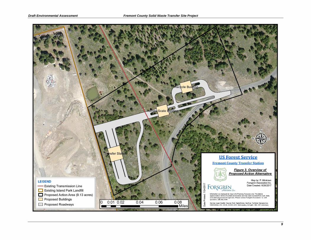
Alternative 2
The Proposed Action
Under the Proposed Action alternative, the Forest Service would issue a special use
authorization to Fremont County to construct the Solid Waste Transfer Site Project. The
special use permit would authorize the use of 9.1 acres of contiguous NFS lands for the
project. The new scales, scale building, recycling center, transfer station building, and
associated interior roads would occupy 4.6 acres of the 9.1 acre site (Figures 3 and 4).
To prevent the unintended interaction between humans and grizzly bears, the buildings
will have walls composed of both concrete and steel. The base of the walls will be
concrete, and four feet tall and eight inches thick along the entire perimeter of each
building. The upper portions of the walls will be built using three steel plates: one on the
interior and exterior, and one between. Windows on the buildings will be no lower than
12 feet high at the lowest section. There will be two types of doors to each building.
Those designed for human entry to the building will be composed of steel with a solid
core. There will also be rollup doors, composed of heavy gauge steel. These will close
with a bolt-locking system that will hold the door down.
The transfer station will not be self-serve. It will be staffed during the same hours as the
existing site. Summer and winter hours may vary, but year-round, the existing landfill is
open five to six days per week and either nine or ten hours per day, depending on the
season. Customers will unload trash or recyclables inside the appropriate building. No
trash or recyclables will be stored outside of buildings.
Page 14
Fremont County Solid Waste Tranfer Site Project Draft Environmental Assessment
8
To facilitate construction, most of the trees within the 4.6 acre area of disturbance would
be removed. Following construction, any disturbed areas would be covered with slash or
wood straw and/or be restored with an appropriate native plant mix.
A forest plan amendment is not proposed. The Proposed Action would continue to
operate as management prescription area 5.1.3(a) (timber management).
Page 15
Draft Environmental Assessment Fremont County Solid Waste Transfer Site Project
9
Page 16
Fremont County Solid Waste Tranfer Site Project Draft Environmental Assessment
10
Page 17
Draft Environmental Assessment Fremont County Solid Waste Transfer Site Project
11
Design Features Associated with the Proposed Action Alternative
The solid waste transfer site project would be designed to comply with Idaho
Department of Environment Quality’s Solid Waste Management Rules (IDAPA
58.01.06) for a Tier II Facility.
The solid waste transfer site would have convenient operating hours to discourage any illegal dumping. The access road gate at Yale-Kilgore Road would be closed and locked when the facility is not open.
If any historical sites are found during construction, work would be immediately
stopped and the Forest Archeologist would be contacted.
All personnel involved with on the ground implementation of the project must
comply with the most current food storage order, to protect grizzly bears. This
order makes attractants unavailable to grizzly bears.
All bear attractants will be stored in closed and locked buildings at the transfer station outside of operating hours. Two transfer stations in grizzly bear country in northwestern Montana that also keep all bear attractants in closed and locked buildings during off-hours have had no grizzly bear conflicts.
In the event of a bear conflict, coordination between IDFG, the Ashton-Island Park/ Ranger District, and Fremont County; will occur to determine if additional measures are necessary to prevent further bear conflicts. These measures may include installation of an electric fence or other structure, or changes in practices, policies, or procedures; to prevent conflicts.
Any machinery used on site for construction or maintenance will be cleaned of
invasive species seed or debris prior to working on site. The site would be
monitored and treated for invasive plant species for the lifetime of the permit.
Best management practices associated with heavy equipment operation (i.e., fuel
storage, fueling procedures, spill prevention/clean-up kits present, and proper
functioning of machinery) would be implemented to prevent contamination of
soils and potential run-off of contaminants offsite.
Vehicle staging, cleaning, maintenance, refueling, and fuel storage will be 150 feet or more from any stream, waterbody, or wetland and in a location where surface runoff from the site is incapable of being delivered to perennial or intermittent channels.
Disturbed areas would be covered with slash (fine wood and coarse wood) or
wood straw whenever feasible to limit erosion and maintain soil productivity.
Areas in need of reseeding post-construction would be re-seeded with an
appropriate native plant mix approved by the Forest Botanist.
Slash would be piled and burned on roads where feasible. Where this is not feasible, slash would either: (1) be piled in such a way (tall and narrow) as to reduce the footprint on the soil and piles would be burned when the soil is cold/frozen and moist, or (2) chipped onsite and transported offsite for use or disposal.
Page 18
Fremont County Solid Waste Tranfer Site Project Draft Environmental Assessment
12
Alternatives Considered but Eliminated from Detailed Study
No other alternatives besides the Proposed Action and No Action Alternatives were
seriously considered during the planning process. One alternative considered during the
planning process, but not included in the EA for detailed study is described briefly below,
along with the rationale for why it was not considered further.
Expanding the existing landfill was considered. This alternative was dropped
from further consideration because the Forest Service would not permit expansion
of the existing landfill as an expansion does not comply with current forest
service direction for landfills.
Comparison of Alternatives ________________________
This section provides a summary of the effects of implementing each alternative.
Information in the table is focused on activities and effects where different levels of
effects or outputs can be distinguished quantitatively or qualitatively among alternatives.
Table 1. Comparison of Effects between Alternatives
Indicator Alternative 1 – No Action Alternative 2 – Proposed
Action
Wildlife – Grizzly bear No Change Not likely to adversely affect
Wilflife – Columbia Spotten Frog No Change
Mayy impact individuals or
habitat, but would not likely
contribute to a trend towards
federal listing, or cause a loss
of viability to the population or
species
Migratory Birds No Change
Negative, however, no bird of
conservation concerns are
expected in the project area
Result in economic impact to
County Yes, greater than Alt 2 Yes
Page 19
Draft Environmental Assessment Fremont County Solid Waste Transfer Site Project
13
CHAPTER 3 - ENVIRONMENTAL CONSEQUENCES
This section summarizes the physical, biological, social and economic environments of
the affected project area and the potential changes to those environments due to
implementation of the alternative. It also presents the scientific and analytical basis for
comparison of alternative presented in the chart above.
In accordance with 40 CFR 1502.21, this EA incorporates by reference the resource
specialist reports in the project record. The specialist reports contain the data, regulatory
framework, assumptions, methodologies, maps, references and documentation that the
interdisciplinary team relies upon to reach the conclusions of the analysis.
The most relevant scientific data that is available is considered and reviewed for this
analysis. The information below and in the project record describes the conditions of
resources and uses that are anticipated to occur under each alternative.
The effects analysis for each alternative consists of the direct and indirect effects of each
alternative. Direct effects are impacts that occur at the same time and place as the initial
action. Indirect effects are impacts that may (1) follow the initial action, (2) be of a
different type, or (3) be in a different place from direct impacts. The direct and indirect
impacts of each alternative can only be completely evaluated within the context of past,
present, and reasonably foreseeable future actions in the area, regardless of what agency
or person undertakes such further action (40 CFR 1508.7) The effects of these other
actions when combined with the effects of the project are referred to as "cumulative
effects." Environmental issues carried forward for analysis in the EA have the potential
for cumulative effects. NEPA implementation guidance requires that federal agencies
identify the temporal and geographic framework used to evaluate potential cumulative
effects of alternatives and the specific past, present and reasonably foreseeable projects
that will be analyzed (40 CFR 1508.25). For purposes of the EA, the general temporal
framework of reference will be from the date of permit issuance through the proposed
permit term of 10 years.
VEGETATION RESOURCES
Existing Conditions
The project area is a forested ecosystem. The overstory within the project area is
primarily lodgepole pine (Pinus contortus), with a few juvenile quaking aspen saplings
(Populus tremuloides). Within the matrix between trees, the main habitat type is
mountain big sagebrush with an Idaho fescue understory. The lodgepole pines within the
project area regenerated following harvest activities in the early 1970s.
During a site visit on December 9, 2016, the site was walked during snowy conditions
and 542 lodgepole pine trees were identified ranging from 4 to 20 inches diameter at
breast height (dbh) with most trees 4 to 8 inches dbh. Of these 542 trees identified,
Page 20
Fremont County Solid Waste Tranfer Site Project Draft Environmental Assessment
14
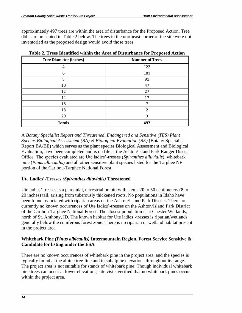
approximately 497 trees are within the area of disturbance for the Proposed Action. Tree
dbhs are presented in Table 2 below. The trees in the northeast corner of the site were not
inventoried as the proposed design would avoid those trees.
Table 2. Trees Identified within the Area of Disturbance for Proposed Action
Tree Diameter (inches) Number of Trees
4 122
6 181
8 91
10 47
12 27
14 17
16 7
18 2
20 3
Totals 497
A Botany Specialist Report and Threatened, Endangered and Sensitive (TES) Plant
Species Biological Assessment (BA) & Biological Evaluation (BE) (Botany Specialist
Report BA/BE) which serves as the plant species Biological Assessment and Biological
Evaluation, have been completed and is on file at the Ashton/Island Park Ranger District
Office. The species evaluated are Ute ladies’-tresses (Spiranthes diluvialis), whitebark
pine (Pinus albicaulis) and all other sensitive plant species listed for the Targhee NF
portion of the Caribou-Targhee National Forest.
Ute Ladies’-Tresses (Spiranthes diluvialis) Threatened
Ute ladies’-tresses is a perennial, terrestrial orchid with stems 20 to 50 centimeters (8 to
20 inches) tall, arising from tuberously thickened roots. No populations in Idaho have
been found associated with riparian areas on the Ashton/Island Park District. There are
currently no known occurrences of Ute ladies’-tresses on the Ashton/Island Park District
of the Caribou-Targhee National Forest. The closest population is at Chester Wetlands,
north of St. Anthony, ID. The known habitat for Ute ladies’-tresses is riparian/wetlands
generally below the coniferous forest zone. There is no riparian or wetland habitat present
in the project area.
Whitebark Pine (Pinus albicaulis) Intermountain Region, Forest Service Sensitive &
Candidate for listing under the ESA
There are no known occurrences of whitebark pine in the project area, and the species is
typically found at the alpine tree-line and in subalpine elevations throughout its range.
The project area is not suitable for stands of whitebark pine. Though individual whitebark
pine trees can occur at lower elevations, site visits verified that no whitebark pines occur
within the project area.
Page 21
Draft Environmental Assessment Fremont County Solid Waste Transfer Site Project
15
The Botany Specialist BA/BE Report is part of the planning record for the National
Environmental Policy Act (NEPA) process that analyzes proposed activities on National
Forest Service System lands in relation to rare plants.
Environmental Effects
Alternative 1 – No Action
Direct and Indirect Effects: By not issuing the special use permit to Fremont County
the proposed project would not occur in the project area. This would result in no impacts
to vegetation within the project area.
Alternative 2 – Proposed Action
Direct and Indirect Effects: The installation of the project would affect vegetation.
Under the Proposed Action, most of the trees and tall brush species in the 4.6 acres of
disturbance of the 9.1-acre project area would be removed, changing a forested setting to
a non-forested developed site. Approximately 497 trees would be removed.
The project will have “no effect” on Ute ladies’-tresses (Spiranthes diluvialis), a
Threatened orchid. A "No Impact" determination for the sensitive species whitebark pine
(Pinus albicaulis), and “No Impact” for all other sensitive species listed for the Targhee
NF planning area.
Disturbance activities often increase the risk of invasion of weedy vegetation species. All
construction equipment will be cleaned of invasive species seeds or debris prior to
working on NFS lands. Areas where soils are disturbed would be covered with slash or
wood straw whenever feasible to limit erosion and maintain soil productivity. Areas
needing reseeding post-construction woulbe be re-seeded with an appropriate native plant
mix approved by the Forest Biologist.
Cumulative Effects: There are no other past, future or current projects planned near the
project area which would cumulatively impact vegetation resources. The site would be
monitored and treated for invasive plant species for lifetime of the permit.
WILDLIFE RESOURCES
Existing Conditions
Three reports have been completed and are on file at the Ashton/Island Park Ranger
District Office: (1) a Biological Assessment (BA) addressing species protected under the
ESA; and (2) a Biological Evaluation (BE) addressing Forest Service special status
species, and (3) a Wildlife Specialist Report.
The purpose of the BA is to analyze the effects of the Proposed Action on threatened and
endangered species in compliance with Section 7 of the Endangered Species Act of 1973
(as amended). Two threatened, one proposed threatened, and one sensitive wildlife
Page 22
Fremont County Solid Waste Tranfer Site Project Draft Environmental Assessment
16
species are described in the BA: Canada lynx (Lynx canadensis; threatened), grizzly bear
(Ursus arctos horribilis; sensitive), yellow-billed cuckoo (Coccyzus americanus;
threatened), and North American wolverine (Gulo gulo; proposed threatened).
The US Fish and Wildlife Service (USFWS) species list (consultation code: 01EIFW00-
2016-SLI-0346) for this analysis was accessed at the IPAC website on January 30, 2016.
The date of streamlining consultation was March 9, 2016. There is no designated critical
habitat in the project area for the listed species.
The BE addresses Forest Service special status species listed for the Targhee National
Forest portion of the Caribou –Targhee National Forest. Twenty Forest Service sensitive
species are addressed in the BE. One species was identified in the BE as occurring in
habitat types like those which are present within the project area, the Columbia Spotted
Frog (Rana luteiventris).
Environmental Effects
Alternative 1 – No Action
Direct and Indirect Effects: By not issuing the special use permit to Fremont County
the proposed project would not occur in the project area. This would result in no impacts
to wildlife species.
Alternative 2 – Proposed Action
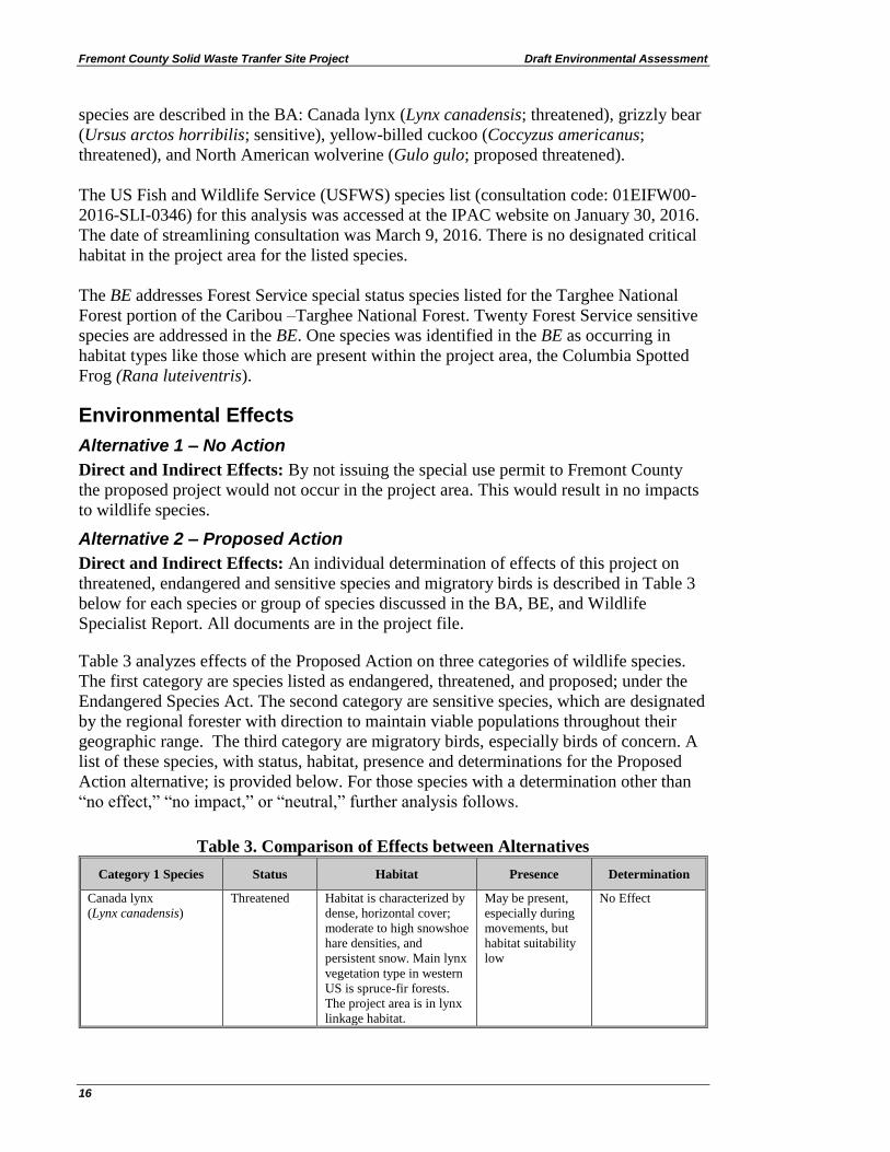
Direct and Indirect Effects: An individual determination of effects of this project on
threatened, endangered and sensitive species and migratory birds is described in Table 3
below for each species or group of species discussed in the BA, BE, and Wildlife
Specialist Report. All documents are in the project file.
Table 3 analyzes effects of the Proposed Action on three categories of wildlife species.
The first category are species listed as endangered, threatened, and proposed; under the
Endangered Species Act. The second category are sensitive species, which are designated
by the regional forester with direction to maintain viable populations throughout their
geographic range. The third category are migratory birds, especially birds of concern. A
list of these species, with status, habitat, presence and determinations for the Proposed
Action alternative; is provided below. For those species with a determination other than
“no effect,” “no impact,” or “neutral,” further analysis follows.
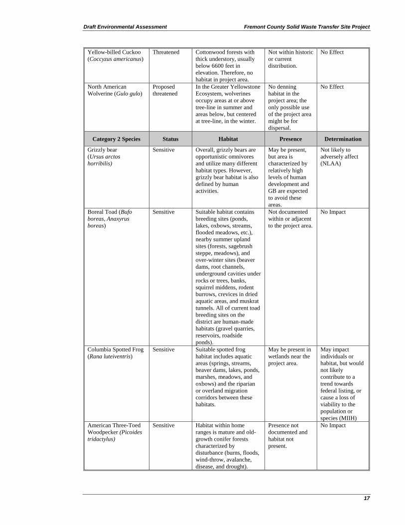
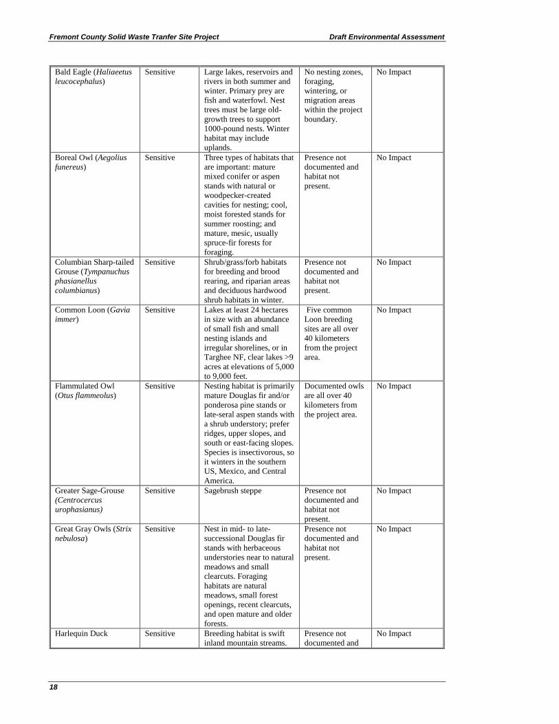
Table 3. Comparison of Effects between Alternatives
Category 1 Species Status Habitat Presence Determination
Canada lynx
(Lynx canadensis)
Threatened Habitat is characterized by
dense, horizontal cover;
moderate to high snowshoe
hare densities, and
persistent snow. Main lynx
vegetation type in western
US is spruce-fir forests.
The project area is in lynx
linkage habitat.
May be present,
especially during
movements, but
habitat suitability
low
No Effect
Page 23
Draft Environmental Assessment Fremont County Solid Waste Transfer Site Project
17
Yellow-billed Cuckoo
(Coccyzus americanus)
Threatened Cottonwood forests with
thick understory, usually
below 6600 feet in
elevation. Therefore, no
habitat in project area.
Not within historic
or current
distribution.
No Effect
North American
Wolverine (Gulo gulo)
Proposed
threatened
In the Greater Yellowstone
Ecosystem, wolverines
occupy areas at or above
tree-line in summer and
areas below, but centered
at tree-line, in the winter.
No denning
habitat in the
project area; the
only possible use
of the project area
might be for
dispersal.
No Effect
Category 2 Species Status Habitat Presence Determination
Grizzly bear
(Ursus arctos
horribilis)
Sensitive Overall, grizzly bears are
opportunistic omnivores
and utilize many different
habitat types. However,
grizzly bear habitat is also
defined by human
activities.
May be present,
but area is
characterized by
relatively high
levels of human
development and
GB are expected
to avoid these
areas.
Not likely to
adversely affect
(NLAA)
Boreal Toad (Bufo
boreas, Anaxyrus
boreas)
Sensitive Suitable habitat contains
breeding sites (ponds,
lakes, oxbows, streams,
flooded meadows, etc.),
nearby summer upland
sites (forests, sagebrush
steppe, meadows), and
over-winter sites (beaver
dams, root channels,
underground cavities under
rocks or trees, banks,
squirrel middens, rodent
burrows, crevices in dried
aquatic areas, and muskrat
tunnels. All of current toad
breeding sites on the
district are human-made
habitats (gravel quarries,
reservoirs, roadside
ponds).
Not documented
within or adjacent
to the project area.
No Impact
Columbia Spotted Frog
(Rana luteiventris)
Sensitive Suitable spotted frog
habitat includes aquatic
areas (springs, streams,
beaver dams, lakes, ponds,
marshes, meadows, and
oxbows) and the riparian
or overland migration
corridors between these
habitats.
May be present in
wetlands near the
project area.
May impact
individuals or
habitat, but would
not likely
contribute to a
trend towards
federal listing, or
cause a loss of
viability to the
population or
species (MIIH)
American Three-Toed
Woodpecker (Picoides
tridactylus)
Sensitive Habitat within home
ranges is mature and old-
growth conifer forests
characterized by
disturbance (burns, floods,
wind-throw, avalanche,
disease, and drought).
Presence not
documented and
habitat not
present.
No Impact
Page 24
Fremont County Solid Waste Tranfer Site Project Draft Environmental Assessment
18
Bald Eagle (Haliaeetus
leucocephalus)
Sensitive Large lakes, reservoirs and
rivers in both summer and
winter. Primary prey are
fish and waterfowl. Nest
trees must be large old-
growth trees to support
1000-pound nests. Winter
habitat may include
uplands.
No nesting zones,
foraging,
wintering, or
migration areas
within the project
boundary.
No Impact
Boreal Owl (Aegolius
funereus)
Sensitive Three types of habitats that
are important: mature
mixed conifer or aspen
stands with natural or
woodpecker-created
cavities for nesting; cool,
moist forested stands for
summer roosting; and
mature, mesic, usually
spruce-fir forests for
foraging.
Presence not
documented and
habitat not
present.
No Impact
Columbian Sharp-tailed
Grouse (Tympanuchus
phasianellus
columbianus)
Sensitive Shrub/grass/forb habitats
for breeding and brood
rearing, and riparian areas
and deciduous hardwood
shrub habitats in winter.
Presence not
documented and
habitat not
present.
No Impact
Common Loon (Gavia
immer)
Sensitive Lakes at least 24 hectares
in size with an abundance
of small fish and small
nesting islands and
irregular shorelines, or in
Targhee NF, clear lakes >9
acres at elevations of 5,000
to 9,000 feet.
Five common
Loon breeding
sites are all over
40 kilometers
from the project
area.
No Impact
Flammulated Owl
(Otus flammeolus)
Sensitive Nesting habitat is primarily
mature Douglas fir and/or
ponderosa pine stands or
late-seral aspen stands with
a shrub understory; prefer
ridges, upper slopes, and
south or east-facing slopes.
Species is insectivorous, so
it winters in the southern
US, Mexico, and Central
America.
Documented owls
are all over 40
kilometers from
the project area.
No Impact
Greater Sage-Grouse
(Centrocercus
urophasianus)
Sensitive Sagebrush steppe Presence not
documented and
habitat not
present.
No Impact
Great Gray Owls (Strix
nebulosa)
Sensitive Nest in mid- to late-
successional Douglas fir
stands with herbaceous
understories near to natural
meadows and small
clearcuts. Foraging
habitats are natural
meadows, small forest
openings, recent clearcuts,
and open mature and older
forests.
Presence not
documented and
habitat not
present.
No Impact
Harlequin Duck Sensitive Breeding habitat is swift
inland mountain streams.
Presence not
documented and
No Impact
Page 25
Draft Environmental Assessment Fremont County Solid Waste Transfer Site Project
19
(Histrionicus
histrionicus)
habitat not
present.
Northern Goshawk
(Accipiter gentilis)
Sensitive Late-seral to old-growth,
primarily Douglas fir and
ponderosa pine for nesting,
but both forested and non-
forested areas for foraging
May be present,
for foraging,
nesting habitat not
present.
No Impact
Peregrine Falcon
(Falco peregrinus)
Sensitive Breeding habitat is steep,
high, large cliffs without
human disturbance for
nesting and adjacent areas
(up to 15 kilometers from
the cliff) of foraging
habitat, primary prey are
birds caught in flight
There is no habitat
within 15
kilometers of the
project area.
No Impact
Trumpeter Swan
(Cygnus buccinator)
Sensitive Nesting habitat includes
marshes, lakes, beaver
ponds, and oxbows and
backwaters of rivers.
There are no
breeding sites
within, adjacent,
or near the project
area.
No Impact
Bighorn sheep
(Ovis canadensis)
Sensitive Summer and winter ranges
are arid or semi-arid, open
or semi-open, and in steep,
rugged, mountainous
terrain. Winter ranges are
windswept or in low-snow
areas, on south, southwest,
and southeast-facing
slopes; and may be at
lower elevations. Summer
ranges may include alpine
meadows or high-elevation
plateaus.
No suitable
habitat.
No Impact
Fisher (Martes
pennanti)
Sensitive Strongly associated with
mature forest (late-
successional coniferous
forest in the Rocky
Mountains) with a high
canopy closure, understory
vegetation, and large-
diameter downed woody
debris; often near riparian
areas.
Presence not
documented and
habitat not
present.
No Impact
Gray wolf
(Canis lupus)
Sensitive Rocky Mountain forested
and non-forested habitat
generalist and primary
prey in the Greater
Yellowstone Ecosystem is
elk
May be present No Impact
Pygmy Rabbit
(Brachylagus
idahoensis)
Sensitive Suitable habitat includes
sagebrush areas with dense
and mature stands of big
sagebrush (which provide
shelter and forage) on deep
loamy soils, which provide
for the development of
residential and natal
burrow systems.
Presence not
documented and
habitat not
present.
No Impact
Spotted bat
(Euderma maculatum)
Sensitive Large, isolated rock walls
and cliff faces within 20
miles of riparian corridors
Presence not
documented and
No Impact
Page 26
Fremont County Solid Waste Tranfer Site Project Draft Environmental Assessment
20
primarily, but also forest
openings, juniper and
sagebrush uplands,
meadows, wetlands, and
fields
habitat not
present.
Townsend's big-eared
bat (Corynorhinus
townsendii)
Sensitive Suitable roosting habitat is
typically caves and mines,
but also hollows of
redwood trees, attics,
abandoned buildings, lava
tubes, and bridges
Presence not
documented and
habitat not
present.
No Impact
Category 3 Species Status Habitat Presence Determination
Migratory birds Bird of
conservation
concern
(BCC) or no
designation
Varies No BCC are
expected in the
project area
because there are
no key migratory
bird habitats in the
project area, such
as late-seral forest,
aspen, riparian
zones, wetlands,
or whitebark pine
stands.
Negative
Grizzly Bear (Ursus arctos)
Affected Environment and Existing Condition
The project area is not within the Primary Conservation Area (PCA) or Grizzly Bear
Recovery Zone (GBRZ). The GBRZ pertains to a listed grizzly bear, while the PCA
pertains to a de-listed grizzly bear. Specifically, the project area is near the junction of
Highway 20 and the eastern terminus of the Yale-Kilgore Road, which is characterized
by high human development.
The most important consideration relative to this project may be the occurrence and
potential for human- grizzly bear conflicts associated with the landfill. The Interagency
Grizzly Bear Study Team (IGBST) knows of three conflicts associated with the existing
landfill, although they believe that there have been other conflicts not reported. The first
known conflict occurred in July 2006 by a sub-adult female. She was able to access the
landfill through a large hole in the fence. The fence was repaired and an electric fence
was installed. One year later, this same female and her two cubs of the year were
removed for repeated nuisance activity, food rewards, and property damage. In
September 2012, an adult female with cubs accessed the landfill several nights in a row
because of a faulty electric fence. A different sub-adult female accessed the landfill for
two nights in September 2012. The electric fence was repaired on September 20, 2012
and no further conflicts were reported (L. Landenburger, IGBST, pers. comm.). Forestry
Technician Mike Alfieri said that the problem was that trees and vegetation were falling
on the electric fence and rendering it useless. The forest gave permission to the county to
clear the vegetation and this solved the faulty electric fence problem.
Page 27
Draft Environmental Assessment Fremont County Solid Waste Transfer Site Project
21
The existing landfill access road is gated at Yale-Kilgore Road and allows access during
hours of operation. This gate is locked after hours and has had incidents of people leaving
garbage at the locked gate. There are no known grizzly bear incidents from garbage left at
the gate. Grizzly bear conflicts with garbage left at the gate may be less likely because
the gate is at a relatively busy paved county road which is less than 1000 feet from
Highway 20 and a small shopping complex with a gas station.
From 1983 to 2002, the annual population growth rate of grizzly bears in the GYE was
four to seven percent. From 2002 to 2011, the annual population growth rate was 0.3 to
2.2 percent. While there were 230 to 312 grizzly bears in the GYE in 1975, there were at
least 714 grizzly bears in the GYE in 2014. In 2013, there were an estimated 58 unique
females with cubs of the year. This is the highest number recorded. Further, the range and
distribution of grizzly bears has tripled since 1975. Forty-one percent of the GYE grizzly
bears are present within the GBRZ and 59 percent are present outside of the GBRZ,
mostly on federal land. The stabilizing population trend, along with evidence of other
density dependent regulation, suggests that the GYE grizzly bear population is
approaching carrying capacity (ICST 2016).
Regulatory Framework
The grizzly bear was designated as a sensitive species under the Endangered Species
Action in the conterminous United States on August 1, 2017. Previously, the bear had
been designated as threatened on July 28, 1975. Since 1975, the U.S. Fish and Wildlife
Service de-listed the Yellowstone Distinct Population Segment of grizzly bears in 2007,
because the population had met recovery plan goals. However, in 2009, the Federal
District Court in Missoula re-listed the Yellowstone grizzly bear by court order because
the decline of whitebark pine stands may be a threat to the grizzly bear in the
Yellowstone Ecosystem.
On the Caribou-Targhee National Forest, Occupancy and Use Order #04-15-117 (food
storage order) applies to the Ashton-Island Park District and portions of the Dubois and
Teton Basin Districts annually from March 1 to December 1. This project is on the
Ashton-Island Park District. Food storage order compliance is mandatory for the
Proposed Action.
The 1997 revised forest plan for the Targhee National Forest contains management
direction for grizzly bears. This direction is based on the best available science on grizzly
bears in the 1990s (see Biological Assessment, Fremont County Solid Waste Transfer Site
Project).
The national forests in the GYE follow the management direction in the 2016
Conservation Strategy for the Grizzly Bear in the Greater Yellowstone Ecosystem. The
strategy provides the adequate regulatory mechanisms to maintain a recovered grizzly
bear population. However, the management direction of the strategy applies only to areas
within the GBRZ.
Direct and Indirect Effects of the Proposed Action
Page 28
Fremont County Solid Waste Tranfer Site Project Draft Environmental Assessment
22
The determination of effects is “may affect, not likely to adversely affect.” The following
are direct and indirect effects to grizzly bears:
There is the potential for construction of the facility to disturb grizzly bears.
However, this disturbance is expected to be minimal for the following
reasons: First, the site is existing with regular and frequent human presence at
the adjacent landfill. Second, the site is in an area already characterized by
high human use including a small residential area, a county road and state
highway nearby, and a shopping complex with gas station, convenience store,
liquor store, auto repair shop, bank, and post office.
Vegetation will be removed in the nine-acre transfer station site. However, this
vegetation removal is not expected to impact grizzly bears for the following
reasons: First, the nine acres is sagebrush-dominated with pole-sized lodgepole
pine. It is not an area of high-quality grizzly bear habitats, such as denning areas,
riparian zones, or areas that contain the four important food resources. Further,
the nine acres is in non-secure habitat, areas within 500 meters of motorized
roads. Grizzly bears are likely to avoid areas of non-secure habitat.
There is the potential for a human-grizzly bear conflict if a grizzly bear received a
food reward from the transfer station. A bear that receives a food reward is likely
to be lethally removed. However, project design features associated with this
project should prevent this occurrence. These design features include keeping all
attractants within the closed building during off-hours, using the current landfill
practices to prevent dumping on the forest, and operations plans stipulations that
any human-grizzly bear conflicts will require changes in policies or structures to
prevent any further conflicts.
Cumulative Effects of the Proposed Action
For the cumulative effects analysis, the analysis area is the area outside of the PCA or
GBRZ on the Ashton-Island Park District of the Caribou-Targhee National Forest. This
area encompasses the project area. This area is approximately 240,000 acres or one-
third of the district.
Currently, there is no charge for municipal dumping or recycling at the landfill; there is
only a fee for large loads of construction waste and dead animals. In the future, the
public will be charged a fee for garbage, but recycling will still be free. This may
cause an increase in dumping of garbage at the transfer station access road gate during
off-hours or an increase in dumping of garbage on adjacent public lands. Garbage
dumping could increase the likelihood of a grizzly bear receiving a food reward,
becoming a nuisance or danger to the public, and requiring lethal removal of that bear.
It is not possible to determine the likelihood of this occurrence, but the greater threat
to grizzly bears may continue to be the presence of food rewards in the subdivisions.
Secure habitat, in areas where human contact is infrequent, is important for grizzly
bear populations (ICST 2007). Secure habitat is largely determined by motorized
roads (ICST 2007). Past road construction decreased habitat quality for grizzly bears,
but the 1999 Motorized Road and Trail Travel Plan for the Targhee National Forest
Page 29
Draft Environmental Assessment Fremont County Solid Waste Transfer Site Project
23
has decreased motorized road density and maintains a stasis into the future. Illegal
motorized activity on unauthorized routes occurs in the analysis area, detracting from
secure habitat for grizzly bears.
Grizzly bear-livestock conflicts may occur with cattle, but are more likely with sheep
(ICST 2007). Seven of the 10 active grazing allotments in the cumulative effects
analysis area are cattle allotments and three are sheep allotments. Since the year 2000,
there have been six total grizzly bear/livestock conflicts in these allotments. All conflicts
occurred in cattle and horse allotments. One conflict occurred in Gerritt Meadows
allotment in 2008, two conflicts occurred in the Antelope Park allotment in 2010, and
three conflicts occurred in 2015, with one in the Davis Lake allotment and two in the
Grandview allotment. None of these conflicts were recurring. Relocation or lethal
removal of grizzly bears is possible when livestock conflicts occur.
Human-grizzly bear conflicts are an important conservation issue, and human recreation,
private developments, and human populations are increasing in the Greater Yellowstone
Ecosystem (Hansen et al. 2002). In Idaho, grizzly bear-human conflicts were relatively
low in 2016 compared to recent years (Nicholson and Hendricks 2016). In 2016 (most
recent available data), increased summer forage and above average whitebark pine cone
production brought fewer bears to human food than in the past (Nicholson and Hendricks
2016).
Columbia Spotted Frog (Rana luteiventris)
Affected Environment and Existing Condition
Forest-wide, decadal surveys for amphibians have occurred in 1992, 2002, and 2012; at
over 90 standard sites. Results from these surveys demonstrate that there is geographic
and temporal variability in amphibian use of sites, but there is no indication that
amphibians species are declining on the forest. Of the 47 standard survey sites on the
Ashton-Island Park District, spotted frogs were detected at 32 of these sites (Clark et al.
2012). Overall, spotted frogs are considered common on the Targhee National Forest. No
decline in spotted frog populations is evident in nearby Yellowstone and Grand Teton
National Parks. However, declines in spotted frog populations have been documented in
southwestern Idaho, Nevada, Oregon, and Utah (Patla and Kenaith, 2005).
There are aquatic areas within one kilometer of the project area. Further, spotted frogs are
common on the district and it is reasonable to expect their presence in aquatic habitats.
Near the project area, there is the Island Park Reservoir to the southwest, a small gravel
quarry pond on the east side of Highway 20 and to the southeast, and a roadside wetland
due east on the east side of Highway 20.
Regulatory Framework
The Columbia spotted frog is a sensitive species on the Targhee National Forest. There
are no standards and guidelines in the 1997 Revised Forest Plan for the Targhee National
Forest for this species.
Page 30
Fremont County Solid Waste Tranfer Site Project Draft Environmental Assessment
24
Direct and Indirect Effects of the Proposed Action
The determination of effects is “may impact individuals or habitat, but will not likely
contribute to a trend towards federal listing or loss of viability to the population or
species.” The following is a direct effect to spotted frogs:
During June and July, and then in late August to mid-October, spotted frogs may
move to summer habitats and over-winter sites, respectively (Bull 2005, Patla and
Kenaith 2005, Pilliod et al. 2002). Movements occur in dry or wet stream
corridors, or overland if the route is more direct (Patla and Kenaith 2005, Pilliod
et al. 2002). Overland routes are possible in the project area, but are not known.
However, movements may occur coincident with project activities such as
clearing vegetation, excavation, and operation of construction equipment. This
could result in direct mortality to Columbia spotted frogs.
Cumulative Effects of the Proposed Action
For the cumulative effects analysis, the analysis area is the Buffalo River Watershed
because the project area is within this watershed. Activities that may impact spotted frogs
include alterations to aquatic habitats, road construction, introduced fish, and beaver
eradication. Beavers create spotted frog habitat (breeding ponds, dams for wintering sites,
and slower streamside areas for summer foraging areas) and a recent study suggested an
increase in spotted frog populations after beaver re-introduction (Patla and Kenaith
2005). However, it is estimated that only 10 percent of the historic North American
beaver population is present today (Naiman et al. 1988).
It is estimated that 95 percent of Western mountain lakes were historically fishless; fish
have been introduced into many lakes and streams. All life phases of spotted frogs (eggs,
tadpoles, and adults) are palatable to salmonids (Patla and Kenaith 2005). Indirect effects
include prevention of movement through riparian corridors and lower habitat quality in
deep lakes used for over-wintering. However, a study of over 2000 Western lakes
suggests that spotted frogs are able to co-exist successfully with fish (Pilliod et al. 2010).
A literature review on road effects on amphibians indicates that amphibians receive
primarily negative effects from roads because of vulnerability to road mortality (Fahrig
and Rytwinski 2009). The 1997 Revised Forest Plan for the Targhee National Forest
reduced road density throughout the forest and this may have provided benefits to frogs.
Aquatic habitat alteration, such as diversions, damming, and recreation; may have
removed or impacted spotted frog habitat. Livestock grazing has occurred in the past, but
currently, is only present on private land within the watershed. However, the duration,
frequency, and intensity of grazing were greater in the past. Grazing has differing effects
on frogs, which include nitrogen pollution, compaction of streambank refugia (negative),
increases in basking sites, and algal tadpole food resources (positive). Research on the
effects of cattle grazing at spotted frog breeding habitats suggests neutral to beneficial
impacts (Bull and Hayes 2000, Adams et al. 2009). Overall, the expected level of effects
for the project would not contribute to overall cumulative effects in a way which is
detrimental to spotted frogs.
Page 31
Draft Environmental Assessment Fremont County Solid Waste Transfer Site Project
25
Migratory Birds
Over 150 migratory bird species breed on the Targhee National Forest (TNF 1997). In
addition, the Ashton-Island Park District is within Bird Conservation Regions (BCR) 9
and 10 and there are 33 Birds of Conservation Concern (BCC) within these 2 regions
(USFWS 2008). Nineteen of the BCC have been documented on the Targhee National
Forest. No BCC are expected to nest within the project area.
Affected Environment and Existing Condition
Habitat in the project area is in a sagebrush dominant landscape with pole-sized
lodgepole pine interspersed. A small pond is very near the project area. No migratory
bird surveys have been conducted in the project area.
Regulatory Framework
The Migratory Bird Treaty Act of 1918 prohibits the killing, taking, or possessing of
native birds, nests, or eggs. One of the nation’s first environmental laws, its purpose was
to prevent the killing of millions of birds annually to supply the fashion hat trade.
Executive Order (EO) 13186, signed by President Clinton in 2001, outlined the
responsibilities of federal agencies to protect migratory birds. The USDA Forest Service
and US Fish and Wildlife Service entered into a Memorandum of Understanding (MOU)
in 2008 regarding migratory birds. This MOU established compliance with the EO. In the
MOU, the Forest Service agreed to consider the effects on migratory birds of agency
actions during the National Environmental Policy Act (NEPA) process. Species of
management concern are the first priority for consideration (e.g. BCC).
Direct and Indirect Effects of the Proposed Action
The following are direct and indirect effects to migratory birds in the project area:
Project activities would most likely occur between May and October . The
migratory bird breeding season is April or May to August 15. Thus, project
activities may occur during the migratory bird breeding season. Project activities
have the potential to disturb or disrupt migratory bird breeding activities. Due to
the presence of an existing road and the adjacent landfill, the project area does not
represent high-quality migratory bird breeding habitat. Further, no migratory birds
of conservation concern are expected to be nesting in the project area. Because of
the lower quality habitat, less disruption and destruction of migratory bird
breeding activities is expected, especially for migratory birds of conservation
concern.
Vegetation will be removed on approximately five acres in the project area.
However, the project area is already lower-quality migratory bird breeding
habitat because of the existing roadway and adjacent landfill. The project area
does not contain any high-quality migratory bird breeding habitats such as
aspen, riparian areas, wetlands, or old-growth forests.
Page 32
Fremont County Solid Waste Tranfer Site Project Draft Environmental Assessment
26
Cumulative Effects
The cumulative effects analysis area is the Ashton-Island Park District (669,726 acres).
Past, present, and future activities that are important for forest birds in the inland Rocky
Mountains are grazing in riparian areas, decline in whitebark pine stands from insects and
disease, presence of snags, increase in urban interface, and climate change (NABCI
2011). There has been an increase in urban interface within the cumulative effects
analysis area and further increase is expected in the future. There are private land
inholdings within the district and the population growth rate of the Greater Yellowstone
Ecosystem was 55 percent between 1970 and 1997, although Fremont County was one of
the slower-growing counties (Hansen et al. 2002). Snags are well-represented in the
analysis area from insect-related tree mortality. Snag presence is between 40 and 70
percent biological potential, which meets or exceeds recommendations for cavity-nesting
species (Bull et al. 1997). Whitebark pine stands are present primarily in the Centennial
Mountains, on Sawtell Peak, and Two Top Mountain Area within the analysis area.
Declines have been consistent with that in other areas in the Greater Yellowstone
Ecosystem. Grazing in riparian areas is present within the analysis area. There is less
grazing pressure currently than in the past. Grazing pressure may decline in the future.
Climate change may be the primary effect on birds in the analysis area. Climate change
may produce asynchrony in the arrival of long-distance migratory bird species and the
peak of food resources, lowering reproductive success and survival. Also, climate change
may alter the hydroperiod, resulting in a decrease in wetland habitats, which are
important habitats for migratory birds. Further, extreme weather events, such as drought,
increase with climate change and can cause bird population declines. Climate change also
requires range shifts, northward or to higher elevations, for bird species, but range shifts
may not be possible because of migration impediments or habitat loss. Further, range
shifts may result in new unfavorable ecological relationships with prey, predators, or
disease (Wormworth and Mallon 2006). Overall, the expected level of effects for the
project would not contribute to overall cumulative effects in a way which is detrimental
to migratory birds.
CULTURAL RESOURCES
Existing Conditions
The area of potential effects (APE) is comprised of an undeveloped parcel of public land
administered by the U.S. Forest Service and is located in the Ashton/Island Park Ranger
District of the Caribou-Targhee National Forest in Fremont County, Idaho. The objective
of the cultural resource inventory was to identify and evaluate cultural properties within
the project’s APE in accordance with 36 CFR 800.
The project area is located 1.5 miles east of the Henry’s Fork River within Island Park.
This area has a rich history dating to 10,000 years ago when nomadic tribes inhabited the
area during the summer months. The first Euro-American explorers arrived after 1800,
followed by fur trappers and later homesteaders. With the establishment of Yellowstone
National Park in 1905, the area became a recreational destination. The Union Pacific
Page 33
Draft Environmental Assessment Fremont County Solid Waste Transfer Site Project
27
Railroad connection between Ashton and Yellowstone increased economic stability and
prosperity until it was abandoned in 1979.
A cultural resource survey of the APE was conducted May 18, 2016. No cultural
properties were identified, however, information from the public indicated the area had
been used to dispose of trash for decades. To determine the presence of a subsurface
cultural deposit, the excavation of the soil stability test pits was monitored on November
14, 2016. No cultural properties were identified. The project will have no effect on any
historic properties. The Idaho State Historic Preservation Office (SHPO) concurred with
this determination on March 14, 2017.
Based on the results of the field monitoring, construction activities within the proposed
area of the Transfer Station will not affect any known NRHP-eligible resources. If any
additional cultural resources are discovered during the course of this project, all work will
cease until the Forest archaeologist can evaluate the resource(s).
Environmental Effects
Alternative 1 – No Action
Direct and Indirect Effects: Under the No Action alternative a special use permit would
not be granted to Fremont County for project. By not constructing the project, the
existing landfill would continue to operate. The adjacent 9.1 acres would not be disturbed
so there would not be opportunity to disturb any subsurface artifacts.
Alternative 2 – Proposed Action
Direct and Indirect Effects: No historic sites were discovered during the archaeological
site survey. If any additional cultural resources are discovered during the course of this
project, all work will cease until a qualified archaeologist or historian can evaluate the
resource(s), and consulting with the Forest Archeologist to determine how to proceed.
Cumulative Effects: There are no other past, future or current projects planned near the
project area which would cumulatively impact historic sites.
RECREATIONAL ACCESS
Existing Conditions
The area associated with the proposed project is prohibited for cross country travel for all
vehicles.
The project area is within IDFG Game Management Unit (GMU) 60 which provides
opportunity for open and controlled hunts for big game species (deer, elk, pronghorn,
bear, lion, wolf, and moose) as well as multiple upland bird species, small game, and
waterfowl. However, due to the close proximity to the landfill properties the area is
anticipated to receive very little use by hunters.
Page 34
Fremont County Solid Waste Tranfer Site Project Draft Environmental Assessment
28
Environmental Effects
Alternative 1 – No Action
Direct and Indirect Effects: Under the No Action alternative recreation use of the
project area would continue. Use by ATVs and snowmobiles in the 9.1 acres would
continue to be prohibited.
Alternative 2 – Proposed Action
Direct and Indirect Effects: Under the Proposed Action, recreation use around the
project area would continue. Use by ATVs and snowmobiles in the 9.1 acres would
continue to be prohibited.
Cumulative Effects: There are no other past, future or current projects planned near the
project area which would cumulatively impact recreational access or activities.
ECONOMIC IMPACTS
Existing Conditions
The Island Park Landfill is expected to be at capacity in approximately 10 to 15 years. By
that time, Fremont County needs to expand its facility or send its waste somewhere else
for disposal. Neighboring Jefferson County operates two landfills, the Circular Butte
Landfill and the County Line Road Landfill. Circular Butte Landfill is located off
Highway 28 near the City of Mud Lake, approximately 140 miles southwest of the Island
Park Landfill, It is a large regional landfill that currently receives waste from Fremont
County’s St. Anthony Transfer Station Facility, and Madison, Clark, and Teton Counties.
It has capacity to accept solid waste from Island Park.
Waste disposal costs for county residents was a flat fee (tax based) system, and is in the
process of transitioning to a tipping fee (weight based) system. This project will be part
of the County’s solid waste management plan. Disposal rates Disposal rates were initially
increased to raise capital funds, and pay for waste transport costs
Environmental Effects
Alternative 1 – No Action
Direct and Indirect Effects: Under the No Action alternative a special use permit would
not be granted to Fremont County for the new transfer station project. By not building the
transfer station, the existing landfill would continue to operate until it reaches capacity,
and residents would need to transport their waste to a different transfer station in St.
Anthony, Idaho that is 38 miles south of Island Park, Idaho. This in turn would impact
the economic growth of the community by requiring residents to drive up to 76 extra
miles to dispose of their waste once the landfill reaches capacity.
Page 35
Draft Environmental Assessment Fremont County Solid Waste Transfer Site Project
29
Alternative 2 – Proposed Action
Direct and Indirect Effects: While disposal rates were raised for capital funds to build
the Proposed Action, it is unknown if they will need to be raised again. Implementation
of the Proposed Action along with the new weight based fee system may result in an
increase or decrease in individual user fees. These changes in user fees may occur over
time however an exact percentage of increase is not known. Recycling fees would be set
by the County. The ability of the new facility to accommodate continued growth in the
Island Park Area would increase the tax base of the County.
Cumulative Effects: Continued development of the new residential and commercial
properties within the Island Park Area which are served by the Island Park Landfill would
have a cumulative economic impact on the area. Without the new transfer station
development of these properties would mostly not be restricted, but would carry the extra
costs of individuals transporting their waste an extra 76 miles or contracting with a
private solid waste hauler. However, the development of these properties would aid in
reducing the cost associated with increased taxes by spreading the total cost over more
users.
WATER QUALITY AND HYDROLOGY
Existing Condition
Ground water levels in the project area vary by season, being shallower in spring and
early summer associated with snow melt and deeper in late summer and fall. During
spring and early summer ground water levels may rise as high as 12 inches above to 24
inches below ground surface, but is most often approximately 20-40 feet below ground
surface. Most domestic wells within a one-mile radius of the existing landfill are bored to
a depth of 34 to 183 feet.
There are no surface water bodies present within the proposed project area. The closest
open surface water is Island Park Reservoir 0.5 miles southwest of the project area. The
closest flowing surface water is the Henry’s Fork of the Snake River, located
approximately 1.6 miles northwest of the project area. Henry’s Fork of the Snake River is
the main collector for the Upper Henry’s Fork Subbasin which encompasses 706,550
acres, and is identified as hydrologic unit code (HUC) 17040202.
IDEQ is currently the governing agency which has issued a permit to Fremont County for
the operation of the existing landfill. Existing Municipal Solid Waste Landfills
(MSWLFs) in Idaho must be certified in compliance with all MSWLF regulations. New
MSWLFs or existing MSWLFs wishing to expand their operations must apply to DEQ
for site certification. Monitoring and sampling practices aid the County in remaining in
compliance with state and federal water quality standards. If at any time levels of
chemical properties within a water sample are found to be outside of the allowable range
the facility manager takes immediate corrective actions to bring levels within acceptable
standards.
Page 36
Fremont County Solid Waste Tranfer Site Project Draft Environmental Assessment
30
Hydrologic Disturbance: A guideline of the RFP is that “Not more than 30% of any of
the principal watersheds and their subwatersheds should be in a hydrologically disturbed
condition at any one time” (RFP Guideline, pg. III-10). Table 4 provides estimates of the
current hydrologic disturbance (HD) in principal watershed and subwatershed. The
watersheds are currently well below the 30% guideline.
Table 4. Estimate of the current hydrologic disturbance (HD) in TPW-010 and the subwatersheds
Targhee Principal Watershed
(TPW) Area (acres) Current HD (%)
TPW 010 - Buffalo River 43,901 10%
Subwatershed HUC Area On NFS Lands (acres) Current HD (%)
170402020401 - Buffalo River 23,899 10%
Environmental Effects
Alternative 1 – No Action
Direct and Indirect Effects: The facility would continue to operate at its current level
under the No Action alternative. Implementation of this alternative is not anticipated to
impact ground water or surface water quality in association with the operation of the
facility, due to the regulation imposed by IDEQ associated with the operation permit.
Alternative 2 – Proposed Action
Direct and Indirect Effects: The installation of the project would require some soil
disturbance in association with the installation of the new buildings and roadways. Best
management practices associated with heavy equipment operation (i.e., fuel storage,
fueling procedures, spill prevention/clean-up kits present, and proper functioning of
machinery) would be implemented to prevent spills which have the potential to impact
water quality.
Under Idaho's Solid Waste Management Rules (IDAPA 58.01.06), transfer stations are
classified as Tier II facilities and must comply with basic Tier II regulations and
deadlines and meet certain specific additional design, operating, and closure
requirements.
There is no open or flowing water present within the proposed project area. The distance
of surface water (Henry’s Fork and Island Park Reservoir) from the proposed project area
limits the risk of potentially impacting these water bodies with increased sediment or
other contaminants associated with the project area. Implementation of BMPs during
construction of the facility also reduces the risk of sediment and contaminants from
entering surface water.
Page 37
Draft Environmental Assessment Fremont County Solid Waste Transfer Site Project
31
Ground water contamination could occur with the Proposal Action alternative. These
risks are associated with ground disturbance activities which would occur during the
clearing of trees associated with construction of the transfer station project. Construction
would not occur at the times when ground water levels are high (during spring melt and
run off). In addition to design features, BMPs associated with heavy equipment operation
(i.e., fuel storage, fueling procedures, spill prevention/clean-up kits present, and proper
functioning of machinery) would be implemented to prevent spills which have the
potential to impact water quality.
Hydrologic Disturbance: The Proposed Action would generate approximately 5 acres of
hydrologic disturbance. This is approximately 0.01% at the Principal Watershed scale
(TPW 010) and 0.02% at the subwatershed scale (170402020401 – Buffalo River).
Cumulative Effects:
No other projects are planned in the immediate project area which would cumulatively
impact water quality or the hydrology of the area. However, the Forest is currently
preparing an Environmental Impact Statement for the Buffalo River Timber Stand
Improvement project, which is located in the headwaters of TPW 010. That project is
consider in the cumulative hydrologic disturbance analysis below.
Hydrologic Disturbance: The timing and/or duration of streamflows is not expected to be
a concern because very little disturbance is occurring at the watershed scale. Table 5 lists
the cumulative hydrologic disturbance information for the analysis areas. The watersheds
would remain well below the 30% guideline
Table 5: Cumulative hydrologic disturbance
Targhee Principal
Watershed Current HD (%) Project Generated HD (%) Cumulative HD (%)
TPW 010 - Buffalo River 10% 0.01% 11%
Subwatershed Current HD (%) Project Generated HD (%) Cumulative HD (%)
170402020401 - Buffalo
River 10% 0.02% 10%
SOILS
Regulatory Framework
Management actions occurring on the National Forest lands, involving the soil resource
are guided by the following: FSM 2500-2010-1 (National Soil Management Manual),
FSM-2500-2011-1 (R4 Supplement) and the Targhee National Forest Plan – 1997.
Activities as described for the construction of a solid waste transfer site are not governed
by FSM 2500-2010-1 or FSM-2500-2011-1.
These activities are considered to occur on administrative sites not primarily managed for
soil productivity and function and are therefore excluded from soil analysis (FSM 2500-
2011-1/2550.5).
Page 38
Fremont County Solid Waste Tranfer Site Project Draft Environmental Assessment
32
The Revised Targhee Forest Plan, 1997 (RFP) does have applicable guidance, which
specifies sustaining long term soil productivity by retaining fine organic matter and
woody residue on activity areas (Goal). This Goal will be complied with by
implementing the prescribed soil related Design Features above limiting erosion.
Existing Conditions
The general soil map unit in the project area is the ARTRV/ARART Trude unit of the
Trude Soil Series (USDA NRCS 2016). Soils are characterized by sandy loam textures in
the upper 20 inches and sandy textures from 20 to 60 inches with 15 to 35 percent gravel
sized fragments throughout. This unit is listed at having a 0 to 4 percent slope with depth
to the water table and restrictive features being more than 80 inches deep. The soil unit is
generally well drained mixed alluvium and has formed in outwash plains.
Environmental Effects
Alternative 1 – No Action
Direct and Indirect Effects: Under the No Action alternative the soils in the project area
would not be affected.
Alternative 2 – Proposed Action
Direct and Indirect Effects: The installation of the proposed project would require some
soil disturbance. 50% of the soils in the project area are anticipated to be disturbed (4.6
acres of the 9.1 acre project area). Clearing the site of vegetation with heavy equipment
would also result in some soil compaction on the site. Best management practices
associated with heavy equipment operation (i.e., fuel storage, fueling procedures, spill
prevention/clean-up kits present, and proper functioning of machinery) would be
implemented to prevent contamination of soils and potential run-off of contaminants
offsite. Erosion control mitigation has been prescribed to maintain site productivity
wherever possible.
Cumulative Effects: There are no other past, future or current projects planned near the
project area which would cumulatively impact soil productivity, or create conditions
susceptible to erosion. The current facility has previously impacted 20 acres of soils. The
expansion proposed in this project would impact an additional 4.6 acres of soils in the 9.1
acre project area.
Page 39
Draft Environmental Assessment Fremont County Solid Waste Transfer Site Project
33
CHAPTER 4 - CONSULTATION AND COORDINATION
The Forest Service consulted the following individuals, Federal, State, and local
agencies, tribes and non-Forest Service persons during the development of this
environmental assessment:
ID TEAM MEMBERS:
Sabrina Derusseau, Zone Wildlife Biologist
Sharon Plager, Forest Archeologist
Brad Higginson, Hydrology
David Marr, Soils
Jessica Taylor, NEPA Specialist
Rose Lehman, Botanist
FEDERAL, STATE, AND LOCAL AGENCIES:
Fremont County
U.S. Fish and Wildlife Service
TRIBES:
Shoshone-Bannock Tribes