ENVIRONMENTAL EVALUATION OF A 845.1 ACRE AREA PROPOSED FOR INCLUSION IN THE MIAMI-DADE COUNTY URBAN DELVELOPMENT BOUNDARY SECTIONS 30 & 31, TOWNSHIP 54 SOUTH, RANGE 39 EAST MIAMI-DADE, FLORIDA Submitted to: Limonar Development and Wonderly Holdings c/o Mr. Francisco Pines Attorney at Law 3301 Ponce de Leon Boulevard Suite 220 Coral Gables, Florida 33134 Submitted by: Carney Environmental Consulting Services, Inc. 6435 SW 85 Street Miami, Florida 33143 May 6, 2015
Transcript
ENVIRONMENTAL EVALUATIONOF A 845.1 ACRE AREA
PROPOSED FOR INCLUSIONIN THE MIAMI-DADE COUNTY
URBAN DELVELOPMENT BOUNDARYSECTIONS 30 & 31, TOWNSHIP 54 SOUTH, RANGE 39 EAST
MIAMI-DADE, FLORIDA
Submitted to:
Limonar Development and Wonderly Holdingsc/o Mr. Francisco Pines
Attorney at Law3301 Ponce de Leon Boulevard
Suite 220Coral Gables, Florida 33134
Submitted by:
Carney Environmental Consulting Services, Inc.6435 SW 85 Street
Miami, Florida 33143
May 6, 2015
Limonar Development and Wonderly HoldingsEnvironmental Evaluation of an 845.1 Acre AreaMay 6, 2015Page 2 of 7
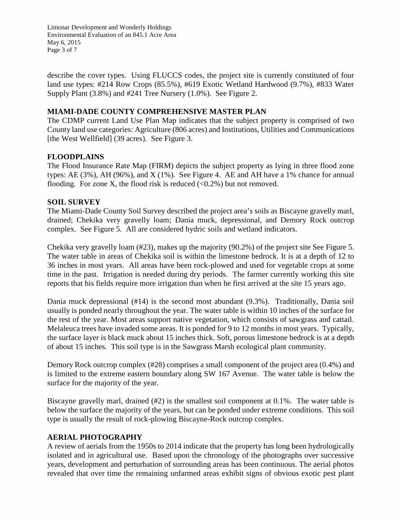
INTRODUCTION:Carney Environmental Consulting Services Inc. (Carney) was contracted by LimonarDevelopment and Wonderly Holdings (Client) to evaluate the environmental resources that maybe associated with an area of unincorporated Miami-Dade County being proposed for inclusion inthe Urban Development Boundary (UDB). The area of interest (AOI) lies within Sections 30 and31, Township 54 South, Range 39 East and is depicted in Figure 1.
To comprehensively address the environmental features and condition of the AOI, Carney: a)reviewed a series of historic aerial photographs of the property (and its surroundings) to establisha history of the site over time; b) performed a site visit to make the field observations necessary toevaluate any ecological/wetland value and function of the parcel as it existed at the time of the sitevisit; c) reviewed previous wetland functional evaluations applied to recent permitting within theproject area; d) reviewed and evaluated USGS groundwater elevation data applicable to the areaof concern; e) applied topographic data provided by Miami-Dade County to understand the area’selevation and slope; f) reviewed, evaluated and utilized a variety of agency GIS shapefiles thatfurther describe some of the salient environmental features of the area.
SITE DESCRIPTIONThe subject property is approximately 845.1 acres and situated in Sections 30 and 31, Township54 South, Range 39 East, Miami-Dade County, Florida (approximately 25°41'42.57" NorthLatitude and 80°28'15.13"West Longitude). The majority of the AOI has been in continuousagricultural use since the middle 1970s. The County’s West Wellfield (WWF) (which is withinthe AOI) was added and brought into operation in early 2000.
When viewing the historic aerials of the site, it is clear that the land surrounding this area has beenundergoing change over the past several decades. The AOI has experienced a slow hydrologicdecline due to its compartmentalization by the construction of Tamiami Trail and Bird Drive Canalto the north, dense residential development to the east, Krome Avenue and L31N to the west, andKendall Drive (and its more recent development) to the south. The addition of the WWFoperations in 2000 has likely furthered this degradation to some degree. It is clearly evident in thehistoric aerials that a slow but continued expansion of woody plant species is occurring – beingpredominated by exotic pest plant species. While it is acknowledged that many of these woodyplants occur in wetlands, their increased presence and densities are indicative of reduced hydrologyand hydroperiod. This is discussed in further detail below.
FIELD INVESTIGATION AND FILE RESEARCHCarney has visited the AOI on a number of occasions providing assistance to the Client for earlierproject or permitting efforts. Most recently, a cursory biological field investigation was conductedon April 24, 2015 to ascertain the presence of possible remaining wetland resources and to makea determination of their current condition. This information was reviewed in concert with fileinformation obtained from Miami-Dade County, the South Florida Water Management District, orother agencies and is discussed below.
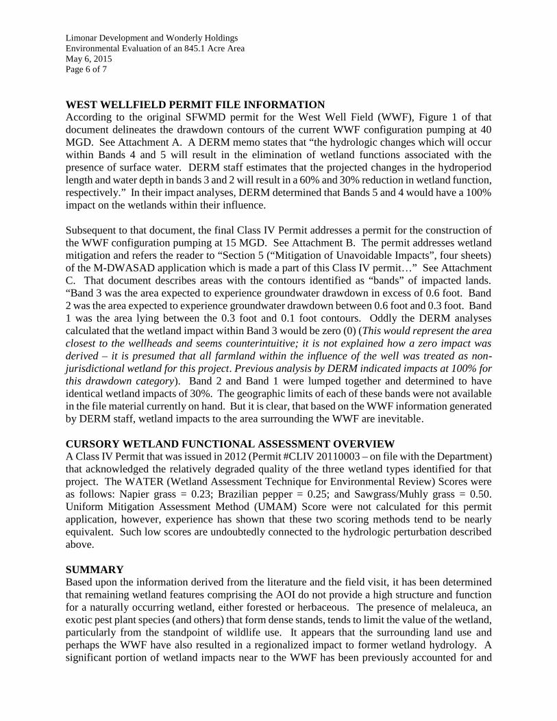
COVER TYPEThe Florida Land Use, Cover, and Forms Classification System (FLUCCS) is typically used to
Limonar Development and Wonderly HoldingsEnvironmental Evaluation of an 845.1 Acre AreaMay 6, 2015Page 3 of 7
describe the cover types. Using FLUCCS codes, the project site is currently constituted of fourland use types: #214 Row Crops (85.5%), #619 Exotic Wetland Hardwood (9.7%), #833 WaterSupply Plant (3.8%) and #241 Tree Nursery (1.0%). See Figure 2.
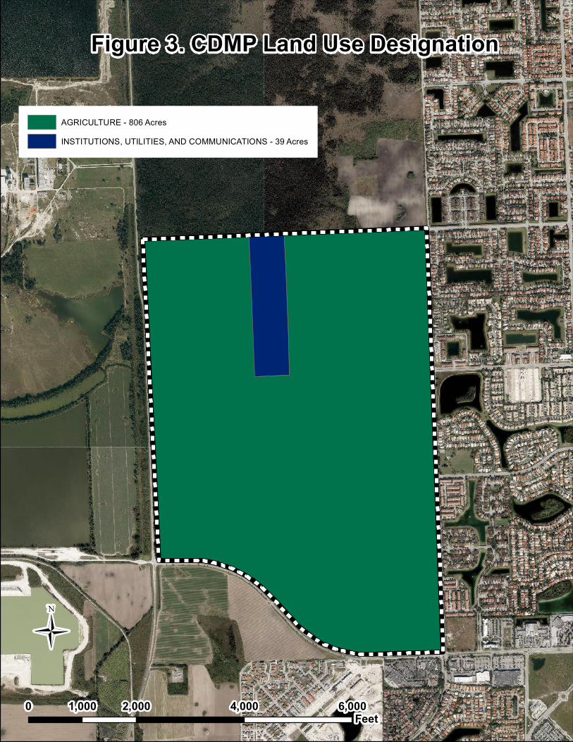
MIAMI-DADE COUNTY COMPREHENSIVE MASTER PLANThe CDMP current Land Use Plan Map indicates that the subject property is comprised of twoCounty land use categories: Agriculture (806 acres) and Institutions, Utilities and Communications[the West Wellfield] (39 acres). See Figure 3.
FLOODPLAINSThe Flood Insurance Rate Map (FIRM) depicts the subject property as lying in three flood zonetypes: AE (3%), AH (96%), and X (1%). See Figure 4. AE and AH have a 1% chance for annualflooding. For zone X, the flood risk is reduced (<0.2%) but not removed.
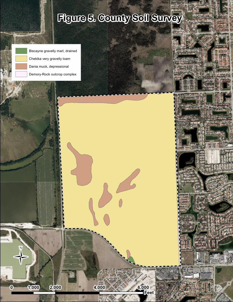
SOIL SURVEYThe Miami-Dade County Soil Survey described the project area’s soils as Biscayne gravelly marl,drained; Chekika very gravelly loam; Dania muck, depressional, and Demory Rock outcropcomplex. See Figure 5. All are considered hydric soils and wetland indicators.
Chekika very gravelly loam (#23), makes up the majority (90.2%) of the project site See Figure 5.The water table in areas of Chekika soil is within the limestone bedrock. It is at a depth of 12 to36 inches in most years. All areas have been rock-plowed and used for vegetable crops at sometime in the past. Irrigation is needed during dry periods. The farmer currently working this sitereports that his fields require more irrigation than when he first arrived at the site 15 years ago.
Dania muck depressional (#14) is the second most abundant (9.3%). Traditionally, Dania soilusually is ponded nearly throughout the year. The water table is within 10 inches of the surface forthe rest of the year. Most areas support native vegetation, which consists of sawgrass and cattail.Melaleuca trees have invaded some areas. It is ponded for 9 to 12 months in most years. Typically,the surface layer is black muck about 15 inches thick. Soft, porous limestone bedrock is at a depthof about 15 inches. This soil type is in the Sawgrass Marsh ecological plant community.
Demory Rock outcrop complex (#28) comprises a small component of the project area (0.4%) andis limited to the extreme eastern boundary along SW 167 Avenue. The water table is below thesurface for the majority of the year.
Biscayne gravelly marl, drained (#2) is the smallest soil component at 0.1%. The water table isbelow the surface the majority of the years, but can be ponded under extreme conditions. This soiltype is usually the result of rock-plowing Biscayne-Rock outcrop complex.
AERIAL PHOTOGRAPHYA review of aerials from the 1950s to 2014 indicate that the property has long been hydrologicallyisolated and in agricultural use. Based upon the chronology of the photographs over successiveyears, development and perturbation of surrounding areas has been continuous. The aerial photosrevealed that over time the remaining unfarmed areas exhibit signs of obvious exotic pest plant
Limonar Development and Wonderly HoldingsEnvironmental Evaluation of an 845.1 Acre AreaMay 6, 2015Page 4 of 7
species encroachment to a point where today its overstory is predominated by melaleuca(Melaleuca quinquenervia), Australian pine (Casuarina spp.), Brazilian pepper (Schinusterebinthifolius), and Napier grass (Pennisetum purpureum).
WETLAND AND OTHER VEGETATION OBSERVEDHydrophytic (and other) vegetation was observed on the property; however, the exotic pestvegetation described above provided the preponderance of the overstory at each of the non-farmedlocations visited. Some wetland ground cover and small trees and shrubs were observed but weresparsely distributed within some of these remnant features. The most common were: bishopwood(Bischofia javanica), castor bean (Ricinus communis), primrose willow (Ludwigia octovalvis),papaya (Carica papaya), sewer vine (Paederia cruddasiana), Virginia creeper (Parthenocissusquinquefolia), saltbush (Baccharis halimifolia), sawgrass (Cladium jamaicense), leather fern(Acrostichum danaeifolium), marsh fern (Thelypteris kunthii), myrsine (Myrsine cubana), swampbay (Persea palustris), and Florida trema (Trema micranthum). Many of the swamp bay wereexhibiting the effects of laurel wilt disease.
At the time of the site visit, the farmed areas were: i) being disked in preparation for the fallowingperiod, ii) still had remnant crops (e.g., tomatoes, squash, beans), or iii) were already fallow withplants such as pigweed (Amaranthus sp.), ragweed (Ambrosia artemisiifolia), Spanish needles(Bidens alba), and other weedy types.
The area within the West Wellfield fence harbors the well infrastructure and is lightly landscapedwith a maintained lawn.
LISTED PROTECTED SPECIES, OTHER WILDLIFE/ENVIRONMENTAL FEATURESNo Federally listed animal or plant species were noted during multiple site visits. Due to the site’slocation and the poor wading habitat offered, it is unlikely that Sate Listed wading bird speciesforage during the wet season. However, some of these birds are opportunistic and could followthe path of tractors plowing the field as fields are prepared each planting season. One State listedplant, Phyla stoechadifolia, was observed within some of the Exotic Wetland Hardwood features.
No Federal Critical Habitats were identified that fall within (or even near to) the AOI. However,the area lies within the consultation area for the Snail Kite (Rostrhamus sociabilis), theconsultation and focus area for the Florida Bonneted Bat (Eumops floridanus), and threedesignated Core Foraging Areas for the Wood Stork (Mycteria americana).
COMPREHENSIVE EVERGLADES RESTORATION PLAN (CERP)Figure 6 depicts CERP projects that lie contiguous with the proposed project. These are theEverglades National Park Seepage Management (specifically the Bird Drive Basin Rechargecomponent) to the north and the West Miami-Dade Reuse at the northern terminus of the WestWellfield. It is understood from the South Florida Water Management District that the design andoperation were determined to be “not feasible” and that these projects have been declared “notimplementable.”
Limonar Development and Wonderly HoldingsEnvironmental Evaluation of an 845.1 Acre AreaMay 6, 2015Page 5 of 7
OTHER SPECIAL AREA DESIGNATIONSNo Natural Forest Communities, Outstanding Florida Waters, Florida Aquatic Preserves, Wild andScenic Rivers or Florida Class I or II Waters occur within the AOI.
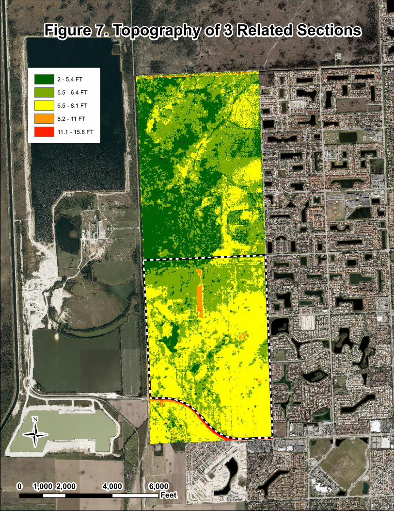
TOPOGRAPHYLIDAR (Laser Imaging, Detection and Ranging) topographic data was obtained from the Countyto understand the topography of the AOI and the surrounding basin. Figure 7 depicts thetopography of the 3 land sections that extend from Kendall Drive north to the Bird Drive Canal.One can see that the farming has occurred in the areas of higher elevation and that the land slopesdownward slightly as one progresses northward. This makes sense as historically the land at thislocation transitions from the former rockland marl marsh (and shorter period wetlands) to the ridgeand slough system of Shark Valley Slough (a longer period wetland). As can be seen in this figure,the AOI resides almost entirely in relatively higher drier areas of this basin.
Figure 8 depicts the topography of the AOI alone minus the area of the West Wellfield (and its fillpad). With few exceptions the slope goes from a high near Kendall Drive to a low near thenorthwest. The average elevation for this data set was determined to be 6.5 feet NGVD. Whencompared to soil survey graphic provided above (Figure 5), you will note that the largerdepressional areas correspond closely to the soil type shown as Dania muck depressional.
HYDROLOGIC INDICATORSIndicators of hydrology were limited at the time of multiple site visits. While the soils were muckyat the land surface in scattered spot locations, it is not apparent if the AOI becomes inundated fora sufficient period to allow the establishment of aquatic prey base at any location within itsboundaries. Water levels were reported by a farmer using the area to be the lowest he hasexperienced in 15 years; he stated that the water was 2 ½ to 3 feet below the land surface duringthe April 24, 2015 site visit. Changes in water levels are discussed in more detail below.
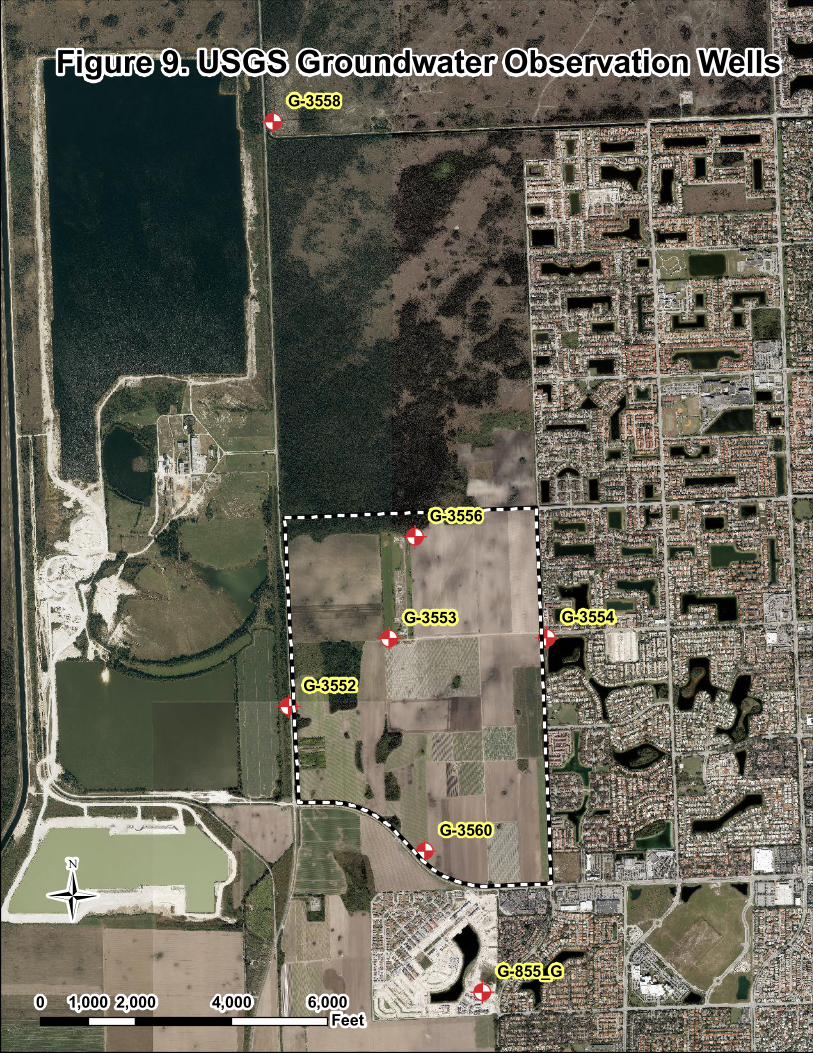
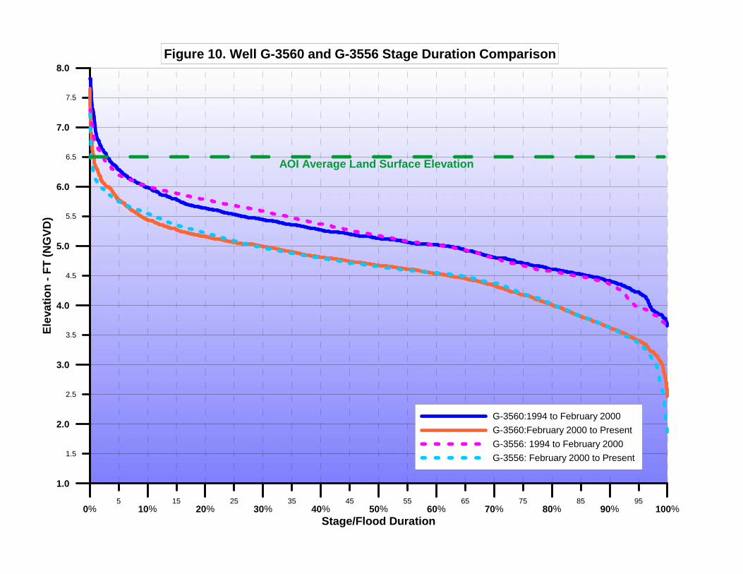
GROUNDWATERTo further understand the vegetation changes within the immediate basin and the AOI, Carneyperformed a cursory analysis on history groundwater data for the area. Data from a total of sevenUSGS wells were examined and comparisons made. See Figure 9 for the well locations. Withfew exceptions, the majority of these wells were installed in 1994 to establish the pre-existinggroundwater conditions prior to the establishment of the West Wellfield. Data from 1994 toFebruary 2000 (the approximate start date of the WWF) were compared at each of these wells.Based on these, it was determined that the groundwater level has dropped 0.52 feet on averagefrom the 1994 levels. Figure 10 compares the stage duration curve of two such wells (G3556 andG3560) which are approximately 1.25 miles apart; both show the half a foot drop discussed. Itdoes not seem probable that the WWF alone at its permitted 15 MGD could have caused this loss,but at each of the seven specified locations, the difference ranged from -0.48 to -0.56 feet and willhave an effect on the remaining wetland quality. When these water levels are compared to thoseof the existing land surface (Figure 10), some elevations may prove to be too high to supportfunctioning wetlands.
Limonar Development and Wonderly HoldingsEnvironmental Evaluation of an 845.1 Acre AreaMay 6, 2015Page 6 of 7
WEST WELLFIELD PERMIT FILE INFORMATIONAccording to the original SFWMD permit for the West Well Field (WWF), Figure 1 of thatdocument delineates the drawdown contours of the current WWF configuration pumping at 40MGD. See Attachment A. A DERM memo states that “the hydrologic changes which will occurwithin Bands 4 and 5 will result in the elimination of wetland functions associated with thepresence of surface water. DERM staff estimates that the projected changes in the hydroperiodlength and water depth in bands 3 and 2 will result in a 60% and 30% reduction in wetland function,respectively.” In their impact analyses, DERM determined that Bands 5 and 4 would have a 100%impact on the wetlands within their influence.
Subsequent to that document, the final Class IV Permit addresses a permit for the construction ofthe WWF configuration pumping at 15 MGD. See Attachment B. The permit addresses wetlandmitigation and refers the reader to “Section 5 (“Mitigation of Unavoidable Impacts”, four sheets)of the M-DWASAD application which is made a part of this Class IV permit…” See AttachmentC. That document describes areas with the contours identified as “bands” of impacted lands.“Band 3 was the area expected to experience groundwater drawdown in excess of 0.6 foot. Band2 was the area expected to experience groundwater drawdown between 0.6 foot and 0.3 foot. Band1 was the area lying between the 0.3 foot and 0.1 foot contours. Oddly the DERM analysescalculated that the wetland impact within Band 3 would be zero (0) (This would represent the areaclosest to the wellheads and seems counterintuitive; it is not explained how a zero impact wasderived – it is presumed that all farmland within the influence of the well was treated as non-jurisdictional wetland for this project. Previous analysis by DERM indicated impacts at 100% forthis drawdown category). Band 2 and Band 1 were lumped together and determined to haveidentical wetland impacts of 30%. The geographic limits of each of these bands were not availablein the file material currently on hand. But it is clear, that based on the WWF information generatedby DERM staff, wetland impacts to the area surrounding the WWF are inevitable.
CURSORY WETLAND FUNCTIONAL ASSESSMENT OVERVIEWA Class IV Permit that was issued in 2012 (Permit #CLIV 20110003 – on file with the Department)that acknowledged the relatively degraded quality of the three wetland types identified for thatproject. The WATER (Wetland Assessment Technique for Environmental Review) Scores wereas follows: Napier grass = 0.23; Brazilian pepper = 0.25; and Sawgrass/Muhly grass = 0.50.Uniform Mitigation Assessment Method (UMAM) Score were not calculated for this permitapplication, however, experience has shown that these two scoring methods tend to be nearlyequivalent. Such low scores are undoubtedly connected to the hydrologic perturbation describedabove.
SUMMARYBased upon the information derived from the literature and the field visit, it has been determinedthat remaining wetland features comprising the AOI do not provide a high structure and functionfor a naturally occurring wetland, either forested or herbaceous. The presence of melaleuca, anexotic pest plant species (and others) that form dense stands, tends to limit the value of the wetland,particularly from the standpoint of wildlife use. It appears that the surrounding land use andperhaps the WWF have also resulted in a regionalized impact to former wetland hydrology. Asignificant portion of wetland impacts near to the WWF has been previously accounted for and
Limonar Development and Wonderly HoldingsEnvironmental Evaluation of an 845.1 Acre AreaMay 6, 2015Page 7 of 7
mitigated by the WWF permits. The compartmentalization of the area by roads, highways, rockmining, and other activities limits interconnectedness with regard to surface hydrology andwetland wildlife movement. Based on the conditions described, any remaining wetland fragmentswill continue to decline in structure (as more exotic pests overtake) and in function (as the wetlandhydroperiod diminishes or disappears).
Attachments
FIGURES
Figure 1. Project LocationRelative to Existing UDB
Proposed UDB Expansion AreaUrban Development Boundary