Environmental Geochemistry of Abandoned Mines in the Puno Region of Peru – to Guide Strategic Planning for Regional Development and Legacy Site Management Researchers: Mansour Edraki and Corinne Unger School/Centre: Centre for Mined Land Rehabilitation University/Institutions: Sustainable Minerals Institute The University of Queensland Key themes: Governance and Regulation Community and Environmental Sustainability Key countries: Peru Completion: June 2015 Research aims: The aim of this research was to provide technical support to an ongoing targeted geochemical investigation at three abandoned mines in the Puno region of Peru. The purpose of the investigation program is to: • characterise mine wastes at abandoned mines to evaluate the potential environmental harm in the context of regional geology • inform management and rehabilitation of these sites as well as to provide baseline data for other mine sites For further information on this action research: Contact person: Mansour Edraki [email protected]
Transcript
Environmental Geochemistry of Abandoned Mines in the Puno Region of Peru – to Guide Strategic Planning for Regional Development and Legacy Site Management Researchers: Mansour Edraki and Corinne Unger School/Centre: Centre for Mined Land Rehabilitation University/Institutions: Sustainable Minerals Institute The University of Queensland
Key themes: Governance and Regulation Community and Environmental Sustainability Key countries: Peru Completion: June 2015
Research aims: The aim of this research was to provide technical support to an ongoing targeted geochemical investigation at three abandoned mines in the Puno region of Peru. The purpose of the investigation program is to: • characterise mine wastes at abandoned mines to evaluate the
potential environmental harm in the context of regional geology • inform management and rehabilitation of these sites as well as to
provide baseline data for other mine sites
For further information on this action research: Contact person: Mansour Edraki [email protected]
International Mining for Development Centre Action Research Report
Environmental geochemistry of abandoned mines in the Puno region of Peru – to guide strategic planning for regional development and legacy site management
The existence of legacy mine sites in future potential mining regions in Peru is recognised by the Peruvian Energy and Mining Ministry as negatively influencing the community perception of mining and social license to mine. Abandoned mines in sensitive water catchments also pose potential risks to environmental values which need to be defined. The Geological Mining and Metallurgical Institute, INGEMMET, is a technical decentralised public agency of the Energy and Mining Ministry of Peru. The aim of this action research was to provide technical support to INGEMMET as they undertook a targeted geochemical investigation at three abandoned mines in the Puno region of Peru, a region which lies within the catchment of Lake Titicaca. The purpose of the INGEMMET investigation program is to characterise mine wastes at these abandoned mines to evaluate the potential environmental harm from these abandoned mines in the context of regional geology.
Through this project, researchers were able to provide guidance on the monitoring program as well as oversight for fieldwork. Researchers also supported INGEMMET with planning and presentation of a multi-departmental and stakeholder workshop on abandoned mines. They also provided guidance on data presentation, management and reporting. The research was focused on capacity building of INGEMMET technical personnel during one phase of monitoring within a multi-year program.
Summary of Action Research Activity
2
Environmental Geochemistry of Abandoned Mines in the Puno Region of Peru - to guide strategic planning for regional development
and legacy site management
Dr Mansour Edraki and Corinne Unger Centre for Mined Land Rehabilitation, Sustainable Minerals Institute,
International Mining for Development Centre Action Research Report 2
Environmental Geochemistry of Abandoned Mines in the Puno Region of Peru - to guide strategic planning for regional development and legacy site management
Executive summary
The existence of legacy mine sites in future potential mining regions in Peru is recognised by the Peruvian Energy and Mining Ministry as an impediment to social license to mine and future access to land for mining. The Geological Mining and Metallurgical Institute, INGEMMET, is a technical decentralised public agency of the Energy and Mining Ministry of Peru. This agency developed a project for which assistance was sought through IM4DC.
The aim of this action research was to provide technical support to INGEMMET as they undertook a targeted geochemical investigation at three abandoned mines in the Puno region of Peru, a region which lies within the catchment of Lake Titicaca. The purpose of the INGEMMET investigation program is to characterise mine wastes at these abandoned mines to evaluate the potential environmental harm from these abandoned mines in the context of regional geology. This information will then be used to inform management and rehabilitation of these sites as well as to provide baseline data which may be of value to other mine sites in the same geologic region and similar climate.
Through this project, researchers were able to provide guidance on the monitoring program as well as oversight for fieldwork carried out during September 2014. Researchers also supported INGEMMET with planning and presentation of a multi-departmental and stakeholder workshop on abandoned mines. They also provided guidance on data presentation, management and reporting. The research was focussed on capacity building of INGEMMET technical personnel during one phase of monitoring within a multi-year program. The disciplines of personnel within the INGEMMET team included geology and environmental engineering.
This preliminary investigation of the three abandoned mines, identified the major geochemical hazards at the sites based on field observations and limited mineralogical, water quality and assay data. At Aladino, tailings and waste rocks contain residual sulfide and locally generate acid mine drainage despite the presence of potential alkalinity in the geology. At Palca, tailings play a significant role in the chemistry of mine drainage flowing downstream from the site. Tailings are highly oxidised and are particularly enriched in arsenic and lead. Stream sediments also show signs of heavy metal contamination related to the mine site. At Jornune, the mine workings are the major sources of contamination transport into the mine catchment. The streams in the catchment may also receive contaminants from the illegal mining. Following the fieldwork a number of steps were outlined to guide the team in their future work on this project. A preliminary analysis of data has been carried out however, due to the long term nature of this project, further funding would be required for researchers to evaluate the data from this multi-year program. The report recommends research in related disciplines in order to add value to this research. Abandoned mines pose complex multi-disciplinary impacts and opportunities. This project forms a foundational basis for planning which is systematic and structured. This project supports a) regional and local economic and social development objective of IM4DC as well as b) Minerals policy, regulation and agreements and c) Environmental management and regulation.
International Mining for Development Centre Action Research Report 3
Table of Contents Executive summary .......................................................................................................................................1
List of Figures ...........................................................................................................................................3
List of Tables ............................................................................................................................................4
Research approach .....................................................................................................................................10
Meetings at INGEMMET ........................................................................................................................10
Fieldwork in Puno Region ......................................................................................................................11
Abandoned mine workshop “challenges and opportunities” ................................................................14
Aladino VI Mine ..........................................................................................................................................18
Appendix A – Participants at abandoned mines workshop ........................................................................50
List of Figures Figure 1 Map of environmental mining liabilities in Peru, (supplied by INGEMMET, Institute for
Mining, Metallurgy and Geology, Peru) Figure 2 The Puno region of Peru in the context of Lake Titicaca Figure 3 Three abandoned mines studied, one in Illpa basin and the others in Coata Basin Figure 4 INGEMMET and CMLR met in the office of INGEMMET in Lima Peru. Figure 5 Sign in Mañazo local government office ‘we will decide – If you don’t have social license you
cannot mine on our land’ Figure 6 Meeting with the Mayor of Mañazo not far from Aladino VI Figure 7 Engaging with a landowner living near Aladino VI abandoned mine Figure 8 Water quality monitoring upstream of the Aladino VI abandoned mine Figure 9 Abandoned mine forum agenda Figure 10 CMLR and INGEMMET team at the abandoned mine workshop Figure 11 Some of the participants at the INGEMMET Abandoned mine forum Figure 12 Workshop proceedings Figure 13 Geology of Aladino VI abandoned mine sub-catchment Figure 14 Mineralogy of waste rocks at Aladino mine
International Mining for Development Centre Action Research Report 4
Figure 15 Mineralogy of a typical waste rock collected at Aladino mine, including XRD results (pie chart), and a photomicrograph; galena (gn), gray copper (CGRs), pyrite (py), sphalerite (ef), chalcopyrite (cp). The original calcareous rock is strongly silicified and contains fractures filled in with calcite.
Figure 16 Acid mine drainage pool near waste rocks at Aladino VI mine Figures 17 & 18 Tailings disposal area and erosion gullies Figure 19 Sampling locations in tailings profile Figure 20 Mineralogy of tailings samples (RV1-3) from Aladino mine Figure 21 Sample sites at Aladino VI Figure 22 Stream water chemistry at Aladino mine Figure 23 Stream sediment chemistry at Aladino VI mine site Figure 24 Palca abandoned mine sub-catchment geology and sample sites Figure 25 Grazing land uses downstream of Palca abandoned mine Figure 26 Mine waste dumps at Palca Figure 27 Representative mineralogy of rocks at Palca Figure 28 Mineralogy of waste rock at Palca Figures 29 & 30 Tailings at Palca showing signs of advance oxidation Figure 31 Mineralogy of oxidised tailings at Palca Figure 32 Sampling tailings and mine waste at Palca Figure 33 Modified glacial lake-dam at Palca mine site Figure 34 Mine water chemistry at Palca Figure 35 Entrance to underground mine workings Figures 36 & 37 Wetland area at Palca mine Figure 38 Geology of the Jornune abandoned mine sub-catchment Figure 39 Aerial photo image of Jornune abandoned mine and sample sites Figure 40 Mineralogy of a typical rock sample from Jornune mine site Figures 41 & 42 Mine residues Figures 43 Mine drainage precipitates at Jornune Figure 44 Mineralogy of mine residues at Jornune mine Figure 45 Mineralogy of mine drainage precipitate at Jornune Figure 46 Chemical composition of water samples from Jornune mine Figure 47 Method for development of water quality objectives (ANZECC, 2000)
List of Tables Table 1 Geochemical composition of tailings at Aladino mine Table 2 Geochemical composition of solid samples collected at Palca mine site Table 3 Geochemical composition of solid samples from the Jornune mine area
International Mining for Development Centre Action Research Report 5
Introduction Since the Spanish colonial times, mining activities have impacted the environment, water resources and soil of Puno Region, Peru. Most of these activities have been abandoned with minimal or no environmental care, causing significant damage to the surrounding water resources. There are approximately 50 abandoned mines distributed in the entire region. For this reason the Geological, Mining and Metallurgic Institute of Peru (INGEMMET) decided to start the geochemical characterisation of mine wastes in abandoned mines in Puno region. INGEMMET were also interested in establishing collaboration with Sustainable Minerals Institute (SMI), particularly with the professionals of the Centre of Mined Land Rehabilitation (CMLR), in order to improve this research project and elaborate a report that supports future programs of remediation in Puno region. The aim of CMLR research input to the project was to support Sheyla Palomino and her colleagues at INGEMMET to build capacity in data gathering and interpretation of geochemical impacts from abandoned mines. At a national level INGEMMET hope to develop a model at a regional scale which can be applied to other mining regions in Peru. The starting place is this project in Puno. This has never been undertaken before and represents a pilot research project with opportunities for subsequent research to build upon this knowledge and collaboration. Three abandoned mines that were selected by their existing hazards and their significance for the communities and the water resources.
a. Aladino VI Mine (PAM 016) b. Palca Mine (PAM 009) c. Jornune Mine (PAM 013)
INGEMMET expect the completed project to generate interest from mining companies currently active in the Puno Region. They hope to generate enough interest to raise funds for the rehabilitation of these abandoned mines. INGEMMET are working toward an understanding of the geology and geochemistry of abandoned mines in the Puno region so that it will support improved mine waste characterisation and management to mitigate water pollution in the future, and identify suitable materials for rehabilitation. Acid and Metalliferous Drainage (AMD) due to the exposure of mine waste materials to oxidation and mobilisation by water is a key factor in the environmental and human health impacts of abandoned mines.
Cultural connections to mining in Peru Peru has an important history in mining activities extending back to the Inca Period when mineral deposits were considered the most important “Apus” (Andean Mountain Gods). Some of these deposits were used as sources of minerals for their daily and ceremonial activities. Years later, during Spanish colonisation, the Andean ‘cosmovision’ (value system based on spiritual connection of humanity and nature) was used to locate gold and silver deposits. This was the beginning of mining activities in Peru.
International Mining for Development Centre Action Research Report 6
Growing environmental awareness of mining impacts Mining expanded in the absence of an environmental legal framework which resulted in the creation of negative environmental impacts and liabilities. This continued until 1993, when the Peruvian government became more aware of these impacts and began to develop environmental regulations. In 1995 a number of studies and environmental investigations identified the environmental impacts and liabilities caused by mining activities in Peru. Studies included a Project on Sustainable Development (1995-2000), Territorial Environment Assessment (TEA) and the inventory of inactive mines. The TEA involved 16 environmental investigations of hydrographic basins where mining activities were being undertaken. The Energy and Mine Ministry was the responsible agency for development of the inventory of the abandoned mines which also provides an important planning tool. From 2001, there has been a greater focus on the elimination of environmental liabilities in order to reduce the negative impacts of the liabilities concerning to the public health, flora and fauna and economic activity. An inventory was developed which identified 610 environmental liabilities, 72% with mining tenure and associated responsibility. The cost of remediation was estimated between 200 -250 million US dollars. This amount did not consider the environmental liabilities generated by national companies which was estimated at 300-400 thousand dollars (US) to remediate each site. This was considered an underestimate1. In order to prioritise risks, sites were evaluated for: risk of catastrophic failure, the size of the population, risks to infrastructure, level of pollution of the water, air, soil, flora and fauna as well as impacts upon the quality of life quality of the population ie. socio-environmental impacts. The initial prioritised basins were in Puno, Cajamarca, Ancash and Huancavelica. In May 2006, Energy and Mines Ministry began the update of the inventory of environmental liabilities considering the study developed in 2001. In order to develop this work was stablished the “Guide of procedures for field work”. As a result of this inventory 850 environmental mining liabilities were identified. During the data gathering process further information on tailings, waste rock dumps, leach pads, underground workings and open pits were identified and evaluated for the following risks: acidic drainage of contaminated water (AMD), risk of catastrophic failure, erosion and sediment pollution impacts. The location, size and catchment area impacted was also recorded. Since 2012, the Energy and Mines Ministry through the Technical Director of Mining have been working through four stages:
Stage 1: Update of environmental mining liabilities - Identification, characterisation and
prioritisation of environmental mining liabilities
Stage 2: Determination of ownership and responsibility for remediation.
Stage 3: Further studies of environmental mining liabilities which are the responsibility of the
Peruvian government.
Stage 4: Remediation projects.
From this process 8,616 environmental mining liabilities were identified. Three abandoned mines were subsequently prioritised to receive funding so that site characterisation for remediation planning could proceed in the Puno region. They included Aladino VI, Palca, Jornune Abandoned Mines.
1 Office of the Ombudsman (2005)
International Mining for Development Centre Action Research Report 7
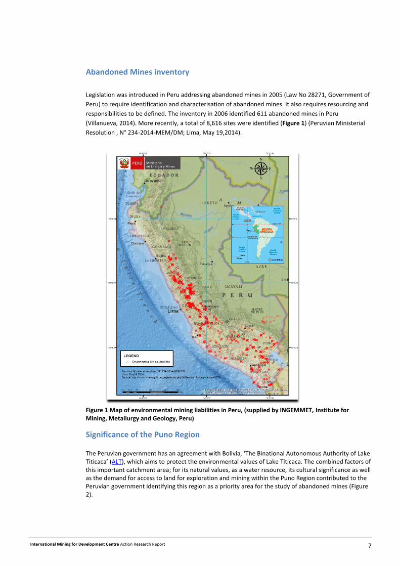
Abandoned Mines inventory
Legislation was introduced in Peru addressing abandoned mines in 2005 (Law No 28271, Government of
Peru) to require identification and characterisation of abandoned mines. It also requires resourcing and
responsibilities to be defined. The inventory in 2006 identified 611 abandoned mines in Peru
(Villanueva, 2014). More recently, a total of 8,616 sites were identified (Figure 1) (Peruvian Ministerial
Resolution , N° 234-2014-MEM/DM; Lima, May 19,2014).
Figure 1 Map of environmental mining liabilities in Peru, (supplied by INGEMMET, Institute for Mining, Metallurgy and Geology, Peru)
Significance of the Puno Region The Peruvian government has an agreement with Bolivia, ‘The Binational Autonomous Authority of Lake Titicaca’ (ALT), which aims to protect the environmental values of Lake Titicaca. The combined factors of this important catchment area; for its natural values, as a water resource, its cultural significance as well as the demand for access to land for exploration and mining within the Puno Region contributed to the Peruvian government identifying this region as a priority area for the study of abandoned mines (Figure 2).
International Mining for Development Centre Action Research Report 8
The Puno region sub-catchments are significant to Lake Titicaca. There are zones of diminishing humidity from north to south, going from humid around Lake Titicaca, to semi-arid in the south of the catchment in Bolivia. The climate within the Puno Region is that of a high mountain region with a tropical hydrological regime of great inter-annual irregularity. Lake Titicaca exercises a moderating influence on temperatures and rainfall in the vicinity of the lake. Precipitation varies between 200 and 1,400 mm, with maximum value of 800 to 1,400 mm at the centre of the lake (ALT). There are great seasonal variations, as the area usually has wet summers and dry winters, with a rainy period from December through March and a dry period from May through August. The air temperature varies within the system depending on latitude, longitude, altitude and proximity to the lake, with minimums of -10 to -7°C and maximums of 19 to 23°C. Humidity is low throughout the system, with an average of 54 percent and variations depending on latitude and season.
Figure 2 The Puno region of Peru in the context of Lake Titicaca Figure 3 shows the location of abandoned mines within two sub-catchments of the Puno region. From these abandoned mines three were selected for this pilot study by INGEMMET.
International Mining for Development Centre Action Research Report 9
Figure 3 Three abandoned mines studied, one in Illpa basin and the others in Coata Basin
Objectives Broadly the objectives of this project are to;
Geochemically characterise mining environmental liabilities in the Titicaca watershed by taking
samples of surface water and mining waste, to delineate areas impacted by abandoned mines
including the distribution of heavy metals in the environment.
Quantify impacts from legacy mining features and provide data for development of management
and remediation plans in order to reduce impacts. Use the data to adjust the risk prioritisation of
mines (previously developed by the Ministry of Energy and Mines).
Map the vulnerability of the environment to potential sources of contamination, and
Contribute to thematic knowledge (geological, geomorphology, geodynamics and geochemistry) for
environmental management in the region Puno generally.
International Mining for Development Centre Action Research Report 10
The objectives of the INGEMMET project are to provide advice to the government on;
1. environmental impact assessments, characterisation and relevant findings, 2. geochemical characterisation of solid mine wastes from abandoned mines 3. characterisation of water quality in the surrounding rivers and associated discharges, 4. construction of a vulnerability map of abandoned mines in the Puno region as a guide for
remediation planning, 5. modelling the geochemistry of the impacted environments, 6. development of a methodology for assessing the risk of pollution, and 7. collaboration on the publication of results
CMLR provided research guidance prior to, during and after the September 2014 fieldwork phase. CMLR also contributed to program planning for an abandoned mines workshop which was hosted by INGEMMET following the fieldwork. Researchers from CMLR also presented during this forum along with representatives from key agencies from the Peruvian government as well as industry stakeholders.
Research approach The aim of this preliminary geochemical investigation was to better understand potential sources of acid and metalliferous drainage within the catchments of the three abandoned mines. A few snapshot solid phase and water samples were collected during the field trip in September 2014. This required a number of pre-fieldwork skype meetings to help INGEMMET plan the sampling program. The project involved the following components whilst in Peru;
Meetings with INGEMMET officials and the team for this project
Fieldwork in Puno Region
An Abandoned Mine workshop which included other agencies and stakeholders
Meetings at INGEMMET CMLR met with officials at INGEMMET prior to fieldwork in the Puno Region to discuss the project and collaboration between the two organisations (Figure 4). A memorandum of Understanding is being discussed between the two organisations.
Figure 4 INGEMMET and CMLR met in the office of INGEMMET in Lima Peru.
International Mining for Development Centre Action Research Report 11
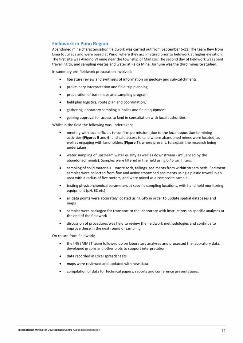
Fieldwork in Puno Region Abandoned mine characterisation fieldwork was carried out from September 6-11. The team flew from Lima to Juliaca and were based at Puno, where they acclimatised prior to fieldwork at higher elevation. The first site was Aladino VI mine near the township of Mañazo. The second day of fieldwork was spent travelling to, and sampling wastes and water at Palca Mine. Jornune was the third minesite studied.
In summary pre-fieldwork preparation involved;
literature review and synthesis of information on geology and sub-catchments
preliminary interpretation and field trip planning
preparation of base maps and sampling program
field plan logistics, route plan and coordination,
gathering laboratory sampling supplies and field equipment
gaining approval for access to land in consultation with local authorities
Whilst in the field the following was undertaken;
meeting with local officials to confirm permission (due to the local opposition to mining activities)(Figures 5 and 6) and safe access to land where abandoned mines were located, as well as engaging with landholders (Figure 7), where present, to explain the research being undertaken
water sampling of upstream water quality as well as downstream - influenced by the
abandoned mine(s). Samples were filtered in the field using 0.45 m filters.
sampling of solid materials – waste rock, tailings, sediments from within stream beds. Sediment samples were collected from fine and active streambed sediments using a plastic trowel in an area with a radius of five meters, and were mixed as a composite sample.
testing physico-chemical parameters at specific sampling locations, with hand held monitoring equipment (pH, EC etc)
all data points were accurately located using GPS in order to update spatial databases and maps
samples were packaged for transport to the laboratory with instructions on specific analyses at the end of the fieldwork
discussion of procedures was held to review the fieldwork methodologies and continue to improve these in the next round of sampling
On return from fieldwork;
the INGEMMET team followed up on laboratory analyses and processed the laboratory data, developed graphs and other plots to support interpretation
data recorded in Excel spreadsheets
maps were reviewed and updated with new data
compilation of data for technical papers, reports and conference presentations.
International Mining for Development Centre Action Research Report 12
Figure 5 Sign in Mañazo local government office ‘we will decide – If you don’t have social license you cannot mine on our land’
Figure 6 Meeting with the Mayor of Mañazo not far from Aladino VI
International Mining for Development Centre Action Research Report 13
Figure 7 Engaging with a landowner living near Aladino VI abandoned mine
Figure 8 Water quality monitoring upstream of the Aladino VI abandoned mine
International Mining for Development Centre Action Research Report 14
Abandoned mine workshop “challenges and opportunities”
An abandoned mine forum was held on 12 September 2014 at INGEMMET. The workshop brought together government agencies who were stakeholders in the abandoned mine environmental geochemistry project (Figure 9). Appendix A includes a list of participants. CMLR presented at this forum to share leading practice knowledge of AMD and abandoned mine management. Themes addressed water management aspects, funding for abandoned mine rehabilitation, prioritisation and risk assessment. Also explained was the national legislation for abandoned mines in Peru. The forum included leaders from small mining, other agencies, academics actively involved in related areas of research and provided a boost to the profile of this team within INGEMMET (Figures 10, 11 and 12).
Figure 9 shows the program for this forum.
Figure 9 Abandoned mine forum agenda
International Mining for Development Centre Action Research Report 15
Figure 10 CMLR and INGEMMET team at the abandoned mine workshop
Figure 11 Some of the participants at the INGEMMET Abandoned mine forum
International Mining for Development Centre Action Research Report 16
Copies of the presentations were given to all participants before they left at the end of the day (Figure 12)
Figure 12 Workshop proceedings
A summary of knowledge gaps was prepared at the end of the forum with a discussion of how issues would be addressed and who would accept responsibility for those tasks. Recommendations included the following, (translated by S Palomino, INGEMMET):
• Establish links and synergy with common objectives among institutions.
• Establishment a multi-sectoral commission on issues as environmental management and
management of environmental mining liabilities.
• Creation of virtual platforms in order to maintain the communication between government
institutions.
• Creation of virtual platforms to communicate to the community with information that contains
simple language.
• Promote, between the higher authorities of Peruvian national institutions the establishment of
strong ties, and request to research institutions (eg universities and other organisations) their
participation.
• Improvement of legislation to address loopholes, especially for small mining projects and related
issues.
• Provide technical support for development of management tools and environmental management
• Enrich and update the databases of institutions with competence in these matters (INGEMMET,
MINAM – Ministry of Environment, MINAM – Energy and Mines Ministry, ANA – National Authority
of Water).
International Mining for Development Centre Action Research Report 17
• Promote exchange of information during and after studies.
In the short term:
Maintain the communication and exchange of information between the institutions with the
projects, which are being developed in Puno region.
Enrichment, update and incorporation of information in virtual Peruvian platform (INGEMMET-
Geocatmin, MEM, MINAM, ANA, MINING ASSETS).
Register a permanent record of participants from each institution for consultation and
exchange of information.
Participation of universities in Geo-environmental research studies trough thesis, internship,
conventions, etc.
Call and participating in meetings as the activities of joint projects, considering the registration
of participants generated. Being the closest:
o Meeting between INGEMMET and representatives of ‘Activos Mineros’ (Remediation
company).
o Meeting between representatives INGEMMET and MINAM.
In the long term:
Provide support to the following institutions according to their competencies and responsibilities with
all the information collected and generated (water, soil, sediment, rock and mining liabilities) in the
Geo-Environmental studies:
National Authority of water (ANA): Water quality information for the re categorisation of rivers.
Energy and Mines Ministry (MINEM): Geochemical characterisation information of mining
environmental liabilities for categorization and prioritisation of mining environmental liabilities.
Ministry of Environment (MINAM): Geo-environmental information of the study (water, soil,
sediment) for review and adaptation of the standards to the Peruvian reality
Recommendations and results of geo-environmental studies that will be useful for
environmental strategies and guidelines developed by the MINAM.
Activos Mineros Company: Geochemical characterization information of mining environmental
liabilities as support for remediation projects.
Information for environmental baseline studies and land managed by the regional, local and
district government.
Development of future geo-environmental studies based on needs of government agencies and critical
areas for social and environmental aspects.
Organisation of courses related to geochemistry and environmental legislation to the institutions
involved in the management of environmental liabilities, with the support of Australian specialists.
International Mining for Development Centre Action Research Report 18
Aladino VI Mine
The Aladino VI Mine is located close to a rural dwelling with grazing activities. The runoff from this mine flows toward an ephemeral creek system which flows toward the town of Mañazo. The abandoned mine is unfenced so there is uninhibited access to waste materials by humans and other animals.
The geology of Aladino VI mine area is dominated by limestone or calcareous sedimentary and intermediate porphyry rocks. Therefore, the waste rocks are either calcite dominated (R2) or silica dominated (R4). Some rocks are extremely mineralised. For example, R3 contains galena (18%), sphalerite (26%), pyrite (6%), chalcopyrite (3%), and Jacobsite (2%) (a manganese iron oxide mineral with the general formula MnFe2O4. The waste rock dumps are located to the west of the site where old mine workings have cut into an area which seems to be at the contact of carbonate rocks and volcanic or intrusive intermediate rocks. Figure 13 shows the geology of the sub-catchment for the Aladino VI mine.
Figure 13 Geology of Aladino VI abandoned mine sub-catchment
The research team provided guidance on water quality measurement during the sampling program (Figure 8).
International Mining for Development Centre Action Research Report 19
The geology of Aladino mine area is dominated by limestone or calcareous sedimentary and intermediate porphyry rocks. Therefore, the waste rocks are either calcite dominated (R2) or silica dominated (R4). Some rocks are extremely mineralised. For example, R3 contains galena (18%), sphalerite (26%), pyrite (6%), chalcopyrite (3%), and Jacobsite (2%) (a manganese iron oxide mineral with the general formula MnFe2O4). The waste rock dumps are located to the west of the site where old mine workings have cut into an area which seems to be at the contact of carbonate rocks and volcanic or intrusive intermediate rocks. The mineralogy of waste rocks is shown in Figure 14 and Figure 15.
Figure 14 Mineralogy of waste rocks at Aladino mine
International Mining for Development Centre Action Research Report 20
Figure 15 Mineralogy of a typical waste rock collected at Aladino VI mine, including XRD results (pie chart), and a photomicrograph; galena (gn), gray copper (CGRs), pyrite (py), sphalerite (ef), chalcopyrite (cp). The original calcareous rock is strongly silicified and contains fractures filled in with calcite.
Figure 16 Acid mine drainage pool near waste rocks at Aladino VI mine Contaminated water ponds onsite (Figure 16) likely to contribute to the ‘first flush’ runoff during rainfall events. The tailings cover a wide area to the east of the site, between the remnants of old mineral processing structures and a stream which flows in a north-westerly direction (Figures 17 and 18). The tailings are partly eroded and incised, and show signs on highly oxidised on the surface. The mineralogy of tailings may include residual pyrite and other sulphides (RV-2) (Figure 19), or may show more advanced stages of oxidation with the dominance of iron oxide (RV-1). One samples (RV-3) collected at the lower section of tailings profile contained rare minerals including Zabuyelite, which is the natural mineral form of lithium carbonate, with a formula Li2CO3, villamaninite [(Cu,Ni,Co,Fe)S2], and Uvarovite [Ca3Cr2(SiO4)3]. The tailings contain elevated concentrations of zinc, bismuth, cadmium, copper, manganese, lead, and antimony (Figure 20 and Table 1).
International Mining for Development Centre Action Research Report 21
Figures 17 & 18 Tailings disposal area and erosion gullies
Figure 19 Sampling locations in tailings profile
International Mining for Development Centre Action Research Report 22
Figure 20 Mineralogy of tailings samples (RV1-3) from Aladino mine
Quartz
Alunite
Anthophyllite Calcite
ChloriteCloromagnesite
Albite
Hematite Microcline
Oligonite
Gypsum
RV-1
Quartz
KaoliniteAlbite
DamaraiteJarosite
MicroclineMontmorillonite
MuscovitePyrite
RV-2
Quartz
KaoliniteAlbite
Dolomite
Sphalerite
Jarosite
Melanterite
Microcline
MuscoviteUvarovite
Villamaninite
Zabuyelite RV-3
International Mining for Development Centre Action Research Report 23
Table 1 Geochemical composition of tailings at Aladino mine
RV-1 RV-2 RV-3
S-2 % 0.15 1.27 0.22
Zn ppm 2856 2073 12321
Ag ppm 8 29 25
As ppm 617 1578 1327
Bi ppm <10 76 17
Cd ppm 24 39 106
Cu ppm 4252 2235 712
Mn ppm 56812 3965 87640
Pb ppm 968 3170 2015
Sb ppm 45 308 80
The stream water sample (0174-154-034) collected about 0.5 kilometre downstream from the tailings location showed similar chemistry compared to those above and outside the mine influence with the pH in the range of 7.00 to 8.48, which is in the near-neutral/low metal classification (Figure 21 and Figure
22). The conductivity of the sample collected above the mine is 473 S/cm, in contrast to those for
other samples in the range of 1000 to 1413 S /cm. The sulfate concentration in the downstream sample is 484 mg/L compared to 88 mg/L upstream from the site. A few pH measurements at drainage channels at the base of old mine workings also showed near-neutral to alkaline property which indicates to the buffering capacity of carbonate rocks.
International Mining for Development Centre Action Research Report 24
Figure 21 Sample sites at Aladino VI
International Mining for Development Centre Action Research Report 25
Figure 22 Stream water chemistry at Aladino VI mine The collected stream sediment samples showed higher concentrations of arsenic, copper, lead, and zinc near the site and at a downstream location not far from the tailings disposal area (Figure 23).
Figure 23 Stream sediment chemistry at Aladino VI mine site
Upstream (SED1) Near the site (SED5) Downstream (SED8)
International Mining for Development Centre Action Research Report 26
Palca mine
Mining at Palca ceased around 1956. It was a former copper lead and zinc mine. This is the highest elevation site included in the fieldwork at around 5000m ASL. Figure 24 shows the Palca mine sub-catchment geology and drainage.
Figure 24 Palca abandoned mine sub-catchment geology and sample sites Snowpatches were evident on the mountain above the minesite. This is the most remote site included in the study. Figure 25 shows the grazing land uses downstream of the mine (tailings visible in the background) where llamas and Alpacas were seen drinking AMD-impacted site drainage. The remoteness and high elevation of this site poses numerous challenges which would need to be addressed as part of any implementation plan for long term management of these sites.
International Mining for Development Centre Action Research Report 27
Figure 25 Grazing land uses downstream of Palca abandoned mine The geology of Palca is dominated by felsic to intermediate volcanic rocks. The mineralogy of the rocks
(e.g. 0176-155-RX2) reflects the local lithology with dominance of quartz, plagioclase, some mafic
minerals (pyroxene?), and with some pyrite. A sample from dumps of crushed rocks (0176-155-RM01)
that could be mill rejects contained similar mineralogy with the addition of secondary minerals (e.g.
jarosite). There are several waste rock dumps at various elevations at places where old mine workings
have cut into the mountain (Figures 26, 27 and 28).
International Mining for Development Centre Action Research Report 28
Figure 26 Mine waste dumps at Palca
Figure 27 Representative mineralogy of rocks at Palca
AlbiteAugite
Calcite
Chlorite
Quartz
FayaliteHematite
MicroclineMuscovite
PyritePyrophyllite
0176-155-RX2
International Mining for Development Centre Action Research Report 29
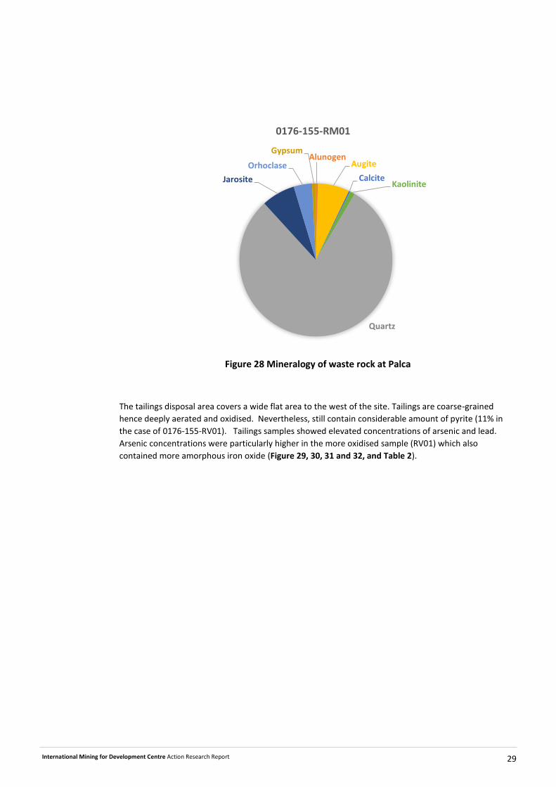
Figure 28 Mineralogy of waste rock at Palca
The tailings disposal area covers a wide flat area to the west of the site. Tailings are coarse-grained
hence deeply aerated and oxidised. Nevertheless, still contain considerable amount of pyrite (11% in
the case of 0176-155-RV01). Tailings samples showed elevated concentrations of arsenic and lead.
Arsenic concentrations were particularly higher in the more oxidised sample (RV01) which also
contained more amorphous iron oxide (Figure 29, 30, 31 and 32, and Table 2).
AlunogenAugite
CalciteKaolinite
Quartz
Jarosite
Orhoclase
Gypsum
0176-155-RM01
International Mining for Development Centre Action Research Report 30
Figures 29 and 30 Tailings at Palca showing signs of advance oxidation
International Mining for Development Centre Action Research Report 31
Figure 31 Mineralogy of oxidised tailings at Palca
Figure 32 Sampling tailings and mine waste at Palca
Albite
Amorphous
Clinocervantite
Quartz
Jarosite
Lanarkite
Marialite
PyriteHubnerite Siderotil
0176-155-RV01
International Mining for Development Centre Action Research Report 32
Table 2 Geochemical composition of solid samples collected at Palca mine site
0176-155-RV01
(tailings)
0176-155-RV02
(tailings)
0176-155- RM01
(mine waste)
0176-155-RX2
(rock)
0176-155-SED01
(sediment)
Co ppm 1 <1 9 5 12
Cr ppm 12 7 18 5 24
Zn ppm 1546 1096 11838 14250 6748
Ag ppm 30 28 35 9 7
As ppm 726 2688 747 23 938
Cd ppm 9 14 61 73 33
Cu ppm 791 462 1057 700 810
Mo ppm 26 27 74 <2 14
Ni ppm <5 <5 7 <5 16
Pb ppm 9141 3657 8694 35435 2191
Sb ppm 115 89 45 7 38
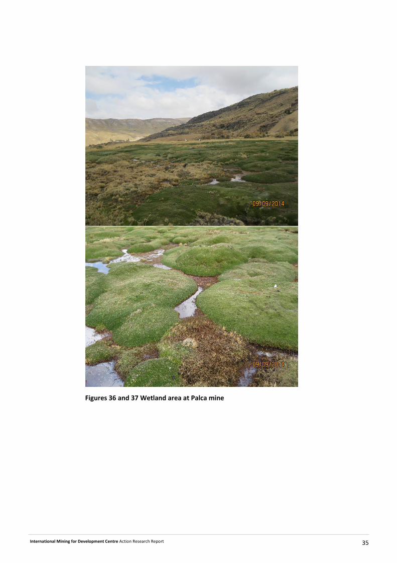
The main sources of acid and metalliferous drainage at Palca are the underground workings, the tailings,
and waste rock dumps. There is also a small glacial lake which has been modified with a dam wall which
perhaps was used as the water source for the operation (Figure 33). A small wetland area near the
tailings and waste rocks is covered with moss-like plants and grasses and attracts migratory birds,
despite the presence of contaminated mine water.
Figure 33 Modified glacial lake-dam at Palca mine site
International Mining for Development Centre Action Research Report 33
The mine drainage adjacent and downstream from the tailings disposal area (0176-155-76) was
particularly acidic and contained higher concentration of metals (Figure 34) with a conductivity above
5000 mS/cm. Sulfate concentration at this point was 3607 mg/L. Stream sediment sample collected
downstream from this point showed elevated concentrations of arsenic and lead which reflects the
geochemistry of tailings (0176-155-SED01).
Figure 34 Mine water chemistry at Palca
Groundwater flowing from the underground mine workings (Figure 35) was sampled during fieldwork.
The wetland feature below the mine is shown in Figure 36 and 37. Parts of the wetland are more
affected by AMD than others.
1
10
100
1000
10000
100000
1000000
-1 0 1 2 3 4 5 6 7 8 9
Zn+C
u+C
d+P
b+C
o+N
i (m
g/L)
pH
0176-155-74 0176-155-76 0176-155-77
High acid-High metal
Acid-High metal
High acid-Low metal
Acid-Low metal
Near neutral-Low metal
High acid-Extreme metal
International Mining for Development Centre Action Research Report 34
Figure 35 Entrance to underground mine workings
International Mining for Development Centre Action Research Report 35
Figures 36 and 37 Wetland area at Palca mine
International Mining for Development Centre Action Research Report 36
Jornune Mine
The Jornune Mine is located in a narrow and steep catchment in a broad valley where grazing is carried out. On the opposite side of the valley evidence of small scale, illegal, mining was apparent. Figure 38 shows the geology of the Jornune mine sub-catchment with Figure 39 providing an aerial image of the mine and its surrounds (including illegal mining areas).
Figure 38: Geology of the Jornune abandoned mine sub-catchment
International Mining for Development Centre Action Research Report 37
Figure 39: Aerial photo image of Jornune abandoned mine and sample sites
The geology of Jornune mine site is dominated by intermediate volcanic (andesite) or intrusive (diorite)
rocks. The mineralogy of rocks may consist mainly of plagioclase, and some pyrite may also be present
(e.g. RX-1 Figures 40, 44 and 45). The mine workings are along a valley which is filled in and obstructed
by dumps of weathered coarse mine residues (Figures 42 and 43). The mine residues which seem to be
a mix of crushed rocks and tailings, ranging in size from gravel to sand and silt, also contain pyrite, but
are highly weathered and enriched in secondary minerals (e.g RM-01 and RM-02, Figures 46 and 47).
International Mining for Development Centre Action Research Report 38
At the bottom of the valley, there is a pool of water which collects seepages from mine workings. At the
seepage point, white coloured aluminium floc and red iron floc are precipitated (Figure 44). A
precipitate sample from this point contained a large amorphous fraction and some hematite and
goethite. Aluminium floc is usually undetectable by XRD. Table 3 summarises the waste geochemistry.
Figure 40 Mineralogy of a typical rock sample from Jornune mine site
Albite
Pyrite
Jarosite
OrthoclaseQuartz Willemite
RX-1
International Mining for Development Centre Action Research Report 39
Figures 41, 42 Mine residue (top and middle) and Figure 43 mine drainage precipitates (bottom) at Jornune
International Mining for Development Centre Action Research Report 40
Figure 44 Mineralogy of mine residues at Jornune mine
Albite
Amorphous
Clinocervantite
Quartz
Jarosite
Lanarkite
MarialitePyrite
Hubnerite
Siderotil
RM-01
Albite
Beidellite
KaoliniteQuartzGerardita
Jarosite
Muscovite Gypsum
RM-02
International Mining for Development Centre Action Research Report 41
Figure 45 Mineralogy of mine drainage precipitate at Jornune
Table 3 Geochemical composition of solid samples from the Jornune mine area
RX-1 RM-01 RM-02 0176-155-PP06
SED07 SED08
Rock Mine residue
Mine residue
Precipitate (spring)
Sediment Sediment
S-2 0.34 14.98 3.22 0.03
LOI* % 5 16 27 28 24 6
Co ppm <1 95 61 7 24 43
Cr ppm 13 17 28 5 17 16
Ni ppm <5 12 9 12 20 12
Ag ppm <0.5 17 9 <0.5 1 <0.5
As ppm 39 27 24 293 1131 61
Bi ppm <10 <10 <10 <10 <10 <10
Cd ppm <1 <1 <1 1 12 1
Cr ppm 13 17 28 5 17 16
Cu ppm 42 17 63 346 196 75
Mn ppm 23 23 30 84 1990 1886
Mo ppm 3 23 29 14 6 7
Ni ppm <5 12 9 12 20 12
Pb ppm <5 158 84 6 195 79
Sb ppm <2 44 32 <2 7 <2
V ppm 186 28 66 56 74 88
W ppm 53 13 6 <5 <5 <5
Zn ppm 25 33 30 84 555 211
Albite
Amorphous
Chlorite
Goethite
GoslariteHematite
Microcline
0176-155-PP06
International Mining for Development Centre Action Research Report 42
The high concentrations of arsenic in sediments samples (Table 3) may indicate the influence from
informal mining to the south of the catchment. Tributaries of the alluvium laden steam in the middle of
the catchment are from the mines at both side of the catchment.
The three water samples collected at the seepage point, and downstream from the mine site were
classified as near-neutral low metal. The conductivities were above 1000 mS/cm and sulfate values were
above 400 mg/L. Figure 46 shows the chemical composition of water samples.
Figure 46 Chemical composition of water samples from Jornune mine
1
10
100
1000
10000
100000
1000000
-1 0 1 2 3 4 5 6 7 8 9
Zn+C
u+C
d+P
b+C
o+N
i (m
g/L)
pH
0176-155-78 0176-155-79 0176-155-80
High acid-High metal
Acid-High metal
High acid-Low metal
Acid-Low metal
Near neutral-Low metal
High acid-Extreme metal
International Mining for Development Centre Action Research Report 43
Conclusions
This preliminary investigation of the three abandoned mines, identified the major geochemical hazards
at the sites based on field observations and limited mineralogical, water quality and assay data.
At Aladino, tailings and waste rocks contain residual sulfide and locally generate acid mine drainage
despite the presence of potential alkalinity in the geology. Tailings are particularly enriched in heavy
metals which are readily mobilised through physical and chemical weathering processes. The tailings
mineralogy is enriched in secondary minerals which may act both as the sink and source of heavy
metals. Downstream from the tailings disposal area, stream sediments are enriched in lead, arsenic,
and copper.
At Palca, tailings play a significant role in the chemistry of mine drainage flowing downstream from the
site. Tailings are highly oxidised and are particularly enriched in arsenic and lead. Stream sediments also
show signs of heavy metal contamination related to the mine site.
At Jornune, the crumbly weathered mine waste in the valley of the mine as well as the seepages from
the mine workings are the major sources of contamination transport into the mine catchment. The
streams in the catchment may also receive contaminants from the illegal mining.
In the absence of hydrological data it is not possible to estimate the loads of contaminants leaving those
sites or predict any changes to water quality. However, the steady infiltration of precipitation and
replenishing groundwater, particularly abundance of snow melt at Palca, indicate that the sites will
continue to discharge contaminated mine water all year round.
Recommendations This project was multi-facetted involving several preliminary skype meetings and the following
components whilst in Peru;
Meetings with INGEMMET officials and the project team;
Fieldwork in Puno Region; and
An Abandoned Mine workshop which included other agencies and stakeholders.
This is a project being undertaken by INGEMMET over several years during which time a significant
volume of data are being gathered. Fieldwork recommendations were made during in-country
meetings. Some of these are already being implemented. In summary;
Systems, procedures and knowledge management
1. Quality assurance methods need to be embedded in data management processes to ensure
that labelling of results is aligned with sample labelling.
2. Similarly, the accurate location of sample sites must be verified through the development and
maintenance of a high quality spatial data systems and checked when maps are produced
showing sample locations,
3. Roles and responsibilities as the project evolves, should be documented and kept current so
that within the team the work is shared and appropriate skills and expertise are assigned to the
task,
International Mining for Development Centre Action Research Report 44
4. Further develop the risk assessment and management method for fieldwork to ensure the
ongoing safety and health of technical personnel working in remote areas
5. Like any data and knowledge gathering project, the information needs to remain accessible to
other personnel within INGEMMET, any future geochemical characterisation personnel who
follow on from the current team into the future in the event that there are any personnel
changes.
6. All sample preparation and handling procedures must be documented, as well as community
engagement methods by finalizing the guidelines which are in progress by INGEMMET;
Water quality monitoring sampling (first draft completed)