190
ENVIRONMENTAL IMPACT ASSESSMENT (EIA) REPORT LANCEWOOD VALLEY SUBDIVISION, CLARENDON Prepared by: We are the Pros for your environmental Cons! JUNE 2007

ENVIRONMENTAL IMPACT ASSESSMENT (EIA) REPORT
LANCEWOOD VALLEY SUBDIVISION, CLARENDON
Prepared by:
We are the Pros for your environmental Cons!
JUNE 2007

ENVIROCONJA June 2007
TABLE OF CONTENTS
Executive Summary . . . . . . . . .i- 1. INTRODUCTION . . . . . . . . 1 1.1 Structure of the Report . . . . . . 2 2. PROJECT DESCRIPTION . . . . . . . 3 2.1 Project Location . . . . . . . 3 2.2 History of the Site . . . . . . . 5 2.3 Description of the Area to be Developed and Land Use . . 5 2.4 Purpose of the Development . . . . . 6
2.5 Proposed Project Design . . . . . . 7 2.5.1 Residential Lots . . . . . . 8
2.5.2 Roads and Infrastructure . . . . . 8 2.5.3 Mineral Needs . . . . . . 8 2.5.4 Water Supply and Demand . . . . 8 2.5.5 Sewage Treatment and Disposal System . . 8
2.6 Project Implementation . . . . . . 8 3. POLICY LEGAL AND ADMINISTRATIVE FRAMEWORK . . 9
3.1 Jamaican Laws and Regulations . . . . . 10 3.1.1 National Environment and Planning Agency . . 10
3.1.2 The Local Improvements Act . . . . 15 3.1.3 The Land Acquisition Act . . . . . 15 3.1.4 The Registration of Titles Act . . . . 16 3.1.5 The Housing Act . . . . . . 16 3.1.6 Watershed Protection Act . . . . 17 3.1.7 Wildlife Protection Act . . . . . 17 3.1.8 The Country Fires Act . . . . . 17 3.1.9 Solid Waste Management Authority Act . . 18 3.1.10 The Clean Air Act . . . . . . 18 3.1.11 The Public Health Nuisance Regulations . . 18
3.2 International Conventions and Regulations . . . 19 3.2.1 Convention on Biological Diversity . . . 19
4. DESCRIPTION OF THE ENVIRONMENTAL SETTING . . 20
4.1 Physical Environment . . . . . . 20
4.1.1 Climate . . . . . . . 20 4.1.2 Air Quality . . . . . . . 23 4.1.3 Water Quality & Quantity. . . . . . 26 4.1.4 Soils and Geology . . . . . . 30 4.1.5 Hydrogeology . . . . . . 33

ENVIROCONJA June 2007
4.1.6 Noise and Vibration . . . . . . 47 4.1.7 Landscape and Aesthetics . . . . 51
4.2 Biological Environment . . . . . . 53 4.2.1 Flora . . . . . . . . 53 4.2.2 Fauna . . . . . . . . 62 4.2.2.1 Avifauna . . . . . . 62 4.2.2.2 Butterflies . . . . . . 65 4.2.2.3 Other Macrofauna . . . . . 67
4.3 Ecological Functions of the Study Area . . . . 73 4.3.1 Ecological Gradients and Interactions . . . 73 4.3.2 Indicator Species . . . . . 74 4.3.3 Factors Influencing the Ecology of the Study Area . 75 4.3.4 Future Description of the Development Area . . 76 5. DESCRIPTION OF THE SOCIO-ECONOMIC SETTING . . 77
5.1 Social Structure . . . . . . . 78 5.1.1 Demography . . . . . . . 78 5.1.2 Employment and Income . . . . . 80 5.1.3 Crime and Violence . . . . . . 81 5.1.4 Traffic . . . . . . . . 81
5.2 Infrastructure . . . . . . . . 82 5.2.1 Housing . . . . . . . 82 5.2.2 Road Network . . . . . . 83 5.2.3 Utilities . . . . . . . 83
5.3 Social Services . . . . . . . 84 5.3.1 Education . . . . . . . 84 5.3.2 Transportation . . . . . . 87 5.3.3 Health Services . . . . . . 88 5.3.4 Postal Services . . . . . . 88 5.3.5 Emergency Services . . . . . 88 5.3.6 Waste . . . . . . . . 89
5.5 Community’s Perception of the Project . . . . 89 6. ANALYSIS OF ALTERNATIVES . . . . . . 90
6.1 Project Alternatives . . . . . . . 90 6.1.1 The ‘No Action’ Scenario . . . . . 90 6.1.2 Proposed Subdivision . . . . 90
6.1.4 Agriculture . . . . . . . 90
6.3 The Chosen Alternative . . . . . . 91
ENVIROCONJA June 2007
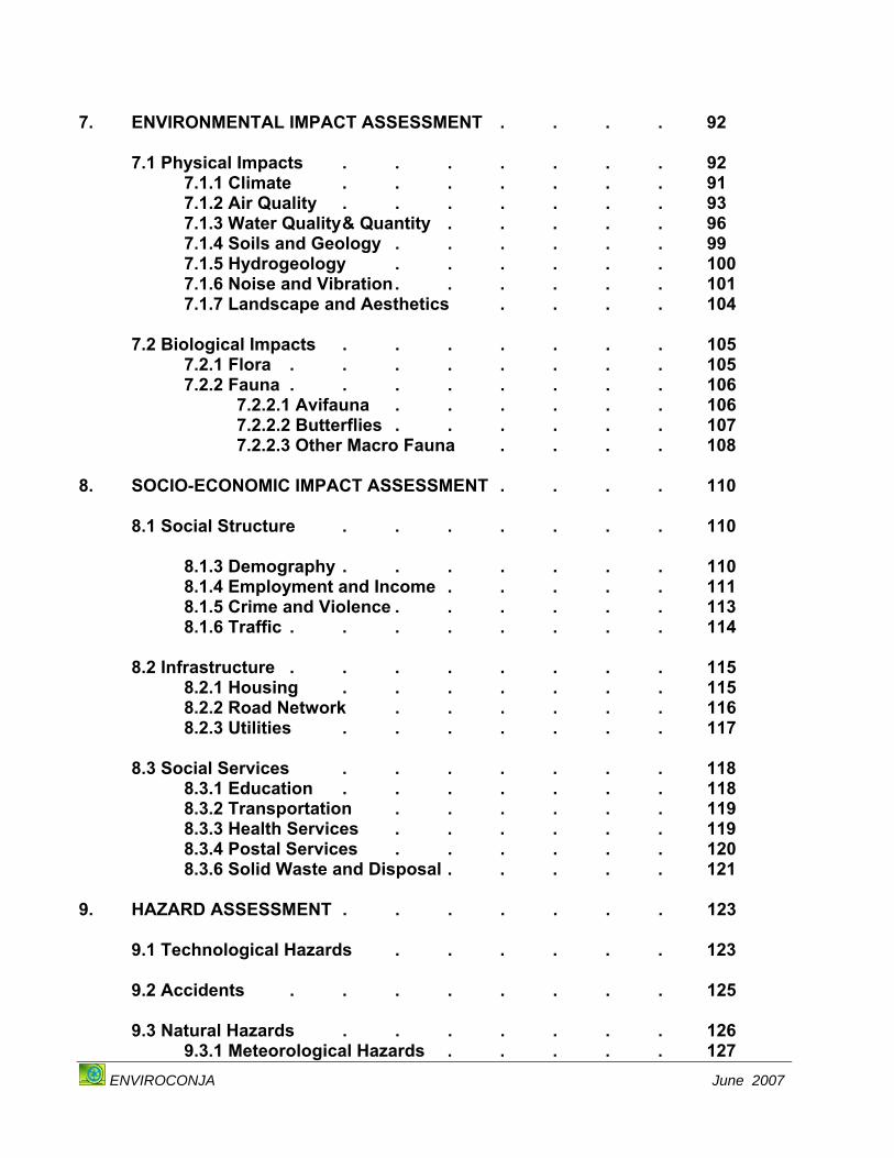
7. ENVIRONMENTAL IMPACT ASSESSMENT . . . . 92
7.1 Physical Impacts . . . . . . . 92 7.1.1 Climate . . . . . . . 91 7.1.2 Air Quality . . . . . . . 93 7.1.3 Water Quality & Quantity . . . . . 96 7.1.4 Soils and Geology . . . . . . 99 7.1.5 Hydrogeology . . . . . . 100 7.1.6 Noise and Vibration . . . . . . 101 7.1.7 Landscape and Aesthetics . . . . 104
7.2 Biological Impacts . . . . . . . 105 7.2.1 Flora . . . . . . . . 105 7.2.2 Fauna . . . . . . . . 106 7.2.2.1 Avifauna . . . . . . 106 7.2.2.2 Butterflies . . . . . . 107 7.2.2.3 Other Macro Fauna . . . . 108 8. SOCIO-ECONOMIC IMPACT ASSESSMENT . . . . 110
8.1 Social Structure . . . . . . . 110 8.1.3 Demography . . . . . . . 110 8.1.4 Employment and Income . . . . . 111 8.1.5 Crime and Violence . . . . . . 113 8.1.6 Traffic . . . . . . . . 114
8.2 Infrastructure . . . . . . . . 115 8.2.1 Housing . . . . . . . 115 8.2.2 Road Network . . . . . . 116 8.2.3 Utilities . . . . . . . 117
8.3 Social Services . . . . . . . 118 8.3.1 Education . . . . . . . 118 8.3.2 Transportation . . . . . . 119 8.3.3 Health Services . . . . . . 119 8.3.4 Postal Services . . . . . . 120 8.3.6 Solid Waste and Disposal . . . . . 121 9. HAZARD ASSESSMENT . . . . . . . 123
9.1 Technological Hazards . . . . . . 123
9.2 Accidents . . . . . . . . 125
9.3 Natural Hazards . . . . . . . 126 9.3.1 Meteorological Hazards . . . . . 127
ENVIROCONJA June 2007
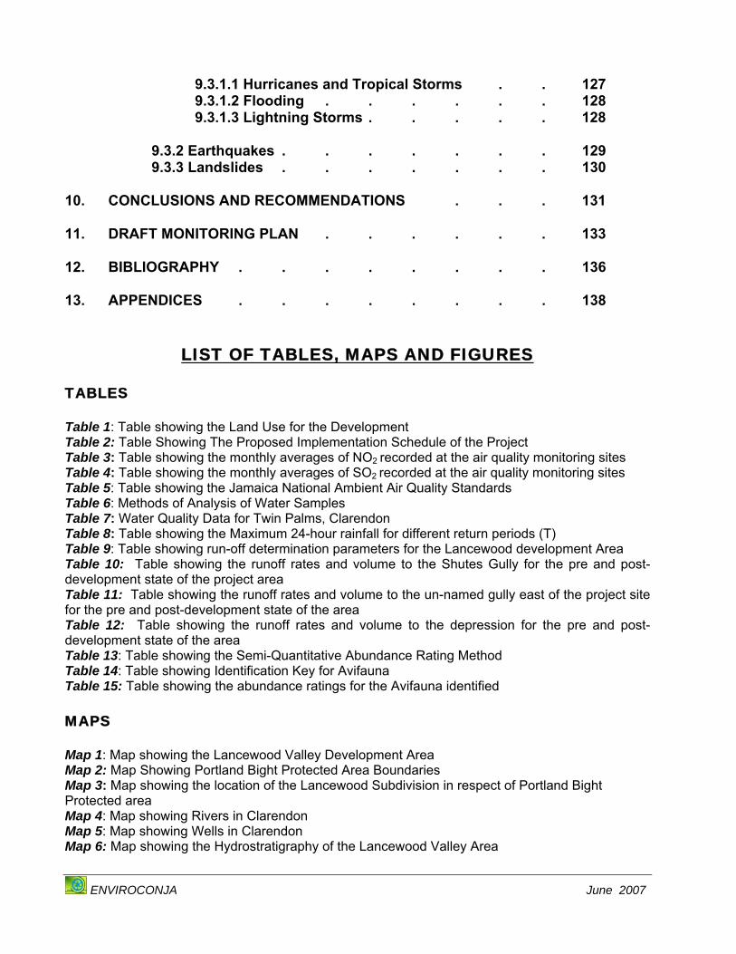
9.3.1.1 Hurricanes and Tropical Storms . . 127 9.3.1.2 Flooding . . . . . . 128 9.3.1.3 Lightning Storms . . . . . 128 9.3.2 Earthquakes . . . . . . . 129 9.3.3 Landslides . . . . . . . 130 10. CONCLUSIONS AND RECOMMENDATIONS . . . 131 11. DRAFT MONITORING PLAN . . . . . . 133 12. BIBLIOGRAPHY . . . . . . . . 136 13. APPENDICES . . . . . . . . 138
LIST OF TABLES, MAPS AND FIGURES TABLES Table 1: Table showing the Land Use for the Development Table 2: Table Showing The Proposed Implementation Schedule of the Project Table 3: Table showing the monthly averages of NO2 recorded at the air quality monitoring sites Table 4: Table showing the monthly averages of SO2 recorded at the air quality monitoring sites Table 5: Table showing the Jamaica National Ambient Air Quality Standards Table 6: Methods of Analysis of Water Samples Table 7: Water Quality Data for Twin Palms, Clarendon Table 8: Table showing the Maximum 24-hour rainfall for different return periods (T) Table 9: Table showing run-off determination parameters for the Lancewood development Area Table 10: Table showing the runoff rates and volume to the Shutes Gully for the pre and post-development state of the project area Table 11: Table showing the runoff rates and volume to the un-named gully east of the project site for the pre and post-development state of the area Table 12: Table showing the runoff rates and volume to the depression for the pre and post-development state of the area Table 13: Table showing the Semi-Quantitative Abundance Rating Method Table 14: Table showing Identification Key for Avifauna Table 15: Table showing the abundance ratings for the Avifauna identified MAPS Map 1: Map showing the Lancewood Valley Development Area Map 2: Map Showing Portland Bight Protected Area Boundaries Map 3: Map showing the location of the Lancewood Subdivision in respect of Portland Bight Protected area Map 4: Map showing Rivers in Clarendon Map 5: Map showing Wells in Clarendon Map 6: Map showing the Hydrostratigraphy of the Lancewood Valley Area
ENVIROCONJA June 2007
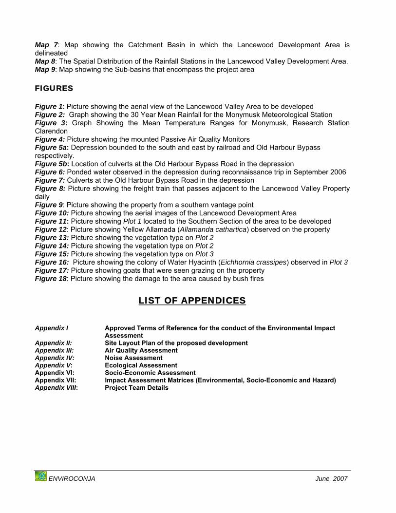
Map 7: Map showing the Catchment Basin in which the Lancewood Development Area is delineated Map 8: The Spatial Distribution of the Rainfall Stations in the Lancewood Valley Development Area. Map 9: Map showing the Sub-basins that encompass the project area FIGURES Figure 1: Picture showing the aerial view of the Lancewood Valley Area to be developed Figure 2: Graph showing the 30 Year Mean Rainfall for the Monymusk Meteorological Station Figure 3: Graph Showing the Mean Temperature Ranges for Monymusk, Research Station Clarendon Figure 4: Picture showing the mounted Passive Air Quality Monitors Figure 5a: Depression bounded to the south and east by railroad and Old Harbour Bypass respectively. Figure 5b: Location of culverts at the Old Harbour Bypass Road in the depression Figure 6: Ponded water observed in the depression during reconnaissance trip in September 2006 Figure 7: Culverts at the Old Harbour Bypass Road in the depression Figure 8: Picture showing the freight train that passes adjacent to the Lancewood Valley Property daily Figure 9: Picture showing the property from a southern vantage point Figure 10: Picture showing the aerial images of the Lancewood Development Area Figure 11: Picture showing Plot 1 located to the Southern Section of the area to be developed Figure 12: Picture showing Yellow Allamada (Allamanda cathartica) observed on the property Figure 13: Picture showing the vegetation type on Plot 2 Figure 14: Picture showing the vegetation type on Plot 2 Figure 15: Picture showing the vegetation type on Plot 3 Figure 16: Picture showing the colony of Water Hyacinth (Eichhornia crassipes) observed in Plot 3 Figure 17: Picture showing goats that were seen grazing on the property Figure 18: Picture showing the damage to the area caused by bush fires
LIST OF APPENDICES Appendix I Approved Terms of Reference for the conduct of the Environmental Impact
Assessment Appendix II: Site Layout Plan of the proposed development Appendix III: Air Quality Assessment Appendix IV: Noise Assessment Appendix V: Ecological Assessment Appendix VI: Socio-Economic Assessment Appendix VII: Impact Assessment Matrices (Environmental, Socio-Economic and Hazard) Appendix VIII: Project Team Details

Lancewood Valley Subdivision EIA Report
ENVIROCONJA June 2007
i
EXECUTIVE SUMMARY
i. The Lancewood Valley property is located centrally between Old Harbour and May
Pen in the Parish of Clarendon and is approximately 2 km south of the community of
Sandy Bay. The project site is also located just north of the boundary of the Portland
Bight Protected Area and lies adjacent to the Vere Plains Region boundary, which
runs south-east along the railway line through Inverness and Freetown to the parish
boundary of Clarendon and St. Catherine.
ii. The proponent intends to subdivide ninety (90) acres ~ 36 hectares into one hundred
and twenty one (121) housing lots, complete with roads, electricity and water. Lots
will range from 1,039 square meters to 11,190.09 square meters. It is anticipated
that three (3) and four (4) bedroom houses will be built on the property and the
project will be implemented over a one (1) year period.
iii. The land has predominantly been utilized for agriculture, namely for cattle rearing, in
the last fifty (50) years. These practices have ceased however due to the frequent
occurrences of praedial larceny. The property is presently in ruinate and is frequently
grazed by stray goats that enter the property through pathways from nearby
communities.
iv. The site is bordered by a small settlement on its northern border and a number of
residences to the northwest and north-northwest. To the east of the property is
Highway 2000 and to the south is a railway that is traversed by Jamaica Aluminium
Company’s (JAMALCO’s) bauxite freight train.
v. Water for the development will be sourced from a well located in Twin Palms, which
is operated by the National Water Commission (NWC). The daily water consumption
by the development is estimated to be between 166,980 – 222,640 litres. This well
has a licence to abstract 4,524,000 litres of water per day.
vi. A sewage treatment system comprising of a Septic Tank/Tile Field has been
recommended for each lot. This will treat the wastewater to a secondary level which
has been recommended by the Environmental Health Unit (EHU), Ministry of Health.

Lancewood Valley Subdivision EIA Report
ENVIROCONJA June 2007
ii
vii. Several regulations and legislation have been reviewed which pertain to the
development. These serve to protect the interest of the developer, the public as well
as preserving the natural environment.
viii. The climate experienced in the area is typical of the south coast of Jamaica. The
rainfall in area ranges from a low of 39 mm in January to a high of 201 mm in
October. Wind speeds vary from a maximum of 21 km/hr in June to a minimum of
10.2 in December. The temperatures range from a high of 32.4 ºC in July to a low of
16.9 ºC in January.
ix. Both the NO2 and SO2 values recorded at the site were well within the air quality
standards that have been stipulated by the Natural Resources Conservation
Authority (NRCA).
x. No streams or rivers are located within 2 km of the project site. A gully traverses
through the property which leads to the Bowers River which is within the Portland
Bight protected area. No water flow was observed during this assessment and
therefore water quality analysis was not possible for this watercourse.
xi. Water quality analysis was undertaken for the Twin Palms well, which is the
proposed water supply for the development. The results from this analysis show that
the water quality from this well is within the World Health Organisation’s Drinking
Water Standards and is therefore suitable for potable use.
xii. Units of the Newport Formation of the White Limestone Group chiefly underlie the
development area. The beds of the Newport Formation have good drainage
properties that contribute to the lack of surface drainage within and in the general
vicinity of the development area.
xiii. No major faults were identified in the area based on the surface geology.

Lancewood Valley Subdivision EIA Report
ENVIROCONJA June 2007
iii
xiv. Gentle slopes characterize the development area. Steep slopes exist, however, in
the vicinity of the Shutes Gully close to the train line whereas moderately steep
slopes are present along the area bordering the Old Harbour Bypass Road.
xv. The major soil types in this area are Bonny Gate and Four Paths.
xvi. There is no recorded history of flooding at the development site. The flood analysis
shows that the development area is not vulnerable to flooding from the Shutes Gully
traversing the project site to the west or from the gully to the east of the site. On the
other hand, runoff from the project site will inundate the depression, which forms the
southern part of the development area. Inundation of the depression is exacerbated
due to its enclosure by the Old Harbour Bypass main road with only two (2) 1 m
diameter culverts for water to flow out.
xvii. The area to be developed cannot be described as a noise sensitive community. With
reference to decibel levels that have been recorded for street side traffic, the noise
values recorded at the site fall well within the expected ranges for trafficked areas.
xviii. The vegetation in the area can be described as dry thorn scrub characterised by the
prevalence of Cashaw Macca (Prosopis juliflora). The vegetation assessment
showed that the floral species diversity in this area is very low. No endemic, rare,
threatened or endangered species were observed during the assessment. Only one
invasive alien species, the Water Hyacinth (Eichhornia crassipes), was observed.
xix. Twenty (20) species of birds representing nine (9) families were observed during the
survey. Only one endemic species was observed, the Jamaican Euphonia. No rare,
threatened, endangered or invasive alien species were observed during the
assessment.
xx. Twenty one (21) species of butterflies were observed during the survey, three (3) of
which are endemic subspecies, which include the Jamaican Gillipus (Danaeus
gillipus jamaicensis), the Jamaican Polydamas (Battus polydamas jamaicensis) and
the Jamaican White Peacock (Anartia jatrophae jamaicensis). No rare, threatened,
protected or endangered species were observed in the assessment.
Lancewood Valley Subdivision EIA Report
ENVIROCONJA June 2007
iv
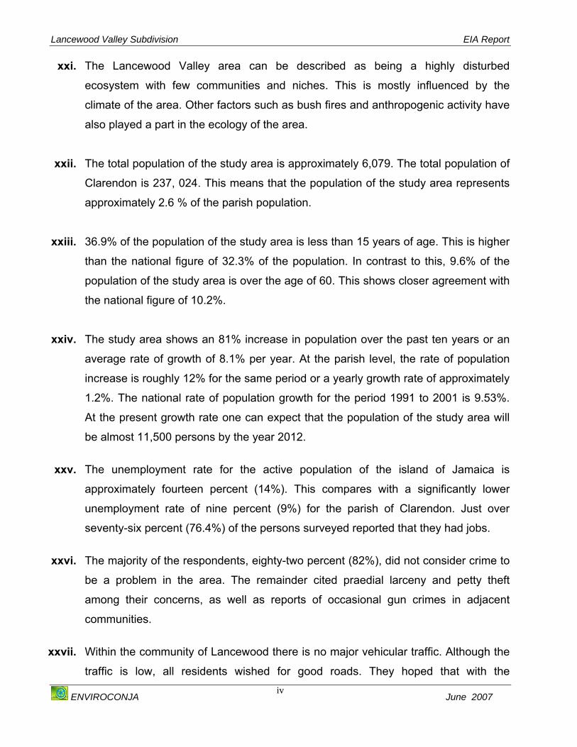
xxi. The Lancewood Valley area can be described as being a highly disturbed
ecosystem with few communities and niches. This is mostly influenced by the
climate of the area. Other factors such as bush fires and anthropogenic activity have
also played a part in the ecology of the area.
xxii. The total population of the study area is approximately 6,079. The total population of
Clarendon is 237, 024. This means that the population of the study area represents
approximately 2.6 % of the parish population. xxiii. 36.9% of the population of the study area is less than 15 years of age. This is higher
than the national figure of 32.3% of the population. In contrast to this, 9.6% of the
population of the study area is over the age of 60. This shows closer agreement with
the national figure of 10.2%.
xxiv. The study area shows an 81% increase in population over the past ten years or an
average rate of growth of 8.1% per year. At the parish level, the rate of population
increase is roughly 12% for the same period or a yearly growth rate of approximately
1.2%. The national rate of population growth for the period 1991 to 2001 is 9.53%.
At the present growth rate one can expect that the population of the study area will
be almost 11,500 persons by the year 2012.
xxv. The unemployment rate for the active population of the island of Jamaica is
approximately fourteen percent (14%). This compares with a significantly lower
unemployment rate of nine percent (9%) for the parish of Clarendon. Just over
seventy-six percent (76.4%) of the persons surveyed reported that they had jobs.
xxvi. The majority of the respondents, eighty-two percent (82%), did not consider crime to
be a problem in the area. The remainder cited praedial larceny and petty theft
among their concerns, as well as reports of occasional gun crimes in adjacent
communities.
xxvii. Within the community of Lancewood there is no major vehicular traffic. Although the
traffic is low, all residents wished for good roads. They hoped that with the

Lancewood Valley Subdivision EIA Report
ENVIROCONJA June 2007
v
development there would be an improvement to the road network of their respective
communities.
xxviii. As at 2001 there were 1646 houses in the study area. Of these, ninety-seven
percent (97%) were separate or detached dwellings. xxix. All the houses in close proximity to the development site (Lancewood Valley)
reported that they have access to electricity or have electricity in their homes. Ninety
percent (90%) of respondents said that they had access to piped water from the
National Water Commission (NWC). Fixed line services are available in the
Lancewood Valley area. Over 50 % of the respondents said they had fixed lines in
their homes. Most respondents said they also relied on cellular service (Digicel,
Cable and Wireless and Miphone) for their telephone communication needs. xxx. Solid waste is collected in the area at least once per week by the Metropolitan Parks
and Market (MPM) and disposed of at the Riverton Landfill. xxxi. Two (2) alternatives to the proposed project were analysed including the ‘no action’
and agriculture alternatives. Based on the environmental and socio economic
assessments of the area the chosen option will be the proposed subdivision.
xxxii. The environmental and socio-economic impacts were assessed using an impact
identification matrix. The project may have major negative environmental impacts
on the air quality, noise, surface water quality and the soil quality of the area.
Mitigation measures have however been proposed to reduce these impacts. Minor
negative impacts may include those to the climate, hydrogeology and ecology of the
area. Mitigation measures have also been proposed to reduce these negative
impacts. The socio-economic impacts predicted were mostly positive. Measures
have been identified to enhance these positive impacts.
xxxiii. A hazard impact identification matrix was designed to determine the probability and
magnitude of the hazards the project may be subjected to. The main hazards that
may be associated with the project include technological impacts and accidents. The
project is also susceptible to natural hazards.
Lancewood Valley Subdivision EIA Report
ENVIROCONJA June 2007
vi
xxxiv. Although negative impacts which may be caused by the development have been
predicted, with the implementation of the recommended mitigation measures the
negative impacts associated with the project can be markedly reduced.
xxxv. A monitoring report for the development was designed to ensure that the mitigation
measures proposed have been implemented and are effective as well as to identify
any unanticipated impacts that may arise from the project.

Lancewood Valley Subdivision EIA Report
ENVIROCONJA June 2007
vii
TABLE I: SUMMARY OF ENVIRONMENTAL MITIGATION MEASURES
ENVIRONMENTAL COMPONENT
MITIGATION MEASURES ADDED COST TO THE
DEVELOPER PHYSICAL CLIMATE
o All mature trees present must be maintained and not be removed during this phase of the development.
$ 0.00 Site Preparation and Construction Phases o Ensure that the road system implemented throughout the development and access
roads to the development involves appropriate signals and signs to ensure the smooth flow of traffic. This will reduce the idling of vehicles and therefore reduce the emissions and noise in the area.
$ 0.00
o Incorporate as far as possible natural vegetation typical of the area during the landscaping of the development.
$ 0.00
Post- Construction Phase
o Although the proper maintenance of vehicles by potential occupants of the development is not the responsibility of the developer, it must be impressed upon the potential residents to maintain their vehicles regularly.
$ 0.00
AIR QUALITY o The clearing of vegetation must be carried out on a phased basis; that is, only
areas designated for construction during the necessary phase of development must be cleared to minimise the dust that may be generated.
$ 0.00
o The area to be designated as a green space will be covered with sod to eliminate the dust to be generated from this area. This area will only be cleared within a week before the sod is to be laid.
$0.00
o Ensure that all material (sand and aggregate) stockpiled on the site to be used in construction activities are regularly sprayed to reduce the effects of wind whipping.
~$500/day
o Ensure that all trucks carrying aggregate and sand are covered during delivery to the site.
$ 0.00
Site Preparation and Construction Phase
o Care must be taken in the unloading of aggregate, sand and cement to prevent spillage.
$ 0.00
Lancewood Valley Subdivision EIA Report
ENVIROCONJA June 2007
viii
o Extra care must be taken to reduce dust in periods when wind speed are greatest which is between June and July, e.g. extra wetting of the compound to suppress dust.
$ 0.00
o Plant large trees on perimeter of compound to create a natural windbreak, which will also serve the purpose of being a sight, screen shielding the plant from public view.
$ 0.00
o All staff employed at the construction site must be provided with dust masks and be asked to use them.
~$3000.00
o All raw materials must be sourced as close as possible to the construction site. $ 0.00 o Where possible waste must be transported off-site for processing, not burnt or
stored for any longer than is necessary. $ 0.00
o Recruit staff from the surrounding communities to decrease the travelling distance thus reducing emissions from vehicular traffic.
$ 0.00
o Ensure that all vehicles involved in the transport of construction material and staff, and machinery involved in the construction are properly maintained and serviced.
$ 0.00
o Machines must not be left idling for unnecessary periods; this will save fuel and reduce emissions and noise pollution.
$ 0.00
o Where possible, the use of the machinery must be scheduled to have most use when the residents are not in the area.
$ 0.00
o Perform road repair and construction at times that persons are expected to be at work and school as this produces noxious gases.
$ 0.00
o Although the proper maintenance of vehicles by potential occupants of the development is not the responsibility of the developer, it must be impressed upon the potential residents to maintain their vehicles regularly.
$ 0.00 Post - Construction
Phase o A traffic system that involves appropriate signals and signs to ensure the smooth
flow of traffic must be implemented. This will reduce the idling of vehicles that may occur and therefore reduce the emissions in the area. This may necessitate the alteration of the existing roadway, which have implied impacts.
$ 0.00
WATER QUALITY Site Preparation and Construction Phases
o If diesel and motor oil is to be stored, ensure that they are properly contained in a bunded area (With capacity to contain 1½ times the amount of substances stored. This area must be situated away from project activities and signs indicating the storage of these substances erected.
$ 20,000.00
Lancewood Valley Subdivision EIA Report
ENVIROCONJA June 2007
ix
o Provide workers at the development site with chemical toilets during this phase of the development. A reasonable ratio would be eight (8) workers per chemical toilet.
~ $20,000.00
o Store all raw materials away from the vicinity of watercourses located on the property to avoid contamination of this area.
$ 0.00
o General refuse must be transported and disposed of appropriately at the designated disposal site at Riverton Landfill by a licensed contractor.
$ 0.00
o Install a proper drainage system to control rain/storm water runoff on the site. $ 0.00
o Implement the recommended sewage treatment method which involves a Septic Tank / Tile Field for each lot.
$ 0.00
o Ensure that the sewage treatment facilities are properly maintained. ~$5,000.00/month o Regularly maintain the drainage system, which controls the storm water runoff at
the site. $ 0.00
Post - Construction Phase
o Ensure that general refuse is collected regularly and is transported and disposed
of appropriately at the designated disposal site at Riverton Landfill by a licensed contractor.
$ 0.00
WATER QUANTITY Site Preparation and Construction Phases
o Although water supply is readily available, it is important for the developer to implement measures to conserve water as much as possible during these phases of the development.
$ 0.00
o The developer should encourage residents to gutter all houses and encourage residents to recycle water for landscaping purposes.
$ 0.00 Post - Construction Phase
o The developer should encourage residents to install water saving devices (faucets, toilets etc.) into their home design.
$ 0.00
SOILS AND GEOLOGY o Remove as little vegetation as possible from the development site and re-
vegetate cleared vegetation as soon as possible. These areas should be cleared in phases.
$0.00
o Install appropriate drainage systems to direct water away from slopes. $0.00
o Avoid as far as possible the traversing of bare soil by vehicles to reduce soil compaction and erosion.
$0.00
o Designate a main access route for heavy machinery. $0.00
Site Preparation and Construction Phases
o Utilise sod layers in the open area, which will reduce the effect of soil erosion when grass is being established.
$0.00
Lancewood Valley Subdivision EIA Report
ENVIROCONJA June 2007
x
o Avoid activities in these phases in period when wind velocities are highest which is between June and July.
$0.00
o Avoid activities in these phases in periods of heavy rainfall, which are September and October.
$0.00
o Areas storing hazardous substances such as diesel must be properly contained in a bunded area (With capacity to contain 1 ½ times the amount of substances stored. This area must be situated away from project activities and signs indicating the storage of these substances erected. Care must be taken when handling these hazardous substances to avoid spills
$ 0.00
o In the event of a spill the contaminated soil must be removed and disposed of at a licensed landfill.
$ 0.00
o Ensure that general refuse is collected regularly and is transported and disposed of appropriately at the designated disposal site at Riverton Landfill by a licensed contractor.
$ 0.00
Post - Construction Phase
o Stipulate that houses to be constructed within the subdivision must be guttered as runoff from roofs may typically cause accelerated soil erosion around the margins of buildings. (Residents can utilise water which can be utilised for irrigation of landscape).
$0.00
HYDROGEOLOGY o Designate a main access route for heavy machinery. $0.00 o Utilise impervious material for areas that require paving to increase run-off. $0.00 o Ensure that the drainage plan proposed is implemented as stipulated on the plan. $ 0.00 o Phase the clearing of vegetation on slopes. $ 0.00 o Ponding may occur in the depression area and therefore this should be retained
as a green area for recreation and possible for the detention of storm water. $ 0.00
o Paved areas should be kept to a minimum to reduce runoff to the depression. $ 0.00 o No lots or building of houses should take place below the 53m contours. $ 0.00
Site Preparation and Construction Phases
o Keep paved areas to an absolute minimum and encourage the use of permeable material for parking lots etc. to allow infiltration into the ground.
$ 0.00
Post-Construction Phase
o Keep paved areas to an absolute minimum and encourage the use of permeable material for parking lots etc. to allow infiltration into the ground.
$ 0.00

Lancewood Valley Subdivision EIA Report
ENVIROCONJA June 2007
xi
NOISE & VIBRATION o Access roads should be cut that are exclusively used for the transportation of
workers, goods and materials. This road should be sited in such a way that the noise from this movement affects as few of the existing residents as possible.
$0.00
o Where possible silenced machinery and instruments should be employed to reduce the impact of noise on the existing residents and workers.
$0.00
o Machinery, vehicles and instruments that emit high levels of noise should be used on a phased basis to reduce the overall impact. These pieces of equipment such as drills, graders and cement mixers should also be used when the least number of residents can be expected to be affected, for example during periods where most residents are at work or school.
$0.00
o Workers, especially those working with machinery, vehicles and instruments that emit high levels of noise should be supplied with ear plugs and ear muffs to reduce the risk of hearing impairment. Prolonged exposure to this impact should be reduced when possible.
~$5,000.00
o Temporary barriers such as earth berms, zinc fencing and sound dampening fencing such as acoustic screens should be employed to reduce the impact of noise to the existing residents
~$10000.00
o Construction hours should be limited to the hours of 8:00 to 6:00 p.m. daily. $0.00
Site Preparation and Construction Phases
o The delivery of raw materials must be limited to 8:00 a.m. and 6:00 p.m. o Proper traffic signage and signals where necessary or appropriate to effect the
free and safe movement of traffic and thereby reduce the noise caused by traffic build-up.
$0.00
o Properly maintained vehicles and well-inflated tyres to reduce the friction will produce less noise.
$ 0.00
Post-Construction Phase o Where carpooling and public transportation is feasible, it should be encouraged to
reduce traffic and therefore noise. $ 0.00
LANDSCAPE AND AESTHETICS o Remove as little vegetation throughout the site as possible. $0.00 o Conduct vegetation clearance on a phased basis. $0.00 o Re-vegetate cleared areas as soon as possible. $0.00
Site Preparation and Construction Phases
o Plant vegetation screens to reduce the visual effect of this stage of the development.
$0.00
Lancewood Valley Subdivision EIA Report
ENVIROCONJA June 2007
xii
o Place caveats on titles of the properties so that the construction of homes within the subdivision will be carried out in a uniform fashion.
$ 0.00
o Ensure that local building materials and muted colours are used to reduce the visual impacts of the development and the landscaping to hide it or blend in with the local environment.
$ 0.00
o Incorporate as far as possible the natural vegetation throughout the site.
$0.00 Post-Construction
Phase o Incorporate fruit trees, ornamentals and flowers throughout the development. Ensure that these plants however are not classified as Invasive Alien Species.
$0.00
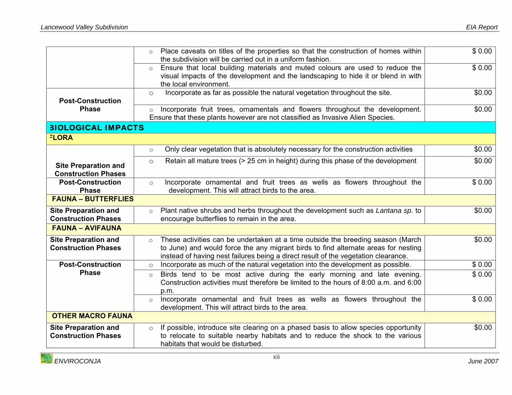
BIOLOGICAL IMPACTS FLORA
o Only clear vegetation that is absolutely necessary for the construction activities $0.00
Site Preparation and Construction Phases
o Retain all mature trees (> 25 cm in height) during this phase of the development
$0.00
Post-Construction Phase
o Incorporate ornamental and fruit trees as wells as flowers throughout the development. This will attract birds to the area.
$ 0.00
FAUNA – BUTTERFLIES Site Preparation and Construction Phases
o Plant native shrubs and herbs throughout the development such as Lantana sp. to encourage butterflies to remain in the area.
$0.00
FAUNA – AVIFAUNA Site Preparation and Construction Phases
o These activities can be undertaken at a time outside the breeding season (March to June) and would force the any migrant birds to find alternate areas for nesting instead of having nest failures being a direct result of the vegetation clearance.
$0.00
o Incorporate as much of the natural vegetation into the development as possible. $ 0.00 o Birds tend to be most active during the early morning and late evening.
Construction activities must therefore be limited to the hours of 8:00 a.m. and 6:00 p.m.
$ 0.00 Post-Construction
Phase
o Incorporate ornamental and fruit trees as wells as flowers throughout the development. This will attract birds to the area.
$ 0.00
OTHER MACRO FAUNA Site Preparation and Construction Phases
o If possible, introduce site clearing on a phased basis to allow species opportunity to relocate to suitable nearby habitats and to reduce the shock to the various habitats that would be disturbed.
$0.00

Lancewood Valley Subdivision EIA Report
ENVIROCONJA June 2007
xiii
o During site preparation and construction phases, the spoilage and waste should be removed, relocated or stored in a manner that does not allow for the disturbance of surrounding habitats or the species that remain.
$0.00
o The planting of native species in lots should allow for the possible re-colonization by some of the species as well as adding to the aesthetic appeal of the development.
$0.00 Post-Construction Phase
o The reservation of green spaces that are uninterrupted by aspects of the development may be used for “passive” habitat creation. Areas of the site can be replanted with plant species that may encourage the return of associated animal species.
$ 0.00
TABLE II: SUMMARY OF SOCIO-ECONOMIC MITIGATION MEASURES
SOCIO-ECONOMIC
COMPONENT MITIGATION MEASURES COST
SOCIAL STRUCTURE DEMOGRAPHY
o Give locals first purchasing options within the development. $0.00 Post – Construction Phase o The Local Planning Authority must play an important role in ensuring that the community
growth in the area is monitored and implemented in an orderly manner. $0.00
EMPLOYMENT AND INCOME o As much as is possible it is recommended that persons from the nearby
communities be employed to work on the construction site. This will ensure that the community gets the most benefits from the development.
$0.00
o As far as possible source raw material to be used in development from local suppliers.
$0.00
Site Preparation and Construction Phases
o Identify a specific area on the project site for vending type activities. Post-Construction
Phase o The Local Planning Authority must play an important role in ensuring that the
community growth in the area is monitored and implemented in an orderly manner.
$0.00

Lancewood Valley Subdivision EIA Report
ENVIROCONJA June 2007
xiv
CRIME AND VIOLENCE o As much as is possible it is recommended that persons from the nearby
communities be employed to work on the construction site. This will avoid any feelings of resentment that may be felt from locals and may reduce the level of crime and violence during these phases of the development.
$0.00 Site Preparation and Construction Phases
o Despite the added expense it is recommended that there be adequate security present at the site at all times.
~$3000/day
Post-Construction Phase
o Residents must be encouraged to implement measures to protect property. This could take the form of neighbourhood watches, burglar bars, security guards, and dogs.
$0.00
TRAFFIC o Place flagmen along road network to regulate the traffic during road upgrade.
$0.00
o As far as possible employ persons from the community to reduce the increase in vehicles that will transport workers.
$0.00
Site Preparation and Construction Phases
o Place warning signs informing persons of the upgrading works. $0.00 o Carry out improvement on the access roads to the development, ensuring that these
improvements are conducted to withstand and allow for the increase in traffic that is expected from the development.
$0.00
o A traffic system that involves appropriate signals and signs to ensure the smooth flow of traffic must be implemented.
$0.00
Post-Construction Phase
o The Local Planning Authority must play an important role in ensuring that the community growth in the area is monitored and implemented in an orderly manner.
$0.00
INFRASTRUCTURE HOUSING
o The developer should offer locals the first purchasing options for houses within the development.
$0.00 Post-Construction Phase
o The developer must liaise with the Local Planning Authority, with respect to advertising of the development so that the area may get most of the benefits from the development.
$0.00
ROAD NETWORK

Lancewood Valley Subdivision EIA Report
ENVIROCONJA June 2007
xv
o The developer must liaise with the Local Planning Authority to improve the road network, which provides access to the project area. This should be accompanied by an upgrade in the drainage along this road network. Ideally the road improvement works should take place prior to the infrastructural works at the development site.
$0.00 Site Preparation and Construction Phases
o These road improvements must be scheduled between 9:00 a.m. and 4:00 p.m. daily, so as not to disrupt traffic in the area and to abate the increase in ambient noise levels in the community.
$0.00
o Ensure that roads are regularly maintained. $0.00 Post-Construction Phase o Ensure that road improvement works are properly conducted in order to minimise
the level of maintenance.
UTILITIES: Electricity Post-Construction
Phase
o Ensure that light fixtures that have been fixed with light sensors to reduce electricity consumption.
$ 0.00
UTILITIES: Telecommunications Site Preparation and Construction Phases
o Liaise with the telecommunications provider from the early stages of the development so that infrastructural work can be integrated with road upgrade works if necessary.
$0.00
SOCIAL SERVICES EDUCATION
Post-Construction Phase
o The Local Planning Authority must play an important role in ensuring that the community growth in the area is monitored and implemented in an orderly manner.
TRANSPORTATION Post-Construction
Phase o The developer must liaise with the Local Planning Authority to improve the road
network, which provides access to the project area. $0.00
HEALTH SERVICES o Provide a First Aid Kit on site for any minor injuries that may occur on site. $2000.00 Site Preparation and
Construction Phases o Inform and make arrangements with the nearest Health Clinic to accommodate any major injuries that may occur in these phases of the project.
$0.00
Post-Construction Phase
o The developers must liaise with Local Government to construct another Health Clinic within 2 km of the project area.
$0.00
POSTAL SERVICES

Lancewood Valley Subdivision EIA Report
ENVIROCONJA June 2007
xvi
Post-Construction Phase
Liaise with the Jamaica Post Company Ltd to construct a Postal Agency/Office within 2 km of the Lancewood Valley area. This could also support the surrounding communities and therefore deter residents from travelling to May Pen to retrieve their mail which will therefore reduce the implied impacts.
$ 0.00
SOLID WASTE DISPOSAL o Ensure that all debris and garbage generated during this stage of the development is
placed in a central place on the project site and collected by a licensed garbage disposal company who will deposit at an approved disposal site.
o
$0.00
o Ensure that vending during these phases of the development is localised. o
$0.00
Site Preparation and Construction Phases
o Provide garbage receptacles around the project site. $0.00 o The developer must liaise with the Local Parish Council to ensure that there is
adequate and timely garbage collection in the community. $0.00
o This garbage must be collected by a licensed garbage disposal company and deposited at the Riverton landfill.
$0.00
Post-Construction Phase
o Encourage members of the community to embark on composting of waste, which can be used in the maintenance of the green area and for general use throughout out the landscaping efforts of the community.
$0.00
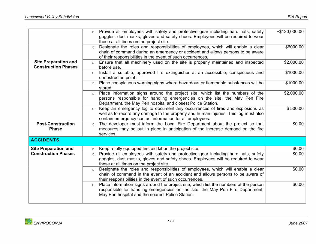
TABLE III: SUMMARY OF HAZARD IMPACT ASSESSMENT MITIGATION MEASURES HAZARD MITIGATION MEASURES COST
TECHNOLOGICAL HAZARDS o Keep a fully equipped first aid kit on the project site. $2000.00
Lancewood Valley Subdivision EIA Report
ENVIROCONJA June 2007
xvii
o Provide all employees with safety and protective gear including hard hats, safety goggles, dust masks, gloves and safety shoes. Employees will be required to wear these at all times on the project site.
~$120,000.00
o Designate the roles and responsibilities of employees, which will enable a clear chain of command during an emergency or accident and allows persons to be aware of their responsibilities in the event of such occurrences.
$6000.00
o Ensure that all machinery used on the site is properly maintained and inspected before use.
$2,000.00
o Install a suitable, approved fire extinguisher at an accessible, conspicuous and unobstructed point.
$1000.00
o Place conspicuous warning signs where hazardous or flammable substances will be stored.
$1000.00
o Place information signs around the project site, which list the numbers of the persons responsible for handling emergencies on the site, the May Pen Fire Department, the May Pen hospital and closest Police Station.
$2,000.00
Site Preparation and Construction Phases
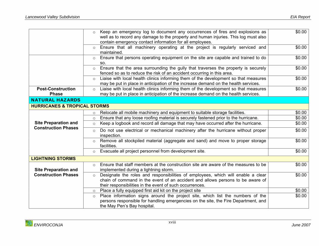
o Keep an emergency log to document any occurrences of fires and explosions as well as to record any damage to the property and human injuries. This log must also contain emergency contact information for all employees.
$ 500.00
Post-Construction Phase
o The developer must inform the Local Fire Department about the project so that measures may be put in place in anticipation of the increase demand on the fire services.
$0.00
ACCIDENTS
o Keep a fully equipped first aid kit on the project site. $0.00 o Provide all employees with safety and protective gear including hard hats, safety
goggles, dust masks, gloves and safety shoes. Employees will be required to wear these at all times on the project site.
$0.00
o Designate the roles and responsibilities of employees, which will enable a clear chain of command in the event of an accident and allows persons to be aware of their responsibilities in the event of such occurrences.
$0.00
Site Preparation and Construction Phases
o Place information signs around the project site, which list the numbers of the person responsible for handling emergencies on the site, the May Pen Fire Department, May Pen hospital and the nearest Police Station.
$0.00
Lancewood Valley Subdivision EIA Report
ENVIROCONJA June 2007
xviii
o Keep an emergency log to document any occurrences of fires and explosions as well as to record any damage to the property and human injuries. This log must also contain emergency contact information for all employees.
$0.00
o Ensure that all machinery operating at the project is regularly serviced and maintained.
$0.00
o Ensure that persons operating equipment on the site are capable and trained to do so.
$0.00
o Ensure that the area surrounding the gully that traverses the property is securely fenced so as to reduce the risk of an accident occurring in this area.
$0.00
o Liaise with local health clinics informing them of the development so that measures may be put in place in anticipation of the increase demand on the health services.
$0.00
Post-Construction Phase
o Liaise with local health clinics informing them of the development so that measures may be put in place in anticipation of the increase demand on the health services.
$0.00
NATURAL HAZARDS HURRICANES & TROPICAL STORMS
o Relocate all mobile machinery and equipment to suitable storage facilities. $0.00 o Ensure that any loose roofing material is securely fastened prior to the hurricane. $0.00 o Keep a logbook and record all damage that may have occurred after the hurricane. $0.00 o Do not use electrical or mechanical machinery after the hurricane without proper
inspection. $0.00
o Remove all stockpiled material (aggregate and sand) and move to proper storage facilities.
$0.00
Site Preparation and Construction Phases
o Evacuate all project personnel from development site. $0.00
LIGHTNING STORMS o Ensure that staff members at the construction site are aware of the measures to be
implemented during a lightning storm. $0.00
o Designate the roles and responsibilities of employees, which will enable a clear chain of command in the event of an accident and allows persons to be aware of their responsibilities in the event of such occurrences.
$0.00
o Place a fully equipped first aid kit on the project site $0.00
Site Preparation and Construction Phases
o Place information signs around the project site, which list the numbers of the
persons responsible for handling emergencies on the site, the Fire Department, and the May Pen’s Bay hospital.
$0.00
Lancewood Valley Subdivision EIA Report
ENVIROCONJA June 2007
xix
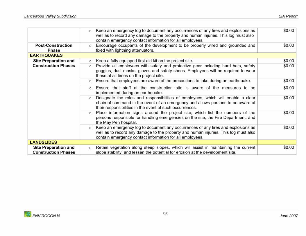
o Keep an emergency log to document any occurrences of any fires and explosions as well as to record any damage to the property and human injuries. This log must also contain emergency contact information for all employees.
$0.00
Post-Construction Phase
o Encourage occupants of the development to be properly wired and grounded and fixed with lightning attenuators.
$0.00
EARTHQUAKES o Keep a fully equipped first aid kit on the project site. $0.00 o Provide all employees with safety and protective gear including hard hats, safety
goggles, dust masks, gloves and safety shoes. Employees will be required to wear these at all times on the project site.
$0.00
o Ensure that employees are aware of the precautions to take during an earthquake. $0.00 o Ensure that staff at the construction site is aware of the measures to be
implemented during an earthquake. $0.00
o Designate the roles and responsibilities of employees, which will enable a clear chain of command in the event of an emergency and allows persons to be aware of their responsibilities in the event of such occurrences.
$0.00
o Place information signs around the project site, which list the numbers of the persons responsible for handling emergencies on the site, the Fire Department, and the May Pen hospital.
$0.00
Site Preparation and Construction Phases
o Keep an emergency log to document any occurrences of any fires and explosions as well as to record any damage to the property and human injuries. This log must also contain emergency contact information for all employees.
$0.00
LANDSLIDES Site Preparation and Construction Phases
o Retain vegetation along steep slopes, which will assist in maintaining the current slope stability, and lessen the potential for erosion at the development site.
$0.00

Lancewood Valley Subdivision EIA Report
ENVIROCONJA June 2007
1
1. INTRODUCTION Mr. Ernest McFarlane, the owner of the Lancewood property, has proposed to subdivide
90 acres ~ 36.4 hectares of land known as Part of Lancewood Valley, Clarendon into
one hundred and twenty (121) housing lots. An environmental permit application was
submitted to the National Environment and Planning Agency (NEPA) for consideration,
and based on the screening of this application, an Environmental Impact Assessment
(EIA) was requested by the Agency.
This report aims to present the assessment criteria, the methodologies for the
assessments, the identification of the possible impacts of the project, analyse project
alternatives, recommend mitigation measures for all impacts identified (See Appendix I
for the Terms of Reference (TOR) issued by NEPA for the conduct of the EIA) and to
give an outline of a environmental monitoring plan for the development.
The objectives of this EIA are as follows:
o To describe the proposed development project;
o To describe the legislative and regulatory considerations associated with the
project;
o To describe the present status of the environment on the project site;
o To describe the present status of the socio-economic attributes of the project
site;
o To identify and predict any potential positive, negative, reversible, irreversible
short and long term impacts, as well as any cumulative environmental and socio-
economic impacts that may arise from the project;
o To assess the hazards associated with the development;
o To facilitate mitigation of possible negative impacts caused by the proposed
development;
o To recommend measures to enhance any positive impacts identified;
o To outline possible alternatives to the project; and
o To outline a suitable environmental management and monitoring plan for the
duration of the project.

Lancewood Valley Subdivision EIA Report
ENVIROCONJA June 2007
2
1.1 STRUCTURE OF THE REPORT The report is divided into eleven (11) sections including the introductory chapter.
Section 2 of the report provides a description of the project including location and
description of activities. This is followed by Section 3, which presents an overview of all
the pertinent laws and regulations that must be considered for this type of development
activity. Sections 4 and 5 provide a description of the current Socio-Economic and
Environment attributes of the study area respectively. All the suitable alternatives to the
project design are presented in Section 6. In Sections 7, 8 and 9 the environmental,
socio-economic and hazard impacts are analysed and mitigation measures presented.
Section 10 provides an overview of the conclusions and recommendations made. A
draft-monitoring plan for the development is presented in Section 11. This is followed
by the Bibliography in Section 12 and the Appendices in Section 13.
Lancewood Valley Subdivision EIA Report
ENVIROCONJA June 2007
3
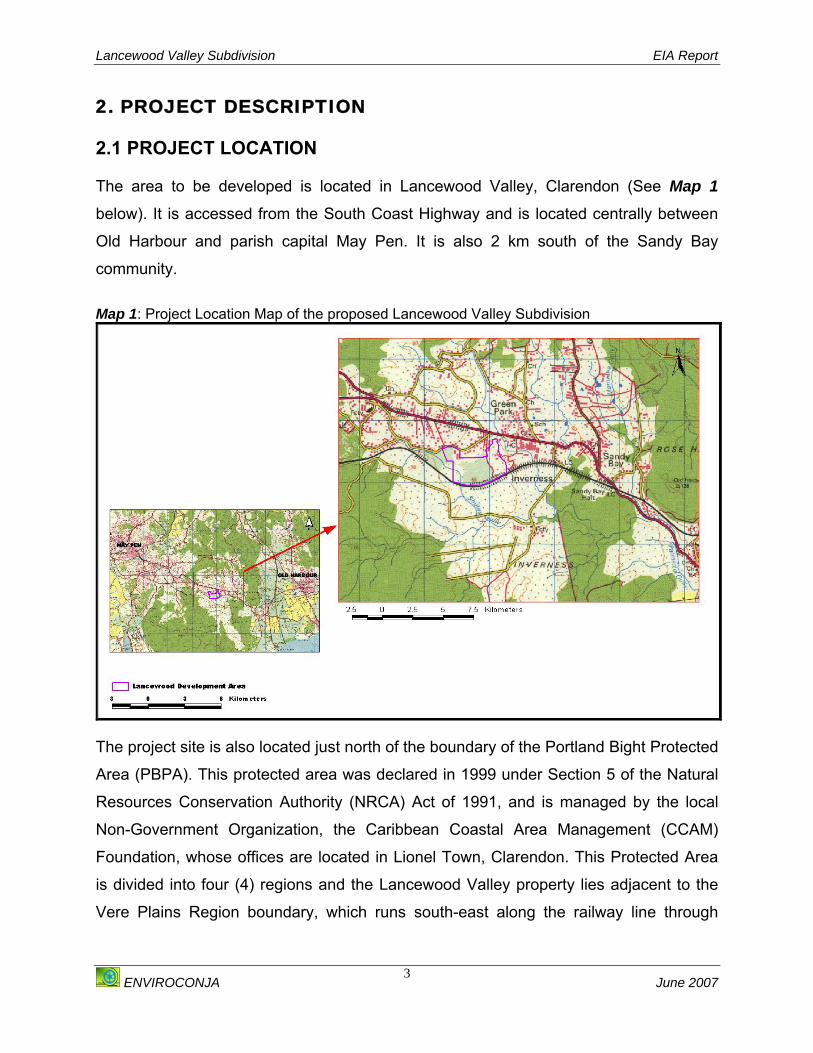
2. PROJECT DESCRIPTION 2.1 PROJECT LOCATION The area to be developed is located in Lancewood Valley, Clarendon (See Map 1
below). It is accessed from the South Coast Highway and is located centrally between
Old Harbour and parish capital May Pen. It is also 2 km south of the Sandy Bay
community.
Map 1: Project Location Map of the proposed Lancewood Valley Subdivision
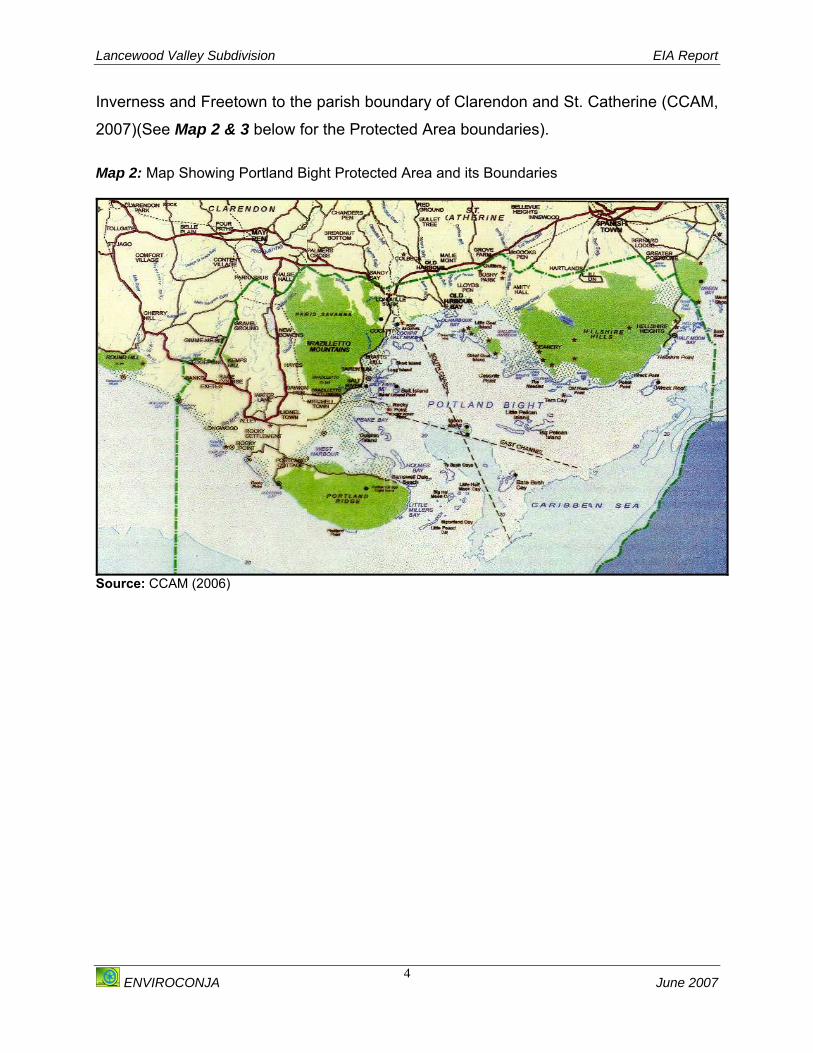
The project site is also located just north of the boundary of the Portland Bight Protected
Area (PBPA). This protected area was declared in 1999 under Section 5 of the Natural
Resources Conservation Authority (NRCA) Act of 1991, and is managed by the local
Non-Government Organization, the Caribbean Coastal Area Management (CCAM)
Foundation, whose offices are located in Lionel Town, Clarendon. This Protected Area
is divided into four (4) regions and the Lancewood Valley property lies adjacent to the
Vere Plains Region boundary, which runs south-east along the railway line through
Lancewood Valley Subdivision EIA Report
ENVIROCONJA June 2007
4
Inverness and Freetown to the parish boundary of Clarendon and St. Catherine (CCAM,
2007)(See Map 2 & 3 below for the Protected Area boundaries). Map 2: Map Showing Portland Bight Protected Area and its Boundaries
Source: CCAM (2006)
Lancewood Valley Subdivision EIA Report
ENVIROCONJA June 2007
5
Map 3: Map showing the location of the Lancewood Subdivision in respect of Portland Bight Protected Area
2.2 HISTORY OF THE SITE The Lancewood Valley has been in use for some time, but to a large extent has
remained undeveloped. Discussions with the developer and residents from the
surrounding communities showed that the primary land use of the site for the past fifty
(50) years has been for agricultural purposes, namely cattle rearing.
The current owner acquired the property in the late nineteen seventies and used the
area as grazing pastures for cattle and goats. This activity was discontinued however
due to the frequent occurrence of praedial larceny as well as the low financial returns
from this activity.
Lancewood Valley Subdivision
Train Line: PA Boundary
Portland Bight Protected Area

Lancewood Valley Subdivision EIA Report
ENVIROCONJA June 2007
6
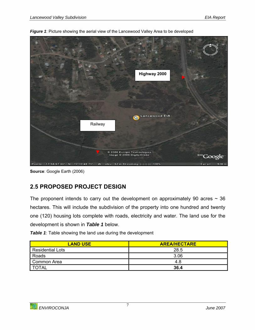
2.3 DESCRIPTION OF THE AREA TO BE DEVELOPED AND CURRENT LAND USE The portion of Lancewood Valley earmarked for the development is currently an
undeveloped, mostly flat parcel of land with few areas with gently sloping gradients. The
site is bordered by a small settlement on its northern border and a number of
residences to the northwest and north-northwest borders. To the east of the property is
Highway 2000, and to the south is a railway that is traversed by JAMALCO’s Bauxite
freight train (See Figure 1 below). (Reservations have been made for these two areas
on the proposed development plan) Three homes have been built on the property and
are currently occupied; these are situated on lots 7, 18 and 19 (See Appendix II). There
is a crude pathway that vehicles can use to the very north of the property. Although one
small section of the property showed evidence of use for charcoal burning this practice
was not observed during the reconnaissance visits. Goats were also seen grazing on
the property; these do not belong to the developer but enter the property through
pathways from nearby fields in the community.
2.4 PURPOSE OF THE DEVELOPMENT The purpose of the development is to provide much needed housing alternatives to the
Clarendon region, which in recent years has been ever expanding. In addition the
project aims to promote community growth and development of Lancewood Valley and
its surrounding communities, while providing economic gain for all stakeholders
involved.
Lancewood Valley Subdivision EIA Report
ENVIROCONJA June 2007
7
Figure 1: Picture showing the aerial view of the Lancewood Valley Area to be developed
Source: Google Earth (2006)
2.5 PROPOSED PROJECT DESIGN The proponent intends to carry out the development on approximately 90 acres ~ 36
hectares. This will include the subdivision of the property into one hundred and twenty
one (120) housing lots complete with roads, electricity and water. The land use for the
development is shown in Table 1 below. Table 1: Table showing the land use during the development
LAND USE AREA/HECTARE Residential Lots 28.5 Roads 3.06 Common Area 4.8 TOTAL 36.4
Highway 2000
Railway
Lancewood Valley Subdivision EIA Report
ENVIROCONJA June 2007
8
2.5.1 RESIDENTIAL LOTS The activities will involve the clearing and grading of land and subsequently the
subdivision of the property into one hundred and twenty one (121) lots. These lots will
range from 1,039 square meters to 11,190.09 square meters.
2.5.2 ROADS AND INFRASTRUCTURE Access roads and other infrastructure including electricity and water supply will be
implemented in the development.
2.5.3 MINERAL NEEDS The construction of the development will require the following raw materials for
construction: cement, aggregate (fine and coarse) and sand for the construction.
2.5.4 WATER SUPPLY AND DEMAND Water for the development will be sourced from a well located in Twin Palms, which is
operated by the National Water Commission (NWC). This well has a licence to abstract
4,524,000 litres of water per day.
It is anticipated that three (3) and four (4) bedroom houses will be constructed at the site
which will accommodate four (4) to eight (8) persons per household. It is estimated that
the water use per person is approximately 230 litres per day (EHU, 2005). Therefore the
approximate water demand for each household will range from 1380 litres to 1840 litres.
Approximate daily water consumption for the entire development will range from
166,980 – 222,640 litres.
2.5.5 SEWAGE TREATMENT AND DISPOSAL SYSTEM Based on recommendations of the Environmental Health Unit (EHU), Ministry of Health
sewage treatment should be at least to a secondary level. Volume 4: Guidelines for
Wastewater and Excreta Treatment, (2006) recommends that a sewage treatment
design comprising of a Septic Tank/Tile Field is an appropriate method of treatment of
sewage. These guidelines however stipulate that a minimum area of 560 m2 is required
Lancewood Valley Subdivision EIA Report
ENVIROCONJA June 2007
9
for the construction of this system. The lots to be developed at the Lancewood Valley
subdivision range 1039 m2 to 11,190.09 m2. These lots sizes are therefore sufficient for
onsite construction of the Septic Tank/ Tile Field sewage treatment design for each
housing lot.
Estimating that there will be 95 % wastewater, based on water consumption, each
onsite system (Septic Tank/Tile Field) should be built to facilitate the maximum of
approximately 1500 litres of wastewater per day for three (3) bedroom houses and 2000
litres for four (4) bedroom houses.
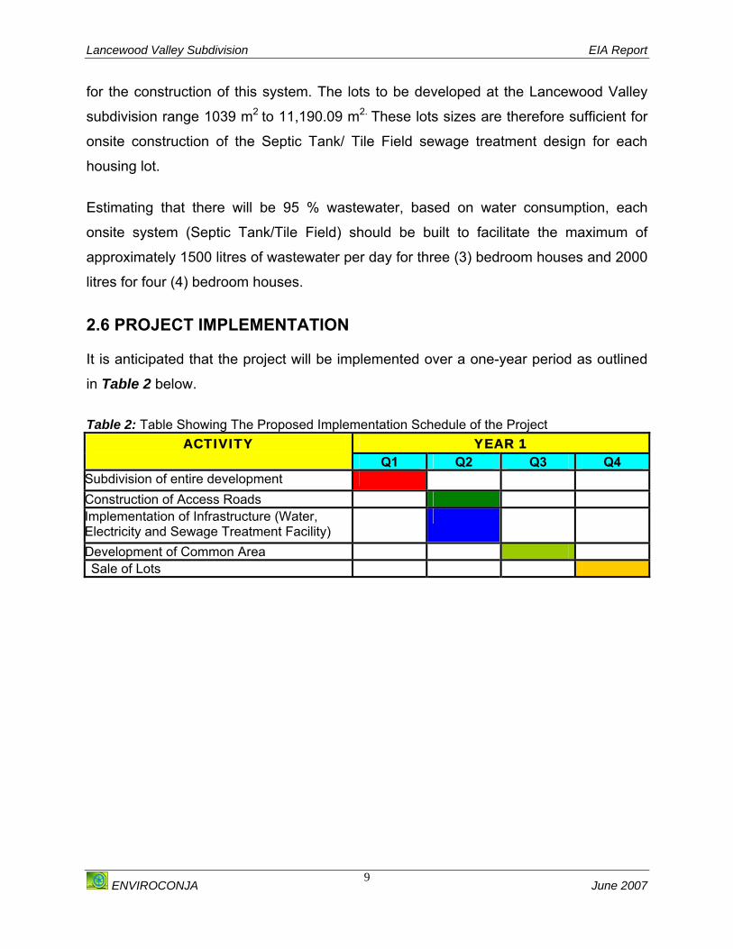
2.6 PROJECT IMPLEMENTATION It is anticipated that the project will be implemented over a one-year period as outlined
in Table 2 below.
Table 2: Table Showing The Proposed Implementation Schedule of the Project
YEAR 1 ACTIVITY Q1 Q2 Q3 Q4
Subdivision of entire development Construction of Access Roads Implementation of Infrastructure (Water, Electricity and Sewage Treatment Facility)
Development of Common Area Sale of Lots
Lancewood Valley Subdivision EIA Report
ENVIROCONJA June 2007
10
3. POLICY LEGAL AND ADMINISTRATIVE FRAMEWORK There are a number of pertinent laws relating to environmental protection that are
applicable to any development and that a developer will need to be aware of when
embarking on a particular type of development. There are also several statutory
agencies that have powers to control certain types of development that have the
potential to affect the environment. These powers of control are typically exercised
through a system of permits that include checks and balances on what kind and form of
development can occur. A developer therefore must be prepared to present, explain,
and in some cases alter an aspect of a proposal in order to comply with the permitting
requirements.
This section is therefore intended as a guide to the relevant permitting requirements that
deal with the environmental impacts of this proposed development and the agencies to
which they relate as well as to present other legislation and regulations, which are
applicable to the development.
3.1 JAMAICAN LAWS AND REGULATIONS 3.1.1 NATIONAL ENVIRONMENT AND PLANNING AGENCY (NEPA) The National Environment and Planning Agency (NEPA) is the starting point for
obtaining permits in relation to the environment. It is an amalgam of three (3) separate
bodies. These are the:
o Natural Resources Conservation Authority (NRCA);
o Town Planning Authority (TPA) and;
o Land Development and Utilisation Commission (LDUC).
The LDUC is not currently an active body and will not be addressed.

Lancewood Valley Subdivision EIA Report
ENVIROCONJA June 2007
11
3.1.1.1 The Natural Resources Conservation Authority (NRCA) Act (1991) The Natural Resources Conservation Authority (NRCA) operates under the NRCA Act
of 1991, which gives the Authority the overriding responsibility for managing “the
physical environment of Jamaica so as to ensure the conservation, protection and
proper use of its natural resources”. In order to do this, it gives the NRCA power, among
other things, to require a permit for developments that fall into prescribed categories as
outlined in Section 9 of the Act, which states:
“‘(2) Subject to provisions of this Section and Section 31, no person shall undertake in a prescribed area any enterprise construction or development of a prescribed description or category except under and in accordance with a permit issued by the Authority ‘(3) Any person who proposes to undertake in a prescribed area any enterprise, construction or development of a prescribed description or category for and manner to the Authority for and such application shall be accompanied by the prescribed fee……. 3.1.1.2 The Natural Resources (Permit and Licence) Regulations (1995) In 1995 the then Natural Resources Conservation Authority (NRCA) promulgated the
Natural Resources (Permit and Licence) Regulations 1995, which was since amended
in 2004. Pursuant to these regulations is a list of the prescribed categories of
developments. The categories that are applicable to this development include:
Development projects:
o Subdivisions of 10 lots or more
o Housing projects consisting of 10 houses
o Water treatment facilities including water supply, desalination plants, sewage and
industrial waste water
Separate permit applications are required for each, that is, a permit to subdivide a
property will be separate from a permit to construct a sewage plant even if it is for the
same development.

Lancewood Valley Subdivision EIA Report
ENVIROCONJA June 2007
12
It is important to note that although a permit may be issued to construct, this is separate
from planning permits issued under the Town and Country Planning Act by the Town
Planning Authority or by the Clarendon Parish Council. It is also important to note that
planning permits cannot substitute for environmental permits or vice versa.
i The Permitting Process
Developers who apply to the NRCA may be required to conduct an Environmental
Impact Assessment (EIA) if the NRCA considers that the project has a potential to be or
is in fact injurious to the natural environment. This is in accordance with Section 10 of
the NRCA Act, which states:
“Subject to the provisions of this section the Authority may by notice in writing require an application for a permit of the person responsible for undertaking in a prescribed area, any enterprise, construction or development of a prescribed description or category (a) To furnish to the Authority such documents or information as the Authority thinks fit; (b) Where it is of the opinion that the activities of such enterprise, construction or development are having or are likely to have an adverse effect on the environment, to submit to the Authority in respect of the enterprise, construction or development, and environmental impact assessment containing such information as may be prescribed And the applicant or, as the case may be, the person responsible shall comply with the requirement…” The contents of this EIA are determined by the Terms of Reference (TOR) approved by
NEPA (See Appendix I) and the will include the likely effects the development will have
on the environment as well as measures to reduce or otherwise mitigate negative
effects.
Copies of the documents are placed in public areas such as public libraries, post offices
or police stations so that interested stakeholders can view it. NRCA/NEPA may also
request the developer to host a public meeting to discuss the contents of the EIA.
“Guidelines for Conducting Public Presentations” have been produced which can be
used if a public consultation meeting has been requested.

Lancewood Valley Subdivision EIA Report
ENVIROCONJA June 2007
13
When considering permits, the NRCA is constrained by law to consult other government
agencies that have interest in environmental issues (for example, water resources)
when making its decisions as stated in Section 9 (5) of the NRCA Act which states:
“(5) In considering an application made under subsection (3) the Authority (a) Shall consult with any agency or department of Government exercising functions in connection with the environment.” Other agencies must also be minded to consider the NRCA’s position on an issue, so
that reference to plans for water use, drainage and other features will usually be made
to and from these relevant agencies, some of which are discussed below.
ii. The Environmental Permit Once an environmental permit is issued it is to be displayed on the site. This permit is
subject to terms and conditions which, if not followed, can result in enforcement action
being taken according to the NRCA Act Section 18, which states:
“ ……………… Where it appears to the Authority that the activities of an undertaking in any area are such to pose a serious threat to the natural resources or to public health, the Authority may serve on the person who appears to have carried out or to be carrying out the activity, a notice (hereinafter referred to as an enforcement notice…” This may include the suspension or revocation of the permit as outlined in Section 11 of
the NRCA Act, which states:
“ The Authority may by notice addressed to the person to whom a permit was issued revoke or suspend the permit if it is satisfied that there has been a breach of any term or condition subject to which the permit was granted, or if such person fails or neglects to submit to the Authority …. Any documents, information or assessment required there-under.” The developer may appeal to the Minister responsible for environment matters against
any term or condition of a permit, or against the refusal to grant one.

Lancewood Valley Subdivision EIA Report
ENVIROCONJA June 2007
14
iii. Environmental Permit and Licence to Discharge In addition to the permit to build, the developer will have to apply for a licence if he
intends to discharge any effluent including sewage or other wastewater (except for
agricultural purposes), pursuant to section 12 NRCA Act which states:
“(1) Subject to the provisions in this section, no person shall- (a) Discharge on or cause or permit the entry into waters, on the ground or into the ground of any sewage or trade effluent or any poisonous, noxious or polluting matter or (b) Construct, reconstruct or alter any works for the discharge of any sewage or trade effluent or any poisonous, noxious or polluting matter.” 3.1.1.3 The Town and Country Planning Act (1958) The Town Planning Authority (TPA) is mandated to issue planning permits under the
Town and Country Planning Act. Local Parish Councils in the area the development is
intended to be located may also issue planning permission. Applications are usually
made to the Parish Councils but on some occasions they are considered by the TPA.
Planning permission is required for any activity that is classified as “development” under
the Act which is defined as “the carrying out of building, engineering, mining or other
operations in, on, over or under land, or the making of any material change in the use of
any buildings or other land.”
The kind of activity proposed must be one that is allowable under the relevant
Development Order (DO) for the parish. The Development Order for Clarendon was
published in 1982. This DO sets out the medium and long-term development plan for
the parish and provides guidance as to how development in the Parish should proceed.
DOs also authorize the carrying out of certain types of activities without the need for a
planning permit.
i. The Permitting Process
It is important to note that no development that is a “prescribed category” under the
NRCA Act will receive a planning permit unless it first receives an environmental
(NRCA) permit.
Lancewood Valley Subdivision EIA Report
ENVIROCONJA June 2007
15
ii. The Permit A planning permit will also have its own terms and conditions set out. Planning
Permission is to be sought by the developer for the construction of the prefabricated
units, while individual lot owners will have to apply for individual planning permission
from the local Parish Council. Additional approval of some sort will be needed for any
activity that is a variant of what is set out in the permit. The applicant may appeal to the
Minister responsible for Planning against the refusal of a permit or to its terms and
conditions.
3.1.2 THE LOCAL IMPROVEMENTS ACT Apart from planning permission, the Clarendon Parish Council also administers the
Local Improvements Act, which requires developers to apply for permission to subdivide
lots for sale or residential purposes. Developers are required by section 5 of that Act to
deposit maps with the Council that show to scale the streets and ways to be formed and
laid out, as well as the street works. That is, location and dimension of sewers, water
pipes, gas pipes and lighting mains. If necessary, the developer may have to have
these confirmed by a Commissioned Surveyor.
The developer will have to confirm application fees with the parish council but a guide is
that subdivisions of over one hundred (100) lots may be charged at a rate of 0.4% of the
value of the land and the cost of the infrastructure development. Normally half is paid on
application and half on grant of the subdivision approval. The Council can also allow a
fee payment schedule if the development is expected to take more than eighteen (18)
months.
3.1.3 LAND ACQUISITION ACT (1947) The Land Acquisition Act of 1947 is administered by the ministry responsible for the
management of Crown Lands. Section 3 of the Act empowers any officer authorised by
the Minister to enter and survey land in any area that is deemed to be required for
public purpose. This officer may dig or bore the soil, cut any standing crops, bush or

Lancewood Valley Subdivision EIA Report
ENVIROCONJA June 2007
16
woodland and remove any fences and carry out any other activities, which may be
necessary to determine the suitability of the land.
Section 5 of this Act authorises the Minister to publicly declare that an area is required
for public purpose. The Minister will then instruct the Commissioner of Lands to take
proceedings to acquire the land, which will include negotiations for purchase of the land.
If no agreement can be reached within a reasonable time the Commissioner will invite
all interested parties to present in writing their interests in the land and the amount and
particulars of their claims to compensation.
On the day specified, the Commissioner will enquire into the value of land and the
interests of persons claiming compensation and will make an award as to the true area
of the land, the compensation for the land and the apportionment of the compensation
to the persons interested. If the party or parties are still dissatisfied with the
compensation presented the matter may be brought before the Supreme Court.
3.1.4 THE REGISTRATION OF TITLES ACT (1989) The Registration of Titles Act was promulgated in 1989. Under this Act all registered
titles are evidence of ownership, which is guaranteed by the Government of Jamaica.
The system used for the registration of titles in Jamaica is similar to the Australian
Torrens System of land registration. Registration in Jamaica is however not compulsory.
Once a parcel of land has been registered, all subsequent transfers must be made
under the Act.
3.1.5 HOUSING ACT (1968) The Housing Act (1968) is administered by the Ministry of Housing and guides the
Ministry in the procedures to be employed for the acquisition of land required for
housing schemes, the approval of these housing schemes and the completion of
schemes by housing associations. Section 9 of the Act outlines that before a scheme is
approved the specifications and particulars of the proposed housing scheme including

Lancewood Valley Subdivision EIA Report
ENVIROCONJA June 2007
17
information relating to the roads, water supply, sewerage and lighting will be furnished
to the Local Authority within whose area the scheme is being proposed.
Before considering the approval of a scheme, the Minister must consider any objections
or representations made to him in pursuance of Section 9 and shall afford the Local
Authority to make such objections or representations an opportunity to be heard.
3.1.6 WATERSHED PROTECTION ACT (1963) The Watershed Protection Act is also administered by the National Environment and
Planning Agency (NEPA). This Act provides for the designation of watersheds for
conservation purposes, to reduce soil erosion, ensure regular flow in rivers and
streams, maintain optimum levels of groundwater, and encourage proper land use to
protect watershed recharge. All Jamaica's watersheds have been designated as
protected under this act.
3.1.7 WILDLIFE PROTECTION ACT (1945)
Under the Wildlife Protection Act (1945), it is illegal to remove, sell or have in ones
possession a protected animal, use dynamite or other poisonous or noxious material to
kill or injure fish, discharge or empty waste or industrial effluent into harbours, lagoons,
estuaries, and streams.
This Act is administered by the National Environment and Planning Agency (NEPA) and
authorises the establishment of Game Sanctuaries and Reserves.
3.1.8 THE COUNTRY FIRES ACT (1942) The land for the development will have to be cleared and therefore the developer may
use fire as a means of clearing the land. The Ministry of Agriculture administers the
Country Fires Act of 1942. Under this Act it is an offence to:
o Set fire to trash without serving an officer of the nearest police station with notice
or clearing open space around trash.
o Set fire to trash between 6 p.m. and 6 a.m.
o Leave open –air fire unattended.
Lancewood Valley Subdivision EIA Report
ENVIROCONJA June 2007
18
o Failure by occupier of land to take responsible steps to extinguish fire on his
land.
o Set a fire contrary to order or permit. 3.1.9 SOLID WASTE MANAGEMENT AUTHORITY ACT (2001) The Solid Waste Management Authority Act was enacted in 2001 and gives the
National Solid Waste Management Authority (NSWMA) jurisdiction over the disposal of
solid waste in Jamaica. Under this Act it is illegal to:
o Dispose of solid waste in an unauthorised way or manner.
o Operate a solid waste disposal facility or to collect, transfer/manage solid waste
without a licence/certificate.
o Throw or deposit litter in a public place.
o Throw or deposit litter on another’s premises without consent. 3.1.10 THE CLEAN AIR ACT (1964) The Clean Air Act (1964) refers to developments where there are industrial works,
which in the opinion of an inspector is likely to result in the discharge of smoke, fumes,
gases or dust into the air. Under this Act, an inspector has the power to inspect or
examine premises where work is being carried out, take samples or make enquiries with
respect to these premises.
3.1.11 THE PUBLIC HEALTH NUISANCE REGULATIONS (1995) The Public Health Nuisance regulations are administered by the Ministry of Health in
Jamaica and were brought into force in 1995. Under these regulations, it is an offence if
an individual fails to abate a nuisance or fails to perform such an act to prevent the
reoccurrence of a nuisance. A nuisance under the regulations is defined as:
o A building or structure which is or likely to become a health hazard due to
structural defects or unsanitary conditions.
o Premises or other places where unsanitary conditions are present or are likely to
become a health hazard.

Lancewood Valley Subdivision EIA Report
ENVIROCONJA June 2007
19
o Accumulation or deposit of solid waste, human or animal excreta.
o Dust, smoke, fumes, gases or effluvia emitting from any manufacturing process
or caused from trade or business.
o Lack of water or water supply system.
o Water supply that is not maintained in a sanitary condition.
o Discharge of sewage, industrial waste or any other noxious matter into the sea or
any watercourse or unto any land.
3.2 INTERNATIONAL CONVENTIONS AND REGULATIONS 3.2.1 CONVENTION ON BIOLOGICAL DIVERSITY (CBD) (1993) The Convention on Biological Diversity (CBD) was negotiated under the auspices of the
United Nations Environment Programme and entered into force in 1993. The three
goals of the CBD are to (CBD, 2006):
o Promote the conservation of biodiversity. o Sustainable use of its components.
o The fair and equitable sharing of benefits arising out of the utilization of genetic
resources.
To date over one hundred and seventy (170) countries have signed the agreement.
Jamaica became signatory in 1995. As a signatory to the CBD Jamaica is obliged to:
o Develop national strategies, plans or programmes for the conservation and
sustainable use of biological diversity or adapt for this purpose existing
strategies, plans or programmes which shall reflect, inter alia, the measures set
out in this Convention relevant to the Contracting Party concerned; and
o Integrate, as far as possible and as appropriate, the conservation and
sustainable use of biological diversity into relevant sectoral or cross-sectoral
plans, programmes and policies.

Lancewood Valley Subdivision EIA Report
ENVIROCONJA June 2007
20
4. DESCRIPTION OF THE ENVIRONMENTAL SETTING This section of the report provides an overall description of the various elements
including the physical and biological characteristics of the environment. It also presents
the methodologies employed in conducting the baseline assessment for each area as
well as the results and observations from these assessments.
4.1 PHYSICAL ENVIRONMENT 4.1.1 CLIMATE Methodology The data presented in this section was collected by secondary research. The National
Meteorological Service of Jamaica has collected a plethora of climate data for the
island. The closest meteorological research centre to the proposed subdivision is the
Bodles Research Centre, which is located approximately 7 km from the Lancewood
Valley area.
a. Rainfall The proposed site for development is located within the Rio Minho Watershed. The 30-
year mean for rainfall data collected at the Bodles meteorological station is shown in
Figure 2 below. The data shows that the average rainfall in the area ranges from a low
of 39 mm in January to a high of 201 mm in October.

Lancewood Valley Subdivision EIA Report
ENVIROCONJA June 2007
21
Figure 2: Graph showing the 30 Year Mean Rainfall for the Bodles Meteorological Station
0
50
100
150
200
250
JAN FEB MAR APR MAY JUN JUL AUG SEP OCT NOV DEC
Time/Months
Am
ount
of R
ainf
all/m
m
Source: National Meteorological Service, Jamaica (2006) b. Wind The island’s wind patterns are dominated by the Northeast Trade Winds. On the south
coast, wind patterns during the day have an east-south-easterly direction, with an
average speed of 33 km/h (18 knots). At night, these Trade Winds combine with land
breezes which blow offshore down the slopes of the hills near the coast. As a result the
wind patterns on the south coast have a northerly component, with a maximum speed of
13 km/hr (7 knots) during the night. Between June and July the wind speeds reach a
maximum of 48 km/hr (26 knots). These wind speeds decrease as you move further
inland.
Data from the Bodles research station shows that wind speeds in this area reach a
maximum of approximately 21 km/hr in June and a minimum of 10.2 km/hr in
December.

Lancewood Valley Subdivision EIA Report
ENVIROCONJA June 2007
22
c. Temperature
The temperatures recorded in the area are reflective of the southern coast of the island.
These temperatures range from a high of 32.4 ºC in July to a low of 16.9 ºC in January.
See Figure 3 below for the graph, which shows the mean temperatures recorded at the
Bodles Research centre.
Figure 3: Graph Showing the Temperature Ranges for the Bodles Research Station, Clarendon
0
5
10
15
20
25
30
35
JAN FEB MAR APR MAY JUN JUL AUG SEP OCT NOV DEC
Time/Months
Tem
pera
ture
/C
Max. T Min. T
Source: National Meteorological Service, Jamaica (2006) d. Relative Humidity The relative humidity recorded at the Bodles Research Center shows that the humidity
in this area is relatively constant throughout the year ranging from a low of 72 in July to
a high of 79 between September and October.
Lancewood Valley Subdivision EIA Report
ENVIROCONJA June 2007
23
4.1.2 AIR QUALITY The location of the proposed subdivision predisposes it to a determination of the air
quality in the area as it is adjacent to both Highway 2000, and the Jamaica Alumina
Company Ltd. (JAMALCO) train line which transports bauxite from the mines to the
processing plant located in Hayes, Clarendon. Given these factors it is important to
monitor air quality for possible pollutants. NO2 and SO2 were measured (as indicators of
NOx and SOx, respectively).
4.1.2.1 METHODOLOGY Passive air quality monitors were used to determine NO2 and SO2 concentrations in the
area. Passive monitors are relatively inexpensive and may provide estimates of the
annual mean concentrations of pollutants from monthly exposures (Morris and Therivel
2001).
Each monitor is composed of a vial capped at one end and which is open to the
atmosphere at the other. Each is fitted with metal gauze containing an adsorbent
specific to the pollutant, which is being monitored. These monitors were removed from
their plastic screw-capped containers and the date and time recorded; they were
attached with the coloured cap facing upward from a suitable, sturdy tree branch using
wire for support (See Figure 4 below). Monitors were placed at four (4) designated sites
on the property and the GPS coordinates for each site noted. Site 1 close proximity to
the highway, Site 3 close to the train line, and the other two sites, Sites 2 and 4, were
placed in central areas of the property. (See Appendix III) These monitors were
labelled and placed in duplicate at each site i.e. two each for NO2 and SO2. At the end
of the two-week sampling period, the container was replaced in the screw-capped
container and the date and time again recorded. These readings were taken to allow
calculation of the exposure time. Another set of monitors were placed in the same area
and the date and time recorded. These were left in the field for another two weeks. At
the end of the two-week period, the date and time were then recorded.
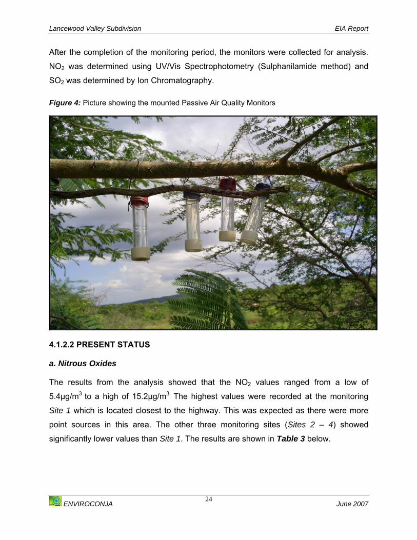
Lancewood Valley Subdivision EIA Report
ENVIROCONJA June 2007
24
After the completion of the monitoring period, the monitors were collected for analysis.
NO2 was determined using UV/Vis Spectrophotometry (Sulphanilamide method) and
SO2 was determined by Ion Chromatography. Figure 4: Picture showing the mounted Passive Air Quality Monitors
4.1.2.2 PRESENT STATUS a. Nitrous Oxides The results from the analysis showed that the NO2 values ranged from a low of
5.4μg/m3 to a high of 15.2μg/m3. The highest values were recorded at the monitoring
Site 1 which is located closest to the highway. This was expected as there were more
point sources in this area. The other three monitoring sites (Sites 2 – 4) showed
significantly lower values than Site 1. The results are shown in Table 3 below.
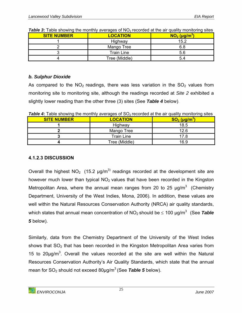
Lancewood Valley Subdivision EIA Report
ENVIROCONJA June 2007
25
Table 3: Table showing the monthly averages of NO2 recorded at the air quality monitoring sites SITE NUMBER LOCATION NO2 (μg/m3)
1 Highway 15.2 2 Mango Tree 6.8 3 Train Line 5.6 4 Tree (Middle) 5.4
b. Sulphur Dioxide
As compared to the NO2 readings, there was less variation in the SO2 values from
monitoring site to monitoring site, although the readings recorded at Site 2 exhibited a
slightly lower reading than the other three (3) sites (See Table 4 below). Table 4: Table showing the monthly averages of SO2 recorded at the air quality monitoring sites
SITE NUMBER LOCATION SO2 (μg/m3) 1 Highway 18.5 2 Mango Tree 12.6 3 Train Line 17.8 4 Tree (Middle) 16.9
4.1.2.3 DISCUSSION Overall the highest NO2 (15.2 μg/m3) readings recorded at the development site are
however much lower than typical NO2 values that have been recorded in the Kingston
Metropolitan Area, where the annual mean ranges from 20 to 25 μg/m3 (Chemistry
Department, University of the West Indies, Mona, 2006). In addition, these values are
well within the Natural Resources Conservation Authority (NRCA) air quality standards,
which states that annual mean concentration of NO2 should be ≤ 100 μg/m3 (See Table
5 below).
Similarly, data from the Chemistry Department of the University of the West Indies
shows that SO2 that has been recorded in the Kingston Metropolitan Area varies from
15 to 20μg/m3. Overall the values recorded at the site are well within the Natural
Resources Conservation Authority’s Air Quality Standards, which state that the annual
mean for SO2 should not exceed 80μg/m3 (See Table 5 below).
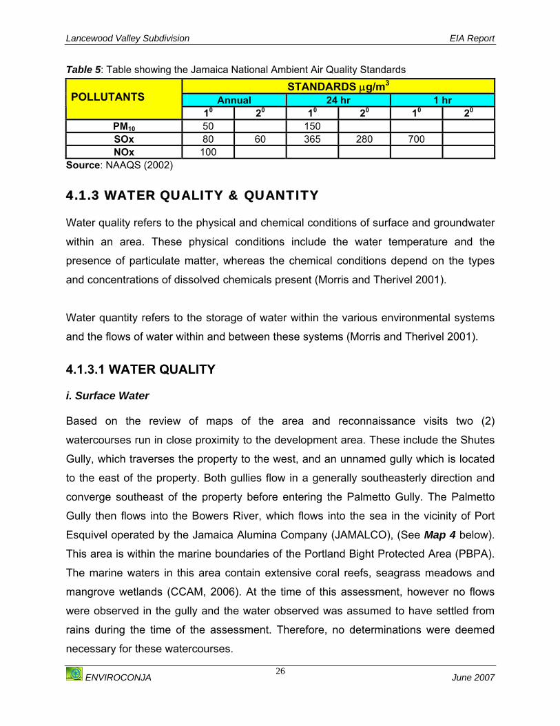
Lancewood Valley Subdivision EIA Report
ENVIROCONJA June 2007
26
Table 5: Table showing the Jamaica National Ambient Air Quality Standards
STANDARDS μg/m3 Annual 24 hr 1 hr POLLUTANTS
10 20 10 20 10 20 PM10 50 150 SOx 80 60 365 280 700 NOx 100
Source: NAAQS (2002) 4.1.3 WATER QUALITY & QUANTITY Water quality refers to the physical and chemical conditions of surface and groundwater
within an area. These physical conditions include the water temperature and the
presence of particulate matter, whereas the chemical conditions depend on the types
and concentrations of dissolved chemicals present (Morris and Therivel 2001).
Water quantity refers to the storage of water within the various environmental systems
and the flows of water within and between these systems (Morris and Therivel 2001).
4.1.3.1 WATER QUALITY i. Surface Water Based on the review of maps of the area and reconnaissance visits two (2)
watercourses run in close proximity to the development area. These include the Shutes
Gully, which traverses the property to the west, and an unnamed gully which is located
to the east of the property. Both gullies flow in a generally southeasterly direction and
converge southeast of the property before entering the Palmetto Gully. The Palmetto
Gully then flows into the Bowers River, which flows into the sea in the vicinity of Port
Esquivel operated by the Jamaica Alumina Company (JAMALCO), (See Map 4 below).
This area is within the marine boundaries of the Portland Bight Protected Area (PBPA).
The marine waters in this area contain extensive coral reefs, seagrass meadows and
mangrove wetlands (CCAM, 2006). At the time of this assessment, however no flows
were observed in the gully and the water observed was assumed to have settled from
rains during the time of the assessment. Therefore, no determinations were deemed
necessary for these watercourses.

Lancewood Valley Subdivision EIA Report
ENVIROCONJA June 2007
27
ii. Ground Water The analysis of the maps of illustrating the wells in Clarendon (Please see Map 5
below) shows that there are no wells within the vicinity of the proposed Lancewood
Valley subdivision. Enquiries with residents and the developer showed that the
Lancewood Valley community is supplied with water from a well located within the Twin
Palms development. This well is operated by the National Water Commission (NWC)
and is the proposed source of water supply for the development. Map 4: Map showing Rivers and Streams in Clarendon
Development
Shutes Gully
Palmetto Gully
Bowers River
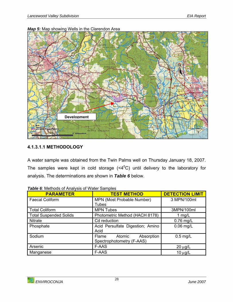
Lancewood Valley Subdivision EIA Report
ENVIROCONJA June 2007
28
Map 5: Map showing Wells in the Clarendon Area
4.1.3.1.1 METHODOLOGY
A water sample was obtained from the Twin Palms well on Thursday January 18, 2007.
The samples were kept in cold storage (<40C) until delivery to the laboratory for
analysis. The determinations are shown in Table 6 below. Table 6: Methods of Analysis of Water Samples
PARAMETER TEST METHOD DETECTION LIMITFaecal Coliform MPN (Most Probable Number)
Tubes 3 MPN/100ml
Total Coliform MPN Tubes 3MPN/100ml Total Suspended Solids Photometric Method (HACH 8178) 1 mg/L Nitrate Cd reduction 0.76 mg/L Phosphate Acid Persulfate Digestion; Amino
Acid 0.06 mg/L
Sodium Flame Atomic Absorption Spectrophotometry (F-AAS)
0.5 mg/L
Arsenic F-AAS 20 μg/L Manganese F-AAS 10 μg/L
Development

Lancewood Valley Subdivision EIA Report
ENVIROCONJA June 2007
29
4.1.3.1.2 PRESENT STATUS The results of the water quality analyses are shown in Table 7 below. Table 7: Water Quality Data for Twin Palms, Clarendon
PARAMETER Twin Palms WHO LIMIT Faecal Coliform (MPN) <3 Undetected Total Coliform (MPN) <3 Undetected
Total Suspended Solids (mg/L) 2 na Nitrate (mg/L) 3.52 50
Phosphate (mg/L) 1.67 na Sodium (mg/L) 13.9 20 Arsenic (μg/L) <10 10
Manganese (μg/L) <20 400 i. Total and Faecal Coliform Total and faecal coliform were undetected in the sample as required by the World
Health Organisation (WHO) Guidelines for Drinking Water Quality (3rd Edition, WHO,
2004).
ii. Total Suspended Solids Total Suspended Solids (TSS) in the sample was 2 mg/L. A health-based guideline has
not been established for TSS. The level present in the sample, however, would not
render the source unfit as a source of potable water.
iii. Nitrates Total Nitrate (NO3) was determined to be 3.52 mg/L, well below the WHO limit of 50
mg/L.
iv. Phosphates Phosphate (PO4) in the water sample was found to be 1.67 mg/L. No health-based
guideline has been issued by the WHO.
v. Sodium Sodium was determined to be 13.9 mg/L; the WHO suggests that potable water must
contain less than 20 mg/L.
Lancewood Valley Subdivision EIA Report
ENVIROCONJA June 2007
30
vi. Manganese and Arsenic Manganese and Arsenic were undetected, meeting the WHO limits of 400 and 10 μg/L
respectively. 4.1.3.1.3 DISCUSSION OF BASELINE ASSESSMENT The well located at Twin Palms currently supplies Lancewood Valley and its
surrounding communities with potable water and is constantly monitored for quality by
the National Water Commission (NWC). No local drinking water standards are available
for Jamaica and therefore the World Health Organisation (WHO) standards are those
that are used. Based on the results of the water quality analysis and comparison with
the WHO standards the proposed source of water for the Lancewood Valley
development is suitable for drinking and household use.
4.1.3.2 WATER QUANTITY
Water for the development will be sourced from a well located in Twin Palms, which is
operated by the National Water Commission (NWC). This well has a licence to abstract
4,524,000 litres of water per day.
It is anticipated that three (3) and four (4) bedroom houses will be constructed at the site
which will accommodate four (4) to eight (8) persons per household. It is estimated that
the water use per person is approximately 230 litres per day (EHU, 2005). Therefore the
approximate water demand for each household will range from 1380 litres to 1840 litres.
Approximate daily water consumption for the entire development will range from
166,980 – 222,640 litres.
The well located at Twin Palms has the generating capacity to supply the development
with water. The developer has been in discussion of the National Water Commission
with respect to this.

Lancewood Valley Subdivision EIA Report
ENVIROCONJA June 2007
31
4.1.4 GEOLOGY 4.1.4.1 METHODOLOGY Three (3) field days were used to make a geological assessment of the proposed
development site. Traverses were conducted to record the rock and soil types present.
An assessment of any geological hazards was made.
4.1.4.2 PRESENT STATUS i. Rock Formations
Units of the Newport Formation of the White Limestone Group chiefly underlie the
development area. The limestone beds of this unit are moderately indurated and are
fossiliferous (sometimes containing mollusc macrofossils in addition to the ubiquitous
microfossils). The beds are generally poorly exposed, but good surface exposures
occur in naturally formed drainage sites (notably Shutes Gully) and in other areas within
the proposed development borders that appear to have been used for very small-scale
surface mining. The beds of the Newport Formation have good drainage properties that
contribute to the lack of surface drainage within and in the general vicinity of the
development area. This, amongst other factors, contributes to the ecology of the dry
limestone hills of the Portland Bight Protected Area to the south.
ii. Faults No major faults were identified in the area based on the surface geology. One linear
feature can be identified on the satellite imagery, which coincides with the Shutes Gully.
It is possible that this gully developed along a minor fault. The absence of fault rocks in
the gully suggests that if this were a fault it is not one along which considerable
displacement has taken place.
The reconnaissance data suggests that the area does not have a considerable
thickness of superficial deposits. As such, the ground acceleration experienced in this
area during an earthquake would be less than that experienced on the alluvial plains
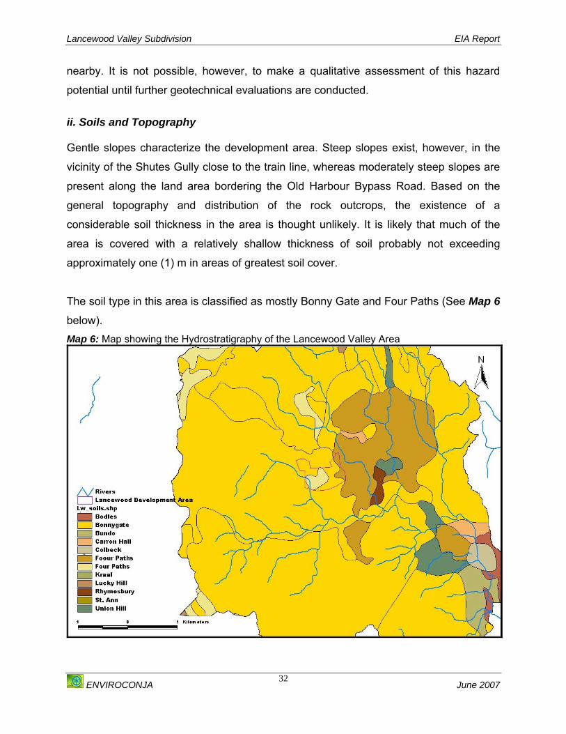
Lancewood Valley Subdivision EIA Report
ENVIROCONJA June 2007
32
nearby. It is not possible, however, to make a qualitative assessment of this hazard
potential until further geotechnical evaluations are conducted.
ii. Soils and Topography Gentle slopes characterize the development area. Steep slopes exist, however, in the
vicinity of the Shutes Gully close to the train line, whereas moderately steep slopes are
present along the land area bordering the Old Harbour Bypass Road. Based on the
general topography and distribution of the rock outcrops, the existence of a
considerable soil thickness in the area is thought unlikely. It is likely that much of the
area is covered with a relatively shallow thickness of soil probably not exceeding
approximately one (1) m in areas of greatest soil cover.
The soil type in this area is classified as mostly Bonny Gate and Four Paths (See Map 6
below). Map 6: Map showing the Hydrostratigraphy of the Lancewood Valley Area
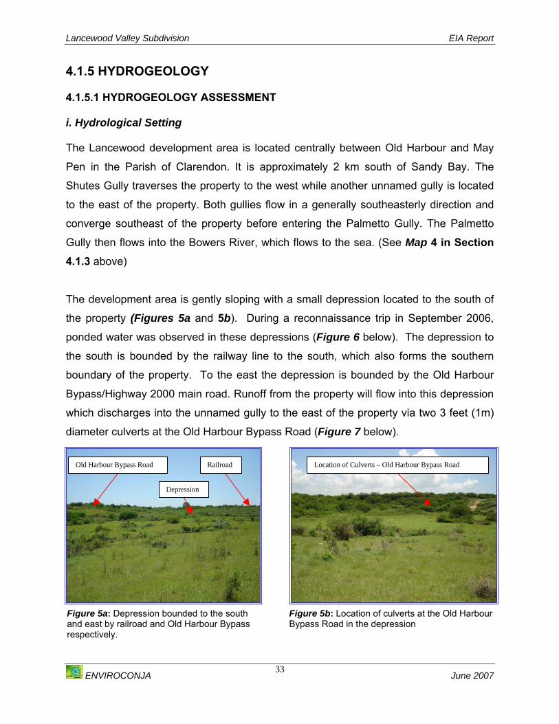
Lancewood Valley Subdivision EIA Report
ENVIROCONJA June 2007
33
4.1.5 HYDROGEOLOGY 4.1.5.1 HYDROGEOLOGY ASSESSMENT i. Hydrological Setting The Lancewood development area is located centrally between Old Harbour and May
Pen in the Parish of Clarendon. It is approximately 2 km south of Sandy Bay. The
Shutes Gully traverses the property to the west while another unnamed gully is located
to the east of the property. Both gullies flow in a generally southeasterly direction and
converge southeast of the property before entering the Palmetto Gully. The Palmetto
Gully then flows into the Bowers River, which flows to the sea. (See Map 4 in Section 4.1.3 above)
The development area is gently sloping with a small depression located to the south of
the property (Figures 5a and 5b). During a reconnaissance trip in September 2006,
ponded water was observed in these depressions (Figure 6 below). The depression to
the south is bounded by the railway line to the south, which also forms the southern
boundary of the property. To the east the depression is bounded by the Old Harbour
Bypass/Highway 2000 main road. Runoff from the property will flow into this depression
which discharges into the unnamed gully to the east of the property via two 3 feet (1m)
diameter culverts at the Old Harbour Bypass Road (Figure 7 below).
Figure 5a: Depression bounded to the south and east by railroad and Old Harbour Bypass respectively.
Old Harbour Bypass Road
Depression
Railroad
Figure 5b: Location of culverts at the Old Harbour Bypass Road in the depression
Location of Culverts – Old Harbour Bypass Road

Lancewood Valley Subdivision EIA Report
ENVIROCONJA June 2007
34
ii. Catchment Basin Boundary
The catchment basin in which the Lancewood Development Area is delineated in Map 7
below has an area of 46 km2. This catchment basin drains to the Palmetto Gully. The
basin boundaries were delineated from contours digitized from 1:12,500 scale
topographic maps produced by the Survey Department using the HEC-GeoHMS (ArcGIS
extension for HEC-HMS1 support) software developed by the US Army Corps of Engineers
and ArcGIS.
This catchment area is further sub-divided into thirteen (13) smaller sub-basins. The
proposed development area cuts across sub-basins 104 and 130 as shown in Map 7.
Sub-dividing the catchment into smaller sub-basins allows for runoff and flood impact
analysis of the proposed development to be analyzed in greater detail.
1 Hydrologic Engineering Center – Hydrologic Modeling System
Figure 6: Ponded water observed in thedepression during reconnaissance trip inSeptember 2006
Figure 7: Culverts at the Old Harbour Bypass Road in the depression
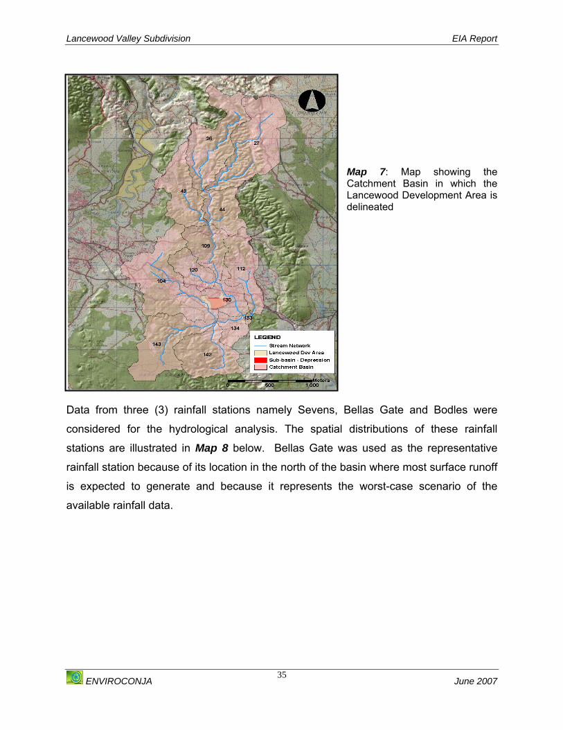
Lancewood Valley Subdivision EIA Report
ENVIROCONJA June 2007
35
Map 7: Map showing the Catchment Basin in which the Lancewood Development Area is delineated
Data from three (3) rainfall stations namely Sevens, Bellas Gate and Bodles were
considered for the hydrological analysis. The spatial distributions of these rainfall
stations are illustrated in Map 8 below. Bellas Gate was used as the representative
rainfall station because of its location in the north of the basin where most surface runoff
is expected to generate and because it represents the worst-case scenario of the
available rainfall data.

Lancewood Valley Subdivision EIA Report
ENVIROCONJA June 2007
36
Map 8: The Spatial Distribution of the Rainfall Stations in the Lancewood Valley Development Area.
Estimates of the maximum 24-hour rainfall at the stations for different return periods are
shown in Table 8 below. These were extracted from data published by the National
Meteorological Service of Jamaica. Table 8: Table showing the Maximum 24-hour rainfall for different return periods (T)
Maximum 24-hour Rainfall (mm) STATIONS
Return Periods
(T) (yrs) Sevens Bellas Gate Bodles 2 Years 100 140 94 5 Years 147 197 140
10 Years 178 251 170 25 Years 211 320 208 50 Years 247 371 236 100 Years 275 421 264
4.1.5.1.1 METHODOLOGY The hydrologic analysis was done using the HEC-HMS software developed by the
Hydrologic Engineering Center of the US Army Corps of Engineers. The US Soil
Conservation Service [now the Natural Resources Conservation Service (NRCS)] Curve Number
(SCS-CN) methodology was used to compute the losses in the basin. The runoff

Lancewood Valley Subdivision EIA Report
ENVIROCONJA June 2007
37
hydrograph was generated using the SCS Unit Hydrograph and Routing was done
using the Lag routing methodology. The SCS Type 1A storm was used as the
hyetograph.
i. Sub-basin Parameters The sub-basin parameters required to estimate the runoff were, for the most part,
generated by the HEC-GeoHMS and ArcGIS software. These include areas, slopes
and hydraulic lengths such as lengths of flowpaths. Table 9 below shows the area, CN
and basin lag time used for each sub-basin in the hydrologic analysis.
Table 9: Table showing run-off determination parameters for the Lancewood development Area
Sub-basin Area (km2) CN Basin Lag (min) 26 6.007 55 210 27 7.296 54 203 43 4.120 50 321 44 2.752 37 213
104 7.956 85 172 109 2.865 80 112 112 3.579 82 117 120 2.065 66 102 130 2.199 87 79 143 5.253 67 240 142 4.333 67 188 134 1.330 81 50 133 0.136 85 16
The sub-basin lag time was estimated from the equation:
Where: tlag: Watershed lag-time (min) L: Length of longest flow-path (m) S: Slope of the longest flow-path (%) CN: Average Curve Number
⎟⎟⎠
⎞⎜⎜⎝
⎛ −= 5.0
7.08.0
1900]9)/1000[(22.155
SCNLtlag
Lancewood Valley Subdivision EIA Report
ENVIROCONJA June 2007
38
ii. Estimates of Runoff Rates and Volumes The peak runoff rates and runoff volumes were estimated for the 2, 5, 10, 25, 50 and
100 yr return period floods and for scenarios reflecting the existing or pre-development
state and the post-development state of the project area.
Runoff estimates were determined for sub-basins 104 and 130; the two basins that
encompass the project area (Map 9 below). Within these sub-basins, the project site
takes up approximately 1.5% of sub-basin 104 and approximately 14% of sub-basin
130. The sub-basin that drains to the depression was also delineated. This sub-basin
is totally within sub-basin 130 and constitutes approximately 15% of the total area.
Runoff from this sub-basin was calculated as 15% of the total runoff from sub-basin
130.
Runoff values were also taken at point A, the point at which the total runoff from the
project site is combined. The flows at this point determine the total impact of the
development on runoff and its likely impact on downstream communities.
Runoff values are tabulated in Tables 10 and 11.
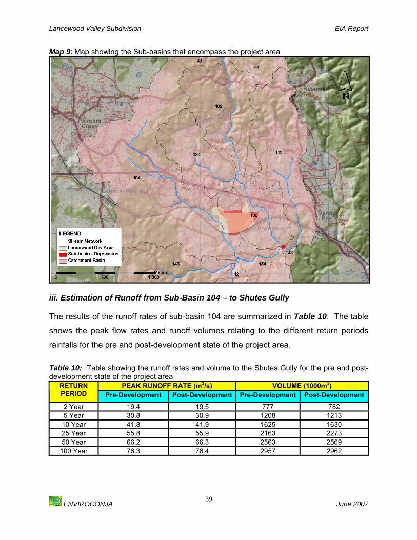
Lancewood Valley Subdivision EIA Report
ENVIROCONJA June 2007
39
Map 9: Map showing the Sub-basins that encompass the project area
iii. Estimation of Runoff from Sub-Basin 104 – to Shutes Gully The results of the runoff rates of sub-basin 104 are summarized in Table 10. The table
shows the peak flow rates and runoff volumes relating to the different return periods
rainfalls for the pre and post-development state of the project area.
Table 10: Table showing the runoff rates and volume to the Shutes Gully for the pre and post-development state of the project area
PEAK RUNOFF RATE (m3/s) VOLUME (1000m3) RETURN PERIOD Pre-Development Post-Development Pre-Development Post-Development2 Year 19.4 19.5 777 782 5 Year 30.8 30.9 1208 1213
10 Year 41.8 41.9 1625 1630 25 Year 55.8 55.9 2163 2273 50 Year 66.2 66.3 2563 2569 100 Year 76.3 76.4 2957 2962
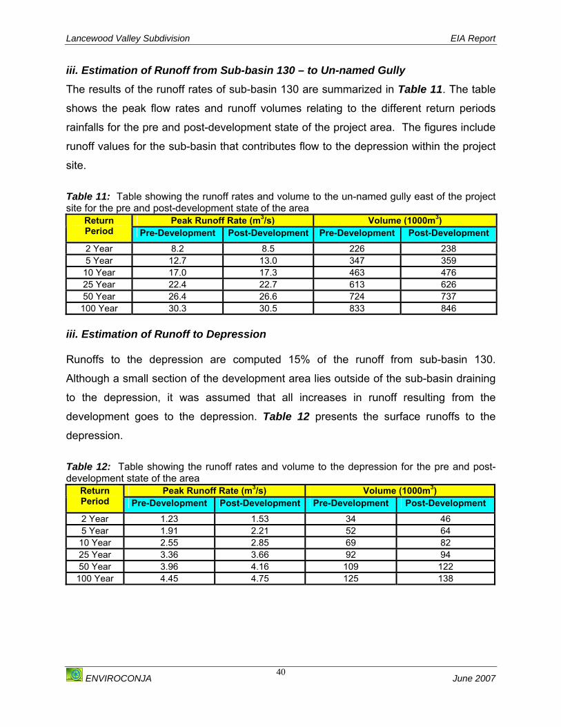
Lancewood Valley Subdivision EIA Report
ENVIROCONJA June 2007
40
iii. Estimation of Runoff from Sub-basin 130 – to Un-named Gully The results of the runoff rates of sub-basin 130 are summarized in Table 11. The table
shows the peak flow rates and runoff volumes relating to the different return periods
rainfalls for the pre and post-development state of the project area. The figures include
runoff values for the sub-basin that contributes flow to the depression within the project
site.
Table 11: Table showing the runoff rates and volume to the un-named gully east of the project site for the pre and post-development state of the area
Peak Runoff Rate (m3/s) Volume (1000m3) Return Period Pre-Development Post-Development Pre-Development Post-Development 2 Year 8.2 8.5 226 238 5 Year 12.7 13.0 347 359
10 Year 17.0 17.3 463 476 25 Year 22.4 22.7 613 626 50 Year 26.4 26.6 724 737 100 Year 30.3 30.5 833 846
iii. Estimation of Runoff to Depression Runoffs to the depression are computed 15% of the runoff from sub-basin 130.
Although a small section of the development area lies outside of the sub-basin draining
to the depression, it was assumed that all increases in runoff resulting from the
development goes to the depression. Table 12 presents the surface runoffs to the
depression.
Table 12: Table showing the runoff rates and volume to the depression for the pre and post-development state of the area
Peak Runoff Rate (m3/s) Volume (1000m3) Return Period Pre-Development Post-Development Pre-Development Post-Development 2 Year 1.23 1.53 34 46 5 Year 1.91 2.21 52 64 10 Year 2.55 2.85 69 82 25 Year 3.36 3.66 92 94 50 Year 3.96 4.16 109 122 100 Year 4.45 4.75 125 138

Lancewood Valley Subdivision EIA Report
ENVIROCONJA June 2007
41
iv. Estimation of Runoff to Point A – Combined Runoff The runoff values of the combined flows at point A are summarized in Table 13. The
table shows the peak flow rates and runoff volumes relating to the different return
periods for the pre and post-development state of the project area.
Table 13: Table showing the combined runoff rates and volume to Point A for the pre and post-development state of the area
Peak Runoff Rate (m3/s) Volume (1000m3) Return Period Pre-Development Post-Development Pre-Development Post-Development2 Year 43.9 44.1 2519 2536 5 Year 79.3 79.5 4434 4452 10 Year 118.2 118.3 6430 6448 25 Year 172.5 172.6 9138 9157 50 Year 214.9 215.0 11217 11236 100 Year 257.8 257.9 13301 13320
4.1.5.2 FLOOD RISK ASSESSMENT Due to the scale of the project and the project location a flood impact assessment was
undertaken for the site.
4.1.5.2 .1 METHODOLOGY The flood impact assessment was done using the HEC-RAS (Hydrologic Engineering Center
– River Analysis System) model developed by the US Army Corps of Engineers. A digital
terrain model (DTM) was developed from contours digitized from 1:12,500 topographic
maps produced by the Survey Department. Basin characteristics such as elevation and
slope as well as cross-sectional data are generated from the DTM using ArcGIS and
HEC-GeoRAS (an ArcGIS extension for support of HEC-RAS) software.
The potential for flooding of the project site by the Shutes Gully and the gully to the east
of the site is assessed. The level of inundation of the depression from surface runoff
from the project site is also assessed. The two culverts at the Old Harbour Bypass
provide the only outlet from the depression assuming infiltration into the ground is
negligible. Accordingly, an assessment of the culverts being 50% blocked was included
in the analysis, the other being that they are free of debris.

Lancewood Valley Subdivision EIA Report
ENVIROCONJA June 2007
42
i. Peak Flows The peak flows used in the HEC-RAS model are the peak runoff values generated in
the hydrologic analysis. These flows are presented in Section 4.1.5.2 above. Given
the small differences observed, only the post-development flows were used in the flood
analysis.
ii. Mannings Roughness Coefficient The Mannings roughness coefficients used are 0.08m1/3/s for the channels and
1.5m1/3/s for the overbanks. Relatively high roughness coefficients are used because of
high vegetation in the channels and on the overbanks. The roughness coefficient used
for the culverts is 0.016m1/3/s.
PRESENT STATUS: FLOOD EXTENTS
a. Gullies The extents of flooding for the two gullies that traverse the property are presented in
Map 10 below. The map show that floods resulting from these two gullies with return
periods up to 100 yrs will not affect the project site. For clarity, only the 100 yr return
period flood extent is shown in the map.
b. Depression The extent of flooding within the depression is presented in Map 11. Only the 100 yr
flood extents are delineated for clarity. The map shows the flood extent when the
culverts are free of debris overlaid on the flood extent for the 100 yr flood when the
culverts are 50% blocked. The map also shows that water will accumulate within the
depression in both cases; however, with the culverts 50% blocked the depth of
inundation increase from 0.69 to 1.2 m for the 2 yr rainfall and from 1.59 to 4.34m for
the 100 yr rainfall. Details of the depth of inundation and water surface elevations for
the two scenarios are presented in Table 14.

Lancewood Valley Subdivision EIA Report
ENVIROCONJA June 2007
43
Table 14: Comparison of flood extents within depression when culverts are free of debris and 50% blocked
FLOOD EXTENTS WITHIN DEPRESSION Water surface elevation (m) a.m.s.l Depth of inundation (m)
RETURN PERIOD
(T) (yrs) Culverts free of debris
Culverts 50% blocked
Culverts free of debris
Culverts 50% blocked
2 46.42 46.93 0.69 1.20 5 46.61 47.33 0.88 1.60 10 46.79 47.83 1.06 2.10 25 46.96 48.65 1.23 2.92 50 47.11 49.26 1.38 3.53
100 47.32 50.07 1.59 4.34
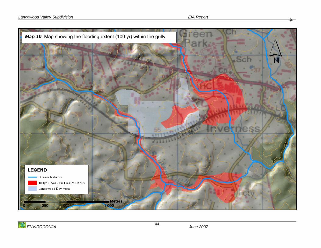
Lancewood Valley Subdivision EIA Report
ENVIROCONJA June 2007
44
44
Map 10: Map showing the flooding extent (100 yr) within the gully
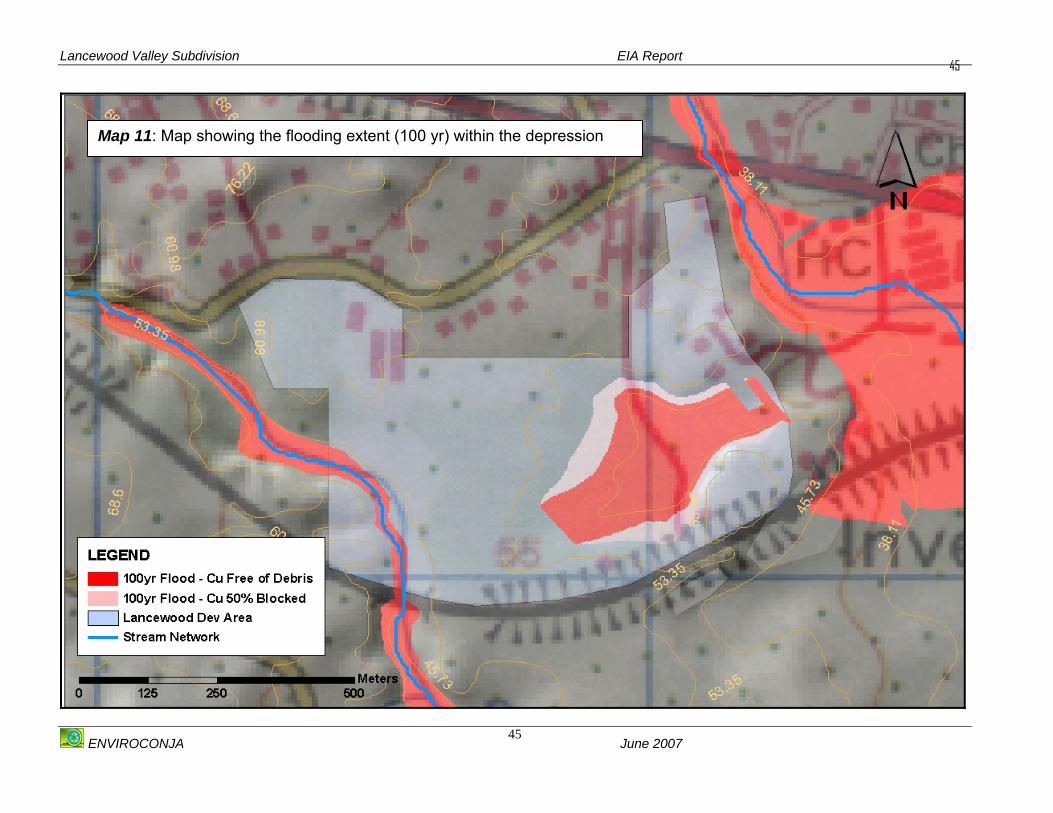
Lancewood Valley Subdivision EIA Report
ENVIROCONJA June 2007
45
45
Map 11: Map showing the flooding extent (100 yr) within the depression
Lancewood Valley Subdivision EIA Report
ENVIROCONJA June 2007
46
DISCUSSION OF BASELINE ASSESSMENT The results of the hydrologic analysis show that the impact of the development on runoff
is very small with less than 1% increases in peak runoff rates except for peak runoffs to
the depression, which ranged from 7% for the 100 yr rainfall to 24% for the 2 yr rainfall.
These represent in absolute terms increases in the peak runoffs of 0.3m3/s for all the
rain events. Given the marginal increases in peak runoffs resulting from the proposed
development, downstream communities and other interests will not be adversely
affected.
The flood analysis shows that the development area is not vulnerable to flooding from
the Shutes Gully traversing the project site to the west or from the gully to the east of
the site. On the other hand, runoff from the project site will inundate the depression,
which forms the southern part of the development area. Inundation of the depression is
exacerbated due to its enclosure by the Old Harbour Bypass main road with only two (2)
1m diameter culverts for water to flow out.
The analysis shows a depth of inundation of 1.59m for the 100 yr return period rainfall
provided that the culverts are free of debris. The depth of inundation increases as the
culverts gets blocked reaching 4.34m when the capacity of the culverts is reduced by
half. Given that the culverts may never be completely free of debris, it can be expected
that the depth of inundation within the depression is likely to be higher than the depths
obtained when the culverts are free of debris but lower than the depths obtained when
the culverts are 50% blocked for all the return period rainfalls.
In terms of the water surface elevations, water levels associated with the 100 yr rainfall
will reach 47.32m and 50.07m when the culverts are free of debris and 50% blocked
respectively. These elevations are below the 53.35m contour, which forms the top of
the depression. Given that during extreme rainfall events the 1m culverts can be easily
blocked by debris, no lots or building of houses should be constructed below the 53 m
contour line.

Lancewood Valley Subdivision EIA Report
ENVIROCONJA June 2007
47
4.1.6 NOISE Due to the close proximity to the highway and the train line that traverses the property,
an assessment of the current ambient noise levels at the Lancewood development site
was undertaken.
4.1.6.1 METHODOLOGY Primary noise data was collected using a Quest Technologies© 2900
Integrating/Logging Type 2 noise meter. The sound calibrator used was a Quest
Technologies© QC 10 calibrator that emits 114 dB at a frequency of 1000 hertz. The
certificate of calibration is shown in Appendix IV.
The relevant impulse setting was selected for the monitoring of community noise. In this
case the slow impulse setting was most appropriate. The A-weighting option was
selected for the decibel levels, as this is most commonly used for the measurement of
environmental noise especially road noise. Though the A-weighting curve gives a single
figure index for the varying sensitivity of the human ear (Therivel and Morris, 2004), it is
not the most valid for sound measurement because of the way the human ear actually
analyses sound. However it is the standard most widely accepted for this kind of
monitoring.
The noise meter was calibrated before each monitoring session. The appropriate
decibel range was selected for the expected results. If and where the range was
exceeded, a higher and appropriate decibel range was selected and the reading
repeated. The time of each reading was recorded, as well as the GPS reading and brief
comments documented on the area in which the readings were taken. Noise readings were taken over a two-day period between Friday November 17th and
Saturday November 18th from points along the highway and from points within the site
during low and high traffic periods for comparison. The weather on both days was sunny
and the air still and so noise from wind and rain was not a factor.

Lancewood Valley Subdivision EIA Report
ENVIROCONJA June 2007
48
The readings taken in the vicinity of the highway were from approximately 7 metres from
the roadway. A two-man team conducted the survey, with one member operating the
noise-meter while the second recorded GPS readings and made relevant notes.
Noise readings closest to the highway were taken on Friday November 17th 2006
between 3:00 pm and 4:24 pm. These readings were taken in order to illustrate a noise
gradient from the noise source (vehicular traffic) to the quietest periods and points of the
site and were also used as quality control/ quality assurance of the noise meter values
in real-world situations.
Readings were taken on-site on Saturday November 18th 2006 between 8:00 a.m. and
11:42 a.m. The sites used for air quality monitoring were used as convenient sites for
noise data readings as these sites were selected to be representative of a gradient from
potential sources of air pollution, i.e. vehicular traffic and the bauxite freight train, which
are also significant sources of noise. Other sites were selected for comparison and to
represent as much of the site as possible without being unduly repetitive.
4.1.6.2 PRESENT STATUS In the Lancewood Valley area transportation is the main source of environmental noise
pollution, which is from two (2) significant sources; Highway 2000 to the east of the
property and another significant though less frequent source of transportation noise, the
railway that is traversed by Jamaica Alumina Company (JAMALCO’s) Bauxite freight
train to the south.
i. Traffic Noise Road traffic noise is generally a function of the sound generated by the engine of the
vehicles, and the friction between vehicle tyres and the road surface. The friction with
air may become significant at higher speeds during which the tyres on the road surface
becomes a more significant source of noise than the engine noise itself. In the case of
Lancewood Valley the topography also contributes to the impact.
Highway 2000 is the major thoroughfare, which links Kingston to the southern parishes
of the island and is therefore traversed by large numbers of vehicles including large
trucks and buses. This highway borders the property to the east and is set several

Lancewood Valley Subdivision EIA Report
ENVIROCONJA June 2007
49
meters above the property. In addition to this, the road takes a corner at the point
closest to the site and has a gradient before entering a second corner. During the
assessment it was observed that vehicles entering the gradient enter low gear either as
a prelude to braking as they go downhill, or to acquire more power to go uphill; this was
especially the case for larger vehicles.
ii. Railway Noise
The noise caused by the railway can be due to a number of factors including the speed
of the train, the condition of the wheels and track and engine noise. In the case of a
freight train, the number of cars, whether they are laden or not and the effort the engine
requires to pull these cars, also contributes to the magnitude of the noise impact.
Despite the acquisition of an ad hoc train schedule from Jamaica Alumina Company
(JAMALCO), several attempts to record the noise and vibration from the train proved to
be futile. According to the schedule provided the train passes adjacent to the
Lancewood property en route to the mine/factory a maximum three (3) times per day;
between 8:00 am – 9:00 am, 11:00 a.m. to 12:00 noon and 3:00 pm to 4:00 pm. During
the entire period of field assessment however, the train was observed only once in a
time far outside the schedule provided and at a time when the noise meter was not
available to take empirical readings.

Lancewood Valley Subdivision EIA Report
ENVIROCONJA June 2007
50
Figure 8: Picture showing the freight train that passes adjacent to the Lancewood Valley Property daily
4.1.6.3 DISCUSSION OF BASELINE ASSESSMENT Lancewood Valley at present cannot be described as a noise sensitive community. Its
proximity to a major highway, as well as the railway line means that it is subjected to
potentially high levels of noise and vibration. No noise standards have been set for
Jamaica. The empirical noise data collected however shows that the majority of the site
is still within the World Health Organization (WHO) guidelines of 50dB LAeq - 55dB LAeq
for outdoor living areas and activities. Even in times of moderate traffic only one site
exceeded 55 dB (A) and this site was approximately 5 metres from the highway. The
lowest readings measured on site were 30.2 dB (A), which is similar to a bedroom at
night. This site was set back from the road and the reading taken at a time with no
traffic. For comparison, readings were taken on the highway at off-peak hours of traffic
as well as when moderately heavy traffic begun. The highest decibel level recorded was
85 db (A) when a large flatbed truck passed by. As illustrated in Appendix IV, the
decibel reading on the highway generally ranged from 70-80 db (A), which is in keeping
with street-corner traffic. The closer to the highway the higher the decibel level and it is

Lancewood Valley Subdivision EIA Report
ENVIROCONJA June 2007
51
expected that this was the same when the train was passing the property. The majority
of the existing residents are closer to the roadway than the potential residents will be
and therefore the impact is more than the undeveloped parcel of land. These residents
have also been subjected to the noise associated with road construction.
Freight trains generally contribute more to the noise impact than commuter trains and it
is anticipated that this will be no different for Lancewood Valley. The train was heard for
some distance before it actually passed the border of the property. The train also let out
several warning blasts of its horn to alert persons and motorists of its passing which
adds to the noise impact, though this is an important safety measure. Reference
numbers indicate 70 dB (A) as being a reasonable estimate for a freight train at a
distance of 30 m (See Appendix IV). This is quite loud but the impact of this noise is
reduced somewhat by the apparent infrequency of the train crossing the property.
Looking at reference numbers for street side traffic (Morris and Therivel, 2004; WHO
Guidelines for Community Noise) the values of noise recorded at the site fall well within
the expected ranges for trafficked areas.
4.1.7 LANDSCAPE AND AESTHETICS 4.1.7.1 METHODOLOGY A walk through of the area was carried out to determine the landscape and aesthetic
value of the site. The site was also viewed from various vantage points.
4.1.7.2 PRESENT STATUS The area as it is presently constitutes of an area predominantly covered with vegetation,
which is typical of open spaces pastureland and scrub vegetation. From all vantage
points within the zone of visual intrusion there is an undeveloped, un-landscaped area,
which some persons may view as not aesthetically pleasing.
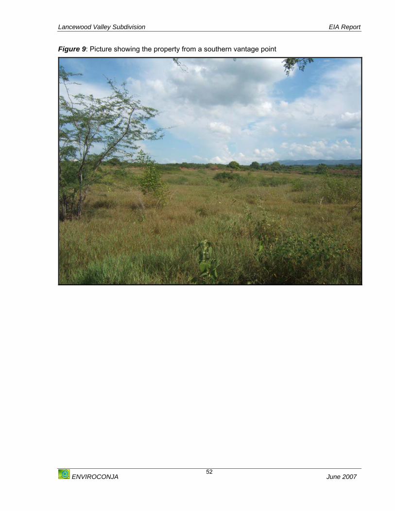
Lancewood Valley Subdivision EIA Report
ENVIROCONJA June 2007
52
Figure 9: Picture showing the property from a southern vantage point
Lancewood Valley Subdivision EIA Report
ENVIROCONJA June 2007
53
4.2 BIOLOGICAL ENVIRONMENT This section outlines the description of the biological environment, the methodologies
involved and the results of the assessment. It is divided into two parts; the first outlines
the results of the Floral Assessment and the second outlines the results of the
Assessment of the Fauna observed in the area.
4.2.1 FLORA The Floral Assessment was conducted in two phases over a four (4) week period
between October and November 2006.
4.2.1.1 PHASE 1 ASSESSMENT 4.2.1.1.1 Methodology The Phase 1 Assessment included a review of aerial images of the project area (Please
see Figure 10 below). These were used to delineate the vegetation types within the
area of influence. This was followed by a “walk through” of the site to formulate a
concept of the area, as well as to identify the particular vegetation types. This was also
carried out to confirm the information gleaned from the aerial images. In addition,
consultation was held with local residents and the developer.
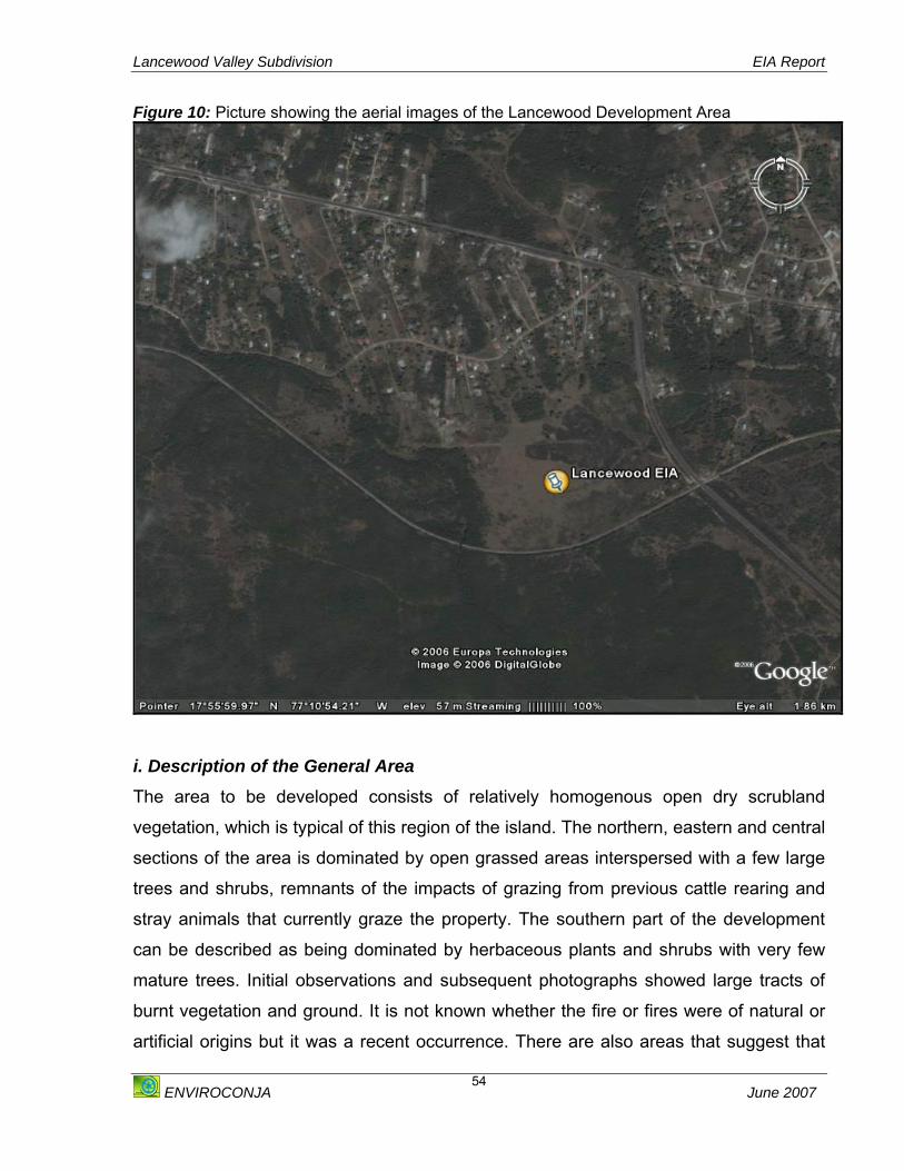
Lancewood Valley Subdivision EIA Report
ENVIROCONJA June 2007
54
Figure 10: Picture showing the aerial images of the Lancewood Development Area
i. Description of the General Area
The area to be developed consists of relatively homogenous open dry scrubland
vegetation, which is typical of this region of the island. The northern, eastern and central
sections of the area is dominated by open grassed areas interspersed with a few large
trees and shrubs, remnants of the impacts of grazing from previous cattle rearing and
stray animals that currently graze the property. The southern part of the development
can be described as being dominated by herbaceous plants and shrubs with very few
mature trees. Initial observations and subsequent photographs showed large tracts of
burnt vegetation and ground. It is not known whether the fire or fires were of natural or
artificial origins but it was a recent occurrence. There are also areas that suggest that

Lancewood Valley Subdivision EIA Report
ENVIROCONJA June 2007
55
vehicles drive through the property with some frequency. With no previous observations
to refer to it is not known to what extent the ecology of the site has been altered by
anthropogenic factors.
ii. Conservation Status of the Area The analysis of aerial photographs of the area, the Portland Bight Protected Area map
showed that the area proposed for development is not designated as a protected or
conservation area.
4.2.1.2 PHASE 2 ASSESSMENTS A Phase 2 Assessment was undertaken which included a more detailed assessment of
the vegetation present at the project site. This stage of the assessment included the
identification, the abundance and conservation status of species and their habitats.
4.2.1.2.1 METHODOLOGY Based on the analysis from the Phase 1 assessment, the project area was divided into
three plots for analysis as follows:
Plot 1: Located on the most southern section of the area to be developed
Plot 2: Encompasses the most northern, central and western parts of the area to be
developed
Plot 3: Encompasses the most eastern section of the area to be developed
i Methodology- Plot 1: Based on the results from the Phase 1 Assessment, the vegetation in this plot appeared
to be open shrubland consisting of herbs, shrubs with very little mature trees. For the
sampling of this type of plant morphology, a Systematic Sampling Method was
employed utilising the Line Intercept Method. This involved the laying of three (3),
parallel, forty (40) m transects across the study area. The same compass bearing for
each transect was used to ensure that the study area was sampled by a set of parallel
transects. Within each plot, species were sampled at intervals of two (2) metres along
Lancewood Valley Subdivision EIA Report
ENVIROCONJA June 2007
56
each transect and within two (2) metres of either side of each transect. The species
were then categorized under the following headings:
o Herbs and Shrubs
o Trees
o Grasses
o Fungi
o Epiphytes
o Ferns
o Other
All species observed during the assessment were identified in the field where possible,
and photographs and samples were taken of all unknown species for later identification.
Species that were of ecological and commercial value were also recorded during this
exercise. A Semi-Quantitative Abundance Rating method was used to determine the
abundance of all the species identified as shown in Table 15 below. Table 15: Table showing the Semi-Quantitative Abundance Rating Method
RATING SYMBOL Dominant D Abundant A Frequent F Occasional O Rare R
This process was repeated at forty (40) meter intervals. Vegetation outside the
immediate area of influence was also examined and any species of ecological and
commercial value recorded.
ii Methodology Plots 2 & 3 Information from the Phase 1 Assessment showed that Plot 2 and Plot 3 consists
predominantly of a homogenous patch of open land covered with grass with few herbs
and shrubs. It was therefore perceived that whole-area sampling was unnecessary and
hence the Random/Stratified Sampling method was used for this part of the
assessment. This method of sampling involved the random selection of three (3) 10 m x
10 m quadrats within each plot and sampling within these quadrats. The species were
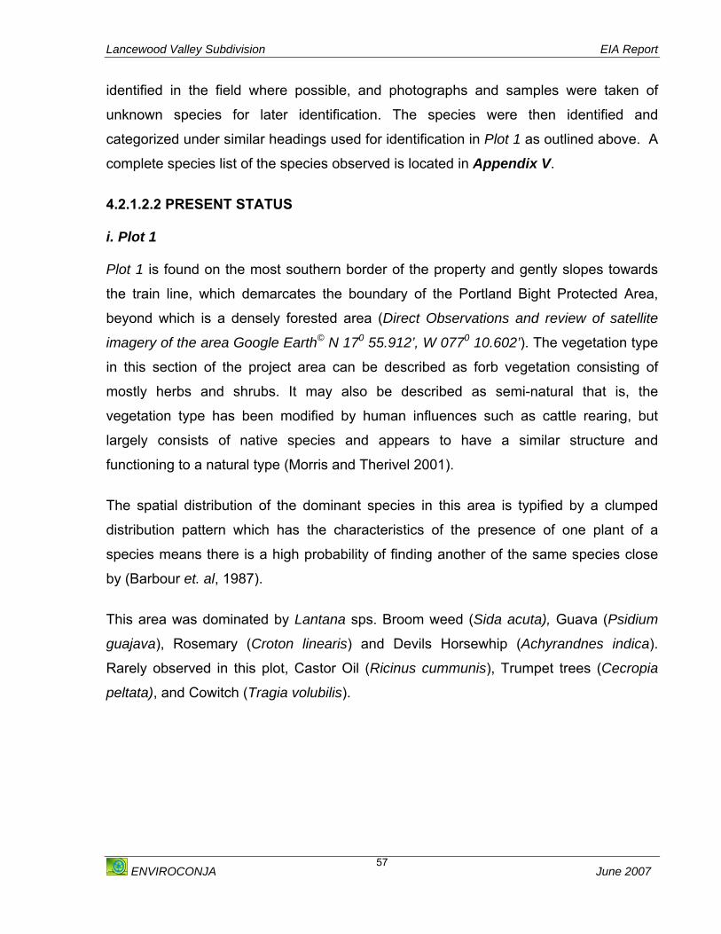
Lancewood Valley Subdivision EIA Report
ENVIROCONJA June 2007
57
identified in the field where possible, and photographs and samples were taken of
unknown species for later identification. The species were then identified and
categorized under similar headings used for identification in Plot 1 as outlined above. A
complete species list of the species observed is located in Appendix V.
4.2.1.2.2 PRESENT STATUS i. Plot 1 Plot 1 is found on the most southern border of the property and gently slopes towards
the train line, which demarcates the boundary of the Portland Bight Protected Area,
beyond which is a densely forested area (Direct Observations and review of satellite
imagery of the area Google Earth© N 170 55.912’, W 0770 10.602’). The vegetation type
in this section of the project area can be described as forb vegetation consisting of
mostly herbs and shrubs. It may also be described as semi-natural that is, the
vegetation type has been modified by human influences such as cattle rearing, but
largely consists of native species and appears to have a similar structure and
functioning to a natural type (Morris and Therivel 2001).
The spatial distribution of the dominant species in this area is typified by a clumped
distribution pattern which has the characteristics of the presence of one plant of a
species means there is a high probability of finding another of the same species close
by (Barbour et. al, 1987).
This area was dominated by Lantana sps. Broom weed (Sida acuta), Guava (Psidium
guajava), Rosemary (Croton linearis) and Devils Horsewhip (Achyrandnes indica).
Rarely observed in this plot, Castor Oil (Ricinus cummunis), Trumpet trees (Cecropia
peltata), and Cowitch (Tragia volubilis).
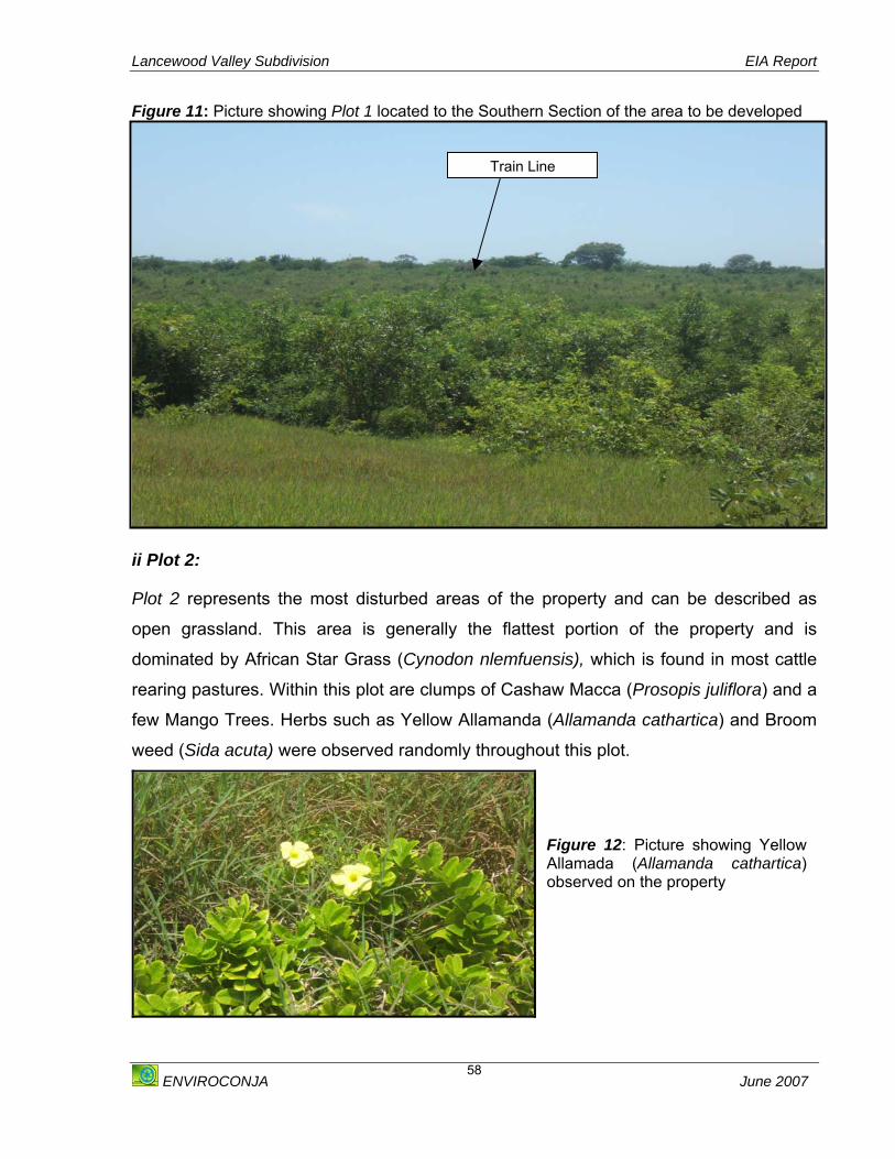
Lancewood Valley Subdivision EIA Report
ENVIROCONJA June 2007
58
Figure 11: Picture showing Plot 1 located to the Southern Section of the area to be developed
ii Plot 2: Plot 2 represents the most disturbed areas of the property and can be described as
open grassland. This area is generally the flattest portion of the property and is
dominated by African Star Grass (Cynodon nlemfuensis), which is found in most cattle
rearing pastures. Within this plot are clumps of Cashaw Macca (Prosopis juliflora) and a
few Mango Trees. Herbs such as Yellow Allamanda (Allamanda cathartica) and Broom
weed (Sida acuta) were observed randomly throughout this plot.
Train Line
Figure 12: Picture showing YellowAllamada (Allamanda cathartica)observed on the property

Lancewood Valley Subdivision EIA Report
ENVIROCONJA June 2007
59
Figure 13: Picture showing the vegetation type on Plot 2
Figure 14: Picture showing the vegetation type on Plot 2
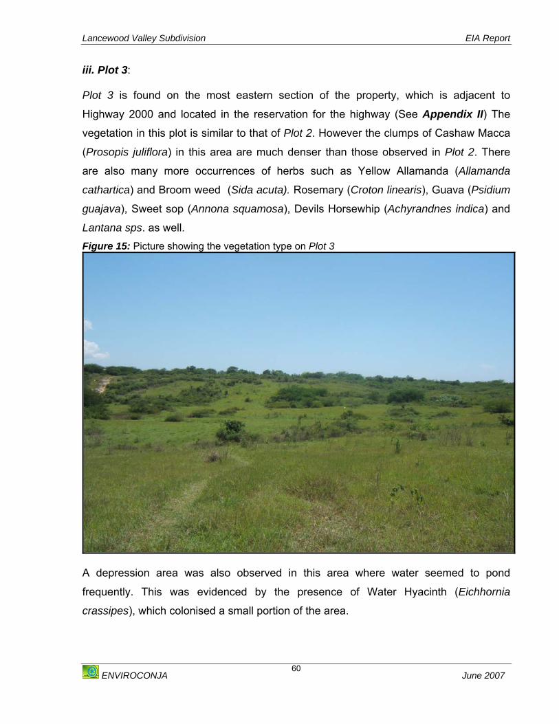
Lancewood Valley Subdivision EIA Report
ENVIROCONJA June 2007
60
iii. Plot 3: Plot 3 is found on the most eastern section of the property, which is adjacent to
Highway 2000 and located in the reservation for the highway (See Appendix II) The
vegetation in this plot is similar to that of Plot 2. However the clumps of Cashaw Macca
(Prosopis juliflora) in this area are much denser than those observed in Plot 2. There
are also many more occurrences of herbs such as Yellow Allamanda (Allamanda
cathartica) and Broom weed (Sida acuta). Rosemary (Croton linearis), Guava (Psidium
guajava), Sweet sop (Annona squamosa), Devils Horsewhip (Achyrandnes indica) and
Lantana sps. as well. Figure 15: Picture showing the vegetation type on Plot 3
A depression area was also observed in this area where water seemed to pond
frequently. This was evidenced by the presence of Water Hyacinth (Eichhornia
crassipes), which colonised a small portion of the area.

Lancewood Valley Subdivision EIA Report
ENVIROCONJA June 2007
61
Figure 16: Picture showing the colony of Water Hyacinth (Eichhornia crassipes) observed in Plot 3
4.2.1.2.3 CONSERVATION STATUS OF SPECIES OBSERVED i. Endemic Species: No endemic species were observed during the assessment. All
species identified are introduced, or native and are found abundantly and commonly in
similar habitats.
ii. Rare Threatened or Endangered Species: No rare, threatened or endangered plant
species were observed during the survey of the area.
iii. Invasive Alien Species: During the assessment only one invasive alien species,
Water Hyacinth (Eichhornia crassipes) was observed.
Water Hyacinth
Lancewood Valley Subdivision EIA Report
ENVIROCONJA June 2007
62
4.2.2 ASSESSMENT OF FAUNA Ecologically, terrestrial fauna is generally concerned with the macro fauna of a habitat.
This is not to say that the microorganisms, which are always present, are any less
important to the health of a particular habitat and that of the overall ecosystem.
However the complexities of the interactions of these organisms with the biotic and
abiotic factors within the macro environment, is not viewed as critical in most ecological
studies of impact assessments. Therefore, the approach taken in this part of the
ecological study utilised a survey, where species are indicators to the overall health of
the ecosystem.
This section of the report is divided into three parts:
o Assessment of Avifauna
o Assessment of Butterflies
o Assessment of Macro Fauna including other Insects, Reptiles, Gastropods and
other Vertebrates
The Class Aves and the Class Insecta (Order Lepidoptera) were assessed separately
because of the importance of these animals as indicator species, and the high level of
endemism present on the island.
4.2.2.1 AVIFAUNA 4.2.2.1.1 METHODOLOGY A point count sampling method was employed to assess the avifauna. In this method,
the observer stood at one point and counted all the birds seen and heard within six (6)
minutes within an estimated fixed radius of 50 meters. In total four (4) points were
counted, each approximately 150 meters apart. In addition, anecdotal notes were made
of the birds observed while travelling between the points.
Point counts were conducted on October 21, 2006 and November 5, 2006 starting at
6:30 am and 6:00 am respectively.

Lancewood Valley Subdivision EIA Report
ENVIROCONJA June 2007
63
Table 16: Table showing Identification Key for Avifauna TYPE OF BIRD SYMBOL
Introduced species I Endemic Species E Resident Species R Breeding Resident (Summer Migrant) BR Non-breeding Resident (Winter Migrant) NBR
The abundance for the birds identified during the assessment was determined by the
scale as shown in Table 17 below. Table 17: Table showing the abundance ratings for the Avifauna identified
ABUNDANCE RATING Common Seen or heard in >50% of observation points in suitable habitat Locally common Detected in >50% of observation points but habitat type restricted in area Fairly common Seen or heard in 25% - 50% of observation points in suitable habitat Uncommon Seen or heard in <25% of observation points in suitable habitat Rare Not likely to be seen on every observation trip Vagrant A migrant that occurs less frequently than once every 10 years
4.2.2.1.2 PRESENT STATUS Twenty (20) species of birds representing nine (9) families were observed over the two
days of surveys (See Appendix V). These are as follows: i. Endemics Only one (1) endemic species (Jamaican Euphonia) was observed at the site, and these
were more closely associated with the edge of the survey area where they move back
and forth between the study site and the adjoining residential areas.
ii. Residents
Of the twenty (20) species observed, fifteen (15) of these are classified as residents.
This includes the White-winged Dove and the Bananaquit, which were also noted to be
more closely associated with the edge of the study area. iii. Migrants The time of year the survey was conducted was approximately two (2) months into the
migrant season for wintering birds and hence a large number of non-breeding residents

Lancewood Valley Subdivision EIA Report
ENVIROCONJA June 2007
64
(winter migrants) are expected on the island. Conversely, the breeding residents
(summer migrants) namely the Black-whiskered Vireo (Vireo altiloquus) and Gray
Kingbird (Tyrannus dominicensis) would have already left the island. Despite the large
number expected, only four (4) migrant species were observed at the development site,
and these were all uncommon except for the Prairie Warbler which was fairly common
(Appendix V). This suggests that the survey area is not a preferred habitat for wintering
birds.
The results from the survey of avifauna are exceptionally poor, which is attributed to the
high level of disturbance and uniformity of the area, which limits the number of available
niches. The surveyed area is mainly grassland type vegetation with outcroppings of
Cashaw Macca (Prosopis juliflora) and other scrub-like plants. This is the main reason
for the absence of many common resident species such as the woodpeckers, vireos,
cuckoos and more flycatcher and hummingbird species found in nearly all wooded
areas on the island.
The dominant species observed in the area were the Common Ground Dove, Cattle
Egret, Smooth-billed Ani, Northern Mockingbird and the Yellow-faced Grassquit. These
are highly ubiquitous species and their dominance again, is illustrative of a poor habitat
type.
4.2.2.1.2 Conservation Status of Species Observed i. Endemic Species: Only one species the Jamaican Euphonia, of the twenty species
identified is endemic to Jamaica.
ii Rare Threatened or Endangered Species: No rare, threatened or endangered
species were observed during the survey of the area.
iii Invasive Alien Species: No invasive animal species were observed during the
assessment

Lancewood Valley Subdivision EIA Report
ENVIROCONJA June 2007
65
4.2.2.2 BUTTERFLIES 4.2.2.2.1 METHODOLOGY Butterfly observations were conducted over a two (2) day period. A reconnaissance visit
to the area was conducted on September 23, 2006 (8:40 a.m. – 10 a.m.) while
comprehensive sighting data and other information was gathered on October 21, 2006
(8:35 a.m. – 11:00 a.m.). Three (3) persons conducted observations that included digital
photography, empiric observations and looking at the underside of leaves to determine
the presence of the various life cycle stages of Lepidoptera.
Butterflies are sometimes difficult to identify in the field when comparing still
photographs to live individuals, so a number of field guides were used [e.g. Martin
Brown (1972) and Garraway and Bailey (2005)] to cross reference identifications.
It is a difficult proposition to use mainly sighting data from adults on the wing to
determine butterfly diversity. However, this methodology does capture much of the
qualitative elements necessary to determine the health of the habitat. The sighting
methodology cannot be used to infer the numerical abundance but rather the relative
abundance of species and genera.
Weather conditions during the two (2) sighting days were party cloudy to sunny. Since
butterfly metabolism is closely linked to the prevailing conditions, butterfly activity would
have been relatively high on these days thereby increasing the reliability of the sample
data.
4.2.2.2.2 PRESENT STATUS Reconnaissance observations indicated that a relatively diverse fauna of butterflies
could be found within the vicinity of the proposed development. This observation was
supported by the detailed observations conducted on October 21, 2006.
Twenty one (21) species of butterflies were observed during the assessment. The fauna
documented represents a diverse group that includes members found in disturbed and
urban habitats, such as the White Peacock (Anartia jatrophae jamaicensis), and more
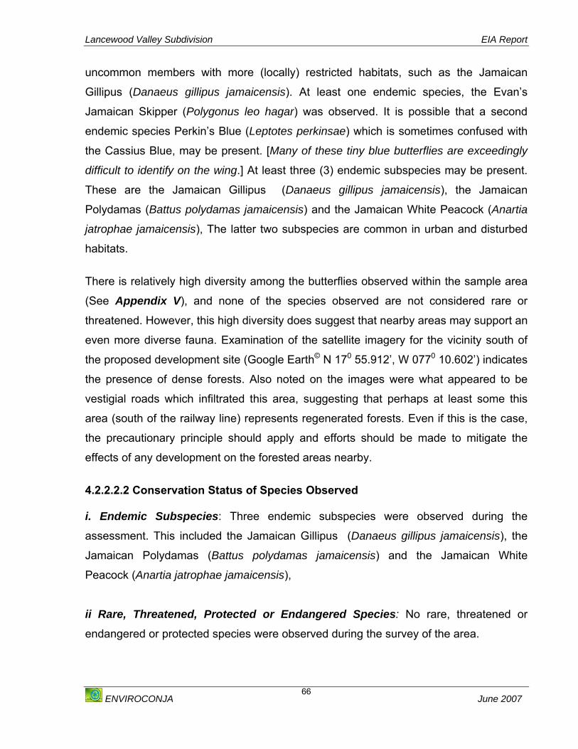
Lancewood Valley Subdivision EIA Report
ENVIROCONJA June 2007
66
uncommon members with more (locally) restricted habitats, such as the Jamaican
Gillipus (Danaeus gillipus jamaicensis). At least one endemic species, the Evan’s
Jamaican Skipper (Polygonus leo hagar) was observed. It is possible that a second
endemic species Perkin’s Blue (Leptotes perkinsae) which is sometimes confused with
the Cassius Blue, may be present. [Many of these tiny blue butterflies are exceedingly
difficult to identify on the wing.] At least three (3) endemic subspecies may be present.
These are the Jamaican Gillipus (Danaeus gillipus jamaicensis), the Jamaican
Polydamas (Battus polydamas jamaicensis) and the Jamaican White Peacock (Anartia
jatrophae jamaicensis), The latter two subspecies are common in urban and disturbed
habitats.
There is relatively high diversity among the butterflies observed within the sample area
(See Appendix V), and none of the species observed are not considered rare or
threatened. However, this high diversity does suggest that nearby areas may support an
even more diverse fauna. Examination of the satellite imagery for the vicinity south of
the proposed development site (Google Earth© N 170 55.912’, W 0770 10.602’) indicates
the presence of dense forests. Also noted on the images were what appeared to be
vestigial roads which infiltrated this area, suggesting that perhaps at least some this
area (south of the railway line) represents regenerated forests. Even if this is the case,
the precautionary principle should apply and efforts should be made to mitigate the
effects of any development on the forested areas nearby.
4.2.2.2.2 Conservation Status of Species Observed i. Endemic Subspecies: Three endemic subspecies were observed during the
assessment. This included the Jamaican Gillipus (Danaeus gillipus jamaicensis), the
Jamaican Polydamas (Battus polydamas jamaicensis) and the Jamaican White
Peacock (Anartia jatrophae jamaicensis),
ii Rare, Threatened, Protected or Endangered Species: No rare, threatened or
endangered or protected species were observed during the survey of the area.

Lancewood Valley Subdivision EIA Report
ENVIROCONJA June 2007
67
4.2.2.3 OTHER MACRO-FAUNA 4.2.2.3.1 METHODOLOGY The assessment of the macrofauna barring avifauna and butterflies were conducted
simultaneously with the assessment of the flora. The advantage of this was that line
transects were already being laid for the plant ecology survey. By creating a width of 2m
from the line transect a quadrat (5m x 5m) was effectively laid and at the same time
animal species were observed within this survey area. Animals were divided into five
categories as follows:
o Vertebrates
o Reptiles
o Amphibians
o Gastropods
o Insects
Attempts were made to record the relative abundances of these species. In theory this
would have been a good idea, however there were very few sessile species. Most of the
species observed were swift flyers or very mobile species such as insects. Direct
observation was therefore employed. This method involved following observed
individuals of a given Order or Genus in order to estimate species abundance and
observe interactivity with the habitat. This was done for successive species. Total
counts are obviously an ideal but this was unlikely except for large and or mostly sessile
species. The species of Macrofauna identified is listed in Appendix V.
4.2.2.3.2 MAMMALS 4.2.2.3.2.1 PRESENT STATUS The largest animals observed on site were donkeys (Equus asinus) and goats (Capra
aegagrus). These donkeys were harnessed and were probably left on the site closest to
where the owners happened to be at that time. No more than three (3) donkeys were
ever seen on the site during the survey period and these animals were only observed to
the north-east of the property closest to one of the communities bordering the property.
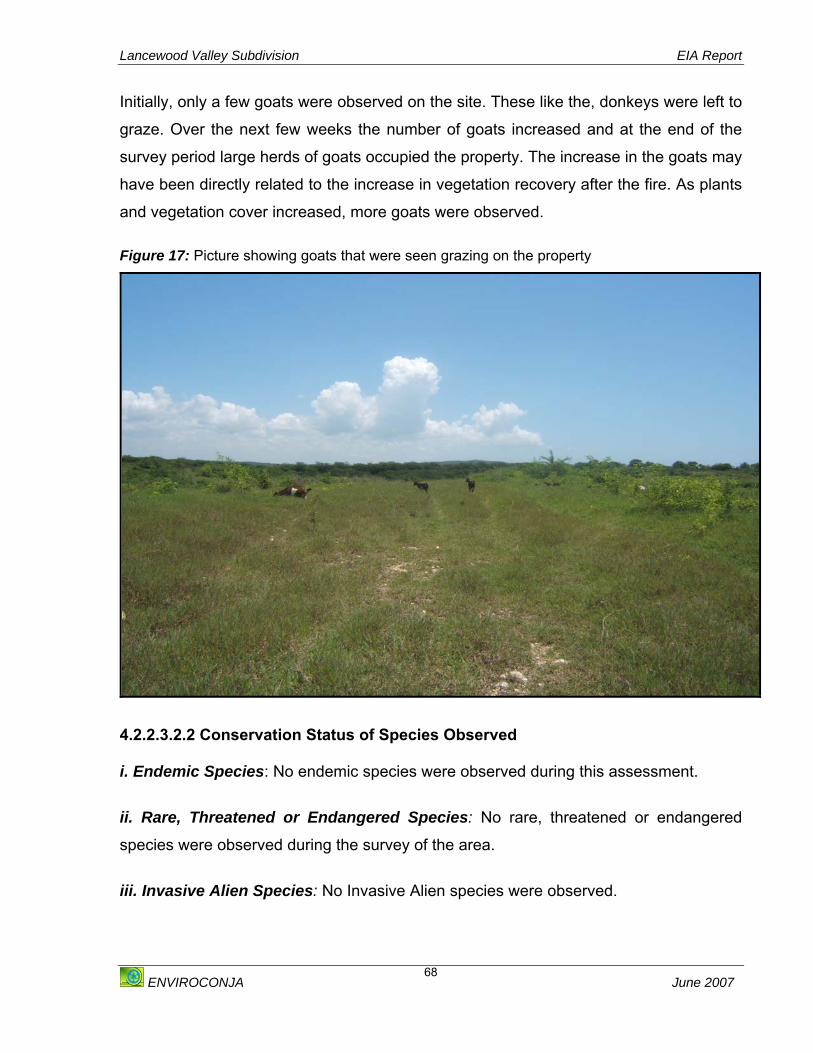
Lancewood Valley Subdivision EIA Report
ENVIROCONJA June 2007
68
Initially, only a few goats were observed on the site. These like the, donkeys were left to
graze. Over the next few weeks the number of goats increased and at the end of the
survey period large herds of goats occupied the property. The increase in the goats may
have been directly related to the increase in vegetation recovery after the fire. As plants
and vegetation cover increased, more goats were observed. Figure 17: Picture showing goats that were seen grazing on the property
4.2.2.3.2.2 Conservation Status of Species Observed i. Endemic Species: No endemic species were observed during this assessment.
ii. Rare, Threatened or Endangered Species: No rare, threatened or endangered
species were observed during the survey of the area.
iii. Invasive Alien Species: No Invasive Alien species were observed.

Lancewood Valley Subdivision EIA Report
ENVIROCONJA June 2007
69
4.2.2.3.2 REPTILES 4.2.2.3.2.1 PRESENT STATUS Lizards were the only reptiles observed during the survey period. These reptiles tend to
be ubiquitous in the Jamaican environment, especially the iguanoid Anolis sp. The
Anolis species identified was the Anolis lineatopus. These lizards are small, carnivorous
reptiles and generally feed on insects. These lizards were found on the Lantana sp.
shrubs that supported all the butterflies and by extension the dragonflies of the area.
The lizards were not as abundant in number as the climate got hotter, though this can
be expected as reptiles are poikilothermic and so tend to regulate their core body
temperature by a combination of internal processes and external factors. These lizards
were rarely observed on the ground.
4.2.2.3.2.1.2 Conservation Status of Species Observed i. Endemic Species: The only species of lizard (A. lineatopus) identified is endemic to
Jamaica.
ii. Rare, Threatened, Protected or Endangered Species: No rare, threatened or
endangered species were observed during the survey of the area. 4.2.2.3.3 AMPHIBIANS 4.2.2.3.3.1 PRESENT STATUS No species of amphibians were identified during the assessment of fauna. Species
within this class of animals generally require a moist/wet habitat for their survival.
Throughout the Lancewood Valley property there is only one area, in the depression
that could support these species. No species of amphibians were however observed in
this area.
4.2.2.3.4 GASTROPODS 4.2.2.3.4 .1 PRESENT STATUS A few small empty shells were photographed and pointed to the presence of snails in
the area, although only one was observed. This individual was too high in the trees to

Lancewood Valley Subdivision EIA Report
ENVIROCONJA June 2007
70
make any sort of positive identification. The diameter of the shells did not exceed half
an inch in length.
4.2.2.3.4 .1 Conservation Status of Species Observed i. Endemic Species: There is an extremely high level of endemism among Jamaican
land snails however and it would not be presumptuous to expect that there are endemic
species of land snails in the area.
ii. Rare, Threatened, Protected or Endangered Species: No rare, threatened or
endangered species were observed during the survey of the area. 4.2.2.3.5 INSECTS 4.2.2.3.5.1 PRESENT STATUS Dragonflies belong to the Order Odontata. Apart from butterflies, dragonflies which
belong to the sub order Anisoptera were the most abundant type of insects observed at
the site. Dragonflies are very high and fast flyers and so it is generally very difficult to
get close enough to catch or critically examine an individual however. On several
occasions during the survey period dozens of individuals were seen flying quite high in
the sky. There seemed to be no obvious occurrences of predation despite the fact that
several butterflies and moths were present. It is quite possible that the dragonflies were
observed during a period of mating and this accounted for large numbers of individuals
seen, as the mating period for dragonflies are know to last for several weeks or even
longer. Female dragonflies lay their eggs in or near water. The larval stage of
dragonflies, called nymphs, are aquatic and are known to last for several weeks to
months. An area of the property is distinct for the ponding that occurs and is dominated
by Water Hyacinth (Eichhornia crassipes) plants. The dragonflies were seen almost
exclusively around this area during the survey period and it is quite likely that this area
is the primary breeding ground for these insects.
Dragonflies are insectivorous and are known to feed on bees, butterflies and
mosquitoes and even other dragonflies. This may be another reason for the abundance
of individuals as the area surrounding the water hyacinths supported a lot of the fauna,
Lancewood Valley Subdivision EIA Report
ENVIROCONJA June 2007
71
especially, insects, found on the site. Dragonflies are known to control the populations
of several pest species such as mosquitoes and the loss of dragonflies in the area may
have implications for nuisance species and for what can become nuisance species. This
important predator may be keeping the population of mosquitoes low in the area and
therefore reducing the risk that mosquitoes pose as a vector to the existing residents.
Individuals of the order Orthoptera were represented by grasshoppers. The differences
in the grasshoppers and crickets can sometimes be hard to distinguish, but crickets
tend to be nocturnal at any rate and the species observed were active in the mid-
morning to afternoon. These were noted in the more disturbed areas of the property
where there was more bare ground and less vegetation. They were also seen most near
the road and areas more likely to be traversed by human and vehicular traffic and
littered with human refuse. Their darker colouration allowed them to blend in with the
habitat of their choice, but several individuals were approached and even crawled or
perched on the clothing of members of the survey team. This may indicate the level of
disturbance that the remaining fauna have become accustomed to.
Other species of Arthropods were observed but these were mostly outside of the areas
of highest species abundance. Of particularly abundance closer to the highway were
jewelled or spiny spiders (Astracantha minax). These spiders are identified by their
colourful abdomens and spines. They are relatively small to medium sized spiders with
relatively short legs. The spider was found regularly in and between the Cashaw Macca
(Prosopis juliflora) in orb-shaped, insect trapping webs.
The Order Diptera, known as true flies consists of flies, mosquitoes and gnats. All these
representatives of Diptera were noted at the site. These individuals are looked at as
pests with flies and mosquitoes being important vectors for several diseases. The
mosquitoes from brief observations seemed more likely to be Aedes aegypti or Culex
sp. A few individual flies were observed and seemed to be the common housefly
(Musca domestica) although there were some much larger species of flies that were
harder to identify.

Lancewood Valley Subdivision EIA Report
ENVIROCONJA June 2007
72
The order Hymenoptera contains several social insects including ants, bees and wasps.
Several species of ants were noted in the area. Most were associated with the few
Mango trees on the property. Fewer individuals of bees and wasps were noticed.
Several bumblebees (Bombus sp.) were observed also.
At the trunks of several trees were the telltale mounds of duck ants or termites. These
were noticed at the south of the property and mostly around the railway where the
vegetation could be described as denser than the remainder of the property. These can
be considered nuisance species and will be discussed later in the chapter.
4.2.2.3.5.2 Conservation Status of Species Observed i. Endemic Species: No endemic species were observed during the assessment
ii. Rare, Threatened, Protected or Endangered Species: No rare, threatened or
endangered species were observed during the survey of the area.
4.2.2.4 NUISANCE SPECIES 4.2.2.4.1 PRESENT STATUS Nuisance species can be defined as any organism, indigenous or invasive, that may
have a negative impact whether environmental, economic or otherwise in a given
habitat. In this definition is a level of subjectivity. Mosquitoes were present at the site
and are common pests among human populations. These are certainly nuisance
species as they are vectors for diseases such as Dengue Fever and more recently
Malaria, which was considered eradicated from Jamaica. The economic and social toll
that this disease can take is considerable.
For any structure the treatment of its foundation for termites is very important.
Economically termites can wreak havoc on the investment of a home by destroying
anything with wood or plant based material. Houseflies are also vectors for several
diseases including typhoid, cholera, Salmonella, bacillary dysentery, tuberculosis,
anthrax, ophthalmia, and parasitic worms. The larval stage of the fly, maggots can infect
wounds of mammals.

Lancewood Valley Subdivision EIA Report
ENVIROCONJA June 2007
73
Lizards are considered by most Jamaicans to be nuisance species although they in fact,
may have a lot to do with the control of dangerous vectors of disease such as
houseflies. This has a lot to do with perception and therefore despite the ecological
benefits of lizards it is unlikely that a lot can be done to change the attitude of most
residents. Spiders also suffer from a similar reputation. Cobwebs in the home are a sign
of an untidy house rather than a clean or balanced habitat. Many people are allergic to
the stings of bees and wasps and their symptoms can range from swelling and mild
irritation to anaphylactic shock and in the most extreme, untreated cases even death.
With a health implication such as this these can be looked at as nuisance species.
Although mosquitoes, houseflies are the true nuisance species any ecological
imbalance can create a situation in which a previously benign species becomes
ecologically, economically or medically injurious.
4.3 ECOLOGICAL FUNCTIONS OF THE STUDY AREA
4.3.1 ECOLOGICAL GRADIENTS AND INTERACTIONS The study area represents a highly disturbed ecosystem with a few communities,
habitats and niches. There appears to be no ecological gradients and the area can be
described as a mosaic of homogeneous vegetation type.
Despite the disturbance animal interactions including predation and symbiosis were
observed. These animals also play a very important role in the operation of the area as
an ecosystem. Grasshoppers are herbivorous insects and are a source of food for
lizards and birds. Spiders are predatory arthropods and several of the webs observed
had trapped small to medium sized flying insects. These predators are also indicators
for the general health of the environment and although they are known for eating a wide
range of prey they are very important in the control and regulation of insect populations.
Both bees and wasps aid in pollination. Bees are adapted to feeding on nectar and to
gathering pollen and by this way are great pollinators. A few Bumblebees were
observed at the property. These are at least threatened in many countries because they
are not as economically viable as honeybees, despite being effective pollinators. Habitat

Lancewood Valley Subdivision EIA Report
ENVIROCONJA June 2007
74
destruction is the chief culprit as well as pesticide use but the latter is unlikely to be the
case in the parish of Clarendon where bees have great economic value for honey
production and so pesticides are used more carefully. Wasps are far less efficient
pollinators though they do play a role. Wasps however tend to be predatory or parasitic.
Wasps prey on several insects and both in the wild and in agricultural settings are very
important in the culling and control of nuisance and pest control.
Termites are ecologically important as detritivores that break down plant material and
aid in the recycling of nutrients in the environment. They also help in soil formation and
create habitats for other species.
4.3.2 INDICATOR SPECIES The results from the assessment of flora and fauna are indicative of the low ecological
importance of the area. Out of the three (3) plots assessed during the floral assessment,
only one plot, (Plot 1) showed any level of species diversity which itself was very low.
The remainder of the plots were relatively homogenous with little or no species diversity
being observed. No endemic, rare, endangered or protected plant species were
observed which indicates the low level of ecological importance of the area.
This low level of species diversity was also evidenced in the assessment of avifauna.
This is indicated by the absence of many common resident species such as the
woodpeckers, vireos, cuckoos and more flycatcher and hummingbird species found in
nearly all wooded areas on the island. The dominant species observed in the area were
the Common Ground Dove, Cattle Egret, Smooth-billed Ani, Northern Mockingbird and
the Yellow-faced Grassquit which are highly ubiquitous species and their dominance
illustrates a poor habitat type.
Butterflies are also a good indicator of ecological importance of an area. The species
diversity of this group within the Lancewood Valley development area was generally
high however based on the assessment it was perceived that the high diversity
observed in the development area may be supported by the nearby densely forested

Lancewood Valley Subdivision EIA Report
ENVIROCONJA June 2007
75
area located to the south of the property and that the butterflies are attracted to the area
for foraging on the numerous Lantana sps that are found throughout the property.
4.3.3 FACTORS INFLUENCING THE ECOLOGY OF THE STUDY AREA The main factor which has influenced the ecology of the Lancewood Valley area is its
climate namely rainfall and temperature. The rainfall experienced in this area when
compared to other areas in the island is very low for most of the year. For most of the
year the average monthly rainfall is between 40 – 50 mm. Rainfall levels over 150 mm
in a month are only experienced in September and October. The temperatures
experienced in this area tend to be higher than other areas as well reaching highs of
32.4°C in the summer months. These factors make the area dry and hot and not many
plants are adapted to survive in these circumstances. Reports from the geological
assessment show that the soil composition in the area is not very thick, likely not
exceeding approximately 1 m in areas of greatest soil cover. These factors accounts for
the low plant species diversity, which was observed at the project site.
Apart from butterflies, the animal species diversity was also low. This can be explained
by the low percentage of cover provided by the plant species. There are therefore not
many available niches for these animals to occupy.
Natural occurrences such as bush fires and anthropogenic influences (cattle rearing)
have also played an important factor in ecological attributes of the study area. Due to
these factors the area seems to be constantly in primary succession for most areas.
Over the eight-week period of ecological assessment bush fires, on more than one
occasion had significantly ravaged plots and vegetation seemed to be constantly
regenerating. (Please see Figures 18 below). These bush fires were likely influenced
by the climatic conditions or may have been influenced by human activities. It was
difficult to tell however.
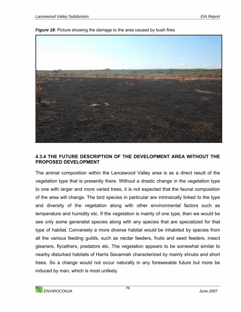
Lancewood Valley Subdivision EIA Report
ENVIROCONJA June 2007
76
Figure 18: Picture showing the damage to the area caused by bush fires
4.3.4 THE FUTURE DESCRIPTION OF THE DEVELOPMENT AREA WITHOUT THE PROPOSED DEVELOPMENT The animal composition within the Lancewood Valley area is as a direct result of the
vegetation type that is presently there. Without a drastic change in the vegetation type
to one with larger and more varied trees, it is not expected that the faunal composition
of the area will change. The bird species in particular are intrinsically linked to the type
and diversity of the vegetation along with other environmental factors such as
temperature and humidity etc. If the vegetation is mainly of one type, then we would be
see only some generalist species along with any species that are specialized for that
type of habitat. Conversely a more diverse habitat would be inhabited by species from
all the various feeding guilds, such as nectar feeders, fruits and seed feeders, insect
gleaners, flycathers, predators etc. The vegetation appears to be somewhat similar to
nearby disturbed habitats of Harris Savannah characterized by mainly shrubs and short
trees. So a change would not occur naturally in any foreseeable future but more be
induced by man, which is most unlikely.

Lancewood Valley Subdivision EIA Report
ENVIROCONJA June 2007
77
5. DESCRIPTION OF THE SOCIO - ECONOMIC SETTING
The socio-economic conditions of the area will be discussed in this section. The
conditions looked at will be examined in terms of micro (local) and macro (national)
levels.
5.1 METHODOLOGY The assessment of the Socio-economic setting of the study area involved the collection
of primary and secondary data.
One of the primary research tools used to glean socio-economic data from the existing
residents of the community was a questionnaire or structured interview (See Appendix
VI). For the purpose of this evaluation, local conditions focused on those on the site
itself and those within a 2 km radius (See Map 4) from the site while those on a national
level focused on the island-wide conditions. Informal discussions were also held with
residents of Lancewood Valley, Sandy Bay, Lancaster Hall, Inverness and Sand Bay
Halt during the month of November 2006.
The questionnaire is an inexpensive survey tool that is appropriate for circumstances in
which resources are limited. Since the questions and answers tend to be relatively
simple the data gathered from questionnaires is relatively easy to compile in
comparison to other survey types.
The questionnaire used had a mixed format of closed and open questions. Where
necessary the answers were limited to facilitate easier answers on the part of
participants. Some questions were semi-structured to allow the respondents to expand
on their previous answers or to give more personal input to their responses. In cases
where the expressed opinion of the participant was most appropriate the question
posed tended to be open allowing full expression.
The gathering of quantitative and qualitative data are equally important when gauging
the perceptions of stakeholders ranging from the existing conditions of their
Lancewood Valley Subdivision EIA Report
ENVIROCONJA June 2007
78
communities to what the impacts they believe any development may have on their
quality of life.
Secondary data collection was carried out through desktop research and data from the
Statistical Institute of Jamaica (STATIN), the Ministry of Education (MOE) and the
Planning Institute of Jamaica (PIOJ). 5.1.1 SOCIAL STRUCTURE
5.1.1.1 DEMOGRAPHY The total population of the study area is approximately 6,079. This number includes the
combined populations of Lancewood Valley, Lancaster Hall, Inverness, Sandy Bay,
Rosewell and Sand Bay Halt. The total population of Clarendon is 237, 024. This means
that the population of the study area represents approximately 2.6 % of the parish
population.
The total female population of the study area is 3,056 and the total male population is
3,023. Therefore, the females make up slightly more than half the population of the
study area at 50.3%. At the parish level however, males make up a marginally greater
portion of the population at 50.5%. It should be noted that 58% of the respondents to
the questionnaire were females and this percentage reasonably conforms to the
population split of the study area.
The 2001 census data from the Statistical Institute of Jamaica (STATIN) show that
approximately 36.9% of the population of the study area is less than 15 years of age.
This is higher than the national figure of 32.3% of the population being less than 15
years of age. In contrast to this 9.6% of the population of the study area is over the age
of 60. This shows closer agreement with the national figure of 10.2%. Using the figures from the 2001 census, and comparing this with the previous island-
wide population census in 1991, it is possible to present a crude estimation of the rate
of growth of the study area over this ten-year period. The study area shows an 81%
increase in population over the past ten years or an average rate of growth in population

Lancewood Valley Subdivision EIA Report
ENVIROCONJA June 2007
79
of 8.1% per year. At the parish level the rate of population increase is roughly 12% for
the same period or a yearly growth rate of approximately 1.2%. The rate of population
growth for the period 1991 to 2001 is 9.53%. Figure 19: Graph Showing the Comparison of the Population numbers of the study area and the Parish of Clarendon
Comparison of the Population numbers of the study area and the Parish of Clarendon
237,024
6,0790
50,000
100,000
150,000
200,000
250,000
Clarendon - Total Population Study area- Tota Population
Num
ber o
f Peo
ple
Source: STATIN (2001) Figure 20: Graph showing the Comparison in Age Distribution between the Study Area and Jamaica
Comparison in Age Distribution between the Study Area and Jamaica
32.3%
57.5%
10.2%
36.9%
53.5%
9.6%
0.0%10.0%20.0%30.0%40.0%50.0%60.0%70.0%
Under 15 years Between 15 and60 years
Above 60 yearsPerc
enta
ge A
ge D
istri
butio
n
JamaicaStudy Area
Source: STATIN (2001)
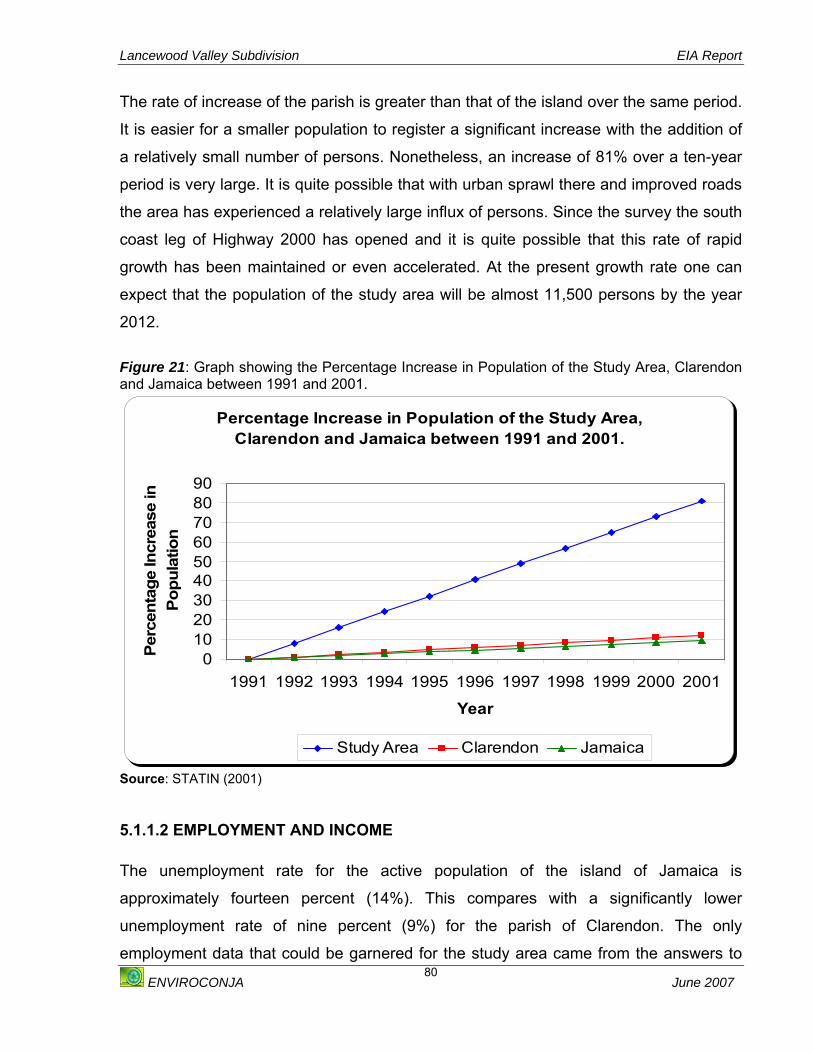
Lancewood Valley Subdivision EIA Report
ENVIROCONJA June 2007
80
The rate of increase of the parish is greater than that of the island over the same period.
It is easier for a smaller population to register a significant increase with the addition of
a relatively small number of persons. Nonetheless, an increase of 81% over a ten-year
period is very large. It is quite possible that with urban sprawl there and improved roads
the area has experienced a relatively large influx of persons. Since the survey the south
coast leg of Highway 2000 has opened and it is quite possible that this rate of rapid
growth has been maintained or even accelerated. At the present growth rate one can
expect that the population of the study area will be almost 11,500 persons by the year
2012.
Figure 21: Graph showing the Percentage Increase in Population of the Study Area, Clarendon and Jamaica between 1991 and 2001.
Percentage Increase in Population of the Study Area, Clarendon and Jamaica between 1991 and 2001.
0102030405060708090
1991 1992 1993 1994 1995 1996 1997 1998 1999 2000 2001
Year
Perc
enta
ge In
crea
se in
Po
pula
tion
Study Area Clarendon Jamaica
Source: STATIN (2001)
5.1.1.2 EMPLOYMENT AND INCOME The unemployment rate for the active population of the island of Jamaica is
approximately fourteen percent (14%). This compares with a significantly lower
unemployment rate of nine percent (9%) for the parish of Clarendon. The only
employment data that could be garnered for the study area came from the answers to

Lancewood Valley Subdivision EIA Report
ENVIROCONJA June 2007
81
the interviews of residents. Employment figures at the community level were not
available for the writing of this assessment.
Just over seventy-six percent (76.4%) responded that they had jobs. These ranged from
construction workers, caterers, drivers, domestic workers, farmers and shopkeepers.
The remaining respondents reported having itinerant jobs that more or less supported
themselves and their dependents. Although, employment did not seem to of major
concern to those polled, it is difficult to separate the economic outlook from persons’
views on the employment. Although most are employed and Clarendon on a whole has
a better employment rate than the island average it is generally a question of the level
of income. Most of the respondents were self-employed and therefore their income was
dependent on the disposable income of others. During difficult economic periods they
make less money and there is always the desire for more opportunity if this is directly
related to improved earnings.
Respondents were not forthcoming about their earnings over any given period. In the
few cases where those surveyed were willing to divulge that information the figures and
time periods were so variable that it was agreed that a reasonable and useful average
could not be used as representative of the study area.
5.1.2.3 CRIME AND VIOLENCE The majority of the respondents, eighty-two percent (82%), did not consider crime to be
a problem in the area. The remainder cited praedial larceny and petty theft among their
concerns, as well as reports of occasional gun crimes in adjacent communities. Given
the large number of goats roaming in the community, reports of praedial larceny are no
surprise.
5.1.2.4 TRAFFIC Within the community of Lancewood there is no major vehicular traffic. This, is in stark
contrast to the situation a few metres from the community where there is a major artery
for vehicular traffic; Highway 2000. The highway allows existing residents access to
other areas of the parish and parts of the south coast of Jamaica. Cars do not usually
Lancewood Valley Subdivision EIA Report
ENVIROCONJA June 2007
82
need to venture further in the community than the outskirts and this is where the
residents commute. The bad roads in the community keep the traffic to a minimum.
Although the traffic is low all residents wish good roads. Respondents were no different
and they hoped that with the development comes an improvement to the road network
of their respective communities.
5.2 INFRASTRUCTURE
5.2.1 HOUSING As at 2001 there were 1646 houses in the study area. Of these, ninety-seven percent
(97%) were separate or detached dwellings. Data for the parish of Clarendon indicates
that ninety-three percent (93%) of houses are separate or detached. The majority of
houses in the parish, eighty percent (80%) are concrete structures, and ninety-two
percent (92%) had roofs of metal sheeting.
The toilet facilities for the houses in the study area showed that in 2001 approximately
forty percent (40%) had access to water closet toilet facilities, whether under separate
or shared circumstances. Approximately fifty-seven percent (57%) of households used
pit latrines as their toilet facilities. This figure also included separate and shared facilities
among households. The remaining percentage either had no facility or there was no
report made for the statistics. Most of the persons who responded to the survey within
the area reported that they had indoor toilets within their homes.
Housing availability did not seem to be a problem within the Lancewood Valley area.
About sixty percent (60 %) of the persons interviewed said they owned their own home.
The remaining forty percent said they rented homes within the area. These persons
reported that it was not difficult to find a place to rent within the community. They
reported that rent ranged from $8,000 - $ 10,000 for a two-bedroom house.
Lancewood Valley Subdivision EIA Report
ENVIROCONJA June 2007
83
5.2.2 ROAD NETWORK The residents of Lancewood Valley and the surrounding communities face a paradox in
their transportation situation. They are in close proximity to the South coast leg of
Highway 2000, which is a new road in very good condition. As you enter the
surrounding communities however the road conditions deteriorate considerably and
movement by motor vehicle is hampered considerably.
5.2.3 UTILITIES
5.2.3.1 Electricity All the houses in close proximity to the development site (Lancewood Valley) reported
that they have access to electricity or have electricity in their homes.
5.2.3.2 Water Ninety percent (90%) of respondents said that they had access to piped water from the
National Water Commission (NWC). The remainder said that they had indoor plumbing
but that their water service from the NWC was unreliable or non-existent and received
their water supply from tanks.
5.2.3.3 Telecommunication Services Fixed line services are available in the Lancewood Valley area over 50 % of the
respondents said they had fixed lines in their homes.
Most respondents said they also relied on cellular service (Digicel, Cable and Wireless
and Miphone) for their telecommunication needs.
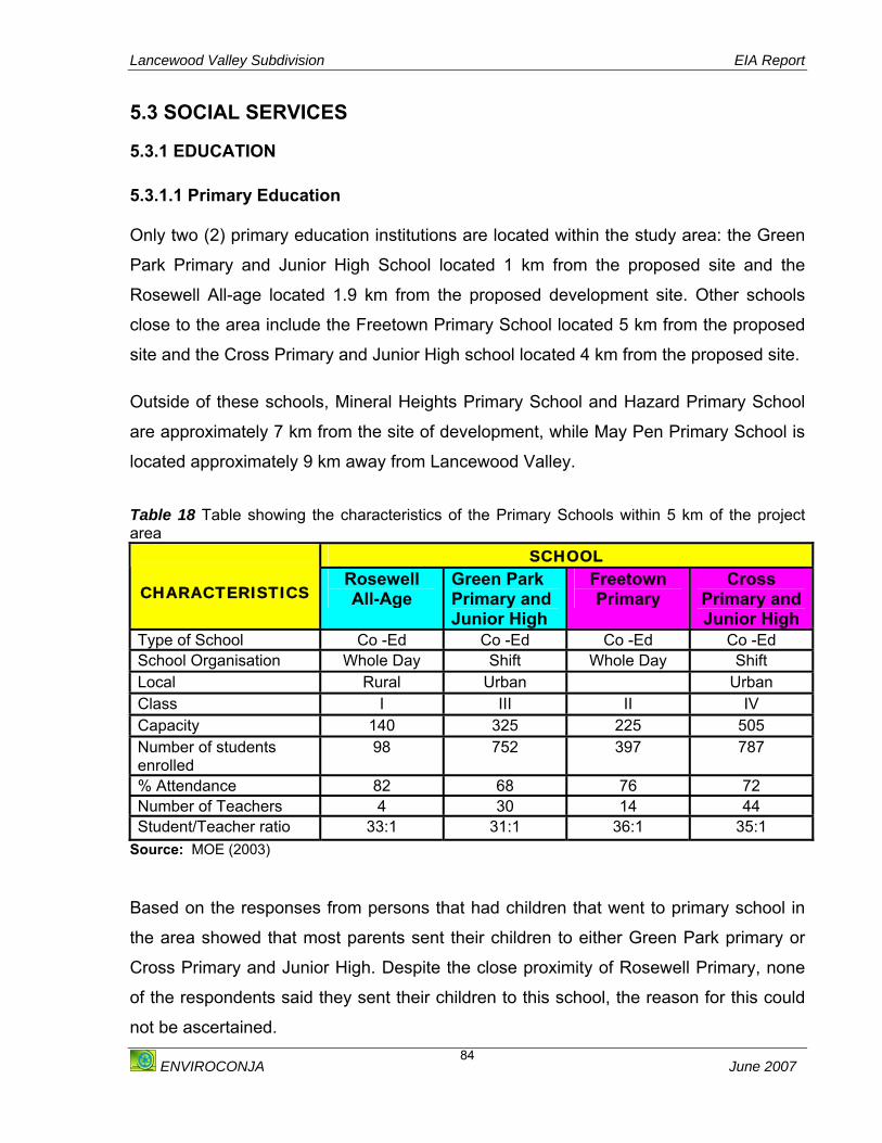
Lancewood Valley Subdivision EIA Report
ENVIROCONJA June 2007
84
5.3 SOCIAL SERVICES
5.3.1 EDUCATION 5.3.1.1 Primary Education Only two (2) primary education institutions are located within the study area: the Green
Park Primary and Junior High School located 1 km from the proposed site and the
Rosewell All-age located 1.9 km from the proposed development site. Other schools
close to the area include the Freetown Primary School located 5 km from the proposed
site and the Cross Primary and Junior High school located 4 km from the proposed site.
Outside of these schools, Mineral Heights Primary School and Hazard Primary School
are approximately 7 km from the site of development, while May Pen Primary School is
located approximately 9 km away from Lancewood Valley.
Table 18 Table showing the characteristics of the Primary Schools within 5 km of the project area
SCHOOL
CHARACTERISTICS Rosewell All-Age
Green Park Primary and Junior High
Freetown Primary
Cross Primary and Junior High
Type of School Co -Ed Co -Ed Co -Ed Co -Ed School Organisation Whole Day Shift Whole Day Shift Local Rural Urban Urban Class I III II IV Capacity 140 325 225 505 Number of students enrolled
98 752 397 787
% Attendance 82 68 76 72 Number of Teachers 4 30 14 44 Student/Teacher ratio 33:1 31:1 36:1 35:1
Source: MOE (2003) Based on the responses from persons that had children that went to primary school in
the area showed that most parents sent their children to either Green Park primary or
Cross Primary and Junior High. Despite the close proximity of Rosewell Primary, none
of the respondents said they sent their children to this school, the reason for this could
not be ascertained.
Lancewood Valley Subdivision EIA Report
ENVIROCONJA June 2007
85
None of the schools in the area showed signs of being overcrowded as both operate on
a shift basis to accommodate the number of students that are enrolled.
5.3.1.2 High/Secondary/Technical Schools There are no secondary, high or technical schools found in the study area. There is only
one technical high school in the parish of Clarendon and this is Vere Technical which is
found approximately eighteen (18) kilometres away from Lancewood Valley. This still
makes it the closest technical high school for existing and potential residents as the next
closest is Jose Marti Technical High School in St. Catherine.
The closest high schools are Central High School, Glenmuir High School and Denbigh
High School. All three (3) are in May Pen and its environs, which is approximately nine
(9) kilometres from Lancewood Valley. Interestingly, several of the respondents to the
questionnaires also mentioned Old Harbour High school as a secondary educational
institution that was used by children in the Sandy Bay district. Old Harbour High School
is found approximately 7.5 kilometres away from the study site. Although the town of
Old Harbour is in the adjoining parish of St. Catherine, it is actually closer to the study
site than May Pen and the high schools found there. It may be of note that the roads
that take one from Lancewood to May Pen are generally in good condition where as Old
Harbour roads may be considerably less so. A small number of the respondents
mentioned Clarendon College as the school their children attended. Clarendon College
is approximately 27 km from the study site and this is a fair distance to travel when
there are several high schools that are much closer. Although it was not expressly
mentioned, perhaps there exists a perception that the quality of education is better at
Clarendon College or perhaps it was the alma mater of one of the parents and this was
the reason that the children were attending this school.
Of the five secondary/high/technical schools close to the project site, only Old Harbour
High showed signs of overcrowding based on the capacity of the school, the enrolment
and the percentage attendance.

Lancewood Valley Subdivision EIA Report
ENVIROCONJA June 2007
86
Table 19: Table showing the characteristics of the secondary and technical schools in the project area
SCHOOLS CHARACTERISTIC Central
High Denbigh
High Glenmuir
High Vere
Technical Old
Harbour High
Gender Co-Ed Co-Ed Co-Ed Co-Ed Co-Ed
School Organisation Shift Extended Day
Whole Day Whole Day Shift
Local Urban Urban Urban Urban Urban Class
IV IV IV IV IV
Capacity
1575 1125 1215 1575 1350
Number of Students Enrolled
1800 1473 1298 1265 2307
Percentage Attendance
75 89 91 72 82
Number of Teachers 108 69 80 78 130 Pupils/ Teacher Ratio
19:1 25:1 18:1 17:1 20:1
Source: MOE (2003) About fifty percent (50%) of the respondents indicated that secondary education was
the highest level achieved. Thirty-six percent (36%) of those surveyed listed primary or
all-age education as the highest level of education attained. Fourteen percent listed
tertiary/ vocational education as the highest level of education achieved.
5.3.1.3 Tertiary Institutions There are two (2) tertiary educational institutions in the parish of Clarendon; Knox
Community College and the privately run May Pen Business College. The Knox
Community College is primarily located in Spaldings, Clarendon which is about 40 km
away from Lancewood Valley, although it operates three other campuses in May Pen,
Cobbla and Mandeville. The College offers pre-university arts and sciences, secretarial
studies and farm management courses culminating in certificates, diplomas, and
associate and bachelors degrees. The Economic and Social Survey of Jamaica, 2005
records the number of students enrolled at this community college as approximately
1,114. May Pen Business College offers courses in business administration and
secretarial studies.
Lancewood Valley Subdivision EIA Report
ENVIROCONJA June 2007
87
None of the respondents interviewed in the survey said they attended any of these
schools.
5.3.1.4 Vocational Institutions There are two vocational schools in the parish of Clarendon. These include the St.
Anna’s Academy which is located in May Pen, approximately 9 km from the Lancewood
Valley area. The other is the Ebony Park HEART Academy, which is located in Toll
Gate, which is approximately 25 km from Lancewood Valley area.
5.3.1.5 Special Education Schools Clarendon Group for the Disabled is the only educational institution dedicated to the
needs of challenged students. It is located in May Pen (9 km from the proposed
development site) and specially caters to the visually impaired. None of the respondents
were apparently physically challenged or indicated that their children were or mentioned
that they had children enrolled in this institution.
5.3.2 TRANSPORTATION The community is not large and it seems that most people get around within the
community by walking. Most respondents mentioned taxi as their main source of
transportation. They mentioned that the taxi service from the community to larger urban
areas such as May Pen was quite regular and were reportedly satisfied with the
reliability of the service.
Lancewood Valley Subdivision EIA Report
ENVIROCONJA June 2007
88
5.3.3 HEALTH SERVICES The major hospital in Clarendon is the May Pen Hospital. This is situated some 9 km
away from the study area. The Sandy Bay/ Green Park Clinic is within a kilometre or so
of the study area and the Denbigh Health clinic is in the environs of May Pen.
All respondents reported using the May Pen Hospital when seeking medical assistance.
Twenty percent (20%) reported using their own private doctors in addition to the hospital
and about thirty-five percent (35%) used either the Sandy Bay clinic or the Denbigh
clinic in addition to the hospitals. The level of health care sought seemed to be directly
related to severity of the health concern. For check ups and for management of chronic
illness those who were able went to private doctors, while others went to the clinic. If the
health issue was deemed major then the respondents used the hospital. The distance
between the study area and May Pen Hospital was never mentioned as a deterrent to
the use of the institution.
5.3.4 POSTAL SERVICES All of the respondents mentioned that the closest available post office was May Pen.
Most listed this as a problem that they hoped the development would help to rectify this
problem. The distance to retrieve their mail seemed to be the main grouse among
respondents.
5.3.5 EMERGENCY SERVICES 5.3.5.1 Fire Services The closest Fire Station to the study area is the May Pen Fire Station, which is located
approximately 10 km from the project site.
5.3.5.2 Police Station The closest Police Station to the study area is also located in May Pen. Residents within
the Lancewood Valley area expressed their concerns about a police post not being
closer to the area.

Lancewood Valley Subdivision EIA Report
ENVIROCONJA June 2007
89
5.3.6 WASTE 5.3.6.1 Solid Waste Based on interviews with resident’s garbage is collected in the area by the Metropolitan
Parks and Market at least once per week. This is disposed of at the solid waste disposal
site located at Riverton Landfill, which is operated by the National Solid Waste
Management Authority (NSWMA).
5.3.6.2 Sewage Disposal Most of the residents interviewed had indoor plumbing suitable for piped water in their
homes with toilet facilities. This sewage is disposed of in individual absorption pits
5.5 COMMUNITY’S PERCEPTION OF THE PROJECT All the respondents polled within the Lancewood Valley area were aware of the project
and its status to varying degrees. As the assessment moved further away from the
study area this awareness decreased. Most respondents seemed to have a favourable
view of the project although some of the respondents did not know what to make of it.
For the most part those polled seemed willing to adopt a ‘wait and see’ attitude before
expressly stating that the project would be of any great benefit to the community.
In general the members of the community would like to see a rise in the standard of
living that is available to them. Development of and improvement in the social amenities
that are available to the residents are of great importance. Perhaps the wariness of the
community members is related to their perception that the highway being in such close
proximity would have improved their standard of living and this has not occurred to the
extent that they would have hoped. It is evident however that cautious optimism remains
and there is still the hope that if the development is successful that it will at least provide
some opportunities such as jobs for the existing residents.

Lancewood Valley Subdivision EIA Report
ENVIROCONJA June 2007
90
6. ANALYSIS OF ALTERNATIVES The alternatives with respect to the project from an environmental and socio-economic
standpoint are discussed in this section. This includes a discussion on the project
activity alternatives and the project design alternatives.
6.1 THE ‘NO ACTION’ SCENARIO If the study area is left in its current state without the development, it can be predicted
that it will remain a highly disturbed area due to the high level of anthropogenic and
natural occurrences of bush fires that affect the area.
From a socio-economic perspective the “no action” option may not be the best
alternative. Lancewood Valley and its surrounding communities are in need of
community growth and development, which a housing development such as the one
proposed may be able to provide directly and indirectly. Considering the political climate
of the country, the area may be subject to squatting if left undeveloped.
6.2 PROPOSED SUBDIVISION The area with the proposed housing development may see some change in its
environmental attributes (physical and biological). Ecologically there will be an
insignificant loss of habitat and species diversity in the area. Drainage patterns, soils
quality and general geology of the area will not be affected by the subdivision.
From a Socio-Economic perspective the proposed housing development would
contribute significantly to a partial national, regional housing shortage. In addition
numerous jobs would be created by the development either directly or indirectly as well
as community growth and development for Lancewood Valley and its surrounding
communities.
6.3 AGRICULTURE The potential for certain agricultural practices such as produce is limited due to the
climate in the are. There is however potential for cattle and goat rearing. The returns on

Lancewood Valley Subdivision EIA Report
ENVIROCONJA June 2007
91
these practices however have been marginal due to the instances of praedial larceny.
Intensive cattle and goat farming may also cause surface water contamination due to
the presence of a watercourse on the property. Agriculture is therefore not a suitable
alternative.
6.4 THE CHOSEN ALTERNATIVE After careful consideration of the environmental and socio-economic impacts that may
arise from the project, the proposed subdivision has been chosen as the most suitable
alternative of the three project activity alternatives analysed. The ‘No Action” alternative
is the best from an ecological point of view although no species of high conservation
value will be lost. The other two alternatives assessed would have varied negative
environmental impacts, which however can be mitigated. From a socio-economic
perspective the subdivision will have the most positive impact on Lancewood Valley and
its surrounding communities.

Lancewood Valley Subdivision EIA Report
ENVIROCONJA June 2007
92
7. ENVIRONMENTAL IMPACT ASSESSMENT This section outlines the methodology used for predicting the impacts of the project and
the identification of subsequent mitigation measures recommended for each impact
identified. These mitigation measures have been summarised and the added cost to the
developer of each mitigation measure estimated.
METHODOLOGY An environmental impact identification matrix was developed which covered the main
potential impacts (positive, negative, major, minor, long and short term and any
cumulative or synergistic impacts) of the project. The matrix lists impact types under
broad headings with more detailed project specific impact categories. These impacts
are divided into the Site Preparation, Construction and Post Construction phases of the
development.
7.1 PHYSICAL IMPACTS
7.1.1 CLIMATE
A. SITE PREPARATION AND CONSTRUCTION PHASES The Lancewood Valley area is covered by very little trees, and therefore the removal of
this vegetation will have little or no impact on the climate in the area.
Mitigation Measures:
o All mature trees present must be maintained and not be removed during this
phase of the development.
o Ensure that the road system implemented throughout the development and
access roads to the development involves appropriate signals and signs to
ensure the smooth flow of traffic. This will reduce the idling of vehicles and
therefore minimise the emissions in the area.

Lancewood Valley Subdivision EIA Report
ENVIROCONJA June 2007
93
B. POST - CONSTRUCTION PHASE The increase in the population after the construction of the development will mean
increase in the traffic in the area. Increased traffic means increased release of exhaust
from cars, which contribute to global warming. Assuming the minimum one car per
household, the traffic in the area will increase by one hundred and twenty one (121)
cars over a period of time. This phase of the development may therefore have a long
term, minor negative impact on the climate locally, nationally and globally.
Landscaping will be done throughout the development during this phase. Research has
however shown that the vegetation can positively affect cloud formation and
precipitation through their impact on evaporation and convection. Vegetation also acts
as carbon sinks for greenhouse gases. These activities can therefore positively impact
on the climate of the area.
Mitigation Measures:
o Incorporate as far as possible natural vegetation typical of the area during the
landscaping of the development.
o Although the proper maintenance of vehicles by potential occupants of the
development is not the responsibility of the developer it must be impressed upon
the potential residents to maintain their vehicles regularly.
7.1.2 AIR QUALITY Nitrogen Dioxide (NO2) is a product of combustion processes (e.g. from vehicle exhaust,
power plants) and is closely associated with other pollutants including particulate
matter. It is toxic and is a precursor of ozone. Most atmospheric NO2 is emitted as
nitrous oxide (NO), and is oxidized to NO2 by ozone (O3). Sulphur dioxide (SO2) is
emitted from power plants and diesel vehicles, as well as from industrial boilers, metal
smelters and paper manufacturing. Sulphur dioxide and nitrogen oxides cause acid rain. NO2 and SO2 may cause adverse health effects, via both acute and chronic exposure.
Chronic exposure may result in increased incidences of respiratory illnesses in the
exposed population.

Lancewood Valley Subdivision EIA Report
ENVIROCONJA June 2007
94
A. SITE PREPARATION and CONSTRUCTION PHASES It is expected that during these phases of development that there may be some
changes in the air quality.
Vegetation clearing for site preparation, storage of raw materials and spoilage, and
preparation of access roads are all expected to liberate dust and other forms of
particulate matter. While most of the dust generated is likely to settle a short distance
from these sources, smaller particles may be transported across a wider area. The
magnitude of dispersion will be influenced by the local meteorological conditions. The
fugitive dust has the impact of being a nuisance as well as fine particulates (< 10µm
measured as PM10) may cause respiratory distress or illness (asthma, bronchitis) and
therefore dust generated from the site preparation and construction activities is likely to
have a major negative short-term local environmental impact.
Movement of heavy construction vehicles and the increase in traffic may cause an
increase of local greenhouse gas emissions. It is also expected that construction of
roads will cause the on-site release of noxious fumes due to the processing of asphalt.
The impacts although negative, may be short term, but not significant.
Mitigation Measures:
o The clearing of vegetation must be carried out on a phased basis; that is only
areas designated for construction during the necessary phase of development
must be cleared to minimise the dust that may be generated.
o The area to be designated as a green space will be covered with sod to eliminate
the dust to be generated from this area. This area will only be cleared within a
week before the sod is to be laid.
o Ensure that all material (sand and aggregate) stockpiled on the site to be used in
construction activities are regularly sprayed to reduce the effects of wind
whipping.
Lancewood Valley Subdivision EIA Report
ENVIROCONJA June 2007
95
o Ensure that all trucks carrying aggregate and sand are covered during delivery to
the site.
o Care must be taken in the unloading of aggregate, sand and cement to prevent
spillage.
o Extra care must be taken to reduce dust in periods when wind speed are greatest
which is between June and July, e.g. extra wetting of the compound to suppress
dust.
o Plant large trees on perimeter of compound to create a natural windbreak, which
will also serve the purpose of being a screen shielding the construction activities
from public view.
o All staff employed at the construction site must be provided with dust masks and
be asked to use them. o All raw materials must be sourced as close as possible to the construction site.
o Where possible waste must be transported off-site for processing, not burnt or
stored for any longer than is absolutely necessary.
o Recruit staff from the surrounding communities to decrease the travelling
distance thus reducing emissions from vehicular traffic.
o Ensure that all vehicles involved in the transport of construction material and
staff, and machinery involved in the construction is properly maintained and
serviced.
o Machines must not be left idling for unnecessary periods of time; this will save
fuel and reduce emissions.
o Where possible, the use of the machinery must be scheduled to have most use
when the residents are not in the area.
o Perform road repair and construction at times that persons are expected to be at
work and school as this produces noxious gases.
B. POST – CONSTRUCTION PHASE Assuming that there will be one car per household, the increase in traffic may increase
by approximately one hundred and twenty one (121) vehicles over a period of time. The
long-term effects of increased traffic in the area will cause an increase in Carbon
Monoxide, SOx and NOx, which are greenhouse gases that contribute to the

Lancewood Valley Subdivision EIA Report
ENVIROCONJA June 2007
96
degradation of the ozone layer and are key factors in the production of acid rain. This
phase of the development may have a minor, long term, negative impact on the air
quality at a local, national and global level.
Mitigation Measures:
o Although the proper maintenance of vehicles by potential occupants of the
development is not the responsibility of the developer, it must be impressed upon
the potential residents to maintain their vehicles regularly.
o A traffic system that involves appropriate signals and signs to ensure the smooth
flow of traffic must be implemented. This will reduce the idling of vehicles that
may occur and therefore reduce the emissions in the area. This may necessitate
the alteration of the existing roadway, which have implied impacts.
7.1.3 WATER QUALITY & QUANTITY 7.1.3.1 WATER QUALITY A. SITE PREPARATION AND CONSTRUCTION PHASES The development may have a minor, negative, long-term impact on surface water
quality during the Site Preparation phase of the development. This will be as a result of
the possible storage of hazardous substances on the site such as diesel and motor oil
onsite for the operation of machinery and stand-by generator as well as the storage of
aggregate and asphalt for the construction of roads.
Inappropriate disposal of sewage during this phase of the development may have an
impact on the surface water as well.
Mitigation Measures:
o If diesel and motor oil is to be stored, ensure that they are properly contained in a
bunded area (With capacity to contain 1½ times the amount of substances
stored. This area must be situated away from project activities and signs
indicating the storage of these substances erected.
Lancewood Valley Subdivision EIA Report
ENVIROCONJA June 2007
97
o Provide workers at the development site with chemical toilets during this phase of
the development. A reasonable ratio would be eight (8) workers per chemical
toilet.
o Store all raw materials away from the vicinity of watercourses located on the
property to avoid contamination of this area.
o General refuse must be transported and disposed of appropriately at the
designated disposal site at Riverton Landfill by a licensed contractor.
o Install a proper drainage system to control rain/storm water runoff on the site.
o Implement the recommended sewage treatment method which involves a
Septic Tank / Tile Field for each lot.
B. POST-CONSTRUCTION PHASE The development may have a major long-term impact on the surface water quality. This
watercourse empties into a river located within the Portland Bight Protected Area and
this increases the relevance of the mitigation of these impacts. Improper sewage
The activities involved in maintaining the open space which are around the development
site may also have a significant, negative, long term impact on water quality as
fertilizers and pesticides may be utilised in the maintenance of this area.
There will be no impact on groundwater quality.
Mitigation Measures:
o Ensure that the sewage treatment facilities are properly maintained.
o Regularly maintain the drainage system, which controls the storm water runoff
at the site.
o Ensure that general refuse is collected regularly and is transported and
disposed of appropriately at the designated disposal site at Riverton Landfill by
a licensed contractor.

Lancewood Valley Subdivision EIA Report
ENVIROCONJA June 2007
98
7.1.3.1 WATER QUANTITY
A. SITE PREPARATION AND CONSTRUCTION PHASES
Lancewood Valley and its surrounding communities do not face a water supply problem
and therefore there is adequate water available to meet the needs during these phases
of the development. This phase of the development will therefore have no impact on the
water supply in the area.
Mitigation Measure:
o Although water supply is readily available, it is important for the developer to
implement measures to conserve water as much as possible during these
phases of the development.
B. POST- CONSTRUCTION PHASE With the proposed subdivision the population in the area may increase by as much as
seven hundred persons, which will increase the demand on water supply in the area.
This however will not have any impact on this water supply, as there is sufficient water
available in the area to adequately supply the development. Although water supply is
not a problem in the area, residents must make an effort to conserve on water.
Mitigation Measures:
o The developer should encourage residents to gutter all houses and encourage
residents to recycle water for landscaping purposes.
o The developer should encourage residents to install water saving devices
(faucets, toilets etc.) into their home design.
Lancewood Valley Subdivision EIA Report
ENVIROCONJA June 2007
99
7.1.4 SOILS AND GEOLOGY
A. SITE PREPARATION AND CONSTRUCTION PHASES The activities involved in the site preparation and construction phases of the
development may have a major negative short-term impact on soil and geology of the
project site. This is due to the removal of vegetation from the area and this will leave
considerable areas of soil exposed to the elements, which may result in soil erosion.
Heavy machinery will be traversing the site due to the construction activities this may
lead to soil compaction and erosion of the soil.
Hazardous substances such as diesel used for the operation of machinery and stand-by
generators, may be stored on the property. This may have a significant negative long-
term impact on soil quality in the area.
Mitigation Measures:
o Remove as little vegetation as possible from the development site and
revegetate cleared vegetation as soon as possible. These areas must be
cleared in phases.
o Install appropriate drainage systems to direct water away from slopes.
o Avoid as far as possible the traversing of bare soil by vehicles to reduce soil
compaction.
o Designate a main access route for heavy machinery.
o Utilise sod layers in the open area, which will reduce the effect of soil erosion
when grass is being established.
o Avoid activities in these phases in period when wind velocities are highest
which is between June and July.
o Avoid activities in these phases in periods of heavy rainfall, which are
September and October.
o Areas storing hazardous substances such as diesel must be properly contained
in a bunded area (With capacity to contain 1 ½ times the amount of substances
stored. This area must be situated away from project activities and signs
Lancewood Valley Subdivision EIA Report
ENVIROCONJA June 2007
100
indicating the storage of these substances erected. Care must be taken when
handling these hazardous substances to avoid spills
o In the event of a spill the contaminated soil must be removed and disposed of at
a licensed landfill.
o Ensure that general refuse is collected regularly and is transported and
disposed of appropriately at the designated disposal site at Riverton Landfill by
a licensed contractor.
B. POST – CONSTRUCTION PHASE With the introduction of vegetation and paved areas to the proposed subdivision there
will be no impacts to the soil quality and geology of the area during this phase of the
assessment.
Mitigation Measures:
o Stipulate that houses to be constructed within the subdivision must be guttered
as runoff from roofs may typically cause accelerated soil erosion around the
margins of buildings. (Residents can collect water which may be utilised for
irrigation of landscape).
7.1.5 HYDROGEOLOGY
a. Site Preparation and Construction Phases These phases of the development may have a minor short-term negative impact on the
hydrology of the area. Heavy equipment used in these phases of the development can
cause soil compaction and therefore result in increased surface runoff, which changes
the natural internal drainage capacity.
Mitigation Measures:
o Designate a main access route for heavy machinery.
o Utilise impervious material for areas that require paving to increase run-off.
o Ensure that the drainage plan proposed is implemented as stipulated on the
plan.

Lancewood Valley Subdivision EIA Report
ENVIROCONJA June 2007
101
o Phase the clearing of vegetation on slopes.
o Ponding may occur in the depression area and therefore this should be retained
as a green area for recreation and possible for a detention of storm water.
o Paved areas should be kept to a minimum to reduce runoff to the depression.
o No lots or building of houses should take place below the 53m contour.
o Keep paved areas to an absolute minimum and encourage the use of
permeable material for parking lots etc. to allow infiltration into the ground.
B. POST-CONSTRUCTION PHASE The Post-Construction Phase is likely to have a minor negative, long-term impact on the
hydrology of the area. This is however not significant as runoff levels predicted are
marginal.
Mitigation Measures:
o Keep paved areas to an absolute minimum and encourage the use of
permeable material for parking lots etc. to allow infiltration into the ground.
7.1.6 NOISE & VIBRATION Noise pollution can be considered any unwanted sound, usually of anthropogenic origin.
This description of course, incorporates the subjectivity of what a receiver may find a
nuisance. Furthermore, a sound that may be insignificant or even pleasurable as is the
case with music at lower decibel levels can become not only a nuisance but even have
long-term health impacts with prolonged exposure at significantly higher decibel levels.
The association of hearing loss and chronic exposure to noise is well established.
A. SITE PREPARATION AND CONSTRUCTION PHASES These phases of the development may have a significant negative, short-term impact
on ambient noise levels of the area. Site preparation will require the cutting of an access
road to accommodate the movement of vehicles related to construction and the
movement of goods and materials for construction of houses and support structures like
roads, electrical wires, and water and sewage conduits. Construction of houses involves

Lancewood Valley Subdivision EIA Report
ENVIROCONJA June 2007
102
noise associated with drilling, hammering and welding. Most construction equipment
available is not silenced and this can be injurious to labourers as well as a nuisance to
existing residents. At 7 metres, a grader can be as loud as 94 db (A) and an un-silenced
pneumatic drill up to 90 db (A). This phase will see the greatest increase in noise
pollution. It will be relatively short-term but the major sources will be from vehicles
involved in site clearing and excavation such as graders and bulldozers as well as
vehicles for construction activities like cement mixers. During the site clearing and
construction phase a number of measures may be undertaken by the developers to
reduce the impact of noise on the existing and potential residents as well as the workers
involved in the project.
Mitigation Measures:
o Access roads should be cut that are exclusively used for the transportation of
workers, goods and materials. This road should be sited in such a way that the
noise from this movement affects as few of the existing residents as possible.
o Where possible silenced machinery and instruments should be employed to
reduce the impact of noise on the existing residents and workers.
o Machinery, vehicles and instruments that emit high levels of noise should be
used on a phased basis to reduce the overall impact. These pieces of equipment
such as drills, graders and cement mixers should also be used when the least
number of residents can be expected to be affected, for example during periods
where most residents are at work or school.
o Workers, especially those working with machinery, vehicles and instruments that
emit high levels of noise should be supplied with ear plugs and ear muffs to
reduce the risk of hearing impairment. Prolonged exposure to this impact should
be reduced where possible.
o Temporary barriers such as earth berms, zinc fencing and sound dampening
fencing such as acoustic screens should be employed to reduce the impact of
noise to the existing residents
o Construction hours should be limited to the hours of 8:00 to 6:00 p.m. daily.
o The delivery of raw materials must be limited to 8:00 a.m. and 6:00 p.m.
Lancewood Valley Subdivision EIA Report
ENVIROCONJA June 2007
103
B. POST - CONSTRUCTION PHASE The operation phase of the project is indefinite. The expected increase in population
and attendant vehicular traffic will probably be the most significant addition to the noise
impact during this phase. A properly planned development will mean well-constructed
roads that allow free flowing traffic within the proposed community. Most of the
mitigation methods will be dependent on the residents.
The close proximity to the trainline, which borders the property, will also create a noise
impact to the housing development.
Mitigation Measures:
o Proper traffic signage and signals where necessary or appropriate to effect
the free and safe movement of traffic and there reduce the noise caused by
traffic build-up.
o Properly maintained vehicles and well-inflated tyres to reduce the friction will
produce less noise.
o Where carpooling and public transportation is feasible, it should be
encouraged to reduce traffic.
o Create a reservation within the subdivision within the vicinity of the trainline to
offset the noise impact from this activity.
o Construct a high wall, which separates the subdivision from the trainline. This
wall should be free of holes and apertures to reduce the propagation path of
the noise that is generated from this activity.
o A vegetation screen should also be created in the vicinity of the trainline. For
this to be effective trees must be tall and dense. The developer therefore
needs to begin this tree planting early in construction phase, in order for this
to have an effect during post- construction.
Lancewood Valley Subdivision EIA Report
ENVIROCONJA June 2007
104
7.1.7 LANDSCAPE AND AESTHETICS A. SITE PREPARATION AND CONSTRUCTION PHASES The site as it currently exists has not been landscaped and many may find it not
aesthetically pleasing, this will be further exacerbated by the removal of vegetation
during these phases of the development. This impact however will be a minor short-
term negative impact.
Mitigation Measures:
o Remove as little vegetation throughout the site as possible.
o Conduct vegetation clearance on a phased basis.
o Re-vegetate cleared areas as soon as possible.
o Plant vegetation screens to reduce the visual effect of this stage of the
development.
o Place caveats on titles of the properties so that the construction of homes within
the subdivision will be carried out in a uniform fashion.
o Ensure that local building materials and muted colours are used to reduce the
visual impacts of the development and the landscaping to hide it or blend in with
the local environment.
B. POST - CONSTRUCTION PHASE The development area is presently in ruinate. Implementing landscaping throughout the
development may have a major positive long-term on the aesthetics of the area. The
upgrade of the roadways to the development may increase the aesthetics appeal of the
general Lancewood Valley area.
A nicely landscaped and uniform housing development, especially from the zone of
visual intrusion from the Highway will have an aesthetic appeal. This can be enhanced
with implementing the mitigation measures outlined below.
Mitigation Measures:
o Incorporate as far as possible the natural vegetation throughout the site.
Lancewood Valley Subdivision EIA Report
ENVIROCONJA June 2007
105
o Incorporate fruit trees, ornamentals and flowers throughout the development.
Ensure that these plants however are not classified as Invasive Alien Species.
7.2 BIOLOGICAL IMPACTS 7.2.1 FLORA
a. Site Preparation and Construction Phases The development will have a minor long-term negative impact on the ecology of the
area. This will be caused by several factors. The most important of these will however
be by land clearance. Vegetation will be cleared from over 25 hectares of land, which is
a considerable amount of clearing. Most of the vegetation to be cleared does not have
any ecological significance however with 70 % being grass.
Because of the low species diversity and plant cover, the vegetation supports a low
species diversity of fauna, which also makes the impact that the development will have
on the flora of the area less significant.
Mitigation Measures:
o Only clear vegetation that is absolutely necessary for the construction activities
o Retain all mature trees during this phase of the development
B. POST-CONSTRUCTION PHASE It is assumed that on the completion of the development occupants will introduce
flowers, fruit trees and other ornamentals to the area. While landscaping will be
undertaken post construction, it is expected that this will positively impact on the
ecology of the area.
Mitigation Measures:
o Avoid the use of invasive alien species in the landscaping of the property.

Lancewood Valley Subdivision EIA Report
ENVIROCONJA June 2007
106
7.2.2 FAUNA 7.2.2.1 AVIFAUNA A. SITE PREPARATION AND CONSTRUCTION PHASES The Lancewood Valley area shows a high level of disturbance with a low species
diversity of birds and few available niches. This phase of the development may have a
minor short-term negative impact during these phases of the development. During this
time birds may be displaced to the nearby open woodlands and residential areas. This
however will only be temporary, as the birds would be expected to return and make use
of the new landscape.
Mitigation Measures:
o These activities can be undertaken at a time outside the breeding season
(March to June) and would force the any migrant birds to find alternate areas for
nesting instead of having nest failures being a direct result of the vegetation
clearance.
o Incorporate as much of the natural vegetation into the development as possible.
o Birds tend to be most active during the early morning and late evening.
Construction activities must therefore be limited to the hours of 8:00 a.m. and
6:00 p.m.
B. POST CONSTRUCTION PHASE With the completion of the project bringing landscaping additions such as ornamental
and fruit trees as well as flowers, it is expected to have a strong positive impact on the
avifauna of the area. Residential areas, although highly disturbed and occupied by man,
often attract a large number of different species of birds. This is because man has so
modified the environment in effect creating more food sources and roosting areas for
birds, in effect creating more niches and a more dynamic habitat.
Lancewood Valley Subdivision EIA Report
ENVIROCONJA June 2007
107
Mitigation Measure:
o Incorporate ornamental and fruit trees as wells as flowers throughout the
development. This will attract birds to the area.
7.2.2.2 BUTTERFLIES A. SITE PREPARATION AND CONSTRUCTION PHASES None of the butterflies observed at the project were threatened in their distribution, the
area does support species diversity in this fauna but this was thought to be supported
by the densely forested areas close to the proposed development site.
The clearing of vegetation, which usually takes place in site preparation, may have a
major negative impact on all aspects of the life cycle of the butterflies, which is
approximately 30 days. All Lepidoptera rely on the leaves of plants, usually the
underside, as the place for laying and attachment of eggs.
Mitigation Measure:
o Plant native shrubs and herbs throughout the development such as Lantana sps.
to encourage the butterflies to remain in the area.
b. POST-CONSTRUCTION PHASE
This phase of the development may have a positive impact on these species. Most of
the butterflies observed in this area can be found in most urban settings throughout the
country and in disturbed environments.
Mitigation Measure:
o Incorporate fruit trees and flowers throughout the development may attract more
species and individuals to the area.

Lancewood Valley Subdivision EIA Report
ENVIROCONJA June 2007
108
7.2.2.3 OTHER MACROFAUNA A. SITE PREPARATION AND CONSTRUCTION PHASES This phase will have the greatest impact on the faunal composition of the development
site. Initially site preparation will involve the clearing of vegetation and levelling of
features of land that act as specific habitats for various animals in the area. The
Lantana sp. supports a wide variety of the butterfly species found in the area as well as
the animals that prey on them including lizards and dragonflies that are also found in
abundance at the site. Similar areas include a stand of water hyacinths found on the
site, which is also a habitat for many of the butterfly species. This impact will be
negative and long-term. It is important to note however that no rare, threatened
protected and endangered species were observed during the assessment. Only one
endemic species of lizard was observed and these are not threatened in their
distribution. This therefore reduces the significance of this impact.
The knock-on effect of vegetation clearance, dust and noise from construction activities
will possibly remove all but fauna most adapted to highly disturbed environments, at
least for the short term. This most likely will mean an increase in nuisance species,
either already present and or the introduction of further nuisance species; especially as
the predator-prey relationships and reproductive regimes are disturbed. It should be
noted, however, that many of the species present have already displayed a tolerance
for a highly disturbed ecosystem. There was major disturbance when the highway was
being constructed although without knowing what the species composition was before it
is impossible to discern to what extent the site has shown a level of recovery.
There is very little that can be done to mitigate this phase. It is likely that the developer
will have to prove that support infrastructure is in place to aid in the selling of lots. This
will mean roads and excavation for water mains, electricity and telecommunications. It is
probable that this will be effected in one phase rather than in several phases. If it is
done on a limited and phased basis then the impact can be mitigated by creating fewer
disturbances to the entire site. This solution is still however limited in its scope because
it represents the preparation for the permanent alteration of various habitats.
Lancewood Valley Subdivision EIA Report
ENVIROCONJA June 2007
109
Mitigation Measures:
o If possible, introduce site clearing on a phased basis to allow species opportunity
to relocate to suitable nearby habitats and to reduce the shock to the various
habitats that would be disturbed.
o During site preparation and construction phases, the spoilage and waste should
be removed, relocated or stored in a manner that does not allow for the
disturbance of surrounding habitats or the species that remain.
B. POST-CONSTRUCTION PHASE An increase in human activity as persons move into the development will cause traffic to
increase, increased noise to the environment, and may create minor though negative
changes to the air quality. These factors coupled with the loss of vegetation will have a
major long-term impact on the fauna currently on the site. With the site permanently
altered there exists the opportunity for mitigation measures that may have a larger and
longer impact than in the site preparation and construction. The Portland Bight
Protected Area is in close proximity to the site and it is hoped that when this relatively
undisturbed area can support the species that are displaced by human activity.
Mitigation measure may have some slight rehabilitative effect on the development site
however even in the post construction phase.
Mitigation Measures:
o The planting of native species in lots should allow for the possible re-colonization
by some of the species as well as adding to the aesthetic appeal of the
development.
o The reservation of green spaces that are uninterrupted by aspects of the
development may be used for a “passive” habitat creation. Areas of the site can
be replanted with plant species that may encourage the return of associated
animal species.

Lancewood Valley Subdivision EIA Report
ENVIROCONJA June 2007
110
8. SOCIO - ECONOMIC IMPACT ASSESSMENT
This section outlines the methodology used for predicting the socio-economic impacts of
the project and the identification of subsequent mitigation measures recommended for
each impact identified.
Methodology A socio-economic impact identification matrix was developed which covered the main
potential impacts (positive, negative, major, minor, long and short term and any
cumulative or synergistic impacts) of the project. The matrix lists impact types under
broad headings with more detailed project specific impact categories. These impacts
are divided into the Site Preparation, construction and post construction phases of the
project.
8.1 SOCIAL STRUCTURE
8.1.1 DEMOGRAPHY A. SITE PREPARATION AND CONSTRUCTION PHASES The inflow of workers who choose to reside in the community during these phases of
the development will not have any impact on the demography of the area, as there is no
evidence of overcrowding in the community. The developer is however encouraged to
recruit as far as possible local workers.
B. POST – CONSTRUCTION PHASE
At the present growth rate one can expect that the population of the study area will be
almost 11,500 persons by the year 2012 this is without the development. The average
household size of 4 - 5 persons in three and four bedroom houses would cause an
increase in the population by approximately seven hundred and twenty six (726)
persons with the completion of the entire development. This will not affect the
demography of the area however.

Lancewood Valley Subdivision EIA Report
ENVIROCONJA June 2007
111
It is assumed however that the development will not significantly affect the age and sex
structure of the area.
Mitigation Measures: o Give locals first purchasing options within the development.
o The Local Planning Authority must play an important role in ensuring that the
community growth in the area is monitored and implemented in an orderly manner.
8.1.2 EMPLOYMENT AND INCOME A. SITE PREPARATION AND CONSTRUCTION PHASES
The parish of Clarendon has an unemployment rate that is considerably lower than that
of the island of Jamaica. The level of growth of the parish is also significantly higher
than that of the island and this is especially so for the study area. Any available jobs will
provide an immediate positive impact on the employment and income situation at the
level of the study area as well as at the regional level. This phase of the development
will provide the most benefits in terms of sustained employment and increase in income.
Initially the site preparation phase will employ specific vehicles and equipment in order
to clear vegetation, for landscaping and grading and levelling and the cutting of access
roads for these vehicles and labourers to access the site. This will initially mean many
skilled workers will be necessary to operate front-end loaders, excavators, bulldozers
and backhoes and other vehicles. In addition to this unskilled labourers will still be
necessary for other tasks. The immediate area and surrounding communities may not
have the pool of workers that are necessary to man these vehicles or marshal the site
clearing work. If this is the case then although the benefits to the community can still be
seen in the use of unskilled labourers the major benefits may be seen more in the
knock-on effects that accrue, such as vendors and the various shops in the area
supplying the workers with meals and refreshments or the ingredients for such.
The construction phase will use several skilled workers including carpenters,
electricians, plumbers, masons, roofing specialists and painters in addition to several

Lancewood Valley Subdivision EIA Report
ENVIROCONJA June 2007
112
unskilled labourers. Once the lots are sold the building responsibilities will be under the
purview of each lot owner or whoever the lot may be subsequently leased or sold to.
The contractor that is chosen by individuals may well hire the workers that he has
worked with before. This may also mean that labourers, whether skilled or otherwise do
not necessarily come from the area or even the parish depending on his local ties. It is
also likely that materials for construction that can be obtained from the area or parish
would be used if only because the cost of transportation becomes increasingly
expensive with distance. Nonetheless both phases should have a positive short-term
impact on employment and income of the community and the parish by supplying
personnel and materials for the project. The use of any and all support services for the
development such as hardware stores, furniture stores, truck drivers to transport raw
and finished products, artisans that provide services like grill-making and woodwork will
all benefit in the short term.
Mitigation Measures:
o As much as is possible it is recommended that persons from the nearby
communities be employed to work on the construction site. This will ensure that
the community gets the most benefits from the development.
o As far as possible source raw material to be used in development from local
suppliers.
o Identify a specific area on the project site for vending type activities.
B. POST - CONSTRUCTION PHASE With the short-term labour finished, any impact on employment at this stage will be a
minor positive. With houses comes the need for upkeep and maintenance of services.
That will mean that although infrequent, there will still be the need for services of
plumbers, electricians, domestic help and other skilled workers. Furthermore, with more
individuals there will be demands on social services and the provision of these services
will lead to greater employment and or increased income. Those expected to benefit
would be shopkeepers, supermarkets, haberdasheries and other similar vendors as well
commercial banks and credit unions in the area.

Lancewood Valley Subdivision EIA Report
ENVIROCONJA June 2007
113
Mitigation Measure: o The Local Planning Authority must play an important role in ensuring that the
community growth in the area is monitored and implemented in an orderly manner.
8.1.3 CRIME AND VIOLENCE A. SITE PREPARATION AND CONSTRUCTION PHASES Violence at construction sites in Jamaica is a common problem. These phases of the
development may have a minor negative, short term effect on the levels of crime and
violence in the area.
Mitigation Measures:
o As much as is possible it is recommended that persons from the nearby
communities be employed to work on the construction site. This will avoid any
feelings of resentment that may be felt from locals and may reduce the level of
crime and violence during these phases of the development.
o Despite the added expense it is recommended that there be adequate security
present at the site at all times.
B. POST - CONSTRUCTION PHASE A major long -term negative impact of the proposed development could be the issue of
the attraction, particularly at the outset, of thieves and burglars to the area. This may
have the added impact of increasing the level of crime and violence in the wider
community as well.
Mitigation Measure:
o Residents must be encouraged to implement measures to protect property. This
could take the form of neighbourhood watches, burglar bars, security guards, and
dogs.

Lancewood Valley Subdivision EIA Report
ENVIROCONJA June 2007
114
8.1.4 TRAFFIC A. SITE PREPARATION AND CONSTRUCTION PHASES This phase of the development will have little impact on the traffic of the area, as traffic
is currently not a problem in the community of Lancewood Valley. The inflow of heavy-
duty vehicles and vehicles transporting workers may slow the traffic that flows into the
area and along access roads, but this will not be significant. It is therefore considered
that this phase of the development will have a minor negative impact on traffic of the
area. The upgrading works that will be undertaken to the access roads may cause an
increase in traffic delays but this too, although negative, will be minor.
Mitigation Measures:
o Place flagmen along road network to regulate the traffic during road upgrade.
o As far as possible employ persons from the community to reduce the increase in
vehicles that will transport workers.
o Place warning signs informing persons of the upgrading works.
B. POST – CONSTRUCTION PHASE Traffic does not seem to currently be a major problem in the Lancewood Valley area,
but the increase in traffic that would accompany a successful subdivision may turn out
to be a nuisance to an area that does not see a lot of traffic at this point. Assuming one
car per household, this would mean an increase of one hundred and twenty one cars to
the area. This however will be a minor negative impact as traffic is currently not a
problem in the area.
Mitigation Measures:
o Carry out improvement on the access roads to the development, ensuring that
these improvements should be conducted to withstand and allow for the increase
in traffic that is expected from the development.
o A traffic system that involves appropriate signals and signs to ensure the smooth
flow of traffic must be implemented.
Lancewood Valley Subdivision EIA Report
ENVIROCONJA June 2007
115
o The Local Planning Authority must play an important role in ensuring that the
community growth in the area is monitored and implemented in an orderly
manner.
8.2 INFRASTRUCTURE
8.2.1 HOUSING A. SITE PREPARATION AND CONSTRUCTION PHASES The project as it stands involves the selling of housing lots and this operation is on a
relatively small scale. It is anticipated that at this phase of the development the
labourers that are needed for this project will be, as much as possible, taken from the
surrounding communities. In this manner there will be no need to house these
labourers, whether in a temporary fashion or more permanent basis. Where this is not
possible or if labour of a skilled nature may not be available in the communities,
arrangements will be made for these workers to commute. This should not be difficult as
the road to the site of development is a major artery for the south coast and is in
excellent condition. It is therefore not expected that there will be any impact, whether
positive or negative, on the current housing situation of Lancewood Valley and the
surrounding communities.
B. POST - CONSTRUCTION PHASE With a growth rate of approximately 8.1% per annum in the population of the study area
as well as an approximate growth rate of 1.2% per annum for the parish of Clarendon,
both of which are significantly higher than the national growth rate, there is an apparent
need for housing solutions. Furthermore the introduction of a highway has meant that
the commute from Clarendon and especially the study area, to larger urban centres
such as Kingston and St. Andrew, Portmore, Spanish Town and May Pen has become
significantly easier. This in turn has made rural and suburban areas that were previously
unattractive because of their distance from these urban centres more desirable as
housing in these areas becomes increasingly expensive because of its scarcity. It is
expected that the development should have a positive long-term impact on the housing

Lancewood Valley Subdivision EIA Report
ENVIROCONJA June 2007
116
situation in the area. Should this project be successful it may signal the beginning of the
conversion of several areas zoned for agriculture into residential areas, as well as the
extension of urban areas in the parish. There are benefits to these possibilities but also
some caveats to this situation. Unbridled urban sprawl can mean that social amenities
cannot support the influx of persons and social services may begin to suffer. It is
therefore important that the Parish Council monitors this development to make sure that
the need for housing in the parish does not lead to uncontrolled development.
Mitigation Measures:
o The developer must offer locals the first purchasing options for houses within the
development.
o The developer must liaise with the Local Planning Authority, with respect to
advertising of the development so that the area may get most of the benefits from
the development.
8.2.2 ROAD NETWORK A. SITE PREPARATION AND CONSTRUCTION PHASES These phases of the development may have a major negative impact on the road
network in the study area. The roads in their current states may not be able to handle
the increase in heavy-duty equipment traffic.
Mitigation Measures:
o The developer must liaise with the Local Planning Authority to improve the road
network, which provides access to the project area. This should be accompanied
by an upgrade in the drainage along this road network. Ideally the road
improvement works should take place prior to the infrastructural works at the
development site.
o These road improvements must be scheduled between 9:00 a.m. and 4:00 p.m.
daily, so as not to disrupt traffic in the area and to abate the increase in ambient
noise levels in the community.

Lancewood Valley Subdivision EIA Report
ENVIROCONJA June 2007
117
B. POST - CONSTRUCTION PHASE The post-construction phase of the project may have a major negative impact on the
road network in the area. This is because of the increase in population that will put a
strain on the road that needs improvement currently.
Mitigation Measures:
o Ensure that roads are regularly maintained.
o Ensure that road improvement works are properly conducted in order to minimise
the level of maintenance.
8.2.3 UTILITIES 8.2.3.1 ELECTRICITY A. SITE PREPARATION AND CONSTRUCTION PHASES These phases of the development will not have an impact on the electricity supplying
the area. This phase of the development will include the installation of street lights
throughout the development.
Mitigation Measure:
o Install light fixtures that have been fixed with light sensors to reduce electricity
consumption.
B. POST – CONSTRUCTION PHASE With the addition of approximately one hundred and twenty one (121) houses to the
area, there will be an increase in electricity consumption. This will have minor, negative
national and global long-term impacts. The energy crisis is looming and therefore the
increase in consumption of electricity will put an added strain on the already strained
situation. This may also have the knock-on impact of contributing to having national and
global air quality as energy production is a major green house gas contributor.

Lancewood Valley Subdivision EIA Report
ENVIROCONJA June 2007
118
8.2.3.3 TELECOMMUNICATIONS A. SITE PREPARATION AND CONSTRUCTION PHASES These phases of the development will not have an impact on the telephone services in
the area.
B. POST-CONSTRUCTION PHASE The development may have a major positive impact on the level of telecommunications
in the area. The increase in housing may encourage the addition of services such as
ADSL to the area.
Mitigation Measure:
o Liaise with the telecommunications provider from the early stages of the
development so that infrastructural work can be integrated with road upgrade
works if necessary.
8.3 SOCIAL SERVICES
8.3.1 EDUCATION A. SITE PREPARATION AND CONSTRUCTION PHASE The education system within the area will not be affected by these phases of the
project, as there will be a minimal influx of in migrants to the study area.
B. POST - CONSTRUCTION PHASE The post construction phase of the project is not likely to have an impact on the
education system in the study area. The two main primary schools in the area do not
show signs of massive overcrowding. Also there are other schools in the area that are
under populated. The high schools within the area also do not show evidence of
overcrowding.

Lancewood Valley Subdivision EIA Report
ENVIROCONJA June 2007
119
Mitigation Measure:
o The Local Planning Authority must play an important role in ensuring that the
community growth in the area is monitored and implemented in an orderly
manner.
8.3.2 TRANSPORTATION A. SITE PREPARATION AND CONSTRUCTION PHASES Accessing public transportation is currently not a problem in the Lancewood Valley
community. The access to the site is also located along a major thoroughfare. Therefore
this stage of the development will have no impact on the access to transportation in the
study area.
B. POST- CONSTRUCTION PHASE The increase in the population numbers of the development may have a minor positive
impact on the transportation options of the study area, as the development may
encourage a bus route to open up within the area. Persons would therefore be able to
travel more freely between the community and the rest of the island.
Mitigation Measure: o The developer must liaise with the Local Planning Authority to improve the road
network, which provides access to the project area
8.3.3 HEALTH SERVICES A. SITE PREPARATION AND CONSTRUCTION PHASE There may be an influx of workers for these phases of the project. It is however
anticipated that most of these workers will be recruited from within the project area and
therefore these phases of the project will have a no impact on the health services in the
area. Accidents may however happen on the site and these are to be anticipated so that
the effects may be reduced if they do occur.
Lancewood Valley Subdivision EIA Report
ENVIROCONJA June 2007
120
Mitigation Measures:
o Provide a First Aid Kit on site for any minor injuries that may occur on site.
o Inform and make arrangements with the nearest Health Clinic to accommodate
any major injuries that may occur in these phases of the project.
B. POST - CONSTRUCTION PHASE The post construction phase of the project may have a minor negative long-term impact
on the Health Services in the area. After the construction of the project the population
in the study area may increase by approximately seven hundred and twenty six (726)
persons, which may put a strain on the health services.
Mitigation Measure:
o The developers must liaise with Local Government to construct another Health
Clinic within 2 km of the project area.
8.3.4 POSTAL SERVICES A. SITE PREPARATION AND CONSTRUCTION PHASES These phases of the development will have no impact on the Postal Services of the
area.
B. POST-CONSTRUCTION PHASE The inflow of additional persons in the area will have a minor negative long-term impact
on the current postal services in the area.
Mitigation Measure:
o Liaise with the Jamaica Post Company Ltd to construct a Postal Agency/Office
within 2 km of the Lancewood Valley area. This could also support the
surrounding communities and therefore deter residents from travelling to May
Pen to retrieve their mail which will therefore reduce the implied impacts.

Lancewood Valley Subdivision EIA Report
ENVIROCONJA June 2007
121
8.3.5 SOLID WASTE DISPOSAL A. SITE PREPARATION AND CONSTRUCTION PHASES A significant amount of debris will be generated during these stages of the
development. Increased vending due to the increase in the number of workers in the
area may also contribute to this short-term major negative impact.
Mitigation Measures:
o Ensure that all debris and garbage generated during this stage of the
development is placed in a central place on the project site and collected by a
licensed garbage disposal company who will deposit at the approved disposal
site.
o Ensure that vending during these phases of the development is localised.
o Provide garbage receptacles around the project site.
B. POST-CONSTRUCTION PHASE This phase of the development may have a major, long-term negative impact on the
solid waste generation in the project area. With the increased population there will be an
increase in the amount of solid waste generated in the Lancewood Valley community.
This means that domestic pests such as rats (Rattus norvegicus and Rattus rattus) may
be attracted to the site. Although these were not observed at the site during the survey
period it is unlikely that these pests were not present in the surrounding communities.
Rats are vectors for many diseases including leptospirosis, which very recently was a
problem in the parish of Clarendon. These vermin are very destructive and can rapidly
multiply especially where garbage collection is infrequent and therefore food is
abundant.
This phase may also encourage stray animals such as dogs which can be nuisance
species because they may bring with them ecto-parasites such as fleas
(Ctenocephalides canis) and ticks (Ixodes sp.), which can create health problems for
domestic pets.

Lancewood Valley Subdivision EIA Report
ENVIROCONJA June 2007
122
Mitigation Measures:
o The developer must liaise with the Local Parish Council to ensure that there is
adequate and timely garbage collection in the community.
o This garbage must be collected by a licensed garbage disposal company and
deposited at the Riverton landfill.
o Encourage members of the community to embark on composting of waste, which
can be used in the maintenance of the green area and for general use
throughout out the landscaping efforts of the community.
Lancewood Valley Subdivision EIA Report
ENVIROCONJA June 2007
123
9. HAZARD IMPACT ASSESSMENT
A Hazard Impact Assessment (HIA) was undertaken to analyse the probability and
magnitude of hazards directly associated with the Site Preparation, Construction and
Post-Construction phases of the development. It also includes an analysis of the
vulnerability of the development to naturally occurring hazards and estimates the
magnitude of these hazards. This process also includes an appraisal or evaluation of
the hazards identified and the identification of recommendations on how to mitigate the
effect of these hazards.
This section outlines the methodology used for the identification of the hazards and their
magnitude associated with the project. Recommendations have been made to mitigate
the effects of each of the hazards identified.
METHODOLOGY A hazard analysis matrix was developed which included the main potential hazards
associated with project activities as well as those caused by forces of nature. The
results of this were used to differentiate between the hazards, which posed a high and
moderate risk to the project. The matrix lists hazard types under broad headings with
more detailed project specific categories.
9.1 TECHNOLOGICAL HAZARDS Fire and explosions may be described as Technological Hazards, which can cause
serious injury or result in loss of life and damage to vegetation. The area being dry
makes it more susceptible to the occurrence of a fire, which may spread rapidly. This
will be especially increased during periods when wind speeds are greatest which is in
the months of June and July. A. SITE PREPARATION AND CONSTRUCTION PHASES Flammable substances including diesel and motor oil may be stored or used on the
project site for heavy-duty equipment. These substances are precursors for fires and
Lancewood Valley Subdivision EIA Report
ENVIROCONJA June 2007
124
explosions, which may range from small incipient to larger fires of great intensity, which
generates heat causing damage to property, injuries or loss of human life.
Mitigation Measures:
o Keep a fully equipped first aid kit on the project site.
o Provide all employees with safety and protective gear including hard hats, safety
goggles, dust masks, gloves and safety shoes. Employees will be required to
wear these at all times on the project site.
o Designate the roles and responsibilities of employees, which will enable a clear
chain of command during a fire or explosion and allows persons to be aware of
their responsibilities in the event of such occurrences.
o Ensure that all machinery used on the site is properly maintained and inspected
before use.
o Install a suitable, approved fire extinguisher at an accessible, conspicuous and
unobstructed point.
o Place conspicuous warning signs where hazardous or flammable substances will
be stored.
o Place information signs around the project site, which list the numbers of the
person responsible for handling emergencies on the site, the May Pen Fire
Department, and the May Pen hospital.
o Keep an emergency log to document any occurrences of fires and explosions as
well as to record any damage to the property and human injuries. This log must
also contain emergency contact information for all employees.
B. POST - CONSTRUCTION PHASE Once the development has been completed the population concentration in the area will
increase. The installation of electricity and the use of flammable systems within each
home increase the probability of the occurrence of a fire or explosion in the area.
Lancewood Valley Subdivision EIA Report
ENVIROCONJA June 2007
125
Mitigation Measures:
o The developer must inform the Local Fire Department about the project so that
measures may be put in place in anticipation of the increase demand on the fire
services.
9.2 ACCIDENTS Accidents may be caused from the malfunction of mechanical and electrical machinery
used during the Site Preparation and Construction phases of the development as well
as human error. These accidents often happen unexpectedly and unintentionally and
can result in the loss of life and injuries, as well as damage to property.
A. SITE PREPARATION AND CONSTRUCTION PHASE The probability of an accident occurring at the project site during these phases of the
development is high. This is due to the intense use of machinery and other heavy-duty
equipment used in this phase.
Mitigation Measures:
o Keep a fully equipped first aid kit on the project site.
o Provide all employees with safety and protective gear including hard hats, safety
goggles, dust masks, gloves and safety shoes. Employees will be required to
wear these at all times on the project site.
o Designate the roles and responsibilities of employees, which will enable a clear
chain of command in the event of an accident and allows persons to be aware of
their responsibilities in the event of such occurrences.
o Place information signs around the project site, which list the numbers of the
person responsible for handling emergencies on the site, the May Pen Fire
Department, and the May Pen hospital.
o Keep an emergency log to document any occurrences of fires and explosions as
well as to record any damage to the property and human injuries. This log must
also contain emergency contact information for all employees.

Lancewood Valley Subdivision EIA Report
ENVIROCONJA June 2007
126
o Ensure that all machinery operating at the project is regularly serviced and
maintained.
o Ensure that persons operating equipment on the site are capable and trained to
do so.
o Ensure that the areas surrounding the gully that traverses the property is
securely fenced so as to reduce the risk of an accident occurring in this area.
o Liaise with local health clinics informing them of the development so that
measures may be put in place in anticipation of the increase demand on the
health services
B. POST-CONSTRUCTION PHASE Accidents will happen whether by human error or failure of machinery. Therefore the
probability of an accident happening during this stage of the development is high.
Mitigation Measure:
o Liaise with local health clinics informing them of the development so that
measures may be put in place in anticipation of the increase demand on the
health services.
9.3 NATURAL HAZARDS Because of Jamaica’s location, geology and geography the island is prone to a range of
natural hazards including those of a meteorological and geological nature. The major
threats include hurricanes, tropical storms, floods, land slippage and
earthquakes. These hazards can cause damage to property, injuries of varying
severities and loss of human life.

Lancewood Valley Subdivision EIA Report
ENVIROCONJA June 2007
127
9.3.1 METEOROLOGICAL HAZARDS 9.3.1.1 HURRICANES AND TROPICAL STORMS Jamaica being in the North Atlantic Hurricane Belt is very susceptible to hurricanes.
Between June and November each year Jamaica enters the “Hurricane Season”.
Hurricanes usually bring very inclement weather conditions including strong winds, and
heavy rainfall, which can lead to flooding.
Jamaica’s location also makes its susceptible to Tropical storms which may have the
same effects but to a lesser extent.
The project is located at a considerable distance from the coast and therefore the
effects will be less than those experienced in coastal areas of the island.
A. SITE PREPARATION AND CONSTRUCTION PHASES There is a high probability that the area will be susceptible to hurricanes and tropical
storms. The effects of these can be reduced however by carrying out the activities
outlined below.
Mitigation Measures:
o Relocate all mobile machinery and equipment to suitable storage facilities.
o Ensure that any loose roofing material is securely fastened prior to the hurricane.
o Keep a logbook and record all damage that may have occurred after the
hurricane.
o Do not use electrical or mechanical machinery after the hurricane without proper
inspection.
o Remove all stockpiled material (aggregate and sand) and move to proper storage
facilities.
o Evacuate all project personnel from development site.

Lancewood Valley Subdivision EIA Report
ENVIROCONJA June 2007
128
B. POST-CONSTRUCTION PHASE There is a high probability that the area will be susceptible to hurricanes and tropical
storms due to the location of the island of Jamaica. The increase infrastructure may
exacerbate the effects that may be caused by a hurricane and/or tropical storm.
9.3.1.2 FLOODING Due to the scale of the project and the project location a flood impact assessment was
undertaken for the site. This has been discussed in Hydrogeology Assessment found in
Section 4 & 7.1.5.
9.3.1.3 LIGHTNING STORMS Jamaica is occasionally affected by lightning storms, which can not only damage
property, but also injure and kill humans. The probability of lightning storms in the area
is moderate but measures have to be put in place to offset the effects of these lightning
storms if they do occur.
A. SITE PREPARATION AND CONSTRUCTION PHASES The effect of lightning storms in this stage of the development will be moderate. Mitigation Measures:
o Ensure that staff members at the construction site are aware of the measures to
be implemented during a lightning storm.
o Designate the roles and responsibilities of employees, which will enable a clear
chain of command in the event of an accident and allows persons to be aware of
their responsibilities in the event of such occurrences.
o Place a fully equipped first aid kit on the project site
o Place information signs around the project site, which list the numbers of the
person responsible for handling emergencies on the site, the Fire Department,
and the May Pen’s Bay hospital.

Lancewood Valley Subdivision EIA Report
ENVIROCONJA June 2007
129
o Keep an emergency log to document any occurrences of any fires and
explosions as well as to record any damage to the property and human injuries.
This log must also contain emergency contact information for all employees.
B. POST-CONSTRUCTION PHASE The magnitude of the effect of lightning storms during this phase of the development will
be high.
Mitigation Measure:
o Encourage occupants of the development to be properly wired and grounded and
fixed with lightning attenuators.
9.3.2 EARTHQUAKES Jamaica lies in a high-risk earthquake zone. Earthquakes can cause loss of human life
and injuries as well as causing damage to infrastructure.
A. SITE PREPARATION AND CONSTRUCTION PHASE Earthquakes are not predictable therefore proper preparation prior to an earthquake is
necessary to mitigate the effects of this natural disaster if one must occur. With the
implementation of the activities outlined below the effects of an earthquake can be
reduced.
Mitigation Measures:
o Keep a fully equipped first aid kit on the project site.
o Provide all employees with safety and protective gear including hard hats, safety
goggles, dust masks, gloves and safety shoes. Employees will be required to
wear these at all times on the project site.
o Ensure that employees are aware of the precautions to take during an
earthquake.
o Ensure that staff at the construction site is aware of the measures to be
implemented during an earthquake.
Lancewood Valley Subdivision EIA Report
ENVIROCONJA June 2007
130
o Designate the roles and responsibilities of employees, which will enable a clear
chain of command in the event of an accident and allows persons to be aware of
their responsibilities in the event of such occurrences.
o Place information signs around the project site, which list the numbers of the
person responsible for handling emergencies on the site, the Fire Department,
and the May Pen hospital.
o Keep an emergency log to document any occurrences of any fires and
explosions as well as to record any damage to the property and human injuries.
This log must also contain emergency contact information for all employees.
9.3.2 LANDSLIDES Most of the project area is relatively flat and thus the overall landslide potential is low. A
slightly greater potential exists along the relatively steep slopes bordering the highway.
However, these slopes are presently heavily vegetated offering increased stability.
a. Site Preparation and Construction Phase Mitigation Measures:
o Retain vegetation along steep slopes, which will assist in maintaining the current
slope stability, and lessen the potential for erosion at the development site.

Lancewood Valley Subdivision EIA Report
ENVIROCONJA June 2007
131
10. CONCLUSIONS AND RECOMMENDATIONS Two alternatives to the proposed project were analysed and based on the
environmental and socio-economic assessment the proposed subdivision was the
chosen alternative.
From an environmental perspective although negative impacts were identified,
mitigation measures have been recommended which may decrease with much success
these negative impacts.
The proposed development, in a socio-economic sense, is the most advantageous
scenario in that it is the likeliest to benefit the existing residents with much needed
infrastructure such as proper roads, and jobs both directly and indirectly related to the
construction and post construction activities of the development. With a population
growth rate of 8.1% per annum in the project area there will certainly be a need for
housing within the area.
There are the several recommendations however, that represent caveats to the
proposed development.
i. The project should be implemented on a phased basis to minimize all negative
impacts. These include the loss of the natural environment and the changes in
environmental impacts such as noise and air pollution that will inevitably follow site
preparation and construction activities. All aforementioned mitigation measures
should be implemented throughout the project for a seamless transition from pre-
to post- development and operational phases of the project.
ii. The hydrogeological study and its implications on potential inundation of the
project site especially of lots below the 53 m contour line.
iii. The necessary improvement in social infrastructure that should accompany a new
housing development must extend to the existing residents of Lancewood Valley. A
feeling of basic social equity is crucial.
iv. A comprehensive monitoring plan has to be implemented to ensure that existing
residents as well as labourers are not exposed to unacceptable levels of noise, air

Lancewood Valley Subdivision EIA Report
ENVIROCONJA June 2007
132
pollution and any effluent or otherwise negative impacts that will affect health,
safety, property or livelihoods. The monitoring plan should have in its scope both
the construction and post construction phases of the development. In addition to
this the monitoring plan should seek to ensure that mitigation measures are being
implemented and where necessary amended for the good of the natural and
human environment.

Lancewood Valley Subdivision EIA Report
ENVIROCONJA June 2007
133
11. DRAFT MONITORING PLAN This section of the report aims to present a draft-monitoring plan for the environmental
and socio-economic mitigation measures proposed for the development. This
monitoring plan will ensure that the mitigation measures recommended are
implemented and are effective and also will identify any unanticipated impacts that
might arise as a result of the project. The draft implementation schedule for this
monitoring plan for the next four years is shown in Table 20 below.
11. 1 ENVIRONMENTAL PARAMETERS 11.1.1 AIR QUALITY The development may have a negative impact on the air quality in the area during the
pre-construction, construction and post-construction phases of the development. The
main impacts will be due to the increase in dust and the increase in the number of motor
vehicles in the area. It is therefore necessary to monitor the PM10, Nox and Sox levels in
the area at different intervals of the development to ensure that these remain within the
National Ambient Air Quality Standards as outlined in Table 18 below.
Table 18: Table showing the Jamaica National Ambient Air Quality Standards
STANDARDS μg/m3 Annual 24 hr 1 hr POLLUTANTS
10 20 10 20 10 20 PM10 50 150
SOx 80 60 365 280 700
NOx 100 Source: NAAQS (2002) 11.1.2 NOISE AND VIBRATION Noise and Vibration levels will have to be monitored especially during the construction
phase due to the use of heavy-duty construction machinery as well as the increased
traffic to the area. It is therefore imperative that the noise and vibration of the area is
monitored to ensure that the standard ambient noise levels are not exceeded. The
World Health Organization (WHO) has released various guidelines for community noise.

Lancewood Valley Subdivision EIA Report
ENVIROCONJA June 2007
134
One such figure is 50dB LAeq for outdoor living areas although it suggests that it can be
up to 55dB LAeq in some circumstances.
11. 1. 3 SOILS AND GEOLOGY The soil quality and quantity at the development site has to be monitored especially
during the construction phase of the development to determine the levels of soil erosion
and the change in soil quality.
11.2 SOCIO - ECONOMIC PARAMETERS The socio-economic parameters pertaining to the project will also have to be monitored
to ensure that the mitigation measures recommended are offsetting any negative impact
identified or enhancing positive impacts. The implementation schedule for the
monitoring of these parameters is shown in Table 20 below.
11.3 HAZARDS The hazards that may be associated with the project also need to be monitored
consistently to ensure that all recommendations have been implemented to reduce the
impact of these hazards. The implementation schedule for the monitoring of these
hazards is shown in Table 20 below.

Lancewood Valley Subdivision Draft EIA Report
ENVIROCONJA June 2007
135
TABLE 20: TABLE SHOWING THE IMPLEMENTATION SCHEDULE FOR THE MONITORING PLAN FOR THE PROPOSED DEVELOPMENT
MONITORING SCHEDULE YEAR 1 YEAR 2 YEAR 3 YEAR 4
PARAMETERS TO BE
MONITORED Q1 Q2 Q3 Q4 Q1 Q2 Q3 Q4 Q1 Q2 Q3 Q4 Q1 Q2 Q3 Q4
PERSON RESPONSIBLE
ENVIRONMENTAL PARAMETERS Air Quality NEPA/DEVELOPER Noise and Vibration NEPA/DEVELOPER Waste Developer/NSWMA/Local
Authority/MOH
SOCIO-ECONOMIC PARAMETERS Demography Local Planning Authority Employment and Income
Local Planning Authority
Crime and Violence Developer/ Community Group Police Force
Road Maintenance
Developer/Local Planning Authority
HAZARDS Technological Hazards
Developer/Community Group/Local Fire
Department Accidents Developer/Community
Group Natural Hazards Developer/Community
Group

Lancewood Valley Subdivision EIA Report
ENVIROCONJA June 2007
136
12. BIBLIOGRAPHY Adams, C. D., (1972), Flowering Plants of Jamaica, University of the West Indies, Mona Jamaican Barbour, Michael G., et al. (1987) Terrestrial Plant Ecology. California: Benjamin/Cummings, Barnes, R.S.K. et al. (1995) The Invertebrates: A New Synthesis. Cambridge. University Press, Brown, F.M. and B. Heinemann (1972). Jamaica and Its Butterflies London: E W. Classey Ltd. CHM (2006) Biodiversity Jamaica Clearing House Mechanism, Institute of Jamaica, Kingston CBD (2006) The Convention on Biological Diversity http://www.biodiv.org/default.shtml Duxbury, R, and S. Morton, eds (2002) Blackstone’s Statutes on Environmental Law. New York: Oxford Press.. Environmental Health Unit (2005) Volume 4: Guidelines for Wastewater and Excreta Treatment , Environmental Health Unit, Jamaica Goodbody, Ivan, and Elizabeth Thomas-Hope, eds. (2002) Natural Resource Management for Sustainable Development in the Caribbean. Mona: Canoe Press,. Jamaica Forestry Department (2003). Manual of Dendrology, Forestry Department, Jamaica Krebs, Charles (1994) Ecology: The Experimental Analysis of Distribution and Abundance. California: Harper Collins. MOE (2004) Jamaica Directory of Educational Institutions 2003 – 2004, Statistics Section, Ministry of Education, Youth and Culture, Kingston Jamaica. MOE (2003) Schools Profile 2002 – 2003 Statistics Section, Ministry of Education, Youth and Culture, Kingston Jamaica. NEPA (2003), Pocket Guide to Environment and Planning Laws of Jamaica. National Environment and Planning Agency, Kingston, Jamaica
Lancewood Valley Subdivision EIA Report
ENVIROCONJA June 2007
137
Natural Resources Conservation Authority (1991) Natural Resources Conservation Authority Act, Government of Jamaica, OSHA (2005) Occupational Health and Safety Administration (2005) www.osha.gov PIOJ (2005) Economic and Social Survey Jamaica, 2005, Planning Institute of Jamaican, Kingston, Jamaica. PIOJ Survey of Living Conditions, Planning Institute of Jamaica, Kingston, Jamaica (various years). RADA (2004) Soil Characteristics, Ministry of Agriculture, ABIS Porject, Kingston, Jamaica Raffaele, H., Wiley, J., Garrido, O., Keith, A. and Raffaele, J. (2003). Birds of the West Indies. Princeton Univ. Pres, New Jersey. Raffaele, H., Wiley, J., Garrido, O., Keith, A. and Raffaele, J. (1998). A Guide to the Birds of the West Indies. Princeton Univ. Pres, New Jersey. Schmidt, Gerald D., Larry S. Roberts (1996) Foundations of Parasitology. Dubuque: WCB,. STATIN, (1991) Population Census, Statistical Institute of Jamaica, Kingston, Jamaica STATIN, (2001) Population Census, Statistical Institute of Jamaica, Kingston, Jamaica. Thain, M., and M. Hickman, eds (1994). The Penguin Dictionary of Biology. London: Penguin,. Town and Country Planning Authority (1982) Development Order for Clarendon, Town and Country Planning Authority, Kingston , Jamaica. WHO (2004) World Health Organisation “Guidelines for Drinking Water Quality” World Health Organisation. Wiesner, Diane (1995). E.I.A. The Environmental Impact Assessment Process: What It Is and How To Do One. Great Britain: Prism Press,

Lancewood Valley Subdivision EIA Report
ENVIROCONJA June 2007
138
APPENDICES
Lancewood Valley Subdivision EIA Report
ENVIROCONJA June 2007
139
APPENDIX I: TERMS OF REFERENCE TERMS OF REFERENCE FOR THE LANCEWOOD VALLEY SUBDIVISION DEVELOPMENT, CLARENDON ENVIRONMENTAL IMPACT ASSESSMENT AS ISSUED BY THE NATIONAL ENVIRONMENT AND PLANNING AGENCY
I. BACKGROUND The area to be developed is located at Part of Lancewood Valley Clarendon. The proponent intends to subdivide approximately 75 acres ~ 30 hectares of land into one hundred and twenty one residential lots ranging from 1023 square meters to 8407 square meters.
II. TERMS OF REFERENCE
The Terms of Reference as stipulated by the National Environment and Planning Agency (NEPA) are as follows: OBJECTIVES:
1. Provide a complete description of the existing site proposed for development. Detail the elements of the development, highlighting areas to be reserved for construction and the areas which are to be preserved in their existing state.
2. Identify the major environmental issues of concern through the presentation of baseline data which should include social and cultural considerations. Assess public perception of the proposed development.
3. Outline the Legislations and Regulations relevant to the project. 4. Predict the likely impacts of the development on the described environment,
including negative, positive, long term, short term, direct, indirect and cumulative impacts, indicating their relative importance to the design of the development’s facilities.
5. Predict the hazard vulnerability and associated risk of the development. 6. Identify mitigation action to be taken to minimise adverse impacts and quantify
associated costs. Make recommendations to enhance any positive impacts
identified.
7. Design a Monitoring Plan which should ensure that the mitigation plan is adhered to.
8. Describe the alternatives to the project that could be considered at that site.

Lancewood Valley Subdivision EIA Report
ENVIROCONJA June 2007
140
SCOPE OF WORK To ensure that a thorough Environmental Impact Assessment (EIA) is conducted, it is expected that the following tasks will be undertaken: Task 1: Description of the Project
A comprehensive description of the project will be provided, including the number of lots to be developed indicating the areas to be reserved for construction, areas to be preserved in their existing state as well as activities and features which will introduce risks or generate impact (negative and positive) on the environment. The report will also include a description go the various hazards to which the project is vulnerable, both natural and man-made.This will involve the use of maps, site plans, aerial photographs and other graphic aids and images, as appropriate, and include information on location, general layout and size, as well as pre-construction, construction, and post construction plans.
Task 2: Description of the Environment
The consultant will generate baseline data, which will be used to describe the study area as follows:
i) Physical Environment ii) Biological Environment iii) Socio-economic and cultural constraints
The methodologies employed to obtain baseline and other data will be clearly detailed. This baseline data will include:
(A) Physical
i) A detailed description of the existing geology and hydrology. Special emphasis will be placed on storm water run-off, drainage patterns, effect on groundwater and availability of potable water. Any slope stability issues that could arise will be thoroughly explored. A detailed hydrologic assessment will be included, detailing the pre and post development runoff and impat on surrounding drainage systems.
ii) Water quality and quantity of any existing wells, rivers, ponds, or streams within 5 km of the development. Quality Indicators will include, but not necessarily be limited to, nitrates, phosphates, faecal coliform, and suspended solids.
iii) Climatic conditions and air quality in the area of influence, NOx and SOx, particulate matter, wind speed and direction, precipitation, relative humidity and ambient temperatures
iv) Noise levels of undeveloped site and the ambient noise in the area of influence.
v) Obvious sources of pollution existing and extent of contamination.
vii) Availability of solid waste management facilities.
Lancewood Valley Subdivision EIA Report
ENVIROCONJA June 2007
141
(B) Biological A detailed description of the flora and fauna of the area will be presented with special emphasis will be placed on rare, endemic, protected or endangered species. Migratory species will also be considered. There may be the need to incorporate micro-organisms to obtain an accurate baseline assessment. Generally, species dependence, niche specificity, community structure and diversity will be considered. (C) Socio-economic & cultural
It will be necessary to determine the present and projected population structure; present and proposed land use; planned development activities, issues relating to squatting and relocation, community structure, employment, distribution of income, goods and services; recreation; public health and safety, medical services and facilities; cultural peculiarities, aspirations and attitudes will be explored. The proximity to urban growth centres will also be identified. The historical importance of the area will also be examined. While this analysis is being conducted, an assessment of public perception of the proposed development will be conducted. This assessment may vary with community structure and may take multiple forms such as public meetings or questionnaires.
A public presentation will be conducted to alert the stakeholders about the project and its associated implications. This will be conducted on the completion of the EIA.
Task 3:- Legislative and Regulatory Considerations
The pertinent regulations and standards governing environmental quality, safety and health, protection of sensitive areas, protection of endangered species, siting and land use control at the national and local levels will be outlined. The examination of the legislation will include at minimum, legislation such as the Natural Resources Conservation (NRCA) Act, the Housing Act, the Town and Country Planning Act, Building Codes and Standards, Development Orders and Plans, the Public Health Act, Clean Air Act and the appropriate international convention/protocol/treaty where applicable.
Task 4:- Identification of Potential Impacts
The major environmental and public health issues of concern and their relative importance to the design of the subdivision will be identified and assessed. The potential impacts as they relate to, (but are not restricted by) the following will be included in this assessment:
- Change in Drainage pattern - Flooding potential : A flood impact assessment will be conducted to evaluate the impact of the development on the environs and the impact of the developed cause by flood levels in nearby manmade/natural channels inclusive of depression and sinkholes. This will also include a evaluation of the

Lancewood Valley Subdivision EIA Report
ENVIROCONJA June 2007
142
impact of normal and extreme flows within the gully to ensure that lots are not negatively impact by flooding. - Landscape impacts of excavation and construction - Loss of natural features, habitats and species by construction and
operation - Pollution of potable, surface and ground water: This will address the issue of the method of sewage treatment, the discharge of final effluent and the potential impact on the selected method on water resources. - Air pollution - Capacity and design parameters of proposed sewage treatment facility. - Socio-economic and cultural impacts. - Risk assessment including earthquake impact and technological hazard impacts - Noise - Solid waste - The Carrying Capacity of the proposed site
There will be an indication of the significant positive and negative impacts, direct and indirect impacts, long term and immediate impacts. Any avoidable as well as irreversible impacts will also be identified. The extent and quality of the available data, explaining significant information deficiencies and any uncertainties associated with the predictions of impacts will be characterised.
Task 5: Identification of Mitigation Measures
Guidelines will be prepared for avoiding, as far as possible, any adverse impacts due to proposed usage of the site and utilising of existing environmental attributes for optimum development. The financial and economic values of the mitigating measures identified will be quantified where possible. Task 6: Monitoring Activities
A monitoring plan will be designed to monitor implementation of mitigatory or compensatory measures and project impacts during construction and occupation/operation of the units/facility.
An outline monitoring programme will be included in the EIA, and a detailed version submitted to National Environment and Planning Agency (NEPA) for approval after the granting of the permit and prior to the commencement of the development. At the minimum the monitoring programme and report will include:
• Introduction outlining the need for a monitoring programme and the relevant specific provisions of the permit license(s) granted.
• The activity being monitored and the parameters chosen to effectively carry out the
exercise.
Lancewood Valley Subdivision EIA Report
ENVIROCONJA June 2007
143
• The methodology to be employed and the frequency of monitoring. • The sites being monitored. These may in instances, be pre-determined by the local
authority and should incorporate a control site where no impact from the development is expected.
• Frequency of reporting to NEPA The Monitoring report should also include, at minimum: • Raw data collected. Tables and graphs are to be used where appropriate • Discussion of results with respect to the development in progress, highlighting any
parameter(s), which exceeds the expected standard(s). • Recommendations • Appendices of data and photographs if necessary.
Task 7: Analysis of Project Alternatives
The alternatives to the project including the no-action alternative will be examined. This examination of project alternatives will incorporate the use history of the overall area in which the site is located and previous uses of the site itself.
Task 8: Report Preparation and Generation
All findings will be presented in the Environmental Impact Assessment (EIA) report and will reflect the headings in the body of the TOR, as well as references. Two hard copies and an electronic copy of the report will be submitted. The report will include an appendix with items such as maps, site plans, the study team, photographs, and other relevant information. The Terms of Reference approval letter from the National Environment and Planning
Agency is shown below.

Lancewood Valley Subdivision EIA Report
ENVIROCONJA June 2007
144
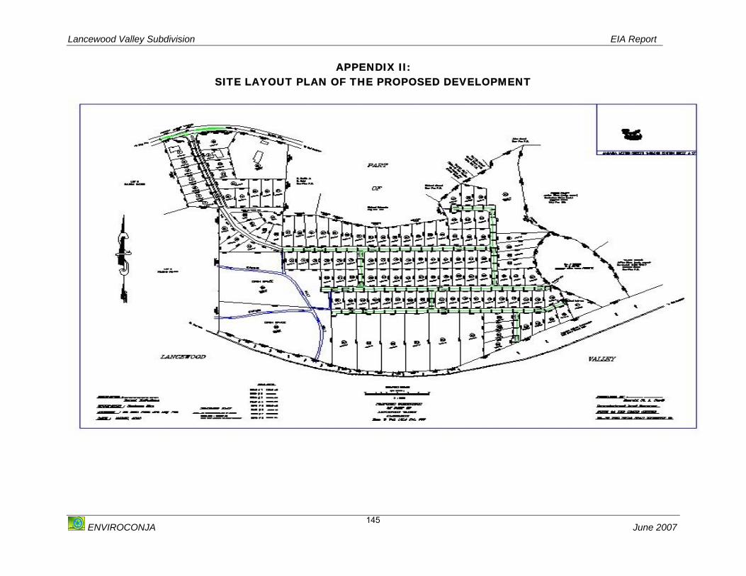
Lancewood Valley Subdivision EIA Report
ENVIROCONJA June 2007
145
APPENDIX II: SITE LAYOUT PLAN OF THE PROPOSED DEVELOPMENT

Lancewood Valley Subdivision EIA Report
ENVIROCONJA June 2007
146
APPENDIX III: AIR QUALITY ASSESSMENT
Table I: Table Showing the GPS Coordinates for the sampling of Air Quality at the Lancewood Development site.
PICTURE I: AIR QUALITY SITES MONITORED
Site 1
N17º 55.942’ W77º 10.601’
Site 2
N17º 55.972’ W77º 10.791’
Site 3
N17º 55.816’ W77º 10.891’
Site 4
N17º 55.928’ W77º 10.933’

Lancewood Valley Subdivision EIA Report
ENVIROCONJA June 2007
147
APPENDIX IV: NOISE ASSESSMENT
Calibration Certificate For Noise Meter

Lancewood Valley Subdivision EIA Report
ENVIROCONJA June 2007
148
TABLE II: Table showing the Highway Noise Meter Readings
Site GPS Reading dB (A) Comments Highway N17º 56.092’
W77º 10.642’ 46.3 Ambient , no cars passing
immediately, community activityHighway N17º 56.092’
W77º 10.642’ 48.3 Ambient , no cars passing
immediately, community activityHighway N17º 56.092’
W77º 10.642’ 71.2 Cars passing (3)
Highway N17º 56.092’ W77º 10.642’
73.2 Cars passing (7)
Highway N17º 56.092’ W77º 10.642’
73.4 Several pickup trucks and cars passing, community activity
Highway N17º 56.092’ W77º 10.642’
74.4 Light truck passing, braking, low gear
Highway N17º 56.092’ W77º 10.642’
75.8 Single Large truck passing by in low gear, braking, cars,
Highway N17º 56.092’ W77º 10.642’
75.8 Large bus passing, in low gear, braking, cars,
Highway N17º 56.092’ W77 º 10.642’
79.2 Large Semi-Cab with Trailer passing in low gear, braking
Highway N17º 56.092’ W77º 10.642’
79.4 Mid-sized Delivery truck
Highway N17º 56.092’ W77º 10.642’
80.3 Mid-sized Delivery truck, several other lighter vehicles in low gear
Highway N17º 56.092’ W77º 10.642’
84.3 Dump truck passing, several other lighter vehicles in low gear
Highway N17º 56.092’ W77º 10.642’
85.0 Large Flat bed truck, passing in low gear, cars
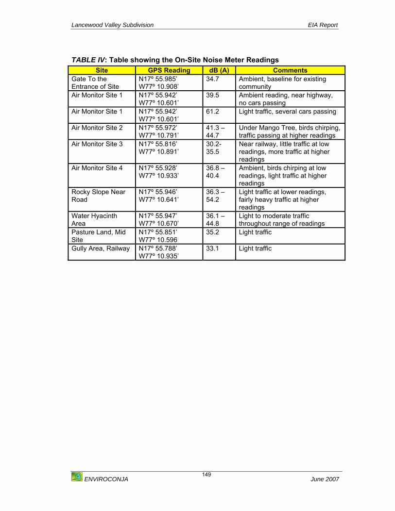
Lancewood Valley Subdivision EIA Report
ENVIROCONJA June 2007
149
TABLE IV: Table showing the On-Site Noise Meter Readings
Site GPS Reading dB (A) Comments Gate To the Entrance of Site
N17º 55.985’ W77º 10.908’
34.7 Ambient, baseline for existing community
Air Monitor Site 1
N17º 55.942’ W77º 10.601’
39.5 Ambient reading, near highway, no cars passing
Air Monitor Site 1
N17º 55.942’ W77º 10.601’
61.2 Light traffic, several cars passing
Air Monitor Site 2
N17º 55.972’ W77º 10.791’
41.3 – 44.7
Under Mango Tree, birds chirping, traffic passing at higher readings
Air Monitor Site 3
N17º 55.816’ W77º 10.891’
30.2- 35.5
Near railway, little traffic at low readings, more traffic at higher readings
Air Monitor Site 4
N17º 55.928’ W77º 10.933’
36.8 – 40.4
Ambient, birds chirping at low readings, light traffic at higher readings
Rocky Slope Near Road
N17º 55.946’ W77º 10.641’
36.3 – 54.2
Light traffic at lower readings, fairly heavy traffic at higher readings
Water Hyacinth Area
N17º 55.947’ W77º 10.670’
36.1 – 44.8
Light to moderate traffic throughout range of readings
Pasture Land, Mid Site
N17º 55.851’ W77º 10.596
35.2 Light traffic
Gully Area, Railway
N17º 55.788’ W77º 10.935’
33.1 Light traffic
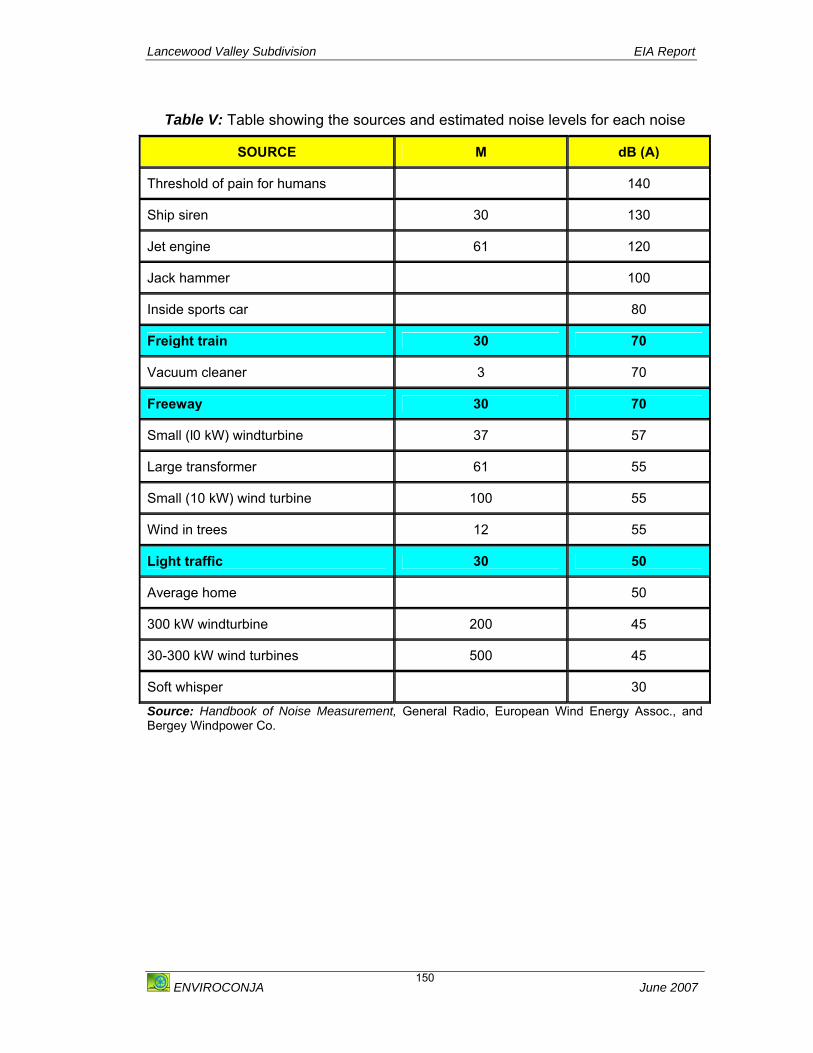
Lancewood Valley Subdivision EIA Report
ENVIROCONJA June 2007
150
Table V: Table showing the sources and estimated noise levels for each noise
Source: Handbook of Noise Measurement, General Radio, European Wind Energy Assoc., and Bergey Windpower Co.
SOURCE M dB (A)
Threshold of pain for humans 140
Ship siren 30 130
Jet engine 61 120
Jack hammer 100
Inside sports car 80
Freight train 30 70
Vacuum cleaner 3 70
Freeway 30 70
Small (l0 kW) windturbine 37 57
Large transformer 61 55
Small (10 kW) wind turbine 100 55
Wind in trees 12 55
Light traffic 30 50
Average home 50
300 kW windturbine 200 45
30-300 kW wind turbines 500 45
Soft whisper 30

Lancewood Valley Subdivision EIA Report
ENVIROCONJA June 2007
151
APPENDIX V: ECOLOGICAL ASSESSMENT
LIST OF FLORA OBSERVED
COMMON NAME SCIENTIFIC NAME RELATIVE ABUNDANCE
SHRUBS Guava Psidium guajava O Castor Oil Ricinus cummunis R Wild Sage Lantana sp.s A Rosemary Croton linearis A Cashaw Macca Prosopis juliflora A Yellow Allamanda Allamanda cathartica F Sweet sop Annona squamosa O HERBS Devils Horsewhip Achyrandnes indica A Broom weed Sida acuta A TREES Trumpet Tree Cecropia peltata R Mango Mangifera indica O GRASSES African Star Grass Cynodon nlemfuensis D OTHER Cowitch Tragia volubilis O Water Hyacinth Eichhornia paniculata R
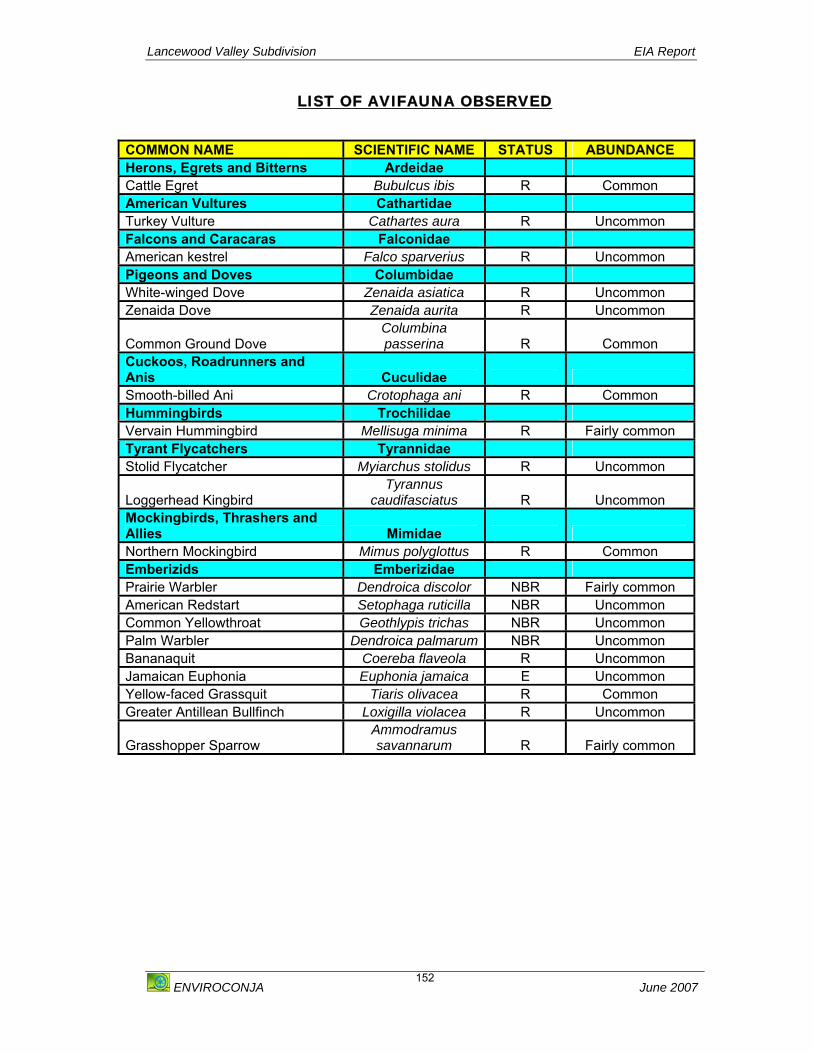
Lancewood Valley Subdivision EIA Report
ENVIROCONJA June 2007
152
LIST OF AVIFAUNA OBSERVED
COMMON NAME SCIENTIFIC NAME STATUS ABUNDANCE Herons, Egrets and Bitterns Ardeidae Cattle Egret Bubulcus ibis R Common American Vultures Cathartidae Turkey Vulture Cathartes aura R Uncommon Falcons and Caracaras Falconidae American kestrel Falco sparverius R Uncommon Pigeons and Doves Columbidae White-winged Dove Zenaida asiatica R Uncommon Zenaida Dove Zenaida aurita R Uncommon
Common Ground Dove Columbina passerina R Common
Cuckoos, Roadrunners and Anis Cuculidae Smooth-billed Ani Crotophaga ani R Common Hummingbirds Trochilidae Vervain Hummingbird Mellisuga minima R Fairly common Tyrant Flycatchers Tyrannidae Stolid Flycatcher Myiarchus stolidus R Uncommon
Loggerhead Kingbird Tyrannus
caudifasciatus R Uncommon Mockingbirds, Thrashers and Allies Mimidae Northern Mockingbird Mimus polyglottus R Common Emberizids Emberizidae Prairie Warbler Dendroica discolor NBR Fairly common American Redstart Setophaga ruticilla NBR Uncommon Common Yellowthroat Geothlypis trichas NBR Uncommon Palm Warbler Dendroica palmarum NBR Uncommon Bananaquit Coereba flaveola R Uncommon Jamaican Euphonia Euphonia jamaica E Uncommon Yellow-faced Grassquit Tiaris olivacea R Common Greater Antillean Bullfinch Loxigilla violacea R Uncommon
Grasshopper Sparrow Ammodramus savannarum R Fairly common

Lancewood Valley Subdivision EIA Report
ENVIROCONJA June 2007
153
LIST OF BUTTERFLIES SPECIES OBSERVED
Common Name
Scientific Name Abundance Initial
Time of Sighting
White Peacock Anartia jatrophae jamaicensis Abundant 8:35am Buckeye
Junonia genoveva Abundant 8:46am
Common Tailed Skipper
Urbanus proteus Uncommon 10:00am
Watson’s Cane Skipper
Panoquina sylvicola woodruffi Uncommon 9:13am
Evan’s Jamaican Skipper
Polygonus leo hagar Rare 9:41am
Cassius Blue Leptotes cassius theonus Occasional 9:47am Roy’s Skipper Astraptes anaphus anausis Uncommon 10:07am
Cuban Swallowtail
Papilio andraemon Uncommon 9:23 am
Tropical Fritillary Euptoieta hegesia hegesia Rare 8:47am Tropical Silverspot Agraulis (Dione) vanillae
insularis Occasional 9:10am
The Sleepy Orange
Eurema nicippe Rare 10:02am
Oileus
Pyrgus oileus Abundant 9:05am
Dorcas
Mestra dorcas Frequent 8:37am
Monarch
Danaeus plexipus Rare 9:09am
Gillipus Danaeus gillipus jamaicensis Abundant 8:53am Julia
Dryas julia delila Frequent 9:08am
Maerula Anteos maerula maerula Occasional 8:45am Jamaican
Goatweed Butterfly Anaea troglodyta Uncommon 9:28am
Malachite Spiroeta stelenes stelenes) Uncommon 9:58am Zebra Heliconius charitonius
simulator Rare 9:37am
Jamaican Albatross
Appias Drusilla castalia Frequent 8:32am

Lancewood Valley Subdivision EIA Report
ENVIROCONJA June 2007
154
LIST OF MOTH SPECIES OBSERVED
LIST OF OTHER MACRO-FAUNA OBSERVED
Common Name
Scientific Name Abundance Initial Time of
Sighting Bella Moth
Uthethesia bella Rare 8:59am
COMMON NAME SCIENTIFIC NAME/ORDER CONSERVATION STATUS
MAMMALS Donkey Equus asinus Introduced Goat Capra aegagrus Introduced REPTILES A. lineatopus Endemic INSECTS Dragon Fly Order Odontata
Suborder – Anisoptera Introduced
Grasshopper Order Orthoptera Sub -Order Caelifera
Introduced
Mosquito Aedes aegypti/ Culex sp Introduced Housefly Musca domestica Introduced Bumblebee Bombus sp Introduced Flea Ctenocephalides canis Introduced Ticks Ixodes sp Introduced Spiny Spiders Astracantha minax Introduced

Lancewood Valley Subdivision EIA Report
ENVIROCONJA June 2007
155
APPENDIX VI: SOCIO-ECONOMIC ASSESSMENT
SOCIO – ECONOMIC SURVEY: LANCEWOOD VALLEY EIA
1. DATE: ___________________________________________ 2. COMMUNITY: _______________________________________________
3. NAME: _______________________________________________ 4. ADDRESS: ________________________________________________ 5. GENDER: M F 6. EDUCATION: Pre-primary Primary All –age Secondary/High School Vocational School College Certificate Post Secondary Certificate University Degree 7. OCCUPATION: _________________________________________________ 8. What is the size of your household and occupation?
NAME M/F Age Occupation
Last School
Attended
Approximate income (if employed)

Lancewood Valley Subdivision EIA Report
ENVIROCONJA June 2007
156
9. Do you have any problems getting your children into school?
Y N If yes What are the problems? ________________________________________________________________________________________________________________________________________ 10. Where is the source of your water supply? 11. Is this supply regular?
Y N If no what is the alternative supply? ________________________________________________________________________________________________________________________________________ 12. Do you have electricity?
Y N 13. What is your means of transport?
Car Bus Taxi Walk Secondary/High School Bicycle Motorbike Other 13. When you are sick where do you seek Health Services? _______________________________________________________________________ 14. Are you aware of the Lancewood Valley Development that has been planned in your community? Y N
Lancewood Valley Subdivision EIA Report
ENVIROCONJA June 2007
157
If yes What do you know about the development? ____________________________________________________________________ 15. Do you now use the property in any way? Y N If yes how do you use the property? ____________________________________________________________________ 16. Do you think this development will affect your community in a good or bad way?
Good Bad How do you think it will affect the community Good/Bad? ________________________________________________________________________________________________________________________________________________ 17. What are some of the things about the community that you would you like to enhance? ________________________________________________________________________________________________________________________________________________________________________________________________________________________ 18. What do you know of the history of the property (Flooding, natural disasters, general information)? ________________________________________________________________________________________________________________________________________________________________________________________________________________________
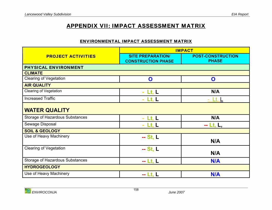
Lancewood Valley Subdivision EIA Report
ENVIROCONJA June 2007
158
APPENDIX VII: IMPACT ASSESSMENT MATRIX
ENVIRONMENTAL IMPACT ASSESSMENT MATRIX
IMPACT PROJECT ACTIVITIES SITE PREPARATION/
CONSTRUCTION PHASE POST-CONSTRUCTION
PHASE PHYSICAL ENVIRONMENT CLIMATE Clearing of Vegetation O O AIR QUALITY Clearing of Vegetation - Lt, L N/A Increased Traffic - Lt, L - Lt, L
WATER QUALITY Storage of Hazardous Substances - Lt, L N/A Sewage Disposal - Lt, L -- Lt, L, SOIL & GEOLOGY Use of Heavy Machinery -- St, L
N/A Clearing of Vegetation -- St, L
N/A Storage of Hazardous Substances -- Lt, L N/A HYDROGEOLOGY Use of Heavy Machinery -- Lt, L N/A

Lancewood Valley Subdivision EIA Report
ENVIROCONJA June 2007
159
Alteration of Drainage Pattern - Lt, L -- Lt, L NOISE AND VIBRATION Use of Heavy Machinery -- Lt, L N/A Increased Traffic - St, L - St, L LANDSCAPE AND VISUAL Clearing of Vegetation - St, L N/A Landscaping and vegetation reintroduction N/A ++ Lt, L BIOLOGICAL ENVIRONMENT FLORA Clearing of Vegetation - Lt, L N/A Increase in Population
N/A O
FAUNA: AVIFAUNA Clearing of Vegetation - Lt, L,N,G N/A Noise and Vibration - Lt, L,N,G - St, L Increase in Population N/A O FAUNA: BUTTERFLIES Clearing of Vegetation - Lt, L N/A Noise and Vibration - Lt, L - St, L Increase in Population N/A O Landscaping + Lt, L + Lt, L FAUNA: OTHER MACRO-FAUNA Clearing of Vegetation - St, L N/A Increase in Population N/A O
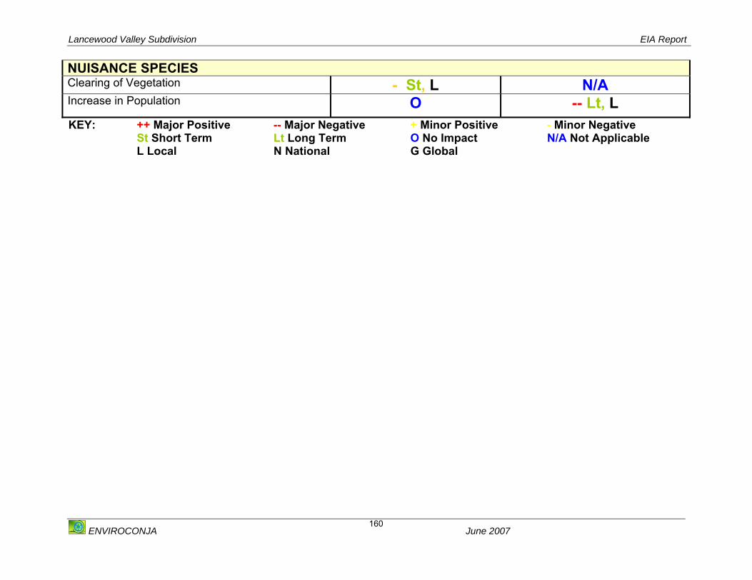
Lancewood Valley Subdivision EIA Report
ENVIROCONJA June 2007
160
NUISANCE SPECIES Clearing of Vegetation - St, L N/A Increase in Population O -- Lt, L
KEY: ++ Major Positive -- Major Negative + Minor Positive - Minor Negative St Short Term Lt Long Term O No Impact N/A Not Applicable L Local N National G Global
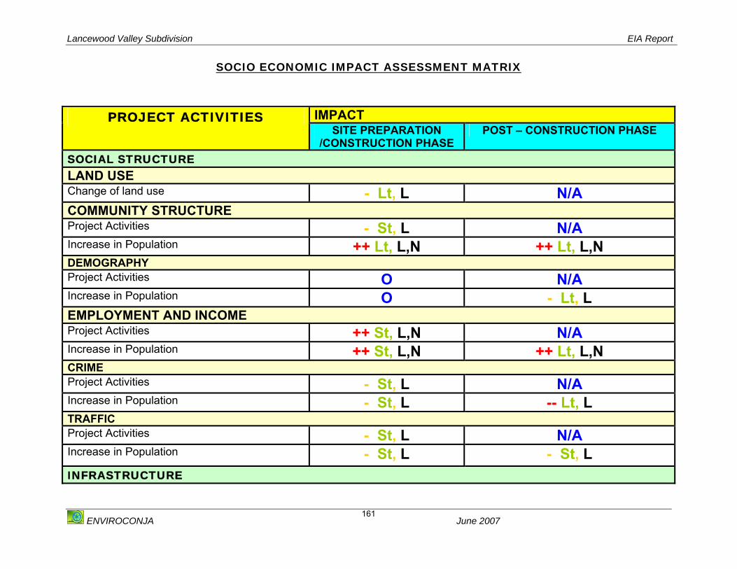
Lancewood Valley Subdivision EIA Report
ENVIROCONJA June 2007
161
SOCIO ECONOMIC IMPACT ASSESSMENT MATRIX
IMPACT PROJECT ACTIVITIES SITE PREPARATION
/CONSTRUCTION PHASE POST – CONSTRUCTION PHASE
SOCIAL STRUCTURE LAND USE Change of land use - Lt, L N/A COMMUNITY STRUCTURE Project Activities - St, L N/A Increase in Population ++ Lt, L,N ++ Lt, L,N DEMOGRAPHY Project Activities O N/A Increase in Population O - Lt, L EMPLOYMENT AND INCOME Project Activities ++ St, L,N N/A Increase in Population ++ St, L,N ++ Lt, L,N CRIME Project Activities - St, L N/A Increase in Population - St, L -- Lt, L TRAFFIC Project Activities - St, L N/A Increase in Population - St, L - St, L
INFRASTRUCTURE
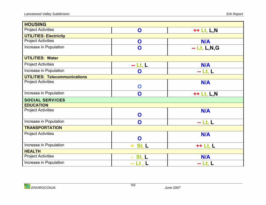
Lancewood Valley Subdivision EIA Report
ENVIROCONJA June 2007
162
HOUSING Project Activities O ++ Lt, L,N UTILITIES: Electricity Project Activities O N/A Increase in Population O -- Lt, L,N,G
UTILITIES: Water Project Activities -- Lt, L N/A Increase in Population O -- Lt, L UTILITIES: Telecommunications Project Activities
O N/A
Increase in Population O ++ Lt, L,N SOCIAL SERVICES EDUCATION Project Activities
O N/A
Increase in Population O -- Lt, L TRANSPORTATION Project Activities
O N/A
Increase in Population + St, L ++ Lt, L HEALTH Project Activities - St, L N/A Increase in Population -- Lt , L -- Lt, L

Lancewood Valley Subdivision EIA Report
ENVIROCONJA June 2007
163
POSTAL SERVICES Project Activities
O N/A
Increase in Population O -- Lt, L RECREATIONAL SERVICES Project Activities
O N/A
Increase in Population O - Lt, L SOLID WASTE Project Activities -- Lt, L N/A Increase in Population -- Lt, L -- Lt, L KEY: ++ Major Positive -- Major Negative + Minor Positive - Minor Negative St Short Term Lt Long Term O No Impact N/A Not Applicable L Local N National G Global
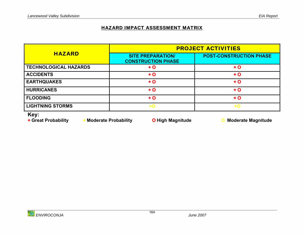
Lancewood Valley Subdivision EIA Report
ENVIROCONJA June 2007
164
HAZARD IMPACT ASSESSMENT MATRIX
PROJECT ACTIVITIES HAZARD SITE PREPARATION/
CONSTRUCTION PHASE POST-CONSTRUCTION PHASE
TECHNOLOGICAL HAZARDS + O + O ACCIDENTS + O + O EARTHQUAKES + O + O
HURRICANES + O + O
FLOODING + O + O
LIGHTNING STORMS +O +O
Key: + Great Probability + Moderate Probability O High Magnitude O Moderate Magnitude

Lancewood Valley Subdivision EIA Report
ENVIROCONJA June 2007
165
APPENDIX VIII: PROJECT TEAM
The project team for the conduct of the EIA comprised of the following persons:
o Johann Antoine BSc Zoology, MSc Natural Resources Management
o Sara Simpson BSc. Botany, M.A. Environmental Impact Assessment and
Management
o Dr. Gavin Gunther: BSc. Geology, PhD. Geology
o Leslie Hoo-Fung: BSc. Analytical Chemistry
o Jevcon Engineering


