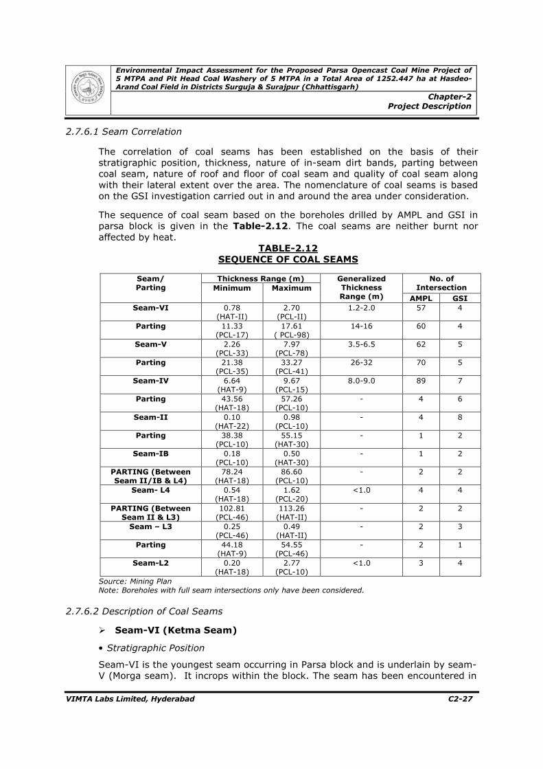
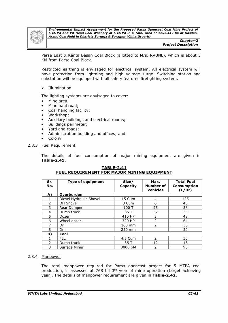
ENVIRONMENTAL IMPACT ASSESSMENT FOR THE PROPOSED PARSA OPENCAST COAL MINE PROJECT OF 5 MTPA AND PIT HEAD COAL WASHERY OF 5 MTPA IN A TOTAL AREA OF 1252.447 HA AT HASDEO-ARAND COAL FIELD IN DISTRICTS SURGUJA & SURAJPUR (CHHATTISGARH) Sponsor : Prepared by : January, 2018 Rajasthan Rajya Vidyut Utpadan Nigam Ltd. Vidyut Bhawan, Janpath, Jyoti Nagar Jaipur - 302 005 Vimta Labs Limited 142, IDA, Phase-II, Cherlapally, Hyderabad–500 051, Telangana State [email protected], www.vimta.com (QCI / NABET Accreditated EIA Consultant & NABL Accredited and ISO 17025 Certified Laboratory, Recognized by MoEF, New Delhi) VOLUME-I : MAIN REPORT
Transcript
ENVIRONMENTAL IMPACT ASSESSMENTFOR
THE PROPOSED PARSA OPENCAST COAL MINE PROJECT OF 5 MTPA AND PIT HEAD COAL WASHERY OF 5 MTPA IN A TOTAL AREA OF 1252.447 HA AT HASDEO-ARAND COAL FIELD IN
For and on behalf of VIMTA Labs Limited Approved by : M. Janardhan Signed : Position : Head & Vice President (Env)
Date : 5th January, 2018
The report has been prepared inline with the prescribed TORs issued vide letter
No J-11015/76/2016-IA.II (M), dated 23rd March 2017 of Ministry of Environment Forest
and Climate Change (MoEF & CC), New Delhi.
This report has been prepared by Vimta Labs Limited with all reasonable skill, care
and diligence within the terms of the contract with the client, incorporating our General
Terms and Conditions of Business and taking account of the resources devoted to it by
agreement with the client.
PREFACE
ENVIRONMENTAL IMPACT ASSESSMENT FOR
THE PROPOSED PARSA OPENCAST COAL MINE PROJECT OF 5 MTPA
AND PIT HEAD COAL WASHERY OF 5 MTPA IN A TOTAL AREA OF
1252.447 HA AT HASDEO-ARAND COAL FIELD IN DISTRICTS
SURGUJA & SURAJPUR (CHHATTISGARH)
Table of Contents
Environmental Impact Assessment for the Proposed Parsa Opencast Coal Mine Project of 5 MTPA and Pit Head Coal Washery of 5 MTPA in a Total Area of 1252.447 ha at Hasdeo-Arand Coal Field in Districts Surguja & Surajpur (Chhattisgarh)
Table of Contents
VIMTA Labs Limited, Hyderabad TC-1
Table of Contents _______________________________________________________________ Chapter # Title Page # _______________________________________________________________
Table of Contents TC-1 List of Figures TC-4 List of Tables TC-5
1.0 Introduction
1.1 Purpose of the Report C1-1 1.2 Identification of Project and Project Proponent C1-2 1.3 Brief Description of Project C1-7 1.4 Scope of the Study C1-13
2.0 Project Description
2.1 Type of Project C2-1 2.2 Need of the Project C2-1 2.3 Location of Parsa Block C2-1 2.4 Size/Magnitude of Operation C2-2
2.5 Land Requirement C2-3 2.6 Technology and Process Description C2-6 2.7 Project Description C2-20 2.8 Resource Requirement C2-60 2.9 Proposed Schedule and Approval for Implementation C2-66
3.0 Description of Environment
3.1 Introduction C3-1 3.2 Geology and Hydrogeology C3-1 3.3 Landuse Studies C3-8 3.4 Soil Characteristics C3-14 3.5 Meteorology C3-18 3.6 Ambient Air Quality C3-30 3.7 Water Quality C3-35 3.8 Noise Level Survey C3-41 3.9 Flora and Fauna Studies C3-46 3.10 Demography and Socio-economics C3-56 4.0 Anticipated Environmental Impacts and Mitigation Measures
4.1 Introduction C4-1 4.2 Impacts during Construction Phase C4-1 4.3 Impacts during Operational Phase C4-3 4.4 Irreversible & Irretrievable Commitments of Environmental Components C4-40 4.5 Mitigation Measures C4-41 4.6 Energy Conservation C4-51 4.7 Community Development Action Plan C4-53
Environmental Impact Assessment for the Proposed Parsa Opencast Coal Mine Project of 5 MTPA and Pit Head Coal Washery of 5 MTPA in a Total Area of 1252.447 ha at Hasdeo-Arand Coal Field in Districts Surguja & Surajpur (Chhattisgarh)
Table of Contents
VIMTA Labs Limited, Hyderabad TC-2
Table of Contents (Contd.) _______________________________________________________________ Chapter # Title Page # _______________________________________________________________
5.0 Analysis of Alternative Technology and Site 5.1 Site Alternatives Under Consideration C5-1 5.2 Analysis of Alternative Technology C5-1 5.3 Assessment of New and Untested Technology for the Risk of Technological Failure C5-2
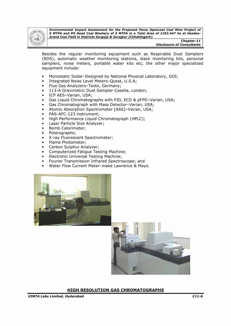
6.0 Environmental Monitoring Programme 6.1 Implementation Schedule of Mitigation Measures C6-1 6.2 Environmental Monitoring C6-1 6.3 Monitoring Methods and Data Analysis of Environmental Monitoring C6-3 6.4 Monitoring Equipment and Consumables C6-4 6.5 Occupational Health and Safety C6-5 6.6 Budgetary Allocation Environmental Production C6-5 7.0 Additional Studies 7.1 Public Consultation C7-1
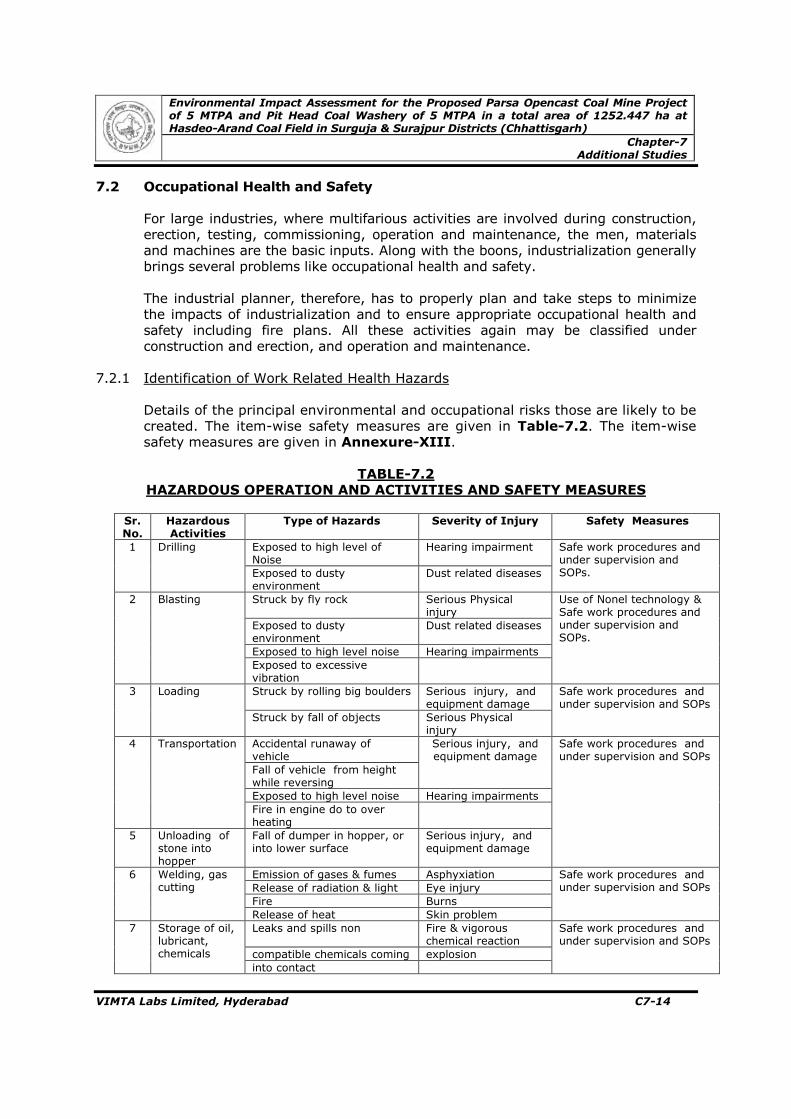
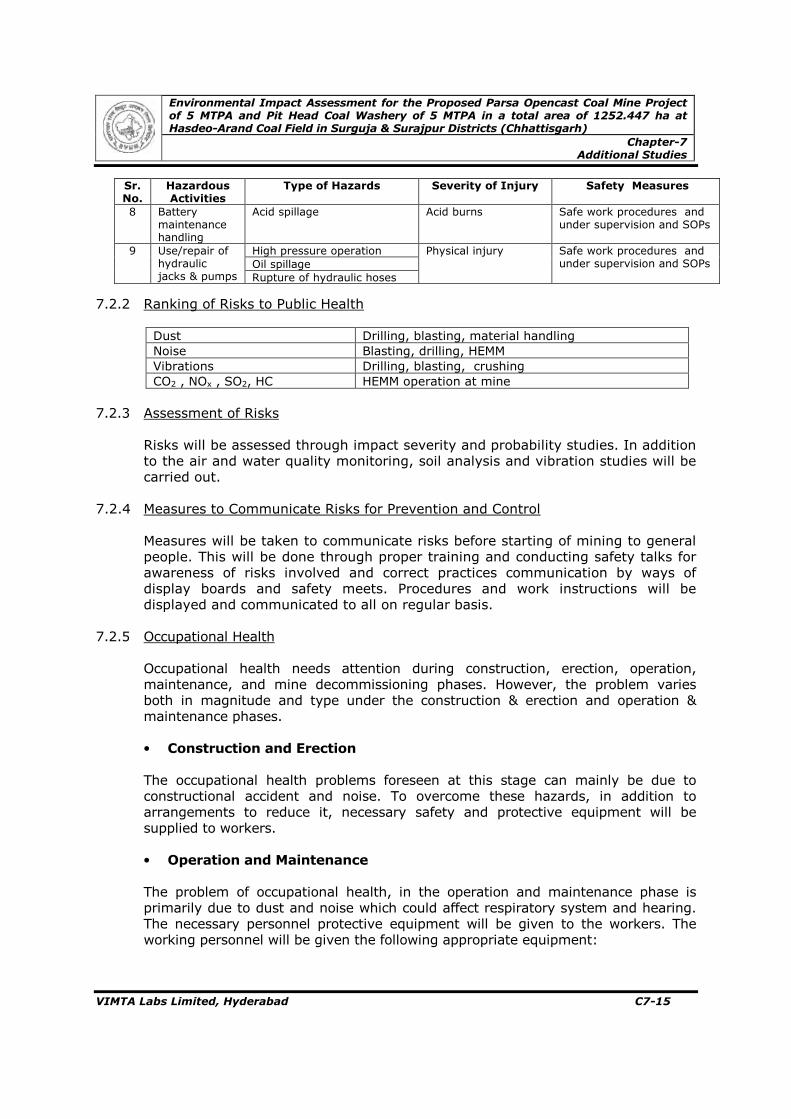
7.2 Occupational Health and Safety C7-14 7.3 Risk Assessment and Disaster Management Plan C7-21 7.4 Wildlife Conservation Plan C7-43 7.5 Social Impact Assessment C7-45 7.6 Rehabilitation & Resettlement Aspects C7-45
8.0 Project Benefits 8.1 Improvement in the Physical Infrastructure C8-1 8.2 Improvement in the Social Infrastructure C8-1 8.3 Indirect benefit of the Project C8-1 8.4 Employment Potential C8-2 8.5 Corporate Social Responsibility C8-3 8.6 Other Tangible Benefits C8-6 9.0 Administrative Aspects 9.1 Institutional Arrangements for Environment Protection
and Conservation C9-1
10.0 Summary & Conclusion
10.1 Type of Project C10-1 10.2 Justification for Implementation of the Project C10-1 10.3 Environmental Setting C10-2 10.4 Project Description C10-2
Environmental Impact Assessment for the Proposed Parsa Opencast Coal Mine Project of 5 MTPA and Pit Head Coal Washery of 5 MTPA in a Total Area of 1252.447 ha at Hasdeo-Arand Coal Field in Districts Surguja & Surajpur (Chhattisgarh)
Table of Contents
VIMTA Labs Limited, Hyderabad TC-3
Table of Contents (Contd.) _______________________________________________________________ Chapter # Title Page # _______________________________________________________________
10.5 Baseline Environmental Status C10-3 10.6 Anticipated Environmental Impacts and Mitigation
List of Annexures Annexure-I : Allotted Letters by Ministry of Coal Annexure-II : Status of FC Application
Annexure-III : MOEF Letter for Fresh Application Annexure-IV : Mine Plan Approval Letter Annexure-V : TOR and its Compliance Annexure-VI : Methodology for Sampling and Analysis Annexure-VII : Applicable Environment Standards Annexure-VIII : Hydro-geological Report & NOC from CGWA Annexure-IX : Landuse Pattern Annexure-X : Ambient Air Quality Levels Annexure-XI : Demographic Details Annexure-XII : Approved Wildlife Conservation Plan Annexure-XIII : Safety Measures Annexure-XIV : Draft R&R Plan Annexure-XV : CSR Policy
Environmental Impact Assessment for the Proposed Parsa Opencast Coal Mine Project of 5 MTPA and Pit Head Coal Washery of 5 MTPA in a Total Area of 1252.447 ha at Hasdeo-Arand Coal Field in Districts Surguja & Surajpur (Chhattisgarh)
Table of Contents
VIMTA Labs Limited, Hyderabad TC-4
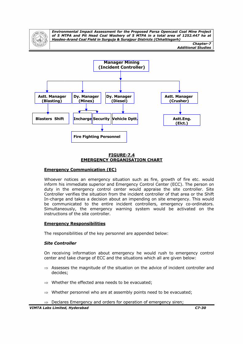
List of Figures _____________________________________________________________ Figures # Title Page # _______________________________________________________________ 1.1 Coal Blocks in Hasdo –Arand Coal Field C1-3 1.2 Index Map of the Project C1-11 1.3 Study Area Map C1-12 2.1 Revenue Map Showing the Core Zone C2-5 2.2 First Year Quarry Plan C2-10 2.3 Third Year Quarry Plan C2-11 2.4 Fifth Year Quarry Plan C2-12 2.5 Tenth Year Quarry Plan C2-13 2.6 Twelfth Year Quarry Plan C2-14 2.7 Mining Operations C2-15 2.8 Layout of Chip & Coal Washery C2-16 2.9 Coal Washery Flow Sheet C2-18 2.10 Topographical Plan C2-22 2.11 Geological Plan of Mine Lease Area C2-25 2.12 Schematic Cross Section of Seams C2-37 2.13 Conceptual Mine Plan C2-47 2.14 Dump Plan C2-58 2.15 Water Balance C2-61 3.2.1 Drainage Map of the Buffer Zone C3-4 3.2.2 Geological Map of the Buffer Zone C3-5 3.3.1 Satellite Image of Study Area C3-12 3.3.2 Satellite Image of Landuse Map C3-13 3.4.1 Soil Quality Sampling Locations C3-15 3.5.1 Windrose Pre Monsoon – IMD Ambikapur C3-24 3.5.2 Windrose Monsoon – IMD Ambikapur C3-25 3.5.3 Windrose Post Monsoon – IMD Ambikapur C3-26 3.5.4 Windrose Winter – IMD Ambikapur C3-27 3.5.5 Annual Wind Rose – IMD Ambikapur C3-28 3.5.6 Site Specific Pre Monsoon Season Windrose C3-29 3.6.1 Air Quality Sampling Locations C3-31 3.7.1 Water Sampling Location C3-37 3.8.1 Noise Monitoring Locations C3-43 3.9.1 Terrestrial & Aquatic Sampling Locations C3-49 4.1 Reclamation Plan C4-8 4.2 Mining Topography C4-9 4.3 GLCs for PM – Pre monsoon Season C4-17 4.4 Basin Characteristics C4-21 4.5 Surface Runoff C4-22 4.6 Change in Infiltration C4-23 4.7 Predicted Noise Levels Around the Mine Site C4-32 4.8 Schematic Diagram of Effluent Treatment Plant C4-45 4.9 Schematic Diagram of Rain Water Harvesting Structure C4-46 7.1 Notices for Public Hearing C7-3 7.2 Photographs of Public Hearing C7-12 7.3 Identification of Hazards in Opencast Mine C7-24 7.2 Emergency Organization Chart C7-30 7.3 On-site Emergency Plan C7-38 7.4 Off-Site Emergency Plan C7-42 9.1 Organization Structure of Environment Management Cell 9-2
Environmental Impact Assessment for the Proposed Parsa Opencast Coal Mine Project of 5 MTPA and Pit Head Coal Washery of 5 MTPA in a Total Area of 1252.447 ha at Hasdeo-Arand Coal Field in Districts Surguja & Surajpur (Chhattisgarh)
Table of Contents
VIMTA Labs Limited, Hyderabad TC-5
List of Tables _______________________________________________________________ Tables # Title Page # _______________________________________________________________
1.1 Coal Requirement for the Thermal Power Plant C1-1 1.2 RVUNL Thermal and Hydel Power Stations in Rajasthan C1-5 1.3 RVUNL Thermal Power Station in Construction in Rajasthan C1-5 1.4(A) RVUNL Coal Requirement in thermal Power Station in Rajasthan C1-6 1.4 (B) Ongoing/Upcoming RVUNL Coal Requirement in TPS
in Rajasthan C1-6 1.4 (C) Summarized details of coal requirement extracted
from table 1.4 (B) C1-7 1.5 Total Reserves C1-8 1.6 Environmental Setting C1-8 1.7 Environmental Attributes and Frequency of Monitoring C1-14 2.1 Salient Features of the Proposed Mine C2-2
2.2 Land Requirement C2-3 2.3 Land Use Pattern of Proposed Coal Block to be Acquired C2-4 2.4 Year Wise Land use and Reclamation C2-6 2.5 Mine Parameters C2-7 2.6 Salient Features of the Coal Washery Plant C2-9 2.7 Characteristics of Raw Coal and Washed Coal Based on the Proximate Analysis C2-19 2.8 Stratigraphic Succession of Hasdeo-Arand Coalfield C2-20
2.9 Stratigraphic Succession, Parsa Block, of Hasdeo-Arand CoalfieldC2-23 2.10 Description of Faults C2-24 2.11 Differentiation of Different Constituents of Coal C2-26 2.12 Sequence of Coal Seams C2-27 2.13 Details of Dirt Bands in Seam-VI C2-28 2.14 Details of Combustible and Non-Combustible Dirt Bands
in Seam-VI C2-28 2.15 Proximate Analysis of Seam-VI C2-29 2.16 Ultimate Analysis of Seam-VI C2-29
2.17 Details of Dirt Bands in Seam-V C2-31 2.18 Details of Combustible and Non-Combustible
Dirt Bands in Seam-V C2-31 2.19 Proximate Analysis and Grade of Seam-V C2-32 2.20 Ultimate Analysis of Seam-V C2-32
2.21 Details of Dirt Bands in Seam-IV C2-34 2.22 Details of Combustible and Non-Combustible Dirt Bands
in Seam-IV C2-34 2.23 Proximate Analysis of Seam-IV C2-35 2.24 Ultimate Analysis of Seam-IV C2-35 2.25 Coordinate of baseline Stations of Parsa Block C2-39 2.26 Details of Equipment Deployment for Exploratory Drilling C2-39 2.27 Quantum of Drilling Completed on March, 2012 C2-40 2.28 Mining and Geological Characteristics of the Quarriable Block C2-40
2.29 Useful Heat Values For Different Grades of Non-Cooking Coal C2-41 2.30 Coal Grade based On GCV Value C2-42 2.31 Seam Wise, Grade Wise Average Specific Gravity C2-43 2.32 Seam Wise and Category Wise Geological Reserves C2-44
Environmental Impact Assessment for the Proposed Parsa Opencast Coal Mine Project of 5 MTPA and Pit Head Coal Washery of 5 MTPA in a Total Area of 1252.447 ha at Hasdeo-Arand Coal Field in Districts Surguja & Surajpur (Chhattisgarh)
Table of Contents
VIMTA Labs Limited, Hyderabad TC-6
List of Tables (Contd..) _______________________________________________________________ Tables # Title Page # _______________________________________________________________
2.33 Seam Wise and Grade Wise Net Proved Reserves C2-44 2.34 Summary of Coal Reserves C2-45 2.35 Year Wise Coal Production For First Five Years C2-48 2.36 Excavation And production Schedule C2-52
2.37 List of Production and Auxiliary Equipment C2-55 2.38 Phase Wise Dump Planning Along with Dump Capacity C2-59 2.39 Top Soil Quantity for First Five Years of Mine Operation C2-60 2.40a Water Requirement for Mining C2-61 2.40b Water Requirement for Domestic Consumption C2-61 2.40c Water Requirement for Coal Washery C2-61 2.41 Fuel Requirement for Major Mining Equipment C2-63 2.42 Manpower Requirement C2-64 3.2.1 Stratigraphic Succession of Hasdeo-Arand Coal Field from Mining Plan C3-2 3.2.2 Stratigraphic Succession of Parsa Block, Hasdeo-Arand Coal FieldC3-3 3.2.3 Ground Water Balance C3-7 3.3.1 Landuse Pattern in the Study Area C3-9 3.3.2 Landuse /Land Cover Classification System C3-9 3.3.3 Landuse Pattern based on Remote Sensing Data C3-11 3.4.1 Details of Soil Sampling Locations C3-14 3.4.2 Soil Analysis Results C3-16 3.4.3 Standard Soil Classification C3-18 3.5.1 Sensitivity of meteorology Monitoring Equipment C3-19 3.5.2 Climatology Data Station : IMD – Ambikapur C3-20 3.5.3 Summary of Wind Pattern – IMD Ambikapur C3-21 3.5.4 Summary of the Meteorological Data Generated at Site C3-22
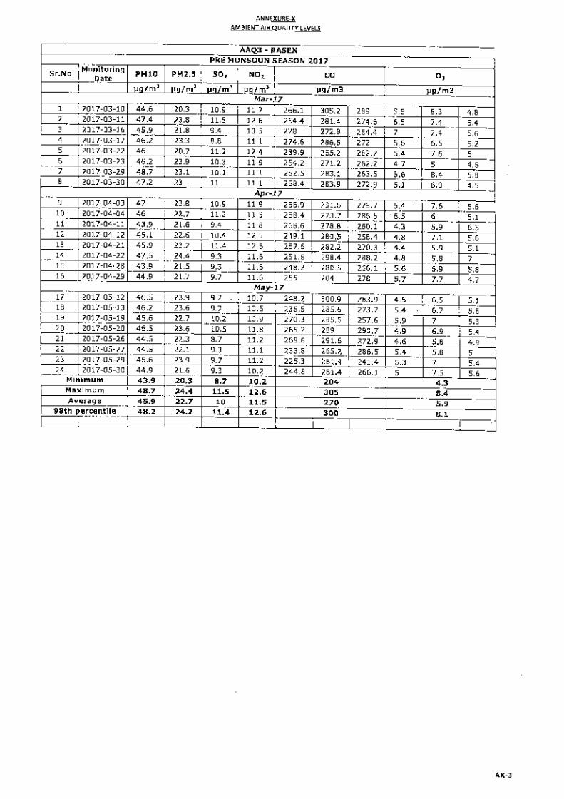
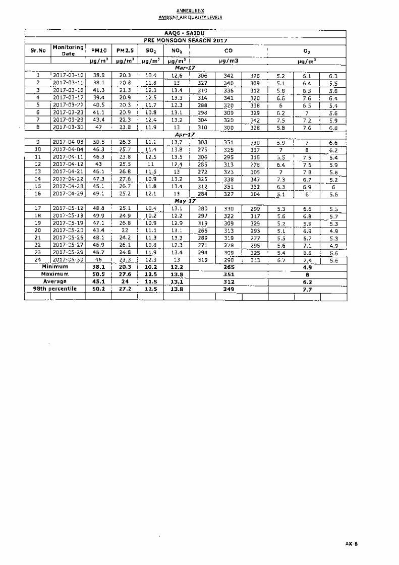
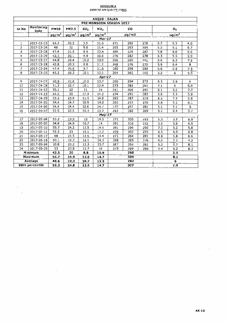
3.6.1 Details of Ambient Air Quality Monitoring Locations C3-32 3.6.2 Summary of Ambient Air Quality Results C3-33 3.6.3 Summary of Dust Fall Concentration C3-34
3.7.1 Details of Water Sampling Locations C3-36 3.7.2 Ground Water Quality C3-40 3.7.3 Surface Water Quality C3-41 3.8.1 Details of Noise Monitoring Locations C3-44
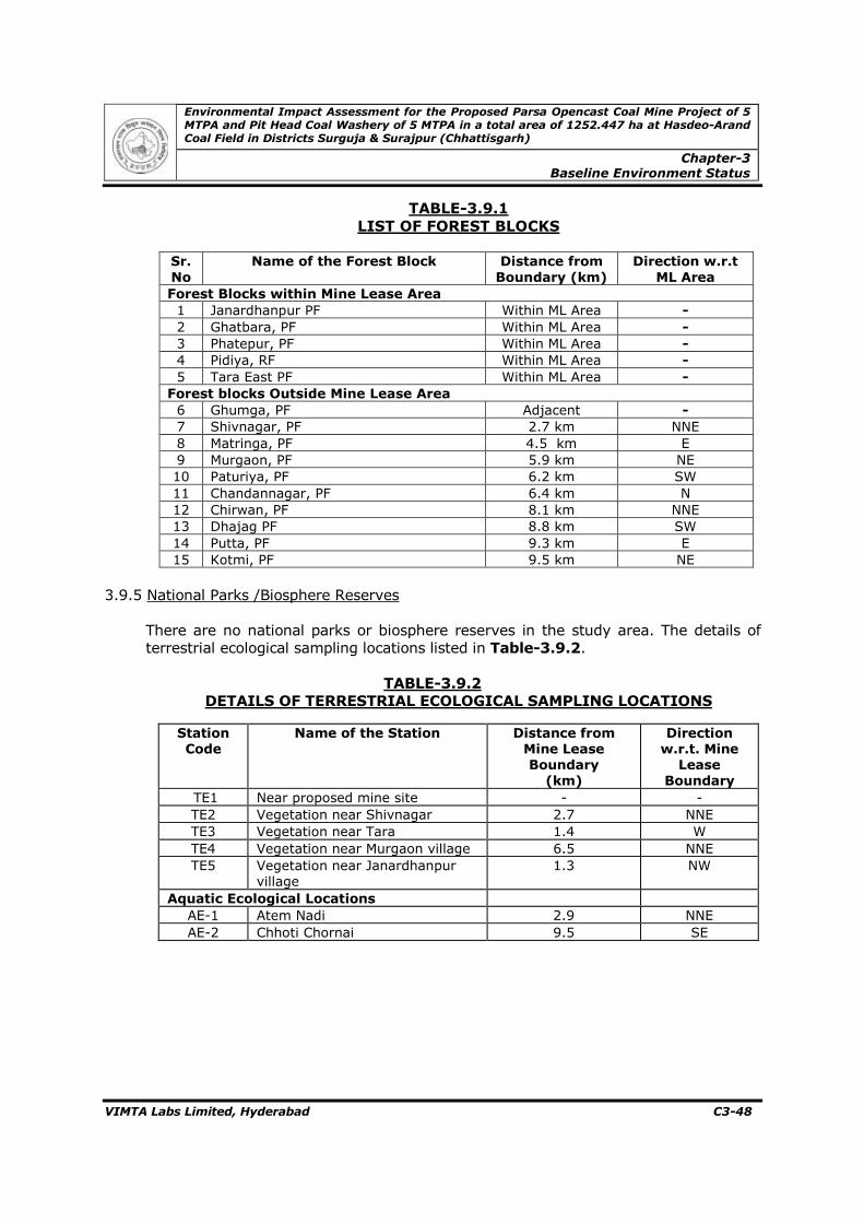
3.8.2 Noise Levels in the Study Area C3-45 3.9.1 List of Forest Blocks in 10 Km Radius C3-48
3.9.2 Details of Terrestrial Ecological Sampling Locations C3-48 3.9.3 Flora Observed in Core Zone C3-50 3.9.4 Flora of the Buffer Zone in the 10 km Mine Lease C3-50 3.9.5 Terrestrial Sampling Analysis C3-52 3.9.6 Fauna in the Core Zone C3-53 3.9.7 Fauna in the Buffer Zone C3-53 3.9.8 Details of Aquatic Sampling Locations C3-55 3.9.9 Details of Diversity Index C3-55 3.9.10 List of Plankton Recorded during Study Period C3-56 3.9.11 Major Fish Species Reported in River Atem C3-56 3.10.1 Distribution of Population C3-57 3.10.2 Distribution of Population by Social Structure C3-58
Environmental Impact Assessment for the Proposed Parsa Opencast Coal Mine Project of 5 MTPA and Pit Head Coal Washery of 5 MTPA in a Total Area of 1252.447 ha at Hasdeo-Arand Coal Field in Districts Surguja & Surajpur (Chhattisgarh)
Table of Contents
VIMTA Labs Limited, Hyderabad TC-7
List of Tables (Contd..) _______________________________________________________________ Tables # Title Page # _______________________________________________________________
3.10.3 Distribution of Literate and Literacy Rates C3-58 3.10.4 Occupational Structure C3-59 4.1 Details of Present Landuse Pattern C4-4 4.2 Stagewise Landuse Pattern C4-4 4.3 Post – Mining Land Use of Core Zone C4-5 4.4 Emission Factor for Various Mining Operations C4-14 4.5 Sources of PM C4-15 4.6 Incremental Concentrations C4-16 4.7 Potential Fugitive Dust Sources C4-18 4.8 Hasdeo River Basin Catchment Area C4-20 4.9 Change in Surface Runoff C4-22 4.10 Rainfall – Infiltration Relation C4-23 4.11 Expected Noise Levels C4-28 4.12 Noise Exposure Levels and its effects C4-29 4.13 Permissible Peak Particle Velocity C4-33 4.14 Top Soil and Overburden Generation C4-34 4.15 Reclamation Programme C4-49 4.16 Cost of Wildlife Conservation Plan for Parsa Coal Block Opencast Mine Project C4-50 4.17 Stage Wise Cumulative Plantation C4-50 6.1 Implementation Schedule C6-1 6.2 Monitoring Schedule for Environmental Parameters C6-2 6.3 Cost of Environmental Protection Measures C6-5 7.1 Public Hearing action plan C7-8 7.2 Hazardous Operation and Activities and Safety Measures C7-14 7.3 Category Wise Schedule of Proposed Storage Tanks C7-26 7.4 Properties of Fuels/Chemical used at the Coal Mine C7-26
7.5 Applicability of GOI rules to Fuel/Chemical Storage C7-26 7.6 Fire Explosion and Toxicity Index for Storage Facilities C7-27 7.7 Requirement of Funds for the Whole Scheme Period C7-45 7.8 Details of PAFs as per R&R Plan C7-46 7.9 Details of PAPS as per R&R Plan C7-46 8.1 Break Up of manpower C8-2 8.2 Five year Budget Breakup of CSR Activities C8-5 10.1 RVUNL Thermal and Hydel Power Stations in Rajasthan C10-1 10.2 RVUNL Under Construction Thermal Power Stations in RajasthanC10-2 10.3 Salient Features of the Mining Project C10-2 10.4 Salient Features of the Coal Washery Plant C10-3 10.5 Cost of Environmental Protection Measures C10-8
Chapter-1
Introduction
Environmental Impact Assessment for the Proposed Parsa Opencast Coal Mine Project of 5 MTPA and Pit Head Coal Washery of 5 MTPA in a Total Area of 1252.447 ha at Hasdeo-Arand Coal Field in Districts Surguja & Surajpur (Chhattisgarh)
Chapter-1 Introduction
VIMTA Labs Limited, Hyderabad C1-1
1.0 INTRODUCTION
1.1 Purpose of the Report
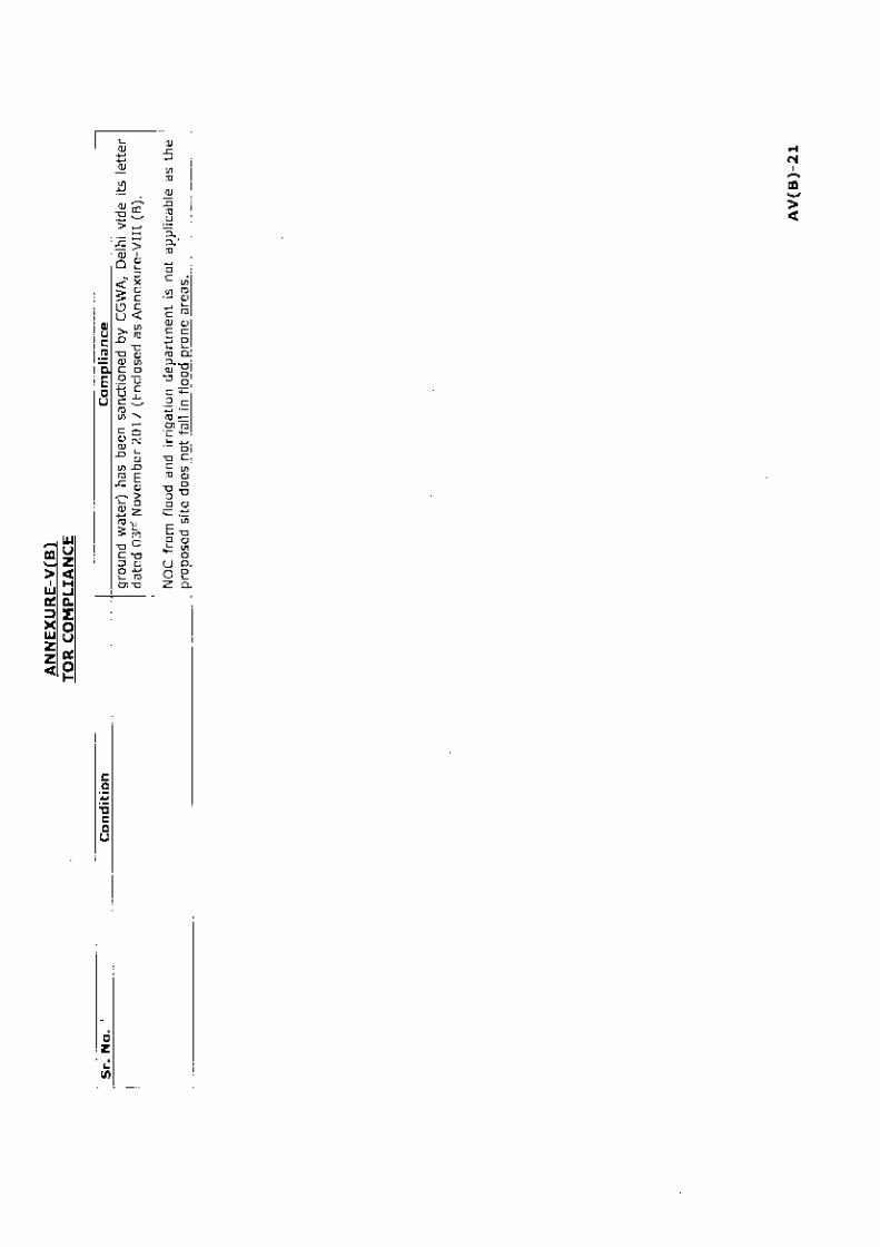
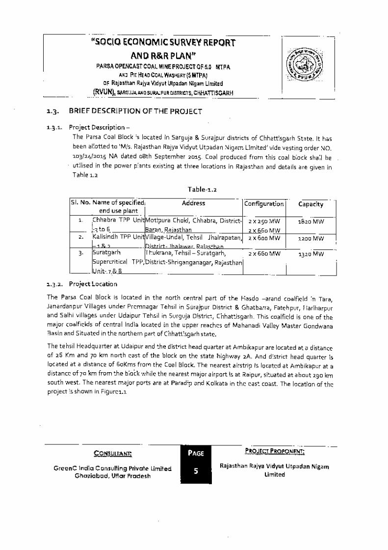
Parsa opencast coal mine is located in northern fringe of Hasdeo-Arand coalfield of Sarguja & Surajpur district, Chhattisgarh state which area about 290 km from Raipur and 150 km from Bilaspur on SH-2A. Parsa coal block was allotted to Chhattisgarh State Power Generation Company Ltd. (CSPGCL) (erstwhile Chhattisgarh state electricity board) by the Ministry of Coal vide F.No-13016/23/2006-CA-I dated 2nd August, 2006 for coal mining. Terms of References (ToR) issued for Environmental Impact Assessment (EIA)/Environmental Management Plan (EMP) of the project by Ministry of Environment, Forest & Climate Change (MoEF&CC) vide letter F.No.J-11015/398/2012.IA.II (M) dated 14th May 2013. The draft EIA/EMP was prepared after collection of baseline data (March to May 2013) as per Terms of References (ToR). The public hearing was organized on 28th February 2014 in Surajpur district & 01st March 2014 in Surguja district of Chhattisgarh. The mine plan and mine closure plan (5 MTPA) was approved by Ministry of Coal vide letter no.13016/90/2006-CA-I (Part) on dated 19th May 2014. Meanwhile, Hon’ble Supreme Court of India through its judgment dated 25th August 2014 & 24th September 2014 had cancelled the allotment of 204 coal blocks including Parsa coal block. Subsequently, block was allotted to Rajasthan Rajya Vidyut Utpadan Nigam Limited (RVUNL) vide vesting order no.103/24/2015/NA dated 8th September 2015 to meet the coal requirement of their three thermal power projects is given in Table-1.1. The coal block allotment order is enclosed as Annexure-I.
TABLE-1.1
COAL REQUIREMENT FOR THE THERMAL POWER PLANT
Sr. No.
Name of Specified end use plant
Address Configuration Capacity
1
Chhabra TPP (Unit 3, 4, 5 & 6)
Motipura Choki, Chhabra, Baran district, Rajasthan
Approval of mine plan and mine closure plan issued to CSPGCL was transferred to RVUNL from the date of allotment. Application for Forest Clearance (FC) was submitted online (proposal no. FP/CG/MIN/20742/2016) on 04th August 2016. The forest clearance for the
Environmental Impact Assessment for the Proposed Parsa Opencast Coal Mine Project of 5 MTPA and Pit Head Coal Washery of 5 MTPA in a Total Area of 1252.447 ha at Hasdeo-Arand Coal Field in Districts Surguja & Surajpur (Chhattisgarh)
Chapter-1 Introduction
VIMTA Labs Limited, Hyderabad C1-2
proposed coal block is in advance stage. The document showing status of the forest clearance is enclosed as Annexure-II. RVUNL requested MoEF&CC for transfer of ToR dated 14th May 2013 issued to CSPGCL through several communications. In reply to the request, MoEF&CC vide its letter dated 06th September 2016, suggested to apply for fresh ToR is enclosed as Annexure III. Application for fresh ToR was submitted online (proposal No. IA/CG/CMIN/59215/2016) on 27th September 2016. The Mine Plan & Mine Closure Plan (1st Revision) was approved by Ministry of Coal vide letter File No. 34011/24/2016-CPAM dated 10th November 2016. The Mine Plan approval is enclosed as Annexure-IV. The ToR proposal was considered by the EAC in its 4th meeting held on 30-31 January 2017, wherein proposal was recommended for ToR. The ToR for EIA/EMP was issued by MoEF&CC vide letter no.J-11015/76/2016-IA.I1 (M) dated 23rd March 2017. The TOR and its compliance are enclosed as Annexure-V. RVUNL proposes mechanized opencast mining in Parsa coal block in a total project area of 1252.447 ha in Hasdeo-Arand Coalfield with production capacity of 5 MTPA with a pit head coal washery of 5 MTPA capacity. With a view to assess the environmental impacts arising due to the proposed Project, M/s. Rajasthan Rajya Vidyut Utpadan Nigam Limited (RVUNL) has entrusted the services to NABET accredited EIA consultant M/s. Vimta Labs
Limited (VLL), Hyderabad to prepare EIA report for various environmental components including air, noise, water, land and biological components along with parameters of human interest, which may be affected and to prepare an EMP for mitigating possible adverse impacts. Draft EIA/EMP report prepared by M/s Vimta Labs Limited in accordance with the provisions of Terms of references issued by MoEF&CC dated 23rd March 2017. The Draft report was submitted to Chhattisgarh Environment Conservation Board (CECB) by RVUNL vide letter dated 18.07.2017 & 21.07.2017. Subsequently, after one month notice, district-wise Public Hearing was organized by CECB at Basan Village, Surguja District, Chhattisgarh on 29th October 2017 and at Tara Village, Surajpur District, Chhattisgarh on 12th November 2017 for the proposed Parsa opencast coal mine project of 5 MTPA and pit head coal washery of 5 MTPA. This Report is updated after Public Hearing by incorporating issues raised during public hearing and action plan to address the issues.
1.2 Identification of Project & Project Proponent
Mine is located in Hasdeo-Arand Coalfield area of Tara and Janardhanpur villages under Premnagar tehsil in Surajpur district & Ghatbarra, Fatehpur, Hariharpur and Salhi villages under Udaipur tehsil in Surguja district, Chhattisgarh. This coalfield is one of the major coalfields of the central India located in the upper reaches of Mahanadi Valley Master Gondwana Basin and is situated in the northern part of Chhattisgarh state. The Hasdeo-Arand coalfield covers an area of about 1200 sqkm having a length of about 70 km and width of about 25 km. It is bounded by latitude 22037΄00˝ & 22055΄00˝N and longitude 82020’00˝ &
Environmental Impact Assessment for the Proposed Parsa Opencast Coal Mine Project of 5 MTPA and Pit Head Coal Washery of 5 MTPA in a Total Area of 1252.447 ha at Hasdeo-Arand Coal Field in Districts Surguja & Surajpur (Chhattisgarh)
Chapter-1 Introduction
VIMTA Labs Limited, Hyderabad C1-3
83006΄00˝E. The coalfield lies partly in the eastern part of Korba district and extends into western part of Surguja district. Major part of the coalfield is still virgin with huge resources of power grade coal.
The Parsa coal block allotted to RVUNL is spread over a total area of 1252.447 ha. The mineable area is about 1129.37 ha in the total project area. It is bounded by latitude 22˚48’57.01˝ & 22˚51΄56.85˝N and longitude 82˚45΄10.50˝ & 82˚47΄ 22.86˝E. The block is covered under survey of India topo sheet no.64J/13 on RF 1: 50,000. The plan showing various coal blocks and their locations is shown in Figure-1.1.
Environmental Impact Assessment for the Proposed Parsa Opencast Coal Mine Project of 5 MTPA and Pit Head Coal Washery of 5 MTPA in a Total Area of 1252.447 ha at Hasdeo-Arand Coal Field in Districts Surguja & Surajpur (Chhattisgarh)
Chapter-1
Introduction
VIMTA Labs Limited, Hyderabad C1-4
FIGURE-1.1
COAL BLOCKS IN HASDEO-ARAND COAL FIELD
Environmental Impact Assessment for the Proposed Parsa Opencast Coal Mine Project of 5 MTPA and Pit Head Coal Washery of 5 MTPA in a Total Area of 1252.447 ha at Hasdeo-Arand Coal Field in Districts Surguja & Surajpur (Chhattisgarh)
Chapter-1 Introduction
VIMTA Labs Limited, Hyderabad C1-5
1.2.1 Project Proponent The Rajasthan Rajya Vidyut Utpadan Nigam Limited (RVUNL) has been entrusted with the job of development of power projects under State sector, in the state along with operation & maintenance of state owned power stations. Government of Rajasthan constituted the RVUNL under the companies act, 1956 on 19th July, 2000. The nigam is since playing lead role in giving highest priority to the power generation for manifold and rapid development of the state. RVUNL owns and operates following thermal/gas/ hydel power stations in the state sector which is listed in Table-1.2.
TABLE-1.2
RVUNL-THERMAL AND HYDEL POWER STATIONS IN RAJASTHAN
Sr.
No.
Power Stations Installed Capacity
(MW)
1 Suratgarh STPS, Suratgarh, District Shriganganagar 1500 2 Kota STPS, Kota 1240 3 Chhabra Thermal Power Station,Chhabra, District Baran
(Unit 1,2,3,4) 1000
4 Kalisindh TPS, District Jhalawar 1200 5 Dholpur CCPS, Dholpur 330 6 Giral Lignite TPS 1&2, Giral, District Barmer 250 7 Ramgarh Gas Thermal Power Station, District Jaisalmer 270.50 8 Mahi Hydel Power Station, District Banswara 140 9 Mini Micro Hydel Schemes 23.85
Total 5954.35
Source: RVUNL
Two coal based power projects, Suratgarh and Kota super thermal power stations of RVUNL are ranked amongst the best power plants in the country and are receiving meritorious productivity awards time and again from the Ministry of Power, Government of India. RVUNL is making all possible efforts to bridge the gap between power demand and availability in the State through expeditious construction of new units aggregating to 2640 MW capacity. The construction work of the following projects is in progress, details is given in Table-1.3.
TABLE-1.3
RVUNL-THERMAL POWER STATIONS UNDER CONSTRUCTION IN
RAJASTHAN
Sr. No. Power Stations Capacity
1 Suratgarh Supercritical Thermal Power Station Unit-7 & 8 1320 MW 2 Chhabra Supercritical Thermal Power Station Unit-5 & 6 1320 MW
Total 2640 MW
Source: RVUNL
RVUNL requires continuous supply of coal for its various existing and planned thermal power generating stations in the state of Rajasthan and for this purpose, RVUNL and the State Government had requested Ministry of Coal, Government of
Environmental Impact Assessment for the Proposed Parsa Opencast Coal Mine Project of 5 MTPA and Pit Head Coal Washery of 5 MTPA in a Total Area of 1252.447 ha at Hasdeo-Arand Coal Field in Districts Surguja & Surajpur (Chhattisgarh)
Chapter-1 Introduction
VIMTA Labs Limited, Hyderabad C1-6
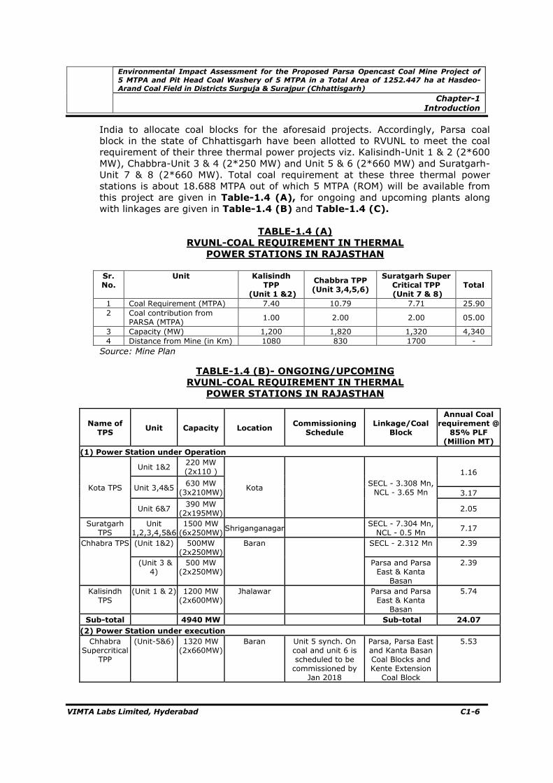
India to allocate coal blocks for the aforesaid projects. Accordingly, Parsa coal block in the state of Chhattisgarh have been allotted to RVUNL to meet the coal requirement of their three thermal power projects viz. Kalisindh-Unit 1 & 2 (2*600 MW), Chabbra-Unit 3 & 4 (2*250 MW) and Unit 5 & 6 (2*660 MW) and Suratgarh-Unit 7 & 8 (2*660 MW). Total coal requirement at these three thermal power stations is about 18.688 MTPA out of which 5 MTPA (ROM) will be available from this project are given in Table-1.4 (A), for ongoing and upcoming plants along with linkages are given in Table-1.4 (B) and Table-1.4 (C).
3 Capacity (MW) 1,200 1,820 1,320 4,340 4 Distance from Mine (in Km) 1080 830 1700 - Source: Mine Plan
TABLE-1.4 (B)- ONGOING/UPCOMING
RVUNL-COAL REQUIREMENT IN THERMAL
POWER STATIONS IN RAJASTHAN
Name of TPS
Unit Capacity Location Commissioning
Schedule Linkage/Coal
Block
Annual Coal requirement @
85% PLF (Million MT)
(1) Power Station under Operation
Kota TPS
Unit 1&2 220 MW (2x110 )
Kota
SECL - 3.308 Mn, NCL - 3.65 Mn
1.16
Unit 3,4&5 630 MW
(3x210MW) 3.17
Unit 6&7 390 MW
(2x195MW) 2.05
Suratgarh TPS
Unit 1,2,3,4,5&6
1500 MW (6x250MW)
Shriganganagar SECL - 7.304 Mn, NCL - 0.5 Mn
7.17
Chhabra TPS (Unit 1&2) 500MW (2x250MW)
Baran SECL - 2.312 Mn 2.39
(Unit 3 & 4)
500 MW (2x250MW)
Parsa and Parsa East & Kanta
Basan
2.39
Kalisindh TPS
(Unit 1 & 2) 1200 MW (2x600MW)
Jhalawar Parsa and Parsa East & Kanta
Basan
5.74
Sub-total 4940 MW Sub-total 24.07
(2) Power Station under execution Chhabra
Supercritical TPP
(Unit-5&6) 1320 MW (2x660MW)
Baran Unit 5 synch. On coal and unit 6 is scheduled to be commissioned by
Jan 2018
Parsa, Parsa East and Kanta Basan Coal Blocks and Kente Extension
Coal Block
5.53
Environmental Impact Assessment for the Proposed Parsa Opencast Coal Mine Project of 5 MTPA and Pit Head Coal Washery of 5 MTPA in a Total Area of 1252.447 ha at Hasdeo-Arand Coal Field in Districts Surguja & Surajpur (Chhattisgarh)
Chapter-1 Introduction
VIMTA Labs Limited, Hyderabad C1-7
Name of TPS
Unit Capacity Location Commissioning
Schedule Linkage/Coal
Block
Annual Coal requirement @
85% PLF
(Million MT)
Suratgarh Supercritical
TPP
(Unit 7&8) 1320 MW (2x660MW)
Shriganganagar Unit 7 commissioning schedule by Dec
2017 and Unit 8 by March 2018
Parsa, Parsa East and Kanta Basan Coal Blocks and Kente Extension
Coal Block
5.53
Sub-total 2640 MW
Sub-total 11.06
Total 7580 MW
Total 35.13
Source: RVUNL
TABLE-1.4 (C)
SUMMARIZED DETAILS OF COAL REQUIREMENT EXTRACTED
FROM TABLE-1.4 (B)
Total Washed Coal requirement at 85% PLF (Million MT)
Operational projects
Projects under execution
Total
Linkage 15.94 0 15.94
Captive 8.13 11.06 19.19
Total 24.07 11.06 35.13
Total raw coal requirement from captive coal blocks is 25.59 Million MT (@.75 MT of washed coal from 1 MT of Raw Coal). Total proposed peak capacity of Parsa East & Kanta Basan Coal Blocks is 15 Million MT. There will be a shortfall of about 10.59 Million MT of Coal after commissioning of all the proposed TPPs and hence production from Parsa (5 Million MT) will be required to make up this shortfall.
1.3 Brief Description of Project
1.3.1 Nature of the Project The proposed mine is a mechanised open-cast coal mining project having pit head coal washery and is classified as “Category-A” by the MoEF&CC, New Delhi as per the EIA Notification dated 14th September, 2006.
1.3.2 Size of the Project
The target production capacity of the mine is 5 Million Tonnes Per Annum (MTPA). M/s RVUNL has applied for the mining lease over an area of 1252.447 ha. The total gross geological reserves, mineable reserves and overburden have been estimated as 256.40 MT, 200.41 MT and 1227.19 Mcum respectively. The overall stripping ratio works out as 6.12 m3/tonnes. The details of mineable reserves are given in Table-1.5.
Environmental Impact Assessment for the Proposed Parsa Opencast Coal Mine Project of 5 MTPA and Pit Head Coal Washery of 5 MTPA in a Total Area of 1252.447 ha at Hasdeo-Arand Coal Field in Districts Surguja & Surajpur (Chhattisgarh)
Chapter-1 Introduction
VIMTA Labs Limited, Hyderabad C1-8
TABLE-1.5
TOTAL RESERVES
Sr. No. Description Quantity (MT)
1 Gross geological reserves 256.40 2 Net geological reserves (10% GR loss) 230.76 3 Net geological reserves blocked in barrier, batter, nala diversion
and not considered for mining (MT) 40.81
4 Net geological reserves considered for mining (MT) 189.96 5 Mining loss @ 3 % (MT) 5.70 6 Mineable reserves (MT) 184.26 7 Coal blocked in barrier & batter in eastern side of parsa Coal
Block 10.80
8 Coal under batter in southern - western boundary of parsa coal block by high wall mining @20%
5.37
Total Recovery of Coal (MT) 200.41
Source: Mine Plan
1.3.3 Location of the Project
The parsa coal block is located in the north central part of the Hasdeo-Arand coalfield in Surguja and Surajpur districts, Chhattisgarh. The block is located adjacent to the Parsa East and Kanta Basan coal blocks of Rajasthan Rajya Vidyut Utpadan Nigam Ltd., Jaipur. The main access to the Hasdeo-Arand coalfield is through the State Highway (SH)-2A aligned in a NE–SW direction, which passes very close to the north western corner of the block. The block can be approached from Tara village, located on SH-2A.
The details of environmental setting is given in Table-1.6. The index map showing the location of the project and study area map of 10 km radius from mine lease boundary are shown in Figure-1.2 and Figure-1.3 respectively.
TABLE-1.6
ENVIRONMENTAL SETTING
Sr. No. Particulars Details
1 Location North central part of Hasdeo-Arand coalfield A Coordinates (Coal Mine Block)
Code Latitude Longitude
A 22o 51' 11.58" N 82o 47' 22.86" E B 22o 48' 57.01" N 82o 46' 38.33" E C 22o 49' 25.25" N 82o 45' 30.68" E D 22o 49' 58.92" N 82o 45' 30.26" E E 22o 50' 14.70" N 82o 45' 14.32" E F 22o 50' 41.58" N 82o 45' 10.50" E G 22o 50' 57.73" N 82o 45' 33.97" E H 22o 51' 56.85" N 82o 45' 37.52" E
B Villages Core Zone covers the following villages- i. Tara, ii. Janardhanpur, iii. Fatehpur, iv. Ghatbarra, v. Hariharpur & vi. Salhi
C Tehsil Udaypur and Premnagar D District Surguja and Surajpur E State Chhattisgarh
Environmental Impact Assessment for the Proposed Parsa Opencast Coal Mine Project of 5 MTPA and Pit Head Coal Washery of 5 MTPA in a Total Area of 1252.447 ha at Hasdeo-Arand Coal Field in Districts Surguja & Surajpur (Chhattisgarh)
Chapter-1 Introduction
VIMTA Labs Limited, Hyderabad C1-9
Sr. No. Particulars Details
2 Elevation above MSL Varies from 505 m to 559 m 3 Toposheet no. 64- J/9, J/10, J/13 and J/14 4 Land Use for the Mine The total area of mine is 1252.447 ha
Forest area – 841.538 ha (67.0%) Agricultural/Tenancy Land – 365.366 ha (29%) Govt. land – 45.543 ha (4%)
5 Coal washery land use with in the ML area
13.586 ha
6 Climatic conditions As per IMD-Ambikapur
Annual Maximum Temperature:42.70C Annual Minimum Temperature:4.40C Annual Rainfall:1526.9 mm
7 Nearest highway SH-2A (0.5 km, NW) 8 Nearest railway station Bisrampur (62 km, NW) 9 Nearest airport Raipur (290 km, SW) Nearest Town/City Udaypur (26 km, NE)/Ambikapur (70 km, NE)
11 Nearest water bodies Atem nadi (1.9 km, NE) Chhoti Chornai nadi (9.5 km, SE) Chornai Nadi (13.2 km S)
1. Pidiya RF (within ML area) Protected Forest (PF):
1. Janardhanpur PF (within ML area) 2. Ghatbarra PF (within ML area) 3. Phatehpur PF(within ML area) 4. Tara East PF (within ML area) 5. Gumga PF – adjacent 6. Shivnagar PF (2.7 km, NNE) 7. Matringa PF (4.5 km, E) 8. Murgaon PF (5.9 km, NE) 9. Paturiya PF (6.2 km, SW) 10. Chandannagar PF (6.4 km, N) 11. Chirwan PF (8.1 km, NNE) 12. Dhajag PF (8.8 km, SW) 13. Putta PF (9.3 km, E) 14. Kotmi PF (9.5 km, NE)
13 Other historical and archaeological places
None within 10 km radius
14 Ecology sensitive/ Protected areas as per Wild Life Protection Act 1972 (National Park/ Wild life Sanctuary/ Bio-sphere reserves)
None within 10 km radius
15 Defence installations None within 10 km radius from ML boundary 16 Industries Nil within 10 km radius 17
Other Industries/Mines Parsa East & Kanta Basan Coal Block under operation by RVUNL and Tara Coal Block (adjacent) Other mines of Hasdeo Arand Coalfield
18 Coal user locations Motipura Choki, Chhabra, Baran district (Rajasthan) Village-Undal, Jhalraptan tehsil,Distt-Jhalawar district (Rajasthan) Thukrana, Suratgarh tehsil, Shriganganagar district (Rajasthan)
19 Socio-economic factors Resettlement and Rehabilitation is involved 20 Seismic zone Zone-II as per IS-1893 (Part-1)-2002
1.3.4 Cost of the Project
Total cost of the proposed mining project is estimated as Rs.1,960 Crores.
Environmental Impact Assessment for the Proposed Parsa Opencast Coal Mine Project of 5 MTPA and Pit Head Coal Washery of 5 MTPA in a Total Area of 1252.447 ha at Hasdeo-Arand Coal Field in Districts Surguja & Surajpur (Chhattisgarh)
Chapter-1 Introduction
VIMTA Labs Limited, Hyderabad C1-10
1.3.5 Project Importance The mineral wealth of a nation is an important feature in its economic progress and mining in India has a vital role in the development. Chhattisgarh state is geologically so endowed that it has become a veritable repository of minerals. Search and exploration of coal in the state during last few years have resulted in the discovery of several coal deposits in Hasdeo-Arand Coalfield. These are large workable reserves and their exploitation has already been started. For the economic development of state, agriculture, industry and commerce plays a very important role. To develop all these facets electricity is an essential commodity. To accelerate the pace of development of Rajasthan and bring it at par with the other developed states, state Government of Rajasthan has taken various steps and formulated various policies, which inter alia include industrialization, electrification in urban and rural areas, infrastructure facilities, agriculture irrigation development. The Government of India has allotted parsa coal block to RVUNL located in Hasdeo-Arand coalfield area for exploitation, mining and beneficiation. The proposed parsa coal block will be utilized by the thermal power plant of RVUNL, which will fulfill the future requirement of Rajasthan state and this will extend a hand to bring the economic development in the state.
1.3.6 Proposed Coal Evacuation Plan It has been planned to bring coal from coal face to surface by belt conveyor after initial 4 years of mine development in which coal transportation will be done by dump trucks. The conveyors will be provided to transport coal into Coal Handling Plant (CHP) to feed into the washery within the mine lease area. The coal evacuation shall be done through pit top railway siding having Silo with rapid loading system. Alternatively, in-pit crushing and conveying system will be installed in the quarry itself and coal is proposed to be transported by belt conveyor to the nearby existing facilities of CHP and Washery. Coal evacuation will be done through railway siding having Silo with rapid loading system. The existing facilities shall be augmented to cater 5 MTPA of coal produced from Parsa Coal Block. The belt conveyor has been envisaged for less fleet of dumper, negligible air pollution and negligible noise pollution. A rail link of about 75 Km has already been established between adjacent mine and Surajpur railway station, which is situated on Anuppur- Ambikapur branch line on Bilaspur division of South East Central Railway.
The coal will be transported to end use power plants located in Rajasthan through the established link of 75 Km connecting Surajpur railway station, which is situated on Anuppur - Ambikapur branch line on Bilaspur division of South East Central Railway.
1.3.7 Coal Supply and Demand The target production capacity of both the mine and coal washery is 5 MTPA each to meet the coal requirement of RVUNL’s three thermal power projects is given in Table-1.1.
Environmental Impact Assessment for the Proposed Parsa Opencast Coal Mine Project of 5 MTPA and Pit Head Coal Washery of 5 MTPA in a Total Area of 1252.447 ha at Hasdeo-Arand Coal Field in Districts Surguja & Surajpur (Chhattisgarh)
Chapter-1 Introduction
VIMTA Labs Limited, Hyderabad C1-11
FIGURE-1.2
INDEX MAP OF THE PROJECT
CHHATTISGARH
Parsa Coal Block
SURGUJA & SURAJPUR
DISTRICTS
SURAJPUR DISTRICT
SURGUJA DISTRICT
Environmental Impact Assessment for the Proposed Parsa Opencast Coal Mine Project of 5 MTPA and Pit Head Coal Washery of 5 MTPA in a Total Area of 1252.447 ha at Hasdeo-Arand Coal Field in Districts Surguja & Surajpur (Chhattisgarh)
Chapter-1 Introduction
VIMTA Labs Limited, Hyderabad C1-12
FIGURE-1.3
STUDY AREA MAP
CO-ORDINATES OF PARSA COAL BLOCK
A : 22°51’11.58”N, 82°47’22.86”E
B : 22°48’57.01”N, 82°46’38.33”E
C : 22°49’25.25”N, 82°45’30.68”E
D : 22°49’58.92”N, 82°45’30.26”E
E : 22°50’14.70”N, 82°45’14.32”E
F : 22°50’41.58”N, 82°45’10.50”E
G: 22°50’57.73”N, 82°45’33.97”E
H: 22°51’56.85”N, 82°45’37.52”E
Environmental Impact Assessment for the Proposed Parsa Opencast Coal Mine Project of 5 MTPA and Pit Head Coal Washery of 5 MTPA in a Total Area of 1252.447 ha at Hasdeo-Arand Coal Field in Districts Surguja & Surajpur (Chhattisgarh)
Chapter-1 Introduction
VIMTA Labs Limited, Hyderabad C1-13
1.4 Scope of the Study
Environmental baseline monitoring has been carried out from 1st March 2017 to 31st May 2017 representing pre-monsoon season and used to identify potential significant impacts. Modeling exercises have been carried out to predict and evaluate the cumulative impacts due to proposed project.
1.4.1 Study Area for EIA The study area for the EIA study is covered within 10 km from the proposed project site boundary.
1.4.2 Details of the Study The scope of study broadly includes: • To conduct literature review and to collect data relevant to the study area; • To undertake environmental monitoring so as to establish the baseline
environmental status of the study area; • To identify various existing pollution loads due to various activities in the
ambient levels; • To evaluate the predicted impacts on the various environmental attributes in
the study area by using scientifically developed and widely accepted environmental impact assessment methodologies;
• To prepare an EMP outlining the measures for improving the environmental quality and scope for environmentally sustainable development; and
• To identify critical environmental attributes required to be monitored.
1.4.3 Methodology of the Study Reconnaissance survey was conducted by the consultants along with concerned
officials and sampling locations were identified on the basis of:
• Predominant wind directions in the study area as recorded by India Meteorological Department (IMD) at Ambikapur;
• Existing topography, location of surface water bodies like ponds, canals and rivers;
• Location of villages, towns and sensitive areas; • Areas which represent baseline conditions; and • Collection, collation and analysis of baseline data for various environmental
attributes.
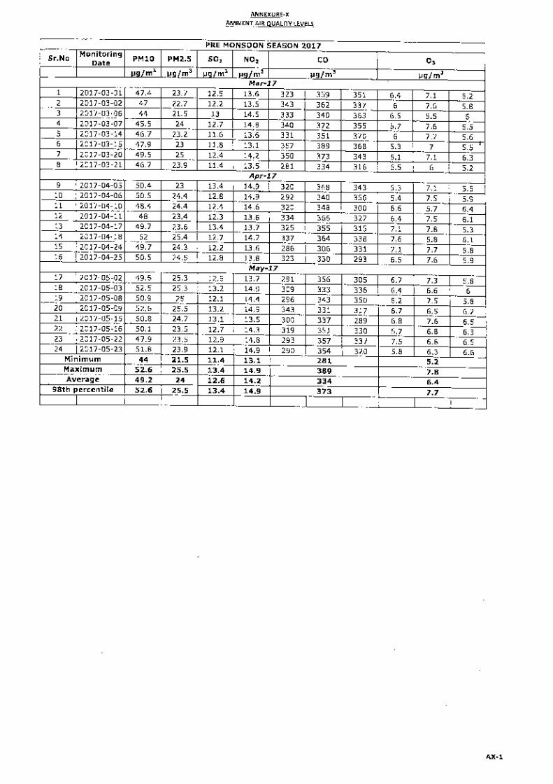
Detailed field studies have been carried out during pre-monsoon season (1st March 2017 to 31st May 2017) covering a period of 3 months to determine existing conditions of various environmental attributes. The monitoring details are outlined in Table-1.7.
Environmental Impact Assessment for the Proposed Parsa Opencast Coal Mine Project of 5 MTPA and Pit Head Coal Washery of 5 MTPA in a Total Area of 1252.447 ha at Hasdeo-Arand Coal Field in Districts Surguja & Surajpur (Chhattisgarh)
Chapter-1 Introduction
VIMTA Labs Limited, Hyderabad C1-14
TABLE-1.7
ENVIRONMENTAL ATTRIBUTES AND FREQUENCY OF MONITORING
24 hourly samples for PM10, PM2.5, SO2 NOx, NH3, C6H6,, BaP, As, Ni and Pb; three 8 hourly samples per day for CO and O3
3 Water quality 7 Ground water and 5 Surface water locations
As per drinking water standards IS: 10500
Grab sampling
Once during study period
4 Noise 10 Locations Sound pressure levels
Continuously for 24 hours
Once during study period
5 Soil 8 Locations Soil profile, Chemical constituents
Composite sample
Once during study period
6 Ecology Existing ecological resources within study area
Flora and fauna Field observations and secondary sources
Once in study period
7 Demography and Socio-economic aspects
Total study area
Demographic profile
Based on district census handbook (2011)
8 Land use Total study area
Trend of land use change for different categories
Based on district census handbook (2011)/ remote sensing data
9 Geology - Geological history Data collected from secondary sources
10 Hydrogeology
- Drainage area and pattern, nature of streams, Aquifer characteristics, Recharge and Discharge rates
Based on data collected from primary study carried out.
Chapter-2
Project Description
Environmental Impact Assessment for the Proposed Parsa Opencast Coal Mine Project of 5 MTPA and Pit Head Coal Washery of 5 MTPA in a Total Area of 1252.447 ha at Hasdeo-Arand Coal Field in Districts Surguja & Surajpur (Chhattisgarh)
Chapter-2 Project Description
VIMTA Labs Limited, Hyderabad C2-1
2.0 PROJECT DESCRIPTION
This chapter deals with the geology of the mining lease area, exploration details, evaluation of the deposit, estimation of ore reserves, method of mining, machinery, phase wise coal extraction details, details on infrastructure & resource requirement including water, fuel, power etc. for mining operation.
2.1 Type of Project
The proposed project is a mechanised opencast coal mine having proposed capacity of 5 MTPA with a pit head coal washery of 5 MTPA throughput capacities. The washed clean coal will be supplied to RVUNL’s thermal power plants by rail through pit head railway siding with silo & rapid loading system.
2.2 Need of the Project
The parsa coal block was allotted to RVUNL by the Ministry of Coal vide vesting order No-103/24/2015/NA dated 8th September 2015 for captive coal mining. Coal mined from the Parsa block to meet the requirement of three power plants of RVUNL in Rajasthan is given in Table-1.1 of Chapter-1.
2.3 Location of Parsa Block
The parsa block is located in the north central part of Hasdeo-Arand coalfield, Udaypur and Premnagar tehsil, Surguja and Surajpur districts, Chhattisgarh. The block is located adjacent to Parsa East and Kanta Basan coal blocks already allocated to the Rajasthan Rajya Vidyut Utpadan Nigam Ltd, Jaipur (RVUNL) which is under operation. The total project area of 1252.447 ha includes 841.538 ha of forest land (includes 556.004 ha RF & PF + 285.534 ha of Chhote bade jhar ka jungle), 365.366 ha is tenancy land (321.09 ha of Adivasi + 44.276 ha of non-adivasi land) and 45.543 ha of Government land. The block geographically extends from latitude 22o48'57.01”N to 22o51'56.85”N and longitude 82o45'10.50"E to 82o47'22.86"E. The entire lease area falls in the Survey of India toposheet No.64-J/13.
The block is rectangular in shape and extends about 3.10 km along the strike direction (NW-SE) and about 4.3 km along the dip direction (SW). The tehsil Headquarters at Udaypur is located 26 km northeast of the block on State Highway (SH)-2A connecting Bilaspur and Ambikapur.
The boundaries of Parsa coal block are given below: North: About 100 to 550 m north of Incrop of Seam-IV; South: An imaginary line connecting points at 260 m, 290 m, 250 m, 220 m &
190 m south of BH No. PCL-70, 84, 106, 86 & 87 respectively and joining the eastern and western boundaries of the block;
East: Common boundary with Parsa East & Kanta Basan coal block of the Rajasthan Rajya Vidyut Utpadan Nigam Ltd (RVUNL); and
West: Common boundary with Tara coal block
Environmental Impact Assessment for the Proposed Parsa Opencast Coal Mine Project of 5 MTPA and Pit Head Coal Washery of 5 MTPA in a Total Area of 1252.447 ha at Hasdeo-Arand Coal Field in Districts Surguja & Surajpur (Chhattisgarh)
Chapter-2 Project Description
VIMTA Labs Limited, Hyderabad C2-2
The tehsil headquarters at Udaypur and the district headquarters at Ambikapur are located at a distance of 26 km and 70 km northeast of the block on SH-2A. Lakhanpur, another small township is located about 43 km northeast of the block on SH-2A. The SH-2A aligned in a NE–SW direction passes very close to the north western corner of the block. The block can be approached from Tara village, located on SH-2A at a distance of about 152 km from Bilaspur, through a fair weather forest road that leads to Ghatbarra village through Fatehpur village located in the southern part of the block. The accessibility within the block is through kuccha/unmetalled roads and is difficult during monsoon. The villages within the block are connected by morrum and mud roads.
The nearest railhead Bisrampur on the Bijuri-Ambikapur section of the South East Central Railway (SECR) is located about 62 km from the northwestern corner of the block (new railway line from Surajpur railway station to pit head is being established).
The nearest airstrip is located at Ambikapur at a distance of about 70 km from the block while the nearest major airport at Raipur. The state capital is Raipur, which is about 290 km in southwest direction from the proposed mine.
The details of environmental setting is given in Table-1.6 and the index map of the proposed mine site is shown in Figure-1.2 in Chapter-1.
2.4 Size/Magnitude of Operation
2.4.1 Coal Mine
The applied mine lease extends over an area of 1252.447 ha. The salient features of the proposed mine are given in Table-2.1.
TABLE-2.1
SALIENT FEATURES OF THE PROPOSED MINE
Sr. No. Description Details
1 Total project area 1252.447 ha 2 Mine lease area (applied) 1252.447 ha 3 Type of mine Opencast mechanized 4 Method of mining Shovel-dumper for over burden removal and
Surface miner for coal mining 5 Rated capacity of mine 5.0 MTPA 6 Expected life of mine 45 years including 3 years of construction
period 7 Average stripping ratio 6.12 m3/Tonne 8 Geological reserves 256.40 Million Tonnes 9 Mineable reserves 200.41 Million Tonnes 10 Thickness of coal seam range Seam IV – 6.64-9.67 m
Seam V - 2.26-7.97 m Seam VI – 0.78-2.70 m
11 Average no. of working days 330 days/year 12 Number of shifts 3 shifts/day 13 Working hours/shift 8 hr 14 No. of benches 3 nos 15 Bench height for OB 6-10 m 16 Bench height for coal 10 m or as the parting thickness 17 Ultimate depth of mine 275 m 18 Overburden to be generated during
entire life of mine 1227.19 million m3
Environmental Impact Assessment for the Proposed Parsa Opencast Coal Mine Project of 5 MTPA and Pit Head Coal Washery of 5 MTPA in a Total Area of 1252.447 ha at Hasdeo-Arand Coal Field in Districts Surguja & Surajpur (Chhattisgarh)
Chapter-2 Project Description
VIMTA Labs Limited, Hyderabad C2-3
Sr. No. Description Details
19 Capacity of Washery 5 MTPA washery 20 Hourly Throughput capacity 950 TPH design 21 No. of Annual working Hours 6000 hrs 22 Washing Technology Wet washing process 23 Modular details Single module of 5 MTPA 24
Plant Process Wet process comprising of crushing, screening, washing and material handling
25 No. of waste dumps planned 2 internal and 2 external dumps 26 Area of waste dumps Total internal dump area: 1059.092 ha
Total external dump area: 64.084 ha 27 Coal handling plant (CHP) 1000/1250 TPH capacity 28 No. of crushers 2 Nos. 29 Power requirement 5-7 MVA at 33 kV from nearest sub-station 30 Total Water requirement 2385 m3/day 31 Transport of coal from mine face to
CHP By belt conveyors
Source: Mining Plan
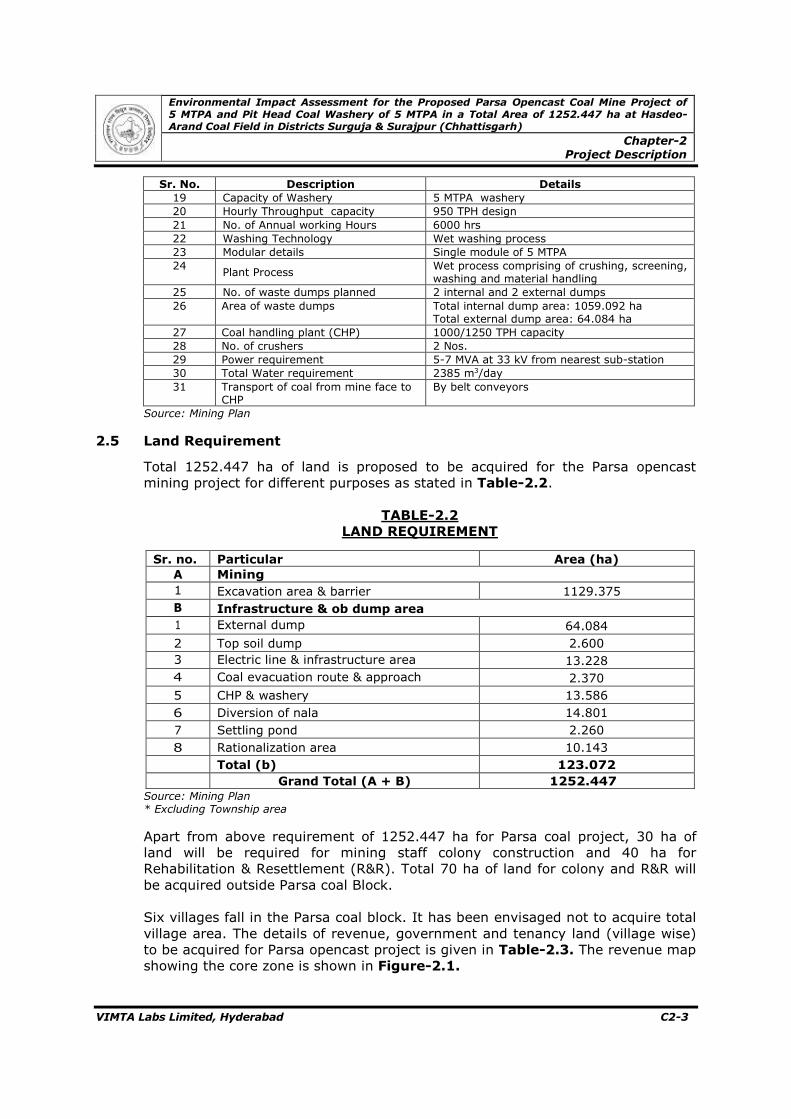
2.5 Land Requirement
Total 1252.447 ha of land is proposed to be acquired for the Parsa opencast mining project for different purposes as stated in Table-2.2.
TABLE-2.2
LAND REQUIREMENT
Sr. no. Particular Area (ha)
A Mining 1 Excavation area & barrier 1129.375 B Infrastructure & ob dump area 1 External dump 64.084 2 Top soil dump 2.600 3 Electric line & infrastructure area 13.228 4 Coal evacuation route & approach 2.370 5 CHP & washery 13.586 6 Diversion of nala 14.801 7 Settling pond 2.260 8 Rationalization area 10.143
Total (b) 123.072
Grand Total (A + B) 1252.447 Source: Mining Plan * Excluding Township area
Apart from above requirement of 1252.447 ha for Parsa coal project, 30 ha of land will be required for mining staff colony construction and 40 ha for Rehabilitation & Resettlement (R&R). Total 70 ha of land for colony and R&R will be acquired outside Parsa coal Block. Six villages fall in the Parsa coal block. It has been envisaged not to acquire total village area. The details of revenue, government and tenancy land (village wise) to be acquired for Parsa opencast project is given in Table-2.3. The revenue map showing the core zone is shown in Figure-2.1.
Environmental Impact Assessment for the Proposed Parsa Opencast Coal Mine Project of 5 MTPA and Pit Head Coal Washery of 5 MTPA in a Total Area of 1252.447 ha at Hasdeo-Arand Coal Field in Districts Surguja & Surajpur (Chhattisgarh)
Chapter-2
Project Description
VIMTA Labs Limited, Hyderabad C2-4
TABLE-2.3
LAND USE PATTERN OF PROPOSED COAL BLOCK TO BE ACQUIRED
Land use Pattern of Land proposed to be Acquired (ha)
Sr.No
Details of Reserved and Protected Forest Details of Govt., Tenancy and Chhote – Bade Jhar ka Jungle (Revenue Forest)
Total Forest Land (Protected Forest Land + Rev. Forest land) 841.538 Total Tenancy Land 365.366 Govt. Land 45.543
Grand Total (Forest land + Govt. Land+ Tenancy land) 1252.447
Source: Mining Plan
Environmental Impact Assessment for the Proposed Parsa Opencast Coal Mine Project of 5 MTPA and Pit Head Coal Washery of 5 MTPA in a Total Area of 1252.447 ha at Hasdeo-Arand Coal Field in Districts Surguja & Surajpur (Chhattisgarh)
Chapter-2 Project Description
VIMTA Labs Limited, Hyderabad C2-5
FIGURE-2.1
REVENUE MAP SHOWING THE CORE ZONE
Environmental Impact Assessment for the Proposed Parsa Opencast Coal Mine Project of 5 MTPA and Pit Head Coal Washery of 5 MTPA in a Total Area of 1252.447 ha at Hasdeo-Arand Coal Field in Districts Surguja & Surajpur (Chhattisgarh)
Chapter-2 Project Description
VIMTA Labs Limited, Hyderabad C2-6
Stage-wise Land Use Pattern of ML Area
The details of year wise land use and reclamation of mine lease area are given in Table-2.4.
TABLE-2.4
YEAR WISE LAND USE AND RECLAMATION All Values in ha
Sr. No
Land Use Present 1st Year 3rd Year 5th Year 10th Year
Total (B) 76.456 123.072 123.072 123.072 123.072 123.072 Grand Total Nil 113.445 269.266 390.685 572.586 833.892 1252.447
a. Internal Dump (Reclamation/ Backfilled area)
Nil - 16.347 151.313 288.827 528.179 1059.092
b. Void Area (Non-reclamation/ Backfilled area)
Nil 36.989 129.847 116.300 160.687 182.641 70.278
c. Balance area for quarry
Nil 1092.381 983.176 861.757 679.856 418.550 -
Source: Mine Plan
2.6 Technology and Process Description
2.6.1 Mining System
The following geo-mining factors have been considered: • Gradient of 20 to 60 of the coal seams; • Multiple coal seams (3 no. of coal horizons); • Long strike length; • Presence of medium thick coal seams; • Variable thickness of OB/partings; and • Less no. faults. Based on the above factors, mining system has been worked out for achievement of rated capacity in shorter period i.e. low gestation period as well as reduction of inter-mixing of coal with stone bands and starting of internal dumping as soon as sufficient de-coaled area is created. The top OB benches above mining mass will be worked in horizontal slicing method.
Environmental Impact Assessment for the Proposed Parsa Opencast Coal Mine Project of 5 MTPA and Pit Head Coal Washery of 5 MTPA in a Total Area of 1252.447 ha at Hasdeo-Arand Coal Field in Districts Surguja & Surajpur (Chhattisgarh)
Chapter-2 Project Description
VIMTA Labs Limited, Hyderabad C2-7
2.6.2 Mining Technology
Conventional mining system with the shovel dumper combination for overburden removal and surface miner for coal mining will be adopted.
2.6.3 Process Description
The mining plan for Parsa coal block has been prepared for a rated capacity of 5 MTPA and pit head washery capacity of 5 MTPA of power grade ROM coal. A detailed exploration in Parsa block of Hasdeo-Arand coalfield has established the existence of 3 persistent and potential coal seams viz Seam-IV, V and VI in ascending order. Besides, at least 1 to 2 thin and impersistent coal seams without any significant economic potential also occur below seam-IV as revealed from a few boreholes drilled upto the Talcher formation. All these seams occur within Barakar column. Among all the seams present in the block, only three seams viz IV, V and VI have attained workability in the block. Out of these 3 seams, seam-IV is the most potential and has least number of in-seam dirt bands followed by Seam-VI and V in that order. All these 3 seams incrop within the block and have quarriable potentiality.
Seams-IV incrop at a shallow depth and maximum depth of seam-IV floor is around 275 m in the block. The entire block is found suitable for exploitation by opencast mining method. The mine boundaries have been considered based on the geological block boundary, lay and disposition of the seams, position of the incrops and strip ratio analysis etc.
It is proposed to mine maximum area leaving a barrier of 7.5 m on surface from block boundary which is a statutory requirement. It is not required for the diversion of roads and watercourse. The mine parameters for the delineated mine boundaries is given in Table-2.5.
TABLE-2.5
MINE PARAMETERS
Sr. No. Parameters Unit Value
1 Maximum depth m 275 2 Maximum strike length:
along the Mine Floor along the Mine Surface
km km
2.95 3.05
3 Minimum strike length: along the Mine Floor along the Mine Surface
km km
1.67 2.20
4 Maximum dip rise length: on the Mine Floor on the Mine Surface
km km
3.95 4.23
5 Minimum dip rise length: on the Mine Floor on the Mine Surface
km km
2.58 2.90
6 Area: On the Mine Floor On the Mine Surface
ha ha
936.20 1114.69
Source: Mining Plan
Environmental Impact Assessment for the Proposed Parsa Opencast Coal Mine Project of 5 MTPA and Pit Head Coal Washery of 5 MTPA in a Total Area of 1252.447 ha at Hasdeo-Arand Coal Field in Districts Surguja & Surajpur (Chhattisgarh)
Chapter-2 Project Description
VIMTA Labs Limited, Hyderabad C2-8
The mine boundaries of the envisaged option are as follows:-
North 1 m thickness line on the base Seam IV as the floor boundary, in the incrop region
East The surface limit of the mine is 7.50 m away from the block boundary and then the resultant floor boundary has been envisaged
South The surface limit of the mine is 7.50 m away from the block boundary and then the resultant floor boundary has been envisaged
West The surface limit of the mine has been fixed by leaving barrier for nala diversion ranging between 18 m to 37 m and embankment against nala of 10 m accommodate nala diversion and then the resultant floor boundary has been envisaged.
2.6.3.1 Quarry Layout
The main considerations in designing the quarry layout have been:
• To design an economical production of required coal quality for the life of
mine; • To minimise transportation distance for coal and waste; • To minimise adverse effects on environment;
2.6.3.2 Sequence of Mining
Three years have been considered as construction period. During this period, following construction activities will be taken up: � Making approach road; � Land acquisition; � Bringing power line to the project and construction of electrical sub-station,
power supply; � Infrastructure like office, store, workshop, coal handling plant etc.; � Statutory clearance; � Colony (essential residential buildings); and � Railway siding and construction of MGR for coal dispatch.
• Opening of Mine Field
The Parsa opencast mine is proposed to be developed in the 1st year of mine operation by grading properly the access trench of 40 m width with the help of hydraulic backhoe and 35 T dumpers and other auxiliary HEMM. The access trench is to be graded from 515 m RL at 1 in 16 to the mine floor of about 500 m RL. The box cut is developed in such a manner so as to facilitate the proper drainage of water towards the sump. This would also facilitate extension of coal and OB bench for full development of mine. The mine will advance towards dip direction exposing the floor of Seam-IV. After creation of sufficient decoaled area, internal backfilling of OB will be started. The coal production will start from the 1st year of mine operation and the target coal production of 5.00 MTPA will be achieved in the 3rd year of mine operation.
Environmental Impact Assessment for the Proposed Parsa Opencast Coal Mine Project of 5 MTPA and Pit Head Coal Washery of 5 MTPA in a Total Area of 1252.447 ha at Hasdeo-Arand Coal Field in Districts Surguja & Surajpur (Chhattisgarh)
Chapter-2 Project Description
VIMTA Labs Limited, Hyderabad C2-9
The alignment of the face has been so planned as to facilitate the drainage of water. The quarry has been divided into two parts i.e. east and west for optimum accommodation of internal dump. Both eastern and western part will be worked simultaneously. During working of the quarry, haul road will be developed at 1 in 16 gradient along center of the quarry. This has been done in order to maximize the volume of the internal dump.
As gradient of coal seam is flat, haul road in quarry is designed along center of the quarry. This central haul road will serve both eastern as well as western quarry. A belt conveyor will be installed along one side of haul road for in-pit transportation of coal to surface. 40 m haul road has been proposed. Out of which, 10 m will be used for installation of belt conveyor. Coal is proposed to be transported from in pit to surface by belt conveyor to reduce fleet size of dumper as well as noise and dust pollution. 1st year, 3rd year, 5th year, 10th year and 20th year stage plans are shown in Figure-2.2 to Figure-2.6 respectively. The flow sheet indicating the different steps of mining operations is shown in Figure-2.7.
2.6.4 Coal Washery
The salient features of the proposed coal washery project are presented in Table-2.6 and the same are detailed in subsequent sections. Layout of the coal washery is shown in Figure-2.8.
As we ramp-up the mine production schedule, a Coal Washery with a Raw Coal throughput capacity of 5 MTPA has been proposed at the mines pit head of the Parsa Coal block to wash coal in order to meet the coal requirement of thermal power projects of RVUNL. 5 MTPA modular washery plant is proposed to be established with specific commitment of quality.
TABLE-2.6
SALIENT FEATURES OF THE COAL WASHERY PLANT
Sr. No. Description Details
1 Capacity 5 MTPA 2 Hourly Throughput capacity 950 TPH 3 No. of Annual working Hours 6000 hrs 4 Washing Technology Wet washing process 5 Plant Process Wet process comprising of crushing,
screening, washing and material handling 6 Land Requirement 13.586 ha 7 Water Requirement 1086 m³/day 8 Source of Water Mine discharge. 9 Power Requirement & source Power requirement (5-7 MVA) will be met
from the nearest Substation.
Environmental Impact Assessment for the Proposed Parsa Opencast Coal Mine Project of 5 MTPA and Pit Head Coal Washery of 5 MTPA in a Total Area of 1252.447 ha at Hasdeo-Arand Coal Field in Districts Surguja & Surajpur (Chhattisgarh)
Chapter-2 Project Description
VIMTA Labs Limited, Hyderabad C2-10
FIGURE-2.2
1ST YEAR QUARRY PLAN
Environmental Impact Assessment for the Proposed Parsa Opencast Coal Mine Project of 5 MTPA and Pit Head Coal Washery of 5 MTPA in a Total Area of 1252.447 ha at Hasdeo-Arand Coal Field in Districts Surguja & Surajpur (Chhattisgarh)
Chapter-2 Project Description
VIMTA Labs Limited, Hyderabad C2-11
FIGURE-2.3
3RD YEAR QUARRY PLAN
Environmental Impact Assessment for the Proposed Parsa Opencast Coal Mine Project of 5 MTPA and Pit Head Coal Washery of 5 MTPA in a Total Area of 1252.447 ha at Hasdeo-Arand Coal Field in Districts Surguja & Surajpur (Chhattisgarh)
Chapter-2 Project Description
VIMTA Labs Limited, Hyderabad C2-12
FIGURE-2.4
5TH YEAR QUARRY PLAN
Environmental Impact Assessment for the Proposed Parsa Opencast Coal Mine Project of 5 MTPA and Pit Head Coal Washery of 5 MTPA in a Total Area of 1252.447 ha at Hasdeo-Arand Coal Field in Districts Surguja & Surajpur (Chhattisgarh)
Chapter-2 Project Description
VIMTA Labs Limited, Hyderabad C2-13
FIGURE-2.5
10TH YEAR QUARRY PLAN
Environmental Impact Assessment for the Proposed Parsa Opencast Coal Mine Project of 5 MTPA and Pit Head Coal Washery of 5 MTPA in a Total Area of 1252.447 ha at Hasdeo-Arand Coal Field in Districts Surguja & Surajpur (Chhattisgarh)
Chapter-2 Project Description
VIMTA Labs Limited, Hyderabad C2-14
FIGURE-2.6
20TH YEAR QUARRY PLAN
Environmental Impact Assessment for the Proposed Parsa Opencast Coal Mine Project of 5 MTPA and Pit Head Coal Washery of 5 MTPA in a Total Area of 1252.447 ha at Hasdeo-Arand Coal Field in Districts Surguja & Surajpur (Chhattisgarh)
Chapter-2 Project Description
VIMTA Labs Limited, Hyderabad C2-15
FIGURE-2.7
MINING OPERATIONS
Environmental Impact Assessment for the Proposed Parsa Opencast Coal Mine Project of 5 MTPA and Pit Head Coal Washery of 5 MTPA in a Total Area of 1252.447 ha at Hasdeo-Arand Coal Field in Districts Surguja & Surajpur (Chhattisgarh)
Chapter-2 Project Description
VIMTA Labs Limited, Hyderabad C2-16
FIGURE-2.8
LAYOUT OF CHP & COAL WASHERY
Environmental Impact Assessment for the Proposed Parsa Opencast Coal Mine Project of 5 MTPA and Pit Head Coal Washery of 5 MTPA in a Total Area of 1252.447 ha at Hasdeo-Arand Coal Field in Districts Surguja & Surajpur (Chhattisgarh)
Chapter-2 Project Description
VIMTA Labs Limited, Hyderabad C2-17
2.6.4.1 Coal Washery Process Technology
For achieving the committed quality requirement of customer, a 5 MTPA coal washery with wet separation technology has been envisaged. The raw coal produced from mines will be conveyed /brought to the CHP hopper through pit head conveyor and after crushing it in CHP, -50mm raw coal will be conveyed to the coal washery for further processing. The washed product from the washing plant shall be fed to the dispatch system of the coal handling plant. The quality of the dispatch coal shall meet the requirement of the RVUNL i.e. 30% ash, 10% moisture and overall GCV shall not be less than 4500 kcal/kg (ADB) Sufficient water will be available from mine seepage to cater water requirement of various mining & washery activities. Hence, no ground water is required. The washery will produce approximate 3.8 MTPA of clean coal with an ash content of 30% and 1.2 MTPA of rejects with an ash content of about 60% approx. The clean coal will be transported by rail to RVUNL’s power plants whereas the rejects are envisaged to generate Power by setting up a FBC Power Plant within the ML area of adjacent Coal Block. The yield of washery shall be around 77.5%. The washery will be planned with the state of the art technology with due consideration to environment in and around washery. The washery plant will be operating with a carefully designed closed loop water circuit with zero discharge outside and also deploys suitable measures to keep noise and air pollution under control as per statutory norms. Also afforestation surrounding the plant has been considered to work as barrier for dust and noise. Metal/pucca roads and avenue plantation will be suitably done. Emergency settling pond of adequate size will be provided to facilitate emergency draining of thickener. A suitable size pond will be made in the vicinity to accommodate storm water discharge which will be recovered for further use or if required treated before discharging into rivers/stream/water bodies.
2.6.4.2 Process Description
The process flow chart of the coal washery is shown in Figure-2.9. i. Receiving raw coal from coal face to raw coal hopper through conveyor; ii. Feeding of raw coal to crusher house & conveyed to screen house in CHP; iii. Screening of -13 mm raw coal into undersize & oversize of 50 mm; iv. Raw coal of size -50 mm will be washed out and conveyed to Yard
conveyor, which comprising bypass coal and washed coal; v. Yard conveyor is envisaged with plough feeder’s arrangement for coal
stacking or reclaiming facility for onward conveying; vi. Yard conveyor is followed by wagon loading system; and vii. It is envisaged to extend the nearest rail link upto mine site for loading
product coal in to wagons.
Environmental Impact Assessment for the Proposed Parsa Opencast Coal Mine Project of 5 MTPA and Pit Head Coal Washery of 5 MTPA in a Total Area of 1252.447 ha at Hasdeo-Arand Coal Field in Districts Surguja & Surajpur (Chhattisgarh)
Chapter-2 Project Description
VIMTA Labs Limited, Hyderabad C2-18
FIGURE-2.9
COAL WASHERY FLOW SHEET
Environmental Impact Assessment for the Proposed Parsa Opencast Coal Mine Project of 5 MTPA and Pit Head Coal Washery of 5 MTPA in a Total Area of 1252.447 ha at Hasdeo-Arand Coal Field in Districts Surguja & Surajpur (Chhattisgarh)
Chapter-2 Project Description
VIMTA Labs Limited, Hyderabad C2-19
2.6.5 Coal Transportation It has been planned to bring coal from coal face to surface by belt conveyor after initial 4 years of mine development in which coal transportation will be done by dump trucks. The conveyors will be provided to transport coal into Coal Handling Plant (CHP) to feed into the washery within the mine lease area. The coal evacuation shall be done through pit top railway siding having Silo with rapid loading system. Alternatively, in-pit crushing and conveying system will be installed in the quarry itself and coal is proposed to be transported by belt conveyor to the nearby existing facilities of CHP and Washery. Coal evacuation will be done through railway siding having Silo with rapid loading system. The existing facilities shall be augmented to cater 5 MTPA of coal produced from Parsa Coal Block. The belt conveyor has been envisaged for less fleet of dumper, negligible air pollution and negligible noise pollution. A rail link of about 75 Km has already been established between adjacent mine and Surajpur railway station, which is situated on Anuppur- Ambikapur branch line on Bilaspur division of South East Central Railway. The coal will be transported to end use power plants located in Rajasthan through the established link of 75 Km connecting Surajpur railway station, which is situated on Anuppur - Ambikapur branch line on Bilaspur division of South East Central Railway. The characteristics of the coal after and before washing are given in Table-2.7.
Environmental Impact Assessment for the Proposed Parsa Opencast Coal Mine Project of 5 MTPA and Pit Head Coal Washery of 5 MTPA in a Total Area of 1252.447 ha at Hasdeo-Arand Coal Field in Districts Surguja & Surajpur (Chhattisgarh)
Chapter-2 Project Description
VIMTA Labs Limited, Hyderabad C2-20
2.7 Project Description
2.7.1 Topography of the Block
The block is characterized by undulating topography with mounds as well as elevated and flat land. The elevation of the area above Mean Sea Level (MSL) ranges from 505 m in the northeast to 559 m in the southwest with higher values in the eastern part. The elevation of the mounds generally ranges from 520 m to 554 m above MSL. The general slope of the land is towards NNW in the northern, central and western part of the block while the slope is towards SE in the southern part. The surface feature & topographical plan is shown in Figure-2.10.
2.7.2 Drainage Pattern
The area is incised by a prominent nala flowing from SW to NE in the northern part of the block and joins the Atem Nadi. The drainage within the block is controlled by several small streamlets joining the above nala. The Atem Nadi and this stream together control the drainage of the area. The southern part of the block is free from the presence of any prominent nala. Small ponds and dug wells are common in the area. These are utilized for irrigation and drinking water purpose.
2.7.3 Regional Geology
The regional geology of Hasdeo-Arand Coal field, where the proposed mine area is located is given below.
2.7.3.1 Stratigraphy
Based on both the surface and subsurface data available, the following stratigraphic succession has been proposed in Hasdeo-Arand coalfield by GSI (2003) is given in Table-2.8. The Parsa block is in the north central part of Hasdeo-Arand coalfield. However, it is covered with coal bearing Barakar formation with underlying Talchir formation which has been intersected in boreholes at depth.
TABLE-2.8
STRATIGRAPHIC SUCCESSION OF HASDEO-ARAND COALFIELD
Age Formation with Thickness (M)
Lithology
Early Creataceous Deccan Trap Dolerite occurring as capping on the top of the hills and as dykes.
------------------------------------ Unconformity ------------------------------------ Early Traissic Kamthi Formation
90-300
Fine/medium to coarse grained white to yellowish white, friable, porous sandstone with large planar cross bedding. Red shales, variegated siltstone and thin pebble zones (2 to 4 cm.) are associated with it.
Environmental Impact Assessment for the Proposed Parsa Opencast Coal Mine Project of 5 MTPA and Pit Head Coal Washery of 5 MTPA in a Total Area of 1252.447 ha at Hasdeo-Arand Coal Field in Districts Surguja & Surajpur (Chhattisgarh)
Chapter-2 Project Description
VIMTA Labs Limited, Hyderabad C2-21
Age Formation with Thickness (M)
Lithology
Late Permian
Raniganj Formation
100-150
Medium to coarse grained, white to grayish white sandstone intercalated with lenticular bands of fine grained micaceous shaly sandstone and red shale and coal seams / carbonaceous units.
Barren Measures
100-300
Ferruginous yellowish to deep brown medium to very coarse grained sandstone, at places micaceous and chocolate/light green in colour, associated with deep brown / greenish micaceous sandy shale or grey shale and occasional bands (1-2 cm.) of siderite/limonite. Devoid of any carbonaceous horizon.
Early Permian Barakar Formation
Max. 484.10-m
Upper Member Multistoried feldspathic (160-222.72 m.) sandstone, shale, carbonaceous shale, coal seams. Middle Member (113.42-244.00 m) Lower Member (83.10-178.61 m)
----------------------- Transitional / Disconformable contact--------------------- Late Carbonaceous To Early Permian
Talchir Formation Max. 445.45-m
Diamictite / outwash / tillite; sandstone, shales, rhythmites etc.
In general, the sedimentaries in Hasdeo-Arand basin, exhibiting a half-graben configuration, show a more or less E-W to NW-SE strike with 3º-6º dip towards south. However, the change of altitude, particularly the magnitude of dip, is conspicuous near fault planes.
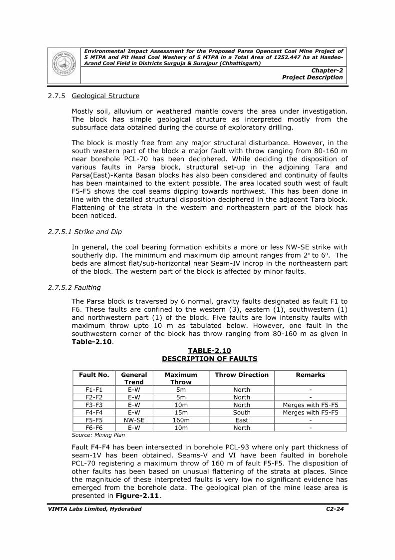
The coalfield is traversed by several generally NW-SE and NE-SW trending faults of varying magnitudes with a lateral extent of about 2 to 8 km.
The available surface and sub-surface data of Hasdeo-Arand coalfield have established the existence of six correletable coal seams viz VI/Ketma, V/Morga, IV/Dhajag, III/Bisrar II/Paturia and I/Sagbari in descending order. Besides, at least six thin coal seams are locally persistent.
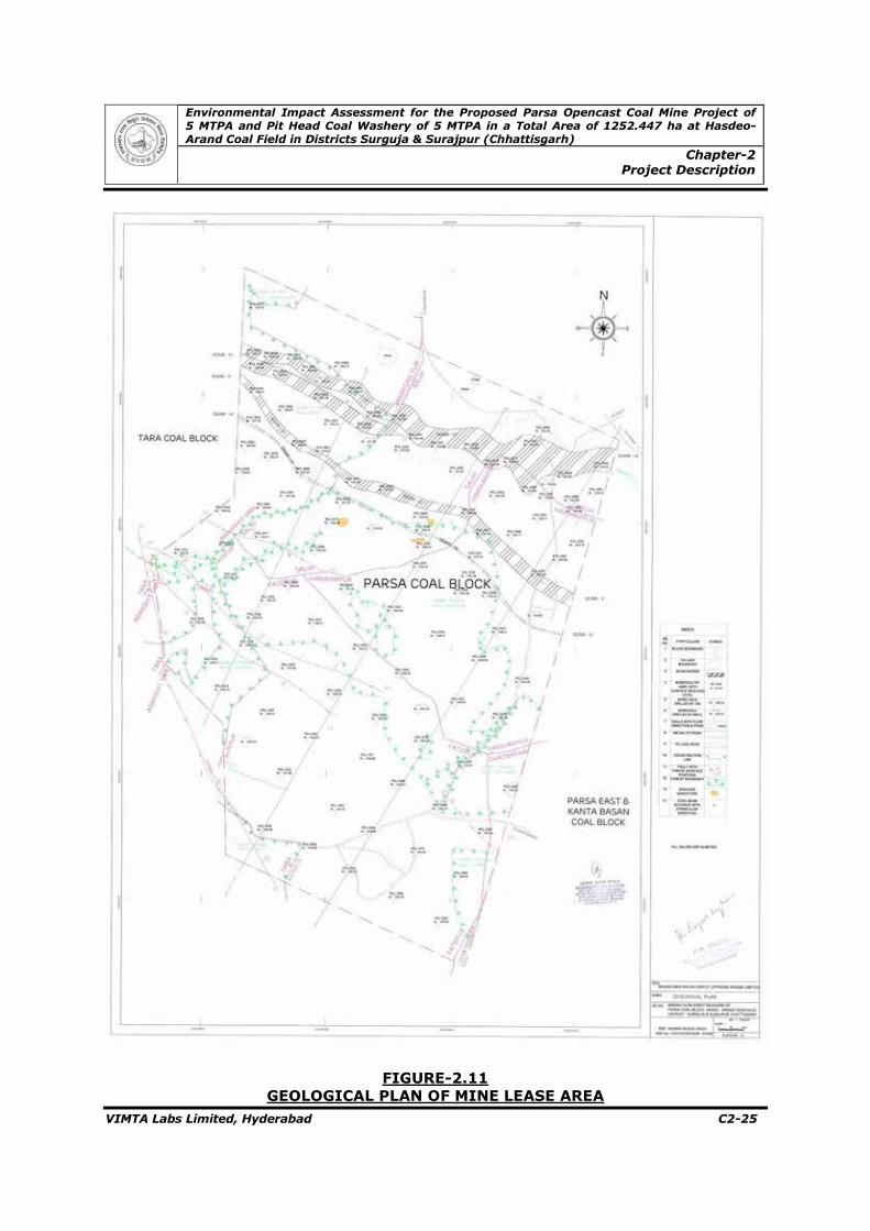
2.7.4 Geology of the Parsa Block
2.7.4.1 General
The detailed exploration in Parsa block has proved the existence of Barakar and Talchir formations under thick blanket of soil and alluvium of residual nature. The area is free from dolerite and mica-peridotite intrusions as in none of the boreholes drilled by GSI and AMPL in the block or during geological mapping, these have been noticed.
Environmental Impact Assessment for the Proposed Parsa Opencast Coal Mine Project of 5 MTPA and Pit Head Coal Washery of 5 MTPA in a Total Area of 1252.447 ha at Hasdeo-Arand Coal Field in Districts Surguja & Surajpur (Chhattisgarh)
Chapter-2 Project Description
VIMTA Labs Limited, Hyderabad C2-22
FIGURE-2.10
TOPOGRAPHICAL PLAN
Environmental Impact Assessment for the Proposed Parsa Opencast Coal Mine Project of 5 MTPA and Pit Head Coal Washery of 5 MTPA in a Total Area of 1252.447 ha at Hasdeo-Arand Coal Field in Districts Surguja & Surajpur (Chhattisgarh)
Chapter-2 Project Description
VIMTA Labs Limited, Hyderabad C2-23
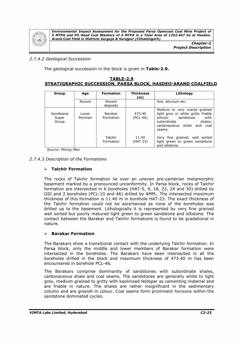
2.7.4.2 Geological Succession
The geological succession in the block is given in Table-2.9.
Medium to very coarse grained light grey or white gritty friable arkosic sandstone with subordinate shales, carbonaceous shale and coal seams. Very fine grained, well sorted light green to green sandstone and siltstone.
Source: Mining Plan
2.7.4.3 Description of the Formations
� Talchir Formation
The rocks of Talchir formation lie over an uneven pre-cambrian metamorphic basement marked by a pronounced unconformity. In Parsa block, rocks of Talchir formation are intersected in 6 boreholes (HAT-5, 9, 18, 23, 24 and 30) drilled by GSI and 2 boreholes (PCL-10 and 46) drilled by AMPL. The intersected maximum thickness of this formation is 11.40 m in borehole HAT-23. The exact thickness of the Talchir formation could not be ascertained as none of the boreholes was drilled up to the basement. Lithologically it is represented by very fine grained well sorted but poorly matured light green to green sandstone and siltstone. The contact between the Barakar and Talchir formations is found to be gradational in nature. � Barakar Formation
The Barakars show a transitional contact with the underlying Talchir formation. In Parsa block, only the middle and lower members of Barakar formation were intersected in the boreholes. The Barakars have been intersected in all the boreholes drilled in the block and maximum thickness of 473.40 m has been encountered in borehole PCL-46.
The Barakars comprise dominantly of sandstones with subordinate shales, carbonaceous shale and coal seams. The sandstones are generally white to light grey, medium grained to gritty with kaolinised feldspar as cementing material and are friable in nature. The shales are rather insignificant in the sedimentary column and are greyish in colour. Coal seams form prominent horizons within the sandstone dominated cycles.
Environmental Impact Assessment for the Proposed Parsa Opencast Coal Mine Project of 5 MTPA and Pit Head Coal Washery of 5 MTPA in a Total Area of 1252.447 ha at Hasdeo-Arand Coal Field in Districts Surguja & Surajpur (Chhattisgarh)
Chapter-2 Project Description
VIMTA Labs Limited, Hyderabad C2-24
2.7.5 Geological Structure
Mostly soil, alluvium or weathered mantle covers the area under investigation. The block has simple geological structure as interpreted mostly from the subsurface data obtained during the course of exploratory drilling. The block is mostly free from any major structural disturbance. However, in the south western part of the block a major fault with throw ranging from 80-160 m near borehole PCL-70 has been deciphered. While deciding the disposition of various faults in Parsa block, structural set-up in the adjoining Tara and Parsa(East)-Kanta Basan blocks has also been considered and continuity of faults has been maintained to the extent possible. The area located south west of fault F5-F5 shows the coal seams dipping towards northwest. This has been done in line with the detailed structural disposition deciphered in the adjacent Tara block. Flattening of the strata in the western and northeastern part of the block has been noticed.
2.7.5.1 Strike and Dip
In general, the coal bearing formation exhibits a more or less NW-SE strike with southerly dip. The minimum and maximum dip amount ranges from 2o to 6o. The beds are almost flat/sub-horizontal near Seam-IV incrop in the northeastern part of the block. The western part of the block is affected by minor faults.
2.7.5.2 Faulting
The Parsa block is traversed by 6 normal, gravity faults designated as fault F1 to F6. These faults are confined to the western (3), eastern (1), southwestern (1) and northwestern part (1) of the block. Five faults are low intensity faults with maximum throw upto 10 m as tabulated below. However, one fault in the southwestern corner of the block has throw ranging from 80-160 m as given in Table-2.10.
TABLE-2.10
DESCRIPTION OF FAULTS
Fault No. General
Trend Maximum Throw
Throw Direction Remarks
F1-F1 E-W 5m North - F2-F2 E-W 5m North - F3-F3 E-W 10m North Merges with F5-F5 F4-F4 E-W 15m South Merges with F5-F5 F5-F5 NW-SE 160m East - F6-F6 E-W 10m North -
Source: Mining Plan
Fault F4-F4 has been intersected in borehole PCL-93 where only part thickness of seam-1V has been obtained. Seams-V and VI have been faulted in borehole PCL-70 registering a maximum throw of 160 m of fault F5-F5. The disposition of other faults has been based on unusual flattening of the strata at places. Since the magnitude of these interpreted faults is very low no significant evidence has emerged from the borehole data. The geological plan of the mine lease area is presented in Figure-2.11.
Environmental Impact Assessment for the Proposed Parsa Opencast Coal Mine Project of 5 MTPA and Pit Head Coal Washery of 5 MTPA in a Total Area of 1252.447 ha at Hasdeo-Arand Coal Field in Districts Surguja & Surajpur (Chhattisgarh)
Chapter-2 Project Description
VIMTA Labs Limited, Hyderabad C2-25
FIGURE-2.11
GEOLOGICAL PLAN OF MINE LEASE AREA
Environmental Impact Assessment for the Proposed Parsa Opencast Coal Mine Project of 5 MTPA and Pit Head Coal Washery of 5 MTPA in a Total Area of 1252.447 ha at Hasdeo-Arand Coal Field in Districts Surguja & Surajpur (Chhattisgarh)
Chapter-2 Project Description
VIMTA Labs Limited, Hyderabad C2-26
2.7.6 Delineation of Coal Seams
The coaly horizons have been correlated and designated as coal seam depending upon their stratigraphic position, thickness, quality and consistency in occurrence over substantial part of the coalfield. The coal and carbonaceous horizons have been differentiated from each other on the basis of moisture and ash contents as applicable in high moisture non-coking coal. Ash plus moisture values, considered for different constituents of coal (irrespective of its thickness), are as given in Table-2.11.
Source: Mining Plan The litho unit which contains ash and moisture value greater than 55% upto 75 % is considered as combustible (carbonaceous shale) band and the litho units that contain ash + moisture value more than 75 % is considered as non-combustible band (grey shale, sandy shale, alternate bands of shale and sandstone, sandstone etc). Combustible or non-combustible litho units occurring within the seam are considered as in-seam dirt bands. Exclusion or inclusion of these bands is dependent on the type of samples considered BCS, I100 etc. as explained below:
• In BCS samples, only coal and shaly coal occurring within a coal seam have been taken (excluding carbonaceous shale, grey shale and other dirt bands like sandstones).
• In I100 samples, all dirt bands upto 1 m thickness has been included and those
above 1 m have been excluded. The roof and floor of coal seams have been fixed on the basis of band by band analysis results eliminating in general dirt bands on 1:1 proportion method barring exceptions. Dirt bands, if found at the roof of in cropping coal seams, the same were included in the seam thickness and no roof correction was made as it represents part thickness of the seam only. However, if such dirt band attained thickness of more than 1 m, the same was included in the overall seam thickness but was excluded from effective thickness for quality and quantity considerations. Further, for drawing floor contours of coal seams, the geological floor of the seams have been considered and not the floors corresponding to the effective thickness.
Environmental Impact Assessment for the Proposed Parsa Opencast Coal Mine Project of 5 MTPA and Pit Head Coal Washery of 5 MTPA in a Total Area of 1252.447 ha at Hasdeo-Arand Coal Field in Districts Surguja & Surajpur (Chhattisgarh)
Chapter-2 Project Description
VIMTA Labs Limited, Hyderabad C2-27
2.7.6.1 Seam Correlation
The correlation of coal seams has been established on the basis of their stratigraphic position, thickness, nature of in-seam dirt bands, parting between coal seam, nature of roof and floor of coal seam and quality of coal seam along with their lateral extent over the area. The nomenclature of coal seams is based on the GSI investigation carried out in and around the area under consideration.
The sequence of coal seam based on the boreholes drilled by AMPL and GSI in parsa block is given in the Table-2.12. The coal seams are neither burnt nor affected by heat.
TABLE-2.12
SEQUENCE OF COAL SEAMS
Seam/ Parting
Thickness Range (m) Generalized Thickness Range (m)
No. of Intersection Minimum Maximum
AMPL GSI
Seam-VI
0.78 (HAT-II)
2.70 (PCL-II)
1.2-2.0 57 4
Parting 11.33 (PCL-17)
17.61 ( PCL-98)
14-16 60 4
Seam-V 2.26 (PCL-33)
7.97 (PCL-78)
3.5-6.5 62 5
Parting 21.38 (PCL-35)
33.27 (PCL-41)
26-32 70 5
Seam-IV 6.64 (HAT-9)
9.67 (PCL-15)
8.0-9.0 89 7
Parting 43.56 (HAT-18)
57.26 (PCL-10)
- 4 6
Seam-II 0.10 (HAT-22)
0.98 (PCL-10)
- 4 8
Parting 38.38 (PCL-10)
55.15 (HAT-30)
- 1 2
Seam-IB 0.18 (PCL-10)
0.50 (HAT-30)
- 1 2
PARTING (Between Seam II/IB & L4)
78.24 (HAT-18)
86.60 (PCL-10)
- 2 2
Seam- L4 0.54 (HAT-18)
1.62 (PCL-20)
<1.0 4 4
PARTING (Between Seam II & L3)
102.81 (PCL-46)
113.26 (HAT-II)
- 2 2
Seam – L3
0.25 (PCL-46)
0.49 (HAT-II)
- 2 3
Parting
44.18 (HAT-9)
54.55 (PCL-46)
- 2 1
Seam-L2 0.20 (HAT-18)
2.77 (PCL-10)
<1.0 3 4
Source: Mining Plan Note: Boreholes with full seam intersections only have been considered.
2.7.6.2 Description of Coal Seams
� Seam-VI (Ketma Seam)
• Stratigraphic Position
Seam-VI is the youngest seam occurring in Parsa block and is underlain by seam-V (Morga seam). It incrops within the block. The seam has been encountered in
Environmental Impact Assessment for the Proposed Parsa Opencast Coal Mine Project of 5 MTPA and Pit Head Coal Washery of 5 MTPA in a Total Area of 1252.447 ha at Hasdeo-Arand Coal Field in Districts Surguja & Surajpur (Chhattisgarh)
Chapter-2 Project Description
VIMTA Labs Limited, Hyderabad C2-28
60 boreholes out of which full thickness has been intersected in 57 boreholes and part thickness in the incrop region has been intersected in 3 boreholes.
• Incrop
Seam-VI incrops within the block. Three boreholes encountered part/incrop thickness of the seam. The incrop of the seam extends throughout the strike length from north-northwest to south-southeast. • Thickness
The full thickness of seam-VI has been encountered in 57 boreholes. The thickness varies from 0.95 m (PCL-32) to 2.70m (PCL-11). The general thickness varies from 1.2 m to 2.0 m.
• Overburden above Seam-VI
Seam-VI being the topmost coal horizon in this block, only overburden above this seam is available and it constitutes soil, shale and sandstone varying in thickness from 14.50 m (PCL-31) to 206.55 m (PCL-84).
• Splitting / Merging
The seam does not show any splitting characteristics within the block.
• Dirt bands
Seam-VI contains 1 to 5 combustible and 1-2 non-combustible dirt bands of upto 1 m thickness as given in Table-2.13. The details of combustible and non-combustible dirt bands within the seam are given in Table-2.14.
TABLE-2.13 DETAILS OF DIRT BANDS IN SEAM-VI
Seam Name
Type of
Sample
Total Seam Thickness
Effective Dirt Bands No Of BH
Included Excluded
Min Max No Thickness (m)
No Thickness (m)
(m) (m) Min Max Min Max Min Max Min Max
VI I100 0.95 2.70 1 5 0.05 0.52 - - - - 57 Source: Mining Plan
TABLE-2.14
DETAILS OF COMBUSTIBLE AND NON-COMBUSTIBLE DIRT BANDS IN SEAM-VI
Seam-VI is the top most coal horizon in the block and is underlain by Seam-V with a parting ranging in thickness from 11.33 m (PCL-17) to 17.61 m (PCL-98).
Environmental Impact Assessment for the Proposed Parsa Opencast Coal Mine Project of 5 MTPA and Pit Head Coal Washery of 5 MTPA in a Total Area of 1252.447 ha at Hasdeo-Arand Coal Field in Districts Surguja & Surajpur (Chhattisgarh)
Chapter-2 Project Description
VIMTA Labs Limited, Hyderabad C2-29
The general parting variation is from 14 to 16 m comprising mainly medium to coarse grained sandstone.
• Roof & Floor
The immediate roof and floor are generally constituted by medium to coarse grained sandstone.
• Coal Quality
The ranges of proximate analysis and grade of Seam-VI and the ultimate analysis results of Seam-VI are given in Table-2.15 and Table-2.16 respectively.
TABLE-2.15
PROXIMATE ANALYSIS AND GRADE OF SEAM-VI
Seam Name Ketma Seam
No.of Determined Boreholes 64
Type of Samples BCS I100
Range of Seam Thickness (m) Min 0.95 0.95
Max 2.70 2.70
Range of Proximate Analysis on 60 % RH & 40˚C
M % Min 6.12 4.80 Max 9.45 8.71
ASH % Min 27.15 32.63 Max 43.67 51.63
VM % Min 20.53 18.23 Max 25.77 23.85
FC % Min 29.12 23.89 Max 39.35 36.67
Range of UVM % Min 33.69 33.18 Max 38.81 38.66
Range of CV In K cal/kg
Gross CV (on 60% RH & 400C)
Min 3572 2658 Max 4820 2859
Gross CV (ADB) Min 3547 2876 Max 4785 4473
Gross CV (DMMF) Min 7675 7693 Max 8043 9136
Range of UHV in K cal/kg
Min 1952 1187 Max 4044 3213
Range of Grade E-G E-UG Source: Mining Plan
TABLE-2.16
ULTIMATE ANALYSIS FOR SEAM-VI
Seam Name Seam VI
Borehole Samples Considered 11
Type of Samples Bcs DMMF Range of Seam Thickness (m) Min 0.95 -
Max 2.70 -
Range of Ultimate Analyses
C% Min 39.20 80.13 Max 52.90 86.40
H% Min 3.6 5.44 Max 4.53 6.16
N% Min 0.68 - Max 1.07 -
S% Min 0.32 - Max 0.89 -
O% by difference
Min 12.61 - Max 17.40 -
Environmental Impact Assessment for the Proposed Parsa Opencast Coal Mine Project of 5 MTPA and Pit Head Coal Washery of 5 MTPA in a Total Area of 1252.447 ha at Hasdeo-Arand Coal Field in Districts Surguja & Surajpur (Chhattisgarh)
Chapter-2 Project Description
VIMTA Labs Limited, Hyderabad C2-30
Seam Name Seam VI
Borehole Samples Considered 11
Type of Samples Bcs DMMF Range of UVM % Min 33.69 -
Max 38.81 - Range of CO2% as carbonate Min 0.18 -
Max 0.56 - Range of phosphorus % Min 0.004 -
Max 0.01 - Mercury (ppm) Min 0.142 -
Max 0.208 - Arsenic (ppm) Min 1.82 -
Max 2.54 - Lead (ppm) Min 7.51 -
Max 13.53 - Chromium (ppm) Min 32.59 -
Max 35.57 - Source: Mining Plan
• Total Sulphur
The total sulphur content varies from 0.32% to 0.89% in the samples from 11 boreholes (pcl-2, 10, 12, 19, 22, 26, 27, 38, 49, 54 & 64). • Summary of Seam Parameters and Special Observation
Seam-VI is the youngest seam occuring in the block and has been encountered in 60 boreholes throughout the block including 3 incrop boreholes. The incrop of the seam extends throughout the strike length. The depth of occurrence of the seam is from 14.50 to 206.55 m. The thickness of the full seam varies from 0.95 to 2.70 m and the general thickness ranges between 1.2 and 2.0 m. The seam is generally free of >1m in seam dirt bands. However, it contains 1-5 dirt bands ranging in thickness from 0.05 to 0.52 m. The proximate analysis on 60% RH and 40oC of the seam on I100 sample for > than 1 m seam thickness shows moisture%, ash% and volatile matter % vary from 4.80 to 8.71, from 32.63 to 51.63 and from 18.23 to 23.85 respectively. Determined Gross CV on I100 samples of the seam are 2658 to 2859 kcal/kg and unit GCV for I100 samples varies from 7693 to 9136 kcal/kg. The unit percentage of Volatile Matter varies from 33.18 to 38.66. The UHV on I100 samples of the seam varies from 1187 to 3213 kcal/kg and the corresponding grade is UG to F. The ultimate analysis of the seam indicates the DMMF carbon% and hydrogen% as 80.13 to 86.40 and 5.44 to 6.16 respectively. The HGI of the seam varies from 70-74.
� Seam-V (Morga Seam)
• Stratigraphic Position
Seam-V is overlain by Seam-VI and underlain by Seam-IV with a parting ranging from 11.33m to 17.61m and 21.38m (PCL-35) to 37.55m (PCL-93) respectively. It incrops within the block. The seam has been encountered in 70 boreholes out of which full thickness has been intersected in 62 boreholes and part thickness in the incrop region has been intersected in 8 boreholes.
Environmental Impact Assessment for the Proposed Parsa Opencast Coal Mine Project of 5 MTPA and Pit Head Coal Washery of 5 MTPA in a Total Area of 1252.447 ha at Hasdeo-Arand Coal Field in Districts Surguja & Surajpur (Chhattisgarh)
Chapter-2 Project Description
VIMTA Labs Limited, Hyderabad C2-31
• Incrop
Seam-V incrops within the block. Eight boreholes encountered part/incrop thickness of the seam. The incrop of the seam extends throughout the strike length from north-northwest to south-southeast with more or less uniform width. • Thickness
The full thickness of seam-V has been encountered in 62 boreholes. The thickness varies from 2.26 m (PCL-33) to 7.97 m (PCL-78). The general thickness varies from 3.5 to 6.5 m.
• Parting
The parting thickness of seam-V with the overlying seam-VI varies from 11.33 m to 17.61 m. The parting generally varies from 14 to 16 m comprising mainly medium to coarse grained sandstone.
• Splitting / Merging
The seam has, in general, developed significant dirt bands having thickness less than 1 m. However, in 19 boreholes the seam has encountered dirt band of thickness over 1 m. This has resulted into the seam occurring in 2 sections in these boreholes. Since these sections do not show significant splitting/merging pattern, the entire Seam-V has been considered as a composite seam instead of split seam.
• Dirt Bands
Seam-V contains 1 to 6 combustible and non-combustible dirt bands upto 1 m thickness. The details are given in Table-2.17. The details of combustible and non-combustible dirt band within the seam are given in Table-2.18.
TABLE-2.17 DETAILS OF DIRT BANDS IN SEAM-V
Seam Name
Type of
Sample
Total Seam Thickness
Effective Dirt Bands No. of BH
Included Excluded
Min Max No Thickness (m)
No Thickness (m)
(m) (m) Min Max Min Max Min Max Min Max
V I100 2.26 7.76 1 6 0.06 0.9 2 4 1.08 1.51 62 Source: Mining Plan
TABLE-2.18
DETAILS OF COMBUSTIBLE AND NON-COMBUSTIBLE DIRT BANDS IN SEAM-V
Environmental Impact Assessment for the Proposed Parsa Opencast Coal Mine Project of 5 MTPA and Pit Head Coal Washery of 5 MTPA in a Total Area of 1252.447 ha at Hasdeo-Arand Coal Field in Districts Surguja & Surajpur (Chhattisgarh)
Chapter-2 Project Description
VIMTA Labs Limited, Hyderabad C2-32
• Roof & Floor
The immediate roof and floor are generally constituted by medium to coarse grained sandstone. • Coal Quality
The ranges of proximate analysis and grade of seam-V are given in Table-2.19.
TABLE-2.19
PROXIMATE ANALYSIS AND GRADE OF SEAM-V
Seam Name Seam-V
No.of Determined Boreholes 62
Type of samples BCS I100
Range of Seam Thickness (m) Min 1.73 2.26
Max 5.22 7.97
Range of Proximate Analysis on 60 % RH & 40˚C
M % (det & cal)
Min 5.83 4.36 Max 9.4 8.64
ASH % (det & cal)
Min 23.53 30.59 Max 50.48 60.30
VM % Min 18.49 14.99 Max 33.79 25.90
FC % Min 24.72 17.95 Max 45.06 37.44
Range of UVM % Min 31.88 30.76 Max 38.89 38.89
Range of CV In K cal/kg
Gross CV (on 60% RH & 400C)
Min 3015 2000 Max 4998 4770
Gross CV (ADB) Min 3053 1986 Max 4979 4791
Gross CV (DMMF) Min 6537 7168 Max 7976 8386
Range of UHV in K cal/kg
Min 1063 61 Max 4553 3487
Range of Grade UG-D UG-E Source: Mining Plan
The ultimate analysis & other tests of seam-V are given in Table-2.20
TABLE-2.20
ULTIMATE ANALYSIS FOR SEAM-V
Seam Name Morga Seam
Borehole samples considered 11
Type of samples Bcs DMMF
Range of seam thickness (m) Min 3.79 - Max 6.84 -
Range of Ultimate Analyses
C% Min 37.60 81.20 Max 51.00 85.24
H% Min 3.44 5.21 Max 4.36 6.27
N% Min 0.69 - Max 1.02 -
S% Min 0.34 - Max 0.47 -
O% by difference
Min 11.05 - Max 16.63 -
Environmental Impact Assessment for the Proposed Parsa Opencast Coal Mine Project of 5 MTPA and Pit Head Coal Washery of 5 MTPA in a Total Area of 1252.447 ha at Hasdeo-Arand Coal Field in Districts Surguja & Surajpur (Chhattisgarh)
Chapter-2 Project Description
VIMTA Labs Limited, Hyderabad C2-33
Seam Name Seam-V
Range of UVM % Min 31.88 - Max 38.89 -
Range of CO2% as carbonate Min 0.189 - Max 0.594 -
Range of phosphorus % Min 0.009 - Max 0.016 -
Mercury (ppm) Min 0.242 - Max 0.273 -
Arsenic (ppm) Min 1.48 - Max 1.80 -
Lead (ppm) Min 9.94 - Max 13.00 -
Chromium (ppm) Min 31.56 - Max 33.51 -
Source: Mining Plan
• Total Sulphur
The Total Sulphur content varies from 0.34 to 0.47% in 11 boreholes (PCL-2, 10, 12, 19, 22, 26, 27, 38, 49, 54 and 64).
• Summary of Seam Parameters and Special Observation
Seam V is encountered in 70 boreholes throughout the block including 8 incrop boreholes. The incrop of seam extends throughout the strike length. The depth of occurrence of the seam is from 6.0 to 224.75 m. The thickness of the full seam varies from 2.26 to 7.97 m and the general thickness ranges between 3.5-6.5 m. The seam has in general developed significant dirt bands having thickness less than 1 m. However, the seam has encountered dirt band thickness over 1 m in 19 boreholes generally spread over the entire area. This has resulted into the seam occurring in two sections in these boreholes. In such cases the sectional as well as seam overall analysis has been conducted by combining both sections. It has been observed that the quality variation is not significant as the grade varies from UG to F and therefore these sections are considered together for reserve estimation. The proximate analysis on 60% RH and 40oC of the seam on I100 sample for >1 m seam thickness shows moisture%, ash% and volatile matter% vary from 4.36 to 8.64, from 30.59 to 60.30 and from 14.99 to 25.90 respectively. Determined Gross CV on I100 samples of the seam are 2000 to 4770 k.cal/kg and unit GCV for I100 samples varies from 7168 to 8386 k.cal/kg. The GCV on ADB varies from 1986 to 4791 k cal/kg. The unit VM% varies from 30.76 to 38.89. The UHV on I100 samples of the seam varies from 61 to 3487 k.cal/kg and the corresponding grade is Ungraded to E. The ultimate analysis of the seam indicates the DMMF carbon% and hydrogen% as 81.20 to 85.24 and 5.21 to 6.27 respectively. The HGI of the seam varies from 69-79.
� Seam-IV (Dhajag Seam)
• Stratigraphic Position
Seam-IV is overlain by Seam-V with a parting ranging from 21.38 m (PCL-35) to 37.55 m. It is underlain by impersistent thin coal bands occurring within the parting between Seam-IV and Talchir formation as observed from a few boreholes
Environmental Impact Assessment for the Proposed Parsa Opencast Coal Mine Project of 5 MTPA and Pit Head Coal Washery of 5 MTPA in a Total Area of 1252.447 ha at Hasdeo-Arand Coal Field in Districts Surguja & Surajpur (Chhattisgarh)
Chapter-2 Project Description
VIMTA Labs Limited, Hyderabad C2-34
drilled below Seam-IV. However, in four boreholes viz PCL-10, 17, 23 and PCL-46 Seam-II having 0.42m to 0.98m has been encountered with a parting of 53.71m to 57.26m below seam-IV. • Incrop
Like the other two younger seams viz Seam-V and VI, Seam-IV also incrops within the block. Fourteen boreholes encountered part/incrop thickness of the seam while three boreholes were drilled beyond the incrop in the north where the seam has not been encountered. The incrop is dissected by a minor strike fault in the western part. The purpose of drilling boreholes beyond the incrop was to increase the confidence level of occurrence of Seam-IV incrop.
• Thickness
The seam has been encountered in 104 boreholes. The full thickness of Seam-IV has been encountered in 90 boreholes. The thickness varies from 6.79 m to 9.67 m. The general thickness varies from 8 to 9 m barring one borehole (PCL- 13) where the seam occurs in two sections.
• Parting
The parting thickness of Seam-IV with the overlying Seam-V varies from 21.38 m (PCL-35) to 37.55 m (PCL-93). The parting generally varies from 26 to 32 m and is composed of coarse grained sandstone.
• Splitting / Merging
Seam-IV, in general, does not show any splitting/ merging characteristics. However, in 1 borehole (PCL-13) the seam is found to occur in 2 sections separated by a parting of 2.0 m.
• Dirt Bands
Seam-IV contains 1 to 4 combustible and non-combustible dirt bands upto 1 m thickness. The details are given in Table-2.21. The details of combustible and non-combustible dirt band within the seam are given in Table-2.22.
TABLE-2.21 DETAILS OF DIRT BANDS IN SEAM-IV
Seam Name
Type of
Sample
Total Seam Thickness
Effective Dirt Bands No Of BH
Included Excluded
Min Max No Thickness (m)
No Thickness (m)
(m) (m) Min Max Min Max Min Max Min Max
IV I100 6.79 9.67 1 4 0.04 0.87 1 1 2.0 2.0 90 Source: Mining Plan
TABLE-2.22
DETAILS OF COMBUSTIBLE AND NON-COMBUSTIBLE DIRT BANDS IN SEAM-IV
Combustible Dirt Bands
(Carbonaceous Shale)
Non-combustible Dirt Bands
(Shale & Sandstone)
Total Bands (Carb. Shale, Shale &
Sandstone)
No.
of
BH
s NO Thick (m) NO Thick (m) No Thick (m) %
Min Max Min Max Min Max Min Max Min Max Min Max Min Max
1 4 0.04 0.76 1 2 0.04 0.87 1 4 0.04 0.87 90 1 4
Source: Mining Plan
Environmental Impact Assessment for the Proposed Parsa Opencast Coal Mine Project of 5 MTPA and Pit Head Coal Washery of 5 MTPA in a Total Area of 1252.447 ha at Hasdeo-Arand Coal Field in Districts Surguja & Surajpur (Chhattisgarh)
Chapter-2 Project Description
VIMTA Labs Limited, Hyderabad C2-35
• Roof & Floor
The immediate roof and floor are generally constituted by medium to coarse grained sandstone.
• Coal Quality
The details of proximate analysis of Seam-IV on 60% RH and 40º C show moisture and ash percentages vary from 5.11(PCL-86) to 8.05 (PCL-46) and 24.57 (PCL-46) to 41.77 (PCL-86) respectively. The determined values of VM percent vary from 20.64 to 31.41. The UHV varies from 2430 (PCL-86) to 4398 (PCL-46) Kcal/kg. The grade varies from D-F. The ranges of proximate analysis and grade of Seam-IV are given in Table-2.23. The ultimate analysis along with other tests has been carried out for Seam-IV and the same is given in Table-2.24.
TABLE-2.23
PROXIMATE ANALYSIS AND GRADE OF SEAM-IV
Seam Name Dhajag Seam
No.of Determined Boreholes 41
Type of Samples BCS I100
Range of Seam Thickness (m) Min 4.22 6.79
Max 9.39 9.67
Range of Proximate Analysis on 60 % RH & 40˚C
M % Min 6.08 5.11 Max 8.60 8.05
ASH % Min 16.21 24.57 Max 38.02 41.77
VM % Min 21.78 20.64 Max 31.41 31.41
FC % Min 32.36 28.14 Max 45.87 44.37
Range of UVM % Min 33.77 33.14 Max 40.17 40.17
Range of CV In K cal/kg
Gross CV (on 60% RH & 400C)
Min 3949 3454 Max 5899 5899
Gross CV (DMMF) Min 7725 7748 Max 8372 8386
Gross CV (ADB) Min 3996 3446 Max 5901 5901
Range of UHV in K cal/kg
Min 2571 2430 Max 5558 4398
Range of Grade C-F D-F Source: Mining Plan
TABLE-2.24
ULTIMATE ANALYSIS FOR SEAM-IV
Seam Name Dhajag Seam
Borehole Samples Considered 11
Type of Samples Bcs DMMF
Range of Seam Thickness (m) Min 8.03 - Max 9.59 -
Range of Ultimate Analyses
C% Min 51.60 81.42 Max 57.00 88.02
H% Min 3.94 4.89 Max 4.53 5.87
N% Min 0.92 -
Environmental Impact Assessment for the Proposed Parsa Opencast Coal Mine Project of 5 MTPA and Pit Head Coal Washery of 5 MTPA in a Total Area of 1252.447 ha at Hasdeo-Arand Coal Field in Districts Surguja & Surajpur (Chhattisgarh)
Chapter-2 Project Description
VIMTA Labs Limited, Hyderabad C2-36
Seam Name Dhajag Seam
Borehole Samples Considered 11
Type of Samples Bcs DMMF
Max 1.12 - S% Min 0.35 -
Max 0.91 - O% by difference
Min 11.83 - Max 16.03 -
Range of UVM % Min 33.77 - Max 40.17 -
Range of CO2% as carbonate Min 0.172 - Max 0.303 -
Range of phosphorus % Min 0.008 - Max 0.019 -
Mercury (ppm) Min 0.279 - Max 0.445 -
Arsenic (ppm) Min 0.50 - Max 1.62 -
Lead (ppm) Min 9.99 - Max 17.95 -
Chromium (ppm) Min 18.79 - Max 21.91 -
Source: Mining Plan
• Total Sulphur
The total sulphur content is 0.35 to 0.91% as available in respect of 11 boreholes (PCL- 10, 12, 19, 20, 22, 26, 27, 38, 49, 54 and 64). • Summary of Seam Parameters and Special Observation
Seam IV is the lowermost potential seam occurring in the block. It is encountered in 104 boreholes throughout the block including 14 incrop boreholes. The incrop of the seam extends throughout the strike length. It is dissected by one low magnitude strike fault in the western part of the block. The depth of occurrence of the seam is from 7.05 m to 270.42 m. The thickness of the full seam varies from 6.79 to 9.67 m and the general thickness ranges between 8.0 and 9.0 m. The seam is generally free of >1 m in-seam dirt bands except in 1 borehole where the seam occurs in 2 sections. The proximate analysis on 60% RH and 40oC of the seam on I100 sample for >1 m seam thickness shows moisture%, ash% and volatile matter% vary from 5.11 to 8.05, from 24.57 to 41.77 and from 20.64 to 31.41 respectively. Determined Gross CV on I100 samples of the seam varies from 3454 to 5899 k.cal/kg and unit GCV for I100 samples varies from 7748 to 8386 k.cal/kg. The GCV on ADB varies from 3446 to 5901 k cal/kg. The unit VM% varies from 33.14 to 40.17. The UHV on I100 samples of the seam varies from 2430 to 4398 k.cal/kg and the corresponding grade is F to D. The ultimate analysis of the seam indicates the DMMF carbon% and hydrogen% as 81.42 to 88.02 and 4.89 to 5.87 respectively. The HGI of the seam varies from 59 to 64. Schematic Cross Section of seams of the excavation area is presented in Figure-2.12-
Environmental Impact Assessment for the Proposed Parsa Opencast Coal Mine Project of 5 MTPA and Pit Head Coal Washery of 5 MTPA in a Total Area of 1252.447 ha at Hasdeo-Arand Coal Field in Districts Surguja & Surajpur (Chhattisgarh)
Chapter-2 Project Description
VIMTA Labs Limited, Hyderabad C2-37
FIGURE–2.12
SCHEMATIC CROSS SECTION OF SEAMS
Environmental Impact Assessment for the Proposed Parsa Opencast Coal Mine Project of 5 MTPA and Pit Head Coal Washery of 5 MTPA in a Total Area of 1252.447 ha at Hasdeo-Arand Coal Field in Districts Surguja & Surajpur (Chhattisgarh)
Chapter-2 Project Description
VIMTA Labs Limited, Hyderabad C2-38
2.7.7 Details of Exploration 2.7.7.1 Previous Exploration
The occurrence of coal in the eastern part of Hasdeo-Arand coalfield was first recorded by Col. J.R. Ousley (1848) followed by Col. T, Dalton (1865) and V. Ball (1882) who reported the occurrence of coal in different localities. However, first systematic studies of this area were done by Lala Hiralal (1886, 87) from Geological Survey of India who delineated the aerial extend of the coalfield and described the occurrence of coal seams. The name Hasdeo-Arand coalfield was assigned by C.S. Fox (1934). The coalfield was mapped by Ghosh (1940, 41), Radhakrishnan (1962), Nagaraja and Choudury (1964), Basu et al (1965), Basu and Choudury (1966), and Choudury and Basu (1967) and huge potentiality was identified. The regional exploration for coal was initiated in this coalfield by Geological Survey of India in 1976-77 Field Season. As part of the systematic regional exploration by GSI, 2457.50 m have been drilled in 7 boreholes (HAT- 5,9,11,18,23,24 and 30) in Parsa coal block during the period 1981-85. The boreholes drilled by GSI have established the development of Talchir and Barakar formations in this area. Among the six established regional coal seams of Hasdeo-Arand coalfield, the top three seams in the upper part of Barakar Formation viz Seam-IV (Dhajag seam), Seam-V (Morga seam) and Seam-VI (Ketma seam) in ascending order have been found to be persistent and occur at shallow depth in the northern part of the block. The lower three seams viz Seam I/IA/IB (Sagbari/Sagbari A/Sagbari B), Seam-II (Paturia seam) and Seam III (Bisrar seam) and other local seams (L-4,3,2,1) are largely less than 1 m thick and not persistently developed in this area and, therefore, are not potential. Parsa block is virgin and free from any mining activity.
2.7.7.2 Present Investigation
• Geological Mapping
The entire area of this block is mostly either under cultivation or forest cover. Hence, no significant rock exposure is available in the area. However, at a few places along the nala cutting, exposure of coal has been noticed and recorded. In the absence of proper in-situ rock exposure, geological mapping could not help to establish the structural aspects in the block.
• Topographical Survey
Topographical and borehole survey have been carried out. During surface contouring, an interval of 1m has been maintained. The area encompassing Parsa block falls under Survey of India toposheet no. 64 J/13 on RF 1: 50,000.
• Equipment
The topographical survey was carried out with Total Station: Leica 407 model with accuracy 1”/ 1 mm.
Environmental Impact Assessment for the Proposed Parsa Opencast Coal Mine Project of 5 MTPA and Pit Head Coal Washery of 5 MTPA in a Total Area of 1252.447 ha at Hasdeo-Arand Coal Field in Districts Surguja & Surajpur (Chhattisgarh)
Chapter-2 Project Description
VIMTA Labs Limited, Hyderabad C2-39
• Baseline
Borehole survey and contouring were done with reference to the National Grid (NG). The reference for NG stations was taken from stations D (Latitude N 1013374.186, Departure E 2880763.246, RL 555.35m) and E (Latitude N 1013433.066, Departure E 2880821.979, RL 557.021m) at Amagaon OC mine of SECL colliery, located about 31 Km from Parsa block using DGPS. The references were carried over to base stations BL-1(Latitude N 982332.924, Departure E 2879535.475, RL- 532.729 m) and BL-2 (Latitude N 982276.174, Departure E 2879640.345, RL 534.952) located in the northern part of adjacent Parsa(East)-Kanta Basan coal block close to the eastern boundary of Parsa block. The distance between BL-1 and BL-2 is 119.24 m.The survey was carried out by closed traverse method. The co-ordinates of baseline stations are given in Table-2.25.
TABLE-2.25 CO-ORDINATE OF BASE LINE STATIONS OF PARSA BLOCK
Points of Baseline Latitude (m) Departure (m) RL (m)
The hydrogeological studies have been carried out in the area to understand the local geological and geomorphological features, drainage network, aquifer characteristics and yield of water through pump test carried out in the adjacent Parsa East and Kanta Basan block. Accordingly, various components controlling the hydrogeological regime of Parsa block have been studied.
2.7.7.4 Exploratory Drilling
• Equipment
A total of seven rigs of Adani Mining Pvt. Ltd. (AMPL) with drilling capacities 600 – 1200 m is given Table-2.26 were deployed for carrying out exploration.
TABLE-2.26
DETAILS OF EQUIPMENT DEPLOYED FOR EXPLORATORY DRILLING
Agency Make Number
of Rigs Drilling Capacity
with NQ String (m)
Adani Mining Pvt Ltd. (AMPL)
(i) RD-60 (Rockdrill) (ii) XD-5 (Chinese make hydrostatic) (iii) KME-1000 (Kores)
2 1 4
600 m
1200 m 1000 m
RG Logger 1 1500 m Source: Mining Plan The core drilling was carried out using double tube core barrel and NQ diamond/TC bits to obtain maximum core recovery in coal and non-coal strata.
Environmental Impact Assessment for the Proposed Parsa Opencast Coal Mine Project of 5 MTPA and Pit Head Coal Washery of 5 MTPA in a Total Area of 1252.447 ha at Hasdeo-Arand Coal Field in Districts Surguja & Surajpur (Chhattisgarh)
Chapter-2 Project Description
VIMTA Labs Limited, Hyderabad C2-40
• Borehole Spacing
Due to scanty rock exposure, adequate generation of subsurface data was essential for proper geological interpretation. Accordingly, exploration of the area was initiated in November, 2011. Initially, drilling was restricted to an interval of 400 m to decipher the general lay and disposition of the coal seams, followed by some closely spaced boreholes as required to fill the data gap and precise delineation of structure and coal seam incrops.
2.7.7.5 Boreholes Drilled
The total area of the block is 12.52 Sq Km. Detailed exploratory drilling in the entire area was completed by March 2012 end and geological report in April end. The quantum of drilling carried out in Parsa block is given in Table-2.27.
TABLE-2.27
QUANTUM OF DRILLING COMPLETED ON MARCH, 2012
Agency Period No. of Boreholes Meter age
GSI 1981-85 7 2, 457.50 AMPL November 2011 – March 2012 107 13, 062.00
Total 114 15, 519.50 Source: Mining Plan
Thus, a total of 114 boreholes involving 15519.50m have been drilled till March’2012 in Parsa block with a borehole density of 9 per sq. km. The depth of the boreholes in the block including those drilled upto Talchir formation ranges from 19.00 m (PCL-102) to 481.00 m (PCL-46). The density of boreholes is adequate to ascertain precisely the geometry, quality and quantity of coal resources. The help of geophysical logging was also considered as a tool to enhance the confidence level of interpretation further.
2.7.8 Geological and Mining Characteristics of the Quarriable Block The Geological i.e. mining characteristics of the quarriable block for the proposed Parsa OCP is given in Table-2.28. Total three seams i.e. Seam-IV to VI are considered for open cast mining. In general, the coal bearing formation exhibits a more or less NW-SE strike with southerly dip. The minimum and maximum dip amount ranges from 2° to 6°. The beds are almost flat/sub-horizontal near Seam-IV in crop in the northeastern part of the block. The western part of the block is affected by minor faults.
TABLE-2.28
MINING AND GEOLOGICAL CHARACTERISTICS OF THE QUARRIABLE BLOCK
Sr No
Particulars
Units
Quarry
Min Max Usual
I
Thickness of Coal Seam (avg) VI M 0.78 2.70 1.2-2.0 V M 2.26 7.97 3.5-6.5 IV M 6.64 9.67 8.0-9.0
Environmental Impact Assessment for the Proposed Parsa Opencast Coal Mine Project of 5 MTPA and Pit Head Coal Washery of 5 MTPA in a Total Area of 1252.447 ha at Hasdeo-Arand Coal Field in Districts Surguja & Surajpur (Chhattisgarh)
Chapter-2 Project Description
VIMTA Labs Limited, Hyderabad C2-41
Sr No
Particulars
Units
Quarry
Min Max Usual
II
Thickness of Top OB & Parting(Avg) Hard OB M 12.00 200.00 90.00 Part bet VI & V M 11.33 17.61 14.0-16.0 Part bet V & IV M 21.38 33.27 26.0-32.0 Quarry Parameters
III Dip of Seams Degree 20 to 60 Source: Mining Plan
2.7.9 Reserves
� General
The detailed exploration in Parsa block has established the existence of 3 persistent and correlatable coal seams viz seam-IV, V and VI in ascending order. Besides, at least 1 to 2 thin and impersistent coal bands without any significant economic potential also occur below seam-IV as revealed from a few boreholes drilled upto the Talchir formation. These coal seams occur within the Barakar formation. The exploration is largely limited to the three persistent coal seams viz seam-IV, V and VI which occur throughout the block. Seam-IV, V and VI have attained workability in the block. Out of these 3 seams, seam-IV is the most potential both qualitatively and quantitatively and has least number of in-seam dirt bands followed by seam-VI and V in that order. All these 3 seams incrop within the block in the strike length of about 3.1 km and have been considered for opencast exploitation in the entire block area. � Categorisation of Reserves
The coal reserve of the block has been considered under “Proved” category and grade-wise and thickness-wise reserves have been computed. � Grade Estimation
The coal seams are medium moisture, medium to high volatile bituminous non-coking coal as such its grading has been done as per Useful Heat Value (UHV) which has been calculated as per the following formula: UHV=8900-138 (A+M). where UHV=Useful Heat value in Kcal/kg A=Ash% and M=Moisture% at 60% RH & 40o C. The ranges of UHV for different grades are as given in Table-2.29.
TABLE-2.29
USEFUL HEAT VALUES FOR DIFFERENT GRADES OF NON-COKING COAL
Grade Range of seam overall
M% + A% at 60% RH & 40°C
UHV in Kcal/kg
A < = 19.56 Exceeding 6200 B > 19.56 TO <=23.91 Exceeding 5600 but not exceeding 6200
Environmental Impact Assessment for the Proposed Parsa Opencast Coal Mine Project of 5 MTPA and Pit Head Coal Washery of 5 MTPA in a Total Area of 1252.447 ha at Hasdeo-Arand Coal Field in Districts Surguja & Surajpur (Chhattisgarh)
Chapter-2 Project Description
VIMTA Labs Limited, Hyderabad C2-42
Grade Range of seam overall M% + A% at 60% RH &
40°C
UHV in Kcal/kg
C >23.91 to <=28.69 Exceeding 4940 but not exceeding 5600 D >28.69 to <=34.05 Exceeding 4200 but not exceeding 4940 E >34.05 to <=40.14 Exceeding 3360 but not exceeding 4200 F >40.14 to <=47.10 Exceeding 2400 but not exceeding 3360 G >47.10 to <=55.07 Exceeding 1300 but not exceeding 2400
Source: Mining Plan
UHV values for the effective thickness (excluding bands over 1m) considered for the different seams have been derived from determined seam overall proximate analyses on 60% RH and 40°C. These UHV values are utilized for drawing Isograd of seams. In some boreholes, coal seams have been found to be deteriorated to ungraded (UHV 1300 kcal/kg and below) due to predominance of dirt bands within the coal seam. � Gross Calorific Value (GCV)
Coal grade based on GCV is given in Table-2.30.
TABLE-2.30
COAL GRADE BASED ON GCV VALUE
Grade Of Coal Gross Calorific Value (GCV) Per Kilo Calories/Kilogram
Specific gravity for each grade has been calculated using the following formula by taking average ash% for each grade:
Sp. Gr. = 1.29 + 0.01 Ash The Table-2.31 shows average grade-wise estimation wise specific gravity.
Environmental Impact Assessment for the Proposed Parsa Opencast Coal Mine Project of 5 MTPA and Pit Head Coal Washery of 5 MTPA in a Total Area of 1252.447 ha at Hasdeo-Arand Coal Field in Districts Surguja & Surajpur (Chhattisgarh)
Chapter-2 Project Description
VIMTA Labs Limited, Hyderabad C2-43
TABLE-2.31
SEAM WISE, GRADE WISE AVERAGE SPECIFIC GRAVITY
Seam Specific Gravity for I100 Samples as per Grade
A B C D E F G UG
VI - - - - - 1.68 1.75 1.8 V - - - - - - 1.75 1.8 IV - - - 1.55 1.61 1.68 - -
Source: Mining Plan
� Computation of Coal Reserves
The reserves are computed separately for full thickness as well as incrop zones. In the case of ‘Proved’ category a deduction of 10% from ’Gross’ reserves has been made to arrive at ‘Net’ reserves in order to account for unforeseen geological factors like abrupt change in seam thickness, structural disturbance etc. No such deduction has been made in the case of ‘Indicated’ category of reserves. The grade-wise reserves for individual seams have been computed separately and tabulated accordingly. The reserves in the coal seam incrop region have been computed by considering the area covered by the incrop and the average part thickness and grades of respective seam in the incrop zone.
� Overburden
The overburden consists of soil, weathered mantle, and argillaceous as well as arenaceous rocks. The parting between the two seams consists of argillaceous and arenaceous rocks with thin coal / carbonaceous bands. Broadly, the overburden and parting upto Seam-IV has been divided into 4 categories as follows: 1) The soil and weathered mantle over the incrop of the seams; 2) The soil, weathered mantle and overburden above the full seam upto the floor
of the next upper seam; 3) The parting between respective seam and next upper seam; and 4) The volume of dirt bands of more than 1 m in thickness occurring within coal
seam for the opencast mining has been added to the overburden parting lying above.
� In-Seam Burden
The in-seam dirt bands of combustible and / or non-combustible nature of more than 1 m in thickness have been identified and volume of such in-seam burden have been added to the volume of parting lying above the seam and accounted under overburden. � Methodology of Overburden Estimation
Methodology of overburden/parting volume estimate is similar to that of reserve
Environmental Impact Assessment for the Proposed Parsa Opencast Coal Mine Project of 5 MTPA and Pit Head Coal Washery of 5 MTPA in a Total Area of 1252.447 ha at Hasdeo-Arand Coal Field in Districts Surguja & Surajpur (Chhattisgarh)
Chapter-2 Project Description
VIMTA Labs Limited, Hyderabad C2-44
estimation except it is restricted upto volume and not for tonnage. These assessments have been made using Minex 5.2.3 software.
� Depth of Excavation
The floor of seam-IV has been considered as the floor of the opencast mine and the minimum and maximum floor depth of this seam from surface is around 10 m and 275 m in the block.
� Description of Reserves
Total gross geological reserves estimated for the block stand at 256.40 million tonnes. The entire reserves are of quarriable nature. Of the 230.76 million tonnes of net reserves, grade-wise reserves are grade D 0.48 m, E 123.45 m, F 20.29 m, G 28.08 m and ungraded 58.46 m. The seam-wise and grade-wise reserves are furnished in Table-2.32 and Table-2.33 respectively.
TABLE-2.32 SEAM-WISE AND CATEGORY-WISE GEOLOGICAL RESERVES
(Million Tonnes) Seam Name Gross Indicated Reserves Net Proved Reserves
2.7.9.1 Mineable Reserves and Anticipated Life of the Mine
The total mineable reserves are estimated as 200.41 Mt up to the requisite block boundary. The corresponding OBR has been envisaged as 1227.19 Mcum at an average stripping ratio of 6.12 cum/t. For the rated output of 5.0 MT, the life of the mine has been estimated as 45 years including three years of construction period, built up period & reducing trend of coal production in start and finishing years of the mine. Due to multiple seams of different thickness, mining Loss has been estimated for each seam separately to arrive at Mineable Coal reserves. Mining Loss depends on:
Environmental Impact Assessment for the Proposed Parsa Opencast Coal Mine Project of 5 MTPA and Pit Head Coal Washery of 5 MTPA in a Total Area of 1252.447 ha at Hasdeo-Arand Coal Field in Districts Surguja & Surajpur (Chhattisgarh)
Chapter-2 Project Description
VIMTA Labs Limited, Hyderabad C2-45
a) Loss of coal in roof and floor of seam; b) Loss of coal while cleaning roof of bench; c) Loss of coal during selective mining for >1m bands; and d) Loss of coal during transportation.
Mining loss of 3% has been taken to arrive at the mineable reserves; the summary of coal reserves is given in Table-2.34.
3 Net Geological Reserves blocked in barrier and batter, nalla diversion and not considered for mining (MT)
40.80
4 Net geological Reserves considered for mining (MT) 189.96 5 Mining loss @ 3 % (MT) 5.70 6 Mineable Reserves (MT) 184.26
7 Coal blocked in barrier & batter in eastern side of Parsa Coal Block
10.80
8 Coal under batter in Southern & western boundary of Parsa Coal Block by High wall Mining @ 20%
5.37
Total Recovery of Coal (MT) 200.41 Source: Mining Plan
2.7.10 Year-Wise Development and Production Details
2.7.10.1 Development for First Five Years
The development works during the first construction year include laying approach road to sites, obtaining three sets of diesel operated mining equipment, top-soil removal and driving access trenches & box-cuts and taking up other construction activities such as CHP, workshop, office & residential complex. Parsa opencast is proposed to be developed in the 1st year of mine operation by grading properly the access trench of 40 m width with the help of Hyd. Backhoe and 35 T dumpers and other auxiliary HEMM. The access trench is to be graded from 515 m R. L. at 1 in 16 to the mine floor of about 500 m R.L. The coal production will start from the 1st year of mine operation and the target coal production of 5.00 MTPA will be achieved in the 3rd year of mine operation. Total OB about 44.87 million m3 will be removed during first five years of operation.
2.7.10.2 Production and Development for First Five Years
• Production and Development during First Year
The works to be completed during the 1st year are laying approach road, land acquisition, getting power line to the project site and construction of electrical sub-station, power supply, construction of infrastructure line office, store, workshop, coal handling plant, township, railway siding, and construction of MGR
Environmental Impact Assessment for the Proposed Parsa Opencast Coal Mine Project of 5 MTPA and Pit Head Coal Washery of 5 MTPA in a Total Area of 1252.447 ha at Hasdeo-Arand Coal Field in Districts Surguja & Surajpur (Chhattisgarh)
Chapter-2 Project Description
VIMTA Labs Limited, Hyderabad C2-46
for coal dispatch. Coal production of 1.5 MT will be achieved by removing 3.51 million m3 of OB during 1st Year of Mine Operation.
• Production and Development during Second Year
During second year of mine operation, the production of coal will be 3.0 MT. OB of about 6.06 million m3 will be handled.
• Production and Development during Third Year
From third year of operation onwards, the mining will be done with an aim of producing 5.0 MTPA and removing OB of 12.60 million m3.
• Production and Development during Fourth Year
During the fourth year, production will be 5.0 MTPA and Overburden (OB) removal of 10.10 million m3.
• Production and Development during Fifth Year
The coal and OB produced during the 5th year of production will be 5.0 MTPA and Overburden (OB) removal of 12.60 million m3. The cumulative coal production in the first five years of coal production will be 19.5 MT and 44.87 million m3 of OB will be removed at an average ratio of 2.30 m3 /T.
As per geological parameters, this mine has been optimally planned for 5.0 MTPA coal. The year-wise target of coal production for five years has been presented in Table-2.35. The conceptual mine plan is shown in Figure-2.13.
Environmental Impact Assessment for the Proposed Parsa Opencast Coal Mine Project of 5 MTPA and Pit Head Coal Washery of 5 MTPA in a Total Area of 1252.447 ha at Hasdeo-Arand Coal Field in Districts Surguja & Surajpur (Chhattisgarh)
Chapter-2 Project Description
VIMTA Labs Limited, Hyderabad C2-47
FIGURE–2.13
CONCEPTUAL MINE PLAN
Environmental Impact Assessment for the Proposed Parsa Opencast Coal Mine Project of 5 MTPA and Pit Head Coal Washery of 5 MTPA in a Total Area of 1252.447 ha at Hasdeo-Arand Coal Field in Districts Surguja & Surajpur (Chhattisgarh)
Chapter-2 Project Description
VIMTA Labs Limited, Hyderabad C2-48
TABLE-2.35
YEARWISE TARGET COAL PRODUCTION FOR FIRST FIVE YEARS
Year Target of Coal Production (MTPA)
1 1.50 2 3.00 3 5.00 4 5.00 5 5.00
Source: Mining Plan
2.7.11 Design Parameters of Mining (Opencast Working) 2.7.11.1 Rated Capacity
Mining Plan for Parsa Coal Block has been prepared for a rated capacity of 5 MTPA of power grade ROM Coal. This output is prima facie considered technically feasible because of its favourable geo-mining conditions like:
- Thickness of various seams; - Their disposition; - Comparatively long strike length; - Free from major geological disturbances; and - Sufficient mineable coal reserves etc.
2.7.11.2 Design Criteria
The design criteria adopted in this Mining plan is as follows:
• Number of annual working days - 330 • Number of daily shifts /day - 3 • Duration of each shift (hours) - 8
The opencast mine will be worked on the 3-shift/day and seven days/week round the year for coal extraction and overburden removal.
2.7.11.3 Life of Mine
For the rated output of 5.0 MTPA, the life of the mine has been estimated as 45 years including three years of construction period, built up period and reducing trend of coal production in start and finishing years of the mine.
2.7.11.4 Mining System
Following geo-mining conditions are considered:
• Gradient of 20 - 60of the coal seams; • Multiple coal seams (3 No. of coal horizons); • Long strike length; • Presence of medium thick coal seams; • Variable thickness of OB/partings; and • Less no. faults.
Environmental Impact Assessment for the Proposed Parsa Opencast Coal Mine Project of 5 MTPA and Pit Head Coal Washery of 5 MTPA in a Total Area of 1252.447 ha at Hasdeo-Arand Coal Field in Districts Surguja & Surajpur (Chhattisgarh)
Chapter-2 Project Description
VIMTA Labs Limited, Hyderabad C2-49
Based on the above factors, mining system has been worked out for achievement of rated capacity in shorter period i.e. low gestation period as well as reduction of inter-mixing of coal with stone bands and starting of internal dumping as soon as sufficient de-coaled area is created. The top OB benches above mining mass will be worked in horizontal slicing method.
2.7.11.5 Equipment Selection
The following options have been considered for selection of equipment for the project:
1) Dragline 2) Shovel dumper combination 3) Surface miners 4) Drilling and Blasting for coal extraction
Option 1 – Deployment of Dragline
(i) Dragline is suitable for flat deposits preferably having a gradient not more than 70 to permit back dumping of OB in de-coaled area. The OB is usually dumped on seam floor very near to the coal bench, leaving space sufficient only for water drainage and also to reduce mixing of OB with coal. If the coal seam gradient is not flat, the dumped OB will slide towards the coal area preventing coal extraction besides being dangerous.
(ii) The Strike length of the property should be 1.5 to 2 kms and more so that the dragline is not required to be frequently shifted from one end to the other.
(iii) The property should be free from geological disturbances. A dragline system works with a rigid operational geometry and frequent changes in the geometry may be difficult to implement without heavy loss of efficiency.
(iv) Not suitable for Multi – Seam working.
(v) The property should be large enough to ensure the life of about 25 years or more so that heavy capital investment can be recovered.
Although the block has sufficient strike length, favorable gradient and life to deploy a dragline, occurrence of multi seam do not favor dragline operation. Due to multi-section operations, re-handling would be more with the deployment of few more draglines in the lower benches thus escalating the project cost. The use of a dragline is therefore ruled out.
Option 2 – Shovel Dumper Combination
This option considers use of shovel dumper combination with inclined slicing pattern for mining mass i.e. Top OB and intervening parting. This will also
Environmental Impact Assessment for the Proposed Parsa Opencast Coal Mine Project of 5 MTPA and Pit Head Coal Washery of 5 MTPA in a Total Area of 1252.447 ha at Hasdeo-Arand Coal Field in Districts Surguja & Surajpur (Chhattisgarh)
Chapter-2 Project Description
VIMTA Labs Limited, Hyderabad C2-50
facilitate water drainage to sump formed along with haul road. The top OB benches above the mining mass would be worked in horizontal slicing method.
The system is flexible and can be used in conditions of varying thickness of seams and partings. The flexibility of the operations enables geological disturbances to be negotiated without much loss of efficiency. Shovel-dumper system is very flexible and also offers convenient mining operations to deal with sudden occurrences of unworkable or poor quality patches. It also offers flexibility for easy transition to any other technology or equipment configuration.
The technology is well known and advantageous to get skilled manpower. Given the geological conditions of the block, this system suits best and has, therefore, been adopted for OB removal. In the process of selection of mining equipment following basis has been considered.
i. Equipment should match the techno-economic criteria for the desired production level.
ii. As much as practicable similar fleet of equipment will be deployed for coal and waste benches.
Option 3 – Deployment of Surface Miner for Coal Mining
Surface miner is suitable for flat and thin seams. The limiting gradient is 1 in 10 or flatter. Also, surface miners require large coal exposures which are possible only with flat deposits. For 5 MTPA, 2 numbers of surface miners would be required, for which sufficient working place/coal exposure would be required. It is preferable to use surface miner for coal winning because of following reasons:
• Elimination of blasting; • Enhanced quality of ROM (Run Off Mine) product by highly selective mining; • Stable, clean surfaces and benches; • Elimination of primary crushing. The number of equipment has been calculated on the basis of existing availability and utilization norms in India as well as international norms. Option 4 – Use of blasting for Coal Mining
It has been observed in the adjacent mine that lot of coal fines are produced during cutting of coal by surface miner. This happens mainly because of high HGI of coal seams and cutting technology of the surface miner. Production of lot of fines (-13 mm size) during cutting by surface miner and crushing the same coal to size of -50 mm in secondary crusher of CHP for feeding requirement of coal into the washery affecting the performance of the washery adversely. In view of this constraint it is proposed to use drilling & blasting for coal extraction with in-pit crushing and conveying system. Modern blasting technology shall be adopted to minimize the effect of blasting. While adopting blasting technology for coal
Environmental Impact Assessment for the Proposed Parsa Opencast Coal Mine Project of 5 MTPA and Pit Head Coal Washery of 5 MTPA in a Total Area of 1252.447 ha at Hasdeo-Arand Coal Field in Districts Surguja & Surajpur (Chhattisgarh)
Chapter-2 Project Description
VIMTA Labs Limited, Hyderabad C2-51
extraction following measures/cautions shall be undertaken to control the ground vibrations due to blasting-
(i) Reducing the amount of explosives charged per delay.
(ii) Reducing spacing and burden of blast holes per blast.
(iii) Reducing the amount of explosives charged per blast.
(iv) Proper controlled rock movement during blast by using suitable initiating sequence and delay.
(v) Proper strata movement during blasting by using suitable firing sequence.
Since above parameters are site specific, the exact blasting pattern will be designed after conducting field trials. Expert agency will be engaged who will design best suited blasting pattern after field trails. Suggested pattern is given below- Annual Coal (ROM) Production : 50,00,000 Tonnes Weekly Coal Removal : 96,154 Tonnes Type of Explosives : Site Mixed Emulsion Powder Factor assumed : 5 tonnes/Kg Weekly Explosive Required for Coal : 19.23 Tonnes. Blast Hole Spacing : 6 to 7 m Blast Hole Burden : 6 to 7 m Blast holes will be suitably drilled to provide sufficient coal to each hydraulic excavator. Blasting design study will be done by CMPDIL/ISM/CIMFR. Following benefits are envisaged from blasting for coal extraction- (i) Fine generation will be reduced in comparison to Surface Miner resulting in
reduction of air borne dust. (ii) The surface moisture of coal produced due to surface miner is much higher
as a fairly large area is exposed for rain water during monsoon. This creates problem in washery operation and efficiency. Blasting for coal extraction will produce coal having less moisture in comparison to surface miner.
(iii) Large area is exposed to rain water due to surface miner resulting into rain water contamination/pollution. Blasting for coal extraction will mitigate the problem of rain water contamination.
2.7.11.6 Overburden Removal: Shovels-Dumper
The following type and size of shovel-dumper combination has been considered optimum. 3.0 cum hydraulic shovel in combination of 35 T dump truck will be used for removal of overburden upto initial 40 m depth. Overburden below 40 m will be removed by using 15 cum hydraulic shovel in combination of 100 T rear dumper. Excavator bigger than 15 Cum and Dumper bigger than 100 T may be considered
Environmental Impact Assessment for the Proposed Parsa Opencast Coal Mine Project of 5 MTPA and Pit Head Coal Washery of 5 MTPA in a Total Area of 1252.447 ha at Hasdeo-Arand Coal Field in Districts Surguja & Surajpur (Chhattisgarh)
Chapter-2 Project Description
VIMTA Labs Limited, Hyderabad C2-52
later in order to reduce traffic density. But in initial year for better extraction, combination of 3.0 cum hydraulic shovel and 15 cum hydraulic shovel will be deployed. The coal and intervening parting benches will be formed parallel to the coal seams and will be mined by inclined slicing method. The top OB benches will be formed horizontally above roof of top seam and will be mined by horizontal slicing method. However, the OB benches immediately above the roof of topmost seams will be formed parallel to the coal seams roof to avoid the formation of triangular rib of OB, which is likely to mix-up with coal after blasting. The maximum OB benches height will be maintained at 10 m and in case of coal and intervening parting benches the height will be 10 m or as the parting thickness permits.
2.7.11.7 Coal Winning
Coal is proposed to be excavated by using Surface Miners. Some major system parameters for both coal winning & OB removal are given below:-
Maximum Bench Height
Top OB (for 12cum / 15 cum Hyd. Shovel) - 10 m Top OB (for 3 cum backhoe Shovel) - 6 m Coal and Intervening parting - 10 m or as the parting
thickness Proposed minimum Bench Width
Working Bench Width for 15 m3 Hyd. Shovel - 20 m Working Bench Width for 3 cum backhoe - 15 m Width of the permanent haul road - 55 m Width of the temporary transport ramp - 20 m Usual height of the spoil dump bench - 30 m The width of the active dump bench - 30m Bench Slope:
2.7.12 Calendar Plan of Excavation and Production Programme
The summarized calendar programme of excavation is given in Table-2.36 which has been developed based on adopted sequence of opencast mine development at optimum condition of mining operation in the block.
Environmental Impact Assessment for the Proposed Parsa Opencast Coal Mine Project of 5 MTPA and Pit Head Coal Washery of 5 MTPA in a Total Area of 1252.447 ha at Hasdeo-Arand Coal Field in Districts Surguja & Surajpur (Chhattisgarh)
Drilling & Blasting will be required in overburden benches before excavation by shovel. The coal extraction has been proposed by surface miner. Top OB benches will be developed in horizontal slicing pattern, hence 3 cum and 15 cum hydraulic shovel along with matching dumpers will be deployed, whereas parting between the coal seams will be excavated parallel to coal seams to avoid intermixing of stone with coal. Coal will also be worked by inclined slicing. � Overburden (OB)
Blasting pattern depends upon the nature and hardness of rock and varies from mine to mine. Expert agency will be engaged who will design best suited blasting pattern after field trials.
Environmental Impact Assessment for the Proposed Parsa Opencast Coal Mine Project of 5 MTPA and Pit Head Coal Washery of 5 MTPA in a Total Area of 1252.447 ha at Hasdeo-Arand Coal Field in Districts Surguja & Surajpur (Chhattisgarh)
Chapter-2 Project Description
VIMTA Labs Limited, Hyderabad C2-54
Suggested pattern is given below- Average annual OB including top and parting at 6.12 m3/t stripping ratio: 32.10 Mcum Weekly OB Removal : 617300.00 Cum Type of Explosives : Site Mixed Emulsion Powder Factor assumed : 0.3Kg/Cum(3.33 Cum/Kg) Weekly Explosive Required for OB : 185 Tonnes. Blast Hole Spacing : 7 to 9 m Blast Hole Burden : 6 to 7 m • Blast holes will be suitably drilled to provide sufficient overburden to each
shovel unit. • Blasting design study will be done by CMPDIL/ISM/CIMFR in order to protect
underlying seam that will be taken by surface miner. � Coal
The coal extraction has been proposed by surface miner.
2.7.13.1 Ground Vibrations and Blasting
The ground vibrations due to blasting can be controlled by: (i) Reducing the amount of explosives charged per delay; (ii) Reducing spacing and burden of blast holes per blast; (iii) Reducing the amount of explosives charged per blast; (iv) Proper controlled rock movement during blast by using suitable initiating
sequence and delay; and (v) Proper strata movement during blasting by using suitable firing sequence.
Since above parameters are site specific, the exact blasting pattern will be designed after conducting field trials.
2.7.13.2 Storage of Explosive
It is envisaged that the blasting operation will be carried out by SME (Site Mixed Emulsion) and will be transported to the mine site by the explosives agency. Magazine will be required only for storage of detonators, detonating fuse, cast boosters, cord-relays, etc.
A cluster of 6T magazines, 2 in nos. (total capacity 12 T) is provided for storing detonating fuses, detonators etc. and other explosives for secondary blasting if necessary.
2.7.14 Mining Machinery
Due to geo-mining conditions of the proposed quarry, inclined slicing system of mining is adopted. Requirement of HEMM in the project for achieving the target capacity of coal production is given in Table-2.37.
Environmental Impact Assessment for the Proposed Parsa Opencast Coal Mine Project of 5 MTPA and Pit Head Coal Washery of 5 MTPA in a Total Area of 1252.447 ha at Hasdeo-Arand Coal Field in Districts Surguja & Surajpur (Chhattisgarh)
Surface transport consists of transport of overburden and coal. Overburden will be transported by dumpers to respective OB dumps. Haul road has been provided for movement of dumpers. It has been planned to bring coal from coal face to surface by belt conveyor after initial 4 years of mine development in which coal transportation will be done by dump trucks. The conveyors will be provided to transport coal into Coal Handling Plant (CHP) to feed into the washery within the mine lease area. The coal evacuation shall be done through pit top railway siding having Silo with rapid loading system. Alternatively, in-pit crushing and conveying system will be installed in the quarry itself and coal is proposed to be transported by belt conveyor to the nearby existing facilities of CHP and Washery. Coal evacuation will be done through railway siding having Silo with rapid loading system. The existing facilities shall be augmented to cater 5 MTPA of coal produced from Parsa Coal Block. The belt conveyor has been envisaged for less fleet of dumper, negligible air pollution and negligible noise pollution.
Environmental Impact Assessment for the Proposed Parsa Opencast Coal Mine Project of 5 MTPA and Pit Head Coal Washery of 5 MTPA in a Total Area of 1252.447 ha at Hasdeo-Arand Coal Field in Districts Surguja & Surajpur (Chhattisgarh)
Chapter-2 Project Description
VIMTA Labs Limited, Hyderabad C2-56
A rail link of about 75 Km has already been established between adjacent mine and Surajpur railway station, which is situated on Anuppur- Ambikapur branch line on Bilaspur division of South East Central Railway. The coal will be transported to end use power plants located in Rajasthan through the established link of 75 Km connecting Surajpur railway station, which is situated on Anuppur - Ambikapur branch line on Bilaspur division of South East Central Railway.
2.7.16 Use of Mineral and Beneficiation 2.7.16.1 Use of Mineral
The project has been planned for producing 5 MT of coal per annum. The weighted average ROM coal quality is likely to be of grade F i.e. power grade coal. The block has been allotted to RVUNL for coal requirement of their three thermal power project viz. Chhabra TPP (Unit 3-6), Kalisindh TPP (Unit 1-2) & Suratgarh Supercritical TPP (unit 7 & 8).
2.7.16.2 Mineral Processing
ROM coal from mine will feed at -50 mm coal to Washery by covered belt conveyor. A coal washery module with 5 MTPA raw coal input capacity is envisaged at the mine pit head. Closed conveying system in CHP will be installed.
The washery is planned with the state of art technology with due consideration to environment in & around plant. The washery plant will be operating with a carefully designed closed loop water circuit with zero discharge outside and also deploys suitable required measures to keep noise and air under control as per statutory norms.
The ROM coal is expected to have lump size upto -100 mm and is envisaged to be crushed down to (-) 50-mm size. The CHP complex will have provision for screening and crushing.
Removal of Tramp Iron pieces by suspended electromagnet on the discharge chute of above belt conveyors.
2.7.18 Stacking of Top Soil, Mineral Rejects and Disposal of Waste 2.7.18.1 Solid Waste Management
The opencast mine is planned up to 275 m depth with average stripping ratio of
6.12 m3/Tonnes.
The total volume of OB has been estimated as 1227.19 M m3. The OB removed during initial years will be placed beyond the incrop of the Seam-IV. The total volume of external dump has been estimated as 21.02 M m3 solid. Rest of the OB
Environmental Impact Assessment for the Proposed Parsa Opencast Coal Mine Project of 5 MTPA and Pit Head Coal Washery of 5 MTPA in a Total Area of 1252.447 ha at Hasdeo-Arand Coal Field in Districts Surguja & Surajpur (Chhattisgarh)
Chapter-2 Project Description
VIMTA Labs Limited, Hyderabad C2-57
will be placed in internal dumps. The total volume of internal OB, in that volume which will be accommodated internally by backfilling has been estimated as 1206.17 M m3. The dump plan is presented in Figure-2.14.
The internal dumping will start when about 100 m space is available on quarry floor. By adopting the proposed sequence of mining, as the quarry advances, the amount of internal dump will increase as more space for the internal dumping is created. For external dumps no additional land will be required outside the block boundary. External dump will be accommodated inside the block boundary. Two external dumps, in that west and external dump east has been proposed on the north western and north eastern side of the block boundary respectively. Two internal dumps in that west and external dump east has also been proposed. There will not be any internal dump till 2nd year of mine operation. It is proposed to start internal dumping from 3rd year of mine operation. As the gradient of the seam is flat, during working of the quarry substantial amount of OB will be accommodated in internal dump. During 3rd year of mine operation, 1.16 M m3 of OB will be accommodated in internal dump and remaining 11.44 Mcum of OB will be accommodated in external dump. From 4th year of mine operation, no external dumping will be required. Hence, OB will be accommodated in internal dump for rest of the mine life. Overburden will be dumped in external as well as internal dump. Height of western external dump and eastern external dump will be 60 m above ground level at the end of mine operation. During closure of mine, overburden dumped above ground level will be used to fill void up to 30 m below ground level. It is proposed to maintain water body in the final void that is 30 m below ground level. At the closure stage, eastern internal dump height will be 60 m above ground level in 179.96 ha and at ground level in 227.37 ha and western internal dump height will be 60 m above ground level in 176.88 ha and at ground level in 212.72 ha. It is proposed to restore 440.09 ha of land to ground level which will be used for agriculture purpose after spreading of top soil. In 440.09 ha, which is proposed to be restored to agriculture purpose, low height grass/plant will be planted to maintain fertility of soil. The land reclamation will be taken progressively after exhaustion of coal and completion of internal back dumping and flushing with external dumps. The top soil is to be used with minimum time lag for spreading over the external & internal dumps. It is proposed to reclaim dumps with plantation etc. after spreading top soil over the external and internal dumps. Out of 1227.19 M m3 of OBR, 21.02 cum will be accommodated in external dumps, which constitutes about 1.71% of total dumping. Details of phased dumping are presented in Table-2.38.
Environmental Impact Assessment for the Proposed Parsa Opencast Coal Mine Project of 5 MTPA and Pit Head Coal Washery of 5 MTPA in a Total Area of 1252.447 ha at Hasdeo-Arand Coal Field in Districts Surguja & Surajpur (Chhattisgarh)
Chapter-2 Project Description
VIMTA Labs Limited, Hyderabad C2-58
FIGURE-2.14
DUMP PLAN
Environmental Impact Assessment for the Proposed Parsa Opencast Coal Mine Project of 5 MTPA and Pit Head Coal Washery of 5 MTPA in a Total Area of 1252.447 ha at Hasdeo-Arand Coal Field in Districts Surguja & Surajpur (Chhattisgarh)
Top soil will be scrapped by dozer before the ground preparation for drilling and
blasting. Scrapped top soil will be transported to the earmarked top soil storage area shown in the Surface Plan. During initial period of mining, the top soil will be directly utilized for plantation of saplings along the proposed roads and barren
Environmental Impact Assessment for the Proposed Parsa Opencast Coal Mine Project of 5 MTPA and Pit Head Coal Washery of 5 MTPA in a Total Area of 1252.447 ha at Hasdeo-Arand Coal Field in Districts Surguja & Surajpur (Chhattisgarh)
Chapter-2 Project Description
VIMTA Labs Limited, Hyderabad C2-60
land. As and when the external waste dump gets stabilized, the stored top soil will be spread over the area of dump to facilitate plantation. The height of top soil will be maintained at 7 m and the reclamation process will be started from the 5th year. Top soil quantities are as given in Table-2.39.
TABLE-2.39
TOP SOIL QUANTITY FOR FIRST FIVE YEARS OF MINE OPERATION
Year of mine
operation
Top Soil Top Soil Utilization Remark
Generate
(Mcum)
Cumulative
(Mcum)
Utilization
(Mcum)
Cumulative
(Mcum)
1st 0.11 0.11 - - Spread on greenbelt,
infrastructure & external dump
2nd to 3rd 0.32 0.43 0.15 0.15
4th to 5th 0.36 0.79 0.17 0.32
6th to 10th 0.55 1.34 0.41 0.73 Top soil will be stored and kept fertile. So that same can be spread over Internal Dump at the time of Mine Closure.
11th to 20th 0.78 2.12 0.85 1.58 20th to 39th 1.26 3.38 0.14 1.72 End of Mine Closure
- 3.38 1.66 3.38
Source: Mining Plan
2.8 Resource Requirement
2.8.1 Water Requirement
The total water requirement is 2,385 m³/day for the proposed mine including mining activities, washery & potable water. Water required for the mining activities will be sourced from tube wells in the first year and & afterwards water will be sourced from mine reservoir after treatment in water treatment plant. The water will be utilized is given in Table-2.40. The water balance flow chart is shown in Figure-2.15.
TABLE-2.40(A)
WATER REQUIREMENT FOR MINING
Sr. No. Description Water m3/day
1 Haul road sprinkling 171 2 Coal handling plant sprinkling 140 3 Sprinkling on coal stock pile 184 4 HEMM washing 5 5 Dust suppression 413 6 Greenbelt 236 Sub Total 1,149
Environmental Impact Assessment for the Proposed Parsa Opencast Coal Mine Project of 5 MTPA and Pit Head Coal Washery of 5 MTPA in a Total Area of 1252.447 ha at Hasdeo-Arand Coal Field in Districts Surguja & Surajpur (Chhattisgarh)
However, it must be noted here that the washery plant is designed with closed loop water cycle and zero effluent discharge outside washery.
FIGURE-2.15
WATER BALANCE
Environmental Impact Assessment for the Proposed Parsa Opencast Coal Mine Project of 5 MTPA and Pit Head Coal Washery of 5 MTPA in a Total Area of 1252.447 ha at Hasdeo-Arand Coal Field in Districts Surguja & Surajpur (Chhattisgarh)
Chapter-2 Project Description
VIMTA Labs Limited, Hyderabad C2-62
2.8.1.1 Water Supply and Sewerage
• Colony Water Supply
It has been envisaged that the requirement for the potable water demand for the colony will be met from deep bore wells. Water will be stored in a ground reservoir, treated and pumped to colony through overhead tank. • Industrial Water Supply
To meet the industrial water demand of the mine and washery, deep well boring has been envisaged for water supply system. A provision of an overhead tank has been made to cater the needs of potable water as well as water for industrial purposes. This overhead tank will be fed with treated water from the proposed bore wells. From this tank water will be distributed to the office complex and such other places wherever required through gravity flow. From this tank, water for industrial purposes has also been considered to be delivered to the various industrial buildings, administrative complex & quarry sites and is proposed to be distributed by gravity to the point of consumption through a distribution network. However, provision of ground sumps with necessary pumps, at places, has also been envisaged as per technological needs. Pumped out water from mine will be used for industrial use after its treatment. For firefighting purposes in the industrial areas like workshops, stores and quarry area, separate distribution networks have been proposed from the ground reservoir. Provision towards requirement of water for public utilities like garden, afforestation etc. has been made. It has been envisaged that the distribution network for firefighting pump shall also be utilised for these purposes. • Colony Sewerage
Colony sewage has been proposed to be dealt through septic tanks, soak pits as well as Sewage Treatment Plant. • Industrial Sewerage
Industrial wastewater from workshop and other Industrial establishments will be passed through oil & grease traps. The effluent coming out of the industrial premises is proposed to be treated and led to the settling tank and to be recycled for various industrial uses. The domestic sewage generated in industrial premise will be treated in septic tanks and soak pits.
2.8.2 Power Requirement
Heavy Earth Moving Machines (HEMM) consumes significant power in opencast project. CHP including crushing & material handling facilities, mine de-watering, workshop, offices, colony etc. add to the total power demand of the project. On achieving the targeted coal production and commissioning of shovels, drills, coal handling plant, workshop and main pumps, the power demand of the OCP is expected to be in the range of 5-7 MVA at 33 KV. The source of power supply for Parsa Coal Block shall be taken from existing 132/33 KV switchyard at nearby
Environmental Impact Assessment for the Proposed Parsa Opencast Coal Mine Project of 5 MTPA and Pit Head Coal Washery of 5 MTPA in a Total Area of 1252.447 ha at Hasdeo-Arand Coal Field in Districts Surguja & Surajpur (Chhattisgarh)
Chapter-2 Project Description
VIMTA Labs Limited, Hyderabad C2-63
Parsa East & Kanta Basan Coal Block (allotted to M/s. RVUNL), which is about 5 KM from Parsa Coal Block. Restricted earthing is envisaged for electrical system. All electrical system will have protection from lightning and high voltage surge. Switching station and substation will be equipped with all safety features firefighting system. � Illumination
The lighting systems are envisaged to cover:
• Mine area; • Mine haul road; • Coal handling facility; • Workshop; • Auxiliary buildings and electrical rooms; • Buildings perimeter; • Yard and roads; • Administration building and offices; and • Colony.
2.8.3 Fuel Requirement
The details of fuel consumption of major mining equipment are given in Table-2.41.
TABLE-2.41
FUEL REQUIREMENT FOR MAJOR MINING EQUIPMENT
Sr. No.
Type of equipment Size/ Capacity
Max. Number of Vehicles
Total Fuel Consumption
(L/Hr)
A) Overburden
1 Diesel Hydraulic Shovel 15 Cum 4 125 2 DH Shovel 3 Cum 6 40 3 Rear Dumper 100 T 25 58 4 Dump truck 35 T 37 35 5 Dozer 410 HP 3 48 6 Wheel dozer 320 HP 2 64 7 Drill 160 mm 2 36 8 Drill 250 mm 50 B) Coal
1 FEL 4.5 Cum 2 30 2 Dump truck 35 T 12 18 3 Surface Miner 3800 SM 2 95
2.8.4 Manpower The total manpower required for Parsa opencast project for 5 MTPA coal production, is assessed at 768 till 3rd year of mine operation (target achieving year). The details of manpower requirement are given in Table-2.42.
Environmental Impact Assessment for the Proposed Parsa Opencast Coal Mine Project of 5 MTPA and Pit Head Coal Washery of 5 MTPA in a Total Area of 1252.447 ha at Hasdeo-Arand Coal Field in Districts Surguja & Surajpur (Chhattisgarh)
Chapter-2 Project Description
VIMTA Labs Limited, Hyderabad C2-64
Manpower has been calculated on following basis: • Number of daily shifts /day - 3 • Duration of each shift (hours) - 8 • Leave sick/absenteeism - 15.5 % The manpower list includes: 1) Operational manpower for coal winning & OBR; 2) Maintenance manpower of HEMM & other equipment; 3) Project office, supervision & common manpower; and 4) Environment & reclamation manpower.
The designations and relevant categories of the manpower have been adopted as
per prevailing norms. The following activities are proposed to be outsourced:
1) Security: Entire security manpower is required to be arranged by outsourcing except skeleton manpower for supervision.
2) Welfare Facilities: like canteen, transport requirement, civil repair &
maintenance are proposed to be outsourced. Hence, only skeleton supervision manpower is provided for this purpose.
3) Light Vehicles: Only a few drivers are provided for senior executives.
TABLE-2.42
MANPOWER REQUIREMENT
Sr. No. Location Total (Nos)
I Operation- overburden removal, coal, common 312 II Maintenance 162 III Coal handling plant 54 IV Common services 240 Grand Total 768
Source: Mining Plan
2.8.5 Site Services
The company will provide necessary infrastructure for its operations and for the well-being of its workforce. It is also expected from the company to provide infrastructure improvement for the local community. Among the infrastructure that will be provided are roads, workshops and stores, water management structures and machinery, potable and industrial water supplies, offices, communications, and housing for the workforce, and transport to and from work site for most employees. Project Affected Person (PAPs) will be rehabilitated as per the approved policy of Chhattisgarh State.
Environmental Impact Assessment for the Proposed Parsa Opencast Coal Mine Project of 5 MTPA and Pit Head Coal Washery of 5 MTPA in a Total Area of 1252.447 ha at Hasdeo-Arand Coal Field in Districts Surguja & Surajpur (Chhattisgarh)
Chapter-2 Project Description
VIMTA Labs Limited, Hyderabad C2-65
2.8.5.1 Workshop
For maintenance and repair of equipment deployed in Parsa opencast project, the following maintenance and repair concept has been envisaged:
a) Daily maintenance, scheduled maintenance, minor repair and medium repair proposed to be carried out in the project maintenance and repair unit; and
b) Capital repair and major overhauling of equipment at manufacturers’ repair
unit or, by outside agency at site.
Planning has been done for providing maintenance and repair facilities to all the major equipment to be deployed in Parsa opencast project. The proposed maintenance and repair unit and project store will facilitate the maintenance and repair requirement of mining, mechanical, electrical, and other auxiliary equipment and storage of spare-parts, sub-assemblies and consumables.
Excavation Maintenance and Repair Unit
• Scope of work for excavation maintenance and repair unit covers.
a) Daily maintenance, routine lubrication and weekly washing of equipment. b) Technical inspection and running repair of equipment and checking of tyre
pressure. c) Daily and fast filling of diesel at fuel delivery station for transport equipment
and at site for field equipment. d) Dismantling, opening and refitting of tyres. e) Incidental minor repairs of assemblies and sub-assemblies of mining and
mechanical equipment i.e. dumper, dozer, shovel, drill etc. • Scheduled maintenance. • Medium repair and replacement of assemblies and sub-assemblies. • Mobile repair and maintenance facilities with maintenance crew for field
equipment at site.
Following facilities have been envisaged in excavation maintenance and repair unit:
• Mechanized washing on specially constructed platform for dumpers and
dozers; • Daily maintenance bays for dumpers and dozers; • Schedule inspection and lubrication bays for dumpers and dozers; • Scheduled maintenance, medium repair and minor repair facilities for
dumpers and dozers; • Minor repair and replacement of sub-assemblies and assemblies of shovels,
drills and other field equipment at site by mobile repair team; • Medium repair and overhauling of sub-assemblies and assemblies of field
equipment; • Machine shop. • Electric and auto repair shop; • Engine and radiator repair shop; • Welding and structural shop;
Environmental Impact Assessment for the Proposed Parsa Opencast Coal Mine Project of 5 MTPA and Pit Head Coal Washery of 5 MTPA in a Total Area of 1252.447 ha at Hasdeo-Arand Coal Field in Districts Surguja & Surajpur (Chhattisgarh)
Chapter-2 Project Description
VIMTA Labs Limited, Hyderabad C2-66
• Pavements for dumper and dozer parking; • Underground water reservoirs; • Supporting facilities like offices, computer room, electronics room, charge
stores, tool room, pump room, cycle stand, canteen, security post, firefighting facilities, ventilation system etc;
• Material handling facilities; • Machine tools, general and special purpose tools, diagnostic tools, master tool
kits etc; and • Refueling station with high capacity pump.
2.8.5.2 Roads ad Culverts
Colony Roads The width of colony road is envisaged as 5 m. Provision for culverts, tree guards
and drains will be made. Haul Road Haul roads suitable for plying 100 T & 35 T class rear dumpers with side drains
and dozer path will be provided within the mining area. Heavy Duty Road
The dumpers deployed in the benches will have to ply to the workshop for maintenance as well as dump for dumping. Hence, a provision for heavy duty road has been made. The type of road suitable for 100 T & 35 T class rear dumpers will be provided connecting, workshop, dumps etc.
Approach Roads Approach roads are proposed in the project, township and magazine area. 2.8.5.3 Infrastructure
The manpower requirement for this opencast mine is estimated as 768. The proposed project has been envisaged as mechanized mine needing skilled manpower. This manpower is required to be housed near the project site for smooth and continuous operation of the mine.
2.9 Proposed Schedule and Approval for Implementation
The mining activities will be commenced after getting statutory approvals /NOC like Environmental Clearance (EC) and forest clearance from MoEF&CC and Consent to Establish (CTE) and Consent to Operate (CTO) from the Chhattisgarh Environment Conservation Board (CECB) etc.
Chapter-3
Baseline Environmental Status
Environmental Impact Assessment for the Proposed Parsa Opencast Coal Mine Project of 5 MTPA and Pit Head Coal Washery of 5 MTPA in a total area of 1252.447 ha at Hasdeo-Arand Coal Field in Districts Surguja & Surajpur (Chhattisgarh)
Chapter-3 Baseline Environment Status
VIMTA Labs Limited, Hyderabad C3-1
3.0 BASELINE ENVIRONMENT STATUS
3.1 Introduction
This chapter illustrates the description of the existing environmental status of the study area with reference to the prominent environmental attributes. The study area covers the region falling within 10 km radius around the proposed mine area.
The existing environmental setting is considered to adjudge the baseline environmental conditions, which are described with respect to climate, hydro- geological aspects, air quality, noise levels, water quality, soil quality, vegetation pattern, ecology, socio-economic profiles of people, land use and archaeological importance.
The present report incorporates the data monitored over a period of three months from 1st March 2017 to 31st May 2017 representing pre-monsoon season. The primary baseline monitoring has covered meteorology, ambient air quality, noise levels, water quality, soil quality and ecology (aquatic and terrestrial). The land use, geology, demography is based on the secondary data collected from various Government, Semi-Government and public sector organizations.
The hydrogeological studies have been carried out in the area to understand the local geological and geomorphological features, drainage network, aquifer characteristics and yield of water through pump test carried out in the adjacent Parsa East and Kanta Basan coal Block. The methodologies of the sampling are given in Annexure-VI and environmental standards are given in Annexure-VII.
3.2 Geology and Hydrogeology
3.2.1 Physiography
The block is characterized by undulating topography with mounds as well as elevated and flat land. The elevation of the area above Mean Sea Level (MSL) ranges from 505 m in the northeast to 559 m in the southwest with higher values in the eastern part. The elevation of the mounds generally ranges from 520 m to 554 m above MSL. The general slope of the land is towards NNW in the northern, central and western part of the block while the slope is towards SE in the southern part.
3.2.2 Drainage
Drainage of the area is controlled by Atem Nadi, which is 2 km from Northern boundary of the block. A seasonal nala namely local nala flows on the South western part of the block and discharge its water into Atem Nadi, which confluence to Hasdeo river and its tributaries mainly control the drainage of the coal field.
The area is incised by a prominent nala flowing from SW to NE in the northern part of the block and joins the Atem Nadi, The drainage within the block is controlled by several small streamlets joining the above nala. The Atem Nadi and this stream together control the drainage of the area. The southern part of the
Environmental Impact Assessment for the Proposed Parsa Opencast Coal Mine Project of 5 MTPA and Pit Head Coal Washery of 5 MTPA in a total area of 1252.447 ha at Hasdeo-Arand Coal Field in Districts Surguja & Surajpur (Chhattisgarh)
Chapter-3 Baseline Environment Status
VIMTA Labs Limited, Hyderabad C3-2
block is free from the presence of any prominent nala. There is proposal for diversion of nala along boundary of mine lease. The drainage map of the buffer zone is given in Figure-3.2.1.
3.2.3 Geology
• Regional Geology (Buffer Zone) The regional geology of Hasdeo-Arand Coal field, where the proposed mine areais also a part of coalfield is given in Figure-3.2.2. The formations within the mine area i.e. core zone mainly belong to Barakar formation of Gondwana Group. The Geological succession of core and buffer zone as established by Geological Survey of India is given in Table-3.2.1.
TABLE-3.2.1
STRATIGRAPHIC SUCCESSION OF HASDEO-ARAND COALFIELD FROM
MINING PLAN
Age Formation
with Thickness (M) Lithology
Early Creataceous Deccan Trap Dolerite occurring as capping on the top of the hills and as dykes
Fine/medium to coarse grained white to yellowish white, friable, porous sandstone with large planar cross bedding. Red shales, variegated siltstone and thin pebble zones (2 to 4 cm) are associated with it.
Medium to coarse grained, white to grayish white sandstone intercalated with lenticular bands of fine grained micaceous shaly sandstone and red shale and coal seams / carbonaceous units.
Barren Measures 100-300
Ferruginous yellowish to deep brown medium to very coarse grained sandstone, at places micaceous and chocolate/light green in colour, associated with deep brown / greenish micaceous sandy shale or grey shale and occasional bands (1-2 cm) of siderite/limonite. Devoid of any carbonaceous horizon.
Early Permian
Barakar Formation Max. 484.10
Upper Member Multistoried feldspathic (160-222.72 m) sandstone, shale, carbonaceous shale coal seams. Middle Member (113.42-244.00 m) Lower Member (83.10-178.61m)
Environmental Impact Assessment for the Proposed Parsa Opencast Coal Mine Project of 5 MTPA and Pit Head Coal Washery of 5 MTPA in a total area of 1252.447 ha at Hasdeo-Arand Coal Field in Districts Surguja & Surajpur (Chhattisgarh)
Chapter-3 Baseline Environment Status
VIMTA Labs Limited, Hyderabad C3-3
Age Formation
with Thickness (M) Lithology
Late Carbonaceous to Early Permian
Talchir Formation Max. 445.45
Diamictite / outwash / tillite; sandstone, shales, rhythmites etc.
The detailed exploration in Parsa block has proved the existence of Barakar and Talchir formations under thick blanket of soil and alluvium of residual nature. The area is free from dolerite and mica-peridotite intrusions as in none of the boreholes drilled by GSI and AMPL in the block or during geological mapping, these have been noticed. The geological succession in the block is given in Table-
3.2.2.
TABLE-3.2.2
STRATIGRAPHIC SUCCESSION, PARSA BLOCK,
HASDEO-ARAND COALFIELD
Group
Age Formation Thickness
(m)
Lithology
Recent Recent Deposits
Soil, alluvium etc.
Gondwana Super Group
Lower Permian
Barakar Formation Talchir Formation
473.40 (PCL-46) 11.40 (HAT 23)
Medium to very coarse grained light grey or white gritty friable arkosic sandstone with subordinate shales, carbonaceous shale and coal seams. Very fine grained, well sorted light green to green sandstone and siltstone.
Source: Hydrogeology Report
3.2.4 Hydrogeology
Hydrogeology of buffer zone and core zone are defined under regional hydrogeological setting and local hydrogeological setting. Detailed hydrogeological investigations were carried out in the block area by M/s. Srushti Seva Private Limited, Nagpur, April 2017. The detailed hydrogeological report and approval of Central Ground water authority (CGWA) is given in Annexure VIII.
Environmental Impact Assessment for the Proposed Parsa Opencast Coal Mine Project of 5 MTPA and Pit Head Coal Washery of 5 MTPA in a total area of 1252.447 ha at Hasdeo-Arand Coal Field in Districts Surguja & Surajpur (Chhattisgarh)
Chapter-3 Baseline Environment Status
VIMTA Labs Limited, Hyderabad C3-4
Source: Hydrogeology Report
FIGURE-3.2.1
DRAINAGE MAP OF THE BUFFER ZONE
Environmental Impact Assessment for the Proposed Parsa Opencast Coal Mine Project of 5 MTPA and Pit Head Coal Washery of 5 MTPA in a total area of 1252.447 ha at Hasdeo-Arand Coal Field in Districts Surguja & Surajpur (Chhattisgarh)
Chapter-3 Baseline Environment Status
VIMTA Labs Limited, Hyderabad C3-5
Source: Hydrogeology Report
FIGURE-3.2.2
GEOLOGICAL MAP OF THE BUFFER ZONE
Environmental Impact Assessment for the Proposed Parsa Opencast Coal Mine Project of 5 MTPA and Pit Head Coal Washery of 5 MTPA in a total area of 1252.447 ha at Hasdeo-Arand Coal Field in Districts Surguja & Surajpur (Chhattisgarh)
Chapter-3 Baseline Environment Status
VIMTA Labs Limited, Hyderabad C3-6
• Regional Hydrogeological Setting
The Parsa Open Cast Coal block of Hasdeo- Arand Coalfield consists of Barakar stratified leaky aquifer system covered by a layer of soil cover/detrital mantle. The aquifer materials constitute of sand stones, medium to coarse grained having a double porosity system, one being the primary porosity of inter granular void spaces and the other being secondary porosity formed due to the fractures. These together form a conduit system making these formations good aquifers for movement and storage of groundwater. It is generally noticed that the intensity of fracturing and the resultant increase in groundwater potential is fairly pronounced in the shallow coal seam in crop areas as compared to deeper areas beyond the in crop zone.
The general direction of groundwater movement is from South South-East to North North-West with local formation of groundwater mound and hydraulic troughs. Groundwater flow is mostly following the topography of the area.
Groundwater movement in the deeper aquifer system is also predominantly lateral coinciding with the water table. The deeper aquifer system is recharged by leakage from the overlying aquifers. The shale/clay bands create a semi-confined aquifer system having local flow path and act as aquitards through which vertical movement of groundwater takes place. So the degree of hydraulic connectivity varies from free hydraulic connection to very little connection through relatively impermeable intervening shale strata. Recharge to the aquifers is mainly through precipitation.
• Local Hydrogeological Setting
The regional hydrogeological setting defined above holds good locally for the Parsa mining Block also. Groundwater at Parsa mining Block occurs under both unconfined and semi-confined to confined conditions. Unconfined conditions prevail where the aquifers are shallow and consist of relatively permeable formations such as top sandy soil or loose sandstones. The deeper stratified aquifer system is of semiconfined nature due to the various leaky aquitards within the aquifer. Within the Barakars above the coal seam, there is a band of carb-shale/coal which seems to be extensive in nature and uniform in spread throughout most of the mine area. Though there is no economic significance of this band its presence in the sequence of formations above coal is vital in the hydro geologic consequence and groundwater movement and storage. The aquifer below the extensive carb-shale band may be of confined condition because of the overlying impermeable shale.
Based on the exploratory borehole data supplied for Parsa Block, a hydrogeological cross sectional view of the western area of investigation is presented as geological cross section. It has been deciphered unconfined the presence of semiconfined and confined aquifer. For the purpose of mine inflow the following aquifer characterization holds good:
• The formations above the extensive carbshale/shale band • The formations below the extensive carbshale/shale band
Environmental Impact Assessment for the Proposed Parsa Opencast Coal Mine Project of 5 MTPA and Pit Head Coal Washery of 5 MTPA in a total area of 1252.447 ha at Hasdeo-Arand Coal Field in Districts Surguja & Surajpur (Chhattisgarh)
Chapter-3 Baseline Environment Status
VIMTA Labs Limited, Hyderabad C3-7
Wherever the carbshale/shale band does not exist in the entire sequence of formations, the areas above the workable coal seam is treated as a single aquifer with the coal seam forming the vertical no flow barrier. Ground water occurs below the water table in the inter-granular pore spaces of sandstone in semi-consolidated sediments of Gondwana and their porous structure.
• Ground Water Level
Well inventory of 26 numbers of dug wells has been done in the core zone and buffer zone. The water level in core zone during pre-monsoon is 8.10 m bgl, while during post-monsoon it is 4.14 m bgl. In buffer zone the depth to water level in pre-monsoon varies between 5.50 to 14.00 m bgl, average being 8.56 m bgl while during post-monsoon it is 1.24 to 9.34 m bgl average being 4.29 m bgl. The average water level fluctuating between two extreme seasons in core zone is 3.96 m and buffer zone it is 4.11 m. The average fluctuation in barakar formation is 4.00m, Talcher formation and Metamorphic formation are 3.00 m each.
3.2.5 Ground Water Resources in Core and Buffer Zone
• Groundwater Recharge
Groundwater recharge is mainly by rainfall. Buffer zone having an area of 462 km2. The normal annual rainfall is 1439.5 mm. The monsoon rain fall is 1281 mm. Monsoon rainfall is the main source of ground water recharge. Additional groundwater recharge is as return flow from Irrigation. The additional recharge may be from proposed mine water pumping and waste water disposal. The area is under non command area. The replenishable ground water recharge has been computed by both rainfall infiltration method and water table fluctuation method as per GWRE-2009 guidelines. The area having slope of surface more than 20% with in buffer zone is 16 km2 and is not considered for recharge calculation. Hence, total area in buffer zone, 446 Km2 has been considered for recharge calculation including 12.52 Km2 under core zone. The rainfall infiltration factor for alluvium/Soil, DM (Detrital mantle) on Barakar sandstone, Talchir shale and Metamorphics have been assigned 12%, 7% and 5% respectively for recharge calculation of respective litho units as per GWRE-2011.
• Ground Water Balance
Ground water balance in respect of buffer zone of Parsa Block has been estimated and is given in Table-3.2.3.
TABLE-3.2.3
GROUND WATER BALANCE
Sr.No. Particulars Million Cubic
Meter (MCM)
i Gross ground water recharge 63.00
ii Natural Discharge to drain and other losses–5 %.of (i) 3.15
iii Net ground water availability(2-22) (i–ii) 59.85
iv Allocation/Projection upto next 25 years for domestic & industrial use
1.12
Environmental Impact Assessment for the Proposed Parsa Opencast Coal Mine Project of 5 MTPA and Pit Head Coal Washery of 5 MTPA in a total area of 1252.447 ha at Hasdeo-Arand Coal Field in Districts Surguja & Surajpur (Chhattisgarh)
Chapter-3 Baseline Environment Status
VIMTA Labs Limited, Hyderabad C3-8
Sr.No. Particulars Million Cubic Meter (MCM)
v Annual Ground Water draft for all uses 3.00
vi Ground water balance (iii-iv & v) 55.73
vii Water requirement /withdrawal by proposed mine 2.35
viii Balance of Ground Water left for development after proposed mine
53.38
ix Present stage of Ground Water Development in buffer zone in percentage
5.01%
x Present Stage of Ground water development of Surguja Dist as per CGWB report
25.59%
Source: Hydrogeology Report 3.3 Land Use Studies
Studies on land use aspects of eco-system play an important role in identifying sensitive issues and taking appropriate actions by maintaining ‘Ecological Homeostatics for development of the region.
3.3.1 Objectives The objectives of land use studies are:
• To determine the existing land use pattern in the study area; • To analyze the impacts on land use in the study area; and • To give recommendations for optimizing the future land use pattern vis-a-vis
proposed mine in the study area and its associated impacts.
3.3.2 Methodology
The land use pattern within 10 km radius area around the proposed mine area has been studied Surguja and Surajpur district by analyzing the available secondary data published in the Surguja and Korba districts primary census abstract. The land use is classified into four types - viz. forests, area under cultivation, cultivable waste and the area not available for cultivation. The land under cultivation is further sub-divided into two types viz. irrigated and un-irrigated.
3.3.3 Land Use in Study Area Based on District Handbook (Buffer Zone) The study area falls in Ambikapur, Surajpur Tehsils of Surguja District and Korba, Katghora Tehsils of Korba Districts covers about 35 villages within 10 km zone around project area. In order to establish the land use pattern in the study area, the total geographical area of each settlement has been considered though many villages located in the peripheries of the study block have been covered partially in the study area. These areas were studied in detail to get the idea of land use pattern in the study area. The land use pattern for the study area as per census hand book is given in Table-3.3.1 and the village-wise land use pattern is presented in Annexure-IX.
Environmental Impact Assessment for the Proposed Parsa Opencast Coal Mine Project of 5 MTPA and Pit Head Coal Washery of 5 MTPA in a total area of 1252.447 ha at Hasdeo-Arand Coal Field in Districts Surguja & Surajpur (Chhattisgarh)
Chapter-3 Baseline Environment Status
VIMTA Labs Limited, Hyderabad C3-9
TABLE-3.3.1
LANDUSE PATTERN IN THE STUDY AREA (in Ha)
Sr. No Particulars of Land use 0-3 km 3-7 km 7-10 km 0-10 km %
1 Forest Land 3015 10796 1643 15454 49.85
2 Land under Cultivation a) Irrigation Land 16 46 101 163 0.53 b) Un Irrigated Land 1221 2606 4140 7967 25.70
3 Cultivable Waste Land 1069 2437 2318 5824 18.78 4 Area not Available for Cultivation 321 537 737 1595 5.14
Total Area 5642 16422 8939 31003 100.00 Source: District Primary Census Hand Books –Surguja and Korba Districts
The forestland under the study area consists of 15,454 ha (49.85%) of the total geographic area. The irrigated land under the study area consists of 163 ha (0.53%) of the total geographic area. Un-irrigated land is about 7,976 ha (25.70%) of the total land in the study area. The study area comprises about 5,824 ha (18.78%) cultivable wastelands. The land not available for cultivation is 5.14% of the total study area.
3.3.4 Land use Pattern Based on Remote Sensing Data
Remote sensing satellite imageries were collected and interpreted for the 10 km radius study area for analyzing the land use pattern of the study area. Based on the satellite data, land use/land cover maps have been prepared. • Methodology
The land use pattern of the study area (10 km radius around the proposed mine site) has been estimated by interpreting the recent IRS Resourcesat-2 of 5 m resolution (L4FMX) for the year 2016.
3.3.3.1 Land use/Land Cover Classification System The present land use / land cover maps were prepared based on the classification system of National standards. For explanation for each of the land use category the details as given in Table 3.3.2 were considered.
TABLE 3.3.2
LAND USE/LAND COVER CLASSIFICATION SYSTEM
Sr. No. Level-1 Level-2
1 Built-up Land Town/cities
Villages
Institution/Industry/Godown etc
Plotted Area/Layout
2 Agriculture Land Crop Land
Plantations
Fallow
3 Forest Evergreen/Semi evergreen
Deciduous
Forest Plantation
4 Wastelands Rocky/Stony Waste
Environmental Impact Assessment for the Proposed Parsa Opencast Coal Mine Project of 5 MTPA and Pit Head Coal Washery of 5 MTPA in a total area of 1252.447 ha at Hasdeo-Arand Coal Field in Districts Surguja & Surajpur (Chhattisgarh)
Chapter-3 Baseline Environment Status
VIMTA Labs Limited, Hyderabad C3-10
Sr. No. Level-1 Level-2 Land with /without scrubs
Saline/sandy & Marshy/swampy
5 Water Bodies River/Stream
Lake/Reservoir/Tanks
6 Others Orchard/Other Plantation
Shifting cultivation
Salt Pans, Snow covered/Glacial
Barren/Vacant Land
3.3.3.2 Data Requirements
IRS Resourcesat-2 of 5.8 m resolution (L4FMX) multispectral satellite data of 3rd May 2017 and was used for the mapping and interpretation. Besides, other collateral data as available in the form of maps, charts, census records, other reports and especially topographical survey of India maps are used. In addition to this, ground truth survey was also conducted to verify and confirm the ground features.
3.3.3.3 Methodology
The methodology adopted for preparation of landuse/land cover thematic maps is as follows:
• Digital interpretation of IRS Resourcesat-2 L4FMX Digital Data using ERDAS software programme; and
• Field observations.
The methodology adopted for preparation of land use/ land cover thematic map is monoscopic visual interpretation of geocoded scenes of IRS-Resourcesat-2 satellite and field observations are taken. The various steps involved in the study are preparatory field work, field survey and post field work.
3.3.3.4 Pre-field Interpretation of Satellite Data
The False Colour Composite (FCC) of IRS-Resourcesat-2; satellite data is used for pre-field interpretation work. Taking the help of topo-sheets, geology, geo-morphology and by using the image elements the features are identified and delineated the boundaries roughly. Each feature is identified on image by their image elements like tone, texture, colour, shape, size, pattern and association. A tentative legend in terms of land cover and land use, physiography and erosion was formulated. The sample areas for field check were selected covering all the physiography landuse/land cover features cum image characteristics to ascertain the ambiguous features.
• Ground Truth Collection
Both toposheets and imagery were taken for field verification and a transverse plan using existing road network was made to cover as many representative sample areas as possible to observe the broad land use features and to adjust the
Environmental Impact Assessment for the Proposed Parsa Opencast Coal Mine Project of 5 MTPA and Pit Head Coal Washery of 5 MTPA in a total area of 1252.447 ha at Hasdeo-Arand Coal Field in Districts Surguja & Surajpur (Chhattisgarh)
Chapter-3 Baseline Environment Status
VIMTA Labs Limited, Hyderabad C3-11
sample areas according to field conditions. Detailed field observations and investigations were carried out and noted the land use features on the imagery.
• Post Field Work
The base maps of the study area were prepared, with the help of Survey of India Topo-sheets. Preliminary interpreted land use and the land cover features boundaries from IRS-Resourcesat-2 false colour composite were modified in light of field information and the final thematic details were transferred onto the base maps. The final interpreted and classified thematic map was catrographed. The cartographic map was colored with standard colour coding and detailed description of feature with standard symbols. All the classes noted and marked by the standard legend on the map.
3.3.3.5 Final Output
The final output would be the land use/land cover map numerals were given different colour code for each category as shown in map. Area estimation of all features of land use/land cover categories was noted. The following are the main interpreted land use/land cover classes of the study area and their respective areas are given in hectares in Table-3.3.3 for the year 2017. The thematic map of study area and land use pattern within 10 km radius based on IRS Resourcesat-2 for the year 2017 are shown in Figure-3.3.1 and Figure-3.3.2
respectively. The land use based on the satellite image is sourced from IRS Resourcesat-2 with 5.8 meter LISS-IV FX dated on 3rd May 2017 is given in Figure-3.3.1 and the satellite image of land use map is given in Figure-3.3.2. The remote sensing data is presented in the Table-3.3.2.
TABLE-3.3.3
LAND USE PATTERN BASED ON REMOTE SENSING DATA
Sr. No. Land Use Area
(sq.km) Area (%)
Built-up Land
1 Settlements 9.16 2.1 2 Industry area 3.92 0.9
Forest
3 Scrub forest 293.40 67.3 Crop land
4 Single crop 40.11 9.2 5 Double crop 5.24 1.2 6 Crop land forest 3.49 0.8
Waste Land
7 Land with Scrub 27.47 6.3
8 Land without Scrub 11.34 2.6 9 Mining area 14.83 3.4 10 Gullied Land 1.31 0.3 11 Forest blank 1.75 0.4
Water Body
12 Stream/River/Tank/Reservoir 23.98 5.5
Total 436 100
Environmental Impact Assessment for the Proposed Parsa Opencast Coal Mine Project of 5 MTPA and Pit Head Coal Washery of 5 MTPA in a total area of 1252.447 ha at Hasdeo-Arand Coal Field in Districts Surguja & Surajpur (Chhattisgarh)
Chapter-3 Baseline Environment Status
VIMTA Labs Limited, Hyderabad C3-12
FIGURE-3.3.1
SATELLITE IMAGE OF STUDY AREA
Environmental Impact Assessment for the Proposed Parsa Opencast Coal Mine Project of 5 MTPA and Pit Head Coal Washery of 5 MTPA in a total area of 1252.447 ha at Hasdeo-Arand Coal Field in Districts Surguja & Surajpur (Chhattisgarh)
Chapter-3 Baseline Environment Status
VIMTA Labs Limited, Hyderabad C3-13
FIGURE-3.3.2
SATELLITE IMAGE OF LAND USE MAP
Environmental Impact Assessment for the Proposed Parsa Opencast Coal Mine Project of 5 MTPA and Pit Head Coal Washery of 5 MTPA in a total area of 1252.447 ha at Hasdeo-Arand Coal Field in Districts Surguja & Surajpur (Chhattisgarh)
Chapter-3 Baseline Environment Status
VIMTA Labs Limited, Hyderabad C3-14
3.4 Soil Characteristics
The baseline information on soils in the area is essential to determine the impact of mining and associated activities on the soil quality and the anticipated impacts in future. Accordingly, the assessment of the soil quality has been carried out.
3.4.1 Data Generation
For studying soil quality in the region, sampling locations were selected to assess the existing soil conditions in and around the mine area representing various land use conditions. The physical, chemical and heavy metal concentrations were determined. The samples were collected by ramming a core-cutter into the soil upto 90 cm depth.
Eight locations were identified within the study area for soil sampling. At each location, soil samples were collected from three different depths viz. 30 cm, 60 cm and 90 cm below the surface and homogenized. The homogenized samples were analyzed for physical and chemical characteristics. Samples were taken once during the study period.
The details of the sampling locations are given in Table-3.4.1 and are shown in Figure-3.4.1. The soil quality for all the locations is tabulated in Table-3.4.2. The results are compared with standard classification as given in Table-3.4.3.
TABLE 3.4.1
DETAILS OF SOIL SAMPLING LOCATIONS
Code No
Location Distance from ML Boundary (Km)
Direction w.r.t Proposed ML Area
S1 Mine lease area Core Area - S2 Basen village 8.7 E S3 Mendra village 3.9 NW S4 Parsa village 3.0 E S5 Ghatbarra village 2.0 SE
S6 Tara village 1.0 W S7 Saidu village 5.7 SSW S8 Salka village 6.5 N
Environmental Impact Assessment for the Proposed Parsa Opencast Coal Mine Project of 5 MTPA and Pit Head Coal Washery of 5 MTPA in a total area of 1252.447 ha at Hasdeo-Arand Coal Field in Districts Surguja & Surajpur (Chhattisgarh)
Chapter-3 Baseline Environment Status
VIMTA Labs Limited, Hyderabad C3-15
FIGURE-3.4.1
SOIL QUALITY SAMPLING LOCATIONS
Environmental Impact Assessment for the Proposed Parsa Opencast Coal Mine Project of 5 MTPA and Pit Head Coal Washery of 5 MTPA in a total area of 1252.447 ha at Hasdeo-Arand Coal Field in Districts Surguja & Surajpur (Chhattisgarh)
8 Exchangeable Calcium as Ca mg/kg 4971 5231 5128 5672
9 Exchangeable Magnesium as Mg mg/kg 612 563 525 674
10 Exchangeable Sodium as Na mg/kg 32.4 44.6 43.4 50.9
11 Available Potassium as K Kg/ha 119.9 176.8 149.9 143.2
12 Available Phosphorous as P Kg/ha 48.7 45.9 52.3 56.1
13 Available Nitrogen as N Kg/ha 46.9 41.2 49.0 53.5
14 Organic Matter % 0.17 0.14 0.21 0.14
15 Organic Carbon mg/kg 0.10 0.08 0.12 0.08
16 Water soluble chloride as Cl mg/kg 125.3 155.7 134.6 182.1
17 Water soluble sulphate as SO4 % 52.3 55.7 49.2 50.4
Environmental Impact Assessment for the Proposed Parsa Opencast Coal Mine Project of 5 MTPA and Pit Head Coal Washery of 5 MTPA in a total area of 1252.447 ha at Hasdeo-Arand Coal Field in Districts Surguja & Surajpur (Chhattisgarh)
Chapter-3 Baseline Environment Status
VIMTA Labs Limited, Hyderabad C3-17
Sr. No Parameters UOM S5 S6 S7 S8
18 Sodium Absorption Ratio -- 0.52 0.75 0.66 0.56
19 Aluminium % 1.02 1.23 0.98 1.24
20 Total iron % 0.82 0.92 1.05 0.88
21 Manganese mg/kg 85.6 90.5 86.3 92.2
22 Boron mg/kg 38.9 40.2 35.4 32.8
23 Zinc mg/kg 55.3 50.8 48.7 51.2
24 Arsenic as As mg/kg <0.1 <0.1 <0.1 <0.1
25 Mercury as Hg mg/kg <0.1 <0.1 <0.1 <0.1
26 Chromium as Cr mg/kg 28.5 27.8 28.8 29.2
27 Copper as Cu mg/kg 7.8 8.2 9.5 8.7
28 Cadmium as Cd mg/kg <0.1 <0.1 <0.1 <0.1
29 Titanium as Ti mg/kg <0.1 <0.1 <0.1 <0.1
30 Cobalt as Co mg/kg <0.1 <0.1 <0.1 <0.1
31 Selenium as Si mg/kg <0.1 <0.1 <0.1 <0.1
32 Nickel as Ni mg/kg 10 12 14 11
3.4.2 Baseline Soil Status
Based on the results obtained from the different soil samples, it is evident that the soil samples are predominantly clay type. The pH of the soil samples ranged from 6.2 to 7.5 indicating the slightly alkaline nature. The electrical conductance of the soil samples varied from 112 µS/cm to 145 µS/cm. Based on the Conductivity results it can be concluded that the ionic content of the soil samples are within the limits that does not harm the crops. Bulk densities of the soil samples varied from 1.0 to 1.2 g/cc.
Available nitrogen in the soil samples varied from 34.9 kg/ha to 53.5 kg/ha and indicating very less to less in the soil samples. Available phosphorus in the region varied from 32.6 kg/ha to 56.1 kg/ha revealing the distribution from medium to average sufficient quantities.
Available potassium levels in the samples ranged from 112.4 kg/ha to 176.8 kg/ha, which is indicating from very less to less quantities in the soil samples.
Soluble chlorides in the region varied from 118.9 mg/kg to 182.1 mg/kg. Organic matter concentrations ranged from 0.14% to 0.21%. Very less organic carbon content is noticed in the soil samples. Based on the above, the soil in the region found to be less in nutrients for crop growth, except for very less available potassium, nitrogen and organic carbon at some locations.
Environmental Impact Assessment for the Proposed Parsa Opencast Coal Mine Project of 5 MTPA and Pit Head Coal Washery of 5 MTPA in a total area of 1252.447 ha at Hasdeo-Arand Coal Field in Districts Surguja & Surajpur (Chhattisgarh)
Upto 1.00 average 1.01-2.00 harmful to germination 2.01-3.00 harmful to crops (sensitive to salts)
3 Organic Carbon Upto 0.2: very less 0.21-0.4: less 0.41-0.5 medium, 0.51-0.8: on an average sufficient 0.81-1.00: sufficient >1.0 more than sufficient
4 Nitrogen (Kg/ha) Upto 50 very less 51-100 less 101-150 good 151-300 better >300 sufficient
5 Phosphorus (Kg/ha) Upto 15 very less 16-30 less 31-50 medium, 51-65 on an average sufficient 66-80 sufficient >80 more than sufficient
6
Potash (Kg/ha) 0 -120 very less 120-180 less 181-240 medium 241-300 average 301-360 better >360 more than sufficient
Source: Handbook of Agriculture, ICAR, New Delhi
3.5 Meteorology
The meteorological data helps for appropriate interpretation of the baseline status of the study area as well as for input into prediction models to evaluate air quality dispersion. Chronological data on meteorological parameters also plays an important role in identifying the general meteorological regime of the region. The year may broadly be divided into four seasons: Winter season : December to February
Pre-monsoon season : March to May
Monsoon season : June to September Post-monsoon season : October to November
Environmental Impact Assessment for the Proposed Parsa Opencast Coal Mine Project of 5 MTPA and Pit Head Coal Washery of 5 MTPA in a total area of 1252.447 ha at Hasdeo-Arand Coal Field in Districts Surguja & Surajpur (Chhattisgarh)
Chapter-3 Baseline Environment Status
VIMTA Labs Limited, Hyderabad C3-19
3.5.1 Methodology
The methodology adopted for monitoring surface observations is as per the standard norms laid down by Bureau of Indian Standards (IS:8829) and India Meteorological Department (IMD). On-site monitoring was undertaken for various meteorological variables in order to generate the site-specific data. Data was collected every hour continuously from 1st March 2017 to 31st May 2017 representing pre-monsoon season.
3.5.1.1Methodology of Data Generation
The Central Monitoring Station (CMS) equipped with continuous monitoring equipment was installed on top of a residential building at a height of 10.0 m above ground level to record wind speed, direction, relative humidity and temperature. The meteorological monitoring station was located in such a way that it is free from any obstructions and as per the guidelines specified under IS: 8829. Cloud cover was recorded by visual observation. Rainfall was monitored by rain gauge. The continuous recording meteorological instrument of Dynalab, Pune (Model No.WDL1002) has been used for recording the met data. The sensitivity of the equipment is given in Table-3.5.1.
TABLE-3.5.1
SENSITIVITY OF METEOROLOGY MONITORING EQUIPMENT
Sr. No. Sensor Sensitivity
1 Wind Speed Sensor ± 0.02 m/s
2 Wind Direction Sensor ± 3 degrees
3 Temperature Sensor ± 0.2oC
3.5.1.2 Sources of Information
India Meteorological Department has been monitoring surface observations at Ambikapur. Pressure, temperature, relative humidity, rainfall, evaporation, wind speed and direction are measured twice a day viz., at 08:30 and 17:30 hr. The data for the above specified parameters has been collected for 30 years and processed. Data on cloud cover is compiled from the climatological tables for the IMD station at Ambikapur.
3.5.2 Presentation of Data 3.5.2.1Meteorological Data Recorded at IMD, Ambikapur
The data collected from IMD includes wind speed, wind direction (recorded in sixteen directions), temperature, relative humidity, atmospheric pressure; rainfall and cloud cover over a period of 30 years. The monthly maximum, minimum and average values are collected for all the parameters except wind speed and direction. All these parameters are recorded twice a day viz at 08:30 and 17:30 hours. The collected data is tabulated in Table-3.5.2.
Environmental Impact Assessment for the Proposed Parsa Opencast Coal Mine Project of 5 MTPA and Pit Head Coal Washery of 5 MTPA in a total area of 1252.447 ha at Hasdeo-Arand Coal Field in Districts Surguja & Surajpur (Chhattisgarh)
Chapter-3 Baseline Environment Status
VIMTA Labs Limited, Hyderabad C3-20
3.5.2.2 Meteorological Data Generated at Site
The meteorological parameters have been recorded on hourly basis during the study period and the parameters recorded at site includes wind speed, wind direction (from 0 to 360 degrees), temperature, relative humidity, atmospheric pressure, rainfall and cloud cover.
3.5.3 Synthesis of Data on Climatic Conditions 3.5.3.1Analysis of the Data Recorded at IMD, Ambikapur
1] Temperature
The pre-monsoon season starts from March and continues till the end of May. Both the night and day temperatures increase rapidly during the onset of the pre-monsoon season from March to May. During pre-monsoon season, the mean maximum temperature (May) was observed to be 42.70C with the mean minimum temperature at 11.00C (March). The mean maximum temperature in the monsoon season was observed to be 41.50C in the month of June whereas the mean minimum temperature was observed to be 19.80C in the month of September. By the end of September with the onset of post-monsoon, day temperature decreases slightly with height. Maximum temperature 32.3OC was observed in October and the lowest minimum temperature was observed to be 8.6OC during November. The winter season starts from December and continues till the end of February. The mean monthly maximum temperature at 31.40C in February and the mean monthly minimum temperature at 4.40C in January. The monthly variations of temperature are presented in Table-3.5.2.
2] Relative Humidity
The air is generally humid in this region during the entire year when the relative humidity at 08:30 hr was observed with a maximum of 88% and a minimum of 22%. Similarly, at 17:30 hr, the relative humidity was observed with a maximum 88% and minimum of 22%. The monthly variations in the relative humidity are presented in Table-3.5.2.
TABLE-3.5.2
CLIMATOLOGICAL DATA STATION: IMD- AMBIKAPUR
Month Atmospheric Pressure (mb)
Temperature (0C) Relative Humidity (%)
Rainfall (mm)
0830 1730 Mean Max Mean Min 0830 1730
January 947.9 945.2 27.6 4.4 75 48 26.1
February 946.3 943.5 31.4 6.7 68 39 22.8
March 944.7 941.2 36.9 11.1 49 26 18.5
April 941.8 937.9 40.7 16.5 39 22 13.3
May 938.4 934.6 42.7 20.7 41 26 24.2
June 934.7 931.7 41.5 21.6 66 55 251.1
July 933.6 932.2 33.9 21.4 86 81 460.9
August 935.4 933.1 32.4 21.4 88 83 389.9
September 939.5 936.7 32.4 19.8 85 78 230.5
Environmental Impact Assessment for the Proposed Parsa Opencast Coal Mine Project of 5 MTPA and Pit Head Coal Washery of 5 MTPA in a total area of 1252.447 ha at Hasdeo-Arand Coal Field in Districts Surguja & Surajpur (Chhattisgarh)
Chapter-3 Baseline Environment Status
VIMTA Labs Limited, Hyderabad C3-21
Month Atmospheric Pressure (mb)
Temperature (0C) Relative Humidity (%)
Rainfall (mm)
0830 1730 Mean Max Mean Min 0830 1730
October 944.2 941.5 32.3 13.4 78 63 62.4
November 947.2 944.5 29.5 8.6 73 54 15.6
December 948.7 945.9 26.5 5.5 75 51 11.6
Total 1526.9 Source: Climatological Normals 1971-2000
3] Atmospheric Pressure
The maximum pressure observed were 948.7 mb at 08:30 hr and 945.9 mb at 17:30 hr, occurring during the winter season, in the months of December and January. The minimum pressure observed were 934.7 mb at 08:30 and 931.7 mb at 17:30, with the minimum pressure occurring during the month of June in monsoon season. The pressure levels are found to be fairly consistent over the region. The monthly variations in the pressure levels are presented in Table-
3.5.2.
4] Rainfall
The average annual rainfall based on the 30 year IMD data, was observed to be 1526.9 mm. The monsoon sets in the month of June and continues till October. The average rainfall observed during the monsoon season was 333.1 mm with maximum amount of rainfall (460.9 mm) occurring in the month of July and the minimum (230.5 mm) in the month of June respectively. The maximum number of rainy days occurs in the month of July. Monthly variations in the rainfall for past 30 years are given in Table-3.4.2.
5] Wind Speed/Direction
Generally, light to moderate winds prevail throughout the year. The seasonal wind roses are presented in Figure-3.5.1 to Figure-3.5.5. The summary of wind pattern at IMD, Ambikapur is given in Table-3.5.3.
TABLE-3.5.3
SUMMARY OF WIND PATTERN–IMD AMBIKAPUR
Season
First Predominant Winds
Second Predominant
Winds
Wind Speed (m/s)
Calm Condition (%)
Pre-Monsoon Season
March N (36.0%) W (12.3%) 0.5-7 25 April N (29.8%) W (15.2%) 0.5-7 23
May N (29.1%) W (15.7%) 0.5-9 16 Monsoon Season
June N (17.4%) W (16.3%) 0.5-7 18
July SW (26.7 %) W (17.5%) 0.5-7 23 August SW (19.5%) W (16.1%) 0.5-7 25 September E (17.2%) SE (13.4%) 0.5-4.5 34 Post Monsoon Season
October E (24%) NE (11%) 0.5-4.5 39 November N (42.3%) NW (1.4%) 0.5-7 38
Environmental Impact Assessment for the Proposed Parsa Opencast Coal Mine Project of 5 MTPA and Pit Head Coal Washery of 5 MTPA in a total area of 1252.447 ha at Hasdeo-Arand Coal Field in Districts Surguja & Surajpur (Chhattisgarh)
Chapter-3 Baseline Environment Status
VIMTA Labs Limited, Hyderabad C3-22
Season
First Predominant Winds
Second Predominant
Winds
Wind Speed (m/s)
Calm Condition (%)
Winter Season
December N (39.4%) NW (6.7%) 0.5-4.5 40 January N (38%) NW (21%) 0.5-4.5 35 February N (35.8%) W (11.3%) 0.5-4.5 26 Annual N (28.3%) W (10.0%) 0.5-4.5 29
Note: Figures in parenthesis indicates % of time wind blows
3.5.3.2 Observations on Primary Data
The site specific data is presented in Table-3.5.4 and discussed below:
TABLE-3.5.4 SUMMARY OF THE METEOROLOGICAL DATA MONITORED AT SITE
Month Temperature (0C)
Relative Humidity (%)
Rainfall (mm)
Atmospheric Pressure (mb)
Max Min Max Min Max Min
March 2017 39.1 18.3 67 48 Nil 948.2 936.5
April 2017 42.3 19.2 52 34 Nil 945.3 939.8
May 2017 44.8 24.3 40 28 Nil 938.2 931.4
1] Temperature
Maximum temperature of 44.8oC and minimum temperature of 18.30C was recorded during the study period. Maximum temperature was observed in May month and the minimum temperature was observed during March in the study period.
2] Relative Humidity
During the period of observation, the relative Humidity recorded ranged from 28 to 67%. Maximum humidity was observed during the month of May.
3] Rainfall
There is no rainfall recorded during the study period.
4] Cloud Cover
Clear skies were observed mostly during the study period.
5] Wind Speed/Direction
The wind roses for the study period representing pre-monsoon season is shown in Figure-3.5.6. A review of the wind rose diagram shows that predominant winds are mostly from N (29.6%) followed by W(13.9%) and NW (11.7%). Calm condition prevailed for 27.0% of the total time.
Environmental Impact Assessment for the Proposed Parsa Opencast Coal Mine Project of 5 MTPA and Pit Head Coal Washery of 5 MTPA in a total area of 1252.447 ha at Hasdeo-Arand Coal Field in Districts Surguja & Surajpur (Chhattisgarh)
Chapter-3 Baseline Environment Status
VIMTA Labs Limited, Hyderabad C3-23
3.5.3.3 Comments
The India Meteorological Department (IMD) records the data at two times a day viz. 08:30 hr and 17:30 hr while the site specific data has been recorded at an hourly interval. On comparison of site specific data generated for study period vis-à-vis the IMD data, slight variations were found. The following observations are brought out:
• The temperature recorded on site when compared vis-à-vis the IMD data, slight variations was found. The maximum and minimum temperatures recorded at site during study period were 44.8oC and 18.3oC, whereas the maximum and minimum temperature recorded at IMD, Ambikapur for the same season are 42.7oC and 11.1oC respectively;
• The relative humidity was observed to range from 67% to 28% during the study period whereas according to IMD, Ambikapur data the relative humidity in the same season was observed to range from 49% to 22%. The variation could be because of the fact that the RH values considered for the site are actual values while the range of IMD, Ambikapur data represents the average values for 10 year period.
The data generated at continuous monitoring station at mine site when compared with the data recorded at IMD, it can be observed that the data generated at the site is broadly compatible with regional meteorology, except minor variations as described above.
Environmental Impact Assessment for the Proposed Parsa Opencast Coal Mine Project of 5 MTPA and Pit Head Coal Washery of 5 MTPA in a total area of 1252.447 ha at Hasdeo-Arand Coal Field in Districts Surguja & Surajpur (Chhattisgarh)
Chapter-3 Baseline Environment Status
VIMTA Labs Limited, Hyderabad C3-24
FIGURE-3.5.1
PRE-MONSOON - IMD AMBIKAPUR
MARCH APRIL
MAY
Environmental Impact Assessment for the Proposed Parsa Opencast Coal Mine Project of 5 MTPA and Pit Head Coal Washery of 5 MTPA in a total area of 1252.447 ha at Hasdeo-Arand Coal Field in Districts Surguja & Surajpur (Chhattisgarh)
Chapter-3 Baseline Environment Status
VIMTA Labs Limited, Hyderabad C3-25
FIGURE-3.5.2
MONSOON – IMD AMBIKAPUR
AUGUST
SEPTEMBER
JUNE
JULY
Environmental Impact Assessment for the Proposed Parsa Opencast Coal Mine Project of 5 MTPA and Pit Head Coal Washery of 5 MTPA in a total area of 1252.447 ha at Hasdeo-Arand Coal Field in Districts Surguja & Surajpur (Chhattisgarh)
Chapter-3 Baseline Environment Status
VIMTA Labs Limited, Hyderabad C3-26
FIGURE-3.5.3
POST-MONSOON – IMD AMBIKAPUR
OCTOBER
NOVEMBER
Environmental Impact Assessment for the Proposed Parsa Opencast Coal Mine Project of 5 MTPA and Pit Head Coal Washery of 5 MTPA in a total area of 1252.447 ha at Hasdeo-Arand Coal Field in Districts Surguja & Surajpur (Chhattisgarh)
Chapter-3 Baseline Environment Status
VIMTA Labs Limited, Hyderabad C3-27
FIGURE-3.5.4
WINTER– IMD AMBIKAPUR
DECEMBER
JANUARY
FEBRUARY
Environmental Impact Assessment for the Proposed Parsa Opencast Coal Mine Project of 5 MTPA and Pit Head Coal Washery of 5 MTPA in a total area of 1252.447 ha at Hasdeo-Arand Coal Field in Districts Surguja & Surajpur (Chhattisgarh)
Chapter-3 Baseline Environment Status
VIMTA Labs Limited, Hyderabad C3-28
FIGURE-3.5.5
ANNUAL WIND ROSE (IMD-AMBIKAPUR)
ANNUAL
Environmental Impact Assessment for the Proposed Parsa Opencast Coal Mine Project of 5 MTPA and Pit Head Coal Washery of 5 MTPA in a total area of 1252.447 ha at Hasdeo-Arand Coal Field in Districts Surguja & Surajpur (Chhattisgarh)
Chapter-3 Baseline Environment Status
VIMTA Labs Limited, Hyderabad C3-29
C-27.0%
N 29.6%
NNE 0.7%
NE 2.5%
ENE 0
.0%
E 1.6%
ESE 0.3%SE 1.5%
SSE 0.2%
S 2.9%
SSW 0.2%
SW 4.3%
WSW 0.4
%
W 13.9%
WNW 0.6%
NW 11.7%
NNW 2.5%
SPEED CALM
SCALE 5%
1 5 11 19 >19 Km/hr
FIGURE-3.5.6
SITE SPECIFIC PRE-MONSOON SEASON WINDROSE
Environmental Impact Assessment for the Proposed Parsa Opencast Coal Mine Project of 5 MTPA and Pit Head Coal Washery of 5 MTPA in a total area of 1252.447 ha at Hasdeo-Arand Coal Field in Districts Surguja & Surajpur (Chhattisgarh)
Chapter-3 Baseline Environment Status
VIMTA Labs Limited, Hyderabad C3-30
3.6 Air Quality
The ambient air quality with respect to the study zone of 10 km radius around the mine area forms the baseline information. Parsa East & Kanta Basan coal mining & beneficiation plant is adjacent to the proposed mine area. Present major source of air pollution in the region is due to domestic activities and rural conditions and mining activities. The prime objective of the baseline air quality study was to assess the existing air quality of the area. The study area represents mostly rural environment.
This section describes the selection of sampling locations, methodology adopted for sampling, analytical techniques and frequency of sampling. The results of monitoring carried out for study period from 1st March 2017 to 31st May 2017 covering pre-monsoon season are presented in Annexure-X.
3.6.1 Methodology adopted for Air Quality Survey 3.6.1.1 Selection of Sampling Locations
The baseline status of the ambient air quality has been assessed through a scientifically designed ambient air quality-monitoring network. The design of monitoring network in the air quality surveillance program has been based on the following considerations: • Meteorological conditions on synoptic scale; • Topography of the study area; • Representatives of regional background air quality for obtaining baseline status;
and • Representatives of likely impact areas.
Ambient Air Quality Monitoring (AAQM) stations were set up at ten locations with due consideration to the above mentioned points. Table-3.6.1 gives the details of environmental setting around each monitoring station. The location of the selected stations with reference to the mine site is given in the same table and shown in Figure-3.6.1.
3.6.1.2 Frequency and Parameters for Sampling
The ambient air quality monitoring has been carried out with a frequency of two days per week at all locations for study period from 1st March 2017 to 31st May 2017. The baseline data of air environment is generated for the following parameters: • Particulate Matter (PM10); • Particulate Matter (PM2.5); • Sulphur dioxide (SO2); • Oxides of Nitrogen (NOx); • Carbon Monoxide (CO); • Ozone (O3); • Ammonia (NH3); • Nickel (Ni); • Arsenic (As); • Benzene (C6H6); • Lead (Pb); and • Benzo Pyrene (BAP).
Environmental Impact Assessment for the Proposed Parsa Opencast Coal Mine Project of 5 MTPA and Pit Head Coal Washery of 5 MTPA in a total area of 1252.447 ha at Hasdeo-Arand Coal Field in Districts Surguja & Surajpur (Chhattisgarh)
Chapter-3 Baseline Environment Status
VIMTA Labs Limited, Hyderabad C3-31
FIGURE-3.6.1
AIR QUALITY SAMPLING LOCATIONS
Environmental Impact Assessment for the Proposed Parsa Opencast Coal Mine Project of 5 MTPA and Pit Head Coal Washery of 5 MTPA in a total area of 1252.447 ha at Hasdeo-Arand Coal Field in Districts Surguja & Surajpur (Chhattisgarh)
Chapter-3 Baseline Environment Status
VIMTA Labs Limited, Hyderabad C3-32
TABLE-3.6.1
DETAILS OF AMBIENT AIR QUALITY MONITORING LOCATIONS
Station Code Name of the
Station
Distance from
ML Boundary (km)
Direction
w.r.t ML Area
Environmental
Setting
AAQ1 Mine Lease Area Core Area Project Site AAQ2 Parsa Village 3.0 E Down Wind
AAQ3 Basen Village 8.7 E Cross wind AAQ4 Ghatbara Village 2.0 SE Cross wind AAQ5 Suskam Village 4.2 S Down Wind
AAQ6 Saidu Village 5.7 SSW Down Wind AAQ7 Patariyadanr
Village 6.7 W Down Wind
AAQ8 Tara Village 1.8 W Upwind
AAQ9 Mendra Village 3.9 NW Cross wind AAQ10 Salka Village 6.5 N Up wind
3.6.1.3 Duration of Sampling
The sampling duration for PM10, PM2.5, SO2 and NO2 is twenty-four hourly continuous samples per day and CO and O3 are sampled for 8 hours continuously thrice a day. This is to allow a comparison with the present revised standards mentioned in the latest Gazette Notification of the Central Pollution Control Board (CPCB, 16th November 2009).
3.6.1.4 Method of Analysis
The air samples were analyzed as per standard methods specified by Central Pollution Control Board (CPCB), IS: 5184 and American Public Health Association (APHA).
3.6.1.5 Selection of Instruments for Air Quality Sampling
Respirable Dust Samplers were used for monitoring Particulate Matter (PM10 & PM2.5) and gaseous pollutants like SO2 and NOx. Glass tubes were deployed for collection of grab samples of Carbon monoxide.
3.6.2 Presentation of Primary Data – Baseline Air Quality Various statistical parameters like 98th percentile, average, maximum and minimum values have been computed from the observed raw data for all the AAQ monitoring stations. The summary of these results for pre-monsoon season is presented in Table-3.6.2. The results of monitoring carried out for three months are presented in Annexure-X. The dust fall concentration results for pre-monsoon is given in Table-3.6.3. These are compared with the standards prescribed by the Central Pollution Control Board (CPCB) for rural and residential zone in 2009.
Environmental Impact Assessment for the Proposed Parsa Opencast Coal Mine Project of 5 MTPA and Pit Head Coal Washery of 5 MTPA in a total area of 1252.447 ha at Hasdeo-Arand Coal Field in Districts Surguja & Surajpur (Chhattisgarh)
Chapter-3 Baseline Environment Status
VIMTA Labs Limited, Hyderabad C3-33
TABLE-3.6.2(A)
SUMMARY OF AMBIENT AIR QUALITY RESULTS (PRE-MONSOON SEASON, 2017)
Environmental Impact Assessment for the Proposed Parsa Opencast Coal Mine Project of 5 MTPA and Pit Head Coal Washery of 5 MTPA in a total area of 1252.447 ha at Hasdeo-Arand Coal Field in Districts Surguja & Surajpur (Chhattisgarh)
Chapter-3 Baseline Environment Status
VIMTA Labs Limited, Hyderabad C3-34
TABLE-3.6.3
SUMMARY OF DUST FALL CONCENTRATION
(PRE-MONSOON SEASON 2017)
Station Code Name of the Station/Village
Dust fall Concentration (mg/m2/day)
AAQ1 Mine lease area 136 AAQ2 Parsa Village 189 AAQ3 Basen Village 145
AAQ4 Ghatbarra Village 165 AAQ5 Suskam Village 134 AAQ6 Saidu Village 138 AAQ7 Patariyadanr Village 143 AAQ8 Tara Village 131 AAQ9 Mendra Village 148 AAQ10 Salka Village 174
• Summary of Observations
The results of the monitored data indicate that the ambient air quality of the region in general is in conformity with respect to rural / residential norms of the National Ambient Air Quality Standards of CPCB, with present level of activities.
PM10: The maximum value for PM10 is observed at Parsa village (AAQ2) station, as 61.5 µg/m3 with the minimum value observed at Mendra village (AAQ9) station as 31.8 µg/m3 during the study period.
PM2.5: The maximum value for PM2.5 is observed at Parsa village (AAQ2) station, as 32.3 µg/m3 with the minimum value observed at Salka village (AAQ10) station as 20.0 µg/m3 during the study period. SO2: The maximum value for SO2 is observed to be 13.7 µg/m3 at Parsa village (AAQ2) station with the minimum value observed at Tara village (AAQ8) station as 8.7 µg/m3 respectively during the study period.
NOx: The maximum value for NOx is observed at Parsa village (AAQ2) station, as 16.8 µg/m3 with the minimum value observed at Basen village (AAQ3) station as 10.2 µg/m3 during the study period.
CO:
The maximum value for CO is observed at Ghatbara village (AAQ4), as 396 µg/m3 with the minimum value observed at Basen village (AAQ3) station as 240 µg/m3 during the study period.
Environmental Impact Assessment for the Proposed Parsa Opencast Coal Mine Project of 5 MTPA and Pit Head Coal Washery of 5 MTPA in a total area of 1252.447 ha at Hasdeo-Arand Coal Field in Districts Surguja & Surajpur (Chhattisgarh)
Chapter-3 Baseline Environment Status
VIMTA Labs Limited, Hyderabad C3-35
O3:
The maximum value for O3 is observed at Basen village (AAQ3), as 10.0 µg/m3 with the minimum value observed at Salka village (AAQ10) station as 3.5 µg/m3 during the study period.
Ammonia (NH3):
Ammonia concentration observed in all the locations is less than 20 µg/m3.
Benzene (C6H6)
Benzene values in all the locations are observed to be <0.1 µg/m3
Benzo(a) Pyrene (BaP):
BaP values observed in all the locations are <1.0 ng/m3.
Arsenic (As):
Arsenic values in all the locations are observed to be less than <0.2 ng/m3.
Nickel (Ni): Nickel values in all the locations are observed to be <0.1 ng/m3 Lead (Pb): Lead concentrations were observed <0.05 µg/m3 in all the sampling locations.
Dust fall:
The maximum concentration of total solids in the collected dust fall sample during the study period was found at Parsa village (AAQ2), which is about 189 mg/m2/day. The minimum concentration of 131 mg/m2/day in Tara village (AAQ8) the core area.
• Conclusions
From the above analysis of the data, it infers that the air quality in the study area is of fairly good quality.
3.7 Water Quality
Selected water quality parameters of ground and surface water resources within 10 km radius of the study area has been studied for assessing the water environment and evaluate anticipated impact of the proposed mine. Understanding the water quality is essential in preparation of Environmental Impact Assessment and to identify critical issues with a view to suggest appropriate mitigation measures for implementation.
Environmental Impact Assessment for the Proposed Parsa Opencast Coal Mine Project of 5 MTPA and Pit Head Coal Washery of 5 MTPA in a total area of 1252.447 ha at Hasdeo-Arand Coal Field in Districts Surguja & Surajpur (Chhattisgarh)
Chapter-3 Baseline Environment Status
VIMTA Labs Limited, Hyderabad C3-36
The purpose of this study is to:
• Assess the water quality characteristics for critical parameters; • Evaluate the impacts on agricultural productivity, habitat conditions,
recreational resources and aesthetics in the vicinity; and • Prediction of impact on water quality by this project and related activities.
The information required has been collected through primary surveys and secondary sources.
3.7.1 Water Sampling Locations
Water samples were collected from twelve sampling locations consisting of 7 ground water samples and 5 surface water samples. These samples were taken as grab samples and analysed as per the procedures specified in 'Standard Methods for the Examination of Water and Wastewater' published by the American Public Health Association (APHA). The details of water sampling locations are given in Table-
3.7.1 and shown in Figure-3.7.1.
TABLE-3.7.1
DETAILS OF WATER SAMPLING LOCATIONS
Code Location Distance from
Boundary (km) Direction w.r.t ML
Area
Ground Water
GW1 Deurpara village Core Area
GW2 Phaterpur village Core Area
GW3 Shivnagar village 2.3 N
GW4 Parsa village 3.0 E
GW5 Ghatbarra village 2.0 SE
GW6 Tara village 1.0 W
GW7 Janardhanpur village 1.3 NW
Surface Water
SW1 Atem river near Shivnagar village
2.9 NE
SW2 Atem river near Rambora village
7.8 E
SW3 Rumrabarhar nalla near Saidu village
5.1 SSE
SW4 Manasi nalla 5.5 W
SW5 Atem river near Salka village 8.1 N
Environmental Impact Assessment for the Proposed Parsa Opencast Coal Mine Project of 5 MTPA and Pit Head Coal Washery of 5 MTPA in a total area of 1252.447 ha at Hasdeo-Arand Coal Field in Districts Surguja & Surajpur (Chhattisgarh)
Chapter-3 Baseline Environment Status
VIMTA Labs Limited, Hyderabad C3-37
FIGURE-3.7.1
WATER SAMPLING LOCATIONS
Environmental Impact Assessment for the Proposed Parsa Opencast Coal Mine Project of 5 MTPA and Pit Head Coal Washery of 5 MTPA in a total area of 1252.447 ha at Hasdeo-Arand Coal Field in Districts Surguja & Surajpur (Chhattisgarh)
Chapter-3 Baseline Environment Status
VIMTA Labs Limited, Hyderabad C3-38
Presentation of Results
The results of the parameters analyzed for the 7 ground water and 5 surface water samples are presented in Table-3.7.2 and Table-3.7.3 respectively and are compared with the standards for drinking water as per IS: 10500-2012 “Specifications for Drinking Water”.
• Ground Water
� The analysis results indicate that the pH ranges in between 7.1 to 7.4 which are well within the specified standard of 6.5 to 8.5. The maximum pH of 7.4 was observed at Deurpara village (GW1) and the minimum pH of 7.1 was observed at Parsa village (GW4).
� Conductivity of the samples lies between 175 µS/cm to 352 µS/cm. The
maximum value 352 µS/cm was at Tara village (GW6), and the minimum value 175 µS/cm was found at Deurpara village (GW1).
� Total Dissolved Solids (TDS) concentrations were found to be ranging in
between 110 to 210 mg/l, the maximum concentration 210 mg/l of was observed at Tara village (GW6). The minimum concentration 110 mg/l of was observed at Deurpara village (GW1).
� Total Hardness was observed to be ranging from 52 to 94 mg/l. The maximum
hardness is 94 mg/l was recorded at Tara village (GW6) and the minimum is 52 mg/l was recorded at Parsa village (GW4) respectively.
� Chlorides were found to be in the range of 11.5 mg/l to 38.3 mg/l, the
maximum concentration is 38.3 mg/l was observed at Tara village (GW6), and where as the minimum concentration is 11.5 mg/l was observed at Parsa village (GW4) respectively.
� Sulphates were found to be in the range of 4.3 mg/l to 18.9 mg/l. The
maximum value is 18.9 mg/l observed at Tara village (GW6) whereas the minimum value observed at Parsa village (GW4).
� Bacteriological studies revealed the absence of E.coli in ground water. Total
coliform count is nil, whereas the standard limit of 10 MPN/100 ml.
The physico-chemical and biological analysis revealed that most of the parameters are well within the permissible limits when there is no alternative choice as per IS: 10500.
The analysis indicates that there is no evidence of any industry related contamination in the groundwater within the study area. • Surface Water
� The analysis results indicate that the pH ranges in between 7.6 to 7.9 which are
well within the specified standard of 6.5 to 8.5. The maximum pH of 7.9 was
Environmental Impact Assessment for the Proposed Parsa Opencast Coal Mine Project of 5 MTPA and Pit Head Coal Washery of 5 MTPA in a total area of 1252.447 ha at Hasdeo-Arand Coal Field in Districts Surguja & Surajpur (Chhattisgarh)
Chapter-3 Baseline Environment Status
VIMTA Labs Limited, Hyderabad C3-39
observed at Atem river near Rambora village (SW2) and the minimum pH of 7.6 was observed at Manasi nalla (SW4).
� Conductivity of the samples lies between 150 µS/cm to 189 µS/cm. The maximum value 189 µS/cm was found in Atem river near Shivangar village (SW1) and the minimum value 150 µS/cm was found in Manasi nalla (SW4).
� The Total Dissolved Solids (TDS) concentrations were found to be ranging in
between 92 to 120 mg/l, the maximum concentration 120 mg/l was observed in Atem river near Shivangar village (SW1) and minimum concentration 92 mg/l of TDS was observed in sample Manasi nalla (SW4).
� Total Hardness was observed to be ranging from 46 to 64 mg/l. The maximum
hardness concentration 64 mg/l was recorded at Atem river near Salka village (SW5) and the minimum concentration 46 mg/l was recorded at Rumbbarhair nalla near Saidu village (SW3).
� Chlorides were found to be in the range of 9.4 mg/l to 16.1 mg/l, the maximum
concentration 16.1 mg/l was observed at Rumbbarhair nalla near Saidu village (SW3), and where as the minimum concentration 9.4 mg/l was observed at Atem river near Salka village (SW5).
� Sulphates were found to be in the range of 4.8 mg/l to 9.3 mg/l. The maximum
value was observed at Atem river near Shivangar village (SW1), whereas the minimum value was observed at Atem river near Salka village (SW5).
� Bacteriological studies revealed the absence of E.coli in surface water. Total
Coliform count is measured 39 to 79 MPN/100ml.
The surface water quality in the study area does not indicate any industrial contamination.
Environmental Impact Assessment for the Proposed Parsa Opencast Coal Mine Project of 5 MTPA and Pit Head Coal Washery of 5 MTPA in a total area of 1252.447 ha at Hasdeo-Arand Coal Field in Districts Surguja & Surajpur (Chhattisgarh)
Chapter-3 Baseline Environment Status
VIMTA Labs Limited, Hyderabad C3-40
TABLE-3.7.2 GROUND WATER QUALITY
$: Limits not specified, Ag-Agreeable Note: The limits given in parenthesis indicate
37 Total Coliforms MPN/100 ml 10 Nil Nil Nil Nil Nil Nil Nil
Environmental Impact Assessment for the Proposed Parsa Opencast Coal Mine Project of 5 MTPA and Pit Head Coal Washery of 5 MTPA in a total area of 1252.447 ha at Hasdeo-Arand Coal Field in Districts Surguja & Surajpur (Chhattisgarh)
Chapter-3 Baseline Environment Status
VIMTA Labs Limited, Hyderabad C3-41
TABLE-3.7.3
SURFACE WATER QUALITY
*Below detection Limit of Instrument
3.8 Noise Level Survey
The physical description of sound concerns its loudness as a function of frequency. Noise in general is sound which is composed of many frequency components of various loudness distributed over the audible frequency range. Various noise scales have been introduced to describe, in a single number, the response of an average human to a complex sound made up of various frequencies at different loudness levels. The most common and universally accepted scale is the A weighted scale which is measured as dB (A). This is more suitable for audible range of 20 to 20,000 Hz. The scale has been designed to weigh various components of noise according to the response of a human ear.
The impact of noise sources on surrounding community depends on:
Environmental Impact Assessment for the Proposed Parsa Opencast Coal Mine Project of 5 MTPA and Pit Head Coal Washery of 5 MTPA in a total area of 1252.447 ha at Hasdeo-Arand Coal Field in Districts Surguja & Surajpur (Chhattisgarh)
Chapter-3 Baseline Environment Status
VIMTA Labs Limited, Hyderabad C3-42
• Characteristics of noise sources (instantaneous, intermittent or continuous in nature). It can be observed that steady noise is not as annoying as one which is continuously varying in loudness;
• The time of day at which noise occurs, for example high noise levels at night in
residential areas are not acceptable because of sleep disturbance; and
• The location of the noise source, with respect to noise sensitive land use, which determines the loudness and period of exposure.
The environmental impact of noise can have several effects varying from Noise Induced Hearing Loss (NIHL) to annoyance depending on loudness of noise. The environmental impact assessment of noise due to construction activity, and vehicular traffic can be undertaken by taking into consideration various factors like potential damage to hearing, physiological responses, annoyance and general community responses. Noise monitoring was undertaken for 24 hrs duration at each identified location.
3.8.1 Identification of Sampling Locations
A preliminary reconnaissance survey was undertaken to identify the major noise generating sources in the area. Noise at different noise generating sources was identified based on the activities in the village area and ambient noise due to traffic.
The noise monitoring was conducted for determination of noise levels at ten
locations during the study period as per the Terms of Reference (ToR) suggested by the Ministry of Environment, Forest and Climate Change, New Delhi. The noise levels at each of the locations were recorded for 24 hours during each season. The environment setting of each noise monitoring location is given in Table-3.8.1
and shown in Figure-3.8.1.
3.8.2 Methodology of Data Generation 3.8.2.1 Instrument Used for Monitoring
Noise levels were measured using integrated sound level meter manufactured by Quest Technologies, USA (Model No.2900). The integrating sound level meter is an integrating/ logging type with Octave filter attachment (model OB-100) with frequency range of 31.5 to 16000 Hz. This instrument is capable of measuring the Sound Pressure Level (SPL), Leq and octave band frequency analysis.
Environmental Impact Assessment for the Proposed Parsa Opencast Coal Mine Project of 5 MTPA and Pit Head Coal Washery of 5 MTPA in a total area of 1252.447 ha at Hasdeo-Arand Coal Field in Districts Surguja & Surajpur (Chhattisgarh)
Chapter-3 Baseline Environment Status
VIMTA Labs Limited, Hyderabad C3-43
FIGURE-3.8.1
NOISE MONITORING LOCATIONS
Environmental Impact Assessment for the Proposed Parsa Opencast Coal Mine Project of 5 MTPA and Pit Head Coal Washery of 5 MTPA in a total area of 1252.447 ha at Hasdeo-Arand Coal Field in Districts Surguja & Surajpur (Chhattisgarh)
Chapter-3 Baseline Environment Status
VIMTA Labs Limited, Hyderabad C3-44
TABLE-3.8.1
DETAILS OF NOISE MONITORING LOCATIONS
Location
Code
Location
(Village)
Distance from
Boundary (km)
Direction
w.r.t ML Area
Environment
Setting
N1 Mine Lease Area Core Area Core Area Industrial Area N2 Parsa Village 3.0 E Industrial Area
N3 Basen Village 8.7 E Residential Area N4 Ghatbarra Village 2.0 SE Commercial Area N5 Suskam Village 4.2 S Residential Area N6 Saidu Village 5.7 SSW Residential Area N7 Patariyadanr
Village 6.7 W Residential Area
N8 Tara Village 1.0 W Residential Area N9 Mendra Village 3.9 NW Residential Area N10 Salka Village 6.5 N Residential Area
3.8.2.2 Method of Monitoring
Sound Pressure Level (SPL) measurements were measured at all locations. The readings were taken for every hour for 24 hours. The day noise levels have been monitored during 6 am to 10 pm and night levels during 10 pm to 6 am at all the locations covered in 10 km radius of the study area.
3.8.2.3 Parameters Measured During Monitoring
For noise levels measured over a given period of time interval, it is possible to describe important features of noise using statistical quantities. This is calculated using the percent of the time certain noise levels are exceeding the time interval. The notation for the statistical quantities of noise levels are described below: • L10 is the noise level exceeded 10 per cent of the time; • L50 is the noise level exceeded 50 per cent of the time; and • L90 is the noise level exceeded 90 per cent of the time.
Equivalent Sound Pressure Level (Leq):
The Leq is the equivalent continuous sound level which is equivalent to the same sound energy as the actual fluctuating sound measured in the same period. This is necessary because sound from noise source often fluctuates widely during a given period of time.
This is calculated from the following equation:
(L10 - L90)2 Leq = L50 + ------------ 60
Lday is defined as the equivalent noise level measured over a period of time during day (6 am to 10 pm).
Environmental Impact Assessment for the Proposed Parsa Opencast Coal Mine Project of 5 MTPA and Pit Head Coal Washery of 5 MTPA in a total area of 1252.447 ha at Hasdeo-Arand Coal Field in Districts Surguja & Surajpur (Chhattisgarh)
Chapter-3 Baseline Environment Status
VIMTA Labs Limited, Hyderabad C3-45
Lnight is defined as the equivalent noise level measured over a period of time during night (10 pm to 6 am).
A noise rating developed by E P A for specification of community noise from all the sources is the Day-Night Sound Level, (Ldn).
Day-Night Sound Level (Ldn):
The noise rating developed for community noise from all sources is the Day-Night Sound Level (Ldn). It is similar to a 24 h equivalent sound level except that during night time period (10 pm to 6 am) a 10 dB (A) weighting penalty is added to the instantaneous sound level before computing the 24 h average.
This night time penalty is added to account for the fact that noise during night when people usually sleep is judged as more annoying than the same noise during the day time.
The Ldn for a given location in a community may be calculated from the hourly Leq's, by the following equation.
Ldn = 10 log {1/24[16(10 Ld/10) + 8 (10(Ln+10)/10)]} Where Ld is the equivalent sound level during the day time (6 am to 10 pm) and Ln is the equivalent sound level during the night time (10 pm to 6 am).
3.8.4 Presentation of Results
The statistical analysis is done for measured noise levels at ten locations for once during study period. The parameters are analyzed for Lday, Lnight, and Ldn. These results are tabulated in Table-3.8.2.
Category of Area Noise Levels (dB (A) Leq (Limits)
Day time Night time
A Industrial Area 75 70
B Commercial Area 65 55 C Residential Area 55 45 D Silence Zone 50 40
Environmental Impact Assessment for the Proposed Parsa Opencast Coal Mine Project of 5 MTPA and Pit Head Coal Washery of 5 MTPA in a total area of 1252.447 ha at Hasdeo-Arand Coal Field in Districts Surguja & Surajpur (Chhattisgarh)
Chapter-3 Baseline Environment Status
VIMTA Labs Limited, Hyderabad C3-46
3.8.5 Observations
a) Day time Noise Levels (Lday)
Residential Zone: The daytime noise levels at the residential locations ranged between 44.3-48.2 dB(A). The maximum value is observed Basen village (N3) and the minimum value is observed Salka village (N10). It is observed that the day time noise levels at maximum commercial locations is within the prescribed limit of 55 dB(A). Commercial Zone: The daytime noise levels at the commercial location N4 (Ghatbara) at 52.9 dB(A). It is observed that the day time noise levels at maximum commercial locations is within the prescribed limit of 65 dB(A). Industrial Zone: The day noise level at the industrial locations ranged between 50.3-57.2 dB(A). The maximum noise level is observed in Parsa (N2) and the minimum level observed at Mine lease area (N1). It is observed that the day time noise levels at maximum industrial location is within the prescribed limit of 75 dB(A). b) Night time Noise Levels (Lnight)
Residential Zone: The night time noise levels were ranged between 40.5-43.9 dB(A). The maximum value was recorded at Tara village (N8) and the minimum value was recorded at the Patariyadanr village (N7). It is observed that the night time noise levels at maximum industrial location is within the prescribed limit of 45 dB(A). Commercial Zone: The night time noise levels at the commercial location N4 (Ghatbara) at 49.3 dB(A). It is observed that the night time noise levels at maximum industrial location is within the prescribed limit of 65 dB(A). Industrial Zone: The day noise level at the industrial locations ranged between 46.2-53.7 dB(A). The maximum noise level is observed in Parsa (N2) and the minimum level observed at Mine lease area (N1). It is observed that the night time noise levels at maximum industrial location is within the prescribed limit of 70 dB(A).
3.9 Flora and Fauna Studies (Ecological Environment)
3.9.1 Introduction
Ecological evaluation aims at developing and applying methodologies to assess the relevance of an area for nature conservation. As such, it is to support the assessment of the impact of a proposed development by providing guidance on how to describe the ecological features within the area affected, how to value them, and how to predict the value losses caused by the development. The evaluation of the ecological significance of an area can be undertaken from different perspectives and consequently with different objectives. One of such perspectives focuses on the conservation of the biological diversity or
Environmental Impact Assessment for the Proposed Parsa Opencast Coal Mine Project of 5 MTPA and Pit Head Coal Washery of 5 MTPA in a total area of 1252.447 ha at Hasdeo-Arand Coal Field in Districts Surguja & Surajpur (Chhattisgarh)
Chapter-3 Baseline Environment Status
VIMTA Labs Limited, Hyderabad C3-47
biodiversity. Among the human activities that pose the highest threat to the conservation of biodiversity are the developmental projects in particular. Such projects represent artificial elements that cut through the landscape and interfere with the natural habitat and its conditions by emissions that may be solid, liquid and or gaseous. This in turn influences the abundance and distribution of plant and animal species, i.e., the biodiversity of the areas impacted.
Most of the background data needs to be acquired from the governmental agencies or the scientific literature. This information is typically complemented by field visit, site surveys and sample collection. The description of the actual ecological assessment provided by the ecological baseline study serves to set a reference for the subsequent impact analysis. Moreover, it helps decision-makers and EIA reviewers to become familiar with the environmental features and the needs of the study area.
3.9.2 Objectives of Ecological Studies
The present study was undertaken with the following objectives: • To assess the nature and distribution of vegetation in and around the proposed
coal mine lease area; • To assess the distribution of animal life spectra; • To understand the productivity of the water bodies; • To assess the niche of flora and fauna in the study area; and • To ascertain migratory routes of fauna and possibility of breeding grounds.
3.9.3 Methodology Adopted for the Survey
To achieve the above objectives a detailed study of the area was undertaken in 10 km radius area as proposed mine lease boundary. The different methods adopted were as follows:
• Compilation of secondary data with respect to the study area from published literature and Government agencies; and
• Generation of primary data by undertaking systematic ecological studies in the area.
The present report gives the review of published secondary data and the results of field sampling conducted during pre-monsoon season 2017.
3.9.4 Forest Blocks in Study Area
The lists of forest blocks in study area are presented in Table-3.9.1. The composition of forest block is mainly Shorea robusta (Sal) and mixed deciduous vegetation structure.
Environmental Impact Assessment for the Proposed Parsa Opencast Coal Mine Project of 5 MTPA and Pit Head Coal Washery of 5 MTPA in a total area of 1252.447 ha at Hasdeo-Arand Coal Field in Districts Surguja & Surajpur (Chhattisgarh)
Chapter-3 Baseline Environment Status
VIMTA Labs Limited, Hyderabad C3-48
TABLE-3.9.1
LIST OF FOREST BLOCKS
Sr.
No
Name of the Forest Block Distance from
Boundary (km)
Direction w.r.t
ML Area
Forest Blocks within Mine Lease Area
1 Janardhanpur PF Within ML Area -
2 Ghatbara, PF Within ML Area - 3 Phatepur, PF Within ML Area - 4 Pidiya, RF Within ML Area - 5 Tara East PF Within ML Area -
Forest blocks Outside Mine Lease Area
6 Ghumga, PF Adjacent -
7 Shivnagar, PF 2.7 km NNE
8 Matringa, PF 4.5 km E
9 Murgaon, PF 5.9 km NE
10 Paturiya, PF 6.2 km SW
11 Chandannagar, PF 6.4 km N
12 Chirwan, PF 8.1 km NNE
13 Dhajag PF 8.8 km SW 14 Putta, PF 9.3 km E
15 Kotmi, PF 9.5 km NE
3.9.5 National Parks /Biosphere Reserves
There are no national parks or biosphere reserves in the study area. The details of terrestrial ecological sampling locations listed in Table-3.9.2.
TABLE-3.9.2
DETAILS OF TERRESTRIAL ECOLOGICAL SAMPLING LOCATIONS
Station Code
Name of the Station Distance from Mine Lease Boundary
(km)
Direction w.r.t. Mine
Lease Boundary
TE1 Near proposed mine site - -
TE2 Vegetation near Shivnagar 2.7 NNE
TE3 Vegetation near Tara 1.4 W
TE4 Vegetation near Murgaon village 6.5 NNE
TE5 Vegetation near Janardhanpur village
1.3 NW
Aquatic Ecological Locations
AE-1 Atem Nadi 2.9 NNE
AE-2 Chhoti Chornai 9.5 SE
Environmental Impact Assessment for the Proposed Parsa Opencast Coal Mine Project of 5 MTPA and Pit Head Coal Washery of 5 MTPA in a total area of 1252.447 ha at Hasdeo-Arand Coal Field in Districts Surguja & Surajpur (Chhattisgarh)
Chapter-3 Baseline Environment Status
VIMTA Labs Limited, Hyderabad C3-49
FIGURE-3.9.1
TERRESTRIAL AND AQUATIC ECOLOGICAL SAMPLING LOCATIONS
Environmental Impact Assessment for the Proposed Parsa Opencast Coal Mine Project of 5 MTPA and Pit Head Coal Washery of 5 MTPA in a total area of 1252.447 ha at Hasdeo-Arand Coal Field in Districts Surguja & Surajpur (Chhattisgarh)
Chapter-3 Baseline Environment Status
VIMTA Labs Limited, Hyderabad C3-50
3.9.6 Flora The flora of the core area is represented in the Table-3.9.3. Shorea robusta (Sal) were dominant species observed in the study area.
Environmental Impact Assessment for the Proposed Parsa Opencast Coal Mine Project of 5 MTPA and Pit Head Coal Washery of 5 MTPA in a total area of 1252.447 ha at Hasdeo-Arand Coal Field in Districts Surguja & Surajpur (Chhattisgarh)
Environmental Impact Assessment for the Proposed Parsa Opencast Coal Mine Project of 5 MTPA and Pit Head Coal Washery of 5 MTPA in a total area of 1252.447 ha at Hasdeo-Arand Coal Field in Districts Surguja & Surajpur (Chhattisgarh)
Floristic Analysis of the terrestrial ecological locations is listed in the Table-3.9.5.
The sampling stations were selected to carry to ecological monitoring. Trees and shrubs were sampled by taking quadrats of 10 m X 10 m. Their girths at 1.37 metres from the ground were recorded. For better understanding of plant diversity, the Shannon Weaver index of diversity was enumerated. The index considers two important characters of vegetation, i.e. floristic richness and proportional abundance of the species. Diversity index increases with the floral spectra (more species means that more wide species diversity) which show the undisturbed scenario of ecosystem. The index is given as:
H' = - sum (Pi ln Pi) Where Pi = Proportional abundance of the I th (individual) species H’= Shannon-Weaver diversity index
Diversity of the sampling locations in the study area is calculated using 10 m X 10 m quadrats, and are listed in the Table-3.9.5.
1 Mine lease area 1.45 2 Vegetation near Shivnagar 2.20 3 Vegetation near Tara 2.86 4 Vegetation near Murgaon village 2.67 5 Vegetation near Janardanpur village 2.45
The fauna recorded of core zone- found in the mine lease area are listed in the
Table-3.9.6.
Environmental Impact Assessment for the Proposed Parsa Opencast Coal Mine Project of 5 MTPA and Pit Head Coal Washery of 5 MTPA in a total area of 1252.447 ha at Hasdeo-Arand Coal Field in Districts Surguja & Surajpur (Chhattisgarh)
Chapter-3 Baseline Environment Status
VIMTA Labs Limited, Hyderabad C3-53
TABLE-3.9.6
FAUNA OF THE CORE AREA
Sr. No Scientific Name Common Name Conservation as
per WPA (1972)
1 Eudynamys scolopacea Koel Sch-IV 2 Centropus sinensis Crow Pheasant Sch-IV 3 Psittacula krameri Rose- ringed parakeet Sch-IV 4 Loriculus vernalis Indian Lorikeet Sch-IV 5 Merops orinetalis Common Bee Eater Sch-IV 6 Caprimulgus asiaticus Indian Nightjar Sch-IV 7 Tyto alba Barn Owl Sch-IV 8 Anhinga melanogaster Darter Sch-IV 9 Egretta garzetta Little Egret Sch-IV
Environmental Impact Assessment for the Proposed Parsa Opencast Coal Mine Project of 5 MTPA and Pit Head Coal Washery of 5 MTPA in a total area of 1252.447 ha at Hasdeo-Arand Coal Field in Districts Surguja & Surajpur (Chhattisgarh)
Chapter-3 Baseline Environment Status
VIMTA Labs Limited, Hyderabad C3-54
Sr. No Scientific Name Common Name Conservation Status as per Wildlife Protection
Act (1972)
11 Psittacula krameri Rose ringed parakeet
Sch-IV
12 Loriculus vernalis Lorikeet Sch-V 13 Coracias benghalensis Indian Roller Sch-IV 14 Alcedo atthis Common Kingfisher Sch-IV
15 Apus affinis House swift Sch-IV 16 Caprimulgus asiaticus Common Indian jar Sch-IV 17 Milvus migrans Common Kite Sch-I
Environmental Impact Assessment for the Proposed Parsa Opencast Coal Mine Project of 5 MTPA and Pit Head Coal Washery of 5 MTPA in a total area of 1252.447 ha at Hasdeo-Arand Coal Field in Districts Surguja & Surajpur (Chhattisgarh)
Chapter-3 Baseline Environment Status
VIMTA Labs Limited, Hyderabad C3-55
Sr. No Scientific Name Common Name Conservation Status as per Wildlife Protection
Ecological sampling locations were taken from Two locations namely Atem Nadi, and at Chhoti Chorni nadi in the study area, details are listed in Table-3.9.8 and shown in the Figure-3.9.1.
TABLE-3.9.8
DETAILS OF AQUATIC SAMPLING LOCATIONS
Code Name of Sampling Location Distance w.r.t
Mine Lease Area (Km) Direction
AE-1 Atem nadi 1.9 E
AE-2 Chhoti Chornai 9.5 SE
The samples were collected in one liter capacity polyethylene cans/bottles and the samples were fixed with 4% buffered formaline solution. For the measurement of frequencies of various forms of phyto-plankton and zoo-plankton, one drop of the sedimented plankton was mounted on a microslide and as many as 10 different microscope fields situated at more or less even distances from each other were examined and the number of Importance organisms counted (Lackey Method,
17th edition, APHA, AWWA 1992). The plankton forms were identified up to species level and Shannon Weaver’s index was calculated.
3.9.12 Results and Discussion of Aquatic Ecosystem Shannon Weaver’s Diversity Index used to calculate the diversity index of the aquatic locations, listed in the Table -3.9.9.
TABLE-3.9.9
DETAILS OF AQUATIC SAMPLING LOCATIONS
Sr.No Aquatic Locations Shannon Weaver Diversity Index
AE-1 Atem nadi 2.20
AE-2 Chhoti Chornai 2.67
The Shannon weaver’ index and list of planktonic flora & fauna are presented in Table-3.9.9 and Table-3.9.10 respectively.
The species of Phytoplankton and Zooplankton are listed in the Table-3.9.10.
Environmental Impact Assessment for the Proposed Parsa Opencast Coal Mine Project of 5 MTPA and Pit Head Coal Washery of 5 MTPA in a total area of 1252.447 ha at Hasdeo-Arand Coal Field in Districts Surguja & Surajpur (Chhattisgarh)
The list of major fish species observed in river Atem is given in Table-3.9.11.
TABLE-3.9.11
MAJOR FISH SPECIES REPORTED IN RIVER ATEM
Sr. No. Local Name Zoological Name
1 Catla Catla catla
2 Rohu Labeo rohita
3 Mrigal Cirrhinus mrigala
4 Silver Carp Thirmethrix molitrix
5 Grass Carp Ctenopheringodon idella
6 Common Carp Ciprinus carpio
3.9.7. Conclusion
The study area is fragmented owing to the anthropogenic pressures and the floristic diversity and faunal diversity of the study area enumerated. There are no rare and endangered species of flora & fauna in the core zone/mine lease area.
3.10 Demography and Socio-Economics
In this section, the prevailing socio-economic aspects of people in the study area around the proposed mine boundary, which would form the basis for making planning efforts for the socio-economic development of people of the study area, have been described.
3.10.1 Methodology Adopted for the Study
The methodology adopted for the study mainly includes review of latest published secondary data (District Census Statistical Handbooks-2011 and Primary Census Abstract of Census-2011) with respect to population, Social structure, literacy levels and occupational structure available for 10-km radius study area.
Environmental Impact Assessment for the Proposed Parsa Opencast Coal Mine Project of 5 MTPA and Pit Head Coal Washery of 5 MTPA in a total area of 1252.447 ha at Hasdeo-Arand Coal Field in Districts Surguja & Surajpur (Chhattisgarh)
Chapter-3 Baseline Environment Status
VIMTA Labs Limited, Hyderabad C3-57
3.10.2 Review of Demographic and Socio-Economic Profile-2011
The village wise demographic data for the census year 2011 is given in Annexure-XI. The salient features of the demographic and socio-economic details are described in the following sections.
3.10.3 Demography
Almost all villages in the study area are experiencing a rapid growth of population, which may be due to the process of industrialization.
� Distribution of Population As per 2011 census the study area consisted of 35,179 souls inhabited in study area. The distribution of population in the study area is shown in Table-3.10.1.
TABLE-3.10.1
DISTRIBUTION OF POPULATION
Particulars 0-3 km 3-7 km 7-10 km 0-10 km
No. of Households 1,440 2,214 4,152 7,806 Male Population 3,255 4,951 9,629 17,835 Female Population 3,139 4,857 9,348 17,344 Total Population 6,394 9,808 18,977 35,179 Male Population (0-6 years) 569 867 1,513 2,949 Female Population (0-6 years) 531 888 1,421 2,840
Total Population (0-6 years) 1,100 1,755 2,934 5,789 Average Household Size 4.44 4.43 4.57 4.51 % of males to the total population 50.91 50.48 50.74 50.70 % of females to the total population
49.09 49.52 49.26 49.30
Sex Ratio (no of females per 1000 males)
964 981 971 972
Density 108 47 208 98 Source: District Census Hand Book –2011
� Average Household Size
The study area has a family size of 4.51 as per 2011 census.
� Population Density
The density of population reveals that the study area has an overall density of 98 persons per km2 (PP km2) as per 2011 census reports. � Sex Ratio
The configuration of male and female indicates that the males constitute to about 50.70% and females to 49.30% of the total population as per 2011 census records. The sex ratio i.e. the number of females per 1000 males indirectly reveals certain sociological aspects in relation with female births, infant mortality among female children and single person family structure, a resultant of
Environmental Impact Assessment for the Proposed Parsa Opencast Coal Mine Project of 5 MTPA and Pit Head Coal Washery of 5 MTPA in a total area of 1252.447 ha at Hasdeo-Arand Coal Field in Districts Surguja & Surajpur (Chhattisgarh)
Chapter-3 Baseline Environment Status
VIMTA Labs Limited, Hyderabad C3-58
migration of industrial workers. The study area on an average has 972 females per 1000 males as per 2011 census reports.
3.10.4 Social Structure
In the study area, as per 2011 census, 3.21 % of the population belongs to Scheduled Castes (SC) and 72.28 % to Scheduled Tribes (ST). The distribution of population by social structure is shown in Table-3.10.2.
TABLE-3.10.2
DISTRIBUTION OF POPULATION BY SOCIAL STRUCTURE
Particulars 0-3 km 3-7 km 7-10 km 0-10 km
Schedule caste 202 269 659 1130 % of total population 3.16 2.74 3.47 3.21 Schedule Tribes 4798 7610 13,019 25,427 % of total population 75.04 77.59 68.60 72.28 Total SC and ST population 5,000 7879 13,678 26,557 % of total population 78.20 80.33 72.08 75.49
Total population 6394 9808 18977 35179 Source: District Census Hand Book –2011
3.10.5 Literacy Levels The study area experiences a literacy rate of 49.06 % (2011). The distribution of
literate and literacy rate in the study area is given in Table-3.10.3.
TABLE-3.10.3
DISTRIBUTION OF LITERATE AND LITERACY RATES
Particulars 0-3 km 3-7 km 7-10 km 0-10 km
Male Population 3,255 4,951 9,629 17,835
Female Population 3,139 4,857 9,348 17,344
Total Population 6,394 9,808 18,977 35,179
Male Population (0-6 years) 569 867 1,513 2,949
Female Population (0-6 years) 531 888 1,421 2,840
Total Population (0-6 years) 1,100 1,755 2,934 5,789
Male literates 1,960 2,672 5,563 10,195
Female literates 1,324 1,814 3,926 7,064
Total literates 3,284 4,486 9,489 17,259
Male literacy rate (%) 59.68 59.56 58.63 59.07
Female literacy rate (%) 40.32 40.44 41.37 40.93
Average Male Literacy to the total population (%)
30.65 27.24 29.31 28.98
Average female Literacy to the total population (%)
20.71 18.50 20.69 20.08
Total Literacy rate (%) 51.36 45.74 50.00 49.06
Source: District Census Hand Book–2011
The male literacy i.e. the percentage of literate males to the total males of the study area works out to be 59.07 %. The female literacy rate, which is an
Environmental Impact Assessment for the Proposed Parsa Opencast Coal Mine Project of 5 MTPA and Pit Head Coal Washery of 5 MTPA in a total area of 1252.447 ha at Hasdeo-Arand Coal Field in Districts Surguja & Surajpur (Chhattisgarh)
Chapter-3 Baseline Environment Status
VIMTA Labs Limited, Hyderabad C3-59
important indicator for social change, is observed to be 40.93 % in the study area as per 2011 census records.
3.10.6 Occupational Structure
The occupational structure of residents in the study area is studied with reference to main workers, marginal workers and non-workers. The main workers include 10 categories of workers defined by the Census Department consisting of cultivators, agricultural laborers, those engaged in live-stock, forestry, fishing, mining and quarrying; manufacturing, processing and repairs in household industry and other than household industry, construction, trade and commerce, transport and communication and other services.
The marginal workers are those workers engaged in some work for a period of less than six months during the reference year prior to the census survey. The non-workers include those engaged in unpaid household duties, students, retired persons, dependents, beggars, vagrants etc. institutional inmates or all other non-workers who do not fall under the above categories.
As per 2011 census records altogether the main workers works out to be 31.32% of the total population. The marginal workers and non-workers constitute to 20.74 % and 47.94 % of the total population respectively. The distribution of workers by occupation indicates that the non-workers are the predominant population. The occupational structure of the study area is shown in Table-
3.10.4. TABLE-3.10.4
OCCUPATIONAL STRUCTURE
Particulars 0-3 km 3-7 km 7-10 km 0-10 km
Total Population 6,394 9,808 18,977 35,179 Total workers 3,328 4,936 10,049 18,313
Work participation rate (%) 52.05 50.33 52.95 52.06 Total main workers 1,892 2,904 6,221 11,017 % of main workers to total population 29.59 29.61 32.78 31.32
Marginal workers 1436 2032 3828 7296 % of marginal workers to total population 22.46 20.72 20.17 20.74 Non-workers 3,066 4,872 8,928 16,866 % of non-workers to total population 47.95 49.67 47.05 47.94
Source: District Census Hand Book-2011
Chapter-4
Impact Assessment and Mitigation Measures
Environmental Impact Assessment for the Proposed Parsa Opencast Coal Mine Project of 5 MTPA and Pit Head Coal Washery of 5 MTPA in a Total Area of 1252.447 ha at Hasdeo-Arand Coal Field in Districts Surguja & Surajpur (Chhattisgarh)
Chapter-4 Anticipated Environmental Impacts and Mitigation Measures
VIMTA Labs Limited, Hyderabad C4-1
4.0 ANTICIPATED ENVIRONMENTAL IMPACTS AND MITIGATION MEASURES
4.1 Introduction
Generally, the environmental impacts can be categorized as either primary or
secondary. Primary impacts are those which are attributed directly by the project,
secondary impacts are those which are indirectly induced and typically include the
associated investment and changed pattern of social and economic activities by
the proposed action.
The impacts have been anticipated for the proposed coal mining and coal washery
project assuming that the pollution due to the mining and washery activities in
the surroundings has already been captured under baseline environmental
monitoring and continue to remain the same during the operation of the mine.
The opencast mining operations involve development of benches, approach roads,
haul roads, excavation and handling followed by waste materials. If adequate
control measures are not taken to prevent/mitigate the adverse environmental
impacts, these operations may cause environmental degradation and lead to
irreversible damage to the eco-system.
The proposed mine will create impact on the environment in two distinct phases:
• During the capacity build up phase of coal mine including development of
infrastructure and construction phase of 5 MTPA coal washery which may be
regarded as temporary or short term;
• During the operational phase which will have long term impacts.
Various impacts during the commissioning, construction and operational phases
on the environment parameters due to coal production have been studied to
estimate the impact on the environment and are discussed briefly below and
elaborated in the subsequent sections along with mitigation measures proposed.
4.2 Impacts during Construction Phase
This includes activities related to leveling of site, construction, erection of coal
crushing unit, vibrating screens, washing system and other related equipment.
4.2.1 Impact on Land use and Drainage
The land required for the proposed activity is about 1252.447 ha. The present
status of land use is under industrial category.
Drainage of the area is controlled by Atem Nadi, which is 2 km from Northern
boundary of the block. A seasonal nala namely local nala flows on the South
western part of the block and discharges its water into Atem Nadi, Which
confluence to Hasdeo River and its tributaries mainly control the drainage of the
coal field.
The core zone (12.52 km2) area is drained by local nala micro-basin. The local
nala is tributary of Atem Nadi sub-basin. The Atem Nadi confluences Hasdeo river
Environmental Impact Assessment for the Proposed Parsa Opencast Coal Mine Project of 5 MTPA and Pit Head Coal Washery of 5 MTPA in a Total Area of 1252.447 ha at Hasdeo-Arand Coal Field in Districts Surguja & Surajpur (Chhattisgarh)
Chapter-4 Anticipated Environmental Impacts and Mitigation Measures
VIMTA Labs Limited, Hyderabad C4-2
basin. The buffer zone area is also drained by Hasdeo river basin comprising three
sub-basins.
There is one seasonal Nala flowing southwest to North east through the Parsa coal
block which needs to be diverted along the western and northern boundary of the
block. There is one more seasonal Nala flowing southeast to North west through
the Parsa coal block which needs to be diverted along the eastern and northern
boundary of the block.
4.2.2 Impact on Soil
The coal mine developmental activities will result in loss of topsoil to some extent
in the crushing plant and other facilities in mine lease area. In addition to that
preparation of coal excavation area also leads to loss of topsoil in this region. The
topsoil requires proper handling like separate stacking so that, it can be used for
greenbelt development. Apart from much localized impacts at the crushing plant
site, no significant adverse impact on soil in the surrounding area is anticipated.
4.2.3 Impact on Air Quality
During mine developmental phase, particulate matter will be the main pollutant,
which would be generated from the site developmental activities and vehicular
movement on the road. Further, concentration of NOx and CO may also increase
due to increased vehicular traffic movement. However, the increase in ambient
concentrations of air quality will be reversible. As most of the equipment will be
mobile, the emissions are likely to be fugitive. The dust generated will also be
fugitive in nature, which can be controlled by suitable mitigation measures like
sprinkling of water.
The impacts will be localized in nature and the areas outside the mine boundary
are not likely to have any adverse impact with respect to ambient air quality.
4.2.4 Impact on Water Resources and Quality
The construction in the coal washery will be more related to mechanical
fabrication, assembly and erection; hence the water requirement will be minimal
during construction phase. The construction water requirement will be met from
the tube wells. Impact on water quality during construction phase may be due to
non-point discharges of solids from soil loss and sewage generated from the
construction work force stationed at the site. However, majority of the
construction will be carried out on flat terrain and relatively small area under
construction, the soil losses will be negligible.
The overall impact on water environment during construction phase due to
proposed mine and coal washery is likely to be short term and insignificant.
4.2.5 Impact on Noise Levels
The major sources of noise during the mine developmental phase are vehicular
traffic, mine development equipment like dozers, scrapers, pumps, compressors,
pneumatic tools, drilling and blasting etc. The operation of these equipment will
Environmental Impact Assessment for the Proposed Parsa Opencast Coal Mine Project of 5 MTPA and Pit Head Coal Washery of 5 MTPA in a Total Area of 1252.447 ha at Hasdeo-Arand Coal Field in Districts Surguja & Surajpur (Chhattisgarh)
Chapter-4 Anticipated Environmental Impacts and Mitigation Measures
VIMTA Labs Limited, Hyderabad C4-3
generate noise ranging between 85-90 dB (A) near source. These noises will be
generated mostly within the mine boundary and will be transient in nature. Due
to proposed greenbelt all around the periphery of the mine boundary, these noise
levels will be attenuated to a large extent and are not likely to have any
significant additional impact on the nearby villages.
4.2.6 Impact on Terrestrial Ecology
The proposed mine production capacity is 5 MTPA and pit head coal washery of
capacity 5 MTPA will be within the mine lease area of 1252.447 ha. Out of the
1252.447 ha, forest land of 841.538 ha is involved.
Removal of vegetation and cutting of trees will be done wherever necessary.
Small girth plants will be relocated in the greenbelt area along the boundary of
mine area. Hence, there will be no major impact envisaged. Plantation by using
native species will be carried out in the restoration area as well as safety zone
along the boundary of the mine. Additionally, Compensatory Afforestation Plan
shall also be undertaken.
No endangered flora and fauna species is present in the mine area. Hence no
impact is envisaged on terrestrial ecology due to the proposed mine area and coal
washery unit. Forest clearance under the provision of forest conservation act
1980 and its subsequent amendment will be taken for the forest land.
4.2.7 Demography and Socio-Economics
The impact of the proposed facility will begin to be felt with the start-up of the
construction activities.
The peak labour force required is estimated to be about 768 nos. It is proposed to
give priority in taking the labour force from the local area. In addition to the
opportunity of getting employment as construction labourers, the local population
will also have employment opportunities in related service activities like petty
commercial establishments, small contracts/sub-contracts and supply of
construction materials for buildings and ancillary infrastructures etc.
Consequently, this may lead to economic upliftment of the area.
4.3 Impacts during Operational Phase
The proposed mine is opencast, which will involve excavation of coal and dispatch
to the linked TPPs after processing in CHP & Washery. The proposed coal washery
is based on wet process which will involve crushing, screening, washing,
dewatering and material handling. Cleaned coal will be stored into the storage
yard through the conveyor. The following activities related to the operational
phase will have varying impacts on the environment and are considered for
impact assessment:
� Land-use;
� Soil;
� Topography and Climate;
� Air quality;
� Water resources;
Environmental Impact Assessment for the Proposed Parsa Opencast Coal Mine Project of 5 MTPA and Pit Head Coal Washery of 5 MTPA in a Total Area of 1252.447 ha at Hasdeo-Arand Coal Field in Districts Surguja & Surajpur (Chhattisgarh)
Chapter-4 Anticipated Environmental Impacts and Mitigation Measures
VIMTA Labs Limited, Hyderabad C4-4
� Water quality;
� Noise levels;
� Terrestrial ecology;
� Aquatic ecology;
� Demography and socio-economics; and
� Infrastructural facilities.
4.3.1 Impact on Land Use
The proposed opencast mine will result in disturbance of the land use pattern of
the ML area. The land degradation is expected during mining activities of
excavation, overburden dumps, soil extraction etc. After commencement of
proposed mining and coal washery operations, the current land use of core zone
will permanently change to industrial category.
No adverse impact is anticipated on land use of buffer zone due to the proposed
mining and coal washery operations, as all the concerned activities will be
concentrated in the core zone only. Common Railway corridor being constructed
for Parsa Coal Block shall be used for transportation of coal.
The present land use of ML area is shown in Table-4.1. The details of stage-wise
land use pattern of mine lease area are given in Table-4.2.
TABLE-4.1
DETAILS OF PRESENT LAND USE PATTERN
Land use Pattern of Land proposed to be Acquired (ha)
Sr.
No.
Details of Reserved and Protected Forest Details of Govt., Tenancy and Chhote – Bade Jhar ka Jungle (Revenue Forest)
Environmental Impact Assessment for the Proposed Parsa Opencast Coal Mine Project of 5 MTPA and Pit Head Coal Washery of 5 MTPA in a Total Area of 1252.447 ha at Hasdeo-Arand Coal Field in Districts Surguja & Surajpur (Chhattisgarh)
Chapter-4 Anticipated Environmental Impacts and Mitigation Measures
Total 1252.447 440.095 428.200 320.027 35.973 28.152 1252.447
Source: Mine Plan
A perusal of the above table and inputs from mine decommissioning plan shows
that about 1252.447 ha area will be disturbed by the end of mine life. This will
lead not only to land degradation but also cause soil erosion as well as visual
impact if appropriate control measures are not adopted. The reclamation plan is
shown in Figure-4.1.
Environmental Impact Assessment for the Proposed Parsa Opencast Coal Mine Project of 5 MTPA and Pit Head Coal Washery of 5 MTPA in a Total Area of 1252.447 ha at Hasdeo-Arand Coal Field in Districts Surguja & Surajpur (Chhattisgarh)
Chapter-4 Anticipated Environmental Impacts and Mitigation Measures
VIMTA Labs Limited, Hyderabad C4-6
4.3.2 Impact on Soil
The environmental impact of the mining activities on topsoil dependents on the
nature of activities, extent of area disturbed and associated aspects of
environmental concern.
The dust generated during blasting operations, loading and unloading operations
and vehicular movements normally constitute heavier particles that will readily
settle on very small areas within the mining area itself. This will have no adverse
impact on the surrounding areas. Vehicular traffic along with the mining
operations will generate particulate emissions. Generation of particulate
emissions is, therefore, of primary concern in this project.
Another important aspect is soil erosion from slopes, if not managed properly.
Soil erosion may also be accelerated on areas where the overburden from the
mineral excavation operation will be dumped. As there is neither a toxic effluent
nor solid waste from the mines, quality of soil is not expected to be adversely
affected.
Impact on soil will be localized around the mine site. Likelihood of any adverse
impact from soil erosion and disturbance in quality is remote. However, the
impacts that will occur are reversible as the impacts will be felt in the initial
stages of mine operation i.e. till the vegetative cover is re-developed.
4.3.3 Impact on Topography and Drainage
• Impact on Topography
The mining and coal washery operations will change the topography and the
landscape of coal bearing area and its immediate vicinity in the core zone only.
Topography of the mining is given in Figure-4.2.
The block is characterized by undulating topography with mounds as well as
elevated and flat land. The elevation of the area above Mean Sea Level (MSL)
ranges from 505 m in the northeast to 559 m in the southwest with higher values
in the eastern part. The elevation of the mounds generally ranges from 520 m to
554 m above Mean Seal Level (MSL). The general slope of the land is towards
NNW in the northern, central and western part of the block while the slope is
towards SE in the southern part.
The dumps will be located on the northern part of the ML area which will give
definite advantage in terms of keeping the land disturbance at the minimum.
• Impact on Drainage
The area is incised by a prominent nala flowing from SW to NE in the northern
part of the block and joins the Atem nadi. The drainage within the block is
controlled by several small streamlets joining the above nala. The Atem nadi and
this stream together controls the drainage of the area. The southern part of the
block is free from the presence of any prominent nala. Small ponds and dug wells
are common in the area, which are utilized for irrigation and drinking water
purpose.
Environmental Impact Assessment for the Proposed Parsa Opencast Coal Mine Project of 5 MTPA and Pit Head Coal Washery of 5 MTPA in a Total Area of 1252.447 ha at Hasdeo-Arand Coal Field in Districts Surguja & Surajpur (Chhattisgarh)
Chapter-4 Anticipated Environmental Impacts and Mitigation Measures
VIMTA Labs Limited, Hyderabad C4-7
The seasonal nallas are proposed to be diverted through the undisturbed area in
a phased manner to maintain the natural drainage system.
The run-off channels are proposed to be diverted ahead of the overburden dump.
The drains will be made along the contour lines to prevent entry of rainwater in
the active mine area.
4.3.4 Impact on Climate
• Temperature
The average, monthly minimum and maximum temperatures have been
monitored at the proposed mine area and also analyzed based on the data from
nearest IMD station at Ambikapur. The trend of temperature shows a regular
cyclic pattern. The temperature pattern indicates a regional behaviour.
The surface exhibits elevation of the area above Mean Sea Level (MSL) ranges
from 505 m in the northeast to 559 m in the southwest with higher values in the
eastern part. The elevation of the mounds generally ranges from 520 m to 554 m
above Mean Seal Level (MSL).
After the commencement of mining operation, the existing land cover in the core
zone will be cleared and the topography of the core area will permanently change.
Due to change in the topography of the project area and clearance of the existing
green cover may results into minor temperature variations at local level only. But
the proposed afforestation programme will moderate any local temperature
changes due to mining operations.
• Rainfall
The monthly total rainfall in the region varies between 3.4 mm (November) to
456.5 mm (July) as per IMD data of Ambikapur. Any changes in the pattern of
rainfall will be on regional scale because of cumulative reasons. The proposed
mining and coal washery operations are not expected to have any major adverse
impact on the rainfall pattern of the area as the impacts will be at micro-level.
• Wind Speed
The wind speeds of any area depend on the existence of elevations and
depressions in the region. The ML area is located on the plateau and almost the
entire area is a part of forest and agriculture lands. The proposed mining
operations will change the topography and the landscape of coal bearing area and
its immediate vicinity in the core zone. But the proposed coal washery facility will
not change any topographical features. Due to change in the topography of the
project area minor variations are envisaged at local level.
Environmental Impact Assessment for the Proposed Parsa Opencast Coal Mine Project of 5 MTPA and Pit Head Coal Washery of 5 MTPA in a Total Area of 1252.447 ha at Hasdeo-Arand Coal Field in Districts Surguja & Surajpur (Chhattisgarh)
Chapter-4 Anticipated Environmental Impacts and Mitigation Measures
VIMTA Labs Limited, Hyderabad C4-8
FIGURE-4.1
RECLAMATION PLAN
Environmental Impact Assessment for the Proposed Parsa Opencast Coal Mine Project of 5 MTPA and Pit Head Coal Washery of 5 MTPA in a Total Area of 1252.447 ha at Hasdeo-Arand Coal Field in Districts Surguja & Surajpur (Chhattisgarh)
Chapter-4 Anticipated Environmental Impacts and Mitigation Measures
VIMTA Labs Limited, Hyderabad C4-9
FIGURE-4.2
MINING TOPOGRAPHY
Environmental Impact Assessment for the Proposed Parsa Opencast Coal Mine Project of 5 MTPA and Pit Head Coal Washery of 5 MTPA in a Total Area of 1252.447 ha at Hasdeo-Arand Coal Field in Districts Surguja & Surajpur (Chhattisgarh)
Chapter-4 Anticipated Environmental Impacts and Mitigation Measures
VIMTA Labs Limited, Hyderabad C4-10
• Humidity
The relative humidity in the area is not likely to change because of the mining
and coal washery operations, as it will not cause any significant change in the
prevailing temperatures and rainfall of the region.
4.3.5 Impact on Air Quality
Impacts on air quality due to the proposed project (mine and washery) depend on
the magnitude of coal extraction operations, transportation and handling of the
mineral. The intensity of operation is directly related to the rate of production of
mineral from the mine and coal washing activity. It is proposed to deploy surface
miner for extraction of coal. It is proposed to provide sets of conveyors belt for
transportation of coal from pit itself. Each conveyor will be provided with hoppers
to receive coal by pay loaders and feed the coal into conveyors. Another set of
conveyors are provided on surface to transport coal into washing plant receiving
stock yard. For loading into wagons loading points are envisaged. At loading point
coal will be transported by belt conveyors from washery and discharged into silo.
Pre weigh hoppers and rapid loading system gate will be provided below the silo
to load coal into wagons.
The following advantages will accrue by using belt conveyor transportation:
• Elimination of drilling and blasting;
• Less fleet of dumper; and
• Less air pollution.
The opencast mining operation will, generate high levels of particulate matter
(PM) and to very limited extent of SO2, NOx, and CO due to blasting for OB
removal (using explosives), fuel oil combustion, etc. The potential sources of dust
emissions are loading / unloading operations, coal handling at CHP and fugitive
emissions from blasting and transportation.
The emissions from the proposed coal washery unit will be particulate matter.
These emissions will be fugitive in nature arising during the unloading of coal,
conveying and coal storage.
The above systems necessitate mine and coal washery workers and others
directly involved in the mining/ field activity to wear dust mask as a safety
precaution.
The emissions are not likely to affect the area outside the project premises. The
emissions of particulate matter from the coal washery will be controlled by
effective dust extraction/dust suppression system. Dusty air from various
materials transfer points will be controlled with dry fog system, which will allow
through vent only clean air to the surrounding environment. Proper emission
control measures will, therefore, be necessary to protect the environment and
workers in these areas.
The ambient air quality monitoring result shows that in the villages around the
proposed ML area, PM concentrations are within the prescribed limits (CPCB
standards) during the study period.
Environmental Impact Assessment for the Proposed Parsa Opencast Coal Mine Project of 5 MTPA and Pit Head Coal Washery of 5 MTPA in a Total Area of 1252.447 ha at Hasdeo-Arand Coal Field in Districts Surguja & Surajpur (Chhattisgarh)
Chapter-4 Anticipated Environmental Impacts and Mitigation Measures
VIMTA Labs Limited, Hyderabad C4-11
Once the mining operation takes place, it is anticipated that increase will occur in
the PM level of the core and the buffer zones. Dust suppression measures are,
therefore, of utmost importance.
Vehicular movements within the mine site will add marginally to contribute NOx
and CO concentration. Monitored values of SO2, NO2 and CO in the ambient air
are reported to be very low in the study area. It is proposed that industry ensures
regular maintenance and engine tuning of vehicles used within the mine area so
that the emission levels remain within the stipulated norms.
PM levels will be higher within the active operational areas (mine area) due to
blasting, removing and handling of soil and OB and coal, subsequent
transportation, crushing and processing. However, the buffer zone is likely to be
not affected with dust, if the recommended dust suppression and mitigation
measures are taken.
As adequate dust suppression measures will be provided, the magnitude of dust
transported to villages will be insignificant.
Air pollution sources at the proposed opencast mine can be classified into three
categories, viz., area sources, line sources and instantaneous point sources as
described below:
� Point Source/Single Source
These are stationary sources, which emit air pollutants into the atmosphere from
a certain fixed point. In the proposed mine, the following sources or activities
form the point sources, which emit Particulate Matter (PM).
• Drilling
Drilling & blasting will be required for overburden benches before excavation by
shovel. The coal extraction has been proposed by surface miner. Top OB benches
will be developed in horizontal slicing pattern, hence 3 m3 and 15 m3 hydraulic
shovels along with matching dumpers will be deployed, whereas parting between
the coal seams will be excavated parallel to coal seams to avoid intermixing of
stone with coal. Coal will also be worked by inclined slicing.
• Overburden
Top OB benches will be of 10 m height where blast holes will be drilled. The length
of hole will be ranging between 7 m-9 m in OB benches. Air pollution in the form
of PM is envisaged from this activity.
• Loading
In the proposed project, the loading of overburden (OB) is proposed by 3 m³ and
15 m3 shovels whereas 4.5 m3 FEL will be used for coal. ROM coal will be sent to
washery from mine by belt conveyor. These activities are likely to contribute air
pollution in the form of dust (PM) during discharge of material from bucket and
gaseous pollutant like SO2, NOx and hydrocarbons due to combustion of diesel
(fuel) in the loading machinery (HEMM).
Environmental Impact Assessment for the Proposed Parsa Opencast Coal Mine Project of 5 MTPA and Pit Head Coal Washery of 5 MTPA in a Total Area of 1252.447 ha at Hasdeo-Arand Coal Field in Districts Surguja & Surajpur (Chhattisgarh)
Chapter-4 Anticipated Environmental Impacts and Mitigation Measures
VIMTA Labs Limited, Hyderabad C4-12
• Unloading
The generated OB will be transported by dumpers and unloaded at the designated
locations i.e. at dump sites. During unloading operation of the OB, air pollution in
the form of dust (PM) is envisaged and gaseous pollutants like SO2, NOx and
hydrocarbons due to consumption of diesel (fuel) by dumper conveying the
material.
• Crushing
The ROM coal is expected to be crushed down to (-) 50 mm size. This activity will
be carried out in CHP. The above activity is envisaged to contribute to air
pollution in the form of dust.
� Line Sources
These are normally mobile sources, which emit atmospheric pollutants in the area
through which they pass. The following are the sources of air pollution falling
under this category.
• Transportation
Surface transport consists of transport of overburden and coal. Overburden will
be transported by dumpers to respective OB dumps. Haul roads will be provided
for movement of dumpers.
It has been planned to bring coal from coal face to surface by belt
conveyor/dump trucks. Another set of conveyors are provided to transport coal
into washing plant receiving stock yard. Belt conveyor has been envisaged for
less fleet of dumper, negligible air pollution and negligible noise pollution. Washed
coal will be loaded to rail wagon by rapid loading system.
A rail link of about 75 Km has already been established between adjacent mine
and Surajpur railway station, which is situated on Anuppur- Ambikapur branch
line on Bilaspur division of South East Central Railway.
The coal will be transported to end use power plants located in Rajasthan
through the established link of 75 Km connecting Surajpur railway station, which
is situated on Anuppur - Ambikapur branch line on Bilaspur division of South East
Central Railway.
Transportation also includes movement of service vehicles also in the mine lease
area. The traffic on the haul roads is likely to contribute towards increase in dust
and gaseous pollutants concentration in the area. However, this is more of a
localized phenomenon within the mining areas that have limited human exposure.
This is also likely to contribute towards increase in dust concentration outside the
ML area. However suitable dust suppression measures like sprinkling will mitigate
this.
Environmental Impact Assessment for the Proposed Parsa Opencast Coal Mine Project of 5 MTPA and Pit Head Coal Washery of 5 MTPA in a Total Area of 1252.447 ha at Hasdeo-Arand Coal Field in Districts Surguja & Surajpur (Chhattisgarh)
Chapter-4 Anticipated Environmental Impacts and Mitigation Measures
VIMTA Labs Limited, Hyderabad C4-13
• Dozing
Dozing is envisaged at OB dumps using dozers. The dozing activity is likely to
contribute to air pollution in the form of PM, SO2, NOx and hydrocarbons due to
use of diesel operated HEMM.
� Area Sources/Multiple Sources
These constitute pollution from various sources and activities situated in the mine
lease area.
The total mine area with all its mining activities constitute the area source. These
include all the mining activities, operations of equipment/machinery (HEMM),
wind erosion from active mine pit, coal stock yard and waste dump locations and
haul roads which contribute to the atmospheric pollution from the various
units/activities.
� Instantaneous Sources
Blasting process involves dislodgement of big blocks of rocks/mineral from the
mines. This operation generates maximum dust, which results in the increase of
PM concentration. It also contributes to emissions of certain gases (Oxides of
Nitrogen and Ammonia) due to the use of explosives like ANFO.
The size of the dust particles emitted into the atmosphere plays a major role in
deciding the distance to which they may be transported. Particles of larger size
fall fairly rapidly and closer to their source, because of gravitational settling.
However, the aerosols because of their small size may be held in suspension for
years in the atmosphere and may be transported on a global scale. Eventually,
these smaller particles are collected in raindrops and fall on earth. The
composition of these particles largely depends on the composition of the mineral
being processed i.e. coal in this case.
Coal Washery
The source of emissions from the proposed coal washery unit will be particulate
matter. These emissions are also fugitive emissions arising during the transport
of coal, unloading of coal, conveying and coal storage.
A dust suppression system is envisaged for control of dust during loading and
discharging of coal into conveyors/wagons.
The objective of the system is to eliminate the air borne coal dust or suppress the
dust at its source. The system involves confinement of the dust within the dust
producing area by a curtain of moisture and wetting the coal dust by direct
contact between the particles and droplets of water. Adequate number of
precision anti-clog nozzles will be installed at suitable locations for suppressing
dust by spraying water mixed with suppressant. Suitable control for dust
suppression will be provided and the system will be so inter-locked that it
functions only when the conveyor system is operating or the loading operation is
on.
Environmental Impact Assessment for the Proposed Parsa Opencast Coal Mine Project of 5 MTPA and Pit Head Coal Washery of 5 MTPA in a Total Area of 1252.447 ha at Hasdeo-Arand Coal Field in Districts Surguja & Surajpur (Chhattisgarh)
Chapter-4 Anticipated Environmental Impacts and Mitigation Measures
VIMTA Labs Limited, Hyderabad C4-14
4.3.5.1 Air Pollution Impact Prediction through Dispersion Modeling
The source of emissions from the proposed mining and coal washery operations
will be from active mine pit and its activities like drilling, blasting, hauling,
loading/unloading and due to coal crushing in the coal handling plant. The
emissions will be mainly Particulate Matter (PM).
� Details of Mathematical Modeling
For prediction of maximum Ground Level Concentrations (GLC’s), the air
dispersion modeling software (AERMOD version 7.1.0) was used. AERMOD is
steady state advanced Gaussian plume model that simulates air quality and
deposition fields up to 50 km radius. AERMOD is approved by USEPA and is widely
used software. It is an advanced version of Industrial Source Complex (ISCST3)
model, utilizes similar input and output structure to ISCST3 sharing many of the
same features, as well as offering additional features. The model is applicable to
rural and urban areas, flat and complex terrain, surface and elevated releases
and multiple sources including point, area, flare, line and volume sources.
Dispersion modeling using AERMOD requires hourly meteorological data. Site
specific data is used for executing modeling studies. The site specific
meteorological data is processed using AERMET processor.
• Emission Factors considered
The modelling has been carried to predict the air quality impacts due to coal mine
and washery operations on the environment, using emission factors for the worst
case i.e. without control measures. The emission factor has been estimated for 18
Nos. of sources for various mining and washery operations and is given in Table-
4.4.
TABLE-4.4
EMISSION FACTOR FOR VARIOUS MINING OPERATIONS
Sr.
No.
Activity Emission factors Emission
Quantity
(g/s)
1 Top soil removal EF = 7.6 x 10 -6 x s 1.3 x W 2.4 0.13
2 Drilling EF = 0.0325 {[(100 - M) x s x u] / [M x (100-s)]} 0.1 x (d x f) 0.3 0.5
3 Blasting EF = 344 x A 0.8 x M -1.9 x D -1.8 0.52
4 Loading OB to dumper EF = 0.74 x 0.0016 x (u/2.2) 1.3 x (M / 2) -1.4 0.25
5 Loading coal to dumper EF = 1.56 x 0.0596 x M -0.9 0.38
6 Dumper unloading OB EF = 0.74 x 0.0016 x (u/2.2) 1.3 x (M / 2) -1.4 0.87
7 Dumper unloading coal EF = 0.74 x 0.0016 x (u/2.2) 1.3 x (M / 2) -1.4 0.28
8 Bulldozing of OB EF = 2.6 x s 1.2 x M -1.3 0.62
9 Bulldozing on coal EF = 35.6 x s 1.2 x M -1.4 0.31
10 Wheel generated dust haul road EF = 2.82 x (Ss/12) 0.8 x (W / 3) 0.5 x (Ms / 0.2) -0.4
0.5
11 Coal handling plant EF = ((100-M) / M)) 0.4 x (a2 x s / (100-s)) 0.3 x (u / 160+ 3.7u) 0.21
14 Crushing/processing EF = ((100 M) / M)) 0.5 x (a x s / (100-s)) 0.1 x (u /20+ 3300 u) 0.01
15 Stock pile EF = ((100 m) / M)) 0.4 x (a2 x s / (100-s)) 0.3 x (u / 160+3.7u) 1.70
16 Loading & unloading E=0.014 kg/T 0.0038
17 Screening E=0.08 kg/T 0.0038
18 Conveyor transfer points K(0.0016)x(u/2.2)1.3x(2/M)1.4 5.1
Sources –AP-42
Environmental Impact Assessment for the Proposed Parsa Opencast Coal Mine Project of 5 MTPA and Pit Head Coal Washery of 5 MTPA in a Total Area of 1252.447 ha at Hasdeo-Arand Coal Field in Districts Surguja & Surajpur (Chhattisgarh)
Chapter-4 Anticipated Environmental Impacts and Mitigation Measures
VIMTA Labs Limited, Hyderabad C4-15
• Model Input Data
Meteorological profile of the area under study obtained from collecting the data
from 10 m above the ground level. The minimum concentration averaging time in
AERMOD is one hour. The 24 hourly average concentrations are calculated from
one-hour average concentrations. PM10 emissions vary by time-of-day, by season,
and within each hour.
Under higher wind speeds and unstable atmospheric conditions, a fugitive dust
plume might maintain appreciable height above ground and be dispersed rapidly
downwind. These are seldom the conditions that will drive maximum impacts.
Under low wind speeds and table conditions, dust plumes are likely to reach the
ground and interact closed with ground features.
The hourly meteorological data recorded at site is converted to the mean hourly
meteorological data as specified by CPCB and the same has been used in the
model. Hourly mixing heights are taken from the “Atlas of Hourly Mixing Height
and Assimilative Capacity of Atmosphere in India”, published by Indian
meteorological department, 2008 New Delhi has been used.
• Meteorological Data
The hourly meteorological data recorded at site is converted to the mean hourly
meteorological data as specified by CPCB and the same has been used in the
model. In absence of site specific mixing depths, mixing depths published in
Spatial Distribution of Hourly Mixing Depths over Indian Region’ by the Central
Pollution Control Board has been used. The meteorological data of the pre-
monsoon season is used for modeling.
• Sources of Pollution
Air pollution sources can be classified into four categories, viz., point sources,
area sources, line sources and instantaneous point sources as described below:
The sources of PM from various activities are given in Table-4.5.
� Point Source/Single Source
These are stationary sources, which emit air pollutants into the atmosphere from
a certain fixed point. In the coal mine and washery, the following sources or
activities form the point sources, which emit Particulate Matter (PM).
TABLE-4.5
SOURCES OF PM
Sr. No. Activity Type of Source Type of Pollutant
1 Top soil removal Line PM10
2 Drilling Point PM10
3 Blasting Point PM10
4 Loading OB to dumper Point PM10
5 Loading coal to dumper Point PM10
6 Dumper unloading OB Point PM10
7 Dumper unloading coal Point PM10
8 Bulldozing of OB Point PM10
9 Bulldozing on coal Point PM10
10 Wheel generated dust haul road Point PM10
Environmental Impact Assessment for the Proposed Parsa Opencast Coal Mine Project of 5 MTPA and Pit Head Coal Washery of 5 MTPA in a Total Area of 1252.447 ha at Hasdeo-Arand Coal Field in Districts Surguja & Surajpur (Chhattisgarh)
Chapter-4 Anticipated Environmental Impacts and Mitigation Measures
VIMTA Labs Limited, Hyderabad C4-16
Sr. No. Activity Type of Source Type of Pollutant
11 Coal handling plant Line PM10
12 Grading Area PM10
13 Wind erosion Line PM10
14 Crushing/processing Point PM10
15 Stock pile Area PM10
16 Loading & unloading Point PM10
17 Screening Point PM10
18 Conveyor transfer points Line PM10
� Line Sources
Transportation of coal to the crusher unit, conveyor belt, transfer points are
covered under line source. It can be observed that the contribution from the
dumper movement on the haul road will be confined to the plant area only and will
not have any adverse impact on the community. The dumper movement will cause
emission of particulate matter. However, this will be fugitive in nature and will be
restricted to the proximity of the haul road only.
� Area Sources
These constitute pollution from various sources and activities situated in the like
stock pile. The total storage area with all its activities constitute the area source.
These include all the operations of equipment/ machinery, wind erosion from
active stock pile and haul road which contribute to the atmospheric pollution from
the various units/activities.
� Instantaneous Sources
The instantaneous sources consist of air pollution due to sudden/instantaneous
activities. This operation generates maximum dust, which results in the increase
of PM concentration.
The size of the dust particles emitted into the atmosphere plays a major role in
deciding the distance to which they may be transported. Particles of larger size
fall fairly rapidly and closer to their source, because of gravitational settling.
However, the aerosols because of their small size may be held in suspension for
years in the atmosphere and may be transported on a global scale. Eventually,
these smaller particles are collected in raindrops and fall on earth. The
composition of these particles largely depends on the composition of the coal
being processed.
• Model predictions
The predicted incremental concentrations of PM are presented in Table-4.6. The
Isopleths are shown in Figure-4.3.
TABLE-4.6
INCREMENTAL CONCENTRATIONS
Predicted Ground Level Concentration
(µg/m3) at the project site Predicted Ground Level Concentration
(µg/m3) at the boundary
88.6 9.92
Environmental Impact Assessment for the Proposed Parsa Opencast Coal Mine Project of 5 MTPA and Pit Head Coal Washery of 5 MTPA in a Total Area of 1252.447 ha at Hasdeo-Arand Coal Field in Districts Surguja & Surajpur (Chhattisgarh)
Chapter-4 Anticipated Environmental Impacts and Mitigation Measures
VIMTA Labs Limited, Hyderabad C4-17
FIGURE-4.3
GLC’s (µµµµg/m3) FOR PM – PRE MONSOON SEASON
Environmental Impact Assessment for the Proposed Parsa Opencast Coal Mine Project of 5 MTPA and Pit Head Coal Washery of 5 MTPA in a Total Area of 1252.447 ha at Hasdeo-Arand Coal Field in Districts Surguja & Surajpur (Chhattisgarh)
Chapter-4 Anticipated Environmental Impacts and Mitigation Measures
VIMTA Labs Limited, Hyderabad C4-18
• Occupational Health Impact
The micron sized particles, once air-borne, are extremely difficult to be collected
or trapped. Due to the minute size of the particles, the ambient environment
remains clear giving a deceptive sense of security to the workers and the
management.
This respirable dust has serious impact on the health of the workers. Lung
functions are impaired due to both respirable and non-respirable dust particles.
Chronic exposure leads to respiratory illnesses like asthma, emphysema, severe
dyspnea (shortness of breath), and bronchitis and in extreme cases
pneumoconiosis or the black-lung disease of miners. The effect of dust may be
harmful to the human health.
4.3.5.2 Overall Impact due to the Mining Operations
As discussed above under each activity, there will be increase in terms of dust load
and gaseous emissions. However, it can be stated that these incremental
contributions will remain within the prescribed limits/norms. Further, the mitigation
measures will further bring down these concentrations making the proposed mining
and coal washery activities more environment friendly.
4.3.5.3 Fugitive Dust Emission
Fugitive emissions from coal washery unit contribute to non-attainment of
national standards if effective management measures are not taken.
The cleaning of coal is mainly based on separation of impurities by
physicochemical methods based on the differences in the specific gravity of coal
constituents and on the differences in surface properties of the coal and its
mineral matter required. The emission characteristics from the coal preparation
plant are highly dependent on the raw coal utilized and final product. The major
potential sources of fugitive dust from coal washery and related operations are
given below in Table-4.7.
TABLE-4.7
POTENTIAL FUGITIVE DUST SOURCES
Sr. No Source of Pollution
1 Coal storage & handling
2 Coal transportation
3 Coal crushing & screening
4 Conveyor belts between different operations
5 Various feeding and transfer points
Inherent in operations that use minerals in aggregate form is the maintenance of
outdoor stock piles in coal washery. Storage piles are usually left uncovered,
partially because of the need for frequent material transfer into or out of storage.
Environmental Impact Assessment for the Proposed Parsa Opencast Coal Mine Project of 5 MTPA and Pit Head Coal Washery of 5 MTPA in a Total Area of 1252.447 ha at Hasdeo-Arand Coal Field in Districts Surguja & Surajpur (Chhattisgarh)
Chapter-4 Anticipated Environmental Impacts and Mitigation Measures
VIMTA Labs Limited, Hyderabad C4-19
Dust emissions occur at several points in the storage cycle, during material loading
into the pile, during disturbances by movement of trucks and loading equipment in
the storage pile area is also a substantial source of dust.
The quantity of dust emissions from aggregate storage operations varies with the
volume of aggregate passing through the storage cycle. Also, emissions depend on
the condition of a particular storage pile: moisture content and proportion of
aggregate fines.
When freshly processed aggregate is loaded onto a storage pile, the potential for
dust emissions is at a maximum. Fines are easily disaggregated and released to the
atmosphere upon exposure to air currents from transfer operations or high winds.
As the aggregate weathers, however, potential for dust emissions is greatly
reduced. Moisture caused aggregation of fine to the surface of larger particles.
Dust emissions may be generated by wind erosion of open storage piles and
exposed areas within the washery. The emissions of particulate matter from the
coal washery will be controlled by effective dust extraction/dust suppression
system.
Mitigation measures
- Provision of control systems to achieve the fugitive emission standards of “the
difference in the value of suspended particulate matter, delta, measured
between 25 and 30 m from the enclosure of coal crushing plant in the
downward and leeward wind direction shall not exceed 150 microgram per
cubic meter;
- Provision of suitable wind breaking walls to be examined along the storage
yards to minimize the generation of fugitive dust emission;
- Employees should be informed of the need to take precautions and use all
protective measures to control fugitive emissions in working environment;
- Dust suppression system of fog type will be provided to suppress dust laden
air from coal handling areas at junction house, crusher house, bunkers,
conveyor chutes
- Dusty air from various material transfer points will be controlled with dry fog
system, which will allow through vent only clean air to the surrounding
environment; and
- The coal crushing and screening plant to be provided with skirt boards and
enclosures along with dry fog type dust suppression system.
Coal stock yard (raw coal, washed coal, coal rejects and coal fines) will be housed
in closed sheds. Adequate moisture will be maintained in coal handling area to
ensure that dust is not getting air borne. Regular sprinkling will be carried out in
the open area to arrest fugitive dust. Further, greenbelt/ green cover will be
provided with native species.
Environmental Impact Assessment for the Proposed Parsa Opencast Coal Mine Project of 5 MTPA and Pit Head Coal Washery of 5 MTPA in a Total Area of 1252.447 ha at Hasdeo-Arand Coal Field in Districts Surguja & Surajpur (Chhattisgarh)
Chapter-4 Anticipated Environmental Impacts and Mitigation Measures
VIMTA Labs Limited, Hyderabad C4-20
4.3.6 Impact on Water Regime
RVUNL has engaged M/s. Srushti Seva Private Limited, Nagpur for detailed
hydrogeological study for Parsa Coal Block Opencast mine. The details of the hydrogeological report are given in Annexure-VIII.
4.3.6.1 Drainage Analysis
A detailed drainage analysis has been done and the basin characteristics of UNDP
study and basin under study have been compared to use the hydrological model
developed in UNDP study for coal fields of India.
���� Drainage
The core zone (12.52 km2) area is drained by Parsa local nala. The Parsa nala is
tributary of Atem nadi sub-basin. The Atem nadi confluences of Hasdeo river
basin. The buffer zone area is also drained by Hasdeo river basin comprising
three sub-basins. The area wise catchment of three sub-basins is shown in
Table-4.8 (Figure-4.4).
TABLE-4.8
HASDEO RIVER BASIN CATCHMENT AREA
Sr.
No.
Sub-Basin Area of Catchment Percentage of
Buffer Zone
1 Atem Nadi a. Parsa O/C mining 27.11
b. Parsa Coal Mining 12.52
c. Parsa Non-Mining 32.37
d. Atem 206.00
Total 278.00
54%
2 Chorai Nadi 241.00 46%
Total Buffer Zone Area 519.00 100
Environmental Impact Assessment for the Proposed Parsa Opencast Coal Mine Project of 5 MTPA and Pit Head Coal Washery of 5 MTPA in a Total Area of 1252.447 ha at Hasdeo-Arand Coal Field in Districts Surguja & Surajpur (Chhattisgarh)
Chapter-4 Anticipated Environmental Impacts and Mitigation Measures
VIMTA Labs Limited, Hyderabad C4-21
FIGURE-4.4
BASIN CHARACTERISTICS
Environmental Impact Assessment for the Proposed Parsa Opencast Coal Mine Project of 5 MTPA and Pit Head Coal Washery of 5 MTPA in a Total Area of 1252.447 ha at Hasdeo-Arand Coal Field in Districts Surguja & Surajpur (Chhattisgarh)
Chapter-4 Anticipated Environmental Impacts and Mitigation Measures
VIMTA Labs Limited, Hyderabad C4-22
The buffer zone constitutes the sub-basin of Hasdeo basin. The basin
characteristics of local micro watershed have been analyzed and compared with
UNDP study area in order to predict hydrological consonances.
���� Drainage Impact Assessment: Considering UNDP model applicable to the
study area, a relationship on unit area basis has been attempted to analyze
the drainage impact assessment in pre and post-mining conditions.
���� Rainfall – Surface Flow Relations: Based on UNDP study, the analysis of
surface flow in Parsa Open Cast Coal project depicts the anticipated hydrologic
consequences of mining operation during pre-mining and post-mining
conditions. The study of Table-4.9 states that there is reduction in surface
flow in opencast mine area (Figure-4.5).
TABLE-4.9
CHANGE IN SURFACE RUNOFF (ANNUAL) (Unit Area Basis)
Phase/Condition Normal Rainfall in
mm
Area Mine km2
Runoff Coefficients
Runoff MCM
Change in Runoff
Pre mining 1281 12.52 0.25 4.01 -1.60
Post Opencast mining
1281 12.52 0.15 2.41
FIGURE-4.5
SURFACE RUNOFF
It can be stated that due to mining there will be reduction in flow in the drainage
and increase in induced infiltration in the area. The induced infiltration will
contribute to drainage as groundwater run-off for the longer period of utilization.
Environmental Impact Assessment for the Proposed Parsa Opencast Coal Mine Project of 5 MTPA and Pit Head Coal Washery of 5 MTPA in a Total Area of 1252.447 ha at Hasdeo-Arand Coal Field in Districts Surguja & Surajpur (Chhattisgarh)
Chapter-4 Anticipated Environmental Impacts and Mitigation Measures
VIMTA Labs Limited, Hyderabad C4-23
Apart from the surface flow, the Parsa sub-basin has little ground water run-off.
During mining, it will be increased by addition of mine inflow into systems.
� Rainfall – Infiltration Relation: Study done by UNDP has established a
model to calculate induced infiltration from normal rainfall over the land in
different conditions. The same is applied to the Parsa coal block project area
and the output is given in Table-4.10 is shown in (Figure-4.6).
TABLE-4.10
RAINFALL – INFILTRATION RELATION (ANNUAL)
(Unit Area Basis) Phase/Condition Normal
Rainfall in
mm
Area of Mine km2
Infiltration Coefficient
MCM Change in MCM Infiltration from
Rainfall
Pre-mining 1281 12.52 0.10 1.60 1.77
Post O/C mining 1281 12.52 0.21 3.37
The induced infiltration in post-mining period will increase due to propagation of
cracks and shattering of formation.
FIGURE-4.6
CHANGE IN INFILTRATION (ANNUAL)
Drainage impact assessment reveals that in the opencast mining area there will
be induced infiltration due to heavy withdrawal of water from system and creation
of high infiltration zone. The blasting in opencast mine accelerate induce
infiltration which will limit the radius of influence in Parsa coal block opencast
mine during mining and post-mining period. There will be reduction in surface
flow due to high infiltration zone created in mining operation.
Environmental Impact Assessment for the Proposed Parsa Opencast Coal Mine Project of 5 MTPA and Pit Head Coal Washery of 5 MTPA in a Total Area of 1252.447 ha at Hasdeo-Arand Coal Field in Districts Surguja & Surajpur (Chhattisgarh)
Chapter-4 Anticipated Environmental Impacts and Mitigation Measures
VIMTA Labs Limited, Hyderabad C4-24
4.3.6.2 Impact of Mining on Water Regime
The area affected by opencast mine is a function of mine depth and hydraulic
diffusivity of the rock. The coal mining activity in Parsa Opencast may create dis-
equilibrium in environmental scenario of the area and impact may be on three
accounts:
• Impact on land surface;
• Impact on surface run-off; and
• Impact on ground water.
� Impact on Land Surface: Within the core zone area, cracks and loosening of
soil will be resulted in due to mine and associated activities such as drilling,
blasting and coal extraction. Thereby physical/textural changes will occur in
soil/formation. This mine induced process increases the rate of infiltration and
recharge. The studies carried out under UNDP in Indian Coalfield have
established that rainfall-infiltration rates have been increased by 100% in the
core zone area of opencast mines thereby increasing the scope of ground
water recharge. The land surface will act as good media for high ground water
recharge due to high induced permeability. Thus, the opencast mine at Parsa
may be used for rain water harvesting.
� Impact on Surface Run-off: It is established that high infiltration zone will
serve as good media for high ground water recharge and reduces the surface
run-off considerably in the core zone. Study carried out by modeling suggests
that in pre-mining condition the surface runoff will be 4.01 mm i.e. 25% of
annual rainfall whereas post-mining condition the runoff will be 2.41 mm i.e.
15% of annual rainfall. As such surface run-off contribution to the natural
drains from the mining area would be reduced to the extent of 1.60 MCM
thereby some change is expected in hydrologic regime of the river system. It
is expected that due to increase in recharge ground water runoff (base flow)
will increase in nearby Atem river. Thus, there will be only marginal change in
quality and quantity of river water due to be proposed mining.
� Impact on Ground Water System: The area affected by an opencast mine
is a function of mine depth and hydraulic diffusivity of the rocks. Due to
consolidation and considerable mine depth, the impact on unconfined aquifer
will be negligible beyond 500 m. During development also the aquifer lying
above coal seam mine gets affected. However, the mine water discharged
into the local drainage/tanks will behave as constant source of recharge and
will improve the water levels near to the mine area. Study has been done for
groundwater recharge in pre-mining and post-mining conditions. The
modeling results reveal that recharge during pre-mining condition will be 1.60
mm (10% of annual rainfall) whereas 3.37 mm will be under post-mining
condition. Thus, there will be increase in ground water recharge due to mining
to the extent of 1.77 MCM.
This will influence in increase of ground water runoff from mine water inflow.
After the cessation of mining, the ground water levels will recoup and attain
normalcy. Thus, the impact on ground water system is a temporary
phenomenon. It is observed that the abandoned mine will behave as a
Environmental Impact Assessment for the Proposed Parsa Opencast Coal Mine Project of 5 MTPA and Pit Head Coal Washery of 5 MTPA in a Total Area of 1252.447 ha at Hasdeo-Arand Coal Field in Districts Surguja & Surajpur (Chhattisgarh)
Chapter-4 Anticipated Environmental Impacts and Mitigation Measures
VIMTA Labs Limited, Hyderabad C4-25
groundwater reservoir and will considerably improve recharge system and
storage in the area.
4.3.7 Impact on Water Quality
4.3.7.1 Impact on Surface Water Quality
The potential impact on the surface water quality is likely to be due to higher load
of suspended solids. The waste dumping area will be properly planned, shaped,
capped and graded drains, so as to prevent soil erosion along with the run-off. By
providing garlands drains, the possibility of surface water contamination due to
wash off water from dumps is not envisaged.
Oil spillage from the workshop in the wastewater will add to the pollution load
resulting in oil and grease contamination of surface water from mine
infrastructural facilities. Treatment of the wastewater will need to pass through a
bar screen followed by oil trap where oil content of wastewater will be recovered.
This will be followed by subsequent treatment before final discharge. Once the oil
is removed and the wastewater generating from the workshop is treated, it will
have negligible impact on the environment.
Sanitary wastewater generated from domestic facilities at mine site is proposed
to be treated. This sewage will be treated in the Sewage Water Reclamation Plant
(SWRP) and used for horticulture, no impact on the aquatic water is envisaged
due to mining operations.
� Wash-off from Dumps
During the heavy rainfall, the wash-off from the waste dumps and coal stock
yards will lead to the adjoining surface water body. The area is prone to surface
run-off and soil erosion that ultimately will lead to the natural drainage systems.
During the rains, the storm water may carry solids and debris from the opencast
mine area and dumps in the absence of any control measures. The run-off from
waste dumps and coal stock yards carries pollutants / silt along with it resulting in
high TDS, SS and pH of the receiving body.
Therefore, location of the waste dumping area should be properly planned,
shaped, capped and graded, so as to prevent soil erosion along with the run-off.
By providing retaining walls and garland drains along the dumps including check
dams, the possibility of surface water contamination due to wash off water from
dumps is not anticipated.
� Spillages from Maintenance Workshops
Oil spillage from the workshop in the wastewater will add to the pollution load
resulting in oil and grease contamination of surface water from mine
infrastructural facilities. Treatment of the wastewater will need wastewater to
pass through a bar screen followed by oil trap where oil content of wastewater
will be recovered. Once the oil is removed and the wastewater generating from
Environmental Impact Assessment for the Proposed Parsa Opencast Coal Mine Project of 5 MTPA and Pit Head Coal Washery of 5 MTPA in a Total Area of 1252.447 ha at Hasdeo-Arand Coal Field in Districts Surguja & Surajpur (Chhattisgarh)
Chapter-4 Anticipated Environmental Impacts and Mitigation Measures
VIMTA Labs Limited, Hyderabad C4-26
the workshop is treated and reused, it will have negligible impact on the
environment.
� Effluent from Domestic Facilities
Sanitary wastewater generated from domestic facilities at mine site and the
residential colony located outside ML area is proposed to be treated. This sanitary
wastewater, if discharged without proper treatment, will have adverse impact on
the surface and ground water quality and could lead to water borne diseases, etc.
Regular monitoring of mine water quality is essential to prevent and control the
pollution of the nearby surface water.
� Impact of Wastewater
As the proposed daily quantities of water used for domestic activities will be
about 150 m3/day, the wastewater generated will be about 90 m3/day. This
sewage will be treated in the Sewage Water Reclamation Plant (SWRP) and used
for horticulture, no impact on the aquatic water is envisaged due to mining
operations.
4.3.7.2 Impact on Ground Water Quality
Ground water pollution can take place only if the mining rejects contain chemical
substances. There will not be any release of harmful chemicals from the coal
mine. Regular monitoring of ground water quality is essential to prevent and
control the pollution of the nearby ground water contamination. The ground water
There will be no generation of the wastewater for the mining operations. Water
used for dust suppression along haulage roadways and at mining faces is not
expected to generate any wastewater as it will percolate through ground and/or
evaporate. Water used for horticulture will not also generate wastewater. The
wastewater generated due to the domestic activities will be the only wastewater
generation due to the mining operations. This wastewater is of the sewage quality
and does not contain any heavy metals or toxic elements.
Treatment and Disposal of Wastewater
The total water requirement for mining & washery is about 2385 m3/day. The
source of water will be mine discharge water (except water for drinking purpose),
which will be completely utilized. No wastewater generation in mining activity.
Hence, no impact of wastewater is envisaged from the mining.
Environmental Impact Assessment for the Proposed Parsa Opencast Coal Mine Project of 5 MTPA and Pit Head Coal Washery of 5 MTPA in a Total Area of 1252.447 ha at Hasdeo-Arand Coal Field in Districts Surguja & Surajpur (Chhattisgarh)
Chapter-4 Anticipated Environmental Impacts and Mitigation Measures
VIMTA Labs Limited, Hyderabad C4-27
Quantity of Water likely to be encountered in Mine Pits
Parsa coal block opencast Project is located in an area having moderate rainfall.
Rainfall data of past thirty years of nearby rain station of the Metrological
Department, Ambikapur has been studied. The planning of de-watering of the
mine has been done in such a way that as far as possible the working faces
remain dry. The layout of the quarry provides suitable gradient along the quarry
floors and the benches to facilitate self-drainage of water to the sump at the
lowest level of the mine.
The planning of dewatering of the mine has been done in such a way that as far
as possible the working face remains dry. The layout of the quarry provides
suitable gradient along the quarry floor and the benches to facilitate self-drainage
of water to the sump at the lowest level of the mine.
The pumping system has been designed to deal mainly with rainfall water. As per
the records of IMD, Ambikapur, the average annual rainfall of the area is 1,526.9
mm.
Total pumping capacity of the mine will be 1,950 m3/hr after the procurement of
all the pumps.
The water from the sump will be used for activities such as:
∗ Spraying on haul roads for dust suppression;
∗ Equipment washing in the service center;
∗ Dust suppression in the crusher; and
∗ Watering in greenbelt and afforestation areas.
Hence, no significant adverse impact of mine water is envisaged.
The total washery plant is envisaged to adopt water reclamation system with zero
discharge to outside water bodies. The requirement of make-up water is greatly
reduced due to provision of water re-cycling. Thus there is no scope of any impact
on water quality due to the operation of the proposed coal washery.
4.3.8 Impact on Noise Levels and Ground Vibrations
4.3.8.1 Noise Impact on Working Environment
Once the mine becomes operational, there will be various sources of noise in the
area. These sources are:
• Drilling;
• Blasting for OB removal;
• Operation of HEMM;
• Coal Handling Plant (CHP);
• Workshop; and
• Vehicular Movement.
Environmental Impact Assessment for the Proposed Parsa Opencast Coal Mine Project of 5 MTPA and Pit Head Coal Washery of 5 MTPA in a Total Area of 1252.447 ha at Hasdeo-Arand Coal Field in Districts Surguja & Surajpur (Chhattisgarh)
Chapter-4 Anticipated Environmental Impacts and Mitigation Measures
VIMTA Labs Limited, Hyderabad C4-28
Mining operations and the CHP will be the main sources of noise pollution. Noise
due to vehicular movement will be intermittent, but will also add to the
background noise level.
It has been observed that mechanization of mining technology generally leads to
higher noise levels if not properly controlled. Operation of drills, shovels,
dumpers, pay loaders and dozers involve noise generation above 90 dB(A), which
is the prescribed Threshold Limit Value. However, the expected noise levels are
not likely to have any effect from the occupational health point of view.
It is proposed to deploy surface miner for extraction of coal. The following
advantages will accrue by using surface miner and belt conveyor transportation:
• Elimination of drilling and blasting;
• Less fleet of dumper;
• Less air pollution; and
• Negligible noise pollution.
Surface transport consists of transport of overburden and coal. Overburden will
be transported by dumpers to respective OB dumps. Haul road will be provided
for movement of dumpers.
It has been planned to bring coal from coal face to surface by belt conveyor. Belt
conveyor has been envisaged to reduce fleet of dumper, thereby less noise and
air pollution.
The likely generation of noise levels due to operation of HEMM in proposed mine
are given in Table-4.11.
TABLE-4.11
EXPECTED NOISE LEVELS
Equipment Expected Noise Levels dB(A)
Mining
Drilling 90-100
Shovel 85-95
Dumpers 95-100
Dozers 95-110
Crusher 85-95 Source: Mine Plan
It is observed that at the mine site where heavy earth moving machinery
deployed during operation, noise level is more than the stipulated 90 dB (A) per
DGMS. The noise level will be within the tolerance limit at a distance of 15 to 20
m. The protection measures for the operators of this equipment will reduce the
impact.
The noise produced by blasting will be for extremely short duration of around 0.5
second, though with a high intensity. The impacts over the surrounding habitat
can be minimized by adopting adequate precautions during blasting and also by
properly scheduling it as indicated in the management plan. Development of
greenbelt along the periphery of the mine site is expected to act as an effective
Environmental Impact Assessment for the Proposed Parsa Opencast Coal Mine Project of 5 MTPA and Pit Head Coal Washery of 5 MTPA in a Total Area of 1252.447 ha at Hasdeo-Arand Coal Field in Districts Surguja & Surajpur (Chhattisgarh)
Chapter-4 Anticipated Environmental Impacts and Mitigation Measures
VIMTA Labs Limited, Hyderabad C4-29
barrier against its propagation of sound waves towards the nearby human
settlements.
Use of surface miner for winning of coal is excellent method to reduce noise
pollution as compared to conventional shovel dumpers method.
4.3.8.2 Effects on Health by Noise Levels
Drilling & Blasting will be required for overburden benches before excavation by
shovel. The coal extraction is proposed by surface miner.
The noise levels in many situations will be above Threshold Limit Value. Exposure
to noise levels, above Threshold Limit Value may have detrimental effect on the
workers' health. Mine workers working for more than 4 to 4.5 hours per shift will
be greatly affected, unless suitable mitigative measures are taken. The adverse
effects of high noise levels on exposed workers may result in:
• Annoyance;
• Fatigue;
• Temporary shift of threshold limit of hearing;
• Permanent loss of hearing; and
• Hypertension and high blood cholesterol etc.
Noise pollution poses a major health risk to the mine workers. When noise in the
form of waves impinges the eardrum, it begins to vibrate, stimulating other
delicate tissues and organs in the ear. If the magnitude of noise exceeds the
tolerance limits, it is manifested in the form of discomfort leading to annoyance
and in extreme cases to loss of hearing. Detrimental effects of noise pollution are
not only related to sound pressure level and frequency, but also on the total
duration of exposure and the age of the person.
Frequency levels and associated mental and physical response of humans are
given in Table-4.12.
TABLE-4.12
NOISE EXPOSURE LEVELS & ITS EFFECTS
Noise Levels dB(A) Exposure Time Effects
85 Continuous Safe
85-90 Continuous Annoyance and irritation
90-100 Short term Temporary shift in hearing
threshold, generally with complete
recovery
Above 100 Continuous Permanent loss of hearing
Short term Permanent hearing loss can be
avoided
100-110 Several years Permanent deafness
110-120 Few months Permanent deafness
120 Short term Extreme discomfort
140 Short term Discomfort with actual pain
150 and above Single exposure Mechanical damage to the ear Source: Hand Book of EIA, Rao & Wooten
Environmental Impact Assessment for the Proposed Parsa Opencast Coal Mine Project of 5 MTPA and Pit Head Coal Washery of 5 MTPA in a Total Area of 1252.447 ha at Hasdeo-Arand Coal Field in Districts Surguja & Surajpur (Chhattisgarh)
Chapter-4 Anticipated Environmental Impacts and Mitigation Measures
VIMTA Labs Limited, Hyderabad C4-30
It is a well-accepted fact that noise pollution causes fatigue to operating
personnel. Provision will be made to keep down the noise level to the extent it is
feasible. All transfer chutes and hoppers will have wear resistant rubber or ultra-
high molecular weight plastic liners of various thicknesses as per design
requirement and their suitability.
4.3.8.3 Noise Dispersion from the Mine
The noise generation from the mine will be from various sources, which will be
originating from various locations within the quarry pit. For the purpose of noise
dispersion, it is assumed that all the noise generating sources from the quarry as
one source. The dispersion of this noise is computed by using the noise dispersion
model.
• Mathematical Model for Sound Wave Propagation During Operation
For an approximate estimation of dispersion of noise in the ambient air from the
source point, a standard mathematical model for sound wave propagation is
used. The sound pressure level generated by noise sources decreases with
increasing distance from the source due to wave divergence. An additional
decrease in sound pressure level with distance from the source is expected due to
atmospheric effect or its interaction with objects in the transmission path.
For hemispherical sound wave propagation through homogenous loss free
medium, one can estimate noise levels at various locations, due to different
sources using model based on first principles, as per the following equation:
Lp2 = Lp1 - 20 Log (r2 / r1) .....(1)
Where Lp2 and Lp1 area Sound Pressure Levels (SPLs) at points located at
distances r2 and r1 from the source. The combined effect of all the sources then
can be determined at various locations by the following equation.
Where, Lp1, Lp2, Lp3 are noise pressure levels at a point due to different sources.
Based on the above equations a user-friendly model has been developed. The
details of the model are as follows:
∗ Maximum number of sources is limited to 200;
∗ Noise levels can be predicted at any distance specified from the source;
∗ Model is designed to take topography or flat terrain;
∗ Coordinates of the sources in meters;
∗ Maximum and Minimum levels are calculated by the model;
∗ Output of the model in the form of isopleths; and
∗ Environmental attenuation factors and machine corrections have not been
incorporated in the model but corrections are made for the measured Leq
levels.
Environmental Impact Assessment for the Proposed Parsa Opencast Coal Mine Project of 5 MTPA and Pit Head Coal Washery of 5 MTPA in a Total Area of 1252.447 ha at Hasdeo-Arand Coal Field in Districts Surguja & Surajpur (Chhattisgarh)
Chapter-4 Anticipated Environmental Impacts and Mitigation Measures
VIMTA Labs Limited, Hyderabad C4-31
Input to the Model
Major noise sources as cumulative noise source has been identified are given
above. For convenience of the contours, 500 m grid scale is chosen for the
immediate impact of the nearby villages from the mine. The center of the mine
lease is taken as center (0,0) for calculating the co-ordinates of noise generating
sources within the mining area. An attempt has been made to predict the noise
levels at the boundary of the mining site. Coordinates X and Y are taken as input
to the model is correlated with grid size and scale (1:100 m). The input to the
model has been taken as the cumulative noise of six noise-generating sources.
Noise Impact Analysis on Community
The isopleths and the noise levels obtained by modeling are presented in
Figure- 4.7. From the isopleth, it is observed that the noise levels at a distance
of 1.0 km and above from ML area will be less than 45 dB(A) and high noise
levels will be conformed to work zone areas only. It can be seen that noise levels
get diffused rapidly with distance.
Day and night sound pressure levels Ldn is often used to describe the community
noise exposure, which includes 10 dB (A) night time penalty. The nearest village
Parsa is 0.2 km away from the mine lease area boundary.
From the noise modeling, it can be stated that the impact on the present noise
levels due to proposed mining operations will be restricted to the work zone
environment only.
It may be observed that the maximum noise levels 52.4 dB (A) at the habitations
in 1.0 km radius area and are well within the prescribed limits of industrial area.
Hence, the impact of noise on the human habitation is insignificant.
Environmental Impact Assessment for the Proposed Parsa Opencast Coal Mine Project of 5 MTPA and Pit Head Coal Washery of 5 MTPA in a Total Area of 1252.447 ha at Hasdeo-Arand Coal Field in Districts Surguja & Surajpur (Chhattisgarh)
Chapter-4 Anticipated Environmental Impacts and Mitigation Measures
VIMTA Labs Limited, Hyderabad C4-32
FIGURE-4.7
PREDICTED NOISE LEVELS AROUND THE MINE SITE [dB (A)]
-1000 -800 -600 -400 -200 0 200 400 600 800 1000
-1000 -800 -600 -400 -200 0 200 400 600 800 1000
-1000
-800
-600
-400
-200
0
200
400
600
800
1000
-1000
-800
-600
-400
-200
0
200
400
600
800
1000
36.00
38.00
40.00
42.00
44.00
46.00
48.00
50.00
52.00
54.00
56.00
58.00
60.00
62.00
64.00
66.00
68.00
70.00
72.00
74.00
76.00
78.00
Environmental Impact Assessment for the Proposed Parsa Opencast Coal Mine Project of 5 MTPA and Pit Head Coal Washery of 5 MTPA in a Total Area of 1252.447 ha at Hasdeo-Arand Coal Field in Districts Surguja & Surajpur (Chhattisgarh)
Chapter-4 Anticipated Environmental Impacts and Mitigation Measures
VIMTA Labs Limited, Hyderabad C4-33
4.3.9 Impact due to Ground Vibrations
Ground vibration, fly rock, air blast, noise, dust and fumes are the deleterious
effects of blasting on environment. The explosive energy sets up a seismic wave
in the ground, which can cause significant damage to structures and disturbance
to human occupants. It causes major damages to the pit configuration too.
When an explosive charge is fired inside the blast hole, it is instantly converted
into hot gases, which exert intense pressure on the blast hole walls. High
intensity shock waves propagate radially in all directions and cause the rock
particles to oscillate. This oscillation is felt as ground vibration. The proposed
mining operations using deep hole drilling and blasting using delay detonators are
bound to produce ground vibrations.
Blasting, in addition to easing the hard strata, generates ground vibrations and
instantaneous noise. Ground vibration from mine blasting is expressed by
amplitude, frequency and duration of blast. The variables, which influence ground
vibrations, are controllable and non-controllable. The non-controllable variables
include general surface terrain, type and depth of overburden and wind. Similarly,
the controllable variables include type of explosives, charge per delay, delay
interval, direction of blast progression, burden, spacing and specific charge and
coupling ratio.
The oscillation of rock particles is called Particle Velocity and its maximum value
is called Peak Particle Velocity (PPV), which is measured in millimeter per second.
The standards for safe limit of PPV are established by Director General of Mines
Safety for safe level criteria through Circular No. 7 dated 29/8/1997. The safe
level criteria PPV as mentioned in Circular No. 7 of DGMS is presented in Table-
4.13.
TABLE-4.13
PERMISSIBLE PEAK PARTICLE VELOCITY (mm/s)
Type of Structure Dominant Excitation Frequency
<8 Hz 8 – 25 Hz >25 Hz
A] Buildings/structures not belonging to the owner
Domestic houses/structures (Kuchha brick and cement) 5 10 15
Industrial Buildings (RCC and framed structures 10 20 25
Objects of historical importance and sensitive structures 2 5 10
A] Buildings belonging to the owner with limited life span
Domestic houses/structures (Kuchha brick and cement) 10 15 25
As the distance increases, the PPV value is likely to reduce. The ground vibrations
generated by blasting during the mining operations will be well within the
standards prescribed by DGMS by controlled blasting. Ground vibrations are not
likely to affect the structures in the vicinity of mine lease area.
By adopting controlled blasting, the problems will be greatly minimized at mines.
The impacts are also minimized by choosing proper detonating system, optimizing
total charge and charge/delay. Noiseless trunk delays to minimize the noise due
to air blast, non-electric (NONEL) system of blasting for true bottom hole
Environmental Impact Assessment for the Proposed Parsa Opencast Coal Mine Project of 5 MTPA and Pit Head Coal Washery of 5 MTPA in a Total Area of 1252.447 ha at Hasdeo-Arand Coal Field in Districts Surguja & Surajpur (Chhattisgarh)
Chapter-4 Anticipated Environmental Impacts and Mitigation Measures
VIMTA Labs Limited, Hyderabad C4-34
initiation, muffling mats to arrest the dust and fly rock will be adopted. Hence,
the impact due to ground vibration will be significantly reduced.
4.3.10 Top Soil and Overburden
The solid waste generated will be non-hazardous in nature. Top soil and
overburden will be generated from the proposed mining project which will be
stacked separately at the designated areas within ML area. During mining
operations, for entire life of quarry of 45 years (including construction for three
years), around 1227.19 million m3 of overburden (waste rock) is likely to be
generated.
The generated topsoil will be stacked separately at the earmarked site. The stage
wise generation of overburden/topsoil waste is as given in Table-4.14. It will be
used for growing plants along the fringes of the site roads and reclamation of
external dump and backfilled area.
The probable cause of pollution may be due to soil erosion and wash off from the
waste dumps in monsoon season.
TABLE-4.14
TOPSOIL & OVERBURDEN GENERATION (MILLION M3)
Year of mine
operation
Top Soil Top Soil Utilization Remark
Generate (Mcum)
Cumulative (Mcum)
Utilization (Mcum)
Cumulative (Mcum)
1st 0.11 0.11 - - Spread on green belt, infrastructure & external dump
2nd to 3rd 0.32 0.43 0.15 0.15
4th to 5th 0.36 0.79 0.17 0.32
6th to 10th 0.55 1.34 0.41 0.73 Top soil will be stored and kept fertile. So that same can be spread
over Internal Dump at the time of Mine Closure.
11th to 20th 0.78 2.12 0.85 1.58
20th to 39th 1.26 3.38 0.14 1.72
End of Mine Closure
- 3.38 1.66 3.38
Source: Mine Plan
Garland drains will be constructed around the dumps to prevent the wash off
during rainy season. The existing and proposed greenbelt plantation on dumps will
prevent soil erosion.
Hence, the impact due to solid waste on surrounding environs will be
insignificant.
4.3.11 Impacts on Ecology and Biodiversity
The impacts of the proposed project on the ecology and biodiversity are described
in the following sections.
Loss of Ecosystem
Development and working of mine in the forest area will result in loss of the
natural ecosystem standing on the land equivalent of the forest area proposed for
diversion. It will also cause loss of the ecosystem on the agricultural fields in the
core zone. The entire flora of the core area will be lost. The fauna will either
Environmental Impact Assessment for the Proposed Parsa Opencast Coal Mine Project of 5 MTPA and Pit Head Coal Washery of 5 MTPA in a Total Area of 1252.447 ha at Hasdeo-Arand Coal Field in Districts Surguja & Surajpur (Chhattisgarh)
Chapter-4 Anticipated Environmental Impacts and Mitigation Measures
VIMTA Labs Limited, Hyderabad C4-35
disperse to the large contiguous patches of forested landscape in the buffer zone
or partly will get dispersed and partly be lost.
Habitat Fragmentation and wildlife Corridor
There will also be loss of floral diversity over the extent of the mine lease area.
There will be habitat fragmentation due to proposed project.
As per the Mining Plan, trees from the entire lease area will not be cut in one go.
The lease area is to be broken-up in phases as detailed in the Mining Plan over a
period of 42 years, which will provide scope for wild animals to move out to the
adjoining forested areas. There is a good tree cover around the buffer area.
During mine development and planned operations, progressive rehabilitation of
inactive areas / sites / dumps continues as a part of environment management
practice besides greenbelt development, which will certainly help in bringing back
the wildlife in the area. Further, a mine closure plan is developed towards the
final stages of mining operation adopting the principles of best mining practices.
All these efforts will help in restoration of the ecosystem which will get disturbed /
lost due to the mining project.
Habitat fragmentation will constrict the area and the mining project will cause
habitat fragmentation to a little extent. However, the mine will not impede the
movement of wild animals in the area as it is surrounded by large contiguous
patches of forest. The subsequent process of restoration will also ameliorate the
habitat fragmentation problem as new patches will develop over the mined areas.
Disturbance to Wildlife Due to Mining
Mining activity consists of a number of operations that are a source of noise.
Noise from blasting is of high intensity but momentary while noise from
mechanical equipment is lower in intensity but continuous. Blasting for removal of
overburden will be carried out during the day time only so there is no disturbance
at night due to blasting. Surface miner will be used to excavate coal. The noise
levels will be low because the walls of the mine pit act as a barrier. Studies have
shown that wild animals get partially accustomed to disturbances over a period of
time. It is difficult to predict the level of acclimatization. As there is a good tree
cover around the mine, the visual disturbance is likely to be low.
Human-Wildlife Conflict
The mining project will cause loss and fragmentation of natural habitats to a little
extent. Human - animal conflicts with respect to the elephants raiding the crops
and houses in search of food are there mostly in the buffer zone of the project
area. As per approved Wildlife conservation plan elephant has been seen lastly in
year 2013 in buffer zone area. There has not been too much conflict with sloth
bears.
Impact of Mine Closure
With scientific and systematic mine closure; the adverse impacts of mining will
cease to continue. The mine area will be returned to the State Forest Department
Environmental Impact Assessment for the Proposed Parsa Opencast Coal Mine Project of 5 MTPA and Pit Head Coal Washery of 5 MTPA in a Total Area of 1252.447 ha at Hasdeo-Arand Coal Field in Districts Surguja & Surajpur (Chhattisgarh)
Chapter-4 Anticipated Environmental Impacts and Mitigation Measures
VIMTA Labs Limited, Hyderabad C4-36
after decommissioning the mine. In the long term, with suitable afforestation and
reclamation in place including compensatory afforestation in view of forest land
diversion there will be positive impact on the forests and wildlife.
Mitigation Measures
Wildlife Conservation
The likely impacts of the proposed project (mining & washery) on wildlife and
biodiversity have been considered in the foregoing sections. The Wildlife
Conservation Plan has been prepared to manage these anticipated impacts.
The main objectives of the Wildlife Conservation Plan are as follows:
a) Protection and Conservation of Natural Resources.
b) Checking degradation, deforestation and loss of Bio-diversity.
c) Ecological restoration, environmental conservation and Eco-development
The Wildlife Conservation Plan has been, therefore, designed to compensate for
the loss of wildlife by creating conditions favorable for an improvement of habitat
and increase in wildlife population in and around the buffer zone. This will be
achieved through measures designed to relieve the pressures that depress wildlife
population levels in the study area. The Forest Department of Chhattisgarh will be
the nodal agency to implement the Plan. NGOs working in the field of
conservation in the area can also be associated in promotion, education, training
and awareness program on wildlife conservation issues. Wildlife Management Plan
has been prepared by Mr. Ashok Masih, Retd. Addl. P.C.C.F.A, “Society for Social
Services, Madhya Bharat Chapter, Bhilai” with an estimated cost of Rs. 1,216
Lakh approved by Wildlife Department, Government of Chhattisgarh. Copy of the
Approved Wildlife Management Plan has been annexed at Annexure-XII.
Summary of Wildlife Management Plan is given in the section below.
Wildlife conservation measures have been proposed in the following broad
categories:
a. Best mining practices;
b. Habitat improvement;
c. Environmental education & awareness through various communication modes;
and
d. Concurrent mine restoration.
� Best Mining Practices
Reduced Disturbance to Wildlife
Tree plantation is an effective means for reducing disturbance to wild animals.
Noise attenuates much more rapidly in areas with tree cover than in areas
without vegetation.
Tree plantation can help prevent multiple impacts ranging from dust pollution,
noise pollution and providing safe cover to the wild animals. Tree plantation is,
Environmental Impact Assessment for the Proposed Parsa Opencast Coal Mine Project of 5 MTPA and Pit Head Coal Washery of 5 MTPA in a Total Area of 1252.447 ha at Hasdeo-Arand Coal Field in Districts Surguja & Surajpur (Chhattisgarh)
Chapter-4 Anticipated Environmental Impacts and Mitigation Measures
VIMTA Labs Limited, Hyderabad C4-37
therefore, recommended in form of greenbelt as an effective means of preventing
disturbance to wild animals in the mining lease area.
It is recommended to create a 3 m wide greenbelt along the roads, a 5 m wide
greenbelt around colony and infrastructure and a plantation at density of 2,500
plants per ha on intervening land. The trees planted should be of native species
with thick leaf cover to be effective as greenbelt.
Minimizing Coal Fire
There should be a well-designed and maintained firefighting system in the mine
to deal with possibilities of fire. Water sprinklers should be provided at
appropriate places to deal with spontaneous combustion of coal. Fire hydrants of
adequate specification should be kept ready at strategic locations in case of any
emergency.
Impact on Aquatic Biodiversity
Siltation ponds of adequate retention capacity should be provided to prevent
siltation of water bodies. Regular monitoring of silt load in the discharge water
should be carried out to keep it within permissible limits. The siltation ponds
should be de-silted regularly to maintain its retention capacity.
Environmental Education and Awareness Among of Work Force
Presence of increased work force including truck drivers and attendants may lead
to increase in firewood collection and poaching. The problem may get aggravated
due to the presence of contract labour. There should be mandatory checking of
vehicles leaving the mines by security staff to prevent such activities.
A regular education, training and awareness program should be conducted for the
work force and local people to sensitize them to wildlife conservation and animal
welfare through various communication modes involving NGOs having capability
and expertise in the field.
Landscape Planning
It is desirable that the overburden dumps should be natural in appearance and
suitable for re-vegetation. The dumps should be properly constructed keeping in
view slope profile, run-off control and topographical features of the area. Some
important features of the landscape are as follows:
a. The landscape should have hillocks with gentle slopes and waterways in a
natural and aesthetic manner.
b. The landscape should merge with the existing landscape in the surrounding
area.
c. The slopes of overburden dumps should be gentle as per the guidelines issued
by Director General Mining Safety (DGMS).
d. There should be no unwanted low-lying areas that can cause water collection
and water logging, except the designated water bodies.
Environmental Impact Assessment for the Proposed Parsa Opencast Coal Mine Project of 5 MTPA and Pit Head Coal Washery of 5 MTPA in a Total Area of 1252.447 ha at Hasdeo-Arand Coal Field in Districts Surguja & Surajpur (Chhattisgarh)
Chapter-4 Anticipated Environmental Impacts and Mitigation Measures
VIMTA Labs Limited, Hyderabad C4-38
e. Planning should be done for the direction in which water will flow. Waterways
should be created and linked to existing waterways on the upstream and
downstream side.
f. The landscaping should be done aesthetically so that the appearance of the
restored mine is very natural and appealing including meandering streams.
Standard Mining Practices
Several standard good mining practices have been in use in the mining sector.
Some of the standard practices recommended for the proposed project are:
a. Dust suppression by sprinkling water on the haul roads;
b. Appropriate chutes / hoods at coal transfer points to prevent fugitive dust;
c. Covering the haul trucks with tarpaulin to prevent dust emission;
d. Controlled blasting only during day time;
e. Matting, grass seeding and vegetation for stabilizing surface of the dump;
f. Peripheral greenbelt and plantation along roads, around colony and CHP;
g. Regular maintenance of vehicles;
h. Water leaving the mine should meet the standards prescribed by the
regulatory authorities;
i. Check dams and gabion structures to prevent soil erosion from dumps;
j. Proper garland drains equipped with baffles to prevent wash offs; and
k. Sumps should have adequate capacity.
These measures in combination with the other best practices will help in
minimizing the identified impacts.
4.3.12 Impact on Traffic Load
Based on the excavation requirement of the mine and envisaged calendar
programme, adequate number of HEMM has been envisaged in the mining plan
with due regard to stand-by provisions for proper maintenance of the same.
Properly designed haul roads should be provided away from the general and
traffic congestion. The traffic rules as enforced by the DGMS will be strictly
followed by the operators of mobile equipment like rear dumpers, water
sprinklers, tippers and other light motor vehicles. All mobile equipment will be
provided with audio-visual alarms.
Safety devices like fire alarm and control, operated by sensors should be inbuilt in
the equipment/HEMM. Flashers should be fitted in relevant HEMM. The haul roads
should be sufficiently wide to prevent accidents.
Provision for proper illumination of quarry faces, haul roads and other working
places should also be made as per the statutory guidelines.
4.3.12.1 Coal Handling Plant Machinery
It is proposed to deploy surface miner for extraction of coal. It is proposed to
provide sets of conveyors belt for transportation of coal from pit itself. Each
conveyor will be provided with mobile hoppers to receive coal by pay loaders and
Environmental Impact Assessment for the Proposed Parsa Opencast Coal Mine Project of 5 MTPA and Pit Head Coal Washery of 5 MTPA in a Total Area of 1252.447 ha at Hasdeo-Arand Coal Field in Districts Surguja & Surajpur (Chhattisgarh)
Chapter-4 Anticipated Environmental Impacts and Mitigation Measures
VIMTA Labs Limited, Hyderabad C4-39
feed the coal into conveyors. For loading into wagons loading points are
envisaged. Pre weigh hoppers and rapid loading system gate will be provided
below the silo to load coal into wagons.
Following advantage will accrue by using surface miner and belt conveyor
transportation:
• Elimination of drilling and blasting;
• Less fleet of dumper;
• Less air pollution; and
• Negligible noise pollution.
4.3.12.2 Haulage/Transport
Surface transport consists of transport of overburden and coal. Overburden will
be transported by dumpers to respective OB dumps. Haul road has been provided
for movement of dumpers.
It has been planned to bring coal from coal face to surface by belt conveyor.
The direct impact on the existing traffic load due to the proposed project will be
only due to service vehicles moving outside ML area.
4.3.13 Impact on Socio - Economic Aspects
It is obvious to assume that the activities of the mining operations will improve
the socio-economic levels in the study area. The anticipated impact of this project
on various aspects is described in the following sections:
• Impact on Human Settlement
The land covered under mining lease area is mostly forest land (72%), agriculture
land (25%) and only 3% land is government land which comprise common
property resources and tenancy agriculture land owned by the individuals.
• Impact on Population Growth
This project will have an impact on the population growth, as it will provide some
employment to the families in the nearby villages. Preference will be given to
local unemployed youth for employment during development of mine and in
operation of mines which will enhance substantially the income status of
population of the area and due to migration of people from outside area will be
having impact on the area.
• Impact on Literacy and Educational Facilities
The literacy rate of the study area is very poor. The literacy level of the study
area is likely to increase as there will be influx of many educated people taking up
jobs in the mine, which is likely to result in establishment of better educational
facilities.
Environmental Impact Assessment for the Proposed Parsa Opencast Coal Mine Project of 5 MTPA and Pit Head Coal Washery of 5 MTPA in a Total Area of 1252.447 ha at Hasdeo-Arand Coal Field in Districts Surguja & Surajpur (Chhattisgarh)
Chapter-4 Anticipated Environmental Impacts and Mitigation Measures
VIMTA Labs Limited, Hyderabad C4-40
• Impact on Civic Amenities
The impact of mining on the civic amenities will be substantial after the
commencement of mining activities. As per the Census 2011, the area has a good
network of roads, educational facilities, post & telegraph facilities and health care
facilities. The construction of new roads in the project area will enhance the
transportation facilities.
• Impact on Health Care Facilities
Mining activities involve accidents during operation phase. Thus, it is imperative
to have proper health care facilities near the mining area. Health care center will
be developed at proposed RVUNL residential colony, which will also extending the
medical facilities in the surrounding villages through its rural welfare schemes.
• Impact on Economic Aspects
The proposed mining activities will provide employment to persons of different
skills and trades. The local population will have preference to get an employment.
The employment potential will ameliorate economic conditions of these families
directly and provide employment to many other families indirectly who are
involved in business and service oriented activities. This will in-turn improve the
socio-economic conditions of the area.
4.3.14 Impact on Historical Monuments and Sensitive Locations
There are no notified historical monuments in the study area. There are no
buildings of public interest and monuments notified by the Archaeological
Department in and around the project area. Thus, there will not be any adverse
impact on the tourist/religious or historical important places due to mining
project.
4.4 Irreversible & Irretrievable Commitments of Environmental Components
This section describes the irreversible and irretrievable commitments of resources
associated with implementation of the proposed opencast coal mine project of
Parsa coal block.
A commitment of resources is irreversible when primary or secondary impacts
limit the future options for a resource. It applies primarily to the effects of use of
non-renewable resources, such as minerals or cultural resources, or to those
factors, such as soil productivity or forest health, that are renewable only over
long periods of time. An irretrievable commitment refers to the use or
consumption of a resource that is neither renewable nor recoverable for use by
future generations. It applies to the loss of production, harvest, or use of natural
resources.
Both irreversible and irretrievable commitments of resources will occur with the
implementation of the proposed opencast coal mine project.
Environmental Impact Assessment for the Proposed Parsa Opencast Coal Mine Project of 5 MTPA and Pit Head Coal Washery of 5 MTPA in a Total Area of 1252.447 ha at Hasdeo-Arand Coal Field in Districts Surguja & Surajpur (Chhattisgarh)
Chapter-4 Anticipated Environmental Impacts and Mitigation Measures
VIMTA Labs Limited, Hyderabad C4-41
Due to implementation of the project an irreversible commitment of land will
occur within the mine area (core zone) where relatively undisturbed land will be
disturbed due the proposed project. The disturbed land may represent irreversible
commitments of resources because they will never recover to their former
vegetation cover and composition.
Impacts on terrestrial resources, such as forests (core zone) may be either
permanent or temporary depending on the time frame considered. A mine site
without reforestation as the post mining land use may still result in a reversion to
forestry through natural succession–despite the problems of excess compaction,
lack of native seed sources across the reclaimed area, and other conditions
hostile to reforestation. With sufficient time, although it may take hundreds of
years, natural processes for mine soil improvement and succession can overcome
conditions limiting reforestation, and the resource loss is not irreversible.
Conversely, intensively managed reclaimed mine sites may never regain trees
due to long-term use as industrial, residential, agricultural, or other non-forest
uses. Reclamation techniques may exist to equal or exceed natural forest
regeneration and productivity. In the cases where these techniques are applied,
the loss of forest resource may be no less reversible than timbering; and in some
cases productivity gains surpassing forestation on native soils. Reclamation of
mine sites to forest conditions may not re-establish flora and fauna to pre mining
conditions.
In the proposed opencast coal mining project, the removal of coal will be an
irreversible and irretrievable commitment of resources. While the coal will be
irreversibly committed from the geologic formations, it is also irretrievably
committed when burnt for electrical generation.
Soil losses from handling, erosion losses from topsoil stockpiles, and other
unavoidable erosion losses of native soils will be irreversible. RVUNL will take
necessary control measures to minimize soil erosion and sedimentation and also
will make effort to control and mitigate these effects to the maximum extent, if
technologically feasible.
The disturbance of the natural drainage pattern due to the mining operations is a
long-term irretrievable commitment for the disturbed rainwater drains. However,
the RVUNL will assure that adverse impacts to on the natural drainage pattern will
be minimized and that significant degradation of the downstream run-off drains
does not occur from mining activities. Consequently, the effects of mining on
water resources are irreversible for disturbed drains, but may produce varying
levels of impact to the overall hydrological regime.
4.5 Mitigation Measures
Mitigation measures at the source level and an overall management plan at the
study area level are elicited so as to improve the supportive capacity of the study
area and also to preserve the assimilative capacity of the receiving bodies.
Environmental Impact Assessment for the Proposed Parsa Opencast Coal Mine Project of 5 MTPA and Pit Head Coal Washery of 5 MTPA in a Total Area of 1252.447 ha at Hasdeo-Arand Coal Field in Districts Surguja & Surajpur (Chhattisgarh)
Chapter-4 Anticipated Environmental Impacts and Mitigation Measures
VIMTA Labs Limited, Hyderabad C4-42
The environmental attributes, which are likely to be affected in the region, are
land use, topography, water resources and quality, soil, air quality, socio-
economic status, ecology and public health etc.
The management action plan aims at controlling pollution at the source level to
the extent possible, with the available and affordable technology, followed by
treatment measures before they are discharged.
It is to be appreciated that mining process is to a certain extent, an inevitable
destructive process, but the hazards are within measurable limits, and can be
ameliorated to a significant extent.
4.5.1 Air Pollution Management
Mitigative measures suggested for air pollution controls are based on the baseline
ambient air quality of the area. From the point of view of maintenance of an
acceptable ambient air quality in the region, it is desirable that air quality is
monitored on a regular basis to check compliance of standards as prescribed by
regulatory authorities. Fugitive dust will be generated in open cast mine due to
drilling, blasting, handling of overburden and coal. To control dust from various
operations following measures will be restored.
A. The production of blast fumes containing noxious gases should be reduced by
the following methods:
• Proper and proportionate mixing of fuel oil with ammonium nitrate to
ensure complete detonation;
• Use of adequate booster/primer; and
• Proper stemming of the blast hole.
B. Dust due to drilling will be minimized by using wet drilling methods:
• If dry drilling is used, dust arrestor should be provided; and
• Dust produced during deep large blast hole drilling will be controlled by
maintaining the drilling speed as recommended by the manufactures.
C. Regular maintenance of vehicles and machinery will be carried in order to
control emission;
D. Cabins for shovel and dumper and dust respirators to workmen should be
provided:
• Depending on the water availability, sprayer system will be incorporated
with shovel loaders, which can also wet the coal during loading and
unloading.
E. Dust suppression will be done on exposed area using water trucks and
sprinkler;
F. Dust generated due to traffic on haul roads will be reduced by water spraying
at regular interval;
Environmental Impact Assessment for the Proposed Parsa Opencast Coal Mine Project of 5 MTPA and Pit Head Coal Washery of 5 MTPA in a Total Area of 1252.447 ha at Hasdeo-Arand Coal Field in Districts Surguja & Surajpur (Chhattisgarh)
Chapter-4 Anticipated Environmental Impacts and Mitigation Measures
VIMTA Labs Limited, Hyderabad C4-43
G. Greenbelt development will be taken up all along the haul roads and
overburden dumps;
H. A good housekeeping and proper maintenance will be practiced which will be
help in controlling pollution.
� Controlling CO Levels
The concentration of CO in the ambient air is found to be below permissible levels
at all the air quality monitoring locations. Expected increase in the CO
concentration is very low as CO emissions from mining operations are less as
compared to other pollutants. Heavy and light vehicles are the major sources of
CO in the mine. All vehicles and their exhausts will be well maintained and
regularly tested for pollutants concentration.
� Controlling NO2 Levels
NOx emissions in the mine mainly occur during blasting operations. The main
reasons for NO2 emissions are:
• Poor quality of explosives having large oxygen imbalance;
• Manufacturing defect;
• Use of expired explosives in which ingredients have disintegrated; and
• Incomplete detonation, which may be due to low Primer to Column ratio.
To ensure low NO2 levels following control measures will be adopted:
• Use of good quality explosives having proper oxygen balance with regular
monitoring; and
• Regular updating of the date of manufacture/expiry to avoid confusions. A
normal procedure should be formulated to check/visually inspect all
explosives, and if disintegrated ingredients are spotted, the explosives won't
be used, even if the date has not expired.
� Protective measures for ground vibration/ air blast caused by blasting
• Blasting will be performed strictly as per the guidelines specified under
blasting technology;
• Overcharging will be avoided;
• The change per delay will be minimized and preferably more number of delays
will be used per blasts;
• Blasting operations will be carried out only during day time as per mine safety
guidelines;
• During blasting, other activities in the immediate vicinity will be temporarily
stopped; and
• Drilling parameters like over burden, depth, diameter and spacing will be
properly designed to give proper blast.
Environmental Impact Assessment for the Proposed Parsa Opencast Coal Mine Project of 5 MTPA and Pit Head Coal Washery of 5 MTPA in a Total Area of 1252.447 ha at Hasdeo-Arand Coal Field in Districts Surguja & Surajpur (Chhattisgarh)
Chapter-4 Anticipated Environmental Impacts and Mitigation Measures
VIMTA Labs Limited, Hyderabad C4-44
4.5.2 Water Quality Management
� Water Resources
The total water requirement for the mine and colony will be 2385 m3/day. The
water for mine area will be sourced from the mine sump except during initial
years of operation and for the drinking purpose it will be sourced from the bore
wells.
The generation of wastewater from the mine operations is expected to be
approximately 10 m3/day from workshop which will be treated in the Effluent
Treatment Plant (ETP) provided at the mine location and will be reused for
workshop. Schematic diagram of Effluent Treatment Plant is given in Figure-4.8.
� Surface Water Pollution Control Measures
• Retaining walls will be provided at the toe of dumps and the unstable
overburden benches within the mine to prevent wash off from dumps and
sliding of material from benches. This will help in preventing silting of water
drains/channels;
• The water channels/drains carrying the rain water from the mine will be
provided with baffles and settling pits to arrest the suspended solids, if any,
present in this water;
• The worked out slopes will be stabilized by planting appropriate shrub/grass
species on the slopes;
• The mine water will be regularly tested for presence of any undesirable
elements and appropriate measures will be taken in case any element is found
exceeding the limits; and
• Seepage water and rain water collected in the open pits will be pumped out
and discharged with natural drainage system after de-silting in settling ponds.
� Ground Water Pollution Control Measures
• The domestic sewage from the canteen and toilets will be routed to septic
tanks followed by soak pits. The domestic wastewater from the colony will be
treated in sewage treatment plant and used for horticulture;
• The workshop effluent will be routed through oil and grease trap and treated
to the discharge standards and reused for mining operations;
• Regular monitoring of water levels and quality in the existing open wells and
bore well in the vicinity will be carried out both with reference to area spread
and time intervals so as to study the hydrology of the area. If found
necessary, additional observation wells will be sunk for monitoring the water
table levels and quality around the mine representing both upstream and
downstream conditions.
Suitable rainwater harvesting structures at appropriate locations will be planned
and constructed in-order to augment the ground water resources in the region. A
schematic diagram of rainwater harvesting structure is shown in Figure-4.9.
Environmental Impact Assessment for the Proposed Parsa Opencast Coal Mine Project of 5 MTPA and Pit Head Coal Washery of 5 MTPA in a Total Area of 1252.447 ha at Hasdeo-Arand Coal Field in Districts Surguja & Surajpur (Chhattisgarh)
Chapter-4 Anticipated Environmental Impacts and Mitigation Measures
VIMTA Labs Limited, Hyderabad C4-45
FIGURE-4.8
SCHEMATIC DIAGRAM OF EFFLUENT TREATMENT PLANT
Work Shop
Waste Water
Oil & Grease
Trap
Sludge Drying Beds
Pressure
Filter
Treated Effluent
Green Belt /
Dust Suppression
Collection Cum
Settling Tank
Environmental Impact Assessment for the Proposed Parsa Opencast Coal Mine Project of 5 MTPA and Pit Head Coal Washery of 5 MTPA in a Total Area of 1252.447 ha at Hasdeo-Arand Coal Field in Districts Surguja & Surajpur (Chhattisgarh)
Chapter-4 Anticipated Environmental Impacts and Mitigation Measures
VIMTA Labs Limited, Hyderabad C4-46
PRECIPITATION
GRAVEL
COVER SOIL
RUNOFF ENHANCING STRUCTURES
RUNOFF
Collection
Sediment Trap
Runoff Collection
LIMITED OR NO
PERCOLATION
FIGURE-4.9
SCHEMATIC DIAGRAM OF RAINWATER HARVESTING STRUCTURE
Environmental Impact Assessment for the Proposed Parsa Opencast Coal Mine Project of 5 MTPA and Pit Head Coal Washery of 5 MTPA in a Total Area of 1252.447 ha at Hasdeo-Arand Coal Field in Districts Surguja & Surajpur (Chhattisgarh)
Chapter-4 Anticipated Environmental Impacts and Mitigation Measures
VIMTA Labs Limited, Hyderabad C4-47
4.5.3 Noise and Vibration
� Mitigation Measures for Noise Control
• Secondary blasting will be totally avoided;
• Controlled blasting with proper spacing, burden and stemming will be
maintained;
• Minimum quantity of detonating fuse will be consumed by using alternatively
excel non-electrical initiation system;
• The blasting will be carried out during favorable atmospheric condition and
less human activity timings;
• The prime movers/diesel engines will be of proper designed and will be
properly maintained;
• The operators chamber will be safe guarded with proper enclosures to reduce
the noise levels;
• A thick tree belt will be provided in phased manner around the periphery of
the mine to attenuate noise;
• Trees will be planted on both sides of hauls roads;
• Personal Protective Equipment (PPE) like ear muffs/ear plugs will be provided
to the operators of HEMM and person working near HEMM;
• Provision of sound insulated chamber for the workers deployed on machines
(HEMM) producing higher levels of noise; and
• Reducing the exposure time of workers to the higher noise levels.
� Vibration Abatement and Fly Rocks
Ground vibrations are caused by blasting operations, deployment of mobile
equipment, rock bursts and rock bumps. Blasting also generates air vibration
waves. Vibration may cause structural damages, which depend on periodical
acceleration due to vibration. Air blasts can damage structurally unsound
buildings and cause window shattering. Blasting is associated with fly rock
hazard.
The vibrations by the mechanical effects act on existing rocks and subject them
to tensile, compressive and shearing stresses, which spoil their mechanical
characteristics with an immediate consequence. The vibrations are caused due to
the permanent installation like crushers, screens, compressors, traffic and
blasting. Among all these, blasting is the major source of vibration.
The measures that are generally followed and currently proposed for abatement
of ground vibration, air blasting and fly rock are detailed below:
• Blasting will be performed strictly as per the guidelines specified under
blasting technology;
• Overcharging will be avoided;
• Supervision of drilling and blasting operations to ensure design blast
geometry;
• Sub-drilling will be kept just adequate to tear-off the bench bottom;
• The charge per delay will be minimized and preferably more number of delays
will be used per blasts;
• Elimination of hole to hole propagation between charges;
Environmental Impact Assessment for the Proposed Parsa Opencast Coal Mine Project of 5 MTPA and Pit Head Coal Washery of 5 MTPA in a Total Area of 1252.447 ha at Hasdeo-Arand Coal Field in Districts Surguja & Surajpur (Chhattisgarh)
Chapter-4 Anticipated Environmental Impacts and Mitigation Measures
VIMTA Labs Limited, Hyderabad C4-48
• Blasting operations will be carried out only during day time as per mine safety
guidelines;
• Proper warning signals will be used;
• Adequate safe distance from center of blasting will be maintained;
• During blasting, other activities in the immediate vicinity will be temporarily
stopped;
• Effective stemming of the explosives will be done in the drill holes;
• Non electric detonators will be used;
• The explosives will have;
� A high velocity of detonation;
� A density suited to it’s particular application;
� Good fume characteristics;
� Good water resistance; and
� Good storage qualities and resistance to atmospheric parameters.
Studies will be conducted through recognized mining institute and recommended
measures to minimize the fly rock hazard will be adopted and Public complaints, if
any will be attended promptly.
4.5.4 Land Reclamation
Land degradation is one of the major adverse impacts of opencast mining in the
form of excavated voids and also in the form of waste dumps. Land reclamation
plan must, therefore, be implemented simultaneously with the mining activities.
Any effort to control adverse impacts will be incomplete without an appropriate
land reclamation strategy.
The first step in a successful reclamation programme is to decide the post
reclamation land use. In this case it is considered appropriate to convert the land
under a cover of dense vegetation, keeping in view the following:
• The area being rich in vegetation, further plantation has to match with the
existing environment; and
• Trees absorb CO2, contribute oxygen, purify the air, conserve the soil and
prevent its erosion. Trees promote precipitation and add to stabilization of
slopes.
Keeping the above in view, the land reclamation will be carried out with an
emphasis on plantation. At any point of time, the area under disturbance will be
kept at minimum. This will be achieved by ensuring reclamation of excavated
area concurrently with mining activities.
The reclamation programme of excavated and backfilled area in given Table-
4.15.
Environmental Impact Assessment for the Proposed Parsa Opencast Coal Mine Project of 5 MTPA and Pit Head Coal Washery of 5 MTPA in a Total Area of 1252.447 ha at Hasdeo-Arand Coal Field in Districts Surguja & Surajpur (Chhattisgarh)
Chapter-4 Anticipated Environmental Impacts and Mitigation Measures
VIMTA Labs Limited, Hyderabad C4-49
TABLE-4.15
RECLAMATION PROGRAMME
Sr. No.
Land Use Present 1st Year 3rd Year 5th Year 10th Year
Total (B) 76.456 123.072 123.072 123.072 123.072 123.072
Grand Total
(A+B) Nil 113.445 269.266 390.685 572.586
833.892 1252.447
a. Internal Dump (Reclamation/ Backfilled area)
Nil - 16.347 151.313 288.827 528.179 1059.092
b. Void Area (Non-reclamation/ Backfilled area)
Nil 36.989 129.847 116.300 160.687 182.641 70.278
c. Balance area for quarry
Nil 1092.381 983.176 861.757 679.856 418.550 -
Source: Mine Plan * Approx. 94% of the quarry area with barrier
• Soil Conservation Measures
Top soil will be properly stacked at earmarked site with adequate scientific
measures. It will be used for growing plants along the fringes of the site roads
and reclamation of external dump and backfilled area. The top soil stockpiles will
be low height not exceeding 6 m and will be grassed to retain fertility. Besides
this topsoil stacks there will be temporary stacks near the excavation area and
area to be reclaimed which will be made use of for concurrent laying.
4.5.5 Wildlife Conservation Plan
Wildlife Management Plan has been prepared by Mr. Ashok Masih, Retd. Addl.
P.C.C.F.A, “Society for Social Services, Madhya Bharat Chapter, Bhilai” with an
estimated cost of Rs. 1216 Lakh approved by Wildlife Department, Government of
Chhattisgarh. Copy of the Approved Wildlife Management Plan has been annexed
at Annexure-XII. Summary of Wildlife Management Plan is given in the section
below.
� Cost Towards Conservation plan
The cost of wildlife conservation plan is given in Table-4.16.
Environmental Impact Assessment for the Proposed Parsa Opencast Coal Mine Project of 5 MTPA and Pit Head Coal Washery of 5 MTPA in a Total Area of 1252.447 ha at Hasdeo-Arand Coal Field in Districts Surguja & Surajpur (Chhattisgarh)
Chapter-4 Anticipated Environmental Impacts and Mitigation Measures
VIMTA Labs Limited, Hyderabad C4-50
TABLE-4.16
COST OF WILDLIFE CONSERVATION PLAN FOR
PARSA COAL BLOCK OPENCAST MINE PROJECT
Sr. No. Items of the work Approx. Cost ( In Lakhs)
1 Purchase of GPS 15.00
2 Project Coordinator 18.00
3 Compensation 50.00
4 Biodiversity Records 20.00
5 ANR 60.00
6 POL Charges 72.00
7 Fire Protection 80.00
8 Fodder Plantation 100.00
9 Bamboo Plantation 200.00
10 Fruit Tree Plantation 100.00
11 Tank Construction 150.00
12 Public Awareness 75.00
13 Emergency Expenses 106.00
14 Biodiversity Conservation 50.00
15 Solar Fencing 100.00
16 Residential Habitat 20.00
Total 1216.00
4.5.6 Plantation Programme on Overburden Dumps and Backfilling Areas
RVUNL proposes to develop about 84.839 ha (including safety area and reclaimed
area OB dump) of land under plantation and greenbelt development programme in
progressive manner during 1st five years of which will cover safety zone, surface
dumps, Infrastructure Area and backfilled area within the ML area. Stage wise
cumulative plantation is given in Table-4.17.
TABLE-4.17
STAGE WISE CUMULATIVE PLANTATION
Sr.
No. Year
Cumulative Plantation Area (Ha)
Greenbelt External
Dump
Backfilled
Area
Infrastructure
Area Total
1 UP TO YEAR-01 - - - - -
2 UP TO YEAR-03 - 40.706 - - 40.706
3 UP TO YEAR-05 28.152 40.706 - 15.981 84.839
4 UP TO YEAR-10 28.152 40.706 107.49 15.981 192.328
5 UP TO YEAR-20 28.152 40.706 333.78 15.981 418.617
6 UP TO FINAL YEAR 28.152 40.706 371.51 15.981 456.352
4.5.7 Socio-Economic Development
Based on the requirement of the people in the area, the development activities
needs to be taken up. The basic requirement of the community needs to be
strengthened by extending health care, educational facilities developed in the
township to the community, providing drinking water to the villages affected,
strengthening of existing roads in the area.
Environmental Impact Assessment for the Proposed Parsa Opencast Coal Mine Project of 5 MTPA and Pit Head Coal Washery of 5 MTPA in a Total Area of 1252.447 ha at Hasdeo-Arand Coal Field in Districts Surguja & Surajpur (Chhattisgarh)
Chapter-4 Anticipated Environmental Impacts and Mitigation Measures
VIMTA Labs Limited, Hyderabad C4-51
RVUNL will initiate the above amenities either by providing or by improving the
facilities in the area, which will help in uplifting the living standards of local
communities.
The preference will be given to the local population for direct and in-direct
employment. The proposed project may create opportunities for indirect
employment in the field of vehicle hiring, labours, trading of construction
materials, carpenters etc. This will help in improving the socio economic status of
the region.
4.6 Energy Conservation
Conservation of energy in any form is assuming greater importance in rapid
industrialisation and increase in per capita consumption of energy resulting in
unsatiable demand of energy. Hence, it is of paramount importance that the
existing quantum of energy is put to optimal and economical use with a high
degree of conservation. Special emphasis is laid at the project formulation stage
to take all steps for conservation of electrical energy including power consumption
and power demand or fuel consumption. All efforts have been made to
incorporate energy conservation system and equipment to achieve this in the
planning and installation stage itself.
4.6.1 Managerial Control
To reduce occurrence of maximum power demand of certain group of equipment
at a time and improve the effective load factor, demand meters have been
proposed in each circuit breaker controlling the feeders.
This will reduce power demand of the project at the same level of power
consumption and also relieve the system of transmitting useless power.
4.6.2 Maintenance
A special emphasis will be laid on the preventive maintenance of all electrical,
mechanical and HEMM equipment. Energy conservation is very much related to
preventive maintenance. Therefore the preventive maintenance will never be over
looked.
As part of management system, a feed back is necessary for better performance
of equipment and statistical information of breakdowns will help in upgrading
maintenance practices, after meaningful and purposeful analysis resulting in
saving of diesel and power.
4.6.3 Distribution Network
In the power distribution network, care has been taken to select suitable size of
conductors and cables to minimize losses and voltage drop.
Utilisation of voltage for the HEMM within the mine has been recommended as
6.6/3.3 KV. The transformer has been selected to operate at maximum efficiency.
Environmental Impact Assessment for the Proposed Parsa Opencast Coal Mine Project of 5 MTPA and Pit Head Coal Washery of 5 MTPA in a Total Area of 1252.447 ha at Hasdeo-Arand Coal Field in Districts Surguja & Surajpur (Chhattisgarh)
Chapter-4 Anticipated Environmental Impacts and Mitigation Measures
VIMTA Labs Limited, Hyderabad C4-52
Each transformer has been selected to cater to the total load. However, all the
transformers under normal conditions will share the load of the mine.
4.6.4 Lighting
For the purpose of illumination in mine and dump areas, sodium vapor lamps
have been recommended to reduce the energy consumption and to achieve the
desired lux level.
4.6.5 Haul Road
Dumpers used for transportation of OB, consume lot of energy in the form of
consumption of diesel. For effective fuel conservation, it is suggested that haul
roads, which play an important role in the use of dumpers and fuel consumption
are made better to reduce ground resistance. To save energy, therefore, it is
absolutely necessary to maintain good haul roads especially at ramps and
turnings. Regular cleaning and watering of haul roads will be done.
4.6.7 Fuel
Fuel conservation measures include:
• Construction of good haul roads;
• Regular cleaning and watering of haul roads;
• Regular cleaning / charging of filters for diesel driven equipment;
• Use of water traps in storage and strainer in handling of diesel fuel to
minimize engine inefficiency;
• Cleaning of air filters to help unrestricted air flow;
• Cleaning of fuel injection system covering correct timing of injection pump,
checking for clogging of injection nozzles and corrective action;
• Avoiding excess idling of equipment;
• Frequent checking of intake and exhaust valves and corrective action; and
• Training of operators of mobile equipment in good operational practices.
The important areas in the opencast mine working where there is scope of energy
saving, have been indicated above. This emphasizes the following:-
• The necessity for going to new system technology and equipment;
• During operation, it is imperative to conduct an energy audit to time
preventive maintenance;
• Complete monitoring by proper communication and instrumentation will
identify the areas where there is energy wastage so that corrective measures
are taken;
• If it deviates from the standards, causes will be identified and corrective
action will be taken;
• Provisions of adequate size of pumps in the mine especially during monsoon;
and
• Staggering of mining activities during usual peak hours.
4.6.8 Energy Audit
Energy audit in the mine would be done regularly to even out maximum
Environmental Impact Assessment for the Proposed Parsa Opencast Coal Mine Project of 5 MTPA and Pit Head Coal Washery of 5 MTPA in a Total Area of 1252.447 ha at Hasdeo-Arand Coal Field in Districts Surguja & Surajpur (Chhattisgarh)
Chapter-4 Anticipated Environmental Impacts and Mitigation Measures
VIMTA Labs Limited, Hyderabad C4-53
demand, as far as possible. Such an energy audit would not only pin-point the
defined areas but also would highlight the areas so that improvement can be
implemented immediately.
4.7 Community Development Action Plan
The proposed RVUNL coal mining project will benefit the communities residing in
various affected villages around mine lease boundary as well as the peripheral
villages either directly or indirectly while generating many positive impacts in
villages around the project site. All efforts will be kept by the RVUNL for the
development of the region under its peripheral area development programmes,
particularly the affected villages due to establishment and operation of the
proposed mining project. As a part of Corporate Responsibility, RVUNL under its
Development Policy aims at creation of a new era of progress and prosperity for
ensuring more and more benefits to the communities.
During the initial stages of implementation of the project, on account of land and
property acquisition, some adverse impacts are likely to occur. However, it is
worth noting that the project is in initial stages and the anticipated adverse
impacts will be mitigated with effective implementation of the suggested
mitigation measures in the already prepared Environment Management Plan and
the Rehabilitation and Resettlement Plan for the Project Affected Persons. As the
project will give impetus for further development of the region while creating
more income generation opportunities, this will lead to the overall socio-economic
development of the region while enriching the quality of life of people.
4.7.1 Suggested Measures
In order to mitigate the anticipated adverse impacts due to the proposed
projects, an action plan covering mitigative measures on environmental and
social issues have been developed. The proposed plan clearly focuses on the key
issues, and recommends effective implementation of the suggested action plan
for negating the environmental and social impacts in a systematic manner, and
promoting sustainable development of the community in the post-project period.
While formulating the action plan for the development of the affected villages as
well as the peripheral area, utmost care has been taken and some special
considerations have been selected while keeping the peculiar socio-cultural and
economic aspects of the communities, particularly the tribals, in mind.
All the possible felt needs of the community will be undertaken up at appropriate
junctures. The action plan involving various activities and programmes as well as
their implementation arrangements have been kept simple, in view of illiteracy
limitations and simplest living of the tribals. Community Social Responsibility
(CSR) plan chartered out nearby villages around the proposed Parsa block has
been detailed in Chapter-7 (Annexure-XIV).
Chapter-5
Analysis of Alternative Technology and Site
Environmental Impact Assessment for the Proposed Parsa Opencast Coal Mine Project of 5 MTPA and Pit Head Coal Washery of 5 MTPA in a Total Area of 1252.447 ha at Hasdeo-Arand Coal Field in Districts Surguja & Surajpur (Chhattisgarh)
Chapter-5 Analysis of Alternative Technology and Site
VIMTA Labs Limited, Hyderabad C5-1
5.0 ANALYSIS OF ALTERNATIVE TECHNOLOGY AND SITE
5.1 Site Alternatives under Consideration
The Parsa Coal block has been selected based on the results of geological
investigations and exploration carried out by the Geological Survey of India
(GSI). The estimated gross geological reserves have been work out as 256.40
million tonnes.
The mining projects are site specific as such alternate sites were not considered.
The coal mining projects are site specific as per allocation by The Ministry of Coal,
GOI hence alternate sites were not considered. To facilitate easy transportation
and reduce the pollution effects, a pit head coal washery is proposed adjoiningthe
mine lease area.
5.2 Analysis of Alternative Technology
For the proposed coal mining project, conventional mining system with shovel
dumper combination for overburden removal and surface miner for coal mining is
envisaged. It will be fully mechanized opencast mine.
Opencast mining proceeds by completely removing overly soil and/or rock
(overburden) to expose a seam or number of seams for extraction. Three obvious
advantages of opencast to underground mining are: safety, high extraction
percentage (about 80-90%) and reasonable flexibility. The methods are also
relatively less labour intensive as, now a days, opencast mining are highly
mechanized due to introduction of new age mining equipment.
Feasibility of an opencast mine is dependent on stripping ratio, thickness of seam,
dip of seam, grade of coal and depth of mine.
5.2.1 Choice of Method of Mining
The opencast mining method is proposed based on the following reasons:
• There are 3 persistent and potential coal seams, namely Seam-IV, Seam-V
and Seam-VI in the Parsa block. Out of these 3 seams, Seam-IV is the most
potential both qualitatively and quantitatively and has least number of in-
seam dirt bands followed by Seam-VI and Seam-V in that order. All these 3
seams incrop within the block and have quarriable potentiality;
• The average stripping ratio for opencast mining is 6.12 m3/t;
• The mining by opencast method will be highly productive & economical as
compared to underground method; and
• The opencast mining operations ensure higher recovery of coal resource.
Environmental Impact Assessment for the Proposed Parsa Opencast Coal Mine Project of 5 MTPA and Pit Head Coal Washery of 5 MTPA in a Total Area of 1252.447 ha at Hasdeo-Arand Coal Field in Districts Surguja & Surajpur (Chhattisgarh)
Chapter-5 Analysis of Alternative Technology and Site
VIMTA Labs Limited, Hyderabad C5-2
5.3 Assessment of New and Untested Technology for the Risk of
Technological Failure
• Equipment Selection
The following options have been considered for selection of equipment for the
proposed mining project:
1) Dragline;
2) Shovel dumper combination; and
3) Surface miners.
4) Use of drilling and blasting for Coal mining
Option 1 – Deployment of Dragline
� Dragline is suitable for flat deposits preferably having a gradient not more than 70 to permit back dumping of OB in de-coaled area. The OB is usually
dumped on seam floor very near to the coal bench, leaving space sufficient
only for water drainage and also to reduce mixing of OB with coal. If the coal
seam gradient is not flat, the dumped OB will slide towards the coal area
preventing coal extraction besides being dangerous/unsafe for man and
materials deployed.
� The strike length of the property should be 1.5 km to 2 km and more so that the dragline is not required to be frequently shifted from one end to the other.
� The property should be free from geological disturbances. A dragline system works with a rigid operational geometry and frequent changes in the
geometry may be difficult to implement without heavy loss of efficiency.
� Not suitable for multi – seam working.
� The property should be large enough to ensure the life of about 25 years or more so that heavy capital investment can be recovered.
Although the block has sufficient strike length, favorable gradient and life to
deploy a dragline, occurrence of multi seam do not favour dragline operation.
Due to multi-section operations, re-handling will be more with the deployment of
few more draglines in the lower benches thus escalating the project cost. The use
of a dragline is therefore ruled out.
Option 2 – Shovel Dumper Combination
This option considers use of shovel dumper combination with inclined slicing
pattern for mining mass i.e. Top OB and intervening parting. This will also
facilitate water drainage to sump formed along with haul road. The top OB
benches above the mining mass will be worked in horizontal slicing method.
The system is flexible and can be used in conditions of varying thickness of
seams and partings. The flexibility of the operations enables geological
disturbances to be negotiated without much loss of efficiency. Shovel-dumper
Environmental Impact Assessment for the Proposed Parsa Opencast Coal Mine Project of 5 MTPA and Pit Head Coal Washery of 5 MTPA in a Total Area of 1252.447 ha at Hasdeo-Arand Coal Field in Districts Surguja & Surajpur (Chhattisgarh)
Chapter-5 Analysis of Alternative Technology and Site
VIMTA Labs Limited, Hyderabad C5-3
system is very flexible and also offers convenient mining operations to deal with
sudden occurrences of unworkable or poor quality patches. It also offers flexibility
for easy transition to any other technology or equipment configuration.
The technology is well known and advantageous to get skilled manpower. Given
the geological conditions of the block, this system suits best and has, therefore,
been adopted for OB removal.
In the process of selection of mining equipment following basis has been
considered:
i. Equipment should match the techno-economical criteria for the desired production level; and
ii. As much as practicable similar fleet of equipment will be deployed for coal and waste benches.
Option 3 – Deployment of Surface Miner for Coal Mining
Surface miner is suitable for flat and thin seams. The limiting gradient is 1 in 10
or flatter. Also, surface miners require large coal exposures which are possible
only with sufficient flat deposits. For 5 MTPA, 2 numbers of surface miners will be
required, for which sufficient working place/coal exposure will be required.
It is preferable to use surface miner for coal winning because of following
reasons:
• Elimination of blasting;
• Enhanced quality of ROM (Run Off Mine) product by highly selective mining;
• Stable, clean surfaces and benches;
• Elimination of primary crushing.
The number of equipment has been calculated on the basis of existing availability
and utilization norms in India as well as international norms.
Option 4 – Use of drilling and blasting for Coal Mining
It has been observed in the adjacent mine that lot of coal fines are produced
during cutting of coal by surface miner. This happens mainly because of high HGI
of coal seams and cutting technology of the surface miner. Production of lot of
fines (-13 mm size) during cutting by surface miner and crushing the same coal
to size of -50 mm in secondary crusher of CHP for feeding requirement of coal
into the washery affecting the performance of the washery adversely. In view of
this constraint it is proposed to use drilling & blasting for coal extraction with in-
pit crushing and conveying system. Modern blasting technology shall be adopted
to minimize the effect of blasting. While adopting blasting technology for coal
extraction following measures/cautions shall be undertaken to control the ground
vibrations due to blasting-
(i) Reducing the amount of explosives charged per delay.
(ii) Reducing spacing and burden of blast holes per blast.
Environmental Impact Assessment for the Proposed Parsa Opencast Coal Mine Project of 5 MTPA and Pit Head Coal Washery of 5 MTPA in a Total Area of 1252.447 ha at Hasdeo-Arand Coal Field in Districts Surguja & Surajpur (Chhattisgarh)
Chapter-5 Analysis of Alternative Technology and Site
VIMTA Labs Limited, Hyderabad C5-4
(iii) Reducing the amount of explosives charged per blast.
(iv) Proper controlled rock movement during blast by using suitable initiating sequence and delay.
(v) Proper strata movement during blasting by using suitable firing sequence.
Since above parameters are site specific, the exact blasting pattern will be
designed after conducting field trials. Expert agency will be engaged who will
design best suited blasting pattern after field trails.
Suggested pattern is given below-
Annual Coal (ROM) Production : 50,00,000 Tonnes
Weekly Coal Removal : 96,154 Tonnes
Type of Explosives : Site Mixed Emulsion
Powder Factor assumed : 5 tonnes/Kg
Weekly Explosive Required for Coal : 19.23 Tonnes.
Blast Hole Spacing : 6 to 7 m
Blast Hole Burden : 6 to 7 m
Blast holes will be suitably drilled to provide sufficient coal to each hydraulic
excavator. Blasting design study will be done by CMPDIL/ISM/CIMFR.
Following benefits are envisaged from drilling and blasting for coal extraction-
(i) Fine generation will be reduced in comparison to Surface Miner resulting in
reduction of air borne dust.
(ii) The surface moisture of coal produced due to surface miner is much higher
as a fairly large area is exposed for rain water during monsoon. This
creates problem in washery operation and efficiency. Blasting for coal
extraction will produce coal having less moisture in comparison to surface
miner.
(iii) Large area is exposed to rain water due to surface miner resulting into rain
water contamination/pollution. Blasting for coal extraction will mitigate the
problem of rain water contamination. 5.3.1 Selection of Coal Washing Technology
The washery is planned with the state of the art technology with due
consideration to environment in and around washery. The washery plant will be
operating with a carefully designed closed loop water circuit with zero discharge
outside and also deploys suitable measures to keep noise and air pollution under
control as per statutory norms.
Selection of coal washing process depends mainly upon the following criterion:
• Washability characteristic of input coal.
• Size and quality (ash & moisture) requirement of products.
In order to ramp-up the mine production schedule, a Coal Washery with a Raw
Coal throughput capacity of 5 MTPA has been proposed at the mines pit head of
the Parsa Coal block to wash coal in order to meet the coal requirement of
Environmental Impact Assessment for the Proposed Parsa Opencast Coal Mine Project of 5 MTPA and Pit Head Coal Washery of 5 MTPA in a Total Area of 1252.447 ha at Hasdeo-Arand Coal Field in Districts Surguja & Surajpur (Chhattisgarh)
Chapter-5 Analysis of Alternative Technology and Site
VIMTA Labs Limited, Hyderabad C5-5
thermal power projects of RVUNL. The technology adapted for achieving the
committed quality requirement of customer, for 5 MTPA production stage, no of
washing circuits have been proposed for washing the (-) 50 mm coal. The raw
coal produced from Mines being conveyed to CHP through feeding conveyor and
after crushing stage of CHP, (-)50 mm raw coal being conveyed to Washery
Building through feeding conveyor. At first instance from the raw coal 0-13mm
shall be screened out and separated and the over sizes of (+)13 to (-)50 mm coal
shall be fed to these washing circuit which shall deliver two products i.e. washed
coal with average 30% ash and the rejects. The washed product from the
washing plant shall be mixed with already screened out 0 to 13 mm coal and it
shall be fed to the dispatch system of the coal handling plant. The quality of the
dispatch coal shall meet the requirement of the RVUNL i.e. 30% ash, 10%
moisture and overall GCV shall not be less than 4500 Kcal/kg. (ADB) Sufficient
water will be available from mine seepage to cater water requirement of various
mining & washery activities. Hence no ground water is required. The washery will
produce approximate 3.8 MTPA of clean coal with an ash content of 30% and 1.2
MTPA of rejects with an ash content of about 60% approx. The clean coal will be
transported by rail to RVUNL’s power plants whereas the rejects are envisaged to
generate Power by setting up a FBC Power Plant within the ML area of adjacent
Parsa East & Kanta Basan Coal Blocks. The yield of washery shall be around
77.5%.
5.3.2 Quarry Layout
The main considerations in designing the quarry layout have been:
• To design an economical production of required coal quality for the life of
mine;
• To minimize transportation distance for coal and waste;
• To minimize adverse effects on environment; and
• Non-sterilizing the remaining potential reserves for future mining.
Chapter-6
Environmental Monitoring Program
Environmental Impact Assessment for the Proposed Parsa Opencast Coal Mine Project of 5 MTPA and Pit Head Coal Washery of 5 MTPA in a Total Area of 1252.447 ha at Hasdeo-Arand Coal Field in Districts Surguja & Surajpur (Chhattisgarh)
Chapter-6 Environmental Monitoring Programme
VIMTA Labs Limited, Hyderabad C6-1
6.0 ENVIRONMENTAL MONITORING PROGRAMME
6.1 Implementation Schedule of Mitigation Measures
The monitoring of various environmental parameters is necessary. Monitoring is
as important as that of control of pollution since the efficacy of control measures
can only be determined by monitoring.
The mitigation measures suggested in Chapter-4 will be implemented so as to
reduce the impact on environment due to the operations of the proposed project.
In order to facilitate easy implementation of mitigation measures, the priority
implementation schedule is given in Table-6.1.
TABLE-6.1
IMPLEMENTATION SCHEDULE
Sr. No. Recommendations Time Requirement Schedule
1 Air pollution control measures
Before commissioning of respective units
Immediate
2 Water pollution control measures
Before commissioning of the mine Immediate
3 Noise control measures Along with the commissioning of the
mine
Immediate
4 Ecological preservation and upgradation
Stage wise implementation Immediate & Progressive
6.2 Environmental Monitoring
The environmental monitoring for the proposed mine operations will be conducted
as follows:
•••• Air quality;
•••• Water and wastewater quality;
•••• Noise levels;
•••• Soil quality; and
•••• Greenbelt development.
6.2.1 Environmental Monitoring Cell
Monitoring is as important as that of control of pollution since the efficiency of
control measures can only be determined by monitoring. A centralized
environmental monitoring cell will be established for monitoring of important and
crucial environmental parameters to assess the status of environment during
mine operations. With the knowledge of baseline conditions, the monitoring
program can serve as an indicator for any deterioration in environmental
conditions due to operation of the mine and suitable timely mitigatory steps could
be taken in time to safeguard the environment.
The following routine monitoring program will be implemented under the post-
project monitoring:
Environmental Impact Assessment for the Proposed Parsa Opencast Coal Mine Project of 5 MTPA and Pit Head Coal Washery of 5 MTPA in a Total Area of 1252.447 ha at Hasdeo-Arand Coal Field in Districts Surguja & Surajpur (Chhattisgarh)
Chapter-6 Environmental Monitoring Programme
VIMTA Labs Limited, Hyderabad C6-2
• Air Pollution and Meteorological Aspects
Both ambient air quality and meteorology will be monitored. The ambient air will
be monitored following the guidelines of the Central Pollution Control Board at
about six to eight locations in and around the mine lease area. Dust fall will also
be regularly monitored in and around the quarry area.
Meteorological parameters like wind speed, wind direction, temperature and
rainfall will also be recorded at proposed mine area.
• Water and Wastewater Quality
The ground and surface water quality will be monitored in every season (January,
May, August, and November) at selected locations. The water depths will be
monitored in the wells of surrounding villages in every season.
• Noise Levels
Noise levels in the work zone environment will be monitored regularly.
The ground vibration will be recorded at the time of blasting for overburden
removal. The frequency of noise monitoring will be once in a month in the work
zone. The ambient noise levels in the surrounding villages will also be monitored
once in six months.
• Soil Sampling
Soil samples will be tested before plantation/vegetation of the area.
The environmental monitoring cell will co-ordinate all monitoring programs at the
site and data thus generated will be regularly furnished to the Chhattisgarh
Environmental Conservation board as well as other regulatory agencies.
The monitoring schedule for environmental parameters is given in Table-6.2. The
post-project monitoring is being carried out for existing mine. This will be further
strengthened as required.
TABLE-6.2
MONITORING SCHEDULE FOR ENVIRONMENTAL PARAMETERS
Sr. No.
Particulars Monitoring Frequency
Duration of Sampling
Important Monitoring Parameters
1 Air Pollution and Meteorology
Air Quality
A Ambient Air Quality Monitoring
Four to Six locations Twice in a week As per SPCB “Consent to Operate Conditions”
PM10, PM2.5, SO2, NO2 and CO
B Fugitive dust sampling at work zone
Monthly once 24 hrs continuously Particulate Matter
Meteorology
a Meteorological data to be monitored at the proposed mine area
Daily Continuous Monitoring Wind speed, direction, temperature and rainfall.
Environmental Impact Assessment for the Proposed Parsa Opencast Coal Mine Project of 5 MTPA and Pit Head Coal Washery of 5 MTPA in a Total Area of 1252.447 ha at Hasdeo-Arand Coal Field in Districts Surguja & Surajpur (Chhattisgarh)
Chapter-6 Environmental Monitoring Programme
VIMTA Labs Limited, Hyderabad C6-3
Sr. No.
Particulars Monitoring Frequency
Duration of Sampling
Important Monitoring Parameters
2 Water and Wastewater Quality
A Industrial/Domestic
1) Sewage treatment plant Once in a month 24 hrs composite As per EPA Rules, 1989.
2)
Mine effluents (if any) during Monsoon
Once in a month 24 hrs composite As per EPA Rules, 1989.
B Water quality in the study area
1) Ground Water quality (4 samples)
Once in a season
Grab
As per the parameters specified under IS:10500
2)
Surface Water quality (3 samples)
Once in a season
Grab
As per the parameters specified under IS:10500
3) Water flows in Atem River streams near to Mine lease
Once in a season
One time As per IS specifications
4) Water level studies in well or bore wells or piezometers in Mine lease and surrounding areas
Once in a season
One time Water levels
3 Industrial Noise Levels
1) Major noise generating sources (CHP)
Once in a month 24 hrs continuous with 1 hr interval
Noise level in dB(A)
2) Near the blasting /drilling site
do 24 hrs continuous with 1 hr interval
Noise level in dB(A)
Ambient Noise Levels
1) Six locations around mine lease area
Monthly once 24 hrs continuous with one hr interval
6.3 Monitoring Methods and Data Analysis of Environmental Monitoring
All environmental monitoring and relevant operational data will be transferred
and processed in a centralised computer facility equipped with required software.
Regular data extracts and interpretive reports will be sent to the concerned
regulator(s).
6.3.1 Air Quality Monitoring and Data Analysis
The concentration of air borne pollutants in the workspace / work zone
environment will be monitored periodically. If concentrations higher than
threshold values are observed, the source of fugitive emissions will be identified
and necessary measures as detailed in EMP will be initiated.
Greenbelt will be developed for minimising dust propagation.
Environmental Impact Assessment for the Proposed Parsa Opencast Coal Mine Project of 5 MTPA and Pit Head Coal Washery of 5 MTPA in a Total Area of 1252.447 ha at Hasdeo-Arand Coal Field in Districts Surguja & Surajpur (Chhattisgarh)
Chapter-6 Environmental Monitoring Programme
VIMTA Labs Limited, Hyderabad C6-4
6.3.2 Water and Wastewater Quality Monitoring and Data Analysis
Methods prescribed in "Standard Methods for Examination of Water and
Wastewater" prepared and published jointly by the American Public Health
Association (APHA), the American Water Works Association (AWWA) and the
Water Pollution Control Federation (WPCF); Manual on Water and Wastewater
Analysis published by NEERI, Nagpur are recommended.
6.4 Monitoring Equipment and Consumables
A well-equipped laboratory with consumable items will be provided for monitoring
of environmental parameters. Alternatively, monitoring can be outsourced to a
MoEF&CC/NABL recognized laboratory.
a) Air Quality and Meteorology
The following equipment and consumable items will be provided:
• Respirable Dust Samplers;
• Personal sampler;
• CO Monitor;
• Weather station (automatic recording);
• Spectrophotometer (visible range);
• Single pan balance;
• Relevant chemicals as per IS:5182; and
• Chemical/Glasswares.
b) Water and Wastewater Quality
The following equipment is recommended:
• BOD incubator;
• Refrigerator;
• Oven;
• Stop watch;
• Thermometer;
• pH meter;
• Distilled water; and
• Relevant chemicals and glasswares.
c) Noise Levels
Sound level meter to record noise levels in different scales like A, B and C with slow
and fast response options and vibration meter.
The post-project monitoring can be off loaded to NABL and MoEF&CC recognized
laboratories.
Environmental Impact Assessment for the Proposed Parsa Opencast Coal Mine Project of 5 MTPA and Pit Head Coal Washery of 5 MTPA in a Total Area of 1252.447 ha at Hasdeo-Arand Coal Field in Districts Surguja & Surajpur (Chhattisgarh)
Chapter-6 Environmental Monitoring Programme
VIMTA Labs Limited, Hyderabad C6-5
6.5 Occupational Health and Safety
Occupational health and safety is very closely related to productivity and good
employer-employee relationship. The main factors affecting the workers’ health in
mine’s are vibration, heat, dust and noise. Safety of employees during blasting
operation and maintenance of mining equipment and handling of explosive
materials is to be taken care of as per the Mine Regulations, 1961 and circulars of
DGMS. To avoid any adverse effects on the health of workers due to dust, heat,
noise and vibration, sufficient measures have been proposed in the EMP. These
include:
• Effective de-dusting system in the crusher house;
• Provision of wet drilling and dust collectors;
• Provision of rest shelters for mine workers with amenities like drinking water,
fans, toilets etc.;
• Provision of personnel protection devices for the workers;
• Rotation of workers exposed to high noise areas;
• Closed control room in crusher house with proper ventilation; and
• First-aid facilities.
Occupational Health check-up of the employees will be carried out at regular
intervals.
6.6 Budgetary Allocation for Environmental Protection
The details of investment for procuring the equipment for efficient control and
monitoring of pollution along with annual recurring cost are given in Table-6.3.
TABLE-6.3
COST OF ENVIRONMENTAL PROTECTION MEASURES
A) Capital Expenditure
Sr. No.
Particulars Total
(Rs. Lakhs) 1st Year 2nd Year 3rd Year 4th Year 5th Year
Total (Rs Lakhs) 2,514.60 1,322.50 257.96 311.38 311.38 311.38
Environmental Impact Assessment for the Proposed Parsa Opencast Coal Mine Project of 5 MTPA and Pit Head Coal Washery of 5 MTPA in a Total Area of 1252.447 ha at Hasdeo-Arand Coal Field in Districts Surguja & Surajpur (Chhattisgarh)
Chapter-6 Environmental Monitoring Programme
VIMTA Labs Limited, Hyderabad C6-6
B) Recurring Expenditure
Sr.
No. Particulars
Recurring Cost
(Rs. in Lakhs)
1 Dust Suppression 17.60
2 Water quality monitoring & management 10.00
3 Air quality and noise monitoring 10.00
4 Greenbelt / Plantation/ Horticulture/
Reclamation* 620.00
5 Wildlife Conservation 20.00
Total 677.60
*Inclusive of Annual Mine Closure Cost of Rs. 237 Lakhs.
ANNUAL CLOSURE COST-
The annual closure cost as per new guidelines issued by MoC is calculated as
follows. In this calculation closure cost of an opencast mine has been considered
as 0.09 Crores per Hectare (as per WPI July, 2016).
WPI as on August. 2009 129.60
WPI as on Base date July, 2016 183.90
Escalation rate of Closure Cost 1.42
Rate of Compounding of Annual Closure Cost 5.00%
Amount to be deposited in to Escrow Account after
Compounding @ of 5% Rs. In Crores as per approved
mine closure plan is given below
378.43
Base Rate of Closure Cost Rs. Crores /Ha 0.06
Closure Cost "Rs Crores/Ha" 0.09
Lease Area "Ha" 1252.45
Amount to be deposited into Escrow Account "Rs. In
Croress."
106.63
Balance Life of the Project "in Years"(include 2 years
Construction Period)
45. 00
Annual Closure Cost "Rs In Crores" 2.37
Chapter-7
Additional Studies
Environmental Impact Assessment for the Proposed Parsa Opencast Coal Mine Project of 5 MTPA and Pit Head Coal Washery of 5 MTPA in a total area of 1252.447 ha at Hasdeo-Arand Coal Field in Surguja & Surajpur Districts (Chhattisgarh)
Chapter-7 Additional Studies
VIMTA Labs Limited, Hyderabad C7-1
7.0 ADDITIONAL STUDIES
This chapter describes the public consultation, risk assessment and disaster management plan, occupational health and safety, wildlife conservation plan, hydrogeological study, social impact assessment and R&R policy.
7.1 Public Consultation
Public Consultation refers to the process by which the concerns of local affected persons and others who have plausible stake in the environmental impacts of the project or activity are ascertained with a view to taking into account all the material concerns in the project or activity design as appropriate. All Category ‘A’ and Category ‘B’ projects or activities under Schedule II of the EIA Notification, dated 14th September 2006 will undertake public consultation. The proposed expansion project falls under Category ‘A’, which requires EIA studies as well as public consultation. A draft EIA/EMP report was submitted to Chhattisgarh Environment Conservation Board (CECB) for conducting public hearing/consultation purpose. Subsequently, after one month notice, a Public Hearing was organized by CECB at Basan Village, Surguja District, Chhattisgarh on 29th October 2017 and at Tara Village, Surajpur District, Chhattisgarh on 12th November 2017 for the proposed Parsa opencast coal mine project of 5 MTPA and pit head coal washery of 5 MTPA. The press notification indicating the date and venue of the public hearing was issued by Regional Officer, Chhattisgarh Environment Conservation Board, Ambikapur which was published on 28/09/2017 in the daily “Nai Dunia & “Chhattisgarh” and in the National daily, “The Indian Express” for Public Hearing on 29.10.2017 at Surguja District and on 11/10/2017 in the daily “Navbharat,” & “Dainik Bhaskar” and in National daily, “The Indian Express”, 30 days ahead of the public hearing as per provisions of E.I.A. Notification dated 14/09/2006 (as amended). The copies of the notification issued in newspapers for public hearing are given in Figure-7.1. Hindi and English versions of Draft E.I.A. Report and Executive Summary of the proposed Parsa opencast coal mine project of 5 MTPA and pit head coal washery of 5 MTPA were kept at following places: • Office of District Collector, Surguja & Surajpur District; • Office of Chief Executive officer, Zila Panchayat, Surguja & Surajpur; • Office of the Chief Executive Officer, Zanpad Panchayat, Premnagar, Surajpur; • Office of General-Manager, District Trade and Industry Centre, Surguja &
Surajpur; • Office of Sub-Divisional Officer (Revenue), Udaipur, District Surguja; • Regional Office, Chhattisgarh Environment Conservation Board, Ambikapur,
Surguja district;
Environmental Impact Assessment for the Proposed Parsa Opencast Coal Mine Project of 5 MTPA and Pit Head Coal Washery of 5 MTPA in a total area of 1252.447 ha at Hasdeo-Arand Coal Field in Surguja & Surajpur Districts (Chhattisgarh)
Chapter-7 Additional Studies
VIMTA Labs Limited, Hyderabad C7-2
• Sarpanch/Secretary, village panchayats– Salhi, Parsa, Ghatbarra & Basen Tehsil Udaipur, Surguja District and village panchayats- Shivnagar, Tara, Abhaypur & Kantarauli, Tehsil- Premnagar, Surajpur District Chhattisgarh;
• Director, Ministry of Environment, Forest and Climate Change, New Delhi; • Additional Principal Chief Conservator of Forest, Regional Office (West-Middle
zone), Nagpur (Maharashtra); and • Office of Member Secretary, Chhattisgarh Environment Conservation Board,
Raipur (Chhattisgarh).
Public hearing meeting organized at Basen Village, Surguja District on 29.10.2017 was convened by Regional Officer, CECB, Ambikapur and chaired by Addl Collector, Ambikapur, Surguja District. More than 1700 people attended the public hearing and 1035 persons expressed their views orally. Public hearing meeting organized at Tara Village, Surajpur District on 12.11.2017 was convened by Regional Officer, CECB, Ambikapur and chaired by Addl Collector, Surajpur District. More than 2000 people attended the public hearing and 1625 persons expressed their views orally. Entire public hearing proceeding was video-graphed. The Regional Officer briefed the public about the purpose of organizing the hearing and asked the project proponent to explain the project details and EIA/EMP Report. After briefing the public about the project details by representative of M/s. Rajasthan Rajya Vidyut Utpadan Nigam Ltd., the Regional Officer invited the public to express their concerns, views and suggestions on this proposal. The minutes of the public hearing in Hindi along with authenticated copy of English translation of minutes of public hearing is separately enclosed as Volume-II and Volume-III Summary of Issues raised and response of Rajasthan Rajya Vidyut Utpadan Nigam Limited has been given in the Table-7.1. Photographs of the public hearing are given in Figure-7.2.
Environmental Impact Assessment for the Proposed Parsa Opencast Coal Mine Project of 5 MTPA and Pit Head Coal Washery of 5 MTPA in a total area of 1252.447 ha at Hasdeo-Arand Coal Field in Surguja & Surajpur Districts (Chhattisgarh)
Chapter-7 Additional Studies
VIMTA Labs Limited, Hyderabad C7-3
FIGURE-7.1(A) NOTICE FOR PUBLIC HEARING- INDIAN EXPRESS-28-09-2017 FOR SARGUJA
Environmental Impact Assessment for the Proposed Parsa Opencast Coal Mine Project of 5 MTPA and Pit Head Coal Washery of 5 MTPA in a total area of 1252.447 ha at Hasdeo-Arand Coal Field in Surguja & Surajpur Districts (Chhattisgarh)
Chapter-7 Additional Studies
VIMTA Labs Limited, Hyderabad C7-4
FIGURE-7.1(B) NOTICE FOR PUBLIC HEARING- NAI DUNIYA-28-09-2017 FOR SARGUJA
Environmental Impact Assessment for the Proposed Parsa Opencast Coal Mine Project of 5 MTPA and Pit Head Coal Washery of 5 MTPA in a total area of 1252.447 ha at Hasdeo-Arand Coal Field in Surguja & Surajpur Districts (Chhattisgarh)
Chapter-7 Additional Studies
VIMTA Labs Limited, Hyderabad C7-5
FIGURE-7.1(C) NOTICE FOR PUBLIC HEARING- CHHATTISGARH-28-09-2017 FOR SARGUJA
Environmental Impact Assessment for the Proposed Parsa Opencast Coal Mine Project of 5 MTPA and Pit Head Coal Washery of 5 MTPA in a total area of 1252.447 ha at Hasdeo-Arand Coal Field in Surguja & Surajpur Districts (Chhattisgarh)
Chapter-7 Additional Studies
VIMTA Labs Limited, Hyderabad C7-6
FIGURE-7.1(D) NOTICE FOR PUBLIC HEARING- NAVBHARAT & INDIAN EXPRESS-11-10-2017
FOR SURAJPUR
Environmental Impact Assessment for the Proposed Parsa Opencast Coal Mine Project of 5 MTPA and Pit Head Coal Washery of 5 MTPA in a total area of 1252.447 ha at Hasdeo-Arand Coal Field in Surguja & Surajpur Districts (Chhattisgarh)
Chapter-7 Additional Studies
VIMTA Labs Limited, Hyderabad C7-7
FIGURE-7.1(E) NOTICE FOR PUBLIC HEARING- DAINIK BHASKAR-11-10-2017 FOR SURAJPUR
Environmental Impact Assessment for the Proposed Parsa Opencast Coal Mine Project of 5 MTPA and Pit Head Coal Washery of 5 MTPA in a Total Area of 1252.447 ha at Hasdeo-Arand Coal Field in Surguja & Surajpur Districts (Chhattisgarh)
Chapter-7 Additional Studies
VIMTA Labs Limited, Hyderabad C7-8
TABLE-7.1 PUBLIC HEARING ACTION PLAN
Sl.
No.
Issues/suggestions/represent
ations made during public
hearing
Action Plan/replies by Project Proponent Time Line and Financial
1. Facts given in the in the Draft
E.I.A. are misleading. Report is
false.
EIA Studies has been done in compliance to the conditions of Terms
of References (T.O.R.) issued by MoEF & CC vide letter dated 23rd
March 2017 and Report has been prepared accordingly. Condition-
wise T.O.R. compliance has been annexed with Draft EIA/EMP Report.
MoEF & CC will grant Environment Clearance to the project only after
thorough scrutiny of EIA/EMP Report through Expert Appraisal
Committee.
2. This entire area comes under 5th
Schedule and PESA 1996 is
applicable in the area according to
which permission from Gram
Sabha is required for Project but
no such permission sought from
Gram Sabha for project, hence this
public hearing is illegal.
Public Hearing is being organized in accordance with the EIA
Notification dated 14th September 2006 (as amended) issued by
MoEF & CC and process of the Public Hearing is an independent
process for grant of Environment Clearance.
Moreover, project will be developed after compliance of all the
applicable rules and regulations of Government of Chhattisgarh &
Government of India.
3. Affected villages are tribal villages
whose livelihood is dependent over
agriculture and forests. Livelihood
will be lost due to the opening
mining and tribal culture will be
affected.
A Tribal Development Plan will be prepared as per Land Acquisition
and R&R Policy of the Government which will benefit tribal population
of the area and will help in socio-economic development of the area
resulting in the generation of direct and indirect employment
opportunities.
R&R Plan & Tribal
Development Plan will
include budgetary
provision for the same.
4. Proposed project will pose danger
for Wildlife residing in the forest
area of the vicinity. This area is
known for frequent visit of
As per primary survey, record of forest department & review of
literature it was found that there are no wild life Sanctuaries,
National Parks and Biosphere reserves in the study area.
Budgetary Provisions has
been made in approved
Wildlife Management Plan
Environmental Impact Assessment for the Proposed Parsa Opencast Coal Mine Project of 5 MTPA and Pit Head Coal Washery of 5 MTPA in a Total Area of 1252.447 ha at Hasdeo-Arand Coal Field in Surguja & Surajpur Districts (Chhattisgarh)
Chapter-7 Additional Studies
VIMTA Labs Limited, Hyderabad C7-9
Sl.
No.
Issues/suggestions/represent
ations made during public
hearing
Action Plan/replies by Project Proponent Time Line and Financial
Elephants and this is an elephant
corridor which is not mentioned in
the EIA report.
There is no elephant corridor in the 10 Km radius of the proposed
project as per the records of Forest Department.
There is no habitat of endemic and endangered species in the study
area. There are no endangered species of flora in the core zone of
the proposed project. Terrestrial Ecological Samples were collected
from 5 places while aquatic ecological samples were collected from
two places.
Moreover, a detailed Wildlife Management Plan has been prepared
and approved by Wildlife Department for conservation of wildlife.
along with timelines.
5. Ground water will be affected due
to 700 to 900 feet depth in
operation of this coal mine and
there will be shortage of drinking
water in the area.
A detailed Hydrogeological survey has been done by experts for the
project and Hydrogeological Report has been prepared. Measures
suggested in the report will be implemented for conservation of
Ground Water. Opening of the proposed mine will not impact the
ground water level of the area as per modelling done in the
hydrogeological report, in view of the ground water recharge from
the mine.
Suitable measures
already mentioned in
Hydrogeological Report
and same will be
implemented.
6. Proposed project will result into air
and water pollution in the area
which will impact residents and
wildlife.
Air quality will be maintained as per prescribed standards by
implementing mitigation measures such as wet drilling, controlled
blasting, continuous water sprinkling, regular maintenance of HEMM
and development of greenbelt in and around the project. Regular
monitoring of environmental parameters will be done and monitoring
reports will be submitted to Regional Office of MoEF&CC, Nagpur and
Regional Office of Chhattisgarh Environment Conservation Board at
prescribed frequency.
Drainage system will be developed to keep run off water in the
predetermined direction. Retaining walls will be provided at the toe
Necessary budget already
kept in Environment
Management Plan.
Environmental Impact Assessment for the Proposed Parsa Opencast Coal Mine Project of 5 MTPA and Pit Head Coal Washery of 5 MTPA in a Total Area of 1252.447 ha at Hasdeo-Arand Coal Field in Surguja & Surajpur Districts (Chhattisgarh)
Chapter-7 Additional Studies
VIMTA Labs Limited, Hyderabad C7-10
Sl.
No.
Issues/suggestions/represent
ations made during public
hearing
Action Plan/replies by Project Proponent Time Line and Financial
of dumps and the unstable overburden benches within the mine to
prevent wash off from dumps and sliding of material from benches.
This will help in preventing silting of water drains/channels. The
water channels/drains carrying the rain water from the mine will be
provided settling pits to arrest the suspended solids, if any, present
in this water. The worked out slopes will be stabilized by planting
appropriate shrub/grass species on the slopes to control soil erosion.
The washery plant will be operating with a carefully designed closed
loop water circuit with zero discharge outside. Thus there is no scope
of any impact on water quality due to the operation of the proposed
coal washery.
7. This is an Opencast Mine and
drilling, blasting resulting into
huge impact on residents and
wildlife.
Proposed project will be an Open Cast mining project as per the
approved mining plan. Controlled blasting techniques like use of
NONEL and Site Mixed Emulsion (SME) will be followed to minimize
the noise and vibration. DG sets will be provided with acoustic
enclosures to control noise. Additionally, greenbelt will be developed
along proposed mine which will also help in attenuation of noise. As
per noise modelling done for the project, it was found that high
intensity noise will be limited to core zone only.
Necessary provisions
already made in EMP.
8. Cumulative Impacts of adjacent
Parsa East & Kanta Basan has not
been considered in EIA/EMP Report
of the proposed project.
Baseline data for Parsa East & Kanta Basan Coal Mine was collected
during EIA studies for proposed Parsa Opencast Coal Mine and same
was considered during prediction of the impact from proposed Parsa
Opencast Coal Mine.
9. Nala diversion has been concealed
for project; it will impact water
bodies of the area.
Details of diversion of nala been mentioned in EIA/EMP report.
There is one seasonal Nala flowing through the Parsa coal block
which needs to be diverted along the western boundary of the block.
All the precautionary measures will be taken in Nala Diversion as per
the approved Mining Plan & EIA/EMP report
Environmental Impact Assessment for the Proposed Parsa Opencast Coal Mine Project of 5 MTPA and Pit Head Coal Washery of 5 MTPA in a Total Area of 1252.447 ha at Hasdeo-Arand Coal Field in Surguja & Surajpur Districts (Chhattisgarh)
Chapter-7 Additional Studies
VIMTA Labs Limited, Hyderabad C7-11
Sl.
No.
Issues/suggestions/represent
ations made during public
hearing
Action Plan/replies by Project Proponent Time Line and Financial
10. Information related to use of reject
of coal from washery has not been
mentioned in Draft EIA/EMP Report
clearly.
Washery reject will be utilized to generate power by setting up a FBC
Power Plant in adjacent coal block.
Environmental Impact Assessment for the Proposed Parsa Opencast Coal Mine Project of 5 MTPA and Pit Head Coal Washery of 5 MTPA in a total area of 1252.447 ha at Hasdeo-Arand Coal Field in Surguja & Surajpur Districts (Chhattisgarh)
Chapter-7 Additional Studies
VIMTA Labs Limited, Hyderabad C7-12
FIGURE-7.2(A) PHOTOGRAPHS of PUBLIC HEARING, SARGUJA DISTRICT
Environmental Impact Assessment for the Proposed Parsa Opencast Coal Mine Project of 5 MTPA and Pit Head Coal Washery of 5 MTPA in a total area of 1252.447 ha at Hasdeo-Arand Coal Field in Surguja & Surajpur Districts (Chhattisgarh)
Chapter-7 Additional Studies
VIMTA Labs Limited, Hyderabad C7-13
FIGURE-7.2 (B) PHOTOGRAPHS of PUBLIC HEARING, SURAJPUR DISTRICT
Environmental Impact Assessment for the Proposed Parsa Opencast Coal Mine Project of 5 MTPA and Pit Head Coal Washery of 5 MTPA in a total area of 1252.447 ha at Hasdeo-Arand Coal Field in Surguja & Surajpur Districts (Chhattisgarh)
Chapter-7 Additional Studies
VIMTA Labs Limited, Hyderabad C7-14
7.2 Occupational Health and Safety For large industries, where multifarious activities are involved during construction,
erection, testing, commissioning, operation and maintenance, the men, materials and machines are the basic inputs. Along with the boons, industrialization generally brings several problems like occupational health and safety. The industrial planner, therefore, has to properly plan and take steps to minimize the impacts of industrialization and to ensure appropriate occupational health and safety including fire plans. All these activities again may be classified under construction and erection, and operation and maintenance.
7.2.1 Identification of Work Related Health Hazards
Details of the principal environmental and occupational risks those are likely to be created. The item-wise safety measures are given in Table-7.2. The item-wise safety measures are given in Annexure-XIII.
TABLE-7.2
HAZARDOUS OPERATION AND ACTIVITIES AND SAFETY MEASURES
Sr. No.
Hazardous Activities
Type of Hazards Severity of Injury Safety Measures
1 Drilling Exposed to high level of Noise
Hearing impairment Safe work procedures and under supervision and SOPs. Exposed to dusty
environment Dust related diseases
2 Blasting Struck by fly rock Serious Physical injury
Use of Nonel technology & Safe work procedures and under supervision and SOPs.
Exposed to dusty environment
Dust related diseases
Exposed to high level noise Hearing impairments
Exposed to excessive vibration
3 Loading Struck by rolling big boulders Serious injury, and equipment damage
Safe work procedures and under supervision and SOPs
Struck by fall of objects Serious Physical injury
4 Transportation Accidental runaway of vehicle
Serious injury, and equipment damage
Safe work procedures and under supervision and SOPs
Fall of vehicle from height while reversing
Exposed to high level noise Hearing impairments
Fire in engine do to over heating
5 Unloading of stone into hopper
Fall of dumper in hopper, or into lower surface
Serious injury, and equipment damage
6 Welding, gas cutting
Emission of gases & fumes Asphyxiation Safe work procedures and under supervision and SOPs Release of radiation & light Eye injury
Fire Burns
Release of heat Skin problem
7 Storage of oil, lubricant, chemicals
Leaks and spills non Fire & vigorous chemical reaction
Safe work procedures and under supervision and SOPs
compatible chemicals coming explosion
into contact
Environmental Impact Assessment for the Proposed Parsa Opencast Coal Mine Project of 5 MTPA and Pit Head Coal Washery of 5 MTPA in a total area of 1252.447 ha at Hasdeo-Arand Coal Field in Surguja & Surajpur Districts (Chhattisgarh)
Chapter-7 Additional Studies
VIMTA Labs Limited, Hyderabad C7-15
Sr. No.
Hazardous Activities
Type of Hazards Severity of Injury Safety Measures
8 Battery maintenance handling
Acid spillage Acid burns Safe work procedures and under supervision and SOPs
9 Use/repair of hydraulic jacks & pumps
High pressure operation Physical injury Safe work procedures and under supervision and SOPs Oil spillage
Rupture of hydraulic hoses
7.2.2 Ranking of Risks to Public Health
Dust Drilling, blasting, material handling
Noise Blasting, drilling, HEMM
Vibrations Drilling, blasting, crushing
CO2 , NOx , SO2, HC HEMM operation at mine
7.2.3 Assessment of Risks
Risks will be assessed through impact severity and probability studies. In addition to the air and water quality monitoring, soil analysis and vibration studies will be carried out.
7.2.4 Measures to Communicate Risks for Prevention and Control
Measures will be taken to communicate risks before starting of mining to general people. This will be done through proper training and conducting safety talks for awareness of risks involved and correct practices communication by ways of display boards and safety meets. Procedures and work instructions will be displayed and communicated to all on regular basis.
7.2.5 Occupational Health
Occupational health needs attention during construction, erection, operation, maintenance, and mine decommissioning phases. However, the problem varies both in magnitude and type under the construction & erection and operation & maintenance phases. • Construction and Erection
The occupational health problems foreseen at this stage can mainly be due to constructional accident and noise. To overcome these hazards, in addition to arrangements to reduce it, necessary safety and protective equipment will be supplied to workers. • Operation and Maintenance
The problem of occupational health, in the operation and maintenance phase is primarily due to dust and noise which could affect respiratory system and hearing. The necessary personnel protective equipment will be given to the workers. The working personnel will be given the following appropriate equipment:
Environmental Impact Assessment for the Proposed Parsa Opencast Coal Mine Project of 5 MTPA and Pit Head Coal Washery of 5 MTPA in a total area of 1252.447 ha at Hasdeo-Arand Coal Field in Surguja & Surajpur Districts (Chhattisgarh)
Chapter-7 Additional Studies
VIMTA Labs Limited, Hyderabad C7-16
� Industrial safety helmet; � Crash helmets; � Face shield with replacement acrylic vision; � Zero power goggles with cut type filters on both sides and blue color glasses; � Welders equipment for eye and face protection; � Cylindrical type earplug; � Ear muffs; � Canister gas mask; � Self-contained breathing apparatus; � Safety belt/line man's safety belt; � Leather hand gloves; � Canvas cum leather hand gloves with leather palm; � Electrically tested electrical resistance hand gloves; and � Industrial safety shoes with steel toe. All working personnel will be medically examined as per provisions of the Factories Act. This will be in addition to the pre-employment medical examination.
7.2.6 Safety Plan It is envisaged that all safety precautions during the mining operations, posting of
sufficient number of statutory officials and persons, disaster management, etc will be undertaken, for which sufficient funds will be provided to deal with all safety provisions.
Mining is a hazardous industry and hence, necessary measures will be taken to prevent accident due to following anticipated hazardous/risk prone activities:
� Slope failure; � Handling of explosives; � Fly-rocks during blasting; � Movement of HEMM; � Inundation due to surface water; � Dust hazards; � Fire hazards due to spontaneous heating of coal; � Hazards associated with use of electricity; � Flooding of lower benches; � Stability of high walls slope; and � Explosion in magazine or explosives handling.
7.2.6.1 Statutory Rules
Deployment of HEMM in any mine for excavation of coal/ OB needs planning of various activities in confirmation with the prevailing statutory provisions as per Mines Act 1952, CMR 1957, various DGMS circulars & bye-laws.
All applicable statutory rules, regulations, bye-laws etc and statutory requirement related to Govt. licenses, workers compensation, insurance, etc, including the Minimum Wage Act for workers employed by the outside agency will have to be adhered. Any other rule imposed by local/state/central authorities will also be complied by user of HEMM/equipment and then will have to supply various
Environmental Impact Assessment for the Proposed Parsa Opencast Coal Mine Project of 5 MTPA and Pit Head Coal Washery of 5 MTPA in a total area of 1252.447 ha at Hasdeo-Arand Coal Field in Surguja & Surajpur Districts (Chhattisgarh)
Chapter-7 Additional Studies
VIMTA Labs Limited, Hyderabad C7-17
protective equipment viz. helmets, shoes, safety gear for welding, working at height, electrical apparatus handling, etc. to the workmen at their cost.
It is recommended that the code of practice be prepared based on the following
Acts & Rules etc.:
� ILO code of safety and health and opencast mines, 1991; � Coal Mines Regulation 1957; � Mines Act 1952; � Mines Rules 1966; � Vocational Training Rules 1966; � Indian Electricity Rules 1956; � DGMS circulars from 1948 up to date; � Factories Act 1948 (as applicable to mines); � Conditions attached to statutory permissions and exemptions granted by DGMS; � Recommendations of National Safety Conferences, Tripartite Safety Review
Committees; and � Special guidelines issued by DGMS following accident enquiries etc.
7.2.6.2 Safety Aspects for Outsourcing of the HEMM/Equipment and Workers Special precaution will be taken if outsourcing the HEMM and workers in the mine.
Some of the major safety aspects before outsourcing of workers & HEMM to the mine are enumerated as follows:
(A) For Workers
� No worker will be deployed unless he is skilled enough to take up the designated
assignment and trained at VTC; � Records in Form- B and Form- D will be maintained; � Records of vocational training certificate and driving license of operators will be
kept by HEMM outsourcing agency and will be made readily available for inspection by management;
� No persons will be employed unless person holds VTC certificate and management is informed. A record of it will be maintained;
� Adequate supervision will be maintained by qualified competent persons; � Outside agency will follow safety guidelines and safety instruction from project
authorities; � All drivers will obey traffics rules prepared by the management; and � Before deploying workers, they must be trained and briefed about safety
aspects in opencast mine. However, during course of execution of the work, if any accident occurs, whether major or minor, the matter will have to be immediately informed to the mine management i.e. colliery manager/agent/GM of area so that notices of accidents in a accordance of (Reg.9 of CMR 1957) and Section-23 of Mines Act, 1952 may be given and other necessary steps may be taken in accordance with the Mines Act, 1952.
Environmental Impact Assessment for the Proposed Parsa Opencast Coal Mine Project of 5 MTPA and Pit Head Coal Washery of 5 MTPA in a total area of 1252.447 ha at Hasdeo-Arand Coal Field in Surguja & Surajpur Districts (Chhattisgarh)
Chapter-7 Additional Studies
VIMTA Labs Limited, Hyderabad C7-18
(B) For Machineries as Recommended by DGMS Circular (Tech.) 1 of 1999
� All machineries to be deployed in mines will be checked before deployment by
competent authority; � Regular checking of machines deployed will be done. No unfit machine will be
deployed before the defect is rectified; � A proper record of repair and maintenance along with inspection done by
management and defect pointed out will be maintained and signed by authorized person;
� The HEMM deployed will be provided with audio visual alarms, proper light for use at night and period when natural light is not sufficient. Also audio-visual alarms for reversing of HEMM will be provided;
� RTO certificate photo copies of all vehicles will be submitted to management; � Regular inspection of HEMM will be done by the agency’s mechanic as directed
by the management; � Machine manufacturers will be asked to give risk analysis details in respect
machines deployed by outside agencies; � Suitable fire extinguishers will be provided in every machine; � Risk management plan of HEMM will be made and implemented; and � Outside agency will operate transport system in such a way so as to minimize
pollution in the mine and keep the environmental status as recommended under the approved EMP.
7.2.6.3 Stability of Benches, Quarry High Walls and Spoil Dumps
During quarry operations, it is necessary to adopt suggested mining parameters for the stability of benches, high-walls and spoil dumps. It is also mandatory to examine systematically the fencing of mine working, land slides and cracks between benches. It is required to maintain well graded and wide roads on benches keeping the width of working areas sufficient for spreading of blasted rock and movement of the mining and transport equipment.
During actual mining operation, systematic observations and regular monitoring of the condition of benches, high-wall slopes and spoil dumps will be carried out and the dimensions will be modified if necessary, to suit the local conditions.
The following slopes have been recommended in this report:
Overall (Ultimate) pit slope 450
OB bench 700
Coal bench 700
Dump bench 370
7.2.6.4 Precautions against Danger of Inundation from Surface Water
• A careful assessment is to be made against the danger from surface water
before the onset of rainy season. The necessary precautions will be clearly laid down and implemented. Adequate dimension garland drains will be provided to drain away the surface rain water from coming into the mine. Garland drain
Environmental Impact Assessment for the Proposed Parsa Opencast Coal Mine Project of 5 MTPA and Pit Head Coal Washery of 5 MTPA in a total area of 1252.447 ha at Hasdeo-Arand Coal Field in Surguja & Surajpur Districts (Chhattisgarh)
Chapter-7 Additional Studies
VIMTA Labs Limited, Hyderabad C7-19
will be provided around OB dumps and working mines to channelize the rain water to main streams;
• Inspections for any accumulation of rain water, obstruction in normal
drainage;
• Standing order for withdrawal of working persons in case of apprehended danger;
• During heavy rain, inspection of vulnerable points is essential. In case of any
danger, persons are to be withdrawn to safer places; 7.2.6.5 Prevention of Flooding of Equipment Deployed at Bottom Horizons
During the heavy monsoon period, the mining operation in the lower most benches may have to be stopped. Adequate pumping capacity on the basis of historical data of maximum rainfall and distribution of rainfall has been designed. But in case of unprecedented rainfall, machineries may have to be withdrawn from lower benches temporarily and redeployed after dewatering in the lower benches. For ensuring safety of the equipment while working out bottom horizons with no access to surface profile, the following measures will be taken; • Drivage of initial trenches and coal cutting on bottom benches will be done
during the dry season of the year; and
• Ramps will be made quick shifting of equipment from bottom horizons, liable to be flooded during monsoon period to the top horizons.
7.2.6.6 Prevention of Electric Shocks During mining operations, all the statutory provisions of the Indian Electricity
Rules 1956, and Indian Standards for installation and maintenance of electrical equipment etc. will be observed.
• For protection from electric shocks to persons, from electrical equipment with
voltage up to 1000V earth leakage relay will be provided which will automatically disconnect electrical circuits;
• Closed mobile substations and switchgears will be mechanically interlocked which exclude the possibility of opening the door when oil switch and air circuit breakers are in operation;
• All metal parts of electrical equipment will be properly earthed to avoid failure of insulation; and
• All HT lines and cables located within the blasting zones will be disconnected during blasting operations.
Environmental Impact Assessment for the Proposed Parsa Opencast Coal Mine Project of 5 MTPA and Pit Head Coal Washery of 5 MTPA in a total area of 1252.447 ha at Hasdeo-Arand Coal Field in Surguja & Surajpur Districts (Chhattisgarh)
Chapter-7 Additional Studies
VIMTA Labs Limited, Hyderabad C7-20
7.2.6.7 Dust Suppression & Dilution of Exhaust Fumes The following measures will be adopted for dust suppression at all quarry working
places, dump, haul roads, CHP and near other auxiliary mining operations:
• Water sprinkling will be deployed in hauls road. Additionally, chemical additives are recommended to form consolidated crust. This can be first tried on certain length and then extended for the entire length, if found suitable;
• Spraying with water on all working faces by special spraying machines; • While drilling holes, it is necessary to use dust extraction devices; • Installation of local dust suppression and air conditioning devices in cabins of
excavators and drilling rigs will be required; • Leveling of spoil dump surface; • Separate dust suppression arrangement will be provided for CHP; • To prevent collection of harmful mixtures in the atmosphere, from the
different sections of quarry working, it is recommended; • Maintaining the engine and exhaust conditioners property, so as to keep
emission gasses within limits and regular checking of exhaust and recording the same.
7.2.6.8 Fire Fighting and Fire Prevention In addition to statutory provisions, the measures for fire-fighting and prevention
of fires are as follows:
• Efforts are to be made not to lose any coal in overburden benches, and specially ledges of coal in inclined slicing system;
• Organization of special cell for systematic observation to examine and prevent fire;
• Removal of spillage of coal on benches and cleaning of coal horizons to prevent cases of coal heating;
• Storage of lubricants and cotton waste in enclosed fire proof containers in working places;
• Provision of fire extinguishers and fire tenders; • Deliver range of pumps should have nozzles, strategically located, to tap
water in case of emergency.
Emergency organization will be formed to deal with emergency during fire. The organization will have names of responsible persons along with their telephone numbers. Their duties will be clearly specified and the persons will be properly trained. Mock – Rehearsals will be held regularly at an interval of not exceeding six months to deal with emergencies of fire. A disaster management plan should be in place and a Crisis Management Group (CMG) consisting of highly skilled & decision making persons will be identified within the organization to tackle with such extreme situations.
7.2.6.9 Measures during Drilling and Blasting
The following measures will be taken while drilling and blasting operations in the quarry:
Environmental Impact Assessment for the Proposed Parsa Opencast Coal Mine Project of 5 MTPA and Pit Head Coal Washery of 5 MTPA in a total area of 1252.447 ha at Hasdeo-Arand Coal Field in Surguja & Surajpur Districts (Chhattisgarh)
Chapter-7 Additional Studies
VIMTA Labs Limited, Hyderabad C7-21
• Drilling and blasting in quarry will be done in accordance with the provisions of Mines Act, rules and regulations; and
• Adequate safety measures will be taken during blasting operations in the quarry so that men/machines are not affected.
Ground vibration due to blasting will be controlled by following:
1. Reducing the explosive charge per delay; 2. Reducing the spacing and burden per blast; 3. Reducing the amount of explosive charged per blast; 4. Proper controlled rock movement during blast by using suitable initiating
sequence and delay; and 5. Pit blasting engineer will optimize powder factor, watch out for quantity of
oversize and secondary blasting, improve utilization of shovel and reduce damage of bucket teeth.
7.3 Risk Assessment and Disaster Management Plan
Hazard analysis involves the identification and quantification of various hazards (unsafe conditions) that exist in the mines. On the other hand, risk analysis deals with the identification and quantification of risks, the mining equipment and personnel are exposed due to accidents resulting from the hazards present in the mine and plant. Risk analysis follows an extensive hazard analysis. It involves the identification and assessment of risks the neighboring populations are exposed to as a result of hazards present. This requires a thorough knowledge of failure probability, credible accident scenario, vulnerability of populations etc. Much of this information is difficult to get or generate. Consequently, the risk analysis is often confined to maximum credible accident studies.
In the sections below, the identification of various hazards, probable risks in the plant, maximum credible accident analysis, and consequence analysis are addressed, which gives a broad identification of risks involved in the proposed mining project. Based on the risk estimation disaster management plan has been also been presented.
7.3.1 Approach to the Study
Risk involves the occurrence or potential occurrence of some accidents consisting of an event or sequence of events. The risk assessment study covers the following: • Identification of potential hazard areas; • Identification of representative failure cases; • Visualization of the resulting scenarios in terms of fire (thermal radiation) and
explosion; • Assess the overall damage potential of the identified hazardous events and the
impact zones from the accidental scenarios; • Assess the overall suitability of the site from hazard minimization and disaster
mitigation point of view;
Environmental Impact Assessment for the Proposed Parsa Opencast Coal Mine Project of 5 MTPA and Pit Head Coal Washery of 5 MTPA in a total area of 1252.447 ha at Hasdeo-Arand Coal Field in Surguja & Surajpur Districts (Chhattisgarh)
Chapter-7 Additional Studies
VIMTA Labs Limited, Hyderabad C7-22
• Furnish specific recommendations on the minimization of the worst accident possibilities; and
• Preparation of broad DMP, On-site and Off-site Emergency Plan, which includes Occupational Health and Safety Plan.
The complete mining will be carried out under the management control and direction of a qualified mine manager holding a first class manager’s certificate of competency. The DGMS have been regularly issuing standing orders, model standing orders and circulars to be followed by the mine management in case of disaster, if any. Moreover, mining staff will be sent to refresher courses from time to time to keep them alert. However, following natural/industrial hazards may occur during normal operation: • Accident due to explosives; • Accident due to heavy mining equipment; and • Sabotage in case of magazine. In order to take care of above hazard/disasters, the following control measures will be adopted: • All safety precautions and provisions of the Mine Act, 1955, the Coal Mines
Regulation, 1957 and the Mines Rules, 1955 will be strictly followed during all mining operations;
• Entry of unauthorized persons will be prohibited;
• Fire-fighting and first-aid provisions in the mines office complex and mining
area;
• Provisions of all the safety appliances such as safety boot, helmets, goggles etc. will be made available to the employees and regular check for their use;
• Training and refresher courses for all the employees working in hazardous
premises; Under mines rules all employees of mines will have to undergo the training at a regular interval;
• Working of mine, as per approved plans and regularly updating the mine
plans;
• Cleaning of mine faces will be regularly done;
• Handling of explosives, charging and blasting will be carried out by competent persons only;
• Provision of magazine at a safe place with fencing and necessary security arrangement;
• Regular maintenance and testing of all mining equipment as per manufacturer’s guidelines;
• Suppression of dust on the haulage roads;
Environmental Impact Assessment for the Proposed Parsa Opencast Coal Mine Project of 5 MTPA and Pit Head Coal Washery of 5 MTPA in a total area of 1252.447 ha at Hasdeo-Arand Coal Field in Surguja & Surajpur Districts (Chhattisgarh)
Chapter-7 Additional Studies
VIMTA Labs Limited, Hyderabad C7-23
• Adequate safety equipment will be provided at explosive magazine; and
• Increasing the awareness of safety and disaster through competitions, posters and other similar drives.
For any type of above disaster, a rescue team will be formed by training the mining staff with specialized training.
7.3.2 Possible Hazards in Opencast Coal Mines
There are various factors, which can cause disaster in the washery and mine. The mining activity has several disaster prone areas. The identification of various hazards are shown in Figure-7.3 and the hazards are discussed below:
7.3.2.1 Blasting
Most of the accidents from blasting occur due to the projectiles, as they may sometimes go even beyond the danger zone, mainly due to overcharging of the shot-holes as a result of certain special features of the local ground. Flying rocks are encountered during initial and final blasting operations. Vibrations also lead to displacement of adjoining areas. Dust and noise are also problems commonly encountered during blasting operations.
7.3.2.2 Overburden
The overburden dumps may cause landslides. High overburden dumps created at the quarry edge may cause sliding of the overburden dump or may cause failure of the pit slope due to excessive loading, thereby causing loss of life and property.
7.3.2.3 Heavy Machinery
Most of the accidents during transport of dumpers, trucks, proclains and ripper dozers and other heavy vehicles are often attributable to mechanical failures and human errors.
7.3.2.4 Storage of Explosives
The explosive magazine with 16 tonne capacity storage facility is proposed for storage of primers, detonators, fuels, etc. For the purpose of transportation of explosives, explosive van is proposed.
The main hazard associated with the storage, transport and handling of explosives is fire and explosion. The rules as per the Indian Explosives Act and Rules 1883 should be followed for handling of explosives, which includes transportation, storage and use of explosives.
Environmental Impact Assessment for the Proposed Parsa Opencast Coal Mine Project of 5 MTPA and Pit Head Coal Washery of 5 MTPA in a total area of 1252.447 ha at Hasdeo-Arand Coal Field in Surguja & Surajpur Districts (Chhattisgarh)
Chapter-7 Additional Studies
VIMTA Labs Limited, Hyderabad C7-24
FIGURE-7.3 IDENTIFICATION OF HAZARDS IN OPENCAST MINE
OPEN CAST MINE
EXPLORATIONOF COAL
DRILLING ANDBLASTING
COAL HANDLINGPLANT
FUEL (DIESEL)
STORAGE
DUSTECOLOGICAL RISK(LAND,AIR,WATER) NOISE FIRE
TRANSPORTATIONCOAL TO CHP
DUST
NOISE
Environmental Impact Assessment for the Proposed Parsa Opencast Coal Mine Project of 5 MTPA and Pit Head Coal Washery of 5 MTPA in a total area of 1252.447 ha at Hasdeo-Arand Coal Field in Surguja & Surajpur Districts (Chhattisgarh)
Chapter-7 Additional Studies
VIMTA Labs Limited, Hyderabad C7-25
7.3.2.5 Fuel Storage
Most of the HEMM will operate on diesel. Hence, an underground 50 KL diesel pump will be established at the mine site. A diesel bouser will also be provided for the crawler mounted machines operating in the mine.
7.3.2.6Water Logging Water logging in the mine site can be avoided by adopting following measures:
• Quantum of anticipated mine discharge should be known; • Position of water body should be correctly known; and • Draining of mine water by suitable capacity pumps.
7.3.2.7 Coal Handling Plant and Coal Processing Plant - Dust Explosion Coal dust when dispersed in air and ignited will explode. Coal crusher house and
conveyor systems are most susceptible to this hazard. To be explosive, the dust mixture should have:
• Particles dispersed in the air with minimum size (typical figure is 400
microns); • Dust concentrations need to be reasonably uniform; and • Minimum explosive concentration for coal dust (33% volatiles) is 50 gm/m3.
Failure of dust extraction and suppression systems may lead to abnormal
conditions and increasing the concentration of coal dust to the explosive limits. Sources of ignition present are incandescent bulbs with the glasses of bulk head fittings missing, electric equipment and cables, friction, spontaneous combustion in accumulated dust.
Dust explosions may occur without any warnings with maximum explosion
pressure upto 6.4 bar. Another dangerous characteristic of dust explosions is that it sets off secondary explosions after the occurrence of the initial dust explosion. Many a times, the secondary explosions are more damaging than primary ones.
The dust explosions are powerful enough to destroy structures, kill or injure pople
and set dangerous fires likely to damage a large portion of the coal handling plant including collapse of its steel structure, which may cripple the life line of the plant.
7.3.2.8 Hazard Identification
• Classification of Major Hazardous Substance
Hazardous substances may be classified into three main classes: flammable substances, unstable substances and toxic substances. The ratings for a large number of chemicals based on flammability, reactivity and toxicity have been given
Environmental Impact Assessment for the Proposed Parsa Opencast Coal Mine Project of 5 MTPA and Pit Head Coal Washery of 5 MTPA in a total area of 1252.447 ha at Hasdeo-Arand Coal Field in Surguja & Surajpur Districts (Chhattisgarh)
Chapter-7 Additional Studies
VIMTA Labs Limited, Hyderabad C7-26
in NFPA Codes 49 and 345 M. The details of the fuel storages in the mine are given in Table-7.3. Hazardous characteristics of the major flammable materials and chemicals that are employed in different processes are listed in Table-7.4.
TABLE- 7.3
CATEGORYWISE SCHEDULE OF PROPOSED STORAGE TANK
Sr. No
Product No. of Tanks
Classification Design Capacity (KL)
1 HSD 1 B 50 A: Dangerous Petroleum B: Non- Dangerous Petroleum C: Heavy Petroleum
Source: Mine Plan
TABLE-7.4
PROPERTIES OF FUELS/CHEMICALS USED AT THE COAL MINE
Chemical Codes/Label TLV FBP MP FP UEL LEL
°C %
HSD Flammable liquid
Not Listed
360 -- 32 5.0 0.5
Source: IOCL/MSDS Sheets
TLV : Threshold Limit Value FBP : Final Boiling Point
• Identification of Major Hazard Installations Based on GOI Rules, 1989 (Amended in 2000)
A systematic analysis of the fuels and their quantities of storage has been carried out, to determine threshold quantities as notified by GOI Rules and the applicable rules are identified. The results are summarized in Table-7.5.
TABLE-7.5
APPLICABILITY OF GOI RULES TO FUEL/CHEMICAL STORAGE
Sr. No.
Chemical/ Fuel
Listed in Schedule
Total Quantity (KL)
Threshold Quantity (T) for Application of Rules
5,7-9,13-15 10-12
1 HSD 3(1) 1 X 50 25 MT 200 MT
Source: Mine Plan & Material Safety Data Sheets
• Fire Explosion and Toxicity Index (FE&TI) Approach Based on the GOI Rules, the hazardous fuels used in the proposed mine are identified. Fire and Explosion are the likely hazards, which may occur due to the fuel storages. Hence, Fire and Explosion index has been calculated for storage in mine. Detailed estimates of FE&TI are given in Table-7.6.
Environmental Impact Assessment for the Proposed Parsa Opencast Coal Mine Project of 5 MTPA and Pit Head Coal Washery of 5 MTPA in a total area of 1252.447 ha at Hasdeo-Arand Coal Field in Surguja & Surajpur Districts (Chhattisgarh)
Chapter-7 Additional Studies
VIMTA Labs Limited, Hyderabad C7-27
TABLE-7.6 FIRE EXPLOSION AND TOXICITY INDEX FOR STORAGE FACILITIES
Sr. No. Chemical Total Quantity F&EI Category TI Category
1 HSD 1 X 50 KL 8.1 Light - -
Source: Mine Plan & Material Safety Data Sheets
� Safety Measures at the Proposed Washery and Opencast Mining
Project
• The overall slope of the sides of the OB dump to the horizontal will not exceed 28.50, and the height of the OB dumps will be restricted to a max of 50-60 m. Raising the dump height to 60 m will be done in 2 stage leaving benches of 30 m width to ensure safety and stability;
• The quarries will be protected by garland drains around the periphery of the dumps for storm water drainage. Where necessary, nallahs will be diverted away from the open pit and cordoned off by bunds to prevent inrush of water into the quarry during monsoon;
• A minimum safe distance of 100 m will be kept between the surface edge of
the quarry and the nearest public building, roads etc. When the surface edge of the quarry approaches within a limit of 300 m from any road, public building special permission from DGMS will be taken to conduct controlled blasting to prevent damage/injury to public life and property; and
• All mining operations both within the quarry and outside will be conducted as
per the conditions laid down by DGMS and under the strict supervision of competent persons appointed under the Coal Mines Regulations, 1957.
� Measures Suggested to avoid Accidents due to Blasting
• Shots will not be fired except during the hours of day light or until adequate
provision is made for artificial lighting and the holes charged on a particular day will be fired on the same day;
• Shots, if fired after hours of daylight, should be muffled so that the flying
fragments from the blasting material do not project beyond a distance of 10 m from the place of blasting;
• Adequate shelters or other protective structures will be provided to the
workers at all times;
• The shot fired will give sufficient warning by effective signal over the entire area falling within a radius of 500 m;
• Where any permanent building or damaged structure exits within the danger
zone, the aggregate maximum change in all the holes fired at any particular time will not exceed 2 kg. But if blasting is done with at least half-second delay of the detonator, even a maximum charge of 2 kg can be used in each hole;
Environmental Impact Assessment for the Proposed Parsa Opencast Coal Mine Project of 5 MTPA and Pit Head Coal Washery of 5 MTPA in a total area of 1252.447 ha at Hasdeo-Arand Coal Field in Surguja & Surajpur Districts (Chhattisgarh)
Chapter-7 Additional Studies
VIMTA Labs Limited, Hyderabad C7-28
• If a single shot exploder is used or if blasting is done with ordinary detonator, the shot-firer will not fire more than fifty shots in one shift, but if multi-shot exploder is used, the number can go up to eighty; and
• During the approach and progress of an electrical storm, adequate precaution
will be taken. � Measures to Prevent the Danger of Overburden • A stone wall should be built around the toe of each active dump at a distance
of about 50 m from the toe;
• To prevent the failure of overburden slopes, especially during the rainy season, the following precautions will be taken;
I. Proper terracing of the dump slopes, with a maximum bench height
from 10 m to 12 m; and II. In flat areas where the dumping operations have come to an end, the
slope angle should be flattened by about 5o lower than the angle of repose which varies from site to site but not less than 28.5o.
• Planting vegetation as early as possible over the overburden dump slopes; • Provide drainage channels along the overburden dump toe for additional
protection, in such a way that a distance of 15 m should be maintained left between the overburden dump and the bench; and
• If a mine is abandoned, the bench and overburden dump should be separated
from each other by digging a trench of 6 to 10 m width.
� Measures to Prevent Accidents due to Trucks and Dumpers • All transportation within the main working area should be carried out under
the direct supervision and control of the management;
• The vehicles must be maintained in good repairs and checked thoroughly at least once a week by a competent person authorized for this purpose by the management;
• Broad signs should be provided at each and every turning point specially for the guidance of the drivers at night;
• To avoid dangers while reversing the trackless vehicles, especially at the embankment and tripping points, all areas for reversing of lorries should, as far as possible, be made man free, and there should be a light and sound device to indicate reversing of trucks; and
• A statutory provision of the fence, awareness/education, training etc. will go a
long way in reducing the incidence of such accidents.
Environmental Impact Assessment for the Proposed Parsa Opencast Coal Mine Project of 5 MTPA and Pit Head Coal Washery of 5 MTPA in a total area of 1252.447 ha at Hasdeo-Arand Coal Field in Surguja & Surajpur Districts (Chhattisgarh)
Chapter-7 Additional Studies
VIMTA Labs Limited, Hyderabad C7-29
7.3.3 Objectives of Disaster Management Plan
The disaster management plan is aimed to ensure safety of life, protection of environment, protection of installation, restoration of production and salvage operations in this same order of priorities. For effective implementation of the disaster management plan, it should be widely circulated and personnel training through rehearsals/drills.
The objective of the disaster management plan is to make use of the combined resources of the mine and coal washery the outside services to achieve the following: 1. Effect the rescue and medical treatment of casualties; 2. Safeguard other people; 3. Minimize damage to property and the environment; 4. Initially contain and ultimately bring the incident under control; 5. Identify any dead; 6. Provide for the needs of relatives; 7. Provide authoritative information to the news media; 8. Secure the safe rehabilitation of affected area; and 9. Preserve relevant records and equipment for the subsequent inquiry into the cause and circumstances of the emergency.
In effect, it is to optimize operational efficiency to rescue rehabilitation and render medical help and to restore normalcy. � Emergency Organization (EO)
It is recommended to setup an emergency organization. A senior executive (mine manager) who has control over the affairs of the mine would be heading the emergency organization. He would be designated as site controller. As per the general organization chart, in the mines, the mines manager would be designated as the Incident Controller (IC). The incident controller would be reporting to the site controller. This emergency organization chart is given in Figure-7.4. Each incident controller, for himself, organizes a team responsible for controlling the incidence with the personnel under his control. Shift In-charge would be the reporting officer, who would bring the incidence to the notice of the incidence controller and site controller. Emergency co-ordinators would be appointed who would undertake the responsibilities like fire-fighting, rescue, rehabilitation, transport and provide essential and support services. For this purposes, Security in-charge, personnel department, essential services personnel would be engaged. All these personnel would be designated as key personnel.
In each shift, electrical supervisor, electrical fitters, pump house in-charge and other maintenance staff would be drafted for emergency operations. In the event of power or communication system failure, some of staff members in the mine offices would be drafted and their services would be utilized as messengers for quick passing of communications. All these personnel would be declared as essential personnel.
Environmental Impact Assessment for the Proposed Parsa Opencast Coal Mine Project of 5 MTPA and Pit Head Coal Washery of 5 MTPA in a total area of 1252.447 ha at Hasdeo-Arand Coal Field in Surguja & Surajpur Districts (Chhattisgarh)
Whoever notices an emergency situation such as fire, growth of fire etc. would inform his immediate superior and Emergency Control Center (ECC). The person on duty in the emergency control center would appraise the site controller. Site Controller verifies the situation from the incident controller of that area or the Shift In-charge and takes a decision about an impending on site emergency. This would be communicated to the entire incident controllers, emergency co-ordinators. Simultaneously, the emergency warning system would be activated on the instructions of the site controller.
Emergency Responsibilities
The responsibilities of the key personnel are appended below: Site Controller
On receiving information about emergency he would rush to emergency control center and take charge of ECC and the situations which all are given below:
⇒ Assesses the magnitude of the situation on the advice of incident controller and
decides;
⇒ Whether the effected area needs to be evacuated;
⇒ Whether personnel who are at assembly points need to be evacuated; ⇒ Declares Emergency and orders for operation of emergency siren;
Environmental Impact Assessment for the Proposed Parsa Opencast Coal Mine Project of 5 MTPA and Pit Head Coal Washery of 5 MTPA in a total area of 1252.447 ha at Hasdeo-Arand Coal Field in Surguja & Surajpur Districts (Chhattisgarh)
Chapter-7 Additional Studies
VIMTA Labs Limited, Hyderabad C7-31
⇒ Organizes announcement by public address system about location of emergency;
⇒ Assesses which areas are likely to be affected, or need to be evacuated or are to
be alerted; ⇒ Maintains a continuous review of possible development and assesses the
situation in consultation with Incident Controller and other Key Personnel as to whether shutting the mine operation required and if evacuation of persons is required;
⇒ Directs personnel for Rescue, rehabilitation, transport, fire, brigade, medical and
other designated mutual support systems locally available, for meeting emergencies;
⇒ Controls evacuation of affected areas, if the situation is likely to go out of
control or effects are likely to go beyond the mine boundary, informs to District Emergency Authority, Police, Hospital and seeks their intervention and help;
⇒ Informs the statutory authorities; ⇒ Gives a public statement if necessary;
⇒ Keeps record of chronological events and prepares an investigation report and
preserves evidence; and
⇒ On completion of On Site Emergency and restoration of normalcy, declares all clear and orders for all clear warning.
Incident Controller
⇒ Assembles the incident control team; ⇒ Directs operations within the affected areas with the priorities for safety to
personnel, minimize damage to property and environment and minimize the loss of materials;
⇒ Directs the shutting down the operations and areas likely to be adversely
affected by the emergency;
⇒ Ensures that all key personnel help is sought;
⇒ Provides advise and information to the Fire and Security Officer and the Local Fire Services as and when they arrive;
⇒ Ensures that all non-essential workers/staff of the affected areas evacuated to
the appropriate assembly points, and the areas are searched for causalities;
Environmental Impact Assessment for the Proposed Parsa Opencast Coal Mine Project of 5 MTPA and Pit Head Coal Washery of 5 MTPA in a total area of 1252.447 ha at Hasdeo-Arand Coal Field in Surguja & Surajpur Districts (Chhattisgarh)
Chapter-7 Additional Studies
VIMTA Labs Limited, Hyderabad C7-32
⇒ Has regard to the need for preservation of evidence so as to facilitate any inquiry into the cause and circumstances which caused or escalated the emergency;
⇒ Co-ordinates with emergency services at the site;
⇒ Provides tools and safety equipment to the team members;
⇒ Keeps in touch with the team and advise them regarding the method of control
to be used; and
⇒ Keeps the Site Controller of Emergency informed of the progress being made. Emergency Coordinator - Rescue, Fire Fighting
⇒ On knowing about emergency, rushes to ECC; ⇒ Helps the incident Controller in containment of the emergency;
⇒ Ensure fire pumps in operating conditions and instructs pump house operator to
ready for any emergency with standby arrangement;
⇒ Guides the fire fighting crew i.e. firemen, trained mine personnel and security staff;
⇒ Organizes shifting the fire fighting facilities to the emergency site, if required;
⇒ Takes guidance of the Incident Controller for fire fighting as well as assesses the
requirements of outside help;
⇒ Arranges to control the traffic at the incident area;
⇒ Directs the security staff to the incident site to take part in the emergency operations under his guidance and supervision;
⇒ Evacuates the people in the mine or in the nearby areas as advised by Site
Controller;
⇒ Searches for casualties and arranges proper aid for them;
⇒ Assembles search and evacuation team;
⇒ Arranges for safety equipment for the members of this team;
⇒ Decides which paths the evacuated workers should follow; and
⇒ Maintains law and order in the area, and if necessary seeks the help of police.
Environmental Impact Assessment for the Proposed Parsa Opencast Coal Mine Project of 5 MTPA and Pit Head Coal Washery of 5 MTPA in a total area of 1252.447 ha at Hasdeo-Arand Coal Field in Surguja & Surajpur Districts (Chhattisgarh)
Chapter-7 Additional Studies
VIMTA Labs Limited, Hyderabad C7-33
Emergency Coordinator - Medical, Mutual Aid, Rehabilitation, Transport and Communication
In the event of failure of electric supply and thereby internal telephone, sets up communication point and establishes contact with the Emergency Control Center (ECC).
⇒ Organizes medical treatment to the injured and if necessary will shift the injured
to near by hospitals; ⇒ Mobilizes extra medical help from outside, if necessary; ⇒ Keeps a list of qualified first aiders of the factory and seek their assistance; ⇒ Maintains first aid and medical emergency requirements;
⇒ Makes sure that all safety equipment are made available to the emergency
team;
⇒ Assists Site Controller with necessary data and to coordinate the emergency activities;
⇒ Assists Site Controller in updating emergency plan, organizing mock drills
verification of inventory of emergency facilities and furnishing report to Site Controller;
⇒ Maintains liaison with Civil Administration;
⇒ Ensure availability of canteen facilities and maintenance of rehabilitation center;
⇒ He will be in liaison with Site Controller/Incident Controller;
⇒ Ensure transportation facility;
⇒ Ensures availability of necessary cash for rescue/rehabilitation and emergency
expenditure; ⇒ Controls rehabilitation of affected areas on discontinuation of emergency; and
⇒ Makes available diesel/petrol for transport vehicles engaged in emergency
⇒ He would assist Site Controller and Incident Controller;
⇒ Maintains essential services like Diesel Generator, Water, Fire Water, power supply for lighting;
Environmental Impact Assessment for the Proposed Parsa Opencast Coal Mine Project of 5 MTPA and Pit Head Coal Washery of 5 MTPA in a total area of 1252.447 ha at Hasdeo-Arand Coal Field in Surguja & Surajpur Districts (Chhattisgarh)
Chapter-7 Additional Studies
VIMTA Labs Limited, Hyderabad C7-34
⇒ Gives necessary instructions regarding emergency electrical supply, isolation of certain sections etc. to shift in-charge and electricians; and
⇒ Ensures availability of adequate quantities of protective equipment and other emergency materials, spares etc.
General Responsibilities of Employees during an Emergency
During an emergency, it becomes more enhanced and pronounced when an emergency warning is raised, the workers in-charge, should adopt safe and emergency shut down and attend any prescribed duty as essential employee. If no such responsibility is assigned, he should adopt a safe course to assembly point and await instructions. He should not resort to spread panic. On the other hand, he must assist emergency personnel towards objectives of DMP.
7.3.4 Emergency Facilities
Emergency Control Center (ECC)
For the time being, Mine Office Block is identified as Emergency Control Center. It would have external Telephone, Fax, and Telex facility. All the Site Controller/ Incident Controller Officers, Senior Personnel would be located here. Also, it would be an elevated place.
The following information and equipment are to be provided at the Emergency Control Center (ECC): ⇒ Intercom, telephone; ⇒ P and T telephone;
⇒ Safe contained breathing apparatus;
⇒ Fire suit/gas tight goggles/gloves/helmets; ⇒ Hand tools, wind direction/velocities indications; ⇒ Public address megaphone, hand bell, telephone directories;
⇒ Internal P and T, factory layout, site plan; ⇒ Emergency lamp/torch light/batteries;
⇒ Plan indicating locations of hazard inventories, sources of safety equipment,
⇒ Emergency shut-down procedures; ⇒ Nominal roll of employees;
Environmental Impact Assessment for the Proposed Parsa Opencast Coal Mine Project of 5 MTPA and Pit Head Coal Washery of 5 MTPA in a total area of 1252.447 ha at Hasdeo-Arand Coal Field in Surguja & Surajpur Districts (Chhattisgarh)
Chapter-7 Additional Studies
VIMTA Labs Limited, Hyderabad C7-35
⇒ List of key personnel, list of essential employees, list of Emergency Co-ordinators;
⇒ Duties of key personnel;
⇒ Address with telephone numbers and key personnel, emergency coordinator, essential employees; and
⇒ Important address and telephone numbers including Government agencies,
neighboring industries and sources of help, out side experts, population details around the Mine.
Assembly Point
Number of assembly depending upon the mine location would be identified wherein employees who are not directly connected with the disaster management would be assembled for safety and rescue. Emergency breathing apparatus, minimum facilities like water etc. would be organized.
In view of the size of mine, different locations should be ear marked as assembly points. Depending upon the location of hazard, the assembly points are to be used.
Emergency Power Supply
Mine facilities are connected to power supply from the CSEB. In the event of any grid supply failure, Diesel Generator will be provided at the mine, which is operated as soon as any power failure occurs. Thus water pumps, mine lighting and emergency control center, administrative building and other auxiliary services are connected to emergency power supply. In all the blocks flame proof type emergency lamps would be provided.
Fire Fighting Facilities
First aid fire-fighting equipment suitable for emergency should be maintained in each operation areas of the mine as per statutory requirements.
Location of Wind Sock
On the top of the administration block, windsocks would be installed to indicate direction of wind for emergency escape.
Emergency Medical Facilities
Stretchers, gas masks and general first aid materials for dealing with chemical burns, fire burns etc. would be maintained in the medical center as well as in the emergency control room. Private medical practitioners help would be sought. Government hospital would be approached for emergency help. First aid facilities would be augmented. Names of medical personnel, medical facilities in the area would be prepared and updated. Necessary specific medicines
Environmental Impact Assessment for the Proposed Parsa Opencast Coal Mine Project of 5 MTPA and Pit Head Coal Washery of 5 MTPA in a total area of 1252.447 ha at Hasdeo-Arand Coal Field in Surguja & Surajpur Districts (Chhattisgarh)
Chapter-7 Additional Studies
VIMTA Labs Limited, Hyderabad C7-36
for emergency treatment of burns patients and for those affected by toxicity would be maintained.
Breathing apparatus and other emergency medical equipment would be provided and maintained. The help of near by industrial management’s in this regard would take on mutual support basis.
Ambulance
An ambulance with driver availability in all the shifts, emergency shift vehicle would be ensured and maintained to transport injured or affected persons. Number of persons would be trained in first aid so that, in every shift first aid personnel would be available.
7.3.5 Emergency Actions Emergency Warning
Communication of emergency would be made familiar to the personnel inside the mine and people outside. An emergency warning system would be established.
Evacuation of Personnel
In the event of an emergency, unconnected personnel have to escape to assembly point. Operators have to take emergency shutdown procedure and escape. Time Office maintains a copy of deployment of employees in each shift. If necessary, persons can be evacuated by rescue teams.
All Clear Signal
Also, at the end of an emergency, after discussing with Incident Controllers and Emergency Co-ordinators, the Site Controller orders an all clear signal. When it becomes essential, the site controller communicates to the district emergency authority, police and fire service personnel regarding help required or development of the situation into an Off-Site Emergency.
7.3.6 General Employee Information
During an emergency, employees would be warned by raising siren in specific pattern. Employees would be provided with information related to fire hazards, antidotes and first aid measures. Those who would designate as key personnel and essential employees should be given training to emergency response.
Co-ordination with Local Authorities
Keeping in view of the nature of emergency, two levels of coordination are proposed. In the case of an On Site Emergency, resources within the organization
Environmental Impact Assessment for the Proposed Parsa Opencast Coal Mine Project of 5 MTPA and Pit Head Coal Washery of 5 MTPA in a total area of 1252.447 ha at Hasdeo-Arand Coal Field in Surguja & Surajpur Districts (Chhattisgarh)
Chapter-7 Additional Studies
VIMTA Labs Limited, Hyderabad C7-37
would be mobilized and in the event extreme emergency local authorities help should be sought.
In the event of an emergency developing into an off site emergency, local authority and District emergency Authority (normally the Collector) would be appraised and under his supervision, the Off Site Disaster Management Plan would be exercised. For this purpose, the facilities that are available locally, i.e. medical, transport, personnel, rescue accommodation, voluntary organizations etc. would be mustered. Necessary rehearsals and training in the form of mock drills should be organized.
Mutual Aid
Mutual aid in the form of technical personnel, runners, helpers, special protective equipment, transport vehicles, communication facility etc. should be sought from the neighboring industrial management’s.
Mock Drills
Emergency preparedness is an important aspect of planning in Industrial Disaster Management. Personnel would be trained suitably and prepared mentally and physically in emergency response through carefully planned, simulated procedures. Similarly, the key personnel and essential personnel should be trained in the operations.
Important Information
Important information such names and addresses of key personnel, essential employees, medical personnel, transporters address, address of those connected with Off Site Emergency such as Police, Local Authorities, Fire Services, District Emergency Authority should be prepared and maintained.
The on-site emergency organization chart for various emergencies is shown in Figure-7.5.
Environmental Impact Assessment for the Proposed Parsa Opencast Coal Mine Project of 5 MTPA and Pit Head Coal Washery of 5 MTPA in a total area of 1252.447 ha at Hasdeo-Arand Coal Field in Surguja & Surajpur Districts (Chhattisgarh)
Chapter-7 Additional Studies
VIMTA Labs Limited, Hyderabad C7-38
Operator
Shift Incharge
Safety Officer
Site ControllerRoom
Emergency Control
Emergency Co-ordinator Emergency Co-ordinator
(Medical,Mutual,Aid
Rehabilitation,Transportand Communication)
(Rescue,Fire Fighting)
Electrician, First Aid,
Transport-Driver
Telephone-Operator
ElectricianPump Operator
Emergency Co-ordinator
(Essential Services)
Pump Operator
Shift Incharge
Incident Controller
FIGURE-7.5 ON-SITE EMERGENCY PLAN
7.3.7 Off-Site Emergency Preparedness Plan
The task of preparing the off-site emergency plan lies with the District Collector. However, the off-site plan will be prepared with the help of the local District Authorities. The proposed plan will be based on the following guidelines.
Aspects Proposed to be considered in the Off-Site Emergency Plan
The main aspects which should be included in the emergency plan are:
• Organization
Details of command structure, warning systems, implementation procedures, emergency control centers, names and appointments of incident controller, site main controller, their deputies and other key personnel.
Environmental Impact Assessment for the Proposed Parsa Opencast Coal Mine Project of 5 MTPA and Pit Head Coal Washery of 5 MTPA in a total area of 1252.447 ha at Hasdeo-Arand Coal Field in Surguja & Surajpur Districts (Chhattisgarh)
Chapter-7 Additional Studies
VIMTA Labs Limited, Hyderabad C7-39
* Communications
Identification of personnel involved, communication center, call signs, network, lists of telephone numbers.
* Specialized Knowledge
Details of specialist bodies, firms and people upon whom it may be necessary to call e.g. those with specialized knowledge of fire control.
* Voluntary Organizations
Details of organizers, telephone numbers, resources etc.
* Chemical Information
Details of the hazardous substances stored or procedure on each site and a summary of the risk associated with them.
* Meteorological Information
Arrangements for obtaining details of weather conditions prevailing at the time and weather forecasts.
* Humanitarian Arrangements
Transport, evacuation centers, emergency feeding treatment of injured, first aid, ambulances, temporary mortuaries.
* Public Information
Arrangements for dealing with the media press office; b] informing relatives, etc.
* Assessment
Arrangements for: (a) collecting information on the causes of the emergency; (b) reviewing the efficiency and effectiveness of all aspects of the emergency plan.
Role of the Emergency Co-ordinating Officer
The various emergency services should be co-ordinated by an emergency co-ordinating officer (ECO), who will be designated by the district collector. The ECO should liaise closely with the site main controller. The ECO should inform the DGMS authorities in case of accidents as per the statutory requirement. Again depending on local arrangements, for very severe incidents/accidents with major or prolonged off-site consequences, the external control should be passed to a senior local authority administrator or even an administrator appointed by the central or state government.
Environmental Impact Assessment for the Proposed Parsa Opencast Coal Mine Project of 5 MTPA and Pit Head Coal Washery of 5 MTPA in a total area of 1252.447 ha at Hasdeo-Arand Coal Field in Surguja & Surajpur Districts (Chhattisgarh)
Chapter-7 Additional Studies
VIMTA Labs Limited, Hyderabad C7-40
Role of the Local Authority
The duty to prepare the off-site plan lies with the local authorities. The emergency planning officer (EPO) appointed should carry out his duty in preparing for a whole range of different emergencies within the local authority area. The EPO should liaise with the works, to obtain the information to provide the basis for the plan. This liaison should ensure that the plan is continually kept up to date.
It will be the responsibility of the EPO to ensure that all those organizations which will be involved off site in handling the emergency, know of their role and are able to accept it by having for example, sufficient staff and appropriate equipment to cover their particular responsibilities. Rehearsals for off-site plans should be organized by the EPO. Role of Police
Formal duties of the police during an emergency include protecting life and property and controlling traffic movements. Their functions should include controlling bystanders evacuating the public, identifying the dead and dealing with casualties, and informing relatives of death or injury.
Role of Fire Authorities
The control of a fire should be normally the responsibility of the senior fire brigade officer who would take over the handling of the fire from the site incident controller on arrival at the site. The senior fire brigade officer should also have a similar responsibility for other events, such as explosions. Fire authorities in the region should be apprised about the location of all stores of flammable materials, water supply points and fire-fighting equipment. They should be involved in on-site emergency rehearsals both as participants and, on occasion, as observers of exercises involving only site personnel.
Role of Health Authorities
Health authorities, including doctors, surgeons, hospitals, ambulances, and so on, have a vital part to play following a major accident, and they should form an integral part of the emergency plan. For major fires, injuries should be the result of the effects of thermal radiation to a varying degree, and the knowledge and experience to handle this in all but extreme cases may be generally available in most hospitals. Major off-site incidents are likely to require medical equipment and facilities additional to those available locally, and a medical "mutual aid" scheme should exist to enable the assistance of neighboring authorities to be obtained in the event of an emergency.
Role of Government Safety Authority
This will be the factory inspectorate available in the region. Inspectors are likely to want to satisfy themselves that the organization responsible for producing the off-site plan has made adequate arrangements for handling emergencies of all types
Environmental Impact Assessment for the Proposed Parsa Opencast Coal Mine Project of 5 MTPA and Pit Head Coal Washery of 5 MTPA in a total area of 1252.447 ha at Hasdeo-Arand Coal Field in Surguja & Surajpur Districts (Chhattisgarh)
Chapter-7 Additional Studies
VIMTA Labs Limited, Hyderabad C7-41
including major emergencies. They may wish to see well documented procedures and evidence of exercise undertaken to test the plan.
In the event of an accident, local arrangements regarding the role of the factory inspector will apply. These may vary from keeping a watching brief to a close involvement in advising on operations in case involvement in advising on operations.
The off-site emergency organization chart for major disaster is shown in Figure-
7.6.
Environmental Impact Assessment for the Proposed Parsa Opencast Coal Mine Project of 5 MTPA and Pit Head Coal Washery of 5 MTPA in a total area of 1252.447 ha at Hasdeo-Arand Coal Field in Surguja & Surajpur Districts (Chhattisgarh)
Chapter-7 Additional Studies
VIMTA Labs Limited, Hyderabad C7-42
FIGURE-7.6 OFF-SITE EMERGENCY PLAN
Environmental Impact Assessment for the Proposed Parsa Opencast Coal Mine Project of 5 MTPA and Pit Head Coal Washery of 5 MTPA in a total area of 1252.447 ha at Hasdeo-Arand Coal Field in Surguja & Surajpur Districts (Chhattisgarh)
Chapter-7 Additional Studies
VIMTA Labs Limited, Hyderabad C7-43
7.4 Wildlife Conservation Plan A comprehensive study has been carried out by Society for Social Services Madhya Bharat Chapter, Bhilai and Mr. Ashok Masih, Retired Additional PCCF, developed a wildlife conservation plan. The approved wildlife conservation plan is given in Annexure-XII. The programme for conservation of flora and fauna and wild life management are vast ones and these are one of the major activities of the Forest Department. These works are taken up with funds received from State Govt. Govt. of India, Planning Commission and various other funding agencies like World Bank, U.N.D.P. CAMPA etc. Here the main consideration here is that due to this mine, the area will be opened up increasing the chance of poaching and will destroy the calmness of the area causing stress and panic amongst the wild life. Hence RVUNL should attend to these and should provide necessary funds to mitigate these. Hence following activities are proposed to be financed by RVUNL. � Creating public awareness and obtaining people’s participation, which will also
include compensation in case of human-animal conflict. � Protection and intensive supervision which will also cover grazing control and
fire protection. � Habitat development. • Scheme Period The forestry operations are long term operations. The life of the mine is estimated to be 45 years including 3 years of construction period. An ideal plan should have been for 42 years. But however leases are given for 20 years and are renewed after that. At the time of renewal a fresh evaluation is normally done. Hence the proposed period of the scheme will be for 20 years. To harvest the results of habitat development to the maximum extent, these activities are proposed in the first 10 years of the scheme. • Objectives The objectives of this project are as under:- � To increase vigilance to control poaching and to ensure better fire protection
and better supervision. � To generate public awareness and to obtain willing cooperation of the people
for conservation and development of wild life and to mitigate the elephant menace.
� To create suitable conditions by improving forest cover so that the disturbance to the wild life due to mine is minimum.
� To create favorable conditions for wild animals so they can get sufficient water and food in interior areas and need not come to areas near the mine area or near the habitation.
Environmental Impact Assessment for the Proposed Parsa Opencast Coal Mine Project of 5 MTPA and Pit Head Coal Washery of 5 MTPA in a total area of 1252.447 ha at Hasdeo-Arand Coal Field in Surguja & Surajpur Districts (Chhattisgarh)
Chapter-7 Additional Studies
VIMTA Labs Limited, Hyderabad C7-44
• Proposed Activities Parsa East Kente and Tara Coal Blocks adjoin the Parsa Coal Block. The Wild Life Management Plans for these two blocks have already been prepared. Hence while proposing any activity in this scheme, special care has been taken to ensure that the proposed activities do not interfere with the activities already proposed or are repeated at the same spot or the infrastructures are not duplicated at the same site. To meet the above objectives, following activities are proposed. � Increased protection and vigilance by a) Providing funds for POL to Range Officers and Range Assistants for better
mobility and as a result increased supervision and help in controlling elephant menace.
b) Employing village youths in sensitive beats as fire watcher to assist the beat
guards for better protection and fire protection.
� Creating public awareness and ensuring willing cooperation of the villagers by organizing workshops and giving help in tackling the elephant menace. Also providing compensation in case of attack on human, cattle kill and damage to property and crop.
� Planting fruit trees in areas where herbivores or birds concentrate or in the areas frequented by elephants.
� Development of grass and fodder near water sources, in blanks, in low density areas and in areas frequented by elephants.
� Construction of tanks and water retention structures along rivulets /streams to ensure water supply in drier months and to keep in elephants localized.
� Biodiversity conservation in Matrenga hills. • Physical Targets For the above proposed activities, following targets have been fixed � For better supervision, provision of POL for range staff in 3 ranges. � To increase protection employment of 5 fire watchers for 4 months in all the 3
ranges � Fodder plantation over 50 ha/year. � Creation of bamboo brakes over 100 ha/year. � Plantation of fruit trees over 50 ha/year. � Water harvesting in 5 nalas in each range � Public awareness in 10 JFMC’s / year � Biodiversity Conservation � Maintenance of biodiversity records at Panchayat level. � Emergency preparation in 20 villages/year. For the activities proposed above the item-wise requirement of funds for the whole scheme period is given in Table-7.7.
Environmental Impact Assessment for the Proposed Parsa Opencast Coal Mine Project of 5 MTPA and Pit Head Coal Washery of 5 MTPA in a total area of 1252.447 ha at Hasdeo-Arand Coal Field in Surguja & Surajpur Districts (Chhattisgarh)
Chapter-7 Additional Studies
VIMTA Labs Limited, Hyderabad C7-45
TABLE-7.6 REQUIREMENT OF FUNDS FOR THE WHOLE SCHEME PERIOD
Sr. No. Item Total Amount
(Lakh Rs.)
1 POL charges 72.00
2 Fire protection 80.00
3 ANR 60.00
4 Fodder Plantation 100.00
5 Bamboo Brakes 200.00
6 Plantation of Fruit Trees 100.00
7 Construction of Series of Tanks 150.00
8 Public Awareness 75.00
9 Biodiversity Conservation 50.00
10 Maintenance of natural wild life residential habitat,
caves, hangings etc. 20.00
11 Maintenance of Biodiversity Records 20.00
12 Payment of Compensation 50.00
13 Solar fencing 100.00
14 Emergency Expenditure 106.00
15 Administrative Expenditure 33.00
Total 1,216.00
7.5 Social Impact Assessment
The impacts of the mining project on socio-economic conditions of the people of surrounding villages are assessed based on interactions with RVUNL or its representatives. It is anticipated that the project will bring following benefits to the people of the surrounding villages:
Generation of employment and improved standard of living, establishment of small and medium scale engineering ancillaries, Increased revenue to the State by way of royalty, taxes and duties; Superior communication and transport facilities etc. In addition to above, due to increase in purchasing power of local habitants, there will be significant change in the socio-economic scenario of the area.
The proposed project will enhance the prospects of employment. Recruitment for the unskilled and semiskilled workers for the proposed project will be from the nearby villages. The basic amenities viz. roads, transportation, electricity, drinking water, proper sanitation, educational institutions, medical facilities, entertainment, etc. will be developed as far as possible. Overall the proposed project will change living standards of the people and improve the socio-economic conditions of the area.
7.6 R&R Plan Aspects
A Draft R&R Plan has been prepared to mitigate the socio-economic impact of land acquisition for the Project. As per GCPL Survey 2017 & Revenue Records total number of families to be displaced is 411 & , total number of project affected families are 911 from 6 villages namely Fatehpur, Ghatbarra, Hariharpur & Salhi of Udaipur Tehsil, Surguja District and Tara & Janardanpur of Premnagar Tehsil, Surajpur District.
Environmental Impact Assessment for the Proposed Parsa Opencast Coal Mine Project of 5 MTPA and Pit Head Coal Washery of 5 MTPA in a total area of 1252.447 ha at Hasdeo-Arand Coal Field in Surguja & Surajpur Districts (Chhattisgarh)
R&R Plan has been prepared as per appropriate provisions of “The Right to Fair Compensation and Transparency in Land Acquisition, Rehabilitation and Resettlement Act, 2013 & Chhattisgarh Government R&R Rules 2007/2010. Copy of the R&R Plan is enclosed as Annexure-XIV.
Chapter-8
Project Benefits
Environmental Impact Assessment for the Proposed Parsa Opencast Coal Mine Project of 5 MTPA and Pit Head Coal Washery of 5 MTPA in a Total Area of 1252.447 ha at Hasdeo-Arand Coal Field in Surguja & Surajpur Districts (Chhattisgarh)
Chapter-8 Project Benefits
VIMTA Labs Limited, Hyderabad C8-1
8.0 PROJECT BENEFITS
8.1 Improvement in the Physical Infrastructure
The impact on the existing civic amenities will be substantial after the
commencement of mining activities. The basic requirement of the, local
community needs will be strengthened by extending health care, educational
facilities developed in the township to the community, providing drinking water to
the villages, strengthening of existing roads in the area. RVUNL will initiate the
above amenities either by providing or by improving the facilities in the area,
which will help in uplifting the living standards of local communities.
Construction of new roads in the project area will enhance overall transportation
facilities. With improved transportation facilities, there is always a scope for
development. The communication facilities will certainly improve after the
commencement of mining activities.
Medical facilities will be provided in the form of dispensary at the mine. These
medical facilities will also be available to local people in the nearby villages in
case of emergencies.
8.2 Improvement in the Social Infrastructure
• Generation of employment and improved standard of living;
• Establishment of small and medium scale engineering ancillaries;
• Increased revenue to the State by way of royalty, taxes and duties; and
• Superior communication and transport facilities etc.
In addition to above, due to increase in purchasing power of local habitants:
• There will be significant change in the socio-economic scenario of the area.
• The proposed project will enhance the prospects of employment. Recruitment
for the unskilled and semiskilled workers for the proposed project will be from
the nearby villages;
• The development of the basic amenities viz. roads, transportation, electricity,
drinking water, proper sanitation, educational institutions, medical facilities,
entertainment, etc. will be developed as far as possible; and
• Overall the proposed project will change living standards of the people and
improve the socio-economic conditions of the area.
8.3 Indirect benefit of the project
Some of the indirect benefits accrued from the project include following:
Environmental Impact Assessment for the Proposed Parsa Opencast Coal Mine Project of 5 MTPA and Pit Head Coal Washery of 5 MTPA in a Total Area of 1252.447 ha at Hasdeo-Arand Coal Field in Surguja & Surajpur Districts (Chhattisgarh)
Chapter-8 Project Benefits
VIMTA Labs Limited, Hyderabad C8-2
• Development of coal block will also boost the local economy and result in
creation of new infrastructure facilities and establishment of commercial
institution such as increase in transportation, setting up hotel, banking,
medical, education, construction and development of allied industries and
mechanical workshops etc., these will create more employment opportunities
for the local people.
• With improvement in local economy and with increase in employment
opportunities there will be overall improvement in standard of living of the
local people.
8.4 Employment Potential
The impact of proposed mining on the economic aspects can be clearly observed.
The proposed mining activities will provide employment to persons of different
skills. The local population will have preference to get an employment. The
employment potential will improve economic condition of these families directly
and provide employment to many other families indirectly who are involved in
business and service oriented activities.
The employment of local people in primary and secondary sectors of project will
upgrade the prosperity of the region. This will in-turn improve the socio-economic
condition of the area. About 768 persons will get direct employment in various
services till 3rd year of mine operation (target achieving year), which will develop
due to the project and the persons employed in the project. Manpower will be
mainly sourced from local community in and around mining project and a few
technical persons will be employed during operational phase from local and also
from outside area. In addition to the above, contractual labour and indirect
employment opportunities will also be getting benefited after commissioning of
mining project.
Breakup of Manpower is given in following Table-8.1
TABLE-8.1
BREAK UP OF MANPOWER
Sr. No. Nature of work Manpower
I Operation
(a) Overburden 206
(b) Removal of Coal 52
(c) Common 54
Sub-total (I) 312
II Maintenance 162
Sub-total (II) 162
III Coal Handling Plant 54
Sub-total (III) 54
IV Common Services
(a) Excv. Supervision 15
(b) E&M Supervision 7
(c) E&M Maint., quarry, w/shop 45
Environmental Impact Assessment for the Proposed Parsa Opencast Coal Mine Project of 5 MTPA and Pit Head Coal Washery of 5 MTPA in a Total Area of 1252.447 ha at Hasdeo-Arand Coal Field in Surguja & Surajpur Districts (Chhattisgarh)
Chapter-8 Project Benefits
VIMTA Labs Limited, Hyderabad C8-3
Sr. No. Nature of work Manpower
(d) Other Operations 16
(e) Planning office
Control
5
(f) Mining, safety, dispatches & quality
Control
40
(g) Training Center 6
(h) Finance & Accounts 12
(i) HR & Administration 9
(j) Stores 17
(k) Civil 7
(l) Medical & Sanitation 14
(m) Water Supply 9
(n) Land Acquisition & Survey 12
(o) Transport 15
(p) Reclamation 11
Sub-total (IV) 240
Grand Total (I to IV) 768
8.5 Corporate Social Responsibility
Thematic Areas of CSR Activities: Keeping in view the requirement of
community around project, the CSR programs under this project have been
developed in the following thematic areas:
• Rural Infrastructure development • Health & Sanitation; • Education; • Skill and entrepreneurship development; • Livelihood Development & farmers productivity.
8.5.1 Objectives of the CSR Projects
� Rural infrastructure development
Developments of access roads, bridges, drinking water facilities, electrification
in mining project area are the major objectives.
� Improvement in Health & Sanitation status of Community
Health awareness, providing health facilities and awareness on sanitation are
the important objectives as a part of CSR.
� Improvement in Education Status
Providing educational infrastructure for students, improvement of literacy
rate in the area are the main objectives.
� Skill and entrepreneurship development
Create Self-Employment Opportunities by skill development is the main
objective.
Environmental Impact Assessment for the Proposed Parsa Opencast Coal Mine Project of 5 MTPA and Pit Head Coal Washery of 5 MTPA in a Total Area of 1252.447 ha at Hasdeo-Arand Coal Field in Surguja & Surajpur Districts (Chhattisgarh)
Chapter-8 Project Benefits
VIMTA Labs Limited, Hyderabad C8-4
� Livelihood Development & farmers productivity
Improvement in production, productivity of the small farms around the
project through use of improved technology, improved seeds and organic
farming and market linkages. Soil and water conservation practices are to
be integrated with farming.
8.5.2 Beneficiaries/ Target Groups
• Land oustees and PAPs; • Children at the age group 0 to 6; • Pregnant women and lactating mothers; • Adolescent/youths between age groups of 11 to 18 years; • Women and their existing groups and new groups to be formed ; • Unemployed youths between age group of 18 to 35 years; • Small and marginal farmers and forest dependent communities; • During the construction and operation period, project would have significant requirement for masons, plumbers, electricians, carpenters, fitters, welders,
security personnel, other miscellaneous services in canteen, plantation,
drivers, housekeeping etc.
• Peak Manpower required for coal production along with its corresponding over burden removal, is assessed at 768 persons.
8.5.3 Budget for CSR
Five year budget break-up of CSR activities is given in Table-8.2.
Environmental Impact Assessment for the Proposed Parsa Opencast Coal Mine Project of 5 MTPA and Pit Head Coal Washery of 5 MTPA in a total area of 1252.447 ha at Hasdeo-Arand Coal Field in Surguja & Surajpur Districts (Chhattisgarh)
Chapter-8 Project Benefits
VIMTA Labs Limited, Hyderabad C8-5
TABLE-8.1
FIVE YEAR BUDGET BREAK-UP OF CSR ACTIVITIES
CSR Activities First Year Second Year Third Year Fourth Year Fifth Year
(Rs. in Lakhs) Capital Recurring Capital Recurring Capital Recurring Capital Recurring Capital Recurring
* Corporate Social Responsibility (CSR) (Recurring) cost is Rs. 5 per tonne of Coal produced. The above proposed CSR budget is
projected as per targeted calendar plan of production mentioned in mine plan which may vary as per actual production achieved in a
year.
Environmental Impact Assessment for the Proposed Parsa Opencast Coal Mine Project of 5 MTPA and Pit Head Coal Washery of 5 MTPA in a total area of 1252.447 ha at Hasdeo-Arand Coal Field in Surguja & Surajpur Districts (Chhattisgarh)
Chapter-8 Project Benefits
VIMTA Labs Limited, Hyderabad C8-6
8.6 Other Tangible Benefits
The impact of proposed mining and washery on the economic aspects can be
clearly observed. The proposed mining and washery activities will provide
employment to persons of different skills. The local population will have
preference to get an employment. The employment potential will ameliorate
economic conditions of these families directly and provide employment to many
other families indirectly who are involved in business and service oriented
activities.
The employment of local people in primary and secondary sectors of project will
upgrade the prosperity of the region. This will in-turn improve the socio-economic
conditions of the area. The total manpower required for the proposed mining and
washery project under various categories is 768 persons and persons will be
mainly sourced from local community in and around mining and washery project
as per eligibility technical persons will be employed during operational phase from
local and also from outside area. In addition to the above, contractual labour and
indirect employment opportunities will also be getting benefited after installation
of mining and washery project.
Chapter-9
Administrative Aspects
Environmental Impact Assessment for the Proposed Parsa Opencast Coal Mine Project of 5 MTPA and Pit Head Coal Washery of 5 MTPA in a total area of 1252.447 ha at Hasdeo-Arand Coal Field in Surguja & Surajpur Districts (Chhattisgarh)
Chapter-9 Administrative Aspects
VIMTA Labs Limited, Hyderabad C9-1
9.0 ADMINISTRATIVE ASPECTS
9.1 Institutional Arrangements for Environment Protection and Conservation
The mine will be supervised and controlled by an independent Mines Manager
supported by adequate team of technically and statutorily qualified personnel
apart from the operating staff of skilled, semi skilled, unskilled and other
categories.
Environment Management Cell will be headed by the Agent of mine and will
constitute Manager (Mines), Environmental Engineer, Scientists and supervisor.
The Organizational Structure of Environment Management cell is presented in
Figure-9.1.
The Environmental Engineer will be responsible for Environment management
activities in the mine. As conscious of this, RVUNL will establish a Department
consisting of officers from various disciplines to co-ordinate the activities
concerned with the management and implementation of the environmental
control measures and CSR activities.
Basically, this Department will supervise the monitoring of environmental
pollution levels viz. ambient air quality, water and effluent quality, noise level
either Departmentally or by appointing external agencies. Besides, the Cells will
collection of statistics of health of workers and population of the region,
afforestation and green belt development.
In case the monitored results indicate that pollution levels have exceeded the
allowable limits, the Environmental Management Cell will suggest remedial
measures and get them implemented through the concerned authorities.
Corporate Environment Responsibility is given in Annexure-XV.
Environmental Impact Assessment for the Proposed Parsa Opencast Coal Mine Project of 5 MTPA and Pit Head Coal Washery of 5 MTPA in a total area of 1252.447 ha at Hasdeo-Arand Coal Field in Surguja & Surajpur Districts (Chhattisgarh)
Chapter-9 Administrative Aspects
VIMTA Labs Limited, Hyderabad C9-2
FIGURE-9.1
ORGANIZATIONAL STRUCTURE OF ENVIRONMENT MANAGEMENT CELL
ENVIRONMENTAL
ENGINEER
MONITORING
TEAM
SCIENTISTS
HELPER/
ASSISTANTS
IMPLEMENTATION
TEAM
SUPERVISOR
WATER SPRINKLING OPERATOR
HORTICULTURIST
EXPERT ADVICE
FROM OUTSIDE
MANAGER (MINES)
Chapter-10
Summary & Conclusions
Environmental Impact Assessment for the Proposed Parsa Opencast Coal Mine Project of 5 MTPA and Pit Head Coal Washery of 5 MTPA in a Total Area of 1252.447 ha at Hasdeo-Arand Coal Field in Surguja & Surajpur Districts (Chhattisgarh)
Chapter-10 Summary & Conclusion
VIMTA Labs Limited, Hyderabad C10-1
10.0 SUMMARY & CONCLUSION
10.1 Type of Project
The proposed project is a mechanised opencast coal mine having proposed capacity of 5 MTPA with a pit head coal washery of 5 MTPA throughput capacities. The washed clean coal will be supplied to RVUNL’s thermal power plants by rail through pit head railway siding with silo & rapid loading system.
The opencast mining method will be adopted because of the following reasons:
• Out of the six established regional coal seams, there are three potential coal seams, namely Seam-IV (Dhajag seam), Seam-V (Morga seam) and Seam-VI (Ketma seam) in ascending order, persistent and occurring at a shallow depth in the northern part of the Parsa block;
• The average stripping ratio for opencast mining is 6.12 m3/t; • The opencast mining operations ensure higher recovery of coal resource; and • The mining by opencast method will be highly productive & economical as
compared to underground method.
10.2 Justification for Implementation of the Project
The total installed power capacity available with Rajasthan Rajya Vidyut Utpadan Nigam Limited power stations is 5954.35 MW. RVUNL owns and operates thermal/gas/hydel power stations in the state sector as listed in Table-10.1.
TABLE-10.1
RVUNL-THERMAL AND HYDEL POWER STATIONS IN RAJASTHAN
Sr. No. Power Stations Installed Capacity (MW)
1 Suratgarh STPS, Suratgarh, District Shriganganagar 1500 2 Kota STPS, Kota 1240 3 Chhabra Thermal Power Station,Chhabra, District Baran
(Unit 1, 2, 3 & 4) 1000
4 Kalisindh Thermal Power Station,Kalisindh, District Jhalawar (Unit 1 & 2)
1200
5 Dholpur CCPS , Dholpur 330 6 Giral Lignite TPS, Giral, District Barmer 250 7 Ramgarh Gas Thermal Power Station, District Jaisalmer 270.5 8 Mahi Hydel Power Station. District Banswara 140 9 Mini Micro Hydel Schemes 23.85
Total 5954.35
In order to meet the requirement of the State, RVUNL is making all possible efforts through expeditious construction of new units aggregating to 2640 MW capacity. Construction work of the following projects is in progress and the details are given in Table-10.2.
Environmental Impact Assessment for the Proposed Parsa Opencast Coal Mine Project of 5 MTPA and Pit Head Coal Washery of 5 MTPA in a Total Area of 1252.447 ha at Hasdeo-Arand Coal Field in Surguja & Surajpur Districts (Chhattisgarh)
Chapter-10 Summary & Conclusion
VIMTA Labs Limited, Hyderabad C10-2
TABLE-10.2
RVUNL-UNDER CONSTRUCTION THERMAL POWER STATIONS
IN RAJASTHAN
Particulars Capacity
Suratgarh Supercritical Thermal Power Station Unit#7 & 8 1320 MW Chhabra Supercritical Thermal Power Station Unit#5 & 6 1320 MW
Total 2640 MW In view of the above, the proposal of augmentation in capacity for coal mine with coal washery project is considered justified from basic raw material requirement considerations.
10.3 Environmental Setting
The study area covers 10 km radius around the proposed mine lease area. The environmental setting of the proposed site is as follows: � The proposed mine lease area is located between from Latitude
22˚48'57.01"N & 22˚51'56.85˝N and Longitude 82˚45'10.50˝E & 82˚47'22.86˝E;
� The proposed ML area is at a distance of 1.9 km from Atem Nadi. Site
elevation is about 505 m to 559 m above MSL;
� Present land use is industrial use; � There are no ecological sensitive locations, archaeological monuments, places of
tourist interests and defence installations within 15 km radius;
� There are 14 protected forests and 1 reserve forest block within 10 km radius.
10.4 Project Description
10.4.1 Salient Features of Coal Mine
The salient features of coal mine and coal washery are given below in Table-10.3
and Table-10.4.
TABLE-10.3
SALIENT FEATURES OF THE COAL MINING PROJECT
Sr. No. Description Details
1 Total project area 1252.447 ha 2 Mine lease area (applied) 1252.447 ha 3 Type of mine Opencast mechanized 4 Method of mining Shovel-dumper for over burden removal and
Surface miner for coal mining 5 Rated capacity of mine 5.0 MTPA 6 Expected life of mine 45 years including 3 years of construction
period 7 Average stripping ratio 6.12 m3/Tonne 8 Geological reserves 256.40 Million Tonnes
Environmental Impact Assessment for the Proposed Parsa Opencast Coal Mine Project of 5 MTPA and Pit Head Coal Washery of 5 MTPA in a Total Area of 1252.447 ha at Hasdeo-Arand Coal Field in Surguja & Surajpur Districts (Chhattisgarh)
Chapter-10 Summary & Conclusion
VIMTA Labs Limited, Hyderabad C10-3
Sr. No. Description Details
9 Mineable reserves 200.41 Million Tonnes 10 Thickness of coal seam range Seam IV – 6.64-9.67 m
Seam V - 2.26-7.97 m Seam VI – 0.78-2.70 m
11 Average no. of working days 330 days/year 12 Number of shifts 3 shifts/day 13 Working hours/shift 8 hr 14 No. of benches 3 nos 15 Bench height for OB 6-10 m 16 Bench height for coal 10 m or as the parting thickness 17 Ultimate depth of mine 275 m 18 Overburden to be generated during
entire life of mine 1227.19 million m3
19 Capacity of Washery 5 MTPA washery 20 Hourly Throughput capacity 950 TPH design 21 No. of Annual working Hours 6000 hrs 22 Washing Technology Wet washing process 23 Modular details Single module of 5 MTPA 24
Plant Process Wet process comprising of crushing, screening, washing and material handling
25 No. of waste dumps planned 2 internal and 2 external dumps 26 Area of waste dumps Total internal dump area: 1059.092 ha
Total external dump area: 64.084 ha 27 Coal handling plant (CHP) 1000/1250 TPH capacity 28 No. of crushers 2 Nos. 29 Power requirement 5-7 MVA at 33 kV from nearest sub-station 30 Total Water requirement 2385 m3/day 31 Transport of coal from mine face to
CHP By belt conveyors
Source: Mine Plan
TABLE-10.4
SALIENT FEATURES OF THE COAL WASHERY PLANT
Sr. No. Description Details
1 Capacity 5 MTPA 2 Hourly Throughput capacity 950 TPH 3 No. of Annual working Hours 6000 hrs 4 Washing Technology Wet washing process 5 Plant Process Wet process comprising of crushing,
screening, washing and material handling 6 Land Requirement 13.586 ha 7 Total Water Requirement 1086 m³/day 8 Source of Water Mine discharge. 9 Power Requirement & source Power requirement (5-7 MVA) will be met
from the nearest Substation. Source: Project Report, RVUNL
10.5 Baseline Environmental Status
The baseline data monitoring studies have been carried out for three months covering pre-monsoon season 2017 (1st March 2017 to 31st May 2017).
Environmental Impact Assessment for the Proposed Parsa Opencast Coal Mine Project of 5 MTPA and Pit Head Coal Washery of 5 MTPA in a Total Area of 1252.447 ha at Hasdeo-Arand Coal Field in Surguja & Surajpur Districts (Chhattisgarh)
Chapter-10 Summary & Conclusion
VIMTA Labs Limited, Hyderabad C10-4
10.5.1 Soil Quality
Eight soil samples were collected and analyzed in and around the proposed mine lease area to assess the present soil quality of the region. The pH of the soil indicates that the soil is slightly acidic to slightly alkaline in nature. The nitrogen concentration was observed to be in the range of very less to less category. Phosphorous concentration was observed to be in the range of medium to average sufficient quantities. Potassium concentration was observed to be in the range of very less to less quantities category. Based on the results, it is evident that the soils are not contaminated by any pollution sources.
10.5.2 Meteorology
Meteorological data at the site was monitored during March to May 2017 representing pre-monsoon season of 2017. It was observed that during study period, temperature ranged from 18.30C to 44.80C and the relative humidity recorded in the range of 28% to 67%.
10.5.3 Ambient Air Quality
Ambient Air Quality Monitoring (AAQM) was carried out at 10 locations with a frequency of two days per week for three months during pre-monsoon season of 2017. The minimum and maximum values of PM10 were observed in the range of 31.8-61.5 µg/m3 and values of PM2.5 was observed in the range of 20.0-32.3 µg/m3. The results thus obtained indicate that the concentrations of PM10, PM2.5, SO2, NOx and CO in the ambient air are well within the National Ambient Air Quality (NAAQ) standards for residential and rural areas.
10.5.4 Water Quality
To assess the physical and chemical properties of water in the region, water samples seven ground water and five surface water locations were collected and analysed from various water sources around the project site. Ground Water
� The analysis results indicate that the pH ranges in between 7.1 to 7.4, which is
well within the specified standard of 6.5 to 8.5;
� Total hardness was observed to be ranging from 52 mg/l to 94 mg/l;
� Chlorides were found to be in the range of 11.5 mg/l to 38.3 mg/l;
� Sulphates were found to be in the range of 4.3 mg/l to 18.9 mg/l;
� The Total Dissolved Solids (TDS) concentrations were found to be ranging in between 110 mg/l to 210 mg/l); and
� Iron is found in between 0.02 mg/l to 0.30 mg/l and zinc found 0.02 mg/l to 0.16 mg/l.
� The ground water does not indicate any external industrial contaminations.
Environmental Impact Assessment for the Proposed Parsa Opencast Coal Mine Project of 5 MTPA and Pit Head Coal Washery of 5 MTPA in a Total Area of 1252.447 ha at Hasdeo-Arand Coal Field in Surguja & Surajpur Districts (Chhattisgarh)
Chapter-10 Summary & Conclusion
VIMTA Labs Limited, Hyderabad C10-5
Surface Water
� The analysis results indicate that the pH values were found to be 7.6 to 7.9;
� DO was observed to be in the range of 5.3 mg/l to 5.9 mg/l. The TDS was observed in the range of 92 mg/l to 120 mg/l;
� The chlorides and sulphates were found to be in the range of 9.4 mg/l to 16.1 mg/l and 4.8 mg/l to 9.3 mg/l, respectively;
� Total hardness expressed as CaCO3 ranges between 46 mg/l to 64 mg/l; and
� The calcium & magnesium were found to be in the range of 9.8 mg/l to 12.6 mg/l and 5.2 mg/l to 7.8 mg/l, respectively. Iron values are found between 0.02 – 0.12 mg/l and zinc is found between 0.01 – 0.05 mg/l.
10.5.5 Noise Levels
Ambient noise levels were measured at ten locations around the project site. The daytime and night time noise levels in all locations were observed to be within the permissible limits.
10.5.6 Ecological Environment
From the primary survey and as per forest department records and review of literature, there are no sanctuaries, national parks, biosphere reserves in the study area. 5 sampling locations were selected for Terrestrial Ecological Samples & Two Locations for aquatic sampling. There are no endemic, endangered species having habitat in the core zone of the study area. There are four Schedule-I species (one mammals and three avi-fauna) in buffer zone. Rest of the species is recorded in Schedules of II, III, IV and V of Indian Wildlife (Protection) Act, 1972. The wildlife conservation plan has been prepared and approved. Among reptilian in the study area are belongs to Schedule-IV of the Indian Wildlife (Protection), Act, 1972. The study area is fragmented owing to the anthropogenic pressures and the floristic diversity and faunal diversity of the study area enumerated. There are no rare and endangered species of flora & fauna in the core zone/mine lease area.
10.5.7 Social Environment The study area (10 km radius) area has a total population of 35179 according to 2011 census. Total male population is about 50.70% and total female population is around 49.30%.
Environmental Impact Assessment for the Proposed Parsa Opencast Coal Mine Project of 5 MTPA and Pit Head Coal Washery of 5 MTPA in a Total Area of 1252.447 ha at Hasdeo-Arand Coal Field in Surguja & Surajpur Districts (Chhattisgarh)
Chapter-10 Summary & Conclusion
VIMTA Labs Limited, Hyderabad C10-6
10.6 Anticipated Environmental Impacts and Mitigation Measures
The opencast mining operations involve development of benches, approach roads, haul roads, excavation and handling followed by waste materials. The environmental impacts due to the proposed mining and washery project, associated activities like drilling, blasting, overburden, loading, overburden & coal transportation and coal beneficiation have been assessed and adequate management plan has been developed to mitigate the impacts.
10.6.1 Air Quality
The opencast mining includes drilling, blasting, loading activities, waste dumping, washery and vehicular movement etc. These activities are likely to contribute predominantly additional particulate matter and oxides of nitrogen. The existing baseline concentrations of pollutants are within the limits prescribed by CPCB. Further, the resultant concentrations of opencast mining methods and surface transport will be within the permissible limits. The air quality management measures, which will be implemented during operation of mine are as follows: • Wet drilling and controlled blasting; • Dust suppression on haul roads, stack yard and other open surfaces; • Stationary water sprinkling on permanent haul roads and workshop; • Regular maintenance of HEMM; and • Greenbelt development along the mine lease boundary, OB dump areas and
colony. Regular monitoring for air quality within the lease area and other adjoining areas will be carried out and the monitoring reports will be submitted to SPCB and MoEF&CC, Regional office.
10.6.2 Noise Levels and Ground Vibrations With the mining operations, due to machinery, drilling and blasting for OB removal, excavation, transportation and crushing of coal, it is imperative that noise levels would increase. Mathematical modeling has been carried out and it was found that the high noise levels will be confined to the mining areas only and the nearby villages and other community areas will not likely to have any major adverse impact as noise levels will attenuate with distance.
There are no human settlements within the mine lease area. Further, blast vibration studies have been carried out. As per the recommendations, blasting parameters such as burden, spacing, charge per delay, sub-grade drilling is being maintained. Controlled blasting techniques like use of NONEL and Site Mixed Slurry (SMS) is being followed to minimize the noise and vibration. These types of practice will be implemented during the operation of mine. Further, all the operator cabins in HEMMs including dozer and drill will be made air tight and air conditioned. Acoustic enclosures will be provided in the DG sets. All the workers will be provided with ear muffs.
Environmental Impact Assessment for the Proposed Parsa Opencast Coal Mine Project of 5 MTPA and Pit Head Coal Washery of 5 MTPA in a Total Area of 1252.447 ha at Hasdeo-Arand Coal Field in Surguja & Surajpur Districts (Chhattisgarh)
Chapter-10 Summary & Conclusion
VIMTA Labs Limited, Hyderabad C10-7
Further, greenbelt will be developed around the mine lease area, washery, along the OB dump areas and in the colony acts as noise attenuator.
10.6.3 Water Resources About 2385 m3/day of water will be required for mine and coal washery and will be sourced from mine dewatering. Adequate drainage systems will be planned in the mining, service center for allowing the water to flow in the pre-determined path. The drainage system will be designed in such a way even to meet excess rainfall. No water will be allowed to flow across the waste dumps. However, few check dams will be constructed to arrest wash out from the waste dumps during rainy season. All along the mine roads drainage will be provided and benches will be properly sloped so as to avoid stagnation of water. Moreover, washery plant is envisaged to adopt water reclamation system with zero discharge to outside water bodies. The requirement of make-up water is greatly reduced due to provision of water re-cycling. Thus there is no scope of any impact on water quality due to the operation of the proposed coal washery. With the above measures no adverse impact is envisaged on the surface water quality in proposed coal mine & pit head washery.
10.6.4 Soil Environment
The environmental impacts of the mining activities on topsoil are based on the quantity of removal of topsoil and its dumping. The topsoil will be temporarily store and it will be used for plantation schemes, no impact of dozing of topsoil is envisaged. No waste rock generation will be involved.
10.6.5 Solid Waste The total volume of OB has been estimated as 1227.19 M m3. The OB removed during initial years will be placed beyond the in crop of the Seam-IV. The total volume of external dump has been estimated as 21.02 M m3 solid. Rest of the OB will be placed in internal dumps. The internal dumping will start when about 100 m space is available on quarry floor. By adopting the proposed sequence of mining, as the quarry advances, the amount of internal dump will increase as more space for the internal dumping is created. For external dumps no additional land will be required outside the block boundary. External dump will be accommodated inside the block boundary. Two external dumps, in that west and external dump east has been proposed on the north western and north eastern side of the block boundary respectively. Two internal dumps in that west and external dump east has also been proposed. There will not be any internal dump till 2nd year of mine operation. It is proposed to start internal dumping from 3rd year of mine operation. As the gradient of the seam is flat, during working of the quarry substantial amount of OB will be accommodated in internal dump. During 3rd year of mine operation, 1.16 M m3 of OB will be accommodated in internal dump and remaining 11.44 Mcum of OB will be accommodated in external dump. From 4th year of mine operation, no external
Environmental Impact Assessment for the Proposed Parsa Opencast Coal Mine Project of 5 MTPA and Pit Head Coal Washery of 5 MTPA in a Total Area of 1252.447 ha at Hasdeo-Arand Coal Field in Surguja & Surajpur Districts (Chhattisgarh)
Chapter-10 Summary & Conclusion
VIMTA Labs Limited, Hyderabad C10-8
dumping will be required. Hence, OB will be accommodated in internal dump for rest of the mine life.
10.6.6 Flora and Fauna As the mining activity is restricted to the core zone, no significant impact on the flora of the buffer zone due to the proposed mining is anticipated. With afforestation on overburden dumps and proper management of forest and development of greenbelt around the mine, the aesthetics will be adopted. There are no endangered flora and fauna species within the core area.
10.6.7 Socio-Economic Aspects The development activities needs to be taken up based on the requirements of the people in the area, The basic requirement of the community needs to be strengthened by extending health care, educational facilities developed in the township to the community, providing drinking water to the villages affected, building/strengthening of existing roads in the area. The preference will be given to the local population for direct and in-direct employment. The proposed mine may create opportunities for indirect employment in the field of vehicle hiring, labours, trading of construction material, carpenters etc. This will be help in improving the socio economic status of the region. Total employment potential of the project is 768 persons after achieving full production capacity.
10.7 Budgetary Allocation for Environmental Protection The details of investment for procuring the equipment for efficient control and monitoring of pollution along with annual recurring cost are given in Table-10.5.
TABLE-10.5
COST OF ENVIRONMENTAL PROTECTION MEASURES
A) Capital Expenditure
Sr. No.
Particulars Total
(Rs. Lakhs) 1st Year 2nd Year 3rd Year 4th Year 5th Year
Total (Rs Lakhs) 2,514.60 1,322.50 257.96 311.38 311.38 311.38
Environmental Impact Assessment for the Proposed Parsa Opencast Coal Mine Project of 5 MTPA and Pit Head Coal Washery of 5 MTPA in a Total Area of 1252.447 ha at Hasdeo-Arand Coal Field in Surguja & Surajpur Districts (Chhattisgarh)
Chapter-10 Summary & Conclusion
VIMTA Labs Limited, Hyderabad C10-9
B) Recurring Expenditure
Sr.
No. Particulars
Recurring Cost (Rs. in
Lakhs)
1 Dust Suppression 17.60 2 Water quality monitoring & management 10.00 3 Air quality and noise monitoring 10.00
*Inclusive of Annual Mine Closure Cost of Rs. 237 Lakhs.
10.8 Conclusion
The proposed opencast coal mine project and coal washery will have impacts on the local environment but with proper mitigation measures with the effective implementation of the environment management measures as suggested in the EIA/EMP report and as recommended by MoEF, CPCB and State Pollution Control Board, the negative impacts will be minimized to a great extent. However, development of this project has beneficial impact/effects in terms growth in regional economy, transform the region's economy from predominantly agricultural to significantly industrial, increase Government earnings and revenues and accelerate the pace of industrial development in the region. The proposed mine will provide direct employment to a large number of personnel. This project will also generate indirect employment to a considerable number of families, who will render their services for the employees of the project. The project will also encourage ancillary industries in the region, which will not only increase the employment potential but also the economic base of the region will be further strengthened. Thus, in view of considerable benefits from the project, the proposed mine & pit head coal washery is most advantageous to the region as well as to the nation.
Chapter-11
Disclosure of Consultants
Environmental Impact Assessment for the Proposed Parsa Opencast Coal Mine Project of 5 MTPA and Pit Head Coal Washery of 5 MTPA in a Total Area of 1252.447 ha at Hasdeo-Arand Coal Field in Districts Surguja & Surajpur (Chhattisgarh)
Chapter-11 Disclosure of Consultants
VIMTA Labs Limited, Hyderabad C11-1
11.0 DISCLOSURE OF CONSULTANTS
11.1 Introduction
Studies were carried out by several institutions of different disciplines during the
preparation of the EIA/EMP report based on the Expert Appraisal Committee
(EAC) prescribed Terms of Reference.
11.2 Vimta Labs Limited-Environment Consultant
Vimta Labs Limited is a leading multi-disciplinary testing and research
laboratory in India. Vimta provides contract research and testing services in the
areas of environmental assessment, analytical testing, clinical research, pre-
biology services and research & development studies.
The Environment Division has been in the forefront of its vision to provide
better environment through guiding and assisting the industry for sustainable
development. A stalwart in the mission to protect and preserve the natural
resources on earth for future generations, it offers extensive research and
consultancy services in the field of environment. With its rich experience, multi-
disciplinary expertise and with the support of its state-of the-art analytical
equipment, the services offered by the division are wide ranging and
encompasses entire gamut of environment management and monitoring services.
With its emphasis on quality services over the years, it has evolved itself into a
single reference point in India for comprehensive environmental services.
11.2.1 The Quality Policy
• Vimta is committed to good professional practices and quality of operations in
its testing, validation and research services;
• Vimta shall ensure customer satisfaction by maintaining independence,
impartiality and integrity in its operations;
• Vimta shall provide the services in accordance with national and international
norms;
• Vimta shall implement quality systems as per ISO/IEC 17025 and applicable
Good Laboratory Practices (GLPs) & Good Clinical Practices (GCPs), to
generate technically valid results/data; and
• Vimta shall ensure that all its personnel familiarize with the policies and
procedures of the quality system and implement the same in their work.
11.2.2 Major Milestones and Accreditations
• 1984–Registered with an initial investment of Rs.200,000=00
• 1985–Recognized by ISI (now known as Bureau of Indian Standards)
Environmental Impact Assessment for the Proposed Parsa Opencast Coal Mine Project of 5 MTPA and Pit Head Coal Washery of 5 MTPA in a Total Area of 1252.447 ha at Hasdeo-Arand Coal Field in Districts Surguja & Surajpur (Chhattisgarh)
Chapter-11 Disclosure of Consultants
VIMTA Labs Limited, Hyderabad C11-2
• 1987–Qualified by the criteria of Ministry of Environment and Forests, India
and was notified as one of the first 14 Standard Environmental Laboratories
published in the Gazette of India
• 1988–Licensed for carrying out tests on Drugs and Pharmaceuticals
• 1991–Accredited by NCTCF, DST, Government of India (the forerunner of
NABL)
• 1995–Accredited by NABL, India under its revised scheme, certified by
Standards Australia, Quality Assurance Services as per ISO/IEC Guide 25 and
ISO 9002
• 1996–GLP Compliance
• 1998–Accreditation by GOSSTANDART and joint venture for certification of
Food Exports with ROSTEST, Russia
• 1998–World Bank Recognition
• 2002–ANVISA Brazil Certification
• 2003–USFDA accepts Vimta Bioequivalence study report. Showcased Vimta at
AAPS (USA) and ICSE-CPHI (Germany)
• 2003–Recognized by Saudi Arabian Standards Organization
• 2004–Enters Gulf market-Executes a contract for environmental consultancy
in Kuwait
• 2006–Expands its overseas activities. Undertakes environmental assignment
in Saudi Arabia
• 2006–Undertakes environmental impact assignment in Tanzania, Africa
• 2008–Has been Pre-Qualified by World Health Organization (WHO)
• 2009–Undertaken environmental impact assessment studies in Cameroon,
Africa
• 2010 – Quality Council of India Recognition
11.2.3 Services Offered
Spread over 70,000 sq.ft lush green garden premises at Cherlapally, Hyderabad
(India), the scientifically designed and meticulously groomed infrastructural
facility of the Central Laboratory of VIMTA has the most sophisticated
instruments backed by an excellent team of professionals.
Over 150,000 sq. ft. of world class research laboratory is also under operation at
Biotech Park-Genome Valley, Hyderabad (India). Having all the facilities under
one roof is perhaps the only one of its kind in South Asia in the contract testing
and research sector.
Environmental Impact Assessment for the Proposed Parsa Opencast Coal Mine Project of 5 MTPA and Pit Head Coal Washery of 5 MTPA in a Total Area of 1252.447 ha at Hasdeo-Arand Coal Field in Districts Surguja & Surajpur (Chhattisgarh)
Chapter-11 Disclosure of Consultants
VIMTA Labs Limited, Hyderabad C11-3
VIMTA Central Laboratory, Cherlapally, Hyderabad VIMTA Life Sciences, Genome Valley, Hyderabad
Vimta offers services under the following specializations:
• Environment;
• Analytical;
• Clinical Reference Lab;
• Clinical Research;
• Preclinical;
• Molecular Biology; and
• Research and Development.
The environment division of VIMTA Labs Limited (VLL) has its presence all over
India and other countries including a strong association with international
consultants like Japan Bank for International Cooperation (JBIC), Kennametal
National Petroleum Corporation–Kuwait, Marafiq and Haif Consultants–Saudi
Arabia and others. Vimta Labs Limited has the following credentials:
• Recognition by BIS, India;
• Recognition by Ministry of Environment and Forests, Govt. of India and
various State Pollution Control Boards (wherever applicable);
• Recognition by Department of Science & Technology, Govt. of India (NABL);
• Recognition by Ministry of Defence, Govt. of India;
• Recognition by APEDA, Ministry of Commerce, Govt. of India;
• Recognition by Saudi Arabia Standard Organization (SASO), Saudi Arabia;
• Recognition from NEMC, Tanzania;
• Accreditation by NCTCF;
• Certification from Standard Australia;
• Recognition from ANVISA Brazil;
• Recognition from USFDA;
• Quality Assurance Services as per ISO/IEC 17025;
• Quality Assurance Services as per ICH Guidelines; and
• Recognition by World Health Organization (WHO).
Environmental Impact Assessment for the Proposed Parsa Opencast Coal Mine Project of 5 MTPA and Pit Head Coal Washery of 5 MTPA in a Total Area of 1252.447 ha at Hasdeo-Arand Coal Field in Districts Surguja & Surajpur (Chhattisgarh)
Chapter-11 Disclosure of Consultants
VIMTA Labs Limited, Hyderabad C11-4
Environmental Impact Assessment for the Proposed Parsa Opencast Coal Mine Project of 5 MTPA and Pit Head Coal Washery of 5 MTPA in a Total Area of 1252.447 ha at Hasdeo-Arand Coal Field in Districts Surguja & Surajpur (Chhattisgarh)
Chapter-11 Disclosure of Consultants
VIMTA Labs Limited, Hyderabad C11-5
11.2.4 Services of Environment Division
Environment essentially being a multi-disciplinary science, the range of services
offered by the division are also comprehensive and caters to the needs of
industry, pollution control agencies, regulatory authorities and in a larger pursuit
of a green globe. The services under environment include:
Vimta-Environment Division is located in scientifically designed Central Laboratory
with the state-of the-art modern facilities to offer vide range of services in indoor
and outdoor monitoring and analytical characterization in the field of
Environment. Further, it is ably supported by highly skilled and experienced team
of professionals in the fields of science, engineering, ecology, meteorology, social
planning, geology & hydro-geology and environmental planning.
Environmental Impact Assessment for the Proposed Parsa Opencast Coal Mine Project of 5 MTPA and Pit Head Coal Washery of 5 MTPA in a Total Area of 1252.447 ha at Hasdeo-Arand Coal Field in Districts Surguja & Surajpur (Chhattisgarh)
Chapter-11 Disclosure of Consultants
VIMTA Labs Limited, Hyderabad C11-6
Besides the regular monitoring equipment such as Respirable Dust Samplers
(RDS), automatic weather monitoring stations, stack monitoring kits, personal
samplers, noise meters, portable water kits etc, the other major specialized
equipment include:
• Monostatic Sodar–Designed by National Physical Laboratory, GOI;
• Integrated Noise Level Meters–Quest, U.S.A;
• Flue Gas Analyzers–Testo, Germany;
• 113-A Gravimetric Dust Sampler-Casella, London;
• ICP AES–Varian, USA;
• Gas Liquid Chromatographs with FID, ECD & pFPD–Varian, USA;
• Gas Chromatograph with Mass Detector–Varian, USA;
Environmental Impact Assessment for the Proposed Parsa Opencast Coal Mine Project of 5 MTPA and Pit Head Coal Washery of 5 MTPA in a Total Area of 1252.447 ha at Hasdeo-Arand Coal Field in Districts Surguja & Surajpur (Chhattisgarh)
Chapter-11 Disclosure of Consultants
VIMTA Labs Limited, Hyderabad C11-7
11.2.6 Quality Systems
The basic fact that environment division and its supporting site laboratories are
accredited by NABL (IS0-17025) and Ministry of Environment and Forests, India
and by other international bodies stand testimony to its emphasis on Quality
Systems.
11.2.7 Achievements
Being the first laboratory to be recognized under Environment Protection (EP) Act
by Government of India (GOI), environment division with its best mind power and
industrial knowledge competency that allows it to compare with the best in the
business.
• The environment division till date has executed about 650 environmental
impact assessment and environment management studies with risk
assessment and disaster management plans for various spectrum of industries
and obtained statutory approvals;
• Supported by the strong modern laboratory and experienced hands,
environment division is well equipped in conducting due diligence, phase-I and
phase-II studies;
• Undertaken specialized studies such as regional environmental impact
assessment on carrying capacity principle; upper air meteorological studies
using monostatic SODAR for major industrial complexes;
• Associated with prestigious studies such as environmental pollution
monitoring around Taj Trapezium (India), pre and post satellite launch studies
for Indian Space Research Organisation (ISRO) and monitoring for offshore oil
& gas exploration for deep-sea water and sediment sampling;
• The services offered include vide spectrum of industries covering power,
asbestos, infrastructure such as highways, seaports and airports, river valley,
foundries etc;
• Undertaken environmental consultancy for pipeline layout and up gradation of
API oil-water separators of various crude oil depots and petrol filling stations
of Kuwait National Petroleum Corporation, Kuwait;
• Undertaken performance evaluation and capacity expansion of sewage
treatment plant and industrial wastewater treatment Plant for Marafiq, Saudi
Arabia;
• Undertaken environmental impact assessment studies for pulp and paper mill
expansion of Mufindi Paper Mills, Tanzania, Africa; and
• Undertaken environmental impact assessment studies for bauxite mines in
Cameroon, Africa for Cameroon Aluminium Limited (CAL).
The details of the persons involved in the preparation of present EIA/EMP report
are presented below:
Environmental Impact Assessment for the Proposed Parsa Opencast Coal Mine Project of 5 MTPA and Pit Head Coal Washery of 5 MTPA in a Total Area of 1252.447 ha at Hasdeo-Arand Coal Field in Districts Surguja & Surajpur (Chhattisgarh)
Chapter-11 Disclosure of Consultants
VIMTA Labs Limited, Hyderabad C11-8
DETAILS OF PERSONNEL INVOLVED IN CURRENT EIA/EMP STUDY – VIMTA LABS LTD
Sr. No. Name Qualification Position Contribution Expertise/Functional
Area Experience
1 Mr. M. Janardhan M.Tech (Env. Engg)
Vice President & Head (Env)
Co-ordination EIA Co-ordinator and FAE for AP, AQ, NV &
SHW
About 25 years of experience in the field of Environmental Management and Environmental
Engineering
2 Dr. B. Chandra Sekhar M.Sc., Ph.D Sr. Manager Co-ordination FAE for AQ About 17 years of experience in the field of Environmental Management and Modeling
3 Mr. G. V. Raghava Rao M.Tech (Env) Manager Expert FAE-AP, ISW & MSW About 17 years of experience in the field of Environmental Management and Environmental Engineering
4 Ms. Bh Durga Bhavani M.Tech. M. Sc (Env Science)
Group Leader Expert FAE – WP, AQ, Team Member SHW
About 12 years of experience in the field of Environmental Management and Environmental Chemistry
5 Mr. Ch Venkatesham M.S.W Group Leader Expert FAE-SE About 15 years of experience in the field of social Impact Assessment Studies
6 Dr. M Subba Reddy M.Sc., Ph.D. (Chemistry)
Group Leader Expert FAE-WP About 5 year of experience in the field of Environmental Management and Environmental Chemistry
7 Mr. M. Raja Manohar M.Tech (Env ) Group Leader Expert FAE – AP, AQ, NV About 7 years of experience in the field of Environment Management and Engineering
8 Mr. T. Rajashekar M.Sc., Ph.D Sr. Scientist Expert FAE-EB About 10 years of experience in the field of Terrestrial and Aquatic Ecology
9 Mr. K V Suryanarayana M.Sc., M.Tech Sr. Env Engineer
Expert FAE-LU/LC About 13 years of experience in the field of Environment Management and Engineering
10 Mr. Ch. Narendra M.S.W Sr. Scientist Expert FAE-SE About 5 years of experience in the field of Social Impact Assessment Studies
11 Mr. M. Siva Kumar M. Sc (Chem.) Sr. Scientist Expert FAE-WP About 5 years of experience in the field of Environment Management and Engineering
12 Mr. Ramakrishna Pullipaka M.Tech (Env ) Env Engineer Expert FAE – AP, AQ About 6 years of experience in the field of Environment Management and Engineering
13 Mr. K. Rajeshwar M.Sc. (Geo) Scientist Expert FAE–HG/GEO About 8 years of experience in the field of geology and Hydrogeology
14 Dr. B. Sreekanth M.Sc., M-Tech, Ph.D. (Env. Engg)
Env Engineer Expert FAE – AQ About 5 years of experience in the field of Environment Management and Engineering
15 Ms. D. Svega M.Tech (Env) Env Engineer Expert Team Member About 4 years of experience in the field of
Environmental Impact Assessment for the Proposed Parsa Opencast Coal Mine Project of 5 MTPA and Pit Head Coal Washery of 5 MTPA in a Total Area of 1252.447 ha at Hasdeo-Arand Coal Field in Districts Surguja & Surajpur (Chhattisgarh)
Chapter-11 Disclosure of Consultants
VIMTA Labs Limited, Hyderabad C11-9
Sr. No. Name Qualification Position Contribution Expertise/Functional Area
Experience
Environment Management and Engineering
16 Mr. K. S. Vishnu Teja M.Tech (Env ) Env Engineer Expert FAE-WP About 3 years of experience in the field of Environment Management and Engineering
17 Ms. M. Ashwani M.Sc Trainee
Scientist Expert Team Member About 1 year of experience in the field of
Environmental Management and Environmental Chemistry
18 Ms. P. Olive Eunice M.Tech Trainee Env Engineer
Expert Team Member About 1 year of experience in the field of Environment Management and Engineering
19 Mr. A Ch. Ramesh Kumar M. Sc (Applied Env. Chem.)
Sr. Scientist Expert Team Member About 14 year of experience in the field of Environmental Management and Environmental Chemistry
20 Mr. B. Naresh M. Sc Group Leader Expert Team Member About 8 year of experience in the field of Environmental Management and Environmental Chemistry
21 Mr. P. Niranjan Babu B.Com Dy. Manager Secretarial Support
-- About 26 years of experience in the field of environmental monitoring and secretarial support
22 Mr. P. Krishna I.T.I (Civil) Jr. Engineer Cartography -- About 16 years of experience in the field of environmental management and civil drawings
23 Mr. J. Rama Krishna I.T.I (Civil) Jr. Engineer Cartography -- About 15 years of experience in the field of environmental management and civil drawings
Empaneled Experts
1 Dr Y. Rammohan M.Sc. Consultant Expert FAE-LU
About 16 years of experience in the field of Land use studies, Remote Sensing and Hydrogeology
2 Mr. Rajgopal Krishnan M. Tech (Chemical Engg)
Consultant Expert FAE for RH About 40 years of experience in the field of Risk and Hazard assessment
3 Mr. Balakrishna Shankarrao Lole
M.Sc. (Ag) Consultant Expert FAE for SE About 38 years of experience in the field of Soil Conservation