Consultancy Agreement No. CE 63/2008 Providing Sufficient Water Depth for Kwai Tsing Container Basin and its Approach Channel Environmental Impact Assessment Report 259053/TNI/ENL/23/E July 2010 P:\Hong Kong\MRT\259053 KTCB\01 Project Management\71 Deliverables\07 Environmental Impact Assessment Report\FINAL_PE\EIA_Rpt_Jul 10_Ch 7 Hazard.doc 7-1 7.1 Introduction This section presents the Hazard to Life Assessment (HA) for the proposed Project in accordance with the requirements of the EIA Study Brief section 3.4.11, and is structured as follows: Section 7.2: Identifies the Potentially Hazardous Facilities (PHI) for this Project; Section 7.3: Presents the project data required for the assessment; Section 7.4: Identify potential hazards of this Project; Section 7.5: Provides discussion on the findings of consequence assessment; Section 7.6: Provides discussion on the findings of frequency assessment; Section 7.7: Provides discussion on the findings of risk prediction; Section 7.8: Presents the conclusion of the Hazard to Life Assessment and proposes potential mitigation measures to address the identified impacts. The hazard to life assessment has been undertaken in accordance with the requirements of the Study Brief and Annexes 4 of the EIAO-TM. Potentially Hazardous Facilities (PHI) located in the vicinity of the proposed Project were identified for the assessment. The assessment concluded that the risks posed by identified PHIs on the sensitive receivers, neighbouring population and the dredging workers satisfy the Hong Kong Government Risk Guidelines. Appropriate mitigation measures have been recommended to further reduce the risks as low as reasonably practicable. 7.1.1 Project Background As required under the Study Brief, a Hazard to Life Assessment (HA) has been undertaken by BMT Asia Pacific Limited (BMT), the nominated sub-consultant to conduct the Hazard to Life Assessment (HA) within the EIA. This assessment considered the risks to the workers and users arising from the Project and has provided appropriate mitigation measures to minimise the risk to an acceptable or As Low As Reasonably Practicable (ALARP) level. 7.1.1.1 List of Abbreviations ALARP As Low As Reasonably Practicable BMT BMT Asia Pacific Ltd CBA Cost Benefit Analysis CEDD Civil Engineering and Development Department CFA Court of Final Appeal CFD Computational Fluid Dynamics 7. Hazard to Life Assessment
Transcript
Consultancy Agreement No. CE 63/2008 Providing Sufficient Water Depth for Kwai Tsing Container Basin and its Approach Channel Environmental Impact Assessment Report
This section presents the Hazard to Life Assessment (HA) for the proposed Project in accordance with the
requirements of the EIA Study Brief section 3.4.11, and is structured as follows:
Section 7.2: Identifies the Potentially Hazardous Facilities (PHI) for this Project;
Section 7.3: Presents the project data required for the assessment;
Section 7.4: Identify potential hazards of this Project;
Section 7.5: Provides discussion on the findings of consequence assessment;
Section 7.6: Provides discussion on the findings of frequency assessment;
Section 7.7: Provides discussion on the findings of risk prediction;
Section 7.8: Presents the conclusion of the Hazard to Life Assessment and proposes potential mitigation
measures to address the identified impacts.
The hazard to life assessment has been undertaken in accordance with the requirements of the Study Brief
and Annexes 4 of the EIAO-TM. Potentially Hazardous Facilities (PHI) located in the vicinity of the
proposed Project were identified for the assessment. The assessment concluded that the risks posed by
identified PHIs on the sensitive receivers, neighbouring population and the dredging workers satisfy the
Hong Kong Government Risk Guidelines.
Appropriate mitigation measures have been recommended to further reduce the risks as low as reasonably
practicable.
7.1.1 Project Background
As required under the Study Brief, a Hazard to Life Assessment (HA) has been undertaken by BMT Asia
Pacific Limited (BMT), the nominated sub-consultant to conduct the Hazard to Life Assessment (HA) within
the EIA. This assessment considered the risks to the workers and users arising from the Project and has
provided appropriate mitigation measures to minimise the risk to an acceptable or As Low As Reasonably
Practicable (ALARP) level.
7.1.1.1 List of Abbreviations
ALARP As Low As Reasonably Practicable
BMT BMT Asia Pacific Ltd
CBA Cost Benefit Analysis
CEDD Civil Engineering and Development Department
CFA Court of Final Appeal
CFD Computational Fluid Dynamics
7. Hazard to Life Assessment
Consultancy Agreement No. CE 63/2008 Providing Sufficient Water Depth for Kwai Tsing Container Basin and its Approach Channel Environmental Impact Assessment Report
The purpose of the Project is to dredge the seabed of Kwai Tsing Container Basin (KTCB), as well as
portions of Northern Fairway and Western Fairway to provide the necessary manoeuvring basin and
approach channel to Kwai Tsing Container Port (KTCP) with adequate draft for the new generation of the
ultra-large container ships (ULCS).
The location of the Project includes the whole KTCB as well as portions of Northern Fairway and Western
Fairway which are shown in Figure 7.1. Project sites are currently used by the container ships of KTCP
and other vessels navigating in the vicinity.
7.1.3 Study Objectives
The objective of the HA is to assess the potential risk to construction workers and users during the
construction (dredging work) of the Project due to their presence within the consultation zones of
Potentially Hazardous Installations (PHIs) (LPG/oil depots), and hence the effect of this additional risk to
the original risk of the PHIs. The results of the assessment are compared with the Hong Kong Government
Risk Guidelines (HKRG).
The detailed requirement of the study (see Condition 3.4.11 of the EIA study brief, ESB-198/2008 [1]) is
repeated as follows:
The Applicant shall follow the criteria for evaluating hazard to life as stated in Annex 4 of the TM.
The Applicant shall carry out a hazard assessment for the potential risk to construction workers and users
during construction stages of the Project due to their presence within the consultation zones of PHIs
(LPG/oil depots). The hazard assessment shall include the following:
Consultancy Agreement No. CE 63/2008 Providing Sufficient Water Depth for Kwai Tsing Container Basin and its Approach Channel Environmental Impact Assessment Report
i. Identification of hazardous scenario associated with the operation of the existing PHIs present in the
Study Area of the Project with a view to determining a set of relevant hazard scenarios to be
included in a Quantitative Risk Assessment (QRA);
ii. Execution of a QRA of the set of hazardous scenarios determined in (i), expressing population risks
in both individual and societal terms;
iii. Comparison of individual and societal risk with the criteria for evaluating hazard to life stipulated in
Annex 4 of the TM; and
iv. Identification and assessment of practicable and cost-effective risk mitigation measures.
The methodology to be used in the hazard assessment shall be consistent with previous studies having
similar issues (e.g. EIA study for the Permanent Aviation Fuel facility for Hong Kong International Airport) or
otherwise be agreed by the Director prior to carrying out of the hazard assessment.
As shown in Figure 7.2, 3 LPG/ oil depots at the southern part of Tsing Yi are located in vicinity of the
proposed dredging area. They are considered as Potentially Hazardous Installations (PHI) as recorded in
the PHI Register managed by the Housing, Planning and Lands Bureau.
� N6 : Exxon Mobil Tsing Yi East Terminal for LPG and oil at TYTL 46RP
� N8 : Exxon Mobil Tsing Yi West Terminal for LPG and oil at TYTL 115
� N11 : China Resources Petrochemicals Co. Ltd (now SINOPEC) LPG and oil depot at TYTL 127
The 1 km consultation zone of N6 and N11 overlaps with part of the proposed dredging area (see Figure
7.2). The potential adverse impacts to construction workers and personnel onboard of dredgers, barges
and other supporting craft will be evaluated by considering the total capacity of the 2 LPG/ oil depots.
7.1.4 Risk Guidelines
The estimated risk levels of hazardous installations have been compared to the Hong Kong Government
Risk Guidelines stipulated in Annex 4 of the Technical Memorandum for Environmental Impact Assessment
Ordinance (EIAO-TM) to determine the acceptability.
Individual Risk Guideline: The maximum level of off-site risk should not exceed 1 in 100,000 years, i.e.
1x10⁻⁵
per year.
Societal Risk Guideline: It is presented graphically in Figure 7.3. The societal risk guideline is expressed in
terms of lines plotting the frequency (F) of N or more fatalities in the off-site population from hazardous
scenarios at the facility of concern. There are three areas as described below:
� Acceptable where the risk is so low that no action is necessary;
� Unacceptable where the risk is so high that they should be reduced regardless of the cost or else the
hazardous activity should not proceed; and
� ALARP (As Low As Reasonably Practicable) where the risk associated with the hazardous activity
should be reduced to a level “as low as reasonably practicable”, in which the priority of measures is
established on the basis of practicality and cost to implement versus the risk reduction achieved.
Consultancy Agreement No. CE 63/2008 Providing Sufficient Water Depth for Kwai Tsing Container Basin and its Approach Channel Environmental Impact Assessment Report
The proposed methodology for the HA is shown schematically in Figure 7.4:
The hazard assessment consists of the following steps and is explained in the subsequent sections:
� Information Collection
� Hazard Identification
� Frequency Assessment
� Consequence Assessment
� Risk Summation and Assessment
� Risk Mitigation and Recommendations
An assessment of the two LPG/ oil depots has been conducted previously in the EIA study for Route 9
between Tsing Yi and Cheung Sha Wan (Route 9 EIA) (Highways Department, 1999) [2]. Information in the
aforementioned report has been referenced where appropriate.
7.1.6 Report Structure
This report is structured in a Hazard to Life Assessment report manner, which is presented as follows:
� Section 7.1 states the background of this study;
� Section 7.2 provides the descriptions of potentially hazardous facilities;
� Section 7.3 describes the project data used in this study;
� Section 7.4 presents hazard identification;
� Section 7.5 presents consequences assessment;
� Section 7.6 presents failure frequency assessment;
� Section 7.7 summarises risk assessment results and compares with the Hong Kong Government
Risk Guidelines;
� Section 7.8 draws conclusions and gives recommendations on further risk mitigation measures;
� Section 7.9 lists references used in this study.
7.2 Potentially Hazardous Facilities
7.2.1 PHI Locations
The 2 LPG/ oil depots (N6 and N11) are situated on a coastal fringe of reclaimed land at elevations
between 4 to 6 meters above mean sea level at the south of the Tsing Yi Island. The neighbouring area is
mainly industrial. Container Terminal 9, Dow Chemical Plant and Cheung Sha Wan-Tsing Yi section of
Tsing Sha Highway on Route 8 (Stonecutters Bridge) are located to the north-east; the ex-Tsing Yi Power
Station site and ExxonMobil Tsing Yi West Terminal lie to the west; the proposed dredging area within the
1 km consultation zone resides to the south. Hilly areas with the slope gradually rising to 125 m ~ 334 m
are situated at the north of the facilities, which forms a natural barrier to the dispersion of hydrocarbon
vapours.
Consultancy Agreement No. CE 63/2008 Providing Sufficient Water Depth for Kwai Tsing Container Basin and its Approach Channel Environmental Impact Assessment Report
Information on the hazardous facilities was extracted from previous EIA study for Route 9 between Tsing Yi
and Cheung Sha Wan (Route 9 EIA) (Highways Department, 1999) [2]. LPG is stored at both facilities, as
listed in Table 7.1. Attempts were made but failed to obtain the most up-to-date data on equipment and
operations of the two PHIs, since both owners of the PHIs do not wish to disclose details of their facilities
due to confidentiality issues. The reasons given were that by disclosing such information to the consultants,
this will be published in the EIA report, which will be available to the general public.
Although updated information is not available, satellite maps and site surveys indicate that the equipment
and operations in the two PHIs are mostly similar to those in Year 1999. Hence it was considered
reasonable to adopt the equipment and operations information for the two PHIs from the previous Route 9
EIA report.
Table 7.1: LPG Throughput and Storage
Depot LPG Throughput (tonnes per year)
Storage Vessels Storage Type
N6 (ExxonMobil) Information not available 3 x 850 te
Tankers 7.5 te
Aboveground vessels(1)
N11 (SINOPEC) 35,000 3 x 700 te
Tankers 8 te
Cylinders, sand mounded bullets
Note: (1) Site survey reveals the LPG vessels are installed aboveground, although mounded type is recommended and assumed in
Route 9 EIA.
Other than LPG, liquid petroleum products are stored in the SINOPEC depot N11, including leaded and
unleaded gasoline, diesel, kerosene and oils. Chemical solvents, such as toluene, isopropyl alcohol,
acetone and styrene monomer, are also stored in the N11 depot.
ExxonMobil depot N6 also stores and handles a range of petroleum liquids.
Other hazardous facilities in the depots include LPG cylinder filling station, fuel oil blending facility and
boiler for heating heavy fuel oils.
LPG is imported from the LPG ships at the jetty to the storage vessels. The stored LPG is exported to LPG
road tankers in the LPG filling stations inside the depots.
7.3 Project Data
7.3.1 Population
The Study Brief [1] requires that the risk to the construction workers and users during construction stage be
assessed due to their presence within the consultation zones of PHIs (LPG/ oil depots). More specifically,
the risk due to the presence of different types of population within the consultation zones (CZs) of the 2
depots needs to be assessed. The effect of population before, during and after dredging work on the risk
profile of the 2 depots will be studied. Year 2009, 2012 and 2014 are used as the benchmark years for
these three stages.
Consultancy Agreement No. CE 63/2008 Providing Sufficient Water Depth for Kwai Tsing Container Basin and its Approach Channel Environmental Impact Assessment Report
The population of construction workers at the dredging site within the two CZs are 15, as estimated from
normal dredging works. This group of workers includes operators, banksmen, technicians, ship captains,
and other labourers on the dredging platoon, the tugboat and the barge. The population has been assumed
to be constant throughout the study period.
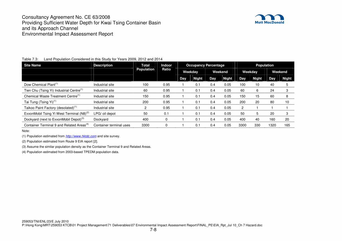
7.3.1.2 Nearby Land Population
Area in the vicinity of the two LPG/ oil depots is of industrial use. There is no residential/ recreational
development within 1 km distance. As illustrated in Figure 7.5, a few industrial sites are located near the oil
depots, including Dow Chemical Plant, Tien Chu (Tsing Yi) Industrial Centre, Chemical Waste Treatment
Centre, etc. Other areas in the surroundings are used for cargo handling, lorry parking, and goods storage
for Container Terminal 9. Estimated population at these sites are summarised in Table 7.2.
In the Planning Department’s Projections of Population Distribution 2009-2018 [11], promulgated in
December 2009, residential population at Tsing Yi South (TPU 350) has a downward trend, from 2009’s
112,200 to 2012’s 109,500 to 2014’s 107,900. Adopting this as an indicator for development in the area, it
can be assumed that the industrial population in the surroundings of the PHIs will follow the same trend as
the residential population. In addition, the change in nearby land population from 2009 to 2014 is not the
main focus of this study; there is no population change caused by the dredging works in the KTCB.
Therefore in this EIA the land population in the surroundings of the PHIs are conservatively assumed to
remain the same from 2009 to 2014.
7.3.1.3 Nearby Road Population
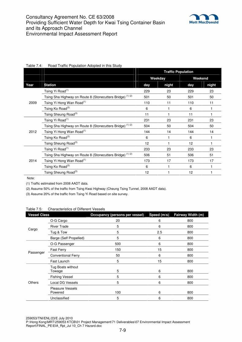
Traffic population of nearby roads such as Tsing Yi Road are estimated based on the 2008 Annual Average
Daily Traffic (AADT) data from Transport Department [9]. Night-time traffic density is assumed to be 10% of
the day-time traffic density. The Cheung Sha Wan-Tsing Yi section of Tsing Sha Highway on Route 8
(Stonecutters Bridge) was opened in December 2009 and no traffic data is available. It is assumed half of
the traffic will be diverted to this new road from the Tsing Kwai Highway (Cheung Tsing Tunnel). The future
traffic data is predicted by the trend of the data from 2007 to 2008.
The average traffic population are calculated from the following formula:
)/(
)(..
hrkmspeedTraffic
kmlengthRoadhr
vehicleofNo
vehicle
pplofNo
PopulationTraffic
××
=
The nearby road considered in this study is shown in Figure 7.5. Traffic population are summarised in
Table 7.4.
7.3.1.4 Marine Traffic Population
The marine traffic population are adopted from the marine traffic impact assessment report of this project.
Daily traffic at two locations at Year 2009 are adopted from the marine traffic survey (see Figure 7.6):
South Entrance of KTCB near the Marine Department Kwai Chung Control Station (KCCS) parallel to the
Consultancy Agreement No. CE 63/2008 Providing Sufficient Water Depth for Kwai Tsing Container Basin and its Approach Channel Environmental Impact Assessment Report
Stonecutters Bridge (1), and Northern Fairway near KCCS (2). Projections are made to predict the traffic at
Year 2012 and Year 2014. In this study, it is conservatively assumed the overall traffic of these two
fairways is the traffic of the fairway located to the south of the two PHIs (3). The average population density
at the fairway (3) is estimated from the following equations:
Overall population density = Σ Population density of each class of vessel
Daytime population density of each class of vessel = N × P / (V × 12 hr × W)
Where N is the daytime traffic of each class of vessel, P is the typical occupancy of the vessel, V is the
typical vessel speed, and W is the fairway width. The calculations are summarized in Tables 7.5, 7.6 and
7.7.
7.3.1.5 Other Factors to be Considered
Indoor / Outdoor Ratio
For this HA, the construction workers, staff in the open industrial areas such as Container Terminal 9 and
dockyard, and marine traffic population will be considered as 100% outdoor. An indoor ratio of 95% and
10% are applied to the population in the industrial buildings and LPG depots respectively. Passengers in
vehicles on the roads are considered as 100% outdoor. These factors have been adopted in the previous
South East Kowloon Development (SEKD) CFS EIA [3] and Harbour Area Treatment Scheme (HATS)
Stage 2A EIA [4].
Temporal Changes in Population
In order to account for the temporal change in population within a week, the following time periods, and
corresponding proportion of population to be adopted in the modelling, are assumed with reference to the
marine traffic survey of this project, SEKD CFS and HATS Stage 2A EIA studies [3] [4].
Table 7.2: Temporal Changes in Population
Time Period Construction Workers(1)(2)
Staff at the Industrial Sites(1)
Vehicle Passengers on the Roads(3)
Marine Traffic(4)
Weekday Day 100% 100% 100% 100%
Weekday Night 10% 10% 10% 80%
Weekend Day 50% 40% 100% 100%
Weekend Night 5% 5% 10% 80%
Note:
(1) Reference to HATS Stage 2A EIA [4].
(2) Population estimation is adjusted based on the project information.
(3) Reference to SEKD CFS EIA [3].
(4) Estimated from the marine traffic survey of this project.
Consultancy Agreement No. CE 63/2008 Providing Sufficient Water Depth for Kwai Tsing Container Basin and its Approach Channel Environmental Impact Assessment Report
Container Terminal 9 and Related Areas(4) Container terminal uses 3300 0 1 0.1 0.4 0.05 3300 330 1320 165
Note:
(1) Population estimated from http://www.hktdc.com and site survey.
(2) Population estimated from Route 9 EIA report [2].
(3) Assume the similar population density as the Container Terminal 9 and Related Areas.
(4) Population estimated from 2003-based TPEDM population data.
Consultancy Agreement No. CE 63/2008 Providing Sufficient Water Depth for Kwai Tsing Container Basin and its Approach Channel Environmental Impact Assessment Report
(2) Assume 50% of the traffic from Tsing Kwai Highway (Cheung Tsing Tunnel, 2008 AADT data).
(3) Assume 20% of the traffic from Tsing Yi Road based on site survey.
Table 7.5: Characteristics of Different Vessels
Vessel Class Occupancy (persons per vessel) Speed (m/s) Fairway Width (m)
O-G Cargo 20 6 800
River Trade 5 6 800
Tug & Tow 5 2.5 800 Cargo
Barge (Self Propelled) 5 6 800
O-G Passenger 500 6 800
Fast Ferry 150 15 800
Conventional Ferry 50 6 800 Passenger
Fast Launch 5 15 800
Tug Boats without Towage 5 6 800
Fishing Vessel 5 6 800
Local DG Vessels 5 6 800
Pleasure Vessels Powered 100 6 800
Others
Unclassified 5 6 800
Consultancy Agreement No. CE 63/2008 Providing Sufficient Water Depth for Kwai Tsing Container Basin and its Approach Channel Environmental Impact Assessment Report
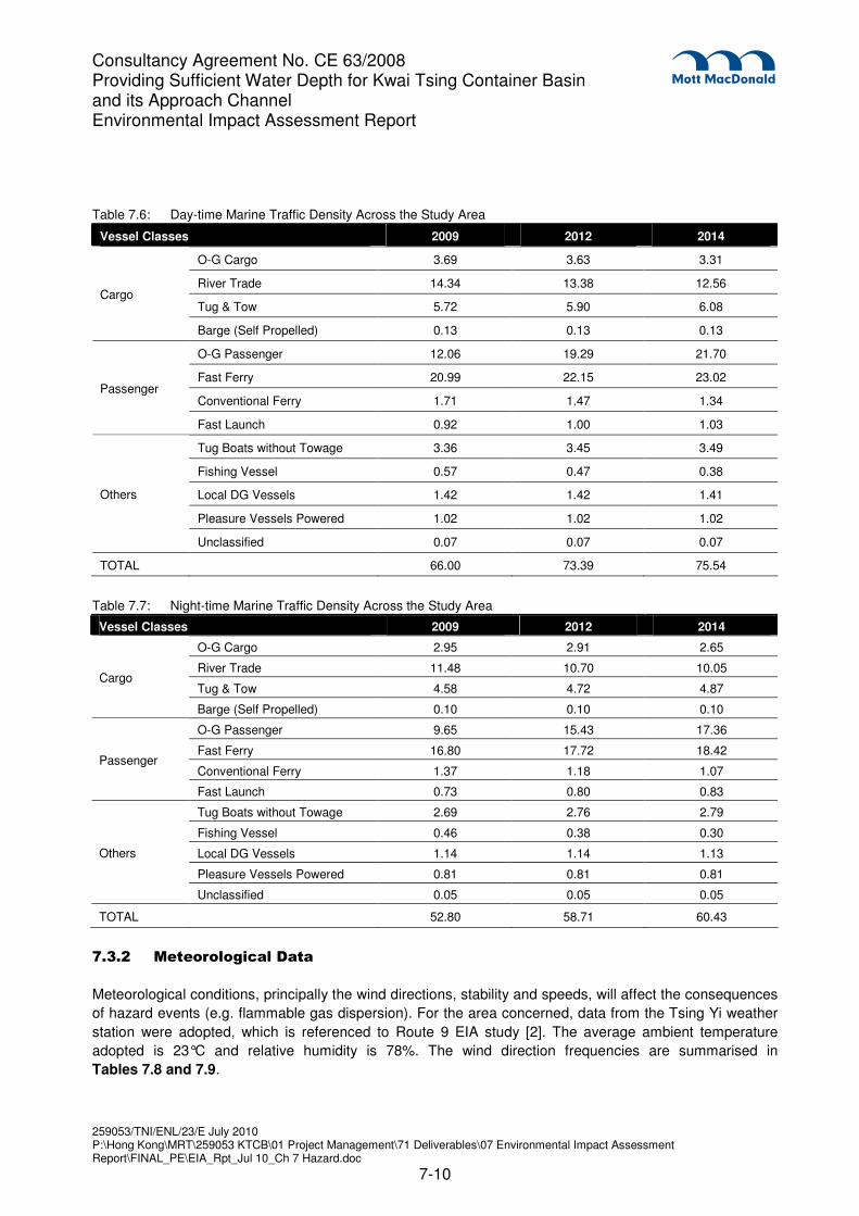
Table 7.6: Day-time Marine Traffic Density Across the Study Area
Vessel Classes 2009 2012 2014
O-G Cargo 3.69 3.63 3.31
River Trade 14.34 13.38 12.56
Tug & Tow 5.72 5.90 6.08 Cargo
Barge (Self Propelled) 0.13 0.13 0.13
O-G Passenger 12.06 19.29 21.70
Fast Ferry 20.99 22.15 23.02
Conventional Ferry 1.71 1.47 1.34 Passenger
Fast Launch 0.92 1.00 1.03
Tug Boats without Towage 3.36 3.45 3.49
Fishing Vessel 0.57 0.47 0.38
Local DG Vessels 1.42 1.42 1.41
Pleasure Vessels Powered 1.02 1.02 1.02
Others
Unclassified 0.07 0.07 0.07
TOTAL 66.00 73.39 75.54
Table 7.7: Night-time Marine Traffic Density Across the Study Area
Vessel Classes 2009 2012 2014
O-G Cargo 2.95 2.91 2.65
River Trade 11.48 10.70 10.05
Tug & Tow 4.58 4.72 4.87 Cargo
Barge (Self Propelled) 0.10 0.10 0.10
O-G Passenger 9.65 15.43 17.36
Fast Ferry 16.80 17.72 18.42
Conventional Ferry 1.37 1.18 1.07 Passenger
Fast Launch 0.73 0.80 0.83
Tug Boats without Towage 2.69 2.76 2.79
Fishing Vessel 0.46 0.38 0.30
Local DG Vessels 1.14 1.14 1.13
Pleasure Vessels Powered 0.81 0.81 0.81
Others
Unclassified 0.05 0.05 0.05
TOTAL 52.80 58.71 60.43
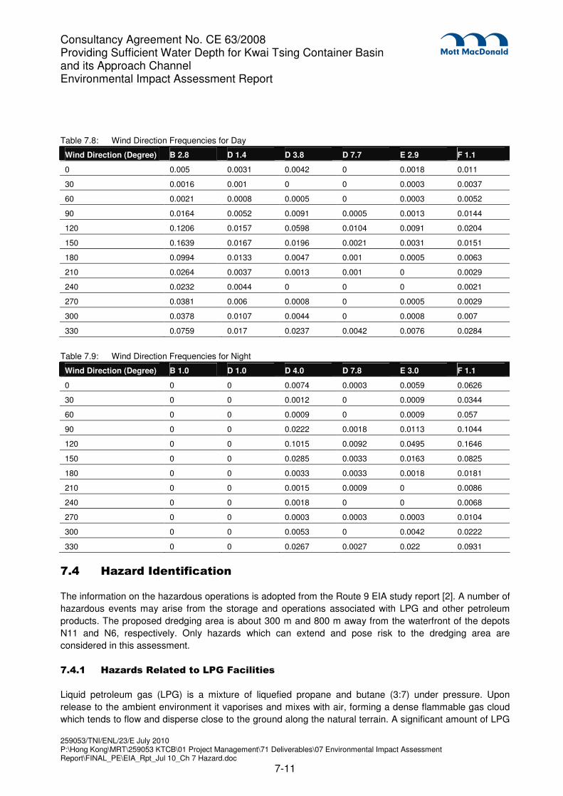
7.3.2 Meteorological Data
Meteorological conditions, principally the wind directions, stability and speeds, will affect the consequences
of hazard events (e.g. flammable gas dispersion). For the area concerned, data from the Tsing Yi weather
station were adopted, which is referenced to Route 9 EIA study [2]. The average ambient temperature
adopted is 23°C and relative humidity is 78%. The wind direction frequencies are summarised in
Tables 7.8 and 7.9.
Consultancy Agreement No. CE 63/2008 Providing Sufficient Water Depth for Kwai Tsing Container Basin and its Approach Channel Environmental Impact Assessment Report
Wind Direction (Degree) B 2.8 D 1.4 D 3.8 D 7.7 E 2.9 F 1.1
0 0.005 0.0031 0.0042 0 0.0018 0.011
30 0.0016 0.001 0 0 0.0003 0.0037
60 0.0021 0.0008 0.0005 0 0.0003 0.0052
90 0.0164 0.0052 0.0091 0.0005 0.0013 0.0144
120 0.1206 0.0157 0.0598 0.0104 0.0091 0.0204
150 0.1639 0.0167 0.0196 0.0021 0.0031 0.0151
180 0.0994 0.0133 0.0047 0.001 0.0005 0.0063
210 0.0264 0.0037 0.0013 0.001 0 0.0029
240 0.0232 0.0044 0 0 0 0.0021
270 0.0381 0.006 0.0008 0 0.0005 0.0029
300 0.0378 0.0107 0.0044 0 0.0008 0.007
330 0.0759 0.017 0.0237 0.0042 0.0076 0.0284
Table 7.9: Wind Direction Frequencies for Night
Wind Direction (Degree) B 1.0 D 1.0 D 4.0 D 7.8 E 3.0 F 1.1
0 0 0 0.0074 0.0003 0.0059 0.0626
30 0 0 0.0012 0 0.0009 0.0344
60 0 0 0.0009 0 0.0009 0.057
90 0 0 0.0222 0.0018 0.0113 0.1044
120 0 0 0.1015 0.0092 0.0495 0.1646
150 0 0 0.0285 0.0033 0.0163 0.0825
180 0 0 0.0033 0.0033 0.0018 0.0181
210 0 0 0.0015 0.0009 0 0.0086
240 0 0 0.0018 0 0 0.0068
270 0 0 0.0003 0.0003 0.0003 0.0104
300 0 0 0.0053 0 0.0042 0.0222
330 0 0 0.0267 0.0027 0.022 0.0931
7.4 Hazard Identification
The information on the hazardous operations is adopted from the Route 9 EIA study report [2]. A number of
hazardous events may arise from the storage and operations associated with LPG and other petroleum
products. The proposed dredging area is about 300 m and 800 m away from the waterfront of the depots
N11 and N6, respectively. Only hazards which can extend and pose risk to the dredging area are
considered in this assessment.
7.4.1 Hazards Related to LPG Facilities
Liquid petroleum gas (LPG) is a mixture of liquefied propane and butane (3:7) under pressure. Upon
release to the ambient environment it vaporises and mixes with air, forming a dense flammable gas cloud
which tends to flow and disperse close to the ground along the natural terrain. A significant amount of LPG
Consultancy Agreement No. CE 63/2008 Providing Sufficient Water Depth for Kwai Tsing Container Basin and its Approach Channel Environmental Impact Assessment Report
Jet fire caused by an immediate ignition of LPG release from a hole may impinge on a nearby LPG
container, and lead to catastrophic failure of the container over a period of time into BLEVE. This is
possible for ship LPG tanks and LPG road tankers. However, escalation of fire to BLEVE is considered
unlikely for mounded LPG storage vessels in the SINOPEC depot.
Representative LPG accidental release scenarios considered in the assessment are summarised below in
Table 7.10.
Consultancy Agreement No. CE 63/2008 Providing Sufficient Water Depth for Kwai Tsing Container Basin and its Approach Channel Environmental Impact Assessment Report
7.4.2 Hazards Related to Other Petroleum Products and Chemical Solvents
Other petroleum products and chemical solvents, as described in Section 7.2.2, are also stored in the
PHIs. Compared with LPG, these products are much less volatile and flammable due to their higher boiling
points and flash points. They are in liquid form under normal condition, and thus stored in vessels under
ambient temperatures and pressures. Accidental spillage of these petroleum products will result in pool fire,
either confined in the bund area or spread on the sea surface. In the Permanent Aviation Fuel Facility
(PAFF) EIA study [8], a number of release scenarios have been identified in association with the oil storage
depot of Jet A1 aviation fuel. These scenarios are used as a reference for the possible scenarios in this
Study. They are summarised in Table 7.11.
Table 7.11: Petroleum Product Release Scenarios in the PAFF EIA [8]
Jetty Transfer
Fire due to rupture/ leak of oil products from loaded vessel
Fire due to rupture/ leak of loading arm during unloading
Fire due to rupture/ leak of jetty equipment
Fire due to rupture/ leak of jetty riser
Fire due to rupture/ leak of submarine pipeline from jetty to tank farm ESD valve
Tank Farm Storage
Fire due to discharge from tank vent
Tank head fire or explosion in tank head space
Multiple tank head fires
Tank failure due to overpressure
Explosion in empty tank (under maintenance)
Bund fire
Fire outside bund due to rupture/ leak of pumps, pipework and fittings
Fire on sea due to release through drainage
Fire due to instantaneous tank wall failure, bottom seam failure
Fire due to instantaneous tank wall failure, unzipping
Aircraft impact
Consultancy Agreement No. CE 63/2008 Providing Sufficient Water Depth for Kwai Tsing Container Basin and its Approach Channel Environmental Impact Assessment Report
The consequence assessment is conducted in two steps: (1) Source term modelling to determine the
release rate, duration and quantity; (2) Effect modelling to determine the gas dispersion, fire and explosion
effects based on the output of source term modelling.
In this study, the simulation software SAFETI 6.51 by Det Norske Veritas (DNV) is used to calculate the
hazardous releases and the effect zones.
7.5.1 Source Term Modelling
LPG is modelled as a mixture of 70% butane and 30% propane. For instantaneous failure of an LPG
storage vessel, 2 release cases of 100% and 50% inventory are considered except for above ground LPG
vessels, where an additional case of 20% inventory is considered. For transient or continuous release, the
release rate is determined by hole size, storage and ambient conditions, and modelled by discharge
models in SAFETI. Duration of discharge is calculated from inventory and release rate. LPG release
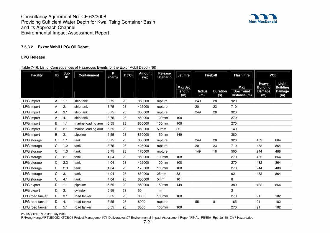
scenarios modelled for the study are listed in Tables 7.12 and 7.13 below. The release conditions
assumed for these scenarios are tabulated in Table 7.14 and 7.16.
Table 7.12: LPG Release Events at SINOPEC Depot
Case Facility Failure Description
A1.1 LPG import Tank rupture (full inventory)
A2.1 LPG import Tank rupture (half inventory)
A3.1 LPG import Catastrophic tank leak due to collision
A4.1 LPG import 100 mm tank leak due to collision
B1.1 LPG import Full bore rupture of marine loading arms
B2.1 LPG import 50 mm leak of marine loading arms
B3.1 LPG import 150 mm leak of jetty pipeline
C1.1 LPG storage Catastrophic tank leak
C2.1 LPG storage 100 mm tank leak
C3.1 LPG storage 25 mm tank leak
C4.1 LPG storage 5 mm tank leak
D1.1 LPG export 150 mm leak of filling pipeline
D2.1 LPG export Leak of LPG cylinders
D3.1 LPG road tanker 100 mm leak during road tanker filling
D4.1 LPG road tanker Rupture of road tanker on road
D5.1 LPG road tanker 100 mm leak of road tanker on road
D6.1 LPG road tanker 5 mm leak of road tanker on road
D7.1 LPG road tanker BLEVE during road tanker on road
D8.1 LPG road tanker BLEVE during road tanker loading
Fire due to multiple tank failure
Tank boilover
Fire due to release from top of tank due to overfilling
Vapour cloud explosion or flash fire
Fire due to 10% instantaneous release from the top of a tank
Consultancy Agreement No. CE 63/2008 Providing Sufficient Water Depth for Kwai Tsing Container Basin and its Approach Channel Environmental Impact Assessment Report
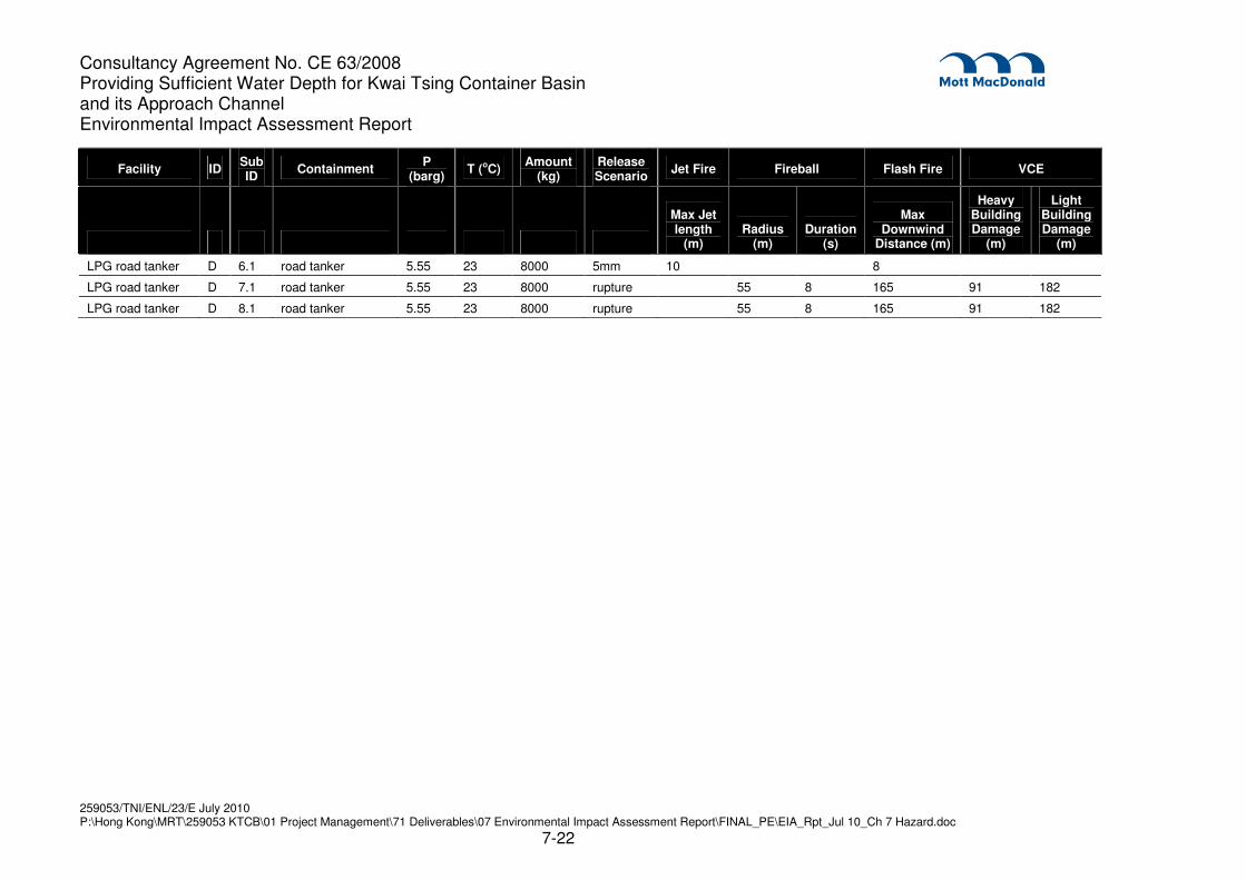
Table 7.13: LPG Release Events at ExxonMobil Depot
Case Facility Failure Description
A1.1 LPG import Tank rupture (full inventory)
A2.1 LPG import Tank rupture (half inventory)
A3.1 LPG import Catastrophic tank leak due to collision
A4.1 LPG import 100 mm tank leak due to collision
B1.1 LPG import Full bore rupture of marine loading arms
B2.1 LPG import 50 mm leak of marine loading arms
B3.1 LPG import 150 mm leak of jetty pipeline
C1.1
C1.2
C1.3
C1.4
LPG storage Catastrophic tank leak
100% inventory
50% inventory
20% inventory
C2.1
C2.2
C2.3
C2.4
LPG storage 100 mm tank leak
100% inventory
50% inventory
20% inventory
C3.1 LPG storage 25 mm tank leak
C4.1 LPG storage 5 mm tank leak
D1.1 LPG export 150 mm leak of filling pipeline
D2.1 LPG export Leak of LPG cylinders
D3.1 LPG road tanker 100 mm leak during road tanker filling
D4.1 LPG road tanker Rupture of road tanker on road
D5.1 LPG road tanker 100 mm leak of road tanker on road
D6.1 LPG road tanker 5 mm leak of road tanker on road
D7.1 LPG road tanker BLEVE during road tanker on road
D8.1 LPG road tanker BLEVE during road tanker loading
7.5.2 Effect Modelling
Gas Dispersion
The UDM model is used for the dispersion of LPG for non-immediate ignition scenarios. The model takes
into account various transition phases, from dense cloud dispersion to buoyant passive gas dispersion, in
both instantaneous and continuous releases.
Upon release of flammable gas, a number of possible outcomes may occur depending on whether the gas
is ignited immediately or ignited after a period of time. The dispersion characteristics are influenced by
meteorological conditions and material properties, such as density of the released gas.
Fire scenarios of different kinds may be developed in the presence of ignition source in the proximity of gas
release. Vapour cloud explosion may occur in a confined space or a congested area. If no ignition source
exists, the gas cloud may disperse downwind and be diluted to the concentration below its Lower
Flammable Limit (LFL). In this case, the gas would become too lean to ignite and have no harmful effect.
Consultancy Agreement No. CE 63/2008 Providing Sufficient Water Depth for Kwai Tsing Container Basin and its Approach Channel Environmental Impact Assessment Report
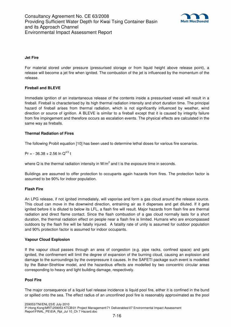
For material stored under pressure (pressurised storage or from liquid height above release point), a
release will become a jet fire when ignited. The combustion of the jet is influenced by the momentum of the
release.
Fireball and BLEVE
Immediate ignition of an instantaneous release of the contents inside a pressurised vessel will result in a
fireball. Fireball is characterised by its high thermal radiation intensity and short duration time. The principal
hazard of fireball arises from thermal radiation, which is not significantly influenced by weather, wind
direction or source of ignition. A BLEVE is similar to a fireball except that it is caused by integrity failure
from fire impingement and therefore occurs as escalation events. The physical effects are calculated in the
same way as fireballs.
Thermal Radiation of Fires
The following Probit equation [10] has been used to determine lethal doses for various fire scenarios.
Pr = - 36.38 + 2.56 ln Q4/3
t
where Q is the thermal radiation intensity in W/m2 and t is the exposure time in seconds.
Buildings are assumed to offer protection to occupants again hazards from fires. The protection factor is
assumed to be 90% for indoor population.
Flash Fire
An LPG release, if not ignited immediately, will vaporise and form a gas cloud around the release source.
This cloud can move in the downwind direction, entraining air as it disperses and get diluted. If it gets
ignited before it is diluted to below its LFL, a flash fire will result. Major hazards from flash fire are thermal
radiation and direct flame contact. Since the flash combustion of a gas cloud normally lasts for a short
duration, the thermal radiation effect on people near a flash fire is limited. Humans who are encompassed
outdoors by the flash fire will be fatally injured. A fatality rate of unity is assumed for outdoor population
and 90% protection factor is assumed for indoor occupants.
Vapour Cloud Explosion
If the vapour cloud passes through an area of congestion (e.g. pipe racks, confined space) and gets
ignited, the confinement will limit the degree of expansion of the burning cloud, causing an explosion and
damage to the surroundings by the overpressure it causes. In the SAFETI package such event is modelled
by the Baker-Strehlow model, and the hazardous effects are modelled by two concentric circular areas
corresponding to heavy and light building damage, respectively.
Pool Fire
The major consequence of a liquid fuel release incidence is liquid pool fire, either it is confined in the bund
or spilled onto the sea. The effect radius of an unconfined pool fire is reasonably approximated as the pool
Consultancy Agreement No. CE 63/2008 Providing Sufficient Water Depth for Kwai Tsing Container Basin and its Approach Channel Environmental Impact Assessment Report
radius, while a confined pool fire (e.g. bund fire) is approximated by the pool size plus the flame drag
caused by the wind, which is consistent with the PAFF EIA report. [8]
7.5.3 Consequence Results
The consequence results of jet fire, fireball/ BLEVE, flash fire and VCE from a release source are
determined from SAFETI and tabulated in Tables 7.14 and 7.16. Fires due to large LPG releases
(instantaneous, 150 mm leak and 100 mm leak) could extend outside the depots and imposes risks to the
offsite populations, including the construction workers at the dredging site. Impacts of small fires are
contained inside the boundary. For late ignition of a gas cloud formed by instantaneous release, it should
be noted that ignition could occur before the cloud reaches its maximum cloud size or maximum travel
distance from the release point. Therefore, the distances and cloud sizes in Tables 7.14 and 7.16 should
be regarded as the upper limit of the hazardous zone for the accidental release.
Consultancy Agreement No. CE 63/2008 Providing Sufficient Water Depth for Kwai Tsing Container Basin and its Approach Channel Environmental Impact Assessment Report
Consultancy Agreement No. CE 63/2008 Providing Sufficient Water Depth for Kwai Tsing Container Basin and its Approach Channel Environmental Impact Assessment Report
Fire due to rupture/ leak of oil products from loaded vessel 236
Fire due to rupture/ leak of loading arm during unloading 69
Fire due to rupture/ leak of jetty equipment 236
Fire due to rupture/ leak of jetty riser 69
Fire due to rupture/ leak of submarine pipeline from jetty to tank farm ESD valve 148
Tank Farm Storage
Fire due to discharge from tank vent Not significant
Tank head fire or explosion in tank head space Not significant
Multiple tank head fires Not significant
Tank failure due to overpressure Not significant
Explosion in empty tank (under maintenance) Not significant
Bund fire 18
Fire outside bund due to rupture/ leak of pumps, pipework and fittings 4
Fire on sea due to release through drainage 219
Fire due to instantaneous tank wall failure, bottom seam failure < 399
Fire due to instantaneous tank wall failure, unzipping < 399
Aircraft impact < 399
Fire due to multiple tank failure 399
Tank boilover Not significant
Fire due to release from top of tank due to overfilling Not significant
Vapour cloud explosion or flash fire Not significant
Fire due to 10% instantaneous release from the top of a tank 39
Consultancy Agreement No. CE 63/2008 Providing Sufficient Water Depth for Kwai Tsing Container Basin and its Approach Channel Environmental Impact Assessment Report
Consultancy Agreement No. CE 63/2008 Providing Sufficient Water Depth for Kwai Tsing Container Basin and its Approach Channel Environmental Impact Assessment Report
The nearest distances from the dredging works area to the ExxonMobil Depot jetty and storage area are
699 and 968 metres respectively. Based on similar arguments as the petroleum product storage facilities at
the SINOPEC Depot, hazard scenarios from the petroleum product storage facilities at the ExxonMobil
Depot will give no (zero) risk impacts to the dredging workers of the Project. Therefore, the risks are
quantified as zero.
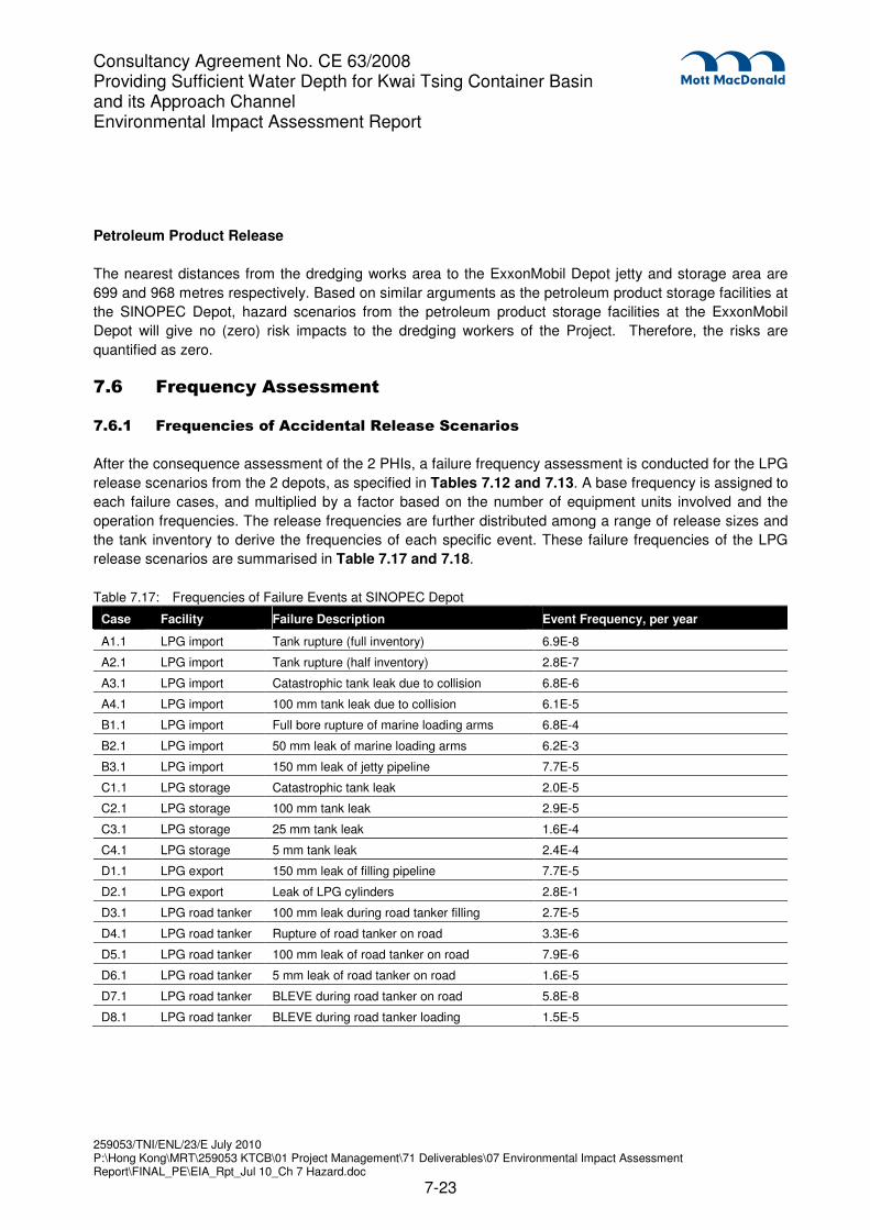
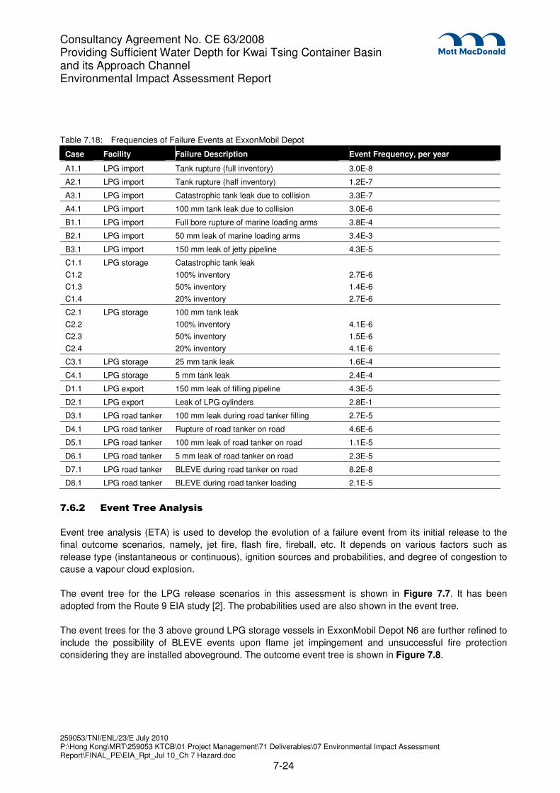
7.6 Frequency Assessment
7.6.1 Frequencies of Accidental Release Scenarios
After the consequence assessment of the 2 PHIs, a failure frequency assessment is conducted for the LPG
release scenarios from the 2 depots, as specified in Tables 7.12 and 7.13. A base frequency is assigned to
each failure cases, and multiplied by a factor based on the number of equipment units involved and the
operation frequencies. The release frequencies are further distributed among a range of release sizes and
the tank inventory to derive the frequencies of each specific event. These failure frequencies of the LPG
release scenarios are summarised in Table 7.17 and 7.18.
Table 7.17: Frequencies of Failure Events at SINOPEC Depot
Case Facility Failure Description Event Frequency, per year
A1.1 LPG import Tank rupture (full inventory) 6.9E-8
A2.1 LPG import Tank rupture (half inventory) 2.8E-7
A3.1 LPG import Catastrophic tank leak due to collision 6.8E-6
A4.1 LPG import 100 mm tank leak due to collision 6.1E-5
B1.1 LPG import Full bore rupture of marine loading arms 6.8E-4
B2.1 LPG import 50 mm leak of marine loading arms 6.2E-3
B3.1 LPG import 150 mm leak of jetty pipeline 7.7E-5
C1.1 LPG storage Catastrophic tank leak 2.0E-5
C2.1 LPG storage 100 mm tank leak 2.9E-5
C3.1 LPG storage 25 mm tank leak 1.6E-4
C4.1 LPG storage 5 mm tank leak 2.4E-4
D1.1 LPG export 150 mm leak of filling pipeline 7.7E-5
D2.1 LPG export Leak of LPG cylinders 2.8E-1
D3.1 LPG road tanker 100 mm leak during road tanker filling 2.7E-5
D4.1 LPG road tanker Rupture of road tanker on road 3.3E-6
D5.1 LPG road tanker 100 mm leak of road tanker on road 7.9E-6
D6.1 LPG road tanker 5 mm leak of road tanker on road 1.6E-5
D7.1 LPG road tanker BLEVE during road tanker on road 5.8E-8
D8.1 LPG road tanker BLEVE during road tanker loading 1.5E-5
Consultancy Agreement No. CE 63/2008 Providing Sufficient Water Depth for Kwai Tsing Container Basin and its Approach Channel Environmental Impact Assessment Report
Table 7.18: Frequencies of Failure Events at ExxonMobil Depot
Case Facility Failure Description Event Frequency, per year
A1.1 LPG import Tank rupture (full inventory) 3.0E-8
A2.1 LPG import Tank rupture (half inventory) 1.2E-7
A3.1 LPG import Catastrophic tank leak due to collision 3.3E-7
A4.1 LPG import 100 mm tank leak due to collision 3.0E-6
B1.1 LPG import Full bore rupture of marine loading arms 3.8E-4
B2.1 LPG import 50 mm leak of marine loading arms 3.4E-3
B3.1 LPG import 150 mm leak of jetty pipeline 4.3E-5
C1.1
C1.2
C1.3
C1.4
LPG storage Catastrophic tank leak
100% inventory
50% inventory
20% inventory
2.7E-6
1.4E-6
2.7E-6
C2.1
C2.2
C2.3
C2.4
LPG storage 100 mm tank leak
100% inventory
50% inventory
20% inventory
4.1E-6
1.5E-6
4.1E-6
C3.1 LPG storage 25 mm tank leak 1.6E-4
C4.1 LPG storage 5 mm tank leak 2.4E-4
D1.1 LPG export 150 mm leak of filling pipeline 4.3E-5
D2.1 LPG export Leak of LPG cylinders 2.8E-1
D3.1 LPG road tanker 100 mm leak during road tanker filling 2.7E-5
D4.1 LPG road tanker Rupture of road tanker on road 4.6E-6
D5.1 LPG road tanker 100 mm leak of road tanker on road 1.1E-5
D6.1 LPG road tanker 5 mm leak of road tanker on road 2.3E-5
D7.1 LPG road tanker BLEVE during road tanker on road 8.2E-8
D8.1 LPG road tanker BLEVE during road tanker loading 2.1E-5
7.6.2 Event Tree Analysis
Event tree analysis (ETA) is used to develop the evolution of a failure event from its initial release to the
final outcome scenarios, namely, jet fire, flash fire, fireball, etc. It depends on various factors such as
release type (instantaneous or continuous), ignition sources and probabilities, and degree of congestion to
cause a vapour cloud explosion.
The event tree for the LPG release scenarios in this assessment is shown in Figure 7.7. It has been
adopted from the Route 9 EIA study [2]. The probabilities used are also shown in the event tree.
The event trees for the 3 above ground LPG storage vessels in ExxonMobil Depot N6 are further refined to
include the possibility of BLEVE events upon flame jet impingement and unsuccessful fire protection
considering they are installed aboveground. The outcome event tree is shown in Figure 7.8.
Consultancy Agreement No. CE 63/2008 Providing Sufficient Water Depth for Kwai Tsing Container Basin and its Approach Channel Environmental Impact Assessment Report
Risk summation combines the estimation of the likelihood and consequences of hazardous events, as well
as the meteorological data and population in the hazard effect zones, to give a numerical measure of the
fatalities. The risk analysis is conducted by the SAFETI package and the outcome results are presented in
terms of individual risk (as individual risk contours), and societal risk (as F-N curves or potential loss of life).
The risk outcome will be compared with the Hong Kong Government Risk Guidelines set out in Annex 4 of
the EIAO-TM, as specified in Section 7.1.4.
7.7.2 Individual Risk
The individual risk contours of the SINOPEC and ExxonMobil Depots are presented in Figures 7.9 and
7.10 respectively. The 1×10⁻⁵
per year risk contours extend slightly outside the PHI boundaries, but are
mostly close to the site boundary and does not go into the proposed dredging works area. Further away
from the depot and jetty, the risk gradually diminishes to lower risk levels. The individual risk levels of the
two PHIs therefore marginally satisfy the Hong Kong Government Risk Guidelines for individual risk.
It should also be noted that individual risk is solely determined by the LPG/ oil depots (N6, N11) and is not
related to the actual population. Therefore, individual risk is not affected by the presence of the dredging
workers of the Project.
7.7.3 Societal Risk
F-N curves for the SINOPEC and ExxonMobil Depots before, during and after the dredging works project
(at Years 2009, 2012 and 2014 respectively) are presented in Figures 7.11 and 7.12.
The societal risk levels for “all neighbouring population” (including dredging workers) for both depots have
only insignificant changes from Year 2009 to 2012 to 2014. The reason for the change is due to changes in
land, road and marine population nearby the PHIs. The F-N curves of the two PHIs all lie in the ALARP
region, which is consistent with the previous Route 9 EIA study [2].
It should be noted that the proposed dredging project does not cause the societal risk levels of the two
PHIs to go into the ALARP region. Comparing to the overall societal risk from the two depots, the presence
of dredging workers of the proposed project is marginal. Therefore it can be concluded that with the
dredging works project taking place, the societal risk levels of the LPG/ oil depots still satisfy the Hong
Kong Government Risk Guidelines for societal risk.
7.8 Conclusion and Recommendations
7.8.1 Conclusions
This QRA study examined the effect from the proposed dredging work near Tsing Yi Island on risk levels
posed by the SINOPEC N11 and ExxonMobil N6 LPG/ oil depots. Major hazardous incidents which could
potentially impact on the dredging area were evaluated in terms of their hazard consequences and
occurring frequencies. The overall risk levels show that the two depots marginally meet the Hong Kong
Government Risk Guidelines, which is consistent with previous studies. The increase in societal risk
caused by the presence of dredging workers is minimal comparing to the overall risk level, and is not
Consultancy Agreement No. CE 63/2008 Providing Sufficient Water Depth for Kwai Tsing Container Basin and its Approach Channel Environmental Impact Assessment Report