253
COAST WATER SERVICES BOARD ENVIRONMENTAL IMPACT ASSESSMENT STUDY REPORT FOR THE PROPOSED MZIMA II WATER PIPELINE MAY 2018

COAST WATER SERVICES BOARD
ENVIRONMENTAL IMPACT ASSESSMENT STUDY
REPORT FOR THE PROPOSED MZIMA II WATER PIPELINE
MAY 2018

i
Declaration
This Environmental Impact Assessment (EIA) Study Report for the proposed Mzima II pipeline
project has been prepared by the EIA Team in collaboration with the Proponent.
Signed for and on behalf of the:
Proponent:
Chief Executive Officer,
Coast Water Services Board (CWSB)
Torrut
Environmental Impact Assessment Team:
Dr Stephen Chege Wairuri
Lead Expert (1580)
ii
List of acronyms and abbreviations
BPT Break Pressure Tank.
CWSB Coast Water Services Board
CBO Community Based Organisation
CR Critically threatened
DD Data deficient
EA Environmental Audit
EIA Environmental Impact Assessment
EMCA Environmental Management and Coordination Act
ESMP Environmental and Social Management Plan
GOK Government of Kenya
IBA Important Bird Area
KDHS Kenya Demographic and Health Survey
KENHA Kenya National Highways Authority
KPLC Kenya Power and Lighting Company
KWS Kenya Wildlife Services
LC Least Concern
MWI Ministry of Water and Irrigation
NEMA National Environment Management Authority
NT Near threatened.
NGO Non-Governmental Organisation
PAP Project Affected Person
RAP Resettlement Action Plan
RE Resident Engineer
TOR Terms of Reference
UNESCO United Nations Educational, Scientific and Cultural Organization VU Vulnerable

iii
Non-Technical Executive Summary
1.0 Background
There is a growing concern in Kenya and at global level that many projects are causing damage
to the environment. Activities carried out to realize the said projects have the potential to damage
the natural resources upon which the economies are based if preventive measures are not put in
place. A major challenge globally and nationally today is how to balance development objectives
and ecological concerns. To achieve this balance, various environmental management tools have
been developed. Environmental Impact Assessment (EIA) is among the many tools for the
protection of the environment from the negative effects of development activities. It is now
accepted that development projects must be economically viable, socially acceptable and
environmentally sound.
In Kenya, EIA became compulsory after the enactment of Environmental Management and
Coordination Act (EMCA) (Revised, 2015). According to, EMCA, and its subsequent
Environmental (Impact and Audit) Regulations, 2003, it is mandatory to get environmental
clearance for all projects in the Second Schedule of EMCA. Among these projects are; rivers and
water resources development and waste disposal projects including:
i. Storage projects, barrages and piers;
ii. Rivers diversions and water transfers between catchments; flood control schemes;
iii. Drilling for the purpose of utilizing ground water resources including geothermal energy.
iv. Sites for hazardous waste disposal;
v. Sewage disposal works;
vi. Works involving major atmospheric emissions;
vii. Works emitting offensive odours;
viii. Sites for solid waste disposal.
(EMCA, Second Schedule; Part IV.)
The proposed Mzima II pipeline for water transmission from Mzima springs thus falls under
projects which must undergo an environmental impact assessment before implementation. The
EIA is based on predictions. It attempts to predict the changes in environmental quality which
would result from the interaction between proposed project activities and the environment in its
totality (Biophysical, socio-cultural, economic and political). The EIA attempts to weigh
environmental effects on a common basis with economic costs and benefits and finally it is a
decision-making tool. The EIA is a procedure used to examine the environmental consequences,
both beneficial and adverse, of a proposed development project and to ensure that these effects
are taken into account in project design.

iv
2.0 Water supply and demand at the Coast of Kenya.
Water demand in the Coast Province depends mostly on a bulk water supply system comprising
of the Mzima Pipeline, Marere Pipeline, Tiwi Boreholes and Sabaki Pipeline. Taveta Township
and the surrounding villages are supplied with water from the high-yielding Njoro Kubwa
Springs (separate from the bulk system). It is suggested that this scheme will be connected only
to Taveta town, following major rehabilitation and expansion. The township of Lamu depends
on the local Shella aquifer. Hola town abstracts water directly from the Tana River. The current
water supply capacity at the Coast is as follows:
Source Capacity Year developed
Mzima Springs 35,000 1957
Marere Springs (with Pemba) 12,000 1923
Baricho Wellfield 90,000 1980
Tiwi Aquifer 13,000 1980
Njoro Kubwa Springs 3,000 1990
Tana River 1,400 1965
Shella Aquifer 1,800 Unknown
Total 149,200
Source: Republic of Kenya (2013)
This supply is against a growing demand as shown in the table below:
Urban Centre
Urban Water Demand (m3/day)
2,012
2,015
2,020
2,025
2,030
2,035
Mombasa 140,999 155,840 188,236 243,288 280,501 317,715
Kwale 23,396 25,764 31,096 39,775 48,956 58,136
Kilifi 37,723 41,516 51,616 65,090 79,823 94,555
Taita Taveta 14,778 16,615 19,554 23,494 28,261 33,028
Lamu 4,300 18,568 37,462 62,068 89,314 116,560
Tana River 3,597 4,340 5,207 6,036 7,629 9,222
Total Population 224,793 262,643 333,171 439,751 534,483 629,216
Source: Republic of Kenya (2013)

v
To meet the projected water demand at the Coast of Kenya, various projects have been proposed.
Among the proposed projects is Mzima II.
3.0 Project Description
The Project involves funding, design and construction of 220km of diameter 1,200mm
pipeline and related appurtenances capable of transmitting 105,000m3/d of water from
Mzima Springs to various coastal region towns in Taita Taveta, Kwale, Kilifi and Mombasa
Counties. The project shall comprise of the headwork, the intake, the main water supply
pipeline, Break pressure tanks, water supply along the pipeline route and water delivery to
the terminal tanks at Mazeras.
Design analysis found out that the existing waterworks at Mzima Springs have a capacity to
abstract the required 1.22 M3/s, the bottleneck to transfer this amount is the existing 30"(762 mm),
1,300 m long pipeline between the intake and the overflow chamber.
The pipeline from Mzima headwork to the existing control chamber of reservoirs in
Mazeras, includes line valves, air valves, washout valves, and regulating valves.
Considering the physical characteristics, construction convenience, anticorrosion
capacity, safe operation requirement, repair conditions and investment cost and
combining the factors such as the project scale, pipe sizes, working pressure, geological
conditions, terrain, loading requirement, construction conditions, construction time, ductile
iron pipe is selected as the pipe material as the main pipeline. Mild steel pipe shall be used
for crosses barriers such as railways, roads and rivers. The recommended protective
measures for both steel and Ductile Iron components are specified in the detailed technical
report. The pipe diameters for construction area DN1400, DN1200, DN1000, DN900; the
total length of transmission pipeline is 219.4km.
Reinforced Concrete Break Pressure Tanks with volume of 400m3 are design to regulating
pressure along the pipeline and also provides safety in case of pipe burst as valves limit the
discharge. A total of 10 BPTs are designed along the pipeline, each station includes 2 (twin) break
pressure tanks, two float valves installed at the inlet of each tank to regulate the water level and
flow meter installed at the outlet of break pressure tank.
Rehabilitating and upgrade of the existing disinfection facility to cope with the increased
abstraction is considered. For urban use, chlorination and disinfection will always be a “must”
before supplying portable water to consumers.

vi
The proposed pipeline will be parallel to the existing one. The service road of the existing pipeline
is in bad condition, rehabilitation shall be required for the construction of the proposed pipeline.
The existing 30m reserve will be adequate for the new pipeline and access road.
4.0 EIA Methodology
The environmental impact assessment study comprised the following activities: mobilization,
consultation with stakeholders, a screening and scoping exercise, desk and field studies, data
analysis, impact identification, and analysis of health and safety issues associated with the
proposed project.
A combination tools was employed to execute the assignment. These include:
Documents analysis.
Unstructured Observation
Collection of water and air samples for analysis.
Noise measurement
Public consultation carried out by:
Key informants’ interviews,
Phone interviews.
Barazas and
Questionnaire administration.
5.0 Positive impacts
The proposed Mzima II will generate positive impacts during the throughout the project lifecycle.
These positive impacts include:
Employment.
Growth of secondary businesses
Improved well-being of women and children
Enhanced Water supply which translates to improved psychological well-being of
households
Increased Profits for Businesses in the Project area
Revenue to the Exchequer
Infrastructure development
Reduced conflicts among users of upstream and downstream beneficiaries.
Reduced cases of water borne diseases

vii
6.0 Potential negative impacts and mitigation measures
These negative impacts will manifest during the construction and operation phases of the
propose Mzima II project. However, these most of them are short term and irreversible with the
application of the proposed mitigation measures.
Impact Mitigation measures
Water pollution Sanitation facilities shall be located within 100m from any point of
work, but not closer than 50 m to any water body.
All temporary/portable toilets shall be secured to the ground to
prevent them toppling due to wind or any other cause.
Only approved portable toilets should be used.
These facilities shall be maintained in a hygienic state and serviced
regularly.
The contractor shall ensure that no spillage occurs when the toilets
are cleaned or emptied and that the contents are removed from site
to an approved disposal site.
Discharge of waste from toilets into the environment and burying of
waste is strictly prohibited.
Wash areas shall be placed and constructed in such a manner so as
to ensure that the surrounding areas, which include groundwater,
are not polluted.
Containers of chemicals and hazardous substances used on the sites
should be confined in secure holding areas before disposal to
approved sites by licensed waste handlers.
Soil erosion and
contamination
Limit clearance of vegetation only on the way leave as much as
possible to minimize exposure of soil to agents of erosion.
Put up barriers to protect soil from erosion along the pipeline route
where there are steep edges.
Service machines, vehicles and heavy equipment to ensure there is
no spillage of oil and greases during operations.
Labelling all hazardous substances and providing work instructions
in their use.
Noise &
Excessive
Vibration
Prevent exposure of construction workers to unacceptable noise
levels.
Minimize construction through night time whenever possible.
PPE for workers operating machines that are generating noise and
vibrations that can be injurious to their health.
Limit construction to day time only unless with special permission.

viii
Impact Mitigation measures
Habitat loss,
degradation and
fragmentation
Restrict the operations relating to installation of the new pipeline to
the existing pipeline wayleave,
Restore cleared areas as soon as the pipes are installed and ensure
landscaping to minimize soil erosion.
Earthworks in ecologically sensitive areas including steep hillsides
and river crossings need to be carried with great caution.
Leveling and replanting and should be made mandatory.
Interference
with wild
animal
distribution and
ranging patterns
Use of less noisy machinery and equipment,
Use of minimal number of vehicles and other equipment in the
national parks
Using an optimal workforce.
Worker’s camps should be located outside the national park.
Potential for
human wildlife
conflicts – the
risk of death or
injury among
workers
Reducing the human footprint associated with water pipeline will
be limited through controlling the number of workers allowed
project site during the implementation, operation and
decommissioning phases.
At the beginning of the project, the workers will need to be briefed
on the dangers they will be exposed to while working in wildlife
habitats. They will be educated on how best to behave and protect
themselves from dangerous animals.
The workers should be accompanied by armed KWS rangers while
working in the parks and other wildlife rich habitats.
Interference
with tourism
activities
It will be crucial that the work at these sites be carried out as fast as
possible and with as minimal impacts on biodiversity and aesthetics
as possible.
Pipeline trenches and other excavated sites should be covered as
soon.
Where practical, most of the work should be timed to coincide with
low tourism season/time of day.
Increased
poaching of
wild animals.
Security agencies including Kenya Wildlife Service (KWS) should
increase anti-poaching effort
Avoiding establishment of workers’ camps inside the parks and
other wildlife rich habitats, in the area and minimizing human traffic
within the area of operation.
Enlisting the support of local community in ant-poaching activities

ix
Impact Mitigation measures
Sensitization of the workers and members of public on the
importance of wildlife conservation, wildlife legislation particularly
of the new the Wildlife Act 2013 (GOK, 2013), which has legislated
very stiff penalties for wildlife poaching especially when
endangered species are involved.
Vetting, screening and profiling of the construction workers to
streamline management of people involved in construction. This
will ensure that only people with no criminal records are allowed in
the park.
The workers should be accompanied by security officers as part of
the park regulation of ensuring their safety and wildlife.
Strict observance of Park Rules and Regulations.
Inspection of all construction vehicles entering and or leaving the
protected areas of Tsavo National park.
Creating a single manned entry and exit for construction workers
and vehicles where the pipeline exits Tsavo West. The same case
should apply for Tsavo East.
Embedding KWS personnel to the Resident Engineer’s (RE) Office to
ensure that the Contractor does not operate in any way that is
prejudicial to conservation of flora and fauna in Tsavo East and
West.
Spread of
Zoonotic
diseases, Gastro
Intestinal
parasites and
other pathogens
Ensuring that construction workers observe hygiene.
Providing mobile toilets to workers.
The worker’s camps should be located outside the national Parks so
as to reduce workers contact with wild animals.
The workers should be educated on the need to avoid feeding wild
animals and to dispose of waste appropriately.
Spread of
invasive species
The pipeline route should be monitored and remedial action taken
should this or other invasive species be noticed in along the pipeline
either during the implementation or the operation stages of the
project.
Movement of soil for service road construction will be limited to
avoid spreading invasive species.
Clean all machines and vehicles before and entering the protected
areas.
Accidental
injury and
Educating the drivers on the legal speed limits in conservation areas.

x
Impact Mitigation measures
deaths of wild
animals
Laying the pipeline and covering the trenches within the shortest
time possible.
Limiting the time of open trenches in the park to maximum 24 hours
and a length of not more than 200 metres each day.
Adherence to Parks Rules and Regulations.
Occupational
accidents
Traffic department should approve crossing plan prior to
construction, and should approve obstruction times during
construction.
Access of residents should be facilitated by installing appropriate
temporary bridges over the pipeline trenches.
Suitable warning signs should be placed at near locations and
should be visible at night.
A guard should be available 24 hours to help people access across
pipeline trenches.
Alternatives access ways should be communicated to the
community
Provide Marshalls to assist the elderly, school children, expectant
mothers and Persons With Disability (PWDs) cross the trenches.
Disturbance of
traffic and
difficulty of
access
Traffic department should approve crossing plan prior to
construction, and should approve obstruction times during
construction.
Access of residents should be facilitated by installing appropriate
temporary bridges over the pipeline trenches.
Suitable warning signs should be placed at near locations and
should be visible at night.
A guard should be available 24 hours to help people access across
pipeline trenches.
Alternatives access ways should be communicated to the
community
Provide Marshalls to assist the elderly, school children, expectant
mothers and Persons With Disability (PWDs) cross the trenches.
Risks of
Damaging
Underground
Infrastructure
Collecting available maps for infrastructure routes.
Excavating manual trial pits to locate the underground
infrastructure facilities before using mechanical excavation.
Notify the relevant service provider in-case of accidental damage.
Prompt repairs to minimise the duration of interruption of services.

xi
Impact Mitigation measures
Effects on
Structural
Integrity
The geotechnical report should include suitable measures for
confining vibrations within project sites. These measures should be
tailored according to the proximity of buildings to the project sites
and earthwork program.
These recommendations identified in the geotechnical report (such
as secant piling or sheet piling or establish cut-off walls) should be
implemented by the contractor and supervised by Environment
Health and Safety Advisor.
No blasting should take place while excavating in built up areas.
Use manual excavations as much as is practicable.
Chemical
Exposure
Material safety data sheets of all chemicals used during construction
will be kept in a register by the contractor
The contractor to have procedures in place regarding emergencies
relating to chemicals and dangerous goods consistent with the
existing legislation.
Records will be kept on the existing inventory, storage location,
personnel training and disposal of waste for all chemicals and
dangerous goods used on site
All relevant construction workers will be trained in appropriate
handling, storage and containment practices for chemicals and
dangerous goods in relation to their position.
All spills will be cleaned immediately
Liquid Effluents
from
Contractor’s
camps
Provision shall be made for employee facilities including shelter,
toilets and washing facilities.
Toilet facilities supplied by the contractor for the workers shall occur
at a minimum ratio of 1 toilet per 30 workers (preferred 1:15).
The exact location of the toilets shall be approved by the Public
Health Department prior to establishment.
Sanitation facilities shall be located within 100m from any point of
work, but not closer than 50 m to any water body.
All temporary/portable toilets shall be secured to the ground to
prevent them toppling due to wind or any other cause.
The contractor shall ensure that the entrances to toilets are
adequately screened from public view.
Only approved portable toilets should be used.
These facilities shall be maintained in a hygienic state and serviced
regularly. Toilet paper shall be provided

xii
Impact Mitigation measures
The contractor shall ensure that no spillage occurs when the toilets
are cleaned or emptied and that the contents are removed from site
to an approved disposal site.
Discharge of waste from toilets into the environment and burying of
waste is strictly prohibited.
Wash areas shall be placed and constructed in such a manner so as
to ensure that the surrounding areas, which include groundwater,
are not polluted.
Solid Wastes Integrated wastes management.
The contractor should segregate hazardous waste, which will be
safely transported to a hazardous waste facility, from non-
hazardous waste which will be transported to approved disposal
sites by NEMA.
Garbage collected from construction sites should be disposed at
appropriate sites approved by NEMA.
Inert construction wastes should be appropriately collected and
disposed in approved disposal site.
Sell metal to authorized scrap metal dealers
Population
Displacement
Prepare a Resettlement Action Pan (RAP) with:
i. A comprehensive census of Project Affected Persons (PAPs).
ii. Asset Inventory of the PAPs.
iii. Cutoff dates that are reasonable.
iv. Compensation rates, procedure and Schedule
v. Grievance Redress Mechanisms.
Risk of Fire
outbreak
Construction camps to located outside the protected areas.
Label all inflammable materials and sore them appropriately
Provision of adequate firefighting equipment capable of fighting all
classes of fire
Put “ No Smoking Signs” in areas where inflammables are stored
Train workers on the use of ire fighting equipment
Label fire exits and keep them clear.
Display a list of emergency contact numbers prominently
Spread of HIV
and AIDS
Sensitize the migrant workers and host community on risky sexual
behaviour.
Have VCT services on site and encourage workers to undergo the
same.

xiii
Impact Mitigation measures
Provision of protective devices such as condoms.
Ensure project is completed within the set timeframe to minimize
the contact.
Social and
cultural conflicts
Sensitize migrant workers on key cultural sensitivities of the host
community.
Ensure fairness in recruitment of workforce by ensuring that local
people get priority of the jobs that they can perform.
Create open communication for people to channel their grievances
to avoid rumours and fake news with respect to the proposed
project.
Engage with local leaders at all times.
Create a project committee with representation of all actors.
Risk of over
abstraction of
water from
Mzima springs
Strengthen water intake monitoring
Increase the quantity of rainfall stations, especially in the ridge area
Strengthen the discharge monitoring of Mzima Springs and other
major springs that have Chyulu aquifer as the water source.
Proponent to work with stakeholders in order to secure Mzima
Springs catchment areas.
Proponent should work with appropriate stakeholders and develop
a payment for ecosystem service scheme in which the users of
water from Mzima Springs pay for the conservation and protection
of the spring’s water catchment.
Reduced water
volume for wild
animals
Proponent should consider constructing extra water line and
watering points/troughs to discourage overconcentration of animals
in Mzima springs during the dry seasons.
Abstract only the licensed volume from the springs.
Encourage development of other water sources downstream such as
dams to harvest rain water.

xiv
Table of Contents
Declaration ................................................................................................................................. i
List of acronyms and abbreviations ...................................................................................... ii
Non-Technical Executive Summary ..................................................................................... iii
Table of Contents .................................................................................................................. xiv
List of Tables .......................................................................................................................... xix
List of Figures ......................................................................................................................... xx
List of Plates ........................................................................................................................... xxi
1.0 INTRODUCTION ............................................................................................... 1
1.1 Background .................................................................................................................... 1
1.2 The Proponent ............................................................................................................... 2
1.3 The Proposed Project .................................................................................................... 2
1.3.1 Mzima I Pipeline ....................................................................................................... 2
1.4 The Proposed Mzima II Pipeline ................................................................................. 3
1.4.1 The Project components ........................................................................................ 3
1.4.2 The source and head works .................................................................................. 3
1.4.3 The Transmission Pipeline .................................................................................... 4
1.4.4 Break Pressure Tank (BPT) ................................................................................... 6
1.4.5 Disinfection Facilities ............................................................................................ 6
1.4.6 Access Road ............................................................................................................ 6
1.4.7 Consideration of water off-takes ......................................................................... 6
1.5 Analysis of Alternatives ............................................................................................... 9
1.6 The Objectives of this EIA ............................................................................................ 9
2.0 ENVIRONMENTAL IMPACT ASSESSMENT APPROACH AND
METHODOLOGY ........................................................................................................ 11
2.1 Introduction ................................................................................................................ 11
2.2 Mobilization, Liaison and Consensus Building with Stakeholders ..................... 11
2.3 Scoping Exercise .......................................................................................................... 11
2.4 Terms of Reference (TOR) .......................................................................................... 11
2.5 Desk Study ................................................................................................................... 12
2.6 Field Study ................................................................................................................... 12
2.7 Public Consultation ..................................................................................................... 12
3.0 RELEVANT LEGISLATIVE AND POLICY FRAMEWORKS ................. 14
3.1 Introduction ................................................................................................................. 14
3.2 The Constitution of Kenya ......................................................................................... 14
3.3 Institutional Framework ............................................................................................. 15
3.3.1 National Environmental Management Authority (NEMA) ........................ 15

xv
3.3.2 National Environment Action Plan Committee ............................................ 16
3.4 Environmental Management and Co-ordination Act (EMCA) (Amended 2015) 17
3.4.1 Environmental Impact Assessment and Audit Regulations, 2003 ............ 18
3.4.2 Water Quality Regulations, 2006 (Legal Notice No. 121) ............................ 18
3.4.3 Waste Management Regulations, 2006 (Legal notice No. 121) ................... 19
3.4.4 Controlled Substances Regulations, 2007 (Legal Notice No.73 of 2007) .. 19
3.4.5 Conservation of Biodiversity Regulations 2006 ............................................ 20
3.4.6 Air Quality Regulations, 2008 ........................................................................... 20
3.4.7 Noise and Excessive Vibration Pollution Control Regulations, 2009 ....... 21
3.4.8 Wetlands, River Banks, Lake Shores and Sea Shore Management
Regulation, 2009 ................................................................................................................ 21
3.4.9 Prevention of pollution in Coastal Zone and other Segments of the
Environment) Regulation, 2003 ...................................................................................... 22
3.5 The Water Act, 2016 .................................................................................................... 22
3.6 Wildlife Management and Conservation Act, Cap 376 ......................................... 22
3.8 The Agricultural Act (Cap 318) ................................................................................. 23
3.9 Energy Act, 2006 .......................................................................................................... 23
3.10 Forest Act, 2005 ........................................................................................................ 23
3.11 The Occupational Safety and Health Act, 2007 ................................................... 24
3.12 Public Health Act 1986 ............................................................................................ 24
3.13 Physical Planning Act (Cap 286) ........................................................................... 25
3.15 Way Leaves Act (Cap. 292) ..................................................................................... 25
3.16 Trust Lands Act, 2010 .............................................................................................. 26
3.17 The Land Registration Act, 2012 ............................................................................ 26
3.18 The Environment and Land Court Act, 2011 ....................................................... 26
3.19 The National Land Commission Act, 2012 (No. 5 of 2012) ................................ 26
3.20 The Land Act, 2012 .................................................................................................. 27
3.21 Land Adjudication Act, 2010.................................................................................. 27
3.22 The Standards Act Cap 496 .................................................................................... 28
3.23 Kenya Railways Corporation Act (Cap. 397), 1979 ............................................. 28
3.24 Public Roads and Roads of Access Act (Cap. 399) .............................................. 28
3.25 Building Code 1997 ................................................................................................. 29
3.26 Penal Code Cap 63 ................................................................................................... 29
3.27 The Antiquities and Monuments Act, 1983 Cap 215 .......................................... 29
3.28 World Bank Safeguards Triggered by the Project .............................................. 30
3.28.1 Environmental Assessment OP 4.01 ................................................................. 30
3.28.2 Involuntary Resettlement (OP 4.12) ................................................................. 31
3.28.3 Bank Operational Policy 4.11-Physical Cultural Resources ........................... 32
4.0 BASELINE INFORMATION ........................................................................... 33

xvi
4.1 Introduction ................................................................................................................. 33
4.2 County Position, Size and Physiographic Conditions ........................................... 33
4.3 Administrative and Political Units ..................................................................... 34
4.4 Demographic Characteristics ............................................................................... 35
4.5 Infrastructure and access ....................................................................................... 37
4.6 Education institutions ............................................................................................ 38
4.7 Land and Land Use ................................................................................................. 38
4.8 Tourism ..................................................................................................................... 40
4.9 Water and Sanitation .................................................................................................. 41
4.10 Biodiversity ............................................................................................................... 42
4.10.1 Biodiversity status of the Tsavo national Parks ............................................ 43
4.10.2 Mammal diversity ........................................................................................... 44
4.10.4 Bird species diversity ........................................................................................ 48
4.10.5 Reptiles and amphibians of Tsavo ecosystem .................................................... 53
4.10.6 Wildlife migration routes .................................................................................. 54
4.11 Chyulu Hills Surface and Ground Catchments ............................................ 55
4.11 Chyulu Hills Surface and Groundwater Catchments ........................................ 55
4.11.2 Meteorology, Recharge and Surface Flows ................................................... 57
4.11.3 Recharge processes ............................................................................................. 58
4.11.4 Discharge .............................................................................................................. 59
4.11.5 Reliability Evaluation Report for Mzima Springs ....................................... 60
4.11.6 Environmental Analysis of Water Resource ................................................. 62
4.12 Environment and Climate Change .................................................................. 63
5.0 PUBLIC PARTICIPATION AND RESPONSES .......................................... 65
5.1 Introduction ................................................................................................................ 65
5.2 Consultation Methodology ........................................................................................ 65
5.3 Objectives of Public Participation ............................................................................. 66
5.4 Aims of Public Participation ...................................................................................... 66
5.5 Legal Requirements .................................................................................................... 66
5.5.1 Environmental (Impact Assessment and Audit Regulations, 2003) ............. 66
5.5.2 Government Policy on Public Consultation ..................................................... 67
5.6 Identification of Stakeholders .................................................................................... 67
5.7 Methodology ................................................................................................................ 67
5.7.1 Direct Interviews ................................................................................................. 67
5.7.2 Questionnaire Administration ......................................................................... 69
5.7.3 Community Consultative Meetings ................................................................ 69
5.8 Outcomes of Public Consultation ............................................................................. 76
5.8.1 Acceptance of the Project ................................................................................... 76
5.8.2 Compensation ...................................................................................................... 76

xvii
5.8.3 Operation and Maintenance of the Mzima II Pipeline ............................... 76
5.8.4 Role of Project in Supporting GoK and County Government Policies .... 76
5.8.5 Potential Damage to Existing Infrastructure ................................................. 77
5.8.6 Potential Interference to Business Operations .............................................. 77
5.8.7 Employment ......................................................................................................... 77
5.8.8 Potential for Increased Economic Activities .................................................. 77
5.8.9 Long-Term Sustainability ................................................................................. 77
5.8.10 Occupational Health and Safety ...................................................................... 78
5.8.11 Project Timeframe ............................................................................................... 78
6.0 POTENTIAL ENVIRONMENTAL IMPACTS............................................ 79
6.1 Introduction ................................................................................................................. 79
6.2 Potential positive impacts during construction ...................................................... 80
6.2.1 Employment ......................................................................................................... 80
6.2.2 Growth of secondary businesses ..................................................................... 81
6.2.3 Revenue to the Exchequer ................................................................................. 81
6.2.4 Infrastructure development .............................................................................. 81
6.3 Construction Phase Potential Negative impacts ..................................................... 82
6.3.1 Water pollution.................................................................................................... 82
6.3.2 Soil erosion and contamination ....................................................................... 82
6.3.3 Noise & Excessive Vibration ............................................................................ 83
6.3.4 Impacts on Biodiversity. .................................................................................... 83
6.3.5 Occupational accidents ...................................................................................... 87
6.3.6 Disturbance of traffic and difficulty of access .............................................. 88
6.3.7 Risks of Damaging Underground Infrastructure ........................................ 89
6.3.8 Effects on Structural Integrity .......................................................................... 89
6.3.9 Chemical Exposure ............................................................................................. 90
6.3.10 Liquid Effluents from Contractor’s camps ..................................................... 90
6.3.11 Solid Wastes ..................................................................................................... 91
6.3.12 Population Displacement .................................................................................. 91
6.3.13 Fire outbreak ........................................................................................................ 92
6.3.14 Spread of HIV and AIDS................................................................................... 92
6.3.15 Social and cultural conflicts .............................................................................. 93
6.4 Positive Impacts during the Operational phase ..................................................... 93
6.4.1 Improved well-being of women and children .............................................. 93
6.4.2 Enhanced Water supply which translates to improved psychological
well-being of households ................................................................................................ 94
6.4.3 Employment ......................................................................................................... 94
6.4.4 Increased Profits for Businesses in the Project area ..................................... 94
6.4.5 Revenue to the Exchequer ................................................................................. 94

xviii
6.4.6 Infrastructure development .............................................................................. 95
6.4.7 Reduced conflicts among users of upstream and downstream
beneficiaries. ...................................................................................................................... 95
6.4.8 Reduced cases of water borne diseases .......................................................... 95
6.5 Potential Negative Impacts during Operational Phase ......................................... 95
7.0 ENVIRONMENTAL MANAGEMENT AND MONITORING PLAN ... 97
7.1 Introduction ................................................................................................................. 97
7.2 Construction Phase Environmental Management Plan ......................................... 97
7.3 Operation phase Environmental Management Plan ............................................ 115
7.4 Decommissioning Phase Environmental Management Plan .............................. 116
8.0 CONCLUSION AND RECOMMENDATION ............................................. 117
8.1 Conclusion .................................................................................................................. 117
8.2 Recommendations ..................................................................................................... 117
References ............................................................................................................................. 118
Appendix 1: Institutional stakeholders consulted. ......................................................... 119
Appendix 2: Lists of community members consulted along the pipeline corridor. .. 121
Appendix 3: Minutes of Kasemeni Consultation meetings ........................................... 122
Appendix 4: Minutes of Mwavumbo (Kalalani) Consultation meetings .................... 125
Appendix 5: Minutes of Mwatate Consultation meetings ............................................. 131
Appendix 6: Minutes of Samburu Consultation meetings ............................................ 133
Appendix 7: Minutes of Taru Consultation meetings .................................................... 139
Appendix 8: Minutes of Voi Consultation meetings ...................................................... 144
Appendix 9: Minutes of Maungu Consultation meetings ............................................. 157
Appendix 10: Minutes of Mackinnon Consultation meetings ...................................... 162
Appendix 11: Minutes of Mbololo Consultation meetings ............................................ 169
Appendix 12: Minutes of Ngolia Consultation meetings............................................... 172
Appendix 13: Lead Expert Annual Practicing License ................................................... 178
Appendix 14: Lead Expert Annual EIK Certificate ......................................................... 181
Appendix 16: Air Quality Measurements ........................................................................ 184
Appendix 17: Water quality assessment ........................................................................... 188
Appendix 18: Conservation Organisations Reponses .................................................... 191
Appendix 19: Community members’ attendance Lists in Consultation meetings ..... 196
Appendix 20: EIA Team Composition .............................................................................. 230

xix
List of Tables
Table 1: Works at head and intake works ................................................................................ 4
Table 2: Works components and operations at various sections of the proposed project 5
Table 3: Supply of water enroute to Mombasa ........................................................................ 7
Table 4: Political and administrative units of Taita Taveta County ................................... 35
Table 5: Population distribution by age and gender in Taita Taveta ................................. 36
Table 6: Key plant species in Tsavo ......................................................................................... 43
Table 7: Mammals in Tsavo ecosystem ................................................................................... 46
Table 8: Globally threatened Birds and IBA trigger species found in Tsavo East and
Tsavo West National Parks ....................................................................................................... 48
Table 9: Birds observed/ringed at Ngulia ........................................................................... 51
Table 10: Herpetofauna and amphibians in Tsavo ............................................................... 53
Table 11: Consultative meetings held ..................................................................................... 70
Table 13: Scale for evaluation of project impacts................................................................... 80
Table 14: Construction Phase EMP .......................................................................................... 98
Table 15 : Operation Phase EMP ............................................................................................ 115

xx
List of Figures
Figure 1: Construction at intake and headworks .................................................................... 4
Figure 2: Schematic representation of the Mzima II pipeline ................................................ 8
Figure 3: Water Pipelines serving Mombasa (WRI, 2007) ................................................... 42
Figure 4: Wildlife migratory routes/corridors in the Tsavo-Mkomazi ecosystem (Ojwang,
et al, 2017) .................................................................................................................................... 54
Figure 5: Mzima catchment basin (Atkins,2018) ................................................................... 56
Figure 6 :Conceptual representation of recharge of Chyulu aquifer .................................. 59
Figure 7: Environment requirement for Mzima headwater resource ................................ 63

xxi
List of Plates
Plate 1: Black Rhino in Tsavo West ......................................................................................... 44
Plate 2: An Elephant ©Paul Muoria ........................................................................................ 44
Plate 3: Grevy's Zebra © Paul Muoria ..................................................................................... 45
Plate 4: Lions© Paul Muoria ..................................................................................................... 45
Plate 5: Consulting Board of Directors TAVEVO .................................................................. 68
Plate 6: Consulting the Chief Officer (Water and Irrigation) Taita Taveta County ......... 68
Plate 7: Interviewing Assistant County Commissioner-Kasemeni ..................................... 68
Plate 8: Interview with MD Kwale Water and Sanitation Company ................................. 69
Plate 9: Interview with County Secretary- Kwale County ................................................... 69
Plate 10: Consultations in Kasemeni ....................................................................................... 71
Plate 11: Consultations in Mwatate location .......................................................................... 71
Plate 12: Consultations in Samburu Location ........................................................................ 72
Plate 13: Taru Location consultations ..................................................................................... 73
Plate 14: Community engagement in Mackinnon road ........................................................ 73
Plate 15: Maungu location consultations ................................................................................ 74
Plate 16: Consultations in Voi .................................................................................................. 74
Plate 17: Hon Omar of Kaloleni Ward address community in Voi .................................... 74
Plate 18: Consultations in Mbololo location ........................................................................... 75
Plate 19: Ngolia Consultations ................................................................................................. 75

1
1.0 INTRODUCTION
1.1 Background
There is a growing concern in Kenya and at global level that many projects are causing damage
to the environment. Activities carried out to realize the said projects have the potential to damage
the natural resources upon which the economies are based if preventive measures are not put in
place. A major challenge globally and nationally today is how to balance development objectives
and ecological concerns. To achieve this balance, various environmental management tools have
been developed. Environmental Impact Assessment (EIA) is among the many tools for the
protection of the environment from the negative effects of development activities. It is now
accepted that development projects must be economically viable, socially acceptable and
environmentally sound.
In Kenya, EIA became compulsory after the enactment of Environmental Management and
Coordination Act (EMCA) (Revised, 2015). According to, EMCA, and its subsequent
Environmental (Impact and Audit) Regulations, 2003, it is mandatory to get environmental
clearance for all projects in the Second Schedule of EMCA. Among these projects are; rivers and
water resources development and waste disposal projects including:
ix. Storage projects, barrages and piers;
x. Rivers diversions and water transfers between catchments; flood control schemes;
xi. Drilling for the purpose of utilizing ground water resources including geothermal energy.
xii. Sites for hazardous waste disposal;
xiii. Sewage disposal works;
xiv. Works involving major atmospheric emissions;
xv. Works emitting offensive odours;
xvi. Sites for solid waste disposal.
(EMCA, 1999, Second Schedule; Part IV.)
The proposed Mzima II pipeline for water transmission from Mzima springs thus falls under
projects which must undergo an environmental impact assessment before implementation.
The EIA is based on predictions. It attempts to predict the changes in environmental quality
which would result from the interaction between proposed project activities and the environment
in its totality (Biophysical, socio-cultural, economic and political). The EIA attempts to weigh
environmental effects on a common basis with economic costs and benefits and finally it is a
decision-making tool. The EIA is a procedure used to examine the environmental consequences,
both beneficial and adverse, of a proposed development project and to ensure that these effects

2
are taken into account in project design. EIA should be viewed as an integral part of the project
planning process.
1.2 The Proponent
Coast Water Services Board (CWSB) hereafter referred to as the Proponent, is one of the eight
regional Water Services Boards that were created to bring about efficiency, economy and
sustainability in the provision of water and sewerage services in Kenya following the
operationalisation of the Water Act 2002. It is a state corporation under the Ministry of Water and
Irrigation. The Coast Water Services Board (CWSB) was gazetted on the 27th February, 2004. In
July 2005, Coast Water Services Board received its mandate for the provision of water and
sewerage services in Coast Region. The core business of the Board is to ensure efficient and
effective delivery of affordable quality water and sanitation services to all residents in Coast
Province.
CWSB's main functions are:-
Ownership and holding of water and sewerage assets
Planning, development and expansion of water and sewerage infrastructure
Contracting out water and sewerage service provision to water service providers also
referred to as water companies
Monitoring water and sewerage services provision in its area of jurisdiction
1.3 The Proposed Project
To have a clear understanding of the proposed project, a brief understanding of the existing
60 year old Mzima I pipeline is necessary.
1.3.1 Mzima I Pipeline
The existing Mzima pipeline (Mzima I) was constructed in the 1950’s. The source work
comprise of a metal sheet pile driven to impervious regolith loams with a cut of trench
before the hippo pool to a collection chamber. The intake consists of a 672 m long
subsurface weir, at an elevation of 684.58 m at the top. From the intake chamber
approximately 1.1 m3/s of water gravitates to an overflow chamber located some 1,300 m
downstream. At the overflow chamber some 0.7 m3
/s is returned to the Mzima River
system discharging into the Hippo Pool and to the upper end of the Long Pool leaving
o.4m3/s to flow through Mzima 1 pipeline. The source work comprise of the following:
3
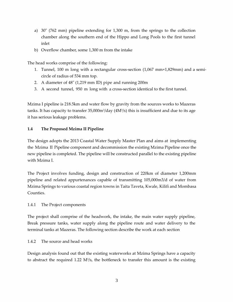
a) 30" (762 mm) pipeline extending for 1,300 m, from the springs to the collection
chamber along the southern end of the Hippo and Long Pools to the first tunnel
inlet
b) Overflow chamber, some 1,300 m from the intake
The head works comprise of the following:
1. Tunnel, 100 m long with a rectangular cross-section (1,067 mm×1,829mm) and a semi-
circle of radius of 534 mm top.
2. A diameter of 48" (1,219 mm ID) pipe and running 200m
3. A second tunnel, 950 m long with a cross-section identical to the first tunnel.
Mzima I pipeline is 218.5km and water flow by gravity from the sources works to Mazeras
tanks. It has capacity to transfer 35,000m3/day (4M3/s) this is insufficient and due to its age
it has serious leakage problems.
1.4 The Proposed Mzima II Pipeline
The design adopts the 2013 Coastal Water Supply Master Plan and aims at implementing
the Mzima II Pipeline component and decommission the existing Mzima Pipeline once the
new pipeline is completed. The pipeline will be constructed parallel to the existing pipeline
with Mzima I.
The Project involves funding, design and construction of 220km of diameter 1,200mm
pipeline and related appurtenances capable of transmitting 105,000m3/d of water from
Mzima Springs to various coastal region towns in Taita Taveta, Kwale, Kilifi and Mombasa
Counties.
1.4.1 The Project components
The project shall comprise of the headwork, the intake, the main water supply pipeline,
Break pressure tanks, water supply along the pipeline route and water delivery to the
terminal tanks at Mazeras. The following section describe the work at each section
1.4.2 The source and head works
Design analysis found out that the existing waterworks at Mzima Springs have a capacity
to abstract the required 1.22 M3/s, the bottleneck to transfer this amount is the existing
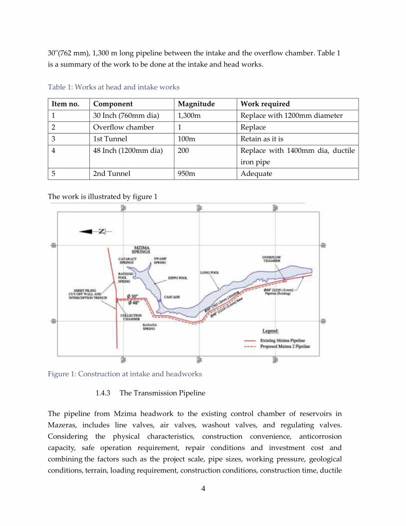
4
30"(762 mm), 1,300 m long pipeline between the intake and the overflow chamber. Table 1
is a summary of the work to be done at the intake and head works.
Table 1: Works at head and intake works
Item no. Component Magnitude Work required
1 30 Inch (760mm dia) 1,300m Replace with 1200mm diameter
2 Overflow chamber 1 Replace
3 1st Tunnel 100m Retain as it is
4 48 Inch (1200mm dia) 200 Replace with 1400mm dia, ductile
iron pipe
5 2nd Tunnel 950m Adequate
The work is illustrated by figure 1
Figure 1: Construction at intake and headworks
1.4.3 The Transmission Pipeline
The pipeline from Mzima headwork to the existing control chamber of reservoirs in
Mazeras, includes line valves, air valves, washout valves, and regulating valves.
Considering the physical characteristics, construction convenience, anticorrosion
capacity, safe operation requirement, repair conditions and investment cost and
combining the factors such as the project scale, pipe sizes, working pressure, geological
conditions, terrain, loading requirement, construction conditions, construction time, ductile

5
iron pipe is selected as the pipe material as the main pipeline. Mild steel pipe shall be used
for crosses barriers such as railways, roads and rivers. The recommended protective
measures for both steel and Ductile Iron components are specified in the detailed technical
report. The pipe diameters for construction area DN1400, DN1200, DN1000, DN900; the
total length of transmission pipeline is 219.4km.
Table 2: Works components and operations at various sections of the proposed project
System Component DI Pipe
specifications
Length (km) Chlorination site
Source works (Between the intake and
tunnel inlet chamber) DN1200 2.1 -
Headworks chamber to BPT1
DN1400 9.9 Χ
DN1200 30.7
15m×13m×2m, 400m3
BPT1 to BPT2 (Voi Junction)
DN1400 15.4 Χ
DN1200 23.8
15m×15m×5m×2, 1125m3× 2 (tanks)
BPT2 (Voi Junction) to BPT3
DN1000 1.7 -
DN700 8.0
15m×13m×2m, 400m3
BPT3 to BPT4
DN900 18.8 -
DN700 1.9
15m×13m×2m, 400m3
BPT4 to BPT5 DN900 24.5 -
15m×13m×2m, 400m3
BPT5 to BPT6
DN900 4.4 -
DN800 5.3
15m×13m×2m, 400m3
BPT6 to BPT7
DN1000 9.4 -
DN900 5.5
15m×13m×2m, 400m3
BPT7 to BPT8
DN900 13 -
DN800 8.9
15m×13m×2m, 400m3
BPT8 to BPT9 DN900 9.1
15m×13m×2m, 400m3
BPT9 to Mariakani Junction DN900 12.9 Χ

6
System Component DI Pipe
specifications
Length (km) Chlorination site
15m×15m×5m×2, 1125m3× 2 (tanks)
Mariakani junction to BPT10
DN900 2.2 -
DN800 3.3
15m×13m×2m, 400m3
BPT10 to Mazeras Reservoir
DN900 6.5 Χ
DN800 3.0
15m×13m×2m, 400m3
Crosses A109 highway twice DN1200 pipeline
Crosses railway twice DN1200 pipeline
Crosses a river with 20m width once DN900 pipeline
Crosses a river with 25m width twice DN800 pipeline
1.4.4 Break Pressure Tank (BPT)
Reinforced Concrete Break Pressure Tanks with volume of 400m3 are design to regulating
pressure along the pipeline and also provides safety in case of pipe burst as valves limit the
discharge. A total of 10 BPTs are designed along the pipeline, each station includes 2 (twin) break
pressure tanks, two float valves installed at the inlet of each tank to regulate the water level and
flow meter installed at the outlet of break pressure tank.
1.4.5 Disinfection Facilities
Rehabilitating and upgrade of the existing disinfection facility to cope with the increased
abstraction is considered. For urban use, chlorination and disinfection will always be a “must”
before supplying portable water to consumers.
1.4.6 Access Road
The proposed pipeline will be parallel to the existing one. The service road of the existing pipeline
is in bad condition, rehabilitation shall be required for the construction of the proposed pipeline.
The existing 30m reserve will be adequate for the new pipeline and access road.
1.4.7 Consideration of water off-takes
The new 219.4km pipeline aims at conveying 105,000 m3/day of water at its ultimate design period
(2035) from Mzima Springs to various coastal counties as summarized below.

7
Table 3: Supply of water enroute to Mombasa
County Town Amount m3/day Supply system
Taita
Taveta
Voi/Maungu 16358 Pumping
Mwatate 4665
Wundanyi 4777
Kilifi Mariakani 10150
The balance of 59,050m3 per day shall be supplied to the city of Mombasa. Figure 2
illustrates the whole project operation.

8
Figure 2: Schematic representation of the Mzima II pipeline

9
1.5 Analysis of Alternatives
I. The ‘No action’ alternative ( Maintain Mzima I Pipeline)
From a biophysical environmental perspective, this may be the best option. Without the
development, the area (especially the Mzima springs and the Tsavo West national Park) would
remain a relatively undisturbed area providing a habitat for the varied flora and fauna presently
observed. This area will continue to be impacted, although minimally, by anthropogenic and
natural factors. From a socio-economic perspective the “No action” alternative may not be the
best alternative as the numerous benefits to be gained from the development both locally and
nationally would not be realised and the resources in the area would continue to be underutilized.
The “No Action Alternative” would mean retaining the old Mzima I pipeline. This pipeline has
outlived its design life, is characterized by bursts and leaks. This is in turn accompanied by
massive losses of water, frequent interruptions of water supply which exposes the citizens in the
affected areas to untold suffering. This alternative which would maintain the status quo is thus
not the best.
II. Construct Mzima II while maintaining Mzima I
This alternative would entail constructing a new pipeline to augment the existing one. Essentially,
Mzima 1 will remain operational while Mzima II would run parallel. This alternative falls because
Mzima I is old and dilapidated. The costs of maintaining it far outweighs the benefits of
maintaining it. It is better decommissioned than rehabilitated.
III. The Preferred Alternative (Constructing Mzima II pipeline and decommission Mzima
I)
This entails implementing Mzima II water pipeline project as described in section 1.4 (Above).
The benefits are enormous which include but not limited to:
Adequate water supply to populations along the corridor.
Reduced water wastage.
Easier maintenance since pipes to be used are made of ductile iron.
1.6 The Objectives of this EIA
To describe the proposed development project;
To describe the legislative and regulatory considerations associated with the project;
To describe the present status of the environment on the project site;
To describe the present status of the socio-economic attributes of the project site;
10
To identify and predict any potential positive, negative, reversible, irreversible, short and
long term impacts, as well as any cumulative and synergistic environmental and socio-
economic impacts that may arise from the project;
To assess the hazards associated with the development;
To facilitate mitigation of possible negative impacts caused by the proposed development;
To recommend measures to enhance any positive impacts identified;
To outline possible alternatives to the project; and
To outline a suitable environmental management and monitoring plan for the

11
2.0 ENVIRONMENTAL IMPACT ASSESSMENT APPROACH AND
METHODOLOGY
2.1 Introduction
Having understood the scope of work presented by the Client, the Consultant undertook the task
of EIA for proposed project by clearly defining the assignment into a number of discrete activities.
These activities facilitated development of a workable framework for the speedy and timely
execution of the assignment. The EIA study was conducted in accordance with the Terms of
Reference provided in the Environmental (Impact Assessment and Audit) Regulations, 2003.
To adequately address the environmental issues emanating from the implementation of the
proposed project, the Consultant carried out environmental study in the entire project area. The
project covers the source of water all the way to the reservoirs. The environmental impact
assessment study comprised the following activities: mobilization, consultation with
stakeholders, a screening and scoping exercise, desk and field studies, data analysis, impact
identification, and analysis of health and safety issues associated with the proposed project.
2.2 Mobilization, Liaison and Consensus Building with Stakeholders
The Consultant liaised with all the relevant stakeholders in the project area. This facilitated
consensus building and enabled all the stakeholders to understand the scope of work.
Consultation and consensus continued through all the phases of this consultancy so as to get all
the stakeholders on board with a view of coming up with the most accommodating and viable
option.
2.3 Scoping Exercise
A scoping exercise was conducted to identify cardinal issues that were addressed during the EIA
Study. A simple checklist of anticipated impacts was used to guide the scoping exercise. Key
issues were also picked during the Public consultation meetings and interviews with Lead
Agencies Representatives.
2.4 Terms of Reference (TOR)
The study was carried out in line with the TOR developed by the EIA Team in keeping with the
EIA/EA Regulations 2003.

12
2.5 Desk Study
Following the completion of the scoping exercise the Consultant embarked on a desk study in
order to gather environmental information of the project area. Document Analysis approach was
employed to obtain relevant information on the political, social, economic and biophysical
characteristics of the project area and its environs. Project designs reports and plans, Government
of Kenya Reports, maps, district development plans, State of Environment Reports, were the key
documents utilized towards this end.
2.6 Field Study
Review of available information of the project area during the desk study revealed information
gaps and the Consultant arranged for a field study. An extensive field survey was carried out to
obtain baseline data to complement information gathered during the desk study. In addition,
land use and other environmental attributes likely to be affected by the project activities were
assessed.
To collect data during the field study, a constellation of methods were used. These include:
Unstructured Observation
Key informants’ interviews,
Collection of water and air samples for analysis. (Appendix 15, and Appendix 16).
Noise measurement (Appendix 17).
2.7 Public Consultation
In conforming to the environmental legislation, Interested and Affected Parties (I&AP’s) were
consulted. To elicit information form the various “Publics”, different methods were employed.
This is because data needed varied from stakeholder to another thus calling for variance in
consultation method.
i. An Open House (Baraza): This method is effective in that it gives an even stimulus in the
information passed. It also provides an opportunity to know the community mood as far
as the proposed project is concerned. In addition it is possible to know whether the public
is united or Divided as far as the proposed project is concerned. In areas of low literacy,
such as the project area, this is the most preferred approach as opposed to questionnaires.
Views were recorded as minutes for the meeting. There was support for the proposed
Mzima II that emanated from awareness among the public. They appreciated the need for
the proposed project.

13
ii. Key Informants’ Interviews: These targeted Lead Agency representatives and other
Institutional stakeholders. The speciality in their different areas of operation called for
candid engagements which could only be achieved through close interactions.
iii. Phone Interviews: This was employed to consult Key Informants who were not available
for Direct Interviews due to their engagements during the EIA study.
iv. Questionnaires: They were employed during the Household Survey
14
3.0 RELEVANT LEGISLATIVE AND POLICY FRAMEWORKS
3.1 Introduction
There are a number of pertinent laws relating to environmental protection that are applicable to
any development and that a developer will need to be aware of when embarking on a particular
type of development. There are also several statutory agencies that have powers to control certain
types of development that have the potential to affect the environment. These powers of control
are typically exercised through a system of permits that induce checks and balances on what kind
and form of development can occur.
A developer therefore must be prepared to present, explain, and in some cases alter an aspect of
a proposal in order to comply with the permitting requirements. This section is therefore intended
as a guide to the relevant permitting requirements that deal with the environmental impacts of
this proposed development and the agencies to which they relate as well as presents other
legislation and regulations, which are applicable to the development.
The prime purpose of this section is to provide the proponent with quick reference to the critical
legal and policy provisions to enable proper planning and impact assessment during project
planning and implementation. Environmental Management and Coordination Act (EMCA)
(Amended 2015) is the principle law of environmental management. This framework law
guarantees every Kenyan the right to a clean and healthy environment.
3.2 The Constitution of Kenya
The provisions of Chapter IV (Protection of Fundamental Rights and Freedoms of The Individual)
protects citizens from deprivation of property. No property of any description shall be
compulsorily taken possession of, and no interest in or right over property of any description
shall be compulsorily acquired, except where it is necessary for public interest. Every person has
also the right to a clean and healthy environment, which includes the right to have the
environment protected for the benefit of present and future generations through legislative and
other measures.
Chapter V (Land and Environment) of the Constitution gives provisions of protecting land,
environment and natural resources. The State is required to:—
Ensure sustainable exploitation, utilization, management and conservation of the
environment and natural resources, and ensure the equitable sharing of the accruing
benefits;

15
Work to achieve and maintain a tree cover of at least ten per cent of the land area of Kenya;
Protect and enhance intellectual property in, and indigenous knowledge of, biodiversity
and the genetic resources of the communities;
Encourage public participation in the management, protection and conservation of the
environment;
Protect genetic resources and biological diversity;
Establish systems of EIA, environmental audit and monitoring of the environment;
Eliminate processes and activities that are likely to endanger the environment; and
Utilize the environment and natural resources for the benefit of the people of Kenya.
Every person has a legal duty to cooperate with State organs and other persons to protect
and conserve the environment and ensure ecologically sustainable development and use
of natural resources.
3.3 Institutional Framework
There exists a host of institutions, which deal with environmental issues in Kenya. Some of the
key institutions include National Environmental Management Authority (NEMA), the
Department of Resource Surveys and Remote sensing (DRSRS), the Water Resources
Management Authority (WRMA), The Kenya Forest Service (KFS), the Kenya Wildlife Service
(KWS) the Kenya Forestry Research Institute (KEFRI), the National Museums of Kenya (NMK),
the Kenya Marine and Fisheries Research Institute (KEMFRI), the Kenya Agricultural and
Livestock Research Organisation (KARLO) among others. There are also local and international
NGOs involved in environmental issues in the country.
3.3.1 National Environmental Management Authority (NEMA)
The object and purpose for which NEMA is established is to exercise general supervision and co-
ordinate over all matters relating to the environment and to be the principal instrument of the
government in the implementation of all policies relating to the environment.
The functions of the Authority include among others to:
Co-ordinate the various environmental management activities being undertaken by the
lead agencies and promote the integration of environmental considerations into
development policies, plan, programmes and projects with a view to ensuring the proper
management and rational utilization of the environmental resources on a sustainable
yield basis for the improvement of the quality of human life in Kenya.
Take stock of the natural resources in Kenya and their utilization’s and consultation, with
the relevant lead agencies, land use guidelines.
16
Examine land use patterns to determine their impact on the quality and quantity of the
natural resources.
Carry out surveys, which will assist in the proper management and conservation of the
environment.
Advise the government on legislative and other measures for the management of the
environment or the implementation of relevant international conservation treaties and
agreements in the field of environment as the case may be.
Advise the government on regional and international environmental convention treaties
and agreements to which Kenya should be a party and follow up the implementation of
such agreements where Kenya is a party.
Undertake and co-ordinate research, investigation and surveys in the field of environment
and collect and disseminate information about the findings of such research, investigation
or survey.
Mobilize and monitor the use of financial and human resources for environmental
management.
3.3.2 National Environment Action Plan Committee
This Committee is responsible for the development of a 5-year Environment Action Plan among
other things. The National Environment Action Plan shall:
Contain analysis of the Natural Resources of Kenya with an indication as to any pattern
of change in their distribution and quantity over time.
Contain analytical profile of the various uses and value of the natural resources
incorporating considerations of intergenerational and intra-generational equity.
Recommend appropriate legal and fiscal incentives that may be used to encourage the
business community to incorporate environmental requirements into their planning and
operational processes.
Recommend methods for building national awareness through environmental education
on the importance of sustainable use of the environment and natural resources for
national development.
Set out operational guidelines for the planning and management of the environment and
natural resources.
Identify actual or likely problems as may affect the natural resources and the broader
environment context in which they exist.
Identify and appraise trends in the development of urban and rural settlements, their
impact on the environment, and strategies for the amelioration of their negative impacts.
Propose guidelines for the integration of standards of environmental protection into
development planning and management.

17
Identify and recommend policy and legislative approaches for preventing, controlling or
mitigating specific as well as general diverse impacts on the environment.
Prioritise areas of environmental research and outline methods of using such research
findings.
3.4 Environmental Management and Co-ordination Act (EMCA) (Amended 2015)
Environmental Management and Co-ordination Act) (Amended 2015), is the principle statute
providing legal and institutional framework for the management of all environment related
matters in Kenya. It is the framework law on environment, which was enacted on the 14th of
January 1999 and commenced in January 2002. The Act is the legislation that governs EIA studies.
The Proponent carried out an ESIA as per the second schedule of this act. The proposed project
is cited in the Second Schedule of EMCA as requiring an EIA License before commencement. The
Act provides for the National Environmental Management Authority (NEMA) whose objective
and purpose is to exercise general supervision and coordination over all matters relating to the
environment and to be the principal instrument of the Government in the implementation of all
policies relating to the environment.
Following the Gazettement of Environmental (Impact Assessment and Audit Regulations), (2003),
the submission of environmental impact assessment reports became mandatory. According to
these regulations no proponent shall implement a project likely to have adverse environmental
impact or for which an EIA has not been concluded and approved in accordance with these
regulation. This proposed Mzima II Pipeline Project falls within Schedule 2 of EMCA and
therefore requires an EIA is required.
In a bid to comply with the Act and these Regulations, Proponent has commissioned the EIA.
The Proponent shall be required to commit to implementing the environmental management plan
laid out in this report and any other conditions laid out by NEMA, prior to being issued an EIA
license.
To operationalize EMCA, various Regulations have been gazetted over the years. These
Regulations touch on different components of the environment and they include:

18
3.4.1 Environmental Impact Assessment and Audit Regulations, 2003
Environmental Impact Assessment (EIA) is a critical examination of the effects of a project on the
environment. The goal of an EIA is to ensure that decisions on proposed projects and activities
are environmentally sustainable. An EIA is conducted in order to identify impacts of a project on
the environment, predict likely changes on the environment as a result of the development,
evaluate the impacts of the various alternatives on the project and propose mitigation measures
for the potential significant negative impacts of the project on the environment.
The EMCA, requires that during the EIA process a proponent shall in consultation with the
Authority seek views of persons who may be affected by the project or activity through posters,
newspaper, radio and hold at least three public meetings with the affected parties and
communities. The Project proponent pays for the entire EIA process.
Conversely, Environmental Audit (EA) is the systematic documentation, periodic and objective
evaluation of activities and processes of an ongoing project. The goal of EA is to establish if
proponents are complying with environmental requirements and enforcing legislation. The
purpose of EA is to determine the extent to which the activities and programs conform to the
approved environmental management plan. A comprehensive EA ensures a safe and healthy
environment at all stages of project operations and decommissioning.
This report complies with the requirements of the Environmental Regulations in the coverage of
environmental issues, project details, impacts, legislation, mitigation measures, management
plans and procedures. The Proponent shall be required to commit to implementing the
environmental management plan laid out in this report and any other conditions laid out by
NEMA.
3.4.2 Water Quality Regulations, 2006 (Legal Notice No. 121)
Water Quality Regulations apply to water used for domestic, industrial, agricultural, and
recreational purposes; water used for fisheries and wildlife purposes, and water used for any
other purposes. Different standards apply to different modes of usage. These regulations provide
for the protection of lakes, rivers, streams, springs, wells and other water sources.
The objective of the regulations is to protect human health and the environment. The effective
enforcement of the water quality regulations will lead to a marked reduction of water-borne
diseases and hence a reduction in the health budget. The regulations also provide guidelines and

19
standards for the discharge of poisons, toxins, noxious, radioactive waste or other pollutants into
the aquatic environment in line with the Third Schedule of the regulations. The regulations have
standards for discharge of effluent into the sewer and aquatic environment. While it is the
responsibility of the sewerage service providers to regulate discharges into sewer lines based on
the given specifications, NEMA regulates discharge of all effluent into the aquatic environment.
Everyone is required to refrain from any actions, which directly or indirectly cause water
pollution, whether or not the water resource was polluted before the enactment of the
Environmental Management and Coordination Act (EMCA) Gazetted in 1999. It is an offence to
contravene the provisions of these regulations with a fine not exceeding five hundred thousand
shillings.
The Proponent shall ensure that the entire project lifecycle (Pre-construction, construction,
operation and decommissioning) of Mzima II complies with these regulations to ensure that
integrity of water is maintained.
3.4.3 Waste Management Regulations, 2006 (Legal notice No. 121)
The Environmental Management and Coordination (Waste Management) Regulations, 2006 are
meant to streamline the handling, transportation and disposal of various types of waste. The aim
of the Waste Management Regulations is to protect human health and the environment.
Currently, different types of waste are dumped haphazardly posing serious environmental and
health concerns. The regulations place emphasis on waste minimization, cleaner production and
segregation of waste at source.
The Proponent shall:
Observe the guidelines as set out in the environmental management plan laid out in this
report as well as the recommendation provided for mitigation /minimization /avoidance
of adverse impacts arising from the Project activities.
Engage licensed waste handlers to deal with various categories of wastes that m might
be generated in the entire lifecycle of the project.
Apply for necessary permits for handling wastes (solid and liquid)
Since solid waste management is a devolved function, the Proponent shall Collaborate
with the respective County Governments in addressing waste matters related to the
proposed project
3.4.4 Controlled Substances Regulations, 2007 (Legal Notice No.73 of 2007)
The Controlled Substances Regulations defines controlled substances and provides guidance on
how to handle them. This regulation mandates NEMA to monitor the activities of persons
handling controlled substances, in consultation with relevant line ministries and departments, to
20
ensure compliance with the set requirements. Under these regulations, NEMA will always be
publishing a list of controlled substances and the quantities of all controlled substances imported
or exported.
The list will also indicate all persons holding licenses to import or export controlled substances,
with their annual permitted allocations. The regulations stipulate that controlled substances must
be clearly labeled with among other words, “Controlled Substance-Not ozone friendly’’) to
indicate that the substance or product is harmful to the ozone layer. Advertisement of such
substances must carry the words, “Warning: Contains chemical materials or substances that
deplete or have the potential to deplete the ozone layer.”
Producers and/or importers of controlled substances are required to include a material safety data
sheet. Persons are prohibited from storing, distributing, transporting or otherwise handling a
controlled substance unless the controlled substance is accompanied by a material safety data
sheet. Manufacturers, exporters or importers of controlled substances must be licensed by
NEMA. Further, any person wishing to dispose of a controlled substance must be authorized by
NEMA. The licensee should ensure that the controlled substance is disposed of in an
environmentally sound manner. These regulations also apply to any person transporting such
controlled substances through Kenya. Such a person is required to obtain a Prior Informed
Consent (PIC) permit from NEMA.
3.4.5 Conservation of Biodiversity Regulations 2006
These are supposed to ensure Conservation of Biodiversity in the country because, Kenya has a
large diversity of ecological zones and habitats including lowland and mountain forests, wooded
and open grasslands, semi-arid scrubland, dry woodlands, and inland aquatic, and coastal and
marine ecosystems. In addition, a total of 467 lake and wetland habitats are estimated to cover
2.5% of the territory. In order to preserve the country’s wildlife, about 8% of Kenya’s land area is
currently under protection. One requires NEMA approvals is areas of rich biodiversity are going
to be affected by a development project.
3.4.6 Air Quality Regulations, 2008
The objective these Regulations is to provide for prevention, control and abatement of air
pollution to ensure clean and healthy ambient air. It provides for the establishment of emission
standards for various sources, including as mobile sources (e.g. motor vehicles) and stationary
sources (e.g. industries) as outlined in the Environmental Management and Coordination Act,
1999. It also covers any other air pollution source as may be determined by the Minister in

21
consultation with the Authority. Emission limits for various areas and facilities have been set.
The regulations provide the procedure for designating controlled areas, and the objectives of air
quality management plans for these areas.
The Proponent shall observe policy and regulatory requirements and implement the mitigation
measures proposed in this document in an effort to comply with the provisions of these
Regulations on abatement of air pollution.
3.4.7 Noise and Excessive Vibration Pollution Control Regulations, 2009
These regulations were published as legal Notice No. 61 being a subsidiary legislation to the
Environmental Management and Co-ordination Act, 1999. The Regulations provide information
on the following:
Prohibition of excessive noise and vibration.
Provisions relating to noise from certain sources
Provisions relating to licensing procedures for certain activities with a potential of
emitting excessive noise and/or vibrations and
Noise and excessive vibrations mapping
According to regulation 3 (1), no person shall make or cause to be made any loud, unreasonable,
unnecessary or unusual noise which annoys, disturbs, injures or endangers the comfort, repose,
health or safety of others and the environment.
Regulation 4 prohibits any person to (a) make or cause to be made excessive vibrations which
annoy, disturb, injure or endanger the comfort, repose, health or safety of others and the
environment; or (b) cause to be made excessive vibrations which exceed 0.5 centimeters per
second beyond any source property boundary or 30 metres from any moving source. Regulation
5 further makes it an offence for any person to make, continue or cause to be made or continued
any noise in excess of the noise levels set in the First Schedule to these Regulations, unless such
noise is reasonably necessary to the preservation of life, health, safety or property.
The Proponent shall observe policy and regulatory requirements and implement the
measures proposed in this documenting an effort to comply with the provisions of the
Regulations.
If need be, the Proponent will apply for relevant licenses as per this Regulations.
3.4.8 Wetlands, River Banks, Lake Shores and Sea Shore Management Regulation, 2009
This Act applies to all wetlands in Kenya whether occurring in private or public land. It contains
provisions for the utilization of wetland resources in a sustainable manner compatible with the

22
continued presence of wetlands and their hydrological, ecological, social and economic functions
and services. The project traverses several rivers, wetlands and streams.
The Proponent shall comply with the provisions of the Act in protecting wetlands, preventing
and controlling pollution and siltation of rivers.
3.4.9 Prevention of pollution in Coastal Zone and other Segments of the Environment)
Regulation, 2003
The objective of these Regulations is to provide for prevention, control and abatement measures
of shipping activities to ensure harmful substances or effluents are not released into the sea or
ocean. The Proponent shall comply with the provisions of the regulation in protecting coastal
environment.
3.5 The Water Act, 2016
The Water Act, 2002 provides the legal framework for the management, conservation, use and
control of water resources and for the acquisition and regulation of right to use water in Kenya.
It also provides for the regulation and management of water supply and sewerage services. In
general, the Act gives provisions regarding ownership of water, institutional framework, national
water resources, management strategy, and requirement for permits, state schemes and
community projects. Part IV of the Act addresses the issues of water supply and sewerage. The
project shall have no adverse impact on the local water supply during operations as there are no
requirements for the installation of water supply and sanitation facilities on-site.
Requirements of the Act shall be observed by the Proponent especially throughout the entire
project lifecycle.
3.6 Wildlife Management and Conservation Act, Cap 376
This Act provides for the protection, conservation and management of wildlife in Kenya. The
provisions of this Act should be applied in the management of the project. Part III Section 13
subsection (I) stipulates that any person who not being an officer of Kenya Wildlife Service hunts
any animal in a National Park shall be guilty of a forfeiture offence and liable to a fine or
imprisonment. Subsection 2 of the Act likewise provides that any person who, without
authorization conveys into a National Park, or being within the area thereof, in possession of, any
weapon, ammunition, explosive, trap or poison, shall be guilty of a forfeiture offence. The Act
provides that no person is allowed to use any aircraft, motor vehicle or mechanically propelled
vessel in such a manner as to drive, stampede or unduly disturb any protected animal or game

23
animal. Therefore it will be prudent that the construction workforce is conversant with the
provisions of this Act.
The Proponent shall implement the proposed measures in this document towards protection and
conservation of wildlife in the project areas.
3.8 The Agricultural Act (Cap 318)
Legislative control over soil conversation and land development are mainly controlled within this
Act, and many of the provisions can be generally applied beyond those lands suitable for
agriculture. The Minister administering the Act, after concurrence with the Central Agricultural
Board and consultation with the District Agricultural Committee, can impose land conservation
orders on lands to control cultivation, grazing and clearing. These controls may be necessary to
protect the land against soil erosion, to protect fertility, and to maintain catchments. Local
authorities are generally empowered to administer these sections of the Act, and the District
Agricultural Committee is entitled to make regulations relating to these controls. Agricultural
Rules are prescribed under the Act, whereby vegetation clearing in steep slopes areas or adjacent
watercourses, without authorization, is controlled.
3.9 Energy Act, 2006
The Energy Act 2006 became law on 2nd January 2007. The Act establishes an energy commission,
which is expected to become the main policy maker and enforcer in the energy sector. With this
Act, all the different aspects of energy e.g. electricity, petroleum and renewable energy are
brought under one ambit unlike as was the case before.
3.10 Forest Act, 2005
The Act highlights the integration of the community on the management, utilization and
conservation of forests and its resources. It prohibits wanton destruction of the forests. As hydro
dams depends on good water catchments protection and management, on the upstream and
around the reservoirs the enforcement of this Act will minimize the flow of sediments into the
rivers which are being utilized for generation of hydro-electric power generation.
There are no formally identified forests along line routes, which will require adherence to this
Act.

24
3.11 The Occupational Safety and Health Act, 2007
This Act applies to all workplaces where any person is at work, whether temporarily or
permanently. The purpose of this Act is to secure the safety, health and welfare of persons at
work, and protect persons other than persons at work against risks to safety and health arising
out of, or in connection with, the activities of persons at work. Some of the areas addressed here
are machinery safety, chemical safety and health and safety. Failure to comply with the OSHA,
2007 attracts penalties of up to KES 300,000 or 3 months jail term or both or penalties of KES
1,000,000 or 12 months jail term or both for cases where death occurs and is in consequence of the
employer.
The EIA identifies various actions that can cause breach in safety with respect to the proposed
project. Measures to avert such breaches have been identified. In addition, the Proponent has
been advised on safety and health aspects, potential impacts, personnel responsible for
implementation and monitoring, frequency of monitoring, and estimated cost, as a basic
guideline for the management of Health and Safety issues in the proposed project.
3.12 Public Health Act 1986
The public Health Act regulates activities detrimental to human Health. An environmental
nuisance is one that causes danger, discomfort or annoyance to the local inhabitants or which is
hazardous to human health. The Act prohibits activities (nuisances) that may be injurious to
health. The primary purpose of the Act is to secure and maintain public health. It defines
nuisances on land and premises and empowers public health authorities to deal with such
conditions.
Part IX, section 115, of the Act states that no person/institution shall cause nuisance or condition
liable to be injuries or dangerous to human health. Section 116 requires that Local Authorities
take all lawful, necessary and reasonably practicable measures to maintain their jurisdiction clean
and sanitary to prevent occurrence of nuisance or condition liable to be injuries or dangerous to
human health.
On responsibility of the Local Authorities Part XI, section 129, of the Act states in part “It shall be
the duty of every local authority to take all lawful, necessary and reasonably practicable measures
for preventing any pollution dangerous to health of any supply of water which the public within
its district has a right to use and does use for drinking or domestic purposes. Section 130 provides
for making and imposing regulations by the local authorities and others the duty of enforcing
rules in respect of prohibiting use of water supply or erection of structures draining filth or
noxious matter into water supply as mentioned in section 129. This provision is supplemented
by section 126A that requires local authorities to develop by laws for controlling and regulating

25
among others private sewers, communication between drains, power lines, and sewers as well as
regulating sanitary conveniences in connection to buildings, drainage, cesspools, etc. for
reception or disposal of foul matter. Part XII, Section 136, states that all collections of water,
sewage, rubbish, refuse and other fluids which permits or facilitates the breeding or
multiplication of pests shall be deemed nuisances and are liable to be dealt with in the matter
provided by this Act.
The Proponent shall observe policy and regulatory requirements and implement measures to
safeguard public health and safety.
3.13 Physical Planning Act (Cap 286)
An Act of Parliament to provide for the preparation and implementation of physical development
plans and for connected purposes enacted by the Parliament of Kenya Under this Act, no person
shall carry out development within the area of a local authority without a development
permission granted by the local authority under section 33. The local authority concerned shall
require the developer to restore the land on which such development has taken place to its
original condition within a period of not more than ninety days. If on the expiry of the ninety
days notice given to the developer such restoration has not been affected the concerned local
authority shall restore the site to its original condition and recover the cost incurred thereto from
the developer.
The Proponent shall secure all mandatory approvals and permits as required by the law.
3.15 Way Leaves Act (Cap. 292)
The Act provides for certain undertakings to be constructed e.g. rail lines transmission lines,
pipelines, canals, pathways etc., through, over or under any lands. This project is under the
provision of the Act. Section 3 of the Act states that the Government may carry any works
through, over or under any land whatsoever provided it shall not interfere with any existing
building or structures of an ongoing activity. In accordance with the Act (section 4), notice will
be given before carrying out works with full description of the intended works and targeted place
for inspection. Any damages caused by the works would then be compensated to the owner as
per section.
The proposed project will occupy the set wayleave. There will be no need to acquire more land to
expand the way leave

26
3.16 Trust Lands Act, 2010
This Act applies to all land which for the time being is Trust land. Under Section 38, a way leave
license may be granted to any person empowering him and his servants and agents to enter upon
Trust land vested in the Council and to lay pipes, make canals, aqueducts, weirs and dams and
execute any other works required for the supply and use of water, to set up electric power or
telephone lines, cables or aerial ropeways and erect poles and pylons therefore, and to make such
excavations as may be necessary for the carrying out of any such purposes, and to maintain any
such works as aforesaid. However, compensation for loss of the use of land in any case where the
usefulness of the land for agricultural purposes is impaired must be made before the license is
awarded.
3.17 The Land Registration Act, 2012
The Land Registration Act is place to revise, consolidate and rationalize the registration of titles
to land, to give effect to the principles and objects of devolved government in land registration,
and for connected purposes. This Act applies to Subject to section 4, this Act shall apply to:
(a) Registration of interests in all public land as declared by Article 62 of the Constitution;
(b) Registration of interests in all private land as declared by Article 64 of the Constitution; and
(c) Registration and recording of community interests in land.
Section 24 states that: (a) the registration of a person as the proprietor of land shall vest in that
person the absolute ownership of that land together with all rights and privileges belonging or
appurtenant thereto; and (b) the registration of a person as the proprietor of a lease shall vest in
that person the leasehold interest described in the lease, together with all implied and expressed
rights and privileges belonging or appurtenant thereto and subject to all implied or expressed
agreements, liabilities or incidents of the lease.
3.18 The Environment and Land Court Act, 2011
This Act is in place to give effect to Article 162(2) (b) of the Constitution; to establish a superior
court to hear and determine disputes relating to the environment and the use and occupation of,
and title to, land, and to make provision for its jurisdiction functions and powers, and for
connected purposes.
3.19 The National Land Commission Act, 2012 (No. 5 of 2012)
Section 5 of the Act outlines the Functions of the Commission, pursuant to Article 67(2) of the
Constitution as follows 5(1):-

27
(a) to manage public land on behalf of the national and county governments;
(b) to recommend a national land policy to the national government;
(c) to advise the national government on a comprehensive programme for the registration of title
in land throughout Kenya;
(d) to conduct research related to land and the use of natural resources, and make
recommendations to appropriate authorities;
(e) to initiate investigations, on its own initiative .or on a complaint, into present or historical land
injustices, and recommend appropriate redress;
(f) to encourage the application of traditional dispute resolution mechanisms in land conflicts;
(g) to assess tax on land and premiums on immovable property in any area designated by law;
and
(h) to monitor and have oversight responsibilities over land use planning throughout the country.
3.20 The Land Act, 2012
This is an ACT of Parliament to give effect to Article 68 of the Constitution, to revise, consolidate
and rationalize land laws; to provide for the sustainable administration and management of land
and land based resources, and for connected purposes. Part viii of this ACT provides procedures
for compulsory acquisition of interests in land.
Section 111 (1) States that if land is acquired compulsorily under this Act, just compensation shall
be paid promptly in full to all persons whose interests in the land have been determined. The Act
also provides for settlement programmes. Any dispute arising out of any matter provided for
under this Act may be referred to the Land and Environment Court for determination.
The proponent endevours to use the existing wayleave where Mzima I runs along. In case there
is need for more land for Mzima II, it will be acquired in accordance with this Act.
3.21 Land Adjudication Act, 2010
This Act applies to any area of Trust land where the County in whom the land is vested so
requests; and the Minister considers it expedient that the rights and interests of persons in the
land should be ascertained and registered; and where the Land Consolidation Act does not apply
to the area.
The Proponent will undertake a survey with extensive public consultations in the affected project
area and commission a Resettlement Action Plan (RAP) study to comply with the provisions of
the Act.

28
3.22 The Standards Act Cap 496
The Act is meant to promote the standardization of the specification of commodities, and to
provide for the standardization of commodities and codes of practice; to establish a Kenya Bureau
of Standards, to define its functions and provide for its management and control. Code of practice
is interpreted in the Act as a set of rules relating to the methods to be applied or the procedure to
be adopted in connection with the construction, installation, testing, sampling, operation or use
of any article, apparatus, instrument, device or process.
The Proponent shall ensure that commodities and codes of practice utilized in the project adhere
to the provisions of this Act.
3.23 Kenya Railways Corporation Act (Cap. 397), 1979
The Kenya Railways Corporation was established by an Act of Parliament (Cap 397) of the Laws
of Kenya, and commenced operations on January 20, 1978. The overall mandate of the
Corporation then was to provide a coordinated and integrated system within Kenya of rail and
inland waterways transport services and inland port facilities. Rail transport is the second most
important mode of transport in Kenya, after road transport. The nature of Kenya Railways, its
operations and business are defined by this Act. Currently, operations of Kenya Railways lie on
a national network of railway tracks covering a total distance of 2,778 km. The land corridor on
which the rail tracks are laid belongs to Kenya Railways. Under the Vesting of Land Order of
1996 made under the Act, Kenya Railways owns the land corridor of 60 metres on for the main
running line.
The proponent to work closely with the KRC where the proposed pipeline is in close proximity
with the old railway line and or the Standard Gauge Railway (SGR)
3.24 Public Roads and Roads of Access Act (Cap. 399)
Sections 8 and 9 of the Act provides for the dedication, conversion or alignment of public travel
lines including construction of access roads adjacent lands from the nearest part of a public road.
Section 10 and 11 allows for notices to be served on the adjacent land owners seeking permission
to construct the respective roads. During the construction phase of the project, access to the site
areas will be required for the construction vehicles.
Where roads do not exist, the Proponent shall seek permission from the appropriate authorities
to create such access during the construction phase.

29
3.25 Building Code 1997
The Local Government By-Laws include Building By-Laws that give the Municipalities or County
Councils powers to approve building plans. Such plans are expected to provide for public
buildings and factories among others. The By-Laws covers factory chimney shafts, stairs, lifts,
rain water disposal, refuse disposal, ventilation of buildings, drainage, sanitary conveniences,
sewers, septic and conservancy tanks, fire and means of escape in case of fire. Compliance with
this Act in up scaling of power supply is necessary. Section 194 requires that where sewer exists,
the occupants of the nearby premises shall apply to the local authority for a permit to connect to
the sewer line and all the wastewater must be discharged into sewers. The code also prohibits
construction of structures or buildings on sewer lines and under power lines.
This Act will apply to the Contractor’s yard and some staff housing facilities.
3.26 Penal Code Cap 63
Section 191 of the penal code states that if any person or institution that voluntarily corrupts or
foils water from public springs or reservoirs, rendering it less fit for its ordinary use is guilty of
an offence. Section 192 of the same act says a person who makes or vitiates the atmosphere in any
place to make it noxious to health of persons /institution, dwelling or business premises in the
neighbourhood or those passing along public way, commit an offence.
The Proponent shall observe the guidelines as set out in the environmental management and
monitoring plan laid out in this report as well as the recommendation provided for mitigation/
minimization/ avoidance of adverse impacts arising from the project activities.
3.27 The Antiquities and Monuments Act, 1983 Cap 215
The Act aims to preserve Kenya’s national heritage. Kenya is rich in its antiquities, monuments
and cultural and natural sites which are spread all over the country. The National Museums of
Kenya is the custodian of the country’s cultural heritage, its principal mission being to collect,
document, preserve and enhance knowledge, appreciation, management and the use of these
resources for the benefit of Kenya and the world. Through the National Museums of Kenya many
of these sites are protected by law by having them gazetted under the Act.
The proponent will ensure the cultural sites near or along the proposed Mzima II pipeline are
preserved. If there any chance finds, further excavations will cease and NMK will be notified
immediately

30
3.28 World Bank Safeguards Triggered by the Project
3.28.1 Environmental Assessment OP 4.01
This policy requires Environmental Assessment (EA) of projects proposed for Bank financing to
help ensure that they are environmentally sound and sustainable, and thus to improve decision
making. The EA is a process whose breadth, depth, and type of analysis depend on the nature,
scale, and potential environmental impact of the proposed investment. The EA process takes
into account the natural environment (air, water, and land); human health and safety; social
aspects (involuntary resettlement, indigenous peoples, and cultural property) and trans
boundary and global environmental aspects.
The World Bank assigns a project to one of three project categories, as defined below:
i. Category “A” Projects
An EIA is always required for projects that are in this category. Impacts are expected to be
‘adverse, sensitive, irreversible and diverse with attributes such as pollutant discharges large
enough to cause degradation of air, water, or soil; large-scale physical disturbance of the site
or surroundings; extraction, consumption or conversion of substantial amounts of forests and
other natural resources; measurable modification of hydrological cycles; use of hazardous
materials in more than incidental quantities; and involuntary displacement of people and other
significant social disturbances.
ii. Category “B” Projects
Although an EIA is not always required, some environmental analysis is necessary. Category B
projects have impacts that are ‘less significant, not as sensitive, numerous, major or diverse. Few,
if any, impacts are irreversible, and remedial measures can be more e a s i l y d e s i g n e d .’
Typical projects i n c l u d e r e h a b i l i t a t i o n , m a i n t e n a n c e , o r upgrades, rather
than new construction.
iii. Category “C” Projects
No EIA or other analysis is required. Category C projects result in negligible or minimal direct
disturbance of the physical environment. Typical projects include education, family planning,
health, and human resource development.
The proposed Mzima II project has been assigned a Category A and thus the current EIA.

31
3.28.2 Involuntary Resettlement (OP 4.12)
The objective of this policy to avoid where feasible, or minimize, exploring all viable
alternative project designs, to avoid resettlement. This policy is triggered in situations involving
involuntary taking of land and involuntary restrictions of access to legally designated parks and
protected areas. The policy aims to avoid involuntary resettlement to the extent feasible, or
to minimize and mitigate its adverse social and economic impacts.
This policy covers direct economic and social impacts that both result from Bank- assisted
investment projects, and are caused by (a) the involuntary taking of land resulting in (i)
relocation or loss of shelter; (ii) loss of assets or access to assets, or (iii) loss of income sources or
means of livelihood, whether or not the affected persons must move to another location; or (b)
the involuntary restriction of access to legally designated parks and protected areas resulting in
adverse impacts on the livelihoods of the displaced persons.
The policy prescribes compensation and other resettlement measures to achieve its objectives
and requires that borrowers prepare adequate resettlement planning instruments prior
to project appraisal of proposed projects. The objective of this policy to avoid where feasible, or
minimize, exploring all viable alternative project designs, to avoid resettlement. The policy
requires the displaced persons and their communities, and any host communities receiving them,
are provided timely and relevant information, consulted on resettlement options, and offered
opportunities to participate in planning, implementing, and monitoring resettlement.
Appropriate and accessible grievance mechanisms are established for these groups. In new
resettlement sites or host communities, infrastructure and public services are provided as
necessary to improve, restore, or maintain accessibility and levels of service for the displaced
persons and host communities.
This policy is triggered when a project activity causes the involuntary taking of land and other
assets resulting in:
i. Relocation or loss of shelter,
ii. Loss of assets or access to assets,
iii. Loss of income sources or means of livelihood, whether or not the affected persons
must move to another location,
iv. Loss of land,
The project will utilize the existing way leaves alongside Mzima I. Thus, no private land
will be acquired compulsorily.

32
3.28.3 Bank Operational Policy 4.11-Physical Cultural Resources
The objective of this policy is to assist in preserving physical cultural resources (PCR) and
avoiding their destruction or damage. PCR includes archaeological,
paleontological, architecturally significant, and religious sites including graveyards, burial sites,
and sites of unique natural value.
Initial indications are that no observed physical or cultural resources will be affected by the
project. Nevertheless, the Contractor is responsible for familiarizing themselves with the
following “Chance Finds Procedures”, in case culturally valuable materials are uncovered
during excavation, including:
i. Stop work immediately following the discovery of any materials with possible
archeological, historical, paleontological, or other cultural value, announce findings
to project manager and notify relevant authorities;
ii. Protect artifacts as well as possible using plastic covers, and implement measures
to stabilize the area, if necessary, to properly protect artifacts
iii. Prevent and penalize any unauthorized access to the artifacts
iv. Restart construction works only upon the authorization of the relevant authorities.
All contracts should include a Chance Finds Procedure clause.

33
4.0 BASELINE INFORMATION
4.1 Introduction
Baseline conditions entail the biophysical and abiophysical conditions of the project area. Baseline
data is gathered to meet the following objectives:
i. To understand key social, cultural, economic, and political conditions in
areas potentially affected by the proposed project;
ii. To provide data to predict, explain and substantiate possible impacts;
iii. To understand the expectations and concerns of a range of stakeholders (e.g.,
impacted settlements, authorities and NGOs) of the development of the
Golf course, hotel and Spa, associated above ground installations and
temporary facilities (particularly the construction camps);
iv. To inform the development of mitigation measures; and
v. To benchmark future socio-economic changes/ impacts and assess the
effectiveness of mitigation measures.
The proposed Mzima II pipeline traverses Taita Taveta, Kwale and parts of Kilifi County. Thus,
this section will touch on the baseline conditions in the three counties. However, Taita Taveta
County will receive a special emphasis due to:
i. Mzima spring has its source in Tsavo National park found in Taita Taveta.
ii. Much of the pipeline traverses the county.
iii. There has been concerns that the county benefits least from the Mzima waters.
4.2 County Position, Size and Physiographic Conditions
Taita Taveta County is one of the six counties in the Coastal region of Kenya. It is located
approximately 150 Km northwest of the coastal city of Mombasa and 350 Km southeast of
Nairobi, the capital city of Kenya. It borders Tana River, Kitui and Makueni Counties to the North,
Kwale and Kilifi Counties to the East, Kajiado County to the North-west, and the Republic of
Tanzania to the South and South-west. The County covers an area of 17,084.1 Km2 and lies
between latitude 20 46/ South and 40 10/ South and longitude 370 36/ East and 300 14/ East.
The County is divided into three major topographical zones. These area:
i. The upper zone, suitable for horticultural farming, comprises of Taita, Mwambirwa and
Sagalla hills regions with altitudes ranging between 304 metres and 2,208 metres above
sea level.
ii. The lower zone consists of plains where there is ranching, national parks and mining.

34
iii. The third topographical zone is the volcanic foothills zone which covers the Taveta region
with potential for underground water and springs emanating from Mt. Kilimanjaro.
The main rivers in the County are the Tsavo, Lumi and Voi rivers. Mzima springs is the major
water supplier to Voi town and Mombasa City, while small springs and streams include Njukini,
Njoro kubwa, Kitobo, Sanite, Maji Wadeni, Humas Springs and Lemonya Springs.
In addition, there are two lakes, Jipe and Challa, both found in Taveta area. Lake Challa is a crater
lake with little economic exploitation, while Lake Jipe is slightly exploited through small scale
fishing. Both lakes are served by springs emanating from Mt. Kilimanjaro. The County is mainly
dry, except for the Taita hills which are considerably wet. The effect of the South-Easterly winds
influences the climate of the County. The hilly areas have ideal conditions for condensation of
moisture, which result in relief rainfall.
4.3 Administrative and Political Units
Taita Taveta County is divided into various administrative and political units for management of
the County and service delivery to the public. Politically, the County has four constituencies
namely, Wundanyi, Mwatate, Voi and Taveta. These are further divided into 20 electoral wards
(County assembly areas). With regard to administrative subdivisions, the County is composed of
four sub-County units which follow the same boundaries as the constituencies and hence go by
the same names as those of the constituencies. The County is further divided into 32 and 90
locations and sub-locations respectively. These are shown in the Table below.

35
Table 4: Political and administrative units of Taita Taveta County
The proposed Mzima II water pipeline will supply water to Voi, Mwatate and Wundanyi. This will meet
the water demand in these areas. In addition, it will bring to a closure the long standing political issue of
the Mzima spring waters. Over the years, there has been a perception that Taita Taveta does not benefit
from the water despite the fact that it is the source.
4.4 Demographic Characteristics
As of 2009, the population of the County was 284,657 (KNBS, 2009) where females and males
were 139,323 and 145,334 respectively. The County population was projected to be 306,205 in 2012
comprising of 149, 869 females and 156,336 males. Further projections indicate that the total
County population will increase to 329,383 and 345,800 in 2015 and 2017 respectively. Table 2
below gives the County population projections based on age cohorts (KNBS, 2009).

36
Table 5: Population distribution by age and gender in Taita Taveta
For the whole population, the human sex ratio (ratio of males to females) is 1.04, meaning that for
every 100 females, there are 104 males. For the population below 15 years, the ratio is 1.02, which
is the same as at birth (KNBS, 2009). For the population between 15 and 64 years the ratio increases
to 1.08 while in the case of 30 years and above, the ratio is 1.05. The ratio gets smaller as the
population advances in age. For those of 40 years and above, the ratio is 0.99. This indicates that
adult males tend to have higher death rate than adult females.
The intercensal growth rate for the County population is 1.6%. Whereas this is below the national
average, estimated at 3%, (KNBS, 2009) the County population is nevertheless projected to
increase to close to 346,000 people in 2017. The increase is expected to directly impact on the basic
needs such as food, water and housing; social services such as health and education; and
infrastructure including access roads and markets.
In addition, there are some age groups that need targeted interventions because of their special
characteristics and needs. This includes: under one year, under five years, 3 to 5 years, primary
37
school going age, secondary school going age, youth population, female reproductive age, the
labour force and the aged population.
The Gender Inequality Index (GII) reflects gender-based disadvantage in three dimensions —
reproductive health, empowerment and the labour market. The index shows the loss in potential
human development due to inequality between female and male achievements in these
dimensions. It varies between 0 – when women and men fare equally – and 1, where one gender
fares as poorly as possible in all measured dimensions. Improving equity in gender issues and
reducing gender disparities will benefit all sectors and thus contribute to sustainable economic
growth, poverty reduction and social injustices
The proposed Mzima II project will supply and meet the water demand by the population. Thus
issues touching on the Human Development Index (HDI), Gender Inequality Index (GII) will be
addressed.
4.5 Infrastructure and access
Taita Taveta County has approximately 90 class D, E and unclassified roads totaling 1,513 km
and a further 200 km of class A, B and C roads. The main roads are A109 -Bachuma to Mtito Andei
(150 Km), A23 Voi to Taveta (123Km), C104 Mwatate to Wundanyi (18Km) and C105 Voi loop
(6Km). The roads in Voi Town have a total length of about 50km.
Of the total County road network, 199 Km is bitumen, 138.2 Km is gravel, and 1251.8 Km is earth.
The Mwatate-Taveta road that holds the key to the County’s economic potential has so far not
been tarmacked. Most of the bitumen is however along the Nairobi–Mombasa highway. The road
networks within the County are not well developed and maintained. Roads especially in the
highlands of Wundanyi, Mwambirwa and Sagalla areas become impassable during the rainy
periods.
There are three railway lines which traverse the County, the new Standard Gauge Railway (SGR),
the old Nairobi-Mombasa railway line and the Voi-Taveta line which has stations at Mwatate,
Bura Mwakitau and Taveta. The latter, which is 96 Km in length, is however currently not in
operation.
There are 17 airstrips in the County with 6 located in Taveta, 5 in Voi and 6 in Mwatate. These
include two private airstrips, one located in Mwatate and the other in Taveta and 4 airstrips
located in the Tsavo National Park.

38
4.6 Education institutions
There are 425 Early Childhood Development Education (ECDE) centres in the County of which
385 are public and 40 are private. Whereas the government’s intention in the Sessional Paper No.
1 of 2005 was to have integrated ECDE into basic education, implementation of the policy has
been weak. Hence most ECDE development has come from private initiatives.
However, there are a number of public primary schools in the County that have integrated a pre-
primary unit in their system to cater for developmental and educational needs of the children
within ages 0-3 and 4-5 years. Some local communities have also identified social or church halls
for use as ECDE centres.
In the case of primary education, there are 261 primary schools where 221 are public while the
remaining 40 are either private- or mission-owned.The primary school age group has an
estimated population of 56,988. Already there is a strain on existing facilities, with some public
primary schools sharing some facilities with their respective pre-primary units. With the
population projected to grow steadily over the next few years to about 61,300 in year 2017, the
County must set aside adequate resources to expand school infrastructure to meet present and
future demand.
The County has 85 public secondary schools which are either day or boarding. Two public
secondary schools have been elevated to a national school status. These are Kenyatta High School
and Bura Girls Secondary School, both in Mwatate constituency.
The 85 secondary schools in Taita Taveta are not adequate to meet the demand for secondary
education. This partly explains the reason for the low primary to secondary school transition rate,
which stands at 67.5% (2010). The main reason most don’t transit is because they cannot get space
in the few schools available, especially for those who do not perform well and come from poor
families and cannot afford far flung boarding facilities.
With respect to post-secondary education, the County has one public University, the Taita Taveta
University, one public institute, the Coast Institute of Technology, and one mission Teachers’
Training College. In addition, there are four tertiary colleges which are privately owned.
4.7 Land and Land Use
The total land area in Taita Taveta County is 17,059.1 Km2. Of this, total agricultural land is
approximately 10,630 Km2, with arable land constituting about 2,055 Km2. The rest is range land,
39
suitable for livestock rearing. Approximately 14,307.2 Km2 of land is non-arable. The percentage
of arable and non-arable land area is 12% and 88% respectively.
Additionally, the two National Parks cover an approximate area of 10,650 Km2, which translates
to about 62% of the total land area. Water bodies cover approximately 16 Km2, leaving about 22%
of County land for settlement and agricultural activities.
Land available for household farming activities is reduced drastically due to the presence of a
total of 28 ranches which combined, cover an approximate area of 773.5 KM2. Eight of these
belong to the Kenya Government, nine to group ranches and 11 are privately owned. The average
size of the ranches is 2,762.5 Ha.
Large scale sisal farming for fibre production further reduces land available for settlement and
household farming activities. There are three companies that produce sisal for both domestic and
export markets. Rain fed agriculture is the dominant activity by most households as a subsistence
and/or economic undertaking.
The average farm holding in the areas that have agricultural potential ranges between 0.5 ha to
30ha, while that of rain fed ranges between 2ha - 20ha. The average farm size for small scale
farmers is about 0.4 Ha in the highlands, 1.3 Ha in the midlands, and 4.8 Ha in the lowlands. In
the case of large scale farming (mostly sisal estates), the average farm size is 7,400 Ha. The total
acreage under food crops is 18,125 Ha while the total acreage under horticulture (excluding sisal
estates) is 3,296 Ha. The land in the County is communally owned with approximately 35%
having title deeds. Land adjudication is currently going on to ensure all land owners are issued
with title deeds.
Livestock keeping is a major land use practice in the county. The main types of livestock kept in
being beef cattle, dairy cows, sheep, goats, camels, pigs and poultry. Chicken is the main poultry
reared, although guinea fowl rearing is emerging in some parts of the County. Rabbit keeping is
also a livestock enterprise that is undertaken in the County.
The livestock population in the County is currently estimated at 179,864 cattle, 480125 goats,
55,540 sheep, 671,174 poultry, 3,568 donkeys and 1,286 camels. In addition, there are an estimated
11,802 beehives. The annual revenue generated from livestock production is estimated at over
950 million.

40
The proposed project will be a boost to livestock keeping due to a constant water supply
4.8 Tourism
The County has immense potential to reap economic gains from tourism activities. There exists a
wide range of tourist attractions in Taita Taveta. The county prides itself in being home to Tsavo
East and Tsavo West National Parks, one of the main tourist attractions in the country. In
addition to their magnificent scenery, the parks team with wildlife and birdlife, and are also home
to indigenous forests with rare tree species. The northern part of Tsavo West has a rolling volcanic
landscape carpeted in long grass and dense bush. In Tsavo West in particular, the main attractions
include volcanoes, lava flows, caves, and Mzima Springs. Tourist activities in the park comprise
game viewing, camping, cave exploration, and underwater hippo and fish watching. Tsavo East,
christened “Theatre of the Wild,” offers a vast and untapped arena of arid bush which is washed
by azure and emerald meandering of Galana River. It is guarded by the limitless lava reaches of
Yatta plateau and patrolled by some of the largest elephant herds in Kenya.
Other attractions include: Aruba dam that is visited by thousands of animals; Mudanda rock that
towers above a natural dam; Lugards Falls, which feature bizarrely eroded rocks through which
the waters of the Galana River plunge into foaming rapids and crocodile infested pools; and the
heat shimmering end of Yatta Plateau, the longest lava flow in the world at 300 kilometers in
length, an ornithological paradise that attracts migrating birds from all over the world. These
include goshawks, buffalo weaver and palm nut vultures, African skimmers. Other birds are
weaverbirds, sunbirds, kingfisher and hornbills.
The County is dotted by the spectacular Taita Hills comprising of Sagalla, Kasigau and Dabida
massifs. The latter is the largest and tallest of the three, with an altitude of 2,208 meters above sea
level at Vuria, which is its peak. This is also the highest point in the coast region. Other three main
peaks are at Dawida massif are Iyale, Wesu, and Susu.
On top of forming perfect spots for rock climbing and campsites, the hills are known for their
moist forests with a unique biodiversity (fauna and flora). More than 20 endemic species of
African violets (e.g. Saintpaulia teitensis) occur exclusively here. Also, the Taita Thrush and the
Taita Apalis are endemic bird species found here. The Taita Falcon and the Taita Fiscal were first
discovered at the hills but occur elsewhere too.

41
Tourist facilities in the county will benefit from the proposed project. They have been
supplementing their supply with water from boreholes which is expensive in terms of treatment
and also laundry due to large volumes of detergents used.
4.9 Water and Sanitation
The County has a total of 71,090 households, of which 35% (24,882) have access to piped water.
41,390 households, representing 58% of the total households have access to portable water. The
number of households with roof catchment systems stands at 13,400 representing 19% of the total
number of households. With scarcity of rainfall, efforts should be made to increase the number
of households with roof catchments to tap rain water. The water quality (% of cleanliness) is 80%.
In terms of water resources, there are six main rivers, 95 shallow wells, 92 protected springs, 25
water pans, five dams, 25 boreholes and 57 Water supply schemes in the County.
The County has the biggest water supply scheme in the coastal region. This is the Mzima Water
Project, which supplies water to Voi town and its environs through a number of major projects
including Voi water supply, Mbololo water supply, Irima, Kimwa and Kaloleni water projects,
Miasenyi water project, Manyani water supply, and Maungu-Buguta water project. This scheme
is also among the major suppliers of water in the coastal city of Mombasa. The source of the water
is Mzima springs, which is situated in the Tsavo West National Park.
Other major water schemes are found in Taveta and Wundanyi areas. In Taveta, there are four
schemes. These are Taveta Lumi water supply, Challa water project, Chumvuni water project,
and Kitobo water project. The County is home to both surface and underground water sources.
The surface water sources include Mzima springs, Lakes Challa and Jipe, and some rivers like
Mwatate, Kishenyi, Ziwani, Lumi, Sanga, Wanganga and Voi, Challa, Kigombo and Kishushe.
Underground water resources include two springs, Homer’s and Lemonya, and a number of
streams including Njukini, Sanite Njoro Kubwa, Kitobo, and Maji ya waleni.
The average distance to the nearest water point is 1.25 Km. In the County, an estimated 13% of
households take between 1-4 minutes one way to fetch drinking water. Likewise, 27.2% take
between 5-14 minutes and 35% take between 15-29 minutes. About 24.8% of households take 30
minutes and above one way to fetch water.
The majority of households in the County use pit latrines, which are 75.8% of total number of
toilet facilities. 67.4% of these are covered pit latrines. The Ventilated Improved Pit (VIP) latrines
form 4.5% of total toilet facilities. The other main type of facility is Flush toilets, which accounts

42
for 5.8%. An estimated 63,981 (about 86%) of the total households in the County have access to
toilet facilities while about 14% of households do not have any kind of toilet facility.
The farm/garden accounts for the largest garbage/waste disposal type at 44.1%, followed by
garbage pits at 23.7%, burning at 22.1%, public garbage heaps at 6.4%, collection by county
government at 2.4%, and collection by private firms at 0.3%. The county government is playing
its role in solid wastes management to make the environment more habitable.
With the proposed allocation of 25,800M3 /day from the proposed Mzima II project, households
in the county will be self-sufficient in water. This will in turn improve the sanitation situation.
4.10 Biodiversity
The proposed project will abstract 105,000 M3/day from the Mzima springs in Tsavo West national
park where Mzima I starts and terminate at Mazeras. The new pipeline Mzima II will follow the
route used by the Mzima I pipeline (Figure1). A significant proportion part of the project will be
in the Tsavo West and Tsavo East National Parks and therefore most of potential impacts on
biodiversity will be experienced in the parks. As such our review of the biodiversity status of the
project area will mainly focus on the Tsavo ecosystem but some of the impacts identified might
also apply in the project area outside the parks which is also rich in biodiversity.
Figure 3: Water Pipelines serving Mombasa (WRI, 2007)
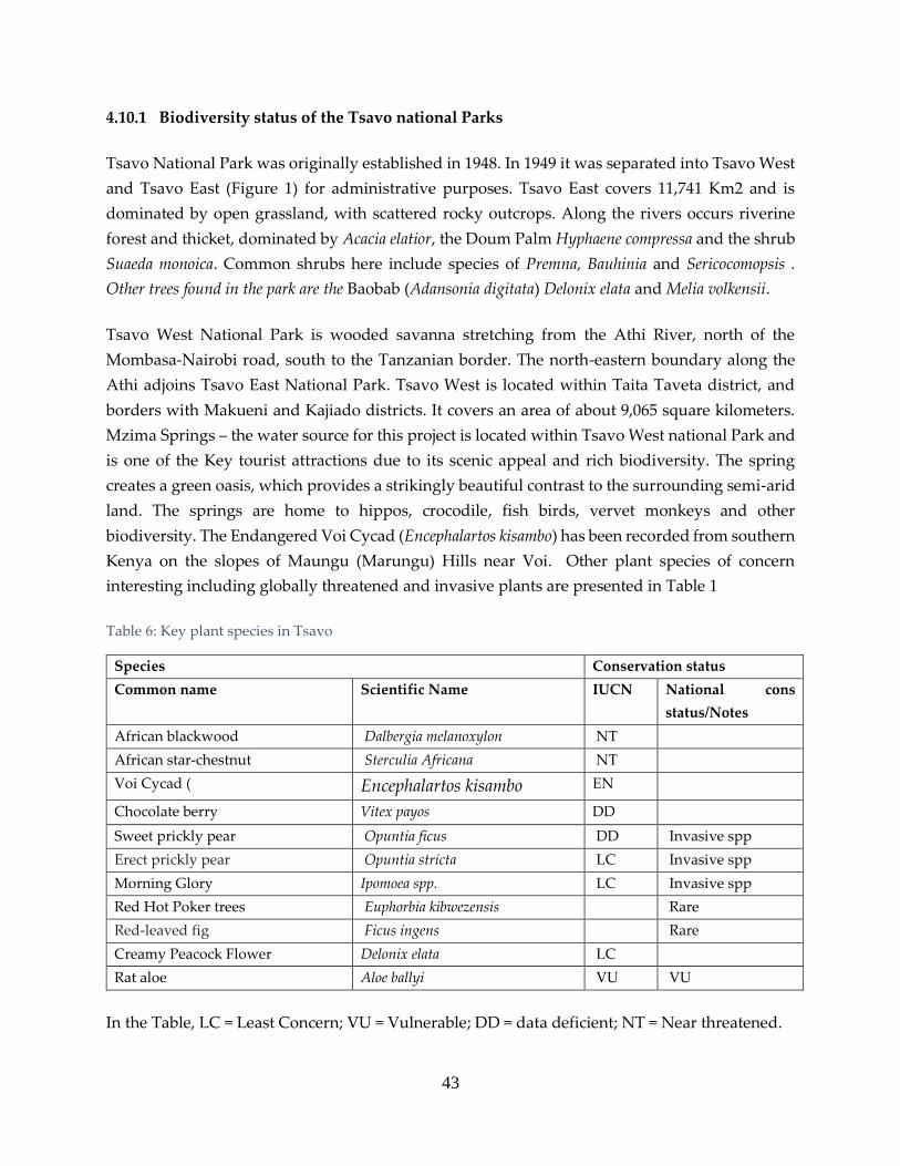
43
4.10.1 Biodiversity status of the Tsavo national Parks
Tsavo National Park was originally established in 1948. In 1949 it was separated into Tsavo West
and Tsavo East (Figure 1) for administrative purposes. Tsavo East covers 11,741 Km2 and is
dominated by open grassland, with scattered rocky outcrops. Along the rivers occurs riverine
forest and thicket, dominated by Acacia elatior, the Doum Palm Hyphaene compressa and the shrub
Suaeda monoica. Common shrubs here include species of Premna, Bauhinia and Sericocomopsis .
Other trees found in the park are the Baobab (Adansonia digitata) Delonix elata and Melia volkensii.
Tsavo West National Park is wooded savanna stretching from the Athi River, north of the
Mombasa-Nairobi road, south to the Tanzanian border. The north-eastern boundary along the
Athi adjoins Tsavo East National Park. Tsavo West is located within Taita Taveta district, and
borders with Makueni and Kajiado districts. It covers an area of about 9,065 square kilometers.
Mzima Springs – the water source for this project is located within Tsavo West national Park and
is one of the Key tourist attractions due to its scenic appeal and rich biodiversity. The spring
creates a green oasis, which provides a strikingly beautiful contrast to the surrounding semi-arid
land. The springs are home to hippos, crocodile, fish birds, vervet monkeys and other
biodiversity. The Endangered Voi Cycad (Encephalartos kisambo) has been recorded from southern
Kenya on the slopes of Maungu (Marungu) Hills near Voi. Other plant species of concern
interesting including globally threatened and invasive plants are presented in Table 1
Table 6: Key plant species in Tsavo
Species Conservation status
Common name Scientific Name IUCN National cons
status/Notes
African blackwood Dalbergia melanoxylon NT
African star-chestnut Sterculia Africana NT
Voi Cycad ( Encephalartos kisambo EN
Chocolate berry Vitex payos DD
Sweet prickly pear Opuntia ficus DD Invasive spp
Erect prickly pear Opuntia stricta LC Invasive spp
Morning Glory Ipomoea spp. LC Invasive spp
Red Hot Poker trees Euphorbia kibwezensis Rare
Red-leaved fig Ficus ingens Rare
Creamy Peacock Flower Delonix elata LC
Rat aloe Aloe ballyi VU VU
In the Table, LC = Least Concern; VU = Vulnerable; DD = data deficient; NT = Near threatened.

44
4.10.2 Mammal diversity
Some of the mammals that are found in the
two parks are listed in Table 4. Both Parks
holds substantial proportion of Kenyan
populations of Black rhinos (Diceros bicornis)
mainly within the Ngulia Rhino Sanctuary in
Tsavo West but also free ranging in Tsavo
East. as. The global population of Black
Rhino has declined drastically over last 30
years and are now classified as Critically
Endangered by IUC. The rhino populations
in Tsavo ecosystem remain small, isolated
and vulnerable.
Plate 1: Black Rhino in Tsavo West
Source: https://www.awf.org/projects/ngulia-
rhino-sanctuary
Plate 2: An Elephant ©Paul Muoria
The Tsavo ecosystem holds the largest
African Elephant (Loxodonta Africana)
population in Kenya. Elephants as classified
as Vulnerable by IUCN and Endangered by
Wildlife Act 2013 (GOK, 2013). In a survey
conducted in 2017, a total of 12573 elephants
were counted in the ecosystem that includes
the two parks and surrounding areas
including Chyulu Hills National Park, Kitui
National Reserve, Mkomazi National
Reserve, and several private and community
ranches.

Other globally and/or nationally threatened mammals found in both Tsavo East and West
National Parks include the critically endangered Hirola (Damaliscus hunteri), the endangered
Grevy’s Zebra(Equus Grevyi) and large carnivores. Grevy’s zebra are endemic to northern Kenya
and southern and eastern Ethiopia; but were introduced into the Tsavo ecoystem in the late 1960s
and 1970s. Their current population in the area is not ecologically viable. Hirola is one of the
world’s rarest antelopes. It was introduced into the Tsavo ecosystem and its current population
around 100. Most of the large carnivores found in the ecosystem including cheetah (), wilddogs
(), lions(), Leopard (Panthera pardus) and the stripped hyena (Hyena hyena), are highly threatened,
yet play an ecologically (and economically from a tourism perspective) essential role in the Tsavo
ecosystem. Wild dogs are classified as Endangered by IUCN. Wild carnivores in the ecosystem
and other parts of Kenya are facing increased threats including human-wildlife conflict, poaching
and closure of dispersal areas.
Plate 3: Grevy's Zebra © Paul Muoria
Plate 4: Lions© Paul Muoria

46
Table 7: Mammals in Tsavo ecosystem
Species Conservation status
Common name Scientific Name IUCN National
Aardwolf Proteles cristata LC
African civet Civettictis civetta
African golden cat Profelis aurata VU VU
African hare Lepus microtis
African hunting dog Lycaon pictus EN EN
African wildcat Felis lybica
Banded mongoose Mungos mungo
Bat-eared fox Otocyon megalotis
Black faced vervet
monkey
Chlorocebus pygerythrus
Black rhinoceros Diceros bicornis michaeli CR CR
Black-backed jackal Canis mesomelas
Blue duiker Philantomba monticola
Bohor reedbuck Redunca redunca
Bush duiker Sylvicapra grimmia
Bush squirrel Paraxerus ochraceus
Bushbuck Tragelaphus sylvaticus
Cane rat Thryonomys swinderianus
Cape buffalo Syncerus caffer LC
Caracal Caracal caracal
Cheetah Acinonyx jubatus jubatus VU EN
Clawless otter Aonyx capensis NT
Coke's hartebeest Alcelaphus buselaphus cokii
Common zebra Equus Zebra
Crested porcupine Hystrix cristata
Dik-dik Madoqua kirkii
Dwarf mongoose Helogale parvula
East African hedgehog Atelerix albiventris
East African red squirrel Paraxerus palliates VU
Egyptian mongoose Herpestes ichneumon
Eland Taurotragus oryx
Elephant Loxodonta Africana VU EN
Fringe-eared oryx Oryx beisa callotis
Gerenuk Litocranius walleri NT
Giant rat Cricetomys gambianus

47
Species Conservation status
Grants Gazelle Nanger granti
Greater galago Otolemur crassicaudatus
Grevy's zebra. Equus grevyi EN EN
Ground pangolin Smutsia temminckii VU
Hunter hartebeest Beatragus hunter CR
Impala Aepyceros melampus
Klipspringer Oreotragus oreotragus
Large-spotted genet Genetta tigrina
Leopard Panthera pardus NT EN
Lesser Bushbaby Galago senegalensis LC
Lesser kudu Tragelaphus imberbis NT VU
Lion Panthera leo VU EN
Marsh mongoose Atilax paludinosus
Masai Giraffe Giraffa tippelskirchi VU
Naked mole rat Heterocephalus glaber
Ratel Mellivora capensis
Red duiker Cephalophus natalensis
Rock hyrax Heterohyrax brucei
Serval Leptailurus serval
Side-striped jackal Canis adustus
Slender mongoose Galerella sanguinea
Small-spotted genet Genetta genetta
Spectacled elephant
shrew
Elephantulus brachyrhynchus
Spotted hyena Crocuta crocuta LC VU
Springhare Pedetes capensis
Striped ground squirrel Xerus erythropus
Striped hyena Hyaena hyaena NT EN
Suni Neotragus moschatus
Sykes' monkey Cercopithecus albogularis
Tree hyrax Dendrohyrax validus VU
Unstriped ground
squirrel
Xerus rutilus
Warthog Phacochoerus africanus
Waterbuck Kobus ellipsiprymnus
White-tailed mongoose Ichneumia albicauda
Yallow baboons Papio cynocephalus
Yellow baboon Papio cynocephalus LC

48
In the Table, CR = critically threatened; LC = Least Concern; VU = Vulnerable; DD = data deficient;
NT = Near threatened.
4.10.4 Bird species diversity
At least 600 and 500 bird species have been recorded in Tsavo West NP and Tsavo East,
respectively. The Near Threatened Mirafra pulpa occurs in both parks. Tsavo ecosystem is also an
important part of a corridor of natural habitat in eastern Kenya through which vast numbers of
Palearctic birds migrate, especially in November/December. These include the globally
threatened Crex crex and Near Threatened Acrocephalus griseldisand Falco naumanni. Other
regionally threatened species common in Tsavo west are Struthio camelus; Casmerodius albus ;
Trigonoceps occipitalis ; Polemaetus bellicosus ; Coturnix adansonii ; Podica senegalensis; Phoeniculus
granti ; and Buphagus africanus . Regionally threatened species in Tsavo East National Park include
Anhinga rufa; Casmerodius albus ; Ephippiorhynchus senegalensis ; Trigonoceps occipitalis; Polemaetus
bellicosus , Podica senegalensis; and Phoeniculus granti. Birds that qualify bot Tsavo West and Tsavo
East national parks as Important Bird Areas (IBAs) are listed in Table 5while birds that have been
caught and ringed by Ngulia Ringing Group (Ngulia Ringing Group, Personal communication)
are presented in Table 4.
Table 8: Globally threatened Birds and IBA trigger species found in Tsavo East and Tsavo West National
Parks
Common name Scientific name Current IUCN
Red List Category
National
Status/Notes
Migrant?
Friedmann's Lark Mirafra pulpa DD LC Resident
Basra Reed-warbler Acrocephalus griseldis EN EN Resident
Crex crex corncrake LC NT Resident
Abyssinian Scimitarbill Rhinopomastus minor LC Resident
African Grey Flycatcher Bradornis microrhynchus
LC Resident
Ashy Cisticola Cisticola cinereolus LC Resident
Banded Warbler Sylvia boehmi LC Resident
Bare-eyed Thrush Turdus tephronotus LC
Comon Ostrich Struthio camelus LC Protected
species
Resident
Black-bellied Sunbird Cinnyris nectarinioides LC
Black-capped Social-weaver Pseudonigrita cabanisi LC
Black-cheeked Waxbill Estrilda charmosyna LC
African Darter Anhinga rufa LC Protected
Species
Resident

49
Common name Scientific name Current IUCN
Red List Category
National
Status/Notes
Migrant?
Black-faced Sandgrouse Pterocles decoratus LC
Black-throated Barbet Tricholaema melanocephala
LC
Great egret Casmerodius albus LC Protected
species
C
Blue-capped Cordon-bleu Uraeginthus cyanocephalus
LC
Chestnut-headed Sparrow-lark Eremopterix signatus LC
Donaldson-Smith's Nightjar Corncrake Crex crex LC
Donaldson Smith's Nightjar Caprimulgus donaldsoni
LC
Eastern Chanting-goshawk Melierax poliopterus LC
Eastern Yellow-billed Hornbill Tockus flavirostris
LC
Fire-fronted Bishop Euplectes diadematus LC
Fischer's Starling Lamprotornis fischeri LC
Golden Pipit Tmetothylacus tenellus LC
Golden-breasted Starling Lamprotornis regius LC
Grey Wren-warbler Calamonastes simplex LC
Grey Wren-warbler Calamonastes simplex LC
Grey-headed Silverbill Odontospiza griseicapilla
LC
Heuglin's Bustard Neotis heuglinii LC
Hildebrandt's Starling Lamprotornis hildebrandti
LC
Hunter's Sunbird Chalcomitra hunteri LC
Lesser Kestrel Falco naumanni LC VU Paleatic
migrant
Long-tailed Fiscal Lanius cabanisi LC
Magpie Starling Speculipastor bicolor LC
Mouse-coloured Penduline-tit Anthoscopus musculus LC
Pale Prinia Prinia somalica LC
Pangani Longclaw Macronyx aurantiigula LC
Pink-breasted Lark Calendulauda poecilosterna
LC
Red-and-yellow Barbet Trachyphonus erythrocephalus
LC
Red-bellied Parrot Poicephalus rufiventris LC
Red-naped Bush-shrike Laniarius ruficeps LC
Red-winged Lark Mirafra hypermetra LC
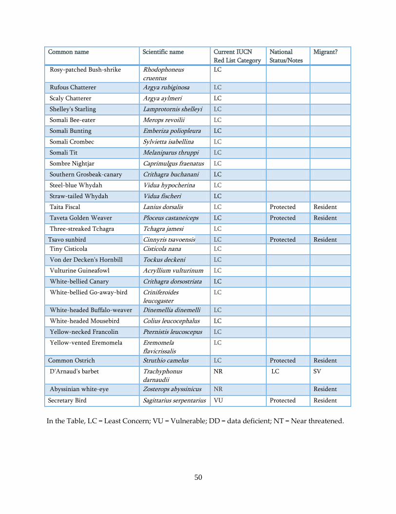
50
Common name Scientific name Current IUCN
Red List Category
National
Status/Notes
Migrant?
Rosy-patched Bush-shrike Rhodophoneus cruentus
LC
Rufous Chatterer Argya rubiginosa LC
Scaly Chatterer Argya aylmeri LC
Shelley's Starling Lamprotornis shelleyi LC
Somali Bee-eater Merops revoilii LC
Somali Bunting Emberiza poliopleura LC
Somali Crombec Sylvietta isabellina LC
Somali Tit Melaniparus thruppi LC
Sombre Nightjar Caprimulgus fraenatus LC
Southern Grosbeak-canary Crithagra buchanani LC
Steel-blue Whydah Vidua hypocherina LC
Straw-tailed Whydah Vidua fischeri LC
Taita Fiscal Lanius dorsalis LC Protected Resident
Taveta Golden Weaver Ploceus castaneiceps LC Protected Resident
Three-streaked Tchagra Tchagra jamesi LC
Tsavo sunbird Cinnyris tsavoensis LC Protected Resident
Tiny Cisticola Cisticola nana LC
Von der Decken's Hornbill Tockus deckeni LC
Vulturine Guineafowl Acryllium vulturinum LC
White-bellied Canary Crithagra dorsostriata LC
White-bellied Go-away-bird Criniferoides leucogaster
LC
White-headed Buffalo-weaver Dinemellia dinemelli LC
White-headed Mousebird Colius leucocephalus LC
Yellow-necked Francolin Pternistis leucoscepus LC
Yellow-vented Eremomela Eremomela flavicrissalis
LC
Common Ostrich Struthio camelus LC Protected Resident
D'Arnaud's barbet Trachyphonus darnaudii
NR LC SV
Abyssinian white-eye Zosterops abyssinicus NR Resident
Secretary Bird Sagittarius serpentarius VU Protected Resident
In the Table, LC = Least Concern; VU = Vulnerable; DD = data deficient; NT = Near threatened.
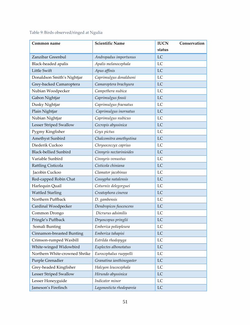
51
Table 9: Birds observed/ringed at Ngulia
Common name Scientific Name IUCN Conservation
status
Zanzibar Greenbul Andropadus importunus LC
Black-headed apalis Apalis melanocephala LC
Little Swift Apus affinis LC
Donaldson Smith’s Nightjar Caprimulgus donaldsoni LC
Grey-backed Camaroptera Camaroptera brachyura LC
Nubian Woodpecker Campethera nubica LC
Gabon Nightjar Caprimulgus fossii LC
Dusky Nightjar Caprimulgus fraenatus LC
Plain Nightjar Caprimulgus inornatus LC
Nubian Nightjar Caprimulgus nubicus LC
Lesser Striped Swallow Cecropis abyssinica LC
Pygmy Kingfisher Ceyx pictus LC
Amethyst Sunbird Chalcomitra amethystina LC
Diederik Cuckoo Chrysococcyx caprius LC
Black-bellied Sunbird Cinnyris nectarinioides LC
Variable Sunbird Cinnyris venustus LC
Rattling Cisticola Cisticola chiniana LC
Jacobin Cuckoo Clamator jacobinus LC
Red-capped Robin Chat Cossypha natalensis LC
Harlequin Quail Coturnix delegorguei LC
Wattled Starling Creatophora cinerea LC
Northern Puffback D. gambensis LC
Cardinal Woodpecker Dendropicos fuscescens LC
Common Drongo Dicrurus adsimilis LC
Pringle’s Puffback Dryoscopus pringlii LC
Somali Bunting Emberiza poliopleura LC
Cinnamon-breasted Bunting Emberiza tahapisi LC
Crimson-rumped Waxbill Estrilda rhodopyga LC
White-winged Widowbird Euplectes albonotatus LC
Northern White-crowned Shrike Eurocephalus rueppelli LC
Purple Grenadier Granatina ianthinogaster LC
Grey-headed Kingfisher Halcyon leucocephala LC
Lesser Striped Swallow Hirundo abyssinica LC
Lesser Honeyguide Indicator minor LC
Jameson’s Firefinch Lagonosticta rhodopareia LC

52
Common name Scientific Name IUCN Conservation
status
Red-billed Firefinch Lagonosticta senegala LC
Superb Starling Lamprotornis suberbus LC
Slate-coloured Boubou Laniaris funebris LC
Pangani Longclaw Macronyx aurantiigula LC
Gambaga Flycatcher Musicapa gambagae LC
Grey-headed Silverbill Odontospiza griseicapilla LC
Namaqua Dove Oena capensis LC
Red-winged Starling Onychognathus morio LC
Village Weaver P. cucullatus LC
Chestnut Weaver P. rubiginosus LC
Grey-headed Sparrow Passer griseus LC
Yellow-spotted Petronia Petronia pyrgita LC
Northern Brownbul Phyllostrephus strepitans LC
Village Weaver Ploceus cucullatus LC
Lesser Masked Weaver Ploceus intermedius LC
Chestnut Weaver Ploceus rubiginosus LC
Vitelline Masked Weaver Ploceus vitellinus LC
Common Bulbul Pycnonotus barbatus LC
Green-winged Pytilia Pytilia melba LC
Red-billed Quelea Quelea quelea LC
Red-eyed Dove Streptopelia semitorquata LC
Laughing Dove Streptopelia senegalensis LC
Red-faced Crombec Sylvietta whytii LC
Three-streaked Tchagra Tchagra jamesi LC
Black-crowned Tchagra Tchagra senegalus LC
African Paradise Flycatcher Terpsiphone viridis LC
D’Arnaud’s Barbet Trachyphonus darnaudii LC
Spot-flanked Barbet Tricholaema lacrymosa LC
Common Buttonquail Turnix sylvatica LC
Emerald-spotted Wood Dove Turtur chalcospilos LC
Red-cheeked Cordon-bleu Uraeginthus bengalus LC
Mbulu White-eye Z. mbuluensis LC
Zanzibar Greenbul Andropadus importunus LC
Abyssinian White-eye Zosterops abyssinicus LC

53
4.10.5 Reptiles and amphibians of Tsavo ecosystem
The Tsavo ecosystem is rich in reptiles. This includes crocodiles (for example at Mzima springs),
Agma agma lizard, African helmeted turtle, Tsavo Gecko and chameleon. Some of the snakes that
have been recorded in the parks include the Puff adder (Bitis arietans ), boomslang (Dispholidus
typus), Large brown spitting cobra (Naja ashei)’ small-scaled burrowing asp (Atractaspis
microlepidota), red spitting cobra (Naja pallida) and black mamba (Dendroaspis polylepis). The
Vulnerable pancake tortoise (Malacochersus tornieri) has also been recorded in Tsavo East National
park (Malaoza, 2003). The Africa reed frog (Hyperolius rhizophilus) that is classified as Data
Deficient by IUCN also occurs in this ecosystem.
Table 10: Herpetofauna and amphibians in Tsavo
Species Conservation status
Common name Scientific Name IUCN Nat con status/Notes
African Helmeted Terrapin Pelomedusa subrufa LC
African Rock Python Python sebae NE
Baobab gecko Hemidactylus platycephalus Protected
Flap-neck Chameleon Chamaeleo dilepis LC Protected Species
Goldie's tree cobra or Gold's tree
cobra
Pseudohaje goldii LC
Kenya Pygmy-Chameleon Rieppeleon kersteni LC
Nile Crocodile Crocodylus niloticus LC
Pancake tortoise(Crevice tortoise) Malacochersus tornieri VU NT
Puff Adder Bitis arietans NE Protected Species
Red-headed agama lizard Agama agama LC Invasive
Reed Frog Afrixalus pygmaeus septentrionalis LC Endemic to Tsavo Area
Savannah monitor lizard Varanus albigularis LC Protected Species
Scheffler's Dwarf Gecko Scheffler's Dwarf Gecko DD
Sheldrick's reed frog Hyperolius sheldricki LC Endemic to Tsavo Area
Slender/graceful Chameleon Chamaeleo gracilis LC

54
4.10.6 Wildlife migration routes
Figure 4: Wildlife migratory routes/corridors in the Tsavo-Mkomazi ecosystem (Ojwang, et al, 2017)
Project area, particularly in the Tsavo ecosystem, has high wild animal densities (Ojwang’ et al ,
2017). Towards the Southern Part of Tsavo East National Park the pipeline will cut across at least
one documented elephant migration corridor that links the Tsavo elephant population to Kwale
County. It is possible that there are other undocumented migration corridors. Care should be
taken to avoid blocking the migration corridors by ensuring that no trenches are left uncovered
and no structure including workers camps are set up in such areas. Due to higher possibilities of
human elephant conflicts along migration routes, the workers will need to be accompanied by
KWS rangers when working in these areas.

55
4.11 Chyulu Hills Surface and Ground Catchments
4.11 Chyulu Hills Surface and Groundwater Catchments
The Chyulu Hills are situated in south-eastern Kenya, are formed from volcanic cones that
emanate from an elongated vent structure which runs in a north west – south east direction. The
main ridge of hills form along a 40 km long series of volcanic cones, with the highest peak at
approximately 2188masl. The hills are surrounded by plains of old lava flows, ash deposits and
pyroclastic material from historic eruptions, which support soils of varying thicknesses and types
depending on the makeup and degree of weathering of the volcanic materials.
The area is classified as semi-arid, although the hills themselves have an orographic impact on
rainfall, with higher rainfall on the ridge and eastern slope, and a ‘rain shadow’ effect leading to
lower rainfall to the west and south. Vegetation varies from grasslands with scattered trees on
the plains and former ash fields through to thicket forest on some lava fields and montaine forest
on the top of the ridge.
The key attribute of interest of the Chyulu hills is the large groundwater catchment that is formed
by the hills and surrounding volcanic material. As shown in Figure below, this forms a relatively
high recharge aquifer with a surface area of approximately 2,126 km2, much of which drains into
the Mzima springs.

56
Figure 5: Mzima catchment basin (Atkins,2018)
4.11.1 Soils
Of key importance to the Chyulu aquifer area is the extremely porous nature of the thin residual
soils that have evolved over the few thousands or tens of thousands of years since active
volcanism ceased. The aa lava flows are characterised by blocky and uneven surfaces, where
pockets of soil have evolved to host thick vegetation; aa flows often terminate as characteristic
small, steep scarps. Areas underlain by thick layers of ash tend to be smooth, grassed and hosting
sparse tree growth; these frequently form shallow basins surrounded by vents and hosting rich
red oat grass on moderately well-developed soils.
Recent ash cones show intervening layers of ash (which dominates) and more compact deposits
(aa lavas or less vesicular basalts), which can be seen in the flanks of some of the cones. Some
erosion – which takes the form of incipient near-straight grassed and shrub-filled gullies – has
occurred, suggesting that some cones are sufficiently impermeable to allow at least some
overland flow; however, there is no evidence of standing water anywhere in the Hills. The BGS
study divided soils in the Hills into two broad groups; soils on the flanks, and soils along the
ridgeline. These can be further sub-divided into:
Hill flank soils:

57
Older lavas (most developed soils)
Intermediate (intermediate soil development)
Young lavas (least developed soils).
Ridgeline soils:
Soils underlying forest (the BGS estimated that only 3% / 63 km2) of the recharge area was
covered by ‘montane rain forest’)
Soils underlying grassland.
4.11.2 Meteorology, Recharge and Surface Flows
The land bordering the Chyulu Hills has low and variable rainfall, supports scrub and marginal
agricultural land and has been classified in the literature as semiarid to arid (BGS, 1988). BGS
(1988) reported that over the period from 1904 to 1982, a large range of annual rainfall (from 67
mm to 1967 mm) had been recorded at Makindu rain gauge.
In contrast to the lower lying surrounding land, the higher ground of the Chyulu Hills receives
greater rainfall and prolonged periods of mist. This results in denser vegetation cover; there is
good grass cover and significant areas of well-developed forest. The climate of the higher
Chyulu’s has been classified as humid to dry sub humid and given the agro climatic classification
of warm sub humid (BGS, 1988).
Twelve new rain gauge stations were established for the BGS study, mostly along the Chyulu
Ridge, using storage gauges which were read monthly. Two unattended automatic weather
stations (AWS) were also installed as part of the study, including one high on the Chyulu ridge.
During the study period (1984 to 1986), the total rainfall recorded at the North Chyulu Ridge
raingauge (altitude 1810 m) was 1185 mm, compared to the a total rainfall of 585 mm at Makindu
(altitude 995 m). The estimated total evaporation (using Penman estimates of evaporation from
vegetation, Et) at the Chyulu study AWS was 1218 mm (based on data collected Dec 1985 to Nov
1986), compared to 1438 mm at the Makindu AWS over the same period.
Across the region, there is a bimodal seasonal rainfall distribution with more rain in the “short
rains” period, typically between October and December, compared to the “long rains”, typically
between March and May (Wright, 1982, BGS, 1988, Kiringe et. al 2016). In terms of spatial
distribution, it has been found that precipitation in the eastern foothills shows a decreasing trend
both north and south from a central maximum. Precipitation increases with altitude and the
western Chyulu appears to be in a slight rain shadow (Wright, 1982, BGS, 1988). The altitudinal
effect on potential evaporation was found to be complex, with the month to month variations

58
during the year, generally much greater than the year to year variations for the same calendar
month (BGS, 1988).
Although further data collection was recommended, there are few measurements at altitude
beyond the BGS study period (1984 to 1986). It is likely that there is variability in the rainfall
distribution with altitude, aspect, and location that has yet to be characterised.
4.11.3 Recharge processes
The volcanic rocks of the Chyulu Hills are covered by a thin to negligible soil cover. There are
areas of bare rock, elsewhere pockets of soil have evolved. The soil cover and rocky outcrops have
high infiltration rates and there is very little surface water runoff.
Vegetation varies from grasslands with scattered trees on the plains and former ash fields through
to thicket forest on some lava fields and montaine forest on the top of the ridge. These features
are related both to the age of the volcanic rocks, with less vegetation on the younger formations,
and to location and altitude, with denser vegetation occurring on the higher ground of the Chyulu
Hills which receives greater rainfall and prolonged periods of mist.
A conceptual representation of the main recharge processes is summarised in below. Volcanic
rock age, soil cover and vegetation cover have a key role in determining recharge:
Variable rainfall has a spatial distribution strongly influenced by altitude and location.
Where there is no vegetation, direct evaporation occurs from those parts of the lava flow
surface that form puddles during rainstorm events, elsewhere evapotranspiration occurs,
dependent on vegetation type.
Surface water runoff is generally insignificant in most areas, although some flow may
occur when soils become saturated in the lower ground around the periphery of the
aquifer. In general, in areas where there is soil and vegetation cover, when the
precipitation exceeds the water required to make up the soil moisture deficit and satisfy
potential evaporation it percolates through the aquifer system.
Where there is no/limited soil and vegetation cover, direct recharge (i.e. that which
bypasses the soil moisture store) can occur by fissure flow.
All recharge percolates to the ‘base’ of the volcanic aquifer to reach the water table.
Water flows laterally to the point of lowest elevation to discharge as springs.
The Mzima springs flow regime has been the subject of several investigations. BGS hypothesised
that major recharge events are quite widely separated with several years of nil recharge, except
through bare lava outcrops, resulting in a routing lag (of two to three years) between rainfall and

59
spring discharge. Using the results of their chloride balance work, BGS tentatively suggested that
the Mzima discharge at the time of the study correlated with the recharge event of 1967/68 (i.e.
(i.e. a residence time of approximately 20 years).
Figure 6 :Conceptual representation of recharge of Chyulu aquifer
4.11.4 Discharge
Natural groundwater discharge from the Chyulu aquifer system occurs through springs, both to
the east and the west as shown in Figure 2-5. The principal discharge is from Mzima, which
together with the north-eastern springs is heavily utilised for public supply (The subject of this
EIA study)
Although main discharge from Chyulu aquifer is through the springs, an as yet unquantified,
proportion of recharge is also distributed to other sources. The BGS study highlights that in more
marginal areas, there is evidence to indicate that the basal aquifer is thin and laterally
discontinuous, similar to a subsurface drainage system. Boreholes in the eastern margins show
rest water levels in the underlying weathered basement rocks. It is considered that some leakage
into underlying or adjacent rocks must occur, especially where these are weathered or have open

60
fractures. In addition, some discharge by phreatophytes is believed to occur in certain areas of
low elevation. The BGS 1988 study suggests this may be the case in the Kibwezi forest/Umani
swamps and also in the Iltilal area. Changes in the catchment since the 1980s (natural and
anthropogenic) may have altered the proportion of discharge from phreatophytes, however the
volume has never been quantified in water balance terms.
4.11.5 Reliability Evaluation Report for Mzima Springs
Hydrologic stations RGS 3G03, 3G05 and 3G02 are set near the Mzima Springs. The source of
Mzima Springs is from the rainwater seepage of Chyulu Hills. After passing through three lakes
(Hippo Lake, Long Lake and Chalk Beach Lake), the water of Mzima Springs flows into the
Mzima River. Since 1951, the hydrologic station RGS 3G03 has made hydrological observation on
Mzima Springs for continuous forty years. The observation shows that the maximum measured
monthly average discharge is 5.9 m3/s, and the minimum measured monthly average discharge
is 2.6 m3/s.
The water yield of Mzima Springs in 1932 - 1994 can be deduced by making the model of
rainwater of the Chyulu Hills and water yield of the Mzima Springs. Water yield model shows
that minimum water yield of Mzima Springs is 2.6 m3/s and the maximum water yield is 5.9 m3/s.
In 2018, Atkins was entrusted to demonstrate and analyze the reliability of the Mzima Springs,
and has used three kinds of data analysis form to demonstrate the sustainable water yield of
Mzima Springs:
i. Validation study of historical data of spring water discharge
ii. Analysis of relationship between monthly supplementary water volume data and
discharge data by using Lagged Multiple Linear Regression model
iii. Extreme Value Analysis: On the one hand, use this method to analyze historical data and
sustainable discharge record data; on the other hand, analyze the data generated by the
fitting of Lagged Multiple Linear Regression.
Besides, the analysis built supplementary water model of Chyulu Hills Aquifer and adjusted the
model input factors such as rainfall, permeation loss coefficient and transpiration through
historical data, geographic environment data and reasonable assumption. Comparing the
obtained supplementary water volume model with measured and simulated spring water
discharge data, and utilizing lagged multiple linear regression analysis and extreme value
analysis, the relationship of rainfall, supplementary water volume of aquifer and spring water
discharge can be determined approximately.

61
According to the analysis conclusion of reliability report of Mzima Springs from Atkins,
compared with the area of this region, Chyulu Hills Aquifer and Mzima Springs can provide
quite huge amount of water. The analysis indicates the importance of the existence of forested
area and pyroclastic flow to the water replenishing mechanism of the aquifer. Relevant hydrology
models and lagged regression analysis indicates that there is a close relation between water
discharge of Mzima Springs and replenishment of water amount of underground aquifer, and
taking it as a whole, the spring water yield is at least related to the water replenishment activity
of the underground aquifer 10 years ago.
This indicates the high resistance of the spring water to intra-annual variation of drought and
rainfall, and further indicates the low sensitivity on climatic change. Through the analysis result,
the spring water yield data can be estimated to be (daily average discharge):
Spring water discharge with 95% guarantee rate: 2.64 m3/s
Spring water discharge with 96% guarantee rate: 2.5 m3/s
Spring water discharge with 98% guarantee rate: 2.4 m3/s
The current spring water withdrawal is 0.43 m3/s, and the water withdrawal of Phase II Project
is 1.21 m3/s, so the Phase I will be abolished after the completion of Phase II. Based on the above
conclusion of spring water yield data and the water supply guarantee rate, the water withdrawal
can be guaranteed even under extremely dry conditions.
Meanwhile, Atkins points out that, Baricho water supply scheme in the Mombasa Water Supply
Master Plan puts forward to increase water withdrawal from the Galana Sabaki River in the lower
reach. Therefore, during the implementation of Baricho Water Supply Phase II Project, it is
necessary to consider the joint influence with water supply scheme of Mzima Springs, and the
construction unit of Baricho Water Supply Phase II Project shall model the Baricho Wellfield and
groundwater level when necessary.
The change of basin caused by the natural process will not bring too much impact on the spring
water yield, while the erosion of the existing forest and vegetation covered area due to human
activities will obviously reduce the groundwater recharge and then reduce the spring water yield.
Through building a model, it is predicted that the probability of a decrease in water yield due to
the climate change trend in the future is only 20%, and before 2080, the probability of decrease of
the existing guarantee rate of water yield is only 10%.
The major recommendations are as follows:
It is recommended to strengthen water intake monitoring
It is recommended to increase the quantity of rainfall stations, especially in the ridge area

62
It is recommended to strengthen the discharge monitoring of Mzima Springs and other
major springs that take the aquifer as the water source
Because of the particularly favorable natural advantages of the Chyulu Hills Aquifer and Mzima
Springs, it is also necessary to take protection measures in various forms, such as taking it as a
protection strategy in particular to support the sustainable development of the basin.
4.11.6 Environmental Analysis of Water Resource
According to the reliability analysis of Atkins for the Mzima Springs, there is sufficient guarantee
rate of water yield of the Mzima Springs, which can guarantee the water withdrawal of the Mzima
II Water Supply Pipeline Project. According to the site survey, at present, the Mzima I Intake has
collected about 1.3 m3/s of water, and the remaining spring water flows into the lake from the
head of the lake. In the overflow well at the lower reach, about 0.84 m3/s of 1.3 m3/s water
overflows back to the lake. The remaining 0.46 m3/s water flows through the Mzima I Pipeline
for the water supply of the lower reach.
According to the environmental requirements on the flow in the Intake (2013 CWSB, Water
Supply Master Plan of) , it is required that the minimum environmental discharge of the three
lakes is 1.4 m3/s, while the minimum environmental discharge of the lower reach of Mzima River
is 1.0 m3/s. According to the water yield demonstration above mentioned, the lowest discharge
of Mzima Springs is about 2.64 m3/s with 95% guarantee rate, and it is required that the minimum
environmental discharge of the lake is 1.4 m3/s. Therefore, the water withdrawal of Mzima
Springs is about 1.21 m3/s under the minimum discharge, and still meets the water withdrawal
of the Mzima II Water Supply Pipeline Project. According to Code for Design of Outdoor Water
Supply Engineering (GB50013-2006), "when surface water is used as the water source for urban
water supply, the design annual guarantee rate of low discharge shall adopt 90% - 97%". From
the above table, it can be seen that the Mzima Springs water supply capacity can meet the water
intake requirement of 105,000 m3/d.

63
Figure 7: Environment requirement for Mzima headwater resource
4.12 Environment and Climate Change
Environmental degradation is a major cause for concern in the County. The quest for
development will ultimately present a challenge to the natural environment. Major contributors
to environmental degradation include slash and burn agriculture, logging, poor agricultural
practices, human settlement on hilltops, sand harvesting along rivers among others.
Environmental degradation poses a major challenge to sustainable development in the County.
Among the effects of environmental degradation are the loss of species and integrity of habitat,
habitat fragmentation and loss, and loss of water catchment areas. Climate change and variability
is an emerging threat to sustainable development in the County. Although climate data from the
Kenya Meteorological Department for the County is scanty, there is evidence of a changing
climate characterized by increased frequency and severity of extreme events such as drought and
floods.
There are observed changes in the seasons whereby the rainy seasons have reduced and the onset
of the rains delayed. These changes present additional challenges to the socio-economic
development of the County in a number of ways. Within the agriculture sector, which is the most
vulnerable, farmers have experienced reduced yields leading to food insecurity in the County.

64
Rising temperatures are associated with high prevalence of pests and diseases which affect
productivity both in crops and livestock. Extreme cold is responsible for frost experienced in
some parts of the County. Moreover, shifting seasons means changes in planting period which in
turn affects crop performance, while drought results in reduced pasture.
The health sector is also affected by climate change and variability because the rising
temperatures provide an environment conducive for malaria vectors to thrive. As a result, the
health facilities are confronted with additional burden. Other effects of climate change are decline
in water quality and quantity, destruction of road infrastructure by floods, and loss of
biodiversity.
Mitigation measures which seek to reduce Greenhouse Gas (GHG) emissions should then be
elaborated. These include use of cleaner and more efficient technologies such as solar and wind.
They also include those actions that aim at increasing GHG sinks such as reforestation, protection
of wetlands, or any relevant change in consumption behaviors.
Other strategies to cope with climate change include water harvesting technologies, efficient
water use, adoption of Early Warning Systems (EWS), awareness and education, introduction of
drought resistant crop and animal varieties and proper natural resource management.

65
5.0 PUBLIC PARTICIPATION AND RESPONSES
5.1 Introduction
Stakeholders are ‘all those people and institutions who have an interest in the successful design,
implementation and sustainability of the project. This includes those positively and negatively
affected by the project. Stakeholder participation involves processes whereby all those with a
stake in the outcome of a project can actively participate in decisions on planning and
management. They share information and knowledge, and may contribute to the project, so as to
enhance the success of the project and hence ultimately their own interests’. Different types of
stakeholders can contribute to the EIA process in different ways and, in most cases; inputs from
a broad variety of stakeholders will complement the EIA process. Stakeholder interests exist at
different levels.
Kenya has entered the era of participatory development in all matters of national life.
Participation in this case is not just through elected representatives but also through direct action.
The Environmental Management and Coordination Act (Revised, 2015) and its subsequent
Environmental (Impact Assessment and Audit) Regulations, 2003 underscore the need for
stakeholder participation in the EIA process. Neighbours of a proposed project have to live with
the project if implemented. They have the most to gain if the project impacts are beneficial to
them. Conversely, they have the most at stake if the project goes awry. Not just neighbours but
for projects whose impacts have a wide geographical spread, distant communities need to be
involved. Stakeholder input is thus vital at the earliest stage possible in project development.
5.2 Consultation Methodology
There is no single ‘public’; instead there are a number of publics some of whom may emerge at
any time during the process depending on their particular concerns and the issues involved.
Strategies for involvement must be appropriate to the individual, the community or the region
potentially being affected. A successful public involvement process must take the characteristics
of the potential publics and their changing views of contentious issues into consideration:
i. Experienced in public involvement.
ii. Informed or uninformed about the issues.
iii. Hostile or apathetic.
iv. United or divided.
Suitable methods were employed for each stakeholder category (Section 2.7, above).

66
5.3 Objectives of Public Participation
Public participation was carried out in order to:
Inform the local people, leaders and other stakeholders about the proposed project and its
objectives;
Initiate public involvement processes, in a bid to induce and cultivate a sense of peoples’
ownership to the project;
Suggest and facilitate the peoples’ roles in the project’s sustainability, in terms of
management, maintenance and productivity;
Seek views, concerns and opinions of people in the area concerning the project.
Establish if the local people foresee any positive or negative environmental effects from
the project and if so, how they would like the impacts to be mitigated;
Find out if there are issues or places of cultural/or religious importance to the local
communities that could be negatively impacted upon by the project and its infrastructure.
5.4 Aims of Public Participation
The specific aims of the consultation process are to:
Improve project design and thereby minimize conflicts and delays on implementation,
Facilitate the development of appropriate and acceptable entitlement options,
Increase long term project sustainability and ownership,
Reduce problems of institutional coordination,
Make the resettlement process transparent,
Increase the effectiveness and sustainability of income restoration strategies and improve
coping mechanisms.
Effective public participation requires the availability of adequate information in public inputs.
The latter involves various values, critiques, questions, information, suggestions and other
inputs, which are expressed by individuals, groups or organizations among the general public in
an attempt to influence decision-making.
5.5 Legal Requirements
5.5.1 Environmental (Impact Assessment and Audit Regulations, 2003)
Legal Notice of 101 of EMCA 1999 (The Environmental Regulations, 2003) requires that all
environmental assessment process in Kenya to incorporate Public Consultation. The aim is to
ensure that all stakeholder interests are identified and incorporated in project development,
implementation and operation. Of necessity, stakeholder consultations should take place
alongside project design and implementation to ensure that the project puts in place measures to

67
cater for stakeholder concerns in all project phases. In case of the proposed project, public
consultations followed several.
5.5.2 Government Policy on Public Consultation
The overall objective of the Government is to involve communities in policy formulation and
implementation at the local level. More specifically, the Community Action Planning Programme
objective is to put in place a durable system of intra-community co-operation through collective
action, which creates communal discussion forums for the implementation of development
activities.
5.6 Identification of Stakeholders
Like in all civil works projects, the core stakeholders (Coast Water Services Board), opinion
leaders within the community; local politicians; County leaders, Sub-County commissioners;
Sub-County officers; area chiefs and their assistants and people staying along the pipeline
corridor were consulted. This is the group that is likely to benefit or be affected by the proposed
development. This study also identified a second category of stakeholders comprised of GoK
officers in charge of diverse sectors, which are likely to be impacted by the Mzima II project. This
category was also consulted as key informants on sectoral policy and to advise this EIA study on
mitigation measures to be put in place so as to minimize adverse impacts in respective sectors.
Each category of stakeholders called for a different approach to consultation.
5.7 Methodology
Public participation was mainly achieved through direct interviews, observations, questionnaire
administration and public barazas with the area chiefs as discussed below. The EIA team began
the public consultation process by holding preparatory meetings to strategize on how to engage
the stakeholders in the EIA process together with the chiefs and the assistant chiefs, who helped
in the process of identification of the significant actors/stakeholders who could provide data
relevant to the proposed project. The following is a detailed discussion of public consultation
methodology used by the EIA team.
5.7.1 Direct Interviews
Direct interviews were conducted with Coast Water Services Board, TAVEVO, KWAWASECO,
opinion leaders within the community; local politicians; County leaders, County commissioners;
Sub-County Officers; area chiefs and their assistants in ten different venues between 2nd and 9th
May 2018. Others include representative from the national government ministries. Their

68
comments were sought through engaging them in discussions about the proposed project and
the benefits that are likely to accrue as a result of its implementation. This kind of engagement
gave the respondents the opportunity to give insights and details about the issue at hand.
Plate 5: Consulting Board of Directors TAVEVO
Plate 6: Consulting the Chief Officer (Water and
Irrigation) Taita Taveta County
Plate 7: Interviewing Assistant County Commissioner-
Kasemeni

69
Plate 8: Interview with MD Kwale Water and
Sanitation Company
Plate 9: Interview with County Secretary- Kwale County
5.7.2 Questionnaire Administration
Questionnaires were prepared and administered to 1000 households in 10 locations along the
corridor of the proposed Mzima II pipeline. The team then organized visits to meet the
representatives of all the stakeholders identified, whom they met and spent considerable time
with, and held discussions with them on their opinions about the proposed project.
5.7.3 Community Consultative Meetings
Ten (10) community consultative meetings were held in ten different venues between 2nd and 9th
May 2018 as a way of reaching as many stakeholders as possible (Table 3 Below and Plates 6-15).
It was meant to give more members of the stakeholder community an opportunity to express
their views, fears and expectations, if any, about the proposed project. In attendance were: area
Chiefs (conveners), Assistant Chiefs, opinion leaders, and representatives from CWSB and project
affected persons.

70
Table 11: Consultative meetings held
Date Time Location Venue GPS Coordinates Number of
Participants Easting Northing
03-
05-18
10am Kasemeni Chief’s Office E039032.047’ S03056.268’ 221
03-
05-18
10am Mwavumbo Kalalani Chief’s Office E39027’15.304 S3050’57.048 237
03-
05-18
12pm Mwatate Kafuduni Assistant
Chief’s Office
E039029.914’ S03054.534’ 230
03-
05-18
12pm Samburu Chief’s Camp E39015’42.881 S3047’45.396 172
03-
05-18
3pm Taru Chief’s Office E039009.047’ S03045.402’ 153
03-
05-18
3am Mackinon
Road
Muslim’s Hall E039001.755’ S03043.248’ 67
08-
05-18
10am Maungu Chief’s Office E038044.986’ S03033.550 177
08-
05-18
10am Voi Sofia Bona Grounds E039027’15.304 S03050’57.048 208
08-
05-18
2pm Mbololo Tausa - Jukwaa E038032.573’ S03023.994’ 154
08-
05-18
2pm Ngolia Chief’s Office-Ndii E038029.643’ S03006.122’ 125

71
Plate 10: Consultations in Kasemeni
Plate 11: Consultations in Mwatate location

72
Plate 12: Consultations in Samburu Location
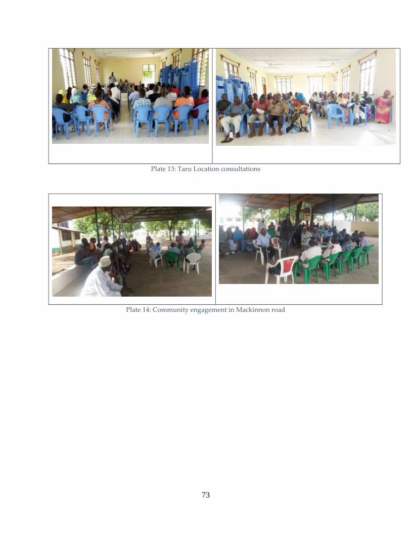
73
Plate 13: Taru Location consultations
Plate 14: Community engagement in Mackinnon road

74
Plate 15: Maungu location consultations
Plate 16: Consultations in Voi
Plate 17: Hon Omar of Kaloleni Ward address community in Voi

75
Plate 18: Consultations in Mbololo location
Consultant Explain Mzima II project in Ngolia A community member contributing during the Ngolia
Consultations.
Proceedings in Ngolia location Ngolia Ward MCA, Honourable making his point
Plate 19: Ngolia Consultations

76
5.8 Outcomes of Public Consultation
In all the public barazas and public consultations held, the project enjoyed overwhelming public
support. No opposition was encountered during the field survey. There was a general consensus
that this project has been longed for in many years. In spite of this, some concerns were expressed
by diverse sections of the public. These concerns however pale in comparison to the benefits that
Mzima II pipeline will bring to the community.
5.8.1 Acceptance of the Project
Most people who attended the public barazas support the proposed project. This support is from
the fact that it will guarantee supply of clean drinking water. Considering the biting shortage of
water in the entire area, the participants actually felt the project should have been implemented
much earlier. Few who objected fear being resettled because they are not sure of compensation
and may be displaced completely.
5.8.2 Compensation
The PAPs raised concerned of them being displaced by the project. What is to be compensated
and when shall they be compensated? It’s the structures being compensated. They are to be
compensated before they can move/before demolitions. The relevant legislations and other
guidelines such as the World Bank standards on compensation shall be observed.
5.8.3 Operation and Maintenance of the Mzima II Pipeline
The community was concerned if they will be involved in the construction phase of the project.
They were informed that the community will be involved in all phases of the project development
and this project can be an avenue for youth involvement. The existing pipeline will be in use till
the Mzima II pipeline is operational.
5.8.4 Role of Project in Supporting GoK and County Government Policies
Though discussions with stakeholders in Government, it was clarified that GoK is committed to
creating an environment favourable for attaining sustainable development in line with the Vision
2030 and the Agenda Four and the county governments strategic development plans (Kwale and
Taita Taveta). The construction of the pipeline will supplement water demands for Mombasa,
parts of Kwale and Kilifi counties.

77
5.8.5 Potential Damage to Existing Infrastructure
Water operators, Kenya Power have extensive infrastructure in form of pipelines and power
distribution lines currently utilizing the road reserve. There is great apprehension that a wrong
move during pipeline construction could damage and possibly occasion untold damage and
interruptions to strategic operations with huge economic implications. The requirement here is
for the design team to work closely with all the operators along this pipeline.
5.8.6 Potential Interference to Business Operations
Without exception all operators along the access roads are concerned that pipeline construction
activity will compound the current traffic congestion and thus affect their businesses. The request
by all actors is that implementation of the project should never interfere with flow of traffic.
5.8.7 Employment
It was the wish of the stakeholders that priority of employment opportunities for skilled, semi-
skilled and unskilled labour, be given to the local residents. However, if the local residents do not
have adequate or none at all of the skilled labour, then these can be sourced from outside the
region. It was agreed that the modalities and quotas for employment for different locations be
agreed upon by the local residents, local administration and the contractor especially between
Kwale and Taita Taveta Counties.
5.8.8 Potential for Increased Economic Activities
The residents are optimistic that upon completion of the Mzima II pipeline project, that more
opportunities for business will be realised. Another additional benefit will be increased water
supply, reduced water shortages, control of water leaking from the busted pipeline, reduced costs
for break down and maintenance costs associated with old pipeline.
5.8.9 Long-Term Sustainability
Many stakeholders are quite clear that the proposed project should not lead to environmental
degradation and require that comprehensive assessment of potential impact areas be carried out
on material borrow areas, civil works sites, fuel storage/maintenance. There was a unanimous
suggestion that such sites should be on public land to avoid future conflicts.

78
5.8.10 Occupational Health and Safety
Heavy truck and equipment / machinery in the project area are hazards that pose various risks to
the persons operating and working with such equipment. The Occupational Safety and Health
Act (OSHA), 2007, stipulate the measures that ought to be taken by an employer, in this case the
contractor, so as to offer mitigation against the risks. Workman’s compensation Act makes it
mandatory for any employer to take insurance cover for their staff.
Apart from the occupational health and safety, the heavy trucks moving from one point to the
other are a hazard to other road users with risks and consequences leading to serious injuries and
even fatalities. Awareness to the general public will be required and accidents arising from such
will be treated under the Traffic Act.
5.8.11 Project Timeframe
The local residents were keen to know when the construction of pipeline will start. The process
involved and the estimated timing in the design, design approval, budgeting and tendering
process was explained, and the estimated waiting time was given in line with the proposed
timeframe as in the project network. It was also strongly articulated that the time frame should be
observed to reduce community-outsiders contact to avert conflicts.
Potential negative impacts identified by the community members have been addressed in the
Environmental and Social Management Plan in Chapter 7.
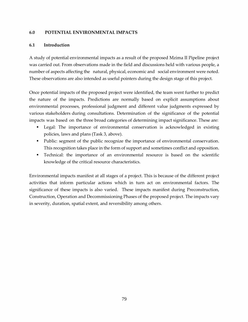
79
6.0 POTENTIAL ENVIRONMENTAL IMPACTS
6.1 Introduction
A study of potential environmental impacts as a result of the proposed Mzima II Pipeline project
was carried out. From observations made in the field and discussions held with various people, a
number of aspects affecting the natural, physical, economic and social environment were noted.
These observations are also intended as useful pointers during the design stage of this project.
Once potential impacts of the proposed project were identified, the team went further to predict
the nature of the impacts. Predictions are normally based on explicit assumptions about
environmental processes, professional judgment and different value judgments expressed by
various stakeholders during consultations. Determination of the significance of the potential
impacts was based on the three broad categories of determining impact significance. These are:
Legal: The importance of environmental conservation is acknowledged in existing
policies, laws and plans (Task 3, above).
Public: segment of the public recognize the importance of environmental conservation.
This recognition takes place in the form of support and sometimes conflict and opposition.
Technical: the importance of an environmental resource is based on the scientific
knowledge of the critical resource characteristics.
Environmental impacts manifest at all stages of a project. This is because of the different project
activities that inform particular actions which in turn act on environmental factors. The
significance of these impacts is also varied. These impacts manifest during Preconstruction,
Construction, Operation and Decommissioning Phases of the proposed project. The impacts vary
in severity, duration, spatial extent, and reversibility among others.

80
Table 12: Scale for evaluation of project impacts
SCORE (-1) +1 (-2) +2 (-3) +3 (-4) +4 (-5) +5
PARAMETER
Magnitude Impacts occur
or are felt on
site
Impacts affect
more than 3
kilometers
radius
Impacts affect
the region
Significance Low
Small changes
which are
hardly
detectable
Moderate
Impact
measurable
but does not
alter processes
High
Many people,
animals,
plants
affected.
Disruption to
ecosystems
and social
systems.
Very high
Loss of
biodiversity,
property,
livelihood
systems
Unknown
effects
Insufficient
information
available.
Apply
precautionary
principle
Probability of
occurrence
Possible
Impacts can
occur but are
controllable
Probable
The impact is
likely to occur
but can be
controlled by
effective
measures.
Definitely will
occur
Duration of
occurrence
Short term
During
construction
phase only
Medium term
Impacts will
be during
operational
phase only
Long term
Impacts will be
there for entire
operation
phase
Very Long
term
For the entire
operational
phase and after
closure
6.2 Potential positive impacts during construction
The proposed project has a host of potential positive impacts. These will be experienced at the
different phases of the proposed project. However, some are phase specific.
6.2.1 Employment
There are various socio-economic benefits that are likely to result from the project. This will be
during the pre-construction, construction and operation phases of the proposed project. Of
importance is employment creation during the construction phase. The existing policy is that all

81
unskilled labour force for any project be sourced from the local community unless such a
population is not available. The local population will be engaged in the site as skilled, semi-skilled
and unskilled workers to provide various services.
During the pre-construction phase, casual workers will be involved in clearing the site and
removing the vegetation from the site. Members of the local community who possess skills such
as driving and operation of heavy equipment could also be engaged drivers or machine operators.
During the operation phase, there will be opportunities for permanent employment.
6.2.2 Growth of secondary businesses
Many secondary businesses could come up in the area especially during the construction phase.
Some key businesses include supply of spare parts for machinery to the contractor and private
individuals, supply and maintenance of furniture, office equipment and stationary. Major
informal businesses include food business, public transport and hospitality services among
others.
The implementation of the project will generate a lot of benefits not only in project area but also
beyond. Nationally, the project will be a contributor to the economic growth of the country in
terms of taxes, offering direct employment to those in water companies and water user
associations. It will also contribute towards the realizing the goal of Water for All.
6.2.3 Revenue to the Exchequer
This will be in form of various licenses that the proponent will have to acquire at different phases.
The government will also earn through various taxes during procurement of materials for the
constructing the proposed project. Other sources of income to government are the taxes paid by
the employees of the proposed project.
6.2.4 Infrastructure development
The proposed project will result in improved road network especially along the pipeline corridor.
This will be necessary to facilitate routine maintenance. Thus local community will benefit from
this improved road network. Currently, the service road for Mzima I is greatly destroyed. Thus
movement by motorists and pedestrians will be enhanced. Other benefits from the improved
access road touch on new business opportunities.

82
6.3 Construction Phase Potential Negative impacts
6.3.1 Water pollution
The activities involved in this phase of the development may cause a negative long-term impact
on the surface and ground water quality within the development area. This will be as a result of
many of the activities which are slated to take place in these phases which includes the possible
storage of hazardous substances on the site such as diesel and motor oil for the operation of
machinery and stand-by generators, and the storage of raw material for the construction of
buildings and roads inter alia.
The clearing of the vegetation within the development area may also have a synergistic negative
long term impact on the water quality in the area as well. The removal of vegetation will increase
the runoff and therefore sedimentation will increase in these areas as well. Inappropriate
treatment of sewage generated from contractor’s campsites may also have a negative impact on
water quality.
Sanitation facilities shall be located within 100m from any point of work, but not closer
than 50 m to any water body.
All temporary/portable toilets shall be secured to the ground to prevent them toppling
due to wind or any other cause.
Only approved portable toilets should be used.
These facilities shall be maintained in a hygienic state and serviced regularly.
The contractor shall ensure that no spillage occurs when the toilets are cleaned or emptied
and that the contents are removed from site to an approved disposal site.
Discharge of waste from toilets into the environment and burying of waste is strictly
prohibited.
Wash areas shall be placed and constructed in such a manner so as to ensure that the
surrounding areas, which include groundwater, are not polluted.
Containers of chemicals and hazardous substances used on the sites should be confined
in secure holding areas before disposal to approved sites by licensed waste handlers.
6.3.2 Soil erosion and contamination
The activities involved in the site preparation and construction phase of the development may
have a major negative short-term impact on soil and geology of the project site. This is due to the
removal of vegetation from the area which will leave considerable areas of soil exposed to the
elements, which may result in soil erosion.

83
Heavy machinery will be traversing the site due to the construction activities and this may lead
to soil compaction and erosion. Hazardous substances such as diesel used for the operation of
machinery and stand-by generators, may be stored on the contractor’s campsites. This may have
a significant negative long-term impact on soil quality in the area.
Limit clearance of vegetation only on the way leave as much as possible to minimize
exposure of soil to agents of erosion.
Put up barriers to protect soil from erosion along the pipeline route where there are steep
edges.
Service machines, vehicles and heavy equipment to ensure there is no spillage of oil and
greases during operations.
Labelling all hazardous substances and providing work instructions in their use.
6.3.3 Noise & Excessive Vibration
The site preparation and construction phases of the development usually have the most negative
impact to the ambient noise and vibration in the development area. Noise and vibration will be
generated by excavators, vibrators and other heavy machines. A number of measures may be
undertaken by the developer/s to reduce the impact of noise on the existing and potential
residents as well as the workers involved in the project. This is temporary, however, and the aim
at this point is to make the increase in noise as small as possible until this phase is complete. The
cumulative impact of the construction activities occurring simultaneously with the other
proposed developments for the area may increase the noise and vibration levels in the area
significantly.
Mitigation
Prevent exposure of construction workers to unacceptable noise levels.
Minimize construction through night time whenever possible.
PPE for workers operating machines that are generating noise and vibrations that can be
injurious to their health.
Limit construction to day time only unless with special permission.
6.3.4 Impacts on Biodiversity.
i. Habitat loss, degradation and fragmentation
The implementation of this project might lead to habitat loss, degradation and fragmentation.
Some of the operations including during implementation and decommissioning stage will
involve use heavy machinery for trenching, making of service roads and moving of pipes and
other equipment. Heavy machinery will have adverse environmental effects including soil
erosion and reduced water quality due to sediment run-off to water bodies thus reducing

84
aquatic habitat quality. Trenching and establishment of service track will lead to habitat
fragmentation and interference of animal movements.
Mitigation measures
Restrict the operations relating to installation of the new pipeline to the existing
pipeline wayleave,
Restore cleared areas as soon as the pipes are installed and ensure landscaping to
minimize soil erosion.
Earthworks in ecologically sensitive areas including steep hillsides and river crossings
need to be carried with great caution.
Leveling and replanting and should be made mandatory.
ii. Interference with wild animal distribution and ranging patterns
Infrastructural projects interfere with the distribution of wild animals. In a study by Benítez-
López et al (2010) reported that mammal and bird population densities declined with their
proximity to infrastructure. Avoidance of infrastructure was more pronounced in open areas
compared to forested areas probably due to reduced visibility of the infrastructure in forested
areas. However, species vary in their response to infrastructure with raptors being abundant
in the proximity of infrastructure whereas other bird taxa tend to avoid it. Mammals are
usually more affected by infrastructure than birds being affected over larger distances than
birds.
Mitigation
Use of less noisy machinery and equipment,
Use of minimal number of vehicles and other equipment in the national parks
Using an optimal workforce.
Worker’s camps should be located outside the national park.
Construct the project within the set timelines to reduce time of operations in the
protected areas.
iii. Potential for human wildlife conflicts – the risk of death or injury among workers
The workers might encounter many dangerous wild animals including crocodiles and hippos
at Mzima Springs and elephants, Rhinos, buffaloes, lions, leopards, poisonous snakes among
others. As shown in Figure 2, elephants and other dangerous animals can be encountered
anywhere along the project area within the parks and also in areas beyond the park
boundaries. Project implementation particularly within the parks will inevitably interfere

85
with animal feeding habits, behavior and ranging patterns, which often leads to human-
wildlife conflict.
Mitigation measures
Reducing the human footprint associated with water pipeline will be limited through
controlling the number of workers allowed project site during the implementation,
operation and decommissioning phases.
At the beginning of the project, the workers will need to be briefed on the dangers
they will be exposed to while working in wildlife habitats. They will be educated on
how best to behave and protect themselves from dangerous animals.
The workers should be accompanied by armed KWS rangers while working in the
parks and other wildlife rich habitats.
iv. Interference with tourism activities
Some of the operations particularly during the project implementation and decommissioning
phases will interfere with tourism activities. Mzima Springs is one of the most important
tourist attractions in Tsavo West National Park and the operations related to this project will
reduce the scenic appeal and interfere with the level of enjoyment that the tourists experience.
Other tourist hotspots include watering points and salt licks.
Mitigation
It will be crucial that the work at these sites be carried out as fast as possible and with
as minimal impacts on biodiversity and aesthetics as possible.
Pipeline trenches and other excavated sites should be covered as soon.
Where practical, most of the work should be timed to coincide with low tourism
season/time of day.
v. Increased poaching of wild animals.
Poaching of elephants and rhino is major conservation concern in the Tsavo ecosystem (KWS,
2008). Other animals including antelopes, giraffes, zebras, buffaloes and game birds may also
be poached for their meat. Other animals for example pancake tortoise (Malacochersus tornieri)
may be smuggled as pets (Malonza 2003). Some of the workers engaged in the project
implementation and decommissioning stages may be tempted to engage in this illegal activity
either for subsistence needs or for commercial gains. This may be countered through by
instituting some of these measures:
Security agencies including Kenya Wildlife Service (KWS) should increase anti-
poaching effort
Avoiding establishment of workers’ camps inside the parks and other wildlife rich
habitats, in the area and minimizing human traffic within the area of operation.
86
Enlisting the support of local community in ant-poaching activities
Sensitization of the workers and members of public on the importance of wildlife
conservation, wildlife legislation particularly of the new the Wildlife Act 2013 (GOK,
2013), which has legislated very stiff penalties for wildlife poaching especially when
endangered species are involved.
Vetting all workers who will work in the park sections of the pipeline. This will ensure
that only people with no criminal records are allowed in the park.
Strict observance of Park Rules and Regulations.
Inspection of all construction vehicles entering and or leaving the protected areas of
Tsavo National park.
Creating a manned entry near for example at Ndii where the pipeline exits Tsavo
West. The same case should apply for Tsavo East.
Embedding KWS personnel to the Resident Engineer’s (RE) Office to ensure that the
Contractor does not operate in any way that is prejudicial to conservation of flora and
fauna in Tsavo East and West.
vi. Spread of Zoonotic diseases, Gastro Intestinal parasites and other pathogens
The presence of many workers can lead to the spread of zoonotic diseases particularly is no
sanitary facilities are provided. Examples of zoonotic diseases that can affect people and/or
wild animals include rabies and anthrax. Nonhuman primates have acquired measles from
tourists (Wallis and Lee, 1999). Inappropriate disposal of human waste can lead to
transmission of human gastrointestinal parasites to wild primates.
Mitigation Measures
Ensuring that construction workers observe hygiene.
Providing mobile toilets to workers.
The worker’s camps should be located outside the national Parks so as to reduce
workers contact with wild animals.
The workers should be educated on the need to avoid feeding wild animals and to
dispose of waste appropriately.
vii. Spread of invasive species
Already some areas of the Tsavo ecosystem ecosystem are severely impacted by invasive
species including Lantana camara , Datura stamonium, Prosopis julifora and Opuntia stricta (TCA
Management plan,20108-2018; Boy and Wii, 2013 ). Invasive plants may be introduced
unintentionally by workers. Earthworks including movement of soil and may facilitate the
spread of invasive species.

87
The pipeline route should be monitored and remedial action taken should this or other
invasive species be noticed in along the pipeline either during the implementation or
the operation stages of the project.
Movement of soil for service road construction will be limited to avoid spreading
invasive species.
Clean all machines and vehicles before and entering the protected areas.
viii. Accidental injury and deaths of wild animals
Use of tractors other equipment can lead to death of wild animals. This is likely to affect slow
moving animals like tortoises and other reptiles and amphibians. This can be mitigated by
ensuring that slow moving animals are physically removed from work area. Increased vehicular
traffic in the in the national parks and other wildlife rich areas can lead to increased incidences of
road kills. In addition, open trenches can injure or even kill animals.
This can be mitigated by educating the drivers on the legal speed limits in
conservation areas.
Laying the pipeline and covering the trenches within the shortest time possible.
Limiting the time of open trenches in the park to maximum 24 hours and a length of
not more than 200 metres each day.
Adherence to Parks Rules and Regulations.
6.3.5 Occupational accidents
Accidents do happen in construction sites. These accidents could be mild or fatal depending on
various factors. Victims of accidents are not only workers but also other third parties such
neighbours, passers. Use of heavy machinery in site clearing presents safety hazards. Vehicular
movements can cause accidents resulting in injuries and probably death. Operation of machinery
can also lead to accidents with differing fatalities. Accidents could result from the following
among other causes:
Poor judgment by the operator or driver.
Operation of equipment by unqualified persons.
Operating faulty machines.
Poor visibility.
Exhaustion by operators.
Operating machine or driving while under influence of alcohol or drugs.
Carelessness.
Abuse and misuse of machine.

88
Failure to use safety gear.
Falls while working in elevated positions.
Collapse of pits or trenches while workers are inside.
Attacks by dangerous animals while working in the protected areas of Tsavo West or East
National Parks.
Mitigation measures
Provision of appropriate working tools such as climbing ropes, safety shoes and helmets
Display at prominent places occupational health and safety rules.
Test and approve equipment such as ladders before use.
Training workers on how to use various PPE and proper use of machinery.
Routine maintenance of machinery.
Right machine for right work.
Enforcing a strict alcohol and drugs policy in the project cycle.
Engaging only competent personnel to handle machinery.
Appropriate informational and warning signs.
Compulsory training on safety precautions to be observed while working in national
parks.
Contractor to get security from Kenya Wildlife Service (KWS) for workers at all time while
there are project activities within the parks.
Project activities within the Parks to be carried out only during the permitted hours unless
the Contractor has a special undertaking for which permission form KWS has been asked
and granted.
Have trained First Aiders and well stocked First Aid boxes at accessible locations in the
proposed project.
6.3.6 Disturbance of traffic and difficulty of access
The main impact on roads traffic will be during excavation and laying of the pipes along, or
across main roads. Longitudinal excavation will cause narrowing of the roads in some sections
for relatively long periods, while lateral crossing of roads may cause blocking of the road but for
a relatively short period, probably few hours. The vehicle flow will thus be interrupted
during such moments.
Excavation in residential areas will cause access problems to pedestrians, and possibly to riders
of animals, motorcycles and bicycles. This access difficulty will have more impact on elderly
people, handicapped and children. This vulnerable group may accidentally fall in open
trenches or make tedious long cycles before they reach their targeted locations.

89
Mitigation measures:
Traffic department should approve crossing plan prior to construction, and should
approve obstruction times during construction.
Access of residents should be facilitated by installing appropriate temporary bridges over
the pipeline trenches.
Suitable warning signs should be placed at near locations and should be visible at night.
A guard should be available 24 hours to help people access across pipeline trenches.
Alternatives access ways should be communicated to the community
Provide Marshalls to assist the elderly, school children, expectant mothers and Persons
With Disability (PWDs) cross the trenches.
6.3.7 Risks of Damaging Underground Infrastructure
During excavation for laying the pipes there are risks of damaging underground potable water
pipes, telecommunication or power lines. This will be associated with cutting water,
communication or power services and ponds of water in excavation trenches. Thus interruption
of such services may this be experienced.
Mitigation measures
Collecting available maps for infrastructure routes.
Excavating manual trial pits to locate the underground infrastructure facilities before
using mechanical excavation.
Notify the relevant service provider in case of accidental damage.
6.3.8 Effects on Structural Integrity
During excavations of trenches, vibrations from excavators may affect the stability of the
buildings near the proposed pipeline in the built up areas. Affected buildings may crack and thus
impact on their safety. The owners may experience losses from the short to the medium term
since such structures may be rendered uninhabitable. Apart from economic losses, the
psychological suffering may be immense. Disruption of the social aspect of such families may
also result.
Mitigation measures
The geotechnical report should include suitable measures for confining vibrations within
project sites. These measures should be tailored according to the proximity of buildings
to the project sites and earthwork program.
These recommendations identified in the geotechnical report (such as secant piling or
sheet piling or establish cut-off walls) should be implemented by the contractor and
supervised by Environment Health and Safety Advisor.

90
No blasting should take place while excavating in built up areas.
Use manual excavations as much as is practicable.
6.3.9 Chemical Exposure
This is a major short term potential negative impact. Chemical such as paints, oils and grease will
be used on different aspects of the proposed project. Those handling them risk heath if certain
measures are not observed. However, the risk is not limited to handlers only other third parties
can also bear the brunt of improperly handled chemicals from the construction of the proposed
project. The containers of pants for example should be disposed of by licensed waste handlers.
Mitigation Measures.
Material safety data sheets of all chemicals used during construction will be kept in a
register by the contractor
The contractor to have procedures in place regarding emergencies relating to chemicals
and dangerous goods consistent with the existing legislation.
Records will be kept on the existing inventory, storage location, personnel training and
disposal of waste for all chemicals and dangerous goods used on site
All relevant construction workers will be trained in appropriate handling, storage and
containment practices for chemicals and dangerous goods in relation to their position.
All spills will be cleaned immediately
6.3.10 Liquid Effluents from Contractor’s camps
The size of the project implies that there will be relatively large labour force. Some of the workers
will be housed in a contractor’s camp for ease of movement and to save transportation costs. The
liquid waste generated in these camps if not properly disposed can contaminate source and
ground water especially where the water table is high. It can also be a source of offensive odours.
Mitigation measures
Provision shall be made for employee facilities including shelter, toilets and washing
facilities.
Toilet facilities supplied by the contractor for the workers shall occur at a minimum ratio
of 1 toilet per 30 workers (preferred 1:15).
The exact location of the toilets shall be approved by the Public Health Department prior
to establishment.
Sanitation facilities shall be located within 100m from any point of work, but not closer
than 50 m to any water body.
All temporary/portable toilets shall be secured to the ground to prevent them toppling
due to wind or any other cause.

91
The contractor shall ensure that the entrances to toilets are adequately screened from
public view.
Only approved portable toilets should be used.
These facilities shall be maintained in a hygienic state and serviced regularly. Toilet paper
shall be provided
The contractor shall ensure that no spillage occurs when the toilets are cleaned or emptied
and that the contents are removed from site to an approved disposal site.
Discharge of waste from toilets into the environment and burying of waste is strictly
prohibited.
Wash areas shall be placed and constructed in such a manner so as to ensure that the
surrounding areas, which include groundwater, are not polluted.
6.3.11 Solid Wastes
Solid waste from the proposed project will be generated from many streams. These include waste
metal pieces from the pipes, cement bags and paint cans among others. Where they are left to pile
up, there is the likelihood of attracting scavengers who in certain instances can pose security
challenges. Tins can trap water and provide breeding ground for mosquitoes which spreads
malaria. The contractor’s camps will also generates copious amounts of wastes especially organic
waste from the kitchens.
Mitigation measures include:
The contractor should segregate hazardous waste, which will be safely transported to a
hazardous waste facility, from non- hazardous waste which will be transported to
approved disposal sites by NEMA.
Removed sewage from cesspits, that will be replaced, and cesspits used by construction
workers camps should be removed by tankers and disposed at approved sites. Garbage
collected from construction sites should be disposed at appropriate sites approved by
NEMA.
Inert construction wastes should be appropriately collected and disposed in approved
disposal site.
Sell metal to authorized scrap metal dealers
6.3.12 Population Displacement
The proposed project will follow the already existing wayleave parallel to Mzima I. However, it
is worth noting that there are some cases where certain individuals have encroached the wayleave
in varying degrees. Encroachment is in the form of farming, construction of structures and
carrying out other businesses on the pipeline route. The structures on the wayleave will have to

92
be demolished for the pipeline to occupy its place. Thus, displacement may be physical in the
case of those with structures or economic in the case of those with open air businesses on the
wayleave.
Mitigation measures:
Prepare a Resettlement Action Pan (RAP) for the proposed project with:
vi. A comprehensive census of Project Affected Persons (PAPs).
vii. Asset Inventory of the PAPs.
viii. Cutoff dates that are reasonable.
ix. Compensation rates, procedure and Schedule
x. Grievance Redress Mechanisms.
6.3.13 Fire outbreak
Fire hazards are more likely in the contractor’s camps where inflammables s such as paints, and
solvent such as thinners and turpentine are stored. The threat is multiplied in case there are open
fires where such are kept. Electric faults can also trigger fire whose damaging effects may vary
depending on how fast and appropriate the response is.
Mitigation Measures:
Label all inflammable materials and sore them appropriately
Provision of adequate firefighting equipment capable of fighting all classes of fire
Put “ No Smoking Signs” in areas where inflammables are stored
Train workers on the use of ire fighting equipment
Label fire exits and keep them clear.
Display a list of emergency contact numbers prominently
6.3.14 Spread of HIV and AIDS
The influx of migrant workers working away from their families and the resulting changes in
sexual behaviors, increase chances of escalation of STI’s including the HIV and AIDS. These will
increase both mortality and morbidity in the project area and beyond. The ripple effect is
orphaned children, widows and widowers, loss of productive workforce, burden on health
service providers and drop out from schools where parents or guardians die. There could also be
cases of unwanted pregnancies as the migrant workers interact and get into relationships with
the local communities. In this case, there is a vulnerable group of school going girls who abandon
their schooling to nurse babies and fall into the vicious circle of poor young unwed single
mothers.
Sensitize the migrant workers and host community on risky sexual behaviour.
Have VCT services on site and encourage workers to undergo the same.

93
Provision of protective devices such as condoms.
Ensure project is completed within the set timeframe to minimize the contact.
6.3.15 Social and cultural conflicts
The proposed Mzima II project has elicited mixed reactions and created high expectations among
the different categories of stakeholders. These expectations include among others; assurance of
uninterrupted water supply, jobs during the construction phase, business opportunities during
construction, political recognition and hefty compensation among others. The question of
employment and political capital from the proposed project rank highly as prominent conflict
triggers. These, if not properly handled will lead to unending feuds among community members,
contractors and the proponent. Social conflicts also can result from the presence of workers from
different cultural backgrounds. Sometimes the host community may feel that migrants are
behaving in ways that are an affront to their (host’s) cultural believes and practices.
Mitigation measures:
Sensitize migrant workers on key cultural sensitivities of the host community.
Ensure fairness in recruitment of workforce by ensuring that local people get priority of
the jobs that they can perform.
Create open communication for people to channel their grievances to avoid rumours and
fake news with respect to the proposed project.
Engage with local leaders at all times.
Create a project committee with representation of all actors.
6.4 Positive Impacts during the Operational phase
Upon completion and commissioning, the proposed Mzima II project will result in a host of
positive impacts. These include:
6.4.1 Improved well-being of women and children
At the household level, women and children (especially girls) bear the burden of fetching water.
Other than the time spent in getting from long distances, this practice has far reaching
consequences on their health and well-being. Constant water in homesteads would translate to
time saving by the women. Time saved thus would be invested in other engagements that could
bring financial benefits to the family. Children also bear the brunt of water borne diseases while
women are tied down to provide nursing care to the sick family members. With access to a safe
water source, all these negative impacts will be reversed in the project area. The reduced
morbidity due to water from unsafe sources will mean financial savings by households.

94
6.4.2 Enhanced Water supply which translates to improved psychological well-being of
households
Water shortage is a major stress factor in households in the project area. Public consultation
meetings found that this stress comes in various ways such as the extra cost incurred in paying
water vendors. This is added by the knowledge that the water so supplied is not safe. It is
compounded by disease burden caused by consuming such water. Other than that, the inability
to maintain the desired level of hygiene and cleanliness due to water shortage adds to the stress.
With a constant water supply from the proposed project, the psychological well-being of
household members will be greatly enhanced. This is the main overall positive impact from the
proposed project.
6.4.3 Employment
The management of extra facilities that will come with Mzima II requires recruitment of new staff.
While some will be on permanent basis, others will be on Contractual casual basis. This will
translate to incomes and improved lives for the households in question.
6.4.4 Increased Profits for Businesses in the Project area
Water shortage has been a key hindrance to business growth in towns in the area. It is also a
major cost that eats into profit margins of businesses. In tourist facilities for instance, it was
reported that they spend large volumes of detergent in laundry due to reliance on salty water
from boreholes. The water also corrodes pipes. To provide clean drinking water for their clients,
these hotels employ expensive water treatment techniques cutting their margins further.
Implementation of the proposed project will alter this state of affairs. A constant water supply
from the proposed project could go a long way in boosting business growth in the town along the
pipeline corridor while minimizing cases of water borne diseases. This will translate into a host
of other benefits such as employment and increased incomes for those engaged in business.
6.4.5 Revenue to the Exchequer
This will be in form of various licenses that the proponent will have to acquire and pay during
the operation phase. For instance the Abstraction permit which is paid for annually and the
charges of water abstracted from the springs has to be paid for by the proponent.

95
6.4.6 Infrastructure development
The proposed project will result in improved road network especially along the pipeline corridor.
This will be necessary to facilitate routine maintenance. Thus local community will benefit from
this improved road network. Currently, the service road for Mzima I is greatly destroyed. Thus
movement by motorists and pedestrians will be enhanced. Other benefits from the improved
access road touch on new business opportunities.
6.4.7 Reduced conflicts among users of upstream and downstream beneficiaries.
Mzima Spring is the water supply lifeline of the project area from Tsavo to Mombasa. However,
there has been disquiet among community in Taita Taveta especially Voi over the utilization of
Mzima waters. Residents in Voi have felt over the years that water is in their territory but it does
not benefit that much. Public consultations revealed this discontent where some residents were
quoted saying “Maji yetu inapelekwa Mombasa kuosha magari” (Our water is taken to wash
vehicles in Mombasa). Another Key Informant confided with the EIA Team that several times
they have worked very hard to prevent demonstrations by angry residents over the Mzima I
waters. Conflicts are thus inevitable. This statement is loaded with meaning. The proposed
project will ensure fair and equitable distribution thus diffusing these tensions.
6.4.8 Reduced cases of water borne diseases
Constant water supply guaranteed by the proposed Mzima II imply residents will not be
consuming water from contaminated sources as is the case currently. This will translate to
reduced exposure to disease causing pathogens in contaminated water.
6.5 Potential Negative Impacts during Operational Phase
Completion and commissioning of Mzima II project as designed could lead to some negative
impacts during its operational phase. However, these impacts will be eliminated or mitigated by
employing effective mitigation measures. Certain stakeholders raised these issues during the
consultations.
6.5.1 Over abstraction of water from Mzima Springs
Implementation of Mzima II pipeline will lead to abstraction of around 62% of the flows into the
Springs (Atkins, 2018). Over-abstraction of water from the springs would endanger the hippos,
crocodiles and fish that live in this habitat. In addition, over abstraction of water could also deny
resident wildlife access to water during the dry season. As Atkins (2018) notes, high water

96
abstraction levels at the springs can pose a risk to downstream aquatic ecology. As such
abstraction at the spring will ensure requirements for minimum environmental flow, through the
ponds and also through the Mzima River. (Section 4.11.6, Above)
Mitigation measures
It is recommended to strengthen water intake monitoring
It is recommended to increase the quantity of rainfall stations, especially in the ridge
area
It is recommended to strengthen the discharge monitoring of Mzima Springs and
other major springs that take the aquifer as the water source
Coast Water Services Board needs to work with appropriate government agencies
(including Kenya Water Towers agencies, Water Resources Authority, Kenya Wildlife
Service and Kenya Forest Services) civil society organizations and local stakeholders
in order to secure Mzima Springs water catchment areas.
This should entail water catchment protection of and conservation activities including
degradation of any degraded areas.
Coast Water Services Board should work with appropriate stakeholders and develop
a payment for ecosystem service scheme in which the users of water from Mzima
Springs pay for the conservation and protection of the spring’s water catchment.

97
7.0 ENVIRONMENTAL MANAGEMENT AND MONITORING PLAN
7.1 Introduction
The purpose of the following Environmental Management Plan (EMP) for the proposed project
is to provide mitigation measures for the significant potential negative environmental impacts.
The objectives of the EMP are:
To provide evidence of practical and achievable plans for the management of the
proposed project.
To provide the Proponent and the relevant Lead Agencies with a framework to confirm
compliance with relevant laws and regulations.
To provide community with evidence of the management of the project in an
environmentally acceptable manner.
On the other hand, Environmental monitoring provides feedback about the actual environmental
impacts of a project. Monitoring results help judge the success of mitigation measures in
protecting the environment. They are also used to ensure compliance with environmental
standards, and to facilitate any needed project design or operational changes. A monitoring
program, backed up by powers to ensure corrective action when the monitoring results show it
necessary, is a proven way to ensure effective implementation of mitigation measures. By
tracking a project’s actual impacts, monitoring reduces the environmental risks associated with
that project, and allows for project modifications to be made where required.
7.2 Construction Phase Environmental Management Plan
The construction Contractor will be responsible for the implementation of the construction phase
EMP. The Contractor will identify responsibilities and organization required to implement the
accountabilities of the construction phase EMP. The EMP will apply to the Principal Contractor
and all Sub-contractors.
The Contractor will also be responsible for developing and implementing a site specific induction
for all construction workers. This induction will include all EHS hazards and their control
measure. The Contractor will ensure that all construction workers are trained and competent and
hold the appropriate certification for the tasks that they will be undertaking.

Table 13: Construction Phase EMP
SN IMPACT MITIGATION
MEASURES
RESPONSIBLE
ACTOR
TIMEFRAME
1. Water
pollution
Sanitation facilities
shall be located within
100m from any point of
work, but not closer
than 50 m to any water
body.
All temporary/portable
toilets shall be secured
to the ground to
prevent them toppling
due to wind or any
other cause.
Only approved
portable toilets should
be used.
These facilities shall be
maintained in a
hygienic state and
serviced regularly.
The contractor shall
ensure that no spillage
occurs when the toilets
are cleaned or emptied
and that the contents
are removed from site
to an approved
disposal site.
Discharge of waste
from toilets into the
environment and
burying of waste is
strictly prohibited.
Wash areas shall be
placed and constructed
in such a manner so as
to ensure that the
surrounding areas,
CONTRACTOR Entire construction
phase

99
SN IMPACT MITIGATION
MEASURES
RESPONSIBLE
ACTOR
TIMEFRAME
which include
groundwater, are not
polluted.
Containers of chemicals
and hazardous
substances used on the
sites should be confined
in secure holding areas
before disposal to
approved sites by
licensed waste
handlers.
2. Soil erosion
and
contamination
Limit clearance of
vegetation only on the
way leave as much as
possible to minimize
exposure of soil to
agents of erosion.
Put up barriers to
protect soil from
erosion along the
pipeline route where
there are steep edges.
Service machines,
vehicles and heavy
equipment to ensure
there is no spillage of
oil and greases during
operations.
Labelling all hazardous
substances and
providing work
instructions in their
use.
Contractor Entire construction
phase
3. Noise and
vibrations
Prevent exposure of
construction workers to
Contractor Entire construction
phase
100
SN IMPACT MITIGATION
MEASURES
RESPONSIBLE
ACTOR
TIMEFRAME
unacceptable noise
levels.
Minimize construction
through night time
whenever possible.
PPE for workers
operating machines
that are generating
noise and vibrations
that can be injurious to
their health.
Limit construction to
day time only unless
with special
permission.
Proper maintenance of
motor vehicles and
other machines.
Install silences in heavy
equipment.
Use manual excavation
where possible.
4. Death of wild
animals
through
accidents such
as falling in
open trenches
or being hit
by speeding
construction
vehicles
Driving within the
permitted speed limit
in the protected areas
such as Tsavo national
park to avoid road kills.
Limiting the time
trenches remain open in
the park to maximum
24 hours and a length of
not more than 200
metres each day.
Strict observance of
Park Rules and
Regulations.
Embedding KWS
personnel to the
Contractor.
KWS.
Security
Agencies
Preconstruction and
Construction phase

101
SN IMPACT MITIGATION
MEASURES
RESPONSIBLE
ACTOR
TIMEFRAME
Resident Engineer’s
(RE) Office to ensure
that the Contractor
does not operate in any
way that is prejudicial
to conservation of flora
and fauna in Tsavo East
and West.
5. Upsurge of
illegal
activities in
the protected
Tsavo
National Park
Inspection of all
construction vehicles
entering and or leaving
the protected areas of
Tsavo National park.
Creating a manned
entry near for example
at Ndii where the
pipeline exits Tsavo
West. The same case
should apply for Tsavo
East.
Embedding KWS
personnel to the
Resident Engineer’s
(RE) Office to ensure
that the Contractor
does not operate in any
way that is prejudicial
to conservation of flora
and fauna in Tsavo East
and West.
Strict observance of
Park Rules and
Regulations.
Vetting all workers
who will work in the
park sections of the
pipeline. This will
ensure that only people
Contractor.
KWS
Security
Agencies
Preconstruction.
Construction.

102
SN IMPACT MITIGATION
MEASURES
RESPONSIBLE
ACTOR
TIMEFRAME
with no criminal
records are allowed in
the park.
6. Disturbance
of wild
animals
distribution
and ranging
patterns
Maintenance of
machines so as to
reduce noise during
operations.
Strict enforcement of
speed limits in the park.
Use of silencers in
heavy noisy machines.
Have optimal
construction workers in
the park.
No construction camps
in the parks.
Contractor Construction phase
7. Introduction
of alien and
invasive
species in
Tsavo
national park
by vehicles
and heavy
machines
Cleaning all machinery
before entering the
protected area to ensure
they are free from seeds
or other material that
may introduce invasive
species.
Contractor Entire construction
phase.
8. Habitat loss,
degradation
and
fragmentation
Restrict to land –take to
the Mzima I right of
way, restore cleared
areas as soon as the
pipes are installed
Landscaping to
minimize soil erosion.
Control earthworks in
ecologically sensitive
areas need to be
controlled and should
not be carried out in
Contractor.
Proponent
Construction phase

103
SN IMPACT MITIGATION
MEASURES
RESPONSIBLE
ACTOR
TIMEFRAME
ecologically sensitive
areas including steep
hillsides and water
sources.
Habitat restoration
measures including
leveling and replanting
and should be made
mandatory
Formulate Payment for
Ecosystem Services
where water uses will
pay for the
conservation of Mzima
springs water
catchment
9. Potential for
human
wildlife
conflicts – the
risk of death
or injury
among
workers
Reducing the human
footprint associated
water pipeline will be
limited through
controlling the number
of workers allowed
project site during the
implementation,
operation and
decommissioning
phases.
At the beginning of
the project, the
workers will need to
be briefed on the
dangers they will be
exposed to while
working in wildlife
habitats. They will be
educated on how best
to behave and protect
Contractor Construction phase
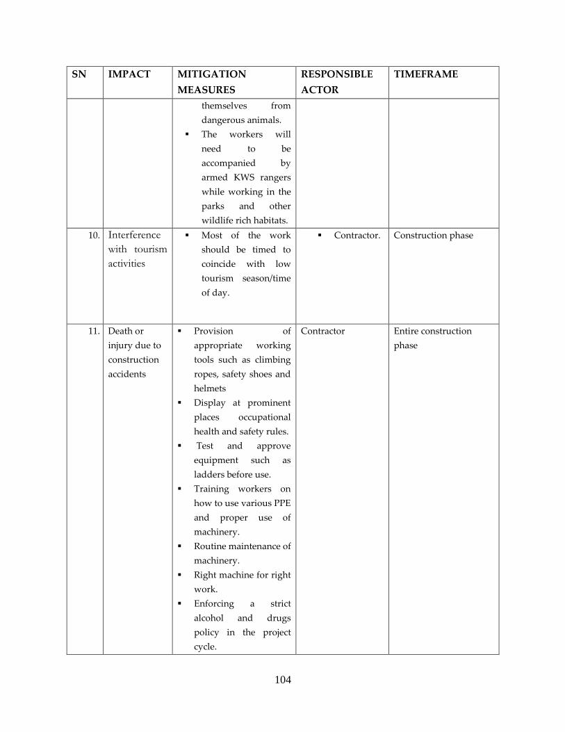
104
SN IMPACT MITIGATION
MEASURES
RESPONSIBLE
ACTOR
TIMEFRAME
themselves from
dangerous animals.
The workers will
need to be
accompanied by
armed KWS rangers
while working in the
parks and other
wildlife rich habitats.
10. Interference
with tourism
activities
Most of the work
should be timed to
coincide with low
tourism season/time
of day.
Contractor. Construction phase
11. Death or
injury due to
construction
accidents
Provision of
appropriate working
tools such as climbing
ropes, safety shoes and
helmets
Display at prominent
places occupational
health and safety rules.
Test and approve
equipment such as
ladders before use.
Training workers on
how to use various PPE
and proper use of
machinery.
Routine maintenance of
machinery.
Right machine for right
work.
Enforcing a strict
alcohol and drugs
policy in the project
cycle.
Contractor Entire construction
phase
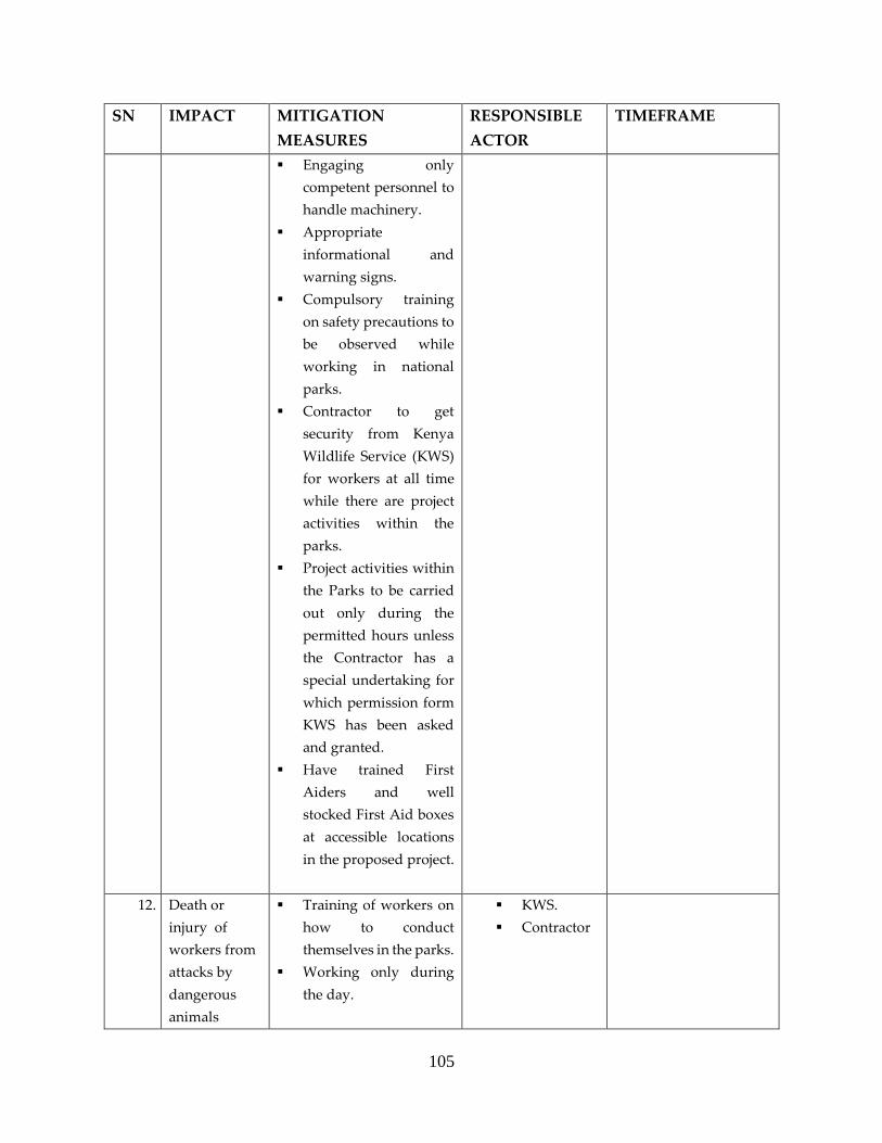
105
SN IMPACT MITIGATION
MEASURES
RESPONSIBLE
ACTOR
TIMEFRAME
Engaging only
competent personnel to
handle machinery.
Appropriate
informational and
warning signs.
Compulsory training
on safety precautions to
be observed while
working in national
parks.
Contractor to get
security from Kenya
Wildlife Service (KWS)
for workers at all time
while there are project
activities within the
parks.
Project activities within
the Parks to be carried
out only during the
permitted hours unless
the Contractor has a
special undertaking for
which permission form
KWS has been asked
and granted.
Have trained First
Aiders and well
stocked First Aid boxes
at accessible locations
in the proposed project.
12. Death or
injury of
workers from
attacks by
dangerous
animals
Training of workers on
how to conduct
themselves in the parks.
Working only during
the day.
KWS.
Contractor

106
SN IMPACT MITIGATION
MEASURES
RESPONSIBLE
ACTOR
TIMEFRAME
Have armed KWS
rangers always
accompanying workers
in the park.
13. Disturbance
of traffic and
difficulty of
access
Traffic department
should approve
crossing plan prior to
construction, and
should approve
obstruction times
during construction.
Access of residents
should be facilitated by
installing appropriate
temporary bridges over
the pipeline trenches.
Suitable warning signs
should be placed at
near locations and
should be visible at
night.
A guard should be
available 24 hours to
help people access
across pipeline
trenches.
Alternatives access
ways should be
communicated to the
community
Provide Marshalls to
assist the elderly,
school children,
expectant mothers and
Persons With Disability
(PWDs) cross the
trenches.
Contractor.
Traffic
Department
Construction phase

107
SN IMPACT MITIGATION
MEASURES
RESPONSIBLE
ACTOR
TIMEFRAME
14. Damage of
underground
infrastructure
Collecting available
maps for infrastructure
routes.
Excavating manual trial
pits to locate the
underground
infrastructure facilities
before using
mechanical excavation.
Design of the proposed
Mzima II be shared
with KPLC, KPC,
KENHA, KERA, and all
companies such as
Safaricom that have
laid their fibre optic
cables in the project
area.
Contractor Construction phase
15. Structural
integrity
The geotechnical report
should include suitable
measures for confining
vibrations within
project sites. These
measures should be
tailored according to
the proximity of
buildings to the project
sites and earthwork
program.
These
recommendations
identified in the
geotechnical report
(such as secant piling or
sheet piling or establish
cut-off walls) should be
implemented by the
contractor and
Contractor Entire Construction
phase

108
SN IMPACT MITIGATION
MEASURES
RESPONSIBLE
ACTOR
TIMEFRAME
supervised by
Environment Health
and Safety Advisor.
No blasting should
take place while
excavating in built up
areas
Use manual excavation
in areas that have
vulnerable structures.
16. Chemical
exposure
Material safety data
sheets of all chemicals
used during
construction will be
kept in a register by the
contractor
The contractor to have
procedures in place
regarding emergencies
relating to chemicals
and dangerous goods
consistent with the
existing legislation.
Records will be kept on
the existing inventory,
storage location,
personnel training and
disposal of waste for all
chemicals and
dangerous goods used
on site
All relevant
construction workers
will be trained in
appropriate handling,
storage and
containment practices
for chemicals and
dangerous goods in
Contractor Construction phase

109
SN IMPACT MITIGATION
MEASURES
RESPONSIBLE
ACTOR
TIMEFRAME
relation to their
position.
All spills will be
cleaned immediately
17. Liquid
Effluents from
Contractor’s
camps
Provision shall be made
for employee facilities
including shelter,
toilets and washing
facilities.
Toilet facilities
supplied by the
contractor for the
workers shall occur at a
minimum ratio of 1
toilet per 30 workers
(preferred 1:15).
The exact location of the
toilets shall be
approved by the Public
Health Department
prior to establishment.
Sanitation facilities
shall be located within
100m from any point of
work, but not closer
than 50 m to any water
body.
All temporary/portable
toilets shall be secured
to the ground to
prevent them toppling
due to wind or any
other cause.
The contractor shall
ensure that the
entrances to toilets are
adequately screened
from public view.
Contractor Construction phase

110
SN IMPACT MITIGATION
MEASURES
RESPONSIBLE
ACTOR
TIMEFRAME
Only approved
portable toilets should
be used.
These facilities shall be
maintained in a
hygienic state and
serviced regularly.
Toilet paper shall be
provided
The contractor shall
ensure that no spillage
occurs when the toilets
are cleaned or emptied
and that the contents
are removed from site
to an approved
disposal site.
Discharge of waste
from toilets into the
environment and
burying of waste is
strictly prohibited.
Wash areas shall be
placed and constructed
in such a manner so as
to ensure that the
surrounding areas,
which include
groundwater, are not
polluted.
18. Solid wastes Employ the integrated
solid waste management
system
i.e. through a hierarchy of
options:
Source reduction
Recycling
Contractor Construction phase

111
SN IMPACT MITIGATION
MEASURES
RESPONSIBLE
ACTOR
TIMEFRAME
Composting and
reuse
The contractor
should segregate
hazardous waste,
which will be safely
transported to a
hazardous waste
facility, from non-
hazardous waste
which will be
transported to
approved disposal
sites by NEMA.
Garbage collected
from construction
sites should be
disposed at
appropriate sites
approved by
NEMA.
Inert construction
wastes should be
appropriately
collected and
disposed in
approved disposal
site.
Sell metal to
authorized scrap
metal dealers
Wastes recovery
19. Population
displacement
with
attendant loss
of income and
property
Compensation at full
replacement cost for
losses of assets
attributable directly to
the project.
Prepare a Resettlement
Action Pan (RAP) for
Proponent and
contractor
Entire Preconstruction
and construction phases

112
SN IMPACT MITIGATION
MEASURES
RESPONSIBLE
ACTOR
TIMEFRAME
the proposed project
with:
i. A comprehensive
census of Project
Affected Persons
(PAPs).
ii. Asset Inventory of
the PAPs.
iii. Cutoff dates that
are reasonable.
iv. Compensation
rates, procedure
and Schedule
v. Grievance Redress
Mechanisms.
vi. Proponent to
properly survey
and map the way
leave
vii. Lay the pipeline
within the existing
way leave.
viii. Avoid
encroachment on
private property.
20. Fire outbreak Label all inflammable
materials and sore them
appropriately
Provision of adequate
firefighting equipment
capable of fighting all
classes of fire
Put “ No Smoking
Signs” in areas where
inflammables are
stored
Contractor Construction phase

113
SN IMPACT MITIGATION
MEASURES
RESPONSIBLE
ACTOR
TIMEFRAME
Train workers on the
use of firefighting
equipment
Label fire exits and
keep them clear in the
Contractor’s camp.
Display a list of
emergency contact
numbers prominently
21. HIV/AIDS Sensitize the migrant
workers and host
community on risky
sexual behaviour.
Have VCT services
on site and
encourage workers
to undergo the
same.
Provision of
protective devices
such as condoms.
Ensure project is
completed within
the set timeframe to
minimize the
contact.
Provide counseling
and testing for
HIV/AIDS to
incoming
construction
personnel
Strengthen
advocacy through
awareness training
in HIV/AIDS and
other STDs;
Contractor Construction phase

114
SN IMPACT MITIGATION
MEASURES
RESPONSIBLE
ACTOR
TIMEFRAME
Encourage the use
of preventive
measures like
condoms by
availing condom
dispensers to
construction staff.
22. Socio-cultural
conflicts
Sensitize migrant
workers on key cultural
sensitivities of the host
community.
Ensure fairness in
recruitment of
workforce by ensuring
that local people get
priority of the jobs that
they can perform.
Create open
communication for
people to channel their
grievances to avoid
rumours and fake news
with respect to the
proposed project.
Engage with local
leaders at all times.
Create a project
committee with
representation of all actors.
Contractor.
Proponent
Construction phase

115
7.3 Operation phase Environmental Management Plan
The responsibility of the implementing operation phase EMP will be shared between the
Contractor and the Proponent. The Contractor will be responsible for any impacts that might
happen during the Defect Liability Period (DLP). Conversely, the Proponent will be responsible
for the entire operations and maintenance of the pipeline upon the expiry of the DLP and
complete handing over of the project from the Contractor.
Table 14 : Operation Phase EMP
SN IMPACT MITIGATION MEASURES RESPONSIBLE
PARTY
TIMEFRAME
1. Risk of over
abstraction of
water from
Mzima
Springs
It is recommended to strengthen water
intake monitoring by installing a Master
Meter
It is recommended to increase the quantity of
rainfall stations, especially in the ridge area
It is recommended to strengthen the
discharge monitoring of Mzima Springs and
other major springs that take the aquifer as
the water source
Proponent.
WRA.
Throughout
operation
2. Catchment
changes
affecting
Chyulu
aquifer and
spring flow
Coast Water Services Board needs to work
with appropriate government agencies
(including Kenya Water Towers agencies,
Water Resources Authority, Kenya Wildlife
Service and Kenya Forest Service) civil
society organizations and local stakeholders
in order to secure Mzima Springs water
catchment areas.
This should entail water catchment
protection of and conservation activities
including degradation of any degraded
areas.
Coast Water Services Board should work
with appropriate stakeholders and develop
a payment for ecosystem service scheme in
which the users of water from Mzima
Springs pay for the conservation and
protection of the spring’s water catchment
Proponent.
WRA.
Throughout
operation

116
3. Risk of pipe
burst
Monitoring water flow to detect leaks.
Effective operation and maintenance of the
pipeline.
Proponent.
WRA.
Operation
phase
4. Shortage of
water for
wild animals
Construct water troughs for wild animals. Proponent
Contractor.
Operation
phase
7.4 Decommissioning Phase Environmental Management Plan
At the end of its design life, the proposed Mzima II project will undergo decommissioning. This
can take two forms:
i. Abandoning the pipeline.
ii. Removing the pipeline from the ground and restoring the area.
In case of the first option, there will be minimal damage and disturbance to the environment.
However, if the Proponent opts for the second option, the impacts will be far reaching.
Apparently, these impacts compare favourably to the impacts in the Construction Phase. Thus
similar mitigations to those of construction phase will apply (Table 13, above). The responsibility
of the implementing decommissioning phase EMP will be shared between the Contractor and the
Proponent.

117
8.0 CONCLUSION AND RECOMMENDATION
8.1 Conclusion
Implementation of the proposed Mzima II water pipeline project deserves unqualified support.
To say that the project is long overdue is an understatement. This socially and economically
uplifting undertaking is worth all the effort and resources. It will mean radical positive
transformation to lives of millions who are alive now and generations after them in the project
area.
The importance of the proposed project at the county and national government levels cannot be
overemphasized. In addition to following the laid down guidelines, project design has also
factored in state of art technology in line with sound environmental management practices.
Having considered the information collected, collated and analysed during the study, it is the
Experts considered opinion that:
i. The potential significant negative impacts identified will be effectively mitigated by
implementing the proposed measures.
ii. The positive environmental impacts far outweigh the negative ones, which shall be
contained by following the prescribed EMP.
iii. The proposed project will not compromise the well-being of the community, ecology or
any other conditions.
iv. The project should be allowed to commence and activities managed within the provided
EMP.
v. The proponents have taken all due care in relation to laws and procedures of the country
in setting up of the project. Construction contractor shall implement the construction
phase by strictly following the proposed mitigation measures.
vi. It will contribute to the economic growth of the area in numerous ways. The injection of
close to 20 Billion shillings in the county is a big boost for the economy of the area.
8.2 Recommendations
The proponent should be given all the available support to implement this noble project.
The licensing authorities should issue the necessary licenses so that the work can
commence immediately.

118
References
1. Atkins (2018) Reliability Assessment Report.
2. Benítez-López A, Alkemade R, Verweij, PA (2010) The impacts of roads and other
infrastructure on mammal and bird populations: A meta-analysis. Biological Conservation
43: 1307-1316
3. Boy G and Witt A (2013) Invasive alien plants and their management in Africa. UNEP/GEF
Removing Barriers to Invasive Plant Management Project International Coordination Unit
CABI Africa. United Nations Nairobi, Kenya.
4. BirdLife International (2018 a) Important Bird Areas factsheet: Tsavo East National Park.
Downloaded from http://www.birdlife.org on 20/05/2018.
5. BirdLife International (2018 b) Important Bird Areas factsheet: Tsavo West National Park.
Downloaded from http://www.birdlife.org on 20/05/2018.
6. GOK (2013) Wildlife (conservation and management) act 2013. Government Printer,
Nairobi, Kenya www.kenyalaw.org
7. Gordon O. Ojwang’, Patrick W. Wargute, Mohammed Y. Said, Jeffrey S. Worden, Zeke
Davidson, Philip Muruthi, Erustus Kanga, Festus Ihwagi and Benson Okita-Ouma (2017).
Wildlife Migratory Corridors and Dispersal Areas: Kenya Rangelands and Coastal Terrestrial
Ecosystems
8. http://www.kenyabrussels.com/ckfinder/userfiles/files/about%20Kenya/tourist%20brochu
res/Tsavo_West_NP.pdf. Down loaded 17 May 2018.
9. (https://keys.lucidcentral.org/keys/v3/eafrinet/weeds/key/weeds/Media/Html/Opuntia_str
icta_(Common_Prickly_Pear).htm)
10. Invasive spp Source (https://www.cabi.org/Uploads/CABI/news/Cactus-Factsheet.pdf)
11. KWS (2018). Tsavo West National Park fact sheet.
12. Malonza P K. (2003) Ecology and Distribution of the Pancake Tortoise, Malacochersus tornieri
in Kenya Journal of East African Natural History, 92(1):81-96.
13. Wallis J. and Lee D. R. (1999) Primate conservation: The prevention of disease transmission.
Int J Primatol20(6):803–826.
14. World Resources Institute; Department of Resource Surveys and Remote Sensing, Ministry
of Environment and Natural Resources, Kenya; Central Bureau of Statistics, Ministry of
Planning and National Development, Kenya; and International Livestock Research
Institute. (2007). Nature’s Benefits in Kenya, An Atlas of Ecosystems and Human Well-
Being. Washington, DC and Nairobi: World Resources Institute.

119
Appendix 1: Institutional stakeholders consulted.
S/N NAME ORGANIZATION DESIGNATION DATE
1. Joseph Mutile Voi Sub-County Deputy County
Commissioner
2. Joyce Koech Kasemeni Division Assistant County
Commissioner
03/05/2018
3. Board of Directors TAVEVO 04/05/2018
4. Joyce Njagi Nyangala Division Assistant County
Commissioner
5. Kenneth Akwiri Tausa Division Assistant County
Commissioner
6. Drussila Ngele Maungu Division Assistant County
Commissioner
08/05/2018
7. Martin Mwaro Kwale County County Secretary 02/05/2018
8. Joseph Ngumo
Karaku
Kwale County County Commissioner 02/05/2018
9. Willie Mwadilu Kenya Association of Hotel
Keepers
Chairman 04/05/2018
10. Athman Gunda Kwale Water and Sewerage
Company
Managing Director 07/05/2018
11. Musyoki M.
Muthoka
Water Services, Roads and
Public Works
Chief Officer 07/05/2018
12. Benson. K. Kokoi Kasemeni Chief 30/04/2018
13. Samson Chale
Joho
Mwatate Chief 30/04/2018
14. Solomon Dalu Mwavumbo Chief 30/04/2018
15. Suleiman Mundu Samburu Chief 30/04/2018
16. Raphael
Mwachilungo
Taru Chief 30/04/2018
17. Mumo Ndana Mackinon Road Chief 30/04/2018
18. Peter Rangi Maungu Chief 08/05/2018
19. Abel Mwangemi Voi Chief 08/05/2018
20. Eliud Mbogho
Majani
Mbololo Chief 08/05/2018
21. Ezekiel Malombo Ngolia Chief 08/05/2018
22. Wario Kuta CWSB Supervisor, Mzima
Pipeline
Throughout
the study
23. Wilson Njue Tsavo East National Park Deputy Senior Warden 09/05/2018
24. Fredrick Lala Tsavo East National Park Senior Research Scientist 09/05/2018
25. David Kimtai Tsavo East National Park Research Scientist 09/05/2018
26. Captain Kenneth
Ochieng
Senior Warden Tsavo West 11/5/2018
27. Bernard Ochieng Scientist Tsavo West 11/5/2018

120
S/N NAME ORGANIZATION DESIGNATION DATE
28. Eng. Mwagazi
Mwamrizi
Deputy Resident Engineer Galana Kulalu Irrigation Email
29. Angela Sheldrick David Sheldrick Wildlife Trust Chief Executive Officer, Email
30. Kenneth Kimtai African Wildlife Foundation Landscape Ecologist Email
31. Dr Ben Okita Save the Elephant Head of Research Email
32. Dr Mwangi
Githiru
Wildlife Works Scientist Email
33. Eng David
Ochiere
Galana Kulalu Food Security
Project
Senior Resident Engineer Email
34. Walter
Nyatwanga
Senior Environmentalist KENHA Phone
Interview
35. Faith Marekia Area Program Head World Vision, Mwatate 10/5/2018
36. Mwarigha Benson Project Officer Kenya Red Cross Voi 10/5/2018

121
Appendix 2: Lists of community members consulted along the pipeline corridor.

122
Appendix 3: Minutes of Kasemeni Consultation meetings

123

124

125
Appendix 4: Minutes of Mwavumbo (Kalalani) Consultation meetings

126

127

128

129
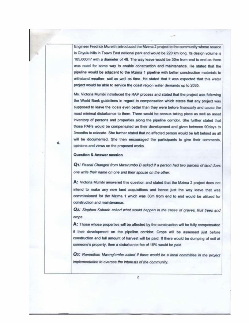
130

131
Appendix 5: Minutes of Mwatate Consultation meetings

132

133
Appendix 6: Minutes of Samburu Consultation meetings
134

135
136

137

138

139
Appendix 7: Minutes of Taru Consultation meetings

140

141
142

143

144
Appendix 8: Minutes of Voi Consultation meetings

145

146

147

148

149

150

151

152

153

154

155

156

157
Appendix 9: Minutes of Maungu Consultation meetings

158

159

160

161

162
Appendix 10: Minutes of Mackinnon Consultation meetings
163

164

165

166

167

168

169
Appendix 11: Minutes of Mbololo Consultation meetings
170

171

172
Appendix 12: Minutes of Ngolia Consultation meetings

173

174

175

176

177

178
Appendix 13: Lead Expert Annual Practicing License

179

180

181
Appendix 14: Lead Expert Annual EIK Certificate

182
Appendix 15: Noise Measurements
CHEMICAL & INDUSTRIAL CONSULTANCY UNIT Department of Chemistry, University of Nairobi
Chiromo Campus, P.O. Box 30197, Tel. 4440042, 4442014, Tel/Fax: 4446138, Nairobi
Our ref.: CLAB MWP 18.099N 21st May 2018
NOISE ASSESSMENT REPORT OF THE PROPOSED MZIMA II WATER PIPELINE.
A. INTRODUCTION
Intense noise may lead to sleep disturbance, mental exhaustion, irritation, gradual hearing disabilities and deafness.
The baseline noise levels were thus determined on 18th May 2018 at three sites listed in the table below. This was in
compliance with the Environmental Management and Coordination Act, 1999.
B MEASUREMENT OF THE NOISE LEVELS
The noise level measurements were carried out using an Extech Sound Level Meter Model 407732.
C. RESULTS: See the table below
SITE AND DATE GLOBAL
POSITIONING
SYSTEM (GPS)
COORDINATES
RANGE IN NOISE
LEVELS
(DECIBELS)
NEMA PERMISSIBLE
NOISE LEVELS
(COMMERCIAL AND
CONSTRUCTION SITES)
MZIMA SPRING
(TSAVO WEST NATIONAL
PARK IN TAITA TAVETA
COUNTY)
(18-05-2018)
Latitude:- 02.98199
Longitude: 038.02216
54.6-55.5 DAY: 60 DECIBELS
NIGHT: 35 DECIBELS
NDII
(IN TAITA TAVETA
COUNTY)
(18-05-2018)
Latitude:- 03.2373
Longitude: 038.50619
61.6-89.3
MAUNGU
(NEAR KENYA PIPELINE
MAUNGU STATION IN
TAITA TAVETA COUNTY)
(18-05-2018)
Latitude:- 03.561049
Longitude: 038.7531
63.1-78.7
CICU

183
D OBSERVATIONS
Noise measurements were carried out during the day. The lowest noise levels at the Mzima Spring site did not
exceed the NEMA permissible levels for commercial, residential and construction sites. However the highest
noise intensity that was recorded at the two sites (Maungu and Ndii) exceeded the NEMA permissible guideline
value (60 decibels during the day). The elevated noise along this proposed water pipe line was mainly due to the
movement of vehicles in the Voi – Mombasa road which is busy with a lot of heavy commercial vehicles.
E RECOMMENDATION
The architectural design of the water pipe line should maintain low noise levels so that the animals are not disturbed
more so in the park.
Godfrey A.Wafula
For CICU
Department of Chemistry
Consultants in: Chemical Processes & Technologies, Pollution & Environmental Control and Monitoring,
Quality Assurance & Specialized Laboratory Analysis

184
Appendix 16: Air Quality Measurements
CHEMICAL & INDUSTRIAL CONSULTANCY UNIT Department of Chemistry, University of Nairobi
Chiromo Campus, P.O. Box 30197, Tel. 4440042, 4442014, Tel/Fax: 4446138, Nairobi
Our ref.: CLAB MWP 18.098 21st May 2018
AIR QUALITY ASSESSMENT REPORT OF THE PROPOSED MZIMA II WATER PIPELINE.
INTRODUCTION
The rapid development in infrastructure and substantial population growth in Coast region and its neighbourhood,
during the last decade, have put enormous pressure on existing public utilities. Expansion of water pipe line in any
given area will therefore result in increased availability of the water to the people.
Water pipe line network will obviously enhance pollution levels along this region. Air pollution has adverse effects
on human health and the physical environment. It is consequently necessary to minimize airborne contamination while
developing the water pipeline.
Aerial pollution control can only be effective if data on existing air quality is obtained. The Environmental
Management and Coordination Act, 1999 also made it mandatory to carry out environmental impact assessments prior
to the commencement of construction projects.
Air quality assessment was thus carried out on 18th May 2018 at three sites listed in the table below.
SAMPLE COLLECTION
Air samples were collected using a portable battery driven suction pump whose flow rate was 3.61 litres per minute.
The air was scrubbed through suitable trapping solutions for sulphur dioxide and nitrogen dioxide for periods of 15
minutes per sample. Total suspended particulate matter (dust) was trapped in pre-weighed and pre-conditioned
membrane filters for the same period. The CO/CO2 Portable Combustion Analyzer was utilized for assessment of
airborne levels of carbon monoxide.
A. QUANTITATIVE DETERMINATION
1. Sulphur dioxide was determined quantitatively using the Pararosaniline method.
2. Nitrogen dioxide was determined using the Modified Griess-Saltzman method.
3. The Filtration Technique followed by gravimetric analysis was used to determine the airborne concentrations of
total suspended particulate matter (dust).
CICU

185
4. The concentrations of carbon monoxide were determined using the CO/CO2 Portable Combustion Analyzer
PCA*3.
B. RESULTS: See the table below
SAMPLING SITE,
DATE AND GPS
COORDINATES
PARAMETER CONCENTRATIONS WHO
GUIDELINES
NEMA AMBIENT
AIR QUALITY
TOLERANCE
LIMITS FOR
RESIDENTIAL,
RURAL AND
OTHER AREAS
MSIMA SPRING
(TSAVO WEST
NATIONAL PARK IN
TAITA TAVETA
COUNTY)
(18-05-2018)GPS
COORDINATES
Latitude:- 02.98199
Longitude: 038.02216
Sulphur dioxide 48µg/m3 500 µg/m3
10 minutes
350 µg/m3
1 hour
125 µg/m3
24 hours
60 µg/m3
1 year
80 µg/m3
-24 hours
60 µg/m3-Annual
Average
Nitrogen dioxide 36 µg/m3 120 µg/m3
8 hours
40 µg/m3
1 year
80 µg/m3
-24 hours
60 µg/m3- Annual
Average
Total Suspended
Particulate Matter
(dust).
66 µg/m3 150-230 µg/m3
24 hours
60-90 µg/m3
1 year
180 µg/m3
-24 hours
100 µg/m3
-Annual Average
Carbon monoxide 88 µg/m3 30 mg/m3
1 hour
10 mg/m3
8 hours
2 mg/m3-8 hours
4 mg/m3-1 hour
NDII
(IN TAITA TAVETA
COUNTY)
(18-05-2018))
GPS COORDINATES
Latitude:- 03.2373
Longitude: 038.50619
Sulphur dioxide 351 µg/m3 500 µg/m3
10 minutes
350 µg/m3
1 hour
125 µg/m3
24 hours
60 µg/m3
1 year
80 µg/m3
-24 hours
60 µg/m3-Annual
Average
Nitrogen dioxide 54 µg/m3 120 µg/m3
8 hours
40 µg/m3
1 year
80 µg/m3
-24 hours
60 µg/m3- Annual
Average
Total Suspended
Particulate Matter
(dust).
123 µg/m3 150-230 µg/m3
24 hours
60-90 µg/m3
180 µg/m3
-24 hours
100 µg/m3
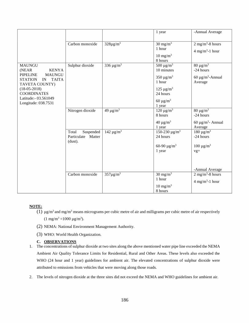
186
1 year -Annual Average
Carbon monoxide 328µg/m3 30 mg/m3
1 hour
10 mg/m3
8 hours
2 mg/m3-8 hours
4 mg/m3-1 hour
MAUNGU
(NEAR KENYA
PIPELINE MAUNGU
STATION IN TAITA
TAVETA COUNTY)
(18-05-2018)
COORDINATES
Latitude:- 03.561049
Longitude: 038.7531
Sulphur dioxide 336 µg/m3 500 µg/m3
10 minutes
350 µg/m3
1 hour
125 µg/m3
24 hours
60 µg/m3
1 year
80 µg/m3
-24 hours
60 µg/m3-Annual
Average
Nitrogen dioxide 49 µg/m3 120 µg/m3
8 hours
40 µg/m3
1 year
80 µg/m3
-24 hours
60 µg/m3- Annual
Average
Total Suspended
Particulate Matter
(dust).
142 µg/m3 150-230 µg/m3
24 hours
60-90 µg/m3
1 year
180 µg/m3
-24 hours
100 µg/m3
vg+
-Annual Average
Carbon monoxide 357µg/m3 30 mg/m3
1 hour
10 mg/m3
8 hours
2 mg/m3-8 hours
4 mg/m3-1 hour
NOTE:
(1) µg/m3 and mg/m3 means micrograms per cubic metre of air and milligrams per cubic metre of air respectively
(1 mg/m3 =1000 µg/m3).
(2) NEMA: National Environment Management Authority.
(3) WHO: World Health Organization.
C. OBSERVATIONS
1. The concentrations of sulphur dioxide at two sites along the above mentioned water pipe line exceeded the NEMA
Ambient Air Quality Tolerance Limits for Residential, Rural and Other Areas. These levels also exceeded the
WHO (24 hour and 1 year) guidelines for ambient air. The elevated concentrations of sulphur dioxide were
attributed to emissions from vehicles that were moving along those roads.
2. The levels of nitrogen dioxide at the three sites did not exceed the NEMA and WHO guidelines for ambient air.

187
3. The concentrations of suspended particulate matter (dust) also did not exceed the NEMA and WHO guidelines
for ambient air. They were, in other words, within the NEMA and WHO recommended guidelines.
4. The concentrations of carbon monoxide at these three sites did not exceed both the NEMA and WHO guideline
values.
D. RECOMMENDATIONS
1. The construction phase of some sections of this water pipeline may lead to significant emissions of dust.
Suitable measures will therefore be necessary in order to contain the dust. These will include periodic
sprinkling of water along the affected areas.
Godfrey A. Wafula
For CICU
Department of Chemistry
Consultants in: Chemical Processes & Technologies, Pollution & Environmental Control and Monitoring,
Quality Assurance & Specialized Laboratory Analysis

188
Appendix 17: Water quality assessment
CHEMICAL & INDUSTRIAL CONSULTANCY UNIT
Department of Chemistry, University of Nairobi
Chiromo Campus, P.O. Box 30197, Tel. 4440042, 4442014, Tel/Fax: 4446138, Nairobi
May 21, 2018
LABORATORY ANALYSIS REPORT FOR MZIMA SPRING WATER (LATITUDE: -
02.98199, LONGITUDE: 038.02216)
Laboratory No.: ODP-01/18/05/18
Date Received: 18/05/2018
Parameters Units Results NEMA
PH @ 210C 7.3 6.5-8.5
Total Suspended Solids Mg/L 13.2±1.17 30
Total Dissolved solids Mg/L 321±15.6 1200
COD Mg/L 10.22±0.03 50
Chloride Mg/L 0.1 250
Oil & Grease Mg/L ND 10
Total Coliform (Counts /100 ml) Nil 30
E-coli (Counts /100 ml) Nil Nil
Color CU 4.6 15
Cr Mg/L ND 0.05
Pb Mg/L ND 0.01
Phosphates Mg/L 0.33±0.00 2.2
Nitrates Mg/L 2.10±0.011 50
NB: Based on these parameters, the sample conforms to the Nema specifications
Godfrey A. Wafula
For CICU
Consultants in: Chemical Processes & Technologies, Pollution & Environmental Control and Monitoring,
Quality Assurance & Specialized Laboratory Analysis
CICU
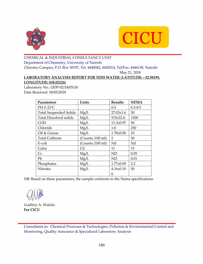
189
CHEMICAL & INDUSTRIAL CONSULTANCY UNIT
Department of Chemistry, University of Nairobi
Chiromo Campus, P.O. Box 30197, Tel. 4440042, 4442014, Tel/Fax: 4446138, Nairobi
May 21, 2018
LABORATORY ANALYSIS REPORT FOR NDII WATER (LATITUDE: - 02.98199,
LONGITUDE: 038.02216)
Laboratory No.: ODP-02/18/05/18
Date Received: 18/05/2018
Parameters Units Results NEMA
PH @ 210C 6.9 6.5-8.5
Total Suspended Solids Mg/L 27.03±1.6 30
Total Dissolved solids Mg/L 515±22.8 1200
COD Mg/L 11.3±0.97 50
Chloride Mg/L 1.8 250
Oil & Grease Mg/L 1.78±0.00 10
Total Coliform (Counts /100 ml) 2 30
E-coli (Counts /100 ml) Nil Nil
Color CU 11 15
Cr Mg/L ND 0.05
Pb Mg/L ND 0.01
Phosphates Mg/L 1.77±0.09 2.2
Nitrates Mg/L 4.16±0.10
6
50
NB: Based on these parameters, the sample conforms to the Nema specifications
Godfrey A. Wafula
For CICU
Consultants in: Chemical Processes & Technologies, Pollution & Environmental Control and
Monitoring, Quality Assurance & Specialized Laboratory Analysis
CICU

190
CHEMICAL & INDUSTRIAL CONSULTANCY UNIT
Department of Chemistry, University of Nairobi
Chiromo Campus, P.O. Box 30197, Tel. 4440042, 4442014, Tel/Fax: 4446138, Nairobi
May 21, 2018
LABORATORY ANALYSIS REPORT FOR MAUNGU WATER (LATITUDE: : - 03.561049,
LONGITUDE: 038.7531)
Laboratory No.: ODP-03/18/05/18
Date Received: 18/05/2018
Parameters Units Results NEMA
PH @ 210C 7.6 6.5-8.5
Total Suspended Solids Mg/L 29.01±0.44 30
Total Dissolved solids Mg/L 695±64.82 1200
COD Mg/L 9.26±0.01 50
Chloride Mg/L 2.7 250
Oil & Grease Mg/L 3.44±0.01 10
Total Coliform (Counts /100 ml) Nil 30
E-coli (Counts /100 ml) Nil Nil
Color CU 14.54 15
Cr Mg/L ND 0.05
Pb Mg/L 0.003±0.00 0.01
Phosphates Mg/L 1.09±0.001 2.2
Nitrates Mg/L 6.37±0.97 50
NB: Based on these parameters, the sample conforms to the Nema specifications
Godfrey A. Wafula
For CICU
Consultants in: Chemical Processes & Technologies, Pollution & Environmental Control and Monitoring,
Quality Assurance & Specialized Laboratory Analysis
CICU

191
Appendix 18: Conservation Organisations Reponses

192

193

194

195

196
Appendix 19: Community members’ attendance Lists in Consultation meetings

197

198
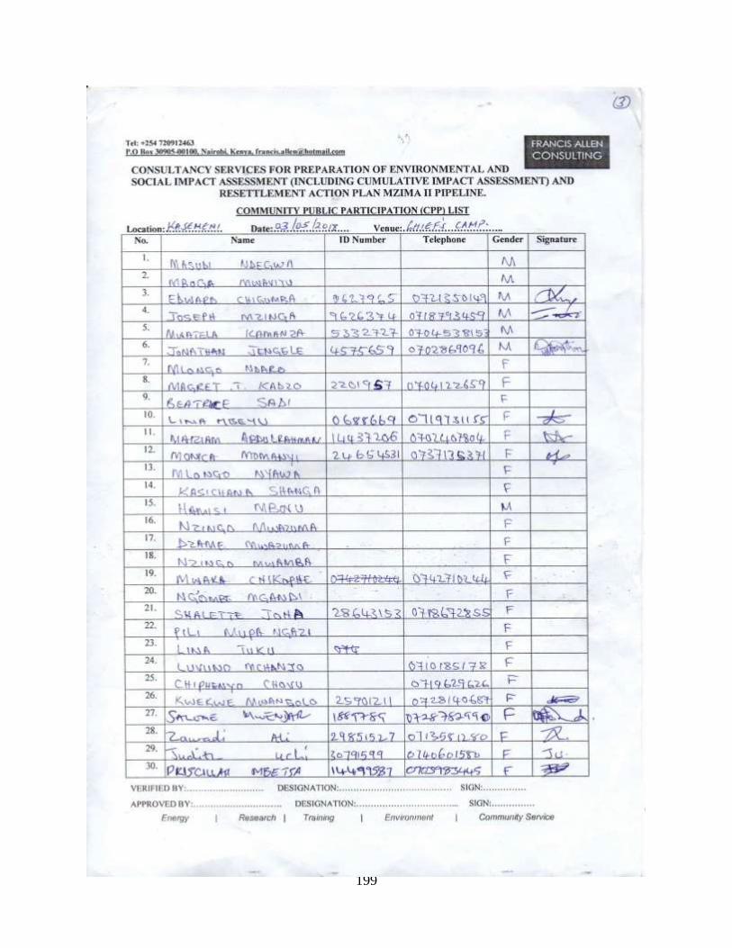
199

200

201

202

203
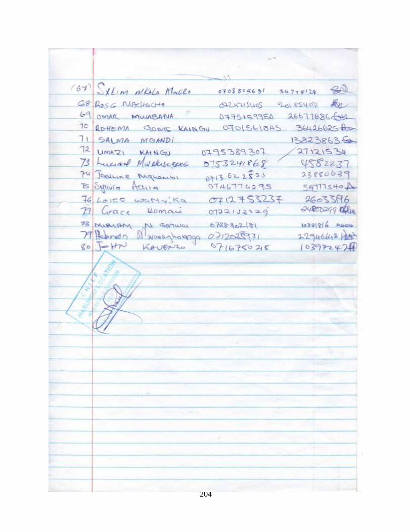
204

205

206

207

208

209

210

211

212

213

214

215

216

217

218

219
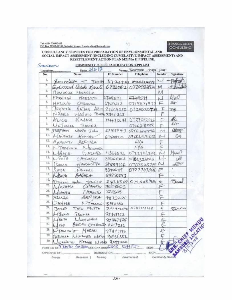
220

221

222

223

224

225

226

227

228

229

230
Appendix 20: EIA Team Composition
Name Qualification Position
Dr Stephen Chege
Wairuri
Doctor of Philosophy
(Environmental Studies and
Community Development),
Kenyatta University
Master of Environmental
Studies and Community
Development, Kenyatta
University.
Bachelor of Environmental
Studies (Arts), Kenyatta
University
Lead Expert for Environmental
Impact Assessment/Audit
Environment Specialist (Team
leader)
Eng. Patrick N
Wambuki
Master of Science in
Management of Water
Resources
B.Sc.(Hons)(Civil Engineering)
Lead Expert for Environmental
Impact Assessment/Audit
Civil Engineer- Water
Management
Carolyne
Mukhuhungu
BSc. in Geospatial Engineering
The University of Nairobi
FDB/GIS (Geographic
Information System) data
collection Kenya Power training
school
Registered Surveyor/GIS
Specialist
Dr Paul Muoria Doctor of Philosophy (Animal
Ecology), Kenyatta University;
Master of Philosophy
(Environmental Studies), Moi
University;
Bachelor of Science (Wildlife
Management), Moi University,
Kenya - 1990
Ecologist
Joy Wasirimba Masters in Business
Administration (Kenyatta
University)
Environment Expert

231
Bachelor of Arts Degree in Social
Work and Social
Administration
Elijah K. Mutuango Masters in Business
Administration (University of
Nicosia),
Degree in Sociology and
Economics
Social Expert
Annabel Waititu Master of Arts ( Development
Communication) , Daystar
University, Nairobi
B.Com, Economics, Jabalpur
University, Madhya Pradesh
India.
Sociologist/gender Expert
Lawrence Muchiri MSc, University of Reading, UK,
1977
BA (Hons) Land Economics,
University of Nairobi, 1971
Registered Valuer
Victoria Mumbi Bachelor of Environment
Studies(Community
Development)– Kenyatta
University
Gender Expert


