Project 109578 File DEIR KZN rev02.docx 28 February 2014 Revision 2 Environmental Impact Assessment: The Proposed Upgrade and new Construction related to the Development of the Swaziland Rail Link Project, from Golela to Nsezi in KwaZulu-Natal Draft Environmental Impact Report Reference: 109578 Prepared for: Transnet SOC Ltd Revision: 2 28 February 2014
Environmental Impact Assessment: The Proposed Upgrade and new Construction related to the Development of the Swaziland Rail Link Project, from Golela to Nsezi in KwaZulu-Natal
Environmental Impact Assessment: The Proposed Upgrade and new Construction related to the Development of the Swaziland Rail Link Project, from Golela to Nsezi in KwaZulu-Natal
Block loads: A grouping of wagons that are detached or coupled to make up a train.
Cross-overs: The link between two parallel tracks.
Environment: means the surroundings within which humans exist and that are made up of -
(i) the land, water and atmosphere of the earth;
(ii) micro-organisms, plant and animal life;
(iii) any part or combination of (i) and (ii) and the interrelationships among and between them; and
(iv) the physical, chemical, aesthetic and cultural properties and conditions of the foregoing that influence human health and wellbeing;
Environmental Impact: The direct effect of human activities and natural events on the components of the environment.
Environmental Impact Assessment (EIA):
The process of identifying, predicting, evaluating and mitigating the biophysical, social, and other relevant effects of a proposed activity on the environment and the surrounding community prior to major decisions being taken and commitments made.
Environmental Management Programme (EMP):
A document that contains recommendations for the control or management of the potential significant impacts of operations on the environment and recommendations to contain or mitigate actual impacts.
Feasible: Acceptable, capable of being used or implemented successfully, without unacceptably damaging the environment.
Occupations: The time duration required to occupy a section of track for maintenance purposes.
Pollution: Any change in the environment which has an adverse effect on human health or well-being or on the composition, resilience and productivity of natural or managed ecosystems, or on materials useful to people, or will have such an effect in the future.
Public Participation Process:
A process of involving the public in order to identify needs, address concerns, choose options, inform decision making, plan and monitor in terms of a proposed project, programme or development.
Risk: The scientific judgement of probability and significance of harm to the environment.
Shut: Refers to the annual shut when maintenance of the infrastructure takes place.
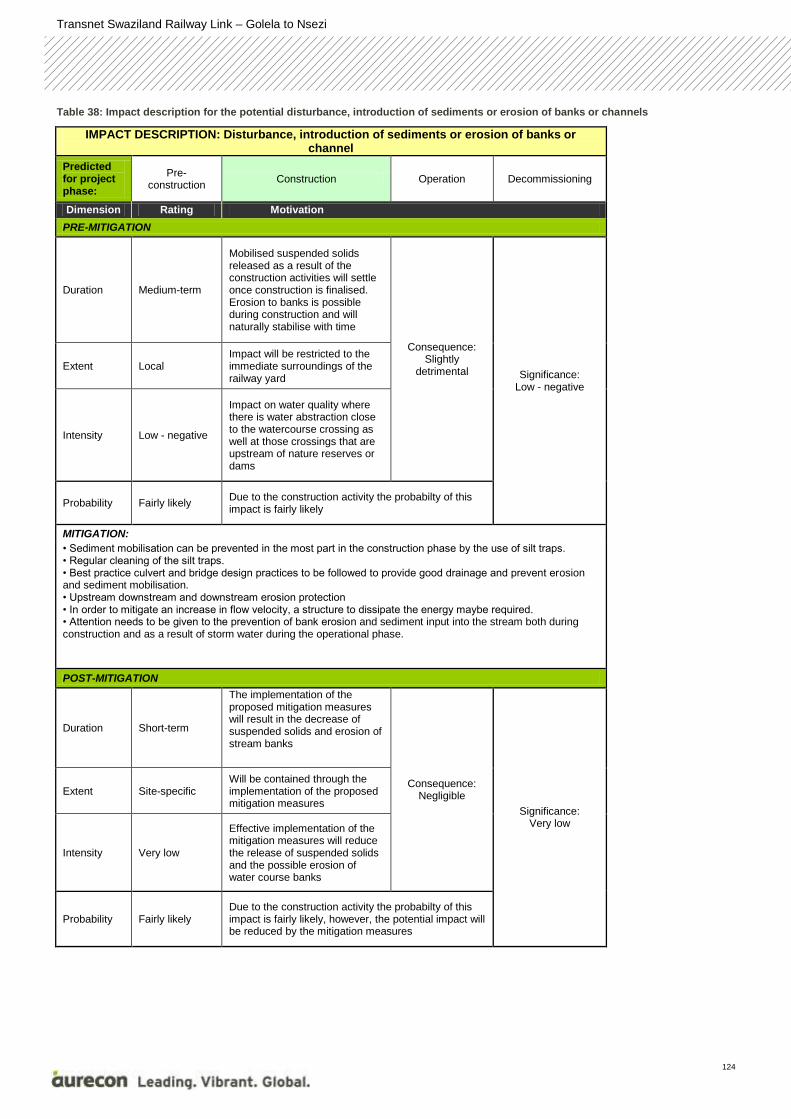
Table 1: Summary table of potential environmental impacts during the construction phase
CONSTRUCTION PHASE
Feature Impact
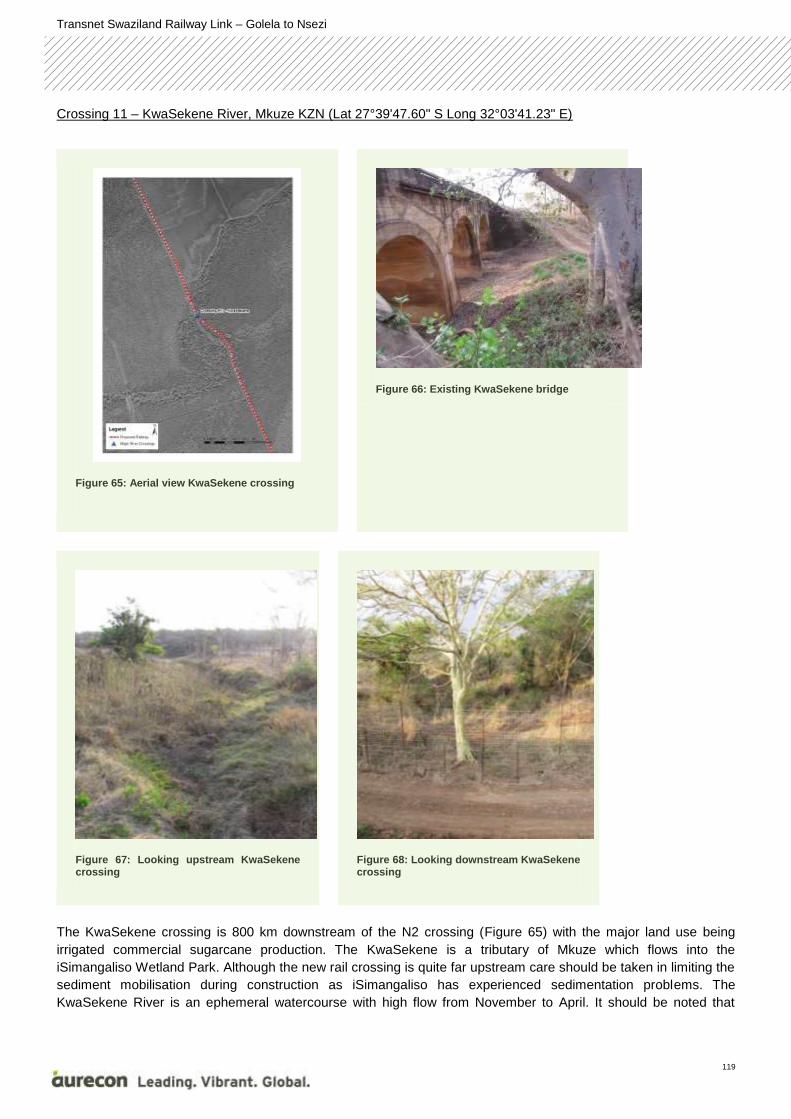
Watercourses The majority of the wetlands within the study area have been shown to be natural, and form part of the important Maputoland Wetland Cluster.
However some of these would be considered modified and have a conservation rating score of Z1 or Z2, i.e. low conservation importance. The remaining natural wetland areas associated with the local streams, pans floodplain wetlands, lakes and estuaries were mostly rated as A/B or C, i.e. Pristine to moderately modified or largely modified respectively (Nel et al., 2012).
It should be noted that sections of the line that will be upgraded, will have a direct impact on a number of the wetlands identified or delineated in this study, while a remaining 18 wetlands fall within the 500m WULA zone and this any works within these areas will require Section 21 (c) & (i) Water Use Licenses.
Hydrology Impacts on surface waters will occur during rail construction. Pollution from mobilised suspended solids is the major concern particularly where water is abstracted close to the watercourse crossing.
The rail alignment runs close to several important hydrological features including the lake St Lucia system, Phongola Dam and Lake Eteza Nature Reserve. There are several large rivers such as the Mfolozi, Mkuze and Phonglo which flow through the region. The alignment crosses each of these rivers once. The iSimangaliso Wetland Park, which contains the Lake St Lucia system, is a World Heritage Site. The Lake St Lucia system current-day sources of fresh water inflows are the Mkuze, Mzinene, Hluhluwe and Nyalazi as well as number of smaller catchments.
Geohydrology The affected quaternary catchments intersected by the proposed alignment include W31H, W44D, W44E, W31K, W23B, W32C, W23D, W32G, W32F, W12H and W23C. Potential sources of impact include:
Incorrect disposal of hazardous and non-hazardous materials or waste could contaminate groundwater;
Potential hydrocarbon spillages resulting from a leakage caused by a fracture/crack or rupture in the fuel storage tanks may lead to contamination of groundwater; and
Potential hydrocarbon spillages from equipment, machinery and vehicle storage may lead to contamination of groundwater.
Ecology The study area is dominated by a mixture of urban and rural development, forestry, and various forms of agriculture, with the associated infrastructure such as roads, lakes dams and the present rail network, while traversing a wide variety habitat that range from drier bushveld in the north to more mesic (moist) coastal forests in the south.
The majority of the vegetation units intersecting the railway are ‘’Threatened’’ and classified as either Critically Endangered or Vulnerable. However it was confirmed during the site investigations that the rail servitude that presently exist and where the development will take place is largely degraded or transformed, with the exception of several of the river crossings. Impacts include the following:
Loss of habitat and removal of vegetation (terrestrial and aquatic);
Increase in soil erosion;
Loss of corridors and habitat fragmentation;
Change in hydrological regimes;
Loss of rare or endangered species; and
Introduction of alien vegetation.
Heritage Stone tools dating from the Early and Middle Stone Age are known to occur sporadically in the area.
A number of concrete arch and metal truss bridges across various rivers have been identified.
Air Quality The construction phase will be relatively short. It will also result in mainly nuisance impacts in the form of dust. However, the nuisance and other possible impacts should still be
Waste The significant impacts caused by waste are related to hydrocarbon spillages during construction phase, both from the removal of contaminated ballast as well as general construction activities.
Noise & Vibration The main contributors of noise caused by the proposed upgrade of the railway line and Nsezi yard are night time operations, shunting activities and ballast corrections. Construction phase impacts are considered under the initial day and night scenario impact description.
Social Positive impacts associated with the project include:
The creation of temporary and permanent employment opportunities and social benefits;
Opportunities for local sourcing of goods and services;
Improved road infrastructure associated with development project;
Local and regional economic benefits; and
Increased development aid/investment from government and/or project investors.
Negative impacts that may be associated with this phase include:
Social and cultural disruption and conflict due to population influx;
Creation of spontaneous and informal settlements;
Possible social pathologies arising from the population influx (such as crime);
The need to secure accommodation for construction staff;
Disturbance impacts related to physical intrusion;
Displacement; and
Land use impacts and impacts on common property resources.
Socio-economic The loss of biological assets, forestry plantations and natural vegetation, due to expropriation and reclamation of land as well as the loss of production from such assets could be included in the capital expenditure (CAPEX) and operational expenditure (OPEX) changes in final demand, respectively. Macro-economic CAPEX on a regional and local scale, and macro-economic OPEX on a regional scale were considered impacts in this specialist field.
Table 2: Summary of potential environmental impacts during the operational phase
OPERATIONAL PHASE
Feature Impact
Watercourses Impacts associated with rail activities in close proximity to the endorheic pan, such as potential spillages of chemical loads, surface water runoff from contaminated ballast.
Hydrology Potential sources of surface water pollution include:
wash bays and workshops;
fuelling facilities; and
coal dust and rainfall seepage from the wagons.
Geohydrology Potential hydrocarbon spillages resulting from a leakage caused by a fracture/crack or rupture in the fuel storage tanks may lead to contamination of groundwater.
Ecology Hydrological impacts on wetlands due to the impediment of flow caused by excess ballast falling into culverts, creating berms; and
Loss of corridors and habitat fragmentation.
Heritage Disturbance of cultural and heritage resources.
Waste Maintenance activities on the yard could lead to hydrocarbon spillages.
Noise & Vibration The main contributors of noise caused by the proposed upgrade of the Golela to Nsezi railway line are night time operations, shunting activities and ballast corrections. Construction phase impacts are considered under the future day and night scenario impact description.
Social Social pathologies arising from population influx (negative); and
Creation / sustaining of employment opportunities (positive);
Socio-economic The loss of biological assets, forestry plantations and natural vegetation, due to expropriation and reclamation of land as well as the loss of production from such assets could be included in the CAPEX and OPEX changes in final demand, respectively. Macro-economic CAPEX on a regional and local scale, and macro-economic OPEX on a regional scale were considered impacts in this specialist field.
CONCLUSION AND EAP IMPACT STATEMENT
The draft DEIR provides a description of the feasible alternatives and potential impacts identified during the
Scoping and Environmental Impact Assessment Phases. It also contains additional information on the affected
environment, mostly drawn from the specialist studies conducted. There is a description and assessment of the
potential impacts associated with the various feasible alternatives as well as an indication of potential mitigation
measures, conclusions and various recommendations with regard to the way forward. A series of Appendices and
Annexures containing relevant information, including the various specialist studies is attached to this report.
It is the opinion of the environmental assessment practioner (EAP) that once final, the information contained in this
report and the documentation attached thereto, will be sufficient for the Department of Environmental Affairs (DEA)
to make an informed decision regarding the EIA for the proposed upgrade and new construction related to the
development of the Swaziland Rail Link Project for the section from Golela to Nsezi in KwaZulu-Natal. Mitigation
measures are proposed to limit the potential negative impacts and to enhance the potential positive impacts.
This report provides an assessment of both benefits and potential negative impacts anticipated as a result of the
proposed new upgrade and construction of the railway line and Nsezi Yard. The findings of the assessment
conclude that identified significant impacts can be addressed with relevant mitigation measures, therefore, in view
of the EAP, no environmental fatal flaws should prevent the proposed project from proceeding.
RECOMMENDATIONS
In order to achieve appropriate environmental management standards and ensure that the findings of the
environmental studies are implemented through practical measures, the recommendations of this DEIR have been
included in an Environmental Management Programme (EMP). It is recommended the EMP be updated once the
final alignment of the railway line has been identified and surveyed (i.e. a site specific EMP should be compiled to
compliment the current EMP). The EMP should be included in the contract of the contractor(s) appointed to
construct the railway line and Nsezi Yard. The EMP would be used to monitor compliance with environmental
specifications and management guidelines. The implementation of the EMP is crucial for the life cycle of the
project and is fundamental in achieving the environmental management standards as set out in this report.
In order to maintain involvement of the community in the implementation of the project, it is recommended that the
current communication with the local community and adjacent landowners be maintained during the construction
Table 80: Impact description for the Macro-economic CAPEX on a regional scale 194
Table 81: Impact description for the macro-economic CAPEX on a local scale 195
Table 82: Impact description for the macro-economic OPEX on a regional scale 195
Transnet Swaziland Railway Link – Golela to Nsezi
1
Aurecon South Africa (Pty) Ltd was appointed by Transnet to provide the environmental services for the
Environmental Impact Assessment (EIA) of the proposed upgrade and new construction of the Swaziland
Railway Link, for the section between Golela and Nsezi in KwaZulu-Natal. The details of the
Environmental Assessment Practitioner (EAP) is summarised in section 1.2 below.
1.1 Context of this report
To ensure that the requirements of NEMA are met, the DEIR contains the following information as per
Section 31(2) of GN R543:
Table 3: EIR contents and chapters
GN R543 CONTENT AS REQUIRED BY NEMA CHAPTER/ ANNEXURE
31(2) (a) Details of (i) the EAP who compiled the report;
and
Before Executive Summary
Details (ii) the expertise of the EAP to carry
out an scoping procedures;
Appendix A
31(2) (b) A detailed description of the proposed activity; Chapter 1
31(2) (c) A description of the property on which the
activity is to be undertaken and the location of
the activity on the property, or if it is –
Not Applicable
(i) a linear activity, a description of the
route of the activity; or
Chapter 1
(ii) an ocean-based activity, the
coordinates where the activity is to be
undertaken;
Not Applicable
31(2) (d) A description of the environment that may be
affected by the activity and the manner in
which the physical, biological, social,
economic and cultural aspects of the
environment may be affected by the proposed
activity;
Chapter 5 (baseline
environment) and Chapter 8
(assessment of potential
impacts)
31(2) (e) Details of the public participation process
conducted in terms of regulation (27)a,
including –
Chapter 4
(i) steps undertaken in accordance with
the plan of study;
Chapter 4 (PPP) and ToR in
Appendix B, Annexure J
1 INTRODUCTION
Transnet Swaziland Railway Link – Golela to Nsezi
2
(ii) a list of persons, organisations and
organs of state that were identified and
registered in terms of regulation 55 as
interested and affected parties;
Appendix C
(iii) a summary of comments and issues
raised by registered interested and affected
parties, the date of receipt of these comments
and the response of the EAP to those
comments;
Appendix C
(iv) copies of any representations and
comments received from registered interested
and affected parties;
Appendix C
31(2) (f) A description of the need and desirability of
the proposed activity;
Chapter 1
31(2) (g) A description of identified potential alternatives
to the proposed activity, including advantages
and disadvantages that the proposed activity
or alternatives may have on the environment
and the community that may be affected by
the activity;
Chapter 1
31(2) (h) An indication of the methodology used in
determining the significance of potential
environmental impacts;
The complete methodologies for
each specialist assessment of
the potential impacts are in the
specialist report in Appendix B.
Methodologies used for
interpreting the significance –
Chapter 7
31(2) (i) A description and comparative assessment of
all alternatives identified during the
environmental impact assessment process;
Chapter 1
31(2) (j) A summary of findings and recommendations
of any specialist report or report on a
specialised process;
Throughout Chapter 8 and also
Chapter 9. Specialist reports –
Appendix B
31(2) (k) A description of all environmental issues that
were identified during the environmental
impact assessment process, an assessment
of the significance of each issue and an
Chapter 8
Transnet Swaziland Railway Link – Golela to Nsezi
3
indication of the extent to which the issue
could be addressed by the adoption of
mitigation measures;
31(2) (l) An assessment of each identified potentially
significant impact, including-
Chapter 8
(i) Cumulative impacts;
(ii) The nature of the impact;
(iii) The extent and duration of the impact;
(iv) The probability of the impact occurring;
(v) The degree to which the impact can be
reversed;
(vi) The degree to which the impact may
cause irreplaceable loss of resources;
(vii) The degree to which the impact can be
mitigated;
31(2) (m) A description of any assumptions,
uncertainties and gaps in knowledge;
Specialist reports contained in
Appendix B
31(2) (n) A reasoned opinion as to whether the activity
should or should not be authorised, and
if the opinion is that it should be
authorised, any conditions that should
be made in respect of that
authorisation;
Chapter 9
31(2) (o) An environmental impact statement which
contains-
Chapter 9
(i) a summary of the key findings of the
environmental impact assessment;
(ii) A comparative assessment of the positive
and negative implications of the
proposed activity and identified
alternatives;
31(2) (p) A draft environmental management
programme containing the aspects
contemplated in regulation 33;
Appendix E
31(2) (q) Copies of any specialist reports and reports on
specialised processes complying with
Appendix B
Transnet Swaziland Railway Link – Golela to Nsezi
4
regulation 32;
31(2) (r) Any specific information that may be required
by the competent authority; and
Not applicable
31(2) (s) Any other matters required in terms of
sections 24(4) (a) and (b) of the Act.
Not applicable
1.2 Details of the EAP
The Environmental Assessment Practitioner for the project is Dr Pieter Botha. Dr Botha is assisted by Mrs
Candice Dürr (environmental scientist). Kindly take note that Mrs Claudia Neethling has resigned from
Aurecon and will therefore no longer fulfil the role as public participation practitioner for this project. Ms
Elise Vermeulen has been appointed in this position and all comments and queries can be sent to Ms
Vermeulen. A summary of their experience and roles in the project is given below. Their full CVs can be
found in Appendix A.
Dr Pieter Botha
Project Leader
Dr Pieter Botha holds a DSc from the North West University, Potchefstroom Campus (1981). He is a
registered professional natural scientist with the South African Council for Natural Scientific Professions.
Dr Botha is also registered as an Environmental Assessment Practitioner with the International Institution
for Impact Assessment (South Africa).
Dr Botha joined Aurecon's Environmental Department in May 2010 as a Senior Environmental
Practitioner, and has since been involved in various projects. These have included projects such as a
Front End Loading (FEL) 1 and 2 studies of the Sishen-Saldanha ore line expansion project, and an EIA
for the Isundu-Mbewu power line project awarded to Aurecon by Eskom and the FEL-1 and 2 studies for
the expansion of the Port of Richards Bay.
Following a career of three decades in the public sector, he established his own consultancy with a view
to make a contribution in the area of natural resources management, environmental protection and
agriculture in respect of policy and legislation formulation and review, as well as the provision of capacity
building in the same areas. He has also undertaken and managed a variety of complex land restitution
projects for the Commission on Restitution of Land Rights in Mpumalanga and North West Provinces.
Dr Botha has managed various sections and divisions during his tenure in the public sector, and has, in
this regard, been responsible for personnel management, financial management and strategic leadership.
Research has formed a vital part of the projects he has been involved in. Dr Botha started his research
career as a range management research officer in the Karoo Region and learnt about the dynamics of the
arid areas of South Africa and, in particular, the agricultural systems applied in those areas.
He has over three decades of experience in environmental research, policy development and
implementation in South Africa, as well as writing various environmental reports. He also has knowledge
and experience relating to biodiversity conservation and utilisation in the southern African region. Dr
Botha has also been involved in the development and drafting of policy and subsequent legislation in
various facets of the environmental field relating to biodiversity conservation, utilisation and rural
development.
Transnet Swaziland Railway Link – Golela to Nsezi
5
An important component of his varied expertise is his involvement in the public participation process
(PPP) as a principal element of his diverse projects, engaging with many, different and challenging
stakeholders at various different levels of engagement.
Dr Botha has led or been part of delegations in various international meetings and conferences on behalf
of South Africa. This required a comprehensive in-depth knowledge of relevant subjects and policies, as
well as good negotiation skills.
A copy of Dr Pieter Botha’s CV is attached in Appendix A (annexure A).
Mrs Candice Dürr
Assist in conducting and managing the Environmental Assessment Process. Compilation and submission
of the Final EIA and EMP to the relevant authority. Liaise with authorities, stakeholders and specialists.
Compilation of the water use licenses for the entire alignment.
Mrs Dürr’s main focus is on environmental management of related issues within a wide range of
infrastructure development which includes environmental impact assessments and Environmental
Management Programmes for listed activities under the various agencies' environmental legislation. To
date Mrs Dürr has gained experience on various projects located in South Africa, including the Eskom
Kusile Power Station Project. Mrs Dürr is a qualified Environmental specialist and obtained her Bachelor
of Science from the North West University. She is currently enrolled for the final year of her BSc Honours
degree in environmental management at the University of South Africa.
A copy of Mrs Candice Dürr’s CV is attached in Appendix A (annexure B).
Ms Elise Vermeulen
Assist in compilation and submission of the Final EIA’s and EMP to the relevant authority. Co-ordinate
and liaise with authorities, stakeholders and IAP’s. Compilation of the Environmental Management
Programmes for the Borrow Pits.
Ms Vermeulen is a qualified Environmental Assessment Practitioner with five year’s experience. She
obtained a Bachelor of Science degree from the University of Pretoria and an honours degree, with
specialisation in Environmental Management from the University of South Africa. Her main focus is on the
environmental management of related issues within a wide range of infrastructure development, which
includes conducting Environmental Impact Assessments and the compilation and enforcement of
Environmental Management Programmes for listed activities under the various agencies' environmental
legislation. To date Ms Vermeulen has gained significant experience while working on various projects
located in South Africa and Australia.
A copy of Ms Vermeulen’s CV is attached in Appendix A (annexure C).
1.3 Introduction to the Project Team
The table below indicates the EIA project team, including the specialists, involved.
Table 4: Details of the EIA project team
Role in Project Team Name Company
Transnet Swaziland Railway Link – Golela to Nsezi
6
Role in Project Team Name Company
Project Director Mr Barend Smit Aurecon
Project Manager and lead EAP Dr Pieter Botha Aurecon
EAP Assistant Mrs Candice Dürr Aurecon
Public Participation Office Ms Elise Vermeulen Aurecon
Heritage Impact Assessor Dr Johnny van Schalkwyk Private
Ecological Impact Assessor Dr Brian Colloty Scherman Colloty & Associates
Air Quality Impact Assessor Mr Roelof Burger
Dr Martin van Nierop
Mrs Anja van Basten
Gondwana Environmental Solutions
Geohydrological Impact Assessor Mr Louis Stroebel
Mr Marius Terblanche
Aurecon
Hydrological Impact Assessor Dr Nicolas Walker Aurecon
Noise and Vibration Impact Assessor
Mr Morne de Jager Enviro-Acoustic Research
Social Impact Assessor Mr Tebogo Sebego
Mrs Noeleen Greyling
Aurecon
Socio-economic Impact Assessor Dr Stephan Jooste
Mr Eben Vos
Ms Justine Barnard
Aurecon
1.4 Project Background
Transnet SOC Limited (hereafter referred to as Transnet) is a government (state) owned company (SOC)
and is the custodian of South Africa’s railway, ports and pipelines, thereby responsible for delivering
reliable freight transport and handling services that satisfy customer demand.
As such, Transnet in collaboration with Swaziland Railway identified the construction and upgrade of the
railway line between Davel in Mpumalanga and Richards Bay in KwaZulu-Natal, connecting via the
Swaziland rail network, as a strategic project. The aim of the project is to unlock the potential of a
multinational strategic rail corridor and divert general freight traffic off the dedicated heavy haul Richards
Bay coal line which runs from Ermelo through rural KwaZulu-Natal to Richards Bay.
In terms of the National Environmental Management Act, 107 of 1998 the proposed development triggers
activities which may significantly impact on the environment. As a result Transnet requires Environmental
Authorisation from the competent authority, the Department of Environmental Affairs (DEA) in
collaboration with the KwaZulu-Natal Department of Agriculture and Environmental Affairs (KZNDAE) to
commence with the development.
The project activities will consist of various works, including the upgrading of existing railway sections
(including re-building certain sections), construction of an entirely new rail link from Lothair in South Africa
to Sidvokodvo in Swaziland and construction of new rail yards. These proposed works trigger a number of
listed activities as specified in the National Environmental Management Act (NEMA), 107 of 1998, the
Transnet Swaziland Railway Link – Golela to Nsezi
7
National Water Act (NWA), 36 of 1998 and the National Environmental Management: Waste Act
(NEM:WA), 59 of 2008.
Due to the magnitude of the proposed project, which stretches over a distance of approximately 570 km
including Swaziland (see figure 1), it was decided that three applications will be compiled as follows:
1. Davel yard and connections, DEA ref no 14/12/16/3/3/2/551;
2. Mpumalanga rail line from Davel to Nerston, DEA ref no 14/12/16/3/3/2/553;
3. KwaZulu-Natal railway line from Golela to Nsezi, DEA ref no 14/12/16/3/3/2/552.
A separate EIA process will be followed for the section in Swaziland as per the Swaziland Environmental
Management Act no 5 of 2002.
Each of the three South African sections will go through the EIA process separately, although
concurrently (as far as possible) in order to simplify the public participation process and to reduce any
potential confusion. This report specifically pertains to application 3 as mentioned above, i.e. the
KwaZulu-Natal railway line from Golela to Nsezi (ref no: 14/12/16/3/3/2/552).
Aurecon South Africa (Pty) Ltd was appointed by Transnet to provide the environmental services for the
EIA of the entire proposed Swaziland Rail Link from Davel in Mpumalanga, through Swaziland to Nsezi in
Richards Bay (Figure 1).
Transnet Swaziland Railway Link – Golela to Nsezi
8
Figure 1: General layout of the entire Swaziland Railway Link from Davel to Nsezi, The red and purple lines indicates the new link alternatives from Lothair to Sidvokodvo. The blue line represents upgrade and construction sections of the existing railway line
Transnet Swaziland Railway Link – Golela to Nsezi
9
1.5 Need for the Project
Transnet commissioned a concept level study in 2011 to investigate the provision of a new rail link between Lothair
(Mpumalanga, South Africa) and a suitable tie-in location along the existing Swaziland railway network. The
concept unlocks the potential for a multinational strategic rail corridor, while at the same time relieving pressure
from the heavy haul Richards Bay Coal Line and the general freight Eastern Mainline to Maputo.
Regional support for this project was confirmed by the signing of the Inter-Governmental Memorandum of
Understanding (MOU) between the South African Government represented by the Department of Public
Enterprises and the Kingdom of Swaziland represented by the Department of Transport on 2 August 2012. The
MOU addresses the governance of a number of matters of commercial interest to both parties, including the
Swaziland Rail Link project. The multinational governance of this MOU is vested in an Executive Steering
Committee (Steercom).
The signing of the Memorandum of Understanding at inter-Railway level between South Africa (Transnet) and the
Kingdom of Swaziland (Swaziland Railway) on 23 November 2012 reinforced the cooperation and relationship at
business and technical levels. The MOU cements the areas addressed in terms of the project structure,
governance and accountability at Management (policy, control and governance) levels as well as the functional and
discipline-specific fields described in terms of Project work streams. The governance of the inter-railway
agreement is vested in an inter-railway Steercom.
Inter-Governmental and inter-Railway cooperation has been applied in the development stage of the Swazi Rail
Link project through, amongst others:
Inter-government meetings and cooperation, culminating in the formal signing of the MOU on August 2012.
Media presentations in South Africa and Swaziland.
Inter-railway Steercom and joint Project Steercom meetings on a regular basis.
Inter-railway workshops and work stream technical collaboration meeting in South Africa as well as
Swaziland.
The creation of a strategic link between South Africa and the export ports of Richards Bay, and Maputo through
Swaziland has been found to be technically feasible, with certain risks attached.
The additional demand on parts of the network brought about by increases in traffic volume from sources other
than Mpumalanga and central Gauteng make upgrades of the network a critical planning driver. Network upgrades
required to achieve the full capacity potential of the project are critical, extensive and expensive, with costs
estimated at billions of South African Rands.
The project holds significant advantages in relieving the general freight bound pressure on the Richards Bay Coal
Line. It provides a strategic link to congested South African export ports, as well as encouraging economic and rail
transport growth in Swaziland, thus in turn reducing the need for road transport and minimising damage to roads
from heavy vehicles.
Transnet Swaziland Railway Link – Golela to Nsezi
10
1.6 Project Description
The following information was made available to Aurecon by Transnet. Detailed information regarding the location
of construction roads, bridges, location and size of borrow pits etc. were not available at the time of the compilation
of this report.
The operation of trains is planned around a single railway line with crossing loops originally at 40 km apart. This
spacing is to be changed to 20 km apart when traffic increases warrant it. This arrangement will provide a practical
capacity, at 65% operating efficiency, of 8 and 16 trains per day respectively, assuming 336 operational days per
year will be achieved.
Geotechnical studies revealed substantially poor geotechnical conditions between Phuzumoya (Swaziland) and
Nsezi, thus resulting in the fact that the section between Golela and Nsezi will require the effective re-building of an
entire line, which is impossible under operational conditions. This created the necessity of having to provide a new
line on the Golela to Nsezi section. This new line will also be constructed to full 26 ton axle loading capability.
The only sections earmarked for in situ upgrade on the existing alignment are the Pongola River Bridge and the
tunnel near Mtubatuba.
The 210km section of existing railway line from Golela to Nsezi (Figure 4) will carry the heaviest combined new and
existing traffic within the ambit of the project. This exposes the presence of numerous sections where curves
sharper than 300m radius and gradients steeper than 1:80 provide “pinch points” or constraints on capac ity
expansion.
To accommodate increased capacity and subsequent heavier trains, apart from the extension of existing and
creation of new loops, a predicted seven (7) deviations, partial doubling or realignment outside the existing reserve
will be required. The existing railway line will thus have to be upgraded.
Here new turns in the railway line will be constructed to prevent the train from derailing and to ensure the design
conforms to all applicable standards. These seven locations have been identified on this section of the line where
deviations or total realignment outside the present rail reserve is required to mitigate unacceptable gradients and
curvature.
1.6.1 Gradients
The aspirational ruling gradient of the system infrastructure in the predominantly loaded direction towards the ports
is 1:160, corresponding to that of the existing Coal Line. This gradient could not be accomplished throughout the
route during detail engineering design and a compromise gradient of 1:120 was eventually achieved.
The ruling gradient in the return direction against trains primarily conveying empty wagons is equal to that of the
Coal Line at 1:66. It was endeavoured to engineer the minimum length of all continuous up or down grade sections
to at least 1500m. This is to allow for acceptable train handling practises by minimizing transitional longitudinal in-
train forces.
Transnet Swaziland Railway Link – Golela to Nsezi
11
Minimum departure gradients achieved are 1:177 in the direction of the ports and 1:95 in the return direction. This
ensures the availability of sufficient locomotive adhesion whilst charging the train brake system as well as when
bringing trains into motion after having stopped at a crossing loop.
1.6.2 Curvature
The design of the horizontal alignment is based on achieving maximum curvature within practical constraints.
Inherent advantages include:
larger curve radii are less prone to wear and consequent maintenance; and
lateral forces in the rail as the result of high tractive and compressive in-train forces are reduced.
The minimum curve radius achieved is 300m with the aspirational radius at 400m achieved in many instances. It is
recommended that the aspirational minimum curvature for FEL-3 design must be 550m.
1.6.3 Train speed
The system design is based on the following maximum permissible train speeds:
Speed in yards: 15km/h;
Maximum line speed: 80km/h;
Maximum train speed: 60km/h and 80km/h for loaded and empty trains respectively. Loaded trains can
reach maximum speeds of 80km/h when using train momentum and when no other more restricting speed
is applicable;
Down grade speed: 40km/h for loaded trains on 1:66 down gradients of 2km and longer in length; and
Special speed restriction: 40km/h on the environmentally sensitive section in the vicinity of Lavumisa to
Kingholm in order to reduce noise generation.
1.6.4 Bridge structures
All the rail over river bridges on this line have steel superstructures comprising of steel plate girders or through
girders, or a combination of these. Whilst the condition of most of these structures is fair, there are nevertheless
localised elements in poor condition which will need to be strengthened or replaced.
At the river crossings the new track is generally at a higher level than the existing track because of gradient easing.
As a consequence, most of the existing river bridges will be abandoned. This is not of significant consequence as
many of the existing river bridges are of steel construction and are nearing the end of their economic lives in terms
of steel corrosion. Many of these structures are also of the “through-span” type which constitutes a risk to the rail
operation in the case of derailment owing to a high probability of the bridge being destroyed.
It is however the recommendation that the two major river bridges on the line be retained. The bridge over the
Pongola River is a reinforced concrete arch bridge, not susceptible to steel corrosion or the risk of major damage in
the event of a derailment. The bridge over the Umfolozi River was largely destroyed and rebuilt after the Domoina
floods in 1983.
1.6.5 Nsezi yard
The Herringbone yard at Nsezi is the only portion of that yard which has 200 wagon capability. It is currently used
for staging and breaking up / consolidation of loads for the port and industrial areas. Given its direct connection to
Transnet Swaziland Railway Link – Golela to Nsezi
12
the Coal Line and port access lines, it is proposed to use this facility by expanding it by the addition of three extra
lines. Minor earthworks will be required for this purpose.
Figure 2: Nsezi yard and proposed Herringbone yard lines
Functionalities envisaged for the Nsezi yard include:
New Nsezi-East or existing Herringbone yard to be used for Traction changes;
Load consolidation / distribution;
Technical inspections;
System regulator;
Crew changes; and
Fuelling.
1.6.6 Traction
The mode of traction is diesel locomotives. Class 43 type diesel electric locomotives have been assumed for the
entire train service. The locomotive requirements for different train loads on selected gradients are given in the
table below.
Table 5: Train traction requirements
Mass per wagon in tons (Gross)
Number of wagons per train
Ruling gradient 1:
Number of locomotives required per train
Payload per train in tons
Train load in tons (Gross)
80 50 50 3 3000 4000
66 2 3000 4000
80 2 3000 4000
80 60 50 4 3600 4800
66 3 3600 4800
80 2 3600 4800
80 80 66 4 4800 6400
80 3 4800 6400
80 100 66 4 6000 8000
80 4 6000 8000
80 120 80 4 7200 9600
Transnet Swaziland Railway Link – Golela to Nsezi
13
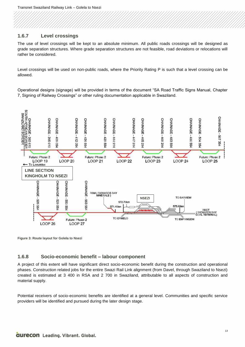
1.6.7 Level crossings
The use of level crossings will be kept to an absolute minimum. All public roads crossings will be designed as
grade separation structures. Where grade separation structures are not feasible, road deviations or relocations will
rather be considered.
Level crossings will be used on non-public roads, where the Priority Rating P is such that a level crossing can be
allowed.
Operational designs (signage) will be provided in terms of the document “SA Road Traffic Signs Manual, Chapter
7, Signing of Railway Crossings” or other ruling documentation applicable in Swaziland.
Figure 3: Route layout for Golela to Nsezi
1.6.8 Socio-economic benefit – labour component
A project of this extent will have significant direct socio-economic benefit during the construction and operational
phases. Construction related jobs for the entire Swazi Rail Link alignment (from Davel, through Swaziland to Nsezi)
created is estimated at 3 400 in RSA and 2 700 in Swaziland, attributable to all aspects of construction and
material supply.
Potential receivers of socio-economic benefits are identified at a general level. Communities and specific service
providers will be identified and pursued during the later design stage.
LINE SECTION
KINGHOLM TO NSEZI
NSEZI
Transnet Swaziland Railway Link – Golela to Nsezi
14
For KwaZulu-Natal, the annual labour element in operations and maintenance in total amount to an estimated
value of R27.4 million.
1.6.9 Service roads
During construction as well as the operational phase, the project will endeavour to utilise existing service roads as
far as possible. However, it is very likely that new roads for construction purposes as well as maintenance
purposes will be constructed. Gravel maintenance roads will typically be 4m wide, generally following the natural
ground level.
New roads to serve as access roads for neighbouring landowners may also be required, depending on the
conditions agreed upon between the landowners and Transnet during the land acquisition process. Access roads
will also be constructed as gravel roads at a 6m width, with vertical curves based on design speed.
These roads will be constructed as far from sensitive areas as possible.
1.6.10 Borrow pits
Transnet envisages the need of approximately thirty (30) borrow pits along the entire Swaziland Rail Link
alignment for construction requirements. It is assumed that borrow pits along the Golela to Nsezi alignment will also
be required to prevent the long haul of materials needed for construction purposes. However, detail of the location
and size of the borrow pits is not yet known and will be determined during the later design stage. Once the detail
has been made available, an application for authorisation of borrow pits will be made to the Department of Mineral
Resources. All concerns, issues and mitigation measures identified by the specialists during the impact
assessments will be taken into consideration during the planning of the location and operations of the borrow pits.
1.7 Proposed alignment alternatives for the Swaziland Railway Link
Project
During the FEL 1 feasibility assessments conducted by Transnet and their appointed engineering consultants, the
following alternatives for establishing a network connection point for the Swaziland Railway Line were considered.
Transnet Swaziland Railway Link – Golela to Nsezi
15
Figure 4: Existing rail line infrastructure
Utilisation of the existing Ermelo-Richards Bay railway line:
An alternative option to the upgrading of the Golela-Nsezi section is the utilisation of the existing Ermelo-Richards
Bay railway line. This option was assessed at the FEL 1 feasibility phase and found to be fatally flawed due to the
following reasons:
Utilising this line would eliminate the strategic purpose of the Swaziland Railway Link project as it would
remove the need to connect the South African railway line to the Swaziland railway line, and eventually
also with the Mozambique Railway system via the proposed railway link between Lothair and Sidvokodvo
(refer to Chapter 1.6).
Currently, much of the coal from the South African inland coalfields is transported via the existing Coal Line
through Ermelo to Richards Bay. Ermelo is currently considered the gateway to the Mpumalanga,
Waterberg and Botswana coal reserves, as well as the centre of the heavy haul export channel. A further
objective is to free up capacity and relieve the Coal Line of non – coal general traffic.
Thus, the upgrading of the existing Golela to Nsezi railway line will be taken into the EIA phase.
The “No Go” alternative:
The “no go” alternative, that is to retain the railway alignment as it currently is, was also assessed during the EIA
process. This assessment takes into account the impacts that could occur should the project not take place. Over
and above the fact that the existing yard cannot accommodate the intended increase in trains that will be travelling
along the route, it has a number of negative impacts. These will include social and financial impacts at a local,
Transnet Swaziland Railway Link – Golela to Nsezi
16
regional, national and international level due to the strategic importance of the project (as mentioned earlier). Due
to these reasons the “no go” alternative is deemed not feasible as it would be against the strategic decision of rail
transportation from South Africa through Swaziland to the port of Richards Bay.
1.8 Project Location
The project runs along the existing Transnet railway line from the Swaziland border at Golela to Nsezi near
Richards Bay (Figure 5). Municipalities traversed include the following:
Jozini
The Big 5 False Bay
Hlabisa
Mtubatuba
Mbonambi
City of Mhlathuze
Uphongolo
Figure 5: Proposed route alignment from Golela to Nsezi. The affected municipalities are also indicated.
Transnet Swaziland Railway Link – Golela to Nsezi
17
The management and mitigation of the environmental impacts experienced during construction and operation is
governed by environmental legislation. It is of utmost importance that this project is constructed and operated in
compliance with all relevant environmental legislation whether National, Provincial and / or Local.
The environmental legislative framework and components for South Africa can best be unpacked and summarised
as follows.
2.1 National Legislation
2.1.1 The Constitution
Section 24 of the Constitution of the Republic of South Africa Act, 108 of 1996 provides the basic right to an
environment which is not harmful to a person’s health or well-being, as well as to have the environment protected
through legislation and any measures which:-
Prevent pollution and / ecological degradation;
Promote conservation;
Secures ecological sustainable development; and
The sustainable use of resources.
At the same time, Section 25 of the Constitution guarantees everyone the right of access to information which is
essential for them to exercise their Constitutional right including any information pertinent to the environmental
assessment (EA) or EIA process. For this reason, Public Participation is considered an essential mechanism for
informing stakeholders of their rights and obligations in terms of the project.
2.1.2 The National Environmental Management Act, 107 of 1998 (NEMA)
The National Environmental Management Act (NEMA) creates the fundamental legal framework that gives effect to
the environmental right guaranteed in Section 24 of the Constitution and sets out the fundamental principles that
apply to environmental decision making.
2.1.2.1 The Principles of NEMA
The Principles of NEMA (Chapter 1) not only serve as a framework upon which Environmental Management is
based (Section 2(1)(b)), but ensures that people and their needs are always considered (Section 2(2)). This is
achieved through avoiding and minimising:
Disturbance on ecosystems or loss of biological diversity (Section 2(4)(a)(i));
Pollution and degradation of the environment (Section 2(4)(a)(ii)); and
Negative impacts on the environment and people’s environmental rights (Section 2(4)(a)(viii));
The principles of NEMA further require that a cautious, methodological approach be applied which takes into
account knowledge or information gaps (Section 2(4)(a)(vii)) so that, as far as possible, all positive or negative
2 LEGISLATIVE FRAMEWORK
Transnet Swaziland Railway Link – Golela to Nsezi
18
impacts on the environment are considered and assessed in order to facilitate the decision-making process in
mitigating these adverse impacts (Section 2(4)(a)(i)).
Mucina and Rutherford (2006) describe the climate in the five regional vegetation types present along the rail line
route (Figure 7), as illustrated in the two boxes below:
5 BASELINE ENVIRONMENTAL
DESCRIPTION
Zululand Lowveld (SVI 23)
The Zululand Lowveld vegetation type falls within the Savanna Biome which constitutes the southernmost extension of the most
widespread biome in Africa. Savannas are largely tropic and occupy the greater area of the southern continents and also some parts of the
northern continents. Most of the savannas are associated with old planation surfaces and are believed to represent a legacy of the
vegetation which flourished during the Tertiary and even earlier geological periods when under hot, wet climatic conditions laterisation
processes were active.
The Zululand Lowveld is classified as “SVI 23” in Mucina and Rutherford (2006). The “SVI” refers to Savannah Biome, Lowveld.
Climate
Summer rainfall with some rain in winter. Mean Annual Precipitation (MAP) of approximately 500-900 mm (highest in the southeast).
Generally a frost free area. Mean monthly maximum and minimum temperatures for Mpila Camp (Hluhluwe-iMfolozi Park) 38.5ºC and
7.8ºC for February and June, respectively.
Geology and soils
Black-clay soils and duplex soils derived from a distinct variety of clastic sediments of the Dwyka, Ecca, Beaufort and igneous rocks of the
Lebombo Groups (all of the Karoo Supergroup). Also well-drained soil forms occur expecially on stony slopes. Land types Fb and Ea, with
some Db and Dc.
Vegetation and landscape features
Extensive flat or only slightly undulating landscapes supporting complex of various bushveld units ranging from dense thickets of
Dichrostachys cineria and Acacia species, through park-like savannah with flat topped A. tortilis to tree dominated woodland with broad-
leaved open bushveld with Sclerocarya birrea subsp. caffra and A. nigrescens. Tall grassveld types with sparsely scattered solitary trees
and shrubs form a mosaic with the typical savannah thornveld, bushveld and thicket patches.
Transnet Swaziland Railway Link – Golela to Nsezi
32
Western Maputoland Clay Bushveld (SVI 20)
Climate
Clay Bushveld (SVI20): Rainfall occurs in summer with dry winters. MAP about 500 – 750 mm. No incidence of frost. Mean monthly
maximum and minimum temperatures 39.5 ºC and 3.1 ºC for January and July, respectively.
Geology and soils
Underlying geology comprises Cretaceous shallow-marine and coastal sediments, siltstones and conglomerates of the Zululand Group and
minor rhyolites of the Jozini Formation (Karoo Supergroup). Dominant or zonal soils of this vegetation unit are latosols comprising red
sandy clay loam to red clay soils (Hutton, Bainsvlei and Shortlands soil forms) and nonduplex brown calcimorphic soils comprising yellow-
brown sandy clay, sandy loam to sandy clay loams (Valsrivier and Avalon soil forms). These are generally fertile soils, characterised by a
moderate to high clay content (20-60%) in the A-horizon. Land types Ea, Ae, Dc, Ia and Db.
Vegetation and landscape feature
Comprises a mixed but mainly compound leaved short (5-10 m) woodlands and wooded grasslands. It occurs on the crests, upper and
midslopes of gently undulating terrain. This vegetation unit is dissected by two large alluvial floodplains associated with the Mkuze and
Phongolo Rivers. FOa 1 Lowveld Riverine Forest and woodland dominate these alluvial soils and numerous small floodplains associated
with smaller streams.
Thembe Sandy Bushveld (SVI 18)
Climate
Summer rainfall with some rain in winter. MAP about 550 – 800 mm. Mist of the warm Indian Ocean contributes to precipitation. No
incidence of frost.
Geology and soils
Shallow soils of Glenrosa and Mispah forms over Jozini Formation rhyolite lavas (Karoo Supergroup). Heavier soils have developed over
dolerite in places. Rocky outcrops are typical. Land types mainly Fa, Ea and Ib.
Vegetation and landscape feature
Ridge plateaus and adjacent slightly sloping flanks covered with open, tall, sour, wiry grasslands, often dotted with low bushes and solitary
savanna trees.
Transnet Swaziland Railway Link – Golela to Nsezi
33
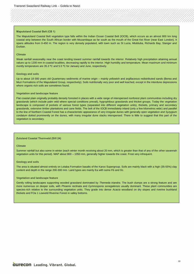
Maputoland Coastal Belt (CB 1)
The Maputoland Coastal Belt vegetation type falls within the Indian Ocean Coastal Belt (IOCB), which occurs as an almost 800 km long
coastal strip between the South African border with Mozambique as far south as the mouth of the Great Kei River (near East London). It
spans altitudes from 0-450 m. The region is very densely populated, with town such as St Lucia, Mtubtuba, Richards Bay, Stanger and
Durban.
Climate
Weak rainfall seasonality near the coast tending toward summer rainfall towards the interior. Relatively high precipitation attaining annual
values up to 1200 mm in coastal localities, decreasing rapidly to the interior. High humidity and temperature. Mean maximum and minimum
montly temperature are 35.3 ºC and 5.5 ºC for January and June, respectively.
Geology and soils
Up to about 18 000 years old Quarternary sediments of marine origin – mainly yellowish and argillaceous redistributed sands (Berea and
Muzi Formations of the Maputaland Group, respectively). Soils nutritionally very poor and well leached, except in the interdune depressions
where organic-rich soils are sometimes found.
Vegetation and landscape feature
Flat coastal plain originally probably densely forested in places with a wide range of interspersed nonforest plant communities including dry
grasslands (which include palm veld where special conditions prevail), hygrophilous grasslands and thicket groups. Today the vegetation
landscape is composed of pockets of various forest types (separated into different vegetation units), thickets, primary and secondary
grasslands, extensive timber plantations and cane fields. The belt of the IOCB immediately inland (only a few kilometres wide) and parallel
to the line of Northern Coastal Forest has a characteristic appearance of very irregular dunes with generally open vegetation and Syzygium
cordatum dotted prominently on the dunes, with many irregular dune slacks interspersed. There is little to suggest that this part of the
vegetation is secondary.
Zululand Coastal Thornveld (SVI 24)
Climate
Summer rainfall but also some in winter (each winter month receiving about 20 mm, which is greater than that of any of the other savannah
vegetation units for this period). MAP about 800 – 1050 mm, generally higher towards the coast. Frost very infrequent.
Geology and soils
The area is situated almost entirely on Letaba Formation basalts of the Karoo Supergroup. Soils are mainly black with a high (35-55%) clay
content and depth in the range 200-300 mm. Land types are mainly Ea with some Fb and Dc.
Vegetation and landscape feature
Gently rolling landscapes supporting wooded grassland dominated by Themeda triandra. The bush clumps are a strong feature and are
more numerous on deeper soils, with Phoenix reclinata and Gymnosporia senegalensis usually dominant. These plant communities are
species-rich relative to the surrounding vegetation units. They grade into dense Acacia woodland on dry slopes and riverine bushland
thickets and FOa 1 Lowveld Riverine Forest in valley bottoms.
Transnet Swaziland Railway Link – Golela to Nsezi
34
Figure 7: The position of the railway line in relation to the regional vegetation types as defined by Mucina & Rutherford (2006) and considered Vulnerable by NEM:BA
5.1.2 Noise and Vibration
According to the GNR 154 of 1992, section 2C, a local authority may:
“if a noise emanating from a building, premises, vehicle, recreational vehicle or street is a disturbing noise or noise
nuisance, or may in the opinion of the local authority concerned be a disturbing noise or noise nuisance, instruct in
writing the person causing such noise or who is responsible therefor, or the owner or occupant of such building or
premises from which or from where such noise emanates or may emanate, or all such persons, to discontinue or
cause to be discontinued such noise, or to take steps to lower the level of the noise to a level conforming to the
requirements of these Regulations within the period stipulated in the instruction: Provided that the provisions of this
paragraph shall not apply in respect of a disturbing noise or noise nuisance caused by rail vehicles or aircraft which
are not used as recreational vehicles;”
Railway locomotives are thus exempt from these requirements. However, the impact assessment conducted
proposes mitigation measures to minimise the impact of noise on the environment as described in the baseline
description below.
The most important roads that the railway route currently or is proposed to traverse is the N2 and the R22 routes
and are illustrated as a yellow lines in Figure 8. Smaller less significant roads (in terms of acoustics) do feature in
the area.
There exist five communities identified for acoustical investigations due to the proposed railway line including the
community of Lavumisa (Golela Border Post), Mkuze, Mfekayi, Hluhluwe and KwaMsane. Numerous assumed
Transnet Swaziland Railway Link – Golela to Nsezi
35
households (GoogleEarth®, imagery date 2013) were identified via a desktop study and are illustrated as green
dots in the mentioned figure.
Ground conditions and vegetation will influence the propagation of the sound from noise sources in the area as
sound that is reflected from the ground would be influenced as certain frequencies would be absorbed by the
ground surface. Taking into consideration available information the ground conditions could be classified as
medium in terms of acoustics (acoustically medium ground absorbency).
Potentially sensitive receptors, also known as noise-sensitive developments (NSDs) were initially identified using
Google Earth® and is illustrated in Figure 8.
Transnet Swaziland Railway Link – Golela to Nsezi
36
Figure 8: Noise sensitive receptors for the receiving environment
Transnet Swaziland Railway Link – Golela to Nsezi
37
5.2 Biophysical Environment
The study area is dominated by a mixture of urban and rural development, forestry, and various forms of
agriculture, with the associated infrastructure such as roads, lakes dams and the present rail network, while
traversing a wide variety habitat that range from drier Bushveld in the north to more mesic (moist) coastal forests in
the south.
Figure 9: A map illustrating the major wetland areas within the study region
The majority of the wetlands within the study area have been shown to be natural, and form part of the important
Maputoland Wetland Cluster (Figure 9). However some of these would be considered modified and have a
conservation rating score of Z1 or Z2, i.e. low conservation importance. The remaining natural wetland areas
associated with the local streams, pans floodplain wetlands, lakes and estuaries were mostly rated as A/B or C, i.e.
Pristine to moderately modified or largely modified respectively (Nel et al., 2012).
Transnet Swaziland Railway Link – Golela to Nsezi
38
Figure 10: A map illustrating the irreplaceability categories that intersect with the line based on results from the Ezemvelo KZN Wildlife Conservation Plan
The provincial conservation authority together with a broad range of stakeholders assessed the conservation status
of the province using the GIS based C-Plan Conservation Planning System. This produced a conservation map of
the province at a Quarter Degree Square (QDS) level, ranking the irreplaceability of each cell or square (Figure 10).
The degree of irreplaceability was based on a weighted score of the potential for important or sensitivity species /
habitats to occur or known to occur within each QDS cells. Several “Totally Irreplaceable” QDS cells are
intersected by line (Figure 10) and will be assessed during the EIA phase. However the majority are associated
with protected mammal species such as the Black Rhino found in the large number of protected areas adjacent to
the line, such as Mkuze, and Hluhluwe Nature Reserves.
Figure 10 indicates that a portion of the line falls within a Highly Significant catchment. This is possibly due to this
catchment forming part of the catchment divide between the Vaal River (Renosterloopspruit – C11F) and the
Olifants (Viskuile – B11A). Most of these rivers are categorised with a Present Ecological State (PES) score Class
C or Moderately Modified, which is a rather unique occurrence considering the general landscape change that has
occurred over time.
During the EIA phase, intensive habitat matching was conducted and ground-truthed to determine the exact status
and importance of the habitats observed at a finer scale as well as identify the presence any Species of Special
Concern (Faunal & Floral). The results of the assessment are captured in Chapter 8 of this report.
5.2.1 Aquatic environment
The Golela to Nsezi line falls within a large number of catchments associated with the following major rivers or
lakes (Figure 11):
Phongola
Transnet Swaziland Railway Link – Golela to Nsezi
39
Mkuze
Msunduzi
Hluhluwe
St Lucia
Nyalazi
Mfolozi
Nhlabane
All of these systems have been classified as part of the National Freshwater Ecosystem Priority Atlas (NFEPA)
project (Nel et al., 2012).
The majority of the wetlands within the study area have been shown to be natural, and form part of the important
Maputoland Wetland Cluster. However some of these would be considered modified and have a conservation
rating score of Z1 or Z2, i.e. low conservation importance. The remaining natural wetland areas associated with
the local streams, pans floodplain wetlands, lakes and estuaries were mostly rated as A/B or C, i.e. Pristine to
moderately modified or largely modified respectively (Nel et al., 2012) (Figure 11).
Transnet Swaziland Railway Link – Golela to Nsezi
40
Figure 11: The project locality (red line) in relation to the respective quaternary catchments
Transnet Swaziland Railway Link – Golela to Nsezi
41
5.2.2 Fauna
In a desktop assessment of various taxonomic databases approximately 640 known animal species are expected
to occur within the region. Mammals and herpetofauna (snakes and frogs) possibly contribute between 130 – 150
of these known animal species. The expected bird species within the study area is expected to be around 350 -
380 species due to the variety of habitat types available within the study area.
One particular Millipede (Centrobolus richardi) was listed in several Quarter Degree Squares along the route within
the coastal areas. However as most of the rail line is already in place it is anticipated that there would be little
impact on any species of special concern in particular.
5.2.3 Flora
According to the Mucina and Rutherford (2006) Vegmap, five regional vegetation types are present along the rail
line route. These include:
Zululand Lowveld (SVI 23)
Western Maputoland Clay Bushveld (SVI20)
Tembe Sandy Bushveld (SVI18)
Maputoland Coastal Belt (CB1)
Zululand Coastal Thornveld (SVI24)
The Biodiversity Act (No 10 of 2004) (Amendment December 2011), lists 225 threatened ecosystems based on
vegetation type (Vegmap). None of these vegetation types are listed by this Act. .
Present maps only indicate the original extent of these ecosystems, therefore the assessment of these
ecosystems, their current extent and status will form a major focus of the EIA field visit, especially in light of the
majority of the study region has been transformed to some degree. Therefore it is imperative that any remaining
functional habitats are properly identified, in order to minimise any further impact to these areas.
Refer to chapter 8 for a detailed description of the specialist assessments of potential impacts of the project.
5.3 Social environment
The following local municipalities as indicated in Figure 12 are affected:
Mfolozi (previously Mbonambi) Local Municipality (KZN281);
uMhlathuze Local Municipality (KZN282);
UPhongolo Local Municipality (KZN262);
Jozini Local Municipality (KZN272);
The Big 5 False Bay Local Municipality (KZN273);
Mtubatuba Local Municipality (KZN275); and
Hlabisa Local Municipality.
Transnet Swaziland Railway Link – Golela to Nsezi
42
The baseline social conditions of a community (community profiles) are the existing conditions and past trends
associated with the human environment in which the proposed activity is to take place. The description of baseline
conditions includes the relationship with the biophysical environment, historical background, social resources,
culture, attitudes and social conditions, economic and population characteristics.
The social parameters of the various municipalities are described below.
uMkhanyakude District Municipality
The key drivers of the local economy of the uMkhanyakude DM has been identified as tourism and retail, and to a
lesser extent agriculture and processing. Therefore, most of the development plans for this DM are focussed at
stimulating growth and development in these sectors. The most prominent plans are listed below:
Corridor development:
Zulu Ocean Corridor – (Richards Bay – St Lucia – Hluhluwe – Kosi Bay to Maputo);
North South Corridor – (Richards Bay – Mtubu/Habisa – Hluhluwe – Mkhuze – Golela) (Similar alignment
The data presented in the table does not present any correlation between GVA contribution and labour force (i.e.
the interplay between labour and capital is not assessed), and therefore it is not possible to draw any specific
conclusion regarding labour productivity. It does however provide an indication of the strength of the respective
sectors and can be used to predict possible employment opportunities per sector. All other labour units reported an
increase in GVA output to labour. If one assumes that these labour units show significant opportunities for
substituting labour with capital, then one might conclude that there was an overall increase in labour productivity
over the assessment period.
Land use
The Province is characterised by a large number of scattered rural settlements and villages, with a vast number of
these settlements and villages occurring within the affected District Municipalities of Zululand, uMkhanyakude and
uThungulu.
The presence of villages, informal settlements, and formal urban areas increase towards the coastline with the
most significant urban conurbation located within the eThekweni Metropolitan Municpality. Although the majority of
urban areas are predominantly located in a southerly location along the coastline and towards the inland, an
extensive urban area is however found towards the north at Richards Bay within the uMhlathuze Local Municpality.
Richards Bay represents one of the largest secondary activity nodes in the Province.
Richards Bay Port and the Port of Durban together handle approximately 78% of South Africa’s cargo tonnage.
Richards Bay is also the operational centre for South Africa’s aluminium industry while Richards Bay Coal terminal
ensures the country’s position as the second largest exporter of steam coal in the world.
The following high-level observations can be made:
The start of the section at Jozini dam;
Primarily forest, woodland and plantations;
The only urban/built up areas are at the start and the end at Richards Bay.
5.4 Cultural and Archaeological environment
In the National Heritage Resources Act, no 25 of 1999 (NHRA), Section 2 (vi), it is stated that ‘‘cultural significance’’
means aesthetic, architectural, historical, scientific, social, spiritual, linguistic or technological value or significance.
This is determined in relation to a site or feature’s uniqueness, condition of preservation and research potential.
The purpose of this Heritage Impact Assessment (HIA) is to review the current state of cultural heritage resources
that occur in the vicinity of the alignment of a new railway line that is planned by Transnet. Preliminary desktop
studies have revealed the following facts regarding the Golela to Nsezi alignment area:
Transnet Swaziland Railway Link – Golela to Nsezi
59
5.4.1 Stone Age
From available evidence, it seems that very little habitation of the region took place during the Early Stone Age.
This change during the Middle Stone Age and some sites are known to occur to the north of the study area.
Although no sites dating to the Later Stone Age are known from the larger region, some very important sites occur
in the Ukhahlamba Mountains, Biggersberg and Ngome escarpment. The latter sites are mostly rock shelters that
were occupied on and off over a long period of time.
5.4.2 Iron Age
Iron Age people started to settle in southern Africa c. AD 300, with one of the oldest known sites at Broederstroom
south of Hartebeespoort Dam dating to AD 470.
Most information on the region is based on surveys that were done in the Hluhluwe Nature Reserve (Natal Museum
Database). Sites dating to all periods, except the Early Iron Age, were identified in the park.
The occupation of the larger geographical area (including the study area) started during the so-called Early Iron
Age and is part of the Kalundu Tradition that links with the Kwale sites of Kenya. These early sites occur almost
always in the dunes of the coastal forest belt, extanding inland ito the lower-laying savannah areas in the vicinity of
rivers - see for example the various maps in Huffman 2007).
During the Late Iron Age settlements seems to move to higher ground further away from rivers. This seems to
indicate a defensive position. The latter part of this period was characterised by increased military tension, the
reason of which is quite complex but has to do with changing environmental circumstances, population increase,
penetration of white settlers into the region and lucrative trade networks with the coast.
5.4.3 Historic period
By 1824 the entire Zululand was under the control of the abaKwazulu, previously a small and insignificant clan. The
Bulawayo capital of the Zulu was moved from the Mkubane site and rebuilt on a hilltop overlooking the Mhlatuze
River near the present Eshowe / Empangeni road. It was here that Shaka, king of the Zulu, met pioneer Natal
settlers Fynn, Farewell and Isaacs.
The Hluhluwe area was originally a royal hunting ground for the Zulu kingdom, but was established as a park in
1895. The Umfolozi and Hluhluwe reserves were established primarily to protect the white rhinoceros, then on the
endangered species list.
Transnet Swaziland Railway Link – Golela to Nsezi
60
The proposed construction and upgrade of the Golela to Nsezi border section of the Swaziland Railway Link project
is anticipated to impact on a range of biophysical, social and economic aspects of the environment. One of the
main purposes of the EIA process is to understand the significance of these potential impacts and to identify
suitable mitigation measures, both positive and negative.
A summary of issues raised by both the specialists and the I&APs during the project’s Scoping Phase are indicated
below. The Plan of Study for the EIA in Appendix B, Annexure J provides a detailed indication of how these issues
were addressed during the Impact Assessment Phase. The results of these assessments are detailed in Chapter 8.
The detail contained below has been sourced from the specialist input reports which can be found in Appendix B,
annexures A through I.
6.1 Issues Raised by the Specialists
The issues and response report (IRR) containing all the issues raised by the public during the public participation
meetings held can be found in Appendix C, Annexure G.
6.1.1 Ecological Issues Raised
Sixty five (65) non-perennial and ten (10) perennial watercourses cross the existing, as well as the proposed 35m
wide railway corridors. These watercourses form the basis for identifying potential wetland and riparian areas to be
investigated during field surveys. These alignments, including the footprints of access roads, crew camps, borrow
pits and refuelling yards, will be extensively surveyed to identify all wetlands and riparian areas within 500m of the
proposed activity footprints. Relevant functional and integrity assessments will be conducted based on the findings
of the site survey.
All waterbodies that lie within 500m of the proposed development footprints will be investigated during a dedicated
field survey as set out in this document. For the purpose of activities within the 1:100 year floodline or the
wetland/riparian area (whichever is the greatest), an application for a Water Use License must be made. In
addition, activities close to wetlands are excluded from the General Authorization for S21 (c) and (i) water uses
(government gazette No. 389) due to the complexity and potentially cumulative impact on a wetlands and rivers
and the resources as a whole (DWA, 2010). Therefore all activities within 500m of wetlands or rivers should be
subject to an application for authorization.
The Golela to Nsezi line falls within a large number of catchments associated with the following major rivers or
lakes:
Phongola
Mkuze
Msunduzi
Hluhluwe
St Lucia
6 ISSUES IDENTIFIED DURING THE
SCOPING PHASE
Transnet Swaziland Railway Link – Golela to Nsezi
61
Nyalazi
Mfolozi
Nhlabane
All of these systems have been classified as part of the National Freshwater Ecosystem Priority Atlas (NFEPA)
project (Nel et al., 2012).
The majority of the wetlands within the study area have been shown to be natural, and form part of the important
Maputoland Wetland Cluster. However some of these would be considered modified and have a conservation
rating score of Z1 or Z2, i.e. low conservation importance. The remaining natural wetland areas associated with
the local streams, pans floodplain wetlands, lakes and estuaries were mostly rated as A/B or C, i.e. Pristine to
moderately modified or largely modified respectively (Nel et al., 2012).
These would then be considered carefully in the EIA phase, firstly to establish their exact form and function through
delineation and then determine their Present Ecological State (PES). This would also be a requirement by the
Department of Water Affairs should any of the proposed line be within 500m of a wetland boundary thus,
construction activity would require a Water Use License Application for a Section 21 c & i use.
During the EIA phase, intensive habitat matching will be conducted and ground-truthed to determine the exact status and importance of the habitats observed at a finer scale as well as identify the presence any Species of Special Concern (Faunal & Floral).
The following issues and impacts have been identified together with potential impacts which will be investigated
during the EIA phase:
Issue 1 – Destruction of natural habitat.
Impact 1 - loss of habitat and removal of vegetation – terrestrial
Impact 2 - loss of habitat and removal of vegetation – wetland and waterbodies
Impact 3 - Loss of corridors
Issue 2 – Loss of endangered species
Impact 1 – Loss of rare and endangered species
Impact 2 – Introduction of alien and invasive species
Issue 3 – Removal of topsoils and soil erosion
Impact 1 – an increase in soil erosion
Issue 4 – Introduction of alien vegetation
Impact 1 – introduction of alien or invasive plants
6.1.2 Geohydrological Issues Raised
The potential for groundwater contamination is associated with uncontrolled spills of fuels and lubricants during the
construction phase, as well as any hazardous material transported during the operational phase. The extent and
Transnet Swaziland Railway Link – Golela to Nsezi
62
impact of potential groundwater contamination is largely dependent on the nature of the subsurface soil, geological
and geohydrological conditions.
6.1.3 Noise and Vibration issues raised
The noise and vibration scoping assessment indicated that the proposed project could have an impact of
significance on the noise climate of the surrounding area as there are noise-sensitive developments within the area
of influence of the railway line. The main factor that will determine the potential noise impact is the distance that the
noise-generating activities would be from a NSD, the type of activities taking place, the speed of the locomotives,
the existing ambient soundscape at receptors dwellings, as well as the likely noise abatement measures to be
implemented.
6.1.4 Social, Economic and Cultural/Heritage Issues Raised
Negative Socio-economic Impacts
A loss of land and assets to the railway servitude or areas to be occupied by project-related surface
infrastructure;
A population influx (due to the presence of a construction and operational workforce, as well as an influx of
job-seekers into the area), with a possible concomitant increase in social pathologies and increased
pressure on existing infrastructure and services;
Disruption of access routes and daily movement patterns by the construction and/or permanent servitude;
Impacts on sense of place. Such impacts may arise as a result of the visual intrusion of project-related
infrastructure, as well as noise and traffic impacts during construction
Dust caused by the construction works and from movement of heavy equipment. During the construction
phase, the local community and construction workers would be inconvenienced by the dust generated by
the construction works.
Noise and vibration due to the construction works and from movement of heavy equipment. Movement of
heavy machinery on existing local roads may be one of the core problems for the local community during
the construction phase. Vibration may also damage structures located nearby.
Socio-cultural differences and conflicts between migrant workers and the local community. Single men
predominately occupy the construction camps which could create social conflicts, usually as a result of
cultural differences, alcohol abuse or being away from their wives or girlfriends for extended periods of
time. A possible reason for conflict would be the perception among locals that the outsiders are taking up
jobs that could have gone to unemployed members of the local community. An influx of unemployed job
seekers could also add to the potential for conflict.
Diseases associated with the arrival of temporary labour in the area. Various social pathologies, such as
drug/alcohol misuse, abuse of woman and children and incidences of sexually transmitted diseases (STDs)
may increase with the influx of job-seekers into the area.
Crime. An inflow of construction workers and job seekers may also be accompanied by an increase in
crime. Even if specific instances of crime are not as a result of the newcomers, they may still be ascribed to
them by local communities.
Informal settlements. Once construction is concluded and the camp is vacated, it may be illegally occupied
by unlawful tenant.
Positive Socio-economic Impacts
Local employment and job opportunities. The construction phase of the project will have a positive impact
on the local labour market. It is anticipated that the operational phase will also create permanent
Transnet Swaziland Railway Link – Golela to Nsezi
63
employment opportunities for the local affected communities though some level of technical skills and
qualifications may be needed.
Local economy opportunities and economic empowerment. The construction phase of the project will have
temporary positive impacts on the local economy.
Establishment/ upgrading of services.
6.1.5 Cultural/Heritage Issues Raised
The cultural and heritage issues foreseen in this project include the following:
Ignorance as to the importance and value of heritage sites and their protection through legislation. Land
and property owners are, in most cases, ignorant about the value of heritage or their legal obligation to
protect it. Current legislation is very clear as to the obligation of the land or property owner with regards to
heritage management and preservation.
Ignorance as to the nature and distribution of heritage resources. There is very little information available
on heritage in the area. This can be overcome by a number of actions, e.g.
o A system whereby members of the public can record the heritage sites in their communities or on
their properties should be established. This can be achieved, for example by keeping a register at
the local library.
o The municipality and other authorities should make funds available for systematic surveys by
which sites can be documented
Lack of information on heritage resources on the side of the authorities responsible for planning. This is
the direct result of the above-mentioned problem. More information is needed.
Heritage is not static. New heritage sites are continuously being created, due to events that take place, or,
simplistically seen, because existing features and structures become older with the passage of time and
all should be considered for their contribution to retelling the story of the past. The process of identifying
and documenting heritage features would therefore, in theory, never stop.
The specialists have investigated the above mentioned impacts in the EIA - the results of the assessments,
description of potential impacts as well as proposed mitigation measures are described in Chapter 8.
6.1.6 Safety and Security Aspects
An emergency response plan should be compiled and incorporated into the EMPs for both the construction and
operational phases. Issues pertaining to regular inspections, monitoring mechanisms, maintenance and
emergency response will be incorporated into this EMP.
Safety requirements linked to the existing development footprint of the proposed construction site will be
investigated and reported in the legislative and institutional requirements of the EIA report. These aspects will
further be incorporated into the design and layout of the proposed facility. Where necessary, monitoring and
inspection mechanisms will be included in the construction and operational phases of the EMP.
6.2 Issues raised during the Public Participation Process
The following issues in Table 21 constitute an extract from the issues and response report (IRR) and the Minutes
captured at the public and focus group meetings for the Golela to Nsezi section of the proposed Swaziland Railway
Transnet Swaziland Railway Link – Golela to Nsezi
64
Link project. The IRR containing all the issues raised by the public during the public participation meetings held can
be found in Appendix C, Annexure G and hard copies of the comments are included in Appendix C Annexure K.
Transnet Swaziland Railway Link – Golela to Nsezi
65
Table 21: Issues and Responses
Issue Response
From Mr David Davidson
Zenith Estates CC:
With reference to your advertisement in
the Zululand Observer of 24/06/2013;
we would like to register as an
interested and affected party with
regards to the Transnet upgrade from
Nsezi to Golela.
We farm on both sides of the rail line
north and south of Nseleni rail way
station which is of our main concern
but some matter will apply no doubt to
the whole upgrade.
Our immediate concerns are:
1. The level crossings need to be
upgraded to guarded level crossings or
under / over passes.
2. The rail lines used to be fenced and
with the upgrade the lines need to be
re-fenced. We have livestock and we
are thus unable to safely graze stock
near the rail lines. As mentioned we
have farm land on both sides of the
"track.” Fencing is a safety issue as it
ensures staff and livestock can only
cross over the lines at recognized
crossings. Just because the fences
allegedly get stolen Transnet and their
predecessors have not even repaired
fences as a result with 20 years of no
fence repairs there are now no fences.
What was not stolen has all rusted
away. If the fencing is stolen a method
of construction that prevents theft
needs to be used. For example old
concrete rail way sleepers can be used
as fence posts and fencing wire can be
electrified.
3. Noise levels need to be addressed.
Prior to 1972 we had steam trains.
These then changed to diesel electric,
with bigger noise and bigger hooters
Recently there has been another
Mr Davidson is included on the database as a
representative of the Kwambonambi Farmers Association
and member of Zenith Estates CC.
1. As the safe crossing of a railway line is a significant
issue this was included as one of the design criteria
considered during the pre-feasibility study. The
following is an extract from the FEL-2 Pre-feasibility
Report prepared for Transnet by Mott MacDonald
Railway & Civil Engineering Consultants.
‘ Level Crossings
The use of level crossings for public roads will be kept
to an absolute minimum for the 100 wagon system.
No level crossings will be permitted for the 200 wagon
system.
For non-public roads, if possible or practical, no level
crossings are provided, except for maintenance road
crossings.
All public roads crossings will be designed as grade
separation structures. Where grade separation
structures are not feasible, road deviations or
relocations will be considered as alternatives.
Operational designs [signage] will be provided in terms
of the document ‘”SA Road Traffic Signs Manual,
Chapter 7, Signing of Railway Crossings” or other
ruling documentation.’
2.Transnet will put necessary security measures in place in
the form of fencing and gates where required with
appropriate access control to affected farmers.
3. Refer to Appendix B for a copy of the Noise Scoping
which has been conducted. The assessment indicated that
the proposed project could have an impact of significance
on the noise climate of the surrounding area as there are
Noise-Sensitive Developments [NSD] within the area of
Transnet Swaziland Railway Link – Golela to Nsezi
66
locomotive upgrade. They seem to
have gotten more noisy and have even
bigger hooters. We live approximately
150 m off the main line and at times our
houses shake and the windows rattle
with the noise of a locomotive
accelerating-we do believe the noise
level of 80 dB is exceeded - in a normal
health and safety situation one should
be wearing ear protection. However this
is Transnet and they have never had
any regard for noise levels around our
homes. For example last year some
train driver found humour in blasting
his hooter solidly. Our concern is
bigger trains = more noise. More Trains
= more noise more often. Remedial
action could involve the cladding of the
diesel engine compartments, better
sound baffling exhausts, electrifying
the line to use electric trains or using
vegetation and structures (earthen
banks or a " precast" wall of old
concrete rail sleepers side by side) to
reduce sound projection onto
residential areas. On the hooter side a
dual system could be used - the initial
blast is reduced in volume and say
after 3 seconds this automatically
becomes VERY loud.
4. Transnet need to become members
of the local Fire Association; this is a
legal requirement but Transnet regard
themselves above the law in this issue.
5. Transnet need to have a system of
addressing concerns. For example: If
the brakes bind on a rail truck and the
molten metal coming off these brakes
sets fire to the surrounding farms there
is no one to contact. So how do we
stop the train to stop the spreading
fires? Or if a scrap dealer is seen
cutting up rail lines - who do we
contact? (As what happened last night
on 23/06/2013 - a suspect was seen;
by local community members; using a
influence of the railway line. The main factor that will
determine the potential noise impact is the distance that the
noise-generating activities would be from a NSD, the type of
activities taking place, the speed of the locomotives, the
existing ambient soundscape at receptors dwellings, as well
as the likely noise abatement measures to be implemented.
An Environmental Noise Impact Assessment will be
conducted in order to determine the significance of the
identified impacts and to investigate and recommend
mitigation measures to reduce the impacts.
4. The concern regarding fire protection is a significant
issue which has been raised by various affected
parties. Firebreaks and protection will be taken up in
the Environmental Management Programme (EMP).
Transnet will ensure the identification and
implementation of measures to adequately address
the risk of uncontrolled fires.
5. A complaints procedure will be developed for the
construction and operational phases to ensure
effective response times. In this regard, a suitable
person(s) will be identified with whom the public can
raise concerns/complaints and contact details will be
made available.
Transnet Swaziland Railway Link – Golela to Nsezi
67
cutting torch to cut up rail lines in the
Mposa Station area -So who do we
call. Transnet does not have contact
details so the theft cannot be
addressed.)
Point 5 may appear to be out of the
scope of this EIA, but if Transnet
cannot address current problems they
should not be allowed to upgrade. .
We would like to see a system in place
much like the ESKOM toll free
number. The call centre could then
asses the urgency of a matter. We do
battle with internet connection so it
would be appreciated that replies and
documents be kept to under 5 Mb.
Alternatively they should be posted.
As representative of the Pongola Game
Reserve Landowners Association
mandated to deal with Elephant and
Black Rhino Management Issues, I
herewith submit my notice as an
interested and affected party with the
above planned railway upgrade project.
The line to be upgraded from Golela to
Nsezi runs for +- 30 km through the
Phongolo Nature Reserve (EKZNW) and
Pongola Private Game Reserve, and
therefore falls within the above project.
Wildlife mortalities from the train are
always been a big concern and all
efforts and methods to reduce these to
the bare minimum is our prime
objective in our co-operation with
Transnet.
Herewith following is a list of concerns
that we would like to be addressed;
1. Speed of locomotives travelling
through the reserve – This problem has
improved following the implementation
of a speed limit after the death of two
Black Rhino in 2008 and 2009. How is
the expected increase in rail traffic
going to effect the current speed limit
Dr Heinz Kohrs as representative of the Pongola Game
Reserve has been registered as an affected stakeholder
and will be notified once the Draft /Final Scoping and
Draft/Final EIA Reports become available for review and
comment by I&Aps. Furthermore Dr Kohrs will receive
notification of stakeholder meetings.
A response to the items raised are included below in the
same numerical order.
1. The impact of increased rail traffic on wildlife is a
significant issue which will require effective mitigating
measures by Transnet. Proposals must be determined by
Transnet in collaboration with the design engineering team
and in particular also the scheduling team. The matter will
be investigated further and mitigating measures will be
included in the Draft EIA Report.
2. The envisaged schedule amounts to 12 to 24 trains per
day per direction; this will necessitate night time travel.
3. Hooting limitations will be addressed in the operational
manual and the construction Environmental Management
Programme;
4. The use of such a deterrent will be considered in
collaboration with Transnet;
5. This issue will be further considered in collaboration with
Transnet;
6. This issue will be investigated during the EIA phase and
feasible mitigation measures that ensure the protection of
Transnet Swaziland Railway Link – Golela to Nsezi
68
restriction? This is critical for all the
wildlife, and not only the Black Rhino.
2. The increase in train traffic – how
can this be kept to the bare essential?
Day vs night traffic?
3. Hooting – to be kept to the bare
minimum.
4. High frequency warning signal on the
locomotive – Is it possible to equip
every locomotive with a high frequency
warning signal devise that will warn all
wildlife on or near the railway line of
the oncoming locomotive? Apparently
such a warning device has been
deployed in other countries to deter
wildlife out of the way of the
approaching trains.
5. Head lights of the locomotive – can
one please consider a head light that
does not blind the animals on and near
the line?
6. Protecting the cuttings – from past
experience, and particularly White
Rhino, tend to wander along the railway
line into the cutting section where they
are trapped from getting out of the way
from approaching trains. Transnet has
put at each entrance to the cuttings a
packed pile of concrete railway
sleepers as an obstacle for wildlife to
wander into this cutting ‘trap’. With the
new upgrade a more effective blockade
could be found and implemented to
stop large animals like elephant and
rhino from wandering into the railway
line cutting areas.
7. Tortoises and Rock Pythons – Many
of these get killed by the train when
crossing the railway line. With the
upgrade, please look into creating more
subways for these reptiles.
8. Bush Clearing – It is essential that on
either sides of the railway line the
Transnet area is kept clear of any
bushes and trees for at least 10 metres.
This will prevent browsers and other
wildlife lurking close to the line and
when startled by the sudden approach
of the train, run onto the line in front of
the train or into the coaches.
affected species at key points will be set for incorporation in
design and implementation during construction and
operation.
7. Proposals for the frequency of subways will be
investigated and included in the EIA Report;
8. Noted. The comment will be considered for inclusion in
the Environmental Management Programme (EMP);
9. This issue will be addressed in the EMP;
10. Noted this issue will be addressed in the EMP;
11. Noted. This issue will be addressed in the EMP.
12. This provision can be included in the EMP.
additional land may be required where the upgrades
extend beyond the existing servitudes.
Measures for the protection of existing fences during
construction will be investigated in the EIA and specified
in the EMP
The impact of the required water usage during the
construction phase will be investigated as part of the
EIA Phase and during the application for a Water Use
License.
A land use map will be included in the Draft EIA Report.
Flora and wetland assessments will be conducted as
part of the EIA Phase and recommendations will be
included in the EMP.
A geotechnical evaluation has been conducted and the
findings will be included in the EIAR.
Transnet Swaziland Railway Link – Golela to Nsezi
69
9. Littering – This is a big problem
especially by the contractor teams
working and maintaining the railway
line. With more contractors working on
this project in the reserve, littering on
the entrance roads and work site will
escalate. This is unacceptable!
10. Security – PPGR are custodians to
the WWF Black Rhino Range
Expansion Project, and security is
critical in the prevention of rhino
poaching. All entrance gates in and out
of the reserve are manned for security
reasons. Contractors entering the
reserve must follow our security and
gate control protocols to assist with
our efforts of preventing and
controlling rhino poaching.
11. Fires – no fires of any kind may be
made in the reserve by contractors. A
veld fire can devastate the reserve and
its wildlife.
12. Road usage – Please respect the 35
km speed limit. Also, after heavy rains,
no heavy vehicle and machinery may
be deployed as it damages our reserve
roads that are not all weather surfaced.
• Will additional land be required?
• All farms next to railway line have
game. Concern regarding damage to
fences of adjacent properties during
construction;
• Consideration of poor natural water
quantities. Impact of Transnet water
usage during construction activities
must be investigated
• The Department acknowledge the
receipt of the invitation to participate .
In view of the document dated 2 July
2013, this office is concerned that the
proposed activity will cover a huge
area comprising different facets of
natural resources (Soils, watercourses,
vegetation etc.) falling under different
Agricultural Land Categories which
may be negatively impacted.
• Therefore this office requests that the
following aspects and studies form part
Transnet Swaziland Railway Link – Golela to Nsezi
70
of the Environmental Impact
Assessment:
Current land use, zoning, extent
of the proposed areas for
development;
Geotechnical survey;
Flora studies
Wetland studies
All the above should form part of the
Environmental Management Plan (EMP)
and all the stipulations related to
responsibilities and conditions therein
must be strictly adhered to.
The railway line is being upgraded
however I am unable to send my timber
to Umkomaas as there are no trucks.
Transnet is looking at a massive export
picture yet there is no local
infrastructure, therefore no benefits for
the locals
The comment has been sent to the Rail planning team for
confirmation on how SMME’s will be supported
Local communities can benefit from job opportunities during
the construction and operational phases. The upgrade of
certain sections such as Davel to Lothair in Mpumalanga
includes local wood and other general freight.
Will impact of this project on existing
rail traffic be considered?
Richards Bay Minerals currently moves
about two million tons of product on
that rail line. Any disruption to this
activity will result in economic impacts.
Will increased traffic on new rail line
have an impact on existing traffic.
No impact on current operations as line between Golela and
Nsezi will be constructed parallel to the existing line within
the existing servitude. Therefore it will be operations as
normal on the existing line.
Apart from its strategic value the link line is constructed
primarily for the purpose of re-routing general freight traffic
from the Coal line and by so doing freeing up capacity for
the export of coal.
Traffic impacts will be considered by the engineers.
6.3 Institutional and Legal Aspects Raised During the Scoping Phase
6.3.1 Project Lifecycle
The project is effectively in the preliminary design phase, and no detailed design is available as such. Where
applicable comment and suggestions made during the scoping phase will be incorporated into the design.
6.3.2 Alternatives to and Need for the Project
A detailed alternatives assessment will be conducted in the EIA phase, based on alternatives identified during the
Scoping Phase (Chapter 1.7). These alternatives include evaluation of the no-go option; alternatives to site
Transnet Swaziland Railway Link – Golela to Nsezi
71
selection; and alternatives to construction methodologies and site layout. The need for the project will be evaluated
and presented in the EIA report.
6.3.3 Availability of Specialist Reports and Information Relevant to the Application
All documentation relevant to this environmental application, particularly specialist reports and background
information used to compile the draft EIR will be appended to the final reports and made available during the
required comment periods.
6.4 Consultation with the Competent Authorities
Consultations with the authorities will occur on the following occasion:-
After the Draft EIA report has been made available for comment within the public domain, comments will be
incorporated into the Issues and Response Report and Final EIA Report for submission to DEA.
The Final EIA Report will once again be made available for comment within the public domain.
A second site visit and meeting with DEA is proposed once the Final EIA report is in its commenting period.
Any final comments will be incorporated into the Final EIA for submission to DEA.
Apart from the above mentioned occasions, further consultation with authorities will occur whenever
necessary.
Transnet Swaziland Railway Link – Golela to Nsezi
72
The purpose of this chapter is to describe the assessment methodology utilised in determining the significance of
the potential impacts of the proposed activities on the biophysical, social and economic environment. The
methodology was developed in 1995 and has been continually refined to date through the application of it to over
400 EIA processes. The methodology is broadly consistent to that described in the DEA’s Guideline Document on
the EIA Regulations (1998).
7.1.1 Evaluation Methods in Environmental Assessments
7.1.1.1 Identification of environmental, social and economic attributes
Environmental, social and economic attributes are first identified for which impacts of the proposed activity will be
assessed. This is done through initial investigations by the EAP and then through public participation.
7.1.1.2 Collection of data and description of status quo situation
Baseline information is then required to establish the status quo for the environmental and social attributes to be
evaluated in the impact assessment. This is done through collection and collation of existing spatial information
(GIS, aerial photographs, planning databases etc.) which is then verified through specialist assessments.
7.1.1.3 Identification of environmental, social and economic impacts
The impact of activities to be conducted during various phases of the proposed project on the attributes identified
during scoping phase EIA is then evaluated by the EAP through input from the various specialists. The preferred
methodology to evaluation is a simple Impact – Activity Checklist.
7.1.1.4 Impact – Activity Checklist
This section outlines the methodology used to assess the significance of the potential environmental impacts
identified. For each impact, the EXTENT (spatial scale), INTENSITY (size or degree scale) and DURATION (time
scale) are described (Table 22). These criteria are used to ascertain the SIGNIFICANCE of the impact, firstly in the
case of no mitigation and then with the most effective mitigation measure(s) in place. The mitigation described in
the EIR represent the full range of plausible and pragmatic measures but does not necessarily imply that they
should or will all be implemented. The decision as to which mitigation measures to implement lies with Transnet
and ultimately with the DEA. The tables on the following pages show the scale used to assess these variables,
and defines each of the rating categories.
7 ASSESSMENT METHODOLOGY
Transnet Swaziland Railway Link – Golela to Nsezi
73
Table 22: Criteria for the evaluation of environmental impacts
CRITERIA CATEGORY DESCRIPTION
Extent or spatial
influence of
impact
Regional Beyond a 10km radius of the proposed construction site
Local Within a 10km radius of the centre of the proposed construction
site
Site specific On site or within 100m of the proposed construction site
Intensity of
impact (at the
indicated spatial
scale)
High Natural and/ or social functions and/ or processes are severely
altered
Medium Natural and/ or social functions and/ or processes are notably
altered
Low Natural and/ or social functions and/ or processes are slightly
altered
Very Low Natural and/ or social functions and/ or processes are negligibly
altered
Zero Natural and/ or social functions and/ or processes remain
unaltered
Duration of
impact
Construction
period
Up to 2 years
Medium Term Up to 5 years after construction
Long Term More than 5 years after construction
The SIGNIFICANCE of an impact is derived by taking into account the temporal and spatial scales and intensity.
The means of arriving at the different significance ratings is explained in the table below.
.
Transnet Swaziland Railway Link – Golela to Nsezi
74
Table 23: Definition of significance ratings
SIGNIFICANC
E RATINGS
LEVEL OF CRITERIA REQUIRED
High High intensity with a regional extent and long term duration
High intensity with either a regional extent and medium term duration or a local
extent and long term duration
Medium intensity with a regional extent and long term duration
Medium High intensity with a local extent and medium term duration
High intensity with a regional extent and construction period or a site specific
extent and long term duration
High intensity with either a local extent and construction period duration or a
site specific extent and medium term duration
Medium intensity with any combination of extent and duration except site
specific and construction period or regional and long term
Low intensity with a regional extent and long term duration
Low High intensity with a site specific extent and construction period duration
Medium intensity with a site specific extent and construction period duration
Low intensity with any combination of extent and duration except site specific
and construction period or regional and long term
Very low intensity with a regional extent and long term duration
Very low Low intensity with a site specific extent and construction period duration
Very low intensity with any combination of extent and duration except regional
and long term
Neutral Zero intensity with any combination of extent and duration
Once the significance of an impact has been determined, the PROBABILITY of this impact occurring as well as the
CONFIDENCE in the assessment of the impact would be determined using the rating systems outlined in Table 24
and Table 25 respectively. It is important to note that the significance of an impact should always be considered in
connection with the probability of that impact occurring. Lastly, the REVERSIBILITY of the impact is estimated
using the rating system outlined in Table 26.
Table 24: Definition of probability ratings
PROBABILITY
RATINGS
CRITERIA
Definite Estimated greater than 95% chance of the impact occurring.
Probable Estimated 5 to 95% chance of the impact occurring.
Unlikely Estimated less than 5% chance of the impact occurring.
Transnet Swaziland Railway Link – Golela to Nsezi
75
Table 25: Definition of confidence ratings
CONFIDENCE
RATINGS
CRITERIA
Certain Wealth of information on and sound understanding of the environmental factors
potentially influencing the impact.
Sure Reasonable amount of useful information on and relatively sound understanding of
the environmental factors potentially influencing the impact.
Unsure Limited useful information on and understanding of the environmental factors
potentially influencing this impact.
Table 26: Definition of reversibility ratings
REVERSIBILITY
RATINGS
CRITERIA
Irreversible The activity will lead to an impact that is permanent.
Reversible The impact is reversible, within a period of 10 years.
7.1.2 Subjectivity in Assigning Significance
Despite attempts at providing a completely objective and impartial assessment of the environmental implications of
development activities, EIA processes can never escape the subjectivity inherent in attempting to define
significance. The determination of the significance of an impact depends on both the context (spatial scale and
temporal duration) and intensity of that impact. Since the rationalisation of context and intensity will ultimately be
prejudiced by the observer, there can be no wholly objective measure by which to judge the components of
significance, let alone how they are integrated into a single comparable measure.
This notwithstanding, in order to facilitate informed decision-making, EIAs must endeavour to come to terms with
the significance of the potential environmental impacts associated with particular development activities.
Recognising this, we have attempted to address potential subjectivity in the current EIA process as follows:
Being explicit about the difficulty of being completely objective in the determination of significance, as
outlined above;
Developing an explicit methodology for assigning significance to impacts and outlining this methodology in
detail in the PoSfEIA and in this EIR. Having an explicit methodology not only forces the assessor to come
to terms with the various facets contributing towards the determination of significance, thereby avoiding
arbitrary assignment, but also provides the reader of the EIR with a clear summary of how the assessor
derived the assigned significance;
Wherever possible, differentiating between the likely significance of potential environmental impacts as
experienced by the various affected parties; and
Utilising a team approach and internal review of the assessment to facilitate a more rigorous and
defendable system.
Transnet Swaziland Railway Link – Golela to Nsezi
76
Although these measures may not totally eliminate subjectivity, they provide an explicit context within which to
review the assessment of impacts.
7.1.3 Consideration of cumulative impacts
Section 2 of the NEMA requires the consideration of cumulative impacts as part of any environmental assessment
process. EIAs have traditionally, however, failed to come to terms with such impacts, largely as a result of the
following considerations:
Cumulative effects may be local, regional or global in scale and dealing with such impacts requires co-
ordinated institutional arrangements; and
EIA’s are typically carried out on specific developments, whereas cumulative impacts result from broader
biophysical, social and economic considerations, which typically cannot be addressed at the project level.
Transnet Swaziland Railway Link – Golela to Nsezi
77
8.1 Introduction
This chapter describes the potential impacts on the biophysical and social environments, which may occur due to
the issues identified in Chapter 6.
The potential impacts identified during the Scoping Phase of this project as assessed in detail in this report. The
significance of the impact determined in the following sections of this chapter is detailed as well. The methodology
used to assess the potential impacts is detailed in Chapter 7 of this report. The terms pre-mitigation and post-
mitigation refer to the impact a certain aspect might have before mitigation measures have been implemented, as
well as the impact of such aspect after mitigation measures have been implemented. Note that this does not
imply that mitigation should or would be undertaken, but merely indicates the extent to which mitigation
could change the significance of the impact where it is to be implemented.
As such, certain mitigation measures proposed by the specialists and contained in their respective
specialist reports are not feasible to implement due to various reasons. Where such mitigation measures
are proposed, the EAP has indicated such on the impact description table. Reasons are also given for why
they are viewed as unfeasible. These mitigation measures will thus NOT be included in the EMP.
8.2 Impacts on the Biophysical Environment
8.2.1 Ecological assessment
Dr Brian Colloty from Scherman Colloty and Associates conducted the ecological and aquatic specialist
assessments for the project. The specialist report can be found in Appendix B, Annexure A.
The following general methods were used in assessing the study area, which included the 35m wide footprint of the
proposed rail line area and 500m zone either side of the alignment with regards to wetlands:
Flora:
Provide a description of the general floristic species diversity and community composition;
Evaluating the occurrence of potential Red Data taxa;
Demarcating physiognomic units based on floristic relevès; and
Provide an indication on the ecological condition (successional stage) of the predetermined physiognomic units.
Fauna:
A detailed faunal assessment based on field observation;
An avifaunal assessment with particular reference towards the occurrence species sensitive to the placement of transmission lines;
An evaluation of the occurrence of any of the listed conservation needy species.
8 ASSESSMENT OF POTENTIAL
IMPACTS AND PROPOSED
MITIGATION MEASURES
Transnet Swaziland Railway Link – Golela to Nsezi
78
Wetlands and rivers:
A large proportion of the available habitat related to sensitive or important taxa are associated with the wetland /
riverine / moist habitats. The EIA phase thus focused on critical assessment of the wetland / riverine systems in the
following way:
Delineation of any important wetland and river boundaries using the requisite techniques based upon the latest Wetland Classification systems (SANBI, 2009);
Indicate suitable buffer zones as prescribed by the relevant provincial policies / conservation plans;
Assess the status of the observed faunal and floral populations observed; and
Assess the potential impacts on the functioning of these systems.
8.2.1.1 Terrestrial habitats
The study area is dominated by a mixture of urban and rural development, forestry, and various forms of
agriculture, with the associated infrastructure such as roads, lakes dams and the present rail network, while
traversing a wide variety habitat that range from drier Bushveld in the north to more mesic (moist) coastal forests in
the south.
Figure 14: Typical landscape within the northern portion of the study area near Pongola
Transnet Swaziland Railway Link – Golela to Nsezi
79
Figure 15: The agricultural landscape that dominates the area between Mkuse and Hluhluwe
Figure 16: Typical drainage lines with Fever Trees (Acacia xanthophloea) found within the northern half of the rail line
Transnet Swaziland Railway Link – Golela to Nsezi
80
As explained in Chapter 5, Mucina and Rutherford (2006) describe five regional vegetation types for the area. The
Biodiversity Act (No 10 of 2004) (Amendment December 2011), lists 225 threatened ecosystems based on
vegetation type (Vegmap). None of these vegetation types are listed by this Act.
KwaZulu-Natal Vegetation Map:
The KZN Vegetation Map (Scott-Shaw and Escott, 2011) is a refinement of the South African Vegetation Map
(Mucina and Rutherford, 2006) (Figure 17). The majority of the vegetation units intersecting the railway are
‘’Threatened’’ and classified as either Critically Endangered or Vulnerable (Table 27). However it was confirmed
during the site investigations that the rail servitude that presently exist and where the development will take place is
largely degraded or transformed, with the exception of several of the river crossings.
Figure 17: The KZN Vegetation Map (Scott-Shaw and Escott, 2011)
Transnet Swaziland Railway Link – Golela to Nsezi
81
Table 27: Vegetation along the railway alignment with associated Ecosystem Status and Biome, within the KZN Province
Western Maputaland Clay Bushveld Vulnerable Savanna
Zululand Coastal Thornveld Critically Endangered
Savanna
Zululand Lowveld Vulnerable Savanna
The following species were observed during the survey:
Species Common Name Conservation
Status
Solanum spp -
Themeda triandra Rooigras -
Aristida junciformis Ngongoni three
awn
-
Plantago lanceolata Ribwort -
Senecio spp - -
Hyparrhenia hirta Common Thatching
Grass
-
Cymbopogon plurinodes Narrow-leaved
turpentine grass
-
Transnet Swaziland Railway Link – Golela to Nsezi
82
Digitaria eriantha Finger grass -
Acacia mearnsii Black wattle -
Eucalyptus spp Gum -
Aloe greatheadii Spotted Aloe -
Cynodon dactylon Kweek -
Imperata cylindrica Cottonwool grass -
Bulbostylis schoenoides Sedge -
Schoenoplectus spp
Pteridium aquilinum Bracken fern -
Senna didimobtyra Peanut-butter Bush -
Pisdium guava Guava -
Strelitzia caudata Wild banana -
Ehrythrina lysistemons Common Coral
Tree
-
Cussonia zuluensis Kiepersol -
Rhoicissus tridentate Wild grape -
Vepris lanceolata Ironwood -
Searsia chirindensis Red currant -
Ptaeroxylon obliquum Sneezewood -
Euphorbia triangularis River euphorbia -
Hypaene coriacea Lala palm -
Ficus abutifolia Large leave rock fig -
Sclerocarya birrea Marula -
Acacia xantholopea Fever tree
Lantana camara Lantana
Birds
Vanellus armatus Blacksmith lapwing -
Bostrychia hagedash Hadeda ibis -
Motacilla capensis Cape Wagtail -
Bubulcus ibis Western cattle
egret
-
Corvus capensis Cape Crow -
Ardea melanocephala Black-headed
heron
-
Lanius collaris Common Fiscal
Shrike
-
Scopus umbretta Hamerkop -
Transnet Swaziland Railway Link – Golela to Nsezi
83
The plant and animal species observed were mostly associated with the intact riverine valleys, small wetland areas
and forest pockets. This is due to the degradation found within the remaining areas which had been converted to
agricultural areas or had reverted to secondary grasslands areas. The most important habitats, with the highest
diversity and largely intact were associated with the small forest and riverine/drainage line areas and for this study
would be rated as highly sensitive.
8.2.1.1.1 Terrestrial environment impact assessment – Loss of habitat and removal of vegetation
Nature of the impact
Due to the nature of the project, vegetation will be cleared and replaced with rail infrastructure, service roads and
stormwater management systems. This will have the greatest impact in areas where no lines are in place and
within the areas earmarked as biodiversity hotspots and associated with the small remaining Coastal forest areas.
Significance of impacts without mitigation
The construction phase would have the greatest impact on the surrounding vegetation. This will definitely result in
the disturbance of the vegetation and soils within the site especially when considering the linear aspects of the
project such as the rail lines and ancillary works mentioned above. Due to the site scale of disturbance in the
construction period on the surrounding vegetation when compared to its current state, i.e. the magnitude would be
Medium, the overall significance of would be rated as High without mitigation (Table 28).
The operational phase of the project would have limited impact on the surrounding vegetation once the plants are
allowed to re-establish themselves in any remaining areas; thus the overall intensity would remain be Very Low as
the species assemblages would have altered from natural. It is also anticipated that the grazing and agricultural
pressure on the vegetation would also continue but would be equitable to the present state and thus similar to the
No-Go option.
The table below indicates the impact description as well as mitigation measures proposed.
Transnet Swaziland Railway Link – Golela to Nsezi
84
Table 28: Impact description for the loss of habitat and removal of vegetation in the terrestrial habitat
IMPACT DESCRIPTION: Loss of habitat and removal of vegetation - terrestrial
Predicted for project phase:
Pre-construction
Construction Operation Decommissioning
Dimension Rating Motivation
PRE-MITIGATION
Duration Short-term Equal to the duration of the construction phase
Consequence: Slightly
detrimental Significance: Moderate - negative
Extent Site-specific
Will result in the disturbance of the vegetation and soils within the sites
Intensity High - negative
Due to the site scale of disturbance in the construction period on the surrounding vegetation when compared to its current state, i.e. the intensity would be low
Probability Certain The activity will definitely lead to on site loss of habitat and vegetation
MITIGATION:
• Clearing of vegetation should be kept to a minimum, keeping the width and length of the earth works to a minimum and the floodplain / wetlands habitats identified should be retained within the development footprint in its current state. • Construction activities should not exceed the proposed construction boundaries by more than 15m to avoid the secondary impact of construction and increasing the areas that would require clearing and rehabilitation • A search and rescue operation for both plants and fauna (particularly reptiles) must be initiated prior to the commencement of any construction once the required permits are in place. • Re-vegetation as part of a rehabilitation plan is always advocated, however due the nature of the vegetation, this may not be practical. It is suggested that the shallow topsoil layer be stockpiled separately from the subsoil layers, should the excavation exceed 0.5 m. When the construction has been completed, then the topsoil layers, which contain seed and vegetative material, should be reinstated last thus allowing plants to rapidly re-colonise the bare soil areas. • Alien plant regrowth should also be monitored, and any such species should be removed during the construction phase.
POST-MITIGATION
Duration Short-term As for pre-mitigation
Consequence: Slightly
detrimental Significance: Low - negative
Extent Site-specific As for pre-mitigation
Intensity Moderate - negative
Mitigation will reduce the negative impact
Probability Certain The activity will definitely lead to on site loss of habitat and vegetation but will be reduced through appropriate mitigation measures
The mitigation measure in red text was found to be highly unfeasible to Transnet. As the new Golela to Nsezi line
will be constructed adjacent to the existing line, 15m either side of the centre line will not allow the contractors
sufficient space to carry out construction activities. Therefore the EAP proposes the following as included in the
EMP that the width of the construction footprint must be agreed upon by the ECO and the Engineer and as
far as possible must be kept to a minimum. The maximum width of the construction footprint servitude will
not exceed 75m. Should additional space be needed for the temporary storage of material, the ECO must
advise on an appropriate area away from any sensitive areas.
Transnet Swaziland Railway Link – Golela to Nsezi
85
8.2.1.2 Aquatic habitats
As described in Chapter 5, the proposed Golela to Nsezi line falls within a large number of catchments associated
with the following major rivers or lakes:
Phongola
Mkuze
Msunduzi
Hluhluwe
St Lucia
Nyalazi
Mfolozi
Nhlabane
All of these systems have been classified as part of the National Freshwater Ecosystem Priority Atlas (NFEPA)
project (Nel et al., 2012).
The majority of the wetlands within the study area have been shown to be natural, and form part of the important
Maputoland Wetland Cluster. However some of these would be considered modified and have a conservation
rating score of Z1 or Z2, i.e. low conservation importance. The remaining natural wetland areas associated with
the local streams, pans floodplain wetlands, lakes and estuaries were mostly rated as A/B or C, i.e. Pristine to
moderately modified or largely modified respectively (Nel et al., 2012).
Figure 18: The main-stem rivers found along the rail line alignment, and showing the seep wetland areas delineated during the study
Notably the Endorheic pan found encircled by the proposed line, is shown to be highly modified and with little or no
function (Nel et al., 2012 – metadata). This is possibly due to all the surrounding developments and is evident in
the aerial images.
Transnet Swaziland Railway Link – Golela to Nsezi
86
It should be noted that sections of the line that will be upgraded, will have a direct impact of a number of the
wetlands identified or delineated in this study, while a remaining 18 wetlands fall within the 500m WULA zone and
this any works within these areas will require Section 21 (c) & (i) Water Use Licenses.
Figure 19, Figure 20 and Figure 21 indicate areas where the new lines would impact on significant wetland areas,
while several other wetlands will be traversed within area already containing rail line infrastructure or bridges and
the Hydrological report should be referred to for these impacts.
These wetland areas are important habitats for potential Species of Special Concern, especially amphibians and
also contained protected trees such as the Umzimbeet (Millettia grandis) within the ecotonal areas bordering the
wetlands.
Figure 19: Freshwater marsh associated with the Hluhluwe River (S28.132219° E32.291549°) where the rail line alignment will be altered (red)
Transnet Swaziland Railway Link – Golela to Nsezi
87
Figure 20: Freshwater marsh swamp near KwaMsane, where a new rail crossing (S28.444136° E32.155363°) is proposed (red) bordering the Mfolozi River
Figure 21: Lake Teza (S28.489126° E32.155773° on the Mzunduzi River (PES = A) with the proposed rail line in red, indicating one area that will be upgraded and one new crossing
8.2.1.2.1 Aquatic environment impact assessment – loss of habitat and removal of vegetation
Nature of the impact
Due to the nature of the project, vegetation will be cleared and replaced with rail infrastructure, service roads and
stormwater management systems. The increase in rail footprint would have an impact on the valley head seeps
with regard physical loss of catchment, wetland area and changes to the local hydrology. However none of the
proposed areas will also impact on the proposed 50m ecological buffer with regard the line upgrading and no loops
Transnet Swaziland Railway Link – Golela to Nsezi
88
are proposed within these areas. However several impacts already occur within and adjacent to these systems
and the proposed layouts would seem to have little further impact considering the size of the footprints or the
current state or lack of connectivity within the sites.
Significance of impacts without mitigation
The construction phase would have the greatest impact on the surrounding wetland areas. This will definitely result
in the disturbance of the vegetation and soils within the site. Due to the site scale of disturbance in the construction
period on the surrounding vegetation when compared to its current state, i.e. the magnitude would be Medium, the
overall significance of would be rated as Low without mitigation.
The operational phase of the project would have limited impact on the surrounding wetland areas once the plants
are allowed to re-establish themselves in any remaining areas; thus the overall intensity would remain be Low as
the species assemblages would have altered from natural. It is also anticipated that the grazing pressure on the
vegetation would also continue but would be equitable to the present state and thus similar to the No-Go option.
The table below indicates the impact description as well as mitigation measures proposed.
Table 29: Impact description for the loss of habitat and removal of vegetation in the aquatic habitat
IMPACT DESCRIPTION: Loss of habitat and removal of vegetation - wetland and waterbodies
Predicted for project phase:
Pre-construction
Construction Operation Decommissioning
Dimension Rating Motivation
PRE-MITIGATION
Duration Short-term Equal to the duration of the construction phase
Consequence: Slightly
detrimental Significance: Low - negative
Extent Site-specific
The increase in rail footprint would have an impact on the observed pans and valley head seeps with regard to physical loss of catchment, wetland area and changes to the local hydrology
Intensity Moderate - negative
Several impacts already occur within and adjacent to these systems and the proposed layouts would seem to have little further impact considering the size of the footprints or the current state or lack of connectivity within the sites
Probability Certain The activity will definitely lead to on site loss of habitat and vegetation in the aquatic environment
MITIGATION:
Transnet Swaziland Railway Link – Golela to Nsezi
89
• All designs should include means to protect or maintain the current hydrological regime, thus maintaining and not impeding or diverting any surface water flows. • Stormwater management systems should include energy dissipation structures to minimise the potential impact of erosion and sedimentation. • Clearing of vegetation should be kept to a minimum, keeping the width and length of the earth works to a minimum and the floodplain / wetlands habitats identified should be retained within the development footprint in its current state. • Construction activities should not exceed the proposed construction boundaries by more than 15m to avoid the secondary impact of construction and increasing the areas that would require clearing and rehabilitation • A search and rescue operation for both plants and fauna (particularly reptiles) must be initiated prior to the commencement of any construction once the required permits are in place. • Re-vegetation as part of a rehabilitation plan is always advocated, however due the nature of the vegetation, this may not be practical. It is suggested that the shallow topsoil layer be stockpiled separately from the subsoil layers, should the excavation exceed 0.5 m. When the construction has been completed, then the topsoil layers, which contain seed and vegetative material, should be reinstated last thus allowing plants to rapidly re-colonise the bare soil areas. • Alien plant regrowth should also be monitored, and any such species should be removed during the construction phase.
POST-MITIGATION
Duration Short-term As for pre-mitigation
Consequence: Slightly
detrimental Significance:
Low - negative
Extent Site-specific As for pre-mitigation
Intensity Moderate - negative
Appropriate mitigation will reduce the potential negative impacts
Probability Certain Appropriate mitigation will reduce the risk of this impact
The mitigation measure in red text was found to be highly unfeasible to Transnet. As the new Golela to Nsezi line
will be constructed adjacent to the existing line, 15m either side of the centre line will not allow the contractors
sufficient space to carry out construction activities. The EMP therefore proposes that the width of the
construction footprint must be agreed upon by the ECO and the Engineer and as far as possible must be
kept to a minimum. The maximum width of the construction footprint servitude will not exceed 75m.
Should additional space be needed for the temporary storage of material, the ECO must advise on an
adequate area away from any sensitive areas.
8.2.1.2.2 Aquatic environment impact assessment – Increase in sedimentation and erosion
Nature of the impact
This impact would be also categorised as a cumulative impact, as it would impact on the region with regard
potential changes to downstream habitat quality. The increase in any surface water flow velocities within the site
would then increase the risk of soil erosion and later downstream sedimentation. Should sediments eventually
reach the downstream systems, this could have impacts on sediments loads, but also smother benthic habitats
(plants and invertebrates).
Significance of impact without mitigation
The magnitude of this impact would be Low due to the site scale of the operations in the construction phase as well
as during the operational phase, i.e. long-term, thus resulting in a Low significance.
The table below indicates the impact description as well as mitigation measures proposed.
Transnet Swaziland Railway Link – Golela to Nsezi
90
Table 30: Impact description of the increase in soil erosion
IMPACT DESCRIPTION: An increase in soil erosion
Predicted for project phase:
Pre-construction
Construction Operation Decommissioning
Dimension Rating Motivation
PRE-MITIGATION
Duration Short-term
During construction denuded and bare areas should be monitored and managed to reduce the surface water felocity and downstream deposit of sediment
Consequence: Slightly
detrimental Significance: Low - negative
Extent Site-specific
Erosion could occur on denuded soil although it could have a downstream impact by way of sediment depositing
Intensity Moderate - negative
Due to the site scale of the operations in the construction phase as well as during the operational phase
Probability Certain Due to the type of activity the potential exist for erosion on denuded soil
MITIGATION:
• During construction, erosion should be monitored while areas of vegetation are being cleared. • Hard engineered surfaces that increase surface water run-off should be limited and a stormwater management plan should be created for the development for the operations phase.
POST-MITIGATION
Duration Short-term As for pre-mitigation
Consequence: Negligible Significance:
Very low
Extent Site-specific As for pre-mitigation
Intensity Low - negative Mitigation measures will decrease the intensity of erosion
Probability Very likely Mitigation will decrease probability of erosion on cleared areas
8.2.1.2.3 Aquatic environment impact assessment – Changes to the hydrological regime within the
wetland environment
Nature of the impact
Due to the nature of the proposed project this would be an operational phase impact, limited to when the rail and
water course crossing features and any erosion protection structures have been constructed. These structures
could interfere with natural run-off patterns, either diverting flows or increasing the velocity of surface water flows.
This has the potential to increase or decrease surface water flows into riparian areas.
Significance of impact with mitigation
Although permanent changes to the local hydrological regime are probable, the magnitude of the impact in the
operational phase would be Low but on a site wide scale in the long-term, thus the overall significance of this
impact would be Low.
The table below indicates the impact description as well as mitigation measures proposed.
Transnet Swaziland Railway Link – Golela to Nsezi
91
Table 31: Impact description for the hydrological impacts on wetlands
IMPACT DESCRIPTION: Hydrological impacts on wetlands
Predicted for project phase:
Pre-construction
Construction Operation Decommissioning
Dimension Rating Motivation
PRE-MITIGATION
Duration Long-term
Structures could interfere with natural run-off patterns, either diverting flows or increasing the velocity of surface water flows and has the potential to increase or decrease surface water flows into wetland areas
Consequence: Moderately detrimental Significance:
Low - negative
Extent Site-specific Impact will generally be confined to specific areas
Intensity Moderate - negative
Permanent changes to the local hydrological regime are probable, the intensity of the impact in the operational phase would be moderate but on a site wide scale in the long-term
Probability Fairly likely Due to the type of activity the potential exist for erosion on denuded soil
MITIGATION:
• Surface water management features such as the crossing of drainage lines, should be placed in manner that flows remain unaltered in terms of direction, velocity and volume, thus the natural base flows, i.e. hydrological regime within these systems is maintained. • It is also important that during construction and operations that excess ballast is not allowed to enter any water course areas, culverts etc.
POST-MITIGATION
Duration Long-term Mitigation can reduce the risk of lasting negative effects
Consequence: Slightly
detrimental Significance: Very low
Extent Site-specific As for pre-mitigation
Intensity Low - negative Mitigation measures should be effective in reducing severity of impacts
Probability Unlikely Mitigation measures would reduce probability of impacts occuring to the extent predicted
8.2.1.3 Biodiversity conservation
Ezemvelo KwaZulu-Natal Wildlife Systematic Biodiversity Conservation Plan (KZNSCP)
The provincial conservation authority together with a broad range of stakeholders assessed the conservation status
of the province using the GIS based C-Plan Conservation Planning System. This produced a conservation map of
the province at a Quarter Degree Square (QDS) level, ranking the irreplaceability of each cell or square (Figure 22).
The degree of irreplaceability was based on a weighted score of the potential for important or sensitivity species /
habitats to occur or known to occur within each QDS cells. Several “Totally Irreplaceable” QDS cells are intersected
by line. However the majority are associated with protected mammal species such as the Black Rhino found in the
large number of protected areas adjacent to the line, such as Mkuze, and Hluhluwe Nature Reserves.
Transnet Swaziland Railway Link – Golela to Nsezi
92
Figure 22: A map illustrating the irreplaceability categories that intersect with the line based on results from the Ezemvelo KZN Wildlife Conservation Plan
Maputaland-Pondoland-Albany Biodiversity Hotspot Conservation Plan (2010)
The Maputaland-Pondoland-Albany Hotspot (MPAH) spans parts of South Africa, Swaziland and Mozambique. In
southern Africa, it is second to the Cape Floristic Region in floristic diversity. A systematic conservation plan was
implemented for the Maputaland-Pondoland-Albany Hotspot in order to identify priority areas for conservation. The
biodiversity map delineates 72 key biodiversity areas (KBA) and 12 conservation corridors. Of the 72 key
biodiversity areas, several fall along the railway route.
Three of the 12 conservation corridors are positioned across the railway route, which encompass all the key
biodiversity areas. The corridors comprise the Lebombo Transfrontier Corridor and the Zululand Corridor. Although
the KwaZulu-Natal Coastal Belt Corridor does not lie adjacent to or across the railway route, the climate change
resilience corridor extends between Mfolozi River to Richards Bay, which also represents one of the key
biodiversity areas, delineated as ‘’KwaZulu Coastal Belt W1’’. Both the Zululand Corridor and the KwaZulu-Natal
Coastal Belt Corridor are covered by the KwaZulu-Natal (KZN) Terrestrial Conservation Plan.
Lebombo Transfrontier Corridor
The Lebombo Transfrontier Corridor extends across parts of Swaziland and KwaZulu-Natal, as well as
Mozambique, encompassing the Lubombo Mountains and the Maputaland Centre of Endemism. It is comprised
almost exclusively of Savannah. The Licuati Forests and Eastern Swazi Lebombo Protected Areas contain
endemic sand forests, containing the highest diversity compared with any other temperate forest in the world.
Approximately 10% of the Lubombo Transfrontier is Threatened habitat. Zululand lowveld is the only Vulnerable
Transnet Swaziland Railway Link – Golela to Nsezi
93
habitat associated with the portion of the Corridor proximate to or traversing the railway. The Vulnerable Lubombo
girdled lizard (Cordylus warreni) and the Endangered fish, Sihouettea sibayi, represent Threatened species
inhabiting the corridor.
Zululand Corridor
The Zululand Corridor is situated in KwaZulu-Natal extending from the Swaziland and Mozambique borders to St
Lucia in the south. Most of the corridor is covered with Savannah. The Vulnerable Zululand Lowveld habitat spans
the majority of this corridor along the railway line, while the Critically Endangered Lowveld Riverine Forest occurs
as small patches near the southern end of the railway, as well as the Endangered Maputaland Coastal Belt.
Critically Endangered species such as Black Rhino and elephant inhabit this area.
KwaZulu-Natal (KZN) Coastal Belt Corridor
The KZN Coastal Belt Corridor stretches from the Mfolozi River in the north to Port Edward in the south, with the
railway line traversing or running proximate to it between Mfolozi and Richards Bay. The Endangered Maputaland
Coastal Belt habitat occupies most of the natural cover surrounding the railway line route in this corridor. The
amphibians Hyperolius pickersgilli, Natalobatrachus bonebergi, Afrixalus spinifrons and Hemisus guttatus, the
Sclater’s forest shrew (Myosorex sclateri), spotted ground-thrush (Zoothera guttata), and a number of plant species
represent Threatened species inhabiting this corridor.
Table 32: Distribution of Threatened Species in each Conservation Corridor and Priority Ranking
Corridor Critically Endangered
Endangered Vulnerable Total species
% of hotspot
Total Summary Priority Ranking (out of the 12 corridors)
Lebombo Transfrontier
9 16 32 57 9 Medium 7
Zululand 3 18 45 66 11 Medium 9
Transnet Swaziland Railway Link – Golela to Nsezi
94
Figure 23: Key Biodiversity Areas (KBA) mapped in the Maputoland-Pondoland Albany Hotspot (MPAH) conservation plan, which intersect the railway alignment. Note that all these KBA are incorporated into the MPAH corridors, apart from the KZN Coastal Belt W1 area between Mfolozi and Richards Bay.
Figure 24: Important Corridors according to the Maputoland-Pondoland Albany Hotspot (MPAH) conservation plan intersecting the railway alignment. The climate change corridors indicate those areas most important for enhancing resilience to climate change impacts.
Transnet Swaziland Railway Link – Golela to Nsezi
95
Species of Concervation concern:
Species of Conservation Concern refer to taxa that are Threatened and Protected. Species are ‘’Threatened’’ if
classified by the IUCN (International Union for Conservation of Nature) Red List of Threatened Species as Rare,
Critically Endangered, Endangered, Vulnerable or Near Threatened.
Protected species refer to those taxa that are protected under the National Environmental Management:
Biodiversity Act (10 of 2004), the National Forest Act (84 of 1998), the KwaZulu-Natal Nature Conservation
Amendment Act (5 of 1999).
A list of potential Species of Conservation Concern was derived from the Maputaland-Pondoland-Albany
Biodiversity Hotspot conservation plan (SANBI, 2010), which incorporate Threatened species and species listed
under the National Biodiversity Act for KZN, Mpumalanga and Swaziland (Table 33).
A number of trees, protected under the National Forest Act, and only some of the species protected via the
provincial legislation, are contained in the listing. Species were mapped according to their location in a Quarter
Degree Square (i.e. an area of approximately 30 km by 30 km covered by one 1:50 000 South African
topographical map). Those quarter degree squares that overlapped the railway route were selected to generate a
list of potential Species of Conservation Concern along the railway alignment (Figure 25).
Table 33: List of potential Species of Conservation Concern sited in close proximity to the railway alignment in KwaZulu-Natal Province.
Species (Taxa) Common Name Red Data Listing
Amphibians
Afrixalus spinifrons Natal Banana Frog VU
Hemisus guttatus Spotted Snout-burrower VU
Hyperolius pickersgilli Pickersgill's Reed Frog EN
Hyperolius pickersgilli Pickersgill's Reed Frog EN
Birds
Geronticus calvus Southern Bald Ibis VU
Gyps coprotheres Cape Vulture VU
Stactolaema olivacea Green Barbet LC
Torgos tracheliotus Lappet-faced Vulture VU
Falco naumanni Lesser Kestrel VU
Zoothera guttata Spotted Ground-thrush EN
Gyps africanus White-backed Vulture NT
Aegypius occipitalis White-headed Vulture VU
Invertebrates
Allawrencius gladiator
Not Listed
Centrobolus fulgidus
Not Listed
Centrobolus richardi
Not Listed
Centrobolus rugulosus
Not Listed
Transnet Swaziland Railway Link – Golela to Nsezi
96
Doratogonus natalensis
Not Listed
Doratogonus peregrinus
Not Listed
Doratogonus zuluensis
Not Listed
Edouardia conulus
Not Listed
Fairy shrimp Fairy shrimp Not Listed
Gulella zuluensis
Not Listed
Ingwavuma slender spined millipede Ingwavuma slender spined millipede Not Listed
Inhaca wingless grasshopper Inhaca wingless grasshopper Not Listed
Ivory striped wingless grasshopper Ivory striped wingless grasshopper Not Listed
Maputaland cannibal snail Maputaland cannibal snail Not Listed
Orange whisp Orange whisp Not Listed
Orthoporoides corrugatus
Not Listed
Pennington's white mimic Pennington's white mimic Not Listed
Peter's flat backed millipede Peter's flat backed millipede Not Listed
St Lucia purple fruit chafer St Lucia purple fruit chafer Not Listed
Zinophora laminata
Not Listed
Zulu buff Zulu buff Not Listed
Zulu darner Zulu darner Not Listed
Mammals
Diceros bicornis Black Rhino CR
Acinonyx jubatus Cheetah VU
Hippopotamus amphibius Hippopotamus VU
Panthera leo Lion VU
Ourebia ourebi Oribi LC
Cercopithecus mitis Samango Monkey LC
Myosorex sclateri Sclater's Forest Shrew NT
Cloeotis percivali Short-Eared Trident Bat LC
Lycaon pictus Wild Dog EN
Plants
Asclepias gordon-grayae
EN
Aspalathus gerrardii
VU
Begonia dregei
EN
Bonatea lamprophylla
VU
Brachystelma sandersonii
VU
Bruguiera gymnorrhiza
VU
Cassipourea gummiflua verticillata
VU
Cavacoa aurea
VU
Transnet Swaziland Railway Link – Golela to Nsezi
97
Cola natalensis
VU
Crinum moorei
VU
Cryptocarya myrtifolia
VU
Didymoplexis verrucosa
VU
Encephalartos lebomboensis
EN
Encephalartos ngoyanus
VU
Encephalartos senticosus
VU
Euphorbia keithii
CR
Fimbristylis aphylla
VU
Habenaria woodii
VU
Kniphofia leucocephala
CR
Kniphofia pauciflora
CR
Ceropegia arenaria
EN
Diospyros glandulifera
LC
Kniphofia littoralis
NT
Mystacidium aliceae
VU
Nesaea wardii
VU
Raphia australis
VU
Restio zuluensis
VU
Senecio ngoyanus
VU
Stangeria eriopus
VU
Thesium polygaloides
VU
Warburgia salutaris
EN
Melhania polygama
VU
Pachycarpus lebomboensis
Rare
Rhus kwazuluana
Reptiles
Bitis gabonica Gaboon Viper VU
Bradypodion setaroi Setaro's Dwarf Chameleon EN
Bradypodion caeruleogula
Not Listed
Coastal dwarf burrowing skink Coastal dwarf burrowing skink Not Listed
Fitzsimon's dwarf burrowing skink Fitzsimon's dwarf burrowing skink Not Listed
Warren's girdled lizard Warren's girdled lizard Not Listed
Transnet Swaziland Railway Link – Golela to Nsezi
98
Zululand dwarf burrowing skink Zululand dwarf burrowing skink Not Listed
(CR = Critically Endangered, EN = Endangered, VU = Vulnerable, NT = Near Threatened, LC = Least Concern)
Figure 25: Important taxa (species) as point data, mapped according to species location in a Quarter Degree Square (i.e. an area of ± 30 km X 30 km covered by one 1:50 000 South African topographical map) by the Maputaland-Pondoland-Albany Biodiversity Hotspot conservation plan (SANBI, 2010) in KZN province.
None of these species were observed during the site visit however specimens within the proposed new servitudes
of Millettia grandis were observed.
8.2.1.3.1 Biodiversity impact assessment – loss of corridors and habitat fragmentation
Nature of the impact
Due to the nature of the project vegetation will be cleared and replaced with rail lines and supporting infrastructure
and this will result in additional habitat fragmentation both within the terrestrial and aquatic environments, i.e. the
elevated embankments on which the rail lines would disrupt movement corridors. The construction phase would
have the greatest impact in terms of habitat destruction, but the actual impact of fragmentation would occur in the
operational phase.
Significance of impact without mitigation
It is anticipated that this impact would be definite and the impact on the fragmentation would remain within the
Local area, resulting in a long-term impact of Medium for the operational phase, resulting in a Medium significance.
Transnet Swaziland Railway Link – Golela to Nsezi
99
The table below describes the impact of the potential loss of corridors and habitat fragmentation and the proposed
mitigation measures.
Table 34: Impact description of the loss of corridors and habitat fragmentation
IMPACT DESCRIPTION: Loss of corridors and habitat fragmentation
Predicted for project phase:
Pre-construction
Construction Operation Decommissioning
Dimension Rating Motivation
PRE-MITIGATION
Duration Long-term
The construction phase would have the greatest impact in terms of habitat destruction, but the actual impact of fragmentation would occur in the operational phase
Consequence: Moderately detrimental
Significance: Moderate - negative
Extent Local
Vegetation will be cleared and replaced with rail lines and supporting infrastructure and this will result in additional habitat fragmentation both within the terrestrial and aquatic environments
Intensity Moderate - negative
The construction of the railway line will restrict movement of fauna to a degree.
Probability Very likely Due to the nature of the activity it will have a definite impact on the corridors of movement resulting in fragmentation
MITIGATION:
• Where extensive or elevated (>2m in height) embankments are required in sensitive areas such as game reserves it is advised that additional culverts are installed to provide access for fauna. • Wetland and floodline areas (1:100 year) must be excluded from development as far as possible, i.e. designs should include means to span these areas thus maintain open ecological networks. • Where culverts are installed across drainage lines and watercourses, the proposed designs should ensure that natural ground levels are maintained, i.e. the culvert base does pose as an obstacle for the movement of aquatic organisms. • Construction activities should not exceed the proposed construction boundaries by more than 15m to avoid the secondary impact of construction and increasing the areas that would require clearing and rehabilitation • Re-vegetation as part of a rehabilitation plan is always advocated, however due the nature of the vegetation, this may not be practical. It is suggested that the shallow topsoil layer be stockpiled separately from the subsoil layers, should the excavation exceed 0.5 m. When the construction has been completed, then the topsoil layers, which contain seed and vegetative material, should be reinstated last thus allowing plants to rapidly re-colonise the bare soil areas. • Alien plant regrowth should also be monitored, and any such species should be removed during the construction phase.
POST-MITIGATION
Duration Long-term As for pre-mitigation
Consequence: Moderately detrimental Significance:
Low - negative
Extent Local
With the implemetation of the proposed mitigating measures the impact on fragmentation would remain in the local sphere
Intensity Moderate - negative
The proposed mitigation will reduce impacts to some extent
Probability Fairly likely Mitigation will reduce the risk of these impacts to some extent
The mitigation measure in red text was found to be highly unfeasible to Transnet. As the new Golela to Nsezi line
will be constructed adjacent to the existing line, 15m either side of the centre line will not allow the contractors
Transnet Swaziland Railway Link – Golela to Nsezi
100
sufficient space to carry out construction activities. The EMP therefore proposes that the width of the
construction footprint must be agreed upon by the ECO and the Engineer and as far as possible must be
kept to a minimum. The maximum width of the construction footprint servitude will not exceed 75m.
Should additional space be needed for the temporary storage of material, the ECO must advise on an
adequate area away from any sensitive areas.
8.2.1.3.2 Biodiversity impact assessment: Loss of species of special concern
Nature of impact
Any loss of systems could possibly result in the loss of species of special concern within the habitats as a result of
their destruction during the construction phase.
However, no flora and fauna species of special concern were evident during the study within the wetland or water
course areas, as well as the terrestrial habitats, possibly due to the intensity of farming, housing and rail
infrastructure already found in the study area. The lack of any rainfall also seemed to precluded the early growth or
appearance of species known to occur in the area so as precautionary step, it is important that all riparian areas
are retained and allowed to function, as a number of protected species listed do occur within the region.
Significance of impact without mitigation
The impact would be rated as a regional impact due to the species under consideration and the lack of potential
habitat still remaining. The impact would persist into the long-term however the unlikely probability of finding such
species the magnitude and significance of the impact magnitude would be Low. The impact significance would be
rated as Low without mitigation due to confidence in this assessment based in the reasons listed above.
The table below describes the impact of the potential loss of rare and endangered species and the proposed
mitigation measures.
Table 35: Impact description for the potential loss of rare and endangered species
IMPACT DESCRIPTION: Loss of rare and endangered species
Predicted for project phase:
Pre-construction
Construction Operation Decommissioning
Dimension Rating Motivation
PRE-MITIGATION
Duration Long-term
Any loss of systems could possibly result in the loss of species of special concern within the habitats as a result of their destruction during the construction phase but could persist into the long term.
Consequence: Moderately detrimental
Significance: Low - negative
Extent Regional
Due to the species under consideration and the lack of potential habitat still remaining.
Transnet Swaziland Railway Link – Golela to Nsezi
101
Intensity Low - negative
In view of the unlikely probability of finding such species together with the proposed mitigations, the intensity of the impact would be low
Probability Unlikely
No flora and fauna species of special concern were evident during the study within the wetland or water course areas, as well as the terrestrial habitats, possibly due to the intensity of farming, housing and rail infrastructure already found in the study area
MITIGATION:
• All designs should include means to protect or maintain the current hydrological regime, thus maintaining and not impeding or diverting any surface water flows. • Stormwater management systems should include energy dissipation structures to minimise the potential impact of erosion and sedimentation. • Clearing of vegetation should be kept to a minimum, keeping the width and length of the earth works to a minimum and the floodplain / wetlands habitats identified should be retained within the development footprint in its current state. • Construction activities should not exceed the proposed construction boundaries by more than 15m to avoid the secondary impact of construction and increasing the areas that would require clearing and rehabilitation • A search and rescue operation for both plants and fauna (particularly reptiles) must be initiated prior to the commencement of any construction once the required permits are in place. • Re-vegetation as part of a rehabilitation plan is always advocated, however due the nature of the vegetation, this may not be practical. It is suggested that the shallow topsoil layer be stockpiled separately from the subsoil layers, should the excavation exceed 0.5 m. When the construction has been completed, then the topsoil layers, which contain seed and vegetative material, should be reinstated last thus allowing plants to rapidly re-colonise the bare soil areas. • Alien plant regrowth should also be monitored, and any such species should be removed during the construction phase.
POST-MITIGATION
Duration Long-term As per pre-mitigation Consequence:
Moderately detrimental
Significance: Very low
Extent Regional As per pre-mitigation
Intensity Low - negative As per pre-mitigation
Probability Very unlikely As per pre-mitigation
The mitigation measure in red text was found to be highly unfeasible to Transnet. As the new Golela to Nsezi line
will be constructed adjacent to the existing line, 15m either side of the centre line will not allow the contractors
sufficient space to carry out construction activities. The EMP therefore proposes that the width of the
construction footprint must be agreed upon by the ECO and the Engineer and as far as possible must be
kept to a minimum. The maximum width of the construction footprint servitude will not exceed 75m.
Should additional space be needed for the temporary storage of material, the ECO must advise on an
adequate area away from any sensitive areas.
8.2.1.3.3 Biodiversity impact assessment – The potential spread of alien vegetation
Nature of the impact
Large areas did contain alien plants, and these are mostly limited to disturbed areas or forestry areas and included
the exotic Senna didimobtryra, Acacia mearnsii, Pinus and Eucalyptus stands for example.
Significance of impact without mitigation
With the above mitigation measures in place, the impact on the vegetation would remain within the site, with natural
re-vegetation happening within a short time period, resulting in a Very Low impact significance with mitigation (Low,
without). This is also based on the fact that during the operational phase on-going clearing and maintenance
practices will be employed by Transnet.
Transnet Swaziland Railway Link – Golela to Nsezi
102
The table below describes the potential impact of the introduction of alien vegetation and the proposed mitigation
measures.
Table 36: Impact description for the introduction of alien and invasive species
IMPACT DESCRIPTION: Introduction of alien and invasive species
Predicted for project phase:
Pre-construction
Construction Operation Decommissioning
Dimension Rating Motivation
PRE-MITIGATION
Duration Medium-term Will be limited to construction phase
Consequence: Slightly
detrimental Significance:
Low - negative
Extent Site-specific Potential for spread of alien species in newly cleared areas
Intensity Low - negative A large area of the project is already disturbed and planted with alien species.
Probability Fairly likely
The disturbance of vegetation can easily lead to the establishment of new colonies of alien and invasive species
MITIGATION:
• Clearing of vegetation should be kept to a minimum, keeping the width and length of the earth works to a minimum. • Re-vegetation as part of a rehabilitation plan is always advocated, however to the low annual rainfall (normal conditions), this may not be practical. It is suggested that the shallow topsoil layer be stockpiled separately from the subsoil layers, should the excavation exceed 0.5 m. When the construction has been completed, then the topsoil layers, which contain seed and vegetative material, should be reinstated last thus allowing plants to rapidly re-colonise the bare soil areas. • Alien plant regrowth should also be monitored, and any such species should be removed during the construction phase.
POST-MITIGATION
Duration Medium-term As for pre-mitigation
Consequence: Slightly
detrimental
Significance: Very low
Extent Site-specific As for pre-mitigation
Intensity Low - negative
Mitigation measures will reduce the potential spread of alien species and natural re-vegetation can take place
Probability Unlikely
Mitigation measures will reduce likelihood of spread of alien species and clearing of the sites during operational phase will further reduce the possible negative impacts.
8.2.1.4 Conclusions and recommendations of the ecological assessment undertaken
The results, based on the available information and the site investigations, show that the proposed line could
impact on a number of sensitive and / or important terrestrial and aquatic habitats. However several of the
metadata sources for the spatial data shown in this report also indicate that large areas of habitat at a broad scale
are degraded or transformed. This is also supported by the observed land use character shown in the aerial
images (Google Earth). This was confirmed during the site visit. Concern is raised with regard the potential
impacts on the three wetland areas identified within this study (Hluhluwe, Mfolozi and Lake Teza).
It would therefore seem based on the site visit and the type of habitats observed that the proposed extension of rail
lines and yard would have a limited impact on both the terrestrial aquatic environment if the mitigations and
recommendations are upheld:
Transnet Swaziland Railway Link – Golela to Nsezi
103
Compilation and implementation of a Construction Environmental Management Programme (CEMP), that provides
specifications with regards to:
Rehabilitation with indigenous plants species. (i.e. a Rehabilitation Plan).
Plant removal within the construction footprint only.
Alien clearing and management within the development footprint / construction area.
Detailed storm-water management and erosion control plan.
Waste management:
o to prevent accidental leakage of pollutants e.g. oil, fuel, cement,
o to identify procedures for solid waste disposal (e.g. bins, no littering or burning policy and the
maintenance of ablution facilities, including the disposal of liquid and hazardous waste at a
licensed waste disposal site,
o to ensure that no re-fuelling of construction vehicles or maintenance activities occur proximate to
the non-perennial stream (drainage area) to the west of the sites; and
o to designate an area for the construction camp (which includes ablution facilities, storage of
hazardous wastes, maintenance stations etc.) at least 100 m away from the non-perennial stream
(drainage area) to the west of the sites
Other generic mitigation measures associated with construction.
Employment of an Environmental Control Officer to oversee the implementation of the CEMP and the
Record of Decision (Environmental Authorisation).
The period and frequency of monitoring will most likely be stipulated by the Environmental Authorisation. Where
this is not clearly dictated, the ECO should determine and stipulate the period and frequency of monitoring required
in consultation with relevant stakeholders and authorities. The Resident Engineer and ECO must ensure that the
monitoring is conducted and reported.
The following protocols are recommended with regards to monitoring and should be read in conjunction with the
CEMP which has already been finalised:
o Weekly environmental auditing.
o Monthly or quarterly environmental audit reports to be submitted to the relevant department.
o Immediate notification of transgression to the Site Manager (& Project Contractor/Engineer) and
provision of suitable mitigation measures to rectify environmental damage.
o If transgressions continue, report such incidences to the DWA immediately, although such
incidences must be recorded in the audit reports.
To this end, it is suggested that the Proponent, Contractor and ECO also consult the following guideline as
reference:
Department of Water Affairs and Forestry, February 2005. Environmental Best Practice Specifications:
Construction Integrated Environmental Management Sub-Series No. IEMS 1.6. Third Edition. Pretoria
Department of Water Affairs and Forestry, February 2005. Environmental Monitoring and Auditing Guideline.
Integrated Environmental Management Sub-Series No. IEMS 1.7. Third Edition. Pretoria.
Transnet Swaziland Railway Link – Golela to Nsezi
104
8.2.2 Hydrology assessment
Aurecon conducted the hydrological assessment for the project. The specialist report can be found in Appendix B,
Annexure C. A short description of the impacts assessed follows.
In the KZN section the rail alignment runs close to several important hydrological features including the lake St
Lucia system, Phongola Dam and Lake Eteza Nature Reserve. There are several large rivers such as the Mfolozi,
Mkuze and Phonglo which flow through the region. The alignment crosses each of these rivers once. The
iSimangaliso Wetland Park, which contains the Lake St Lucia system, is a World Heritage Site. The Lake St Lucia
system current-day sources of fresh water inflows are the Mkuze, Mzinene, Hluhluwe and Nyalazi as well as
number of smaller catchments.
Mean annual precipitation for catchments in the study area range from 550mm to over 1000mm. The study area is
a major agricultural area and includes both commercial sugarcane and timber plantations as well as significant
amounts of subsistence agriculture.
Predominant soil types vary from loamy soils in the high elevations of the western catchments, to loamy sands in
the bottom third of the catchment, and sandy clay loam in the low lying regions of the eastern catchments. The
stream frequency of the KZN region in which the rail alignment traverses is low to medium and the drainage density
is low (Kleynhans et al., 2005).
The major crossing that were identified as potential sites of concern and requiring a field assessment are listed in
Table 37 together with information relating to the Quaternary Catchment in which the crossing is located.
Table 37: Major watercourse crossings and Quaternary Catchment Information
Crossing
No
Lat Long River Name Quat
number
Quat
MAP
(mm)
Quat
Runoff
(mm)
1 28°38'28.97" S 32°03'39.65" E Mposa W12H 1039 83
2 28°30'07.11" S 32°08'22.16" E Msunduzi W23B 920 24
3 28°26'47.54" S 32°09'20.52" E Mfolozi W23D 1039 35
4 28°12'26.58" S 32°17'59.16" E Nyalazi W32G 846 54
5 28°08'07.07" S 32°18'18.15" E Hluhuwe W32F 783 11
6 28°02'23.58" S 32°16'38.75" E Mzinene W32C 686 25
7 28°00'09.64" S 32°16'33.66" E Ngweni W32C 686 25
8 27°52'29.83" S 32°11'10.97" E Mhlosinga W32C 686 25
9 27°50'40.36" S 32°10'17.02" E Mduna W31K 645 23
10 27°46'27.25" S 32°08'13.63" E Msunduzi W31K 645 23
11 27°39'47.60" S 32°03'41.23" E KwaSekane W31H 651 9
Transnet Swaziland Railway Link – Golela to Nsezi
105
12 27°35'38.19" S 32°01'05.66" E Mkuze W31H 651 9
13 27°30'30.87" S 31°57'53.69" E Mhlanganisi W44E 581 15
14 27°22'10.70" S 31°51'22.48" E Phongolo W44D 564 4
Impacts on surface waters will occur during rail construction. Pollution from mobilised suspended solids is the major
concern particularly where there are water abstractions close to the watercourse crossing as well at those
crossings that are upstream of nature reserves or dams. Sediment mobilisation can be prevented in the most part
in the construction phase by the use of silt traps. These silt traps would need to be cleaned regularly. If best
practice is followed in bridge and culvert design then erosion and sediment mobilisation in the long term will have a
limited impact. Good practice would include upstream downstream and downstream erosion protection.
It is not anticipated that there would be major hydraulic related impacts during high flows at the crossings of the
major water courses. This assumption is based on Swaziland Rail Link FEl-2 (Mott MacDonald, 2013) study, where
the drawings of major drainage structures show the height of the structure openings to be well above the 1:100
year flood level. For the minor crossing where culverts maybe constructed, the flow velocity downstream of the
culvert should not be greater than pre-construction velocity. In order to mitigate an increase in flow velocity, a
structure to dissipate the energy maybe required.
Another impact during the construction phase is the accidental spillage of fuels and hydraulic fluids from
construction plant. Therefore, storage of fuel, oils and chemicals should be on an impermeable base, away from
drains and watercourses.
Crossing 1: Mposa River, Nseleni KZN (Lat 28°38'28.97" S, Long 32°03'39.65" E)
Figure 26: Ariel view crossing 1
Figure 27: Existing Mposa River Bridge
Transnet Swaziland Railway Link – Golela to Nsezi
106
Figure 28: Looking upstream Mposa crossing
Figure 29: Looking downstream Mposa crossing
As the railway itinerary goes along the KwaZulu-Natal coast, it crosses several rivers that run into the Indian
Ocean. About 5km northeast of Nseleni, in a region with land use dominated by forestry and logging activities, the
railway crosses the Mposa River, which flows away from the coast into the Nseleni River. Regarding flow, the
Mposa River displays strong seasonal variability and it flows during the wet summer months. Flow in the river
during the rest of the year is very low. Flow channel and banks ill-defined, obstructed with vegetation (Figure 27
and Figure 28). They’re will be a duplication of the existing operating railway (see Figure 27) so the impacts will
mainly result from construction phase with short term time scale. Accumulation of coal dust along the railway line
and seepage of rain water from uncovered wagons during the rainfall season may have impacts on water quality in
local streams and rivers.
Transnet Swaziland Railway Link – Golela to Nsezi
107
Crossing 2 – Msunduzi River, Lakeview KZN (Lat 28°30'07.11" S Long 32°08'22.16" E)
Figure 30: Ariel view Msunduzi crossing
Figure 31: N2 crossing Msunduzi River 150m upstream
Figure 32: Looking downstream Msunduzi River
The existing railway crosses the Msunduzi immediately upstream of the Lake Eteza Nature reserve. The new
crossing will be 1400m upstream of the existing bridge and 150m downstream of the N2 Msunduzi crossing. The
longer term impacts will be similar to those of the existing bridges.
Regarding flow, the Msunduzi River displays normal seasonal variability with higher flows in summer months and
permanent flow all year round. However, it should be noted that flooding occurred in July 2002 and July 2004. A
flood peak of 1300 m3/s was recorded in March 1925 (Kovacs, 1988). The flow channel and banks are well defined
and relatively stable. Impacts during the construction phase include the introduction of sediment and erosion of
banks.
Accumulation of coal dust along the railway line and seepage of rain water from uncovered wagons during the
rainfall season may have impacts on water quality in local streams and rivers.
Transnet Swaziland Railway Link – Golela to Nsezi
108
Crossing 3 – Mfolozi River, KwaMsane KZN (Lat 28°26'47.54" S Long 32°09'20.52" E)
Figure 33: Aerial view Mfolozi crossing
Figure 34: Abstraction 400m downstream of existing bridge
Figure 35: Mfolozi crossing upstream of existing bridge
The Mfolozi River crossing is close to the KwaMsane settlement (Figure 33). The new crossing is 250m upstream
of the existing rail bridge. The two alignments are either side of the wetland at KwaMsane and come together at the
rail tunnel.
The flow channel and banks are well defined and relatively stable. Regarding flow, the Mfolozi River displays
normal seasonal variability but permanent all year round. It should be noted that flooding occurred in July 2002 and
July 2004. A flood peak of 16 000m3/s was recorded 5 km upstream of the N2 road bridge in January 1984
(Kovacs, 1988).
The longer term impacts will be similar to those of the existing bridges. Impacts during the construction phase
include the mobilisation of sediment and erosion of banks. There is an abstraction 400 m downstream (see Figure
34), apparently for drinking water supply. WWTP located 600 m downstream, with effluent discharged into the river.
Accumulation of coal dust along the railway line and seepage of rain water from uncovered wagons during the
rainfall season may have impacts on water quality in local streams and rivers.
Transnet Swaziland Railway Link – Golela to Nsezi
109
Crossing 4 – Nyalazi River, Mfekayi KZN (Lat 28°12'26.58" S Long 32°17'59.16" E)
Figure 36: Aerial view Nyalazi crossing
Figure 37: Existing Nyalazi bridge
Figure 38: Looking upstream Nyalazi crossing
Figure 39: Looking downstream Nyalazi crossing
Transnet Swaziland Railway Link – Golela to Nsezi
110
The Nyalazi crossing is near to the Mfekayi, settlement with the major land use being substance agriculture and
grazing of cattle. The Nyalazi is a tributary of iSimangaliso Wetland Park (a world heritage site), which is situated
22km downstream. Although the new rail crossing is quite far upstream care should be taken in limiting the
sediment mobilisation during construction as iSimangaliso has experienced sedimentation problems.
The Nyalazi River has permanent flow with high flow from November to April. It should be noted that flooding
occurred in July 2002 and 2004. The banks close to the existing rail crossing have been significantly eroded by
cattle activities and floods (Figure 81).
The longer term impacts will be similar to those of the existing bridges. Impacts during the construction phase
include the introduction of sediment and erosion of banks. Accumulation of coal dust along the railway line and
seepage of rain water from uncovered wagons during the rainfall season may have impacts on water quality in
local streams and rivers.
Crossing 5 – Hluhluwe River, Qakwini KZN (Lat 28°08'07.07" S Long 32°18'18.15" E)
Figure 40: Aerial view Hluhluwe crossing
Figure 41: Existing Hluhluwe bridge
Figure 42: Irrigation water abstraction
Transnet Swaziland Railway Link – Golela to Nsezi
111
Figure 43: Looking upstream Hluhluwe crossing
Figure 44: Looking downstream Hluhluwe crossing
The Hluhluwe crossing is near to the Qakwini settlement with the major land use being substance agriculture and
grazing of cattle. The Hluhluwe is a tributary of iSimangaliso Wetland Park (a world heritage site), which is situated
16km downstream. Although the new rail crossing is quite far upstream care should be taken in limiting the
sediment mobilisation during construction as iSimangaliso has experienced sedimentation problems.
The Hluhluwe River has permanent flow with high flow from November to April. It should be noted that flooding
occurred in July 2002 and 2004. At the upstream Hluhluwe Dam a flood peak of 3060 m3/s in July 1963 (Kovacs,
1988).The banks close to the existing rail crossing have been significantly eroded by cattle activities and floods
(Figure 43). There is a small irrigation abstraction system (including weir) immediately downstream the river
crossing.
The longer term impacts will be similar to those of the existing bridges. Impacts during the construction phase
include the introduction of sediment and erosion of banks. Accumulation of coal dust along the railway line and
seepage of rain water from uncovered wagons during the rainfall season may have impacts on water quality in
local streams and rivers.
Transnet Swaziland Railway Link – Golela to Nsezi
112
Crossing 6 – Mzinene River, Hluhluwe KZN (Lat 28°02'23.58" S Long 32°16'38.75" E)
Figure 45: Aerial view Mzinene River
Figure 46: Existing Mzinene bridge
Figure 47: Looking upstream Mzinene River
Figure 48: Looking downstream Mzinene River
The Mzinene crossing is near to the Hluhluwe settlement with the major land use being substance agriculture and
grazing of cattle. The Mzinene is a tributary of iSimangaliso Wetland Park (a world heritage site), which is situated
40km downstream. Although the new rail crossing is quite far upstream care should be taken in limiting the
sediment mobilisation during construction as iSimangaliso has experienced sedimentation problems. The Mzinene
River is an ephemeral watercourse with high flow from November to April. It should be noted that flooding occurred
in July 2002 and 2004. The river channel and banks ill-defined, obstructed with dense vegetation (see Figure 46
and Figure 47). Hluhluwe WWTP is located 600 m upstream, with effluents discharged into the river
The longer term impacts will be similar to those of the existing bridges. Impacts during the construction phase
include the introduction of sediment and erosion of banks. Accumulation of coal dust along the railway line and
seepage of rain water from uncovered wagons during the rainfall season may have impacts on water quality in
local streams and rivers.
Transnet Swaziland Railway Link – Golela to Nsezi
113
Crossing 7 – Ngweni River, Hluhluwe KZN (Lat 28°00'09.64" S Long 32°16'33.66" E)
Figure 49: Aerial view Ngweni crossing
Figure 50: Existing Ngweni Bridge
Figure 51: Looking upstream at Ngweni crossing
Figure 52: Looking downstream at Ngweni crossing
The Ngweni crossing is near to the Hluhluwe settlement with the major land use being substance agriculture and
grazing of cattle. The Ngweni is a tributary of iSimangaliso Wetland Park (a world heritage site), which is situated
35km downstream. Although the new rail crossing is quite far upstream care should be taken in limiting the
sediment mobilisation during construction as iSimangaliso has experienced sedimentation problems. The Ngweni
River is an ephemeral watercourse with high flow from November to April. It should be noted that flooding occurred
Transnet Swaziland Railway Link – Golela to Nsezi
114
in July 2002 and 2004. The river channel and banks ill-defined, obstructed with dense vegetation (see Figure 51
and Figure 52).
The longer term impacts will be similar to those of the existing bridges. Impacts during the construction phase
include the introduction of sediment and erosion of banks. Accumulation of coal dust along the railway line and
seepage of rain water from uncovered wagons during the rainfall season may have impacts on water quality in
local streams and rivers
Crossing 8 – Mhlosinga River, Mhlongisa KZN (Lat 27°52'29.83" S Long 32°11'10.97"E)
Figure 53: Aerial view Mhlongisa River crossing
Figure 54: Existing Mhlongisa bridge
Transnet Swaziland Railway Link – Golela to Nsezi
115
Figure 55: Looking upstream at Mhlongisa crossing
Figure 56: Looking downstream at Mhlongisa crossing
The Mhlongisa crossing is 800m downstream of the N2 crossing (Figure 53) with the major land use being
substance agriculture and grazing of cattle. The Mhlongisa is a tributary of iSimangaliso Wetland Park (a world
heritage site), which is situated 35km downstream. Although the new rail crossing is quite far upstream care should
be taken in limiting the sediment mobilisation during construction as iSimangaliso has experienced sedimentation
problems. The Mhlongisa River is an ephemeral watercourse with high flow from November to April. It should be
noted that flooding occurred in July 2002 and 2004. The river channel and banks ill-defined, obstructed with dense
vegetation (see Figure 55 and Figure 56).
The longer term impacts will be similar to those of the existing bridges. Impacts during the construction phase
include the introduction of sediment and erosion of banks. Accumulation of coal dust along the railway line and
seepage of rain water from uncovered wagons during the rainfall season may have impacts on water quality in
local streams and rivers.
Transnet Swaziland Railway Link – Golela to Nsezi
116
Crossing 9 – Mduna River, Mhlongisa KZN (Lat 27°50'40.36" S 32°10'17.02" E)
Figure 57: Aerial view Mduna River crossing.
Figure 58: Existing Mduna River bridge
Figure 59: Looking upstream at Mduna crossing
Figure 60: Looking downstream at Mduna crossing
The Mhlongisa crossing is 1.1 km downstream of the N2 crossing (Figure 57) with the major land use being
substance agriculture and grazing of cattle. The Mduna is a tributary of iSimangaliso Wetland Park (a world
heritage site), which is situated 60km downstream. Although the new rail crossing is quite far upstream care should
be taken in limiting the sediment mobilisation during construction as iSimangaliso has experienced sedimentation
problems. The Mduna River is an ephemeral watercourse with high flow from November to April. It should be noted
that flooding occurred in July 2002 and 2004. The river channel and banks ill-defined, obstructed with dense
Transnet Swaziland Railway Link – Golela to Nsezi
117
vegetation (see Figure 59 and Figure 60). There are signs of erosion due to fast flows and flooding during rainy
season.
The longer term impacts will be similar to those of the existing bridges. Impacts during the construction phase
include the introduction of sediment and erosion of banks. Accumulation of coal dust along the railway line and
seepage of rain water from uncovered wagons during the rainfall season may have impacts on water quality in
local streams and rivers.
Crossing 10 – Msunduzi River (Mkuze tributary), Bayala KZN (Lat 27°46'27.25" S Long 32°08'13.63" E)
Figure 61: Aerial view Msunduzi crossing
Figure 62: Existing Msunduzi bridge.
Transnet Swaziland Railway Link – Golela to Nsezi
118
Figure 63: Looking upstream Msunduzi crossing
Figure 64: Looking downstream Msunduzi crossing
The Msunduzi crossing is 1.8 km downstream of the N2 crossing (Figure 61) with the major land use being
substance agriculture and grazing of cattle. The Msunduzi is a tributary of Mkuze which flows into the iSimangaliso
Wetland Park (a world heritage site), which is situated 60km downstream. Although the new rail crossing is quite far
upstream care should be taken in limiting the sediment mobilisation during construction as iSimangaliso has
experienced sedimentation problems. The Msunduzi River is an ephemeral watercourse with high flow from
November to April. It should be noted that flooding occurred in July 2002 and 2004. The river channel and banks
are well defined (see Figure 63 and Figure 64). Flow channel and banks eroded by cattle activity. High loads of
settled sedimentation just upstream the crossing section, due to a distinct meander at this location (Figure 61).
The longer term impacts will be similar to those of the existing bridges. Impacts during the construction phase
include the introduction of sediment and erosion of banks. Accumulation of coal dust along the railway line and
seepage of rain water from uncovered wagons during the rainfall season may have impacts on water quality in
local streams and rivers.
Transnet Swaziland Railway Link – Golela to Nsezi
119
Crossing 11 – KwaSekene River, Mkuze KZN (Lat 27°39'47.60" S Long 32°03'41.23" E)
Figure 65: Aerial view KwaSekene crossing
Figure 66: Existing KwaSekene bridge
Figure 67: Looking upstream KwaSekene crossing
Figure 68: Looking downstream KwaSekene crossing
The KwaSekene crossing is 800 km downstream of the N2 crossing (Figure 65) with the major land use being
irrigated commercial sugarcane production. The KwaSekene is a tributary of Mkuze which flows into the
iSimangaliso Wetland Park. Although the new rail crossing is quite far upstream care should be taken in limiting the
sediment mobilisation during construction as iSimangaliso has experienced sedimentation problems. The
KwaSekene River is an ephemeral watercourse with high flow from November to April. It should be noted that
Transnet Swaziland Railway Link – Golela to Nsezi
120
flooding occurred in July 2002 and 2004. The river channel and banks are ill-defined and obstructed with
vegetation (see Figure 67 and Figure 68).
The longer term impacts will be similar to those of the existing bridges. Impacts during the construction phase
include the introduction of sediment and erosion of banks. Accumulation of coal dust along the railway line and
seepage of rain water from uncovered wagons during the rainfall season may have impacts on water quality in
local streams and rivers.
Crossing 12 – Mkuze River, Mkuze KZN (Lat 27°35'38.19" S Long 32°01'05.66" E)
Figure 69: Aerial view Mkuze crossing
Figure 70: Looking upstream at Mkuze crossing
Figure 71: Looking downstream Mkuze crossing
The Mkuze crossing is 700 km downstream of the N2 crossing (Figure 69) and north of Mkuze settlement with the
major land use being irrigated commercial sugarcane production. The Mkuze flows into the iSimangaliso Wetland
Park. Although the new rail crossing is quite far upstream care should be taken in limiting the sediment mobilisation
during construction as iSimangaliso has experienced sedimentation problems. The Mkuze River is a perennial
watercourse with high flow from November to April. It should be noted that flooding occurred in July 2002 and
2004. Flow channel and banks are well defined and relatively stable, despite erosion by cattle activity, low dredging
activity and fast-flowing floods. (see Figure 70 and Figure 71). During the Tropical Storm Demonia a flood peak of
5500 m3/s was estimated in January 1984 close to the proposed crossing (Kovacs, 1988).
High irrigation activity both up and downstream, but investigation showed water is supplied by small earth dams
located in Mkuze river contributors. Mkuze waste-water treatment plant is 5000m downstream, with effluents
discharged into the river.
The longer term impacts will be similar to those of the existing bridges. Impacts during the construction phase
include the introduction of sediment and erosion of banks. Accumulation of coal dust along the railway line and
seepage of rain water from uncovered wagons during the rainfall season may have impacts on water quality in
local streams and rivers.
Transnet Swaziland Railway Link – Golela to Nsezi
121
Crossing 13 – Mhlanganisi River, Nkonkoni KZN (Lat 27°30'30.87" S Long 31°57'53.69" E)
Figure 72: Aerial view Mhlanganisi River crossing
Figure 73: Looking upstream Mhlanganisi crossing
Figure 74: Looking upstream Mhlanganisi crossing
The Mhlanganisi crossing is 700m downstream of the N2 crossing (Figure 72) with the land use dominated by
game and cattle farms activities. The Mhlanganisi River, flows through the Phongola Nature Reserve into the
Phongolapoort Dam which is 1.3km downstream. The Mhlanganisi River is an ephemeral watercourse with high
flow from November to April. Flow channel and banks ill-defined, obstructed with vegetation and eroded by fast-
flows and floods (see Figure 73 and Figure 74). There are signs of erosion due to fast flows and flooding during
rainy season.
The longer term impacts will be similar to those of the existing bridges. Impacts during the construction phase
include the introduction of sediment and erosion of banks. Accumulation of coal dust along the railway line and
seepage of rain water from uncovered wagons during the rainfall season may have impacts on water quality in
local streams and rivers.
Transnet Swaziland Railway Link – Golela to Nsezi
122
Crossing 14 – Phongolo River, Leeuspoor KZN (Lat 27°22'10.70" S Long 31°51'22.48" E)
Figure 75: Aerial view Phongolo River crossing
Figure 76: Existing Phongolo bridge
Figure 77: Looking downstream Phongolo crossing
The Phongolo river crossing is 6km South-west of Golela (border post with Swaziland). The regional land use is
dominated by game and cattle farm activities with some upstream irrigated agriculture. The railway crosses the
Phongolo River, which flows into the Phongolo Dam, in the Phongolo Nature Reserve, just downstream. Regarding
flow, the Phongolo River displays normal seasonal variability but permanent all year round. Flow channel and
banks are well defined and relatively stable. During the Tropical Storm Demonia a flood peak of 13000m3/s was
recorded in January 1984 at Phongolo Dam (Kovacs, 1988). There is a small WWTP on the left riverbank, by the
river crossing.
The longer term impacts will be similar to those of the existing bridges. Impacts during the construction phase
include the introduction of sediment and erosion of banks. Accumulation of coal dust along the railway line and
seepage of rain water from uncovered wagons during the rainfall season may have impacts on water quality in
local streams and rivers.
Upgrade of the Nsezi Yard:
The Nsezi Rail Yard currently has the capacity to accommodate 200 rail wagons. It is currently used for staging and
breaking up loads for the port and industrial areas in Richards Bay. The yard will be expanded by the addition of
three extra rail lines. Minor earthworks will be required for this purpose. The existing fuel storage tanks and waste
water separation facility are shown in Figure 78 and Figure 79 respectively.
Transnet Swaziland Railway Link – Golela to Nsezi
123
Figure 78: Fuel storage Nsezi Yard
Figure 79: Separation tank at Nsezi Yard
Potential sources of surface water pollution at the rail yard include:
wastewater from kitchen and ablution facilities
wash bays and workshops
fuelling facilities
coal dust and rainfall seepage from the wagons.
It is recommended that monitoring be undertaken of any effluent that is discharged from the Nesezi Yard into a
surface water resource such as a stream or coastal lake. If the volume of the discharge is less than 2000 cubic
metres on any given day, then the effluent must comply with the general effluent standards according to Sections
21 (f) and (h) of the Revision of General Authorisations in terms of Section 39 of the National Water Act (as revised
on 6 September 2013) (Government Notice No. 665). The general effluent standards are specified in Table 2.1 of
the General Authorisation regulations. The effluent should be metered and records be kept of total weekly
discharges, and the effluent quality should be monitored at a monthly frequency. The constituents to be monitored
for depends on effluent volume that is discharged (refer Table 2.2 of the General Authorisation regulations). For a
small discharge (up to 100 cubic metres) only three parameters are monitored, and more parameters for larger
volumes of effluent.
If the volume of effluent discharged exceeds 2000 cubic metres per day, then a water use licence must be issued
by the Department of Water Affairs and the effluent standards and monitoring conditions will be specified in the
licence conditions. When wastewater or stormwater is discharged from the yard it should not result in contaminant
concentrations in excess of local ambient water quality criteria (IFC, 200).
8.2.2.1 Hydrological impact assessment and mitigation
The table below describes the impacts associated with the hydrological assessments conducted by the specialist
as well as mitigation measures proposed.
Transnet Swaziland Railway Link – Golela to Nsezi
124
Table 38: Impact description for the potential disturbance, introduction of sediments or erosion of banks or channels
IMPACT DESCRIPTION: Disturbance, introduction of sediments or erosion of banks or channel
Predicted for project phase:
Pre-construction
Construction Operation Decommissioning
Dimension Rating Motivation
PRE-MITIGATION
Duration Medium-term
Mobilised suspended solids released as a result of the construction activities will settle once construction is finalised. Erosion to banks is possible during construction and will naturally stabilise with time
Consequence: Slightly
detrimental Significance: Low - negative
Extent Local Impact will be restricted to the immediate surroundings of the railway yard
Intensity Low - negative
Impact on water quality where there is water abstraction close to the watercourse crossing as well at those crossings that are upstream of nature reserves or dams
Probability Fairly likely Due to the construction activity the probabilty of this impact is fairly likely
MITIGATION:
• Sediment mobilisation can be prevented in the most part in the construction phase by the use of silt traps. • Regular cleaning of the silt traps. • Best practice culvert and bridge design practices to be followed to provide good drainage and prevent erosion and sediment mobilisation. • Upstream downstream and downstream erosion protection • In order to mitigate an increase in flow velocity, a structure to dissipate the energy maybe required. • Attention needs to be given to the prevention of bank erosion and sediment input into the stream both during construction and as a result of storm water during the operational phase.
POST-MITIGATION
Duration Short-term
The implementation of the proposed mitigation measures will result in the decrease of suspended solids and erosion of stream banks
Consequence: Negligible
Significance: Very low
Extent Site-specific Will be contained through the implementation of the proposed mitigation measures
Intensity Very low
Effective implementation of the mitigation measures will reduce the release of suspended solids and the possible erosion of water course banks
Probability Fairly likely Due to the construction activity the probabilty of this impact is fairly likely, however, the potential impact will be reduced by the mitigation measures
Transnet Swaziland Railway Link – Golela to Nsezi
125
Table 39: Impact description for the impact of potential waste water from Nsezi Yard
IMPACT DESCRIPTION: Impact of waste water from Nsezi Yard
Predicted for project phase:
Pre-construction
Construction Operation Decommissioning
Dimension Rating Motivation
PRE-MITIGATION
Duration Long-term
Waste water will be generated during the construction and operational activities
Consequence: Moderately detrimental
Significance: Low - negative
Extent Local Impact will be within the immediate vicinty of the railway yard
Intensity Low - negative Effluent will have an impact on the water resources
Probability Fairly likely
Generation of waste water from ablution facilities, wash bays, workshops and fueling stations can pollute the water resources
MITIGATION:
• Good practice guidelines will be followed to eliminate or minimise any waste water effluent discharges to surface waters. • Good stormwater management practices will be employed to separate clean stormwater runoff from contaminated runoff. Surface water discharges will meet waste water effluent standards. • Oily waste water will undergo treatment in an oil separator before the oil is recycled. • Monitoring is to be implemented for any effluent which is discharged.
POST-MITIGATION
Duration Long-term As per pre-mitigation
Consequence: Negligible
Significance: Very low
Extent Local As per pre-mitigation
Intensity Very low Appropriate mitigation will reduce the release and acccidental discharge of effluent
Probability Unlikely Appropriate mitigation will reduce the release and acccidental discharge of effluent
Transnet Swaziland Railway Link – Golela to Nsezi
126
Table 40: Impact description for coal dust and rainfall seepage water from the coal wagons
IMPACT DESCRIPTION: Coal dust and rainfall seepage water from the coal wagons.
Predicted for project phase:
Pre-construction
Construction Operation Decommissioning
Dimension Rating Motivation
PRE-MITIGATION
Duration Long-term Suspended solids in the water might cause reduction in water quality during construction
Consequence: Moderately detrimental Significance:
Low - negative
Extent Local Water abstraction points downstream of construction will be affected
Intensity Low - negative Concentration of suspended solids may impact on water quality for man and beast
Probability Fairly likely Due to the construction activity the probabilty of this impact is fairly likely
MITIGATION:
• Coal should be transported using both sealed wagons and bottom dumping wagons.
POST-MITIGATION
Duration Long-term As for pre-mitigation
Consequence: Negligible
Significance: Very low
Extent Site-specific As for pre-mitigation
Intensity Very low Concentration of suspended solids will be reduced as a result of the mitigation measures
Probability Fairly likely
Due to the construction activity the probabilty of this impact is fairly likely, however, the potential impact will be reduced by the mitigation measures
The mitigation measure in red text was found to be highly unfeasible to Transnet. This would require major
operational variations to their current operational system. The time and cost required to implement this requirement
would lead to a major delay in turnaround times of trains together with the subsequent economic impacts which
would follow. It is the EAP’s view that as the significance of the impact is determined by the specialist to be low, the
implementation of such an extravagant mitigation measure is unjustifiable. Therefore, no mitigation
measures are proposed for this impact. The significance of this impact will thus remain low.
Transnet Swaziland Railway Link – Golela to Nsezi
127
8.2.3 Air quality assessment
The objectives of the air quality impact assessment (AIA) are to:
Assess qualitatively the potential air quality impacts of emissions during the construction phase of the
railway line and associated infrastructure.
Assess quantitatively the potential air quality impacts of pollutants from the combustion of diesel fuel from
locomotives.
Propose mitigation measure for each phase to prevent or reduce any adverse air quality impacts on the
receiving environment.
The complete air quality impact assessment report can be found in Appendix B, Annexure F.
8.2.3.1 Emissions characterisation
Emission estimates are typically the biggest uncertainty in an AIA. Since the overall objective of any AIA is to
protect human and environmental health, it is important to understand that conservative estimates will be made at
every step of emissions estimation. Two operational scenarios are considered. First the construction phase of the
proposed project, thereafter the operational phase.
8.2.3.1.1 Construction phase of the project
The construction phase will mainly result in nuisance impacts in the form of dust. Large uncertainties are
associated with emission estimates for these type of activities, resulting mostly in fugitive emissions. These factors
therefore do not justify a full modelling assessment for the construction phase of this project. However, the
nuisance and other possible impacts should still be managed. Best practise and possible mitigation strategies are
therefore recommended for the construction activities.
It will include emissions from on-site heavy-duty off-road vehicles, other light-duty vehicles and dust emissions as a
result of the construction activities. The most important emissions will be 𝑁𝑂𝑥 from the vehicles and dust from the
earthworks. It will also result in mainly nuisance impacts in the form of dust.
8.2.3.1.2 Operational phase of the project
Combustion of diesel results in the following emissions:
∙ volatile organic compounds (𝑉 𝑂𝐶𝑠) and other hydrocarbons (𝐻𝐶)
∙ carbon monoxide (𝐶𝑂)
∙ nitrogen oxides (𝑁𝑂𝑥)
∙ particulate matter with an aerodynamic diameter smaller than 10 𝜇𝑔 (𝑃𝑀10)
∙ particulate matter with an aerodynamic diameter smaller than 2.5 𝜇𝑔 (𝑃𝑀2.5)
∙ sulphur dioxide (𝑆𝑂2)
The pollutants of most concern and for which there exist ambient standards in South Africa include 𝐶𝑂, nitrogen
dioxide (𝑁𝑂2), 𝑃𝑀10 and benzene (𝐶6𝐻6) (one of the 𝐻𝐶s). Although 𝑆𝑂2 is a pollutant of concern, the emission
factors strongly depend of the fuel characteristics, which is not known, and furthermore, the contribution is likely not
significant. Emissions for diesel locomotives have been quantified by the US-EPA USEPA (1989). Emissions
factors for different duty cycle diesel locomotives are shown in Table 41. The different duty cycles correspond to
Transnet Swaziland Railway Link – Golela to Nsezi
128
the age of the technology (as shown in brackets). Separate emissions standards are given for line-haul and switch
Trains start off in 50 wagon lengths at 20 ton axle loads during 2017. By 2020 almost all possible combinations with
current wagon types are performed and 25% of coal trains run at 26 ton axle loads. By 2030 approximately 50% of
all wagons are high capacity wagons running at 20 ton axle loads whilst some coal runs at 26 tons. At 2040 the
majority of bulk trains run in 200 wagon lengths at 26 ton axle loads. All general freight trains then run at maximum
lengths.
Coal from other areas will probably be transported in light-loaded jumbo wagons and 100 wagon blocks initially.
The train axle loading and length will evolve to the maximum permissible axle loading and length over time.
A worst case scenario at full capacity is assumed for the purpose of an AIA. The maximum particle design capacity
estimated scenario is shown in Table 43. Slight differences in train frequencies exist between the Davel to
Phuzamoya and the Phuzamoya to Nsezi sections. For this AIA, the maximum of the two are used. A conservative
estimate of 150 Ml of diesel per annum is assumed. This includes haul-line and switch mode operations.
Table 43: Maximum annual estimated fuel consumption during the operational phase
Train composition Trains/direction/day Litre diesel/train Litre diesel/day Mega litre diesel/annum
100w/20 tal 1 15 010 15 010
150 160w/20 tal 7 24 141 144 846
200w/26 tal 8 35 089 280 712
8.2.3.2 Proposed emissions included in the assessment
The locomotive fleet is likely older and the maintenance might not be to the same standard as those used in for
testing. It is also not certain what the exact specification of the locomotives used on this rail line will be. For the
purpose of the AIA, conservative estimates of operations, as well as emission factors should account for these
uncertainties. The AIA therefore models two scenarios: scenario A assumes old, badly maintained tier 0
locomotives and scenario B assumes new locomotives with the best available emission control technology, or tier
4. This approach provides the absolute worst possible impact as well as the benefits obtainable from using best
available technology. The final set of emission factors used for modelling the two scenarios are shown in Table 43.
It is further assumed that 15% of fuel is spent on switch mode operations an 85% for line haul. Combining the
Transnet Swaziland Railway Link – Golela to Nsezi
130
emission factors in Table 44 with the fuel estimates in Table 44 leads to total estimated annual emissions for the
peak of operations (Table 45). Annual contributions of 13307 T/annum 𝑁𝑂𝑥, 336 T/annum 𝑃𝑀10, 673 T/annum
hydro carbons and 4394 T/annum 𝐶𝑂 makes up a significant portion of the national budget for the worst case
scenario.
Table 44: Locomotive emission estimates used in this analysis (g/l)
Duty Cycle NOx PM10 HC CO
Scenario A (worst case)
Line-haul 83.5 2.1 4.1 27.5
Switch 95.6 2.4 5.5 32.1
Scenario B (mitigated)
Line-haul 0.14 1.5 1.3 0.03
Switch 0.14 2.4 1.3 0.03
Table 45: Total estimated annual emissions for the peak operations of the Swazi Rail Link (T/annum)
Scenario NOx PM10 HC CO
A: Worst-case 13 307 336 673 4394
B: Mitigated 1 070 24 116 1318
8.2.3.3 Baseline air quality assessment
The rail line runs through KwaZulu-Natal’s East coast past many low income villages and towns. Domestic burning
is a common source of pollution. Typical diurnal patterns driven by domestic cooking and heating are visible in the
diurnal distribution. Isolated high peaks in CO and SO2 suggest an impact for industry and biomass burning in the
area. CO values are relatively low and below the national guidelines. Particulate matter PM (PM10 and PM2.5), NOx
and SO2 are especially high during times of domestic burning.
It is evident that the ambient concentrations of pollutants in low income areas are poor. Even isolated villages are
expected to have high PM values. Any contribution to ambient PM and NOx would therefore be significant.
The following tables indicate the impact description together with the proposed mitigation measures for the impacts
relative to air quality for the railway line.
Table 46: Impact description for the release of dust from earthworks
IMPACT DESCRIPTION: Dust releases from earthworks
Predicted for project phase:
Pre-construction
Construction Operation Decommissioning
Dimension Rating Motivation
PRE-MITIGATION
Duration Short-term Particulate matter will be produced during the construction phase Consequence:
Moderately detrimental
Significance: Low - negative
Extent Local Be restricted to the immediate
vicinity of the site
Transnet Swaziland Railway Link – Golela to Nsezi
131
Intensity
High - negative Dust emissions as a result of the construction activities which will mainly be as nuisance impacts
Probability Fairly likely Due to the activities associated with construction dust will be generated
MITIGATION:
Standard mitigation measures are recommended for the construction phase. These include: • Use of enclosures, screens and sheeting to contain dust • Use of paved / surfaced and cleaned haul routes • Use of water suppression and wheel washing • Choice of location and facilities for site storage where required • Location of dust generating activities • Transport route selection and location • No burning on site and close to settlements • Conduct any slash burning (glossary term) in compliance with open burning permit requirements • Minimize the amount of disturbance and areas cleared of vegetation • Revegetate disturbed areas as soon as possible after disturbance • Use dust abatement techniques on unpaved, unvegetated surfaces • Enact fugitive dust and vehicle emission controls • Establish and enforce speed limits to reduce airborne fugitive dust • When feasible, shut down idling construction equipment • Keep soil moist while loading into dump trucks to minimize fugitive dust • Keep soil loads below the freeboard of the truck to minimize fugitive dust • Minimize drop heights when loaders dump soil into trucks • Tighten gate seals on dump trucks • Cover dump trucks before traveling on public roads • When possible, schedule construction activities during periods of low winds to reduce fugitive dust
POST-MITIGATION
Duration Short-term As per pre-mitigation
Consequence: Slightly
detrimental Significance: Very low
Extent Local As per pre-mitigation
Intensity Low - negative Mitigation measures will reduce the intensity
Probability Unlikely The implementation of the proposed mitigation measures will reduce the probability of the impact
The mitigation measure highlighted in red has been included in the EMP as well. However, an alternative for this
mitigation measure has also been proposed by the EAP: Dump trucks that cannot be covered may only be
filled up to 80 % capacity when travelling on public roads to prevent spillage onto public roads as well as
subsequent dust related to this activity.
Transnet Swaziland Railway Link – Golela to Nsezi
132
Table 47: Impact description of vehicle exhaust during construction
IMPACT DESCRIPTION: Construction vehicle exhaust
Predicted for project phase:
Pre-construction
Construction Operation Decommissioning
Dimension Rating Motivation
PRE-MITIGATION
Duration Short-term Emissions of mainly NO2 from on-site heavy-duty off-road vehicles and other light-duty vehicles will occur during the construction phase
Consequence: Moderately detrimental Significance:
Low - negative Extent Local Emissions will be restricted to the immediate vicinity of the construction activities
Intensity High - negative The emissions will have a nuisance value
Probability Fairly likely Due to the activities associated with construction exhaust emissions will be generated
MITIGATION:
Standard mitigation measures are recommended for the construction phase. These include: • Transport route selection and location • Enact fugitive dust and vehicle emission controls • Establish and enforce speed limits to reduce airborne fugitive dust • When feasible, shut down idling construction equipment • Tighten gate seals on dump trucks
POST-MITIGATION
Duration Short-term As per pre-mitigation
Consequence: Negligible
Significance: Very low
Extent Local As per pre-mitigation
Intensity Very low Mitigation will reduce the intensity of the impact
Probability Fairly likely Due to the activities associated with construction exhaust emissions will be generated
Transnet Swaziland Railway Link – Golela to Nsezi
133
Table 48: Impact description for the contribution of the proposed project to the ambient CO
IMPACT DESCRIPTION: Contribution to ambient CO
Predicted for project phase:
Pre-construction
Construction Operation Decommissioning
Dimension Rating Motivation
PRE-MITIGATION
Duration Medium-term Combustion of diesel will result in release of carbon monoxide
Consequence: Moderately detrimental Significance:
Moderate - negative
Extent Local Impact will be localised
Intensity Moderate - negative
Calculated release is well below ambient standard
Probability Very likely Combustion of diesel will result in release of carbon monoxide
MITIGATION:
• Huge reduction in emissions from diesel locomotives can be achieved by upgrading the engines • Maintenance of the locomotives
POST-MITIGATION
Duration Medium-term As per pre-mitigation
Consequence: Negligible
Significance: Very low
Extent Local As per pre-mitigation
Intensity Very low Implementation of the mitigation measures will reduce the release of carbon monoxide
Probability Unlikely Implementation of mitigation measures will greatly reduce the probability of the impact
Table 49: Impact description for the contribution to ambient PM10
IMPACT DESCRIPTION: Contribution to ambiet PM10
Predicted for project phase:
Pre-construction
Construction Operation Decommissioning
Dimension Rating Motivation
PRE-MITIGATION
Duration Medium-term Combustion of diesel will result in release of particulate matter
Consequence: Moderately detrimental Significance:
Moderate - negative
Extent Local Impact will be localised
Intensity High - negative
Ambient concentration of PM in low income areas are poor and even isolated villages will have a high PM. Release of particulate matter will contribute to this will have a significant impact at local level
Probability Very likely Combustion of diesel will result in release of particulate matter
MITIGATION:
• Huge reduction in emissions from diesel locomotives can be achieved by upgrading the engines • Maintenance of the locomotives
POST-MITIGATION
Duration Short-term Mitigation will reduce the duration of the impact Consequence:
Negligible Significance:
Very low Extent Local As per pre-mitigation
Transnet Swaziland Railway Link – Golela to Nsezi
134
Intensity Very low
Release of partuclate matter will be reduced to almost zero through the implementation of appropriate mitigation measures
Probability Unlikely Release of particulate matter will be reduced
Table 50: Impact description for the contribution to ambient NO2
IMPACT DESCRIPTION: Contribution to ambient NO2
Predicted for project phase:
Pre-construction
Construction Operation Decommissioning
Dimension Rating Motivation
PRE-MITIGATION
Duration Long-term Combustion of diesel will result in release of nitrogen oxides
Consequence: Highly detrimental Significance:
High - negative
Extent Regional Distribution of the plume could result in a regional impact
Intensity High - negative Nitrogen oxide pollution have an impact on human health
Probability Very likely Combustion of diesel results in the release of nitrogen oxides
MITIGATION:
• Huge reduction in emissions from diesel locomotives can be achieved by upgrading the engines • Maintenance of the locomotives
POST-MITIGATION
Duration Short-term Combustion of diesel will result in release of nitrogen oxides
Consequence: Negligible Significance:
Very low
Extent Local Distribution of the plume could result in a regional impact
Intensity Very low Implementation of appropriate mitigation measures will reduce the level of nitrogen oxides
Probability Unlikely Combustion of diesel results in the release of nitrogen oxides albeit at a much reduced level
Transnet Swaziland Railway Link – Golela to Nsezi
135
Table 51: Impact description for the contribution to ambient C6H6
IMPACT DESCRIPTION: Contribution to ambient C6H6
Predicted for project phase:
Pre-construction
Construction Operation Decommissioning
Dimension Rating Motivation
PRE-MITIGATION
Duration Medium-term Combustion of diesel will result in release of hydro carbons
Consequence: Moderately detrimental Significance:
Moderate - negative
Extent Local Impact will be localised
Intensity Moderate - negative
Hydro carbon pollution could have an impact on human health
Probability Very likely Combustion of diesel will result in release of hydro carbons
MITIGATION:
• Huge reduction in emissions from diesel locomotives can be achieved by upgrading the engines • Maintenance of the locomotives
POST-MITIGATION
Duration Short-term Combustion of diesel will result in release of hydro carbons
Consequence: Negligible
Significance: Very low
Extent Local Impact will be localised
Intensity Very low The release of hydro carbons will be reduced to below the ambient standard
Probability Unlikely Combustion of diesel will result in release of hydro carbons
Transnet Swaziland Railway Link – Golela to Nsezi
136
8.2.4 Geohydrological assessment
The project consists of the construction and upgrade of the railway line from Golela to Nsezi, as well as the
upgrading of the existing Nsezi Yard.
Golela to Nsezi Rail Upgrade:
Only a geohydrological desk study for this portion was required. The tasks consisted of the following:
Reconnaissance Trip & Desk study, and
Reporting.
The Golela to Nsezi section of the Transnet Swazi Rail Link is divided into four sections according to the
geohydrological boundaries as described in the 1: 500 000 Hydrogeological Map (Vryheid 2730) underlying the
route. The physical attributes hereof are described in the following table according to this arrangement.
D1 Predominantly argillaceous rocks (shale and siltstone)
Fractured and Intergranular
0.0 – 0.1
490 – 492; 495 – 576 (Portion 4)
A3 Unconsolidated coastal deposits
Intergranular 0.5 – 2.0
Since the majority of the Golela - Nsezi section of the rail link is located in the rural areas of KwaZulu-Natal, it can
be assumed that groundwater is mainly used for domestic purposes and stock watering.
From the Geohydrological Impact Assessment it can be seen that the construction and operational phases of the
railway line between Golela and Nsezi will have a “very low” impact on the investigated geohydrological
environment, given that sound environmental infrastructure and management procedures are put in place. All of
the identified impacts could be countered by appropriate mitigation.
Nsezi Yard Upgrade:
The existing Nsezi Yard will be upgraded which will include amongst other, the upgrade of the existing fuel farm.
As part of the Nsezi Yard upgrade, the fuel farm per se was identified as potentially having the greatest impact on
the geohydrological environment in the event of a fuel spill. Therefore, the detailed baseline groundwater study
focussed on this area.
As a requirement for the environmental authorizations for the project, a geohydrological study was undertaken to
determine the baseline geohydrological conditions of the site. This report details the approach and methodology of
the geohydrological study to describe the baseline conditions in order to quantify potential impacts and to develop a
groundwater management framework to mitigate identified potential impacts.
1 According to the 1:500 000 Hydrogeological Map (2730 Vryheid)
Transnet Swaziland Railway Link – Golela to Nsezi
137
The investigation consisted of the following:
Desk study & Hydrocensus;
Borehole siting taking existing infrastructure and local drainage into account;
Appointment of a drilling contractor and supervising the drilling of 3 monitoring boreholes;
Hydraulic testing & chemical analysis of the newly drilled boreholes; and
Report on the findings, perform an impact assessment and develop a monitoring program.
The specialist assessment report for the geohydrological studies conducted can be found in Appendix B, Annexure
B. The summary of the impact assessment findings are discussed below.
Based on the 1:250 000 geological map (2732 St. Lucia), the site is underlain by Quaternary redistributed sand.
According to King (2003) the unconsolidated Quaternary sands mostly comprise of fine to medium grained material
with localised coarser grained layers. It is these coarser grained layers which can produce significant amounts of
groundwater. Groundwater is also found in the finer sand, although its lower transmissivity reduces its potential.
Most aquifers in this Group are unconfined to semi-confined. Groundwater levels are generally shallow (<10m) in
low lying areas and 50% of boreholes have groundwater levels less than 15m below ground level. The likelihood of
drilling a successful borehole in these aquifers is very good, usually greater than 95%.
A hydrocensus was carried out on the 15th of November 2013 within the yard site area, as well as the adjacent
properties to identify legitimate groundwater users, the groundwater potential and quality. No boreholes could be
found on the adjacent land, while a total of 7 boreholes were identified within the Nsezi Yard area. The Nsezi Yard
makes use of municipal water and the identified boreholes were drilled for monitoring purposes only. All 7 of the
boreholes were found to be dry.
Installation of additional monitoring boreholes around the fuel farm was conducted by Kwa-Natal Drilling using the
mud rotary drilling method. One up- and two downstream monitoring boreholes were drilled from the 13th to the
15th of November 2013. The boreholes were drilled down to a depth of 30m and delivered with 125 mm PVC
casing, gravel pack, bentonite seal, concrete plinth and cap. Solid casing was installed in the upper 1m, together
with the bentonite sanitary seal. Perforated (slotted) casing and a gravel pack was installed in the remainder of the
borehole in order to allow seepage into the borehole. From the drilling logs it can be concluded that the site is
underlain by sand, sandy clay and clay. The upstream boreholes proved to have a yield more significant than
seepage while only seepage was observed in the 2 downstream monitoring boreholes.
Falling head tests (“slug tests”) were carried out on the newly drilled boreholes. Data acquired from the “slug tests”
was used to calculate the hydraulic conductivity (K) used in the calculation of the flow velocity of groundwater on-
site. Based on the results of the “slug tests” and using Darcy’s flow equation it was calculated that potential
pollutants originating from the fuel farm and seeping into the groundwater would migrate at an estimated rate of
~2.53 x 10⁻⁹
m/d towards the Nseleni River.
Pumped groundwater samples were collected for chemical analysis from the 3 newly drilled boreholes on the 15th
of November 2013. The water quality in boreholes NS-BH 1 & 3 fall within the Class 1 drinking water standards.
NS-BH2 falls within the Class 2 drinking water standards due to elevated Na, Fe, and Al concentrations. Apart
from the groundwater samples taken for inorganic analysis, floating bailed samples were also taken from each
newly drilled borehole and submitted for a Gasoline Range Organics (GRO) and Diesel Range Organics (DRO)
screening. No detectable traces of GRO & DRO’s were reported in boreholes NS-BH1 & 2. Detectable traces of
Transnet Swaziland Railway Link – Golela to Nsezi
138
GRO’s in the form of Benzene & Naphthalene, as well as detectable traces of DRO’s were reported in downstream
monitoring borehole NS-BH 3, indicating on diesel/petrol contaminated groundwater.
The aquifer(s) underlying the Nsezi Yard were classified in accordance with “A South African Aquifer System
Management Classification, December 1995” by Parsons. Based on information collected during the hydrocensus
it can be concluded that aquifer system in the study area can be classified as a “Minor-Aquifer System”. The local
population are not dependant on groundwater. The aquifer is however important for supplying baseflow to the local
river and its tributaries.
Based on the field work and interpretation of available and newly acquired data, the (1) Construction and upgrade
of the railway line from Golela to Nsezi, and (2) Upgrade of the Nsezi Yard and Fuel Farm, will have a “very low”
impact on the investigated geohydrological environment, given that sound environmental infrastructure and
management procedures are put in place. During the rating and ranking procedure of impacts, all identified
impacts could be countered by appropriate mitigation. The impact description and accompanying mitigation
measures can be found in the following table:
Table 52: Impact description for the possible contamination of groundwater by contaminated ballast stone
IMPACT DESCRIPTION: Contaminated ballast stone may lead to contamination of groundwater.
Predicted for project phase:
Pre-construction
Construction Operation Decommissioning
Dimension Rating Motivation
PRE-MITIGATION
Duration Long-term Contamination of groundwater resources as a result of hydrocarbon runoff from contaminated poses a long term threat Consequence:
Highly detrimental Significance:
Moderate - negative Extent Local Plumes migrate off-site
Intensity Very high - negative
Hydrocarbon contamination poses a serious health risk
Probability Fairly likely Hydrocarbon spills on ballast stones is failrly likely resulting in a contamination of groudwater
MITIGATION:
• Ballasts should be cleaned every 3 to 4 years by the use of a ballast cleaner • Ballast cleaning should involve the removal of worn ballasts with the replacement of new ballasts
POST-MITIGATION
Duration Short-term
Hydrocarbon contamination of water resources will be contained thereby reducing the impact on the water resources
Consequence: Negligible Significance:
Very low Extent Site-specific
Reduction of hydrocarbon contamination will restrict impact to specific sites
Intensity Very low No contamination of aquifers
Probability Unlikely Contamination will be contained and restricted
Transnet Swaziland Railway Link – Golela to Nsezi
139
Table 53: Impact description for the potential contamination of groundwater by spillages of hazardous materials resulting from accidents or collisions
IMPACT DESCRIPTION: Spillages of hazardous materials resulting from accidents or collisions may result in contamination of groundwater.
Predicted for project phase:
Pre-construction
Construction Operation Decommissioning
Dimension Rating Motivation
PRE-MITIGATION
Duration Medium-term Contamination of aquifers poses a long term threat
Consequence: Highly detrimental
Significance: Moderate - negative
Extent Local Plumes migrate off-site
Intensity Very high - negative
Poses serious health risks
Probability Fairly likely Accidents and contamination is fairly likely due to human nature
MITIGATION:
• The construction of the workshops, cleaning bays and fuel dispensing areas should be in such a way that no accidental spillages leave the site and surface and storm water run-off be diverted through an oil/water separator before leaving the site. • Emergency spill kits should always be present at strategic locations with capable people with the necessary training available to use it in the case of accidental spillages.
POST-MITIGATION
Duration Short-term Spillages are contained and threat will be short term
Consequence: Negligible Significance:
Very low Extent Site-specific Spillages will be contained
Intensity Very low No contamination of aquifers
Probability Unlikely Spillages will be contained and contamination restricted
Transnet Swaziland Railway Link – Golela to Nsezi
140
Table 54: Impact description for the potential contamination of groundwater due to hydrocarbon spillages from equipment, machinery and vehicle storage
IMPACT DESCRIPTION: Nsezi Yard: Potential hydrocarbon spillages from equipment, machinery and vehicle storage may lead to contamination of groundwater.
Predicted for project phase:
Pre-construction
Construction Operation Decommissioning
Dimension Rating Motivation
PRE-MITIGATION
Duration Long-term Contamination of water resources could pose a long term health risk
Consequence: Highly detrimental Significance:
Very low Extent Local Plumes migrate off-site
Intensity Very high - negative
Poses a serious health risk
Probability Fairly likely Contamination is fairly likely due to human error
MITIGATION:
• Fuel Storage Tanks should be installed according to the relevant SABS standards, for example SABS 089, 1535, 0131, 0108 and 0400. These standards make provision for observation wells, leak detectors, overfill protectors, etc. • The construction of the workshops, cleaning bays and fuel dispensing areas should be in such a way that no accidental spillages leave the site and surface and storm water run-off be diverted through an oil/water separator before leaving the site. • Emergency spill kits should always be present at strategic locations with capable people with the necessary training available to use it in the case of accidental spillages. • A groundwater monitoring program as outlined in the EMP should be implemented to monitor the impact of the Rail Yard and Fuel Farm on the geohydrological environment. • Should it become evident from the monitoring program that pollution of the groundwater environment occurs, corrective and remedial actions should be implemented. • Ground water monitoring network must be dynamic (ie adaptable)
POST-MITIGATION
Duration Short-term Aquifers will not be contaminated
Consequence: Negligible
Significance: Very low
Extent Site-specific Spillages will be contained
Intensity Very low No contamination of aquifers
Probability Unlikely Mitigation will reduce the potential for spillages and contamination
Table 55: Impact description for the potential contamination of groundwater from waste leakages / spillages in construction camps
IMPACT DESCRIPTION: Nsezi Yard: Potential waste leakages / spillages in construction camp may lead to contamination of groundwater.
Predicted for project phase:
Pre-construction
Construction Operation Decommissioning
Dimension Rating Motivation
PRE-MITIGATION
Duration Long-term Contamination of surface water resources could have a long term impact on groundwater
Consequence: Highly detrimental Significance:
Very low Extent Local Will be restricted to local impact
Intensity Very high - negative
Contaminated groundwater could pose a serious health risk
Probability Fairly likely Contamination is likely due to human error
MITIGATION:
Transnet Swaziland Railway Link – Golela to Nsezi
141
• Fuel Storage Tanks should be installed according to the relevant SABS standards, for example SABS 089, 1535, 0131, 0108 and 0400. These standards make provision for observation wells, leak detectors, overfill protectors, etc. • The construction of the workshops, cleaning bays and fuel dispensing areas should be in such a way that no accidental spillages leave the site and surface and storm water run-off be diverted through an oil/water separator before leaving the site. • Emergency spill kits should always be present at strategic locations with capable people with the necessary training available to use it in the case of accidental spillages. • A groundwater monitoring program as outlined in the EMP should be implemented to monitor the impact of the Rail Yard and Fuel Farm on the geohydrological environment. • Should it become evident from the monitoring program that pollution of the groundwater environment occurs, corrective and remedial actions should be implemented. • Ground water monitoring network must be dynamic (ie adaptable)
POST-MITIGATION
Duration Short-term Contamination of water resources will be contaied before aquifers are affected
Consequence: Negligible Significance:
Very low
Extent Site-specific Contamination will be contained
Intensity Very low Contamination will be contained resulting in low impact
Probability Unlikely Mitigation will greatly reduce the impact of waste and spillage contamination of water resources
Table 56: Impact description for the potential contamination of groundwater from windblown material emanating from uncovered rail trucks
IMPACT DESCRIPTION: Windblown material emanating from uncovered rail trucks may result in contamination of groundwater.
Predicted for project phase:
Pre-construction
Construction Operation Decommissioning
Dimension Rating Motivation
PRE-MITIGATION
Duration Long-term Contamination of aquifers poses a long term threat
Consequence: Moderately detrimental
Significance: Low - negative
Extent Local Local water resources may be contaminated resulting in contamination of aquifers
Intensity Moderate - negative
Contamination of water resources with hazardous material could lead to health risks
Probability Fairly likely Contamination of water resources by material emanating from uncovered wagons is fairly likely due to the nature of the material being transported
MITIGATION:
• Coal should be transported using both sealed wagons and bottom dumping wagons
POST-MITIGATION
Duration Short-term
Contamination of water resources will be prevented therefore restricting the potential impact of contamination
Consequence: Negligible
Significance: Very low Extent Site-specific
Potential impacts will be contained at will only have an impact at at site level
Intensity Very low
Contamination of water resources will be contained therefore restricting the potential impact of contamination
Transnet Swaziland Railway Link – Golela to Nsezi
142
Probability Unlikely Implementation of appropriate mitigating measures will severely reduce the potential of contamination of water resources
The mitigation measure in red text was found to be highly unfeasible to Transnet. This would require major
operational variations to their current operational system. The time and cost required to implement this requirement
would lead to a major delay in turnaround times of trains together with the subsequent economic impacts which
would follow. It is the EAP’s view that as the significance of the impact is determined by the specialist to be low, the
implementation of such an extravagant mitigation measure is unjustifiable. Therefore, no mitigation
measures are proposed for this impact. The significance of this impact will thus remain low.
8.3 Impacts on the Physical Environment
8.3.1 Noise and vibration assessment
Enviro Acoustic Research conducted the noise and vibration specialist assessments for the project. Their specialist
report can be found in Appendix B, Annexure G.
The word "noise" is generally used to convey a negative response or attitude to the sound received by a listener.
There are four common characteristics of sound, any or all of which determine listener response and the
subsequent definition of the sound as "noise". These characteristics are:
Intensity;
Loudness;
Annoyance; and
Offensiveness.
Of the four common characteristics of sound, intensity is the only one which is not subjective and can be quantified.
Loudness is a subjective measure of the effect sound has on the human ear. As a quantity it is therefore
complicated, but has been defined by experimentation on subjects known to have normal hearing.
The annoyance and offensive characteristics of noise are also subjective. Whether or not a noise causes
annoyance mostly depends upon its reception by an individual, the environment in which it is heard, the type of
activity and mood of the person and how acclimatised or familiar that person is to the sound.
Initial daytime (06:00 – 22:00) and night-time (22:00 – 06:00) operations were assessed during the study. Most
critical investigational times would be the night-time hours when a quiet environment is desired (at night for
sleeping, weekends etc.).
At future dates (taken as 15 years in this study) the capacity of train trips, carriages and locomotives will increase.
Assessment for future daytime (06:00 – 22:00) and night-time (22:00 – 06:00) operations were also addressed.
Calculations in this section are based on a worst-case scenario and will not be relevant for all times of the
development operations. It is based on peak hours (over a 1 hour equivalent period).
Measurements and site investigation were conducted from the 10th
September till the 13th
September 2013 as well
as from the 28th till the 29
th September 2013. Potentially sensitive receptors, also known as noise-sensitive
developments (NSDs) were identified up to 200 m from the railway line. Receptors locations were identified using
Transnet Swaziland Railway Link – Golela to Nsezi
143
tools such as Google Earth®
and other available internet resources and information. Potential receptors around the
development were classified between NSD1437 to NSD1523 as well as five separate communities. The following
rating levels are proposed for receptors in the study area:
The Equator Principle IFC guideline with a 55 and 45 dBA day/night time rating level for receptors.
8.3.1.1 Vibrations
South African Standards available are limited to the SABS ISO 4866:1990 and SABS ISO 2631-1 1991. These
documents are based on human and building infrastructure that is exposed to vibrations. It is a trend in African
countries to refer to International Standards and guidelines in terms of vibration criteria.
Infrastructure vibrations predominately occur below 300 Hz, with many International guidelines highlighting the
need to consider the measurement frequency weighting when assessing vibrations. These include the international
Wm/KB and British Wb/Wd standards, vibration decibel (VdB) measurements as well as the correlation between LAeq
and LCeq for assessment of lower frequencies 2 (refer to Section 2.5 of the Noise and Vibration specialist report for
SANS methodology).
A ground-borne vibration is a system interlinking the noise source, vibration medium and receiver with one another.
Several different mechanisms constitute this system including the distances, infrastructure specifications and
railway modus operandi.
This report will only investigate airborne noise disturbances motivated by the following reasons:
Vibration decibel’s international criterion for annoyance includes the amount of trains per day and is
generally based on railways used for commuting purposes. International countries where railways are used
for commuting purposes is a far busier and more complex system than what is required from this proposed
industrial route;
International documents based on commuter trains do focus a fair amount on built-up dense urban
environments whereby potential vibration annoyance may increase. This proposed railway route
assessment is in a fairly rural area when considering the surrounding land use;
International guidelines also take into account high speed commuter trains, with commuter trains that can
reach a velocity of a maximum of 200 km/h3. This proposed industrial route will have trains operating at 40
km/h near sensitive areas. The levels of ground-borne vibration and noise vary approximately 20 times the
logarithm of speed. This means that doubling train speed will increase the vibration levels approximately 6
decibels and halving train speed will reduce the levels by 6 decibels. Due to the directly proportional
relationship between vibration and noise, the lower the rolling stock speeds the less likely there will be for a
vibration annoyance4;
Ground-borne noise mainly applies at receiver locations above rail operations in tunnels where ground-
borne noise levels from rail transport are likely to be greater than airborne noise levels (and at speed). This
is particularly relevant internationally for commuter underground subway systems. Air-borne noise
generally is far more annoying to a receptor than ground-borne vibrations;
Only limited research into the impacts of ground-borne noise is available, and information and modelling on
practices applied overseas is scarce5. There is currently no accepted model available to allow the extent of
vibration and ground-born noise from railway vehicles. Such efforts as the CATdBTren6 and ENVIB
7
2 RIVAS. Review of existing standards, regulations and guidelines, as well as laboratory and field studies concerning human exposure to vibration. 2011.
3 http://en.wikipedia.org/wiki/High-speed_rail
4 High-Speed Ground Transportation Noise and Vibration Impact Assessment.1998.
5 M.J Griffin. The Handbook of Human Vibration. 1996
6 The Sixteenth International Congress of Sound and Vibration. Krakow. 2009.
7 Mehdi Bahrekazemi. Train-Induce Ground Vibration and its Prediction.2004
Transnet Swaziland Railway Link – Golela to Nsezi
144
projects whereby empirical calculations are proposed for the prediction of the complex ground-borne
vibration;
A ground-borne vibration is proportional of the distance from noise source to the receiver. Refer to Figure
80 for such an example (based on an underground subway system, example only). In this instance, not all
receptors in the study area are adjacent to the proposed railway line;
Many proposed mitigation measures for consideration in this document due to air-borne noise will similarly
influence ground vibrations8. Refer to Table 57 indicating the likely corrections that can be achieved to
reduce both air and ground-borne vibrations simultaneously, and was considered for the air-borne
acoustical mitigation section of this document9. Continuous welded rails and wheel maintenance is
important for both air and ground-borne vibration reductions. Wheel flat spots can be generated when
trains slide over the tracks. The wheel flat spots will similarly influence the increase in audible acoustics as
well as ground-borne vibrations due to the clunking effect of the lack of symmetry of wheel radii. The
maintenance of the wheel will thus benefit both air and ground-borne acoustics; and
There are many factors involved in the sophisticated estimation of vibration and ground-borne vibration,
including:
1. The medium - The surrounding geological strata, bedrock depth, soil type, bedrock contours, soil
layering, depth of the water table etc.;
2. The source - Condition of the track, design of the track, speed of the locomotive and carriage, track
support, suspension, track alignment, weight of cargo, condition of the rail track and wheel, wheel
axles etc.; and
3. The receiver – Receptor’s foundation design, building construction, interior acoustical absorption and
location of building etc.
It must be noted that due to the high level of uncertainties of the geology in relation to the railway line, an
individual’s unique infrastructure and foundation specifications, it cannot be guaranteed that ground-borne
vibrations will meet international criteria at all dwellings. An unlikely situation may arise whereby a receptors
dwelling may be located in an ideal setting whereby vibrations may be easily transmitted to the surrounding
environment.
8 High-Speed Ground Transportation Noise and Vibration Impact Assessment.1998.
9 High-Speed Ground Transportation Noise and Vibration Impact Assessment.1998.
Transnet Swaziland Railway Link – Golela to Nsezi
145
Figure 80: Trains speed vs VdB (underground subway system)
Transnet Swaziland Railway Link – Golela to Nsezi
146
Table 57: Adjustment factors, railway noise and vibration
Transnet Swaziland Railway Link – Golela to Nsezi
147
8.3.1.1.1 Vibrations – International Regulations and Guidelines
International guidelines available for vibrations include the ISO 2631-1:1997, ISO8041:2005, Austrian ÖNORMS S
9012: 2010, German DIN4150-2:1999, American ANSI S3.29-1983 etc. These standards are measurement-based
methodologies recommending units and weighting corrections that can be used in a measured scenario. The
descriptor used for structural vibration damage is the Peak Particle Velocity unit (PPV. in/sec), while potential
vibration annoyance is expressed in vibration decibels (VdB), a root mean square calculation.
Europe, Australia and other countries make use of railway lines for multiple purposes and not just industrial use,
with commuting rail infrastructure far more advanced than what is available in South Africa. The magnitude of trains
due to rail commuting in mentioned countries far exceeds the trip volume as proposed for this acoustical
assessment. A staggering example is the 1.3 billion commuter journeys made by rails annually in the United
Kingdom, with 575,000 trains alone from towns/cities traversing into London10
. In comparison a paltry 8 trains is
envisaged operations on this assessed rail route (initial volume).
As such the VdB criterion is a correction based on the amount of train passages near a receptor as well as the
magnitude of trains per day/night period. The magnitude of trains that pass-by is defined as either infrequent or
frequent events. Infrequent events can be classed as “fewer than 70 vibrations a day”. This criterion is defined in
Figure 81. Furthermore a correction based on the type noise receiver is implemented. The limits for the three land
uses applicable for vibrational assessments are:
1. Buildings where a low ambient vibration is essential – Refer to Figure 82;
2. Residential dwellings where a peaceful environment is sought for rest; and
Figure 82: Ground-bourne vibration criteria for special buildings
8.3.1.1.2 Secondary vibrations – wind and air-borne infrastructure vibration
Buildings can be classified into two categories with regards to wind-induced vibration; vibration sensitive (flexible)
and Vibration Insensitive (Rigid). The height of the building is directly proportional the vibration sensitivity of the
building. As such, skyscrapers make use of large mass-tuned dampers to act as a ballast or counter-weight in
relation to opposing wind shear.
Secondary vibrations can occur due to the propagation of acoustics in an air-borne manner, with the result
manifesting as a secondary action, such as an audible rattle from a window pane.
8.3.2 Investigated Scenarios
Calculations in this section are based on a worst-case scenario and will not be relevant for all times of the
development operations. It is based on peak hours (over a 1 hour equivalent period).
Information in this section made use of data supplied by the main consultant as well as discussions with train
drivers at Golela train yard (c/o Terrence Petzer and Queen Nzabe).
8.3.2.1 Road traffic
It is likely that the road traffic volumes around the proposed rail loops will increase during the operational phase but
this increase is unlikely to impact on the total noise levels. It will not be considered in scenario.
8.3.2.2 Railway traffic
Based on available information the initial operations were assessed taking into account the following:
The railway lines were split into sections for various corrections. The daytime mainline operations of 4 x
Class 43 electric locomotives and 160 x 4-axle tread braked wagons per train with 10 trains a day (5
delivery, 5 return) at 60 to 80 km/h. Trains can travel at 40 km/h in and around sensitive areas, this was not
considered;
The night-time mainline operations of 6 x Class 43 electric locomotives and 160 x 4-axle tread braked
wagons per train with 6 trains per night (3 delivery, 3 return) travelling at 60 to 80 km/h;
Transnet Swaziland Railway Link – Golela to Nsezi
149
Ballast correction (acoustics attenuation due to ballast effect) was not considered on the single rail (main
line);
Intervening ground conditions of a medium ground nature, i.e. (50% hard ground conditions);
Continuous welded rail (CWR) corrections were considered; and
Assessment does not consider façade corrections or the row of houses acting as a screen when
obstructing a direct line of sight to the railway line. Assessed calculations better illustrate potential noise
levels at houses directly adjacent or with a direct line of sight to railway lines.
8.3.2.3 Rail infrastructure
A + 5 dBA correction can be implemented for train brake squeal at areas where momentum needs to be reduced or
trains make periodic stops (reference as per SANS 10103:2008 methodology). The SANS 10103:2008
methodology indicates a + 5 dBA (tone, Ct) in the calculation of the Rating level in the formulae LReq,T = LAeq,T + Ci +
Ct.
8.3.2.4 Existing ambient contributors and acoustical factors
Receptors are regarded at a 2 meters height in relation to the surrounding environment.
Intervening ground conditions of a medium ground nature, i.e. some flora etc. (50% hard ground
conditions); and
Activities functioning during wind-still conditions, in good sound propagation conditions (20°C and 80%
humidity).
8.3.2.5 Investigated worst case scenarios – initial noise levels as modelled for peak hours:
This impact assessment is quite precautious and a worst-case scenario represents maximum equivalent (average)
noise climate (LReq,1 h) the area could be exposed to during peak traffic hours. The potential initial day and night-
time operational noise levels are presented in Appendix F1 and F2 of the specialist report.
Another method of indicating the potential noise climate is in a linear fashion. For the purposes of this illustration
method, train speeds at 80 km/h are assessed in a linear fashion (no tone or impulse corrections). This result is
illustrated in Figure 83. For reference purpose, a basic estimation of the existing ambient soundscape made use of
24.2 dBA (night-time) and 29.4 dBA (daytime) equivalent ambient soundscape with data taken from the lowest LA90
value/s measured at measurement points.
Figure 84 illustrates conceptual daytime worst-case peak operational contours of noise levels while Figure 85
illustrates a conceptual night-time scenario. Figures are based on a small portion of track for illustration purpose.
Both day and night-times contours are illustrated from 35 dBA upwards (for better illustration purpose). Yellow to
red contours illustrate the increase above the Equator Principle IFC of 45 and 55 dBA (night and day).These
figures indicate a LReq,1 h value with no tone corrections.
Transnet Swaziland Railway Link – Golela to Nsezi
150
Figure 83: Basic linear calculations, noise climate vs. speed at distance from railway line
Figure 84: Projected initial scenario – Conceputal modelled worst-case daytime noise levels (no tone correction)
Transnet Swaziland Railway Link – Golela to Nsezi
151
Figure 85: Projected initial scenario – Conceputal modelled worst-case night-time noise levels (no tone correction)
8.3.2.6 Investigated worst case scenarios – future noise levels as modelled for peak hours:
As with the initial noise levels modelled, this impact assessment is also quite precautious and a worst-case
scenario represents maximum equivalent (average) noise climate (LReq,1 h) the area could be exposed to during
peak traffic hours. The potential future day and night-time operational noise levels are presented in Appendix G1
and G2 of the specialist report.
Another method of indicating the potential noise climate is in a linear fashion. For the purposes of this illustration
method, train speeds at 80 km/h are assessed in a linear fashion (no tone or impulse corrections). This result is
illustrated in Figure 86. A basic estimation of the existing ambient soundscape made use of 24.2 dBA (night-time)
and 29.4 dBA (daytime) equivalent ambient soundscape with data taken from the lowest LA90 value/s measured at
measurement points.
Transnet Swaziland Railway Link – Golela to Nsezi
152
Figure 86: Basic linear calculations, noise climate vs. speed at distance from railway line
Figure 87 illustrates the conceptual daytime worst-case peak operational contours of noise levels while Figure 88
illustrates a conceptual night-time scenario. Figures are based on a small portion of track for illustration purpose.
Both day and night-times contours are illustrated from 35 dBA upwards (for better illustration purpose). Yellow to
red contours illustrate the increase above the Equator Principle IFC of 45 and 55 dBA (night and day).These
figures indicate a LReq,1 h value with no tone corrections. These figures indicate a LReq,1 h value with no tone
corrections.
Transnet Swaziland Railway Link – Golela to Nsezi
153
Figure 87: Projected future scenario – Conceputal modelled worst-case daytime noise levels (no tone correction)
Figure 88: Projected future scenario – Conceputal modelled worst-case night-time noise levels (no tone correction)
Transnet Swaziland Railway Link – Golela to Nsezi
154
The tables below describe the impact and sets out a summary of mitigation measures for the initial and future day
and night time scenarios.
Table 58: Impact description of the initial day and night scenario
IMPACT DESCRIPTION: Initial day and night scenario
Predicted for project phase:
Pre-construction
Construction Operation Decommissioning
Dimension Rating Motivation
PRE-MITIGATION
Duration Long-term Will continue after construction is complete
Consequence: Extremely detrimental Significance:
Very high - negative
Extent Regional Will affect surrounding communities
Intensity Very high - negative
Equivalent noise levels will exceed the Equator Principle during day and night-time hours
Probability Certain The nature of the project will result in noise and vibration becoming a nuisance
MITIGATION:
• Programmes to manage rail and wheel roughness • Lowering of speed limits near sensitive areas • Screening of line of sight from sensitive receptors • Relocate receptors • Continuous public participation • Establishment of a help line and noise complaint logging • Environmental acoustical programme • Identifying of special receptors such as religious, health and educational facilities
POST-MITIGATION
Duration Long-term Will continue after construction is complete
Consequence: Highly detrimental
Significance: High - negative
Extent Regional Will affect surrounding communities
Intensity Moderate - negative
Equivalent noise levels will exceed the the Equator Principle during day and night-time hours
Probability Certain
The implementation of the proposed mitigation measures will reduce the potential negative impact and the potential positive economic impacts of the project might create a positive attititude towards the project
Table 59: Impact description of the future day and night scenario
IMPACT DESCRIPTION: Future day and night scenario
Predicted for project phase:
Pre-construction
Construction Operation Decommissioning
Dimension Rating Motivation
PRE-MITIGATION
Duration Long-term Will continue after construction is completed.
Consequence: Extremely detrimental
Significance: Very high - negative
Extent Regional Will affect surrounding communities
Intensity Very high - negative
Equivalent noise levels will exceed the the Equator Principle during day and night-time hours
Transnet Swaziland Railway Link – Golela to Nsezi
155
Probability Certain The nature of the project will result in noise and vibration becoming a nuisance
MITIGATION:
• Programmes to manage rail and wheel roughness • Lowering of speed limits near sensitive areas • Screening of line of sight from receptors • Relocate receptors • Continuous public participation • Establishment of a help line and noise complaint logging • Environmental acoustical programme • Identifying of special receptors such as religious, health and educational facilities
POST-MITIGATION
Duration Long-term Will continue after construction is completed.
Consequence: Highly detrimental
Significance: High - negative
Extent Regional Will affect surrounding communities
Intensity Moderate - negative
Equivalent noise levels will exceed the the Equator Principle during day and night-time hours
Probability Certain
The implementation of the proposed mitigation measures will reduce the potential negative impact and the potential positive economic impacts of the project might create a positive attititude towards the project
Assessment indicated a potential sound environment where Equator Principle IFC guideline would be exceeded by
the initial and future day and night-time operation sound levels during peak traffic periods at houses directly
adjacent or bordering the train line. This is mostly due to the proximately of the proposed railway line in relation to
certain receptors.
It must be noted that commercial railway line activities are exempted from certain requirements of Government
Notice R154 of 1992 (Noise Control Regulations) – Regulation 2.(c) - “Provided that the provisions of this
paragraph (in reference to noise emanating from a development) shall not apply in respect of a disturbing noise or
noise nuisance caused by rail vehicles or aircraft which are not used as recreational vehicles”.
Furthermore the locomotive horns is exempted from the Government Notice R154 of 1992 (Noise Control
Regulations) – Clause 7.(1) – “the emission of sound is for the purposes of warning people of a dangerous
situation”.
With a risk of a noise impact developing during the night-time hours of high significance, mitigation options as set
out in the specialist report are recommended to be evaluated by the developer. As it is unsure of which (if any)
mitigation options the developer may implement, identifying the potential impacts with mitigation options
implemented cannot be assessed.
Mitigation Options: Management Mitigation
Public relations are important throughout the entire planning, construction and development of the project. The
developer could consider the following:
1. Public participation – A developer representative could discuss the calculated noise levels in this document
with receptors. The developer representative should indicate other positive aspects of the project (job and
infrastructure enhancement in the area);
Transnet Swaziland Railway Link – Golela to Nsezi
156
2. Help line and noise complaint logging - The developer could consider a line of communication (e.g. a help
line where complaints could be lodged). All potential sensitive receptors should be made aware of these
contact numbers. Sporadic and legitimate noise complaints could develop. For example, sudden and sharp
increases in sound levels could result from poorly maintained tracks. Noise complaints can be logged and
supplied to railway maintenance staff to further investigate (rail roughness);
3. Environmental Acoustical Measurement Programme – The developer could implement a noise
measurements programme and reporting conducted on an annual basis and preferably linked to a noise
propagation model to illustrate the extent of the noise impact from the railway. This may enable the
developer to identify and potential problems relating to noise from the development at that stage of the
project operations; and
4. It must also be noted that it is unfair to expect the noises from the development to be inaudible under all
circumstances (even mitigated noise) as this is an unrealistic expectation that is not required or expected
from any other agricultural, commercial, industrial or transportation related noise source. Care must be
taken to ensure that the sound produced by the proposed development is at a reasonable level in relation
to the existing ambient sound levels.
Transnet Swaziland Railway Link – Golela to Nsezi
157
8.3.3 Cultural and heritage resources assessment
Dr Johnny van Schalkwyk conducted the cultural and heritage assessment for the project. His specialist report can
be found in Appendix B, Annexure H.
The NHRA stipulates the assessment criteria and grading of archaeological sites. The following categories are
distinguished in Section 7 of the Act:
Grade I: Heritage resources with qualities so exceptional that they are of special national significance;
Grade II: Heritage resources which, although forming part of the national estate, can be considered to have
special qualities which make them significant within the context of a province or a region; and
Grade III: Other heritage resources worthy of conservation on a local authority level.
The cultural landscape qualities of the larger region essentially consist of two components. The first is a rural area
in which the human occupation is made up of a pre-colonial element (Stone Age and limited Iron Age) as well as a
much later colonial (farmer/plantation) component. The second component is an urban landscape dating to the
colonial period and is linked to the rural colonial landscape.
8.3.3.1 Statement of significance
The short (1880s to 1930s), yet intense period of railway development in South Africa saw the construction of a
large number of bridging structures. Although the rivers and divides that had to be bridged are not as large as in
Europe or North America, it never-the-less resulted in a number of hugely interesting and significant structures
being developed (Van Schalkwyk 2013).
The existing railway line was constructed, from Durban northwards up to Mtubatuba by 1926 and completed up to
Golela by 1927. Information regarding this development, the cost, number of bridges, stations and proposed route,
was obtained from the 1924 Government Blue Book and is presented in Appendix 3 of the heritage specialist
report.
In essence the total length of the line was to be 90 miles (88 miles for the route and 2 miles for side lines). The total
budget was to be £ 350,412 and the construction was scheduled to last 1½ years. This also included the 9 bridges
and culverts and the 18 stations and halts.
Analysis of the old topocadastral maps, dating respectively to 1942, 1966 and 1979, shows that the only roads that
existed in the region until the late 1960s were gravel roads, in most cases following the railway line and this was
eventually to become the R102. It was only during the early 1970s that the current N2 was constructed in northern
KwaZulu-Natal (Floor 1985:43-44). Although the authoritative Donaldson’s South African Motor Routes (1924) does
not indicate a suitable road in the study region, a scrutiny of the different maps indicated that in other regions the
roads also used to follow the railway lines. One result of this is that many of the road bridges are located in close
proximity to the railway line, in some cases even close enough to share the same substructure (Figure 89).
Transnet Swaziland Railway Link – Golela to Nsezi
158
Figure 89: Concrete road bridge near the railway line and an example where they share the same substructure
Based on current information regarding sites in the surrounding area, all sites expected to occur in the study region
are judged to have Grade III significance and therefore would not prevent the proposed development for
continuing after the implementation of the proposed mitigation measures and its acceptance by SAHRA. Table 60
provides a summary of the identified heritage resources.
Table 60: Summary of identified heritage resources
Category, according to the NHRA Identification / Description
Formal protections (NHRA)
National heritage site (Section 27) None
Provincial heritage site (Section 27) None
Provisional protection (Section 29) None
Place listed in heritage register (Section 30) None
General protections (NHRA)
Structures older than 60 years (Section 34) Yes
Archaeological site or material (Section 35) Yes
Paleontological site or material (Section 35) None
Graves or burial grounds (Section 36) None
Public monuments or memorials (Section 37) None
Other
Any other heritage resources None
8.3.3.2 Impact assessment
Impact analysis of cultural heritage resources under threat of the proposed development, are based on the present understanding of the development. The following sites, objects and structures of cultural heritage significance were identified: 1. Stone tools dating from the Early and Middle Stone Age are known to occur sporadically in the study area. As
these objects are open finds and not in their original position anymore they are classified as find-spots rather
than sites. Such places and artefacts are viewed as having a low significance.
Transnet Swaziland Railway Link – Golela to Nsezi
159
All the known Stone Age find-spots in the study area are currently viewed to have low significance on a
regional level and are classified as being of Grade III significance.
No further action is required with regard to this issue.
2. A number of concrete arch and metal truss bridges across different rivers have been identified.
Dependant on the number of similar structures (according to function, age and architectural features) in the
region, these features are viewed to have high significance on a regional level and are classified as being
of Grade III significance.
In all probability these features are older than 60 years, although some of them might have been upgraded
in the past. As they are inside the railway lines, the probability that it would be impacted on is very high. If
that is to be the case, it should be documented (architectural drawings, descriptions and full photographic
documentation) unless such information can be access from Transnet Heritage Foundation. After
acceptance of this documentation by Amafa aKwaZulu-Natali/Heritage, application for a permit for its
destruction can be applied for.
The table below describes the impact predicted by the heritage impact assessment, as well as the proposed
mitigation measures.
Transnet Swaziland Railway Link – Golela to Nsezi
160
Table 61: Impact description of the possible disturbance of cultural and heritage resources
IMPACT DESCRIPTION: Disturbance of cultural and heritage resources
Predicted for project phase:
Pre-construction
Construction Operation Decommissioning
Dimension Rating Motivation
PRE-MITIGATION
Duration Long-term
The negative impact on heritage and cultural resources would have a permanent effect.
Consequence: Moderately detrimental Significance:
Moderate - negative
Extent Site-specific Impact would be localised
Intensity High - negative
Should heritage and cultural resources be impacted on it could mean the removal and/or relocation of such resources.
Probability Very likely Unclear if the buildings will be affected, it is however likely to happen although it is quite likely
MITIGATION:
Buildings, culverts and/or bridges older than 60 years to be demolished should be documented: • architectural drawings; • descriptions and full photographic documentation. After acceptance of these documents by SAHRA, application for a permit for its destruction can be applied for.
POST-MITIGATION
Duration Long-term As for pre-mitigation, if it is required to demolish the buildings
Consequence: Moderately detrimental
Significance: Moderate - negative
Extent Site-specific As per pre-mitigation
Intensity Moderate - negative
As per pre-mitigation
Probability Very likely As per pre-mitigation
Transnet Swaziland Railway Link – Golela to Nsezi
161
8.4 Impacts on the Social and Socio-economic Environment
8.4.1 Social impact assessment
The social impact assessment (SIA) formed an important component of the EIA and was aimed at assessing and
estimating, in advance, the social consequences that are likely to follow the implementation of the proposed
project. The complete SIA assessment report can be found in Appendix B, Annexure E.
The SIA sought to provide a framework for prioritising, gathering, analysing, and incorporating social information
and participation into the design and delivery of the project. Furthermore, the SIA ensured that the proposed project
is informed and took into account the key relevant social issues.
The methodology took into account the distinction between social change processes and social impacts. A change
process refers to a change that takes place within the receiving environment as a result of a direct or indirect
intervention. An impact follows as a result of the change process. Impacts are those changes that are physically felt
and emotionally experienced, positively and negatively. However, a change process can only result in an impact
once it is experienced as such by individual persons, by groups of people and households, a community or society
as a whole, social organisations and institutions individual/community on a physical and/or cognitive level.
The social impacts identified during the specialist assessments can be classified into the following broad
categories:
8.4.1.1 Objective social impacts
These are impacts that can be quantified and verified by independent observers, such as changes in population
size or composition, in employment patterns, in standard of living or in health and safety.
8.4.1.2 Subjective social impacts
These are impacts that occur “in the imagination” or emotions of people, such as negative public attitudes,
psychological stress or reduced quality of life. This kind of impact is much more difficult to identify and describe, as
one cannot readily quantify perceptions or emotions.
For the purpose of this SIA the following categories were investigated:
Social well-being;
Quality of the living environment;
Economic impacts and material well-being;
Family and community impacts;
Institutional impacts, and
Gender impacts.
The general criteria for selecting significant social impacts included the following:
Probability of the event occurring;
Number of people that will be affected;
Duration of the impact;
Value of benefits or costs to the impacted group;
Extent to which identified social impacts are reversible or can be mitigated;
Likelihood that an identified impact will lead to secondary or cumulative impacts; and
Uncertainty over possible effects.
Transnet Swaziland Railway Link – Golela to Nsezi
162
Positive impacts associated with the project include:
The creation of temporary employment opportunities and social benefits;
Opportunities for local sourcing of goods and services;
Improved road infrastructure associated with development project;
Local and regional economic benefits; and
Increased development aid/investment from government and/or project investors.
Negative impacts that may be associated with this phase include:
Social and cultural disruption and conflict due to population influx;
Creation of spontaneous and informal settlements;
Possible social pathologies arising from the population influx (such as crime, HIV?AIDS, prostitution etc);
The need to secure accommodation for construction staff;
Disturbance impacts related to physical intrusion (i.e. the impacts of dust, noise, traffic and pollution on
sense of place, etc);
Land use impacts and impacts on common property resources;
Displacement; and
Community perceptions and responses.
8.4.1.3 Impact assessment: Creation of temporary employment opportunities and social benefits
The results of the socio-economic survey indicate that the surrounding environment of the project are characterised
by poverty and underdevelopment. Notable socio-economic statistics include:
A very high unemployment rate – 31 percent of the surveyed population is unemployed;
There is a significant dependency ratio in these areas, with 1 or 2 employed household members often
having to provide for households with an average of 5.3 household members; and
From these figures, it is clear that the households in the project area face significant socio-economic challenges.
The creation of employment opportunities can therefore be seen as a significant positive impact on the surrounding
communities, even if these opportunities are only of a temporary nature.
During the household survey, the issue regarding creation of employment opportunities was most frequently
mentioned in the area. There is a widespread high expectation Transnet should provide employment opportunities
to the residents in the local area. With increased income-earning capacity the individuals and communities will be
empowered.
Construction activities on the proposed railway project will create a number of permanent and temporary
employment opportunities. The magnitude of this impact is related to the number of construction workers to be
employed, either by Transnet itself or by contractors. It is recommended that local labour must be used as much
as possible.
Sourcing of construction workers from the local labour pool is likely to be limited to unskilled and semi-skilled
workers. This could have some economic benefits for surrounding communities, although only of a temporary
nature. It is recommended that recruitment for new positions be undertaken through the Employment Forum that
has been established by the local municipality.
Transnet Swaziland Railway Link – Golela to Nsezi
163
In addition to creating job opportunities for construction workers, the project may also lead to indirect employment
creation in the informal sector, for instance in terms of food stalls for the convenience of construction workers.
Additionally, more informal employment opportunities may be created through a multiplier effect from the project’s
activities.
The table below describes the impact for the creation of employment opportunities as well as recommended
mitigation (or maximisation) measures.
Table 62: Impact description for the creation of employment opportunities
IMPACT DESCRIPTION: Creation of employment opportunities
Predicted for project phase:
Pre-construction
Construction Operation Decommissioning
Dimension Rating Motivation
PRE-MITIGATION
Duration Medium-term Construction activities will create a number of temporary jobs
Consequence: Moderately beneficial Significance:
Low - positive
Extent Local
Sourcing of construction workers from the local labour pool is likely to be limited to unskilled and semi-skilled workers
Intensity Moderate - positive
In addition to creating job opportunities for construction workers, the project may also lead to indirect employment creation in the informal sector
Probability Fairly likely Semi-skilled and unskilled jobs will be created
MITIGATION:
Proactively manage: • Make use of local labour as far as possible. • Liaise with local community structures to identify local labour pool. • Provision of training or skills enhancements for local people (in advance of construction) to allow them to benefit from higher wages during construction and improve their potential for similar work in future.
POST-MITIGATION
Duration Medium-term As for pre-mitigation
Consequence: Moderately beneficial Significance:
High - positive
Extent Local As for pre-mitigation
Intensity High - positive Increase in the number of locals employed will increase
Probability Certain Semi-skilled and unskilled jobs will be created
8.4.1.4 Impact assessment: Opportunities for local sourcing of goods and services
Local communities often have high expectations about participating in new opportunities in their area. Local
procurement of goods and services are a manner that these communities can successfully partake in the
development project. Local procurement can provide a fundamental linkage between the project implementers and
the local communities.
Community contracting describes a number of different methods to implement infrastructure projects at a
community level. These range from what is effectively direct implementation by project developers and contractors
Transnet Swaziland Railway Link – Golela to Nsezi
164
using community labour, either on a voluntary or a paid basis, to structures where independent community-based
organisations act as contractors on a similar basis to a private sector contractor.
Creating a platform where Local suppliers development (LSD) can take place would not only benefit the local
micro, small and medium enterprises as they would be in a better position to win contracts, but the project
implementer as well as they would have a bigger and more experienced pool of enterprises to choose from.
The table below describes the impact for the opportunities for local sourcing of goods and services as well as
Table 63: Impact description for opportunities for local sourcing of goods and services
IMPACT DESCRIPTION: BEE opportunities
Predicted for project phase:
Pre-construction
Construction Operation Decommissioning
Dimension Rating Motivation
PRE-MITIGATION
Duration Short-term
Goods and services for the construction phase will be procured from compoanies owned by PDIs
Consequence: Moderately beneficial
Significance: Low - positive
Extent Regional
Benefits will accrue to local entrepreuneurs and service providers
Intensity Moderate - positive
Certain goods and services will still have to be acquired from outside the local ambit
Probability Fairly likely
Transnet has set certain targets in terms of procurement progression, i.e. procurement from BEE companies
MITIGATION:
Proactively manage: • Include conditions in construction contract to involve and train emerging BEE Companies • Local procurement opportunities • Implement community contracting and training • Create a platform where development of micro, small and medium enterprises is developed through LSD.
POST-MITIGATION
Duration Short-term As for pre-mitigation
Consequence: Moderately beneficial Significance:
High - positive
Extent Regional As for pre-mitigation
Intensity High - positive Increase in procurement from BEE companies
Probability Certain Local BEE companies will benefit
8.4.1.5 Impact assessment: Improved road infrastructure associated with development project
As mentioned earlier the needs analysis revealed that respondents felt that bad roads and associated transport
problems has a negative impact on the quality of their life. Projects like construction of new railway lines cannot
take place without creating access points and routes to the areas where the project is to take place, and this
infrastructure can have countless positive consequences for the local communities. The current road infrastructure
that has been classified by the local residents as bad will have to be upgraded, making it easier for the local
communities to travel on and transport goods from and to places previously unreachable. Better road infrastructure
and transport linkages can provide opportunities for catalysing local economic opportunities.
Transnet Swaziland Railway Link – Golela to Nsezi
165
The table below describes the impact for the possible improvement of road infrastructure as well as recommended
mitigation (or maximisation) measures.
Table 64: Impact description for the improvement of road infrastructure associated with the project
IMPACT DESCRIPTION: Improved road infrastructure
Predicted for project phase:
Pre-construction
Construction Operation Decommissioning
Dimension Rating Motivation
PRE-MITIGATION
Duration Long-term
Due to the nature of the project the impact on the land use and resources will be beyond the construction phase and will also be evident during the operational phase.
Consequence: Highly beneficial
Significance: Moderate - positive
Extent Regional The impact would be localised as a result of the nature of the impact
Intensity Moderate - positive
The development will have a reasonable negative impact on the land use as it could impact on access to land
Probability Fairly likely
Will most likely take place
MITIGATION:
Proactively manage: • Construction of road infrastructure • Upgrading current road infrastructure • Maintain newly constructed and upgraded road infrastructure
POST-MITIGATION
Duration Long-term As for pre-mitigation
Consequence: Highly beneficial
Significance: High - positive
Extent Regional As for pre-mitigation
Intensity High - positive
To accommodate construction vehicles the roads will be better maintained with increased benefits
Probability Very likely As for pre-mitigation
8.4.1.6 Impact assessment: Local and regional economic benefits
In addition to the economic benefits derived from employment, the development will also contribute to the local and
regional economy in other ways. For instance, local expenditure by employees will have multiplier effects in various
sectors of the economy, thereby stimulating business activity and further employment creation.
Changes in the local economy structure such as opening of new markets for products and services, increased
demand for consumer goods and inflation of local prices can all have some positive outcomes on the local and
regional economy for example profits that will be injected into the local and regional markets.
Transnet Swaziland Railway Link – Golela to Nsezi
166
The project could also have fiscal impacts – in other words, an impact on government revenues and expenditures.
In particular, payment of business and personal tax could contribute to government revenue at a national level,
while rates and payment for services could strengthen the income base of the local municipality.
The table below describes the impact for the possible local and regional economic benefits as well as
Table 65: Impact description for local and regional economic benefits
IMPACT DESCRIPTION: Local and regional economic benefits (operational phase)
Predicted for project phase:
Pre-construction
Construction Operation Decommissioning
Dimension Rating Motivation
PRE-MITIGATION
Duration Long-term
Creating employment will increase the spending regime in the area. Long term jobs will persist for the life span of the project
Consequence: Highly beneficial Significance:
High - positive
Extent Regional Will affect local and regional economies
Intensity Moderate - positive
Local expenditure by employees will have multiplier effects in various sectors of the economy, thereby stimulating business activity and further employment creation
Probability Certain Increased employment levels will contribute to the economy
MITIGATION:
Not Applicable
POST-MITIGATION
Duration Long-term Economic benefits will persist for the duration of the project
Consequence: Highly beneficial Significance:
High - positive
Extent Regional The region will benefit from the implementation of the project
Intensity High - positive
Increased employment rate and available expenditure will contribute to the regional economy
Probability Very likely As per pre-mitigation, albeit at an increase intensity
8.4.1.7 Impact assessment: Increased support from government and/or project implementers
In many cases the project will be located in remote rural areas where the population is engaged in subsistence
production that provide limited opportunities for development and economic growth. Low levels of skills and literacy
can restrict communities in their ability to realise opportunities associated with the project.
Human Capital Development investments have both short and long term returns. In the short term, training and
skills development can provide a basis for new augmented sources of income for the local population. In the long
term, some projects may provide human development in the area through support for education, training and skills
development.
The table below describes the impact for the possible increased support from government and/or project
implementers as well as recommended mitigation (or maximisation) measures.
Transnet Swaziland Railway Link – Golela to Nsezi
167
Table 66: Impact description for possible increased support from government and/or project implementers
IMPACT DESCRIPTION: Increased support
Predicted for project phase:
Pre-construction
Construction Operation Decommissioning
Dimension Rating Motivation
PRE-MITIGATION
Duration Long-term Increased economic opportunities will lead to increased Government support
Consequence: Highly beneficial
Significance: Moderate - positive
Extent Regional Will have a regional impact
Intensity Moderate - positive
The increased economic activity in the area could result in positive response from local and regional governments
Probability Fairly likely
The increased government support isw fairly likely to happen
MITIGATION:
Proactively manage: • Capacity building and skills development
POST-MITIGATION
Duration Long-term
As for pre-mitigation
Consequence: Highly beneficial
Significance: Moderate - positive
Extent Regional As for pre-mitigation
Intensity High - positive As for pre-mitigation
Probability Fairly likely
As for pre-mitigation
8.4.1.8 Impact assessment: Social and cultural disruption and conflict due to population influx
As news regarding the proposed project spreads, expectations regarding possible employment opportunities may
also take root. Consequently, the area surrounding the site may experience an influx of job seekers.
The magnitude of this impact depends on the severity of unemployment in surrounding areas. It could be expected
that migrant labours will flock to the area. Furthermore, poverty is a widespread problem in the South Africa, with
an unemployment rate of more than 24% Given these figures, it is likely that a large enough number of job seekers
will flock into the area to have a fairly significant population impact on the immediate social environment. This
population increase may impact on the area in terms of additional demand for services and infrastructure.
An influx of newcomers seeking opportunities associated with the project could also create various social problems.
Tension or conflict can be created as a result of religious or ethnic rivalries.
The table below describes the impact for the potential social and cultural disruption and conflict due to population
influx as well as recommended mitigation (or maximisation) measures.
Transnet Swaziland Railway Link – Golela to Nsezi
168
Table 67: Impact description social and cultural disruption and conflict due to population influx
IMPACT DESCRIPTION: Influx of job seekers
Predicted for project phase:
Pre-construction
Construction Operation Decommissioning
Dimension Rating Motivation
PRE-MITIGATION
Duration Short-term
Knowledge of the project will in all probability attrack unemployed people to the area during the construction phase
Consequence: Slightly
detrimental Significance: Low - negative
Extent Local Will affect local communities
Intensity Moderate - negative
A large number of job seekers could flock to the area to cause fairly significant impact on the social issues in the local arena
Probability Very likely In view of the high unemployment levels in the area, this project will create expectations of job opportunities
MITIGATION:
Proactively manage: • As far as possible, make use of local labour. • Liaise with local community structures to identify mutually acceptable means of controlling the influx of job seekers or, if this is not possible, to mitigate the negative effects of such an influx. • Recruitment is to be conducted via the Employment Forum and not within the project area itself
POST-MITIGATION
Duration Short-term
Through appropriate mitigation measures the impact will be restricted to the construction phase
Consequence: Slightly
detrimental Significance: Low - negative
Extent Local As for pre-mitigation
Intensity Low - negative
The proposed mitigation measures will ensure the employment of more locals and thereby also reduce other social pathologies
Probability Fairly likely Mitigation will incease the number of local people employed by the project
8.4.1.9 Impact assessment: Creation of spontaneous and informal settlements
One of the contributors to the expansion of informal settlements is the influx of job seekers into the area, as these
job seekers tend to settle in the informal settlements. However, many other factors are also responsible for the
growth of informal settlements, which cannot all be attributed to the proposed railway line project. Therefore, this
expansion in informal settlements is the result of many cumulative impacts, such as influences of other mines and
factories in the area, current socio-economic conditions in the country and region and so forth.
Many impacts also arise from the expansion of informal settlements, especially an increase in associated social
pathologies. The informal settlements are highly underdeveloped in terms of infrastructure. Most houses have no
electricity supply, buy bottled water and have no refuse disposal systems. These informal settlers are also mostly
unemployed as they are job seekers who migrate to the area.
Transnet Swaziland Railway Link – Golela to Nsezi
169
In most instances the local communities would claim that the informal settlements are contributing directly to a
number of problems. In particular, the community believes that these settlements lead to a higher crime rate in the
area.
It is therefore clear that there is a cumulative impact of various preceding factors that influence the extent of this
impact. It is possible that an influx of job-seekers moving into the area because of the project will cause informal
settlements to expand even more, and thereby exacerbate the social problems mentioned above.
Measures to mitigate or control the expansion of informal settlements will have to be implemented with
considerable sensitivity so as not to infringe on people’s constitutionally guaranteed right to freedom of movement.
To this end, it is recommended that and Transnet facilitate the establishment of a “Community Safety Committee”
with the aim of monitoring and controlling illegal squatting. The suggested membership of such a committee would
include:
The Community Relations Department of Transnet;
Respective Local Municipalities;
Local landowners;
Representatives of local community; and
Local police and the Community Policing Forum.
The functions of this committee would include:
Frequent monitoring of the area to detect the establishment of new informal settlements. (It is foreseen that
this function could be carried out by Community Relations Department of Transnet in cooperation with the
local Community Policing Forum, as well as other stakeholders in the area);
The establishment of a “hotline” at a local police station or at the local municipality for reporting of illegal
squatting. The number of this hotline should be widely disseminated among local communities and
landowners to ensure that the erection of new informal settlements is reported as soon as possible, thereby
allowing for timeous response ; and
The formulation, in consultation with all relevant stakeholders, of an appropriate plan for responding to
illegal squatting.
The table below describes the impact which could arise due to the creation of spontaneous and informal
settlements as well as recommended mitigation (or maximisation) measures.
Table 68: Impact description for the creation of spontaneous and informal settlements
IMPACT DESCRIPTION: Creation of informal settlements
Predicted for project phase:
Pre-construction
Construction Operation Decommissioning
Dimension Rating Motivation
PRE-MITIGATION
Duration Short-term
Shortage of housing might lead to the establishment of informal settlements during the construction phase
Consequence: Slightly
detrimental
Significance: Low - negative
Extent Local Will affect local communities
Transnet Swaziland Railway Link – Golela to Nsezi
170
Intensity Low - negative
The establishment of informal settlements will have a negative impact on social aspects in the area
Probability Fairly likely In a region with high levels of unemployment this is very likely to happen when job seekers flock to the area of the project
MITIGATION:
Proactively manage: • Facilitate the establishment of a "Community Safety Committee" to monitor and control illegal squatting. Committee to consist of: - The Community Relations Department of Transnet - Its counterparts at other mines in the area - The Local Municipality - Local landowners - Representatives of the local community - Local police and the Community Policing Forum • Align social investment strategies with municipal development • Transnet employees who receive living-out allowances should be required to provide proof that this allowance is used for formal accommodation. • Include a requirement in the Conditions of Service of construction contractors that construction workers must be vacated from the area once construction is complete.
POST-MITIGATION
Duration Short-term As for pre-mitigation
Consequence: Slightly
detrimental Significance:
Low - negative
Extent Local As for pre-mitigation
Intensity Low - negative Mitigation will reduce the need for non-local people to travel to the area
Probability Fairly likely Reduced need for non-locals to move to the area in search of jobs will reduce the likelihood of establishment of informal settlements
8.4.1.10 Impact assessment: Possible social pathologies arising from population influx
It is assumed that the biggest percentage of the construction workforce for the Swaziland Railway Link will be
locals, while the remainder will have to be housed reasonably close to the construction site. It is possible that
conflict might arise between the newcomers and local residents. One possible reason for such conflict would be the
perception among locals that the outsiders are taking up jobs that could have gone to unemployed members of the
local community. An influx of unemployed job seekers (which was discussed in the preceding sections) could add
to the potential for conflict.
One of the potential social pathologies that may arise from a rapid increase in population numbers in an existing
underdeveloped area is an increase in crime levels. The extra strain that the influx of job seekers will place on
limited employment opportunities in the area will potentially increase the unemployment rate, which will increase
the crime rate. Even if particular instances of crime are not as a result of the newcomers, they may still be
attributed to them by local communities.
Another possibility is that a population influx will contribute to alcoholism, drug abuse, prostitution and the spread of
sexually transmitted diseases in the local population. An influx of newcomers can overburden the health services
and infrastructure, inadequate sewage and waste management and can increase some health risks
The table below describes the impact which could arise due to possible social pathologies due to population influx
as well as recommended mitigation (or maximisation) measures.
Transnet Swaziland Railway Link – Golela to Nsezi
171
Table 69: Impact description for possible social pathologies arising from population influx
IMPACT DESCRIPTION: Social pathologies arising from population influx
Predicted for project phase:
Pre-construction
Construction Operation Decommissioning
Dimension Rating Motivation
PRE-MITIGATION
Duration Short-term
Influx of job seekers during the construction phase could lead to conflict between locals and newcomers
Consequence: Slightly
detrimental Significance:
Low - negative
Extent Site-specific Will affect local communities
Intensity Moderate - negative
• An influx of unemployed job seekers could add to the potential for conflict. • An influx of construction workers and job seekers might be accompanied by an increase in crime. • Another possibility is that a population influx will contribute to alcoholism, drug abuse, prostitution and the spread of sexually transmitted diseases in the local population
Probability Very likely Even if particular instances of crime are not as a result of the newcomers, they may still be attributed to them by local communities
MITIGATION:
• Additional security must be provided during this period by the contractors, which should be integrated with existing community systems. • Implement HIV/AIDS awareness programs, improved quality of water supply and alcohol abuse campaigns in the communities. • Align awareness campaigns with those of other organisations in the area.
POST-MITIGATION
Duration Short-term
The potential impact will be management during the construction phase
Consequence: Negligible
Significance: Very low
Extent Site-specific As for pre-mitigation
Intensity Low - negative
Management of the social interaction between locals and newcomers will reduce the potential impact
Probability Fairly likely By appropriate management of the issue the potential intensity for the development of such pathologies will be reduced.
8.4.1.11 Impact assessment: The need to secure accommodation for construction staff
It may be necessary to find accommodation for a number of construction workers in the vicinity of the proposed
developments. One option would be to house them in a construction village. The other option will be to house them
in nearby settlements. This may require that the local Municipality or Transnet invest in the construction of
additional housing units.
A major concern for communities in the area relates to the management of housing for the construction workers
who are employed by the contractors. Construction contractors also reportedly do not construct adequate housing
facilities for their workers, resulting in the expansion of informal settlements and other social pathologies, such as
increased crime levels.
Transnet Swaziland Railway Link – Golela to Nsezi
172
The construction of additional housing units for construction workers will increase the pressure on the service
infrastructure. In addition, there is an existing perception among community members that construction workers
from contractors move into the area and stay there even after construction activities have completed. The
construction of additional housing units for construction workers might reinforce this perception and cause
resentment.
Therefore, it is recommended that a construction village be used as housing for the construction workers. It is
recommended that one construction village be used to house construction workers of the project components to
minimise the extent of pressure the additional housing will exert on social and municipal infrastructure. Since the
construction timeline of the proposed project components is sequential with some overlapping time periods, it is
necessary to ensure that the construction village is large enough to accommodate the maximum number of
construction workers that will be employed at any given time.
Furthermore, it would be preferable if sufficient entertainment facilities could be included in the construction camp.
Entertainment facilities could comprise a lounge with pool table, television, vending machines for soft drinks, etc.
By providing entertainment facilities, the workers’ motivational levels may increase and the risk to social
pathologies will decrease. If entertainment facilities cannot be included in the camp layout, attendance of
alternative entertainment facilities must be encouraged.
Once construction of the project components is completed, the construction camp should be demolished
completely to avoid settling of informal residents. As an alternative, the construction contractor may negotiate with
the local municipality about possibly selling or donating the construction camp to them for use as formal housing in
the area.
The table below describes the impact which could arise due to the need to accommodate construction staff as well
as recommended mitigation (or maximisation) measures.
Table 70: Impact description for the accommodation of construction staff
IMPACT DESCRIPTION: Accommodation for construction staff
Predicted for project phase:
Pre-construction
Construction Operation Decommissioning
Dimension Rating Motivation
PRE-MITIGATION
Duration Short-term
Influx of job seekers during the construction phase could lead to the need for additional accommodation
Consequence: Negligible
Significance: Low - negative
Extent Site-specific Impact will be restricted to sites where additional accommodation is required
Intensity Low - negative Additional accommodation will have an impact on resources and possible conflict with locals
Probability Certain Local communities frequently, rightly or wrongly, associate newcomers with social problems
MITIGATION:
Transnet Swaziland Railway Link – Golela to Nsezi
173
• Housing of construction workers in a construction village. • Maximisation of the proportion of job opportunities allocated to locals thus reducing the need for outsiders. • Provision of sufficient entertainment facilities (eg lounge with TV, pool table etc) • Demolishing construction village after construction activities have finished, or donating the construction camp to the local municipality for formal housing, or alternatively convert the construction camp to permanent housing for labourers during the operational phase.
POST-MITIGATION
Duration Short-term Management of the issue could contain the impact to construction phase
Consequence: Negligible Significance:
Very low
Extent Site-specific As per pre-mitigation
Intensity Very low Mitigation will alleviate the pressure on local housing
Probability Certain Even with mitigation potential still exists, albeit at a lower intensity
8.4.1.12 Impact assessment: Disturbance impacts related to physical intrusion
Impacts related to noise, visual aspects, air quality and the like are discussed under this heading, as all these
impacts are related to the physical presence of project-related infrastructure and the intrusion this imposes on
surrounding communities. Such intrusion could impinge on the lives of surrounding communities by affecting the
area’s sense of place.
Several factors have to be borne in mind when assessing the potential magnitude of such an impact. One of these
factors is the current state of the landscape in which the development is situated. The landscape already bears the
marks of development and as such sense of place will not be such a major issue.
Another factor to take into account when assessing the impact on sense of place is the meanings that people who
live or work in an area attach to the anticipated changes. If a development promises to offer tangible benefits to
surrounding communities (in terms of job creation, etc.), it is unlikely that its impact on the character of the
landscape will be perceived in a negative light – even if that impact is substantial from an aesthetic point of view.
Dust generated by construction activities, and by vehicles moving on access roads during construction could affect
air quality in the area. The air quality specialist study reports on the potential impacts on air quality in the area.
Construction activities may also increase noise pollution in the area.
As indicated above, the impact of a development on the character of the landscape may not be experienced as
negative if that development offers tangible benefits. To the extent that the project benefits local communities, it is
therefore unlikely that they will experience it as a significant negative impact on the area’s sense of place.
The table below describes the impact due to the physical intrusion as well as recommended mitigation (or
maximisation) measures.
Table 71: Impact description for physical intrusion
IMPACT DESCRIPTION: Physical intrusion
Predicted for project phase:
Pre-construction
Construction Operation Decommissioning
Dimension Rating Motivation
PRE-MITIGATION
Transnet Swaziland Railway Link – Golela to Nsezi
174
Duration Long-term The construction activities will impact on the sense-of-place
Consequence: Moderately detrimental Significance:
High - negative
Extent Local Local communities will be affected
Intensity Moderate - negative
Impacts related to noise, visual aspects, air quality and the like are related to the physical presence of project-related infrastructure and the intrusion this imposes on surrounding communities by affecting the area’s sense of place.
Probability Certain Due to the nature of the project these impacts will be generated and affect the communities
MITIGATION:
• See separate specialists reports for noise impacts, visual impacts and air quality for mitigation measures. • Do not engage in construction activities during church church gatherings or at night. • Liaise with local communities as to the activities scheduled and avoid construction during these times, if possible.
POST-MITIGATION
Duration Long-term Will be mainly limited to the construction pahse
Consequence: Moderately detrimental
Significance: Moderate - negative
Extent Local Impact will be contained at local level
Intensity Low - negative Mitigation will lower the crime levels
Probability Very likely Due to the nature of the project these impacts will be generated and affect the communities, albeit a lower level of intensity
The mitigation measure highlighted in red as proposed by the specialist and contained in the specialist report was
found to be unfeasible to implement at all times during the construction phase. This is due to the very tight
timelines set to complete the construction activities in order to ensure the railway line is commissioned on time. It is
the EAPs opinion that, with the full implementation of the EMP, sufficient mitigation exists to prevent
unprecedented disturbance of the public. This mitigation measure will thus not be considered. Even without the
mitigation referred to above, the significance rating therefore remains as is, in other words Moderate - Negative.
8.4.1.13 Impact assessment: Land use impacts and impacts on common property resources
There is a probability that the project will result in impacts on traditional land rights, occupations and production
systems, it can as well result in increased and unsustainable utilisation of local natural resources. There may be a
loss or reduction in existing land use, potential land use, access to or quality of natural resources on which
communities depend now or in the future.
In the above sections we saw that 9% of households’ main source of water is the river, with a linear project like this
it is bound to happen that some of the households will lose access to their primary water source. Furthermore it
was indicated that 43% of households has land under cultivation and when rural subsistence farmers are cut off
from their livelihood it poses a big and complicated problem. Special investigations should be done to identify
affected land owners, create access points and compensate affected parties appropriately.
Access to common property resources are at risk with a linear project like this, access to water, grazing, hunting
and fishing areas, timber and fuel wood, medicinal and herbal plants, craft materials and seasonal uses are all at
Transnet Swaziland Railway Link – Golela to Nsezi
175
threat. It is not just access to and availability of these communal resources that are threatened but the construction
phase poses an imminent risk to the quality of these resources especially water resources.
The table below describes the impact on land use and common property resources as well as recommended
mitigation (or maximisation) measures.
Table 72: Impact description for land use impacts and impacts on common property resources
IMPACT DESCRIPTION: Land use impacts and impacts on common property resources
Predicted for project phase:
Pre-construction
Construction Operation Decommissioning
Dimension Rating Motivation
PRE-MITIGATION
Duration Long-term
Due to the nature of the project the impact on the land use and resources will be beyond the construction phase and will also be evident during the operational phase
Consequence: Moderately detrimental Significance:
Moderate - negative Extent Local
The impact would be localised as a result of the nature of the impact
Intensity Moderate - negative
The development will have a reasonable negative impact on the land use as it could impact on access to land
Probability Very likely Will most likely take place
MITIGATION:
• See that the consumption of natural resources in construction phase is minimised. • Construct enough access points. • Appropriately compensate affected landowners. • Put necessary measures in place to minimise or eliminate any pollution by project.
POST-MITIGATION
Duration Long-term As for pre-mitigation
Consequence: Moderately detrimental Significance:
Low - negative
Extent Local As for pre-mitigation
Intensity Low - negative
Mitigation measures will alleviate the impacts on landowners and resource utilisation
Probability Fairly likely As for pre-mitigation
8.4.1.14 Impact assessment: Displacement
Historically development induced displacement in South Africa has been negatively perceived by the population as
previous projects relocated project affected persons without proper consultation and compensation. This left the
people affected scared and others wary of development projects and the consequences they have. There should
be proper mechanisms for addressing the relocated person’s grievances to restore their livelihoods and prevent
them from feeling helpless or powerless.
Transnet Swaziland Railway Link – Golela to Nsezi
176
There will be a permanent loss of life-long social and emotional investment as well as livelihood resources for the
households that need to be relocated. Special care should be taken to relocate the affected households back into
their own communities through using the infill method.
In Figure 90 below the potential households that will have to be relocated in KwaMasane are shown. The
coordinates for the above mentioned community is; 28°26'20.39"S 32° 9'24.96"E. The red line indicates the new
rail alignment and the blue line indicates the current rail alignment. At this stage the relocation buffer zone has not
yet been specified and agreed upon, for that reason the figure below only represents the potentially directly
affected households.
Figure 90: KwaMasane directly affected households
Figure 91 and Figure 92 below show the potentially directly affected households in Mtubatuba area that will either
need to be relocated or compensated. The coordinates for the two locations are Figure 38; 28°25'23.87"S
32°10'41.27"E, and Figure 39; 28°24'47.50"S 32°10'48.88"E, further investigations will need to be done to identify
all the directly affected parties in the Mtubatuba area.
Intensity Low - negative Implementation of appropriate mitigation measures will allevaite the potential impacts
Probability Fairly likely The implementation of the mitigation measures will not prevent the relocation of households but will assist in alleviating the negative association of relocation
8.4.1.15 Impact assessment: Community perceptions and responses
The communities in the area generally have no major problems with the proposed railway line, as they expect it will
create employment opportunities in the area. However, significant concerns have also been raised about the
possible negative impacts of the project. In particular, influx of construction workers and job seekers and
concomitant social effects associated with the two. The as seen above some of the farm owners were consulted
and they were given the opportunity to voice their issues and concerns. Here are some of the issues and concerns:
Mr W. Davidson and Mr D. Davidson
Mr Davidson farms with macadamia nuts and eucalyptus trees, he also has litchi, guava, lemon/ lime, mango,
orange and papaya/ pawpaw trees. He has 310 goats on his farm as well. His farm has been passed down by
generations and he personally has lived on the farm for 77 years. He permanently employs 49 people and has a
big number of tenants living on his farm. He has raised the following issues:
A water pipe crosses the proposed railway alignment (farmer wants to keep the use of it)
A power supply cable crosses the proposed railway alignment
Buried optical fibre line is situated underneath the level crossing
He wants more than one railway crossing
Mr Davidson wants to know who are the design engineers and be contacted by them
They want to know which side of the current rail will the proposed railway line be built
The farmers concerned about the fires caused by the trains, especially when the brakes bind or bearings
seize. They are also concerned about the maintenance and lack of maintenance done currently and in the
future
Previously when Transnet replaced railway sleepers the sleepers were left next to the rail, farmers
concerned about the pollution and littering of old and unused materials
There is a school on the other side of the railway that will be cut off from the road with construction, this
could cause a serious accident zone
The farmers would like some socio-economic benefits for their area, for example if the train could pick up
and transport local produce/ freight/ passengers
Wants to know what will be happening at Mapoza station which is currently not in use.
Mr Peter and Mr Edgar Freese
Mr Peter Freese has had his farm for 22 years already. He has a small amount of fruit trees around the homestead
and farms with cattle; he also has some chickens and ducks/ geese around the home. He employs 8 permanent
Transnet Swaziland Railway Link – Golela to Nsezi
182
and 5 temporary staff. Mr Edgar Freese has had his farm for 25 years and utilises the farm as a game farm with
200 different game species on it. He has raised the following issues:
Where the line deviates from the current line there will be ‘wasted space’ see Figure 97, that the farmers
will not be able to use as they will not have access to it. Will Transnet buy that piece of land from them or
give them access ways?
Figure 97: Evelyn RE 17117 – Peter Freese
RE/15607 will be cut in 4 pieces and this makes it economically unviable. Farmer not happy with this at all
he wants to know what Transnet will do to mitigate this problem.
They are livestock farmers and want to know if there will be enough crossings to move their livestock.
They want sufficient access to all parts of their farm.
Farmers wants Transnet to maintain and police the fences they put up as a lot of their livestock gets killed
and stolen. If Transnet does not do this they must pay the farmers for any damages or losses.
Edgar Freese is willing and in favour of the line if Transnet buys portion of land from him.
The new alignment will go through his existing dam, borehole, windmill and reservoir and this will not only
cut him off from his main water source but eliminate his water source sufficient. The farmer is of the view
that some compensation and replacement must be given and that the design engineers and Transnet Land
Acquisition team must contact Mr Pete and Edgar Freese
Mr Van Eeden
Have been living on the farm for 24 years and has a forestry and transport business on the property. They also
farm with cattle, ostriches and horses. They have some tenant on the property and employ 15 permanent
employees. Mr van Eeden raised the following concerns:
Concerned about the noise and vibration as the proposed line will be 50m from the main house see Figure
98.
They concede that the design engineers must look at options to move the line a little to the right as
indicated by the red arrow in Figure 98.
Transnet Swaziland Railway Link – Golela to Nsezi
183
Proposed line will be in between their tennis court and the main house (approximately 20m from the main
house) this is a big concern for the Van Eeden family and Transnet is requested to please look at
alternative routing for the railway line, as well as sufficient compensation and replacement has been
requested and will have to be agreed upon if the route can’t be moved, see Figure 99.
Proposed line will go through and split the ostrich and cattle camp see Figure 100, fences will need to be
maintained and access granted so that the farmer can get to and move livestock
Farmer worried that the portion of land will lose value.
Figure 98: Portion 8, Mcilrath 14452GV - Van Eeden
Transnet Swaziland Railway Link – Golela to Nsezi
184
Figure 99: Van Eeden tennis court
Figure 100: Cattle and ostrich camp
Mr Barry Bird
Mr Bird has bought this farm 9 years ago and moved there from Richards Bay. His daughter runs a lodge from the
property and his son has a ‘handyman’ business which he also runs from the farm. They moved here because of
the peace and quiet and to be closer to nature.
Transnet Swaziland Railway Link – Golela to Nsezi
185
His portion is only 23ha, and he is of the view that if proposed line is constructed on his side of the line it is
a big problem for him as he will lose a lot of land.
Noise and vibration is a big concern to him as his house is only a couple of hundred metres away from the
railway line see Figure 42 , he also has a lodge (Boshoek Lodge) on his property and more noise and
vibration will have a negative effect on his business.
The current trains brake and accelerate on his portion and it causes loud noises, he is worried that with the
new rail and bigger and heavier trains that the noise will be unbearable.
Figure 101: Portion 7 Umbukwane - Barry Bird
Mr Grewar van Huyssteen – Sappi
If proposed line falls into current servitude they do not have a problem, but if it falls outside they will lose
land or access to land, then they will have concerns with the construction of the railway line
They are concerned about losing access to their land or that access points will not be big enough for their
trucks to pass through
They requested that all current access points be retained
They want to know the exact location of proposed line
Mr Murray Wilson Brown – Kwambo Conservancy
They have ecological concerns and want to be kept informed.
Mr Malcolm Thompson - Karel Landman Trust t/a Pongola Game Reserve
The proposed double railway line will have impacts on the Trans frontier Park initiative.
Concern about the increased mortalities that will be caused by the double line, as putting up fences will not
work in the reserve.
The reserve is a TOP registered game reserve.
See park management plan attached Appendix 3.
Transnet Swaziland Railway Link – Golela to Nsezi
186
The line increases the threat to the Black Rhino project.
Worried about what impact the noise will have on their guests.
The railway line is regarded as having a negative visual impact.
At the moment the reserve and Transnet have good understanding regarding the speed limit in the reserve
and driver conduct, when a driver hits an animal they should contact the reserve immediately. The reserve
wishes to keep this good communication and understanding between them and Transnet, but they would
like a Code of Conduct for the drivers passing through the game reserve to be put in place, and also to
formalise the speed limit within the game reserve.
The reserve is the main income source for the Landman family and therefore it is very important for them to
keep their credibility, so that they can uphold their economic status.
The conduct of the construction and maintenance crews are very important to the reserve as this is a
sensitive area and it needs to be handled in a balanced and correct manner. They would also like a Code
of Conduct for the maintenance crews to be put in place, regarding access protocols and how they conduct
themselves during maintenance projects.
The two main impacts the reserve is concerned about are; animal mortality and impact on ecotourism
(noise, vibration and visual).
The reserve wants to know if Transnet is widening the railway reserve and/ or are they looking for new
reserve as some parts of the rail reserve are very narrow and would not be big enough for a second track.
The reserve enquired where exactly the rail will be constructed, without exact location they could not
comment comprehensively – design engineers need to contact the Pongola Reserve for further discussion;
The reserve has concerns about their access to the lodges and requested that during construction access
must not be blocked as this will seriously influence the their business and livelihood.
The reserve is also concerned about feedback from Transnet and requested that an effort is made by
Transnet to answer any questions that the reserve may have.
The reserve permanently employs 87 skilled workers and spends about R 4 million on salaries annually
They use electricity and solar energy for lighting, cooking and heating and has 3 boreholes and a well for
domestic and game use.
Two black rhinos, 3 elephants, kudus etc. have already been killed on the railway line.
The reserve requested that the servitude needs to be as small as possible and that only selective clearing
takes place (do not remove large trees and bushes), that Transnet be responsible for this clearing in terms
of an agreement on the scale of the clearing, and that Transnet be responsible for maintaining the access
road along the railway line.
The reserve requested that there must be a formal management plan and agreement between them and
Transnet.
While the potential impacts related to these effects were discussed earlier, they are mentioned here due to the
fact that community perceptions and concerns regarding these effects may in themselves constitute a
significant social impact. If community members believe that the project will have a negative effect on their lives
– regardless of whether or not this perception is justified – they are likely to be extremely resistant to the
proposed developments. This constitutes a source of social risk to the project, which should be addressed by
allaying unjustified community fears regarding the project, and instituting appropriate mitigation measures to
address realistic concerns.
Transnet Swaziland Railway Link – Golela to Nsezi
187
The table below describes the impact on community perceptions and responses as well as recommended
mitigation (or maximisation) measures.
Table 74: Impact description relating to community perceptions and responses
IMPACT DESCRIPTION: Community perceptions and responses
Predicted for project phase:
Pre-construction
Construction Operation Decommissioning
Dimension Rating Motivation
PRE-MITIGATION
Duration Short-term
Negative perceptions of the impacts of the project by the local communities will develop prior to and during the construction phase
Consequence: Slightly
detrimental
Significance: Moderate - negative
Extent Local Localised impact
Intensity Moderate - negative
• Generally no major problems with the proposed upgrade, as communities expect it will create employment opportunities in the area • Concerns have been raised about the possible negative impacts of the project, in particular, influx of construction workers and job seekers and concomitant social effects, including air quality due to dust during construction
Probability Certain
If community members and farmers believe that the project will have a negative effect on their lives – regardless of whether or not this perception is justified – they are likely to be resistant to the proposed developments
MITIGATION:
• Involve communities continuously in the construction process. • Implement proposed mitigation measures • Maintain a transparent approach to the EIA process • Provide for local employment
POST-MITIGATION
Duration Short-term Will be limited to the construction phase
Consequence: Slightly
detrimental Significance:
Low - negative
Extent Local Localised impact
Intensity Low - negative
Allaying unjustified community / farmer fears regarding the project will reduce the potential resistance to the project
Probability Fairly likely Effective implementation of the mitigation measures will contribute to the change in attitude of the communities towards the project
8.4.1.16 Summary of the predicted SIA impacts and recommendations
Based on the discussion presented in the previous sections, it can be concluded that many of the significant socio-
economic impacts of the proposed Swaziland Railway Link project will occur during their construction phase.
Transnet Swaziland Railway Link – Golela to Nsezi
188
Positive impacts include temporary and permanent creation of employment opportunities as well as associated
economic benefits and possible creation of opportunities for local sourcing of goods and services as well as
anticipated positive impacts on local micro, small and medium enterprises.
Negative impacts include the potential influx of job seekers, creation of informal settlements, possible social
pathologies arising from the influx of construction workers and job seekers, as well as increased traffic, damage to
roads and impacts related to physical intrusion (dust, noise and vibration). Loss of access to communal resources
such as water, grazing and fuel wood are other negative impacts related to the project.
The socio-economic environment in general poses no significant adverse socio-economic impacts of the
construction of the proposed Swaziland Railway Link project. The preceding tables show that a total of 13 socio-
economic impacts were identified for the project, of these 5 are positive and 8 negative. If all the mitigation
measures are implemented according to the recommendations given, it is anticipated that the probability of most
negative impacts will be minimized. This is particularly relevant where construction activities phase could affect the
quality of life of adjacent households in terms of access, noise, dust, safety and security.
In conclusion, the proposed Swaziland Railway Link project poses a number of potential positive and negative
social impacts. With appropriate measures, the negative impacts can be reduced to acceptable levels while the
positive impacts can be maximised to provide significant benefits to the region. Measures must also be put in place
to monitor and evaluate implementation of these mitigation measures and to take corrective action where
necessary.
8.4.2 Socio-economic assessment
Due to the nature of assessing the socio-economic impact the project might have on the environment, it is
necessary to view the impact holistically. Therefore, the findings presented in this chapter are representative of the
entire Swaziland Railway Link project, and not only for that of the Golela to Nsezi railway line section. The
complete specialist report can be found in Appendix B, Annexure I.
The capital investment in rail infrastructure for this project will boost the transport and export sectors in the
respective economies. However, it will also have an immediate direct and indirect positive impact on the growth
and development of South Africa and Swaziland. The economic impact analysis reveals a positive impact on major
macro-economic variables such as Output, Gross Value Added (GVA), income and employment on the provinces
of Mpumalanga and Kwazulu-Natal as well as Swaziland.
The impact evaluation uses economic multipliers from Social Accounting Matrices (SAMs). A SAM is a widely used
tool to assess the macro-economic impact of changes in final demand induced by events such as large scale
developments or shifts in policy.
In addition to the short-run implications of a large scale capital investment injection, the on-going operational
expenditure effect on the provincial economies and Swaziland is estimated.
The static framework of the SAM will not be able to capture the structural changes occurring in subsequent years
due to the construction of the rail link. The model only takes into account one particular shock to the system, while
everything else is assumed to remain constant. Therefore the magnitude and direction of the response variables
could have been cushioned or increased by other changes in the economy.
The CAPEX or investment is estimated at approximately R19 billion. The terms CAPEX and investment are used
interchangeably in this report but are identical. In order to understand how this shock will affect and filter through
Transnet Swaziland Railway Link – Golela to Nsezi
189
the respective economies it is important to understand how investments are recorded in the system of national
accounts (SNA).
8.4.2.1 Capital investment expenditure
Investment in capital goods is the same as the concept of gross capital formation (GCF) in the SNA which includes
produced capital goods (machinery, buildings, roads etc.). Gross capital formation measures the additions to the
capital stock or the capacity to produce more goods and income in the future and is subdivided into gross fixed
capital formation (GFCF) and changes in inventories.
GFCF includes all goods and services that can be used repeatedly for more than one year to produce other goods
and services while changes in inventories include materials and supplies, work-in-progress, finished goods and
goods for resale. Gross capital formation or capital investment is financed through savings by households, firms,
government and foreign investment.
8.4.2.2 Gross domestic product
An economic impact is typically measured in terms of changes in labour income; employment; gross domestic
product (GDP) or gross value added (GVA). Both GDP and GVA are measurements of final goods and services
(output) produced within a region in a given period of time, serving as a measure of the size of a region’s economy.
GVA equals GDP plus taxes on products minus subsidies on products and is typically used for measuring gross
regional domestic product of entities smaller than a whole economy.
GDP can be determined in three ways, all of which should, in principle, give the same result. They are the
production approach, the income approach, and the expenditure approach. This study will use the production
approach which calculates GDP as follows:
𝑠 𝑠 𝑠 𝑉 𝑠
𝑉 𝑠 𝑥 𝑠 𝑠 𝑠 𝑠 𝑃 𝑠
Capital projects create additional demands for labour, materials, technology etc. and increase production, both
during construction phase as well as the operations. A macro-economic impact analysis evaluates and quantifies
the effect of a capital project on the economy of a given area.
Imports of capital goods are excluded from the CAPEX estimates used in this study in order to isolate the effects
on the local economy.
Economic multipliers from SAMs were used to estimate the effects of the capital project. Economic effects in terms
of output, GVA, employment and income are calculated annually for the duration of the project period based on
preliminary cash flow estimates. These annual estimates are then aggregated to give a lump-sum economic effect
of the capital expansion for the duration of the project’s construction phase as well as effects due to annual OPEX.
The estimated effects are based on the CAPEX and OPEX numbers, estimated at current 2013 prices, as reported
in the FEL-2 study.
OPEX estimates used are the average cost of repairs and maintenance over the 24 analysis period for both rail
and rolling stock.
8.4.2.3 Results of the assessment undertaken
The following sub-sections present and expand upon the applications and results of the analysis conducted. A
separate analysis was done for each province, Mpumalanga and Kwazulu-Natal and for Swaziland. The CAPEX
values were assigned to Mpumalanga, Kwazulu-Natal and Swaziland according to the three sections of the
Swaziland Railway Link project, namely Mpumalanga, Swaziland and KwaZulu-Natal. Table 75 presents the
The tables below describe the impact for macro-economic CAPEX and OPEX as well as proposed mitigation
measures.
Transnet Swaziland Railway Link – Golela to Nsezi
194
Table 80: Impact description for the Macro-economic CAPEX on a regional scale
IMPACT DESCRIPTION: Macro-economic CAPEX Regional
Predicted for project phase:
Pre-construction
Construction Operation Decommissioning
Dimension Rating Motivation
PRE-MITIGATION
Duration Short-term
Generation and sustaining of employment opportunities is the main concern for the communities surrounding the project area which will have long term downstream impacts on the economic activity of the area.
Intensity High - positive Salary and wages earned will mostly be spent in the vicinity of the affected area
Probability Very likely The project will generate jobs which will persist after the construction phase
MITIGATION:
Not Applicable
POST-MITIGATION
Duration Short-term Using local employment for permanent jobs will contribute to the local economy
Consequence: Highly beneficial Significance:
High - positive
Extent Regional Localised impact
Intensity Very high - positive
Increased employment levels will increase local economy
Probability Very likely Mitigation will further enhance the positive impacts of the project
Transnet Swaziland Railway Link – Golela to Nsezi
195
Table 81: Impact description for the macro-economic CAPEX on a local scale
IMPACT DESCRIPTION: Macro-economic CAPEX Local
Predicted for project phase:
Pre-construction
Construction Operation Decommissioning
Dimension Rating Motivation
PRE-MITIGATION
Duration Short-term
Creating employment will increase the spending regime in the area. Long term jobs will persist for the life span of the project
Consequence: Moderately beneficial Significance:
Moderate - positive
Extent Local
The project could also have fiscal impacts. Payment of business and personal tax could contribute to government revenue at a national level, while rates and payment for services could strengthen the income base of the district and local municipalities
Intensity High - positive
Local expenditure by employees will have multiplier effects in various sectors of the economy, thereby stimulating business activity and further employment creation
Probability Very likely Increased employment levels will contribute to the economy
MITIGATION:
Not Applicable
POST-MITIGATION
Duration Short-term increased levels of employment will persist for the duration of the project Consequence:
Moderately beneficial
Significance: Moderate - positive
Extent Local As per pre-mitigation
Intensity High - positive As per pre-mitigation
Probability Very likely As per pre-mitigation
Table 82: Impact description for the macro-economic OPEX on a regional scale
IMPACT DESCRIPTION: Macro-economic OPEX Regional
Predicted for project phase:
Pre-construction Construction Operation Decommissioning
Dimension Rating Motivation
PRE-MITIGATION
Duration Long-term
Creating employment will increase the spending regime in the area. Long term jobs will persist for the life span of the project
Consequence: Moderately beneficial
Significance: Low - positive
Transnet Swaziland Railway Link – Golela to Nsezi
196
Extent Regional
The project could also have fiscal impacts. Payment of business and personal tax could contribute to government revenue at a national level, while rates and payment for services could strengthen the income base of the district and local municipalities
Intensity Low - positive
Local expenditure by employees will have multiplier effects in various sectors of the economy, thereby stimulating business activity and further employment creation
Probability Fairly likely Increased employment levels will contribute to the economy
MITIGATION:
Not Applicable
POST-MITIGATION
Duration Long-term increased levels of employment will persist for the duration of the project
Consequence: Highly beneficial Significance:
Moderate - positive Extent Regional As per pre-mitigation
Intensity Moderate - positive
As per pre-mitigation
Probability Fairly likely As per pre-mitigation
8.4.2.4 Conclusion
The proposed rail link between Davel - Lothair (South Africa) and Sidvokodvo (Swaziland) as well as additional
upgrades to existing railways would have a significant macro-economic impact on the provinces of the
Mpumalanga and KwaZulu-Natal as well as Swaziland. This is illustrated through the estimated changes in
economic metrics caused by the changes in final demand during the project construction and operations,
maintenance and upgrades.
The effect of the estimated project expenditure on employment, total output and value added were estimated. This
was conducted on provincial level by the use of multipliers of Social Accounting Matrices.
It should be noted that the macro-economic impacts reported are high-level estimates based on estimated costs of
preliminary designs. These figures are indicative of nature and should be treated as such. The rail link and
additional infrastructure works are expected to have a robust positive effect on the economies of the Mpumalanga,
KwaZulu-Natal and Swaziland.
The economic effects due to the loss of biological assets, plantations and vegetation, as a result of expropriation
could not be estimated due to the lack of information regarding asset values and loss of annual economic outputs.
Transnet Swaziland Railway Link – Golela to Nsezi
197
9.1 Conclusions
The project is currently fast-tracked to an aggressive completion programme. By virtue of its international nature,
cohesive and wide-ranging inter-governmental co-operation remains one of the key pillars to success. The creation
of a strategic link between South Africa and the export Ports of Richards Bay and Maputo, through Swaziland, has
been found to be technically feasible, with certain risks attached.
Two possible corridors are proposed and the potential impact of the construction of the railway line on the
environment needs to be assessed in terms of the process prescribed by the National Environmental Management
Act, 107 of 1998.
Network upgrades
The additional demand on parts of the network brought about by increase in traffic volume from sources other than
Mpumalanga and central Gauteng make upgrades of the network a critical planning driver. Expected Limpopo
traffic is a major contributor to demand capacity on the southern section of the corridor. This refers particularly to
the Phuzamoya-Nsezi section which has the addition of growing North-South line traffic to deal with. This fact
should not be permitted to cloud or delay the original strategic intent, namely, to create a new rail link between
Swaziland and South Africa.
In summary:
The upgrade of the existing rail network from Davel to Lothair and from Sidvokodvo to Nsezi is key to the
project feasibility, reflected in the viability of the new link section;
Certain network upgrade activities equal or even surpass the new link in length and scope of civil works
required. This is particularly true in respect of the section Sidvokodvo-Phuzamoya to Nsezi;
Critical infrastructural elements are introduced under route upgrades, including:
o Davel Yard. Penultimate Work Package, due to long term nature of load consolidation, but will be
required for 200 wagon functionality;
o New line between Breyten and Buhrmanskop, including links for existing and future traffic access
and major Level Crossing elimination benefit;
o New junctions at Lothair and Phuzamoya; and
o New line between Sidvokodvo and Nsezi, (excluding Pongola River bridge and Mtubatuba tunnel)
creating bypass lines at the towns of Golela, Mtubatuba and Hluhluwe.
All public level crossings will be eliminated where practicable;
Upgrades can be achieved with minimum disruption to current operations; and
The line between Buhrmanskop and Lothair will need to be closed for the Commodities originating from
Lothair will need to be transported by road to Buhrmanskop.
The above, notwithstanding that there are many planning and construction aspects (activities) and many areas of
environmental concern attached to the project.
9 CONCLUSIONS AND
RECOMMENDATIONS
Transnet Swaziland Railway Link – Golela to Nsezi
198
These arise by virtue of:
The topography of the area, linked to stringent route geometry factors required to meet the design criteria
for heavy haul operations as planned.
The intensity of earthworks required (high banks and deep cuttings) as well as the number and size of
structures involved.
The rural nature of large sections of the route, environmentally sensitive land use (forestry, subsistence
farming) and long linear impact on riverine / floodplain farming and land use.
Point-type areas of impact such as the proximity to the Westoe Dam near Lothair and the Usuthu River and
numerous other river and stream crossings.
The impact on human settlement, particularly the rural settlement patterns prevailing in the Swaziland
section and in the rural areas of KwaZulu-Natal of the project.
The successful conclusion of the EIA process, culminating in Authorisations valid in each of the Partner
States is critical to the viability of the Project, timeous commencement of the Works and commencement of
train operations according to the agreed programme in the 2nd Quarter of 2017.
The EIA process will be complex from management and technical perspectives and exhaustive in extent by
virtue of:
o The multinational nature of the project;
o Complexities inherent in differing legal and governance requirements per Partner State; and
o The sensitive bio-physical and social setting of the project.
Other permitting processes must not be overlooked in the need to obtain environmental approval under the
respective country regulations. Factors such as the need for water use or borrow pit licences need to be clarified as
soon as possible, since these processes can be extensive.
An exhaustive and dedicated Stakeholder Engagement Plan (internal as well as external) has been compiled for
early implementation. Social impacts in the form of site camp labour requirements are identified.
At this stage the direct labour force could reach 2 180 units, with a potential value of ZAR 2 080 million. This
comprises labour components of both construction activities as well as material supply. The Swaziland / RSA split
is estimated at approximately 45% / 54%. Viewed as an on-going project, the estimated annual labour budget to
operate the corridor amounts to ZAR 115 million. This comprises direct personnel in the fields of Movement, Train
Control and Yard functions, as well as Rolling Stock and Infrastructure maintenance.
The “Equator Principles” established by the Equator Principles Financial Institutions are described for applicability
to the project. Visible compliance to this set of voluntary guidelines for the financing industry in assessing
environmental and social risks is a prerequisite for funding and investment purposes. The criteria of the Equator
Principles as applicable to the project are met.
The construction activities associated with the upgrade of the railway line from Golela to Nsezi and the Nsezi Yard
development as proposed by Transnet potentially has certain impacts on the environment. These potential impacts
are both positive and negative.
Positive impacts associated with the project include the following:
Creation of employment opportunities;
BEE opportunities;
Transnet Swaziland Railway Link – Golela to Nsezi
199
Creation and or sustaining of employment opportunities during the operational phase;
Benefits to the local and regional economies during the operational phase;
Macro-economic benefits at regional and local levels during the construction phase; and
Macro-economic benefits at regional level during the operational phase.
Negative impacts associated with the project include inter alia:
Potential loss of corridors and habitat fragmentation;
Noise pollution during the construction and operational phases;
Physical intrusion through noise and air quality pollution and impact on sense of place during the
construction phase;
Potential for contamination through hydrocarbon spillages.
While all the mitigation measures as recommended by the specialists were carefully considered, few of these were
found to be unfeasible for the proponent to implement. An example of such unfeasible mitigation measures
includes the minimisation of train activity during night times to reduce the impact of noise on nearby dwellings.
While all the recommended mitigation measures are captured in the specialist reports (contained in Appendix B),
only the feasible and realistic mitigation measures are captured in this report. Such feasible mitigation measures
are also included in the EMP (Appendix E).
Through identified mitigation measures the positive impacts of the project can be enhanced and the potentially
negative impacts reduced. Impacts associated with the type of project such as for example railway noise during
the operational phase cannot be avoided entirely but with appropriate mitigation measure the impact could be
alleviated.
None of the potential negative impacts of the project can be considered a significant long term negative
consequence on the affected social and biophysical environment that is extremely difficult to mitigate or
undesirable to promote, in other words an environmental fatal flaw.
An issue that runs like a golden thread through the process is that the local communities and other stakeholders
such as the farming and forestry community must be taken on-board for the entire project. The goodwill of these
stakeholders is paramount for the success of the construction of the railway line and Nsezi Yard which is a crucial
element of the entire project to establish a railway link between Mpumalanga and Richards Bay through Swaziland.
Aurecon is of the opinion that the information contained in this dEIA Report and the associated documentation will
enable the DEA to make an informed decision that the proposed construction of the Golela to Nsezi railway line
and associated infrastructure can proceed.
Transnet Swaziland Railway Link – Golela to Nsezi
200
9.2 Recommendations
Taking into account the mitigation measures proposed by the specialist as well as those contained in the EMP, the
EAP is of the opinion that the potential impacts posed by the proposed development can be adequately mitigated
to prevent detrimental impacts to the environment. The Authority is reminded that, as described in Chapter 8, many
of the mitigation measures proposed by the specialists in their various reports were found to be totally
unfeasible to implement and were therefore out-motivated in Chapter 8. The feasible mitigation measures as
well as alternative mitigation measures are captured in the EMP.
It is therefore recommended that the DEA considers the EIA Report and issues an Environmental Authorisation to
Transnet to proceed with the construction of the railway line and associated infrastructure.
Transnet Swaziland Railway Link – Golela to Nsezi
201
10 REFERENCES
Huffman, T.N. 2007. Handbook of the Iron Age. Scottsville: University of KwaZulu-Natal Press.
IFC (2007) Environmental , Health and Safety Guidelines. International Finance Corporation
King, G.M. 2003. An Explanation of the 1:500 000 General Hydrogeological Map – Vryheid 2730. Directorate
Geohydrology, Department of Water Affairs and Forestry,
Kleynhans, CJ, Thirion, C and Moolman, J (2005). A Level I River Ecoregion classification system for South Africa,
Lesotho and Swaziland. Report No. N/0000/00/REQ0104. Resource Quality Services, Department of Water
Affairs and Forestry, Pretoria, South Africa.
Kovaćs, Z.P. 1988. Regional maximum flood peaks in Southern Africa. TR 137, Department of Water Affairs,
Pretoria.
Mucina, L. and Rutherford, M.C. (2006). South African vegetation map. South African National Biodiversity Institute
– Accessed: http://bgis.sanbi.org/vegmap/map.asp, 18 September 2009.
Nel, J.L., Murray, K.M., Maherry, A.M., Petersen, C.P., Roux, D.J., Driver, A., Hill, L., Van Deventer, H., Funke, N.,
Swartz, E.R., Smith-Adao, L.B., Mbona, N., Downsborough, L. and Nienaber, S. (2011). Technical Report
for the National Freshwater Ecosystem Priority Areas project. WRC Report No. K5/1801.
SANBI, 2009. Further Development of a Proposed National Wetland Classification System for South Africa.
Primary Project Report. Prepared by the Freshwater Consulting Group (FCG) for the South African
Aurecon offices are located in: Angola, Australia, Botswana, China, Ethiopia, Ghana, Hong Kong, Indonesia, Lesotho, Libya, Malawi, Mozambique, Namibia, New Zealand, Nigeria, Philippines, Qatar, Singapore, South Africa, Swaziland, Tanzania, Thailand, Uganda, United Arab Emirates, Vietnam.
Appendix A Curriculum Vitae
Annexures:
A: Pieter Botha
B: Candice Dürr
C: Elise Vermeulen
Appendix B Specialist Reports
Annexures:
A: Ecological
B: Geohydrological impact assessment
C: Hydrological impact assessment
D: Waste management plan
E: Social impact assessment
F: Air Quality impact assessment
G: Noise impact assessment
H: Heritage impact assessment
I: Socio-economic impact assessment
J: Plan of Study for EIA
Appendix C Public Participation
Annexures
A: BID and landowner notification letters
B: Proof of landowner notification
C: Newspaper advertisements
D: Site notices
E: Request for assistance with landowner details
F: I&AP database
G: Issues and Response Report and minutes of public meeting