Page 1
SLR Consulting (South Africa) (Pty) Ltd Page i
ENVIRONMENTAL IMPACT REPORT AND ENVIRONMENTAL MANAGEMENT PROGRAMME FOR AN EXPLORATION RIGHT APPLICATION FOR PETROLEUM
PRODUCTS ON VARIOUS FARMS IN THE MAGISTERIAL DISTRICTS OF MATATIELE AND MT FLETCHER, EASTERN CAPE (12/3/295 ER)
EXECUTIVE SUMMARY
1. Introduction and Background
This Environmental Impact Report (“EIR”) and Environmental Management Programme (“EMPr”) have
been compiled and distributed for review and comment as part of the Scoping and Environmental Impact
Assessment (hereafter collectively referred to as “EIA”) process that is being undertaken for the
application by Rhino Oil & Gas Exploration South Africa (Pty) Ltd (hereafter referred to as “Rhino Oil and
Gas”) for an Exploration Right (“ER’) for petroleum products on various farms in the magisterial districts
of Matatiele and Mount Fletcher, Eastern Cape, South Africa (12/3/295 ER).
This EIR summarises the EIA process followed to date and provides an overview of the proposed project
and the affected environment. It provides an assessment of the impacts of the proposed project and sets
out the recommend management measures. Interested and Affected Parties (“I&APs”) are asked to
comment on the EIA and EMPr before it is submitted to the Petroleum Agency of South Africa (“PASA”)
for decision-making.
In early 2015 Rhino Oil and Gas lodged an application for an ER to explore for petroleum products
(including oil, gas, condensate, coal bed methane, helium and biogenic gas) with PASA in terms of
Section 79 of the Mineral and Petroleum Resources Development Act, 2002 (No. 28 of 2002) (MPRDA),
as amended. PASA accepted the ER application on 22 May 2015 (Ref: 12/3/295 ER).
The purpose of exploration is to identify the existence of any commercially viable reserves of oil and / or
gas. Exploration is a technically complex and iterative process consisting of a number of stages typically
termed i) early-phase exploration, ii) appraisal and iii) well drilling. Data from each stage improves the
knowledge and understanding of the resource, and informs the following stage, which is only undertaken
if results are positive. Exploration can require a period of up to 10 years to inform a decision on a
production right application. Rhino Oil and Gas is proposing to undertake ‘early-phase exploration’
activities.
The initial ER application area was approximately 120 000 ha in extent and covered approximately 200
properties (farms and portions) (see Figure 1-1 for the regional setting of the project). The proposed
‘early-phase exploration’ activities as included in the initial ER application were:
various non-invasive and remote exploration techniques (including analysis of existing data and full
tensor gradiometry gravity survey);
the drilling of up to 10 core boreholes; and
125 km of seismic survey acquisition.
Page 2
SLR Consulting (South Africa) (Pty) Ltd Page ii
Subsequent to the acceptance of the Scoping Report, Rhino Oil and Gas reduced the extent of the
ER application area through the exclusion of the Malekgalonyane (Ongeluksnek) Nature Reserve to an
area of 110 572 ha. In addition, Rhino Oil and Gas has excluded the ground-based core hole drilling
and seismic surveys from proposed ‘early-phase exploration’ work for which they are seeking
environmental authorisation. Thus the current focus of the application and the related environmental
assessment work is now only related to the proposed remote exploration techniques (including analysis
of existing data and an aerial full tensor gradiometry gravity survey).
Exploration activities proposed for this
application
Page 3
SLR Consulting (South Africa) (Pty) Ltd Page iii
If the application is approved, Rhino Oil and Gas would be in a position to conduct the remote exploration
and to develop a more detailed understanding of the potential oil and gas resources in the ER area.
Thereafter, should Rhino Oil and Gas propose to conduct ground-based exploration activities this would
need to be informed by a further application to PASA and a separate environmental assessment and
authorisation process. A benefit of this revised approach is that any future application for ground-based
exploration activities will be focussed on specified sites, thereby enabling I&APs to know where Rhino Oil
and Gas proposes to access land and conduct ground-based exploration activities.
The approval being sought as part of this application does not include any activities relating to the
appraisal or well drilling phases that comprise a commercial viability assessment of a possible resource,
nor any aspect of production. Thus no wells, permeability testing, pressure testing or hydraulic fracturing
(commonly referred to as “fracking”) is proposed as part of the initial three-year exploration programme.
1.1 Opportunity to Comment
This EIR has been distributed for a 30-day comment period from 12 August to 13 September 2016.
Copies of the report have been made available for download from the SLR website (go to:
http://www.ccaenvironmental.co.za/sub-oil-gas-minerals/) and are available in hard copy at the locations
described below. An electronic copy of the EIR can be emailed or provided on CD on request. The
reports’ Executive Summary has also been translated into Sesotho and isiXhosa and is available for
download from the SLR website or can be emailed on request.
Location name Physical Address
Matatiele Public Library 102 Main Street, Matatiele, 4730
Maluti Magistrate Offices 101 Main Street, Matatiele, 4730
Mount Fletcher Public Library Enkululekweni Location, Mount Fletcher
Elundini Local Municipality (Mount Fletcher Offices) 272 Back Street, Mount Fletcher
Maclear Public Library Van Riebeeck Street, Maclear, 5480
Bakoena Traditional Council Chief Moshoeshoe’s Office, Queen’s Mercy
Ramohlakoana Traditional Council Queen Sibi’s Office, Hebron
Bakoena Traditional Council Chief Lebenya’s Office, Seqhobong
Amahlubi Traditional Council Chief Zibi’s Office, Ezingonyameni, Kwa Dzingwa
Any comments on the EIR should be forwarded to SLR by no later than 13 September 2016.
2. Legislative requirements
An application for an exploration right requires statutory approval in terms of both the MPRDA and the
National Environmental Management Act, 1998 (No. 107 of 1998) (NEMA), as amended.
Page 4
SLR Consulting (South Africa) (Pty) Ltd Page iv
The MPRDA provides that mineral and petroleum resources are the common heritage of all South
Africans and that the State, as custodian thereof, is entitled to issue rights to ensure the sustainable
development of South Africa’s mineral and petroleum resources within a framework of national
environmental policy, while promoting economic and social development.
Any right granted under the MPRDA is a limited real right in respect of the mineral or petroleum and the
land to which such right relates. The holder of a right is entitled to the rights referred to in Section 5 of
the MPRDA and such other rights as may be granted to, acquired by or conferred upon such holder
under the MPRDA or any other law. Mineral and petroleum rights are however also specific and have
limitations in terms of the target resources, included land, the work programme and a timeframe. Any
change to the scope of a right (i.e. further exploration or future production activities) would need to be
subject to additional authorisation / approval in terms of the MPRDA and NEMA.
In terms of section 79 of the MPRDA an exploration right is required from the Minister of Mineral
Resources (or delegated authority) prior to the commencement of any exploration activities. A
requirement for obtaining an ER is that an applicant must comply with Chapter 5 of NEMA with regards to
consultation and reporting (see below). The Minister (or delegated authority) may only grant the ER if an
Environmental Authorisation is issued.
Section 2 of NEMA sets the environmental principles to be applied by all organs of State when taking
decisions that significantly affect the environment. Included amongst the key principles is that all
development must be socially, economically and environmentally sustainable and that environmental
management must place people and their needs at the forefront of its concern, and serve their physical,
psychological, developmental, cultural and social interests equitably. NEMA also provides for the
participation of I&APs and stipulates that decisions must take into account the interests, needs and
values of all I&APs.
Chapter 5 of NEMA outlines the general objectives and implementation of Integrated Environmental
Management (IEM), which provides a framework for the integration of environmental issues into the
planning, design, decision-making and implementation of plans and developments. Section 24 provides
a framework for granting of Environmental Authorisations. In order to give effect to the general objectives
of IEM, the potential impacts of listed activities must be considered, investigated, assessed and reported
on to the competent authority. The proposed exploration right application triggers Activity 18 of Listing
Notice 2 (GN R984) and a Scoping and EIA process must be undertaken to inform a decision from PASA
on an environmental authorisation. Rhino Oil and Gas appointed SLR Consulting (South Africa) (Pty) Ltd
(hereafter referred to as “SLR”) as the independent environmental assessment practitioner (“EAP”)
responsible for undertaking the EIA process.
Page 5
SLR Consulting (South Africa) (Pty) Ltd Page v
The scope of the current EIA process is aligned specifically to the early-phase exploration work
programme (i.e. aerial full tensor gradiometry gravity survey). The environmental assessment of further
ground based exploration including core hole drilling, seismic surveys, appraisal or well drilling activities
for exploration or future production falls outside of the scope of this EIA process. If such work were to be
proposed by Rhino Oil and Gas then it would be required to seek further approval from PASA in terms of
the MPRDA and NEMA. Any further approval would be subject to an additional environmental
assessment process with further public consultation as is required by NEMA.
In accordance with the EIA Regulations 2014, all other legislation and guidelines that were considered in
the preparation of the EIR are documented. Review of the proposed exploration work programme in
terms of the relevant legislation has not identified other requirements for authorisation.
3. Study Methodology
3.1 Scoping
A Scoping process was undertaken between October 2015 and April 2016 and concluded with a Scoping
Report being submitted to PASA. The Scoping Report included copies of all supporting documents and
inputs received during the public participation conducted during the Scoping phase. The Scoping Report
was accepted by PASA on 10 June 2016, granting permission for the EIA to continue in terms of the Plan
of Study described in the Scoping Report and the conditions included in the acceptance.
3.2 Key Issues Considered
The key issues and concerns identified by the project team, with I&AP input, during the Scoping Phase
are detailed below.
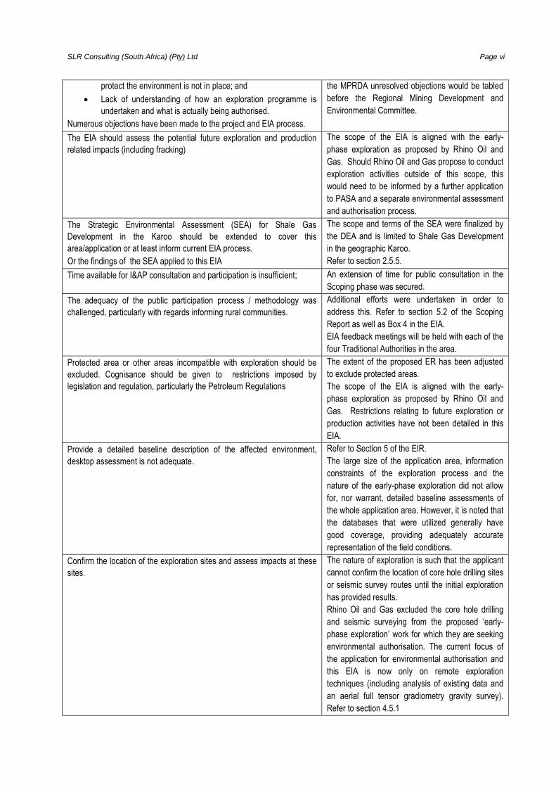
Key issues identified by the project team, with I&APs input Manner in which the issues were incorporated,
or the reasons for not including them
1. Procedural issues
There is strong opposition to the proposed exploration right application.
The major themes of the public opposition are the following:
Concern, even fear, of the future risks that might arise from
production should a resource be found;
Concern that given the money involved, if any hydrocarbon
resource is found, it will not be possible to stop production
regardless of what the future EIA processes may indicate in
terms of risk. Thus the only way to avoid such risks is to not
open the door to such projects;
Hydrocarbon based energy is a flawed concept and countries
are moving away from new hydrocarbons in favour of a
renewable energy system;
A deep mistrust of government institutions and the true motives
and people behind such an application;
Significant doubt over government’s ability to enforce
compliance to the legislation;
South Africa does not understand unconventional hydrocarbon
extraction risks and the necessary legislative framework to
The level of public opposition to the project has
been documented in the Scoping and EIA Reports.
Where people have registered their opposition to
the project, this has been recorded. All objections
received have been recorded. The EIA report has
attempted to present accurate project information
and a realistic assessment of impacts in order that
I&APs can make an informed judgement.
It is evident that much of the opposition is not
directly against the merits of exploration activities
as proposed, but rather against the anticipated
outcome and risks that, if successful, could result
from exploration. No attempt has been made to
address issues and objections that are based on
concerns that relating to further exploration or future
production activities
NEMA does not specifically provide a mechanism to
address objections raised in the EIA process. Under
Page 6
SLR Consulting (South Africa) (Pty) Ltd Page vi
protect the environment is not in place; and
Lack of understanding of how an exploration programme is
undertaken and what is actually being authorised.
Numerous objections have been made to the project and EIA process.
the MPRDA unresolved objections would be tabled
before the Regional Mining Development and
Environmental Committee.
The EIA should assess the potential future exploration and production
related impacts (including fracking)
The scope of the EIA is aligned with the early-
phase exploration as proposed by Rhino Oil and
Gas. Should Rhino Oil and Gas propose to conduct
exploration activities outside of this scope, this
would need to be informed by a further application
to PASA and a separate environmental assessment
and authorisation process.
The Strategic Environmental Assessment (SEA) for Shale Gas
Development in the Karoo should be extended to cover this
area/application or at least inform current EIA process.
Or the findings of the SEA applied to this EIA
The scope and terms of the SEA were finalized by
the DEA and is limited to Shale Gas Development
in the geographic Karoo.
Refer to section 2.5.5.
Time available for I&AP consultation and participation is insufficient; An extension of time for public consultation in the
Scoping phase was secured.
The adequacy of the public participation process / methodology was
challenged, particularly with regards informing rural communities.
Additional efforts were undertaken in order to
address this. Refer to section 5.2 of the Scoping
Report as well as Box 4 in the EIA.
EIA feedback meetings will be held with each of the
four Traditional Authorities in the area.
Protected area or other areas incompatible with exploration should be
excluded. Cognisance should be given to restrictions imposed by
legislation and regulation, particularly the Petroleum Regulations
The extent of the proposed ER has been adjusted
to exclude protected areas.
The scope of the EIA is aligned with the early-
phase exploration as proposed by Rhino Oil and
Gas. Restrictions relating to future exploration or
production activities have not been detailed in this
EIA.
Provide a detailed baseline description of the affected environment,
desktop assessment is not adequate.
Refer to Section 5 of the EIR.
The large size of the application area, information
constraints of the exploration process and the
nature of the early-phase exploration did not allow
for, nor warrant, detailed baseline assessments of
the whole application area. However, it is noted that
the databases that were utilized generally have
good coverage, providing adequately accurate
representation of the field conditions.
Confirm the location of the exploration sites and assess impacts at these
sites.
The nature of exploration is such that the applicant
cannot confirm the location of core hole drilling sites
or seismic survey routes until the initial exploration
has provided results.
Rhino Oil and Gas excluded the core hole drilling
and seismic surveying from the proposed ‘early-
phase exploration’ work for which they are seeking
environmental authorisation. The current focus of
the application for environmental authorisation and
this EIA is now only on remote exploration
techniques (including analysis of existing data and
an aerial full tensor gradiometry gravity survey).
Refer to section 4.5.1
Page 7
SLR Consulting (South Africa) (Pty) Ltd Page vii
2. Potential impacts of the proposed exploration
Impact on ecology
Loss of or disturbance to vegetation and faunal habitats
Disturbance to and mortality of fauna
Enabling the establishment of alien and invasive species
in disturbed areas
The potential impacts of core hole drilling and
seismic surveys have not been assessed in this EIA
as they no longer form part of the proposed ‘early-
phase exploration’ work for which Rhino Oil and
Gas are seeking environmental authorisation. See
Section 4.5.1.
The aerial FTG surveys (see Section 4.5.5)
included as part of the proposed ‘early-phase
exploration’ would result in almost no interaction
with the ground over which the survey is
undertaken. Thus impacts on the majority
environmental aspects could not occur. For this
reason the issues were not considered further in
this EIA.
Should Rhino Oil and Gas propose to conduct
ground-based exploration activities in the future,
this would need to be informed by a further
application to PASA and a separate environmental
assessment and authorisation process.
Impact to Groundwater
Altered hydrogeological regime and groundwater
availability
Contamination of groundwater resources
Water consumption
Impacts on surface water
Altered surface water hydrological regime
Contamination of surface water resources
Water consumption
Impacts on geology
Destabilisation of certain geologies
Risk to underground caverns or mine workings
Impact on soils
Physical impact on soils (increased erosion / compaction)
Potential contamination of soils
Impact on heritage resources
Impact on land tenure and access to private property
Impact on current land uses
Structural damage to infrastructure
Structural damage to infrastructure due to shock waves,
air overpressure and ground vibration
Degradation or damage due to exploration vehicles and
equipment
Impact on ambient air quality
Dust and vehicle emissions
Escape or release of gas from exploration boreholes
Safety and security
Public safety due to inter alia, increased traffic volumes,
heavy machinery, explosives, hazardous materials,
release of gas, etc.
Fires
Landowner security
Contribution or effect on the local economy
Compensation
Rehabilitation and liability
Impact on ambient noise levels Refer to Section 6.1
Page 8
SLR Consulting (South Africa) (Pty) Ltd Page viii
3.3 EIA Method
In accordance with Appendix 3 of GN No. R982, the objectives of the EIA are to:
identify the relevant policies and legislation relevant to the activity;
present the need and desirability of the proposed activity and its preferred location;
identify feasible alternatives related to the project proposal;
ensure that all potential key environmental issues and impacts that would result from the proposed
project are identified;
provide a reasonable opportunity for I&APs to be involved in the EIA process;
assess potential impacts of the proposed project alternatives during the different phases of project
development;
present appropriate mitigation or optimisation measures to minimise potential impacts or enhance
potential benefits, respectively; and
Through the above, to ensure informed, transparent and accountable decision-making by the
relevant authorities.
As per the Plan of Study for EIA presented in the Scoping Report, the approach was to commission a
number of specialist studies to inform this EIA. However, with the exclusion of core hole drilling and
seismic survey activities from the scope of the EIA these studies are no longer applicable.
The identification and assessment of environmental impacts is a multi-faceted process, using a
combination of quantitative and qualitative descriptions and evaluations. It involves applying scientific
measurements and professional judgement to determine the significance of environmental impacts
associated with the proposed project. The process involves consideration of, inter alia: the purpose and
need for the project; views and concerns of I&APs; social and political norms, and general public interest.
SLR used an assessment methodology which considered: the intensity, extent, duration of impacts, the
probability of the impact occurring, the reversibility and the degree to which the impacts can be mitigated.
The significance of environmental impacts was rated before and after the implementation of mitigation
measures. The method applied to the assessment of environmental impacts was:
Consequence is a function of intensity, spatial extent and duration;
Significance is a result of the consequence and probability.
Page 9
SLR Consulting (South Africa) (Pty) Ltd Page ix
4. Project Description
4.1 Introduction
Rhino Oil and Gas Exploration South Africa (Pty) Ltd is a South African registered subsidiary of Rhino
Resources Ltd., an independent oil and gas exploration and development company focused on Africa.
Rhino Resources is building a portfolio of both onshore and offshore oil and gas assets with a primary
focus on West Africa, East Africa and Southern Africa. Rhino Oil and Gas’s BBBEE status has been
provisionally agreed upon with another party and will comply with the Charter on empowering Historically
Disadvantaged South Africans in the Petroleum and Liquid Fuels Industry. More information is available
on http://www.rhinoresourcesltd.com.
4.2 Overview of exploration
The conditions necessary for petroleum reserves to have accumulated are complex and largely
dependent on past geological history and present geological formations and structures. Discovering
petroleum/gas reservoirs and estimating the likelihood of them containing oil and / or gas is a technically
complex process consisting of a number of different stages, requiring a range of techniques. Exploration
begins with the identification of target regions based on a general geological understanding. These areas
are subjected to early-phase exploration that is focused on large-scale regional analysis. Exploration in
areas identified as prospective would progress to the appraisal stage. This work is aimed at identifying
and defining the extent of target areas with high potential for reserves of oil and / or gas. In order to fully
define the commercial viability of an oil and / or gas resource a well drilling stage is generally
undertaken. The type of wells and tests would depend entirely on the nature of the resource that has
been identified. Exploration typically requires early-phase exploration, appraisal and well drilling
stages, undertaken over a period of up to 10 years, to inform a decision on a production right application.
Rhino Oil and Gas is at the beginning of an oil and gas exploration process and at this stage is only
seeking authorisation to undertake a portion of activities necessary to inform an early-phase exploration
stage.
4.2 Need and Desirability
This section in the report aims to provide an overview of the need and desirability for the proposed
project by firstly, highlighting the applications for the use of natural gas (particularly with reference to the
electricity generation sector) and, secondly, indicating how these applications are aligned within the
strategic context of national policy and energy planning, broader societal needs and regional planning, as
appropriate.
Use of Natural Gas
Natural gas is a fossil fuel, used globally as a source of energy for heating, cooking, and electricity
generation, amongst others. The fastest growing use of natural gas is for the generation of electric power.
Page 10
SLR Consulting (South Africa) (Pty) Ltd Page x
Of the three fossil fuels used for electric power generation (coal, oil and natural gas), natural gas emits
the least carbon dioxide per unit of energy produced. Burning natural gas also releases lower amounts of
nitrogen oxides, sulphur dioxide, particulates and mercury when compared to coal and oil (Union of
Concerned Scientists, n.d.).
As economic growth is dependent on the availability of electricity, ensuring a sustainable and reliable
supply of electricity with sufficient capacity is a key aspect to growing the economy of South Africa. The
electricity shortages experienced in South Africa over the past decade were a contributing factor to the
significant slowdown in economic growth rate. In the context of the above, the use of natural gas for
electricity generation is considered to have substantial benefits and is identified in national policy,
together with renewable energy technologies, toward diversifying the domestic energy supply away from
coal. The economic feasibility of using natural gas for domestic power generation is dependent on the
availability of domestic reserves of natural gas, as well as the financial cost of importing natural gas.
At present, domestic resources are limited to offshore gas fields close to Mossel Bay (F-A field), which
are understood to be in decline. The F-O offshore field (Project Ikhwezi) is envisioned to complement this
supply in the short- to medium-term. Other proven offshore reserves include the Ibhubesi Gas Field off
the West Coast of South Africa. The development of this field to supply gas to the existing Ankerlig Power
Station is currently being considered. Neighbouring countries (Mozambique and Namibia) and regional
African nations (Angola and Tanzania) have substantial gas reserves.
Although limited, gas infrastructure and consumption do exist in South Africa. Presently, gas is imported
to South Africa through the Republic of Mozambique Pipeline Company (ROMPCO) pipeline from
Mozambique. This gas is mostly used in Sasol’s coal-to-liquid (CTL) process in Secunda (Bischof-Niemz,
et al., 2016). In Johannesburg, Egoli Gas supplies industry and households in some suburbs with
reticulated natural gas that is sourced from Sasol. In 2013, the total natural gas supply in South Africa
(domestic production and import) equated to approximately 2.5% of total primary energy supply for the
country (Bischof-Niemz, et al., 2016). Thus, an increase in domestic natural gas reserves would enable
South Africa to take steps to secure the countries’ energy supply (through diversification), assist in
reducing the emissions of greenhouse gases (by reducing the country’s reliance on coal for electricity
generation) and reduce the need for the importation of gas. As such, exploration for additional domestic
hydrocarbon reserves is considered important and supported by national policy, and any discoveries
would be well received by the local market.
National Policy and Planning Context
An overview of the national policy and planning context relating to the promotion of economic
development in general within South Africa, development of the energy sector (with specific reference to
natural gas and renewable energy) and response to climate change is provided. The following documents
were considered:
Page 11
SLR Consulting (South Africa) (Pty) Ltd Page xi
- White Paper on the Energy Policy of the Republic of South Africa (1998)
- White Paper on the Renewable Energy Policy (2003)
- National Gas Infrastructure Plan (2005)
- New Growth Path (2011)
- National Development Plan (2012)
- Integrated Resource Plan for Electricity (2010 and updated in 2013)
- Draft Integrated Energy Plan (2013)
- Gas Utilisation Master Plan (GUMP)
- Paris Agreement, United Nations Framework Convention on Climate Change
- National Climate Change Response White Paper
Consideration was also given to regional policy and planning context relating to development within the
Eastern Cape in general.
4.3 Exploration Work Programme
Rhino Oil and Gas proposes to undertake early-phase exploration for oil and gas resources which may
be located within suitable geological strata. A three-year exploration work programme has been
proposed.
The initial ER application area included ~ 200 properties over an area of ~ 120 000 ha. The applicant has
reduced the extent of the ER application area through the exclusion of the Malekgalonyane
(Ongeluksnek) Nature Reserve to an area of 110 572 ha. The ER application area excludes all land as
identified in Section 48 (1) of the MPRDA.
As indicated previously, Rhino Oil and Gas has now excluded the core hole drilling and seismic surveying
from the proposed ‘early-phase exploration’ work for which they are seeking environmental authorisation.
The current focus of the application for environmental authorisation and this EIA is now only on remote
exploration techniques (including analysis of existing data and an aerial full tensor gradiometry gravity
survey). If the revised application is approved, Rhino Oil and Gas would only be in a position to conduct
remote exploration techniques and to develop a more detailed understanding of the potential oil and gas
resources in the application area. Thereafter, should Rhino Oil and Gas propose to conduct ground
based exploration activities this would need to be informed by a further application to PASA and a
separate environmental assessment and authorisation process.
The initial exploration work would be desktop based and include the evaluation of geological data and the
assessment of source-rock geochemistry. Full tensor gravity gradiometry (“FTG”) surveys may be
undertaken to provide information that would lead to the identification of target sites for core hole drilling
and alignment of seismic survey routes. FTG is used by oil and gas companies to measure the density of
the subsurface in order to assist in the building of geological models to aid exploration. FTG uses multiple
Page 12
SLR Consulting (South Africa) (Pty) Ltd Page xii
pairs of accelerometers to measure the rate of change of the gravity field in three directions and render a
detailed interpretation of subsurface geology. FTG surveys involve grid-based flights using a light fixed
wing aircraft (fitted with the FTG equipment) at slow speeds (~ 130 knots) and at an altitude of between
80 and 300 m above ground. It is envisaged that up to a maximum of 4 000 km2 could be surveyed with
a spacing of between 2 and 6 km between lines. In good weather the survey would take less than 7 days
to complete.
No further ground-based exploration, appraisal or well drilling and future production forms part of the
current ER application. Thus no extraction of hydrocarbons or water, no stimulation of wells or hydraulic
fracturing (fracking) is proposed in the initial three-year exploration work programme for which approval is
sought. If the early-phase exploration were to confirm the presence of a potential resource, then Rhino
Oil and Gas would need to seek further authorisation / approval from PASA for any additional exploration
work required to appraise the resource. Any further approval would be subject to an additional
environmental assessment (or environmental authorisation amendment) process with further public
consultation and specialist input. Approvals are also likely to be required in terms of other legislation.
5. Description of the baseline environment
5.1 Biophysical Environment
Climate
The proposed ER area experiences a typical escarpment climate with warm summers and mild winter
that includes periods of very cold conditions with snow. Mean annual precipitation varies between 700
mm in the east up to 1000 mm to the west, with a high proportion coming in summer through
thunderstorms.
Geology
The geology of the proposed ER area comprises the Molteno, Elliot and Clarens Formations (from the
Karoo Supergroup) and the Drakensberg Group.
The Molteno Formation is overlain by Elliot Formation with a maximum thickness of approximately 500 m
in the south. The formation comprises an alternating sequence of greyish-red or less commonly greenish-
grey mudstone and subordinate fine- to medium-coarse sandstone.
The Clarens Formation superimposes the Elliot Formation. This formation represents the final phase of
Karoo sedimentation (Lurie, 2008). The Clarens Formation consists of fine- to very fine-grained
sandstone and siltstone with subordinate mudstone and occasional chert and nodular limestone horizons
(Johnson et al., 2006). The mudstones are generally pale-olive to pale-red in colour and the sandstones
are usually very pale-orange, well sorted with sub-angular to sub-rounded grains (Karpeta and Johnson,
Page 13
SLR Consulting (South Africa) (Pty) Ltd Page xiii
1979). The thickness of the Clarens Formation ranges between 200-250 m, however, the northern extent
of the formation has a thickness of 100 m.
The Drakensberg Group forms the upper part of the Drakensberg Mountains. It is characterised by the
dark-grey basaltic lavas with subordinate tuffs and occasional sandstones (Karpeta and Johnson, 1979).
The basalts are made up of altercations of a tough and massive coarsely crystalline rock and easier-
weathering vesicular varieties. The total thickness of Drakensberg Group is up to 700 m (Johnson et al.,
2006). Dolerite dykes, also present in the area, are inclined sheets and sills that intruded the Karoo
Sequence. Dolerite dykes are generally 3 - 10 m wide and 5 - 30 km long, although some can be
followed for 80 km (Johnson et al, 2006). The inclined sheets and sills range from a few metres to 200 m
or more in thickness. Quaternary deposits (<2 m in thickness) are generally limited in the study area and
concentrate only along the upper Kinira River and its upper tributaries (Karpeta and Johnson, 1979).
The Southern African region is considered to be relatively stable from a seismic perspective. In general
earth tremors and quakes are infrequent and generally of low magnitude. Within the ER, the Cedarville
Fault is an active fault with associated recorded earthquake activity (in 1986 an earthquake of 5.15 was
recorded at the town of Matatiele which is located near the fault).
Soils
The ER area consists of two main landforms including medium gradient hills and high gradient
mountains. Six dominant soil classes were identified within the proposed ER area namely:
• Freely drained, structureless soils;
• Lithosols (shallow soils on hard or weathering rock);
• Undifferentiated clays;
• Undifferentiated poorly drained soils;
• Undifferentiated shallow soils; and
• Structureless and poorly drained soils.
The majority of the proposed ER area (61 633 ha) is considered to be non-arable for the purposes of crop
cultivation and has moderate to low suitability as grazing land. A small section on the eastern portion of
the proposed ER area (400 ha) has wilderness land capability and in terms of land capability class
system should preferably only be used for wildlife and habitat conservation. The remaining areas,
approximately 27 140 ha, are mapped to have a moderate potential for arable agriculture. These soils are
mainly located in valley bottoms where the slope gradients are less steep and pockets of arable land
makes crop farming possible (typically in close proximity to villages).
Land Cover
According the National Land Cover Data Set (2013/2014), the great majority of the ER area comprises
grasslands. Some of the larger river valleys have thicket/dense bush in the upper reaches. Much of this
Page 14
SLR Consulting (South Africa) (Pty) Ltd Page xiv
comprises stands of alien and invasive trees rather than indigenous vegetation (pers. obs). The flatter
ground in the lower elevation areas has been largely transformed, either by rural housing and
urbanisation or through various forms of cultivation (subsistence and commercial). Many of the valley
bottoms contain wetland areas.
Hydrology
The proposed ER area falls within the Mzimvubu to Keiskamma Water Management Area (WMA) which
has the highest mean annual runoff in South Africa, and equates to almost 15% of the total river flow in
the country. At least 6 quaternary catchments occur. The source of rivers, including their associated
tributaries, such as the Mosenene River, Seeta River, Mabele River, Lekhetlane River, Marulane River
and the Tinana Rivers are located within the proposed ER area.
Surface water use consists of a combination of domestic, livestock use and irrigation for crop production
in the low lying areas. The municipalities estimate that 50% of households rely on water from rivers,
springs and dams. It is estimated that around 1 million people derive water and a livelihood within the
greater catchment (pers. comm. UCPP). The uMzimvubu Catchment Partnership Programme has been
established to tackle degradation of the upper uMzimvubu landscape, and protect the livelihoods
dependent upon it.
Numerous wetlands are located within the proposed ER area. The upper section of the Umzimvubu
catchment in the MLM hosts as much as 42 765 ha of wetland (email, UCPP). There are no major dams.
Groundwater
The exploration area is classified as a minor aquifer region. On a regional level, the hydrogeology of the
proposed ER area comprises fractured and intergranular aquifers with yields in the range of 0.5 to 2 L/s.
Aquifer types are related to the lithology but are typically fractured and intergranular. These aquifers are
generally of ‘least’ or ‘moderate’ vulnerability, with a ‘low’ to ‘medium’ susceptibility.
Available data from the National Groundwater Archive indicates that groundwater levels range between
0.3 -108 m below ground level, with discharge rates varying between 0.01 - 9.6 L/s. Published
information from the DWS indicates a mean depth to groundwater ranging between 15 - 20 mbgl and the
recommended borehole drilling depth ranges between 20 – 30 m. Groundwater also surfaces at various
spring sites. These sites include dykes intersecting features, contacts of dolerite sill/sheets, basal contact
of fractured sandstone with an underlying less permeable mudstone horizon and on weathered basins
(usually weathered dolerite sheets). The anticipated electrical conductivity concentration of groundwater
within the proposed ER area is between 0 and 70 mS/m, while Total Dissolved Solids are expected to
range between 200 - 449 mg/L. Calcium and magnesium are dominant constituents of groundwater
within the proposed ER area, however, groundwater with high fluoride content has been reported to the
south.
Page 15
SLR Consulting (South Africa) (Pty) Ltd Page xv
According to records, there are as many as 537 registered boreholes in the larger area, however only
193 of these boreholes are still in use. Registered groundwater use in the area ranges between 1 505 m3
and 50 000 m3 per annum and is used mainly for drinking, livestock watering and irrigation purposes
(DWAF, 2008). Stakeholders within the proposed ER area note that the Cedarville Fault is an important
groundwater feature with regards to groundwater development and use.
Biodiversity
The proposed ER area is located within the grassland biome within the Sub-Escarpment Grassland
Bioregion and the Drakensberg Grassland Bioregion, which is structurally simple and strongly dominated
by grasses which are comprised of various vegetation units. Vegetation units that are associated with the
proposed ER area include the Drakensberg Foothill Moist Grassland, the East Griqualand Grassland, the
Lesotho Highland Basalt Grassland, the Mabela Sandy Grassland and the Southern Drakensberg
Highland Grassland (Mucina and Rutherford, 2006). The Mabela Sandy Grassland and the East
Griqualand Grassland vegetation units are listed as vulnerable ecosystems in terms of Section 52 of the
National Environmental Management: Biodiversity Act, 2004.
The region was historically home to numerous faunal species. The lower slopes of the Drakensberg
Mountains support a greater variety of faunal species to that of the high mountains, although these areas
are also subject to more significant human use. The White-tailed Rat (Mystromys albicaudatus) is the
only mammal species of conservation concern (endangered) that may occur in the area. It is widely
distributed but not much is known about it habitat needs or current status. A number of bird species of
conservation concern occur including all 3 crane species (Wattled, Grey Crowned and Blue) as well as
the Bearded and Cape Vultures. Rudd’s Lark (Heteromirafra ruddi) and Black Harrier (Circus maurus)
may also be found where suitable habitat is present. Wetland and high altitude grasslands are the most
important habitat for most of these species.
The Malekgalonyane (Ongeluksnek) Nature Reserve was located within the extent of the proposed ER
area. No areas declared in terms of the Biodiversity Act, 2004 (Act 10 of 2004); National Forests Act,
1998 (No. 84 of 1998) and Mountain Catchment Areas Act 1970 (No. 63 of 1970) were identified within
the proposed ER area. Much of the proposed ER area overlaps with ‘focus area’ from the National
Protected Area Expansion Strategy. The ‘Development Area’ of the Maloti Drakensburg Transfrontier
Conservation Plan extends from KZN to the Malekgalonyane (Ongeluksnek) Nature Reserve. The
Matatiele Local Municipality have identified areas for protection through the declaration of stewardship
areas under the Matatiele Water Factory Project. The draft stewardship plan identifies all areas above
1750 mamsl as stewardship targets. The National Freshwater Ecosystem Priority Areas project identifies
numerous NFEPA rivers and wetlands within the proposed ER area. The Eastern Cape Biodiversity
Conservation Plan (ECBCP) identified and mapped critical biodiversity areas (CBAs) in the Province. A
large proportion of the proposed ER area is mapped as terrestrial CBA 1, with the balance being almost
entirely CBA 2.
Page 16
SLR Consulting (South Africa) (Pty) Ltd Page xvi
The aquatic perspective is similar with a large proportion of the proposed ER area being mapped as
aquatic CBA 1 and much of the balance being CBA 2. It is therefore evident that much of the proposed
ER area is considered to be ecologically sensitive. It must however be noted that a significant amount
subsistence agriculture is taking place in the lower lying area of the region. Many of the datasets do not
give cognisance to this, or such use may have escalated in intensity. It is therefore likely that certain
areas designated with conservation planning status may in reality be disturbed or cultivated.
Air Quality
The majority of the proposed ER area is rural in nature and is comprised mostly of small towns, isolated
farmsteads, scattered communities and agricultural activities such as livestock grazing and crop
cultivation. It follows that the ambient air quality is likely to be good. Air quality may be compromised at
times near waste burning sites and informal brick makers and around concentrations of houses in winter
when fuel burning is used as a source of warmth. Veld fires are also a major contributor to reduced air
quality in winter.
5.2 Cultural Environment
The area is exceptionally rich in rock art occurrences. Numerous San and pastoralist rock art sites are
located in rock shelters in the sandstone outcrops. Of the 60 heritage sites known in the area, 46 of these
are rock art sites. It is highly likely that more sites are present in the area. Much of this art is unprotected
and at risk from degradation of the rock-face as well as damage from humans and livestock using the
shelters. The well-known Mariazelle Mission Station and the smaller Maria Linden Mission as well as the
Ongeluksnek Mountain Pass are known historical features. There is very limited data on sites from the
historical period, cultural landscape of living resources in the project area.
Paleontological surveys of the area are also limited. The lower elevation sections of the proposed ER
area are underlain by formations of high (Clarens Formation, Stormberg Subgroup, Karoo Supergroup)
and very high sensitivity (Molteno and Elliot Formations). Taking the above into consideration there is a
high likelihood of fossil occurrence within the proposed ER area.
5.3 Socio-Economic Environment
The proposed ER area is located largely within the Matatiele Local Municipality (MLM) with the southern
portions in the Elundini Local Municipality (ELM). These municipal areas have population in excess of
325 000 people, with a high proportion of females. Unemployment is high. The majority of people reside
in a largely rural setting, with a high proportion in dwellings made of traditional materials. Basic service
provision is low with as much as 50% of households relying on water from rivers, springs and dams.
There are no major towns located within the proposed ER area. Matatiele to the east is the largest town
in the region. Agricultural activities are limited to the lower lying areas where the topography, water and
soils are suitable for agriculture. Agricultural activities include a combination of commercial and
Page 17
SLR Consulting (South Africa) (Pty) Ltd Page xvii
subsistence farming. Subsistence farming is mostly associated with villages (which are numerous) which
undertake both subsistence and small scale commercial farming. The grasslands around most of the
villages and rural settlements is heavily grazed by mixed herds of domestic livestock.
The region is well known for its scenic beauty (particularly views of the Drakensberg) and revenue is
generated from numerous eco-tourism activities. Many of these activities are widely dispersed but focus
points include the Mehloding hiking trail and Malekgalonyane (Ongeluksnek) Nature Reserve.
The DMR indicated that there are no other mineral rights holders with the proposed ER area. Chief
Lebenya has a pending claim on a large number of the properties within the ER application area.
6. Impact Description and Assessment
Only those potential impacts associated with remote exploration techniques have been assessed. The
potential impacts of core hole drilling and seismic surveys have not been assessed in this EIA as they do
not form part of the proposed ‘early-phase exploration’ work for which Rhino Oil and Gas are seeking
environmental authorisation.
6.1 Biophysical Impacts
The flying of a light aircraft to undertake an FTG survey is not anticipated to have any impact of
significance on the biophysical environment. Overpass flights of light aircraft are not uncommon over the
region, even protected areas. Other than a momentary flight response, it is estimated that the impact of
noise on wildlife would be insignificant.
6.2 Cultural/ Heritage Impacts
The flying of a light aircraft to undertake an FTG survey is not anticipated to have any impact of
significance on the cultural or heritage environment. Any noise impact would be as described below.
6.3 Socio-economic impacts
Noise Impacts
The noise generated by a light aircraft flying at a low altitude (approximately 100 m) could be a nuisance
to or result in the localised disturbance of a receptor. No health impacts (such as loss of hearing or
increased blood pressure) are anticipated based on the proposed FTG survey.
Based on a light aircraft (e.g. Cessna) flying at a low altitude of + 80 m, it is estimated that the maximum
noise level would not exceed 70 dBA outdoors and 60 dBA indoors. The latter is similar to conversational
speech measured at 1 m. At any one location the duration of the overflight would be tens of seconds.
Indoors the noise generated would probably not be noticed. Although the survey would cover wide areas,
Page 18
SLR Consulting (South Africa) (Pty) Ltd Page xviii
the extent of the impact is localised for each receptor. Where there are no receptors there would be no
impact. Thus, depending on the selected flight path, an impact is possible.
Although aircraft noise would increase noise levels in what are largely quiet rural and agricultural areas,
only a slight disturbance or nuisance is anticipated (i.e. low intensity). Based on these considerations
and the fact that disturbances from light aircraft are not uncommon with a multitude of light aircraft
working in and traversing the region, the significance of this impact is considered to be very low before
and after mitigation.
All planned survey flights should comply with local civil aviation rules. Flight paths must be pre-planned to
avoid special nature reserves, national parks and world heritage sites. Where this is not possible, an
altitude of 2 500 feet (762 m) should be maintained (as per Section 47(1) of NEMPRAA), unless
permission is obtained from the management authority or in an emergency. Where flights are planned to
occur over game farms, landowners should be notified of the survey programme prior to survey
commencement.
Local limitations
As discussed in the preceding sections, the flying of a light aircraft to undertake an FTG survey would be
unlikely to pose significant risk to the environment. As a result there are relatively few constraints arising
from legislation, regulation, guidelines and best practice that would apply. The FTG survey would have no
effect on water use or availability and could therefore be undertaken without regard for water related
constraints and restrictions.
At the time of completion of the EIA report there was no indication of any change to the public or
landowner position with regards the application. The majority opinion is opposed to exploration for
unconventional gas or petroleum resources in the ER application area.
Granting of a Right
There is strong public opinion and I&APs refer to a significant body of evidence from around the world
(not least that fracking is banned in a growing number of countries and territories), that late phase
exploration and production of unconventional gas has huge risks to society and the environment. Such
risks are borne by the landowners and local communities who do not participate in the economic benefits
that accrue to the right holder and government. While there may be a consumer driven need for
hydrocarbon extraction, the risks and costs to society and the environment far outweigh the benefits. The
extraction of unconventional hydrocarbons is therefore not wanted in the Eastern Cape.
Even though early-phase exploration may have impacts of low significance, the public have raised
concern that the granting of an exploration right would set in motion the development of a petroleum
Page 19
SLR Consulting (South Africa) (Pty) Ltd Page xix
extraction project that would be extremely difficult to stop. Because the future process has unknown
outcome and risk, this exploration right should not be approved.
The MPRDA provides that the State, as custodian of mineral and petroleum resources in South Africa,
may issue mineral and petroleum rights to applicants. Such rights must enable the sustainable
development of South Africa’s mineral and petroleum resources within a framework of national
environmental policy, while promoting economic and social development.
The granting of a right has no effect on the presence or absence of a resource, merely on whom has the
entitlement to that mineral (i.e. minerals and petroleum exist regardless of the holder). A mineral and/or
petroleum right is only part of the regulatory approval required by a holder and in isolation does not
enable the holder to access the subject mineral. A holder must also have obtained environmental
authorisation in terms of Chapter 5 of the NEMA. Furthermore, a mineral and/or petroleum right and
environmental authorisation do not provide blanket approval for any conceived operation, but are both
particular to the specific activities that the holder has detailed in an application. The holder is also
required to negotiate access with the land owner and determine payment of compensation for loss or
damages due to the specific activities. It is therefore presented that the grant of a right over a parcel of
land does provide the holder carte blanche with respect to the mineral and land in question. There is thus
not necessarily a direct conflict with the land owners’ right to use the surface. It would in fact be the
undertaking of specified activities that could result in an impact on or conflict between the land owner and
the mineral and/or petroleum rights holder (if any). Such specified activities would have been subject to
approval through an environmental authorisation process. In the case of this application by Rhino Oil and
Gas, only remote sensing activities are included which have been shown not to have any impact on the
environment.
Any further exploration (beyond what may be approved in an environmental authorisation) would have to
be subject to the requisite environmental assessment and authorisation process under the NEMA and an
amendment to the ER in terms of the MPRDA. Such processes assess the merits of an application in
light of the principles of sustainable development as set out in Section 2 of NEMA. An environmental
authorisation process would not grant approval for the undertaking of activities resulting in impacts of
unacceptable significance. Each of the petroleum right approval sections in the MPRDA (80 and 84) set
out that such rights may only be granted if the activity will not result in unacceptable pollution, ecological
degradation or damage to the environment. Thus a decision to grant the current ER application by Rhino
Oil and Gas (for remote sensing activities only) does not presuppose that future applications for further
exploration or production would be approved.
It is also noted that the specified activities associated with a mineral and/or petroleum right may also be
subject to approval requirements under other legislation. The need for such authorisations (e.g. water use
Page 20
SLR Consulting (South Africa) (Pty) Ltd Page xx
licence, land use planning permission etc.) provide further permitting frameworks for impact assessment
and management.
6.4 No-go Alternative
The positive implications of not going ahead with the proposed exploration are:
No impacts resulting from the FTG survey within the exploration right area;
No (reduced) chance of any risks arising from further exploration or future production; and
Allayment of the current majority opposition from the public.
The negative implications of not going ahead with the proposed exploration are as follows:
South Africa would lose the opportunity to further establish the extent of indigenous oil or gas
reserves in the Eastern Cape;
Lost economic opportunities related to sunken costs (i.e. costs already incurred) of initial desktop
investigations in the proposed exploration licence area;
If economic oil and gas reserves do exist and are not developed, South Africa / Rhino Oil and Gas
would lose the opportunity to maximise the use of its own indigenous oil and gas reserves; and
Other sources of energy would need to be identified and developed in order to meet the growing
demand in South Africa.
The great majority of I&APs that have participated in the EIA process have expressed their opposition to
all forms of oil and gas exploration in the Eastern Cape and to this application in particular. Thus the “no-
go” alternative would alleviate much of the anxiety and concerns related to potential future shale gas
development should reserves be identified for further exploration and/or future production.
Given the wide array of unknown facts regarding the potential for economic growth and the potential for
environmental impacts arising from unconventional gas production, as well as the unknown facts of the
future energy mix in the absence of gas, the overall impact associated with the “no-go” alternative is
considered to be of unknown significance.
7. Conclusions and Recommendations
SLR, as the environmental assessment practitioner appointed by Rhino Oil and Gas, has undertaken a
Scoping and EIA process in terms of the EIA Regulations 2014 to inform an authority decision on the
application made for environmental authorisation under the NEMA. The current ER application only
includes remote exploration techniques, restricted to analysis of existing data and an aerial full tensor
gradiometry gravity survey. If the application is approved Rhino Oil and Gas would be in a position to
conduct the remote exploration techniques. Thereafter, should Rhino Oil and Gas propose to conduct
ground based exploration activities (core boreholes and seismic surveys) this would necessitate a further
Page 21
SLR Consulting (South Africa) (Pty) Ltd Page xxi
application to PASA and a separate environmental assessment and authorisation process in terms of
NEMA..
The key finding of the EIA is of a contrast between very low significance impacts resulting from an
exploration work programme which is limited to desktop and remote sensing methods and extremely
strong public opposition to all forms of exploration for onshore unconventional gas.
The assessment concluded that the impacts of proposed exploration activities would be extremely limited
in extent, widely dispersed, of very short duration and very low intensity and would there have very low
significance. On the simple merits of the application there is therefore no environmental reason why the
exploration activities should not be approved. All of the ER application area would be suitable for the
undertaking of the remote sensing exploration methods as proposed. It is noted however that the
proposed activities are likely to be the first in a series of exploration stages comprising activities that
would likely increase in impact significance (if exploration was successful and the project proceeded to
the following stages). The intensity and duration of such impacts would likely increase with each
subsequent phase, but would likely become confined to increasingly limited target areas.
The public opposition to the exploration right application has been strongly voiced and have been
received almost unanimously from all the sectors of society that have participated in the EIA. It is evident
however that the majority of the opposition is not directly against the merits of exploration activities as
proposed, but rather against the anticipated outcome and risks that, if exploration is successful, could
result from production. The public perception is interpreted to be that issuing of an exploration right could
lead to successful exploration; that would ultimately result in an application for production with the
potential use of hydraulic fracturing. It is further perceived that this could lead to widespread impacts on
water and land causing devastation to local livelihoods. The perception is informed by the widely
publicised, purported negative effects of hydraulic fracturing and the decisions taken by many governing
bodies from around the world to suspend such activities. The related concern is that once an exploration
right is granted, it will be nearly impossible to stop the process later, even if the environmental risks to
local receptors outweigh the benefits. This is seen to arise from a mistrust and or misunderstanding of the
governance framework that is in place to regulate petroleum exploration and production; concern as to
whether government can balance the needs and interests of local people against such development, and
an expectation that enforcement of compliance with environmental management obligations would be
poor. For these reasons the public approach is to ‘close the door on exploration before it opens’, thereby
preventing any future risk, or potential benefit, from resulting.
It is the opinion of SLR in terms of the sustainability criteria described above and the nature and extent of
the proposed early-phase exploration programme (remote sensing only), that the generally very low
significance of the impacts, with the implementation of the proposed mitigation measures, should support
a positive decision being made by the Minister of Mineral Resources (or delegated authority) in this
Page 22
SLR Consulting (South Africa) (Pty) Ltd Page xxii
regard. Since the proposed exploration activities are associated with Rhino Oil and Gas’s initial three-
year exploration work programme, the applicant requests that that Environmental Authorisation (should it
be granted) be issued and remain valid for a period of three years or more.
The estimated cost for management and / or rehabilitation of potential negative environmental impacts
that might be incurred during the proposed remote sensing exploration activities is nil.
8. Environmental Management Programme
The EMPR, once approved by the competent authority, is a legal document and Rhino Oil and Gas is
overall accountable and responsible for the implementation thereof. The EMPR is set out to provide
environmental management i) objectives, ii) outcomes and iii) actions for the planning and design,
undertaking of exploration; and rehabilitation and post closure phases.