Environmental Management Plan Appendix: Archaeology and Heritage Resources Management Plan for Site Clean-up and Remediation Activities This Appendix has been formatted to function as a standalone plan in an effort to be an effective resource for Project personnel planning, executing, and monitoring of activities associated with the cleanup and remediation of the historic, industrial Woodfibre site, as well as to facilitate dialogue with applicable external parties. The information included in this Appendix is derived from Environmental Management Plans (EMPs) to which it is appended. In addition, this Appendix takes into consideration, and will continue to be updated to reflect, key issues of concern, views and information, identified by “Aboriginal Groups” as defined in section 1.1 of Woodfibre LNG’s Federal Decision Statement, as amended March 7, 2018. 1.0 Purpose and Intent The Plan has been derived from Woodfibre LNG’s ongoing communication with Aboriginal Groups. It is intended to describe how potential risk, as it relates to both archaeological and heritage resources, has been identified, and to outline the mitigation measures to be implemented. 2.0 Background The Woodfibre site is historically the Squamish Nation Village of Swiy'a'at. A sawmill was first built on Mill Creek in 1908 and destroyed in a washout in the 1930s. A second mill operated at the north end of the Site under various owners until its decommissioning by Western Forest Products in 2006. Woodfibre LNG took ownership of the site from Western Forest Products on February 6, 2015. Prior to the land transfer in 2015, Western Forest Products received two Certificates of Compliance (CoC, land and water lots) from the BC Ministry of Environment and Climate Change Strategy, which were a condition of the sale agreement. The Woodfibre property is a fee simple, industrially zoned brownfield site with deep-water marine access and a history of more than 100 years of industrial use. The infrastructure includes an active landfill, a leachate treatment system, a wastewater treatment system, a dam at the outlet of Henriette Lake, an operational small hydro project, and failing infrastructure associated with the pulp and paper mill. As part of the Environmental Assessment (EA) completed to inform regulatory evaluation and subsequent approval (including that of the Squamish Nation) for the Project, Woodfibre LNG commissioned appropriately qualified professionals to undertake an archaeological assessment of the proposed project area, including an initial Heritage Resources Overview Assessment followed by a field based Archaeological Impact Assessment (AIA).
Transcript
Environmental Management Plan Appendix:
Archaeology and Heritage Resources Management Plan
for Site Clean-up and Remediation Activities
This Appendix has been formatted to function as a standalone plan in an effort to be an effective
resource for Project personnel planning, executing, and monitoring of activities associated with the
cleanup and remediation of the historic, industrial Woodfibre site, as well as to facilitate dialogue with
applicable external parties.
The information included in this Appendix is derived from Environmental Management Plans (EMPs) to
which it is appended. In addition, this Appendix takes into consideration, and will continue to be
updated to reflect, key issues of concern, views and information, identified by “Aboriginal Groups” as
defined in section 1.1 of Woodfibre LNG’s Federal Decision Statement, as amended March 7, 2018.
1.0 Purpose and Intent
The Plan has been derived from Woodfibre LNG’s ongoing communication with Aboriginal Groups. It is
intended to describe how potential risk, as it relates to both archaeological and heritage resources, has
been identified, and to outline the mitigation measures to be implemented.
2.0 Background
The Woodfibre site is historically the Squamish Nation Village of Swiy'a'at. A sawmill was first built on
Mill Creek in 1908 and destroyed in a washout in the 1930s. A second mill operated at the north end of
the Site under various owners until its decommissioning by Western Forest Products in 2006.
Woodfibre LNG took ownership of the site from Western Forest Products on February 6, 2015. Prior to
the land transfer in 2015, Western Forest Products received two Certificates of Compliance (CoC, land
and water lots) from the BC Ministry of Environment and Climate Change Strategy, which were a
condition of the sale agreement.
The Woodfibre property is a fee simple, industrially zoned brownfield site with deep-water marine
access and a history of more than 100 years of industrial use. The infrastructure includes an active
landfill, a leachate treatment system, a wastewater treatment system, a dam at the outlet of Henriette
Lake, an operational small hydro project, and failing infrastructure associated with the pulp and paper
mill.
As part of the Environmental Assessment (EA) completed to inform regulatory evaluation and
subsequent approval (including that of the Squamish Nation) for the Project, Woodfibre LNG
commissioned appropriately qualified professionals to undertake an archaeological assessment of the
proposed project area, including an initial Heritage Resources Overview Assessment followed by a field
based Archaeological Impact Assessment (AIA).
Environmental Management Plan Appendix: Archaeology and Heritage Resources Management Plan for Site Clean-up and Remediation Activities
Page | 2
All archeological sites in the province of British Columbia (BC), both known and unknown, are protected
under the Heritage Conservation Act (HCA). The Archaeology Branch of the Ministry of Forests, Lands,
Natural Resource Operations, and Rural Development (MFLNRORD) requires that Proponents of
industrial development projects follow a standard process to evaluate and mitigate the effects to
archaeological and heritage resources. Furthermore, the Squamish Nation has established its own
regulatory processes, including cultural and environmental reviews of industrial projects in its territory.
3.0 Clean up and Remediation Work
This Plan applies to all activities that occur within the recognized Certified Project Area (CPA)
associated with the clean-up and remediation. This includes avoiding subsurface excavation into
original ground or the removal of mature timber and all activities described are within the study area of
the Archaeology Impact Assessment, where applicable. More specifically these activities include but are
not limited to:
Closure of the existing pulp mill land fill i.e., grading and excavation of landfill material and
placing and installation of landfill cover;
Investigative work e.g., geotechnical testing
Demolition and removal or onsite remediation of existing terrestrial structure e.g., concrete
slab removal and stockpiling on site, creosote pile removal; and
Ongoing maintenance and upgrades to the existing work or infrastructure to address safety,
environment or regulatory compliance e.g., building and facilities work and repair, water
management facilities, electrical distribution.
4.0 Archaeology and Heritage Resources
Completion of the AIA field study confirmed the results of the desktop overview assessment in that,
while no archaeological sites are known to exist, there remains the potential for undocumented
intertidal features, and heritage wrecks. In addition, based on comment from Squamish Nation, the
following may also be present at locations on the site: fire-cracked rock and boiling stones,
architectural features, cultural mounds, cultural depressions, hearths, rock shelters, rock art,
petroforms or rock cairns, deposits in waterlogged sediments – basketry, arrow shafts, planks, wedges,
rope etc. Attachment 1 of this document offers photographic examples that highlight identifying
features of potential artifacts.
Additionally, surface and buried historical features, including building foundations and infrastructures,
and associated cultural material may be situated across the site. Finally, although no paleontological
resources have been previously recorded at the site the potential remains for the discovery or
encounter of undocumented fossils and paleontological sites to exist in select portions of the site. Items
that may be uncovered include human bones, stone tools, or other artifacts, all of which are protected
under the BC Heritage Conservation Act.
Environmental Management Plan Appendix: Archaeology and Heritage Resources Management Plan for Site Clean-up and Remediation Activities
Page | 3
5.0 Monitoring
While the initial overview assessment and the subsequent effects assessment concluded that the
geographic area is of cultural significance to the Squamish Nation and pre-contact use of the assessed
area is certain, substantial industrial disturbance over the last one hundred years has likely eliminated
archeological materials from the previous disturbed areas of the site. Given the scope of work covered
by this management plan, routine or full time monitoring is not planned.
However, should excavation into original soils or clearing of mature timber be required as part of clean
up and remediation, the EMP and this Appendix will need to be updated, along with any monitoring
requirements. This will also include, in the event of tree clearing, taking into account British Columbia’s
Handbook for the Identification and Recording of Culturally Modified Trees.
In acknowledgement of the ethnographic literature which confirms traditional land use throughout the
Project footprint and in recognition of the Aboriginal interests in the assessed area, Project activities
will be subject to chance find protocols.
6.0 Procedure for Chance Find of Archaeological and Cultural Heritage Resources
Implementation of a chance find protocol may lead to the discovery of cultural and/or heritage
resources, such as those described above, that were not identified in previous archeological site
investigation(s). All contractors and subcontractors working on the site will have a responsibility to
confirm that their employees and subcontractors are familiar with the contents of Environmental
Management Plans, and Appendix as they applies to their work.
In the event of what is suspected to be a possible archaeological or cultural heritage resource, the
following protocol will be followed:
all activities at that location, or with the potential to impact the suspected resources, will be
halted as safety to so or when safe to do so;
the area will be secured, marked and reported to the work supervisor and Woodfibre LNG site
manager;
Woodfibre LNG will notify relevant agencies and Aboriginal Groups and should suspected
human remains be discovered, local law enforcement (RCMP) shall also be informed;
based on the finding and based on key concerns, views and information from relevant
Aboriginal Groups appropriate mitigation will be developed, which may include confirmation of
the find and removal of the structure, site or thing identified; and
no further disturbance to the area until approved by an appropriately qualified professional.
7.0 Updates to the Plan
Management of archeological and heritage resources is a living process and the EMPs and this plan will
be updated, as required, based on concerns, views and information expressed by Aboriginal Groups,
plan performance, permitting requirements and as appropriate for the scope of work being undertaken
at the site. Project personnel will be informed of relevant changes to EMPs and this plan as those
changes occur.
Environmental Management Plan Appendix:
Archaeology and Heritage Resources Management Plan
for Site Clean-up and Remediation Activities: Attachment 1
Page | 1
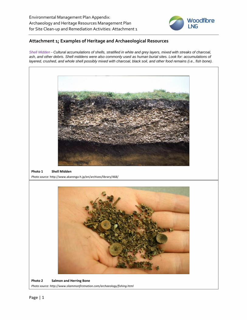
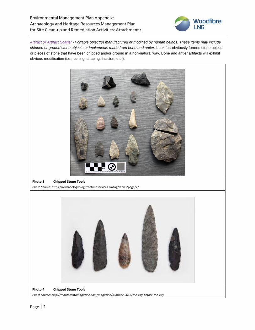
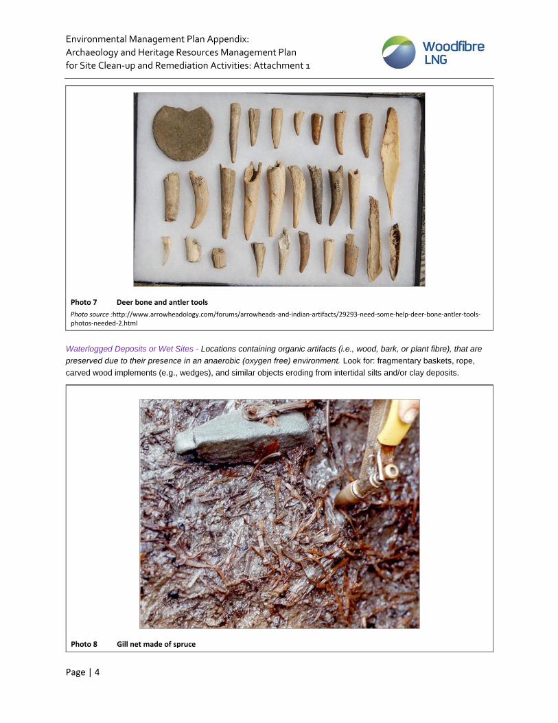
Attachment 1; Examples of Heritage and Archaeological Resources Shell Midden - Cultural accumulations of shells, stratified in white and grey layers, mixed with streaks of charcoal,
ash, and other debris. Shell middens were also commonly used as human burial sites. Look for: accumulations of
layered, crushed, and whole shell possibly mixed with charcoal, black soil, and other food remains (i.e., fish bone).
Archaeology and Heritage Resources Management Plan
for Site Clean-up and Remediation Activities: Attachment 1
Page | 7
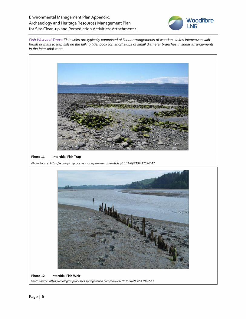
Fire Broken Rock and Hearths: Fire-broken rock (FBR) results from the use of fire during cooking, heating and processing activities. FBR is often associated with other features including hearths and cultural depressions but can also be thinly scattered in concentrations away from the features with which they were first associated. When looking for FBR, note concentrations of roughly fractured rock from rapid heating and cooling, rock showing signs of burning or oxidation and/or reddening or blackening of surrounding matrix. A distinctive squared or “castellate” fracture pattern is characteristic of precontact culturally fired rock.
A hearth feature is evidence of a fire pit or other fireplace feature of any period. Hearths were used for cooking, heating, and processing of some stone, wood, faunal, and floral resources and may be either lined with a wide range of materials like stone or left unlined. Occasionally site formation processes (e.g., farming or excavation) deform or disperse hearth features, making them difficult to identify without careful study. What to look for:
reddening or blackening of the associated soil/sediment
charcoal
layering of FBR and charcoal, and
depressions in the earth associated with FBR, reddened or blackened matrix and charcoal.
Archaeology and Heritage Resources Management Plan
for Site Clean-up and Remediation Activities: Attachment 1
Page | 8
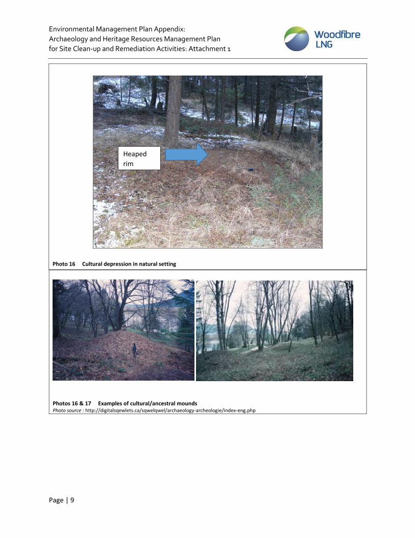
Cultural Depressions: Any depression seen on the ground surface that appears to have been excavated by a human can be a cultural depression and have archaeological significance. These “pits” were dug for a variety of reasons such as for food storage, cooking or as a base for a dwelling. They can range in size from 1m across to 7-10m across and are usually found associated with other artifacts such as FBR and lithic scatters. Look for:
Subtle to deep scours on the ground surface that are circular to rectilinear in shape
A raised rim along the edge of a depression
Depressions associated with artifacts and FBR
Depressions associated with fire reddening and blackening of the matrix
Cultural Mounds: Any raised or mounded surface feature that appears to have been created by a human, unnatural to the surrounding landscape. These mounds were used as burial locations and fortification sites. Look for subtle to obvious slopes and mounds in the landscape, often in an area with multiple mound features.
Photo 15 Cultural depression in cut bank
Natural soil Cultural
depression
Environmental Management Plan Appendix:
Archaeology and Heritage Resources Management Plan
for Site Clean-up and Remediation Activities: Attachment 1
Archaeology and Heritage Resources Management Plan
for Site Clean-up and Remediation Activities: Attachment 1
Page | 10
Rock Cairns or Ancestral Burial Cairns: Rock and boulders placed in circles or mounds, often represent precontact burials,
essentially consisting of rock and soil structures built on the ground surface. Look for intentional looking piles or rock, not
natural to the landscape.
Photo 18 Rock Cairn or Ancestral Burial Cairn Photo Source: http://digitalsqewlets.ca/sqwelqwel/archaeology-archeologie/index-eng.php
Photo 19 Rock Cairn or Ancestral Burial Cairn Photo source: https://qmackie.com/tag/cairns/
Environmental Management Plan Appendix:
Archaeology and Heritage Resources Management Plan
for Site Clean-up and Remediation Activities: Attachment 1
Page | 11
Rock Art: Includes pictographs (paintings) and petroglyphs (carvings), often found on rock faces, not always in obvious locations – may be obscured by vegetation or rock overhangs.