1 PROPOSAL COVER SHEET Project Title: Environmental Monitors on Lobster Traps V: Real-time Temperature Project Leader : Jim Manning NOAA/NEFSC 166 Water St. Woods Hole, Ma. 02543 Phone: 508-495-2211 Fax: 508-495-2258 [email protected]Lead Institution: Gulf of Maine Lobster Foundation Erin Pelletier 1 High Street, Box 523 Kennebunk, Me. 04043 Phone: 207-985-8088 Fax: 207-985-8099 [email protected]Other Key Participants : Patrice McCarron Maine Lobstermen's Association 1 High Street, Suite#5 Kennebunk, ME 04043 207-985-4544 [email protected]Bonnie H. Spinazzola Atlantic Offshore Lobstermen's Association 54 Chatham Drive Bedford, NH 03110 603-206-5476 [email protected]David Casoni Massachusetts Lobstermen's Association Halfway Pond Rd Plymouth, Massachusetts 508-224-3038 [email protected]Jeremy & CharleneCates Downeast Lobstermen's Association PO Box 52 Cutler, Me. 207-255-8301 [email protected]Budget Request: $90K Brief project description (1 paragraph): We propose to leverage a previously-funded development/engineering contract by purchasing several new temperature-pressure probes and introducing them to the lobster community. These units are designed to wirelessly send both bottom temperature and pressure (ie water depth) data to the wheelhouse and eventually to a satellite when they are hauled on deck. Distributing a few of these probes to each of the lobster associations will spark more interest in the eMOLT project and provide both the incentive and the equipment necessary to maintain our long-term monitoring objective.
Project Leader : Jim Manning NOAA/NEFSC 166 Water St. Woods Hole, Ma. 02543 Phone: 508-495-2211 Fax: 508-495-2258 [email protected]
Lead Institution: Gulf of Maine Lobster Foundation Erin Pelletier 1 High Street, Box 523 Kennebunk, Me. 04043 Phone: 207-985-8088 Fax: 207-985-8099 [email protected]
Other Key Participants: Patrice McCarron Maine Lobstermen's Association 1 High Street, Suite#5 Kennebunk, ME 04043 207-985-4544 [email protected]
Bonnie H. Spinazzola Atlantic Offshore Lobstermen's Association 54 Chatham Drive Bedford, NH 03110 603-206-5476 [email protected]
David Casoni Massachusetts Lobstermen's Association Halfway Pond Rd Plymouth, Massachusetts 508-224-3038 [email protected]
Jeremy & CharleneCates Downeast Lobstermen's Association PO Box 52 Cutler, Me. 207-255-8301 [email protected]
Budget Request: $90K Brief project description (1 paragraph): We propose to leverage a previously-funded development/engineering contract by purchasing several new temperature-pressure probes and introducing them to the lobster community. These units are designed to wirelessly send both bottom temperature and pressure (ie water depth) data to the wheelhouse and eventually to a satellite when they are hauled on deck. Distributing a few of these probes to each of the lobster associations will spark more interest in the eMOLT project and provide both the incentive and the equipment necessary to maintain our long-term monitoring objective.
2
Environmental Monitors on Lobster Traps V: Realtime Temperature Rationale The Environmental Monitors on Lobster Traps (eMOLT) project has evolved over the last five years. One of the most successful aspects of the program occurred in the first phase of operation when nearly one hundred lobstermen attached internally-recording temperature probes to their traps. Having now collected multiple-years of hourly bottom-water temperature from dozens of locations off our coast, both New England lobstermen and the scientist as well have a better understanding of the physical environment and a better appreciation of both spatial and temporal variability. Not only is there interest in correlating this data to “the run” of lobsters but, in recent years, more and more issues related to water temperature have come to the forefront: shell disease, harmful algal blooms, changes in planktonic assemblages, etc. As discussed in the scientific objective section below, there are a variety of questions to address. Unfortunately, the eMOLT participants do not see the data until months after they collect it. Many of them are now asking, “How can we get a real-time temperature?” After hearing this request from so many individuals, we submitted a proposal to NOAA's Small Business Innovative Research office in 2002. SBIR then issued a call to the high tech development community which responded with nine full proposals. After a lengthy review process by experts in submarine sensor systems, a company was selected in 2004. The specifications of this probe were drawn up with input from the industry. The prototype, first deployed in the ocean by two local fishermen in 2005, required revision and is expected to be ready for further testing later this summer. The next step is to demonstrate this technology (Figures 1 and 2) to the lobster industry. Given the recent advances towards a nation-wide ocean observing system, the idea is ripe. New England lobstermen now have an opportunity to make a significant contribution to the integrated system on the Northeast Continental Shelf by securing an unprecedented array of relatively inexpensive sensors on the seafloor. While the data will not be transmitted hourly (as many of the GOMOOS moorings are), it will be transmitted on a near-weekly basis (as often as lobstermen haul). The biggest expense in conducting physical oceanographic research has traditionally been in ship time and the care of fixed moorings. These costs are essentially eliminated with the eMOLT system.
3
Figure 1. Schematic of wireless data transmission plan.
Figure 2. Handheld device to be stored in the wheelhouse. There are a number of initiatives currently underway to coordinate oceanographic observations including the Gulf of Maine Ocean Data Partnership. Our objective is to become an active participant in these initiatives by sharing our data in real-time mode. While we would start by simply posting bottom temperature, we would then propose in subsequent years to a) secure other sensors such as salinity, oxygen, pH, etc. and b) extend the instrumentation throughout the water column. If we can prove ourselves as potential contributors to the regional observing system, we hope to obtain sustained funding in the future. In the meantime, we are seeking small amounts of seed money for pilot studies and, as discussed below, we have devised a small means of supporting ourselves through the sale of eMOLT drifters to other research parties. Review of previous work As noted above, the work proposed here is a natural extension of previous eMOLT efforts. The first phase of eMOLT (2001) funded a set of internally-recording
4
temperature probes many of which are still collecting data at the time of this writing. In the last five years however the technology of underwater sensors has evolved considerably so what we are proposing this year is significantly different from the original project in 2001. For nearly the same amount of money, we will have not only temperature but pressure (i.e. depth) sensors and the ability to transmit this information to the satellite. Much of our previous work involved developing a network of participants. While this outreach work (building relationships with fishermen) will certainly continue, we hope to now focus the majority of our effort in providing useful products in the form of web-served, real-time information. In 2003, the Gulf of Maine Ocean Observing System (GOMOOS) took the initiative to incorporate eMOLT data into their web services. Unfortunately however, the data served through this system was often years old and was rarely updated. Our own attempts to serve the data were also limited in that the data was only updated on an annual basis. Aside from the GOMOOS moorings and a few dockside recordings therefore, realtime water temperature records around the Gulf of Maine, especially in offshore locations, are scarce. There are only a few moorings maintained by NOAA’s National Data Buoy Center and they only report surface values. Local state agencies like Mass Division of Marine Fisheries and Maine Dept of Marine Resources maintain a few moorings but none of them are both realtime and from deeper offshore waters. The dockside records such as those maintained by NOAA’s National Ocean Services often reflect the local weather rather than the processes associated with oceanographic features/water mass distribution.
5
Figure 3. Example of seasurface temperature images available to compare with realtime bottom temperature distributions. The remote sensing lab at U Maine Orono provides a valuable service in providing satellite imagery but this information reflects only the very surface waters of the gulf and clear imagery is rare off the New England coast. Having obtained access to their raw data files, we have been able to examine the distribution of sea-surface temperatures as they relate to processes we observe near the bottom and detect frontal systems as they advect water masses both alongshore and cross-shore. As seen in Figure 3, for example, the offshore environment is often very different from that observed at the dock. The only widespread monitoring of GoM bottom temperatures is obtained from shipboard surveys by agencies such as the Northeast Fisheries Science Center but these are conducted no more frequent than seasonally and do not capture the temporal variability associated with higher frequency processes (storms, tides, etc).
6
In the past few years, there has been some effort in developing ocean observing systems in the region. Both the National Science Foundation’s ORION project and NOAA’s IOOS project have funded several organizational meetings of potential partners but very little has resulted in the form of concrete governing structure. While all involved seem optimistic and hope for a large-scale coordinated system, a significant sum of money is needed to build such a network. So, until that money is available, we are forced to take small steps with low-cost alternatives. These small steps will, at least, provide some form of background data in the intervening years and provide a system to gradually build in the future. As noted in the rationale section above, the proposed work has been already underway as a commercial venture by Advanced Design Consultants (ADC) in Lansing, New York. Having invested a few years of effort towards the product, they intend to follow through. The engineers have visited Woods Hole to discuss the design with scientist, managers, and fishermen. Their objective is to build a product that is useful for all parties.
Figure 4. Photo of instrument components. They have focused on having data sent (Figure 1) to both a handheld machine in the wheelhouse (for the fishermen) as well as the satellite (for the scientist). The unit is designed to transmit automatically while being hauled on deck (zero pressure) so that the fisherman does not need to breakup his routine in order to get the data. This wireless transfer of data between the probe and the handheld was tested on board some of New England’s largest lobster boats at the dock in Sandwich, Massachusetts and succeeded in sending data the full length of the vessel even with all the electronic equipment turned on. They leaked, however, in their first deployments by lobstermen when left in deep water (50 meters) for a period of two weeks. Since then they have been redesigned and the new units are scheduled to be deployed again in August 2006.
7
In the meantime, the real-time telemetry of temperature has been tested and proven. Using an independent set of instrumentation derived from the eMOLT drifter apparatus, temperatures were collected at the Woods Hole dock for a brief period in 2005 (Figure 5). Values were telemetered from an AXONN Axtracker unit to the GLOBALSTAR satellite system and available on the web within minutes of the sample. The off-the-shelf sensor that was used for this test was limited in that its accuracy was less than 0.5 degC and the depth of the sensor was only 3 meters. These units are the same as those used by refrigeration units by the trucking industry.
Figure 5. Example of pilot study telemetering temperature in April 2005.
Project objectives and scientific hypothesis While real-time bottom temperature data is certainly useful and will someday contribute to the operational oceanography in the region, scientifically it is most important that the data is collected consistently and archived properly for years to come. One of our primary reasons for proposing “real-time” data collection therefore is not for its real-time use but rather to provide the lobstermen with more immediate feedback that they have so often requested. They now understand that there are processes deep in the water column associated with upwelling and down-welling that can alter the bottom temperatures by several degrees in periods of less than a day or two. It is important that the lobstermen maintain this interest and continue to deploy probes. Nearly all lobstermen are convinced that temperature is a primary variable driving the activity of their prey (Drinkwater et al, 2005). A recent manuscript (Worden et al, 2006), depicts an eMOLT temperature series documenting the large variability the animal is exposed to in short periods of time. The usefulness of real-time data, however, should not be undermined. One very important application that has come up in recent years, for example, is the predictive models for Harmful Algal Blooms (Anderson, et al, 2005). One of the primary variables that go into these simulations is water temperature since it governs the growth of toxic
8
algae. Recent advances in data assimilative modeling in this region (He et al, 2005) call for a variety of inputs to generate realistic predictions. Given the pressure records proposed here in addition to temperatures, it may also be possible to detect seasurface elevations at offshore locations. This would undoubtedly be a valuable input to Gulf of Maine coastal circulation models as it is generally agreed that the offshore boundary conditions associated with limited-area models is the biggest uncertainty (Aretxabaleta, 2004; Bogden et al, 1996). Another important justification to monitor bottom temperatures in the region is to help forecast lobster shell disease outbreaks. The notion that warmer water temperatures was one of several factors causing a disastrous event in Southern New England waters beginning in the mid-90’s is fairly well accepted (Cobb and Castro, 2006). Warming temperatures are always included in the list of “environmental stresses” that evidently elevate the occurrence of shell disease. Shouldn’t we be monitoring lobster grounds to detect these critical temperatures in real-time so that we are not surprised in the future? Finally, one of the most important management issues concerning the lobster industry in recent years is the problem of float line near the bottom and the possibility that right whales can be entangled in these lines. Recent research in New England waters has documented the fact that these animals do often feed very near bottom in search of Calanus finmarchicus (Baumgartner, 2005). If right whales are congregating in certain areas it is likely due to the concentrations of Calanus. If we can remotely detect the presence of Calanus we can make strides in knowing where whales are feeding. The first step in this process, however, is to monitor basic physical oceanographic parameters that regulate zoo-plankton growth and abundance. Project plan and experimental design We envision a series of five steps:
1. Winter 2006-2007: more testing of sensor by lobstermen until fail-proof 2. Spring 2007: testing of telemetry system 3. Summer 2007: major demonstration project 4. Fall 2007: assessment & feedback from fishermen on usefulness 5. Winter 2007-2008: Distribution of product w/GoMLF providing support
In step one, we expect to enlist the help of the same two lobstermen who conducted the first test last year, John Carver and Phil Mason, since they are local lobstermen, are active in their association, and fish year round. They are already familiar with the device and willing to help get the unit perfected. They will be asked to deploy the probe for several days at a time until it is faultless. They will mail it back to ADC with feedback with each failure. ADC has facilities in Ithaca, NY to pressure test and submerge the unit but the sensor will not be fully operational until it survives the real ocean. In step two, a total of 8 sensors (and the equipment needed to telemeter the data) will be purchased from ADC to be distributed evenly to all four of the major associations. Two
9
individuals from each association will be chosen to deploy the new sensor (along with their existing probes) in sites that a) they have occupied for multiple years and b) are in significantly different depth zones. The data will be posted on a public website at NOAA’s Northeast Fisheries Science Center within minutes of the sample. The website will include plots of the raw hourly values along with the deviations from historical means at these sites. In other words, this will provide lobstermen a near-realtime estimate of just how cold or how warm the bottom water is relative to the previous 4-5 years of eMOLT records and will provide a record of temperature CHANGE that is so important to the activity of their prey (Drinkwater et al, 2005; Worden et al, 2006). In step three, an outreach effort will be conducted where all parties involved (engineers, scientist, and lobstermen) will come together to present their experiences at association meetings. The design of the probe, the telemetry device, and the website will be modified according to the feedback from fishermen. Finally, in step four, the project will begin to take care of itself. Once lobstermen see this product work, they will want to purchase units on their own. They have already expressed interest in purchasing such a product. We will continue to process and analyze their data. GoMLF may be able to coordinate bulk purchases of these sensors and help distribute units but ADC will conduct the commercial venture. Given bulk purchases, ADC estimates unit costs being on the order of a few hundred dollars (not much more than the probes used in the past). The unit to transmit data to the satellite may be on the order of $500 and will involve nominal monthly fees to cover the transmission cost. The fees will depend on the frequency of transmission but can be limited to less than $10/month given daily values. In the meantime, we will focus our efforts on the science and be watchful of new instrumentation as it comes on the market. The success of this project could provide both the fishing community and the scientific community the ability to conduct cooperative research on a large scale. As noted above, temperature and pressure could be just a start. We imagine a variety of sensors being attached to this system in future years such as salinity, pH, oxygen, etc. This proposal is just another step towards a more sophisticated system. Personnel and available resources With five years of experience in working together, we have found that “lobstermen associations” are ideal organizations to conduct this kind of experimental research. The individuals who are involved with these groups are genuinely interested in the lobster resource and doing whatever it takes to understand the variety of factors regulating activity and abundance of the animal. Most of the individuals involved with the eMOLT project have been association members for many years and continue to attend near-monthly meetings. They are committed to a collective investigation of management, science, and the economics related to lobsters. As evidenced in recent “town meeting” discussions conducted by the Lobster Institute the last few years, lobstermen throughout the Northeast and in Canada are very concerned
10
with water quality. Many lobstermen now participate in more than one collaborative research project. For example, many of the eMOLT participants are also involved with various “ventless trap” projects. GoMLF coordinates these projects and actually manages a few of them. We have strived to coordinate the two as much as possible since one dataset feeds another. We have also been collaborating with the Fishermen and Scientist Research Society of Canada and expect them to be interested in the results of our experiments proposed here. GoMLF is closely tied to FSRS and are active members of their shellfish and data committees. In March 2006, for example, we provided nearly a dozen FSRS lobstermen (who were invited to the Maine Fishermen’s Forum by GoMLF) with a internally recording temperature-pressure probe in order to expand our network of stations all the way to Cape Breton. If we can eventually extend the proposed real-time moorings to the north (upstream) by collaborating with our Nova Scotian colleagues, one can imagine a early-warning system where pulses of source water mass, for example, circulating around Cape Sable and even in the deeper water of the Northeast Channel can be detected months prior to their arrival in our coastal waters. Dissemination of results, impacts and end-users The nature of this “real-time” data project lends itself to the web. This has been the approach from the beginning, hence the small “e” in eMOLT. With oceanographic conditions changing as rapidly as they do, it is imperative to post information in a timely fashion. A weekly mailing, for example, to describe the conditions would be out-of date before the recipient gets to read it. While we have produced very little in the form of printed reports other than those required by NEC, we have an extensive website to disseminate the information in multiple ways (animations, powerpoints, and user-friendly mapping routines). We have recently implemented an open-source internet mapping software that allows users to select data according to time and space, make maps, and access the actual data. This allows an individual to query not only the eMOLT database but several other related databases stored at NOAA’s Northeast Fisheries Science Center. Users can overlay multiple GIS layers and generate customized views of the data. In addition to posting the data on our own website, we strive to register the data with national clearing houses, serve it via Open-source Project for Network Data Access Protocols, and include the associated meta data in accordance with Ocean.US standards. We recognize, however, that many of our participants do not frequent the web so, in the last few years, we have been mailing a seasonal update on eMOLT findings. These are generally a few page descriptions with plots showing the most interesting temperature records and drifter tracks. The primary purpose of these mailings is to remind participants about the project and to ensure them that the data they collect is valuable, that the data is used in a variety of ways, and that, despite struggles to fund it, the project will go on for years to come thanks to them. Each participant is also mailed a packet every time they submit a data record. The packet includes multiple plots of their own data including both details of the latest deployment and how it relates to previous deployments. In recent
11
years, we have been able to provide plots of “temperature anomalies” where the seasonal mean cycle at their particular site is removed from the data. Finally, one of the most effective means to present the data is in person. For the last five years, eMOLT findings have been presented in hour-long seminars at both the Maine Fishermen’s Forum and the Mass Lobstermen’s Weekend. Here, the participants are encouraged to ask questions and provide feedback. In addition to these well-attended forums, eMOLT results have been presented at dozens of monthly association meetings.
12
Literature cited Anderson, D.M., D.J. McGillicuddy, B.A. Keafer, M. Michelson, K. Keay, P.S.
Libby, J. Manning, C. Mayo, D. Whittaker, J.M. Hickey, R. He, D. Lynch, K. Smith, 2006. Initial Observations of the 2005 Alexandrium fundyense bloom in southern New England. Deep Sea Research II. 52:2856-2876.
Aretxabaleta, A., J.P. Manning, F.E. Werner, K. Smith, B. Blanton, and D.R. Lynch,
2004. Hindcasting May 1999 on the Southern Flank of Georges Bank: frontal circulation and implications. Cont. Shelf Res. 25 (7/8), 849-874.
Baumgartner, M. 2005. Observations of near-bottom foraging by right whales in the
Great South Channel. Right Whale Consortium Meeting. New Bedford, Massachusetts. November 2-3, 2005.
Bogden, P.S., P. Malanotte-Rizzoli, and R. Signell, 1996, Open-ocean boundary
conditions from interior data: Local and remote forcing of Massachusetts Bay, Jour. of Geophys. Res., 101(C3):6487-6500.
Cobb, J.S. and K.M. Castro, 2006, Shell disease in lobsters: a synthesis, Prepared for the
New England Lobster Research Initiative. Drinkwater, K, M.J. Tremblay, and M.Comeau, 2005. The influence of wind and
temperature on the catch rate of the American lobster (Homarus americanus) during spring fisheries off eastern Canada. Fisheries Oceanography. 15:2,150-165.
He, R., D. McGillicuddy, D.R. Lynch, K.W.Smith, C.A.Stock, and J.P.Manning, 2005.
Adjoint Assimilation Model Hindcast of the Gulf of Maine Coastal Current. Jour. Geophys. Res. Vol. 110(C10011) doi:10,1029/2004JC002807.
Incze, L.S. and C.E.Naimie, 2000. Modelling the transport of lobster (Homarus
americanus) larvae and postlarvae in the Gulf of Maine. Fish. Oceanog. 9:99-113. Incze, L.S., P. Wells, J. Manning, D. Brooks, and N. Wolff, 2005, Drifter study of a front
in the Maine Coastal Current off Penobscot Bay, poster presented at 2005 NEC annual meeting.
J.A. Quinlan, D.J. McGillicuddy, J.R. Ledwell, J. Churchill, V. Kosnyrev, C.S. Davis, S.M. Gallager, C.J. Ashjian, R.G. Lough, J. Manning, C.N. Flagg, C.G. Hanna, R.C. Groman. 2001. Real-time assimilative modeling on Georges Bank. Oceanography. 14(1):65-77.
Worden, M.K., C.M. Clark, M. Conaway, S.A. Qadri, 2006. Temperature dependence of
13
cardiac performance in the lobster Homarus americanus. The Jour. of Exp. Biology. 209:1024-1034.
14
Budget justification The budget is simple. There are four parties involved with the project:
1. Gulf of Maine Lobster Foundation (GOMLF) 2. Lobstermen Associations (Mass, Maine, Downeast, and Atlantic Offshore) 3. Lobstermen 4. NOAA/NEFSC
All administrators will attend 1-day meetings at least four times over the course of the project which may require overnight travel. GOMLF acts as the lead administration. They will be responsible for
• buying and distributing the instrumentation • compensating the lobstermen associations for travel & specific outreach work
(see below) • generating laminated mooring information cards for all eMOLT participants • compiling and reporting feedback on system to ADC • working with ADC in 2008 to encourage lobstermen to use the system
Lobstermen Associations are responsible for conducting the following outreach work:
• select two individuals in their organization to test the equipment • train these lobsterman to use the equipment • ensure lobstermen complete well documented mooring logs • ensure lobstermen provide feedback in the form of a written questionnaire • help lobstermen present their findings at association meetings & forums • phone all eMOLT participants on a semi-annual basis
Lobstermen test the new real-time system will be compensated for:
• being trained to use the system • filling out logsheets • mailing equipment back to ADC if and when they fail • filling out questionnaire after the summer 2007 demonstration period • presenting their impressions of the system at association meeting and forums
NOAA/NEFSC will be responsible for:
• posting the realtime data within minutes of each sample • providing up-to-date online analysis of the data including anomalies • ensuring the information is incorporated into the local ocean observing systems • ensuring that the sensors are properly calibrated before and after the
demonstration period • generating meta data and registering the data with national clearing houses • presenting the results at a national meeting of ocean observing systems
15
ERIN L. PELLETIER Gulf of Maine Lobster Foundation
Gulf of Maine Lobster Foundation, Kennebunk, Maine Office Manager and Project Coordinator 2003 to present
• Manage all aspects of several cooperative research projects with the lobster industry including eMOLT temperature probe project, eMOLT drifter project and Ventless Trap Survey
The Environmental Schools, Ocean Park, Maine Associate Director 1998-2003
• Oversee daily operation of 4 residential environmental education sites in New England.
• Hire, train and supervise 25-30 seasonal teaching staff members • Manage main office, communication among sites and with incoming schools
Controller 1999-2003
• Responsible for all financial records, budgets, accounts payable and receivable.
• Run weekly payroll and quarterly taxes • Utilize Quickbooks
Program Director, Ocean Park site 1997-1998
• Directed the teaching staff, classroom teachers and students in daily program needs.
• Organized all activities and assisted with medical and teaching. Naturalist 1995-1997
• Taught environmental education to 4th to 6th graders. Lessons included astronomy, forest, fresh water ecology, ocean and salt marsh.
• Responsible for a group of 10-12 students at a time. Shoals Marine Laboratory, Appeldore Island, Maine Teaching Assistant, Field Marine Science 1998
• Assisted professor in teaching preparation of lessons, field trips and testing for college level marine science class.
• Organized research groups with students and other scientists. Seacoast Science Center, Rye, NH Environmental Educator 1997
• Head counselor for kindergarten group at summer camp. • Taught outdoor education with an emphasis on ocean ecology.
Education State University of New York at Cortland BS, Biology and Environmental Science, December 1994
16
Bonnie H. Spinazzola
54 Chatham Dr
Bedford, NH 03110
Abbreviated resume of:
Bonnie Spinazzola,
Executive Director
Atlantic Offshore Lobstermen's Association (AOLA)
1998 Executive Director: Atlantic Offshore Lobstermen's Association
Serve as liaison for AOLA members and facilitate discussion and collaboration with local, state, and federal regulatory authorities, as well as scientific and academic communities, to pro-actively and creatively formulate methods with which to maintain a sustainable lobster resource. Ongoing efforts also include issues relative to collaboration among other industry groups, and protection of marine mammals, the environment, and fishery habitat.
1989 Assistant Projects Director: State Coordinator for Fisheries and Defense -United States Senate
1986 Administrative Assistant for the Town of Candia, New Hampshire
1974 Central Connecticut State University
17
David Casoni
Halfway Pond Rd
Plymouth, Massachusetts
Education:
Masters in Biology
Past Experience:
34 years teaching school in Hanover, Massachusetts.
37 years commercial lobstermen
Current Positions:
Secretary/Treasurer for the Massachusetts Lobstermen's Association
Executive Board of the Shore Shore Lobstermen's Association
Executive Board of the East Boat Basin Commercial Fisheries Association
Massachusetts Ocean Management Task Force
18
PATRICE MCCARRON Gulf of Maine Lobster Foundation
PO Box 523, Kennebunk, ME 04043
Professional Experience Executive Director November 2001 / Present GULF OF MAINE LOBSTER FOUNDATION – Kennebunk, Maine • Oversee and manage programs for industry-based research organization. Executive Director November 2001 / Present Associate Director March 2000 / November 2001 MAINE LOBSTERMEN’S ASSOCIATION – Kennebunk, Maine • Oversee all aspects of industry association. Serve as industry liaison for issues
affecting the lobster industry. Serve on the Board of Directors of organizations including the Maine Fishermen’s Forum and Gulf of Maine Ocean Observing System (GOMOOS)
Conservation Associate October 1998 / March 2000 NEW ENGLAND AQUARIUM – Boston, Massachusetts • Monitor fisheries management, policy and conservation issues through
attendance of various and liaisons with fishing industry and other stakeholders. • Organize multi-stakeholder forums on a variety of issues including lobster stock
assessment and electronic information exchange and prepare forum reports. Resource Center Director April 1997 / October 1998 MARINE ENVIRONMENTAL RESEARCH INSTITUTE – Brooklin, Maine • Managed all aspects of marine education center (staff, publicity, budget, etc.). • Developed and managed marine education and community outreach programs. Planner May 1996 / April 1997 and May 1995 / August 1995 HANCOCK AND WASHINGTON COUNTY PLANNING COMMISION(S) – Ellsworth & Machias, Maine • Advised coastal municipalities and community groups on coastal planning issues. • Developed public education programs, coordinated and facilitated public
meetings, and wrote proposals, reports and comprehensive planning chapters. Coastal Outreach Consultant May 1995 / September 1995 MAINE COASTAL PROGRAM – Augusta, Maine • Coordinated marine debris reduction programs in Stonington and Eastport,
Maine. Education and Outreach Intern June 1994 / January 1995 LAKE CHAMPLAIN BASIN PROGRAM – Grand Isle, Vermont • Organized celebration of Lake Champlain and established VT natural resources
license plate. Peace Corps Recruiter June 1994 / May 1996 UNITED STATES PEACE CORPS – Burlington, Vermont • Managed all aspects of Vermont Peace Corps Recruiting office and conducted
recruitment campaigns, public presentations, candidate screening and interviewing.
Founder and Manager of Wheelchair Factory (Peace Corps Volunteer) July 1991 / August 1993
19
UNITED STATES PEACE CORPS, NATIONAL COUNCIL OF THE DISABLED – St. Lucia, Caribbean • Established and managed wheelchair factory. Education University of Vermont – Burlington, Vermont Master of Science – Natural Resource Planning (pending) University of Maine – Orono, Maine; Year abroad in Salzburg, Austria Bachelor of Arts – International Affairs and German May 1991 with Highest Distinction
20
Curriculum Vitae James P. Manning
NOAA National Marine Fisheries Service 166 Water St.
Education: B.A. Mathematics, 1979, University of Maine M.S. Oceanography, 1987, University of Rhode Island Experience: 1987-present: Oceanographer @ NOAA/NEFSC Woods Hole, Ma. Summer 1987: Instructor @ Acadia Institute of Oceanography,Seal Harbor,Me. 1983-1987: Marine Research Specialist @ Grad. School of Oceanography, URI 1982-1983: Research Assistant @ Center for Coastal Studies, Provincetown, Ma. Selected Committees & Distinctions:
Gulf of Maine Ocean Data Partnership Tech Committee (2003-present) NEFSC Ecosystem Monitoring Task Force (2005-present) NEFSC Judith Brennan Hoskins Award for Excellence (2003)
Peer-Reviewed, First-Author Publications: Manning, J.P. and D.R.Watts. 1989. Temperature and Velocity Structure of the Gulf
Res. 11(2):123-137. Manning, J.P.. L.Y. Oey, D. Packer, J. Vitaliano, T.W. Finneran, K.W.You, and S.
Fromm. 1994. Observations of Bottom Currents and Estimates of Resuspended Sediment Transport at the New York Bight 12-mile Dumpsite. Jour. Geophys. Res. 99(C5):10,221-10,239.
Manning, J.P., 1996. Oceanographic Conditions of Georges Bank Spawning Grounds: 1992-1994. NAFO Scientific Council Series Doc. No. 24. p.125-141.
Manning, J.P. and R. Beardsley. 1996. Assessment of Georges Bank Recirculation from Eulerian Current Observations in the Great South Channel. Deep Sea ResearchII. Vol. 43(7-8):1575-1600.
Manning, J.P. and G. Strout. 2001. Georges Bank Winds: 1975-1997. Deep Sea Res.II. 48:115-135.
Manning, J.P., R.G. Lough, C.E. Naimie, and J.H. Churchill. 2001. Modeling the effect of a slope water intrusion on advection of fish larvae: May 1995 on Georges Bank. ICES Jour. Mar. Sci. in Recruitment Dynamics of Exploited Marine Populations: Physical-Biological Interactions Vol.58(5) 985-993.
Manning, J.P. and J.H. Churchill, 2006, Estimates of dispersion from clustered-drifter deployments on the southern flank of Georges Bank. Deep Sea Research II. (in press.)
Manning, J.P., D.J. McGillicuddy, W.R. Geyer, J.H. Churchill, and L. Incze, 2006, Observations of Maine Coastal Current Drift. (in prep).
21
Peer Reviewed Co-Authored Publications Anderson, D.M., D.J. McGillicuddy, B.A. Keafer, M. Michelson, K. Keay, P.S. Libby, J.
Manning, C. Mayo, D. Whittaker, J.M. Hickey, R. He, D. Lynch, K. Smith, 2006. Initial Observations of the 2005 Alexandrium fundyense bloom in southern New England. Deep Sea Research II. 52:2856-2876.
Aretxabaleta, A., J.P. Manning, F.E. Werner, K. Smith, B. Blanton, and D.R. Lynch, 2004. Hindcasting May 1999 on the Southern Flank of Georges Bank: frontal circulation and implications. Cont. Shelf Res. 25 (7/8), 849-874.
Bisagni, J.J., R.C. Beardsley, C.M. Rusham, J.P. Manning, and W.J. Williams. 1996. Historical and recent evidence of Scotian Shelf Water on southern Georges Bank. Deep Sea ResearchII (7-8):1439-1472.
Chen, C., R. Schlitz, K. Smith, R.C. Beardsley, J.P. Manning, and R.G. Lough, 2003, Wind-Induced, Cross-frontal water exchange on Georges Bank: A Mechanism for the early summer on-bank larval transport. Jour. of Geophys. Res., VOL. 108, NO. C11, 8011, doi:10.1029/2002JC001358.
Churchill, J.H., J.P. Manning, and R.C. Beardsley, 2003, Slope water intrusions onto Georges Bank, Jour. Geophys. Res. Vol.108, No.C11.
He, Ruoying, D. McGillicuddy, D.R. Lynch, K.W.Smith, C.A.Stock, and J.P.Manning, 2005. Adjoint Assimilation Model Hindcast of the Gulf of Maine Coastal Current. Jour. Geophys. Res. Vol. 110(C10011) doi:10,1029/2004JC002807.
Lentz, S., R.C. Beardsley, J.P.Manning, J.Irish, K. Brink, and P.C. Smith, 2003. Temperature and salt balances on Georges Bank February - August 1995. Jour. Geophys. Res. Vol. 108(C11):8006, doi:10.1029/2001JC001220.
Lough, R.G. and J.P. Manning. 2001. Tidal-front entrainment and retention of fish larvae on Georges Bank. Deep Sea Res II. 48:631-644.
Lynch, D.R., C.E. Naimie, J.T. Ip, C.V. Lewis, F.E. Werner, R. Luettich, B.O. Blanton, J.A. Quinlan, D.J. McGillicuddy, J.R. Ledwell, J. Churchill, V. Kosnyrev, C.S. Davis, S.M. Gallager, C.J. Ashjian, R.G. Lough, J. Manning, C.N. Flagg, C.G. Hanna, R.C. Groman. 2001. Real-time assimilative modeling on Georges Bank. Oceanography. 14(1):65-77.
Mountain, D.G. and J.P. Manning. 1992. Seasonal and Interannual Variability in the Properties of the surface waters of the Gulf of Maine. Cont.Shf.Res. 14(13/14):1555-1581.
Pershing, A.J., P.H. Wiebe, J.P. Manning, and N.J. Copley. 2001. Evidence for vertical circulation cells in the well-mixed area of Georges Bank and their biological implications. Deep Sea ResearchII. 48:283-310.
Oey, L.Y., J. Manning, H.T. Jo, and K.W. You. A plume and wind driven circulation model of the New York Bight. 1995. Quantitative Skill Assessment for Coastal Ocean Models. D.R. Lynch and A.M. Davies. American Geophysical Union. Coastal and Estuarine Studies Volume 47. p.329-347.
Schlitz, R., J.P. Manning, and K. Smith. 2001. Structure and transport of Alongshelf currents across the Southern Flank of Georges Bank during late summer. Deep Sea Res. II. 48:341-372.
22
Description of prior cooperative research results and impacts All final reports from previous eMOLT cycles are posted on both emolt.org and NEC’s website. These provide detailed summaries of the work to date including a variety of plots. The results are often divided into subsections by lobstermen associations. Since each association fishes in very different environments, the bottom temperature records are distinct. While Downeast participants return records with smooth sinusoidal cycles from very well mixed water masses, those from Mass Bay, for example, demonstrate a very different environment of stratified waters. The offshore fishermen document entirely different features associated with shelf-slope frontal perturbations. A shallow-water oceanographer, therefore, can find a variety of data in the eMOLT dataset depending on what aspect they are interested in. The final reports provide summaries of all phases:
1. temperature 2. salinity 3. data management 4. drifters
To completely describe the results of the more successful phases (1 & 4) is beyond the scope of this proposal section. Under the “results” section of the emolt.org site, for example, one can visit the personalized websites of nearly 100 lobstermen with plots of all their individual temperature records.
Figure 1. eMOLT temperature moorings where more than one year has been sampled.
Figure 2. Example of one lobsterman's temperature records (2001-2006).
23
Figure 3. Time periods when Seabird Microcats salinity sensors were deployed by lobstermen (2002-2004).
24
In addition to the interactive mapping sites mentioned above, there is an “updates/reports” section where an archive of seasonal updates is stored. One of the most useful pages on the website is the “What’s New”. Here, a lobsterman who might browse the web on an infrequent basis can see a list of the most important notes on eMOLT evolution. This site has near-weekly notes extending back to the year 2000. Figure 1 shows only those sites with more than one year of records. Many of the lobstermen now have several years compiled. One example is given in Figure 2 where, at Kurt Oehme’s site in Mass Bay, the past few month May-June 2006 is shown to be considerably warmer (brown line) than the previous years 2003-2005 but similar to what was recorded in 2002. As with most bottom-temperature records from Mass Bay, there is a abrupt increase that occurs in late summer but the timing of that event can vary by several weeks.
Phases 1 & 4 were the most successful but 2 & 3 failed to some extent. The salinity (phase 2) monitors mounted on lobster traps (Figure 3) suffered from being near bottom. Sediment particles were apparently affecting the conductivity cells from time to time. In the end, it was difficult to distinguish between sediment interference and real oceanographic events since the signal was typically less than 1 ppt. Given the limited resources, it was not possible to ask lobstermen to collect more frequent calibration samples than they did. There was also the problem with the Niskin samplers hitting bottom and disturbing the calibration sample. Several
Figure 5 Locations of lobstermen’s salinity moorings (colored dots) along with GoMOOS mooring locations (yellow dots).
Figure 4. Month+ period of lobstermen-obtained salinity records from the bottom of the Maine Coastal Current just offshore the GoMOOS mooring I (red).
25
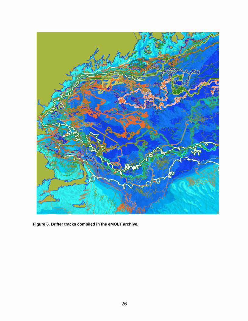
months and, in some cases, well over a year of hourly salinity records were, nevertheless, collected at seven sites. Over 70,000 hourly samples were collected (Figures 3 & 4). The data is archived and our experiences well documented. The data management phase 3 did not go exactly as planned either. We had hoped to supply many of the participants with an electronic logbook for recording catch data but the commercial outfit that was supplying the unit went out-of-business. We did, however, document a year or more of haul data from several participants. The ship’s GPS fed the unit so that accurate position data was recorded with each haul. When it did work, it worked well and proved to be far more efficient that hand-written logsheets. This data is now being analyzed. A scientific journal article has been published (Worden et al, 2006) and another is in preparation. In the end though, it was not worth the fishermen’s trouble because the user support was limited and the company went under. The phase IV drifter project was very successful. Four lobstermen deployed four or more drifters along a cross-shelf transect the first week of each months Jun-Sep in 2004. While the less-expensive electronic-less units were not sighted and reported as often as hoped the GPS-fitted units performed exceedingly well. In fact, the GPS units, built by the Southern Maine Community College marine science students, have now been used by several other research labs to track Harmful Algal Blooms, power plant effluent, sewage outfall effluent, invasive crabs, and zooplankton concentrations. They have now logged well over 70 thousand kilometers of ocean and more than doubled the archive of drifter tracks in the Gulf of Maine. As in the case of the temperature and salinity data, the drifter data is served to the public via the OPeNDAP protocol. It has been used by multiple investigators to, for example, validate numerical ocean circulation model runs. Dozens of marine science students at the Southern Maine Community College have been involved with the eMOLT project in the drifter production since 2003. A few of them have subsequently gone on to university level and one of them has actually gone on to get a degree in physical oceanography. One could argue that this is, in fact, the most significant result of the eMOLT project to date. Finally, in the last month, we have been asked to submit an article to the International Consul for the Exploration of the Seas (ICES) newsletter on the eMOLT project. While eMOLT has been featured in dozens of local newspapers in New England, this is by far the most significant publication to date reaching many thousands of subscribers around the world.
26
Figure 6. Drifter tracks compiled in the eMOLT archive.
27
Current and pending support Most PIs are primarily supported by their own respective organizations. It should be noted that some eMOLT funds to buy internally recording temperature probes in the last few years have come from the sale of satellite tracked drifters to other research parties. The proceeds of one new instrument provide funds to buy the previous. We hope to maintain this type of self-supporting strategy with the development of the real-time probe proposed here. The Gulf of Maine Lobster Foundation can partially fund future research with the sale of equipment developed in previous phases.
June 23, 2006 Jim Manning NOAA/NEFSC 166 Water St. Woods Hole, Ma. 02543 Phone: 508-495-2211 Fax: 508-495-2258 Dear Jim Manning: I am writing this letter to pledge our support for your continued strong Environmental Monitors on Lobster Traps (eMOLT) project has advanced continuously through the past five years.
As an engineer of a high technology USA based company I believe this project has the potential of making a large impact on the way our oceans environmental measurements are taken. I am also very proud to say that our collaboration with the eMOLT project is proving extremely positive creating an underwater sensor package for monitoring both ocean water pressure and temperature.
I predict the future of eMOLT will continue to grow with great promise and has the ability to expand throughout all coasts and ocean in the United States.