34
Environmental Statement Volume 1 Non - technical Summary

Environmental Statement
Volume 1 Non-technical
Summary

CONTENTS 1.0 Introduction .............................................................................. 2
2.0 What is Being Proposed ............................................................ 5
3.0 Assessment of Environmental Effects ....................................... 10
4.0 Summary & Conclusions ......................................................... 25

CBRE | ERITH QUARRY
1.0 Introduction
Page
2
INTR
ODUC
TION
BACKGROUND AND CONTEXT
Anderson Design & Build Limited (Anderson) has submitted a hybrid planning application
(comprising part detailed and part outline elements) to the London Borough of Bexley (LB
Bexley) for the redevelopment of Erith Quarry (the site), located at Fraser Road, Erith.
The site is allocated for a range of land uses, including residential and educational facilities,
by the ‘saved’ policies of LB Bexley’s Unitary Development Plan. It is also designated as a
Site of Borough Grade 1 Importance for Nature Conservation (SBG1INC) by the LB Bexley’s
Core Strategy.
A site location plan is shown in Figure NTS1.
Anderson is proposing the redevelopment of the site to provide up to 600 residential units,
as well as a 3-Form Entry Primary School, complementary non-residential/community
floorspace, open space, designated ecological areas and associated infrastructure.
The illustrative masterplan for the site is shown in Figure NTS2.
ENVIRONMENTAL IMPACT ASSESSMENT
Environmental Impact Assessment (EIA) is a process for ensuring that the likely significant
effects of a new development on its surrounding environment are fully described and taken
into account by the local planning authority before a development is allowed to proceed.
EIA should be focussed on the likely significant environmental effects of a proposed
development. It is not intended to be a process to address all of the possible environmental
effects of a development.
The proposed development is not a Schedule 1 development, for which EIA would be
mandatory. It is however a Schedule 2 development, for which EIA is required where the
development is “likely to have significant effects on the environment by virtue of factors such
as its nature, size or location”. Given the size of the site and its history, the applicant has
voluntarily submitted this Environmental Statement (ES) to LB Bexley in conjunction with the
proposed planning application.
THE PURPOSE OF THIS DOCUMENT
This document forms Volume 1 of the ES. It is the Non-technical Summary of the ES that has
been prepared by Anderson and their consultant team. Its purpose is to present the findings
of the EIA process – as presented in Volume 2 (Main Volume) and Volume 3 (Technical
Appendices) of the ES – in a way that makes it readily understandable to non-specialists.
THE STRUCTURE OF THE OTHER VOLUMES OF THE ES
Volume 2 is the main volume of the ES. It contains the following chapters:
Chapter 1 – Introduction
Chapter 2 – EIA Methodology
Chapter 3 – Site Description & Development Proposals
Chapter 4 – Alternatives Considered & Design Evolution
Chapter 5 – Construction Strategy & CEMP
Chapter 6 – Socio-economic Effects
1.0 Introduction
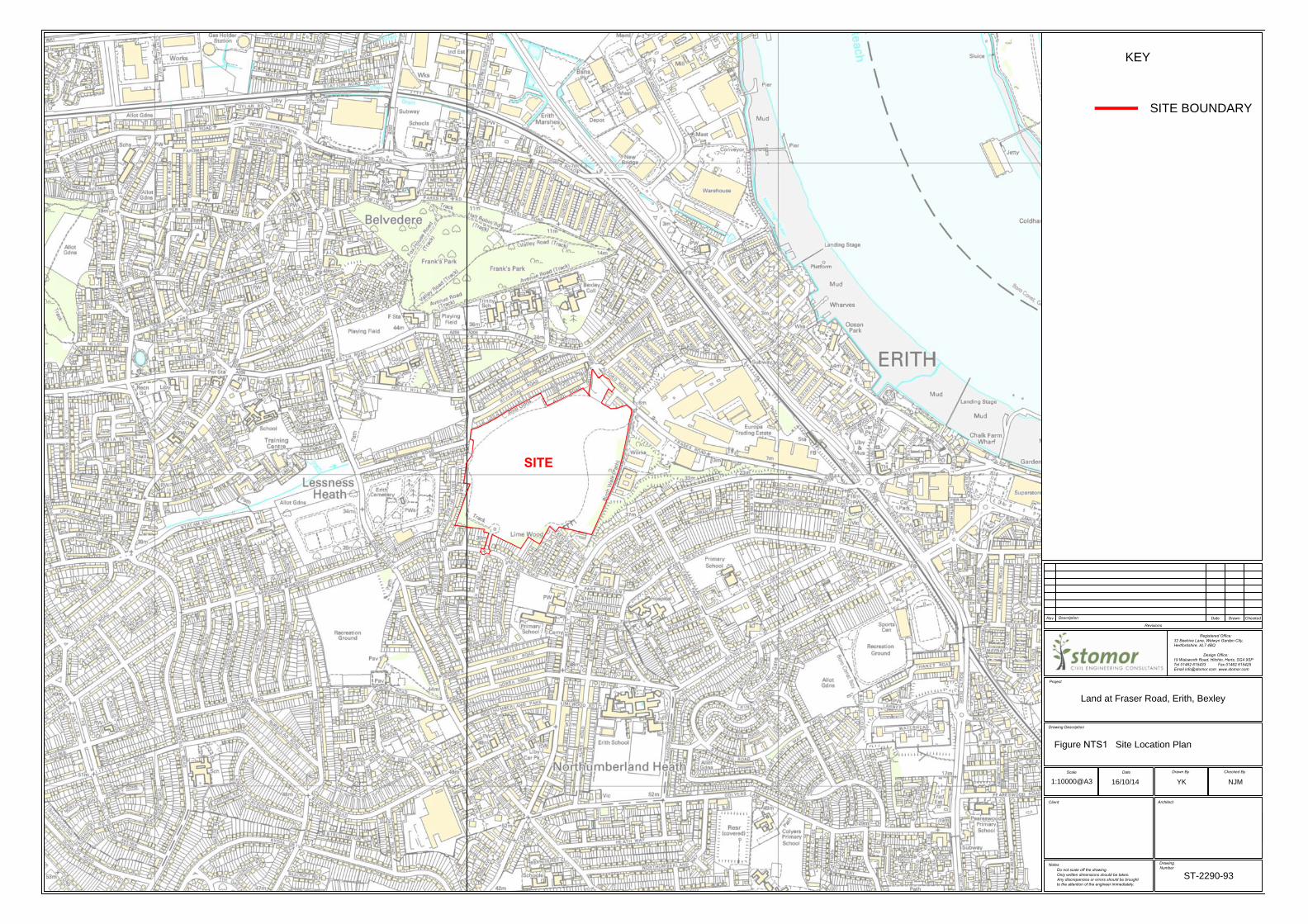
SITE
SITE BOUNDARY
KEY
Registered Office:
32 Beehive Lane, Welwyn Garden City,
Hertfordshire, AL7 4BQ
Design Office:
19 Walsworth Road, Hitchin, Herts, SG4 9SP
Tel 01462 615433 Fax 01462 615425
Email [email protected] www.stomor.com
Revisions
Rev
Description
Date Drawn Checked
Project
Drawing Description
Scale Date
Drawn By Checked By
Client
Notes
Do not scale off the drawing.
Only written dimensions should be taken.
Any discrepancies or errors should be brought
to the attention of the engineer immediately.
Architect
Drawing
Number
Land at Fraser Road, Erith, Bexley
Site Location Plan
ST-2290-93
1:10000@A316/10/14 YK NJM
Figure NTS1

Figure NTS2

CBRE | ERITH QUARRY
1.0 Introduction
Page
3
INTR
ODUC
TION
Chapter 7 – Ecology
Chapter 8 – Ground Conditions
Chapter 9 – Landscape & Visual Effects
Chapter 10 – Transportation
Chapter 11 – Cumulative Effects
Chapter 12 – Summary & Conclusions
The technical chapters contained in Volume 2 (Chapters 6 – 10) relate to those
environmental topics on which it was considered the proposed development had the
potential to result in significant environmental effects.
This was established through the submission of a ‘request for a scoping opinion’ to LB
Bexley in April 2014. In considering the content, or scope, of the ES, LB Bexley sought views
from a range of stakeholders, including internal departments, the Environment Agency and
Natural England.
Volume 3 of the ES comprises the technical appendices, including the technical reports that
have informed the chapters in Volume 2, as well as those on environmental topics on which
the proposed development was considered unlikely to have significant environmental effects
(and did not warrant a stand-alone chapter within Volume 2). These include:
Appendix 1.1 – Request for a Scoping Opinion
Appendix 2.1 – Scoping Opinion and Consultation Responses
Appendix 3.1 – Services & Utilities Statement
Appendix 4.1 – Air Quality Assessment
Appendix 5.1 – Baseline Noise Survey
Appendix 6.1 – Flood Risk Assessment
Appendix 7.1 – SINC Consultation Response
Appendix 7.2 – Interim Ecology Report
Appendix 7.3 – Invertebrate Survey
Appendix 7.4 – Ecological Management Plan
Appendix 8.1 – Phase 1 Environmental Assessment
Appendix 9.1 – Landscape and Visual Impact Assessment
Appendix 10.1 – Transport Assessment
Appendix 10.2 – Travel Plans
HOW TO COMMENT
The full ES and planning application can be inspected at the following location:
The London Borough of Bexley
Civic Office
2 Watling Street
Bexleyheath

CBRE | ERITH QUARRY
1.0 Introduction
Page
4
INTR
ODUC
TION
Kent
DA6 7AT
A copy of the ES and other planning application documents will also be available to view
and download on LB Bexley’s website (www.bexley.gov.uk). A link to these documents is
also provided via Erith Quarry’s dedicated website (www.erithquarry.co.uk).
Comments on the planning application and ES should be addressed to Mr Steve Bell at the
above address.
Copies of the full document can be obtained at a cost to reflect printing and distribution by
contacting CBRE Planning on 020 7182 2000.

CBRE | ERITH QUARRY
2.0 What is Being Proposed
Page
5
WHA
T IS
BEIN
G PR
OPOS
ED
THE SCHEME
The description of the development as it appears on the planning application is as follows:
“Full planning permission for the provision of new site accesses and access roads, a 3-Form
Entry Primary School (4,190 sq m), 86 residential dwellings (Use Class C3) and an
ecology/grassland area in Phase 1 with outline planning permission in 3 subsequent phases
(with all matters reserved except for access) for up to a maximum of 540 sq m GEA of
ancillary non-residential floorspace (Use Classes A1, A2, A3, B1 and / or D1) and up to a
further 514 residential dwellings together with associated works including informal and
formal open space; pedestrian and cyclist infrastructure; car and cycle parking.”
The following paragraphs describe the various elements of the scheme. These sections are
split between the detailed application (Phase 1) and the outline application (Phase 2-4).
The proposed phases of the scheme are shown on the phasing plan shown in Figure NTS3.
A detailed planning application means full details of the proposals are submitted for
consideration by the local planning authority, whereas an outline application looks to
obtain ‘in principle’ agreement for development within set parameters.
The scheme is described in further detail in Chapter 3 of Volume 2.
Phase 1 (detailed application)
Phase 1 comprises the construction of site accesses from Fraser Road and Carlton Road, a
3-form entry primary school and 86 residential units in the north east of the site, a 3.25
hectare ecology area in the north-west of the site, open space and associated infrastructure.
The main vehicular access point will be provided from Fraser Road in the northeast of the
site. The proposed access takes the form of a roundabout. A second vehicular access will be
provided off Carlton Road, which will provide an emergency access route through to the
main body of the site and will directly serve no more than 50 residential units. This junction
will take the form of a priority controlled junction.
The three form entry primary school, which will have a floorspace of 4,190 sq. metres, is
proposed in the north of the site. When fully operational, the school will offer 21 class
rooms with capacity for 630 pupils between the ages of 4 and 11. The building will include
an activity studio, drama studio, LRC and specialist teaching spaces for science, art and
ICT, while a variety of sports facilities will also be provided at the site.
86 Residential units, ranging from 2 bedroom maisonettes to 4 bedroom houses, are
proposed for Phase 1 of the scheme. The breakdown of units to be provided is shown in
Table NTS1.
Table NTS1
Schedule of units within Phase 1: breakdown by type and number
UNIT TYPE NUMBER % SPLIT
2 bedroom maisonette 32 37.2
3 bedroom house 40 46.5
4 bedroom house 14 16.3
TOTAL 86
Source: Studio Egret West
2.0 What is Being Proposed
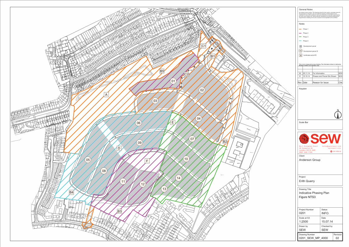
Figure NTS3

CBRE | ERITH QUARRY
2.0 What is Being Proposed
Page
6
WHA
T IS
BEIN
G PR
OPOS
ED
A 3.25 hectare ecology area is provided in the north-west portion of the site. This area has
been shown through surveys to be the most valuable part of the site in ecological terms.
This area will not be subject to development other than the erection of raised
footways/cycleways and the construction of sustainable drainage features, including wet
ponds and swales. These will act to manage surface water and to promote biodiversity.
Phases 2 – 4 (outline application)
Phase 2 – 4 comprise the construction of up to 514 residential units, 540 sq. metres of non-
residential/community floorspace, open space and associated infrastructure.
In addition to the vehicular access points at Fraser Road and Carlton Road, and the
pedestrian and cycle access from Riverdale Road, pedestrian and cycle access will also be
provided from Birch Walk.
Phase 2-4 includes construction of up to 514 residential units. As such, up to 600 units will
be constructed across the scheme. The preferred residential unit mix for the entire scheme
(including Phase 1) is shown in Table NTS2.
Table NTS2
Schedule of units across all phases: breakdown by type and number
UNIT TYPE NUMBER % SPLIT
1 bedroom flat (assisted) 24 4
1 bedroom flat 21 3.5
2 bedroom flat 60 10
2 bedroom maisonette 120 20
3 bedroom house 270 45
4 bedroom house 105 17.5
TOTAL 600
Source: Studio Egret West
Levels of affordable housing within each phase of the development will be determined
through a Viability Assessment. LB Bexley targets 35% affordable housing provision within
new developments.
It is proposed that the scheme will provide up to 540 sq. metres of non-residential/
community floorspace. Permission is being sought for a flexible range of land uses,
including shops (A1 use), financial and professional services (A2 use), restaurants and cafes
(A3 use), offices (B1a use) and non-residential institutions1 (D1 use), which across use
classes A1, A2, A3, B1(a) and/or D1. The end use of this floorspace will depend on future
demand.
Overall phasing of the development
The anticipated programme for the construction works is set out in Table NTS3.
1 These include: places of worship, church halls, clinics, health centres, creches, day nurseries,
consulting rooms, museums, public halls, libraries, art galleries, exhibition halls, law courts,
non-residential education and training centres.

CBRE | ERITH QUARRY
2.0 What is Being Proposed
Page
7
WHA
T IS
BEIN
G PR
OPOS
ED
Table NTS3
Indicative programme of construction works
PHASE CONTENT START DATE FINISH DATE DURATION
Site Preparation Enabling works, service diversions and infrastructure
May 2015 May 2016 52 weeks
Construction (Phase 1) School and 86 dwellings November 2015 December 2017 104 weeks
Construction (Phases 2 ) Apartment blocks & 33
dwellings
November 2016 December 2018 104 weeks
Construction (Phases 3 ) Homes of maisonettes,
terraces, semi-detached
& phase 2 school
classroom fit out
November 2018 December 2020 104 weeks
Construction (Phases 4 ) Homes of maisonettes,
terraces, semi-detached
& phase 3 school
classroom fit out
November 2019 December 2021 104 weeks
May 2015 December 2021 468 weeks
Source: Anderson Design & Build
Further detail on construction is contained within Chapter 5 of Volume 2.
PUBLIC CONSULTATION
Three public consultation events were held by the applicant in advance of the planning
application being submitted. The events were held at Trinity School, Erith Road, DA17 6HT
on:
Saturday 19 July 2014;
Tuesday 22 July 2014; and
Saturday 18 October 2014.
The purpose of these events was to receive feedback from the local community on the
proposals. The consultation process is discussed in more detail within the Statement of
Community Involvement submitted alongside the planning application.
ALTERNATIVES CONSIDERED
This section outlines the main alternatives that were considered by the applicant when
progressing the layout and design of the scheme. Further detail of the alternatives is
presented in Chapter 4 of Volume 2.
Number of residential units
Given its size, the site is capable of supplying more than the 600 units for which planning
consent is being sought. Initially, the applicant considered a variety of different options in
terms of unit numbers and potential mixes, including the provision of up to 700 residential
units on the site. However, when engaging with LB Bexley and the local community, it
became clear that there were concerns that 700 units would represent an overdevelopment
of the site and could also put pressure on ecological conditions within the site boundary.

CBRE | ERITH QUARRY
2.0 What is Being Proposed
Page
8
WHA
T IS
BEIN
G PR
OPOS
ED
Schemes comprising fewer than 600 units were also considered; though these did not
provide sufficient value for the development of the site to bring forward some of the
community benefits now being proposed, such as the 3 form primary school. The applicant
therefore took the decision to proceed on the basis of up to 600 residential units.
Location of the apartment building
Under earlier iterations of the masterplan, one of the apartment buildings (within Phase 2)
was positioned approximately 20 metres from existing properties along Athol Road.
Following consultation with the residents, Anderson took the decision to reposition the
apartment building closest to Athol Road to increase the distance between new and existing
buildings. This change also had the benefit of increasing the size of the ecology area from
3.1 hectares to 3.25 hectares.
Community facilities
During the early stages of the pre-application consultation with LB Bexley, discussions were
held over the potential for the scheme to provide a significant community facility for the
borough. Potential options included an assisted living facility; however, research indicated
that demand was not sufficient to make such a facility viable. Demand for primary school
places is high across London and in the north of LB Bexley. The three-form entry primary
school was therefore included as part of the scheme.
Ecological area
Under early versions of the masterplan, development was proposed throughout the site,
with the notable exception of an ecological buffer zone around the periphery.
Results from ecological survey work carried out subsequently indicated that the site’s
general ecological condition had deteriorated substantially since it was first designated as a
SBG1INC in 1991 and last surveyed in 2004, as a result of ‘benign neglect’ which had
resulted in the spread of Japanese knotweed and encroachment of Brambles. Nevertheless,
the surveys also indicated that the area of grassland in the north west of the site was
relatively species-rich in comparison with the rest of the site and contained a number of the
species for which the SBG1INC was originally designated.
Following consideration of these results and engagement with the Ecology Officer at LB
Bexley, the decision was made to refrain from developing this portion of the site and instead
to retain it in its current state, allowing its ecological value to be preserved and protecting it
from further deterioration through ongoing management.
Other Considerations
A number of other alternatives were also considered, including:
Alternative designs for the main vehicular access junction at Fraser Road – a priority
junction was initially proposed but results from the assessment work indicated that this
junction type would not be capable of managing the volumes of development traffic
anticipated during the peak periods. Results indicated that the best junction type at this
location would be a roundabout and, as such, this has been incorporated into the
design.
Alternative designs for the internal access roads – this has been primarily influenced by
site levels. Due to the significant increase in levels between the point of access on Fraser
Road and the main body of the site, the internal road sweeps along the northern and

CBRE | ERITH QUARRY
2.0 What is Being Proposed
Page
9
WHA
T IS
BEIN
G PR
OPOS
ED
eastern boundaries of the site. An access route running directly into the site from Fraser
Road would generate significant depths of cut across the entire site resulting in an
increase in the volume of construction traffic to remove this material from the site.

CBRE | ERITH QUARRY
3.0 Assessment of Environmental Effects
Page
10
ASSE
SSM
ENT O
F EN
VIRO
NMEN
TAL E
FFEC
TS
THE CONTENT OF THE ES
The content (or scope) of the ES was agreed with LB Bexley following the submission of a
‘request for a scoping opinion’ in April 2014. Before returning their scoping opinion, LB
Bexley consulted a number of their internal departments, as well as external organisations
such as the Environment Agency. A summary of the comments is contained in Table NTS4,
along with an indication of where these comments have been addressed within the ES.
Table NTS4
Summary of consultation responses
CONSULTEE COMMENT WHERE ADDRESSED
LB Bexley – Highways The submitted EIA scoping report includes a
methodology for the production of the Transport
Assessment which will support the future planning
application, and confirms that a detailed scope will be
agreed with the Highway Authority and Transport for
London.
ES Volume 2, Chapter 10 – Transportation
ES Volume 3, Appendix 10.1 – Transport
Assessment
LB Bexley – Drainage The scoping document rightly identifies the treatment of
surface water on and off site as a concern and proposed
to address these in the ES. These sections and the Flood
Risk Assessment also proposed will need to, where
sections consider water/flood-related matters, pay due
regard to the Mayor of London and Bexley’s Planning
Policies.
ES Volume 2, Chapter 3 – Site Description &
Development Proposals
ES Volume 2, Chapter 8 – Ground
Conditions
ES Volume 3, Appendix 6.1 – Flood Risk
Assessment
LB Bexley – Contaminated Land The scope of the EIA includes reference to undertaking
appropriate land contamination assessments and is
therefore considered acceptable
ES Volume 2, Chapter 8 – Ground
Conditions
ES Volume 3, Appendix 8.1 – Desk Study
Report
Environment Agency The proposed scope of the EIA is appropriate with
regards to flood risk management. The use of
sustainable drainage features will be expected and these
should incorporate water quality, habitat and amenity
benefits in addition to attenuation
ES Volume 2, Chapter 3 – Site Description &
Development Proposals
ES Volume 2, Chapter 7 – Ecology &
Biodiversity
ES Volume 3, Appendix 6.1 – Flood Risk
Assessment
We note the contents of the ‘Ground Conditions’ section
and can confirm that this represents an acceptable scope
of works
ES Volume 2, Chapter 8 - Ground Conditions
ES Volume 3, Appendix 8.1 – Desk Study
Report
Natural England We would expect the final Environmental Statement to
include all necessary information as outlined in Schedule
4 of the Town & Country Planning (Environmental
Impact Assessment) Regulations 2011.
ES Volume 2, Chapter 1 – Introduction,
Tables 1.2 & 1.3
Buglife Due to the site’s history of previous disturbance and site
vegetation description with the scoping report, the
Habitat of Principle Importance, Open Mosaic Habitat on
Previously Development Land (OMHPDL) may be
present. The site should be assessed against the Defra
funded standard assessment guidelines for OMHPDL1.
ES Volume 2, Chapter 7 – Ecology &
Biodiversity
ES Volume 3, Appendix 7.2 – Interim
Ecology Report
The invertebrate survey scheduled for 3 visits in mid-July ES Volume 2, Chapter 7 – Ecology & Nature
3.0 Assessment of Environmental Effects

CBRE | ERITH QUARRY
3.0 Assessment of Environmental Effects
Page
11
ASSE
SSM
ENT O
F EN
VIRO
NMEN
TAL E
FFEC
TS
CONSULTEE COMMENT WHERE ADDRESSED
will not be an adequate assessment of the site2. Under
Natural England guidelines, invertebrate surveys should
be carried out over 3 to 7 days of field work, depending
upon the size of the site, covering the period March to
October. Buglife recommends that an invertebrate survey
following the Natural England guidelines should be
carried out so that the biodiversity impacts of the
development can be fully assessed.
Conservation
ES Volume 3, Appendix 7.3 – Invertebrate
Survey Report
Thames Water We would recommend that any EIA report should be
expanded to consider the following:
The development’s demand for water
supply and network infrastructure both on
and off site and can it be met;
ES Volume 3, Appendix 3.1 – Utilities and
Services Strategy
The development’s demand for sewage
treatment and network infrastructure both
on and off site and can it be met;
ES Volume 3, Appendix 3.1 – Utilities and
Services Strategy
The surface water drainage requirements
and flood risk of the development both on
and off site and can it be met;
ES Volume 3, Appendix 6.1 – Flood Risk
Assessment
Any piling methodology and will it
adversely affect neighbouring utility
services;
ES Volume 2, Chapter 5 – Construction
Strategy & CEMP
There are water mains located within the
development site area. The proposed EIA
should include information on how these
water mains will be protected during
construction to ensure potable water
continues to be adequately supplied to the
area
ES Volume 2, Chapter 5 – Construction
Strategy & CEMP
Source: LB Bexley Scoping Opinion (23 June 2014)
KEY RECEPTORS
The following key receptors were identified in the vicinity of the site:
Residents living on roads surrounding the site (Carlton Road, Silver Spring Road,
Riverdale Road, Fraser Road, Athol Road, Thwaite Close, Vicarage Close & Kempton
Close) as well as properties north of the site as far as Erith Road;
Residents living in houses constructed during the early phases of the proposed
development;
Grade II Listed Buildings located within 1 km of the site, including Bexley College,
Parish Church of All Saints, the X-Ray Department (Erith & District Hospital), Christ
Church, Erith Library and Parish Church of St John the Baptist;
2 It should be noted that this is an incorrect interpretation of the survey effort proposed within the
scoping report. Three surveys were proposed – one in May 2014, one in June 2014 and one in
July 2014.
CBRE | ERITH QUARRY
3.0 Assessment of Environmental Effects
Page
12
ASSE
SSM
ENT O
F EN
VIRO
NMEN
TAL E
FFEC
TS
Erith Quarry Site of Borough Grade I Importance for Nature Conservation (SBG1INC)
located at the site, as well as Abbey Wood Site of Special Scientific Interest (SSSI) and
Lesnes Abbey Woods Local Nature Reserve (LNR);
The Seaford Chalk Formation below the site;
The small vegetated stream located close to the site’s western boundary; and
the River Thames.
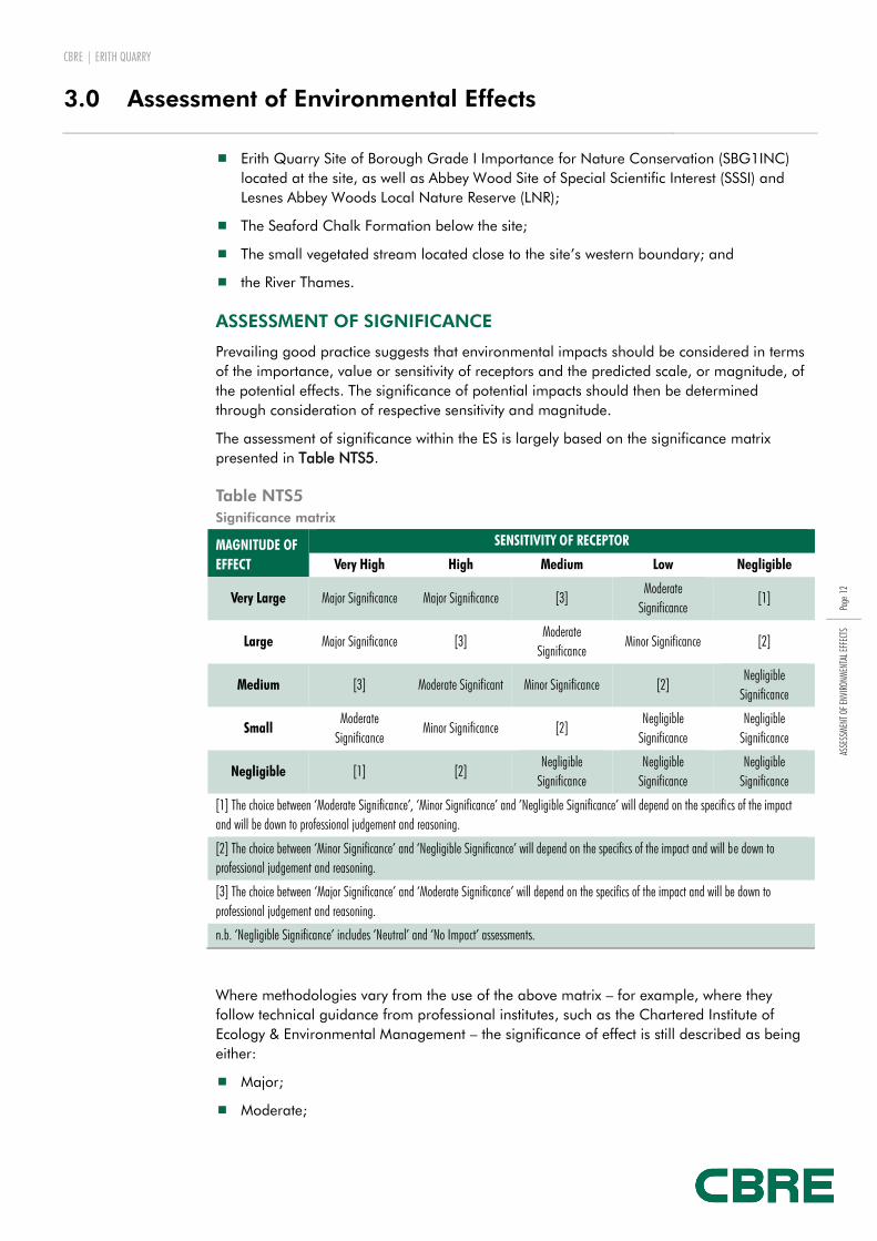
ASSESSMENT OF SIGNIFICANCE
Prevailing good practice suggests that environmental impacts should be considered in terms
of the importance, value or sensitivity of receptors and the predicted scale, or magnitude, of
the potential effects. The significance of potential impacts should then be determined
through consideration of respective sensitivity and magnitude.
The assessment of significance within the ES is largely based on the significance matrix
presented in Table NTS5.
Table NTS5
Significance matrix
MAGNITUDE OF
EFFECT
SENSITIVITY OF RECEPTOR
Very High High Medium Low Negligible
Very Large Major Significance Major Significance [3] Moderate
Significance [1]
Large Major Significance [3] Moderate
Significance Minor Significance [2]
Medium [3] Moderate Significant Minor Significance [2] Negligible
Significance
Small Moderate
Significance Minor Significance [2]
Negligible
Significance
Negligible
Significance
Negligible [1] [2] Negligible
Significance
Negligible
Significance
Negligible
Significance
[1] The choice between ‘Moderate Significance’, ‘Minor Significance’ and ’Negligible Significance’ will depend on the specifics of the impact
and will be down to professional judgement and reasoning.
[2] The choice between ‘Minor Significance’ and ‘Negligible Significance’ will depend on the specifics of the impact and will be down to
professional judgement and reasoning.
[3] The choice between ‘Major Significance’ and ‘Moderate Significance’ will depend on the specifics of the impact and will be down to
professional judgement and reasoning.
n.b. ‘Negligible Significance’ includes ‘Neutral’ and ‘No Impact’ assessments.
Where methodologies vary from the use of the above matrix – for example, where they
follow technical guidance from professional institutes, such as the Chartered Institute of
Ecology & Environmental Management – the significance of effect is still described as being
either:
Major;
Moderate;

CBRE | ERITH QUARRY
3.0 Assessment of Environmental Effects
Page
13
ASSE
SSM
ENT O
F EN
VIRO
NMEN
TAL E
FFEC
TS
Minor; or
Negligible.
Statements are also made as to whether the effects are:
Beneficial or adverse;
Direct or indirect; and
Long-(>15 years), medium-(7-15 years) or short-term (<7 years).
Cumulative effects are also considered within the ES. The dictionary definition is ‘increasing
by one addition after another’ and cumulative impacts can result from individually minor
but collectively significant actions taking place over a period of time. It was agreed with LB
Bexley that four schemes had the potential for cumulative effects alongside the Erith Quarry
proposals. These are listed in Table NTS6.
Table NTS6
Developments with potential for combined effects alongside the Erith Quarry proposals
SITE PROPOSALS STATUS RELEVANCE
Bexley College,
Tower Road, Erith
Demolition of the existing college buildings and the redevelopment of
the site to provide 192 dwellings (91 x 3 bed and 8 x 2 bed houses,
one 4 storey block providing 65 x 2 bed apartments, 26 x 2 bed
duplex units and 2 x 2 bed apartments) together with new access,
associated parking and amenity space.
Application
granted subject
to Section 1063
Agreement
Potential cumulative
environmental effects
during
construction/operation
phase.
Larner Road, Erith Demolition of existing building and construction of between 550 and
622 residential units (Class C3) in two phases. Phase 1 (detailed
planning permission) comprises the construction of 343 residential
units comprising 12 x 2 bed, 107 x 3 bed, 21 x 4 bed houses and 27
x 1 bed, 176 x 2 bed apartments, landscaping and enhancement
works to The Dell, open space provision, public realm works,
landscaping, 304 car spaces, 34 disability car spaces and 483 cycle
spaces together with associated works. Phase 2 (Outline planning
permission) comprises construction of between 207 and 279
residential units, a community facility of up to 150 sq.m (Class D1
and/or D2) and associated works. Approval of details of access for
Phase 2.
Application
granted subject
to Section 106
Agreement
Potential cumulative
environmental effects
during
construction/operation
phase.
Walnut Tree Depot
Site, Stonewood
Road, Erith
Construction of a three storey college building, together with the
provision of a new pedestrian link, access, car parking (41 spaces)
and landscaping.
Application
granted subject
to Section 106
Agreement
Potential cumulative
environmental effects
during
construction/operation
phase.
Pirelli Church
Manorway, Erith
Demolition of existing buildings and erection of industrial and
distribution park with a total of 60,263sqm, comprising light
industrial use (Class B1), general industrial use (Class B2) and
warehouse and distribution floorspace (Class B8), amended access
Application
granted subject
to Section 106
Agreement
Potential cumulative
environmental effects
during
construction/operation
3 Planning obligations under Section 106 of the Town and Country Planning Act 1990 (as amended)
are a mechanism that makes a development proposal acceptable in planning terms, which
would not otherwise be acceptable. They are focused on site-specific mitigation of the impact of
development. S106 agreements are often referred to as 'developer contributions'.

CBRE | ERITH QUARRY
3.0 Assessment of Environmental Effects
Page
14
ASSE
SSM
ENT O
F EN
VIRO
NMEN
TAL E
FFEC
TS
arrangements, landscaping, car parking and servicing areas.
(Application for an extension of the time limit for implementation on
the previously approved planning reference 05/01201/FULM).
phase.
Further detail on the EIA Methodology is presented in Chapter 2 of Volume 2.
The remainder of this section outlines the assessment of the main environmental effects that
has been undertaken. Topics are presented in the order in which they appear within Volume
2 of the ES.
Section 4 of this report contains a table of that summarises the significance of the residual
effects of the proposed development (i.e. those effects that remain after the implementation
of the mitigation measures detailed within the ES).
SOCIO-ECONOMICS
The assessment of socio-economic effects has been undertaken by Zeta Economics and is
presented in Chapter 6 of Volume 2.
The scheme has been assessed in terms of the likely potential impact on socio-economic
conditions. The assessment considers:
Social and demographic effects. These include likely changes in the local population
and the effect of the development on social and community infrastructure, including
primary and secondary education, and health facilities.
Economic effects. These include likely employment generation and likely expenditure by
new residents.
Construction phase
Job creation
Based on a conservative estimate of construction costs, which is based on industry estimates
for the size of the development, but which is likely to underestimate costs associated with
building on a former quarry and landfill site:
gross direct employment during the construction phase is estimated to be 605 man-
years, or 60.5 full time equivalent (FTE) jobs;
gross indirect employment, which is that generated through the supply chain is
estimated to be 484 man-years (48.4 FTE jobs); and
gross induced employment, which is that as a result of additional spending by
construction workers, is estimated to be 236 man-years (23.6 FTE jobs)
net additional impacts are estimated to result in 395 man-years (39.5 FTE jobs).
Community disturbance
As with construction works on all schemes of this nature, side effects, such as noise and
construction traffic, have the potential to disturb local residents. The level of community
disturbance from the construction site will also be dependent on the perceptions and levels
of tolerance of existing residents.
Impacts will be minimised by undertaking works in accordance with an agreed Construction
Environmental Management Plan (CEMP). Measures to be included in the CEMP are
outlined in Chapter 5 of Volume 2. They include measures in relation to:

CBRE | ERITH QUARRY
3.0 Assessment of Environmental Effects
Page
15
ASSE
SSM
ENT O
F EN
VIRO
NMEN
TAL E
FFEC
TS
air quality (including dust generation);
noise and vibration;
contamination; and
construction traffic.
Post-construction phase
Population
Based on the latest Census data, the likely number of future residents across a total of up to
600 residential units is approximately 1,453. Table NTS7 shows the estimated child yield
based on two methods:
Census data from 2011; and
LB Bexley’s Planning Obligations Guidance Supplementary Planning Document.
Table NTS7
School age pupil estimates
SCHOOL AGE GROUP CENSUS BASED ESTIMATE SPD RULE BASED ESTIMATE
Primary (aged 4-11) 130 136
Secondary (aged 12-16) 89 97
Post-16 (aged 17-19) 54 39
Source: Zeta Economics
Employment
Based on pupil-teacher ratios for primary and secondary schools in Bexley, the primary
school at Erith Quarry site will create approximately 30-33 FTE teaching jobs when fully
operational.
In addition, the development will also include 540 sq.m. of non-residential floorspace.
Based on the highest and lowest employment densities for the use classes applied for (A1
‘shops’ and B1 ‘business uses’, respectively) the development is likely to generate between
32 and 54 direct FTE jobs and between 42 and 90 FTE jobs. Of these jobs, between 15 and
32 are estimated to be completely new (i.e. net) FTE jobs.
Effects from local spend
The expenditure by households within the new development has been modelled using the
UK Household Expenditure 2011 data for London. Based on this, it is expected that the total
household expenditure may amount to £21.13 million annually in total for all households
(this includes all expenditure items). Expenditure on various consumer items is estimated at
£15.15 million annually.
Overall, the expenditure by all residents will create an estimated 170 direct, indirect and
induced FTE jobs in the UK economy. Up to 27.4 FTE jobs are expected to be completely
new to the economy of LB Bexley.

CBRE | ERITH QUARRY
3.0 Assessment of Environmental Effects
Page
16
ASSE
SSM
ENT O
F EN
VIRO
NMEN
TAL E
FFEC
TS
Education facilities
The three-form entry primary school will provide places for an estimated 620 children when
fully operational, based on an average class size of 30 children from Reception to Year 6. It
is proposed that the primary school will be brought forward in four stages:
September 2017 – 3 classrooms
September 2018 – 4 classrooms
September 2019 – 7 classrooms
September 2021 – 7 classrooms
Healthcare facilities
A total of between 0.6 – 1 (FTE) GPs and 0.3-0.5 FTE dentists are estimated to be required
in order meet the needs of the additional residents of the proposed scheme.
17 of the 18 GP and dental practices within 3km of the site were accepting NHS patients in
October 2014. There is therefore considered to be additional capacity within existing
healthcare facilities, though the exact extent of this capacity is uncertain.
The applicant has entered into early discussions with the local NHS Trust to examine the
possibility of a small healthcare facility (D1 use) to operate within the 540 sq.m. non-
residential floorspace. D1 use is listed within the description of development for which
permission is being sought.
Open space provision
Based on the illustrative masterplan, the development will provide 22,385m2 of open space
above what is required in LB Bexley’s Open Space Strategy (2008). This is equivalent to a
48% overprovision.
Community facilities
Approximate population thresholds for community centres are one per 7,000 to 15,000
residents. Therefore, it is anticipated that the proposed development will not result in a
sufficient increase in demand in order to warrant additional community centre capacity.
ECOLOGY & BIODIVERSITY
The assessment of ecological effects has been undertaken by Ecology Solutions and is
presented in Chapter 7 of Volume 2.
The scheme has been assessed in terms of the likely potential impact related to ecological
conditions at the site and in the surrounding area. A number of ecological surveys were
undertaken to inform the assessment of ecological effects, including:
Habitat survey;
Arboricultural survey;
Bat surveys;
Badger survey;
Reptile surveys;
Breeding birds surveys; and

CBRE | ERITH QUARRY
3.0 Assessment of Environmental Effects
Page
17
ASSE
SSM
ENT O
F EN
VIRO
NMEN
TAL E
FFEC
TS
Invertebrates surveys.
Habitats
The following main habitat / vegetation types are present within the site:
Scrub;
Rough Grassland and Ruderal;
Woodland belts and scattered trees;
Stream;
Hardstanding; and
Bare ground/rubble.
The majority of the site consists of extensive areas of Bramble scrub, particularly to the east
of the site, large areas of which have become inaccessible. Where Bramble is not dominant
a range of other scrub species are present. Significant areas of rough grassland and
ruderal vegetation are still present across the site, although there is evidence that these
areas are declining as a results of scrub encroachment. A moderate diversity of plant
species are present; however, no areas of significant species richness were identified. The
more species-rich, diverse areas are primarily to the north and west of the site.
Wooded areas are present along much of the northern, eastern and southern site
boundaries, whilst a number of scattered, generally semi-mature trees are present within
the scrub and grassland habitats towards the centre of the site. Japanese Knotweed, an
invasive species, is also present at the site.
A small stream is present to the west of the site, which is overshaded by woodland along
much of its extent. Areas of hardstanding, in the form of dilapidated tarmac track, are
present along the southern and south-western areas of the site, while a small number of
rubble/soil piles are present within the grassland/scrub mosaic.
The site forms the majority of the non-statutory site of Erith Quarry Site of Borough
Importance for Nature Conservation (SBG1INC), although a section of this designated site
lies to the east. Results from ecological surveys indicate that the site’s general ecological
condition has deteriorated substantially since it was first designated as a SBG1INC in 1991,
and last surveyed by the London Wildlife Trust (LWT) on behalf of LB Bexley in 2004, with
encroachment of bramble scrub highlighted as the key reason for this loss of species
biodiversity. The results, however, indicate that the area of predominantly rough grassland
in the north west of the site is relatively species rich in comparison with the rest of the site
and contain a number of the species for which the SBG1INC was originally designated.
Following consideration of these results and consultation with the biodiversity officer at LB
Bexley, the decision was made to refrain from developing this portion of the site and instead
to retain it in its current state, managed with a ‘hands-off’ approach by a designated
management company, protecting it from further encroachment from bramble scrub and
allowing its ecological value to be conserved. It is also considered that the protection and
management of this area will allow the SBG1INC designation to be retained in this part of
the site.
To ensure that the wooded belt that lines much of the periphery of the site is retained under
the proposals, a minimum 10 metre woodland buffer will be ensured to the main area of
built development and internal road network. A number of trees will require removal to

CBRE | ERITH QUARRY
3.0 Assessment of Environmental Effects
Page
18
ASSE
SSM
ENT O
F EN
VIRO
NMEN
TAL E
FFEC
TS
facilitate the works, including 7 located at the location of the southern access at Carlton
Road. The majority are, however, outside of the agreed buffer zone and have limited
ecological and local amenity value.
New native tree planting, as part of a long-term management regime, will be undertaken to
produce a more contiguous area of woodland.
Species
No evidence of Badger activity in the form of any setts, latrines, footprints, well used
footpaths or foraging signs was recorded within or immediately adjacent to the site. There
are no ponds present within the site, whilst the flowing nature of the stream present to the
west of the site makes it unsuitable to support breeding amphibians. As such, badgers and
amphibian species are not considered to be present at the site.
Generally low levels of bat activity have been recorded at the site. Activity was found to be
mostly limited to along the wooded belt along the site periphery. No direct evidence of bat
roosts was identified. The habitats of greatest value to bats at the site (i.e. the woodland
belt) will be retained under the proposals. The lighting scheme will be designed to minimise
impacts on bats in proximity to the site, while a total of 20 bat boxes will be placed on
suitable trees/buildings within the site in order to provide roosting opportunities.
The breeding bird surveys indicate that the site is utilised by a range of bird species for
breeding and foraging purposes. Of the 29 species recorded during the breeding bird
survey, 16 were breeding or probably breeding within the site, and three were possibly
breeding (i.e. habitat suitable to support the species is present). The remaining ten species
were either breeding in adjacent areas, recorded only as migrants or flying over the site, or
represented by non-breeding individuals. Some areas of suitable habitat will be lost for
some of these species, however it is considered that the enhancement measures to the
retained habitats at the site will reduce this impact. A total of 60 bird nesting boxes of a
variety of designs will be provided across the site within areas of new and retained
woodland, which will provide further nesting opportunities for a range of bird species.
Surveys recorded a total of 375 terrestrial invertebrate species at the site, identifying that a
range of species utilise the habitats present within the site, including a number of
noteworthy species. Although some habitats at the site that support invertebrates will be lost,
the habitats identified as being of highest value to invertebrates will be retained within the
dedicated ecology area. The ecological management regime will include all retained
habitats, as well as proposed habitats within the site (e.g. wet ponds), which will ensure that
the extent and quality of these habitats is retained and enhanced in the long-term,
promoting enhancements to many invertebrate species. The provision of specific
invertebrate plateaus within an ecology corridor connecting to the retained ecology area
will further mitigate for an impacts to invertebrates.
Surveys recorded reptiles to be distributed across the site, although presence was limited to
within areas of grassland and ruderal. A relatively higher number of reptiles were recorded
in the north-west of the site, where more extensive areas of suitable habitat are present. In
light of the need to commence the removal of Japanese Knotweed from the site, a reptile
mitigation strategy was initiated in July 2014 such that the existing reptile population could
be fully safeguarded during these works. This mitigation strategy incorporated the use of a
translocation exercise, with reptiles being moved to a dedicated holding area, measuring 1
hectare, in the north-west of the site. The reptile translocation exercise on site was
concluded in early November 2014. It is now considered that reptiles are only likely to be
present within the holding area in the north-west of the site. They will be released when

CBRE | ERITH QUARRY
3.0 Assessment of Environmental Effects
Page
19
ASSE
SSM
ENT O
F EN
VIRO
NMEN
TAL E
FFEC
TS
conditions are deemed safe for them to be returned to the environment, or should planning
permission not be granted.
GROUND CONDITIONS
The assessment of ground conditions has been undertaken by GB Card and Partners and is
presented in Chapter 8 of Volume 2.
The scheme has been assessed in terms of the likely potential impact related to ground
conditions at the site. The assessment has been based on both desk study and previous site
investigation data (undertaken by previous owners).
The data sources utilised include the following:
Historic maps;
Geological records;
Information held on environmental registers; and
Previous technical reports.
Available historical records indicate that the majority of the site was quarried for sand and
gravel from the late 1800’s until at least 1960’s and possibly until 1970’s. The quarry was
subsequently filled with mixture of inert and commercial wastes, construction and
demolition wastes and industrial non-hazardous wastes. Records suggest that the filling of
the site had ceased by 1980. The northern part of the site did not form part of the quarry
and was occupied by a garage/petrol station from the 1950s until 2004, when it was
decommissioned. This area of the site was remediated between 2008 and 2009/2010 by
the previous site owners.
Existing data indicates that the ground conditions beneath the site comprise a thin layer of
topsoil over waste deposits. The maximum thickness of the waste deposits has been
reported to be in excess of 30m. These deposits are underlain by sandstone bedrock across
the majority of the site, which itself is underlain by chalk deposits. The sandstone bedrock
underlying the site is classed as a Secondary A aquifer by the Environment Agency, while
the underlying Chalk is classed as a Principal aquifer. Principle aquifers are layers of rock
or soil that have high permeability, meaning they usually provide a high level of water
storage. Secondary A aquifers have some permeability but provide a lower level of water
storage.
Existing investigation data for the site indicates the presence of elevated concentrations of a
number of contaminants within the waste deposits. Although the data is limited, elevated
levels of some heavy metals have also been reported in the overlying topsoil. Analysis
undertaken to date also indicates that there are elevated concentrations of a range of
contaminants in groundwater below the site. Monitoring data indicates that gas
concentrations at the site are generally low.
Ground contamination will only pose a risk to receptors – such as future site residents and
aquifers beneath the site – if there is a pollution pathway between the source of the
contamination and those receptors.
Appropriate personal protective equipment and safe working practices will be implemented
to protect workers and neighbours from any ground related hazards during construction.
Should contamination be encountered during construction works, soils will be treated.
Treated soils will be re-used on the site wherever possible.

CBRE | ERITH QUARRY
3.0 Assessment of Environmental Effects
Page
20
ASSE
SSM
ENT O
F EN
VIRO
NMEN
TAL E
FFEC
TS
In order to protect future site users from potential contamination at the site, an engineered
layer of clean soil will be provided in all soft landscaped areas. This will be constructed to
ensure that all requirements are met in terms of human health protection, gas protection,
plant growth and drainage. In hard landscaped parts of the site (i.e. beneath buildings,
roads and pavements), the concrete basements and roads etc. will serve as a capping layer.
This will extend up to the retained ecology area, which will remain in its current condition in
order to maintain its ecological value. Public access to this area will be via a network of
raised boardwalks to prevent direct contact with the ground below.
Further site investigations have recently been undertaken by Anderson Group. The scope of
these has been agreed with both LB Bexley and the Environment Agency. These results will
be submitted to the Council in due course and, together with the results of previous
investigations, will inform the proposed remediation strategy for the site. This will ensure
that the site is ‘suitable for its intended use’.
LANDSCAPE AND VISUAL EFFECTS
The assessment of landscape and visual effects has been undertaken by LandscapeVisual
and is presented in Chapter 9 of Volume 2.
The likely significant effects of the development on landscape features, landscape character,
and visual amenity have been assessed.
The site forms the eastern edge of a minor valley which runs in a south-westerly to north-
easterly direction towards the River Thames. From the site, there are open views to riverside
industry and housing, particularly to the north. The surrounding townscape is a mix of
Victorian and Edwardian, inter-war and 1970s suburban housing with extensive industrial
and commercial areas to the north and east.
Viewpoints assessed are shown in Table NTS8:
Table NTS8:
Viewpoints assessed
NO. NAME
APPROXIMATE OS
GRID REFERENCE RATIONALE FOR VIEWPOINT SELECTION
1. Kempton Close/Victoria Close 550319 177775 Residential street
2. Junction Fraser Road/Bexley Road 551141 177996 Principal road near site
3. Carlton Road Entrance 550059 177754 Residential street/proposed site entrance
4. Riverdale Road Entrance 549997 178128 Residential street/proposed site entrance
5. Top of Holmhurst Road 549910 178459 Residential street with elevated view over site
6. Holly Hill 549715 178212 Open space with elevated view over site
7. A206 main site entrance 550452 178305 Main road/commercial street/proposed site entrance
8. Erith Road near Trinity School 550186 178447 Main road with elevated view over site
9. Athol Road 550337 178265 Residential street
The proposed development would bring about large-scale change to much of the quarry
site, transforming approximately 15 hectares into planned mixed-use development. The
proposed development would retain some of the features currently on the site, including the

CBRE | ERITH QUARRY
3.0 Assessment of Environmental Effects
Page
21
ASSE
SSM
ENT O
F EN
VIRO
NMEN
TAL E
FFEC
TS
grassland at the north-western end. This will form part of the 3.25 hectare ecology area.
The development largely retains and reinforces the existing woodland boundaries.
A development of the scale proposed will always have defined landscape and visual effects.
While short-term effects should be afforded due consideration, it is particularly the long-
term effects which are important.
The proposed development would be visible from nearby residential areas. Many of these
areas already contain views of housing or industry. The proposed development would not
contain features which are not already present in the surrounding suburbs. The change in
views would nevertheless be noticeable, particularly for residents of streets adjoining the site
and on the valley-side to the north.
The development would open access through the site and to open spaces within the site,
including the village green and ‘play spine’. The development would improve the
permeability for the surrounding suburbs for those on foot and cycle. The development is
considered to represent an increase in the density of development in the wider area, but
also an increase in the quality of planned development.
TRANSPORT
The assessment of transport has been undertaken by Stomor Ltd. and is presented in
Chapter 10 of Volume 2.
The assessment evaluates the likely significant effects of the proposed development in
relation to transport matters. It considers the proposed development impact with regard to
the following:
vehicular traffic;
pedestrians;
cyclists;
public transport; and
car parking.
The area surrounding the site is heavily urbanised. The largest roads in the vicinity are the
A220 (Bexley Road), the A206 (Fraser Road/Erith Road) and the A2016 (Bronze Age Way).
A pair of bus stops are located on Fraser Road north of the site and a further pair are
located on Bexley Road south-east of the site. A ‘Hail and Ride’ bus service operates along
Carlton Road, south of the site where passengers can be picked up or dropped off upon
request at any safe location. Bus route B12 provides a regular service between Erith and
Bexleyheath. Erith station is approximately 1km by road to the east of the site boundary with
Fraser Road.
The existing road network generally operates within capacity, but with selected junctions
experiencing delay during peak periods. Of the 17 junctions assessed, it was identified that
during peak traffic periods, nine junctions are currently operating with spare capacity, while
two junctions are operating close to capacity and 6 junctions are operating over capacity.
Construction phase
Construction vehicles are proposed to be routed to and from the site along Fraser Road and
Bexley Road to the Erith Roundabout to pick up the more strategic routes of Bronze Age
Way and Queens Road. The maximum number of Heavy Good Vehicle (HGV) movements
CBRE | ERITH QUARRY
3.0 Assessment of Environmental Effects
Page
22
ASSE
SSM
ENT O
F EN
VIRO
NMEN
TAL E
FFEC
TS
during the construction phase is anticipated to be 80 per day. An increase in HGV
movements of this magnitude is not anticipated to significantly affect background conditions
on the local road network. In addition, a range of mitigation measures will be implemented
to ensure that any impacts are further kept to a minimum. These will include the following:
Designation of suitable highway routes, avoiding minor roads and agreeing these with
the Local Planning Authority;
Minimising the need to import or export soil to reduce the amount of lorry movements;
Design of haul routes to avoid impact on existing and adjacent land uses;
Control of vehicle speeds; and
Wheel washing for all HGVs leaving site.
Operation
Off-site works to improve junction capacity will be undertaken for local junctions where the
effects of the increase in traffic are considered likely to result in driver delay. The works have
been designed to accommodate not only traffic from the Erith Quarry site once completed,
but also background traffic increases up to 2022 and traffic associated with the
redevelopment of Bexley College. Works will include the following:
Conversion of the A206 Erith Road / Brook Street priority tee junction to a mini
roundabout with some localised kerb realignment;
Enlargement of the A206 Fraser Road / A220 Bexley Road roundabout; and
Widening of the Bexley Road western approach to the Walnut Tree Road / Bexley Road
/ Queens Road (A206) / Bexley Road (A220) / Bronze Age Way (A2016) roundabout.
Additional junction improvement works may also be undertaken at four other junctions. The
extent of the highways improvements required and the timescales for implementation will be
established through consultation with LB Bexley. The proposed highway improvement works
will also provide improved pedestrian safety improvements in the area.
In order to promote non-car use, footway / cycle links will be provided within the site,
linking to adjacent footway systems and public transport links near to the site.
OTHER TOPICS
Air Quality
ACCON UK Ltd. has carried out an air quality assessment for the scheme, which is
presented in Appendix 4.1 of Volume 3.
The assessment considers overall levels of key air pollutants at the proposed development
site and at existing locations within close proximity. It covers the effects on local air quality
from the combined heat and power (CHP) unit, which is proposed to help address the
energy demands of the apartment buildings within Phase 2, and vehicle movements
associated with the scheme during the construction and operation phase.
The report concludes that impacts during the construction phase will range from minor to
negligible by undertaking works in accordance with Best Practice, and will be temporary in
nature. Impacts during the operation of the scheme are considered to be negligible, with no
predicted exceedances of National Air Quality Objectives.
CBRE | ERITH QUARRY
3.0 Assessment of Environmental Effects
Page
23
ASSE
SSM
ENT O
F EN
VIRO
NMEN
TAL E
FFEC
TS
The assessment has also addressed the potential for nitrogen deposition to affect the
retained ecology area. Levels of nitrogen oxides are below the threshold that has been set
to protect vegetation and habitats under the Air Quality Strategy for England, Scotland,
Wales and Northern Ireland.
Noise
A noise assessment of the proposed development has been undertaken by Sharps Redmore.
This is included as Appendix 5.1 of Volume 3.
The assessment considers the development in relation to the existing noise environment,
particularly at noise‐sensitive locations, such as the proposed school site, and residential
units that will be in close proximity to existing roads.
The assessment was informed by noise surveys at the site and subsequent calculations. The
report concludes that the noise environment is such that the site can be developed in a way
which provides an acceptable noise climate for future residents and students, both in terms
of interior and exterior noise levels, in dwellings and teaching/learning spaces. Measures to
achieve this include the use of high specification double-glazing in certain areas and
limiting noise associated with new mechanical and electrical plant at source.
Flood Risk and Drainage
Stomor Ltd. has prepared a Flood Risk Assessment (FRA) and drainage strategy in relation
to the proposed scheme, which is provided in Appendix 6.1 of Volume 3.
The design sets out measures to ensure that the site would not flood, or allow for run-off of
water into neighbours’ properties. The drainage system proposed will have the capacity to
accommodate a 1 in 100 year storm event, plus 30% to make allowance for future climate
change, as required by the Environment Agency.
Key features of the proposed SuDS scheme are:
Rain gardens/planters are to be provided, where appropriate, to provide a form of
source control. Overflows will be required for higher intensity storm events.
Porous paving to be provided, where appropriate, to control runoff at source and treat
surface water runoff within the site.
Provision of a swale/ditch to convey roof runoff between the proposed apartments and
wet pond areas.
Provision of storage pipes and cellular tanks under the internal road network and
parking areas, where appropriate, to provide storage for the 1 in 30 and 1 in 100 year
+ 30% Climate Change storm events.
Wet ponds to provide storage for the 1 in 30 and 1 in 100 year + 30% Climate
Change storm events, providing ecological features in accordance with the ecological
strategy for the site.
The drainage strategy for the development of the site identifies off-site connections to the
public foul and surface water sewers in Riverdale Road and the public foul water sewer in
Fraser Road. A Sewer Impact Study has been issued by Thames Water. It outlines indicative
improvements which would allow for the development to connect while maintaining the
existing level of service. These are as follows:
CBRE | ERITH QUARRY
3.0 Assessment of Environmental Effects
Page
24
ASSE
SSM
ENT O
F EN
VIRO
NMEN
TAL E
FFEC
TS
Fraser Road. To provide additional capacity within the existing branch sewer it is
recommended that the existing 150mm diameter sewer from manhole TQ50785105 to
TQ50785205 is upgraded to a 225mm diameter sewer. The approximate length of the
sewer is16m at an average depth of 1.8m.
Fraser Road. A 1500mm diameter offline storage tank sewer is suggested between
existing manholes TQ50787005 and TQ50785104, located within Fraser Road. The
approximate length of the offline tank sewer is 181m at an average depth of
approximately 4.0m. A number of 450mm high level overflow pipes connect the
existing surface water sewer to the off-line tank sewer. Flows discharging from the tank
sewer are restricted through a 300mm diameter continuation pipe.
Holly Hill Road. Reinforcement in Holly Hill Road to comprise the construction of a
bifurcation chamber at manhole TQ49789205 and approximately 184m of 300mm
diameter sewer connecting existing manholes TQ49789205 and TQ50781303 at an
average depth of 2.5m.
Pembroke Road. Network reinforcement is required within Pembroke Road and
comprises the construction of a bifurcation chamber at existing manhole TQ50785508
and approximately 58m of 300mm diameter sewer connecting existing manholes
TQ50785508 and TQ50786607 at an average depth of 2.25m.
Further consultations are underway and the final works package is to be agreed with
Thames Water.

CBRE | ERITH QUARRY
4.0 Summary & Conclusions
Page
25
SUM
MAR
Y &
CONC
LUSI
ONS
SUMMARY OF RESIDUAL EFFECTS
Table NTS8 summarises the residual effects of the proposed development (i.e. those effects
that remain after the implementation of the mitigation measures detailed within the ES).
Table NTS8
Summary of residual effects
TOPIC IMPACT
PRE-MITIGATION
SIGNIFICANCE
MITIGATION
PROPOSED
POST-MITIGATION
SIGNIFICANCE
Socio-economics
Temporary economic
impacts
Total new (net additional)
employment arising from
construction expenditure
Minor beneficial
significance within the
Study Area
Minor to negligible
beneficial significance
within Bexley Borough
No mitigation is required Minor beneficial
significance within the
Study Area
Minor to negligible
beneficial significance
within Bexley Borough
Temporary social
impacts
Community disturbance
during construction phase
Minor to moderate
adverse significance
for nearby properties
Construction Environmental
Management Plan
Minor to negligible
adverse significance for
nearby properties
Long-term social
impacts
Impacts on education
facilities
Moderate to minor
adverse significance
within the Study Area
A three-form entry primary
school will be delivered as
part of the Erith Quarry
development
Major beneficial
significance within Study
Area. Moderate
beneficial significance
within Bexley Borough.
Long-term social
impacts
Impacts on health care
facilities
Minor to moderate
adverse significance
within the Study Area
Engagement with Bexley CCG
to increase GP and dentist
care provision towards the
completion of the scheme
Minor to moderate
adverse significance
within the Study Area†
Long-term social
impacts
Impacts on community
facilities
Moderate beneficial
significance within the
Study Area.
No significance with
respect to community
facilities alone.
Provision of open space
above required standards
Moderate beneficial
significance within the
Study Area
Long-term economic
impacts
Employment and GVA
arising from expenditure by
new residents and from
new employment space
provision
Moderate beneficial
significance within the
Study Area
Minor to negligible
beneficial significance
within Bexley Borough
No mitigation is required Moderate beneficial
significance within the
Study Area
Minor to negligible
beneficial significance
within Bexley Borough
Ecology & Biodiversity
Designated Sites Loss of existing habitat within Erith Quarry SBG1INC.
Moderate adverse significance at the borough level.
Instigation of a suitable management regime.
Retention of most ecologically valuable habitats.
New habitat creation
Minor positive significance at the Borough level.
4.0 Summary & Conclusions

CBRE | ERITH QUARRY
4.0 Summary & Conclusions
Page
26
SUM
MAR
Y &
CONC
LUSI
ONS
including opportunities for notable faunal groups.
Designated Sites Indirect interference through noise / dust deposition and recreational disturbance on nearby non-statutory sites.
Minor adverse significance at the Borough level.
Implementation of best practice construction measures in regard to noise, dust deposition and recreation impacts.
Negligible significance at the Borough level.
Habitats Loss of scrub Minor adverse significance at the site level.
Retention of areas of scrub within ecology area.
New scrub planting adjacent within ecology corridor.
Moderate positive significance at the site level.
Habitats Loss of rough grassland and ruderal
Moderate adverse significance at the Borough level.
Retention of most ecologically diverse areas of grassland within a dedicated ecology area.
Implementation of suitable long-term management in regard to encroachment of scrub and aggressive grassland species.
Provision of new grass and ruderal habitat such as within the ecology corridor and in public open space.
Moderate positive significance at the Borough level.
Habitats Loss of individual trees Minor adverse significance at the Borough level.
Protection of retained trees in accordance with BS 5837:2012.
New native tree planting to produce more contiguous area of woodland.
Long term management regime to remove non-native species and maintain a woodland edge.
Moderate beneficial significance at the Borough level.
Habitats Contamination of stream Negligible at the site level.
Protection of stream corridor with fencing.
Removal of overshading scrub.
Works to the stream channel to provide a series of pools to enhance structural diversity.
Major beneficial significance at the site level.
Bats Potential loss or damage to roosting habitat. Loss of foraging habitat.
Minor adverse significance.
Works impacting any trees that have potential to support roosting bats to be proceeded by detailed surveys to confirm the presence / absence of roosts.
Implementation of a sensitive lighting regime.
Provision of 20 new bat roosting boxes.
Minor positive significance at the international level.
CBRE | ERITH QUARRY
4.0 Summary & Conclusions
Page
27
SUM
MAR
Y &
CONC
LUSI
ONS
Retention and enhancements of woodland belt and woodland edge.
Birds Loss of foraging and nesting habitat.
Minor adverse significance at the Borough level.
Provision of 60 new bird nesting boxes.
Enhancements to retained habitats such as new woodland planting.
Negligible at site level.
Invertebrates Loss of habitat Major adverse significance at the Borough level.
Ecology area to be managed in perpetuity such that the most valuable invertebrate habitat is retained and enhanced (e.g. scrub and grassland edge habitat and early successional ruderal).
Provision of dedicated invertebrate plateaus in ecology corridor.
Management of woodland to retain deadwood and woodland edge habitat.
Provision of new wet habitats.
Minor positive significance at the Borough level.
Reptiles Loss of habitat Minor adverse significance
Completion of a reptile translocation exercise to include a destructive search exercise.
Implementation of scrub management to retain areas of suitable breeding and foraging habitat.
Provision of new water features to provide optimal foraging habitat for Grass Snake.
Moderate positive significance at the site level.
Ground Conditions
Population Health problems for occupiers due to contact with contaminated soil, asbestos containing materials or soil gases/vapours.
Major Adverse Removal of contamination sources
Provision of engineered capping layer above residual contamination
Installation of gas protection measures
Negligible
Health problems for maintenance workers due to contact with contaminated soil, water, asbestos containing materials or soil gases/vapours.
Minor Adverse Personal Protective Equipment (PPE)
Safe Working Practices
Residual ground conditions to be recorded in the Health & Safety File (maintained under CDM)
Negligible
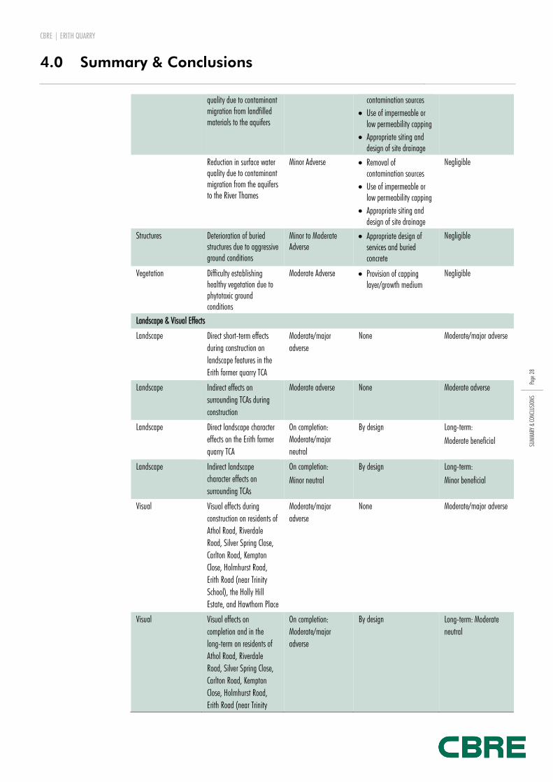
Resources Reduction in groundwater Moderate Adverse Removal of Negligible
CBRE | ERITH QUARRY
4.0 Summary & Conclusions
Page
28
SUM
MAR
Y &
CONC
LUSI
ONS
quality due to contaminant migration from landfilled materials to the aquifers
contamination sources
Use of impermeable or low permeability capping
Appropriate siting and design of site drainage
Reduction in surface water quality due to contaminant migration from the aquifers to the River Thames
Minor Adverse Removal of contamination sources
Use of impermeable or low permeability capping
Appropriate siting and design of site drainage
Negligible
Structures
Deterioration of buried structures due to aggressive ground conditions
Minor to Moderate Adverse
Appropriate design of services and buried concrete
Negligible
Vegetation Difficulty establishing healthy vegetation due to phytotoxic ground conditions
Moderate Adverse Provision of capping layer/growth medium
Negligible
Landscape & Visual Effects
Landscape Direct short-term effects
during construction on
landscape features in the
Erith former quarry TCA
Moderate/major
adverse
None Moderate/major adverse
Landscape Indirect effects on
surrounding TCAs during
construction
Moderate adverse None Moderate adverse
Landscape Direct landscape character
effects on the Erith former
quarry TCA
On completion:
Moderate/major
neutral
By design Long-term:
Moderate beneficial
Landscape Indirect landscape
character effects on
surrounding TCAs
On completion:
Minor neutral
By design Long-term:
Minor beneficial
Visual Visual effects during
construction on residents of
Athol Road, Riverdale
Road, Silver Spring Close,
Carlton Road, Kempton
Close, Holmhurst Road,
Erith Road (near Trinity
School), the Holly Hill
Estate, and Hawthorn Place
Moderate/major
adverse
None Moderate/major adverse
Visual Visual effects on
completion and in the
long-term on residents of
Athol Road, Riverdale
Road, Silver Spring Close,
Carlton Road, Kempton
Close, Holmhurst Road,
Erith Road (near Trinity
On completion:
Moderate/major
adverse
By design Long-term: Moderate
neutral

CBRE | ERITH QUARRY
4.0 Summary & Conclusions
Page
29
SUM
MAR
Y &
CONC
LUSI
ONS
School), the Holly Hill
Estate, and Hawthorn Place
Visual Visual effects during
construction on users of
Birch Walk footpath
Moderate adverse None Moderate adverse
Visual Visual effects on
completion and in the
long-term on users of Birch
Walk footpath
On completion:
Moderate adverse
By design Long-term:
Minor neutral
Visual Visual effects during
construction on users of
Holly Hill open space
Moderate adverse None Moderate adverse
Visual Visual effects on
completion and in the
long-term on users of Holly
Hill open space
On completion:
Moderate adverse
By design Long-term:
Minor neutral
Visual Visual effects during
construction on road users
on Erith Road (northern site
entrance)
Moderate adverse None Moderate adverse
Visual Visual effects on
completion and in the
long-term on road users on
Erith Road (northern site
entrance)
On completion:
Moderate adverse
By design Long-term:
Minor neutral
Transportation
Pedestrian Amenity A206 Fraser Road Minor adverse More defined pedestrian
routes
Neutral
Driver Delay A206 Erith Rd / Brook St
Junction
Moderate adverse Conversion of junction to
mini-roundabout
Minor beneficial
Driver Delay A206 Fraser Rd / A220
Bexley Rd Junction
Moderate adverse Enlarging roundabout Minor beneficial
Driver Delay Erith Roundabout Moderate adverse Widening on Bexley Rd
approach
Major beneficial
Driver Delay A220 Bexley Rd / Brook St
/ Colyers Ln Junction
Moderate adverse Kerb realignment Neutral
Driver Delay A220 Bexley Rd / Park Cres
/ Carlton Rd Junction
Minor adverse Kerb realignment Minor beneficial
Source: Zeta Economics, Ecology Solutions, LandscapeVisual, GB Card, Stomor
SECURING MITIGATION MEASURES
Table NTS9 summarises the specific measures put forward to mitigate the effects of the
development and also identifies the proposed mechanism for securing them. This will
ensure that, should the development be granted planning consent, it would proceed in line
with the assessments made within the ES that have informed the decision of the local
planning authority.

CBRE | ERITH QUARRY
4.0 Summary & Conclusions
Page
30
SUM
MAR
Y &
CONC
LUSI
ONS
Table NTS9
Mechanisms for securing mitigation measures
MITIGATION MEASURE MECHANISM
Construction Environmental Management Plan Planning Condition
Ecological Management & Mitigation Plan Planning Condition
Supplementary intrusive investigation Planning Condition
Remediation strategy & validation of works Planning Condition
Provision of Primary School S106 Legal Agreement
Management Company (Highways, Drainage, Landscape & Ecology) S106 Legal Agreement
Upgrades to off-site junctions Planning Conditions, S38 & S278 Legal Agreement
DETERMINING THE PLANNING APPLICATION
In contrast to normal planning applications, which should be decided upon within either 8
or 13 weeks of submission, those applications accompanied by an ES are to be decided
within 16 weeks of submission.
Further details on the deadlines for making comments on the ES and the planning
application as well as the date on which a decision will be made will be available on LB
Bexley’s website (www.bexley.gov.uk).


