Halton Region Environmental Study Report Trafalgar Road Class EA Study Chapter 3 - Existing and Future Conditions – North of 10 Side Road to Highway 7 MMM Group Limited June 2016 Page 3-1 3 EXISTING AND FUTURE CONDITIONS Background information was collected from numerous sources including: • The review of pertinent background studies and reports; • Data provided by Halton Region; • Investigations undertaken as part of this Class EA study; • Meetings with the Project Team; • Correspondence and meetings with participating Technical Agencies, including the Town of Halton Hills, CN, Metrolinx, Conservation Halton, Credit Valley Conservation; and • Consultation with members of the public, including key stakeholders (e.g. property owners, representatives of churches, etc.). The study area focuses on Trafalgar Road from north of 10 Side Road to Highway 7, and is located within the Town of Halton Hills in Halton Region. Exhibit 1-2 provides a key plan of the study area. Exhibit 3-1 is an aerial mosaic of the study area identifying existing conditions and key features which are discussed in the following sections. 3.1 Transportation 3.1.1 Transportation Network The main components of the existing road network are described in Table 3-1: Table 3-1: Existing Road Network Road Description Trafalgar Road (Regional Road 3) – north of 10 Side Road to Highway 7 • Under the jurisdiction of Halton Region • Major Arterial Road • Mostly a 2-lane rural cross-section • Posted speed ranges between 60 km/h to 80 km/h • Bridge crossing at Black Creek north of 15 Side Road • CN Rail at-grade crossing north of 17 Side Road • Metrolinx at-grade crossing south of Highway 7 • Signalized intersections (from south to north): 15 Side Road, 17 Side Road / Maple Avenue, Princess Anne Drive, and Highway 7 • Few existing provisions for cyclists or pedestrians • Limited illumination • Farming equipment utilize Trafalgar Road 15 Side Road • Minor arterial road, under jurisdiction of the Town of Halton Hills • Signalized intersection at Trafalgar Road • 2-lane roadway east and west of Trafalgar Road 17 Side Road / Maple Avenue • Minor arterial road, under jurisdiction of the Town of Halton Hills • Signalized intersection at Trafalgar Road • 2-lane roadway east and west of Trafalgar Road
Transcript
Halton Region Environmental Study Report Trafalgar Road Class EA Study Chapter 3 - Existing and Future Conditions – North of 10 Side Road to Highway 7
MMM Group Limited June 2016 Page 3-1
3 EXISTING AND FUTURE CONDITIONS
Background information was collected from numerous sources including:
• The review of pertinent background studies and reports; • Data provided by Halton Region; • Investigations undertaken as part of this Class EA study; • Meetings with the Project Team; • Correspondence and meetings with participating Technical Agencies, including the
Town of Halton Hills, CN, Metrolinx, Conservation Halton, Credit Valley Conservation; and
• Consultation with members of the public, including key stakeholders (e.g. property owners, representatives of churches, etc.).
The study area focuses on Trafalgar Road from north of 10 Side Road to Highway 7, and is located within the Town of Halton Hills in Halton Region. Exhibit 1-2 provides a key plan of the study area.
Exhibit 3-1 is an aerial mosaic of the study area identifying existing conditions and key features which are discussed in the following sections.
3.1 Transportation
3.1.1 Transportation Network
The main components of the existing road network are described in Table 3-1:
Table 3-1: Existing Road Network
Road Description Trafalgar Road (Regional Road 3) – north of 10 Side Road to Highway 7
• Under the jurisdiction of Halton Region • Major Arterial Road • Mostly a 2-lane rural cross-section • Posted speed ranges between 60 km/h to 80 km/h • Bridge crossing at Black Creek north of 15 Side Road • CN Rail at-grade crossing north of 17 Side Road • Metrolinx at-grade crossing south of Highway 7 • Signalized intersections (from south to north): 15 Side Road, 17
Side Road / Maple Avenue, Princess Anne Drive, and Highway 7
• Few existing provisions for cyclists or pedestrians • Limited illumination • Farming equipment utilize Trafalgar Road
15 Side Road • Minor arterial road, under jurisdiction of the Town of Halton Hills • Signalized intersection at Trafalgar Road • 2-lane roadway east and west of Trafalgar Road
17 Side Road / Maple Avenue
• Minor arterial road, under jurisdiction of the Town of Halton Hills • Signalized intersection at Trafalgar Road • 2-lane roadway east and west of Trafalgar Road
Halton Region Environmental Study Report Trafalgar Road Class EA Study Chapter 3 - Existing and Future Conditions – North of 10 Side Road to Highway 7
MMM Group Limited June 2016 Page 3-2
Road Description 20 Side Road • Local road, under jurisdiction of the Town of Halton Hills
• One-way stop-controlled T-intersection at Trafalgar Road • 2-lane roadway
Highway 7 • Provincial highway under jurisdiction of MTO • Signalized T-intersection at Trafalgar Road • Southbound right movement via channelized lane, yield
controlled • 4-lane roadway with turn lanes
3.1.2 Transit
Currently, there are no transit services that operate on Trafalgar Road between 10 Side Road and Highway 7.
3.1.3 Active Transportation
There are currently no dedicated active transportation facilities along Trafalgar Road between 10 Side Road and Highway 7 to accommodate cyclists or pedestrians; except for pedestrian crossings at signalized intersections.
Halton Region has completed an Active Transportation Master Plan Study to create a 20-year vision for active transportation in Halton Region. As part of the Trafalgar Road corridor improvements, features of active transportation were considered, such as paved shoulders, on-road bike lanes, multi-use paths, and sidewalks for pedestrians and cyclists.
3.1.4 Railway Crossings
There are two at-grade rail crossings on Trafalgar Road; one at the CN crossing north of 17 Side Road/Maple Avenue and the other at Metrolinx crossing south of Highway 7. Current daily operations are as follows:
Both CN and Metrolinx have noted the potential for future railway expansion; however, there is no confirmed implementation schedule at this time. Metrolinx is intending to initiate an EA Study for the planning of the improvements on the Kitchener Line.
Trafalgar Road is currently experiencing significant delays during peak periods at these rail crossings, with delays expected to rise in the future due to increased operations by CN and Metrolinx in combination with population growth and future development.
15 S
IDE R
OA
D
THE CLUB OFTHE CLUB OF
NORTH HALTONNORTH HALTON
THE CLUB OF
NORTH HALTON
STEWARTTOWNSTEWARTTOWN
PUBLIC SCHOOLPUBLIC SCHOOL
STEWARTTOWN
PUBLIC SCHOOL
Steep Grade Existing at-gradecrossing (1 track)
BLACK CREEK
ExistingRetaining Walls
Existing at-gradecrossing (2 tracks)
ASHGROVE
GEORGETOWN
20 S
IDE
RO
AD
SIXTH LINESIXTH LINE
HIGHWAY 7
STEWARTTOWN
3-1Existing Conditions /
Key Features PlanNorth of 10 Side Road to Highway 7
Exhibit
TRAFALGAR ROAD CLASS EA STUDY (Section 2)North of 10 Side Road to Highway 7
TRAFALGAR TRAFALGAR
SPORTS COMPLEXSPORTS COMPLEX
TRAFALGAR
SPORTS COMPLEX
HOLY REDEEMERHOLY REDEEMER
CEMETERYCEMETERY
HOLY REDEEMER
CEMETERY
ESTATES OFESTATES OF
BLACK CREEK BLACK CREEK
ESTATES OF
BLACK CREEK
(Residential Subdivisionunder construction)
Not To Scale
Study Area (South Section)
Study Area (North Section)
X Feature Number(See Table 3-2)
LEGEND
ME
TR
OL
INX
(G
O T
RA
NS
IT -
KIT
CH
EN
ER
LIN
E)
(Peak H
ou
r Tra
in S
erv
ice)
STUDY AREA(SECTION 2)
Halton Region Environmental Study Report Trafalgar Road Class EA Study Chapter 3 - Existing and Future Conditions – North of 10 Side Road to Highway 7
MMM Group Limited June 2016 Page 3-4
3.2 Socio-Economic Environment
3.2.1 Existing Communities
Currently, Trafalgar Road between 10 Side Road and 15 Side Road consists of rural areas on both sides of Trafalgar Road. There are some intermittent rural residential properties with direct access to Trafalgar Road. Areas between 15 Side Road and 17 Side Road are part of the Stewarttown community; residential houses adjacent to Trafalgar Road have direct access to the roadway. North of 17 Side Road to Highway 7, lands on the east side of Trafalgar Road are part of the Georgetown community.
3.2.2 Existing Land Use
Land use adjacent to Trafalgar Road between 10 Side Road and Highway 7 are a mix of agricultural, residential (both rural residential and subdivisions), commercial, and industrial land uses, as well as natural open spaces. This section describes the existing and future land use from south to north.
10 Side Road to 15 Side Road
Lands east and west of Trafalgar Road between 10 Side Road and 15 Side Road are primarily agricultural with intermittent residential properties. Lands to the east of Trafalgar Road between 10 Side Road and 15 Side Road are within the Vision Georgetown Plan, which are designated for future development.
Stewarttown Public School and St. John’s Anglican Church are situated in the southeast and southwest quadrants of the 15 Side Road intersection, respectively. The northeast and northwest quadrants are residential properties. St. John’s Anglican Church has direct right-in, right-out access to Trafalgar Road and access to 15 Side Road. Accesses to Stewarttown Public School are from 15 Side Road only.
15 Side Road to 17 Side Road
Lands east and west of Trafalgar Road between 15 Side Road and 17 Side Road are part of the Stewarttown community. Land uses are largely low residential uses (i.e. detached houses). Most of the houses that are adjacent to Trafalgar Road have direct full move access to the roadway.
The crossing of Black Creek is located approximately 500 m north of 15 Side Road.
The St. John Cemetery is located approximately 300 m north of 15 Side Road. The cemetery is not visible from Trafalgar Road as it is situated on a hill on the east side of the retaining wall south of Black Creek (i.e. top of slope beyond the retaining wall). Access to the cemetery is via the adjacent property and a flight of stairs.
The Club at North Halton Golf and Country Club is located on the east side of Trafalgar Road between Black Creek and Maple Avenue. Access to the golf club is from Maple Avenue.
Halton Region Environmental Study Report Trafalgar Road Class EA Study Chapter 3 - Existing and Future Conditions – North of 10 Side Road to Highway 7
MMM Group Limited June 2016 Page 3-5
17 Side Road to Highway 7
There are two at-grade rail crossings along this section of Trafalgar Road – CN railway crossing north of 17 Side Road and Metrolinx crossing just south of Highway 7; both are gated crossings. The CN crossing has two rail tracks and the Metrolinx crossing has a single track.
Between 17 Side Road and Highway 7, lands immediately north of 17 Side Road on the west side of Trafalgar Road are part of the Trafalgar Sports Complex. The Trafalgar Sports Complex is home to several soccer fields and a baseball diamond. There are plans for future expansion of the Sports Complex for additional sports facilities to service the community. Accesses to the Sports Complex are from Trafalgar Road and 17 Side Road. Deveraux House, a designated heritage property on the west side of Trafalgar Road, and is located immediately south of the access to the Sports Complex. Currently, Deveraux House can be accessed via Trafalgar Road or via the Sports Complex.
North of the Sports Complex, on the west side of Trafalgar Road, land uses include the J.S. Jones & Son Funeral Home and the Town of Halton Hills Works Yard; both facilities have direct full move access to Trafalgar Road.
North of the Town of Halton Hills works yard, lands on the west side of Trafalgar Road are largely agricultural uses with a few residential houses in the southwest quadrant of Trafalgar Road / 20 Side Road, which is within the Greenbelt Plan Area.
On the east side of Trafalgar Road, lands are largely within the Georgetown community. While many residential properties are part of relatively newer subdivisions where they are reverse frontage along Trafalgar Road, there are some older residential properties with direct access to Trafalgar Road.
The Christian Reformed Church of Georgetown and the Halton Hills Christian School are located approximately 700 m north of 17 Side Road with direct full move access to Trafalgar Road.
In the northeast quadrant of Trafalgar Road / Lindsay Court, there is a municipal water pumping station with access from Lindsay Court. There is also a long term care facility in the southeast quadrant of Trafalgar Road / Highway 7. The main access to the long term care facility is currently on Highway 7; however, this was intended to be a temporary access until such time when the Trafalgar Road / Lindsay Court is reconstructed to address sight line issue. MTO has reiterated this intent and will require the entrance to be closed following completion of Trafalgar Road construction.
3.2.3 Future Land Use
Within the study area, the only lands to east of Trafalgar Road between 10 Side Road and 15 Side Road are designated for future residential development as part of Vision Georgetown (see Section 2.1.8). The study area of Vision Georgetown is bounded by Trafalgar Road, Eighth Line, 10 Side Road and 15 Side Road. The planning study is ongoing to identify future land use designation and transportation network. Thereafter, development applications will be subject to approval by the Town of Halton Hills and Halton Region. Future intersections along Trafalgar Road have not yet been identified or
Halton Region Environmental Study Report Trafalgar Road Class EA Study Chapter 3 - Existing and Future Conditions – North of 10 Side Road to Highway 7
MMM Group Limited June 2016 Page 3-6
approved and will be accommodated as development planning proceeds and Regional reviews are completed.
North of 17 Side Road / Maple Avenue, on the east side of Trafalgar Road, south of the CN tracks, lands are designated for future development; namely the Humberstone lands. Townhouses and condominium are proposed on the site. Zoning By-law Amendment and Draft Plan of Subdivision applications were submitted for the Humberstone lands in February 2015 for the development of townhouse and condominium units. The portion of the lands proposed to contain the condominium units has been deferred pending the completion of the Trafalgar Road Class EA. The applications are currently being reviewed by staff for the proposed townhouse units
There are proposed future residential developments on the east side of Trafalgar Road south of Lindsay Court. The development application is not yet approved and is subject to review by the Town of Halton Hills, MTO and Halton Region.
It should be noted that an OMB decision was issued on March 29, 2016 regarding the Official Plan Amendment and Zoning By-law Amendments to permit a medium density residential development on these lands, thereby approving By-law No. 2016-0019 to adopt OPA No. 28 and By-law No. 2016-0020 to rezone the subject properties. These documents are attached for the reference of the project team.
By-law No. 2016-0020 includes a holding provision which may be lifted subject to conditions related to the design and construction of Trafalgar Road, Lindsay Court, and emergency access to Highway 7. Details regarding by-law No. 2016-0020 is available from the Town of Halton Hills.
3.2.4 Noise
There are Noise Sensitive Areas (NSAs) located within the study limits. A noise analysis has been carried out as part of this Class EA Study (see Section 7.2.3).
It should be noted that noise analysis will have to be prepared for new residential development (i.e. within Vision Georgetown) on the east side of Trafalgar Road as part of the development site plan approval process. Therefore, noise analysis for any new residential developments along the Trafalgar Road corridor was not carried out as part of the EA Study.
3.2.5 Pedestrian and Cycling Facilities
As noted in Section 3.1.3, Trafalgar Road within the Study Area is largely a 2-lane roadway with a rural cross section with few existing active transportation facilities along Trafalgar Road to accommodate cyclists or pedestrians. An active transportation strategy has been considered in this study.
Halton Region Environmental Study Report Trafalgar Road Class EA Study Chapter 3 - Existing and Future Conditions – North of 10 Side Road to Highway 7
MMM Group Limited June 2016 Page 3-7
3.3 Natural Environment
3.3.1 Study Approach
A thorough natural environment assessment was carried out as part of the Trafalgar Road EA Study. Field investigations and the existing conditions assessment was completed for the entire corridor between Steeles Avenue and Highway 7. A summary of the findings are documented in this section and the Natural Environment Report is included in Appendix E. While most of the discussion are related to the greater study area between Steeles Avenue and Highway 7; some of the discussions in this section (specifically the Exhibits) will be focused on the section of Trafalgar Road between north of 10 Side Road and Highway 7 only.
3.3.1.1 Background Data Collection and Analysis
Background information was reviewed to assess the general character of the Study Area, identify potential constraints and sensitivities, and assess the general connectivity of natural features within the study limits to features within the surrounding landscape.
Background natural environment information collection included the following key sources:
• Trafalgar Road EA Study- 10 Side Road to Highway 7, Region of Halton (Various Reports 2004-2006);
• Silver Creek Subwatershed Study Phase 1 Characterization Report (CVC 2002); • Black Creek Subwatershed Background Report Study (CVC 2009); • Halton Region Environmentally Sensitive Areas Consolidation Report (Halton
2005); • Trafalgar Road Animal Road Collision Data. (Halton Region 2014); • Sixteen Mile Creek Monitoring Study (Dunn and Jamieson Undated); • MNRF Natural Heritage Information Centre (NHIC) Land Information Ontario
mapping (2014); • MNRF Species at Risk website - regional Species at Risk list (2014); • MNRF Land Information Ontario (LIO) (2014); • Regional Official Plan (ROP) Consolidation 2013 (Halton Region 2013); • Halton Region Official Plan (Halton Region 2009); • Department of Fisheries and Oceans (DFO) Distribution of Species at Fish and
Mussel Species at Risk Mapping, Credit Valley Conservation and Conservation Halton Authority Jurisdictions (2014); and
• Digital air photos
3.3.1.2 Aquatic and Fish Habitat Survey Approach
Field investigations of aquatic features within the study area were conducted on June 23 and September 15, 2014 by MMM Group ecologists. The compiled background information, including comments and input from agencies, was considered specifically in developing and undertaking the field program. As listed in Section 3.3.1.1, SAR information discussed below was obtained from a variety of background information sources. All watercourse and drainage features crossing Trafalgar Road within the study area were assessed and habitat mapped approximately 50 m upstream and 50 m downstream of Trafalgar Road where access was permitted. Within the remainder of the
Halton Region Environmental Study Report Trafalgar Road Class EA Study Chapter 3 - Existing and Future Conditions – North of 10 Side Road to Highway 7
MMM Group Limited June 2016 Page 3-8
study area, all mapped watercourse features visible on aerial photography were assessed generally for habitat characteristics and quality from roadsides. Watercourse assessments included the following habitat parameters (where applicable):
• Flow condition, clarity, general gradient and velocities; • Channel dimensions and general character; • Morphology (e.g., riffles, pools); • Cover opportunities (i.e., woody debris, undercut banks, boulders, aquatic
vegetation); • Substrate type; • Bank height, character and stability/evidence of erosion; • Riparian vegetation; • Any observations of fish presence and/or barriers to fish movement; • Potential specialized and important habitat areas including potential spawning
habitat, good nursery cover, holding habitat (deeper refuge pools); • Evidence of groundwater discharge or indicators; and • Disturbances, habitat limitations and potential habitat enhancement
opportunities.
Fish community surveys were not undertaken, as existing fish community data were available from numerous previous reports (see Section 3.3.1.1) in the study area. The available background information was deemed sufficient to categorize these watercourses without requiring additional fish community surveys.
3.3.1.3 Vegetation Survey Approach
A two-season vegetation assessment and botanical inventories were undertaken on June 23, June 24, July 10, September 18 and September 19, 2014 within the study area (Right-of-Way and adjacent 120 m on either side, and select properties where permission to enter (PTE) was granted). For those properties in which access was not granted, vegetation communities were characterized by: existing available characterization information from previous studies, air photo interpretation, or by roadside survey (closest available vantage point).
The scope of vegetation fieldwork and analyses included the following:
• Classifying and mapping vegetation communities according to the Ecological Land Classification (ELC) System for Southern Ontario (Lee et. al., 1998);
• Evaluating vegetation community significance using Natural Heritage Resources of Ontario: Vegetation Communities of Southern Ontario (Bakowsky 1996) and vegetation community significance listed on the NHIC website at the time of report preparation. A vascular plant species list was prepared based on the botanical inventory work.
• Evaluating plant species status was using the rankings within The Vascular Plants of Halton Region (Halton Natural Areas Inventory 2006) for regional significance; the Rare Vascular Plants of Ontario, Fourth Edition (Oldham and Brinker 2009) for provincial significance; the current Species At Risk in Ontario List (OMNRF, May 2014) for Ontario species at risk; and, the Species At Risk Act (Schedules 1 and 3), for species at risk in Canada.
Halton Region Environmental Study Report Trafalgar Road Class EA Study Chapter 3 - Existing and Future Conditions – North of 10 Side Road to Highway 7
MMM Group Limited June 2016 Page 3-9
Vegetation characteristics were documented generally for each feature within the study area where information was available.
Vegetation communities between 10 Side Road and Highway 7 are mapped in Exhibits 3-2a and 3-2b.
3.3.1.4 Wildlife Survey Approach
A general field assessment of existing habitat conditions and wildlife use within the study limits was conducted in conjunction with the aquatic and vegetation field surveys. Wildlife surveys were undertaken on April 24, May 15, June 6, June 9, June 12, June 17, June 18, June 23, June 15, and September 16, 2014. Surveys included; avifauna, breeding amphibians, wildlife habitat assessment for SAR and SWH, as well as collection of general wildlife and habitat information. The surveys were carried out within the ROW and on adjacent private properties within 120 m of the ROW, where PTE was obtained.
Avian surveys were conducted to gather breeding bird data and to evaluate the study area for avian habitat potential. Breeding bird surveys were undertaken on June 6, 9, 17, 23, and 25 2014 and were conducted by qualified, experienced staff. The surveys included recording all visual and audible observations as well as the level of breeding bird evidence following standard criteria established by the Ontario Breeding Bird Atlas (OBBA).
Amphibian calling (breeding) activity was surveyed using the Marsh Monitoring Program (MMP) amphibian calling survey protocol (Bird Studies Canada 2003, revised 2009). Surveys were conducted by qualified experienced staff under appropriate conditions (i.e., dusk/evening survey with suitable air temperatures, high humidity or light rain, and low/no wind).
An assessment of existing wildlife habitats was undertaken to consider potential use for Species at Risk (SAR) and Species of Conservation Concern (SCC) known to occur within the vicinity of the study area as well as other wildlife. This included searches for cavity/snag trees and open building structures that may provide suitable roosting/maternity habitat for SAR bats. Existing habitats were also screened for potential as Significant Wildlife Habitat (SWH) as defined in Ecoregion 6E SWH Criterion Schedule (MNRF 2015), including key wildlife movement corridors. Existing structures such as bridges and culverts were also surveyed to document any bird nesting or other wildlife use (e.g. using culverts as a movement corridor).
Supplemental observations of herpetofauna, mammals, and insects were recorded during all field visits. These observations were recorded, including sightings of species, as well as evidence of use (e.g. browse, tracks / trails, scat, burrows, and vocalizations).
Wildlife habitats between 10 Side Road and Highway 7 are mapped in Exhibits 3-3a and 3-3b.
3.3.2 Existing Conditions
Existing natural environmental features between 10 Side Road and Highway 7, including reference to culvert locations, are shown on Exhibit 3-1 and summarized in Table 3-2 (listed in order of location from south to north). Further information can be found in Appendix E (Natural Environment: Appendix H).
Halton Region Environmental Study Report Trafalgar Road Class EA Study Chapter 3 - Existing and Future Conditions – North of 10 Side Road to Highway 7
MMM Group Limited June 2016 Page 3-10
Table 3-2: Summary of Natural Features within the Trafalgar Road EA Study Area (see Exhibit 3-1)
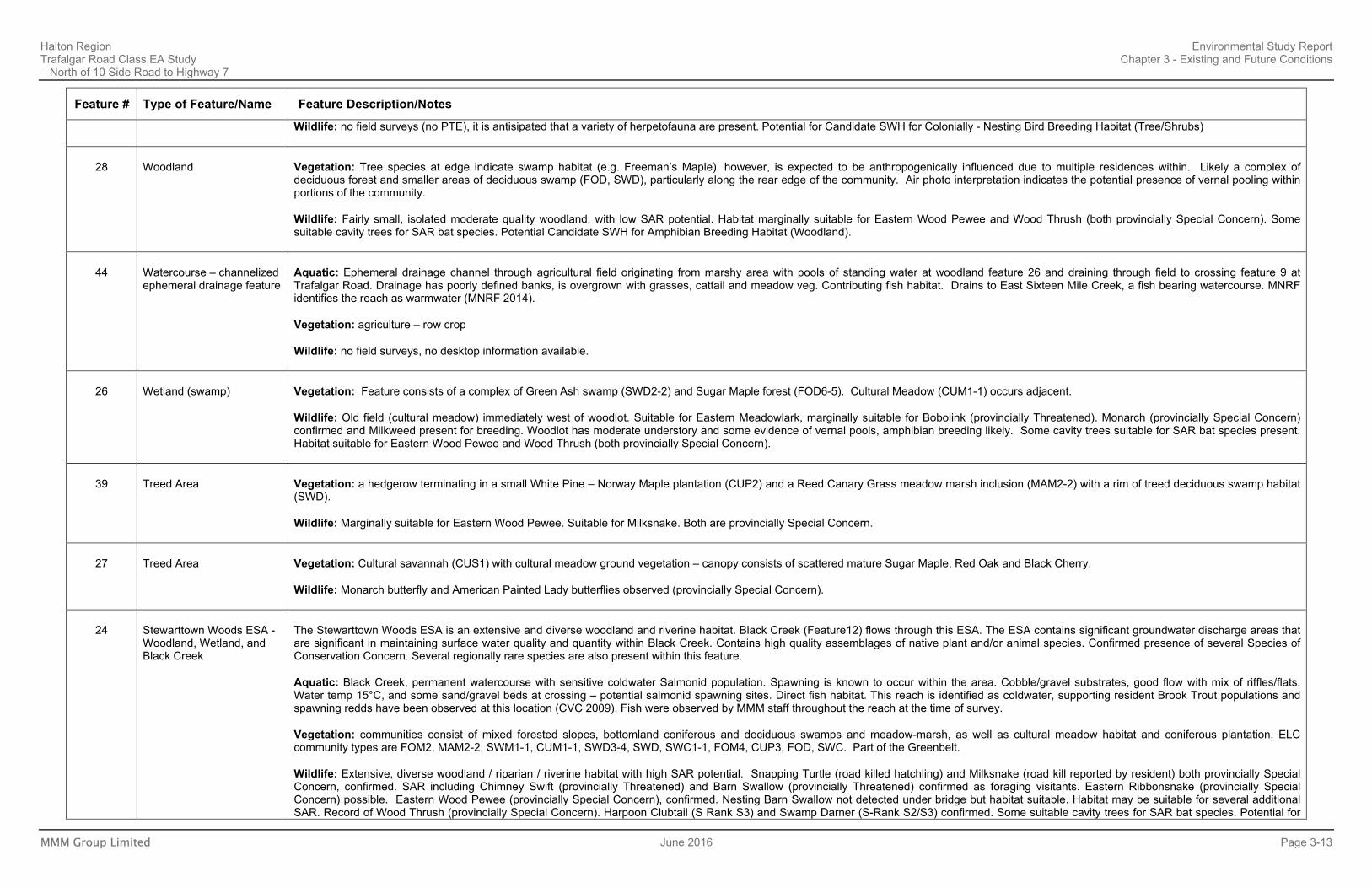
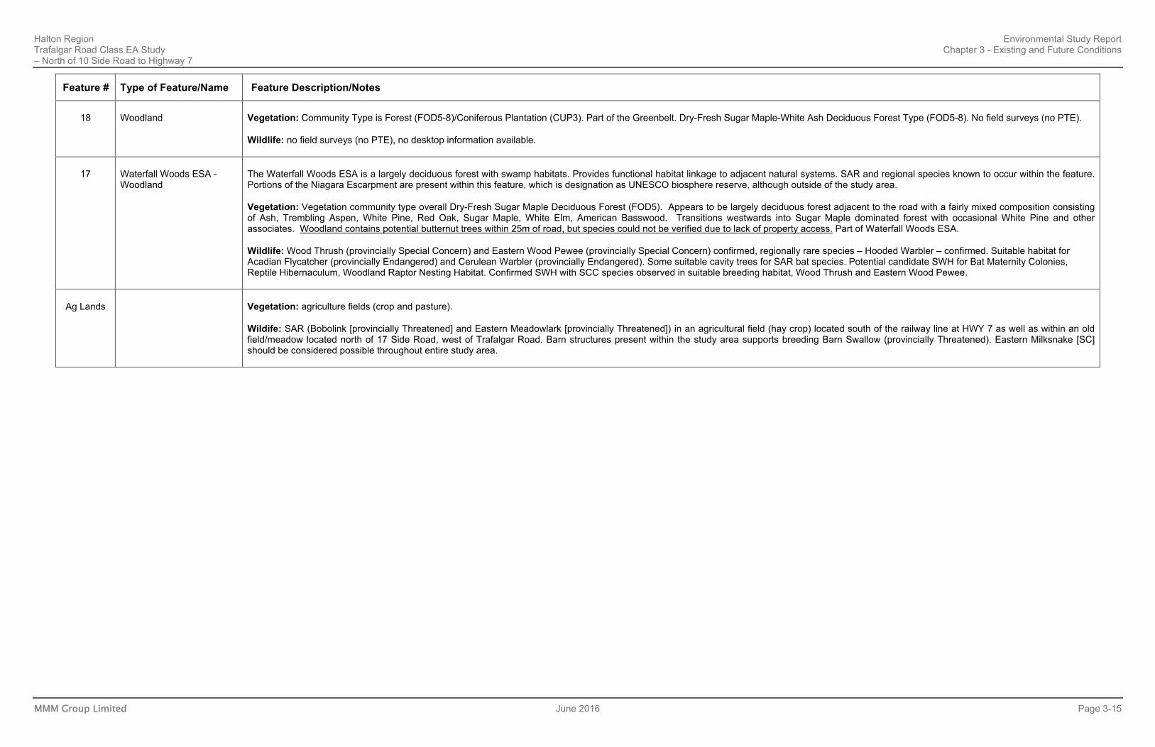
Feature # Type of Feature/Name Feature Description/Notes
8 Watercourse – channelized drain
Aquatic: Shallow intermittent drainage feature. Some standing water, no flow. Channelized drain on downstream sections.. Contributing fish habitat. No fish habitat is present at the Trafalgar Road
crossing, but flow drains to East Sixteen Mile Creek, a fish bearing watercourse. MNRF identifies the reach as coolwater (MNRF 2014) although species records downstream indicate warmwater baitfish
community.
Vegetation: In-stream vegetation dominated by Narrow-leaved Cattail (MAS2-1) or Reed Canary Grass (MAM2-2). A small deciduous swamp occurs near Study Area boundary (SWD).
Wildlife: No SAR potential
9 Watercourse – ephemeral drainage feature
Aquatic: Shallow ephemeral drainage feature with some standing water, no flow. Scouring of banks just downstream of culvert and dry ‘pool’ area ~0.75 m wide indicates high flows at certain times. Contributing fish habitat. Intermittent flow likely prevents fish use, flow drains to East Sixteen Mile Creek, a fish bearing watercourse. MNRF identifies the reach as coolwater (MNRF 2014) although species records downstream indicate warmwater baitfish community.
Vegetation: vegetation associated with the stream channel is low diversity Reed Canary Grass Mineral Meadow Marsh (MAM2-2).
Wildlife: No SAR potential. Culvert unsuitable for nesting birds.
10 Watercourse - ephemeral drainage feature
Aquatic: Shallow ephemeral drainage feature with some standing water, no flow. Some riprap/cobble downstream of culvert, but mostly channelized ditch through cornfield, no cover, earth substrate, no flow. Contributing fish habitat. Ephemeral flow and lack of fish habitat, flow drains to East Sixteen Mile Creek, a fish bearing watercourse.
MNRF identifies the reach as coolwater (MNRF 2014) although species records downstream indicate warmwater baitfish community. Flowing on April 14 2015.
Vegetation: primarily agricultural land use (cultivated field on east side of road, pasture on west) with some very small patches of wetland vegetation associated with low-lying areas of the pasture. Pasture includes some common meadow species such as New-England Aster.
Wildlife: No SAR potential.
11 Hungry Hollow Environmental Sensitive Area (ESA)
The Hungry Hollow Ravine is a deep valley feature with several tributaries of the Credit River, including Black Creek. The feature woodland is extensive and diverse and is comprised of cedar and lush herbaceous layer. Fens, which are considered rare vegetation communities, are present within the ESA. The wooded areas of the ESA are of very high quality. There are excellent examples of mature Sugar Maple forests and mixed forests. The high quality woodlands and floodplain, combined with scenic views of the surrounding landscape, give this area a high aesthetic value. Wetlands within the ESA are designated as PSW, but are located well away from the ROW (outside of study area).
Vegetation: Community Types within Study Area are FOD5 and FOM. Provincially Significant Wetland Complex. Plant communities in the ESA include Cattail Marsh, Shrub Rich Wet Meadow, Southern White Cedar Swamp, Silver Maple Swamp, Rich Sugar Maple-Mixed Hardwood Forest, Eastern Hemlock-Mixed Hardwood Forest, Hawthorn Thicket, Late Successional Old Field. Rare spp in ESA include Finely-pilose Evening-primrose. Numerous regionally rare vegetation species.
A fen community exists within this ESA. Fens are considered to be rare plant communities whenever they occur south of the Canadian Shield.
Wildlife: no field surveys undertaken (no PTE). SAR and several SCC are known to occur within the feature. An abundance of regionally rare species are also present within this feature. Candidate SWH is present as Bat Maternity Colonies, Reptile Hibernaculum, Colonially - Nesting Bird Breeding Habitat (Tree/Shrubs), and Wildlife Movement Corridor (between Units 11 and 24). Confirmed SWH with presence of Seeps and Springs within the feature.
12 Black Creek – permanent watercourse with sensitive resident coldwater salmonid population
Black Creek is a permanent sensitive coldwater watercourse. Salmonids (Brown Trout, Rainbow Trout, and Atlantic Salmon) present with known spawning in the area. Atlantic Salmon is an extinct species that is currently being reintroduced into the Credit River through stocking programs
Aquatic: Sensitive cool/coldwater fish community with the presence of Salmonids (Brown Trout, Brown Trout, Rainbow Trout, Atlantic Salmon). Stewarttown dam (major dam) is present just (~0.5 km) upstream from crossing feature. Substrate mostly cobble – not likely sufficient gravel for salmonid spawning near bridge. Bankfull width average 9 m. Uniform riffle upstream, riffle with large pool (~1 m
Halton Region Environmental Study Report Trafalgar Road Class EA Study Chapter 3 - Existing and Future Conditions – North of 10 Side Road to Highway 7
MMM Group Limited June 2016 Page 3-11
Feature # Type of Feature/Name Feature Description/Notes
deep) downstream. Deep, clear nursery pool with YOY (potentially salmonid) at bank immediately downstream of Trafalgar Rd. Large fish observed in deep downstream pool. Direct fish habitat. This reach is classified as a coldwater stream with resident Brook Trout populations (MNRF 2014, CVC 2009). Contributing habitat to identified Redside Dace habitat at confluence with The Credit River West Branch approx. 2 km downstream (CVC 2009).ATOS adult fish (approx. 200 – 300 mm TL) were observed in the large pool downstream and YOY
2 salmonids in the nursery pool just downstream of
Trafalgar Road.
Vegetation: Surrounded in part by the Hungry Hallow ESA (see Feature 11 for vegetation communities).
Wildlife: Potential Candidate SWH as Turtke Wintering Areas. Bridge supports no nesting birds but is suitable for Barn Swallow (provincially Threatened). Watercourse / edge habitat suitable for Louisiana Waterthrush (provincially Special Concern) and upstream habitat likely suitable for Eastern Wood Pewee (provincially Special Concern) and Wood Thrush (provincially Special Concern). Watercourse may be suitable for Rapid’s Clubtail (provincially Endangered) and other provincially rare (S- Rank) odonates.
13 Small wetland/
woodland, NW of Hungry Hollow ESA
Vegetation: Forested slope contains Black Walnut, White Elm, Sugar Maple, and White Ash (FOD5). Swamp (SWD2-1) contains open patches of marshy ground cover largely dominated by Narrow-leaved Cattail, Reed Canary Grass, and Spotted Touch-me-not. Health of ash trees is poor, however, White Elm is also abundant and occasional willow trees are scattered throughout.
Wildlife: Wetland may be suitable for Snapping Turtle (provincially listed as Special Concern) and Milksnake also listed as Special Concern. Roadside surveys did not detect open wetland habitat. It is anticipated to provide habitat for a variety of herpetofaunal species.
25 Woodland, Wetland (Swamp), and Watercourse
Vegetation: Consists primarily of Black Walnut, American Ash and Black Locust, with Freeman’s Maple also observed. A butternut (provincially Endangered) was observed at the eastern edge of the community and additional butternuts are suspected in the interior. Community Type is FOD7.
Wildlife: Small, isolated and fairly low quality woodland, with low SAR potential. Habitat marginally suitable for Eastern Wood Pewee and Wood Thrush (both provincially Special Concern). Potential Candidate SWH for Amphibian Breeding Habitat (woodlands).
Aquatic: Intermittent coldwater creek in steep wooded valley. Iron floc indicators of groundwater seepage. Wetted channel <1 m, bankfull width ~2.5-3 m. No fish observed. Rocky substrates with stabilized banks and a concrete dam barrier present downstream. Significant groundwater inputs (visible seeps and Watercress). Watercourse is connected to Black Creek and fish were observed by MMM staff at the field survey throughout the reach of the tributary below the waterfall barrier (within the golf course). MNRF identifies the reach as coldwater (MNRF 2014).
41 Woodland Vegetation: Consists of a mix of young to mid-age deciduous forest (FOD7) with areas of regeneration within cultural meadow habitat; situated on rolling topography; may include small portions of swamp habitat in bottomland stream areas.
Wildlife: no field surveys (no PTE), no desktop information available.
14 Watercourse crossing (intermittent) and small wetland
Aquatic: Intermittent watercourse. No defined channel upstream – small trickle through dense Phragmites. Defined channel downstream flows onto private residential property (no PTE). Stone bank stabilization and riprap instream. Culvert outlet slightly perched, low flow seasonal barrier. Contributing fish habitat. Low quality habitat. This watercourse continues to Feature #25 with very low flows and is piped for approx. 170 m upstream of confirmed fish use on the golf course. MNRF identifies the reach as coldwater (MNRF 2014). Fish collection records indicate the watercourse supports a warmwater fish community. CVC observed iron staining (groundwater indicator) upstream of culvert.
Vegetation: Vegetation adjacent to the road consists of a European Reed-dominated marsh (MAMM1-12*) and cultural meadow (CUM1-1). Aerial photography indicates there is an open pond in the interior. On the east side of the crossing vegetation consists of a small deciduous swamp with a Willow species and Black Walnut (SWD4).
Wildlife: Wetland may be suitable for Snapping Turtle and Milksnake (both provincially Special Concern). No other SAR potential.
21 Cultural Meadow Vegetation: Recent air photo interpretation and roadside surveys indicate majority of the small woodland that was previously located in this area has been removed for development. Background data indicates community type is Cultural. Mineral cultural thicket with less than 25% tree cover and more than 25% shrub cover with anthropogenic influence due to domestic species such as apple and pear.
2 YOY- Young of the Year
Halton Region Environmental Study Report Trafalgar Road Class EA Study Chapter 3 - Existing and Future Conditions – North of 10 Side Road to Highway 7
MMM Group Limited June 2016 Page 3-12
Feature # Type of Feature/Name Feature Description/Notes
No field surveys (no PTE).
Wildlife: no field surveys (no PTE), no desktop information available.
19 Woodland and intermittent watercourse
Vegetation: A forested ravine community consisting primarily of a mix of Sugar Maple, Ash species, and Black Cherry. Near the road, Ash, White Birch, and Sugar Maple are most abundant. A culvert drains to bottomland in the center of the community where Reed Canary Grass dominates. Seepage areas with an abundance of Spotted Touch-me-not occur in the interior. Transitions to southeast into SWM areas dominated by marsh vegetation. ELC community types are FOD5-8 and MAM2-2. One vascular plant species considered rare in Halton Region was observed during field surveys: Hackberry (Celtis occidentalis). The observation was a planted specimen associated with SWM facilities near Natural Heritage Feature #19.
Wildlife: Moderate size / quality deciduous woodland. Potential for Wildlife Movement Corridor (between 19 and 15). Candidate SWH for Amphibian Breeding Habitat (woodland). Confirmed SWH with presence of SCC Eastern Wood Pewee in suitable breeding habitat. Suitable for Wood Thrush (provincially Special Concern). Moderate potential for Milksnake (provincially Special Concern). Some suitable cavity trees for SAR bat species.
Aquatic: Intermittent channel present draining from Feature 15, crossing Trafalgar road through PVC culvert with concrete collar, and through feature 19. Standing water, no flow. Rip rap/boulder rock protection present. Both up and downstream flow through deciduous forest woodlots with ~100% canopy cover. Downstream, substrates were sand, cobble, and boulder with a bankfull width ~1.5-2.0 m. Some iron staining was observed in a pool on the downstream side, indicating possible groundwater seepages.CVC notes large boulders and concrete channel at downstream culvert. Contributing fish habitat, low or no flows exclude direct fish use, at least seasonally. Watercourse drains to fish bearing tributary of Black Creek. MNRF identifies the reach as coolwater (MNRF 2014). Flowing on April 14 2015.
*Features 15 and 19 (located on other side of Trafalgar Road) are essentially one unit
15 Woodland Vegetation: Deciduous forest consisting of Sugar Maple with Basswood, American Beech, Trembling Aspen, and American Ash associates (FOD5-1).
Wildlife: Moderate size / quality deciduous woodland. Suitable for Eastern Wood Pewee (provincially Special Concern) and Wood Thrush (provincially Special Concern). Moderate potential for Milksnake (provincially Special Concern). Potential Candidate SWH for Wildlife Movement Corridor (between 15 and 19).
*Features 15 and 19 (located on other side of Trafalgar Road) are essentially one unit
16 Watercourse Crossing – Tributary of Black Creek (ephemeral)
Aquatic: Ephemeral watercourse with steep sides, especially downstream (~15 m high). Standing water in culvert, wet substrates/no flow, defined channel ~1.8 m bankfull width with sand/gravel/cobble substrate. Indication of frequent high flows. No barriers to fish observed other than no flow. Contributing fish habitat. Low or no flows exclude direct fish use, at least seasonally. Watercourse drains to fish bearing tributary of Black Creek. MNRF identifies the reach as coolwater (MNRF 2014). Feature originates in agricultural fields to the north, flows through a culvert underneath the rail ine to a grassed lawn area. Flows do not appear to be significant as there is only evidence of small pooling at the outlet of the channel. Overland flows from this would continue over the lawn to a large CSP, there is no evidence of scouring, bed or banks. Grass is growing in all areas. The culvert goes under the driveway and outlets to the west of Trafalgar where flows are present. It is possible that openings/cracks in the culvert are allowing for shallow groundwater to enter the culvert. A small channel is present for a few meters before flowing into another culvert and crossing Trafalgar Road.
Vegetation: Cultural meadow (CUM1-1) habitat adjacent to road/rail, with small pockets of Staghorn Sumac thicket and a hedgerow consisting of White Elm, willow, and Pine.
Wildlife: No SAR potential apart from low probability of Milksnake (provincially Special Concern). Monarch (provincially Special Concern) recorded as a fly-by along RR – suitable habitat
42 Treed Area near Lindsay Court Well
Vegetation: Red Oak dominated mid-age forest with White Pine and Sugar Maple associates (FOD5-8).
Wildlife: SAR potential likely very low. Low potential for Eastern Wood Pewee (provincially Special Concern)
29 Wetland (swamp)
Vegetation: Background data indicates Dry-fresh sugar maple-white ash deciduous forest type (J. Whitford Existing Conditions Terrestrial Report. August 2004). No field surveys were undertaken by MMM (no PTE), however, a wetland is identified within the community in MNRF wetland mapping, and air photointerpretation indicates presence of large areas f surface pooling. The feature is therefore asssumed to be a swamp based on available information for the purposes of this study.
Halton Region Environmental Study Report Trafalgar Road Class EA Study Chapter 3 - Existing and Future Conditions – North of 10 Side Road to Highway 7
MMM Group Limited June 2016 Page 3-13
Feature # Type of Feature/Name Feature Description/Notes
Wildlife: no field surveys (no PTE), it is antisipated that a variety of herpetofauna are present. Potential for Candidate SWH for Colonially - Nesting Bird Breeding Habitat (Tree/Shrubs)
28 Woodland Vegetation: Tree species at edge indicate swamp habitat (e.g. Freeman’s Maple), however, is expected to be anthropogenically influenced due to multiple residences within. Likely a complex of deciduous forest and smaller areas of deciduous swamp (FOD, SWD), particularly along the rear edge of the community. Air photo interpretation indicates the potential presence of vernal pooling within portions of the community.
Wildlife: Fairly small, isolated moderate quality woodland, with low SAR potential. Habitat marginally suitable for Eastern Wood Pewee and Wood Thrush (both provincially Special Concern). Some suitable cavity trees for SAR bat species. Potential Candidate SWH for Amphibian Breeding Habitat (Woodland).
Aquatic: Ephemeral drainage channel through agricultural field originating from marshy area with pools of standing water at woodland feature 26 and draining through field to crossing feature 9 at Trafalgar Road. Drainage has poorly defined banks, is overgrown with grasses, cattail and meadow veg. Contributing fish habitat. Drains to East Sixteen Mile Creek, a fish bearing watercourse. MNRF identifies the reach as warmwater (MNRF 2014).
Vegetation: agriculture – row crop
Wildlife: no field surveys, no desktop information available.
26 Wetland (swamp) Vegetation: Feature consists of a complex of Green Ash swamp (SWD2-2) and Sugar Maple forest (FOD6-5). Cultural Meadow (CUM1-1) occurs adjacent.
Wildlife: Old field (cultural meadow) immediately west of woodlot. Suitable for Eastern Meadowlark, marginally suitable for Bobolink (provincially Threatened). Monarch (provincially Special Concern) confirmed and Milkweed present for breeding. Woodlot has moderate understory and some evidence of vernal pools, amphibian breeding likely. Some cavity trees suitable for SAR bat species present. Habitat suitable for Eastern Wood Pewee and Wood Thrush (both provincially Special Concern).
39 Treed Area Vegetation: a hedgerow terminating in a small White Pine – Norway Maple plantation (CUP2) and a Reed Canary Grass meadow marsh inclusion (MAM2-2) with a rim of treed deciduous swamp habitat (SWD).
Wildlife: Marginally suitable for Eastern Wood Pewee. Suitable for Milksnake. Both are provincially Special Concern.
27 Treed Area Vegetation: Cultural savannah (CUS1) with cultural meadow ground vegetation – canopy consists of scattered mature Sugar Maple, Red Oak and Black Cherry.
Wildlife: Monarch butterfly and American Painted Lady butterflies observed (provincially Special Concern).
24 Stewarttown Woods ESA - Woodland, Wetland, and Black Creek
The Stewarttown Woods ESA is an extensive and diverse woodland and riverine habitat. Black Creek (Feature12) flows through this ESA. The ESA contains significant groundwater discharge areas that are significant in maintaining surface water quality and quantity within Black Creek. Contains high quality assemblages of native plant and/or animal species. Confirmed presence of several Species of Conservation Concern. Several regionally rare species are also present within this feature.
Aquatic: Black Creek, permanent watercourse with sensitive coldwater Salmonid population. Spawning is known to occur within the area. Cobble/gravel substrates, good flow with mix of riffles/flats. Water temp 15°C, and some sand/gravel beds at crossing – potential salmonid spawning sites. Direct fish habitat. This reach is identified as coldwater, supporting resident Brook Trout populations and spawning redds have been observed at this location (CVC 2009). Fish were observed by MMM staff throughout the reach at the time of survey.
Vegetation: communities consist of mixed forested slopes, bottomland coniferous and deciduous swamps and meadow-marsh, as well as cultural meadow habitat and coniferous plantation. ELC community types are FOM2, MAM2-2, SWM1-1, CUM1-1, SWD3-4, SWD, SWC1-1, FOM4, CUP3, FOD, SWC. Part of the Greenbelt.
Wildlife: Extensive, diverse woodland / riparian / riverine habitat with high SAR potential. Snapping Turtle (road killed hatchling) and Milksnake (road kill reported by resident) both provincially Special Concern, confirmed. SAR including Chimney Swift (provincially Threatened) and Barn Swallow (provincially Threatened) confirmed as foraging visitants. Eastern Ribbonsnake (provincially Special Concern) possible. Eastern Wood Pewee (provincially Special Concern), confirmed. Nesting Barn Swallow not detected under bridge but habitat suitable. Habitat may be suitable for several additional SAR. Record of Wood Thrush (provincially Special Concern). Harpoon Clubtail (S Rank S3) and Swamp Darner (S-Rank S2/S3) confirmed. Some suitable cavity trees for SAR bat species. Potential for
Halton Region Environmental Study Report Trafalgar Road Class EA Study Chapter 3 - Existing and Future Conditions – North of 10 Side Road to Highway 7
MMM Group Limited June 2016 Page 3-14
Feature # Type of Feature/Name Feature Description/Notes
Candidate SWH for Bat Maternity Colonies, Turtle Wintering Areas, Reptile Hibernaculum, Colonially - Nesting Bird Breeding Habitat, Woodland Raptor Nesting Habitat and Wildlife Movement Corridor. Confirmed SWH with the presence of several SCC in suitable breeding habitat including the Swamp Darner, Harpoon Clubtail, Snapping Turtle, and Eastern Wood Pewee. Seeps and Springs are also confirmed to be present in the feature.
23 Woodland and Watercourse
Vegetation: Community Type is Swamp/Cultural (SWD / CUW1) No field surveys (no PTE).
Wildlife: No field surveys (no PTE). Potential Candidate SWH for Bat Maternity Colonies and Amphibian Breeding Habitat (Woodland).
Aquatic: Drainage channel (same as Feature 43). Defined channel has moderate gradient and cobble substrate with a bankfull width of ~1.2 m. Channel has abundant iron floc and temperature was 14°C indicating groundwater-fed coldwater stream. Flows through mixed forest canopy between residential properties. Watercourse is not mapped on available layers. If direct connection to Black Creek downstream and no significant barriers, could support direct fish use. MNRF identifies the reach as coldwater (MNRF 2014)
22 Woodland Vegetation: Mid-age deciduous woodland surrounding residences, likely subject to a fair amount of anthropogenic disturbance. Canopy composition includes American Basswood, Red Oak, Sugar Maple, Hickory, and Ash. Community Type is FOD5-3 and is part of the Greenbelt.
Wildlife: High potential for Wood Thrush and Eastern Wood Pewee (both provincially Special Concern). Eastern Milksnake confirmed – landowner record from approx. 7 years ago. Some suitable cavity trees for SAR bat species
40 Plantation Vegetation: Conifer plantation (CUP3) and residential properties – species composition difficult to see from road but Scotch Pine, Norway Spruce and White Spruce observed...
Wildlife: Appears mostly anthropogenic from roadside – a mix of houses and lawns with apparent conifer plantation. SAR potential likely very low. Will survey in Sept.
43 Watercourse - ephemeral drainage feature
Aquatic: Ephemeral drainage feature with dense grasses/meadow vegetation west of a mowed lawn/cemetery. Some standing water, very low flow through overgrown channel with grasses and Cattail. Channel drains south across the road and eventually into Feature 23 (same watercourse). Likely provides indirect fish habitat.
Vegetation: Cultural meadow dominated banks with Reed Canary Grass and Cattail in channel; adjacent farm field contains small depressional Cattail and Reed Canary Grass marshes.
Wildlife: no field surveys, no desktop information available.
45 Wetland Vegetation: Feature is comprised of MAS 2-1 Cattail Mineral Shallow Marsh. Small depressional area in agricultural field.
Wildlife: Amphibian breeding was confirmed within this feature. Several species were heard calling including Northern Leopard frog, American toad, gray tree frog, spring peeper, wood frog. Anticipated to provide limited habitat for other wildlife species.
20 Wetland/
Woodland
Vegetation: Feature consists of two contiguous community types, Sugar Maple dominated Forest and Freeman’s Maple dominated swamp (FOD5-8 and SWD3-3). The FOD5-8 consists of Sugar Maple dominated canopy with White Ash as the primary associate, with varying amounts of White Pine, Black Cherry, Eastern Hop-hornbeam, Paper Birch, and American Beech. The mid-age swamp (SWD3-3) is dominated by Freeman’s Maple with occasional Eastern Hemlock, and rare occurrences of Green Ash, Red Maple, and Paper Birch. American Elm is abundant in the subcanopy. Ground vegetation is dominated by Orange Jewelweed, with Panicled Aster, Devil’s Beggar’s Ticks, Hairy Willow Herb (Epilobium ciliatum ssp ciliatum), Wild Lily-of-the-valley (Maianthemum canadense),
Sensitive Fern, Climbing Nightshade, Spinulose Woodfern, and Wild Sarsaparilla (Aralia nudicaulis). Along its interface with the FOD5-8, several distinct pools (dry) were observed.
Wildlife: A variety of amphibian species are likely to breed within seasonal pools within the feature, although no targeted surveys were undertaken as access was not available during the breeding amphibian calling season.
On April 14 2015 spring peepers were heard calling, standing water was also present throughout the wetland areas. Habitat very likely to provide SWH.
Halton Region Environmental Study Report Trafalgar Road Class EA Study Chapter 3 - Existing and Future Conditions – North of 10 Side Road to Highway 7
MMM Group Limited June 2016 Page 3-15
Feature # Type of Feature/Name Feature Description/Notes
18 Woodland Vegetation: Community Type is Forest (FOD5-8)/Coniferous Plantation (CUP3). Part of the Greenbelt. Dry-Fresh Sugar Maple-White Ash Deciduous Forest Type (FOD5-8). No field surveys (no PTE).
Wildlife: no field surveys (no PTE), no desktop information available.
17 Waterfall Woods ESA - Woodland
The Waterfall Woods ESA is a largely deciduous forest with swamp habitats. Provides functional habitat linkage to adjacent natural systems. SAR and regional species known to occur within the feature. Portions of the Niagara Escarpment are present within this feature, which is designation as UNESCO biosphere reserve, although outside of the study area.
Vegetation: Vegetation community type overall Dry-Fresh Sugar Maple Deciduous Forest (FOD5). Appears to be largely deciduous forest adjacent to the road with a fairly mixed composition consisting of Ash, Trembling Aspen, White Pine, Red Oak, Sugar Maple, White Elm, American Basswood. Transitions westwards into Sugar Maple dominated forest with occasional White Pine and other associates. Woodland contains potential butternut trees within 25m of road, but species could not be verified due to lack of property access. Part of Waterfall Woods ESA.
Wildlife: Wood Thrush (provincially Special Concern) and Eastern Wood Pewee (provincially Special Concern) confirmed, regionally rare species – Hooded Warbler – confirmed. Suitable habitat for Acadian Flycatcher (provincially Endangered) and Cerulean Warbler (provincially Endangered). Some suitable cavity trees for SAR bat species. Potential candidate SWH for Bat Maternity Colonies, Reptile Hibernaculum, Woodland Raptor Nesting Habitat. Confirmed SWH with SCC species observed in suitable breeding habitat, Wood Thrush and Eastern Wood Pewee.
Ag Lands Vegetation: agriculture fields (crop and pasture).
Wildife: SAR (Bobolink [provincially Threatened] and Eastern Meadowlark [provincially Threatened]) in an agricultural field (hay crop) located south of the railway line at HWY 7 as well as within an old field/meadow located north of 17 Side Road, west of Trafalgar Road. Barn structures present within the study area supports breeding Barn Swallow (provincially Threatened). Eastern Milksnake [SC] should be considered possible throughout entire study area.
TRAFALGAR ROAD CLASS EA STUDY (Section 2) North of 10 Side Road to Highway 7
3-2aVegetation Communities -
Ecological Land Classification
Exhibit
See Trafalgar Road Environmental Study Report
Steeles Avenue to North of 10 Side Road
3-2bVegetation Communities -
Ecological Land ClassificationTRAFALGAR ROAD CLASS EA STUDY (Section 2)North of 10 Side Road to Highway 7
Exhibit
TRAFALGAR ROAD CLASS EA STUDY (Section 2) North of 10 Side Road to Highway 7
Natural Heritage Features - Wildlife Habitat 3-3a
Exhibit
See Trafalgar Road Environmental Study Report
Steeles Avenue to North of 10 Side Road
3-3bNatural Heritage Features -
Wildlife HabitatTRAFALGAR ROAD CLASS EA STUDY (Section 2) North of 10 Side Road to Highway 7
Exhibit
Halton Region Environmental Study Report Trafalgar Road Class EA Study Chapter 3 - Existing and Future Conditions – North of 10 Side Road to Highway 7
MMM Group Limited June 2016 Page 3-20
3.3.2.1 Environmentally Designated Areas
Several overlapping natural heritage features and designated policy areas are present within the study area. These include:
Policy Plan Areas
The greater Study Area between Steeles Avenue and Highway 7 falls partially within the Niagara Escarpment Plan Area and the Greenbelt Plan Area:
• Greenbelt Plan Natural Heritage System (2005) - Protected Countryside – Portions of the study area, specifically on the west of Trafalgar Road between 17 Side Road and Highway 7, are designated under the Greenbelt Plan Natural Heritage System ‘Protected Countryside’.
• Niagara Escarpment Plan Area (2005)- Rural Area – A small portion of the study area located on the west side of Trafalgar Road north of 20 Side Road is designated under the Niagara Escarpment Plan, Rural Area.
Provincially Designated Features
Floodplain regulation areas governed by the Regulation of Development, Interface with Wetlands and Alterations to Shorelines and Watercourses (Ontario Regulation 160/06 and 162/06, respectively) are present within the study area.
Regional and Municipal Designated Features
Regionally and municipally designated features include those features identified as regionally or locally Significant in the Halton Region and / or the Town of Halton Hills Official Plans. Regionally and municipally designated features identified within the study area are as follows:
• Hungry Hollow ESA – The Hungry Hollow Ravine is a deep valley feature with several tributaries of the Credit River, including Black Creek. The feature woodland is extensive and diverse and is comprised of mature Sugar Maple forests and mixed forests and a lush herbaceous layer.
• Waterfalls Woods ESA – A largely deciduous forest with swamp habitats located west of Trafalgar Road on 20 Side Road. Provides functional habitat linkage to adjacent natural systems. SAR and regional species known to occur within the feature. Portions of the Niagara Escarpment are present within this feature, which is designated as a UNESCO biosphere reserve, although outside of the study area.
• Stewarttown Woods ESA – Extensive and diverse woodland and riverine habitat located west of Trafalgar Road primarily between 15 Side Road and 17 Side Road. Black Creek flows through this ESA.
• Hornby Swamp Wetland Complex (locally significant wetland) – Located east of Trafalgar Road, north of Hornby Road. Consists of deciduous swamp with a small open natural area adjacent to the road. Identified as a Regional Wetland.
3.3.2.2 Physiography and Soils
The Niagara Escarpment, located approximately 6 km northwest of the greater Study Area (i.e. Steeles Avenue to Highway 7), is the most significant physiographic feature within the region. Within the study area, two physiographic regions are present, the Peel
Halton Region Environmental Study Report Trafalgar Road Class EA Study Chapter 3 - Existing and Future Conditions – North of 10 Side Road to Highway 7
MMM Group Limited June 2016 Page 3-21
Plain in the south and South Slope in the north. The Peel Plain represents areas that were once covered by a pre-glacial lake (Glacial Lake Peel), whereby shallow water deposits (silt and clay) overlie deeper glacial till units, and bedrock. This region consists of flat to undulating terrain, whereby this plain has a very gentle slope to the southeast, towards Lake Ontario. As per Chapman and Putnam (1984), much of the Peel Plain is underlain by poorly drained clay soils, however select regions have sandy sub- soils. The South Slope differs from the Peel Plain in that the glaciolacustrine deposits are absent and glacial till is typically the surficial geological unit. Again, this area consists of undulating terrain (drumlinized to bevelled till plains), with a very gentle slope towards Lake Ontario - however the plain is characterized by flutings (subtle elongated ridges and valleys) and localized drumlins.
Additional detail, including bedrock geology, is provided in Appendix N Hydrogeology Report.
3.3.2.3 Surface Drainage and Watershed Characteristics
The greater Study Area (between Steeles Avenue and Highway 7) lies within two watershed systems; Credit River (Credit Valley Conservation) and 16 Mile Creek (Halton Region Conservation). Within the Credit River watershed portion of the study area, Black Creek is the dominant watercourse feature. Within the 16 Mile Creek watershed (Middle Branch), the Hornby Tributary is the dominant watercourse feature. Both of these features are classified as permanent watercourses.
Black Creek Subwatershed
The Black Creek subwatershed is approximately 79.28 sq. km in area and is a major tributary of Silver Creek intercepting it in the west end of Georgetown. Silver Creek is a tributary to the Credit River (CVC 2009). The headwaters of Black Creek originate at Fairy Lake in the Town of Acton. The majority of the watercourse flows through undulating terrain and crosses over the Niagara Escarpment between Acton and Georgetown. Groundwater supports baseflow of the creek and maintains cool/coldwater thermal characteristics. Black Creek contains sensitive coldwater salmonids, specifically, Brown Trout (Salmo trutta), Brook Trout (Salvelinus fontinalis), Rainbow Trout (Oncorhynchus mykiss), and Atlantic Salmon (Salmo salar) (through stocking efforts by MNRF). Black Creek is currently managed as a mixed coldwater/coolwater system under the Credit River Fisheries Management Plan (MNRF & CVC 2002). Land use within the subwatershed is predominantly agriculture, with some naturalized areas (woodlands and wetlands), rural residential and urban (Acton, Stewarttown and Georgetown).
In addition to Black Creek, within the study area there are 3 tributaries of Black Creek present, two of which cross Trafalgar Road.
16 Mile Creek Subwatershed (Middle and Middle East Branches):
The Sixteen Mile Creek watershed is located at the western end of Lake Ontario. It drains approximately 372 km² of land within nine distinct sub-watersheds (Dunn and Jamieson Undated). The main branches of the creek originate from wetlands and forested swamps associated with the Niagara Escarpment. The tributaries within the study area generally support warmwater baitfish species. The Middle Branch of 16 Mile Creek is known to be occupied by Redside Dace (Clinostomus elongates) a species
Halton Region Environmental Study Report Trafalgar Road Class EA Study Chapter 3 - Existing and Future Conditions – North of 10 Side Road to Highway 7
MMM Group Limited June 2016 Page 3-22
listed as Endangered provincially, and therefore afforded protection under the Endangered Species Act (2007). Land use within the subwatershed is predominantly agriculture, with some naturalized areas (woodlands and wetlands), rural residential, becoming predominantly urban south of the study area as it flows through several Greater Toronto Area (GTA) communities.
The main associated watercourse within the study area is the Hornby Tributary. There are an additional 9 tributaries present within the study area associated with either the middle or east branches of 16 Mile Creek, 7 of which cross Trafalgar Road.
3.3.2.4 Hydrogeology
A hydrogeology assessment was completed as part of the EA Study. The Hydrogeology Report can be found in Appendix N.
Regional Aquifers
The main regional aquifers within Halton Region include the shallow overburden aquifer, the overburden bedrock valley aquifer and bedrock aquifer.
The shallow overburden aquifer consists of thin sand and gravel lenses interbedded within the Halton Till. These lenses have created minor aquifers that support private domestic water supplies.
The bedrock underlying the Study Area is the Queenston Shale; that yields some water within the upper weathered zone. The groundwater yield is adequate to supply private domestic supplies, but has marginal aesthetic drinking water quality, due to the mineral content.
The Acton/Mississauga and Inglewood/Milton buried bedrock valley aquifers are the major regional supply aquifers. All the municipal wellfields in Georgetown namely, Cedarvale, Princess Anne and Lindsay Court are supplied by groundwater from these aquifers. The Lindsay Court and Princess Anne wellfields are located in the Acton/Mississauga bedrock valley aquifer, while the Cedarvale wellfield is located in the Inglewood/Milton bedrock valley aquifer, near the area where it joins the Acton/Mississauga bedrock valley (CVC, 2009). The aquifers were formed due to glaciofluvial processes that deposited sands and gravels within the bedrock valleys.
Groundwater Resources
Recent well surveys performed along Steeles Avenue and Hornby Road have determined that although access to municipal water is available on Steeles Avenue, most households and small commercial properties use private wells as the main source of water between Steeles Avenue and 5 Side Road.
The municipally serviced areas are located on Steeles Avenue, and north and east of the 15 Side Road intersection with Trafalgar Road. Properties on Trafalgar road between Steeles Avenue and 15 Side Road use private water wells for their water supply, (Halton Region Source Protection Area Assessment Report (2015)).
Halton Region Environmental Study Report Trafalgar Road Class EA Study Chapter 3 - Existing and Future Conditions – North of 10 Side Road to Highway 7
MMM Group Limited June 2016 Page 3-23
3.3.2.5 Vegetation
Land use within the greater Study Area (i.e. Steeles Avenue to Highway 7) is primarily agricultural with residential development concentrated at the northeastern end (Georgetown). Natural communities are fragmented and interspersed throughout the agricultural/rural landscape. Larger areas of natural vegetation in the form of woodlands and wetlands are concentrated within the northern portion of the study area with the presence of the Hungry Hollow ESA/PSW, Waterfalls ESA, and Stewarttown Woods ESA. Details of the vegetation species and communities in the Study Area are presented in the following sections, and detailed in Appendix E.
Plant lists for each community type are provided for communities where a reasonable level of observation of community strata was possible from the roadside/community edge or where property access was permitted. In some cases, communities were observed from a large distance away or had high edge density which reduced visibility, in which only the primary canopy and edge species could be observed. As such, no plant list for these communities has been included. Vascular plant lists are provided in Appendix E (Natural Heritage Report – Appendix D).
Vegetation Communities
Thirty-two distinct vegetation community types as classified using the ELC system were delineated along the study corridor. Maps of vegetation communities are provided in Appendix E (Natural Heritage Report - Appendix A, Figure 3, plates 1-12). Vegetation communities are also identified by Feature # in Appendix E (Natural Heritage Report - Appendix H). These community types are:
• Moist Old Field Meadow (CUM1-1) – Dry • Mineral Cultural Savannah – CUS1 • Mineral Cultural Thicket Ecosite – CUT1 • Mineral Cultural Woodland Ecosite – CUW1 • Mixed Plantation – CUP2 • Coniferous Plantation – CUP3 • Deciduous Forest – FOD • Fresh Poplar Deciduous Forest – FOD3-1 Dry • Fresh Sugar Maple Deciduous Forest Ecosite – FOD5 Dry • Fresh Sugar Maple Deciduous Forest – FOD5-1 Dry • Fresh Sugar Maple – Oak Deciduous Forest – FOD5-3 Dry • Fresh Sugar Maple – White Ash Deciduous Forest – FOD5-8 Dry • Moist Sugar Maple – Hardwood Deciduous Forest – FOD6-5 Fresh • Moist Lowland Deciduous Forest Ecosite – FOD7 Fresh • Moist Oak – Maple – Hickory Deciduous Forest Ecosite – FOD9 Fresh • Mixed Forest – FOM • Fresh White Pine – Maple – Oak Mixed Forest Ecosite – FOM2 Dry • Fresh White Cedar Mixed Forest Ecosite – FOM4 Dry • Deciduous Swamp – SWD • Bur Oak Mineral Deciduous Swamp – SWD1-2 • Black Ash Mineral Deciduous Swamp – SWD2-1 • Green Ash Mineral Deciduous Swamp – SWD2-2
Halton Region Environmental Study Report Trafalgar Road Class EA Study Chapter 3 - Existing and Future Conditions – North of 10 Side Road to Highway 7
MMM Group Limited June 2016 Page 3-24
• Swamp Maple Mineral Deciduous Swamp – SWD3-3 • Manitoba Maple Mineral Deciduous Swamp – SWD3-4 • Mineral Deciduous Swamp Ecosite – SWD4 • Coniferous Swamp – SWC • White Cedar – Hardwood Mineral Mixed Swamp – SWM1-1 • Thicket Swamp – SWT • Common Reed Graminoid Mineral Meadow Marsh – MAMM1-12 • Reed-canary Grass Mineral Meadow Marsh – MAM2-2 • Cattail Mineral Shallow Marsh – MAS2-1 • Open Water – OA
No federally designated vegetation communities were recorded along the study corridor.
Of the above noted community types, one is considered rare in the province: Bur Oak Mineral Deciduous Swamp (S3). This swamp type has been delineated within Natural Heritage Features 3, 4 and 5.
Floristic Inventory
A vascular plant species checklist is provided in Appendix E (Natural Heritage Report – Appendix D). A total of 196 species were recorded within the study area during field surveys, 21 of which could not be identified to species due to an absence of identifying characteristics. Of the identified species, 31 (17%) are non-native.
Of the native species for which information is available, Coefficient of Conservatism (CC)3 values range from 0 to 8 with the majority being 0 to 6. The majority of species observed have S-ranks4 of S5 (Secure in the province), while one species has a rank of S4 (Apparently secure). One provincially endangered species with an S-rank of S3?, also a SAR, was observed within the study area:
• Butternut (Juglans cineria) – This species was observed within 2 communities in the study area – once at the edge of the FOD7 associated with Natural Heritage Feature 25, and within the FOD5 of Feature #17. It is likely that more than one individual is present within each of these communities, although this could not be confirmed due to lack of property access. Additionally, one dead specimen was observed within the SWD1-2 associated with Natural Heritage Feature #3. No other provincially or federally listed plant species were observed.
One vascular plant species considered regionally rare in Halton Region was observed during field surveys:
• Hackberry (Celtis occidentalis) – The observation was a planted specimen associated with SWM facilities near Natural Heritage Feature #19.
3 Value of 0 to 10 based on plants degree of fidelity to a range of synecological parameters: (0-3) Taxa found in a variety of plant
communities; (4-6) Taxa typically associated with a specific plant community but tolerate moderate disturbance; (7-8) Taxa associated with a plant community in an advanced successional stage that has undergone minor disturbance; (9-10) Taxa with a high fidelity to a narrow range of synecological parameters (Oldham et al., 1995). 4 Refer to plant list legend in Appendix D for an explanation of S-Ranks.
Halton Region Environmental Study Report Trafalgar Road Class EA Study Chapter 3 - Existing and Future Conditions – North of 10 Side Road to Highway 7
MMM Group Limited June 2016 Page 3-25
3.3.2.6 Wildlife
This section summarizes the birds, amphibians and reptiles, mammals, Lepidoptera and Odonates, and wildlife movement corridors observed within the greater Study (i.e. Steeles Avenue to Highway 7).
Birds
Breeding bird surveys were conducted on; June 6, 9, 17, 23, and 25 2014. Through completion of these surveys as well as documentation of any birds observed during other surveys, a total of 85 bird species were observed within the study area (refer to Appendix E (Natural Heritage Report – Appendix E) for a full list of species). A summary of results, including level of breeding evidence, is highlighted below:
• Of the 85 species observed, 81 are considered to be breeding within the study area (i.e. ‘possible’, ‘probable’ or ‘confirmed’ OBBA breeding evidence)
• Four (4) SAR species listed as Threatened provincially and afforded protection under the ESA (2007) were observed within the study area. These were: Barn Swallow (Hirundo rustica), Bobolink (Dolichonyx oryzivorus), Chimney Swift (Chaetura pelagica) and Eastern Meadowlark (Sturnella magna).
• Three (3) species of Conservation Concern (SCC) were observed within the study area and included: Wood Thrush (Hylocichla mustelina) [federally listed as Threatened]; Eastern Wood Pewee (Contopus virens) [federally listed as Special Concern]; and Hooded Warbler (Setophaga citrina) [provincially S-Rank 3B].
• Several Regionally Significant bird species were observed within the study area:
o Regionally Rare – a total of 3 regionally rare bird species within Halton Region were observed within the study area, this included the Common Raven (Corvus corax), Hooded Warbler (Setophaga citrina), and Orchard Oriole (Icterus spurius); and
o Regionally Un-Common: a total of 19 regionally un-common bird species within Halton Region were observed within the study area.
Bird species observed are predominantly common, generalist, urban-adapted and agricultural species, with forest-associated species recorded in appropriate habitats. The avifauna observed and exhibiting breeding evidence in the study area are expected for the site conditions present. All of the SAR and SCC bird species recorded would be considered common and expected for Halton Region, given the habitats present. A full list of bird observations is provided in Appendix E (Natural Heritage Report – Appendix E), as is the Feature # in which the species was observed.
Amphibians and Reptiles
Seven calling amphibians were recorded during calling surveys undertaken by MMM staff in 2014, all of which except one are common and expected species for the area. These species included; Green Frog (Lithobates clamitans), Northern Leopard Frog (Lithobates pipiens), American Toad (Anaxyrus americanus), Gray Treefrog (Hyla
Halton Region Environmental Study Report Trafalgar Road Class EA Study Chapter 3 - Existing and Future Conditions – North of 10 Side Road to Highway 7
MMM Group Limited June 2016 Page 3-26
versicolor), Spring Peeper (Pseudacris crucifer), Chorus Frog (Pseudacris), and Wood Frog (Rana sylvatica).
These species were observed likely breeding in Features 23 (likely farm pond adjacent to the feature), 25, 28, 29, 38, and 45 within the study area. An additional dug farm pond had confirmed breeding noted, this pond is located south of 20 Side Road and north of Feature 15.
Spring Peepers were also noted calling during the April 14, 2015 agency site visit in the wetland/woodland Feature 20. Standing water was also observed within the wetland areas. It is inferred that this feature provides breeding amphibian habitat for a variety of species.
One species, Western Chorus Frog (Pseudacris triseriata, Great Lakes / St. Lawrence - Canadian Shield population), a federally Threatened species, was recorded at chorus (L3) call levels at calling station 9 on May 15, 2014. This calling station is located well outside of the study area within Natural Heritage Feature 17, which is part of the Niagara Escarpment Plan Area. Species recorded at each station are provided in Appendix E (Natural Heritage Report – Appendix E).
A total of 4 reptile species were observed within the study area during the 2014 surveys. This included two species with provincial Special Concern status; the Snapping Turtle (Chelydra serpentina) observed in Feature 24 (Stewarttown Woods ESA) as a roadkill specimen; and the Milksnake (Lampropeltis triangulum) observed in Feature 24 with an additional anecdotal observation noted in Feature 22. The remaining two species included the Midland Painted Turtle (Chrysemys picta marginata) observed in Feature 2 and the Eastern Gartersnake (Thamnophis sirtalis sirtalis) observed in Feature 17 (Waterfall Woods ESA).
Mammals
Mammal observations, including sightings and evidence of use (e.g. browse, tracks / trails, scat and burrows) were recorded during all field surveys.
In total, 12 common and expected mammal species, including Eastern Chipmunk (Tamias striatus), Grey Squirrel (Sciurus carolinensis), Raccoon (Procyon lotor), and White-tailed Deer (Odocoileus virginianus) were observed in the study area. A complete list of species is found in Appendix E, (Natural Heritage Report – Appendix E). All are expected in this rural and urbanizing setting.
No federally (SARA/COSEWIC) or provincially (SARO) designated SAR, or provincially rare species (i.e. S1 to S3 ranked by NHIC) were recorded within the study area.
This area likely supports a range of common mammals that were not observed during the field surveys but are often found in similar habitats throughout the province. These species may include but are not limited to a number of small mammals that often go undetected (e.g. shrews, voles, mice, bats).
Three species of bat including; Little Brown Bat (Myotis lucifugus), Northern Long-eared Bat (Myotis septentrionalis), and Eastern Small-Footed Bat (Myotis leibii) have potential
Halton Region Environmental Study Report Trafalgar Road Class EA Study Chapter 3 - Existing and Future Conditions – North of 10 Side Road to Highway 7
MMM Group Limited June 2016 Page 3-27
to occur within the study area. These species are listed as Endangered provincially and as such are afforded protection under the ESA (2007). There may be a potential for the presence of the three bat species in the study area.
Lepidoptera and Odonates
Seventeen Odonate (damselfly and dragonfly) species and 26 Lepidoptera (butterfly and moth) species were recorded in the course of the field surveys within the study area. Of these species one SCC were recorded within the study area which included; Monarch (Danaus plexippus) [listed as Special Concern Provincially]. Nine of these species are considered regionally Rare in Halton Region, 4 are considered uncommon in Halton Region, and 5 are considered Locally Significant. A complete list of species is found in Appendix E (Natural Heritage Report – Appendix E).
Of the remaining species recorded, all would be considered common and expected for Halton Region. The greatest diversity of Odonates and Lepidoptera species was observed in Feature 24 (Stewarttown Woods ESA).
Wildlife Movement Corridors
Field investigations did not indicate any areas of obvious high-use large / medium-sized mammal movement corridors or road crossing points. Examination of Halton Region Police Service (HRPS) collision data involving vehicular traffic and medium/large sized mammals suggest seven reported collisions between Steeles Avenue and 10 Side Road (approx. 4.5km’s) over a 5-yr period. It should be noted that documentation of the collision locations is not sufficiently detailed to suggest any collision patterns or defined crossing points.
Within the broad study area, large and medium sized mammals such as White-tailed Deer and Coyote will likely follow the contours and / or interior of wooded features as they approach roadways. Areas where woodland patches of sufficient size are bisected by the roadway creates a potential crossing point. Examples of this within the study area include – Features 2, 24/11, and 15/19. Outside of these locations, mammals can be expected to follow wooded corridors such as hedgerows, riparian corridors or vegetated drains. In some cases, both large and small mammals may use the underside of bridges and culverts as movement opportunities, avoiding any vehicular interaction in the process. Amphibian movement is also anticipated to be similar in that they will move across Trafalgar Road at locations where natural features are bisected - this also includes Features 2, 24/11, and 15/19.
Within the road realignment study area, it is anticipated that wildlife movement is occurring along the length of Black Creek within Feature 24 as well as between Features 17, 18, and 15.
3.3.2.7 Species at Risk and Species of Conservation Concern
Species at Risk (SAR) are defined as species listed as Threatened or Endangered provincially by the Committee on the Status of Species at Risk in Ontario (COSSARO) and subsequently are afforded protection under the Endangered Species Act (ESA). Species designated as Special Concern provincially, assigned a conservation status (S-
Halton Region Environmental Study Report Trafalgar Road Class EA Study Chapter 3 - Existing and Future Conditions – North of 10 Side Road to Highway 7
MMM Group Limited June 2016 Page 3-28
Rank) of S1 to S3 or SH, or designated as Special Concern, Threatened, or Endangered by the Committee for the Status of Endangered Wildlife in Canada (COSEWIC) or under the federal Species at Risk Act, are considered Species of Conservation Concern (SCC). Confirmed habitat for SCC is considered Significant Wildlife Habitat (SWH) under the Provincial Policy Statement (PPS) and therefore is discussed further within the context of SWH (Section 3.3.2.8).
Recent direction from MNRF to assess the potential presence of SAR has been to undertake a screening exercise to identify which SAR have potential to be present within a given study area based on known occurrences of the species within the area and habitat present. The screening exercise involved developing a list of SAR and SCC known to occur within the vicinity of study area or region from review of various sources including: species indicated by MNRF through correspondence, NHIC data extracted from online tool, MNR Species at Risk website regional species list, and DFO SAR mapping. Once the list of species was developed, each species known preferred habitat was then cross-referenced against habitats identified within the study area or adjacent lands. Background lists and other SAR information are provided in Appendix E (Natural Heritage Report – Appendix G) along with a summary table of the screening assessment.
Those species identified through the completion of the screening as having potential suitable habitat within the study area and that have reasonable potential to be present are summarized below, and discussed further in Appendix E.
Aquatic SAR and SCC Habitat Potential in the Study Area
Based on an analysis of the preferred habitat for all the SAR and SCC identified in the screening assessment table provided in Appendix E (Natural Heritage Report – Appendix G), no aquatic SAR are known to occur within the study area. Only one aquatic SAR was confirmed as being present in downstream reaches of Black Creek and Tributaries of the Middle 16 Mile Creek outside of the study area - Redside Dace. These features would be considered contributing habitat to the species.
Redside Dace is listed as Endangered provincially by SARO and is also listed as Special Concern-Schedule 1 federally under SARA. As such, this species is afforded protection under the ESA.
It is of note that Atlantic Salmon are present within Black Creek. This species is listed as Extinct in Ontario and is currently being reintroduced into the Credit River through an ongoing fish stocking programs. Success of the species within the systems has been documented.
Terrestrial SAR Habitat Potential in the Study Area
Findings of the SAR and SCC screening indicated that suitable habitat is present within the study area for several vegetation species. These species are summarized in Table 3-3.
Halton Region Environmental Study Report Trafalgar Road Class EA Study Chapter 3 - Existing and Future Conditions – North of 10 Side Road to Highway 7
MMM Group Limited June 2016 Page 3-29
Table 3-3: Summary of SAR and SCC Vegetation Species with Reasonable Potential to be Present within the Study Area (North of 10 Side Road to Highway 7)
Species S-Rank COSEWIC SARO SARA Summary of Observations and Presence of Suitable Habitat
American Columbo (Frasera caroliniensis)
S2 END END END- Schedule 1
Not observed.
Suitable habitat throughout study area in open deciduous woods in Feature Units 38, 35, 34, 32, 30, 28, 11, 24, 23, 22, 25, 15, 19, 18, 17, and 42. Presence of species in suitable habitats could not be assessed as PTE was not granted.
Butternut (Juglans cineria)
S3? END END END- Schedule 1
Species was observed within Feature Units 17 and 25. Records provided from MNRF indicate presence in Feature #17 and 24.
Suitable habitat present throughout study area in all natural communities or at their edges and in Hedgerows (HRs). Likely to be present within FOD communities, and moderate potential to occur within SWD and floodplain areas.
Broad Beech Fern (Phegopteris hexagonoptera)
S3 SC SC SC- Schedule 3
Not observed.
Suitable habitat present within FOD communities throughout study area (located within Feature Units 38, 35, 34, 32, 30, 28, 11, 24, 23, 22, 25, 15, 19, 18, 17, and 42. Presence of species in suitable habitats could not be assessed as PTE was not granted.
Northern Hawthorn (Crataegus pruinosa var. dissona)
S3 NAR NAR NAR
Not observed. Potential to occur throughout study area, particularly in HRs where Hawthorns are abundant. Moderate potential to occur. Presence of species in suitable habitats could not be assessed as PTE was not granted.
SARA – Species at Risk Act (SARA 2014) END- Endangered SC- Special Concern
Halton Region Environmental Study Report Trafalgar Road Class EA Study Chapter 3 - Existing and Future Conditions – North of 10 Side Road to Highway 7
MMM Group Limited June 2016 Page 3-30
COSEWIC – Committee on the Status of Endangered Wildlife in Canada (COSEWIC 2014)
NAR- Not at Risk SARO – Species at Risk in Ontario (MNR 2014)
Of the species identified above, one species, Butternut, was observed within the study area. This species was observed within two communities in the study area – once at the edge of the FOD7 associated with Feature #25 (Stewarttown Woods ESA), and within the FOD5 of Feature #17 (Waterfall Woods ESA). More specimens have potential to be located within the study area. More detailed tree surveys should be undertaken at the detailed design phase in locations where tree removal is proposed. The remaining species were not observed in areas surveyed, although suitable habitats for the species are present within the study area and with limited PTE access, absence of the species cannot be confirmed.
SAR and SCC Wildlife Species with Potential to be Present in the Study Area
Findings of the SAR and SCC screening indicated that several wildlife species have been documented or have reasonable potential to be present with the study area. These species are summarized in Table 3-4 and Table 3-5.
Table 3-4: Summary of SAR Wildlife Species with Reasonable Potential to be Present within the Study Area (i.e. North of 10 Side Road to Highway 7)
Species S-Rank COSEWIC SARO SARA Summary of Observations and Presence of Suitable Habitat
Birds
Barn Swallow (Hirundo rustica)
S4B, SZN
THR THR No Status
Observed in Feature #24 (Stewarttown Woods) with confirmed breeding evidence and in agricultural fields throughout the study area.
Suitable breeding habitat is present within the study area, in the form of culverts, barns, out buildings and other suitable structures.
Bobolink (Dolichonyx oryzivorus)
S4B THR THR No Status
Observed in agricultural lands within the study area. Records provided from MNRF indicate presence in Feature #24.
Suitable breeding habitat is present adjacent to the Trafalgar Road corridor, in the form of hayfields, pasture, cultural meadow and old field habitat. Suitable breeding habitat is also located immediately adjacent to Feature 26.
Chimney Swift S5B,SZ THR THR THR- Observed in Feature #24 with
Halton Region Environmental Study Report Trafalgar Road Class EA Study Chapter 3 - Existing and Future Conditions – North of 10 Side Road to Highway 7
MMM Group Limited June 2016 Page 3-31
Species S-Rank COSEWIC SARO SARA Summary of Observations and Presence of Suitable Habitat
(Chaetura pelagica)
N Schedule 1
possible breeding evidence.
Potentially suitable habitat is present throughout the study area wherever wooded areas occur, or in the form of suitable chimneys as part of roadside / study area structures. Both woodland nesting (in hollow trees, snags or cavities) and anthropogenic nesting (chimneys, enclosed vertical surfaces) are extremely hard to detect without specific surveys.
Eastern Meadowlark (Sturnella magna)
S4B THR THR No Status
Observed in agricultural lands adjacent to Feature #3 within the study area.
Suitable breeding habitat is present within the study area, in the form of hayfields, pasture, cultural meadow and old field habitat. Suitable breeding habitat also located immediately adjacent to Unit 26.
COSEWIC – Committee on the Status of Endangered Wildlife in Canada (COSEWIC 2014) SARO – Species at Risk in Ontario (MNR 2014) SARA – Species at Risk Act (SARA 2014) END- Endangered SC- Special Concern
Halton Region Environmental Study Report Trafalgar Road Class EA Study Chapter 3 - Existing and Future Conditions – North of 10 Side Road to Highway 7
MMM Group Limited June 2016 Page 3-32
Table 3-5: Summary of SCC Wildlife Species with Reasonable Potential to be Present within the Study Area (i.e. North of 10 Side Road to Highway 7)
Species S-Rank COSEWIC SARO SARA Summary of Observations and Presence of Suitable Habitat
Birds
Eastern Wood Peewee (Contopus virens)
S4B SC No Status
No Status
Observed within the study area in Features 2, 17, 19, 24, and 32 with evidence of possible breeding. Suitable breeding habitat is present throughout the study area where moderate to large- sized deciduous and mixed woodland is present. Areas of most suitable habitat include Features 2, 3, 6, 12, 15, 17, 19, 22, 24, 25, 26, 28, 32, 35, and 39.
Hooded Warbler (Setophaga citrina)
S3B No Status No Status
No Status
Observed in Feature 17 with possible breeding evidence. Note that is observation occurred within Feature #17 but outside of the study area.
Wood Thrush (Hylocichla mustelina)
S4B THR SC No Status
Observed in Feature #17 with possible breeding evidence. Suitable breeding habitat is present throughout the study area where moderate to large-sized deciduous and mixed woodland is present. Suitable habitat include Features 2,3,12,15,17,19,22,24,25,26,28, and 32.
Reptiles
Eastern Milksnake (Lampropeltis triangulum)
S3 SC SC SC- Schedule 1
Not observed. This species was not observed within the study area, although no targeted snake surveys were undertaken. Anecdotal observations from locals indicated they have seen the snake in features #22 and #24.
Snapping Turtle
(Chelydra s. serpentina)
S3 SC SC SC- Schedule 1
Observed as a road kill hatchling specimen found along 6th Line, adjacent to Feature #24. Records provided from MNRF also indicate presence in Feature #24.
Suitable habitat is present
Halton Region Environmental Study Report Trafalgar Road Class EA Study Chapter 3 - Existing and Future Conditions – North of 10 Side Road to Highway 7
MMM Group Limited June 2016 Page 3-33
Species S-Rank COSEWIC SARO SARA Summary of Observations and Presence of Suitable Habitat
wherever permanent or even seasonal water bodies are present. In the case of the study area, this could include any creek, river, pond or drain, depending on water levels, and rainfall amounts. Areas of best habitat, including conditions suitable for nesting and overwintering are Features 2, 3, 12, 24, with some potential in Features 19 and 33.
Mammals
Tri-coloured Bat (Perimyotis subflavus)
S3? END No Status
No Status
Bats have potential to occur within the study area. As targeted bat surveys were not part of the approved study scope, presence/absence of these species and their habitat is unknown. No bat work was undertaken, but potential for cavity trees are present in woodland features- 15, 17, 19, 22, 24, 26, 28, 32.
Insects
Harpoon Clubtail (Gomphus descriptus)
S3 No Status No Status
No Status
Observed in Feature #24, but outside of the study area.
Suitable habitat for the species is present along the length of Black Creek (Feature #24).
Swamp Darner (Epiaeschna heros)
S2,S3 No Status No Status
No Status
Observed in Feature #24, but outside of the study area.
Suitable habitat for the species is present along the length of Black Creek (Feature #24) and Feature #17.
Monarch (Danaus plexippus)
S4 SC SC SC- Schedule 3
Observed in features 16, 26, and 41. Suitable habitat is present wherever nectar sources or the host plant (milkweed) are present, which was observed throughout the study area.
COSEWIC – Committee on the Status of Endangered Wildlife in Canada (COSEWIC 2014) SARO – Species at Risk in Ontario (MNR 2014) SARA – Species at Risk Act (SARA 2014) END- Endangered SC- Special Concern
Halton Region Environmental Study Report Trafalgar Road Class EA Study Chapter 3 - Existing and Future Conditions – North of 10 Side Road to Highway 7
MMM Group Limited June 2016 Page 3-34
Of the species listed above, suitable nesting habitat for three species was identified within the study area. This includes the potential for Barn Swallow to nest in culvert structures at water crossings, as well as presence of suitable nesting habitat of Bobolink and Eastern Meadowlark in an agricultural field (hay crop) located south of the Metrolinx Railway line (south of Highway 7), as well as within an old field/meadow located north of 17 Side Road, west of Trafalgar Road.
No key hibernation or roosting habitats were identified within the areas of the identified road alternatives.
3.3.2.8 Significant Wildlife Habitat
A general assessment of the potential for Significant Wildlife Habitat (SWH) within the study area was completed using the definitions provided below in consideration of available provincial guidance documents: Significant Wildlife Habitat Technical Guide (SWHTG) (OMNR 2000) and Ecoregion 6E Criterion Schedule (MNRF 2012).
In the SWHTG, SWH is broadly identified under four categories, with evaluation criteria presented under each category:
• Seasonal Concentration Areas • Rare Vegetation Communities and Specialized Habitats for Wildlife • Habitat of Species of Conservation Concern • Wildlife Movement Corridors
These categories are discussed further in Appendix E. Based on a review of background information and results of site-specific field surveys, the assessment of SWH within the study area is discussed as ‘candidate’ and ‘confirmed’. Those categories that are identified as candidate require additional targeted surveys to be undertaken to confirm. Consideration for carrying out additional surveys to confirm presence of SWH may be undertaken at the detailed design phase when project footprints are known. Confirmed SWH, identifies those categories in which available information has confirmed that SWH category criteria are met. A summary of the findings of this exercise are as follows:
SWH Confirmed in the Area
Within the Study Area, the presence of the following rare vegetation communities or specialized habitats for wildlife was confirmed:
• Seeps and Springs – Confirmed to be present within Features 11 and 24 through existing documentation and/or field observations.
Additionally, the presence of habitats for several Species of Conservation Concern (SCC) was confirmed within the Study Area, including:
• Eastern Wood Pewee – Observed within the study area in Features 2, 15, 17, 24, and 32 with evidence of possible breeding in suitable breeding habitat;
• Wood Thrush – Observed in Feature #17 with possible breeding evidence in suitable breeding habitat;
Halton Region Environmental Study Report Trafalgar Road Class EA Study Chapter 3 - Existing and Future Conditions – North of 10 Side Road to Highway 7
MMM Group Limited June 2016 Page 3-35
• Snapping Turtle – Observed as a road kill hatchling specimen found along 6th Line, adjacent to Feature #24. Feature likely supports breeding and nesting of the species;
• Harpoon Clubtail – Observed in Feature #24. Suitable habitat for the species is present along the length of Black Creek in Feature #24;
• Swamp Darner – Observed in Feature #24. Suitable habitat for the species is present along the length of Black Creek (Feature #24); and
• Monarch Butterfly – Observed throughout the study area (migrant individuals). Suitable habitat is present wherever nectar sources or the host plant (milkweed) are present, which was observed throughout the study area.
Therefore, based on the assessment of the existing natural heritage features, Features 2, 11, 15, 17, 24, and 32 meet the criteria for SWH although would require confirmation by MNRF.
Candidate SWH
Critical habitat areas that provide for seasonal concentrations of animals within the Study Area include:
• Waterfowl Stopover and Staging Areas - CUM1 communities are present within Features #1, 5, 14, 16, 26, and 24. CUT1 community is also present just south of Feature #10. Large tracts of agricultural lands are also present within the study area. It is unknown if these areas flood in the spring, enabling them to act as waterfowl stopover and staging areas;
• Bat Maternity Colonies - Potential suitable habitat is present in the following woodland features that are greater than 10 ha in size: Features 2, 24, 23, 17, and 11;
• Turtle Wintering Areas – Potential suitable habitat present in Features 3, 12, and 24. Feature 24 highly likely, with a road-killed hatchling Snapping Turtle indicating suitable breeding habitat, overwintering likely to also occur within the feature;
• Reptile Hibernaculum – Potential suitable habitat likely to occur within study area. Most likely locations include man-made structures (e.g. old building foundations, rock piles, etc.). In natural areas, the greater potential occurs within Features 3, 11, 5, 24, and 17; and
• Colonially - Nesting Bird Breeding Habitat (Tree/Shrubs) - Potential suitable habitat for nesting herons may be present in larger woodlands within the study area, such as Features 2, 5, 11, and 24.
Rare vegetation communities or specialized habitats for wildlife within the Study Area include:
• Rare Vegetation Community - One rare vegetation community type is present within the study area; Bur Oak Mineral Deciduous Swamp (S3). This swamp type has been delineated within Features 3, 4 and 5;
• Waterfowl Nesting Area – Potential suitable habitat within the study area located adjacent to Features 13, 5, 29, 26, 20, and 24 in upland habitats.
Halton Region Environmental Study Report Trafalgar Road Class EA Study Chapter 3 - Existing and Future Conditions – North of 10 Side Road to Highway 7
MMM Group Limited June 2016 Page 3-36
• Woodland Raptor Nesting Habitat – Potential suitable habitat present within the study area in Features 2, 17, and 24. Cooper’s hawk was recorded from Feature 24 and 40, very likely to be found nesting within study area.
• Turtle Nesting Areas – High potential for turtle nesting area located in Feature 24 with observation of a road-killed hatchling Common Snapping Turtle adjacent to the feature.
• Amphibian Breeding Habitat (Woodland) – Potential suitable habitat present within the study area including Features 23 (likely in adjacent pond), 19, 25, 28, 29, and 38.
See Section 3.3.2.7. for a list of all SCC that have potential to occur within the study area as suitable habitats are present within the study area and there is a reasonable likelihood the species may occur.
Wildlife movement corridors within the Study Area include:
• Amphibian Movement Corridor – Potential for amphibian movement corridors, although no data or observations confirmed within the study area. Amphibian movement is anticipated at locations where natural features are bisected - examples include Features 2, 24/11, and 15/19. Within the road realignment study area, it is anticipated that wildlife movement is concentrated along the length of Black Creek within Feature 24 as well as between Features 17, 18, and 15.
• Deer Movement Corridor – Potential for deer movement corridors, although no data or observations confirmed within study area. Areas where woodland patches of sufficient size are bisected by the roadway create a potential crossing corridor. Examples of this within the study area include – Features 2, 24/11, and 15/19. Within the road realignment study area, it is anticipated that wildlife movement is concentrated along the length of Black Creek within Feature 24 as well as between Features 17, 18, and 15.
3.3.2.9 Watercourses and Fish Habitat
Field investigations of aquatic features within the study area were conducted on June 23 and September 15, 2014 by MMM Group ecologists. Aquatic habitat characterization surveys were carried out on all watercourses within the study area with exception of those where PTE was not granted. These features included Features 33 and 36 within the Trafalgar Road study corridor, as well as Feature 44 located in the road realignment study area.
A summary of findings from the watercourse assessments carried out within the study area is provided in Appendix E (Natural Heritage Report – Tables 2 and 3). A discussion of associated watersheds and subwatersheds (Black Creek and 16 Mile Creek) as well as watercourses present within the Study Area has been previously provided in Section 3.3.2.3.
In total, there are 12 watercourses present within the study area. Of these 12, nine cross Trafalgar Road. Two are permanent watercourses directly supporting fish: Hornby Tributary of Middle Sixteen Mile Creek, and Black Creek in the Credit River watershed.
Halton Region Environmental Study Report Trafalgar Road Class EA Study Chapter 3 - Existing and Future Conditions – North of 10 Side Road to Highway 7
MMM Group Limited June 2016 Page 3-37
Both of these watercourses contain high quality fish habitat in the vicinity of Trafalgar Road.
Of the remaining watercourses present, only one watercourse (Feature 7) had no potential for fish habitat with no surface connection to a fish bearing watercourse. The remaining six watercourses were considered contributing fish habitat, with no potential to directly support fish communities, although they do provide flow to a fish bearing watercourse.
A summary of the existing conditions associated with each of the 12 watercourses/drainage features is presented in Appendix E (Natural Heritage Report – Tables 2 and 3).
3.4 Drainage
Trafalgar Road between 10 Side Road and Highway 7 includes portions of the Sixteen Mile Creek watershed and the Black Creek watershed, under the jurisdiction of Conservation Halton (CH) and Credit Valley Conservation (CVC), respectively. Two (2) of the watercourses between 10 Side Road and Highway 7 are regulated, and they are Black Creek (Bridge B1), and Sixteen Mile Creek Mideast Reach 1 North (Culvert C11).
Black Creek is a permanent watercourse directly supporting fish, and contains high quality fish habitat in the vicinity of Trafalgar Road. The other watercourse, including the Sixteen Mile Creek Mideast Reach 1 North is intermittent or ephemeral. Drainage from the roadway is being conveyed by roadside ditches and crossing culverts to the receiving watercourses. In general, the drainage pattern is from west to east.
The existing land use on both sides of Trafalgar Road is mainly agriculture with some forest, meadow, and residential features. The soil types in the area include: Chinguacousy Clay Loam, Chinguacousy Silt Loam, Farmington Loam, Fox Sandy Loam, Font Sandy Loam, Grimbsy Sandy Loam, Guelph Loam, Jeddo Clay Loam, London Loam, Lockport Clay, Oneida Silt Loam, and Oneida Clay Loam. The general topography slopes from west to east.
There are ten (10) culverts (Culverts C9 to C18) and one (1) bridge (Bridge B1) within the study area. There are also two (2) storm inlets. Culverts C9 through C12, between 10 Side Road and south of 15 Side Road are located within the CH jurisdiction. Bridge B1, Culverts C13 through C18 and the two (2) storm inlets, between 15 Side Road and Highway 7, are located within the CVC jurisdiction. All the culverts drain from west to east.
The existing conditions drainage mosaics are provided in Exhibits 3-4 to 3-11.
.
Exhibit
TRAFALGAR ROAD CLASS EA STUDY (Section 2)North of 10 Side Road to Highway 7
3-4Existing Conditions
Drainage Mosaic
10 S
IDE
RO
AD
See Trafalgar Road Class EA Study (Section 1) Steeles Avenue to North of 10 Side Road
Exhibit
TRAFALGAR ROAD CLASS EA STUDY (Section 2)North of 10 Side Road to Highway 7
3-5Existing Conditions
Drainage Mosaic
Exhibit
TRAFALGAR ROAD CLASS EA STUDY (Section 2)North of 10 Side Road to Highway 7
3-6Existing Conditions
Drainage Mosaic
Exhibit
TRAFALGAR ROAD CLASS EA STUDY (Section 2)North of 10 Side Road to Highway 7
3-7Existing Conditions
Drainage Mosaic
SIXTH LINE
CNR
10 S
IDE
RO
AD
15 S
IDE
RO
AD
Exhibit
TRAFALGAR ROAD CLASS EA STUDY (Section 2)North of 10 Side Road to Highway 7
3-8Existing Conditions
Drainage Mosaic
CNR
Exhibit
TRAFALGAR ROAD CLASS EA STUDY (Section 2)North of 10 Side Road to Highway 7
3-9Existing Conditions
Drainage Mosaic
17 S
IDE
RO
AD
Exhibit
TRAFALGAR ROAD CLASS EA STUDY (Section 2)North of 10 Side Road to Highway 7
3-10Existing Conditions
Drainage Mosaic
20 S
IDE
RO
AD
ME
TR
OLIN
X (
GO
TR
AN
SIT
KIT
CH
EN
ER
LIN
E)
Exhibit
TRAFALGAR ROAD CLASS EA STUDY (Section 2)North of 10 Side Road to Highway 7
3-11Existing Conditions
Drainage Mosaic
17 S
IDE
RO
AD
20 S
IDE
RO
AD
22 S
IDE
RO
AD
ME
TR
OLIN
X (
GO
TR
AN
SIT
KIT
CH
EN
ER
LIN
E)
Halton Region Environmental Study Report Trafalgar Road Class EA Study Chapter 3 - Existing and Future Conditions – North of 10 Side Road to Highway 7
MMM Group Limited June 2016 Page 3-46
Under CH jurisdiction Catchments 140, 145, 150, and 155 are conveyed through Culverts C9, C10, C11, and C12, respectively.
Under CVC jurisdiction, west of Trafalgar Road (i.e. west of Sixth Line), Black Creek flows in a north to south direction and changes to an easterly direction from the CN railway crossing, crosses Trafalgar Road and joins Silver Creek approximately 2.2 km downstream of Trafalgar Road.
Catchment 200 (10.5 ha area) consists mainly of subdivision area. Minor system runoff are captured and conveyed to the stormwater management facility in the subdivision; however, the major system runoff drains westerly toward Trafalgar Road and ultimately drains to the Black Creek. Both major and minor system flows ultimately drain to Black Creek
Minor system runoff from Catchments 205, 210 and 215 are conveyed by storm sewers to Black Creek and the major system runoff drains overland to Black Creek. Land use in these catchments is mainly residential. Catchment 220, which has a drainage area of 21.0 ha, consists of mainly playground/lawns (part of Trafalgar Sports Park). It drains to an existing stormwater management (SWM) facility. The outflows from the SWM facility are directed to the CNR ditch on the east side by a 700 mm diameter corrugated pipe. The ditch discharges to the Trafalgar Road storm sewer via a ditch inlet and the storm sewer ultimately drains to Black Creek. There is no survey information for the SWM facility and details of the outlet control structure are not available. Therefore, it is assumed that the outflows are controlled to the 5-year level for all the storm events. It is recommended that a detailed survey of the SWM facility and outlet control structure be carried out so that reservoir routing can be performed during the detailed design phase.
Catchment 225 includes the existing conditions area for the proposed alignment. Catchment 230 includes a small roadway area of 0.81 ha drained by Culvert C13. Both Catchments 225 and 230 drain overland in an easterly direction to a tributary (Tributary 1) of Black Creek. Culvert C13 drains an insignificant area, and as such, the culvert will be removed or abandoned under the proposed conditions based on the preferred alignment of Trafalgar Road at the CNR crossing.
Flows from Catchments 235 and 240 are conveyed through Culverts C14 and C15, respectively. Flows from Catchment 245 drain to an open-end storm inlet which conveys the flows to the existing storm sewers located in the residential subdivision.
The headwater of another Black Creek tributary (Tributary 2) originates in Catchment 260. Combined flows from Catchments 255 and 260 are conveyed through Culvert C18 on 20 Side Road. The flows from Culvert C18 combine with flows from Catchments 250 and 265, to discharge through Culvert C16. This tributary ultimately drains to Black creek
Flows from Catchments 270 and 275 combine and discharge through Culvert C17.
A SWMHYMO hydrologic model was developed to estimate localized runoff from the roadway and external areas under existing conditions. The flows at each culvert were generated as follows:
Halton Region Environmental Study Report Trafalgar Road Class EA Study Chapter 3 - Existing and Future Conditions – North of 10 Side Road to Highway 7
MMM Group Limited June 2016 Page 3-47
• SWMHYMO modelling using the 12-hour Chicago, 24-hour Chicago and 24-hour SCS (Soil Conservation Service) storm distributions to determine the various return period and Regional Storm (Hurricane Hazel) peak flows; and
• Additionally, GAWSER flows of Catchment 7, as described in the Black Creek Hydrology Study Report, were provided by CVC and were transposed to various points of interest (Culvert C13 to C17) using MTO’s Transposition of Flood Discharges Formula. The drainage areas of Culvert C13 to C17 are subcatchments of Catchment 7 which has a drainage area of approximately 503 ha.
The summary of hydrological parameters, model schematics, and SWMHYMO output files are provided in Appendix J Drainage and Stormwater Management Report – Appendix A. The CVC’s Standard Parameter’s guidelines were used when determining the hydrological parameters for both watersheds. The rainfall hyetographs for the 12-hour Chicago, 24-hour Chicago and 24-hour SCS were prepared from the rainfall IDF values provided in the Black Creek Hydrology Study Report.
Table 3-6 and Table 3-7 provide a comparison of flows obtained for each storm distribution at each culvert under CH and CVC jurisdiction respectively.
As shown in Table 3-6 and Table 3-7, the 24-hour SCS storm distribution generated the highest flows at most culvert locations. Therefore, the flows obtained from the 24-hour SCS storm distribution were carried forward for hydraulic analysis of the culverts to provide the most conservative results. The results of the hydrologic modelling for the drainage areas under CVC jurisdiction were sent to CVC for their review and comments. CVC reviewed the hydrologic modelling information and agreed that the flows obtained from the 24-hour SCS storm distribution be carried forward for hydraulic analysis.
Halton Region Environmental Study Report Trafalgar Road Class EA Study Chapter 3 - Existing and Future Conditions – North of 10 Side Road to Highway 7
MMM Group Limited June 2016 Page 3-49
3.5 Source Protection Area
Trafalgar Road between 10 Side Road and 15 Side Road
Areas between 10 Side Road and 15 Side Road are located within the Halton Region Source Protection Area; within the Middle East Branch Subwatershed, within the greater Sixteen Mile Creek Watershed.
The Middle East Branch Subwatershed are within areas that have very high surface water monthly stresses, at 266% Percent Water Demand, per Figure 5.8 of the Halton Region Source Protection Area (HRSPA) Assessment Report (July 2015). The surface water stresses are due to rural land use, with substantially higher agricultural and commercial takings. The construction of Trafalgar Road between 10 Side Road and 15 Side Road are not anticipated to increase the surface water stresses within the Middle East Subwatershed, since no consumptive water takings will be required.
The annual groundwater stresses within the Middle East Branch Subwatershed; however, are very low, at 1% Percent Water Demand. For perspective, the highest groundwater stresses within the Halton Region Source Protection Area are associated with the Upper West Branch (15%) and Willoughby Creek (24%). The Upper West Branch contains the Kelso and Campbellville municipal supply wellfields.
According to Figure 6.9 of the HRSPA Assessment Report (2015), the area of Trafalgar Road between 10 Side Road and 15 Side Road is located within an area of Medium Intrinsic Groundwater Susceptibility. A highly vulnerable aquifer near Ashgrove, crosses Trafalgar Road. Vulnerable aquifers, as defined in the HRSPA Assessment Report (2015), are subsurface, geologic formations that are sources of drinking water which could, relatively easily, be impacted by the release of pollutants on the ground surface.
Best Management Practices and a suitable Soil Management Plan (for imported fill used for the road extension) will have to be applied along the entire construction alignment to minimize impacts to groundwater aquifers and surface watercourses.
The alignment of Trafalgar Road between 10 Side Road and 15 Side Road is not located within significant groundwater recharge areas (Figures 6.12 and 6.13 of the HRSPA Assessment Report (2015)) and as such, the construction related to the widening of Trafalgar Road is not anticipated to affect groundwater recharge.
A short stretch of Trafalgar Road between 10 Side Road and 15 Side Road is within the Georgetown Well Head Protection Area and the Sodium/Chloride Issue Contributing Area. The Approved Source Protection Plan: CTC Source Protection Region (2015) Report and applicable source protection policies will apply to this stretch.
Trafalgar Road between 15 Side Road to Highway 7
The Approved Source Protection Plan: CTC Source Protection Region (2015) Report is presented in Appendix N Hydrogeology Report – Appendix A (Maps 1.14, 2.14 and 3.3). Maps 1.14, 2.14 and 3.3 are from the Source Protection Report show where significant drinking water threat policies will apply in these specific Wellhead Protection Areas (WHPAs) in Georgetown. WHPAs are areas on the land surface around a
Halton Region Environmental Study Report Trafalgar Road Class EA Study Chapter 3 - Existing and Future Conditions – North of 10 Side Road to Highway 7
MMM Group Limited June 2016 Page 3-50
municipal well that is determined by how quickly groundwater travels to the well, measured in years. There are five well WHPA categories, namely:
• WHPA – A: 100 m radius circle around the municipal well • WHPA – B: 2-year time of travel • WHPA – C: 5-year time of travel • WHPA – D: 25 year time of travel • WHPA – E: Municipal wells that are under the direct influence of surface water.
Georgetown – Significant Groundwater Quality Threat Areas (Map 1.14):
• A short stretch of Trafalgar Road between 10 Side Road and 15 Side Road intercepts the Georgetown Municipal Wellfield WHPA-D, and is within the Sodium/Chloride Issue Contributing Area (ICA).
• Between 15 Side Road and Highway 7, Trafalgar Road intercepts the Georgetown Municipal Wellfield WHPA-B and WHPA-C, south of the Black Creek Bridge crossing. The proposed CNR grade separation is outside the municipal wellhead protection areas.
• Between Princess Anne Drive and Highway 7, it falls within the WHPA-B and WHPA-A for the Georgetown Municipal Wellfield, with a Vulnerability score of 10. This stretch of construction will be located within an area that has a high susceptibility to surface contamination.
Georgetown – Significant DNAPL Threat Areas (Map 2.14) - The handling and storage of dense non-aqueous phase liquid (DNAPL) is prohibited or requires a risk management plan under the Clean Water Act, for all the areas identified in Map 1.14.
Georgetown – Future Significant Groundwater Quantity Threat Areas (Map 3.3) - The entire Credit Valley Source Protection Area is classified as WHPA – Q1/Q2 – Moderate Risk Level with regard to future groundwater quantity. WHPA-Q1 refers to the area where activities that take water without returning it to the same source, may be a threat. WHPA-Q2 refers to the area where activities that reduce recharge may be a threat.
The areas of aquifer vulnerability follow a westward and southern trajectory that aligns with the orientations of the Acton/Mississauga and Inglewood/Milton bedrock valleys, respectively.
The infiltration reduction potential of the proposed grade separation is considered negligible in comparison to alternative design options which do not include a grade separation.
Several design and construction aspects, such as construction period dewatering, the handling and storage of fuels and chemicals during construction, the application of road salt, the widening design of Trafalgar Road (which can lead to reduced water infiltration), storm water management, and water quality management (use of an oil/grit separator) will need to be considered where Trafalgar Road is within WHPAs and ICAs. Wellhead protection measures need to be considered into the design and construction of the proposed grade separation, as per the policy guidelines defined within the Approved Source Protection Plan: CTC Source Protection Region (2015) report. The CTC SPR (2015) issue category and applicable policy IDs are listed in Table 3-8.
Halton Region Environmental Study Report Trafalgar Road Class EA Study Chapter 3 - Existing and Future Conditions – North of 10 Side Road to Highway 7
MMM Group Limited June 2016 Page 3-51
Table 3-8: Applicable Policies and Policy IDs as defined by the Approved Source
Protection Plan: CTC Source Protection Region (SPR), July 2015
CTC SPR (2015) Category CTC SPR (2015) Policy ID CTC SPR (2015) Policy Area
Map ID (where available)
Sewage (Storm Water Management)
SWG-12 1.14
Road Salt SAL-2, SAL-3, SAL-4, SAL-5, SAL-6, SAL-7, SAL-8, SAL-9,
SAL-10, SAL-11, SAL-12, SAL-13
1.14
Storage of Snow SNO-1 1.14
Fuel FUEL-1, FUEL-3, FUEL-4 1.14
DNAPLs and Organic Solvents DNAP-1, DNAP-2, DNAP-3, OS-1, OS-2, OS-3
2.14
Water Quantity DEM-1, DEM-2, DEM-3, DEM-4, DEM-8, REC-1
3.3
The Policy IDs listed also have four associated Monitoring Policies that apply, namely MON-1, MON-2, MON-3 and MON-4; which are to be implemented by the Municipality (planning approval authority), Risk Management Official, Source Protection Authority and Provincial Ministry, respectively. The applicability of the Policy IDs and Monitoring Policies to the project will have to be confirmed with the CTC and the applicable Implementing Body.
Recent changes to regulations governing dewatering activities outlined in Ontario Regulation 63/16: Registrations Under Part II.2 of the Act – Water Taking also place restrictions on where dewatering effluent may be discharged within WHPAs. The requirements of this regulation shall be considered during the dewatering planning and execution stages.
Some of the policies noted above may require preparation of a Risk Management Plan (RMP) outlining risk management measures that must be implemented to address significant drinking water threat (SDWT) activities. Separate RMPs may be required to address SDWT activities during the construction and post construction phases of the project. RMPs are to be established between the organization engaged in the SWDT activity and Halton Region’s Risk Management Official (RMO).
3.6 Cultural Environment
Unterman McPhail Associates, Heritage Management Consultants, was retained by MMM to undertake the cultural heritage resource assessment for cultural heritage landscapes and built heritage resources. New Directions Archaeology Ltd. was retained to assess the area’s archaeological potential. Both reports are provided in Appendices
Halton Region Environmental Study Report Trafalgar Road Class EA Study Chapter 3 - Existing and Future Conditions – North of 10 Side Road to Highway 7
MMM Group Limited June 2016 Page 3-52
F and G, respectively, while the key findings are summarized in this section. It should be noted that these reports have been prepared for the limits of Trafalgar Road between Steeles Avenue and Highway 7. Cultural heritage features related to Trafalgar Road between north of 10 Side Road to Highway 7 (i.e. the Study Area for this ESR) have been extracted and summarized in Sections 3.6.1 and 3.6.2.
3.6.1 Built Heritage Resources and Cultural Heritage Landscapes
A cultural heritage resource is used to describe cultural heritage landscapes and built heritage resources. A cultural landscape is perceived as a collection of individual built heritage features and other related features that together form farm complexes, roadscapes and nucleated settlements. Built heritage features are typically individual buildings or structures that may be associated with a variety of human activities, such as historical settlement and patterns of architectural development.
A Cultural Heritage Resource Assessment was carried out and is included in Appendix F.
Historic research revealed that the study corridor has origins in early nineteenth century survey and settlement and that by the mid-1800s an established pattern of agricultural fields, hedgerows, tree lines, woodlots and rural gravel roads were well established.
Field surveys conducted in March 2014 confirmed that vestiges of this nineteenth century landscape remain along the roadway. Agricultural lands containing farmhouse, barns, field, fence lines, tree lines and hedgerows characterize the surrounding land uses through the study area between 10 Side Road and 15 Side Road. The land on the east side of Trafalgar Road between 10 Side Road and 15 Side Road lies within the Vision Georgetown Study Area and is planned for development.
Between 10 Side Road and Highway 7, there are 11 Built Heritage Resources (BHR) and 18 Cultural Heritage Landscapes (CHL), including:
Halton Region Environmental Study Report Trafalgar Road Class EA Study Chapter 3 - Existing and Future Conditions – North of 10 Side Road to Highway 7
MMM Group Limited June 2016 Page 3-53
Site Category
11494 Trafalgar Road (Devereaux House) – Designated under Part IV of the Ontario Heritage Act
BHR
12337 17 Side Road BHR
11673 Sixth Line CHL
11672 Trafalgar Road (Barn) CHL
11727 and 11753 Trafalgar Road CHL
Toronto-Guelph Electric Suburban Railway (closed) CHL
12332 20 Side Road CHL
12794 20 Side Road CHL
Metrolinx Railway (formerly Goderich and Exeter Railway) CHL
Highway 7 CHL
3.6.2 Archaeological Assessment
A Stage 1 Archaeology Assessment was carried out. It was determined that the area within the right-of-way of Trafalgar Road between 10 Side Road and Highway 7 (east and west sides) has been completely disturbed by the existing roadway, gravel shoulders, and ditching associated with roadway construction. Therefore, since the study corridor within the right-of-way is completely disturbed, no further assessment is required for these areas. However, much of the area outside of the study corridor appears undisturbed, so it is recommended that any land outside of the right-of-way require a Stage 2 Archaeological Assessment if it is to be impacted by future roadway construction. Details may be found in Appendix G – Stage 1 Archaeological Assessment.
3.7 Major Utilities
There are a number of existing utilities along the Trafalgar Road corridor including:
• Halton Hills Hydro • Bell • Storm sewer along Trafalgar Road from the CN tracks to an outfall on the east
side of Trafalgar Road opposite Stewarttown Road North • Watermain along Trafalgar Road from Lindsay Court southerly to Stewarttown