74
ENVISIONING DEVELOPMENT / Guide No. 2 NEW YORK CITY EDITION

ENVISIONING DEVELOPMENT / Guide No. 2
NEW YORK CITY EDITION

Envisioning Development is a set of portable, interactive, workshop tools designed to help experts and laypeople communicate. Each tool translates abstract concepts and language into straightforward activities and physical objects that let people learn by looking, doing, and listening to each other. CUP works with an advisory board of community organizations and land use and planning experts to determine which topics they most need assistance explaining to their communities. CUP researches the concepts and works in consultation with community partners to break the information down into visual, hands-on, interactive teaching tools. The tools are tested extensively by our community partners. They are distributed citywide to housing and planning organizations, who use the tools in their own advocacy and organizing work.
Other tools in the series include:• What is Affordable Housing?—
NYC Edition• What is Affordable Housing?—
Chicago Edition
Copyright ©2013The Center for Urban PedagogyAll rights reserved
Published byThe Center for Urban Pedagogy232 Third Street #D201Brooklyn, NY [email protected]
“What is Zoning?” is a guidebook from the Envisioning Development Toolkit Program
Written and edited by Christine Gaspar, Mark Torrey, and John Mangin
Developed byJohn Mangin, Rosten Woo, Christine Gaspar, and Mark Torrey
Designed byJeff Lai and Andrew Sloat
The Center for Urban Pedagogy (CUP) is a nonprofit organization that uses the power of design and art to increase meaningful civic engagement, particularly among historically underrepresented communities.
CUP collaborates with designers, educators, students, and communities to make educational tools that demystify complex policy and planning issues.
We believe that increasing understanding of how these systems work is the first step to better, more equitable, and more diverse community participation.
welcometoCUP.org
Contents
How zoning works6 what is zoning?
10 what is zoning for?
22 How does zoning affect land use?
42 How does zoning affect the size and shape of buildings?
78 what is a rezoning?
90 How can zoning make my neighborhood better?
THe worksHop108 Using the zoning Toolkit
110 what’s in the box?
112 why zoning?
116 what is “use zoning”?
124 How does a mixed use rezoning work?
126 How does size & shape zoning work?
136 How does a size & shape rezoning work?
140 what is inclusionary zoning?
144 what’s my zone?

Support for this project was provided by The Nathan Cummings Foundation; the Surdna Foundation; public funds from the New York City Department of Cultural Affairs in partnership with the City Council and the National Endowment for the Arts; and Sappi Ideas that Matter.
CUP’s programs are supported in part by: The Lily Auchincloss Foundation; the Scherman Foundation; the Union Square Awards, a project of the Tides Center; the David Rockefeller Fund; and North Star Fund.
Photos on pages 22, 23, 24, 25, 28, 29, 32, 33 are in the public domain.
Photo, page 40: 23rd Street, east from 6th Ave., New York, N.Y. Print & Photographs Online Catalog (PPOC). Collection: Detroit Publishing Company. In Library of Congress. Retrieved October 22, 2013, from http://www.loc.gov/pictures/item/det1994020586/PP/.
Photo, page 76: UCLA Department of Geography, Benjamin and Gladys Thomas Air Photo Archives, Fairchild Aerial Surveys Collection
All other photos: Copyright © 2013 The Center for Urban Pedagogy, all rights reserved.
Middle photo, page 33: thanks to Lite Brite Neon Studio & Esther Ruiz
Cover printed on Sappi Flo Gloss paper.
AcknowledgementsThis book benefited greatly from the guidance and advice of the following individuals and organizations:
Vicki Been, Furman Center for Real Estate & Urban Policy Michelle De La Uz, Fifth Avenue CommitteeMark Foggin, Public Works PartnersAnne Frederick, Hester Street CollaborativeMichael Freedman-Schnapp, Council Member Brad Lander’s OfficeMichael Heimbinder, HabitatMapMatt Klein, Housing Conservation CoordinatorsJeff Lai, DesignerBrad Lander, New York City Council MemberJuan Camilo Osorio, Pratt InstitutePaul Parkhill, SpaceworksFrank Ruchala Jr., Department of City PlanningLucas Shapiro, FUREEAndrew Sloat, DesignerLacey Tauber, Pratt Institute
And all of the community residents, students, and friends who helped us test and revise the book and activities:
Tom Angotti, Hunter College Eve Baron, Municipal Art Society Planning Center Bettina Damiani, Good Jobs New York Benjamin Dulchin, ANHD Richard Lee, AAFE Bethany Li, AALDEF David PowellDamaris Reyes, GOLESLisa J. Servon, The New School for Public Engagement Susanna Schaller, City College of New YorkElana Shneyer, Pratt Area Community CouncilEricka Stallings, ANHDVicki Weiner, Pratt Center Rosten Woo
This project is indebted to the work of Andrew Watanabe, Laura Wolf-Powers, and the Furman Center for Real Estate & Urban Policy.
Special thanks to:
Clara Amenyo, Tess Bath, Pema Domingo-Barker, Sam Holleran, Jeff Kasper, Lize Mogel, Valeria Mogilevich, Oscar Nunez, Sarah Serpas, Matt Zebrowski

What is zoning?
Most cities have rules about what you can build where. These rules make up zoning law.
This guide will help you understand what zoning is, and how it works in new York City.
say you own a piece of land.
What would you build on it?
A FACTORY?
A DEPARTMENT STORE?
A HIGH-RISE?
A HOUSE WITH A YARD?
6 7INTRODUCTION

There are different zones for everything in between.
what you can build depends on where—or in what ‘zone’—your property is.
The city uses zoning to group land into different areas, or zones, with different rules about what you can build in each one.
some zones allow big factories.
some zones only allow small single-family houses.
INTRODUCTIONwhat is zoning?8 9

zoning keeps similar things together and keeps apart things that don’t go well together.
There are two big ways that zoning groups similar things—by the types of activities that happen in them, and by their size and shape.
What is zoning for?
10 11INTRODUCTION

The part of zoning that separates different building uses is called “use zoning” or “land-use zoning.”
zoning law keeps housing in one zone, and factories in another.
NICE! NOT SO NICE!
… then someone builds a jackhammer factory next door.
Let’s say you build a house on your lot.
INTRODUCTIONwhat is zoning?12 13

The other part of zoning law controls the size and shape of buildings in each zone.
planning the size and shape of buildings can prevent overcrowding, protect public health and safety, and make neighborhoods nicer places to live.
zoning doesn’t actually build anything. it just guides and limits what people can build in different zones.
NICE! NOT SO NICE!Let’s say
a developer builds a high-rise
next door.
Back to your nice house.
INTRODUCTIONwhat is zoning?14 15

zoning works at different scales— the building scale, the neighborhood scale, and the city scale.
BUIlDINGWhat can I build on my lot?
NEIGHBORHOOD What do the buildings look like and how do
they relate to each other? Where do people live and where do they shop? What parts of the
neighborhood are quiet and what parts are busy?
CITY Where are the industrial zones? Where are the
regional commercial centers? What parts of the city need to be protected from further development?
INTRODUCTIONwhat is zoning?16 17

if you own a property in a single family housing zone, you can’t build a luxury high-rise.
But neither can your neighbors.
so that means everyone in the neighborhood knows they are playing by the same rules.
ideally, zoning balances private property rights with the interests of the public. That’s important in a city where lots of people live really close to each other.
Let me tell you what i have in mind…
Ummm… i don’t think that’ll work.
INTRODUCTIONwhat is zoning?18 19

Because people have different ideas about how a building or a block should look, or how a neighborhood or the city should grow and change, people fight about zoning.
it can be really controversial.
Let’s take a closer look at how zoning works and at what it does and doesn’t do.
A PARK?
KEEP IT EMPTY
WHAT?!
A FARM!lUxURY CONDOS!
GO BIG OR GO HOME!
A PARK?
KEEP IT EMPTY
WHAT?!
A FARM!lUxURY CONDOS!
GO BIG OR GO HOME!
INTRODUCTIONwhat is zoning?20 21

How doeszoning affect
land use?“Use zoning” guides which types of building uses can go in different areas. new York City has four land use categories:
Residential
Commercial
Manufacturing
Special Purpose
22 23USE ZONING

Residential zones occupy 75% of all the land in new York City.
But there are lots of kinds of housing in the city, from midtown high-rises to brownstones to a trailer park on staten island!
residential zones also allow for “community facilities” like schools, places of worship, doctors’ offices, and community centers—things that are nice to have in the neighborhood.
USE ZONINGwhat is zoning?24 25

R1 R2 R3 R4 R5 R6 R7 R8 R9 R10
Single-family homeS
Small apartment buildingS
tWo-family homeS
mid-riSe apartment buildingS
broWnStoneS Walk-upS big apartment buildingS
freeStanding homeS
huge toWerSin manhattan
There are 10 kinds of residential zones in the city, from single-family detached houses (r1) to high-density towers (r10).
USE ZONINGwHaT is zoning?26 27

Commercial zones are for businesses where people do office work or buy and sell things.
That covers a lot of different establishments—bodegas, boutiques, beauty parlors, restaurants, grocery stores, law firms, banks, plumbing shops, hotels, movie theaters, department stores, offices, auto repair shops, sports arenas, shopping malls... you name it.
USE ZONINGwhat is zoning?28 29

coney iSland
C1 C5C2 C6C3 C7C4 C8
waterfront recreationCommercial overlay
Most commercial zones also allow residential uses, but homes always have to be above businesses. some residential districts have something called a
‘commercial overlay’—this allows local retail, usually on the avenue or main commercial street
in your neighborhood.
generally a higher number indicates commercial uses that serve a larger area (with the
exception of amusement parks and automotive uses). so C1 and C2 are for neighborhood services like bodegas
and C5 and C6 are for central business districts and corporate headquarters.
There are eight commercial zones—C1 through C8. You guessed it: different commercial zones allow different types of businesses.
amusement parks
automotive uses
bodegaS department StoreS
theaterS
big office buildingS
hotelS
barber ShopS
pizza parlorS
boating corporate hQS gaS StationS
car dealerShipS
car WaSheS
beacheS
fiShing
repair ServiceS
applianceStoreS
USE ZONINGwHaT is zoning?30 31

Manufacturing zones are for industry and other uses, which are often things that make noise, smell bad, emit pollution, create traffic, or are otherwise not very fun to live around, even though they are an important part of the city.
in a manufacturing zone, you might find things like woodshops, ironworks, industrial bakeries, warehouses, sewage treatment plants, garbage truck parking lots, scrap yards, power plants, cement factories, and fuel depots.
USE ZONINGwhat is zoning?32 33

M1 is often used as a buffer zone to keep heavier manufacturing
uses from being located right next to residential or commercial uses.
residential and commercial uses aren’t allowed in manufacturing zones. Usually the lower number means the use has less of a negative impact on surrounding uses.
M1 M2 M3garment factorieS SeWage treatment plantSinduStrial bakerieS
machine ShopSWoodWorking ShopS
garbage tranSfer StationSironWorkS
aSphalt factorieSWarehouSeS
USE ZONINGwHaT is zoning?34 35

125TH STREET DISTRICT
lITTlE ITAlY
preserve CHarMing HisToriCaL disTriCT
TIMES SQUARE
preserve THe garMenT- Making indUsTrY,
a HisToriCaL Use in THe area
preserve iTs TiMes sqUare-isHness, wiTH
reqUireMenTs for THings Like gianT iLLUMinaTed signs
proTeCT THe view of ManHaTTan and
THe waTer
preserve THe naTUraL LandsCape
enCoUrage CoMMerCiaL deveLopMenT, preserve
rowHoUses, and sTiMULaTe CreaTion of LoCaL
perforMing arTs spaCes
Here are some examples of special purpose districts that have been created and why:
GARMENTDISTRICT
BROOKlYNHEIGHTS
SHORE ACRES NATURAl AREA
in the 1960s, new construction started to change the characters of some older neighborhoods. To allow for more specialized zoning rules that would apply only in certain areas, the city created “special purpose districts.”
in special purpose districts, the basic zoning rules apply, but there are also other rules to protect something unique about an area.
Specialpurposedistricts
USE ZONINGwhat is zoning?36 37

one type of special purpose district is called a “mixed use district” (MX).
a “mixed use district” in nYC is one that used to be a manufacturing zone, but has been rezoned so that all uses are now allowed there, including residential and commercial. we’ll talk about this more in the section on rezoning.
MX-1 port Morris
MX-2 dUMBo
MX-4 flushing/Bedford
MX-5 red Hook
MX-6 Hudson square
MX-7 Morrisania
MX-8 greenpoint/williamsburg
MX-9 northern Hunters point waterfront
MX-10 atlantic and Howard avenues
MX-11 gowanus
MX-12 Borough park
MX-13 Lower Concourse
MX-14 Third avenue/Tremont avenue
These are some of the mixed use districts. The numbers in MX zones just refer to different neighborhoods. each new MX gets a new number.
USE ZONINGwhat is zoning?38 39

garment district
“sHaLL we save new York?” blared a full-page ad that ran in new York City in March of 1916. did it have something to do with world war i? no, it was about the “factory invasion of the shopping district.”
in the early 1900s, new York City’s garment industry outgrew piecework and the tenement sweatshops of the Lower east side. it moved uptown to a bunch of new loft buildings north of 34th street in what came to be known as the garment district.
fifth avenue merchants were horrified. with the factories came hordes of immigrant laborers who flooded Broadway and fifth avenue at lunchtime and repelled the well-to-do shoppers that Bonwit Teller, saks & Co, gimbel Brothers, Lord & Taylor, and r.H. Macy depended on for their business.
The merchants formed the fifth avenue association and decided on a three-pronged course of action: first, they would get their banker friends to stop funding new loft buildings. second, they would organize a boycott. Third, they would push for zoning, a new idea that offered a way to stop industry from encroaching any further on their valuable commercial real estate.
Today, the city is attempting to use special zoning to preserve the garment district, not to keep it at bay. styles change!
what is zoning?40 41

zoning law also guides the size and shape (sometimes called “bulk”) that buildings can be. it doesn’t say what a building should look like, but it does set up rules about how tall it can be, how it sits on the building lot, and how big it can be overall, depending on where it’s located.
How does zoning affect the
size and shape of buildings?
42 43SIZE + SHAPE ZONING

why limit the size of buildings? well, because otherwise buildings would be a lot bigger! You can earn more money from a big building than you can from a smaller building in the same spot. a bigger building has more floor area to rent or sell. More floor area equals more money.
if every building was as big as owners and developers wanted it to be, a lot of neighborhoods would be overcrowded with big buildings. That’s the situation that led to zoning law in the first place.
Hey, what’s wrong with big buildings? nothing!
zoning can help make sure that neighborhoods with big buildings have the infrastructure—like subway stops and schools—needed to support lots of people.
1,000 sf flr area
$2,000x $2 sf rent/month
rent/month
20,000 sf flr area
$40,000x $2 sf rent/month
rent/month
SIZE + SHAPE ZONINGwhat is zoning?44 45

The main way zoning law limits size and shape is with something called f-a-r, or floor area ratio.
it’s the total square footage of all the floors of a building, divided by the total square footage of the lot it’s on.
FAR : Floor Area Ratio
1,000 sf flr area
20,000 sf flr area
0.5
10.0
2,000 sf lot
2,000 sf lot
Small buildings on big lots
have a low FAR:
far forMULa
total floor area FARlot areaBig buildings on small lots
have a high FAR:
what is zoning? SIZE + SHAPE ZONING46 4746 47

YoUr LoT size is
YoUr LoT area eqUaLs
2,000 sf
20' x 100'
Area = length x width
each zoning classification in the city has a maximum fa r .
it limits how big a building can be in relation to the size of the lot it sits on.
Let’s figure out some far!
FAR : Floor Area Ratio
Let’s start with lot size.Here’s your lot.
SIZE + SHAPE ZONINGwhat is zoning?48 49

say you build a one-story building that covers your whole 2,000 sf lot.
What’s the FAR of your building?
FAR : Floor Area Ratio
YoUr far
2,000 sf flr area 1.02,000 sf lotFAR = total floor area ÷ lot area
YoUr BUiLding
YoUr BUiLding area
2,000 sf
20' x 100'
Area = length x width
SIZE + SHAPE ZONINGwhat is zoning?50 51
LoT area
2,000 sf

Here’s how to calculate the far.
The far is still 1.0 even though the building looks different now.
YoUr far
1.0FAR = total floor area ÷ lot area
Let’s add some floors.
say you build a 2 story building that covers half of your lot.
FAR : Floor Area Ratio
fLoor area
fLoor area
2,000 sf flr area
LoT area
2,000 sf lot
2nd floor 20' x 50' = 1,000 sf
1st floor 20' x 50' = 1,000 sf
= 2,000 sf
+
Total FloorArea
LoT area
20' x 100' = 2,000 sf
SIZE + SHAPE ZONINGwhat is zoning?52 53

Let’s say the city increases your far from 1.0 to 2.0. You have the same lot, but you
can make your building twice as big!
FAR : Floor Area Ratio
Look!, these two buildings look different, but they have the same far of 2.0.
YoUr far
4,000 sf flr area 2.02,000 sf lot
FAR = total floor area ÷ lot area
fLoor area
fLoor area
1st floor = 2,000 sf
2nd floor = 2,000 sf
= 4,000 sf
1st floor = 1,000 sf
2nd floor = 1,000 sf
3rd floor = 1,000 sf
4th floor = 1,000 sf
= 4,000 sf
Total FloorArea
Total FloorArea
+
+
+
+
SIZE + SHAPE ZONINGwhat is zoning?54 55

if your lot has a maximum far of 6.0, say, then you can make a building with six times the square footage of your lot. The bigger the lot, the higher your maximum square footage.
in new York, the maximum far allowed ranges from 0.5 for low density areas like riverdale in the Bronx, all the way up to 15.0 for high density districts like Midtown Manhattan.
when you see an far like 1.0 or 4.0 or 10.0, one way to think of it is: that’s the number of stories that a building
covering the entire lot could be.
FAR : Floor Area Ratio
far
0.5far
6.0far
2.0far
10.0far
4.0far
15.0
SIZE + SHAPE ZONINGwhat is zoning?56 57

Legend has it that outrage over the equitable Building in Lower Manhattan led to the first zoning code in 1916.
who was outraged? why?
The building is pretty big. elevators and steel construction made skyscrapers possible for the first time, and general T. Coleman du pont, the gunpowder magnate who put up the money for the building, wanted to show off.
when it was finished in 1915, the equitable Building became the largest office building in the world—over 13,000 workers in about 1.2 million square feet of space. it fills a whole city block and goes straight up 538 feet from the sidewalk, with no setbacks. new Yorkers cower in the seven-acre shadow it casts across the neighborhood.
Mostly it outraged other rich guys who owned buildings in the neighborhood. They were afraid that a glut of office space and the huge shadow would decrease the rents they could charge. as soon as they saw the first plan for the building, they tried to get the city to turn the lot into a park. when that didn’t work, they became leading advocates of something called zoning—to make sure they didn’t end up with a whole neighborhood full of giant buildings like the equitable Building.
The equitable Building became a historic landmark in 1978. so you can’t build a new one, but you can’t tear down the old one either!
equitable Building
what is zoning?58 59

far isn’t the only rule about size and shape.
if you could cover your whole lot with a building, and so could all your neighbors, there would be no walls with windows!
Space between buildings
Here’s a city block without any open space, backyards, or shaftways.
Would you want to live here?
what is zoning? SIZE + SHAPE ZONING60 6160 61

The city limits how much of a lot you can build on, so that there will be some space between buildings.
These are called “lot coverage requirements.” They usually say what percentage of the lot you can cover.
in most of nYC, you can cover a maximum of 60 to 70% of your lot, or 80% on a corner lot.
lot coverage requirements
LoT Coverage
60%
LoT Coverage
20%The building on the right has the largest
footprint allowed under a 60% lot coverage limit. Both buildings have the same far.
if your maximum lot coverage is 60%, your building can
cover up to 60% (or 1,200 sf) of your lot.
Here is your 2,000 sf lot again with an far of 1.0.
what is zoning? SIZE + SHAPE ZONING62 6362 63

Lot coverage limits help create some space between buildings, but the city also uses front and rear “yard” requirements to keep things from getting dangerous.
These don’t always look like what we think of as “yards.” They are just setbacks between the property line and where your building can sit.
in nYC, almost all residential districts require rear yards of at least 30 feet. front yard requirements can be 5 feet to 20 feet. detached houses also have side yard requirements of 2 feet to 15 feet depending on the district.
Yard requirements
Let’s look at your 2,000 sf lot, with its far of 1.0, 60% lot coverage, and add a 30' rear yard.
This building has the largest footprint allowed under the
coverage requirements.
Back to your lot.
what is zoning? SIZE + SHAPE ZONING64 6564 65

Base height/building height
zoning law limits the heights of buildings. Many zones have two height limits.
“Base height” is the height of the front wall of the building.
“Building height” is the total height of the building at its tallest point.
why are there height limits? what if your neighbor built a 30-story building next to your 4-story one? Cities use height limits to prevent huge buildings from literally overshadowing small ones, especially in lower-density areas.
Your building can’t be taller than the maximum height limit in your zone, even if you haven’t used up all of your far yet.
Base Height
BuildingHeight
what is zoning? SIZE + SHAPE ZONING66 6766 67

in the middle of the 20th century, urban planners reacting to the overcrowding of dense tenement neighborhoods thought it was healthier to build tall, skinny buildings surrounded by open space instead.
The zoning laws that encouraged this type of building are called “height factor” regulations.
They allow tall building heights and require low lot coverage—in other words, tall buildings with lots of space around them. The more open space around the building the taller the building can be.
Height factor regulations apply in zones that allow tall buildings: r6–r10.
Height factor regulations
wHaT is zoning?68 Size + Shape zoning 6969

Height factor laws led to some weird looking neighborhoods, though.
so the city created “contextual zones” in the 1980s. in these zones, the rules about size and shape and how buildings fit on a lot are based on existing buildings in a neighborhood. This is meant to make new buildings fit in better with the existing neighborhood “context.”
Contextual zoning is a common way for the city to try to protect the look and feel of a neighborhood.
Contextual zones
R6Aif you see a suffix
(a, B, d, or X), it’s a contextual zone!
wHaT is zoning?70 Size + Shape zoning 7171wHaT is zoning? Size + Shape zoning

Contextual zoning is used in hundreds of nYC neighborhoods, from those with small buildings (r3a–r5d) to those with large buildings (r6a–r10X).
in regular height factor zones (r6– r10), where contextual zoning is not required, you can choose to follow the contextual zoning rules anyway. often, the city will even give you an far bonus for doing that.
(To keep things complicated, the city calls these optional contextual zoning rules in large building zones, “quality Housing” regulations.)
Quality housing regulations
wHaT is zoning?72 Size + Shape zoning 7373

one way that developers can build bigger buildings is by combining their lot with a next door neighbor’s.
say you own a small building that hasn’t used all its far, next door to a property owned by a someone who wants to build a big building.
They can pay you to combine your lot with theirs so they can use your far on their building.
You still own your building, but you can’t make it any bigger because your neighbor has used up all the far on the lot you share.
This is called a “zoning lot merger” and it’s a common way to increase far.
Zoning lot mergers
Existing FAR limit
Lot 1 Lot 2
Lot 1
in some places in the city, you can buy the extra far from a building across the
street or down the block. This is called “Transfer of development rights (Tdr)”
BEFORE MERGER
AFTER MERGER
wHaT is zoning?74 Size + Shape zoning 7575

Towers in the park
in the cities of the future, people will live in identical apartment towers surrounded by green space and spread evenly across the city. Busy and messy mixed-use street scenes will be a thing of the past. people will zoom from home to factory and back on dedicated, elevated superhighways.
That’s what french architect Le Corbusier thought in 1920. These avant-garde ideas were surprisingly influential on american urban planning. They even found their way into new York City’s 1961 zoning resolution, which revamped the 1916 code to emphasize open space and make the city more car-friendly.
The style of building Le Corbusier envisioned came to be known as “Towers in the park.” Can you think of any buildings that look like that? That’s right: public housing in new York City, Chicago, st. Louis, and other cities across the country. They were one big experiment in modernist architecture. from the 1940s through the 1960s, the federal government funded huge “urban renewal” projects that replaced so-called “slums” of tenement apartments with high-rises and freeways.
Le Corbusier left his mark on fancier buildings as well—Lever House on 53rd street and the United nations Headquarters, for example. Those buildings are more like slabs-in-the-plaza than towers-in-the-park, but it’s the same general idea.
These ideas are pretty controversial today.
what is zoning?76 77

What is arezoning?
every piece of land in the city has a zoning designation. But zoning can change. when it does, it’s called a rezoning.
You can propose a rezoning of your neighborhood, and so can the city, or a developer.
people sometimes refer to a particular rezoning as an “upzoning” if it increases the far or allowable building area in a neighborhood. a “downzoning” is a rezoning that decreases the far or allowable building area.
78 79REZONING

Upzoning usually happens in places where the city wants to promote development. The scale of the neighborhood is probably going to increase, along with the number of people and services.
downzoning usually happens in neighborhoods where existing buildings are mostly below the current allowable far. a neighborhood might propose a downzoning to protect the existing neighborhood scale.
DownzoningUpzoning
Buildings in this neighborhood have
unused far.
The buildings could be bigger in this neighborhood.
a downzoning will make sure these buildings
don’t get torn down and replaced with bigger ones.
now, the neighborhood has changed; there are a lot more people living
and doing business here.
BEFORE UPZONING BEFORE DOWNZONINGAFTER UPZONING AFTER DOWNZONING
Allowed FAR
REZONINGwhat is zoning?80 81

residential street residential street
Comm
ercia
l ave
nue
Comm
ercia
l ave
nue
Up or down?
it can be hard to tell whether your neighborhood is being upzoned or downzoned. Most rezonings increase far in some parts of a neighborhood and decrease it in others.
in recent years the city has proposed many rezonings that increase far close to transit stations and decrease it slightly in surrounding blocks. The idea is to direct development to where there is more infrastructure to support it.
BEFORE AFTERLots in this area have unused far. some lots are downzoned and others are upzoned.
REZONINGwhat is zoning?82 83
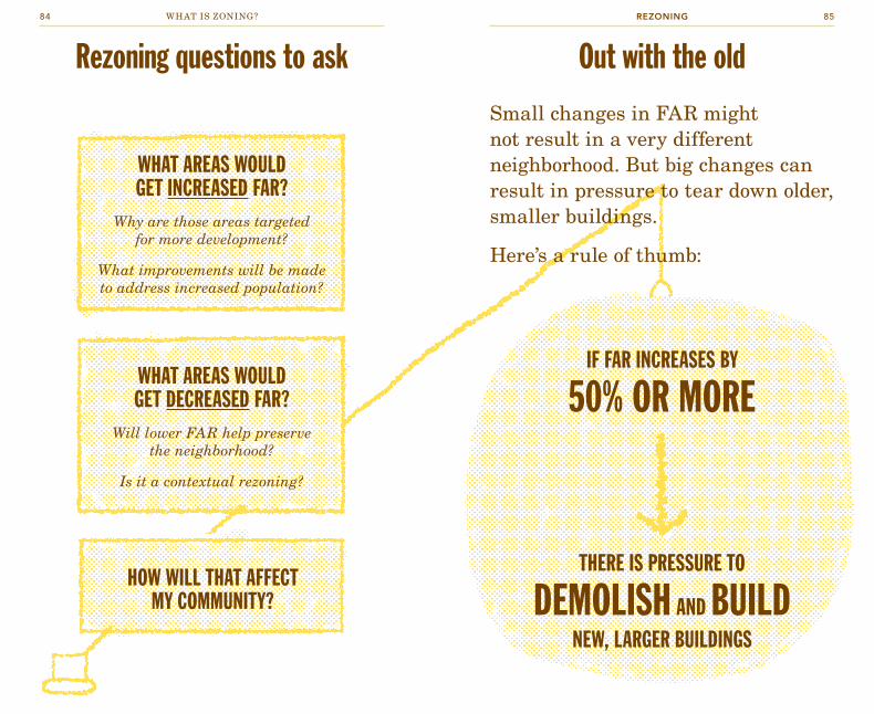
IF FAR INCREASES BY
50% OR MORE
THERE IS PRESSURE TO
DEMOlISH AND BUIlDNEW, lARGER BUIlDINGS
small changes in far might not result in a very different neighborhood. But big changes can result in pressure to tear down older, smaller buildings.
Here’s a rule of thumb:
WHAT AREAS WOUlD GET INCREASED FAR?
Why are those areas targeted for more development?
What improvements will be made to address increased population?
WHAT AREAS WOUlD GET DECREASED FAR?
Will lower FAR help preserve the neighborhood?
Is it a contextual rezoning?
HOW WIll THAT AFFECT MY COMMUNITY?
Out with the oldRezoning questions to ask
REZONINGwhat is zoning?84 85

Rezoning for use
sometimes a neighborhood rezoning changes the allowable uses in a district.
in nYC, the most common type of use rezoning is one that changes a manufacturing (M) district to a “mixed use” (or MX) district. a change from M to MX allows existing manufacturing to stay, but also allows new residential and commercial uses to come in to the area, and makes things like illegal loft conversions in old manufacturing buildings legal.
“Mixed use” is a term some people use to describe buildings that have commercial uses on the first floor with residential uses on upper floors. But it means something different in nYC zoning!
BEFORE
AFTER
a productive manufacturing zone.
a bustling mixed use zone.
REZONINGwhat is zoning?86 87

Mixed use rezoning
FOR RENTFOR RENT
If you owned this building, what would you do?
REZONINGwhat is zoning?88 89
“Mixed use” rezonings usually happen in areas the city thinks are “underused”—in other words, where there is demand for development. These are often neighborhoods where people are already starting to move to, like Tribeca in the 1970s and greenpoint in the early 2000s.
Between 1960 and 1989, new York went from around 1 million manufacturing jobs to just 369,000.
developers and some city officials think other kinds of development should be allowed in the declining manufacturing areas and that rezoning is a good way to encourage development and create more housing.
other people, including some city officials, think manufacturing jobs are an important part of the city’s economy and that rezonings make it harder for manufacturers to afford to stay in the five boroughs.

How can zoning make my
neighborhood better?
a lot of zoning focuses on the size and shape of buildings and how they can be used. But the zoning code includes other provisions that can affect how—and how quickly—neighborhoods grow and change. This section lays out some of the tools you can use to encourage changes that reflect your community’s goals. some of these tools are officially part of the zoning process, while others are separate from zoning, but can work with zoning to shape your community.
ANTI-HARASSMENT RUlES
HoW It WoRkS
In areas where proposed development is expected to contribute to rapid and significant increases in rent prices, anti-harassment rules can be used to at least slow the impact. These rules allow a tenant to take his/her landlord to court for a history of harassment or if the landlord tries to force him/her to move out of the building.
The special district rules require community organizations to be notified when a new development is going up and give those community organizations a chance to check up on landlords. (There’s also a law called the Tenant Protection Act that makes it illegal for a landlord to harass tenants anywhere in the city. But that act only covers harassment that is currently occurring and does not notify community organizations of new developments.)
WHAt It’S good FoR
Protecting affordable rents in neighborhoods where housing prices are rapidly increasing
WHEn It doESn’t WoRk
Because of the Tenant Protection Act, the city doesn’t think communities need these rules. So they are very difficult to get these days.
They have to be included as a part of a special purpose district and aren’t available other places.
WHERE It’S BEEn uSEd
Greenpoint/Williamsburg, Hell’s Kitchen
90 91COMMUNITY-LED ZONING

ANTI-DEMOlITION RUlES
INClUSIONARYZONING
HoW It WoRkS
Anti-demolition rules make it illegal for a landlord to tear down a building that is in good condition.
By preserving older, rental buildings, anti-demolition rules can preserve affordable rents for tenants. Buildings with smaller apartments and fewer of the conveniences of newer buildings will likely have to charge lower rents than newer buildings, even in gentrifying areas.
HoW It WoRkS
In areas where housing costs are increasing and where there is development interest, the city designates zones for the Inclusionary Housing Program.
In these zones, developers can make their buildings up to 33% bigger, if they preserve 20% or more of their buildings for affordable housing. The city calls this “incentive zoning” because they are offering developers a bonus in exchange for building something the community needs.
This can work well in areas where there is a lot of developer interest. The more buildings that go up in an area like this, which is usually one where rents are going up quickly, the more affordable units that are created.
WHAt It’S good FoR
Preserving neighborhood character and buildings; In some situations it can help preserve affordable rents, but in some cases it can do the opposite
WHEn It doESn’t WoRk
In areas where housing demand is already great and there is less new construction (like the West Village, for example), smaller older buildings can still become very expensive. In those situations, allowing demolition might actually lead to the creation of more housing units and more affordable housing prices. These rules have only been used in special purpose districts and not included as parts of other rezonings.
WHERE It’S BEEn uSEd
West Chelsea Special District
WHAt It’S good FoR
Creating housing units affordable to families with incomes between 80% and 125% of median family income, in areas with high demand for housing
WHEn It doESn’t WoRk
Inclusionary zoning requires a hot real estate market and doesn’t work as well in areas where housing demand is not so high that developers feel like they need the bonus. For example, on 4th Avenue near Park Slope in Brooklyn, several large apartment buildings have gone up but almost none have used the inclusionary housing bonus. So very little affordable housing is actually created.
WHERE It’S BEEn uSEd
Greenpoint-Williamsburg, Parts of Chelsea and Bedford Stuyvesant, 4th Avenue in Brooklyn, and lots of other places across the city
community-led zoningwhat is zoning?92 93

MANDATORY AFFORDABlE
HOUSINGHoW It WoRkS
Inclusionary zoning creates an incentive for developers to provide affordable housing units in exchange for a development bonus. The developers don’t always take the bonus.
Some communities have advocated for mandatory affordable housing. Instead of just providing an incentive, this would require developers to include affordable units in their projects. This could apply to projects over a certain size and in designated areas.
WHAt It’S good FoR
Ensuring that new developments will include affordable units. And if these units are required to be permanently affordable, then affordable homes will be added for generations to come.
WHEn It doESn’t WoRk
No one in NYC has used this yet. Developers will likely be opposed to it.
WHERE It’S BEEn uSEd
Nowhere in NYC, but other cities, like Cambridge, MA, and San Francisco, CA, have used this for years
INDUSTRIAl BUSINESS ZONES
HoW It WoRkS
These are not formally part of the zoning process, but the city has promised to keep IBZ areas as manufacturing zones. This could change and individual parcels of land within IBZs have already received zoning variances allowing non-manufacturing uses.
There is a city tax credit for manufacturing businesses that relocate to IBZs, which helps preserve the viability of manufacturing in these areas.
WHAt It’S good FoR
Preserving manufacturing uses in the city
WHEn It doESn’t WoRk
When individual variances undermine the overall designation
WHERE It’S BEEn uSEd
Long Island City, East New York, Port Morris
community-led zoningwhat is zoning?94 95

DISTRICT IMPROvEMENT BONUS
INDUSTRIAl PRESERvATION AREAS
HoW It WoRkS
Some neighborhoods with special districts have created District Improvement Bonuses (DIBs). Developers can pay money to a city fund in exchange for extra FAR. The fund is then used to pay for things that benefit the neighborhood or that offset the impacts of increased population, like subways, sidewalks, or sewers.
HoW It WoRkS
In the Garment District, special preservation rules have limited the number of areas in which competing land uses (including hotels, residential, and commercial uses) can be developed. Businesses located on the cross streets in the area have to be related to the garment industry.
WHAt It’S good FoR
Ideally, it will help pay for services in neighborhoods with lots of people. A lot of different types of services could be paid for with DIBs.
WHEn It doESn’t WoRk
This is a relatively new program, so no one knows if it really works yet. It depends on a hot real estate market where developers want to pay extra to build bigger. There is also no guarantee the money will be spent effectively.
WHERE It’S BEEn uSEd
Hudson Yards
WHAt It’S good FoR
Preserving manufacturing in areas with development pressure
WHEn It doESn’t WoRk
This is an unusual protection and most likely reflects the economic power of the fashion industry in NYC. Communities have had difficulty securing similar provisions in other manufacturing areas. Some of the building owners in the Garment District think it costs them money by keeping them from renting to whomever can afford to pay the most.
WHERE It’S BEEn uSEd
Garment District
community-led zoningwhat is zoning?96 97

ARTS, ENTERTAINMENT, AND
OTHER DISTRICTS
ENHANCED COMMERICIAl
DISTRICTSHoW It WoRkS
In the 125th Street area in Harlem, a special district was created to build on the area’s history as a performing arts district. Developers are allowed to build larger buildings in exchange for creating ground floor space for nonprofit visual or performing arts groups.
HoW It WoRkS
The city has added a new type of special district called an “enhanced commercial district,” which limits the amount of ground floor retail space that can be occupied by banks, offices, lobbies, and other “non-active” uses. This is meant to encourage a diversity of businesses but also to help make sure that retail streets include lots of pedestrian activity, even after 5 pm.
These districts also include rules about how much glass is required, especially on the ground floor. The idea being that the more glass, the more active (and safer) the street is.
One enhanced commercial district on the Upper West Side limits the maximum size of a storefront as a way to prevent banks from filling up entire blocks.
WHAt It’S good FoR
Encouraging arts spaces, and supporting nonprofit arts groups
WHEn It doESn’t WoRk
When there aren’t enough organizations to fill the spaces, they will usually end up used for other purposes.
WHERE It’S BEEn uSEd
125th Street in Harlem
WHAt It’S good FoR
Encouraging an active street environment and a diversity of businesses
WHEn It doESn’t WoRk
This is a fairly new type of protection. It remains to be seen how well it works.
WHERE It’S BEEn uSEd
Parts of the Upper West Side, Broadway in Bedford-Stuyvesant, 4th Avenue in Brooklyn
community-led zoningwhat is zoning?98 99

TREES & GREENSPACE
PARKING RUlES
HoW It WoRkS
As of 2008, all zoning districts require a street tree for every 25 feet of property facing the street. The requirement kicks in with new developments or significant enlargements. But some special districts have more specific planting requirements.
In areas with large developments, developers are sometimes asked to provide additional parks as a public benefit, and the city has committed to building additional parks in areas of major rezonings. For example, in Greenpoint/Williamsburg, the city committed to building 10 acres of parks as part of the rezoning.
HoW It WoRkS
There are a few pieces of the zoning code that affect how much and where parking goes in a neighborhood.
Every district has some rules about the number of off-street parking spaces required for new developments. Some of these rules define the minimum amount of spaces per district, but there are some rules limiting the maximum number of spaces as well. The number of off-street parking spaces in a neighborhood can have big impacts on how much traffic there is, and your community can push to have the limits adjusted. For example in Rockaway residents wanted more parking available, while in the West Clinton rezoning, they wanted less.
WHAt It’S good FoR
Creating outdoor public space, especially in areas with significant new development
WHEn It doESn’t WoRk
Not all parks and greenspace are the same, and sometimes parks can be located in parts of districts that are more accessible to some residents than others. It can take a very long time for the city to build parks it has committed to, and as time passes priorities may change.
WHERE It’S BEEn uSEd
Greenpont/Williamsburg
WHAt It’S good FoR
Ideally parking rules are calibrated to community needs
WHEn It doESn’t WoRk
In some places, if you require more parking, people will drive their cars more, and create more traffic.
WHERE It’S BEEn uSEd
These apply in all districts, but you can push for different limits in your community
community-led zoningwhat is zoning?100 101
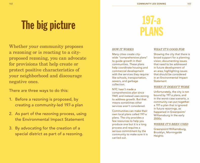
whether your community proposes a rezoning or is reacting to a city-proposed rezoning, you can advocate for provisions that help create or protect positive characteristics of your neighborhood and discourage negative ones.
there are three ways to do this:
1. before a rezoning is proposed, by creating a community-led 197-a plan
2. as part of the rezoning process, using the environmental impact Statement
3. by advocating for the creation of a special district as part of a rezoning.
The big picture 197-a PlANS
HoW It WoRkS
Many cities create city-wide “comprehensive plans” to guide growth in their communities. These plans help coordinate housing and commercial development with the services they require like schools, transportation, sewers, and garbage collection.
NYC hasn’t made a comprehensive plan since 1969, and instead uses zoning to address growth. But that means sometimes other services aren’t considered.
Communities can make their own local plans called 197-a plans. The city provides a few resources to help you produce one but it is a long process and requires a serious commitment by the community to make sure it is carried out.
WHAt It’S good FoR
Showing the city that there is broad support for a planning vision; documenting issues that need to be addressed in future development of an area; highlighting issues that should be considered in an Environmental Impact Statement
WHEn It doESn’t WoRk
Unfortunately, the city is not bound by 197-a plans, and in the worst-case scenario, a community can put together a 197-a plan that is ignored in future rezonings, as happened in Greenpoint/Williamsburg in the early 2000s.
WHERE It’S BEEn uSEd
Greenpoint/Williamsburg, Brooklyn, Morningside Heights
community-led zoning 103102

SPECIAl PURPOSE DISTRICTS
HoW It WoRkS
There are only three land use categories in NYC zoning, but for anything outside the standard zoning categories, there are special districts. (See page 36)
When city agencies, developers, or communities want to include non-standard provisions in a rezoning, they can ask for special districts.
WHAt It’S good FoR
Getting non-standard provisions (including many of the ones listed in the previous section) included in a rezoning.
WHEn It doESn’t WoRk
Anyone can advocate for a special district, so you have to look carefully at the provisions to know if you think it’s creating positive or negative change for your community
WHERE It’S BEEn uSEd
Lots of places. There are special districts for things like natural areas; large developments like Hudson Yards; all of the mixed use zones (like Greenpoint-Williamsburg); historic areas like Little Italy; theater zones like 125th Street in Harlem; and many more
ENvIRONMENTAl REvIEW
HoW It WoRkS
Every rezoning proposal, as well as any major development project, requires an environmental review. It’s a report that describes all the different kinds of impacts that the proposed project will have on a community—including things like traffic, noise, parking, sewers, economic conditions, public health, and more.
Part of the review might be an Environmental Impact Statement (EIS) which includes public comments and suggestions of other impacts the proposal might have.
The EIS is important because impacts that are added to the “scoping” list at the beginning of the process can be brought up later in public hearings to hold the project accountable.
WHAt It’S good FoR
Making sure that the city bodies responsible for approving rezoning and development proposals recognize your community’s concerns
WHEn It doESn’t WoRk
Even if major impacts are included, a project may still be approved over community objections. The EIS only lists impacts, it doesn’t say anything has to be done about them.
WHERE It’S BEEn uSEd
In every rezoning and many large development proposals
community-led zoningwhat is zoning?104 105

Workshopinstructions
106 107workshopwhat is zoning?

Using the Zoning Toolkit
Public participation works best when everyone understands the basic laws, policies, and jargon they will hear at a public meeting.
The Zoning Toolkit can help you facilitate conversations about zoning rules and how they affect your neighborhood and the city as a whole. The activities are designed to help people easily understand some of the core ideas behind the complexities of zoning. Once the group you’re working with understands the basics, you might want to plug these tools into a broader discussion about how you think things should work or what you think should happen in your neighborhood. The tools themselves don’t make arguments for or against different zoning decisions, but they can help you make yours.
The activities are flexible. You don’t have to do them all. You can mix and match to focus on the issues more important to you and your group or neighborhood.
The topics of the activities are:
1. Why Zoning?
Use Zoning2. What is “Use Zoning”?3. How Does Mixed Use Rezoning Work?
Zoning for Size & Shape4. How Does Size & Shape Zoning Work?5. How Does a Size & Shape Rezoning Work?6. What Is Inclusionary Zoning?
You can do all of the activities in order, or you can do Use Zoning or Zoning for Size & Shape on their own. The activities build on each other, so you will probably want to do the introductory activities (like #1, #2 and #4) before you do the more complicated ones (like #3, #5, or #6).
This guide is arranged so that things you might say out loud are in italics. The rest of the text provides information you’ll need to be familiar with to lead the workshop. (You don’t have to memorize it, just use this guide to help you.)
108 109workshopwhat is zoning?

WHAT’S IN THE BOx?Game BoardThe game board has two sides:
zoning the cityThis side is used for activities about land and building use. (Activities 1–3)
zoning the blockThis side is used for the size & shape zoning activities. (Activities 4–6)
Infrastructure TilesThe kit includes green and blue plastic infrastructure pieces to be used on the “Zoning the City” side of the board.
Building BlocksThe kit includes colored block in 2 sizes and 4 colors. Participants will use these to build individual buildings on the “Zoning the Block” side, and to build city blocks on the “Zoning the City” side.
Individual Activity SheetsHand these out to the participants so they can follow along, take notes, and take the information home with them. Like the game board, one side is labeled “Zoning the City” with information
about use zoning and the other is labeled “Zoning the Block” with information about size & shape zoning. (You can make more copies by downloading the file here: welcometocup.org/zoning)
GettInG StARteD
The activities work best for groups of 5 to 14 people. Fewer than that and it can be hard to see the patterns that result from the decisions people are making. If you have fewer than 5, you may want to ask participants to make multiple buildings on the “Zoning the Block” side of the board. With more than 14 people, it can be hard for everyone to reach the board. You might ask people to team up in this case. Or you can find out how to purchase additional blocks or gameboards for the activities here: welcometoCUP.org/zoning
1. Place the game board in the center of a table where all the participants can reach it.
2. Give every participant an activity sheet. Have some pens or pencils ready for people to take notes with.
3. Hand out red, yellow, and blue colored blocks to each participant, making sure each person gets some of each color and all participants have about the same number of blocks. Every participant should get at least 10 blocks. Additional setup is addressed in the activities.
4. Have fun!
110 111workshopwhat is zoning?

activity 1
WHY ZONING? Objective This is an introductory activity for zoning in
general. The group will get a sense of why zoning law exists by creating and analyzing a city created without zoning.
Time 10 minutes
Setup Flip the game board to the “Zoning the City” side:
Be sure everyone has both some 2×2 and 2×4 blocks. Keep about 10 blocks aside for yourself to build an “asphalt plant” in step 4. For this activity it doesn’t matter what color blocks are used.
1. BUIlD WHAteveR yoU WAnt!
You all have some bricks, a plot of land, and an unlimited amount of money. Build whatever you want! You don’t have to use all of your bricks, and you can build as large or as small as you like. no rules!
2. ADD BUIlDInGS to tHe BoARD
When you finish your building, place it on the board.
3. IntRoDUCe yoUR BUIlDInG
Go around the room and have each person introduce his or her building.
What did you build?
Make sure each person explains how the building is used, or what's in it.
4. ASPHAlt PlAnt
Often there will be a hodge-podge of buildings — houses next to factories, big buildings next to small ones.
Would you want to live here? Why or why not?
Now build a large and bulky asphalt plant with your own blocks and place it in the middle of the neighborhood.
What if someone built an asphalt plant here? What do you think of the neighborhood now? Would you still want to live here?
112 113workshopwhat is zoning?

5. DISCUSS
What would you worry about if you lived next to an asphalt plant?
Some things that participants might point out: safety concerns, health problems, property values, pollution, smells, shadows, and noise. If people don’t mention these, ask questions to draw them out.
What other things would you worry about if you lived in this neighborhood? Would you buy property here?
If you were the head of the planning department for this city, how would you arrange the buildings?
Usually people will make rules to keep factories away from houses. Sometimes they’ll want to make rules to put bigger buildings in one part of the city and smaller buildings in another part. They’re basically inventing zoning law themselves!
that’s why zoning law exists — to keep similar things together, and to keep apart things that don’t go well together. Zoning law helps protect health and safety, but it also creates a predictable environment that helps protect individual property values. You can’t build a tower, but neither can your neighbor.
Zoning law uses two major tools to shape neighborhoods — rules about use, what types of activities (like housing or industry) go where; and rules about size and shape (sometimes called “bulk”).
114 115workshopwhat is zoning?

activity 2
WHAT IS “USE ZONING”?Objective The group will understand land uses, as
well as how and why they are grouped and separated.
Time 15 minutes
Setup You will need the infrastructure tiles for this activity. Flip the game board to the “Zoning the City” side.
If you haven't already, distribute individual activity sheets to every person, and have them flip to the “Zoning the City” side.
We’re going to build a city today. It’s a little unusual because our city already has streets laid out, so we’re going to build within these city blocks.
Note: When New York City was built, there was no grid and people built out the city without these rules.
1. lAy oUt tHe InFRAStRUCtURe
First we are going to build some infrastructure.
Who wants to build the deep water port? Where would you put the deep water port? (There is a hint on the board.)
Hand the volunteer the deep water port and ask him or her to locate it on the board. Repeat this step for each additional infrastructure tile, asking for or picking a volunteer for each. We suggest this order: deep water port, freight depot, beautiful park, airport, garbage dump, and finally subways (which fit in the intersections between white blocks).
Where should the airport go? What about the beautiful park? the freight station? (There is a hint for that one too.) And finally the subway stations?
116 117workshopwhat is zoning?

2. BUIlD MAnUFACtURInG SPACe
okay, now that we have some infrastructure, we’re going to make some buildings.
In nYC land use falls into three big categories: manufacturing, commercial, and residential. In our city the first thing we will build is manufacturing.
What do you think counts as manufacturing?
What kinds of things do you think are done in manufacturing zones?
Basically manufacturing takes place where things are made and distributed. Manufacturing uses are often noisy, smelly, or dirty.
the blue building blocks represent manufacturing. Where would you put manufacturing uses in our city?
Ask people to build manufacturing in places where they think it makes sense.
Why did you choose to build manufacturing in those places?
If you want more detail, you can tell them that the city has different levels of manufacturing: M1 — for lower impact uses like storage and woodworking shops; M2 — for medium uses like big boat-building workshops; and M3 — for things like waste transfer stations, water treatment plants, and asphalt factories. The higher the number, the more noise, pollution, and other impacts that manufacturing use has. This information is on the worksheets.
3. BUIlD ReSIDentIAl SPACe
now we are going to look at residential. What happens in a residential zone?
Residential zones are where people live. Residential zones make up about 75% of NYC’s land area.
there are ten major categories of residential, R1 to R10 — from small to large. the higher the number, the bigger the building and the more occupants it has.
What do you think an R1 would be?
R1, R2 — Are freestanding houses that don’t touch other buildings.
Can anyone think of a neighborhood in nYC that might be zoned R1 or R2?
Jamaica Estates in Queens, Riverdale in the Bronx, parts of Staten Island
What do you think an R5 zone would be?
R5, R6 — Are row houses 3 to 5 stories tall, like brownstones.
Can anyone think of a neighborhood in nYC that might be zoned R5 or R6?
Sunset Park and Bedford-Stuyvesant in Brooklyn, and Astoria in Queens
What do you think an R10 would be?
R8 through R10 — Are large apartment buildings and residential towers.
Can anyone think of a neighborhood in nYC that might be zoned R10?
118 119workshopwhat is zoning?
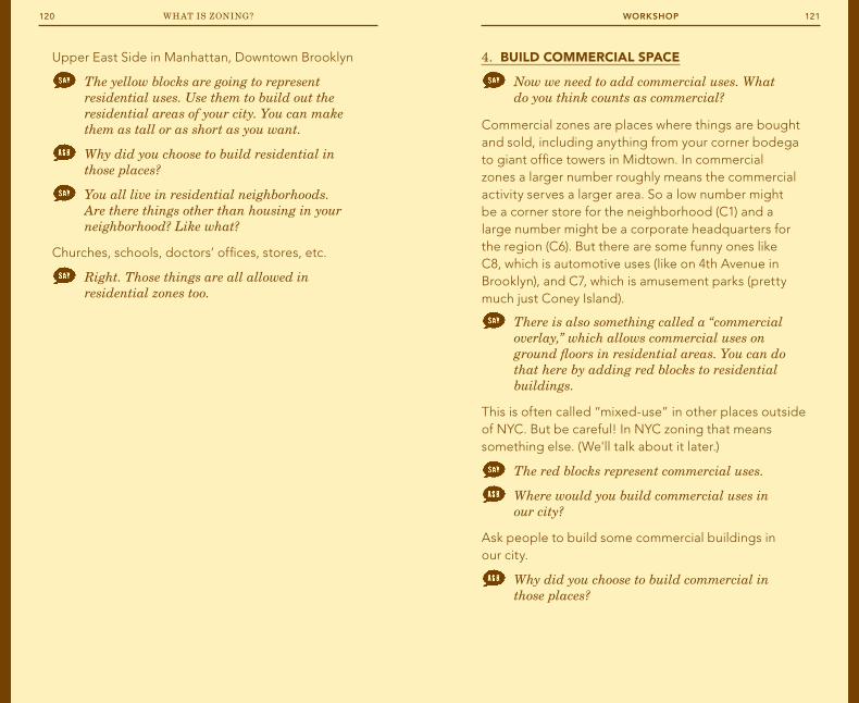
4. BUIlD CoMMeRCIAl SPACe
now we need to add commercial uses. What do you think counts as commercial?
Commercial zones are places where things are bought and sold, including anything from your corner bodega to giant office towers in Midtown. In commercial zones a larger number roughly means the commercial activity serves a larger area. So a low number might be a corner store for the neighborhood (C1) and a large number might be a corporate headquarters for the region (C6). But there are some funny ones like C8, which is automotive uses (like on 4th Avenue in Brooklyn), and C7, which is amusement parks (pretty much just Coney Island).
there is also something called a “commercial overlay,” which allows commercial uses on ground floors in residential areas. You can do that here by adding red blocks to residential buildings.
This is often called “mixed-use” in other places outside of NYC. But be careful! In NYC zoning that means something else. (We'll talk about it later.)
the red blocks represent commercial uses.
Where would you build commercial uses in our city?
Ask people to build some commercial buildings in our city.
Why did you choose to build commercial in those places?
Upper East Side in Manhattan, Downtown Brooklyn
the yellow blocks are going to represent residential uses. use them to build out the residential areas of your city. You can make them as tall or as short as you want.
Why did you choose to build residential in those places?
You all live in residential neighborhoods. Are there things other than housing in your neighborhood? Like what?
Churches, schools, doctors’ offices, stores, etc.
Right. those things are all allowed in residential zones too.
120 121workshopwhat is zoning?

5. DISCUSS
What do you think about the city you built? Would you want to live here? Why?
Sometimes people make changes at this point.
does it have everything you need in a city? (Places to live, work, eat, shop, and relax?)
Why did you put these things together?
Point at areas with separated uses.
Why did you keep those separate?
Usually people keep residential and manufacturing uses apart.
You basically created zoning by putting some uses together and keeping some uses apart. You were doing the same thing that cities do when they use zoning to shape how a city develops. But most of nYC was built before zoning laws, which were only introduced in 1916.
Zoning doesn’t build or change anything, it only affects what can be built going forward. things that already existed that don’t meet the zoning rules don’t get torn down; they are “grandfathered” in. the same is true when zoning laws change.
ultimately the city develops by lots of individual land owners making decisions within the rules of what the zoning code lets them do.
122 123workshopwhat is zoning?

activity 3
HOW DOES A MIxED USE REZONING WORK?Objective The group will understand the possible
impacts of a mixed use rezoning.
Time 5 minutes
Setup This activity builds on the previous one, ACTIvITY 2: WHAT IS USE ZONING? So you should already have everything set up for that. You will need orange building blocks for this activity. Make sure every person gets an equal number of orange blocks.
1. “MIxeD USe”
We’ve talked about how zoning doesn’t change what’s already been built. But changes in zoning can alter the conditions that building owners or developers respond to when they make decisions. there’s a fourth category of land use we sometimes see in nYC. It’s called “mixed use.”
What do you think that means?
In other cities, the term “mixed-use” usually means areas where individual buildings have offices or storefronts on the bottom with residences above it. In nYC zoning the term “mixed use” means something different: it is when manufacturing zones are rezoned to also allow residential and commercial uses.
In this activity you are all owners of the blue manufacturing buildings you built.
the city is rezoning this area to a mixed use zone. You can keep your manufacturing building, or you can change your building over to residential.
Before you decide, let me tell you about rent values: residential uses in this area will bring in twice as much rent per square foot as manufacturing. What do you do?
Have anyone who wants to convert to residential replace their blue blocks with orange ones. It’s OK if they don’t want to convert, there are always holdouts in a mixed use zone. And it is OK if they want to convert only part of their building.
2. DISCUSS
What did you do? Why?
Ask someone that changed and someone that didn't to talk about why.
Is this a good change or a bad change for the neighborhood? Why could it be good to build more residential? Why could it be bad?
More places for people to live could mean lower rents. But less manufacturing will mean fewer jobs, especially high-paying jobs for low-skilled workers.
Rezonings don’t change anything on the ground and don’t force owners to do anything. But zoning changes can dramatically shift the economics of the real estate market. How do you think the city uses that as a tool? How do you think they should use it?
124 125workshopwhat is zoning?

activity 4
HOW DOES SIZE & SHAPE ZONING WORK?Objective This series of exercises will help
participants understand how the city controls the size and shape of buildings.
Time 20 minutes
Setup Flip the game board to the “Zoning the Block” side. Be sure everyone has some 2×2 and 2×4 blocks. For activities on this side of the board it doesn’t matter what color blocks are used.
Distribute individual lot sheets to every person, and have them flip to the “Zoning the Block” side.
1. HoW BIG IS yoUR lot?
there is a building lot on your individual lot sheet where we are going to create our own buildings for this activity. It’s the same size as those lots on the board.
What is the area (or square footage) of your lot? does anyone remember how to calculate area?
AREA = LENGTH × WIDTH so in this case: 20' × 100' = 2,000 sq. ft.
20' x 100' lots are pretty common in medium density neighborhoods in nYC, like brownstone neighborhoods.
2. WHAt IS FAR?
a. Introduce FAR
the main tool the city uses to control size and shape of buildings is something called Floor Area Ratio, or F-A-R. does anyone know what that is?
Sometimes people do know. If not:
F-A-R is a way to think about the size of a building in relation to the size of the lot that it is built on.
So floor area ratio is the total square footage of all the floors in a building divided by the total square footage of the building lot. the F-A-R number for different zones is written into the zoning laws.
126 127workshopwhat is zoning?

b. Cover the lot with bricks
now build a building that covers your entire lot and is one story tall. (the height of one brick is equal to one story.)
What is the floor area of your building?
2,000 sq. ft.
What is the area of your lot?
2,000 sq. ft.
So if FAR is total building floor area, divided by lot area, what is the FAR?
It’s one. But FAR is usually said one-point-oh—1.0
c. Re-stack your blocks
take the same bricks on your lot (don’t add or remove any), and stack them any way you like, anywhere you would like to put your building on your lot.
What is the FAR now?
It is still 1.0.
Buildings of different shapes can have the same FAR! It's not about shape, it's about building area versus lot area.
d. Different FARs for different places
the city sets different FARs for different zones, from 0.5 to 15.0.
Can you think of an example of a type of building that might have an FAR of 0.5?
When the FAR is 0.5 the whole building is half the size of the lot.
Detached single family houses in Riverdale
Can you think of an example of a type of building that might have an FAR of 15.0?
the whole building would be 15x the size of the lot.
Office towers in Manhattan
e. try it for FAR 2.0
now build a building with an FAR of 2.0 that covers the whole lot.
Ask participants to fill in the FAR equation on their worksheets with the numbers for a FAR 2.0 building.
When you are happy with your building, put it on a lot on the board. the building lots on the board look like the ones on your sheet, long and narrow with the narrow side facing the street. Your building has to fit between the dark lines and can't hang over onto other lots.
Have participants place the buildings close together, especially if there aren’t enough people to fill all the lots on the board. This helps participants see how buildings relate to each other in a real neighborhood.
What would it be like to live in one of these buildings? Where would the windows be?
Typically windows would only be possible on the front of the building.
What would happen if there was a fire?
128 129workshopwhat is zoning?

Build:
60%
Maximum lot coverage
far
2.0
FAR = Floor Area Ratio
3. MAxIMUM lot CoveRAGe
to address these safety issues, the city has other rules that control the size and shape of buildings too. one of those rules is called maximum lot coverage. What do you think that means?
Maximum lot coverage is the maximum percentage of the lot that you can build a building on.
take your FAR 2.0 building and rearrange it so that it only covers 60% of your lot. now it can be any shape you like and it can cover less than 60% of the lot, but not more.
HInt Remind people to use the same number of bricks for each of these next steps to be sure they maintain an FAR of 2.0.
Why would the city have a rule like this?
Maximum lot coverage ensures that buildings aren't too crowded together. Originally this was to help make sure tenement buildings got enough light and air, and were safe for residents to live in and get out of during fires. If everyone built to the lot line on every side there would be no windows and only one exit for emergencies!
130 131workshopwhat is zoning?

4. MInIMUM yARD ReqUIReMentS
there is another set of rules called minimum yard requirements. What do you think these rules do?
Minimum yard requirements say where on your lot you can build your building by telling you the minimum amount of yard space you are required to have. These yards are “setbacks” that say how far back from the lot line your building has to be. They are called “yards” but in NYC they often don’t look very much like yards.
now rearrange your same building so it has a front yard at least 10' deep and a rear yard at least 30' feet deep.
Build:
60%
Maximum lot coverage
far
2.0
FAR = Floor Area Ratio
fronT Yard rear Yard
10' 30'
Yard requirements
How does this neighborhood look? Would you rather live here or in the one with no lot coverage and yard requirements?
5. HeIGHt lIMItS
But wait, there’s more! Any guesses? What other rules affect size and shape?
the city limits how high you can build, too. In our neighborhood there is a 40' (about 4 stories—or 4 building blocks) height limit. Rearrange your building so it is a maximum of 4 stories.
Build:
60%
Maximum lot coverage
far
2.0
FAR = Floor Area Ratio
fronT Yard rear Yard
10' 30'
Yard requirements
MaXiMUM sTreeT waLL
40'
Height limits
But sometimes there are actually two height limits. there is the tallest point on the building—the maximum “building height”—and there is also a height limit for the front wall of the building that faces the street, which the city calls the “base height.” Rearrange your building so it still has a 40' overall height limit, but the wall facing the street has a maximum height of 30'.
132 133workshopwhat is zoning?

Build:
60%
Maximum lot coverage
far
2.0
FAR = Floor Area Ratio
fronT Yard rear Yard
10' 30'
Yard requirements
MaXiMUM sTreeT waLL
40' 30'
Height limits
Make sure everyone has it. Every building should be about the same size and shape with a little notch at the front.
Why does the city require a lower height limit near the street?
More sunlight reaches the street and lower floors of buildings when the upper stories are set back.
6. DISCUSS
You started out with lots of different buildings. What happened to them?
They look the same now.
All these rules together create an invisible boundary of the maximum space a building can occupy, which is called a “building envelope.” People usually build their buildings to fill as much of the building envelope as possible, which is called maxing out your lot. Why do they do this?
More square footage equals more rent.
What happens to the neighborhood when everyone builds to the maximum?
All the buildings will start to look pretty similar.
134 135workshopwhat is zoning?

activity 5
HOW DOES A SIZE & SHAPE REZONING WORK?Objective Participants will understand how a size &
shape rezoning affects the neighborhood.
Time 5 minutes
Setup This activity builds on the previous one, ACTIvITY 4: HOW DOES SIZE & SHAPE ZONING WORK? So you should already have everything set up for that. Be sure there are enough building blocks remaining for people to build bigger (FAR 4.0) buildings.
1. tHIS neIGHBoRHooD IS BeInG ReZoneD
Sometimes the city, or a developer, or a group of residents wants to change the zoning in their neighborhood. these are called “rezonings.” In recent years many changes came in the form of rezonings that the city initiated to promote growth in particular areas.
these are called “upzonings” because of the overall increase in the intensity of uses.
In our neighborhood, which until now was an FAR 2.0 neighborhood, the city is rezoning this area to FAR 4.0. So you have the option to keep the building you have now, or you can tear it down and rebuild it at FAR 4.0, with a higher height limit. Your building can stay as it is, or you can double your rentable square footage.
Build:
60%
Maximum lot coverage
far
4.0
FAR = Floor Area Ratio
fronT Yard rear Yard
10' 30'
Yard requirements
MaXiMUM sTreeT waLL
80' 70'
Height limits
136 137workshopwhat is zoning?

HInt If people are having trouble visualizing a FAR 4.0 building, suggest they build out a four story building that covers their entire lot, and then rearrange the blocks to meet the other requirements. Or they can just double the amount of blocks in their building from activity 4.
2. DISCUSS
did you decide to rebuild? Why or why not?
Rezoning doesn’t tear anything down. old buildings are grandfathered in. the rules only apply to new developments. An FAR increase of 50% or more will often lead to pressure to tear down old buildings and build new, bigger buildings at the maximum FAR.
that’s what happens in an upzoning. What do you think happens in a “downzoning”?
In a downzoning the overall FAR is decreased. Communities often initiate downzonings as a way to protect the character of their neighborhood. This usually happens in areas where existing buildings are mostly below the allowed FAR. The rezoned FAR is meant to more closely match what is already built.
In most rezonings there is some combination of areas that are upzoned (usually near transit and on major avenues) and ones that are downzoned (on residential streets). Many rezonings are led by the city, but communities can propose them too.
138 139workshopwhat is zoning?

activity 6
WHAT IS INClUSIONARY ZONING?Objective The group will understand what options a
developer has in inclusionary zoning areas.
Time 5 minutes
Setup This activity builds on ACTIvITY 4: HOW DOES SIZE & SHAPE ZONING WORK? So you should already have everything set up for that. There should be enough building blocks remaining for people to build bigger buildings. If you also did ACTIvITY 5: HOW DOES A SIZE & SHAPE REZONING WORK? and some people have FAR 4.0 buildings, just give them the option to increase the size of their building through inclusionary zoning.
1. WHAt IS InClUSIonARy ZonInG?
Zoning is mostly used to control how buildings look and how they are used. But sometimes the city uses zoning to meet other goals. they do this by letting developers build more if they agree to provide other benefits. Can you think of any examples?
Community facilities, subway stations, public parks, plazas, and affordable housing.
one way the city uses these incentives is encouraging developers to build affordable housing through something called “inclusionary zoning.” does anyone know how inclusionary zoning works?
Sometimes someone does know. Inclusionary zoning is when the city allows a developer to build a bigger building if part of the building is set aside for affordable housing. This currently only applies in particular districts the city has identified as target areas (like Greenpoint/Williamsburg or 4th Avenue in Brooklyn).
2. BonUS FAR BUIlDInG
In inclusionary zoning areas developers have the option to get an FAR bonus and build a bigger building if they make some of their building affordable housing. usually they can build a 33% bigger building if 20% of the units are made affordable.
In our neighborhood on the game board, the FAR is 4.0. You now have the option to keep your FAR 4.0 building or build a new building with 20% affordable housing and
140 141workshopwhat is zoning?

a 33% larger FAR of 5.4. (that is equal to seven 2x2 blocks.)
It may help people to visualize this if you ask them to build the 20% affordable housing with four 2×2 orange blocks, and the rest of the building with a different color.
Build:
60%
Maximum lot coverage
far
5.4
FAR = Floor Area Ratio
fronT Yard rear Yard
10' 30'
Yard requirements
MaXiMUM sTreeT waLL
100' 90'
Height limits
Here’s how the math works:
FAR 4.0 + (.33 × 4.0) FAR 4.0 + 1.32 = New FAR = 5.32 (we’ll call it 5.4)
do you take the bonus? Why or why not?
3. DISCUSS
Why does the city use inclusionary zoning?
What do you think of this neighborhood?
What could be good about inclusionary zoning? What could be bad?
The city wants more affordable housing but doesn’t have the money to build it all. So instead they create incentives for private developers to build some units of affordable housing.
More affordable housing does get built, but not enough to meet the entire need. Also, developers often make their affordable housing units “affordable” to middle income people, so the question always has to be asked: affordable to whom?
do you think everyone would take the bonus? Why or why not?
It can really vary. In some places like Williamsburg, almost everyone took the bonus when it was offered. In others, like 4th Avenue in Park Slope, almost no one took it. It largely depends on how hot the real estate market in that area is. If developers know they can rent or sell all the units easily, they are more likely to take the bonus.
that also mean that this doesn't work when no one is building!
142 143workshopwhat is zoning?

What’s my zone?
This is what a zoning map looks like. every block in the city has a zone designation.
what is zoning?144
every part of nYC is in a zone. every zone has a classification that tells you what kind of
things can be built in that zone.
the first character is the land use, or what the buildings in this zone can be used for.
in nyc, it can be:
R = residential
C = commercial
M = manufacturing
MX = “mixed use”
find out more on page 22.
the second character refers to the scale of development.
for residential, it can be r1 (single family) to r10 (skyscraper).
for commercial, it can be c1 to c8. Smaller numbers usually mean more local-serving businesses, c6 means large corporate headquarters, and c7 means amusement parks!
for manufacturing, it can be m1 (least impact on surroung areas), m2, or m3 (most impact).
find out more on page 42.
the third character means this zone has additional requirements to make it “contextual,” which means to make sure that new buildings have similar size, shape, or look to existing buildings in that zone.
this can be a, b, d, or X.
find out more on page 70.
R6B

This book: WHAT IS ZONING? is part of the Envisioning Development Toolkits, a series of teaching tools that foster conversations and group learning about land use and urban development.
The envisioning development Toolkits allow everyday new Yorkers to use the language that professionals use to describe land use processes and outcomes. They provide visual and tactile tools to facilitate discussions, describe and clarify problems, and propose and communicate solutions.
wHaT is zoning? breaks down density, bulk, land use, and how proposed rezonings could affect your neighborhood.
find out more about this and other tools at: welcometoCUP.org


