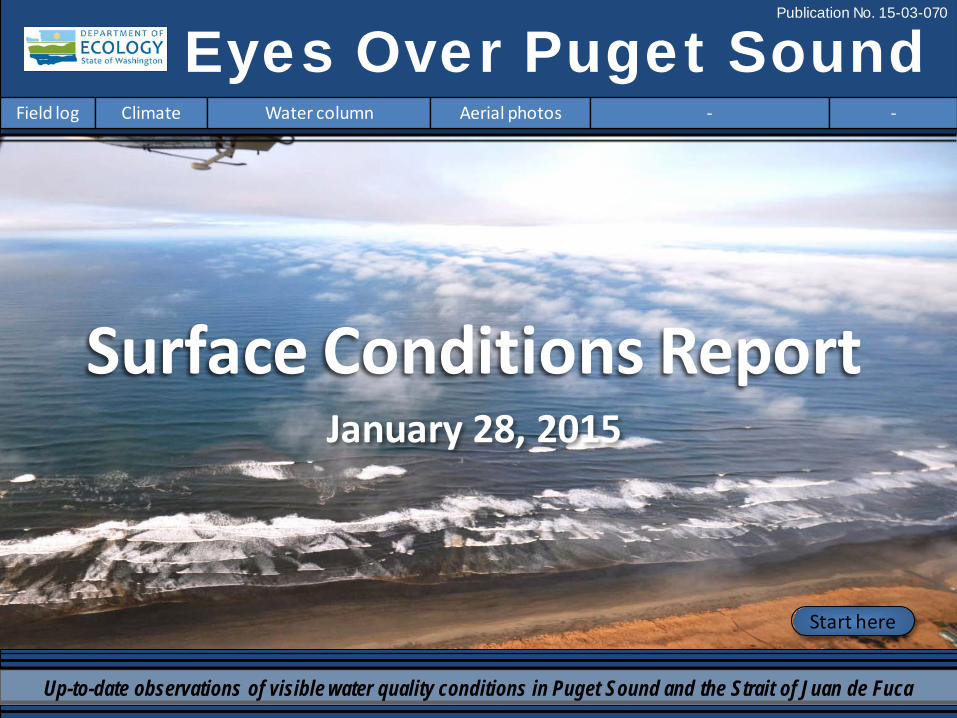
Eyes Over Puget Sound Field log Climate Water column Aerial photos - - Publication No. 15-03-070 Start here Up-to-date observations of visible water quality conditions in Puget Sound and the Strait of Juan de Fuca January 28, 2015 Surface Conditions Report
Transcript
Eyes Over Puget Sound Field log Climate Water column Aerial photos - -
Publication No. 15-03-070
Start here
Up-to-date observations of visible water quality conditions in Puget Sound and the Strait of Juan de Fuca
January 28, 2015
Surface Conditions Report
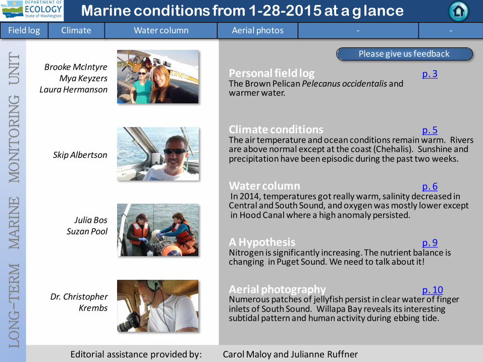
Personal field log p. 3 The Brown Pelican Pelecanus occidentalis and warmer water. Climate conditions p. 5 The air temperature and ocean conditions remain warm. Rivers are above normal except at the coast (Chehalis). Sunshine and precipitation have been episodic during the past two weeks. Water column p. 6 In 2014, temperatures got really warm, salinity decreased in Central and South Sound, and oxygen was mostly lower except in Hood Canal where a high anomaly persisted. A Hypothesis p. 9 Nitrogen is significantly increasing. The nutrient balance is changing in Puget Sound. We need to talk about it! Aerial photography p. 10 Numerous patches of jellyfish persist in clear water of finger inlets of South Sound. Willapa Bay reveals its interesting subtidal pattern and human activity during ebbing tide.
LO
NG
-T
ER
M
MA
RIN
E
MO
NIT
OR
ING
U
NIT
Brooke McIntyre Mya Keyzers
Laura Hermanson
Skip Albertson
Dr. Christopher Krembs
Julia Bos Suzan Pool
Editorial assistance provided by: Carol Maloy and Julianne Ruffner
Marine conditions from 1-28-2015 at a g lance Field log Climate Water column Aerial photos - -
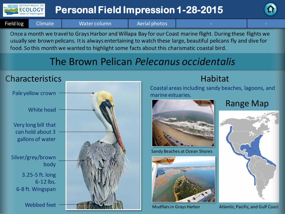
Very long bill that can hold about 3 gallons of water
3.25-5 ft. long 6-12 lbs.
6-8 ft. Wingspan
Webbed feet
Characteristics
Habitat Coastal areas including sandy beaches, lagoons, and marine estuaries.
Once a month we travel to Grays Harbor and Willapa Bay for our Coast marine flight. During these flights we usually see brown pelicans. It is always entertaining to watch these large, beautiful pelicans fly and dive for food. So this month we wanted to highlight some facts about this charismatic coastal bird.
Mudflats in Grays Harbor
Range Map
Atlantic, Pacific, and Gulf Coast
White head
Sandy Beaches at Ocean Shores
Personal Field Impression 1-28-2015 Field log Climate Water column Aerial photos - -
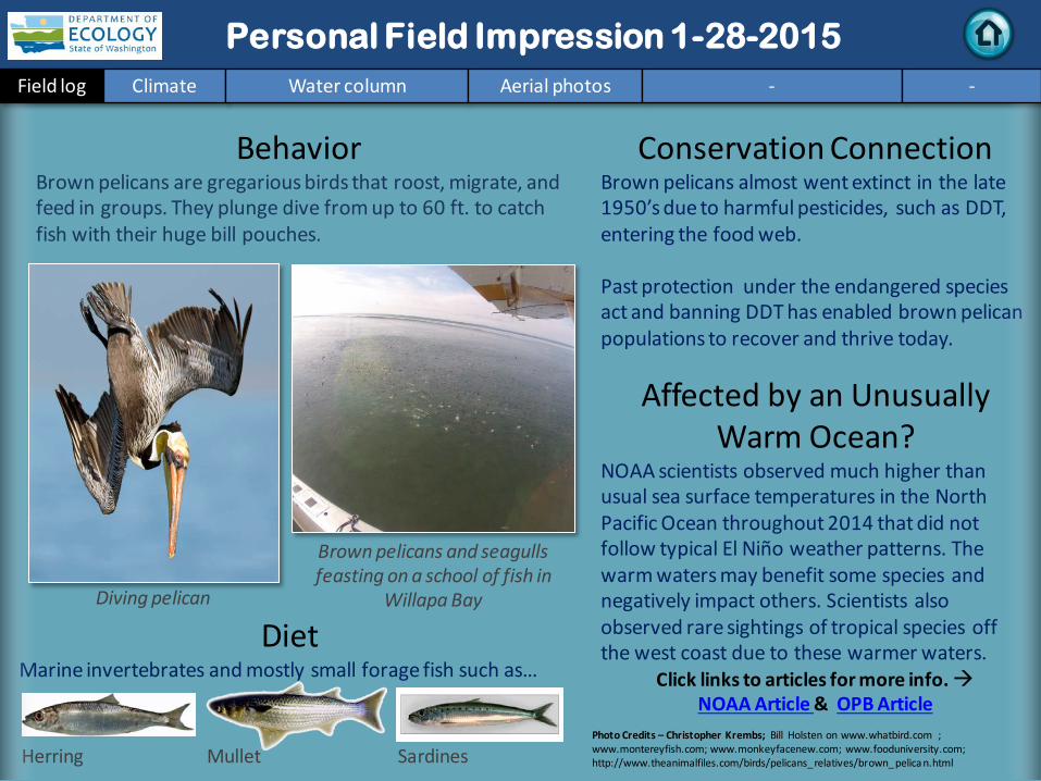
Diet Marine invertebrates and mostly small forage fish such as…
Behavior Brown pelicans are gregarious birds that roost, migrate, and feed in groups. They plunge dive from up to 60 ft. to catch fish with their huge bill pouches.
Brown pelicans and seagulls feasting on a school of fish in
Willapa Bay
Herring Sardines Mullet
Conservation Connection Brown pelicans almost went extinct in the late 1950’s due to harmful pesticides, such as DDT, entering the food web. Past protection under the endangered species act and banning DDT has enabled brown pelican populations to recover and thrive today.
Affected by an Unusually Warm Ocean?
NOAA scientists observed much higher than usual sea surface temperatures in the North Pacific Ocean throughout 2014 that did not follow typical El Niño weather patterns. The warm waters may benefit some species and negatively impact others. Scientists also observed rare sightings of tropical species off the west coast due to these warmer waters.
Click links to articles for more info. NOAA Article & OPB Article
Diving pelican
Photo Credits – Christopher Krembs; Bill Holsten on www.whatbird.com ; www.montereyfish.com; www.monkeyfacenew.com; www.fooduniversity.com; http://www.theanimalfiles.com/birds/pelicans_relatives/brown_pelica n.html
Personal Field Impression Field log Weather Water column Aerial photos - -
Personal Field Impression 1-28-2015 Field log Climate Water column Aerial photos - -
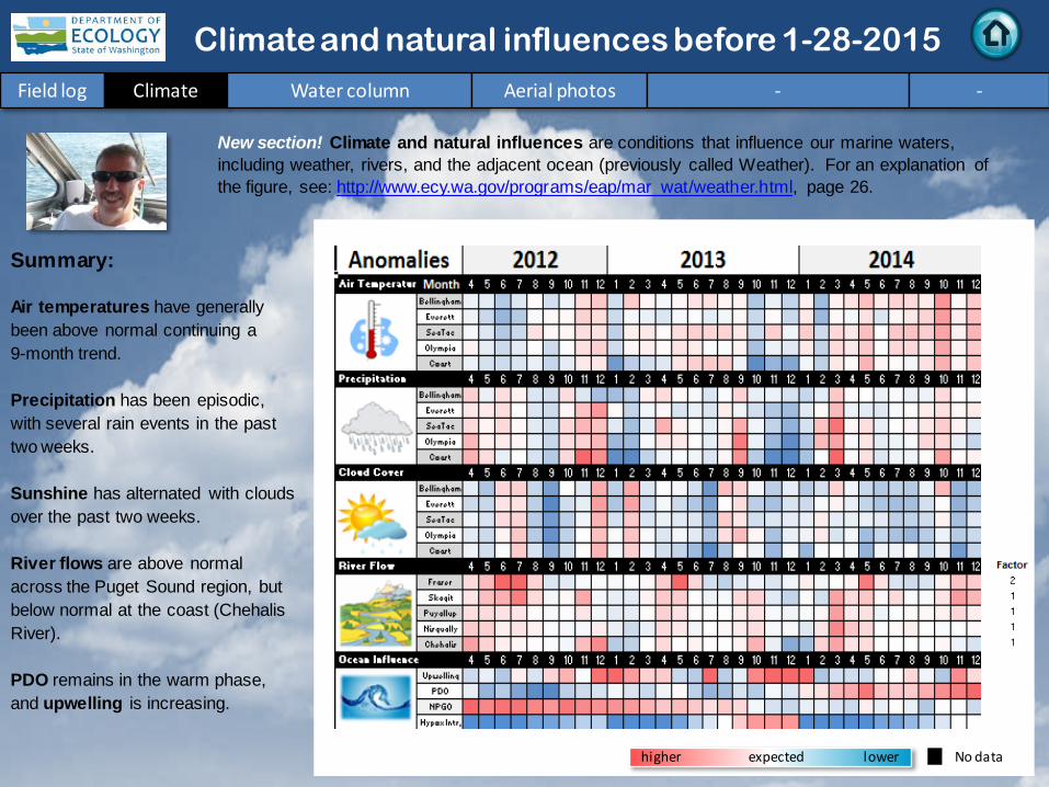
Summary: Air temperatures have generally been above normal continuing a 9-month trend. Precipitation has been episodic, with several rain events in the past two weeks. Sunshine has alternated with clouds over the past two weeks. River flows are above normal across the Puget Sound region, but below normal at the coast (Chehalis River). PDO remains in the warm phase, and upwelling is increasing.
lower higher expected No data
New section! Climate and natural influences are conditions that influence our marine waters, including weather, rivers, and the adjacent ocean (previously called Weather). For an explanation of the figure, see: http://www.ecy.wa.gov/programs/eap/mar_wat/weather.html, page 26.
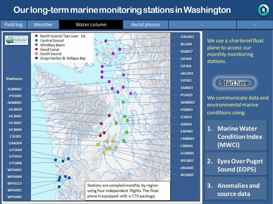
We use a chartered float plane to access our monthly monitoring stations. We communicate data and environmental marine conditions using: 1. Marine Water
Condition Index (MWCI)
2. Eyes Over Puget Sound (EOPS)
3. Anomalies and source data
Field log Weather Water column Aerial photos - -
Our long-term marine monitoring stations in Washington
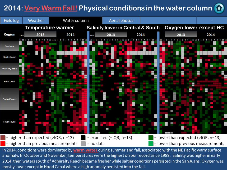
In 2014, conditions were dominated by warm water during summer and fall, associated with the NE Pacific warm surface anomaly. In October and November, temperatures were the highest on our record since 1989. Salinity was higher in early 2014, then waters south of Admiralty Reach became fresher while saltier conditions persisted in the San Juans. Oxygen was mostly lower except in Hood Canal where a high anomaly persisted into the fall.
Salinity lower in Central & South
2014: Very Warm Fall! Physical conditions in the water column
Field log Weather Water column Aerial photos - -
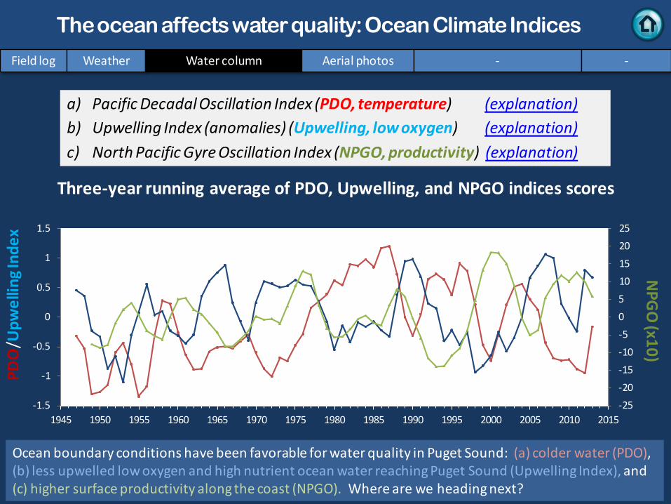
a) Pacific Decadal Oscillation Index (PDO, temperature) (explanation) b) Upwelling Index (anomalies) (Upwelling, low oxygen) (explanation) c) North Pacific Gyre Oscillation Index (NPGO, productivity) (explanation)
NPG
O (x10)
PDO
/Upw
ellin
g Ind
ex
Three-year running average of PDO, Upwelling, and NPGO indices scores
Field log Weather Water column Aerial photos - -
The ocean affects water quality: Ocean Climate Indices
Ocean boundary conditions have been favorable for water quality in Puget Sound: (a) colder water (PDO), (b) less upwelled low oxygen and high nutrient ocean water reaching Puget Sound (Upwelling Index), and (c) higher surface productivity along the coast (NPGO). Where are we heading next? .
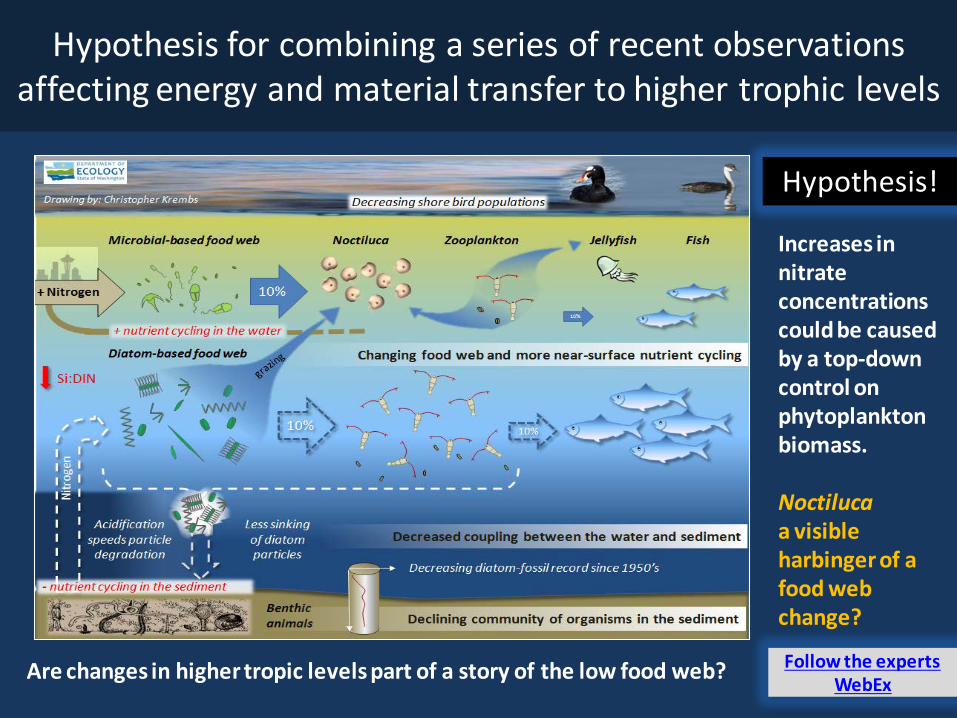
Hypothesis! Increases in nitrate concentrations could be caused by a top-down control on phytoplankton biomass. Noctiluca a visible harbinger of a food web change?
Hypothesis for combining a series of recent observations affecting energy and material transfer to higher trophic levels
Are changes in higher tropic levels part of a story of the low food web?
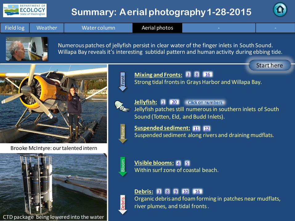
Numerous patches of jellyfish persist in clear water of the finger inlets in South Sound. Willapa Bay reveals it’s interesting subtidal pattern and human activity during ebbing tide.
Field log Weather Water column Aerial photos - -
Start here Mixing and Fronts: Strong tidal fronts in Grays Harbor and Willapa Bay.
Debris: Organic debris and foam forming in patches near mudflats, river plumes, and tidal fronts .
Visible blooms: Within surf zone of coastal beach.
Jellyfish: Jellyfish patches still numerous in southern inlets of South Sound (Totten, Eld, and Budd Inlets).
Bloo
m
Debr
is
Fron
t Suspended sediment: Suspended sediment along rivers and draining mudflats. Pl
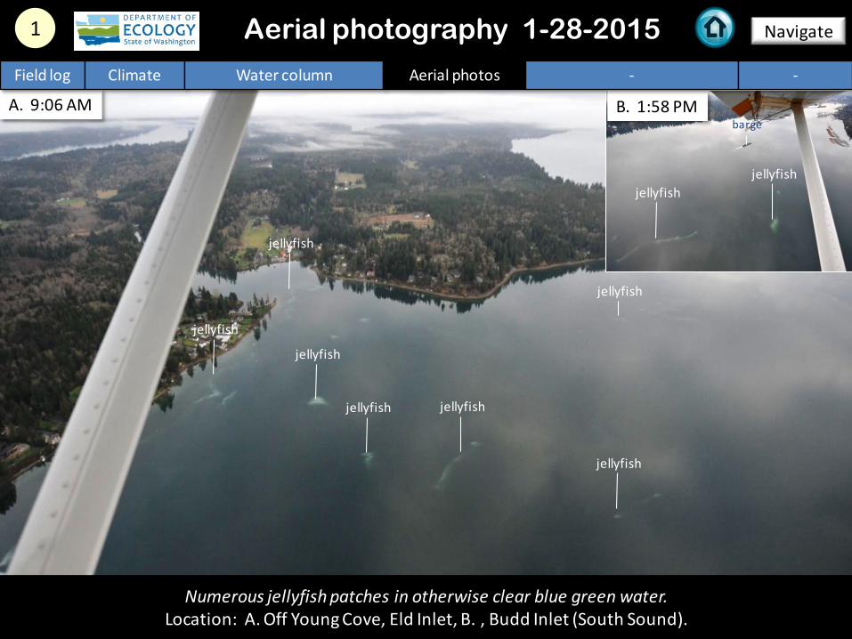
Numerous jellyfish patches in otherwise clear blue green water. Location: A. Off Young Cove, Eld Inlet, B. , Budd Inlet (South Sound).
1 Aerial photography 1-28-2015 Navigate
Field log Climate Water column Aerial photos - -
jellyfish
jellyfish
jellyfish
jellyfish
jellyfish
jellyfish
jellyfish
jellyfish jellyfish
barge
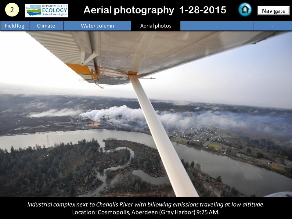
2 Navigate Aerial photography 1-28-2015 Field log Climate Water column Aerial photos - -
Industrial complex next to Chehalis River with billowing emissions traveling at low altitude. Location: Cosmopolis, Aberdeen (Gray Harbor) 9:25 AM.
A.
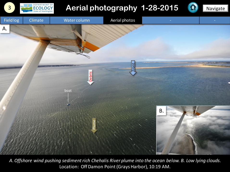
3 Navigate Aerial photography 1-28-2015
A. Offshore wind pushing sediment rich Chehalis River plume into the ocean below. B. Low lying clouds. Location: Off Damon Point (Grays Harbor), 10:19 AM.
Field log Climate Water column Aerial photos - -
Debr
is
B.
Fron
t
Plum
e boat
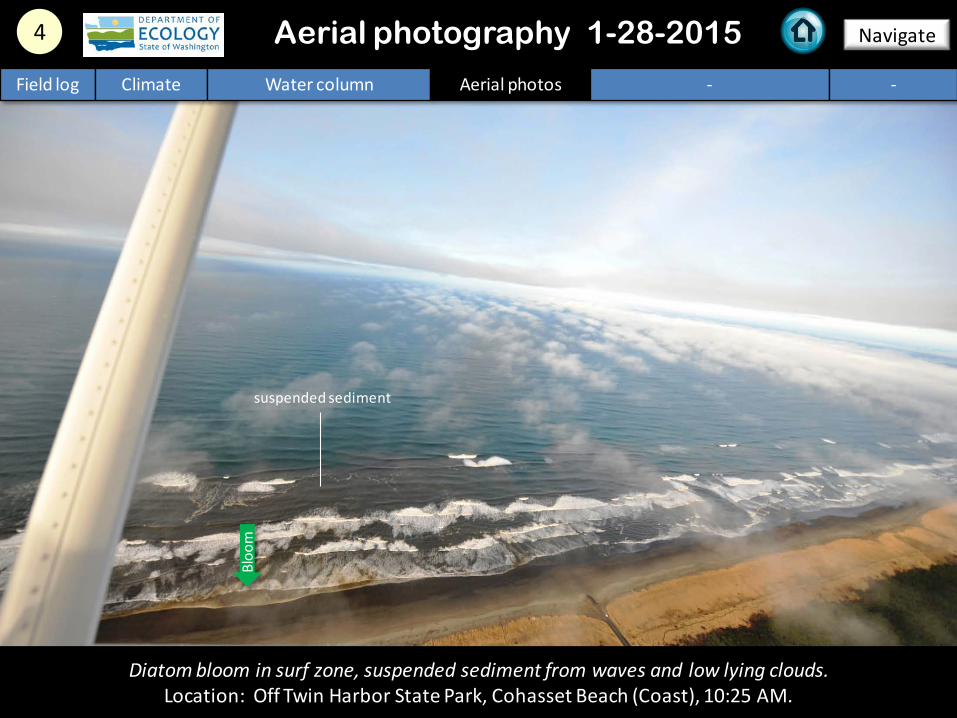
4 Navigate
Field log Climate Water column Aerial photos - -
Aerial photography 1-28-2015
Diatom bloom in surf zone, suspended sediment from waves and low lying clouds. Location: Off Twin Harbor State Park, Cohasset Beach (Coast), 10:25 AM.
Bloo
m
suspended sediment
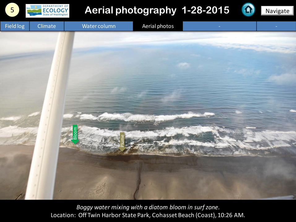
5 Navigate Aerial photography 1-28-2015 Field log Climate Water column Aerial photos - -
Boggy water mixing with a diatom bloom in surf zone. Location: Off Twin Harbor State Park, Cohasset Beach (Coast), 10:26 AM.
Plum
e Bloo
m
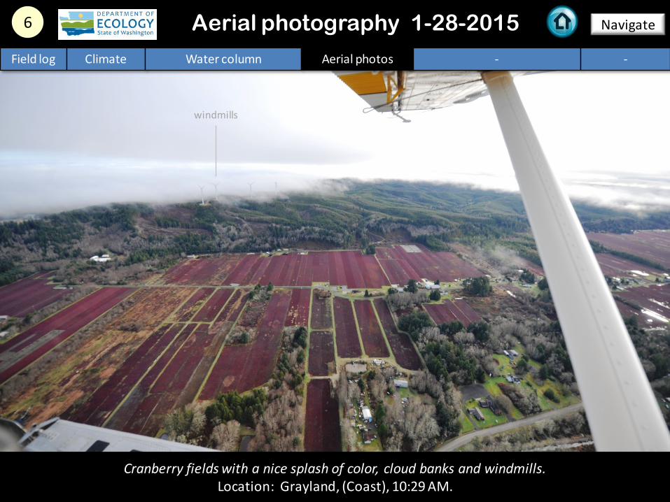
Cranberry fields with a nice splash of color, cloud banks and windmills. Location: Grayland, (Coast), 10:29 AM.
6 Navigate Aerial photography 1-28-2015 Field log Climate Water column Aerial photos - -
windmills
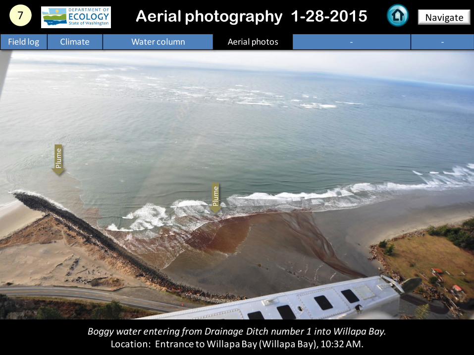
Boggy water entering from Drainage Ditch number 1 into Willapa Bay. Location: Entrance to Willapa Bay (Willapa Bay), 10:32 AM.
7 Navigate Aerial photography 1-28-2015 Field log Climate Water column Aerial photos - -
Plum
e
Plum
e
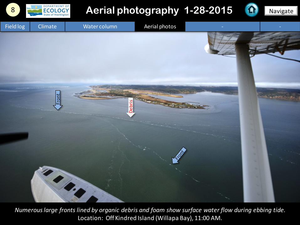
Numerous large fronts lined by organic debris and foam show surface water flow during ebbing tide. Location: Off Kindred Island (Willapa Bay), 11:00 AM.
8 Navigate Aerial photography 1-28-2015 Field log Climate Water column Aerial photos - -
Fron
t
Debr
is
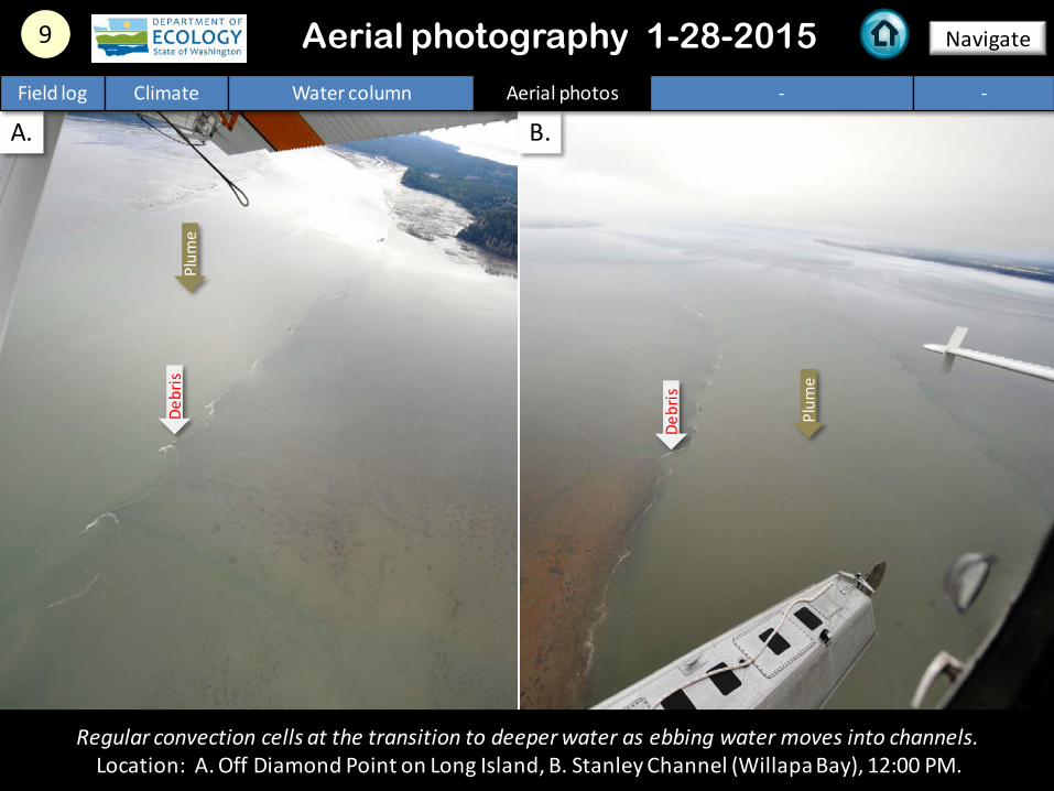
A. B.
Regular convection cells at the transition to deeper water as ebbing water moves into channels. Location: A. Off Diamond Point on Long Island, B. Stanley Channel (Willapa Bay), 12:00 PM.
9 Navigate Aerial photography 1-28-2015 Field log Climate Water column Aerial photos - -
Plum
e
Plum
e
Debr
is
Debr
is
10 Navigate Aerial photography 1-28-2015
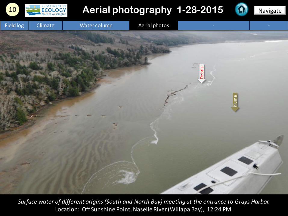
Surface water of different origins (South and North Bay) meeting at the entrance to Grays Harbor. Location: Off Sunshine Point, Naselle River (Willapa Bay), 12:24 PM.
Field log Climate Water column Aerial photos - -
Plum
e
Debr
is
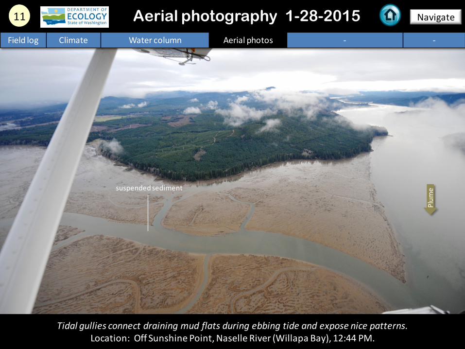
11 Navigate Aerial photography 1-28-2015
Tidal gullies connect draining mud flats during ebbing tide and expose nice patterns. Location: Off Sunshine Point, Naselle River (Willapa Bay), 12:44 PM.
Field log Climate Water column Aerial photos - -
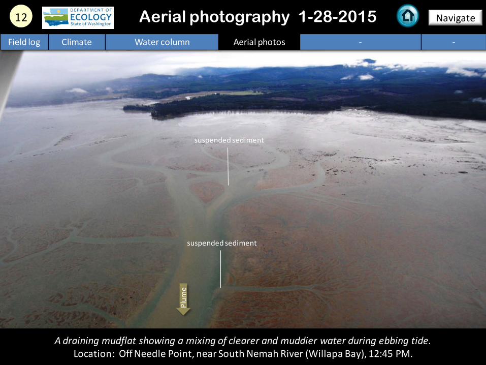
Plum
e suspended sediment
A draining mudflat showing a mixing of clearer and muddier water during ebbing tide. Location: Off Needle Point, near South Nemah River (Willapa Bay), 12:45 PM.
12 Navigate
Field log Climate Water column Aerial photos - -
Aerial photography 1-28-2015
Plum
e
suspended sediment
suspended sediment
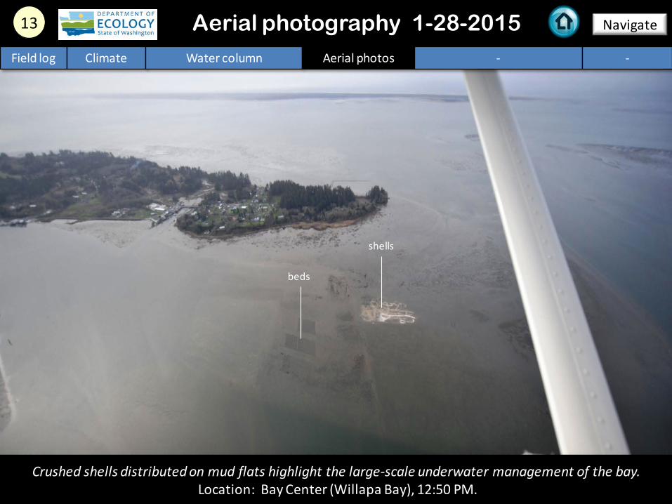
Crushed shells distributed on mud flats highlight the large-scale underwater management of the bay. Location: Bay Center (Willapa Bay), 12:50 PM.
13 Navigate Aerial photography 1-28-2015 Field log Climate Water column Aerial photos - -
shells
beds
Patterns on mud flats, resembling fields, highlight the large-scale underwater management of the bay. Location: Bay Center (Willapa Bay), 12:50 PM.
14 Navigate
Field log Climate Water column Aerial photos - -
Aerial photography 1-28-2015
beds beds
beds
15 Navigate
Field log Climate Water column Aerial photos - -
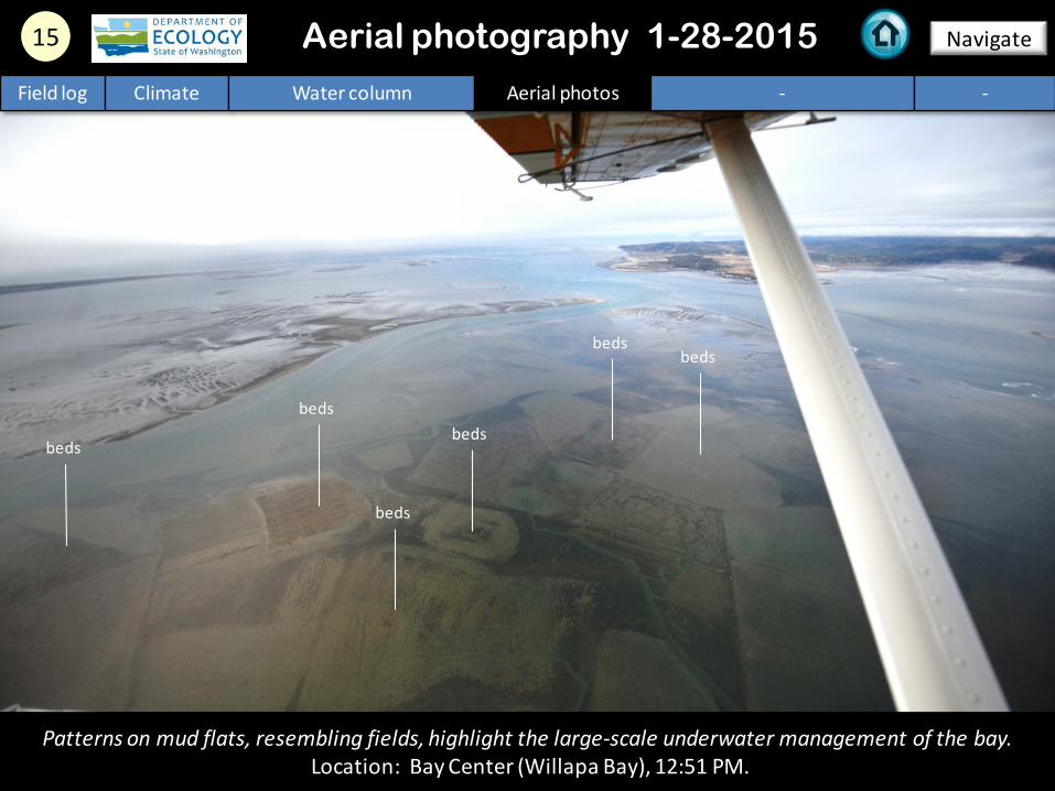
Patterns on mud flats, resembling fields, highlight the large-scale underwater management of the bay. Location: Bay Center (Willapa Bay), 12:51 PM.
Aerial photography 1-28-2015
beds
beds
beds
beds
beds
beds
16 Navigate
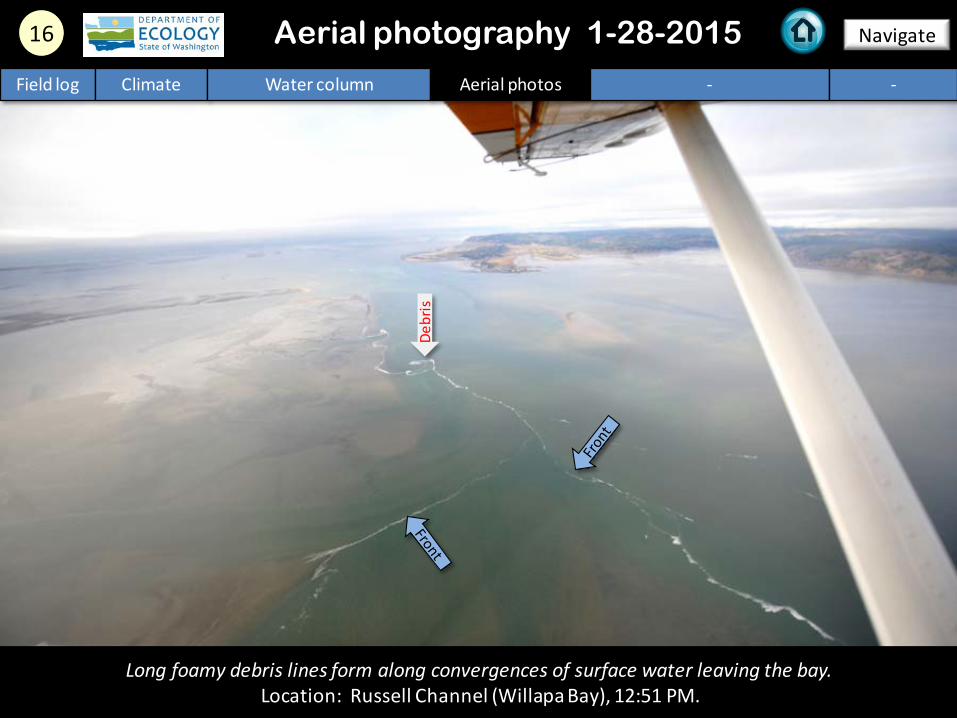
Long foamy debris lines form along convergences of surface water leaving the bay. Location: Russell Channel (Willapa Bay), 12:51 PM.
Aerial photography 1-28-2015 Field log Climate Water column Aerial photos - -
Debr
is
A. B.
17 Navigate
Field log Climate Water column Aerial photos - -
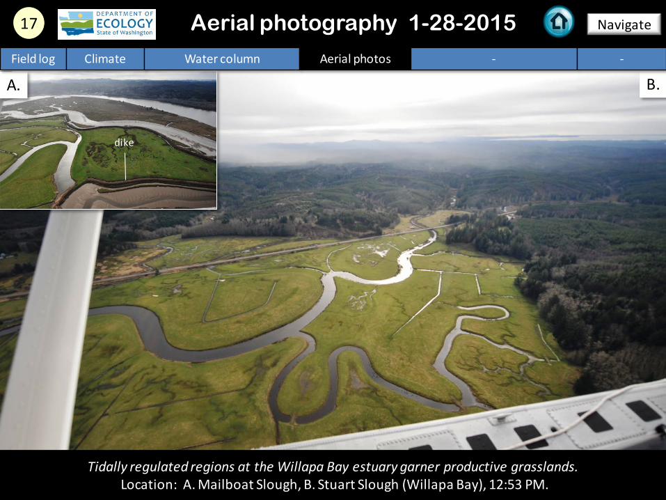
Tidally regulated regions at the Willapa Bay estuary garner productive grasslands. Location: A. Mailboat Slough, B. Stuart Slough (Willapa Bay), 12:53 PM.
Aerial photography 1-28-2015
dike
18 Navigate
Field log Climate Water column Aerial photos - -
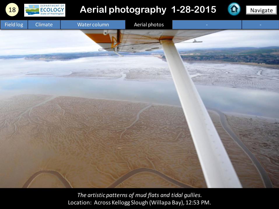
The artistic patterns of mud flats and tidal gullies. Location: Across Kellogg Slough (Willapa Bay), 12:53 PM.
Aerial photography 1-28-2015
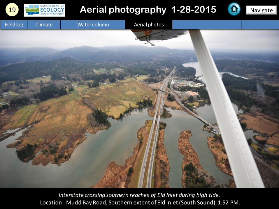
19 Navigate
Field log Climate Water column Aerial photos - -
Interstate crossing southern reaches of Eld Inlet during high tide. Location: Mudd Bay Road, Southern extent of Eld Inlet (South Sound), 1:52 PM.
Aerial photography 1-28-2015
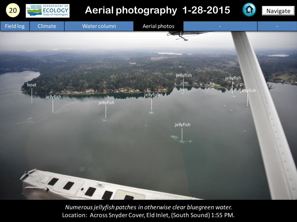
20 Navigate
Numerous jellyfish patches in otherwise clear bluegreen water. Location: Across Snyder Cover, Eld Inlet, (South Sound) 1:55 PM.
Aerial photography 1-28-2015 Field log Climate Water column Aerial photos - -
jellyfish
jellyfish jellyfish
jellyfish
jellyfish jellyfish
jellyfish
boat
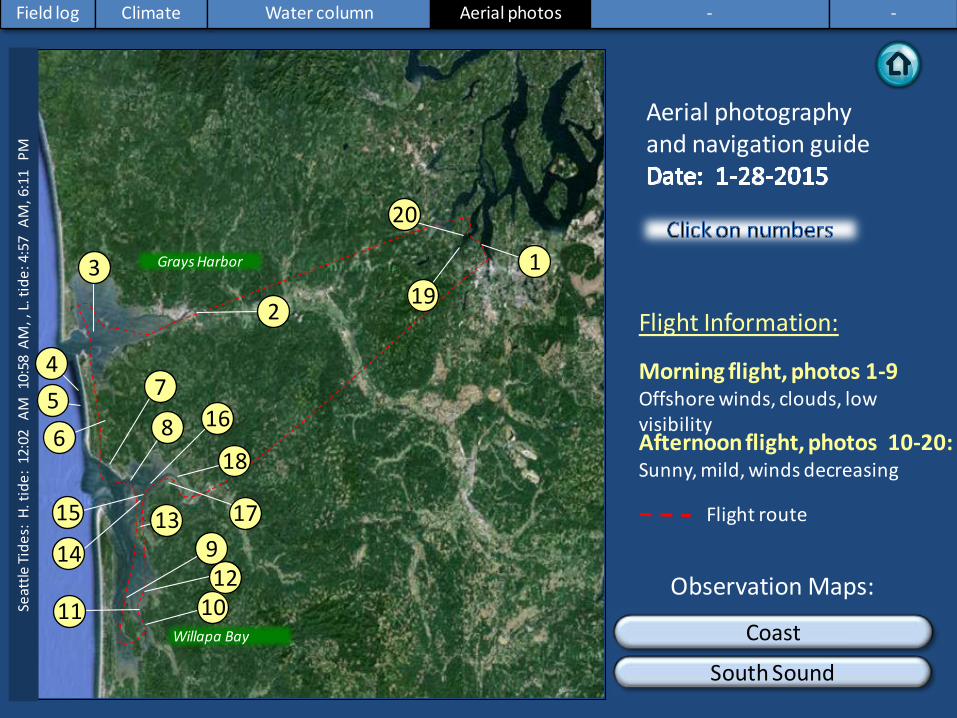
Numbers on map refer to picture numbers for spatial reference
Date: 1-28-2015
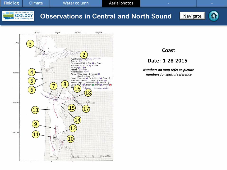
Coast
Aerial photography observations in Central Sound Observations in Central and North Sound Navigate
Field log Climate Water column Aerial photos - -
9
4
3
8
13
14
15
16
2
17
18
5 6
10
7
11 12
Date: 1-28-2015
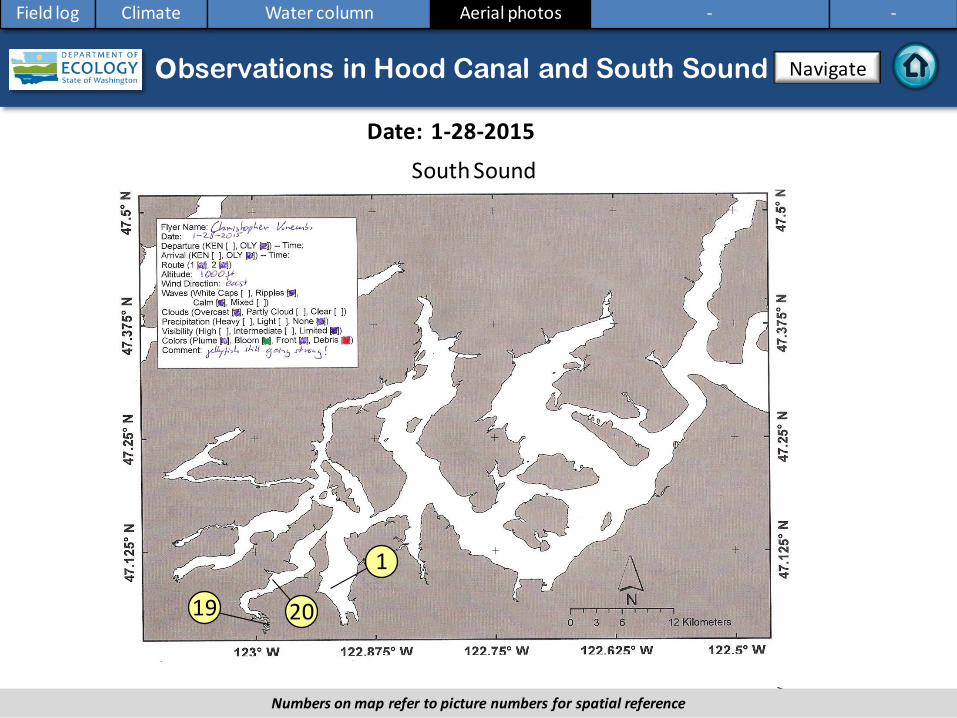
Observations in Hood Canal and South Sound
Numbers on map refer to picture numbers for spatial reference
Navigate
Field log Climate Water column Aerial photos - -
South Sound
19 20
1
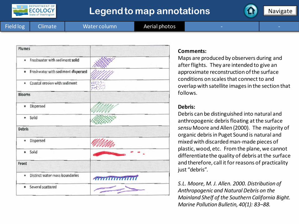
Legend to map annotations
Comments: Maps are produced by observers during and after flights. They are intended to give an approximate reconstruction of the surface conditions on scales that connect to and overlap with satellite images in the section that follows. Debris: Debris can be distinguished into natural and anthropogenic debris floating at the surface sensu Moore and Allen (2000). The majority of organic debris in Puget Sound is natural and mixed with discarded man-made pieces of plastic, wood, etc. From the plane, we cannot differentiate the quality of debris at the surface and therefore, call it for reasons of practicality just “debris”. S.L. Moore, M. J. Allen. 2000. Distribution of Anthropogenic and Natural Debris on the Mainland Shelf of the Southern California Bight. Marine Pollution Bulletin, 40(1): 83–88.
You may subscribe or unsubscribe to the Eyes Over Puget Sound email listserv by going to: http://listserv.wa.gov/cgi-bin/wa?A0=ECOLOGY-EYES-OVER-PUGET-SOUND
Many thanks to our business partners: Clipper Navigations, Swantown Marina, and Kenmore Air.
We are looking for feedback to improve our products.