27
EPA Geospatial Metadata Style Guide using EME 3 Version 1.2, March 17, 2017
EPA Geospatial Metadata Style Guide using EME 3
Version 1.2, March 17, 2017

March 17, 2017 Page i EPA Geospatial Metadata Style Guide using EME 3
Document Change Control
The following is the document control for revisions to this document.
Version Number
Date of Issue
Author(s) Brief Description of Change
V1.0 October 7, 2014
Steven Jett, Suzanne Pierson, Torrin Hultgren, Innovate!, Inc.
Initial Version.
V1.1 May 4, 2015
Steven Jett, Suzanne Pierson, Torrin Hultgren, Innovate!, Inc.
Updates for changes to Distribution Liability in order to comply with OMB Project Open Data requirements.
V1.2 March 17, 2017
Suzanne Pierson, Torrin Hultgren, Innovate!, Inc.
Extracted documentation for EME 3 portion of the EPA Metadata Style Guide and created a separate document.

March 17, 2017 Page ii EPA Geospatial Metadata Style Guide using EME 3
Contents Document Change Control ............................................................................................................................. i
Important note – EME v5 released and is recommended over EME v3.2.1 ................................................. 1
Introduction .................................................................................................................................................. 1
Prepare FGDC-Compliant Metadata for a Geospatial Resource ............................................................... 2
Types of geospatial resources ............................................................................................................... 2
Helpful metadata templates ................................................................................................................. 2
The EPA Metadata Editor (EME) v3.2.1 ................................................................................................ 3
Additional metadata preparation considerations ................................................................................ 3
Instructions for using this guide ............................................................................................................ 4
EME Tab 1: Basic Dataset Information .................................................................................................. 6
EME Tab 2: Quality, Coordinate System, and Attribute Information ................................................. 13
EME Tab 3: Distribution & Metadata Information .............................................................................. 21

March 17, 2017 Page 1 EPA Geospatial Metadata Style Guide using EME 3
Important note – EME v5 released and is recommended over EME v3.2.1
In March 2017, EME v5.0 was released and allows users to create geospatial metadata conforming to
the 2016 EPA Metadata Technical Specification, ISO’s 19115 standard endorsed by the Federal
Geographic Data Committee (FGDC), and OMB’s Project Open Data (POD) schema. EME v5.0 is EPA’s
customization of Esri’s ArcCatalog metadata editor and creates ISO/POD-compliant ArcGIS Metadata.
Previous versions of EME have followed FGDC-compliant metadata standards which necessitated
creating two separate metadata documents when documenting a web service and corresponding data
download file. EME v5.0 allows for consolidation of web service and data download records into one
metadata record due to implementation of the ISO 19115 metadata standard and improved functionality
when documenting online linkage formats. For more information about downloading and installing the
EME v5.0 toolkit, go to the EME v5.0 GitHub site.
The guidelines in this document are for creating FGDC-compliant metadata using EPA’s Metadata Editor
(EME) v.3.2.1. EME v3.2.1 can function either as a standalone tool or as an extension to Esri’s ArcCatalog
and is compatible with ArcGIS 10.2 (or higher). EME v3.2.1 includes minor updates to ensure minimal
compliance to Project Open Data (schema 1.1) requirements.
Introduction This Style Guide provides suggestions on FGDC-compliant metadata preparation for EPA geospatial
resources using EME v3.2.1. Detailed guidance on metadata requirements, standard language, and
naming conventions are provided with the goal of simplifying the documentation process and
standardizing (to the extent possible) EPA dataset metadata and documentation. This guidance is rooted
in the guidelines set forth in the 2007 EPA Geospatial Metadata Technical Specification. The goal of this
guide is to help users create metadata that has a consistent appearance and, where applicable,
conforms to all EPA and Project Open Data requirements that make the metadata record sharable in the
Environmental Dataset Gateway (EDG) and Data.gov.
For assistance with locating suggested keywords and EPA organization names used to complete
metadata fields (i.e., Title and Keywords), please refer to EPA’s Metadata Style Guide – Keywords and
EPA Organization Names. To access additional metadata style guides and information designed
specifically for documenting web services, EPA GeoPlatform Online content items, and non-geospatial
data, refer to EPA’s Metadata Style Guide for Geospatial and Non Geospatial Data.
This guide does not detail the process to publish metadata records to the Environmental Dataset
Gateway (EDG). Please consult documents at the EDG Home page for help on publishing metadata to
EDG. For additional assistance, contact the EDG Team ([email protected]).

March 17, 2017 Page 2 EPA Geospatial Metadata Style Guide using EME 3
Prepare FGDC-Compliant Metadata for a Geospatial Resource This Style Guide provides detailed documentation on how to create FGDC-compliant metadata for each
type of geospatial resource that is suitable for publishing in the EDG. The documentation is designed to
be used with metadata templates that accompany the EPA Metadata Editor (EME) v3.2.1.
Types of geospatial resources FGDC-compliant metadata for geospatial resources is published in the EDG to facilitate discovery of the
resource. Geospatial resources include the following:
Geospatial dataset – shapefile, feature class, imagery file, etc.
Data download package – dataset or group of datasets made available as a download (often
compressed into a zip file).
Web service – geospatial data, accessible via a web URL, consumable in client applications such
as web maps.
Helpful metadata templates Three downloadable templates are designed to be used with this Style Guide:
MetadataTemplateLayerLevel.xml – designed to be used to create metadata for a geospatial
dataset such as a shapefile, individual feature class, imagery file, etc.
MetadataTemplateDownloadPkg.xml – designed to be used to create metadata for a data
download package
MetadataTemplateWebService.xml – designed to be used to create metadata for a web service
The templates contain required text for each metadata element along with text prompts for data-
specific text. The text prompts are enclosed in brackets and asterisks {***ENTER HERE***} which the
user must replace with text that describes the data layer.

March 17, 2017 Page 3 EPA Geospatial Metadata Style Guide using EME 3
The EPA Metadata Editor
(EME) v3.2.1 This guide was developed based on the
structure of the EPA Metadata Editor
(EME) v3.2.1 (for information on EME
v3.2.1, please see the document What’s
New in the EPA Metadata Editor Version
3.2.1). The advantage of using EME is
that it specifically denotes which
elements are mandatory and which are
optional, and has dropdowns for several
elements that may be populated with
standardized text. The user may also
validate the metadata record directly
within EME to ensure it complies with
standards. Developers with considerable metadata editing experience may find a text editor more
efficient than using EME, but need to be cognizant of elements requiring specific language in order for
the metadata record to pass validation to be published in the EDG. Some developers might find that
initial editing within the EME followed by final editing in a text editor will produce the desired results.
Download EME v3.2.1 and review EME training materials at the EPA Metadata Editor 3 GitHub site.
Additional metadata preparation considerations Review these considerations for preparing metadata based on the geospatial resource type.
Preparing FGDC metadata for a dataset (layer-level metadata):
NOTE: in this document, “layer-level” metadata refers to metadata prepared for an individual
geospatial dataset such as a shapefile, individual feature class within a geodatabase, raster
dataset, imagery file, etc.
Metadata preparation should occur in the EME extension of ArcCatalog.
If the dataset has accompanying original metadata, use this guide to edit the original metadata.
If no accompanying metadata exists, use this guide to create new metadata. In both cases, list
whether the dataset has been value-added in the Supplemental Information metadata element
and details about improvements to the dataset in the Processing Steps metadata element.
This guide assumes that metadata is linked to the geospatial dataset. In ArcCatalog, use the EME
Import function to link a metadata XML file to the dataset. If metadata is being created for the
first time, link a copy of the MetadataTemplateDataset.xml file to the dataset to begin the
editing process. Linking metadata to the dataset takes advantage of EME’s metadata
synchronization function, which automatically writes certain properties of the geospatial dataset
(Bounding Box, Coordinate System, and Lineage) to the appropriate elements in the metadata,
eliminating the need to update these manually.
March 17, 2017 Page 4 EPA Geospatial Metadata Style Guide using EME 3
To ensure that the Bounding Box and Coordinate System fields are properly populated, make
sure to set the EME Sync Settings as follows:
o In ArcCatalog, click the Manage Metadata Synchronization button on the EME toolbar.
o Click the EPA Sync Settings tab.
o Check Remove ESRI tags, Coordinate System, and Spatial Extent.
o Uncheck Attributes, Online Linkage, and Retain PublishedDocID.
o Click OK.
o Perform synchronization.
Preparing FGDC metadata for a data download package:
Metadata preparation should occur in the standalone version of EME.
It is recommended that a data download package consist of a zip file containing the following:
o A file geodatabase.
o An Esri ArcMap map document (MXD).
o An XML file of the FGDC-compliant metadata for the download package.
Additionally, a duplicate copy of the XML metadata file should be placed alongside the zip file
(external to the zip file) to provide an easily-accessible indication of the zip file contents. This
arrangement allows data users to preview the metadata and ensure the package contains the
desired contents before commencing a download session.
As a best practice, layer-level metadata should exist in the file geodatabase for each feature
class.
Preparing FGDC metadata for a web service:
NOTE: EPA web services require two types of metadata: A FGDC metadata record that is
published in the EDG to facilitate discovery of the web service, and metadata at the web service
REST endpoint page that results from publishing the web service in ArcGIS Server. This section
pertains to creating the FGDC metadata record. Please refer to the following section, “Prepare
ArcMap MXD documentation for web service metadata,” for REST endpoint metadata.
Metadata preparation should occur in the standalone version of EME.
As a best practice, layer-level metadata should be published in the EDG for each layer in the web
service. The link to the layer-level metadata should be made available at each layer’s REST
endpoint.
It is strongly recommended that data download packages be made available for geospatial
datasets that are published as web services.
Instructions for using this guide This guide has instructions and recommendations for creating FGDC metadata for all three geospatial
resource types. Specific instructions are included for specific resource types where appropriate. For
example, separate instructions for completing the Description elements in EME are included and
denoted as “FOR LAYER-LEVEL METADATA,” “FOR DATA DOWNLOAD PACKAGE METADATA”, and “FOR
WEB SERVICE METADATA.”

March 17, 2017 Page 5 EPA Geospatial Metadata Style Guide using EME 3
Open the metadata file in EME and follow along in the guide which steps through each EME tab,
element by element, with instructions. While most elements are pre-populated with text prompts, other
elements may be optionally edited as needed. Elements in this guide denoted with light gray text should
not be edited. In addition, help with individual EME elements is available directly in the EME interface by
clicking on the link for the element or selecting the Help menu item.

March 17, 2017 Page 6 EPA Geospatial Metadata Style Guide using EME 3
EME Tab 1: Basic Dataset Information
Citation
Origin: {***ENTER
SOURCE DATA ORIGINATOR(S)***}
Example: US Census Bureau
Example: Virginia Institute of Marine Science and U.S. Fish and Wildlife Service
Title: {***ENTER SUBJECT, GEOGRAPHIC EXTENT, RELEVANT TIME PERIOD, DATA OWNER/PROVIDER,
OFFICE/REGION/RESEARCH LAB OF DATA OWNER***}
Example: Toxics Release Inventory (TRI) Locations, Oklahoma, 2012, EPA OIAA, EPA REG 06
WQPD
Example: Tribal Lands, Idaho, 2000, Bureau of Indian Affairs, EPA REG 10
Example: Potomac River Basin Boundary, Chesapeake Bay Program
NOTE: individual elements in this convention may be omitted if they are superfluous or
redundant. For example, there is no need to include a date if data are not date-specific, or are
frequently or continuously updated. Additionally, if the geographic extent is implicit in the
content text (e.g. Potomac River Basin Boundary), it may be omitted provided that the actual
extent of the data matches the extent implied in the title (an example of a dataset whose actual
extent does not match the implicitly titled extent would be National Hydrography Dataset
clipped to a given state). Geographic extent should always refer to a place name, not
coordinates.
Publisher
Published by: {***EPA DATA: ENTER FROM DROPDOWN. NON-EPA DATA: TYPE THE AGENCY, VENDOR
OR ORGANIZATION NAME***}
Example: EPA Office of Enforcement and Compliance Assurance (OECA)
NOTE: the Publisher element should reflect the name of the agency, vendor, or organization
responsible for creating the dataset. For EPA datasets, Publisher should be populated by the
most appropriate value in the dropdown. For non-EPA datasets, the name may be entered in the
element, which can accommodate free text entries.
Published at: {***ENTER CITY, STATE OF EPA DATA PUBLISHER***}
Example: Research Triangle Park, NC
Date:
Click the today button. Alternatively, a specific publication date may be entered.

March 17, 2017 Page 7 EPA Geospatial Metadata Style Guide using EME 3
Online Linkage
The Online Linkage element may be expanded to reveal ten linkage elements. Press
the plus button in the upper right corner.
NOTE: Each linkage must comply with a standard convention for the online linkage
type, and the sequence is critical. Review the descriptions below to understand the specific type of online
resource assigned to each linkage. To preserve the sequence of the linkages, no blank linkages may exist
earlier in the order—a placeholder URL must be used. The default button may be used to generate a
placeholder URL, if desired.
Primary Linkage: {***ENTER URL TO DOWNLOADABLE DATASET***}
Example: http://edg-intranet.epa.gov/data/Restricted/OEI/GolfCourses/GolfCourses.zip
This linkage is mandatory if applicable. The standard convention for the Primary Linkage is a URL
providing direct access to the download.
NOTE: If no downloadable version exists this element may be left blank unless a subsequent
linkage is specified, in which case a placeholder URL must be used. The default button may be
used to generate a placeholder URL, if desired.
Secondary Linkage: {***ENTER ENDPOINT OF WEB SERVICE TO ACCESS THE DATASET***}
Example: http://igeo.epa.gov/ArcGIS/Rest/Services/OEI_IGD/GolfCourses/MapServer
This linkage is mandatory if applicable. The standard convention for the Secondary Linkage is a
URL pointing to the endpoint of a web service to access the dataset (REST endpoint, WMS
GetCapabilities URL, or a Soap WSDL endpoint).
NOTE: If no web service exists this element may be left blank unless a subsequent linkage is
specified, in which case a placeholder URL must be used. The default button may be used to
generate a placeholder URL, if desired.
Linkage 3:
The standard convention for Linkage 3 is a URL for accessing related documents such as
technical information about a dataset, developer documentation, etc.

March 17, 2017 Page 8 EPA Geospatial Metadata Style Guide using EME 3
NOTE: If an appropriate URL does not exist this element may be left blank unless a subsequent
linkage is specified, in which case a placeholder URL must be used. The default button may be
used to generate a placeholder URL, if desired.
Linkage 4:
The standard convention for Linkage 4 is a URL for an alternative landing page used to redirect
user to a contextual, Agency-hosted “homepage” for the dataset. This field is not intended for
an agency’s homepage, but rather related to resources tied to the dataset.
NOTE: If an appropriate URL does not exist this element may be left blank unless a subsequent
linkage is specified, in which case a placeholder URL must be used. The default button may be
used to generate a placeholder URL, if desired.
Other Linkages:
Any other URLs related to this dataset. These may be left blank if no additional URLs exist.
NOTE: It is recommended that these elements remain blank if no linkages are provided in the
Primary Linkage, Secondary Linkage, Linkage 3, and/or Linkage 4 elements.
Description
FOR LAYER-LEVEL METADATA:
Abstract: This {***raster (IF APPLICABLE)***} GIS dataset contains {***POINTS/LINES/POLYGONS/
CELLS***} depicting {***CONTENT FROM TITLE***}. {***ADDITIONAL CONTEXTUAL INFORMATION.***}
This element is pre-populated with suggested text. Change the text to fit specific needs to
describe the dataset as thoroughly as possible. Use clear and concise language, keeping in mind
that different portals and clearinghouses that harvest metadata show only a portion of the
abstract as a preview. As such, structure the abstract content in decreasing order of importance.
Any additional contextual information that helps inform the user about the dataset is helpful.
Example: This raster GIS dataset contains 100-meter-resolution cells depicting mean surface
salinity (parts per thousand) in the Chesapeake Bay and its tidal tributaries during Fall season.
Salinity was measured annually from 1985 to 2006.
Purpose: {***TEXT DESCRIBING THE GENERAL PURPOSE OF THE GIS DATASET***} The overall goal of
the Chesapeake Bay Program is to lead and direct Chesapeake Bay restoration and protection.
Populate this element with text describing the general purpose of the geospatial dataset.

March 17, 2017 Page 9 EPA Geospatial Metadata Style Guide using EME 3
Example: The purpose of this dataset is to show the differences in salinity throughout the
Chesapeake Bay during the Fall season. The overall goal of the Chesapeake Bay Program is to
lead and direct Chesapeake Bay restoration and protection.
Supplemental Info:
This element is frequently used to denote whether the dataset is EPA-created or EPA-Value-
added, or for other information that should be communicated to the end user such as caveats.
This element may be completed with such information or may be left blank.
FOR DATA DOWNLOAD PACKAGE METADATA:
Abstract: This downloadable data package contains the following layers: {***DEFINE LAYERS HERE***}.
Included in this package are a file geodatabase, Esri ArcMap map document, and a XML file of this
metadata record. Full FGDC metadata records for each layer are contained in the database.
This element is pre-populated with suggested text which may be changed to fit specific needs.
Complete the element using clear and concise language, keeping in mind that different portals
and clearinghouses that harvest metadata show only a portion of the abstract as a preview. As
such, structure the abstract content in decreasing order of importance.
Purpose: {***TEXT DESCRIBING THE GENERAL PURPOSE OF THE DOWNLOAD PACKAGE***}
Populate this element with text describing the purpose of the data download package.
Example: These data provide information about Toxic Release Inventory (TRI) locations in EPA
Region 4 and are intended for geographic display and analysis at regional, state, and local levels.
Supplemental Info:
This element is frequently used for data caveats or other information that should be
communicated to the end user. This element may be completed with such information or may
be left blank.
FOR WEB SERVICE METADATA:
Abstract: This web service contains the following map layers: {***DEFINE LAYERS HERE***}. Layers are
drawn at scales of {***DEFINE THIS IF MAP CONTAINS SCALE DEPENDENCIES***}. Data used to create
this web service are available as a separate download at the Primary Linkage listed. Full FGDC metadata
records for each layer may be found by clicking the layer name at the web service endpoint (available
through the online link provided above) and viewing the layer description.
This element is pre-populated with suggested text which may be changed to fit specific needs.
Complete the element using clear and concise language, keeping in mind that different portals
and clearinghouses that harvest metadata show only a portion of the abstract as a preview. As
such, structure the abstract content in decreasing order of importance. Once completed, review
for errors and content prior to validating and publishing.
Purpose: {***TEXT DESCRIBING THE GENERAL PURPOSE OF THE WEB SERVICE***}
Populate this element with text describing the general purpose of the web service.
Example: These data provide information about Toxic Release Inventory (TRI) locations in EPA
Region 4 and are intended for geographic display and analysis at regional, state, and local levels.
Supplemental Info:

March 17, 2017 Page 10 EPA Geospatial Metadata Style Guide using EME 3
This element is frequently used for data caveats or other information that should be
communicated to the end user. This element may be completed with such information or may
be left blank.
Time Period
Date of Data Set:
Enter the date or time period that the resource reflects.
Progress of the data:
Select the text that best describes the status of the dataset.
Data currency:
Select the text that best describes the basis on which the time period of the content is
determined.
Update frequency:
Select the text that best describes the update frequency for the dataset.
Bounding Box
FOR LAYER-LEVEL METADATA:
N, E, S, W:
These elements are automatically populated with the bounding box coordinates of the dataset
when the metadata is synchronized with the dataset.
FOR DATA DOWNLOAD OR WEB SERVICE METADATA:
N, E, S, W:
If using the EME, select the appropriate bounding box from the dropdown list. If the dropdown
list options do not include the exact bounding box for the data, enter the extent values
manually.
March 17, 2017 Page 11 EPA Geospatial Metadata Style Guide using EME 3
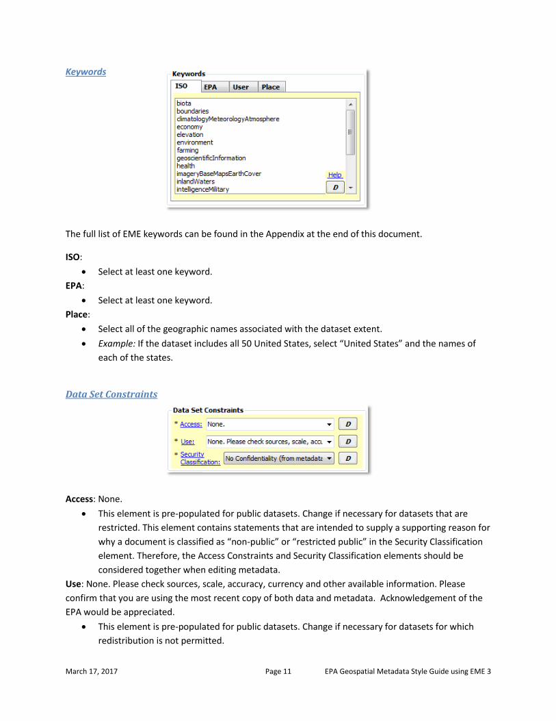
Keywords
The full list of EME keywords can be found in the Appendix at the end of this document.
ISO:
Select at least one keyword.
EPA:
Select at least one keyword.
Place:
Select all of the geographic names associated with the dataset extent.
Example: If the dataset includes all 50 United States, select “United States” and the names of
each of the states.
Data Set Constraints
Access: None.
This element is pre-populated for public datasets. Change if necessary for datasets that are
restricted. This element contains statements that are intended to supply a supporting reason for
why a document is classified as “non-public” or “restricted public” in the Security Classification
element. Therefore, the Access Constraints and Security Classification elements should be
considered together when editing metadata.
Use: None. Please check sources, scale, accuracy, currency and other available information. Please
confirm that you are using the most recent copy of both data and metadata. Acknowledgement of the
EPA would be appreciated.
This element is pre-populated for public datasets. Change if necessary for datasets for which
redistribution is not permitted.

March 17, 2017 Page 12 EPA Geospatial Metadata Style Guide using EME 3
Security Classification: public
This element is pre-populated for public datasets. Change if necessary for restricted datasets.
NOTE: This element is a critical Project Open Data requirement. Choices and definitions are:
o public – Data asset is or could be made publicly available to all without restrictions.
o restricted public – Data asset is available under certain use restrictions.
o non-public – Data asset is not available to members of the public.
Contact
{***USE CONTACT INFORMATION FROM EXISTING METADATA IF AVAILABLE, OR ADD CONTACT
INFORMATION FROM DROPDOWN. IF PRECISE CONTACT INFORMATION DOES NOT EXIST IN
DROPDOWN, ADD THE INFORMATION WITH A TEXT EDITOR OR ADD IT TO THE EME
DATABASE***}.
NOTE: Although the Contact element appears as a single element in EME, it is actually a
compound element that draws information from multiple fields in the EME database to populate
several fields in the metadata record. When a user selects a contact from the dropdown, all EPA
and Project Open Data requirements are satisfied. If custom contact information is desired
(contact information that does not appear in the dropdown), there are two options: 1) add the
information to the metadata XML file manually using a text editor, or 2) add the information to
the EME database to make the contact available in the EME dropdown (see the “Setting up the
EME Database” section under “Getting Started” in EME Help for guidance on editing the EME
database), then select the new contact from the dropdown. In either case, care must be taken to
ensure that the following contact fields are complete in the metadata record in order to be
compliant:
o Publisher (organization name)
o Contact name (may be substituted with position name)
o Email address
o Mailing address (not a Project Open Data requirement, but required to meet EPA
metadata standards)
NOTE: When selecting from the dropdown, the Contact will always be “Primary Person” and that
radio button should be selected. However, for some datasets it may be more appropriate to use
a position name and group email address instead of a contact name and email, in which case the
“Primary Organization” contact button may be selected. In this case, custom contact information
is necessary and the metadata record must be manually edited in the manner listed above.

March 17, 2017 Page 13 EPA Geospatial Metadata Style Guide using EME 3
EME Tab 2: Quality, Coordinate System, and Attribute Information
Quality
Integrity Tests: Tests for integrity have not been performed.
This section is pre-populated. If available, replace the template text with integrity test
information from the dataset.
Completeness of Data: Features represented have not been tested for completeness.
This section is pre-populated. If available, replace the template text with completeness
information from the dataset.
Horizontal Positional Accuracy
Report: Data were collected using methods that have unknown accuracy (EPA National Geospatial Data
Policy [NGDP] Accuracy Tier 10). For more information, please see EPA's NGDP at
http://epa.gov/geospatial/policies.html.
This section is pre-populated. If available, replace the template text with horizontal positional
accuracy collection reporting information from the dataset.
Value:
This element is not required. If available, enter the value of the horizontal positional accuracy
from the dataset.
Test used:
This element is not required. If available, enter the test used to determine the horizontal
positional accuracy from the dataset.

March 17, 2017 Page 14 EPA Geospatial Metadata Style Guide using EME 3
Vertical Positional Accuracy
Report:
This element is not required. If available, enter vertical positional accuracy collection reporting
information from the dataset.
Value:
This element is not required. If available, enter the value of the vertical positional accuracy from
the dataset.
Test used:
This element is not required. If available, enter the test used to determine the vertical
positional accuracy from the dataset
Lineage
NOTE: The Lineage element of
the EME is divided into two child elements: Source Information and Processing Steps. Click the Edit
Lineage button to access the two child elements.
Source Information:
While completion of the Source Information section is not required for minimum EPA compliancy,
consider completing the Source Information elements to provide details about the source data used to
create the resource. Refer to EME help for additional information on these elements.

March 17, 2017 Page 15 EPA Geospatial Metadata Style Guide using EME 3
Processing Steps:
The completion of at least one processing step is required for minimum FGDC compliancy. The elements
suggested here have been generalized. Each step suggested is a separate entry and multiple steps may
contain the same value for Date if they were performed on the same date. Modify these suggested
entries and create additional entries if necessary.
PROCESSING STEPS FOR LAYER-LEVEL METADATA:
Date: {***ENTER DATE PROCESSING STEP WAS PERFORMED***}
Description: {***ENTER PROCESSING STEP***)
Example Processing Steps:
o Converted Excel spreadsheet with latitude/longitude coordinates to GIS shapefile.
o Projected GIS Shapefile to UTM Zone 18, NAD 83 projection.
o Standardized attribute units from acres to hectares.
o Created FGDC-compliant metadata for GIS shapefile.
o Imported GIS shapefile into SDE as new feature class.
PROCESSING STEPS FOR DATA DOWNLOAD PACKAGE METADATA:
Date: {***ENTER DATE PROCESSING STEP WAS PERFORMED***}
Description: {***ENTER PROCESSING STEP***)
Example Processing Steps:
o Imported shapefiles into file geodatabase as new feature classes.
o Created FGDC-compliant metadata for each file geodatabase feature class.
o Created Esri ArcMap map document (MXD).
o Created FGDC-compliant metadata for the data download package.
o Zipped data, map document, and metadata.
PROCESSING STEPS FOR WEB SERVICE METADATA:
Date: {***ENTER DATE PROCESSING STEP WAS PERFORMED***}
Description: {***ENTER PROCESSING STEP***)
Example Processing Steps:
o Imported data into file geodatabase as new feature classes in Web Mercator projection.
o Created FGDC-compliant metadata for each file geodatabase feature class.
o Created Esri ArcMap map document (MXD).
o Published the web service.
o Created FGDC-compliant metadata for the web service.

March 17, 2017 Page 16 EPA Geospatial Metadata Style Guide using EME 3
Spatial Data Organization Information
NOTE: These elements are not required. They should be left blank for data download and web service
metadata preparation. For layer-level metadata, detailed data object information for specific vector and
raster formats may be entered by clicking the Edit Object Info button. Refer to EME help for more
information on these elements.
FOR LAYER-LEVEL METADATA:
Direct Spatial Reference:
This element is not required. If desired, use the dropdown to select the system used to
represent the objects in the dataset.
Indirect Spatial Reference:
This element is not required. If desired, enter the name of the types of geographic features,
addressing schemes, or other means through which locations are referenced in the dataset.
Coordinate System Information (Horizontal)
FOR LAYER-LEVEL METADATA:
Projection:
SPCS Zone / UTM Zone / Projection Name:
Units:
Datum:
Resolution: X: / Y:
These elements are automatically populated with the coordinate system information of the
dataset when the metadata is synchronized with the dataset.
FOR DATA DOWNLOAD OR WEB SERVICE METADATA:
Projection:
Use the dropdown to select the projection reference system for the dataset. If the reference
system is not in the list, use a text editor to populate this field.

March 17, 2017 Page 17 EPA Geospatial Metadata Style Guide using EME 3
SPCS Zone / UTM Zone / Projection Name:
Use the dropdown to select the State Plane Coordinate System Zone, UTM Zone, or Projection
Name for the dataset. If the zone or name is not in the list, use a text editor to populate this
field.
NOTE: The dropdown selections in this field will correspond with the projection reference system
selected in the Projection field.
Units:
Use the dropdown to select the coordinate system units. If the correct entry for units is not in
the list, use a text editor to populate this field.
NOTE: The dropdown selection(s) in this field will correspond with the entry in the Projection field
and the entry in the SPCS Zone, UTM Zone, or Projection Name field.
Datum:
Use the dropdown to select the coordinate system datum. If the correct entry for the datum is
not in the list, use a text editor to populate this field.
NOTE: The dropdown selection(s) in this field will correspond with the entries in the other fields
in this section.
Resolution: X: / Y:
Enter the coordinate resolution (minimum distance between two adjacent points). For vector
data, these values usually correspond to the fuzzy tolerance of the dataset. For raster data,
these values usually correspond to the raster cell size.
Entity and Attribute Information
NOTE: These elements are not required. They should be left blank for data download and web service
metadata preparation. For layer-level metadata, while completion of the Entity and Attribute
Information section is not required for minimum FGDC compliancy, it is considered a best practice to
complete these elements so that details about the dataset’s attributes are recorded.
FOR LAYER-LEVEL METADATA:
The Entity and Attribute Information section of EME has two tabs: Overview and Detailed. Choose one
or the other to document the attributes in the dataset’s table. As a best practice, it is recommended
that the elements in the Detailed tab be completed for geospatial datasets created within EPA. For
datasets that originate from outside of EPA it is recommended that the Overview tab be used unless
there is a desire to provide detailed attribute information.

March 17, 2017 Page 18 EPA Geospatial Metadata Style Guide using EME 3
Overview:
The Overview tab provides two metadata
elements: Overview Description and Citation. The Overview Description element is a free-text block in
which to enter a description of the geospatial dataset attributes. This is useful if “official” definitions of
the attributes were not provided with the source data from which the geospatial dataset was created. If
descriptive text about the dataset was provided, that may be transferred to this tab. Additionally,
hyperlinks that point to an online resource with additional information about the dataset may be used.
Note that if the Overview Description element is completed, the Citation element becomes required.
The metadata will not validate if the Citation element is left blank.
Overview Description:
Provide a summary of the information contained in the dataset. Use the descriptive text that
accompanied the original data if any existed, or make a best effort to summarize the contents.
Example: Zebra mussel sightings from 1991 to 2010 data provided to the Chesapeake Bay
Program for use in GIS analysis and visualization. Data provided by US Geological Survey
Nonindigenous Aquatic Species (NAS) Program. Inquiries regarding attribute data may be
addressed to the Metadata Contact.
Citation:
Provide a citation if available, or minimally the name of the source data provider.
Example: Pawlitz, R.J., and David, K.D., 2012, The National Nonindigenous Aquatic Species
Program: U.S. Geological Survey Fact Sheet 2012-3100, 4 p.
Example: National Register of Historic Places, US Department of the Interior National Parks
Service

March 17, 2017 Page 19 EPA Geospatial Metadata Style Guide using EME 3
Detailed:
The Detailed tab provides several
elements that permit the entry of detailed information about each attribute in the geospatial dataset
attribute table. If the original dataset contained a linked FGDC metadata record with defined Entity and
Attribute information, these elements are automatically populated with that information. If these fields
are all blank, synchronizing the metadata with the dataset will populate these elements with
information from the metadata record. If no metadata record exists, performing synchronization will
populate the Attribute Information – Label element with the names of all of the attributes.
Entity Information - Label:
The name of the dataset. Automatically populated when metadata is synchronized.
Entity Information – Definition Source:
The source of the geospatial dataset. Generally corresponds with the name provided in the
Origin element on Tab 1.
Example: US Census Bureau
Example: Virginia Institute of Marine Science and U.S. Fish and Wildlife Service
Entity Information – Definition:
The definition of the geospatial dataset. Generally corresponds with the information provided in
the Title element on Tab 1.
Example: Toxics Release Inventory (TRI) Locations, Oklahoma, 2012, EPA OIAA, EPA REG 06,
WQPD
Example: Tribal Lands, Idaho, 2000, Bureau of Indian Affairs, EPA REG 10
Example: Potomac River Basin Boundary, Chesapeake Bay Program
Attribute Information - Label:
The name of the attributes. Dropdown is automatically populated with all the attribute names
when metadata is synchronized.

March 17, 2017 Page 20 EPA Geospatial Metadata Style Guide using EME 3
Attribute Information – Definition Source:
The source of the attribute. Attributes that are properties of the geospatial dataset (e.g.
OBJECTID and Shape) are automatically credited to Esri when metadata is synchronized.
Example: US Census Bureau
Attribute Information – Definition:
The definition of the attribute. It is recommended that a one- or two-sentence definition be
used, although the element accepts very long character strings.
Domain Information:
Refer to EME help for details on selecting the proper domain type (Range, Codeset, Enumerated,
or Unrepresentable) and completing Domain Information section.

March 17, 2017 Page 21 EPA Geospatial Metadata Style Guide using EME 3
EME Tab 3: Distribution & Metadata Information
Distribution Information
Distribution Contact: {***USE CONTACT INFORMATION FROM EXISTING METADATA IF AVAILABLE, OR
ADD CONTACT INFORMATION FROM DROPDOWN. IF PRECISE CONTACT INFORMATION DOES NOT EXIST
IN DROPDOWN, ADD THE INFORMATION WITH A TEXT EDITOR OR ADD IT TO THE EME DATABASE***}.
NOTE: Although the Contact element appears as a single element in EME, it is actually a
compound element that draws information from multiple fields in the EME database to populate
several fields in the metadata record. When a user selects a contact from the dropdown, all EPA
and Project Open Data requirements are satisfied. If custom contact information is desired
(contact information that does not appear in the dropdown), there are two options: 1) add the
information to the metadata XML file manually using a text editor, or 2) add the information to
the EME database to make the contact available in the EME dropdown (see the “Setting up the
EME Database” section under “Getting Started” in EME Help for guidance on editing the EME
database), then select the new contact from the dropdown. In either case, care must be taken to
ensure that the following contact fields are complete in the metadata record in order to be
compliant:
o Publisher (organization name)
o Contact name (may be substituted with position name)
o Email address
o Mailing address (not a Project Open Data requirement, but required to meet EPA
metadata standards)
NOTE: When selecting from the dropdown, the Contact will always be “Primary Person” and that
radio button should be selected. However, for some datasets it may be more appropriate to use
a position name and group email address instead of a contact name and email, in which case the
“Primary Organization” contact button may be selected. In this case, custom contact information
is necessary and the metadata record must be manually edited in the manner listed above.
Data Resource Type
FOR LAYER-LEVEL METADATA:
Type of dataset?:
Use the dropdown to select the content type classification (method of access) for the geospatial
dataset. The most common classifications are:

March 17, 2017 Page 22 EPA Geospatial Metadata Style Guide using EME 3
o Downloadable Data – dataset is made available as part of a data download package.
o Live Data and Maps – dataset is made available as a layer in a web service.
o Offline Data – dataset is not made available through the internet.
FOR DATA DOWNLOAD OR WEB SERVICE METADATA:
Type of dataset?:
“Downloadable Data” for data download package metadata.
“Live Data and Maps” for web service metadata.
This element is pre-populated and should not be updated.
Distribution Liability
https://edg.epa.gov/EPA_Data_License.html
This element is pre-populated with the URL to the EPA Distribution Liability text. For EPA-
produced datasets, this text is all that is necessary in this element.
For non-EPA-produced datasets, please retain the distribution liability text from the source, if
available.
o Example – Non-EPA dataset FROM A GOVERNMENT SOURCE: The New York State
Department of Environmental Conservation (NYSDEC) provides these geographic data
"as is". NYSDEC makes no guarantee or warranty concerning the accuracy of information
contained in the geographic data. NYSDEC further makes no warranty, either expressed
or implied, regarding the condition of the product or its fitness for any particular
purpose. The burden for determining fitness for use lies entirely with the user. Although
these data have been processed successfully on a computer system at NYSDEC, no
warranty expressed or implied is made regarding the accuracy or utility of the data on
any other system or for general or scientific purposes. This disclaimer applies both to
individual use of the data and aggregate use with other data. It is strongly
recommended that careful attention be paid to the contents of the metadata file
associated with these data. NYSDEC shall not be held liable for improper or incorrect use
of the data described and/or contained herein.
o Example – Non-EPA dataset FROM A COMMERICAL SOURCE: This data can only be
distributed to NAVTEQ customers, as detailed specifically in NAVTEQ licensing terms and
agreements.
If original distribution liability information is not available, please follow one of these examples:
o Example – Non-EPA dataset FROM A GOVERNMENT SOURCE:
https://edg.epa.gov/EPA_Data_License.html

March 17, 2017 Page 23 EPA Geospatial Metadata Style Guide using EME 3
o Example – Non-EPA dataset FROM A COMMERCIAL SOURCE: This is a licensed product
by [insert licensor here] for use within the U.S. EPA. No third party copy of this product
will be permitted.
Metadata Information
Metadata Date:
Click the today button.
Metadata Future Review Date:
Click the 4 yrs button.
Metadata Contact
{***USE CONTACT
INFORMATION FROM EXISTING METADATA IF AVAILABLE, OR ADD CONTACT INFORMATION
FROM DROPDOWN. IF PRECISE CONTACT INFORMATION DOES NOT EXIST IN DROPDOWN, ADD
THE INFORMATION WITH A TEXT EDITOR OR ADD IT TO THE EME DATABASE***}.
NOTE: Although the Contact element appears as a single element in EME, it is actually a
compound element that draws information from multiple fields in the EME database to populate
several fields in the metadata record. When a user selects a contact from the dropdown, all EPA
and Project Open Data requirements are satisfied. If custom contact information is desired
(contact information that does not appear in the dropdown), there are two options: 1) add the
information to the metadata XML file manually using a text editor, or 2) add the information to
the EME database to make the contact available in the EME dropdown (see the “Setting up the
EME Database” section under “Getting Started” in EME Help for guidance on editing the EME
database), then select the new contact from the dropdown. In either case, care must be taken to
ensure that the following contact fields are complete in the metadata record in order to be
compliant:
o Publisher (organization name)
o Contact name (may be substituted with position name)
o Email address
o Mailing address (not a Project Open Data requirement, but required to meet EPA
metadata standards)
NOTE: When selecting from the dropdown, the Contact will always be “Primary Person” and that
radio button should be selected. However, for some datasets it may be more appropriate to use

March 17, 2017 Page 24 EPA Geospatial Metadata Style Guide using EME 3
a position name and group email address instead of a contact name and email, in which case the
“Primary Organization” contact button may be selected. In this case, custom contact information
is necessary and the metadata record must be manually edited in the manner listed above.
Metadata Standard
Standard Name: FGDC Content Standard for Digital Geospatial Metadata
This element is pre-populated and should not be updated.
Standard Version: FGDC-STD-001-1998
This element is pre-populated and should not be updated.


