94
MANITOBA – MINNESOTA TRANSMISSION PROJECT Environmental Impact Statement ENVIRONMENTAL AND SOCIO-ECONOMIC SETTING CHAPTER 6 SEPTEMBER 2015

MANITOBA – MINNESOTA TRANSMISSION PROJECT Environmental Impact Statement
ENVIRONMENTAL AND SOCIO-ECONOMIC SETTING
CHAPTER 6 SEPTEMBER 2015

MANITOBA – MINNESOTA TRANSMISSION PROJECT ENVIRONMENTAL IMPACT STATEMENT
6: ENVIRONMENTAL AND SOCIO-ECONOMIC SETTING TABLE OF CONTENTS
TABLE OF CONTENTS Page
6 ENVIRONMENTAL AND SOCIO-ECONOMIC SETTING ...................... 6-1
6.1 Introduction .................................................................................. 6-1
6.2 Biophysical Environment .............................................................. 6-2
6.2.1 Climate .................................................................................................. 6-2
6.2.2 Geology and Hydrogeology .................................................................. 6-3
6.2.2.1 Geology ................................................................................. 6-3
6.2.2.2 Aquifers ................................................................................. 6-4
6.2.2.3 Flowing Well Areas ............................................................... 6-5
6.2.3 Surface Water ....................................................................................... 6-5
6.2.4 Terrain and Soils ................................................................................... 6-6
6.2.4.1 Surficial Geology, Landforms and Terrain ........................... 6-6
6.2.4.2 Soils ....................................................................................... 6-7
6.2.4.3 Contaminated Soils ............................................................... 6-8
6.2.5 Vegetation and Wetlands ..................................................................... 6-8
6.2.6 Wildlife ................................................................................................. 6-12
6.2.6.1 Mammals ............................................................................. 6-12
6.2.6.2 Birds .................................................................................... 6-13
6.2.6.3 Amphibians and Reptiles .................................................... 6-14
6.2.6.4 Wildlife Species of Conservation Concern ......................... 6-14
6.2.7 Aquatic Resources.............................................................................. 6-16
6.2.7.1 Aquatic Species .................................................................. 6-18
6.3 Socio-economic Environment .................................................... 6-19
6.3.1 Traditional Land and Resource Use .................................................. 6-20
6.3.1.1 Participating First Nations and Metis ................................. 6-20
6.3.1.2 Aboriginal Traditional Knowledge Studies ......................... 6-23
6.3.1.3 Traditional Land and Resource Use .................................. 6-24
September 2015 6-i

MANITOBA – MINNESOTA TRANSMISSION PROJECT ENVIRONMENTAL IMPACT STATEMENT 6: ENVIRONMENTAL AND SOCIO-ECONOMIC SETTING TABLE OF CONTENTS
6.3.2 Heritage Resources ............................................................................ 6-27
6.3.3 Population ........................................................................................... 6-29
6.3.3.1 Regional Population............................................................ 6-29
6.3.3.2 Aboriginal Population .......................................................... 6-31
6.3.4 Infrastructure and Services ................................................................ 6-35
6.3.4.1 Transportation Infrastructure .............................................. 6-35
6.3.4.2 Utility and Communication Infrastructure ........................... 6-35
6.3.4.3 Water and Waste Infrastructure ......................................... 6-36
6.3.4.4 Emergency Services ........................................................... 6-36
6.3.4.5 Temporary Accommodations ............................................. 6-37
6.3.5 Employment and Economy ................................................................ 6-37
6.3.5.1 Manitoba Economy ............................................................. 6-37
6.3.5.2 Local and Regional Economy............................................. 6-38
6.3.5.3 Educational Attainment ....................................................... 6-38
6.3.5.4 Industries ............................................................................. 6-38
6.3.5.5 Labour Force Activity .......................................................... 6-39
6.3.5.6 Labour Income and Earnings ............................................. 6-39
6.3.6 Agricultural Land Use ......................................................................... 6-39
6.3.6.1 Agricultural Capability ......................................................... 6-40
6.3.6.2 Agricultural Land Cover and Crop Production ................... 6-40
6.3.6.3 Livestock Operations .......................................................... 6-41
6.3.7 Land and Resource Use ..................................................................... 6-42
6.3.7.1 Municipal and Urban Centres ............................................. 6-42
6.3.7.2 Land Use Development Controls ....................................... 6-43
6.3.7.3 Land Tenure and Property Ownership ............................... 6-44
6.3.7.4 Designated Lands and Protected Areas ............................ 6-46
6.3.7.5 Recreation ........................................................................... 6-49
6.3.7.6 Domestic and Commercial Resource Use ......................... 6-50
6.3.8 Community Health and Well-being .................................................... 6-55
6.3.8.1 Health Care Services and Infrastructure ............................ 6-55
6.3.8.2 General Health Conditions ................................................. 6-56
6-ii September 2015

MANITOBA – MINNESOTA TRANSMISSION PROJECT ENVIRONMENTAL IMPACT STATEMENT
6: ENVIRONMENTAL AND SOCIO-ECONOMIC SETTING TABLE OF CONTENTS
6.3.8.3 First Nation and Metis Health ............................................. 6-57
6.3.8.4 Visual Quality ...................................................................... 6-58
6.3.9 Human Health Risk ............................................................................. 6-60
6.4 Summary ................................................................................... 6-60
6.5 References ................................................................................ 6-62
6.5.1 Literature Cited ................................................................................... 6-62
6.5.1.1 Terrestrial Environment ...................................................... 6-62
6.5.1.2 Aquatic Resources .............................................................. 6-65
6.5.1.3 Socio-economic and Land Use Environment .................... 6-67
6.5.1.4 First Nations and Metis ....................................................... 6-78
6.5.2 Personal Communications ................................................................. 6-80
September 2015 6-iii

MANITOBA – MINNESOTA TRANSMISSION PROJECT ENVIRONMENTAL IMPACT STATEMENT 6: ENVIRONMENTAL AND SOCIO-ECONOMIC SETTING LIST OF TABLES
LIST OF TABLES Page
Table 6-1 Population in the Project Region – Statistics Canada and Manitoba Health Population Data .................................................................................................. 6-29
Table 6-2 Total Aboriginal Population and Aboriginal Identity within the Project Region, 2011 ....................................................................................................... 6-32
Table 6-3 First Nation On/Off Reserve Populations, May 2015 ........................................ 6-34 Table 6-4 Water Rights Licences in the Project Region .................................................... 6-54
6-iv September 2015

MANITOBA – MINNESOTA TRANSMISSION PROJECT ENVIRONMENTAL IMPACT STATEMENT
6: ENVIRONMENTAL AND SOCIO-ECONOMIC SETTING LIST OF FIGURES
LIST OF FIGURES Page
Figure 6-1 Total Precipitation Normals (1981–2010) .......................................................... 6-3 Figure 6-2 2011 Population Pyramid for the Project Region ............................................ 6-30
September 2015 6-v

MANITOBA – MINNESOTA TRANSMISSION PROJECT ENVIRONMENTAL IMPACT STATEMENT 6: ENVIRONMENTAL AND SOCIO-ECONOMIC SETTING LIST OF PHOTOS
LIST OF PHOTOS Page
Photo 6-1 Typical Mixedwood Forest in the Region ........................................................... 6-10 Photo 6-2 Typical Coniferous Forest in the Project Region ............................................... 6-10 Photo 6-3 Typical Peatland Bog within the Project Region ................................................ 6-11 Photo 6-4 Typical Deciduous Forest within the Project Region ......................................... 6-11 Photo 6-5 Landscape and Development within the Project Region ................................... 6-59
6-vi September 2015

MANITOBA – MINNESOTA TRANSMISSION PROJECT ENVIRONMENTAL IMPACT STATEMENT
6: ENVIRONMENTAL AND SOCIO-ECONOMIC SETTING LIST OF MAPS
LIST OF MAPS Map 6-1 Project Region Map 6-2 Glenboro Project Region Map 6-3 Ecoregions and Ecozones Map 6-4 Generalized Bedrock Geology Map 6-5 Sand and Gravel Aquifers Map 6-6 Flowing Wells and Springs Map 6-7 Watersheds and Sub-watersheds Map 6-8 Major Waterbodies Map 6-9 Predominant Plant Habitats in the Project Region Map 6-10 Annual and Perennial Cropping Map 6-11 Crop Production 2014 Map 6-12 Livestock Operations Map 6-13 Municipal Jurisdictions Map 6-14 Conservation Districts Map 6-15 Land Tenure and Ownership Map 6-16 Designated Lands and Protected Areas Map 6-17 Land Use and Recreation Map 6-18 Productive Forest Land Map 6-19 Groundwater Wells
September 2015 6-vii

MANITOBA – MINNESOTA TRANSMISSION PROJECT ENVIRONMENTAL IMPACT STATEMENT
6: ENVIRONMENTAL AND SOCIO-ECONOMIC SETTING ABBREVIATIONS AND ACRONYMS
ABBREVIATIONS AND ACRONYMS AAC annual allowable cut
ARD acid rock drainage
ASI area of special interest
ATKS Aboriginal Traditional Knowledge Study
ATV all-terrain vehicle
BRHC Bethesda Regional Health Centre
CEAA Canadian Environmental Assessment Agency
CCME Canadian Council of Ministers for the Environment
CCSM Continuing Consolidation of the Statutes of Manitoba
CEC Clean Environment Commission
CHRS Canadian Heritage River System
CLI Canada Land Inventory
COSEWIC Committee on the Status of Endangered Wildlife in Canada
EMF electric magnetic field
ER emergency room
FMU forest management unit
FNFNES First Nations Food, Nutrition and Environment Study
FNMEP First Nation and Metis Engagement Process
GBHZ game bird hunting zone
GHA game hunting area
HRB Historic Resources Branch
Man. Reg. Manitoba Regulation
Manitoba ESEA The Manitoba Endangered Species and Ecosystems Act, C.C.S.M. c. E.111
masl metres above sea level
MB Manitoba
MB CDC Manitoba Conservation Data Centre
September 2015 6-ix

MANITOBA – MINNESOTA TRANSMISSION PROJECT ENVIRONMENTAL IMPACT STATEMENT 6: ENVIRONMENTAL AND SOCIO-ECONOMIC SETTING ABBREVIATIONS AND ACRONYMS
MCWS Manitoba Conservation and Water Stewardship
MIT Manitoba Infrastructure and Transportation
mm millimetre
MMF Manitoba Metis Federation
MMTP Manitoba-Minnesota Transmission Project
NCC Nature Conservancy of Canada
NEB National Energy Board
NPA Navigation Protection Act, R.S.C. 1985, c. N-22
OTA open trapping area
PAI Protected Areas Initiative
PDA Project development area
PR Provincial Road
PTH Provincial Trunk Highway
PVWC Pembina Valley Water Cooperative
RCMP Royal Canadian Mounted Police
RHA regional health authority
RM rural municipality
RSC Revised Statutes of Canada
SARA Species at Risk Act, S.C. 2002, c. 29
SC Statutes of Canada
SLTC Southern Loop Transmission Corridor
SnoMAN Snowmobilers of Manitoba
SOCC species of conservation concern
SRRCD Seine-Rat River Conservation District
TDR technical data report
TLE treaty land entitlement
TLU traditional land use
VC valued component
WMA wildlife management area
6-x September 2015

MANITOBA – MINNESOTA TRANSMISSION PROJECT ENVIRONMENTAL IMPACT STATEMENT
6: ENVIRONMENTAL AND SOCIO-ECONOMIC SETTING GLOSSARY OF TECHNICAL TERMS
GLOSSARY OF TECHNICAL TERMS Agriculture and resource-based industries
Industry sector comprised of establishments engaged primarily in growing crops, raising animals, harvesting timber, harvesting fish and other animals from their natural habitats and providing related support activities
Area of special interest Large areas of land proposed for protected area status under Manitoba’s Protected Areas Initiative
Casual quarry permit Annual permits issued for the production of a specified quantity of Crown quarry mineral (Quarry Minerals Regulation, 1992, Man. Reg. 65/92)
Construction Industry sector composed of establishments engaged primarily in constructing, repairing and renovating buildings and engineering works and in subdividing and developing land
Ecological reserve Crown lands in Manitoba designated to preserve unique and rare natural (biological and geological) features of the province and examples of natural and modified ecosystems
Educational services Industry sector composed of establishments engaged primarily in providing instruction and training in a wide variety of subjects. This instruction and training is provided by specialized establishments, such as schools, colleges, universities and training centres.
Exploration permit Permit to search for minerals by prospecting, surveys, trenching, stripping, excavating or drilling
Finance Industry sector composed of establishments engaged primarily in financial transactions (that is, transactions involving the creation, liquidation, or change in ownership of financial assets) or in facilitating financial transactions
Furbearer An animal of a species or type listed in Division 2 of Schedule A of The Wildlife Act, C.C.S.M. c. W130 or declared by the regulations to be a fur bearing animal, or any part thereof
September 2015 6-xi

MANITOBA – MINNESOTA TRANSMISSION PROJECT ENVIRONMENTAL IMPACT STATEMENT 6: ENVIRONMENTAL AND SOCIO-ECONOMIC SETTING GLOSSARY OF TECHNICAL TERMS
Healthcare and social services
Industry sector composed of establishments engaged primarily in providing health care by diagnosis and treatment, providing residential care for medical and social reasons and providing social assistance, such as counselling, welfare, child protection, community housing and food services, vocational rehabilitation and child care, to those requiring such assistance
Heritage park Provincial park set aside for heritage resource appreciation
Heritage river River designated for specific heritage values (historic, cultural, recreational)
Kettled Terrain consisting of bowl-shaped depressions formed as a result of detached pieces of ice from a receding glacier melting and leaving a hole where the ice lay
Manufacturing Industry sector composed of establishments engaged primarily in the chemical, mechanical or physical transformation of materials or substances into new products
Mining area Refers to a quarry site, aggregate deposit, or peat area
Other services Industry sector composed of establishments, not classified to any other sector, engaged primarily in repairing, or performing general or routine maintenance, on motor vehicles, machinery, equipment and other products to ensure that they work efficiently; providing personal care services, funeral services, laundry services and other services to individuals, such as pet care services and photo finishing services; organizing and promoting religious activities; supporting various causes through grant-making, advocating (promoting) various social and political causes and promoting and defending the interests of their members
Private quarry permit Refers to a permit for private aggregate or quarry operations in Manitoba
Project region Includes the area in southeastern Manitoba from the Dorsey Converter Station near Rosser to the Manitoba–Minnesota border and the area of the Glenboro South Station in the rural municipality of South Cypress, south of the Village of Glenboro
Protected area Protected areas prohibit, through legal means, logging, mining (including aggregate extraction) and oil, petroleum, natural gas or hydro-electric development
6-xii September 2015

MANITOBA – MINNESOTA TRANSMISSION PROJECT ENVIRONMENTAL IMPACT STATEMENT
6: ENVIRONMENTAL AND SOCIO-ECONOMIC SETTING GLOSSARY OF TECHNICAL TERMS
Provincial forest Reserves established for the perpetual growth of timber, the preservation of forest cover and to provide for a reasonable use of the resources contained on the forestlands (Manitoba Government 2011)
Quarry lease Refers to a 10-year lease granted by the Crown with the exclusive rights to excavate quarry minerals (e.g., sand, gravel, clay, shale, gypsum, peat, salt, rock or stone)
Real estate Industry sector composed of establishments engaged primarily in renting, leasing or otherwise allowing the use of tangible or intangible assets
Recreation park Provincial park that is set aside for recreational purposes
Retail trade Industry sector composed of establishments engaged primarily in retailing merchandise, generally without transformation and rendering services incidental to the sale of merchandise
Visual quality The potential for a landscape to produce varying degrees of satisfaction among viewers. It is a human response to a landscape, which arises from the relationship between the landscape character and its effects on viewers.
Wholesale trade Industry sector composed of establishments engaged primarily in wholesaling merchandise, generally without transformation and rendering services incidental to the sale of merchandise
Wildlife Management Area Crown lands in Manitoba designated for the "better management, conservation and enhancement of the wildlife resource of the province." Wildlife Management Areas exist for the benefit of wildlife and for the enjoyment of people. They play an important role in biodiversity conservation and provide for a variety of wildlife-related forms of recreation, including birding and wildlife watching.
Wildlife refuge Lands set aside as a refuge or sanctuary for wildlife
September 2015 6-xiii

MANITOBA – MINNESOTA TRANSMISSION PROJECT ENVIRONMENTAL IMPACT STATEMENT
6: ENVIRONMENTAL AND SOCIO-ECONOMIC SETTING
6 Environmental and Socio-economic Setting
6.1 Introduction Manitoba Hydro is proposing construction of the Manitoba–Minnesota Transmission Project (MMTP, or the Project), which involves the construction of a 500 kilovolt (kV) AC transmission line in southeastern Manitoba. The transmission line would originate at the Dorsey Converter Station northwest of Winnipeg, continue south around Winnipeg and within the Existing Transmission Corridor (Existing Corridor), the Southern Loop Transmission Corridor (SLTC) and the Riel–Vivian Transmission Corridor (RVTC), to just east of Provincial Trunk Highway (PTH) 12. The transmission line then continues southward on a New Right-of-way (New ROW) across the rural municipalities of Springfield, Tache, Ste. Anne, La Broquerie, Stuartburn and Piney to the Manitoba–Minnesota border crossing south of the community of Piney. The Project also includes the construction of terminal equipment at the Dorsey Converter Station, electrical upgrades within the Dorsey and Riel converter stations, and modifications at the Glenboro South Station requiring realignment of transmission lines entering the station.
Based on the above description, the assessment of the Project is divided into three components:
• transmission line construction in Existing Corridor, extending from Dorsey Converter Station to just east of PTH 12
• transmission line construction in a New ROW, extending south from the Anola area to the border by Piney
• station upgrades—at Glenboro South Station, Dorsey Converter Station and Riel Converter Station—and transmission line realignment work at Glenboro South Station)
This chapter provides an overview of the existing environment in the Project region, including a summary of the biophysical and socio-economic environments with respect to the Project.
The biophysical environment section provides an overview of the biophysical setting of the Project, including information on climate, geology and hydrogeology, surface water, terrain and soils, vegetation, wildlife and aquatic resources.
The socio-economic environment section provides an overview of the socio-economic setting of the Project. It provides information on traditional land and resource use, heritage resources, population, infrastructure and services, employment and economy, agricultural land use, land and resource use, community health and well-being and human health risk.
It should be noted that this is a region of southern Manitoba in which the original native ecology has been substantially affected for more than one hundred years by human development. This change has been dominated by conversion of native prairie to agricultural lands, accompanied by urban and rural settlements, public infrastructure, and various other land uses. As such, many
September 2015 6-1

MANITOBA – MINNESOTA TRANSMISSION PROJECT ENVIRONMENTAL IMPACT STATEMENT 6: ENVIRONMENTAL AND SOCIO-ECONOMIC SETTING
natural values on this landscape have been diminished and, in some cases in some areas, lost. These ecological changes are the consequence of numerous land and resource use decisions by many administrative jurisdictions and governments over an extended period of time; typically in order to advance economic opportunities to support the growing population. As a result, there has been a gradual displacement of natural features.
The information in this chapter provides the basis of this environmental assessment. Additional information regarding the existing condition of valued components is provided in Chapters 8 through 19 and in the technical data reports (TDRs).
6.2 Biophysical Environment The Project is located in southern Manitoba in the Prairies Ecozone, Boreal Plains Ecozone and Boreal Shield Ecozone (Map 6-3 – Ecoregions and Ecozones). The three terrestrial ecozones in the Project region are divided into four terrestrial ecoregions (Smith et al. 1998). The Existing Corridor is located primarily in the Lake Manitoba Plain Ecoregion of the Prairies Ecozone. The northern portion of the New ROW is located in the Interlake Plain Ecoregion of the Boreal Plain Ecozone; the southernmost portion is located in the Lake of the Woods Ecoregion of the Boreal Shield Ecozone. The Glenboro South Station is located in the Aspen Parkland Ecoregion of the Prairies Ecozone.
6.2.1 Climate This section presents information on the general climate, including temperature, precipitation and wind speed in the Project region.
The Project is located in southern Manitoba, which has a climate characterized by short, warm summers and long, cold winters. Winds are frequent and often strong (Smith et al. 1998). The climate is characterized by regional influences that include day to night temperature fluctuations, localized storms, large weather systems and the potential occurrence of tornadoes in the summer.
Environment Canada’s 1981-2010 climate normals were used to characterize the climate for the Project region. Temperature and precipitation normals are based on available data at Winnipeg, Steinbach, Piney, Sprague and Cypress River. While, while Winnipeg and Brandon data is used to describe wind normals.
In the Project region, average annual temperature ranges from 2.7°C at Sprague to 3.2°C at Piney and 3.5°C at Cypress River in the Glenboro area (see long-term climate data, including temperature, precipitation and wind normals, in the MMTP Historic and Future Climate Study). There is little variability in average monthly temperature across the Project region. Five stations in the Project region have recorded extreme minimum temperatures below -40°C and above +35°C.
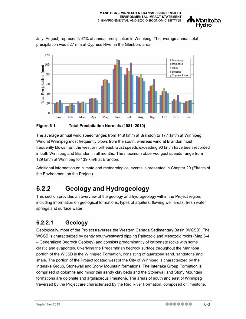
Total precipitation varies throughout the Project region from an annual average total of 521 mm at Winnipeg to 637 mm at Sprague (Figure 6-1). On average, precipitation in the summer (i.e., June,
6-2 September 2015
MANITOBA – MINNESOTA TRANSMISSION PROJECT ENVIRONMENTAL IMPACT STATEMENT
6: ENVIRONMENTAL AND SOCIO-ECONOMIC SETTING
July, August) represents 47% of annual precipitation in Winnipeg. The average annual total precipitation was 527 mm at Cypress River in the Glenboro area.
Figure 6-1 Total Precipitation Normals (1981–2010)
The average annual wind speed ranges from 14.9 km/h at Brandon to 17.1 km/h at Winnipeg. Wind at Winnipeg most frequently blows from the south, whereas wind at Brandon most frequently blows from the west or northeast. Gust speeds exceeding 90 km/h have been recorded in both Winnipeg and Brandon in all months. The maximum observed gust speeds range from 129 km/h at Winnipeg to 139 km/h at Brandon.
Additional information on climate and meteorological events is presented in Chapter 20 (Effects of the Environment on the Project).
6.2.2 Geology and Hydrogeology This section provides an overview of the geology and hydrogeology within the Project region, including information on geological formations, types of aquifers, flowing well areas, fresh water springs and surface water.
6.2.2.1 Geology Geologically, most of the Project traverses the Western Canada Sedimentary Basin (WCSB). The WCSB is characterized by gently southwestward dipping Paleozoic and Mesozoic rocks (Map 6-4 – Generalized Bedrock Geology) and consists predominantly of carbonate rocks with some clastic and evaporites. Overlying the Precambrian bedrock surface throughout the Manitoba portion of the WCSB is the Winnipeg Formation, consisting of quartzose sand, sandstone and shale. The portion of the Project located west of the City of Winnipeg is characterized by the Interlake Group, Stonewall and Stony Mountain formations. The Interlake Group Formation is comprised of dolomite and minor thin sandy clay beds and the Stonewall and Stony Mountain formations are dolomite and argillaceous limestone. The areas of south and east of Winnipeg traversed by the Project are characterized by the Red River Formation, composed of limestone,
September 2015 6-3

MANITOBA – MINNESOTA TRANSMISSION PROJECT ENVIRONMENTAL IMPACT STATEMENT 6: ENVIRONMENTAL AND SOCIO-ECONOMIC SETTING
dolomitic limestone and dolomite. The Amaranth, Reston and Melita formations cover a portion of the southeastern area of the New ROW. These formations are composed of anhydrite gypsum, shale, dolostone, argillaceous limestone and varicoloured shale, calcareous shale and limestone, respectively. The remainder of the southeast portion of the New ROW is within the Superior Province of the Canadian Shield, where bedrock is predominantly granite, granodiorite and related gneiss (Betcher et al. 1995, Klassen et al. 1970). In the South Cypress-Glenboro area, the Project is underlain by Mesozoic sediments of the Vermillion River Formation (Pembina Member) comprised of non-calcareous shale and bentonite (Klassen et al. 1970). The acid rock drainage (ARD) potential in the Project region is low.
Surficial deposits cover the entire area and are composed predominantly of glaciolacustrine and glaciofluvial deposits and till.
6.2.2.2 Aquifers Aquifers can be found in the sand and gravel lenses located above the carbonate bedrock throughout the Project area (Betcher et al. 1995). There are major buried sand and gravel aquifers located in areas of the RMs of Springfield, Ste. Anne, La Broquerie, Stuartburn and Piney (Map 6-5 – Sand and Gravel Aquifers). Groundwater quality in the aquifers ranges from poor to excellent. Depth to these aquifers ranges from a few metres to more than 100 m (Rutulis 1987).
The Carbonate Aquifer is the major bedrock aquifer in the Project area and is the largest freshwater aquifer in Manitoba (Rutulis 1984a, b, 1990; SRGMP 2010). It ranges from north of The Pas, Manitoba, southward through the Interlake region and continues east of the Red and Rat rivers into Minnesota (Grasby and Betcher 2002) with a westerly flow of groundwater (Rutulis 1984a, b, 1990; Betcher et al. 1995). The groundwater becomes increasingly saline west of the Red and Rat rivers south of Winnipeg. Freshwater from the Carbonate Aquifer has an adequate-to-abundant quantity for household and normal farm requirements in the area east of the Red and Rat rivers (Rutulis 1984a). There are two freshwater recharge areas in the Carbonate Aquifer in Manitoba. One is located in the Sandilands area in southeastern Manitoba, east of the New ROW and the other is located outside of the Project area in the Interlake Region (Thorleifson et al. 1998, Grasby and Betcher 2002, Ferguson et al. 2003). The Winnipeg Formation Sandstone Aquifer is located below the Carbonate Aquifer throughout the Project area, extending westward for approximately 150 km from its eastern limit. The thickness of this aquifer exceeds 20 m throughout most of its area and forms a valuable fresh water aquifer east of the Red River (Betcher et al. 1995).
The Assiniboine Delta Aquifer, an extensive sand and gravel aquifer, is the major aquifer located in the South Cypress–Glenboro area (Rutulis 1978; Assiniboine Delta Aquifer Management Plan Round Table 2005). Portions of the aquifer located south of the Assiniboine River can vary from 10 m to 30 m in depth. Groundwater quality ranges from good to excellent.
6-4 September 2015

MANITOBA – MINNESOTA TRANSMISSION PROJECT ENVIRONMENTAL IMPACT STATEMENT
6: ENVIRONMENTAL AND SOCIO-ECONOMIC SETTING
6.2.2.3 Flowing Well Areas Two large flowing well areas of fresh water are located in the Project region. One large flowing well area is located at the east end of the Existing Corridor at the northern portion of the New ROW going from Hazelridge in the northcentral part of the RM of Springfield south to the town of Ste. Anne. The second large flowing well area is located in the central portion of the New ROW going from Giroux in the RM of Ste. Anne south to Marchand in the RM of La Broquerie (Map 6-6 – Flowing Wells and Springs). Three smaller flowing well areas are located just west of the town of Ste. Anne, and around the communities of Ross and Piney (Rutulis 1985b). There is one saline flowing well area in the southwest corner of the RM of Macdonald.
Areas with fresh springs mapped in the region include an area of the New ROW in the RM of Piney and in the northeastern portion of the RM of Springfield. Freshwater springs in the RM of South Cypress are located along the Assiniboine River Valley in the Shilo/Spruce Woods Forest and Provincial Park area north of the Glenboro South Station (Rutulis 1985a).
6.2.3 Surface Water The Project crosses 75 watercourses, including rivers, streams, creeks and agricultural drains. The main watercourses in the Project region from north to south are Sturgeon Creek, Assiniboine River, La Salle River, Red River, Red River Floodway, Cooks Creek, Edie Creek, Fish Creek, Seine River, La Broquerie Drain, Rat River and Pine Creek. These watercourses are categorized as being large permanent, intermittent, or small permanent waterbodies (Map 6-7 – Watersheds and Sub-watersheds).
The dominant land use in two of the seven sub-watersheds (i.e., Rat River and Roseau River sub-watersheds) is forestry, whereas dominant land use in the remaining five sub-watersheds is agriculture. Historical and present day land use practices have directly influenced fish and fish habitat, from activities such as cultivation practices, livestock operations (Graveline et al. 2006), watercourse modifications and channelization, cattle wading into watercourses, use of terrestrial fertilizers that are transported into watercourses, and other land use practices that cause erosion (RRIW 2007a). Long-term effects throughout the region include changes in riparian vegetation ecosystem structure and surface water quality.
The Project is located predominantly within the Red River Basin, where fish habitat has been historically affected by agricultural activity. Channelized waterways and constructed agricultural drains are prevalent in areas under crop production. To manage flooding of creeks and rivers in the spring, settlers began constructing drainage canals and ditches in the Red River Valley by the 1880s (Elliott 1978; Ledohowski 2003). Water quality has also been affected by rural agricultural activities. Surface water is affected by seasonal runoff, local runoff and groundwater discharge. Each of these is directly affected by soil, terrain, vegetation and human activities.
These agriculture and drainage practices continue to the present day throughout the Project development area (PDA). Historical and present day land use practices have directly influenced existing ecological conditions, including fish and fish habitat. Long-term effects include changes in
September 2015 6-5

MANITOBA – MINNESOTA TRANSMISSION PROJECT ENVIRONMENTAL IMPACT STATEMENT 6: ENVIRONMENTAL AND SOCIO-ECONOMIC SETTING
riparian ecosystem structure (i.e., decreased vegetation cover and bank stability) and surface water quality (i.e., increased sedimentation and water temperature).
The surface waters of watercourses within the northern half of the PDA are characterized as slow-moving and turbid. Oxygen levels typically are above water quality guidelines, but may dip mid-summer due to decomposition of algal growth from high nutrient loading (AAFC-PFRA 2005, SRRCD 2009, MWS 2010, City of Winnipeg 2007-2014). Watercourses in the south of the PDA typically less turbid and adequately oxygenated for aquatic life (MWS 2011, Red River Basin Commission 2007).
6.2.4 Terrain and Soils This section describes the surficial geology, landforms, terrain and soils within the Project region. The most common soils in the region and the potential for contaminated soils are described.
6.2.4.1 Surficial Geology, Landforms and Terrain The surficial geology and terrain in the Project region is the result of the Pleistocene glaciation modified by post-glacial processes. Most surficial materials are glaciolacustrine sands, silts and clays from Glacial Lake Agassiz overlying till. In the Project region, the landform is dominantly a level to gently sloping lacustrine plain with elevations ranging from 221 masl (metres above sea level) to 396 masl in the southeast.
The Existing Corridor and Dorsey and Riel converter stations are within a smooth, level to gently sloping landscape composed of clay and silts with slopes ranging from level to less than 2% (Hopkins 1985; Smith et al. 1998). The mean elevation is 236 masl.
The New ROW originates in the same glaciolacustrine plain as the Existing Corridor; however, it transitions to an area of gently undulating water-worked moraines with thin and discontinuous veneers and blankets of sandy to clayey glaciolacustrine sediments (Smith et al. 1998). The moraines consist of a cobble and gravel loam till. Sandy to gravelly beach materials and bouldery near-shore materials are also present. Slopes range from level to 5%. The mean elevation is 297 masl.
Moving south and southeastward along the New ROW into the RMs of La Broquerie, Stuartburn and Piney, the Project region has a more complex surficial geology. As reported by (Mills et al. 1977), the area consists of:
• gently undulating ground moraine composed of medium-textured calcareous till
• coarse-textured outwash and beach ridge deposits
• undulating to hummocky terrain with some dunes composed of thin, coarse- to fine-textured lacustrine and deltaic deposits overlying till
• large, level to depressional areas of poorly drained organic deposits
6-6 September 2015

MANITOBA – MINNESOTA TRANSMISSION PROJECT ENVIRONMENTAL IMPACT STATEMENT
6: ENVIRONMENTAL AND SOCIO-ECONOMIC SETTING
September 2015 6-7
The Glenboro South Station is located within a level to hummocky pro-glacial lacustrine plain with slopes ranging between level and 15%. Surficial deposits and landforms in the area range from kettled to gently undulating loamy till, to level to gently undulating sandy glaciofluvial and glaciolacustrine deposits. The level to hummocky physiography is a major part of the Assiniboine Delta (Smith et al. 1998). The mean elevation is 366 masl.
The dominantly flat to very gently sloping topography in the Project region results in a low likelihood for mass movement processes.
6.2.4.2 Soils The dominant soils in the Project region are of the Vertisolic, Chernozemic, Gleysolic, Organic, Luvisolic and Brunisolic orders. In general, the soils have developed on glaciolacustrine deposits from Glacial Lake Agassiz deposited over the till in moraines from the last glaciation (Smith et al. 1998).
The soils within the Existing Corridor and Dorsey and Riel converter stations are dominantly imperfectly drained Gleyed Humic Vertisols and Gleyed Vertic Black Chernozems, with areas of poorly drained Gleysolic Humic Vertisols and Humic Gleysols (Smith et al. 1998). These soils were formed in the clayey glaciolacustrine deposits of Glacial Lake Agassiz. Gleyed Rego Black Chernozems and other Gleysolic soils have also developed on calcareous loamy to silty sediments from the latter stages of the lake.
Along the northern portions of New ROW, soils are predominantly well and imperfectly drained Dark Gray Chernozems developed on thin, discontinuous sandy to loamy glaciolacustrine veneers over till. Well-drained Luvisolic soils occur on the exposed moraine ridges with imperfectly drained Luvisols and Brunisols occurring in the sandy deposits. Soils occupying the lowlands are poorly drained peaty Gleysols and very poorly drained Organic soils.
Towards the south and southeast portions of the New ROW soils are complex and have developed on a variety of materials and under a range of drainage conditions. Lowland areas are dominated by poorly drained peaty Gleysols and very poorly drained Mesisols developed on sedge peat. Dark Gray Chernozems, Eutric Brunisols and Gray Luvisols are common in the sandy to loamy veneers overlying till and moraine ridges, while Dystric Brunisols occur on the weakly to non-calcareous glaciofluvial, till and eolian deposits.
Soils within the vicinity of the Glenboro South Station belong to the Chernozemic and Gleysolic orders. Both Chernozems and Gleysols have developed on the strongly calcareous, fine loamy sediments that dominate the area. Surface texture within the station is primarily fine loamy.
Information on soil capability for agriculture is provided in Section 6.3.6.

MANITOBA – MINNESOTA TRANSMISSION PROJECT ENVIRONMENTAL IMPACT STATEMENT 6: ENVIRONMENTAL AND SOCIO-ECONOMIC SETTING
6.2.4.3 Contaminated Soils Four databases were reviewed to identify sites with contaminated soils:
• Manitoba Hydro’s internal Contaminated Sites Database (Zahariuk 2015, pers. comm.)
• Contaminated, Impacted and Other Sites database (MCWS 2015a)
• Federal Contaminated Sites Inventory (Treasury Board of Canada Secretariat 2015)
• National Energy Board (NEB) Interactive Incident Map (NEB 2015)
The Manitoba Hydro Potentially Contaminated Sites Database was reviewed for known contaminated or impacted sites within the PDA. One impacted site, the Manitoba Hydro Dorsey Converter Station, was identified within the PDA. A review of the Manitoba Hydro Potentially Contaminated Sites Database indicated that the areas of Dorsey Converter Station where impacts were previously identified are not within the planned construction area. Active Manitoba Hydro Station properties are considered to be potentially impacted. Two other Manitoba Hydro properties, the Hydro Glenboro South Station and the Richer South Terminal #2756 are within the PDA (Zahariuk 2015, pers. comm.). The Manitoba Conservation and Water Stewardship Contaminated Sites List, Impacted Sites List, and List of All Sites were also reviewed. No other known contaminated or impacted sites were identified within the PDA.
Unexpected soil contamination that is encountered during construction will be managed in accordance with the EPP.
6.2.5 Vegetation and Wetlands This section describes the vegetation, wetlands and peatland resources within the Project region.
The Project crosses many types of land cover classifications, varying from cultivated, pasture, native grasslands and shrubland to deciduous forests, mixedwood forests, coniferous forests and varying types of wetlands (Map 6-9 – Predominant Plant Habitats in the Project Region). Agriculture (pasture and cultivated) is the most common land cover class in the Project region. The eastern portions of the Project move from cultivated land to pasture and hayland, with most of the forested landscape in the southeastern portion of the Project region.
Prior to settlement (1800s), the tallgrass prairie spanned 138 million ha in Manitoba along the Red River east to the boreal shield region (i.e., Lake of the Woods and south into the United States) (Thorpe 2014, Sveinson 2003). This once large grassland has been converted to agricultural land use, with less than 1% of the original land cover of tallgrass prairie remaining in Manitoba (Government of Manitoba 2014a). The Existing Corridor, Dorsey and Riel converter stations and Final Preferred Route are located predominantly in what used to be tallgrass prairie. Over the past century, most of the land has been converted to agricultural, industrial and urban land surrounding Winnipeg. The Glenboro South Station is located in a region that was historically aspen parkland. The extent of the forest has been reduced in the region due to increased agriculture and encroachment of urban areas.
6-8 September 2015

MANITOBA – MINNESOTA TRANSMISSION PROJECT ENVIRONMENTAL IMPACT STATEMENT
6: ENVIRONMENTAL AND SOCIO-ECONOMIC SETTING
Native grassland is located in the Project region near Anola. Much of the native grassland is wet (e.g., marsh) or used as hayland because it is too wet for cultivation (Smith et al. 1998). In the past, mixed-grass and fescue prairie were present in the Project region, however, only a few remnant patches of fescue prairie remain in Manitoba. The mixed-grass prairie is intermediate between the tallgrass prairie in Manitoba and the shortgrass prairie in southwestern Saskatchewan. Fescue prairie occurs only in the Canadian portion of the North American prairies.
Mixedwood forest (including peatlands) is located along the eastern portion of the Final Preferred Route and is dominated by deciduous (trembling aspen, paper birch, black ash) and coniferous tree species (jack pine, white spruce, cedar) (Photo 6-1). Some areas in the mixedwood forest units have been converted to forestry and recreational use. Coniferous forest is located along the southeastern portion of the Final Preferred Route (Photo 6-2). This forest is dominated by evergreen tree species, including black spruce, jack pine, white spruce and tamarack. There are several large intact peatland bogs and fens within coniferous forests along the route (Photo 6-3). The southeastern portion of the Project intersects a number of these bogs, including Caliento, Sundown and Piney bog. Deciduous forest, dominated by trembling aspen, is scattered throughout the Final Preferred Route (Photo 6-4). The southeastern portion of the Project region has many large intact areas of forested land, which are critical to many wildlife species.
Wetlands in the Project region include marshes, bogs, fens, swamp and shallow open water. The most dominant wetland type in the Project region is marsh. Only 30% to 60% of the original wetlands in agricultural land in Manitoba remain (Government of Manitoba 2014b). In the areas traversed by the Project, there are 269.6 ha of marshes, 24.7 ha of bogs, 73.9 ha of fens, 107.9 ha of swamps and 0.3 ha of shallow open water wetlands. Large bogs, fens and swamps are located along Final Preferred Route.
Vegetation in marsh, swamp and shallow open water wetlands often include submerged aquatic plants with a fringe of emergent species (e.g., bulrush and cattail). Depending on site-specific moisture and nutrient regimes, peatland areas contain a variety of mosses, sedges, forbs and shrubs.
Peatlands are organic wetlands consisting of two types of classes – bogs and fens (MCWS 2014). In Manitoba, approximately 90% of all wetlands are peatlands. Made up of sphagnum moss, peatlands are concentrated in the southeastern part of the province, The Pas Region, north and east of Lake Winnipeg and in the Hudson Bay Lowlands (MCWS 2014). For information on peat harvesting operations in the Project region, see Section 6.3.7.6.4.
Within the Prairies Ecozone, the Lake Manitoba Plain and Aspen Parkland ecoregions have the potential for 111 and 135 provincially ranked plant species of conservation concern (SOCC) (i.e., S1, S2 and S3) (MB CDC 2014). The Interlake Plain ecoregion of the Boreal Plain ecozone has the potential for 108 provincially ranked species and the Lake of the Woods ecoregion of the Boreal Shield ecozone has the potential for 123 plant species of conservation concern (MB CDC 2014). Most provincially ranked species include those that would have occurred in the tallgrass prairie or those that are uncommon woodland species.
September 2015 6-9

MANITOBA – MINNESOTA TRANSMISSION PROJECT ENVIRONMENTAL IMPACT STATEMENT 6: ENVIRONMENTAL AND SOCIO-ECONOMIC SETTING
SOURCE: Brian Miller 2014 Photo 6-1 Typical Mixedwood Forest in the Region
SOURCE: Jayme Viglas 2014 Photo 6-2 Typical Coniferous Forest in the Project Region
6-10 September 2015

MANITOBA – MINNESOTA TRANSMISSION PROJECT ENVIRONMENTAL IMPACT STATEMENT
6: ENVIRONMENTAL AND SOCIO-ECONOMIC SETTING
SOURCE: Jayme Viglas 2014 Photo 6-3 Typical Peatland Bog within the Project Region
SOURCE: Brian Miller 2014 Photo 6-4 Typical Deciduous Forest within the Project Region
September 2015 6-11
MANITOBA – MINNESOTA TRANSMISSION PROJECT ENVIRONMENTAL IMPACT STATEMENT 6: ENVIRONMENTAL AND SOCIO-ECONOMIC SETTING
6.2.6 Wildlife This section describes the wildlife in the Project region, including mammals, birds, amphibians, reptiles and SOCC.
The Project is located in a region characterized predominantly by agriculture and grasslands and interspersed with wetlands and woodlands (Map 6-9 – Predominant Plant Habitats in the Project Region). Native grasslands support a variety of small mammals and birds. Some of these species have adapted to using pasture and cropland, although these modified habitats are generally less productive for wildlife. Grasslands, pasture and croplands may provide staging sites for large numbers of waterfowl, gulls, shorebirds and cranes during migration. Wetlands tend to support the greatest diversity and abundance of wildlife, including aquatic furbearers, a variety of waterbirds and most of the amphibians and reptiles that occur in the Project region. Forested areas support a diversity of mammals and birds. Large contiguous forest patches provide habitat for interior species such as ovenbird (Seiurus aurocapillus). Overall, the southeastern part of the Project region features the greatest concentration of undeveloped land, including large intact patches of forest, marsh and bog complexes; this area is of particular importance for wildlife.
6.2.6.1 Mammals Mammals in the Project region include ungulates, furbearers, bats and other large and small mammals. White-tailed deer (Odocoileus virginianus) are widespread and use a variety of habitats, including pasture, cropland, wetland margins and woodlands. American elk (Cervus canadensis) have a more limited distribution, with a single herd occurring primarily in the Vita/Arbakka area, but also ranging south into Kittson County, Minnesota (Franke 2014, pers. comm.). The elk use forested areas for cover, although they forage in grasslands, cropland fields and traverse the periphery of wetlands. Although moose (Alces alces) were historically more common, they have become rare in the Project region due to a combination of factors such as hunting, predation and disease (e.g., brainworm [MCWS 2014]). Moose is rarely encountered in forests or wetlands. Large mammals and furbearers associated with woodland habitat are black bear (Ursus americanus), gray wolf (Canis lupus) and bobcat (Lynx rufus). Coyote (Canis latrans) typically occur in areas that are more open. Small furbearers in the Project region include American marten (Martes americana), red fox (Vulpes vulpes), and beaver (Castor canadensis). These species are typically associated with wooded areas but also make use of adjacent open habitat. Similarly, bats (e.g., little brown myotis [Myotis lucifugus] and long-eared myotis [Myotis septentrionalis]) roost in forests but hunt in nearby fields or wetlands. Other small mammals common in the Project region include eastern cottontail (Sylvilagus floridanus), striped skunk (Mephitis mephitis), snowshoe hare (Lepus americanus), deer mouse (Peromyscus maniculatus) and southern red-backed vole (Clethrionomys gapperi).
6-12 September 2015

MANITOBA – MINNESOTA TRANSMISSION PROJECT ENVIRONMENTAL IMPACT STATEMENT
6: ENVIRONMENTAL AND SOCIO-ECONOMIC SETTING
6.2.6.2 Birds Fifty species of waterbirds (swans, geese, ducks, loons, grebes, pelicans, cormorants, herons, rails, shorebirds, gulls and terns) were observed in the Project region during 2014 field surveys. Although some of these species breed within the region, some move through only during migration. Among the most common species are Canada goose (Branta canadensis), snow goose (Chen caerulescens), tundra swan (Cygnus columbianus), ring-billed gull (Larus delawarensis), sandhill crane (Grus canadensis) and killdeer (Charadrius vociferous) (Wildlife and Wildlife Habitat TDR). Waterbirds are associated primarily with large open wetlands. They also occur along streams and at small ponds and wetlands with limited areas of open water. Important staging sites for migrating waterbirds in spring and fall include Lonesand, Sundown Lake, Richer Lake, Deacon’s Reservoir, the Red River and the Assiniboine River (Map 6-10 – Annual and Perennial Cropping; Wildlife and Wildlife Habitat TDR).
Sixteen raptors (vultures, eagles, hawks, falcons, owls) were observed in the Project region during 2014 field surveys. Although some of these species breed within the region, some move through only during migration. Peregrine falcons (Falco peregrinus) move through the Project region during migration and are known to nest in downtown Winnipeg (atop skyscrapers) (Wheeldon 2003). Young peregrine falcons are also reared and released from the Parkland Mews captive breeding centre near St. Norbert (Wheeldon 2003). Most species that breed in the Project region nest in forested habitat and hunt in adjacent open areas. Northern harrier (Circus cyaneus) and short-eared owl (Asio flammeus) differ in that they are limited to nesting and hunting in open habitat.
Eighty-five songbird species were observed din the Project region during 2014 field surveys, with the potential for more species to pass through the region during the migration periods=. Relatively few species remain over winter. Many songbird species occur in wooded areas, including species that favour mature forest interiors (e.g., ovenbird) and those that thrive along edges (e.g., golden-winged warbler [Vermivora chrysoptera]). A number of songbirds are associated primarily with wetland habitat and may occur there in large numbers (e.g., yellow warbler [Dendroica petechial], common yellowthroat [Geothlypis trichas], red-winged blackbird [Agelaius phoeniceus]). Several species are widespread and common in upland open habitat, some are more associated with native grassland or pasture (e.g., bobolink [Dolichonyx oryzivorus]) and others are common in cropland (e.g., horned lark [Eremophila alpestris]).
Seventeen other bird species (i.e., upland gamebirds, doves, nightjars, swifts and woodpeckers) were observed in the Project region during 2014 field surveys. Native upland gamebirds in the Project region are primarily ruffed grouse (Bonasa umbellus), found in deciduous and mixedwood forests, and sharp-tailed grouse (Tympanuchus phasianellus), found primarily in native grassland and pasture), and the introduced gray partridge (Perdix perdix), which occurs in open areas and cropland. The native mourning dove (Zenaida macroura) and the non-native rock pigeon (Columba livia) occur in open areas. Two species of nightjar (eastern whip-poor-will [Antrostomus vociferous] and common nighthawk [Chordeiles minor]) nest in wooded habitat but forage nocturnally over adjacent open areas. Four woodpecker species are year-round residents in the
September 2015 6-13

MANITOBA – MINNESOTA TRANSMISSION PROJECT ENVIRONMENTAL IMPACT STATEMENT 6: ENVIRONMENTAL AND SOCIO-ECONOMIC SETTING
Project region, while another three occur during the breeding season. All are associated primarily with wooded areas, although some species, such as red-headed woodpecker (Melanerpes erythrocepalus) and northern flicker (Colaptes auratus), favour open forests and edges.
6.2.6.3 Amphibians and Reptiles Most of the 13 amphibian species that occur in the Project region are frogs and toads; the most common species are boreal chorus frog (Pseudacris maculate), wood frog (Rana sylvatica) and northern leopard frog (Lithobates pipiens). They tend to breed in wetlands (including lakes, ponds, rivers, creeks and roadside ditches), although most species spend time in adjacent upland communities. In contrast, mudpuppies are entirely aquatic and are therefore restricted to suitable habitat, generally streams and ponds with submerged rocks or logs for cover (Manitoba Herps Atlas 2015).
The seven reptile species in the Project region include one lizard, two turtles and five snakes. The western painted turtle (Chrysemys picta belli), snapping turtle (Chelydra serpentine), red-sided garter snake (Thamnophis sirtalis parietalis) and western plains garter snake (Thamnophis radix) occur primarily near wetlands and riparian habitat. The red-bellied snake (Storeria occipitomaculata) and smooth green snake (Opheodrys vernalis) are more associated with upland open habitat, such as edges of wooded areas, in fields, meadows and abandoned farms. The western hognose snake (Heterodon nasicus) and the northern prairie skink (Plestiodon septentrionalis) have narrow ranges within Spruce Woods Provincial Park, located approximately 8 km northeast of the Glenboro South Station. The western hognose snake occurs in the sandy grasslands and open woodlands of the park, whereas the prairie skink is limited to areas of mixed-grass prairie in sandy soils (Manitoba Herps Atlas 2015).
6.2.6.4 Wildlife Species of Conservation Concern Wildlife SOCC are those species listed under the Species at Risk Act, S.C. 2002, c. 29 (SARA) or The Manitoba Endangered Species and Ecosystems Act, C.C.S.M. c. E.111 (Manitoba ESEA), have been recommended by Committee on the Status of Endangered Wildlife in Canada (COSEWIC) for listing under SARA, or are ranked by the Manitoba Conservation Data Centre (MB CDC) as provincially rare (i.e., S1, S2 or S3 rankings). At least 45 SOCC occur in the Project region: 5 mammals, 27 birds, 3 amphibians, 3 reptiles and 7 terrestrial invertebrates (Chapter 9 – Wildlife and Wildlife Habitat).
Grey fox (Urocyon cinereoargenteus) is listed as Threatened under Schedule 1 of SARA. This furbearer has been found in deciduous forest and scrub habitat located in the southeastern part of the province, for example near Sprague (Berezanski pers. comm. 2015). Although there are no documented occurrences of American badger (listed as Special Concern by COSEWIC) in the Project region, they have the potential to occur in areas that support open field and grassland habitat, including along roads, shelterbelts, field edges and hedgerows (COSEWIC 2012). Star-nosed mole (Condylura cristata) is listed as Uncommon (MB CDC 2014b). It occurs in open
6-14 September 2015

MANITOBA – MINNESOTA TRANSMISSION PROJECT ENVIRONMENTAL IMPACT STATEMENT
6: ENVIRONMENTAL AND SOCIO-ECONOMIC SETTING
forests, wet meadows, and riparian habitat. Although southern Manitoba represents the western limit of its range, it inhabits areas throughout the Project region.
The two bat species listed as Endangered under SARA have the potential to occur within the Project region: little brown myotis and long-eared myotis Both (Government of Canada (COSEWIC 2013).
Of the 27 bird SOCC, 15 are listed by Manitoba ESEA and SARA (Chapter 9).Two bird species are listed under SARA but not Manitoba ESEA: yellow rail (Special Concern) and rusty blackbird (Special Concern). Trumpeter swan (Cygnus buccinator) is listed as Endangered under Manitoba ESEA but is not listed under SARA. Six species are listed by COSEWIC: horned grebe (Podiceps auritus; Special Concern), eastern wood-pewee (Contopus virens; Special Concern), bank swallow (Riparia riparia; Threatened), barn swallow (Hirundo rustica; Threatened), and bobolink (Threatened) and Baird’s sparrow (Special Concern). The final three SOCC are ranked as rare by the MB CDC: pine warbler (Setophaga pinus), grasshopper sparrow (Ammodramus savannarum) and great egret (Ardea alba).
Of the six herptile SOCC, three are amphibian species (northern leopard frog [Lithobates pipiens], eastern tiger salamander [Ambystoma tigrinum] and western tiger salamander [Ambystoma mavortium]) and three are reptile species (prairie skink [Eumeces septentrionalis], western hognose snake [Heterodon nasicus] and common snapping turtle [Chelydra serpentina serpentine]). Three species are listed under SARA: northern leopard frog (Threatened), common snapping turtle (Special Concern) and prairie skink (Endangered). Two species are listed under COSEWIC: eastern tiger salamander (Endangered) and western tiger salamander (Special Concern). The final species, western hognose snake, is listed as Threatened by Manitoba ESEA.
Of the seven terrestrial invertebrate SOCC, two are associated with grassland habitats (monarch [Danaus plexippus] and mottled dusky moth [Erynnis martialis]); five are associated with sand dune habitats (pale yellow dune moth [Copablepharon grandis], dusky dune moth [Copablepharon longipenne], white flower moth [Schinia bimatris], golden-edged gem [Schinia avemensis], and Verna’s flower moth [Schinia verna]. Sand dune habitat is located approximately 13 km from the Glenboro South Station. Monarch and pale yellow dune moth are listed as Special Concern under Schedule 1 of SARA; Dusky dune moth, white flower moth and golden-edged gem are listed as Endangered under Schedule 1 of SARA. Verna’s flower moth is listed as Threatened under Schedule 1 of SARA. All terrestrial invertebrates except monarch (provincial rank S3B; uncommon) and mottled dusky moth (provincial rank S2; rare) are also listed as Endangered under Manitoba ESEA.
September 2015 6-15

MANITOBA – MINNESOTA TRANSMISSION PROJECT ENVIRONMENTAL IMPACT STATEMENT 6: ENVIRONMENTAL AND SOCIO-ECONOMIC SETTING
6.2.7 Aquatic Resources This section describes the aquatic resources within the Project region, consisting of the major watercourses, common aquatic species and invertebrates, including SOCC.
The Project is located within the Nelson River Drainage Basin of the Hudson Bay Basin, specifically the Lake Winnipeg watershed. The Project traverses two major basins, the Assiniboine River and Red River basins (Map 6-7 – Watersheds and Sub-Watersheds). The Glenboro South Station is located within the Assiniboine River watershed, Brandon Division (Smith et al. 1998).
The Project extends across one sub-watershed within the Assiniboine River Basin, the Lower Assiniboine River (05MJ) sub-watershed, and six sub-watersheds of the Red River Basin: the La Salle (05OG), Red River (05OC), Seine River (05OH), Cooks Creek/Devils Creek (05OJ), Rat River (05OE) and the Roseau River (05OD) sub-watersheds (Map 6-7). A discussion of aquatic conditions in each sub-watershed follows.
Lower Assiniboine River Sub-watershed (05MJ)
The Lower Assiniboine River sub-watershed is approximately 2485 km2 in area and contains an extensive network of agricultural drains as well as Sturgeon Creek and the Assiniboine River. Within this sub-watershed, the Project will cross Sturgeon Creek, Third Creek (a tertiary drain within the RM of Headingley) and the Assiniboine River. Currently, riparian habitat is heavily affected and is mowed at the proposed crossing location on both Sturgeon and Third Creek to aid in agricultural drainage. There is intact riparian vegetation along both the north and south sides of the Assiniboine River with a mixture of Manitoba maple, ash, basswood, cattail, cottonwood, dogwood, elm, grass/sedge and poplar species (Benke and Cushing 2010).
The La Salle River Sub-watershed (05OG)
The southern portion of the Existing Corridor runs through the La Salle River sub-watershed. The drainage area in this basin is approximately 2426 km2. Approximately 60% of the land use is for agriculture with an added 16% for drainage canals (Graveline and Larter 2006). Urban and residential land use accounts for approximately 6% of the La Salle sub-watershed area and 8% is deciduous forest. Aquatic habitats in this watershed are moderately to severely influenced by anthropogenic activities (Graveline and Larter 2006), including cultivation practices, livestock operations, wastewater lagoon discharges and urban storm water drains species (Bourne et al. 2002; Manitoba Phosphorus Expert Committee [MPEC] 2006). The Project crosses only one watercourse in this sub-watershed, the La Salle River. Riparian area consist of grasses and shrubs with oak, poplar, dogwood and willow (Benke and Cushing 2010).
The Red River Sub-watershed (05OC)
The drainage area of the Red River sub-watershed is approximately 96,716 km2. The Project crosses two watercourses: the Red River and the Red River Floodway. The riparian area and banks of the Red River crossing are generally covered in grasses/sedge with a few shrubs and deciduous trees along the southwestern bank. The Red River Floodway is a 48 km human-
6-16 September 2015

MANITOBA – MINNESOTA TRANSMISSION PROJECT ENVIRONMENTAL IMPACT STATEMENT
6: ENVIRONMENTAL AND SOCIO-ECONOMIC SETTING
constructed channel with long sloping banks. Water flow is intermittent because the floodway is opened primarily in the spring to manage high water levels in the Red River.
The Seine River Sub-watershed (05OH)
The Seine River sub-watershed is similar to the La Salle River sub-watershed in that more than 60% of the 1196 km2 area is dominated by agricultural land use. There are six watercourses crossed by the Project in this sub-watershed, including the Seine River, three unnamed tributaries, Fish Creek and La Broquerie Drain. This sub-watershed contains an extensive network of waterways, including more than 600 km of provincial drains. More than half of the riparian area in this sub-watershed is heavily affected by cultural development such as cities, towns, golf courses and other residential developments. The remaining portion of the sub-watershed’s riparian area land cover has been classified as native cover (grass, shrubs and trees) (SRRCD 2009).
The Cooks Creek/Devils Creek Sub-watersheds (05OJ)
From the Seine River sub-watershed, the Project extends east and briefly crosses into the Cooks-Devils Creek sub-watershed. The Project will cross both Cooks Creek and Edie Creek twice. The Cooks-Devils watershed area is 4251 km2. There are 440 km of provincial drains and 850 km in municipal drains within this watershed; however, key surface water issues in this area still include flooding, drainage and water retention (MWS 2013.).
The Rat River Sub-watershed (05OE)
The Rat River sub-watershed covers 3193 km2 and has an expansive natural floodplain, which frequently floods in the spring. Water is retained in the watershed by wetlands and the construction of dams and retention projects developed by Ducks Unlimited Canada (SRRCD 2012). The eastern portion of the watershed is poorly drained and contains numerous wetlands (AAFC-PFRA 2005). Riparian areas are vegetated with slough grass, marsh reed grass, sedge, cattail and shrubby willow. Trees and grasslands account for more than 50% of the land cover in this sub-watershed (AAFC-PFRA 2005). There is only one watercourse crossed by the Project in this sub-watershed, the Rat River itself.
The Roseau River Sub-watershed (05OD)
As the MMTP extends to the south, it enters the Roseau River sub-watershed and the Rural Municipality of Piney. The total watershed drainage area is approximately 5350 km2, with the Canadian portion accounting for about 2500 km2 or 44% of the area (Roseau River International Watershed 2007a). Much of this portion of the watershed is undisturbed, 7% is native grassland and wetlands account for 29% of the area (Roseau River International Watershed 2007a). Within the Pine Creek and Sprague Creek drainage areas, within the Roseau River sub watershed, there are a total of 37 km of Provincial waterways and 185 km of municipal drains. Increases in both the frequency and duration of flooding events have been observed throughout the watershed over the last decade (RRIW 2007b). Activities along the riparian areas, including river channel modifications, cattle wading into watercourses, increased use of fertilizers, and land use practices
September 2015 6-17

MANITOBA – MINNESOTA TRANSMISSION PROJECT ENVIRONMENTAL IMPACT STATEMENT 6: ENVIRONMENTAL AND SOCIO-ECONOMIC SETTING
that increase erosion, have been suggested as causing water quality degradation in this area (RRIW 2007b).
6.2.7.1 Aquatic Species Large, permanent watercourses crossed in the Project region include Sturgeon Creek, Assiniboine River, Red River, La Salle River, Seine River, Cooks Creek, and the Rat River (Map 6-8 – Major Waterbodies). The aquatic species that occur in these waterbodies support a commercial, recreational and First Nation fishery in the Project region. Common aquatic species in these waterbodies are:
• black bullhead (Ameiurus melas)
• common carp (Cyprinus carpo)
• rock bass (Ambloplites rupestris)
• black crappie (Poxmoxis nigromaculatus)
• freshwater drum (Aplodinotus grunniens)
• sauger (Sander canadensis)
• brook trout (Salvenlinus fontainalis)
• golden redhorse (Moxostoma erythrurum)
• shorthead redhorse (Moxostoma macrolepidotum)
• brown bullhead (Ameiurus nebulosus)
• goldeye (Hiodon alosoides)
• silver redhorse (Moxostama anisurum)
• brown trout (Salmo trutta) • lake whitefish (Coregonus clupeaformis)
• smallmouth bass (Micropterus dolomieu)
• burbot (Lota lota) • largemouth bass (Micropterus salmoides)
• walleye (Sander vitreus) (also called pickerel)
• channel catfish (Ictalurus punctatus)
• northern pike (Esox lucius) • white sucker (Catostomus commersonii)
• cisco (Coregonus artedi) • quillback (Caripiodes cyprinus)
• yellow perch (Perca flavescens)
Nine fish species that have the potential to inhabit the regional watercourses are listed under SARA, COSEWIC, Manitoba ESEA or Manitoba’s SOCC listed species:
• banded killfish (Fundulus diaphanous) – Special Concern (SOCC)
• bigmouth buffalo (Ictiobus chyprinellus) – Special Concern (SARA, COSEWIC)
• carmine shiner (Notropis percombromus) – Threatened (SARA, COSEWIC) and vulnerable (Manitoba ESEA)
• chestnut lamprey (Ichthyomyzon castaneus) – Special Concern (SOCC)
• lake sturgeon (Acipenser fulvescens) – Endangered (COSEWIC, SARA under consideration)
6-18 September 2015

MANITOBA – MINNESOTA TRANSMISSION PROJECT ENVIRONMENTAL IMPACT STATEMENT
6: ENVIRONMENTAL AND SOCIO-ECONOMIC SETTING
• mapleleaf mussel (Quadrula quadrula) – Threatened (SARA, COSEWIC) and Endangered (Manitoba ESEA)
• northern brook lamprey (Ichthyomyzon fossor) – Special Concern (SARA)
• shortjaw cisco (Coregonus zenithicus) – Threatened (SARA Schedule 2, COSEWIC)
• silver chub (Macrhybopsis storeriana) – Special Concern (SARA)
6.3 Socio-economic Environment The socio-economic environment consists primarily of the 11 RMs traversed by the Project (Map 6-13 – Municipal Jurisdictions). Major adjacent centres are also described, where applicable. Winnipeg, the capital and largest metropolitan area in the province, is home to about 60% of the province’s population. Brandon, about a 1-hour drive from the Glenboro South Station, is Manitoba’s second largest metropolitan area. Both Winnipeg and Brandon provide a full range of infrastructure and services, and are major economic and employment centres in the province. The Town of Ste. Anne is a smaller community in the Project region. The City of Steinbach is located adjacent to the Project region; it may be used for labour, infrastructure and services. The Village of Glenboro is located north of the Glenboro South Station.
First Nations near the Project region or with an interest in the Project are Brokenhead Ojibway Nation, Dakota Plains First Nation, Dakota Tipi First Nation, Long Plain First Nation, Peguis First Nation, Roseau River Anishinabe First Nation, Sagkeeng First Nation, Black River First Nation, Sandy Bay Ojibway First Nation, Swan Lake First Nation and Buffalo Point First Nation. Metis people also live within villages, towns and RMs in the Project region. Chapter 4 provides information on the First Nation and Metis engagement process.
Agriculture is the dominant land use within the Project region. Other economic activities include mining (quarrying, aggregate, mineral peat) and forestry (limited sawlog and pulpwood). Hunting and trapping are ongoing activities. Recreation and tourism, including camping, fishing and boating are important activities centred on use of provincial parks and provincial forestlands, other designated lands and water-oriented recreation areas.
This section provides an overview of the socio-economic setting of the Project and information on:
• participating First Nations and Metis engagement process and traditional land use (i.e., plant harvesting, fishing, hunting and trapping, trails and travelways and cultural sites)
• Metis population
• heritage resources (i.e., cultural environment, archaeological sites and centennial farms)
• population (i.e., population total and population change, First Nation population and First Nation On/Off Reserve population)
September 2015 6-19

MANITOBA – MINNESOTA TRANSMISSION PROJECT ENVIRONMENTAL IMPACT STATEMENT 6: ENVIRONMENTAL AND SOCIO-ECONOMIC SETTING
• infrastructure and services (i.e., accommodations, emergency and protection services, municipal utilities, transportation and utility infrastructure and communications and radio signals)
• employment and economy (i.e., regional and local economy and labour force characteristics)
• agricultural land use (i.e., annual and perennial cropping, livestock operations and specialty uses)
• land and resource use (i.e., planning and development controls, land tenure and property ownership, designated lands and protected areas, recreational use and resource use)
• community health and well-being (i.e., health care infrastructure and services, general health conditions, First Nation health and visual quality)
• human health risk (i.e., exposure to chemical emissions, noise and electric magnetic fields [EMF])
Additional information about the socio-economic context for the Project is described in Chapters 11 through 19 and in the Socio-economic and Land Use Environment TDR (Stantec 2015).
6.3.1 Traditional Land and Resource Use This section identifies the First Nations and Metis located near the Project and presents an overview of traditional land use.
6.3.1.1 Participating First Nations and Metis Manitoba Hydro is committed to engaging with First Nations and Metis that have indicated an interest in the Project. Throughout the engagement process, Manitoba Hydro has specific staff be the key contact for each First Nation, the Manitoba Metis Federation (MMF) or Aboriginal Organization. Manitoba Hydro offered community coordinator positions to facilitate ongoing and regular community participation and engagement in the Project. As new circumstances arose, the engagement process was refined.
Consistent with MMTP’s engagement criteria (Chapter 4, Section 4.1.3), the following First Nations and the MMF were identified to participate in the First Nation and Metis engagement process for the Project:
• Black River First Nation
• Brokenhead Ojibway Nation
• Buffalo Point First Nation
• Dakota Plains Wahpeton First Nation
• Dakota Tipi First Nation
6-20 September 2015

MANITOBA – MINNESOTA TRANSMISSION PROJECT ENVIRONMENTAL IMPACT STATEMENT
6: ENVIRONMENTAL AND SOCIO-ECONOMIC SETTING
• Long Plain First Nation
• Peguis First Nation
• Roseau River Anishinabe First Nation
• Sagkeeng First Nation
• Sandy Bay Ojibway First Nation
• Swan Lake First Nation
• Manitoba Metis Federation
6.3.1.1.1 Black River First Nation Black River First Nation is a signatory to Treaty 5. Black River First Nation has one reserve, Black River 9 (809 ha), located approximately 138 km northeast of Winnipeg and approximately 36 km north of Powerview/Pinefalls, Manitoba. As of June 2015, Black River First Nation had a registered population of 1290 (AANDC 2015a). The primary language used is Ojibwe (Black River First Nation 2015).
6.3.1.1.2 Brokenhead Ojibway Nation Brokenhead Ojibway Nation is a signatory to Treaty 1. Brokenhead Ojibway Nation has three reserves: Brokenhead 4 (5413 ha), Birch Landing (272 ha) and Na-Sha-Ke-Penais (3 ha). Brokenhead Ojibway Nation’s main reserve, Brokenhead 4, is located approximately 64 km northeast of Winnipeg on Highway 59. As of June 2015, the registered population is 1938 (AANDC 2015b).
6.3.1.1.3 Buffalo Point First Nation Buffalo Point First Nation is a signatory to Treaty 3 and is located on the shores of Lake of the Woods in the southeastern corner of Manitoba at the Canada and United States international boundary across from Warroad, Minnesota (Buffalo Point First Nation 2015). Buffalo Point First Nation has six reserves: Agency 30 (379 ha), Buffalo Point 36 (2332 ha), Buffalo Point First Nation 1 (37 ha), Buffalo Point First Nation 2 (347 ha), Buffalo Point First Nation 3 (92 ha), and Reed River 36A (1162 ha). The registered population as of June 2015 was 128 (AANDC 2015c). The native language is Chippewa (Buffalo Point First Nation 2015).
6.3.1.1.4 Dakota Plains Wahpeton First Nation Dakota Plains Wahpeton First Nation Reserve 6A (10 ha) is located approximately 104 km southwest of Winnipeg and 32 km southwest of Portage la Prairie. In 1972, the Sioux Village settlement divided into two separate groups creating the presently known as Dakota Tipi First Nation and Dakota Plains Wahpeton First Nation. The main language spoken is Sioux, followed by Ojibway (Dakota Plains Wahpeton First Nation 2015). The registered population as of June 2015 was 268 (AANDC 2015d).
September 2015 6-21

MANITOBA – MINNESOTA TRANSMISSION PROJECT ENVIRONMENTAL IMPACT STATEMENT 6: ENVIRONMENTAL AND SOCIO-ECONOMIC SETTING
6.3.1.1.5 Dakota Tipi First Nation Dakota Tipi First Nation has one reserve, Dakota Tipi 1 (59 ha), located approximately 80 km west of Winnipeg on the Yellow Quill Trail. The registered population as of June 2015 was 395 (AANDC 2015e). In 1972, the Sioux Village settlement divided into two separate groups creating the presently known Dakota Tipi First Nation and Dakota Plains First Nation. Although the native language is Sioux, most people speak English (Dakota Tipi First Nation 2015).
6.3.1.1.6 Long Plain First Nation Long Plain First Nation is signatory to Treaty 1 and has two reserves: Long Plain 6 (4383 ha) and Long Plain Madison Indian Reserve No. 1 (1 ha). The main reserve, Long Plain 6, is located approximately 30 km southwest from Portage la Prairie, 100 km west of Winnipeg. The registered population as of June 2015 was 4269 (AANDC 2015f). The main languages spoken are English and Ojibway (Long Plain First Nation 2015).
6.3.1.1.7 Peguis First Nation Peguis First Nation is a signatory to Treaty 1. Peguis First Nation has 30,655 ha of reserve land located 190 km north of Winnipeg (AANDC 2015g). Peguis First Nation is the largest First Nation in Manitoba (Peguis First Nation 2015); the registered population as of June 2015 was 9869 (AANDC 2015g).
6.3.1.1.8 Roseau River Anishinabe First Nation Roseau River Anishinabe First Nation is a signatory to Treaty 1. Roseau River Anishinabe First Nation has three reserves: Roseau River 2 (2224 ha), Roseau Rapids 2A (323 ha) and Roseau River 2B (30 ha). Roseau River 2, the main reserve, is located at the junction of the Red and Roseau rivers and is located approximately 80 km south of Winnipeg. Roseau Rapids 2A is located on an escarpment 32 km east of the main reserve. Roseau River 2B is located at the junction of Provincial Trunk Highway (PTH) 6 and Provincial Road (PR) 236 and the Perimeter Highway on the northwest side of Winnipeg. The registered population as of June 2015 was 2580 (AANDC 2015h).
6.3.1.1.9 Sagkeeng First Nation Sagkeeng First Nation is a signatory to Treaty 1. Sagkeeng First Nation has one reserve, Fort Alexander 3 (8771 ha), located approximately 122 km northeast of Winnipeg. The registered population as of June 2015 was 7651 (AANDC 2015i).
6.3.1.1.10 Sandy Bay Ojibway First Nation Sandy Bay Ojibway First Nation is a signatory to Treaty 1. Sandy Bay Ojibway First Nation has one reserve, Sandy Bay 5 (6659 ha), located approximately 165 km northwest of Winnipeg, 90 kilometers from Portage la Prairie. Agricultural activities, such as farming, are important to the community with approximately three quarters of the reserve land used for agriculture. The main
6-22 September 2015

MANITOBA – MINNESOTA TRANSMISSION PROJECT ENVIRONMENTAL IMPACT STATEMENT
6: ENVIRONMENTAL AND SOCIO-ECONOMIC SETTING
language spoken is Ojibway (Sandy Bay Ojibway First Nation 2015). The registered population of June 2015 was 6448 (AANDC 2015j).
6.3.1.1.11 Swan Lake First Nation Swan Lake First Nation is a signatory to Treaty 1 and is located in south central Manitoba. The main reserve, Swan Lake 7 (3116 ha) is located approximately 120 km southwest of the Winnipeg along highway junctions 23 and 24. The registered population as of May 2015 was 1387(AANDC 2015k).
6.3.1.1.12 Manitoba Metis Federation “The MMF promotes the political, social, cultural, and economic interests and rights of the Metis in Manitoba.” (http://www.mmf.mb.ca/)
The MMF was founded in 1967 by a group of Metis who wanted to advocate for the rights of the Metis people of Manitoba (Manitoba Metis Federation 2015). To be a member of the MMF, an individual must self-identify as Metis, show an ancestral connection to the historic Métis community and be accepted by the contemporary Metis community. In 2011, 78,830 people in Manitoba self-identified as Metis (Statistics Canada 2013t) although those who self-identify may not be members of the MMF.
6.3.1.2 Aboriginal Traditional Knowledge Studies Black River First Nation, Long Plain First Nation and Swan Lake First Nation developed a coordinated approach to participating in the engagement process and established an Aboriginal Traditional Knowledge Study (ATKS) Team. Although Roseau River Anishinabe First Nation was initially a member of the Team, the First Nation ultimately conducted their own ATKS independently. Information provided in the following preliminary and completed traditional land use (TLU) reports have been incorporated into the results of this EIS:
• Preliminary Aboriginal Traditional Knowledge Study Community Report submitted by Black River First Nation, Long Plain First Nation, Swan Lake First Nation
• Aboriginal Traditional Knowledge Study Community Report submitted by Black River First Nation, Long Plain First Nation, Swan Lake First Nation
• Roseau River Anishinabe First Nation Aboriginal Traditional Knowledge Report
• Peguis First Nation Draft Land Use and Occupancy Study
The Sagkeeng First Nation Traditional Knowledge Study and Monitoring Plan was submitted during the final weeks of compiling the EIS.
September 2015 6-23

MANITOBA – MINNESOTA TRANSMISSION PROJECT ENVIRONMENTAL IMPACT STATEMENT 6: ENVIRONMENTAL AND SOCIO-ECONOMIC SETTING
At the time of EIS submission, the following self-directed TLU studies are in progress:
• Manitoba Metis Federation (in discussion regarding a TLU study for the Project)
• Dakota Plains Wahpeton First Nation
• Dakota Tipi First Nation
6.3.1.3 Traditional Land and Resource Use Manitoba Hydro invited First Nations to participate in the Project that are signatory to Treaty 1, Treaty 3 and Treaty 5 and non-signatory to Treaty.
The Project is located within Treaty 1, which was negotiated and signed at Lower Fort Garry in August 1871. Treaty 1 included all of Manitoba, as it existed at the time. The following First Nations are signatories to Treaty 1 and were invited to participate in the First Nation and Metis Engagement Process (FNMEP): Brokenhead Ojibway Nation, Long Plain First Nation, Peguis First Nation, Roseau River Anishinabe First Nation, Sagkeeng First Nation, Sandy Bay Ojibway First Nation and Swan Lake First Nation (AANDC 2010a).
Treaty 3 was signed in 1873 and covers what is now northwestern Ontario and a small portion of eastern Manitoba (AANDC 2010b). Buffalo Point First Nation is a signatory to Treaty 3 and was invited to participate in the FNMEP due to proximity to the Project
Treaty 5 was signed in 1875 (southern portion) and 1908 (northern portion) and covers northern Manitoba and small portions of Saskatchewan and Ontario (AANDC 2010d). Black River First Nation is a signatory to Treaty 5 and indicated an interest in participating in the FNMEP.
Manitoba Hydro also invited First Nations that are not signatory to the Treaties to participate in the Project, including Dakota Plains Wahpeton First Nation and Dakota Tipi First Nation, because they are located within the Treaty 1 area and indicated an interest in the Project.
The Project is located within the Metis Natural Resource Harvesting Zone, which is the recognized area for Metis natural resource harvesting by the Province of Manitoba (MCWS, Metis Natural Resource Harvesting Map 2013).
Treaty 1, Treaty 3, and Treaty 5established Treaty and Aboriginal rights relating to hunting, trapping, fishing and gathering and are constitutionally recognized and affirmed under section 35 of the Constitution, 1982 (AANDC 2010c).
Based on the available information, First Nation and Metis land and resource use categories were selected for the assessment (see Chapter 11, Section 11.4 for more information):
• plant harvesting (food, medicinal and cultural purposes)
• hunting and trapping (economic and cultural purposes)
• trails and travelways (e.g., trail systems, waterways and landmarks)
• cultural sites (e.g., burial sites, sacred sites, spiritual sites and sacred geography)
6-24 September 2015

MANITOBA – MINNESOTA TRANSMISSION PROJECT ENVIRONMENTAL IMPACT STATEMENT
6: ENVIRONMENTAL AND SOCIO-ECONOMIC SETTING
First Nation and Metis people harvest native plants for food, medicinal and cultural purposes . A self-directed TLU study undertaken jointly by Black River First Nation, Swan Lake First Nation and Long Plain First Nation (2015) identified traditional use plant species along the proposed New ROW along the western and southern edges of Watson P. Davidson wildlife management area (WMA) and noted bogs and marshes as areas of specific use. The area from Marchand, including Pocock Lake Ecological Reserve, heading south to Watson P. Davidson WMA and Sandilands Provincial Forest was identified as an area people travel great distances to pick berries and medicines.
In their self-directed TLU study, Roseau River Anishinabe First Nation (2015) noted that members harvest plants as far east as the Ontario border and as far north as the Sandilands. Through the First Nation and Metis engagement process, Roseau River Anishinabe First Nation indicated there are high levels of interest for medicines along the east and west sides of the Watson P. Davidson WMA, diagonally southeast to the Spur Woods WMA and areas directly south of the Spur Woods WMA. High usage for berry picking and gathering occurs south of Richer, to La Broquerie, Marchand to Sundown. Peguis First Nation indicated the use of the following areas for gathering berries, sweetgrass, eggs, ginger, rice, mushrooms, medicinal plants and other plants:
• east of the Riel Converter Station to Anola
• north of Dufresne
• the east and west sides of the Watson P. Davidson WMA
• diagonally southeast to the Spur Woods WMA
• directly south of the Spur Woods WMA
In a summary of results from a Traditional Land Use Knowledge Study (TLUKS) undertaken on behalf of the MMF for the Bipole III Environmental Impact Statement (EIS), the Manitoba Metis Federation depicted four gathering areas in the RAA, one northeast of Ste. Anne and three to the southwest of Ste. Anne (North/South Consultants, 2014).
Through the First Nation and Metis engagement process, Peguis First Nation identified fishing locales and important spawning areas in the area from the Riel Converter Station heading east to south of Anola and north of Dufresne, areas along the east and west sides of the Watson P. Davidson WMA and diagonally southeast to the Spur Woods WMA and areas directly south of the Spur Woods WMA (Manitoba Hydro 2014/2015). Roseau River Anishinabe First Nation (2015) noted fishing occurs in Buffalo Bay (Lake of the Woods) and Whitemouth Lake, both located east of the Project. In a summary of results from Traditional Land Use Knowledge Study (TLUKS) undertaken on behalf of the MMF for the BiPole III Environmental Impact Statement (EIS), Manitoba Metis Federation identified a fishing area near St. Malo, and on the Roseau River in the vicinity of Stuartburn, east of the Project (North/South Consultants, 2014). Black River First Nation, Long Plain First Nation and Swan Lake First Nation (2015) identified an area from Marchand, including Pocock Lake Ecological Reserve and Sandilands Provincial Forest, south to Watson P. Davidson WMA as an area currently used to fish.
September 2015 6-25

MANITOBA – MINNESOTA TRANSMISSION PROJECT ENVIRONMENTAL IMPACT STATEMENT 6: ENVIRONMENTAL AND SOCIO-ECONOMIC SETTING
Through the First Nation and Metis engagement process, Peguis First Nation noted hunting of large and small game, waterfowl and other animals occurs from the Riel Converter Station to south of Anola and areas along the east and west sides of the Watson P. Davidson WMA, in the Spur Woods WMA and areas directly south. Trapping of animals such as beaver, muskrat, mink, fox and others occurs northwest of Dufresne, and along the east and west sides of the Watson P. Davidson WMA and diagonally southeast to the Spur Woods WMA. Roseau River Anishinabe First Nation indicated there are high levels of interest for hunting and trapping in the same areas mentioned by Peguis First Nation as well as areas south of Piney (Manitoba Hydro 2014/2015). In a summary of results from Traditional Land Use Knowledge Study (TLUKS) undertaken on behalf of the MMF for the BiPole III Environmental Impact Statement (EIS), Manitoba Metis Federation indicated moose was the primary big game species hunted by Metis, followed by deer and elk. Metis hunt deer in a large area southeast of Ste. Anne, extending as far south as the Manitoba border (North/South Consultants, 2014). Black River First Nation, Long Plain First Nation and Swan Lake First Nation (2015) indicated hunting occurs in an area from Marchand, including Pocock Lake Ecological Reserve and Sandilands Provincial Forest, south to Watson P. Davidson WMA.
First Nation and Metis peoples continue to use long-established trails and travelways that connect communities, harvesting areas and gathering places in a network of traditional use and cultural patterns. Travelways in the area include trade routes, escape routes from the U.S. military and travel corridors to reach gathering areas (Black River First Nation, Long Plain First Nation, and Swan Lake First Nation 2014). In their self-directed TLU study, Roseau River Anishinabe First Nation (2015) noted that the river was used as a way to travel from one destination to. Roseau River Anishinabe First Nation indicated there are high levels of interest for access roads to traditional areas from east of La Coulee, on the east and west sides of Watson P. Davidson WMA and southeast to Spur Woods WMA. Dakota Plains First Nation identified a historical route and burial site from Red Lakes area and large tipi groupings along trade routes and tobacco trade routes (Manitoba Hydro 2014/2015).
Cultural sites are areas that were used for food gathering, medicine picking, trapping, hunting areas, fishing camps and non-spiritual activities (e.g., recreational events, gathering places, heritage resources and sacred sites). Roseau River Anishinabe First Nation identified a cultural area in South Rapids used for local traditional ceremonies, children’s camping and medicine gathering. A heritage site was identified off PR 201 and PR 218; the Crow Wing Trail goes by this site and is identified as a heritage site (Roseau River Anishinabe First Nation 2015). Through the First Nation and Metis engagement process, Peguis First Nation indicated cultural areas from PR 501, PTH 1, east of La Coulee, on the east and west sides of Watson P. Davidson WMA and south of Piney and Spur Woods WMA (Manitoba Hydro 2014/2015). These cultural areas include burial sites, petro forms and rock paintings. Ceremonial practices such as sweat lodges and gatherings also occur in these areas. Black River First Nation, Long Plain First Nation and Swan Lake First Nation (2015) noted the area from Dufresne, including Sandilands Provincial Forest to Marchand and Pocock Lake Ecological Reserve and Sandilands Provincial Forest extending to Watson P. Davidson WMA, contain cultural sensitive and sacred sites.
6-26 September 2015

MANITOBA – MINNESOTA TRANSMISSION PROJECT ENVIRONMENTAL IMPACT STATEMENT
6: ENVIRONMENTAL AND SOCIO-ECONOMIC SETTING
Black River First Nation, Swan Lake First Nation and Long Plain First Nation (2015) identified the following heritage sites:
• From Rosser along the south side of Winnipeg, pre-Treaty archaeological sites were identified through archival research at the Historic Resources Branch (HRB) as well as 1870-era Orkney-Metis farms along the Assiniboine River and high potential for other pre and post contact sites. Along the La Salle River south of St. Norbert are historic structures west of an old cart trail dating back to the 1870s. Pre-contact potsherds, fired clay and charcoal were found south of Prairie Grove Road along the Seine River and east of Highway 59, south of Winnipeg.
• In an area from Dufresne, to the north edge of Sandilands Provincial Forest, additional archaeological sites are present that require further study.
• From Marchand, including Pocock Lake Ecological Reserve and Sandilands Provincial Forest, extending south to Watson P. Davidson WMA, large gathering areas confirmed by oral history, where people traveled long distances to camp, hunt, fish and harvest as well as pre-Treaty archaeological sites identified through the HRB requiring further study, and an abandoned town were all identified.
• The area from the southwest corner of Watson P. Davidson WMA extending southeast to Spur Woods WMA and further east to an area south of Piney has high potential for undisturbed heritage cultural gathering areas, 1sites and pre-Treaty settlements.
6.3.2 Heritage Resources The heritage resources within the Project region are described in terms of the cultural environment that are based on provincial and municipal designated sites, previously recorded archaeological sites, centennial farms, former school sites and recognized cemeteries.
The Project region in southeastern Manitoba, although established relatively recently when compared to past ecological episodes and human occupancy within Manitoba, provided a wide variety of flora and fauna for First Nation and Metis resource users, fur trade provisions and European and Canadian homestead settlers. Most of the Project region has been under agricultural land use for the past 130 years and this has altered the horizontal and vertical context of artifacts within archaeological sites. Several areas south of Zhoda, Manitoba have not been developed and remain under native vegetation.
The cultural chronology and cultural environment of Manitoba is generally divided into two periods, Precontact and Historic. Each is further divided into Early, Middle and Late. The Precontact Period dates from ca. 12,000 to 300 years ago and relates to the time when First Nation hunter/gatherer groups first moved into the area as Lake Agassiz receded, bringing with them a plains-adapted subsistence based primarily on bison hunting. Through time, woodland adapted groups from the south and southeast used the area and either displaced or merged their cultural traditions with earlier groups. Cultural traditions, history and spirituality were passed to subsequent generations through the spoken word or possibly by rock paintings (pictographs),
September 2015 6-27

MANITOBA – MINNESOTA TRANSMISSION PROJECT ENVIRONMENTAL IMPACT STATEMENT 6: ENVIRONMENTAL AND SOCIO-ECONOMIC SETTING
alignments (petroforms) and figures cut into rock faces (petroglyphs). The archaeological sites that relate to these First Nation groups consist of stone tools and waste flakes discarded when making or sharpening the tools, pottery fragments and bone fragments from mammals, birds and fish.
The Dawson Trail, which extended through present day Ste. Anne, was used into the 1870s. Several other cart trails were used in the region between 1870 and 1900, including Ste. Anne’s Road, “Cart Trail to Spruce Island”, two unnamed trails identified as Public Roads 463 and 464 and an unnamed trail that possibly connected the East Mennonite Reserve with present-day Ile des Chenes (Oak Island). Most of the trails in the Project region were originally pedestrian corridors developed by First Nation groups prior to the 1700s and were subsequently modified into cart trails and several were developed as provincial highways during the 1920s and 1930s.
The provincial inventory of Provincial and Municipal designated sites listed seven sites within the Project region consisting of six churches and a bridge. None of these sites are within the development area of the Final Preferred Route.
The provincial inventory of previously recorded archaeological sites within the Project region contains 59 sites. Most sites were altered by cultivation and/or erosion and most of the sites were recorded based on artifacts found on the surface of agricultural fields. One site is located within the Final Preferred Route of the New ROW and consists of an isolated artifact find in an area of modified pastureland. The site indicates past human activity from an undated period but the vertical and horizontal locations of any additional artifacts, if present, have been altered by cultivation. The altered artifact locations have reduced the importance of this site and its presence within the Final Preferred Route would not affect construction and operation of the transmission line.
Two archaeological sites have been previously recorded within the Existing Corridor and both relate to farmsteads that were occupied by former Hudson’s Bay Company employees between the mid-1850s and the early 1900s. Both sites are along the west edge of the Existing Corridor ROW and would not be disturbed by proposed construction and operation.
The provincial inventory of Centennial farms (i.e., farmstead that have remained with the same family for 100+ years) contains 15 sites. There are no centennial farm sites within the Final Preferred Route ROW.
There are 27 former school sites within the Project region and all school buildings have been demolished. None of the school sites are within Final Preferred Route ROW.
Sixty-eight cemeteries were identified within the Project region. No cemeteries are located within the Existing Corridor ROW. The eastern boundary of the Ridgeland Cemetery north of Sundown Manitoba is within 100 m of the New ROW. This cemetery was assessed during the Heritage Resources Impact Assessment, and there a low potential for unmarked burials outside of the recognized east cemetery perimeter.
There are no previously recorded heritage resources in or adjacent to the Dorsey Converter Station, Riel Converter Station or Glenboro South Station.
6-28 September 2015

MANITOBA – MINNESOTA TRANSMISSION PROJECT ENVIRONMENTAL IMPACT STATEMENT
6: ENVIRONMENTAL AND SOCIO-ECONOMIC SETTING
6.3.3 Population This subsection describes the population in the Project region, including those identified as Aboriginal. The on and off reserve First Nation populations are also presented for First Nations in the Project region.
6.3.3.1 Regional Population Population data from Statistics Canada and Manitoba Health sources are presented for the Project region (Table 6-1). The general trend in the RMs and communities in the Project region is one of increasing population growth. Manitoba Hydro recognizes there is sensitivity with population data and that they may not reflect the population currently understood by community membership.
Table 6-1 Population in the Project Region – Statistics Canada and Manitoba Health Population Data
Location Statistics Canada 2006
Manitoba Health 2006
Statistics Canada 2011
Manitoba Health 2011
Manitoba Health 2014
Manitoba 1,148,401 1,178, 457 1,208,268 1,250, 484 1,306,309
Region
RM of Headingley 2,726 2,335 3,215 2,676 3,016
RM of La Broquerie 3,659 2,005 5,198 2,660 4,064
RM of Macdonald 5,653 5,948 6,280 6,607 7,136
RM of Piney 1,755 1,733 1,720 1,751 1,728
RM of Ritchot 5,051 5,680 5,478 6,299 7,049
RM of Rosser 1,364 1,394 1,352 1,312 1,279
RM of South Cypress 834 493 838 431 383
RM of Springfield 12,990 12,171 14,069 13,294 14,066
RM of Ste. Anne 4,509 4,347 4,686 4,645 4,924
RM of Stuartburn 1,629 1,679 1,535 1,643 1,737
RM of Tache 9,083 7,746 10,284 8,690 9,263
Town of Ste. Anne 1,534 2,401 1,626 2,431 2,554
Village of Glenboro 633 796 645 883 953
COW CT 6020100.021 1,644 – 1,794 – –
COW CT 6020110.071 2,8952 – 6,624 – –
City of Winnipeg 633,451 667,038 666,832 710,789 745,603
September 2015 6-29

MANITOBA – MINNESOTA TRANSMISSION PROJECT ENVIRONMENTAL IMPACT STATEMENT 6: ENVIRONMENTAL AND SOCIO-ECONOMIC SETTING
Location Statistics Canada 2006
Manitoba Health 2006
Statistics Canada 2011
Manitoba Health 2011
Manitoba Health 2014
TOTAL (excluding Winnipeg and Census Tracts)
Region (excluding Winnipeg and Census Tracts)
51,420 48,728 56,926 53,322 58,152
NOTE: “– “ Indicates data are not available 1 Population numbers by census tract are not available from Manitoba Health. 2 Counts have been adjusted as needed to take into account boundary changes between the 2006 and 2011 censuses SOURCES: Statistics Canada 2007a, 2007b, 2007c, 2007d, 2007e, 2007f, 2007g, 2007h, 2007i, 2007j, 2007k, 2007l, 2007m, 2007n, 2012a, 2012b, 2012c, 2012d, 2012e, 2012f, 2012g, 2012h, 2012i, 2012j, 2012k, 2012l, 2012m, 2012n, 2012o, 2012p, Province of Manitoba 2010; Province of Manitoba 2012a; Province of Manitoba 2013, Province of Manitoba 2014a.
Figure 6-2 presents a population pyramid of the distribution of population by age and sex for the Project region, including the RMs, Town of Ste. Anne, Village of Glenboro and those portions of the City of Winnipeg within Census Tracts 6020100.02 and 6020110.07. The population pyramid does not include the remainder of the City of Winnipeg, or the cities of Brandon or Steinbach.
SOURCE: Statistics Canada 2012a, 2012b, 2012c, 2012d, 2012e, 2012f, 2012g, 2012h, 2012i, 2012j, 2012k, 2012l, 2012m, 2012n, 2012o, 2012p
Figure 6-2 2011 Population Pyramid for the Project Region
6-30 September 2015

MANITOBA – MINNESOTA TRANSMISSION PROJECT ENVIRONMENTAL IMPACT STATEMENT
6: ENVIRONMENTAL AND SOCIO-ECONOMIC SETTING
6.3.3.2 Aboriginal Population This section discusses the 2011 Aboriginal population in the Region. According to Statistics Canada, the term Aboriginal includes First Nations, Metis, Inuk (Inuit), those that identify with multiple Aboriginal identities and Aboriginal identities not included elsewhere.
6.3.3.2.1 2011 Aboriginal Population and Identity in the Region Table 6-2 presents total Aboriginal population and Aboriginal identity within the Project region based on the 2011 census. Approximately 11% of the population self-identified as being of Aboriginal decent, or 5980 of 55,570 people in the Project region. Most of the approximately 6000 people in the Project region who self-identified as being of Aboriginal decent identified themselves as Metis (5470 people [91%]), 7% identified themselves as First Nations, and less than 1% identified as having multiple Aboriginal identities. No one identified as Inuk (Inuit) or an Aboriginal identity not included elsewhere. Within the Project region, most people who identified as Metis (68% [4020 people]) resided in the RMs of Tache, Ritchot, Springfield and La Broquerie. In the Project region, the RM of Tache had the highest population that identified as Metis (1465 people or 25% of the 5980 people in the Project region that identified themselves as having an Aboriginal identity), followed by the RMs of Ritchot (16%), Springfield (14%) and La Broquerie (13%).
September 2015 6-31

MANITOBA – MINNESOTA TRANSMISSION PROJECT ENVIRONMENTAL IMPACT STATEMENT 6: ENVIRONMENTAL AND SOCIO-ECONOMIC SETTING
6-32 September 2015
Table 6-2 Total Aboriginal Population and Aboriginal Identity within the Project Region, 2011
Location
Total Pop in Private
Households by Aboriginal
Identity
Non-aboriginal
Identity Aboriginal
Identity
Aboriginal Identity
First Nations Metis Inuk (Inuit)
Multiple Aboriginal Identities1
Aboriginal Identities
not Included Elsewhere2
Manitoba # 1,174,350 978,445 195,895 114,225 78,830 580 1,200 1,055
% 83 17 58 40 0 1 1
RM of Headingley # 2,550 2,415 140 0 140 0 0 0
% 95 5 0 100 0 0 0
RM of La Broquerie # 5,200 4,350 850 55 790 0 0 0
% 84 16 7 93 0 0 0
RM of Macdonald # 6,190 5,710 485 95 385 0 0 0
% 92 8 20 80 0 0 0
RM of Piney3 # – – – – – – – –
% – – – – – – – –
RM of Ritchot # 5,460 4,480 980 20 955 0 0 0
% 82 18 2 98 0 0 0
RM of Rosser # 1,145 1,085 55 0 45 0 0 0
% 95 5 0 100 0 0 0
RM of South Cypress
# 495 490 0 0 0 0 0 0
% 99 0 0 0 0 0 0
RM of Springfield # 13,715 12,820 890 70 810 0 0 0
% 93 6 8 92 0 0 0
RM of Ste. Anne3 # – – – – – – – –
% – – – – – – – –
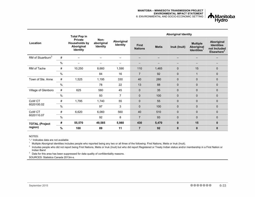
MANITOBA – MINNESOTA TRANSMISSION PROJECT ENVIRONMENTAL IMPACT STATEMENT
6: ENVIRONMENTAL AND SOCIO-ECONOMIC SETTING
September 2015 6-33
Location
Total Pop in Private
Households by Aboriginal
Identity
Non-aboriginal
Identity Aboriginal
Identity
Aboriginal Identity
First Nations Metis Inuk (Inuit)
Multiple Aboriginal Identities1
Aboriginal Identities
not Included Elsewhere2
RM of Stuartburn3 # – – – – – – – –
% – – – – – – – –
RM of Tache # 10,250 8,660 1,590 110 1,465 0 15 0
% 84 16 7 92 0 1 0
Town of Ste. Anne # 1,525 1,195 330 40 280 0 0 0
% 78 22 13 88 0 0 0
Village of Glenboro # 625 580 45 0 35 0 0 0
% 93 7 0 100 0 0 0
CoW CT 6020100.02
# 1,795 1,740 55 0 55 0 0 0
% 97 3 0 100 0 0 0
CoW CT 6020110.07
# 6,620 6,060 560 40 510 0 0 0
% 92 8 7 93 0 0 0
TOTAL (Project region)
# 55,570 49,585 5,980 430 5,470 0 15 0
% 100 89 11 7 92 0 0 0
NOTES: “–“ Indicates data are not available 1 Multiple Aboriginal identities includes people who reported being any two or all three of the following: First Nations, Metis or Inuk (Inuit). 2 Includes people who did not report being First Nations, Metis or Inuk (Inuit) but who did report Registered or Treaty Indian status and/or membership in a First Nation or
Indian Band 3 Data for this area has been suppressed for data quality of confidentiality reasons. SOURCES: Statistics Canada 2013m-s.

MANITOBA – MINNESOTA TRANSMISSION PROJECT ENVIRONMENTAL IMPACT STATEMENT 6: ENVIRONMENTAL AND SOCIO-ECONOMIC SETTING
6-34 September 2015
6.3.3.2.2 First Nation On/Off Reserve Populations Table 6-3 presents information on First Nation on and off reserve populations for those First Nations that identified as having an interest in the Project.
Table 6-3 First Nation On/Off Reserve Populations, May 2015
First Nation On Reserve On Other Reserves Off Reserve1
Total Total Male Female Total Male Female Total Male Female
Black River First Nation
912 454 458 11 5 6 354 195 159 1,277
Brokenhead Ojibway Nation
672 346 326 3 2 1 1,260 607 653 1,935
Buffalo Point First Nation
33 17 16 5 4 1 90 40 50 128
Dakota Plains First Nation
168 84 84 11 4 7 89 41 48 268
Dakota Tipi First Nation
195 119 76 2 0 2 198 110 88 395
Long Plain First Nation
2,195 1,137 1,058 49 24 25 2,022 959 1,063 4,266
Peguis First Nation
3,575 1,825 1,750 132 61 71 6,145 2,955 3,190 9,852
Roseau River Anishinabe First Nation
1,157 612 545 28 13 15 1,394 658 736 2,579
Sagkeeng First Nation
3,354 1,729 1,625 25 12 13 4,272 2,053 2,219 7,651
Sandy Bay Ojibway First Nation
3,951 2,076 1,875 38 16 22 2,437 1,157 1,280 6,426
Swan Lake First Nation
582 272 310 17 6 11 786 362 424 1,385
TOTAL 16,794 8,671 8,123 321 147 174 19,047 9,137 9,910 36,162
NOTE: 1 Off reserve includes on own Crown land, on other Band Crown land, on no Band Crown land and Off reserve
populations SOURCES: AANDC 2015a, 2015b, 2015c, 2015d, 2015e, 2015f, 2015g, 2015g, 2015h, 2015i, 2015j, 2015k

MANITOBA – MINNESOTA TRANSMISSION PROJECT ENVIRONMENTAL IMPACT STATEMENT
6: ENVIRONMENTAL AND SOCIO-ECONOMIC SETTING
6.3.4 Infrastructure and Services This subsection describes transportation, utility, water and waste infrastructure; temporary accommodations; emergency services (i.e., police and fire); and temporary accommodations in the Project region. Further information on infrastructure and services is provided in the Socio-Economic and Land Use Environment TDR or Chapter 13 – Infrastructure and Services.
6.3.4.1 Transportation Infrastructure Manitoba’s road network is owned and maintained by two jurisdictions: Manitoba Infrastructure and Transportation (MIT), which operates the provincial highway network, and municipal governments, which operate the municipal road network.
The provincial highway network includes primary routes (PTHs) and secondary routes (PRs). PRs are typically two-lane collector roads, carrying at most 4000 vehicles per day. PTHs typically carry higher volumes than PRs and are normally classified as expressways or arterials with two to four lanes. Most roads in the provincial highway network operate below capacity and at an acceptable level of service (Stantec 2015).
Most municipal road network in the region is two-lane, gravel-surfaced public roads, with a numbering scheme based on the mile grid system. Municipal roads within communities are often paved and named. Most municipalities have limited records of traffic volumes, but it is estimated that many carry less than 200 vehicles per day.
Other transportation infrastructure includes the Winnipeg/Lyncrest Airport, Zhoda Airport and Piney Pinecreek Border Airport and three unnamed aerodromes.
6.3.4.2 Utility and Communication Infrastructure The Project will cross or parallel various linear infrastructures in the region, including transmission lines and pipelines. More than 150 km of existing transmission lines are paralleled by the Project.
Approximately 265 communication, cell and broadcast towers are located throughout the Project region; they are concentrated in the RMs of Springfield, Tache, Ste. Anne and Piney. The towers are maintained by communication companies, broadcast companies and radio stations. Cellular coverage in the region is widespread through service providers (e.g., MTS, Rogers and Telus) with the exception of spotty coverage south of Marchand, in the southeastern part of the RM of La Broquerie and the southwestern portion of the RM of Piney, between the communities of Woodridge and Piney to the U.S. border.
Other linear infrastructure in the Project region includes the Red River Floodway and Greater Winnipeg Water District aqueduct.
September 2015 6-35

MANITOBA – MINNESOTA TRANSMISSION PROJECT ENVIRONMENTAL IMPACT STATEMENT 6: ENVIRONMENTAL AND SOCIO-ECONOMIC SETTING
6.3.4.3 Water and Waste Infrastructure RMs and communities are served by public drinking water systems and regional water supply systems (MCWS n.d.a). Sources of water vary throughout the region. Water sources include Shoal Lake, Assiniboine River, La Salle River and groundwater. Wastewater facilities also vary throughout the region and include treatment plants, lagoons, low-pressure sewage systems and septic tanks. While usage and capacity information was not available for all water and wastewater utilities in the region, those that had information available had enough capacity to meet the average demand.
Solid waste is collected and disposed of at various facilities throughout the region. Most household waste, construction, renovation, demolition waste and industrial non-hazardous waste is disposed of at landfills. Hazardous wastes such as pesticide containers, oil, antifreeze and paint are disposed of at specialized facilities. Household hazardous wastes can be brought to “eco-depots” established throughout the region, while commercial hazardous waste can be transported to and processed at the Miller Environmental facility located in southern Manitoba.
6.3.4.4 Emergency Services Emergency services include police and fire. Information on ambulance services is provided in Section 6.3.8.1.
6.3.4.4.1 Police The Royal Canadian Mounted Police (RCMP) provides police services in the RMs, while local police serve the Town of Ste. Anne and the cities of Winnipeg and Brandon. RCMP detachments in the region serve between 1140 and 2080 population per officer, and have caseloads ranging from 44 to 63 criminal code incidents per police officer. The local police detachments in Ste. Anne, Winnipeg, and Brandon have higher police strengths (i.e., lower populations per police officer). The police strengths in these communities represent some of the highest in Canada, surpassing the national average of 518 population per officer.
6.3.4.4.2 Fire Firefighting services are provided by a combination of professional and volunteer firefighters based out of fire departments throughout the region. Fire departments serving RMs typically have 20 to 30 members and take between 25 and 100 calls per year. The 25-member Headingley Fire Department serving the RM of Headingley and the 60-member Springfield Fire and Rescue Service serving the RM of Springfield are the two busiest RMs in the region, taking 300 and 500 calls per year, respectively. Characteristic of the larger populations they serve, fire services in Winnipeg and Brandon take on a substantially higher call volume (100,000 and 5000, respectively) than the smaller departments serving the RMs. They have a correspondingly higher number of members as well, with approximately 900 in Winnipeg and 60 in Brandon. Fire department representatives have indicated that the services currently available are sufficient to meet current demand.
6-36 September 2015

MANITOBA – MINNESOTA TRANSMISSION PROJECT ENVIRONMENTAL IMPACT STATEMENT
6: ENVIRONMENTAL AND SOCIO-ECONOMIC SETTING
6.3.4.5 Temporary Accommodations Temporary accommodations in the Project region include hotels,1 resorts, campgrounds and bed and breakfasts. The focus of this section is on hotels since they are most likely to be used and affected by the Project. The cities of Winnipeg, Brandon and Steinbach have the largest varieties of hotels in the region. There are approximately 6450 rooms available in Winnipeg, 1400 rooms in Brandon and 100 rooms in Steinbach. The RM of Headingley also has about 80 rooms. Scattered throughout the rest of the Project region there are hotels with at most a few dozen rooms. Vacancy rates are typically low during the summer (June through September), with several hotels fully booked during this period. Winters and weekdays (except around holiday breaks) typically have higher vacancy rates (Travel Manitoba 2014; Moir 2015, pers. comm.; Howdle 2015, pers. comm.; Doerksen 2015, pers. comm.).
In total, the Project region has 23 year-round or seasonal rental accommodations of which 12 are hotels or motels and three are bed and breakfasts, with a combined total of approximately 230 units for rental. The seasonal lodges, RV parks and campgrounds in the region have approximately 300 sites. Vacancy rates would typically be lower for the summer months (June to September), particularly for the RV parks and campgrounds and higher during the winter and on weekdays, except around holiday breaks.
6.3.5 Employment and Economy This section provides information on the Manitoba economy, local economic profiles, educational attainment, labour force by industry and labour incomes. Further information on employment and economy is provided in the Socio-Economic and Land Use Environment TDR or in Chapter 14 – Employment and Economy. Statistics Canada data used in this section refer to the general population and Aboriginal population. The term Aboriginal according to Statistics Canada includes First Nations, Metis, Inuk (Inuit), those that identify with multiple Aboriginal identities and Aboriginal identities not included elsewhere
6.3.5.1 Manitoba Economy Manitoba’s diversified $55 billon economy in 2012 was led by manufacturing, agriculture, and resourced-based industries (such as mining and forestry).
Major industries in the province include agri-food, transportation equipment, resource-based industries, chemicals machinery and equipment, furniture and building products, paper products, fabricated metal products, plastics, printing, apparel, electronics, information technology and telecommunications, aerospace, farm equipment, electric power generation, health care products, environmental services and tourism/cultural industries (Province of Manitoba 2014).
1 The term “hotels” refers to hotels, motels, inns and other similar accommodation types
September 2015 6-37

MANITOBA – MINNESOTA TRANSMISSION PROJECT ENVIRONMENTAL IMPACT STATEMENT 6: ENVIRONMENTAL AND SOCIO-ECONOMIC SETTING
6.3.5.2 Local and Regional Economy Basic industries in the Project region include agriculture and resource-based industries, construction, manufacturing, educational services, health care and social services. Non-basic industries include wholesale and retail trade, finance and real estate, business services and other industries. Between 2006 and 2011 there was a slight shift from non-basic industry employment to basic industry employment in the Project region. The most common occupations in the Project region were related to sales and service with the least common occupations in the manufacturing and utilities and natural resources, agriculture and related production.
6.3.5.3 Educational Attainment In 2011, the level of educational attainment in the Project region was similar to that in the province, with more people in the Project region having attained an apprenticeship or trades certificate, college certificate or diploma.
The most common field of study for those with a trades, college or university certificate, diploma or degree was architecture, engineering and related technologies, followed closely by business, management and public administration. These are also the most common fields of study in the province (Statistics Canada 2013 a-s).
6.3.5.4 Industries Basic industries in the Project region include agriculture, resourced-based industries, construction, manufacturing, health care, social services and educational services. Non-basic industries include wholesale trade, retail trade, finance, real estate, business services and “other” (i.e., management of companies and enterprises; arts, entertainment and recreation; public administration and other services). Over the 2006 to 2011 period, there was a decline in dependence on agricultural and resource based industries in the Project region.
The number of workers employed in occupations related to trade, transport and equipment operation gives an indication of the local and regional supply of workers with appropriate skills for construction employment. In 2011, the Project region had a higher percentage of workers in trade, transport and equipment operation (18%) than the province (15%).
Aboriginal labour force employment for basic and non-basic industries was similar to the labour force employment for the Project region in 2011. In total, 26% of the Aboriginal labour force (675 people) in the Project region was employed in trades, transportation and equipment operators.
6-38 September 2015

MANITOBA – MINNESOTA TRANSMISSION PROJECT ENVIRONMENTAL IMPACT STATEMENT
6: ENVIRONMENTAL AND SOCIO-ECONOMIC SETTING
6.3.5.5 Labour Force Activity Labour force activity is discussed in this section by unemployment rates,2 employment rates3 and participation rates.4
In recent years, Manitoba has had a lower rate of unemployment than Canada overall. Within the Project region, participation and employment rates were higher and unemployment rates were lower compared to the provincial averages. In the province and the Project region, unemployment rates increased between 2006 and 2011. The Aboriginal labour force had higher participation and employment rates compared to the region and a similar unemployment rate. The total labour force in the Project region was 40,655 in 2006 and increased 5.5% to 42,910 in 2011. The Aboriginal labour force increased 21.8% from 2760 in 2006 to 3530 in 2011 (Statistics Canada 2013 a-s).
6.3.5.6 Labour Income and Earnings In 2010, income and earnings in the Project region were higher than in the province. The median income in the region was $51,037 compared to $43,621 in Manitoba. The average income in the region was $56,780 compared to $51,037 in Manitoba. Aboriginal median and average incomes ($43,884 and $48,840 respectively) were lower compared to the Project region.
The Project region had a higher reliance on self-employment income (6.8%) compared to the province (4.4%) and a lower reliance on government transfers (9.9% compared to 12.5%). The Aboriginal population had a higher composition of income from wages and salaries (79%) compared to the region (73%) and a lower reliance on other income (6% compared to 11%).
6.3.6 Agricultural Land Use This section provides information on agricultural capability, land cover and crop production and livestock operations in the Project region. Further information on agricultural land use is provided in the Soils TDR or in Chapter 15 – Agriculture.
Agricultural land use is a dominant land use in the Project region. The Project region contributes substantially to agricultural production in the province. According to Statistics Canada (2011b), 1456 farms within the RMs are traversed by the Project. Oilseed, grain and cattle farms are the most common types of farms. Many of the oilseed and grain farms are located in the RMs of Macdonald, Springfield, Tache, Rosser, Ritchot, Ste. Anne and Headingley. A large proportion of livestock farms within the Project region are located in the RMs of Stuartburn, La Broquerie and Piney.
2 Unemployment rate – percentage of people not currently employed but seeking employment aged 15 years and over 3 Employment rate – percentage of people employed aged 15 years and over 4 Participation rate – percentage of people participating in the labour force aged 15 and over, excluding institutional
residents
September 2015 6-39

MANITOBA – MINNESOTA TRANSMISSION PROJECT ENVIRONMENTAL IMPACT STATEMENT 6: ENVIRONMENTAL AND SOCIO-ECONOMIC SETTING
6.3.6.1 Agricultural Capability The capability of land for agriculture is determined using the Canada Land Inventory (CLI) interpretative system for assessing the effects of climate and soil characteristics on the limitations of land for growing common field crops (CLI 1969 and Province of Ontario 2015). The system classifies mineral soils from Class 1 to Class 7 with decreasing potential and increasing limitations (Government of Canada 2013c).
Soils within the RMs of Rosser, Headingley, Macdonald, Ritchot, Tache, Springfield and Ste. Anne are dominantly rated Class 2 and Class 3 soils with moderate limitations for agricultural capability. These soils are imperfectly drained and fine to very fine in texture and are rated to have a high risk for soil compaction.
However, the eastern portions of RMs traversed by the Project have increased occurrence of marginal soils belonging to Class 4 and Class 5, which have severe limitations for agricultural capability, as well as organic soils, which are considered unsuitable for cropping. The occurrence of marginal soils is more pronounced in the RMs of La Broquerie, Stuartburn and Piney where Class 4, Class 5, Class 6 and organic soils cover larger areas than the more productive Class 2 and Class 3 soils. The primary limitations to agricultural capability in the Project region are excess water and moisture limitation (Chapter 15, Section 15.4).
In the RM of South Cypress, Class 6 soils are dominant with appreciable areas of Class 2 to 5 and organic soils. Class 2 soils are dominant in the vicinity of the Glenboro South Station.
6.3.6.2 Agricultural Land Cover and Crop Production The Project region contains a mixture of perennial cropland, pasture, annual cropland, range and grassland (Map 6-10 – Annual and Perennial Cropping). In areas under agricultural land cover, annual cropland constitutes the largest area and is the dominant land cover in the RMs of Rosser, Headingley, Macdonald, Ritchot, Tache, Springfield and Ste. Anne. Range and grassland is the most common agricultural land cover type in the RMs of La Broquerie, Stuartburn and Piney, which have smaller areas under annual cropland. This pattern of increased marginal areas and reduced areas under annual cropland is consistent with decreasing land capability for agriculture and increased occurrence of livestock operations. Perennial cropland and pasture is scattered throughout the Project region.
Top annual crops grown within the region are red spring wheat, canola, soybeans, oats, winter wheat, corn, barley, flax and sunflowers. Perennial crops grown include alfalfa, grasses, forage and greenfeed (MASC 2014). Map 6-11 – Crop Production 2014 shows the distribution of crops grown in the Project region in 2014.
Soils in the RMs of Rosser, Headingley, Macdonald, Ritchot, Tache, Springfield and Ste. Anne are predominantly fine-textured and imperfectly drained. As a result, aerial application of crop protection products, especially under wet field conditions, is important for the maintenance of crop productivity in these RMs.
6-40 September 2015

MANITOBA – MINNESOTA TRANSMISSION PROJECT ENVIRONMENTAL IMPACT STATEMENT
6: ENVIRONMENTAL AND SOCIO-ECONOMIC SETTING
6.3.6.3 Livestock Operations Livestock operations, including hog, dairy, cattle and poultry, are located throughout the Project region (Map 6-12– Livestock Operations).
The RM of La Broquerie has the highest number of intensive hog operations followed by the RMs of Tache, Ritchot and the western portion of the RM of Ste. Anne. There are approximately 11 hog operations within 1 km of the Project: three along the Existing Corridor and eight along the New ROW.
Dairy cattle operation locations within the Project region are scattered throughout the RM of Springfield and concentrated in the southern part of the RM of Tache, southern part of RM of Ste. Anne and northern part of RM of La Broquerie. Fewer dairy cattle operations are located in the RMs of Rosser and Stuartburn. There are approximately nine dairy operations located within one km of the Project: one on the Existing Corridor and eight along the New ROW.
Broiler and hatching egg chicken operations are concentrated in the southern part of the RM of Tache and the western part of the RM of Ste. Anne. Fewer operations are located in the RMs of La Broquerie and Rosser. Manitoba Chicken Producers have no registered broiler and hatching egg chicken operations in the RM of South Cypress (Armstrong 2015, pers. comm.). Manitoba Turkey Producers and Manitoba Egg Farmers provided the number of operations by nearest town, community or RM but did not provide specific operation locations for confidentially reasons.
According to data provided by MAFRD (Lafreniere 2014, pers. comm.), beekeeping operations occur throughout most of the Project region. However, their locations are unknown.
There are no known organic operations within the Project region. The Organic Producers Association of Manitoba does not have registered organic producers in the area (Rogalsky-Tapp 2015, pers. comm.).
Specialty operations in the Project region include:
• a mushroom farm in the RM of Springfield
• three fruit farms in the RM of Macdonald
• two fruit farms in the RM of South Cypress
• two sod farms - one south of the City of Winnipeg near PTH 75 located within the SLTC and one in the RM of Headingley
• an aquafarm in the RM of Springfield
September 2015 6-41

MANITOBA – MINNESOTA TRANSMISSION PROJECT ENVIRONMENTAL IMPACT STATEMENT 6: ENVIRONMENTAL AND SOCIO-ECONOMIC SETTING
6.3.7 Land and Resource Use This section describes provincial land use planning, municipal and urban centres (incorporated and unincorporated communities), land use development controls, land tenure and property ownership (i.e., Crown and municipal lands, private residential development, agricultural and industrial developments [i.e., Hutterite colonies, industrial business parks and agro-industrial sites]). The setting for designated lands and protected areas, recreation and resource use (i.e., commercial and domestic) are also described. Further information on land and resource use is provided in the Socio-Economic and Land Use Environment TDR or Chapter 16 – Land and Resource Use.
6.3.7.1 Municipal and Urban Centres Municipal jurisdiction in the Project region is divided primarily between RMs and urban centres, such as cities, towns and villages (Map 6-13 – Municipal Jurisdictions). Rural areas may be organized as planning districts, while smaller settlements and communities have no independent municipal status. Development planning for smaller settlements and communities is undertaken at the RM level in the form of development plans and zoning bylaws.
A Reeve or Mayor and an elected council govern each incorporated municipal jurisdiction. The incorporated municipal jurisdiction is responsible for land use planning, infrastructure and services within their boundaries. The municipalities derive their authority from the Provincial government, which retains direct control over certain higher order regional services (e.g., PTHs and PRs). Municipalities are typically responsible for the provision of essential services (e.g., water, sewer, waste, firefighting and other services [e.g., recreation]).
The Project is located within 11 RMs:
• RM of Rosser • RM of Ste. Anne
• RM of Macdonald • RM of La Broquerie
• RM of Ritchot • RM of Stuartburn
• RM of Tache • RM of Piney
• RM of Springfield • RM of South Cypress
Urban centres near the Project include the City of Winnipeg, Town of Ste. Anne, City of Steinbach and Village of Glenboro. The two southernmost census tracts5 within the City of Winnipeg, encompassing land south of the Perimeter Highway, are used in this assessment. The City of Brandon is the largest urban centre in the Glenboro area of the Project region.
5 Census tracts 6020100.02 and 6020110.07
6-42 September 2015

MANITOBA – MINNESOTA TRANSMISSION PROJECT ENVIRONMENTAL IMPACT STATEMENT
6: ENVIRONMENTAL AND SOCIO-ECONOMIC SETTING
Settlements and unincorporated communities within the Project region include:
• Anola • Giroux
• Caliento • La Broquerie
• Dugald • Marchand
• Richer • Piney
• Ile des Chenes • South Junction
• La Salle • Sprague
• Lorette • Sundown
• Landmark • Vassar
• Oak Bluff • Vita
• Rosser • Zhoda
Planning districts are principally responsible for land use development planning under The Planning Act, C.C.S.M. c. P80. Three planning districts are traversed by the Project:
• South Interlake (encompassing Rosser)
• Macdonald-Ritchot (encompassing Macdonald and Ritchot)
• Cypress River (encompassing North and South Cypress) at the Glenboro South Station
Conservation Districts are formed as partnerships between the Province and local municipalities to protect, restore and manage land and water resources on a watershed basis. Conservation districts are also the lead organization responsible for the development of integrated watershed management plans under the Manitoba Conservation Districts Program.
Five conservation districts are traversed by the Project (Map 6-14 – Conservation Districts):
• East Interlake
• Cooks Creek
• La Salle-Redboine
• Seine-Rat River
• Assiniboine Hills Conservation District (Glenboro Project region)
6.3.7.2 Land Use Development Controls Land use planning responsibility at the RM level extends to land use control and development policy. Municipal jurisdictions may adopt development plans and zoning bylaws to guide land use decisions within their respective boundaries.
September 2015 6-43

MANITOBA – MINNESOTA TRANSMISSION PROJECT ENVIRONMENTAL IMPACT STATEMENT 6: ENVIRONMENTAL AND SOCIO-ECONOMIC SETTING
Outside of urban centres or settlement areas, most of the land within the Project region is designated as “Agricultural”, “Agricultural Limited” or “Rural Area” under individual municipal development plans. Areas of Crown land are typically designated as “Natural Resource Area”, “Natural Environment Area”, “Rural Natural Area”, or as designated Crown land (e.g., provincial forests, WMAs) in the development plans. Specific municipal or planning district development plan policies note that essential activities of government and public and private utilities should be permitted in any land use designation subject to the requirements in a municipal zoning bylaw and should be developed in a manner so as to reduce any incompatibility with neighbouring land uses. Major portions of land in the southeast within the RM of Piney and in the northeast within the RM of Stuartburn are designated as Crown land or provincial forest, respectively.
Manitoba Hydro maintains the position that the Corporation is not subject to the jurisdiction of local planning authorities pertaining to matters related to zoning and or the subdivision process. This position is based on certain provisions of The Manitoba Hydro Act, C.C.S.M. c. H190 governing:
• the Corporation’s standing as an agent of Her Majesty (the Province of Manitoba)
• the Corporation’s sole and exclusive jurisdiction to all matters under the Act notwithstanding provisions of any other Act or regulation, rule or bylaw
• the preference given to the Act over conflicting provisions of any other Act (Manitoba Hydro 1998)
6.3.7.3 Land Tenure and Property Ownership Property ownership patterns are influenced by the pattern of land use survey, which is primarily the section-township-range system in the Project region. The exceptions to this general pattern occur near Ste. Anne, Lorette and the Oak Island Settlement located southeast of Ile des Chenes where long river lot land use survey is evident.
Most land traversed by the Project is privately owned (42%), followed by Manitoba Hydro-owned or -eased land (33%), followed by Crown land (25%).
6.3.7.3.1 Crown and Public Lands Crown and public lands in the Project region include several publicly owned parcels set aside as an ecological reserve, WMAs, provincial forests and a community pasture and the Red River Floodway (Section 6.3.7.4). Crown-owned or Crown-leased lands are located in the RMs of Springfield, Tache, Ste. Anne, La Broquerie, Stuartburn and Piney (Map 6-15 – Land Tenure and Ownership). The Existing Corridor is a mixture of land owned either by Manitoba Hydro or under easement. Municipal-owned land is limited and occurs only as individual quarter-section parcels of land within the RMs of Macdonald and Piney.
6-44 September 2015
MANITOBA – MINNESOTA TRANSMISSION PROJECT ENVIRONMENTAL IMPACT STATEMENT
6: ENVIRONMENTAL AND SOCIO-ECONOMIC SETTING
Agricultural Crown lands, either owned or leased from the Crown, are prevalent in the eastern portions of the RMs of Springfield and Tache, in scattered pockets in the RM of La Broquerie, in the north, south and eastern sections of the RM of Stuartburn and in the north-central and southern portions of the RM of Piney. Parcels of Crown land that are encumbered within the Project region are located in the RMs of Headingley, Springfield and the City of Winnipeg (i.e., Red River Floodway) along the Existing Corridors, and the RMs of Tache, Ste. Anne, La Broquerie, Stuartburn and Piney along the New ROW. The encumbrances6 are largely concentrated in the RMs of Ste. Anne, La Broquerie, Stuartburn and Piney (Crown Land and Property Agency 2015). Crown land encumbrance types7 consist of forage leases/agricultural rental (16), wildlife-DUC lands (5), community license of occupation (5), forest research plantation (4), fish and game association license of occupation (2), school land (2) and treaty land entitlement (TLE) notice (2). Crown land encumbrances also exist for protected areas, provincial forest, WMAs, quarry leases, and easements for Manitoba Hydro and MTS (Crown Land and Property Agency 2015).
In the RM of South Cypress, Crown-owned and agricultural Crown-leased land is prevalent to the north of Glenboro and the Glenboro South Station. No Crown lands are located in the immediate vicinity of Glenboro. Most of the land around the Glenboro South Station is privately owned.
The Project does not cross any First Nation Reserve lands (Map 6-15 – Land Tenure and Ownership). There are two Treaty Land Entitlement (TLE) sites/Aboriginal land parcels in the Project region. Swan Lake First Nation owns a 10 ha parcel of land in the RM of Headingley. The Peguis First Nation has a TLE site of 129 ha in the RM of Springfield. Two recent additional TLE encumbrances are located in the RM of Springfield in part NE5-10-7E (approximately 16 ha) and in NW4-10-7E (approximately 65 ha).
6.3.7.3.2 Private Residential Development Urban residential development and other settlement centres occur within the communities of Headingley, Oak Bluff, La Salle, Grande Pointe, La Broquerie, Marchand and Town of Ste. Anne. Pockets of rural residential development stem out from areas of dense urban residential areas in the RMs of Springfield, Tache, Ste. Anne and La Broquerie and to a lesser extent in the RMs of Stuartburn and Piney. Rural farm residential development is generally widespread throughout the Project region and is associated with agricultural operations, including farm accessory buildings. In addition, the Oak Bluff West residential subdivision is located immediately adjacent to Oak Bluff in the RM of Macdonald.
Private development rights within the Project region are described in terms of active and closed subdivision applications. As of 2014, there were 58 active subdivision applications within 1 km of the Project: 43 along the Existing Corridor, and 15 along the New ROW. In addition to active
6 A lien or claim on property that affects transfer of ownership but does not prevent such a transfer. 7 Number of parcels or quarter sections provided based on section-township-range.
September 2015 6-45

MANITOBA – MINNESOTA TRANSMISSION PROJECT ENVIRONMENTAL IMPACT STATEMENT 6: ENVIRONMENTAL AND SOCIO-ECONOMIC SETTING
subdivision applications, there were 54 closed subdivision applications within a 1 km of the Project.
6.3.7.3.3 Agricultural and Industrial Developments There are a number of agricultural and industrial developments in the Project region, including Hutterite colonies, industrial areas and parks and agro-industrial developments.
Hutterite colonies own large tracts of land based on collective ownership whereby land, buildings, including housing units and other common buildings (i.e., dining or fellowship hall) are owned by the colony, which is operated like a corporation. Colonies run industrial hog, dairy, turkey, chicken and egg production or manufacturing operations. Three Hutterite colonies are located within the Project region:
• Sturgeon Creek Colony in the RM of Rosser, south of the Dorsey Converter Station; it includes about 160 residents
• Ridgeland Colony in the RM of Springfield, south of Anola; it includes about 100 residents
• Pineland Colony in the RM of Piney, south of Piney (Cedrontech Hutterite Contact Directory n.d.); it includes about 115 residents
There are about 12 industrial areas and parks within the Project region, including select industrial parks in Winnipeg and Steinbach. Within the City of Winnipeg, there are approximately 30 industrial areas and parks. Municipal industrial parks are located in the RMs of Rosser, Headingley, Macdonald, Ritchot and Springfield. These areas are generally in close proximity to major transportation centres (Province of Manitoba 2015a; CentrePort Canada 2015; and Partnership of the Manitoba Capital Region 2012).
Agro-industrial developments are also located within the Project region. Richardson Limited maintains a 500-acre research farm and crop development centre, Kelburn Farm, at Howden, just south of the City of Winnipeg along the Red River. Richardson Limited also operates agriculture business centres in the cities of Winnipeg and Steinbach. Viterra operates a canola processing plant in Ste. Agathe and maintains grain terminals in Rosser, Ste. Agathe and Winnipeg. Paterson Grain operates terminals in La Salle and Winnipeg and maintains a crop input centre in Steinbach.
6.3.7.4 Designated Lands and Protected Areas Manitoba’s protected areas network includes parts of provincial forests, provincial parks, heritage parks, ecological reserves, WMAs and private conservation lands (MCWS 2014a). Under Manitoba’s PAI, protected areas prohibit logging, mining (including aggregate extraction), oil, petroleum, natural gas or hydro-electric development. However, activities such as hunting, trapping or fishing are allowed. As well, protected areas respect First Nation's rights and agreements.
6-46 September 2015

MANITOBA – MINNESOTA TRANSMISSION PROJECT ENVIRONMENTAL IMPACT STATEMENT
6: ENVIRONMENTAL AND SOCIO-ECONOMIC SETTING
Designated lands within the Project region include heritage parks, recreation parks, provincial forests, protected areas and candidate protected areas (i.e., ASIs, ecological reserves, heritage rivers, WMAs, wildlife refuge and non-governmental conservation lands) (Map 6-16 – Designated Lands and Protected Areas). There are no national parks or national protected areas located in the Project region.
Designated lands and sites within the region are:
• Trappist Monastery Heritage Park • Cat Hills Provincial Park
• St. Norbert Provincial Heritage Park • Wampum Provincial Forest
• Duff Roblin Provincial Heritage Park • Marchand Provincial Recreation Park
• Agassiz Provincial Forest • Woodridge Provincial Park
• Sandilands Provincial Forest
Provincial forests were initially established as reserves for timber. They are now used for a variety of activities, such as wildlife conservation, outdoor recreation, traditional harvesting and scientific research. Provincial forests and provincial parks include facilities to accommodate horseback riding, hiking, cross-country, all-terrain vehicle (ATV) and snowmobile trail users. These lands are protected with special considerations for economy, habitat, traditional and social uses. Special permits are typically required for resource harvesting within Manitoba’s provincial forests (MCWS 2015).
Duff Roblin Provincial Heritage Park is located at the floodway inlet in the City of Winnipeg. Manitoba Hydro maintains an easement across an “Access” land use category established by the Parks and Natural Areas Branch that allows for hydroelectric transmission lines (i.e., SLTC) through the heritage park. This usage was established under the Red River Floodway Agreement signed between the Province of Manitoba and Manitoba Hydro.
Ecological reserves are established to preserve unique and rare natural (biological and geological) features of the province and examples of natural and modified ecosystems. These sites are set aside for ecosystem and biodiversity preservation, research, education and nature study. Three ecological reserves have been given permanent protection in the Project region under the provincial Protected Areas Initiative (MCWS 2015):
• Lewis Bog • Wampum Provincial Forest
• Pocock Lake
Six additional proposed ecological reserves located in the have not been given permanent protection status yet (MCWS 2015):
• an expansion of Lewis Bog • St. Labre
• Cedar Bog • Woodridge
• Balsam Willows • Piney
September 2015 6-47

MANITOBA – MINNESOTA TRANSMISSION PROJECT ENVIRONMENTAL IMPACT STATEMENT 6: ENVIRONMENTAL AND SOCIO-ECONOMIC SETTING
WMAs exist for the benefit of wildlife and for the enjoyment of people. They play an important role in biodiversity conservation and provide for a variety of wildlife-related forms of recreation, including birding and wildlife watching. Hunting and trapping are permitted in WMAs, but these activities may be prohibited or restricted in a few areas. The use of vehicles, off-road vehicles, watercraft, power boats, or airboats, may be restricted in some areas. WMAs within the region include:
• Rat River WMA (parcel) • Watson P. Davidson WMA
• Spur Woods WMA
There is one community pasture, Gardenton-Pansy, in the RM of Stuartburn. A Crown-owned red pine wildlife refuge is located in the southeast portion of the region.
The Nature Conservancy of Canada (NCC) owns private lands as part of a tall-grass prairie preserve within the southwest portion of region in the RM of Stuartburn. An additional three areas owned by the NCC are partially located on the southwest edge of the Project region, also within the RM of Stuartburn.
ASIs are candidate protected areas selected under Manitoba’s PAI to represent enduring features within a natural region that still need to be captured in Manitoba’s protected areas network. ASIs within the area include:
• Spruce Siding • Rat River East
• North Hugo Lake • Menisino Tower
• Boutang • Menisino Ridge
• 55 Burn • Somme
• St. Labre • Great Gray Own
• Earls Block • Badger
• Sandilands • Rat River West
The Red River Floodway was designated as a National Historic Site of Canada in 2001 as an outstanding engineering achievement in terms of function and impact (The Manitoba Historical Society 2014).
The Red River is a designated heritage river under the Canadian Heritage Rivers System (CHRS). This route has been key to the cultural heritage of western Canada. It was the primary transportation corridor for First Nations and European settlers for exploration and the fur trade and settlement (CHRS 2011).
In the South Cypress-Glenboro area, designated lands include Spruce Woods Forest Reserve and Provincial Park. WMAs in the vicinity include the Assiniboine Corridor WMA, a collection of land parcels along the Assiniboine River valley, Spruce Woods WMA (south of Spruce Woods Provincial Park) and Tiger Hills WMA (south of Glenboro). Another wildlife parcel is the Glenboro Marsh south of the station site (Manitoba Hydro 2001).
6-48 September 2015
MANITOBA – MINNESOTA TRANSMISSION PROJECT ENVIRONMENTAL IMPACT STATEMENT
6: ENVIRONMENTAL AND SOCIO-ECONOMIC SETTING
6.3.7.5 Recreation Recreational activities occur throughout the Project region (Map 6-17 – Land Use and Recreation), including the use of motorized and non-motorized trails, lodges and resorts, campgrounds and wayside picnic areas. Several private businesses located in the Project region provide nature-based tourism activities to visitors.
6.3.7.5.1 Multi-Use Trails and Routes Recreational trails and routes in the Project region include snowmobile trails, ATV trails, hiking and multi-use trails, cross-country ski trails and canoe routes.
Manitoba has an extensive network of over 500 km of designated snowmobile trails (Map 6-17) which connect users to communities in all areas in the region (SnoMAN Inc. 2014). Groomed snowmobile trails are maintained by local clubs, including the Cross Country Snow Drifters, the Snow Raiders Snowmobile Club Inc. and the South East SnowRiders (SnoMan Inc. 2011; SESR 2012; SRSC 2013; CCSD 2015; and SnoMan Inc. pers. comm. 2015).
Cross-country skiing and snowshoeing trails in the region include Beaudry Provincial Park, Crow Wing Trail (part of the Trans Canada Trail), La Salle River, and Sandilands Ski Trails (Ernst 2010). The Sandilands Ski Club has approximately 38 km of trails in the Sandilands Provincial Forest (SCCSC 2015).
ATV trails and off-road vehicle use is common in Sandilands Provincial Forest. According to a representative of ATV Manitoba, there are approximately 1000 km of trails in the Woodridge area of southeastern Manitoba (ATVMB pers. comm. 2015).
There are five non-motorized multiuse trails within the Project region and Glenboro area:
• Headingley Grand Trunk Trail is a 10 km trail located along an abandoned Canadian National railway bed between the City of Winnipeg Perimeter and Beaudry Provincial Park (Winnipeg Trails Association 2015).
• Duff Roblin Parkway Trail is a 46 km trail, beginning at Duff Roblin Provincial Heritage Park and travelling along the west side of the Red River Floodway on the berm lands to the community of Lockport in the north (Manitoba Floodway Authority 2013).
• Crow Wing Trail is the longest section of the TransCanada Trail in Manitoba, at 191 km, connecting Winnipeg south of the Floodway to Emerson. The trail was initially established in the 1800s as a route to transport goods from the Red River Settlement on the Red River to the Crow Wing Settlement on the Mississippi River. Currently, the multiuse trail recreational trail is used for hiking, walking, running, off-road biking, horseback riding and cross-country skiing (Canada Trails 2015; Trails Manitoba 2013a).
September 2015 6-49

MANITOBA – MINNESOTA TRANSMISSION PROJECT ENVIRONMENTAL IMPACT STATEMENT 6: ENVIRONMENTAL AND SOCIO-ECONOMIC SETTING
6-50 September 2015
• Winnipeg Trail is approximately 81 km long, entering the City of Winnipeg along the Red River ending and exiting at the St. Norbert Provincial Heritage Park. Activities along the trail include hiking, walking, running, cycling, cross-country skiing and snowshoeing (Trails Manitoba 2013b).
• Glenboro South Cypress Trail is approximately 45 km long and located approximately 10 km north of Glenboro. Activities on the trail include hiking, walking, running, back country, cross-country skiing, snowshoeing and mountain biking (Trails Manitoba 2013c).
Navigable waterways (i.e., by small motor boats and canoe) in the Project region include the Assiniboine and Red rivers. Both of these rivers are “Scheduled Waters” under the federal Navigation Protection Act, R.S.C. 1985, c. N-22 (NPA). The purpose of the NPA is to regulate works and obstructions that risk interfering with the public right of navigation. Other large permanent waterbodies within the Project region that are likely navigable by canoe include reaches of Cooks Creek and the La Salle, Seine and Rat rivers.
The Red River is a designated heritage river and is used for recreational purposes. A representative of RiversWest Inc. indicated that boating and fishing occur along the Red River corridor, stretching from Emerson to Lake Winnipeg. RiversWest maintains an access point along the Red River north of St. Adolphe (RiversWest Inc. 2015, pers. comm.). Two other designated canoe routes are located in the Project region:
• Riviere Aux Rats Canoe Route traverses the region commencing at a point near Carrick, in Sandilands Provincial Forest and then proceeding westerly to its junction with the Red River south of Ste. Adolphe (Manitoba Department of Natural Resources 1971).
• Assiniboine River Canoe Route commences in Brandon and follows the Assiniboine River through Spruce Woods Provincial Forest/Canadian Forces Base Shilo and Spruce Woods Provincial Park east to PTH 34, north of Holland, Manitoba.
Recreational areas and activities in the South Cypress-Glenboro area include hiking and cross-country ski trails in Spruce Woods Provincial Park, designated SnoMAN snowmobile trails and tourist sites (e.g., Spirit Sands in Spruce Woods and Stockton Ferry; Ernst 2010).
6.3.7.5.2 Tourism Tourism activities within the Project region include outfitting services (i.e., hunting), visiting provincial parks, historic sites, museums, churches and activities such as golfing and birding.
6.3.7.6 Domestic and Commercial Resource Use This sub-section discusses trapping and hunting, fishing, gathering, mining and aggregates, forestry and surface water and groundwater use. Information regarding traditional resource use is included in Section 6.3.1 and Chapter 11 – Traditional Land and Resource Use.

MANITOBA – MINNESOTA TRANSMISSION PROJECT ENVIRONMENTAL IMPACT STATEMENT
6: ENVIRONMENTAL AND SOCIO-ECONOMIC SETTING
6.3.7.6.1 Trapping and Hunting The Project region consists of open trapping areas (OTAs), game hunting areas (GHAs) and game bird hunting zones (GBHZs). Areas that allow restricted hunting and trapping within the region include WMAs, Provincial Parks and Provincial Forests (Map 6-16 – Designated Lands and Protected Areas).
OTAs allow for harvesting of furbearing animals on private lands with the appropriate licence and landowner permission. The Project region and the South Cypress-Glenboro area are located in the same, large OTA (Zone 1), with Zones 3 and 4 also located in the Project region.
Common species trapped in OTAs include beaver, mink, muskrat, river otter, badger, fisher, red fox, coyote, lynx, bobcat, marten, raccoon, red squirrel, wolf and weasel (MCWS 2014b). Resource users consider most furbearers (e.g., American marten) to be important (Wildlife and Wildlife Habitat TDR, Stantec 2015).
There are six GHAs within the Project region: 25B, 31, 33, 34A, 35 and 35A. Common game species in these GHAs include whitetail deer, black bear, ruffed grouse, wild turkey, wolf and coyote. The South Cypress-Glenboro area is within GHAs 30 and 31.
White-tailed deer is an important game species to resource users. Prohibited hunting areas for white-tailed deer with a centrefire rifle include the RMs of Rosser, Headingley and sections of the RMs of Macdonald and Ritchot (MCWS 2014c). Hunting by other methods (e.g., bow hunting) is still permitted.
Black bear is also an important furbearer to resource users. Two outfitters offer black bear hunting in the southern parts of the Project region.
The Project region is located within GBHZ 4,which spans southern Manitoba from the Ontario to Saskatchewan borders. Common game bird species hunted include ducks, coots, snipes, woodcock, geese, snow geese, sandhill cranes, grouse and wild turkey (MCWS 2014c). The Environment Canada Canadian Wildlife Service keeps migratory game bird hunting licence records (e.g., geese, ducks and other waterbirds). Non-migratory game bird (e.g. ruffed grouse, sharp-tailed grouse, spruce grouse and Hungarian partridge) seasons and licensing is under the jurisdiction of the Wildlife and Ecosystem Protection Branch of MCWS.
6.3.7.6.2 Fishing Watercourses in the Project region support a recreational sport fishery. Sport fish species present include yellow perch, brown bullhead, channel catfish, rainbow trout, brook trout, brown trout, northern pike, walleye, sauger, goldeneye, white sucker, freshwater drum, cisco and lake whitefish. Watercourses where recreational fishing typically occurs include the Assiniboine River, Red River, La Salle River, the Seine River and its tributaries, the Rat River, as well as Sturgeon, Edie, Cooks, Fish and Pine creeks. Other smaller watercourses crossed by the Project contain small-bodied fish that could be used as bait.
September 2015 6-51

MANITOBA – MINNESOTA TRANSMISSION PROJECT ENVIRONMENTAL IMPACT STATEMENT 6: ENVIRONMENTAL AND SOCIO-ECONOMIC SETTING
6.3.7.6.3 Gathering (Berries and Firewood) Local domestic gathering activities occur across the Project region. “U-pick” berry farms are located in the region, notably in the La Salle, St. Norbert and Steinbach areas and at Glenboro. Berries picked include black currants, Evans cherries, Saskatoon berry, raspberry and strawberry (Prairie Fruit Growers Association 2014).
Domestic use of forests is administered by the MCWS Forestry Branch through the issuance of timber permits. Most timber permits on Crown land are issued for fuelwood purposes. The timber permit system allows for personal forest utilization of up to 25 m3 (MCWS 2015c). Some private landowners manage woodlots on their own properties (Manitoba Forestry Association 2015, Woodlot Association of Manitoba 2015). Further information on woodlot management in the Project region is included in Section 6.3.7.6.5.
6.3.7.6.4 Mining and Aggregates Mining is the second leading primary resource sector in Manitoba after agriculture. The largest mining sector is aggregate (sand, gravel and crushed stone) based on volume produced and land acreage used (Province of Manitoba 2014c). Surface rights and mineral rights in Manitoba have been government-owned since the early 1900s. Most mineral rights in the Project region are owned by government. They cannot be purchased but can be leased by individuals or companies. In a few instances, mineral rights can be privately owned and sold independently from surface rights where different owners hold different rights on the same property (Natural Resources Canada 2015).
The Manitoba Mineral Resources Branch issues permits for exploration and extraction of mineral resources. Casual quarry permits, private quarry permits, quarry leases, exploration permits and mining areas occur throughout the Project region.
In 2014, 52 quarry leases were issued for the Project region for a total area of approximately 88,000,000 m². The leases are located in the RMs of Springfield, Tache, Ste. Anne, La Broquerie, Stuartburn and Piney (Province of Manitoba 2014c).
PEAT EXTRACTION Within the Project region, sphagnum peat moss is harvested in several locations, including at Giroux bog in the RM of Ste. Anne and Caribou bogs, Elma, Moss Spur, Julius North and Hadashville bog in the RM of Reynolds. A peat harvesting plant operated by Premier Horticulture is located adjacent to the Giroux bog (Province of Manitoba 2015b).
The Province of Manitoba has developed The Peatlands Stewardship Strategy under the Tomorrow Now Green Plan. In June 2011, the Manitoba government passed a two-year moratorium on the issuance of new peat quarry leases. In June 2013, the moratorium was extended to run until June 2015 and included a moratorium to prevent the issuance of licences for new peat extraction on existing peat leases (MCWS 2014d).
6-52 September 2015

MANITOBA – MINNESOTA TRANSMISSION PROJECT ENVIRONMENTAL IMPACT STATEMENT
6: ENVIRONMENTAL AND SOCIO-ECONOMIC SETTING
AGGREGATE RESOURCES Aggregate resources of varying quantity and quality are present within the Project region and are concentrated along sand and gravel pits in the RMs of Rosser, Springfield, Tache, Ste. Anne, La Broquerie, Stuartburn and Piney. There are no aggregate deposits, gravel pits or quarries in the immediate vicinity of the Glenboro South Station (Manitoba Energy and Mines 1988a).
6.3.7.6.5 Forestry Productive forestland is concentrated primarily in the central and eastern portions of the Project region, specifically in the eastern parts of the RMs of Springfield, Tache and Ste. Anne, in scattered pockets in the RM of La Broquerie and in the western half of the RM of Stuartburn (Map 6-18 – Productive Forest Land). The eastern half of the RM of Stuartburn and adjacent in the western half of the RM of Piney consists of contiguous blocks of forest.
The Project is located within forest management units (FMUs) 1 and 24 of the Aspen Parkland and Pineland Forest Sections, respectively. Productive forestland is discussed in terms of commercial forest area, timber sales and timber permits, annual allowable cut (AAC) and standing timber. Timber sale/permit areas are shown in Map 6-18.
MCWS administers commercial forest operations through the establishment of timber sale and timber permit areas (including fuelwood-harvesting areas). There were 98 timber sale/timber permits in the Project region encompassing approximately 32,500 ha (MCWS 2010). The ACC for FMU 1 and 24 totalled 305,745 m3 for both softwoods and hardwoods in 2010 (MCWS 2010). The total growing stock of standing timber in FMU 24 is approximately 33.7 million m3. Information on the size of the total growing stock for FMU 1 is not available (MCWS 2010).
Reforestation and forest-related research and monitoring activities conducted by MCWS are concentrated in the Provincial Forest areas. High-value forest sites include enhanced silviculture sites, research and monitoring sites, privately managed woodlots, plantations, shelterbelts and productive forest areas. MCWS undertakes enhanced silvicultural treatments in the Project region to control the establishment, growth, composition, health and quality of forests. There are 346 plantations located in the region with 5703 ha (Porteous 2014, pers. comm.). There are 47 FRI permanent sample plots and one tree improvement program site located in the Project region (Porteous 2014 pers. comm.).
The Manitoba Forestry Association and MCWS have developed 302 woodlot plans totalling 19,400 ha and established 40 Trees for Tomorrow plantations within the Project region (MFA 2014 and MCWS 2012). Private productive forestland areas are dispersed throughout the region and are maintained on private residential and agricultural areas for aesthetic and environmental values.
Forest cover in the Glenboro South Station area is unevenly distributed. The flat lands around Glenboro and the lower slopes of the Tiger Hills have little forest cover with shelterbelts occurring as windrows and around farmsteads. Minor clumps of trees and native forest cover remain in wet depressions and along streams. Narrow fringe riparian forest stands remain along streams,
September 2015 6-53
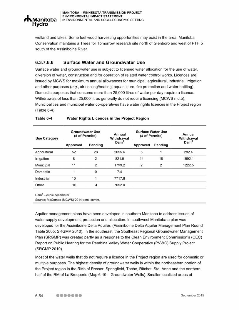
MANITOBA – MINNESOTA TRANSMISSION PROJECT ENVIRONMENTAL IMPACT STATEMENT 6: ENVIRONMENTAL AND SOCIO-ECONOMIC SETTING
wetland and lakes. Some fuel wood harvesting opportunities may exist in the area. Manitoba Conservation maintains a Trees for Tomorrow research site north of Glenboro and west of PTH 5 south of the Assiniboine River.
6.3.7.6.6 Surface Water and Groundwater Use Surface water and groundwater use is subject to licensed water allocation for the use of water, diversion of water, construction and /or operation of related water control works. Licences are issued by MCWS for maximum annual allowances for municipal, agricultural, industrial, irrigation and other purposes (e.g., air cooling/heating, aquaculture, fire protection and water bottling). Domestic purposes that consume more than 25,000 litres of water per day require a licence. Withdrawals of less than 25,000 litres generally do not require licensing (MCWS n.d.b). Municipalities and municipal water co-operatives have water rights licences in the Project region (Table 6-4).
Table 6-4 Water Rights Licences in the Project Region
Use Category
Groundwater Use (# of Permits) Annual
Withdrawal Dam3
Surface Water Use (# of Permits) Annual
Withdrawal Dam3
Approved Pending Approved Pending
Agricultural 52 28 2055.6 5 1 282.4
Irrigation 8 2 821.9 14 18 1592.1
Municipal 11 2 1799.2 2 2 1222.5
Domestic 1 0 7.4
Industrial 10 1 7717.8
Other 16 4 7052.0
Dam3 – cubic decameter Source: McCombe (MCWS) 2014 pers. comm.
Aquifer management plans have been developed in southern Manitoba to address issues of water supply development, protection and allocation. In southwest Manitoba a plan was developed for the Assiniboine Delta Aquifer, (Assiniboine Delta Aquifer Management Plan Round Table 2005; SRGMP 2010). In the southeast, the Southeast Regional Groundwater Management Plan (SRGMP) was created partly as a response to the Clean Environment Commission’s (CEC) Report on Public Hearing for the Pembina Valley Water Cooperative (PVWC) Supply Project (SRGMP 2010).
Most of the water wells that do not require a licence in the Project region are used for domestic or multiple purposes. The highest density of groundwater wells is within the northeastern portion of the Project region in the RMs of Rosser, Springfield, Tache, Ritchot, Ste. Anne and the northern half of the RM of La Broquerie (Map 6-19 – Groundwater Wells). Smaller localized areas of
6-54 September 2015

MANITOBA – MINNESOTA TRANSMISSION PROJECT ENVIRONMENTAL IMPACT STATEMENT
6: ENVIRONMENTAL AND SOCIO-ECONOMIC SETTING
groundwater wells are located in the southern half of the Project region in the RMs of Stuartburn and Piney. The highest density of groundwater wells in the RM of South Cypress are located in the southern half of the RM. Most wells are listed as “other” usage and typically denote test wells or observation wells. The remaining wells are used for irrigation or domestic purposes.
See Section 6.3.4.3 for additional details on public drinking water systems and regional water supply systems.
6.3.8 Community Health and Well-being This section provides an overview of community health and well-being, including health care services and infrastructure, general health condition, infectious diseases, stress and anxiety, injury, food security, diet and nutrition, and Aboriginal health. Visual quality is also discussed in this section, including the biophysical and land use setting. Further information on community health and wellbeing and visual quality is provided in the Socio-Economic and Land Use Environment TDR or in Chapter 19 – Community Health and Well-being.
6.3.8.1 Health Care Services and Infrastructure The Project traverses four regional health authorities (RHAs):
• Southern Health
• Interlake-Eastern
• Winnipeg
• Prairie Mountain Health
The RHAs organize and administer all hospital care, in addition to most ambulance and public health services.
The Project region is serviced by hospitals and health centres in Ste. Anne, Vita and Glenboro. Hospitals; 24/7 emergency care is provided in Winnipeg, Steinbach and Brandon. In addition, Winnipeg is the referral centre for the Province of Manitoba because it has a number of primary health centres, regional and tertiary hospitals and ancillary services.
Emergency medical response services consist of both ground and air ambulance. Ground ambulance service is provided by the RHAs and by other service providers (e.g., RMs and First Nation communities). A 2012 review of Manitoba’s EMS services stated that Manitoba’s ground ambulance services were like a “patchwork quilt”, with wide variations in organization, staffing models and response times (Toews 2013).
Currently in Southern Health, full-time, part-time and casual paramedics provide ground ambulance services with assistance from community first responders. Ambulances and/or stations are located in Ste. Anne and Vita. As of 2012, 32 fleet units were operated out of eighteen stations in Winnipeg. Limited data were available on ground ambulance services for Interlake-Eastern Regional Health Authority and Prairie Mountain Health.
September 2015 6-55

MANITOBA – MINNESOTA TRANSMISSION PROJECT ENVIRONMENTAL IMPACT STATEMENT 6: ENVIRONMENTAL AND SOCIO-ECONOMIC SETTING
There are four air ambulances services in Manitoba:
• Basic Air Ambulance
• Lifeflight Air Ambulance
• Shock Trauma Air Rescue Society
• Southern Air Ambulance Inter-Facility Transport Program (Toews 2013)
Most mental health services in Manitoba are delivered by the RHAs, with some services administered or funded centrally by Manitoba Health. A wide range of community-based and inpatient mental health services are available.
Within the Bethesda Regional Health Centre (BRHC), Mental Health Liaison Nurses work in the emergency room (ER) to address mental health challenges in an effort to prevent unnecessary admissions where possible (personal communication, key person interview). Steinbach has a short-stay crisis stabilization unit and the Eden Mental Health Centre (in Winkler, outside the Project region) offers acute psychiatry services. The Selkirk Health Centre (located outside the Project region) is the provincial mental health service, provides specialized in-patient mental health services. There are many community resources available through the Southern Health mental health program.
6.3.8.2 General Health Conditions Overall, general health measures differ among the four RHAs. The Southern Health and Winnipeg RHAs have lower rates of infant mortality, all-cause mortality, premature mortality and potential years of life lost than provincial average. The Eastern RHA has higher rates for the same indicators compared to the provincial average, while Prairie Mountain Health has higher rates of infant mortality and all-cause mortality than the provincial average. The variations in rates for each measure in the RHAs are not large.
The Interlake-Eastern Regional Health Authority and Prairie Mountain Health have a substantially higher rate of chronic conditions, such as arthritis, asthma/chronic obstructive pulmonary disease, diabetes, coronary heart disease, or stroke, compared to Southern Health. Age- and sex-adjusted rates of arthritis, diabetes and high blood pressure in Southern Health and Winnipeg RHA are the same or lower than the provincial average, while Interlake-Eastern RHA and Prairie Mountain Health experience these conditions at rates that are higher than the provincial average.
6-56 September 2015

MANITOBA – MINNESOTA TRANSMISSION PROJECT ENVIRONMENTAL IMPACT STATEMENT
6: ENVIRONMENTAL AND SOCIO-ECONOMIC SETTING
6.3.8.3 First Nation and Metis Health For many Aboriginal peoples, health is a concept that is holistic in nature and deeply rooted in the inter-relationships between land, water, culture and identity (Loppie-Reading and Wien 2009). The ability to access the land and participate in traditional activities, cultural events and ceremonies is an important support for positive health. Many of the Aboriginal groups in southern Manitoba are active in these activities (personal communication, key person interview).
Traditional foods are important to First Nation communities for nutritional, cultural and economic reasons. Traditional subsistence diets are relatively healthy and have considerable social and cultural value. Because Aboriginal populations in Canada and elsewhere have transitioned away from a subsistence diet to a more Western diet and lifestyle, rates of obesity, diabetes and other chronic diseases have drastically increased (Kuhnlein and Receveur 1996).
Data on traditional food consumption patterns and food access for Manitoba First Nations are available through the First Nations Food, Nutrition and Environment Study (FNFNES), which examines traditional food consumption patterns and levels of contaminants in traditional foods for on reserve First Nations populations across Canada.
The FNFNES study found that 38% of First Nations communities in Manitoba reported having inadequate access to food to meet their dietary needs (Chan et al. 2012). Within the ecozones, inadequate access to food ranged from 21% to 44%.
The FNFNES study further reported that 27% of respondents “sometimes” worried about running out of traditional food and 13% “often” worried about running out of traditional food (Chan et al. 2012). Data regarding food availability within the Métis population was not available.
In order to determine how the health of First Nations people in Manitoba compared to the non-First Nations population, the First Nations Regional Health Survey, a First Nations governed national health survey was conducted. It found that First Nations in Manitoba experienced lower rates of several chronic conditions, including high blood pressure, arthritis and heart disease compared to the non-Aboriginal population. However, rates of diabetes, obesity, daily smoking and heavy drinking were substantially higher in the First Nations populations compared to the non-Aboriginal population.
The Manitoba Centre collected data for Metis health for Health Policy in collaboration with Manitoba Metis Federation. For all of the health measures included in reporting on mortality, general health and chronic conditions and health behaviors, some level of variation can be observed between each of the former RHAs. However, premature mortality and total mortality rates are generally higher for the Metis populations compared to the rest of Manitoba. Excluding the former RHA of Assiniboine, self-rated health is substantially lower for the Metis populations compared to the rest of Manitoba. A similar pattern can be observed for rates of chronic conditions and personal health behaviours, with Metis populations experiencing higher rates of chronic conditions and adverse personal health behaviours than other Manitobans.
September 2015 6-57

MANITOBA – MINNESOTA TRANSMISSION PROJECT ENVIRONMENTAL IMPACT STATEMENT 6: ENVIRONMENTAL AND SOCIO-ECONOMIC SETTING
6.3.8.4 Visual Quality This section describes the existing visual conditions in the Project region. Further information on visual quality is provided in the Socio-Economic and Land Use Environment TDR or in Chapter 17 – Visual Quality.
The Project region is defined by low to gently sloping topographic variation, consistent vegetation patterns, common views of agricultural landscapes and views of water along the Red, La Salle and Assiniboine rivers. These characteristics form a somewhat non-distinct landscape. Land use within the Project region is predominantly agricultural and pastureland, but other visible anthropogenic disturbances include recent and historical forest harvesting, major industrial developments, commercial developments and residential development, road construction and utility corridors.
The Existing Corridor and areas around the Dorsey and Riel converter stations have low to gently rolling terrain, with views of water as the route crosses the Red, Assiniboine and La Salle rivers and their tributaries. The Existing Corridor near the Dorsey Converter Station is characterized primarily by agricultural lands and pasture lands despite its proximity to the urban and suburban areas of Winnipeg. Traveling from the Dorsey Converter Station to the Red River, the visual landscape is mostly semi-rural and agricultural in nature, with a patchwork of residential communities and commercial development. Traveling east of the Red River along the Existing Corridor, views consist of residential development to the north, greenspace along the floodway, agricultural lands to the south and the communities of Grande Pointe, Prairie Grove and Deacon’s Corner.
The New ROW transects a viewscape that is dominated by agricultural land and rural farm residential development. New ROW is gently undulating with slopes up to 5%. Land cover moves from cultivated land to pastureland and hayland. Much of the forested landscapes along the route are located along this southeast portion of the route with the larger patches occurring mostly near the Sandilands Provincial Forest, WMAs and the communities of Menisino and Sundown. Views include forested lands consisting of mixedwood forest and peatlands.
A compilation of photographs of these various land uses and biophysical characteristics is shown in Photo 6-5.
6-58 September 2015

MANITOBA – MINNESOTA TRANSMISSION PROJECT ENVIRONMENTAL IMPACT STATEMENT
6: ENVIRONMENTAL AND SOCIO-ECONOMIC SETTING
Rural/Semi-Urban Interface
Forested Areas
Rural Residences
Community Sites of Interest
Agricultural Fields Parks
SOURCE: La Broquerie.com; Visual Quality Field Team (2014)
Photo 6-5 Landscape and Development within the Project Region
September 2015 6-59

MANITOBA – MINNESOTA TRANSMISSION PROJECT ENVIRONMENTAL IMPACT STATEMENT 6: ENVIRONMENTAL AND SOCIO-ECONOMIC SETTING
6.3.9 Human Health Risk Chapter 18 assesses human health risks from potential exposure to Project-related chemical emissions, noise and EMF for people who live, work or engage in traditional and/or recreational activities in the Project region.
Existing sources of emissions in the Project region include air emissions (e.g., vehicles, industrial and agriculture-related emissions), applications of pesticides (e.g., agriculture), noise (e.g., road, air, rail, agricultural activities and electrical noise from transmission lines) and human-generated EMF (household appliances, vehicles and powerlines).
6.4 Summary The information provided in this chapter is an overview of the biophysical and socio-economic setting in the Project region. Information was collected using a desktop analysis, fieldwork, key person interviews and a review of relevant maps from GIS data sources. Additional, detailed information on these topics is available in Chapters 8 through 19, and in the TDRs and supplemental studies conducted for the Project. This section provides a summary of the environmental setting of the Project.
Climate in the Project region is characterized by short, warm summers and long, cold winters. Physiography consists of a level to sloping plain composed of clay deposits overlying till. Carbonate rock and the large Carbonate Aquifer underlie the region, transitioning to granite bedrock in the southeast. Freshwater springs are located in the eastern portion of the Project region, as well as multiple known flowing well areas.
The Project crosses two major drainage basins, the Assiniboine River and Red River basin, and seven sub-watersheds. Major watercourses crossed by the Project are the Assiniboine, La Salle, Red, Seine and Rat rivers and the Red River Floodway. Land cover varies from cultivated, pasture, native grasslands and shrubland to deciduous forests, mixedwood forests, coniferous forests and varying types of wetlands.
Mammals that occur in the Project region include deer, bears, wolves, bobcats, coyotes, marten, skunks and beavers, and elk have a limited distribution in the region. Nearly 200 bird species, including songbirds, waterbirds and raptors, occur in the region, and more than 22 amphibians and reptile species are also know to occur. Twenty-nine species of conservation concern are known to occur in the region, including four mammal, 22 bird, two amphibian and one reptile species.
Eleven First Nations are located near the Project region or have expressed interest in the Project: Black River First Nation, Brokenhead Ojibway Nation, Buffalo Point First Nation, Dakota Plains Wahpeton First Nation, Dakota Tipi First Nation, Long Plain First Nation, Peguis First Nation, Roseau River Anishinabe First Nation, Swan Lake First Nation, Sagkeeng First Nation and Sandy Bay Ojibway First Nation. The Manitoba Metis Federation has also expressed an interest in the Project.
6-60 September 2015

MANITOBA – MINNESOTA TRANSMISSION PROJECT ENVIRONMENTAL IMPACT STATEMENT
6: ENVIRONMENTAL AND SOCIO-ECONOMIC SETTING
Heritage resources in the region include cemeteries, archaeological sites, former school sites, centennial farms and provincially or municipally designated sites. However, there are only three sites near the Final Preferred Route, and no previously recorded sites in or adjacent to the Dorsey or Riel converter stations or the Glenboro South Station.
Numerous infrastructure and services provided throughout the region. Police service is provided by the RCMP in rural areas and local police in major centres. Fire-fighting services are provided by a combination of professional and volunteer fire departments.
Drinking water sources in the Project region include lakes, rivers and groundwater. Wastewater infrastructure includes treatment plants, lagoons, low-pressure systems and septic tanks. The Project region has capacity to meet increased demand in water, wastewater and solid waste acceptance. Roads in the Project region operate below capacity at an acceptable level of service and are able to accommodate increased demand.
Existing utilities, such as transmission lines and pipelines, as well as communication towers are located throughout the Project region. Cell coverage is widespread, although spotty in areas south of Marchand to the U.S. border. Hotel accommodations are available in larger centres such as Winnipeg, Brandon and Steinbach, as well as in smaller communities throughout the region. Vacancy rates are typically low in the summer and higher in the winter and on weekdays.
Agriculture and agriculture-related businesses are the main economic industries. The Project region has higher levels of educational attainment, employment in trades, transportation and equipment operation and income than the provincial average, and a lower unemployment rate.
Agriculture is also the dominant land use. Soil agricultural capability along the Existing Corridor has only moderate limitations for agriculture, but there are increased occurrences of soils with severe limitations along the New ROW. Agricultural land cover in the region includes annual cropland, perennial cropland, pastureland range and grassland. Livestock operations are located throughout the region, particularly in the La Broquerie area.
Eleven RMs are crossed by the Project: Rosser, Headingley, Macdonald, Ritchot, Tache, Springfield, Ste. Anne, La Broquerie, Stuartburn, Piney and South Cypress. Proximal urban centres include the City of Winnipeg, Town of Ste. Anne, City of Steinbach and Village of Glenboro. Nearly half of the land traversed by the Project is privately owned, followed by Manitoba Hydro owned or leased land and Crown land.
Designated lands and protected areas in the region include heritage parks, recreation parks and provincial forests, including Sandilands Provincial Forest. Recreational activities, domestic and commercial resource use occur throughout, with ATVing, snowmobiling, trapping, hunting, fishing, aggregate and peat extraction and forestry being notable activities.
Hospitals, health centres, mental health services, air and ground ambulance services are available in the region, with 24/7 emergency care hospitals located in Winnipeg, Steinbach and Brandon. General health measures differ across the region, with both lower and higher rates of mortality than the provincial average experienced in different areas. First Nations in Manitoba have lower rates of high blood pressure, arthritis and heart disease compared to the non-
September 2015 6-61

MANITOBA – MINNESOTA TRANSMISSION PROJECT ENVIRONMENTAL IMPACT STATEMENT 6: ENVIRONMENTAL AND SOCIO-ECONOMIC SETTING
Aboriginal population; however, experience higher rates of diseases such as diabetes. Metis health varies in the region; however, premature mortality and total mortality rates are generally higher for Metis populations compared to the rest of Manitoba.
This information provides a basis for this environmental assessment and is expanded on in the discussion of each VC in Chapters 8 through 19.
6.5 References
6.5.1 Literature Cited
6.5.1.1 Terrestrial Environment Assiniboine Delta Aquifer Management Plan Round Table. 2005. Assiniboine Delta aquifer
management plan. Planning for the future of the Assiniboine Delta Aquifer. Assiniboine Delta Aquifer Management Plan Round Table. http://www.gov.mb.ca/waterstewardship/reports/acquifer/assiniboine_delta_aquifermgmt_plan.pdf. Accessed June 30, 2015.
Betcher R., Grove, G. and Pupp, C. 1995. Groundwater in Manitoba: hydrogeology, quality concerns, management. NHRI Contribution No. CS-93017 [online]. Available from http://www.manitoba.ca/waterstewardship/reports/groundwater/hg_of_manitoba.pdf [accessed March 2015].
CCME (Canadian Council of Ministers of the Environment). 1999. Canadian Soil Quality Guidelines for the Protection of Environmental and Human Health [online]. Winnipeg, MB. Available from http://ceqg-rcqe.ccme.ca/ [accessed March 2015].
CCME. 2008. Canada-Wide Standards for Petroleum Hydrocarbons (PHC) in Soil. Winnipeg, Manitoba [online]. Available from http://www.ccme.ca/assets/pdf/phc_standard_1.0_e.pdf [accessed April 2015].
COSEWIC (Committee on the Status of Endangered Wildlife in Canada). 2012. Wildlife Species Search and Assessments [online]. Available from http://www.cosewic.gc.ca/eng/sct1/searchform_e.cfm [accessed March 2015].
COSEWIC. 2013. COSEWIC Assessment and Update Status Report on the Little Brown Myotis Myotis lucifugus, Northern Myotis Myotis septentrionalis and Tri-colored Bat Perimyotis subflavus in Canada. Ottawa, ON [online]. xxiv + 93 pp [online] Available from http://www.registrelep-sararegistry.gc.ca/virtual_sara/files/cosewic/sr_Little%20Brown%20Myotis%26Northern%20Myotis%26Tri-colored%20Bat_2013_e.pdf [accessed July 23, 2015].
6-62 September 2015

MANITOBA – MINNESOTA TRANSMISSION PROJECT ENVIRONMENTAL IMPACT STATEMENT
6: ENVIRONMENTAL AND SOCIO-ECONOMIC SETTING
CSA (Canadian Standards Association). 2000. CAN/CSA-Z769-00 (R2013) - Phase II environmental Site Assessment [online]. Available from http://shop.csa.ca/en/canada/environmental-auditing-and-related-investigations/cancsa-z769-00-r2013/invt/27010352000 [accessed March 2015].
CSA. 2001. CAN/CSA-Z768-01 (R2012) - Phase I environmental Site Assessment [online]. Available from http://shop.csa.ca/en/canada/environmental-auditing-and-related-investigations/z768-01-r2012/invt/27015182001 [accessed March 2015].
Ferguson, G., Woodbury, A., and Matile, G. 2003. Estimating Deep Recharge Rates Beneath an Interlobate Moraine Using Temperature. Ground Water. 41(5): 640-646 pp.
Government of Canada. 2014. Species at Risk Public Registry [online]. Available from http://www.sararegistry.gc.ca/species/schedules_e.cfm?id=1 [accessed March 2015].
Government of Manitoba. 2014a. Critical Wildlife Habitat Program: Manitoba Tall Grass Prairie Preserve [online]. Available from http://www.gov.mb.ca/conservation/wildlife/habcons/cwhp/tgp.html [accessed January 2015].
Government of Manitoba. 2014b. The role and importance of wetlands in Manitoba [online]. Available from http://www.gov.mb.ca/conservation/waterstewardship/water_info/riparian/wetlands.html [accessed January 2015].
Grasby S.E. and Betcher., R.N. 2002. Regional hydrogeochemistry of the carbonate rock aquifer, southern Manitoba. Can. J. Earth Sci. 39:1053-1063 [online]. Available from http://web.viu.ca/earle/geol304/grasby-betcher.pdf. [accessed January 2015].
Hopkins, L. 1985. Soils of the rural municipalities of Ste. Anne and La Broquerie and part of the Local Government District of Stuartburn. Canada-Manitoba Soil Survey Report D49.
Klassen, R.W., Wyder, J.E. and Bannatyne, B.B. 1970. Bedrock topography and geology of Southern Manitoba. Map 25, Geological Survey of Canada [online]. Available from http://geogratis.gc.ca/api/en/nrcan-rncan/ess-sst/c9bcf6a4-b98a-5ed2-b65e-82dcfd9888b4.html [accessed January 2015].
Manitoba Herps Atlas. 2015. Manitoba Herps Atlas on NatureNorth.com [online]. Available from http://www.naturenorth.com/Herps/Manitoba_Herps_Atlas.html [accessed January 20, 2015].
MB BBA (Manitoba Breeding Bird Atlas). 2010. Manitoba Breeding Bird Atlas Safe Dates [online]. Available from http://www.birdatlas.mb.ca/download/safedates.pdf [accessed March 6 2014].
MB CDC (Manitoba Conservation Data Centre). 2014a. List of Species of Conservation Status by Ecoregion [online]. Available from http://www.gov.mb.ca/conservation/cdc/ecoregions.html [accessed 28 February, 2015].
September 2015 6-63

MANITOBA – MINNESOTA TRANSMISSION PROJECT ENVIRONMENTAL IMPACT STATEMENT 6: ENVIRONMENTAL AND SOCIO-ECONOMIC SETTING
MB CDC. 2014b. Species and Plant Community Database [online]. Available from http://www.gov.mb.ca/conservation/cdc/ [accessed February 25, 2015].
MCWS (Manitoba Conservation and Water Stewardship). 2014. The Peatlands Stewardship Strategy – Promoting the Sustainability of Peatlands. Part of Tomorrow Now, Manitoba’s Green Plan. Winnipeg, MB.
Mills G.F., Hopkins, L.A. and Smith, R.E. 1977. Organic soils of the Roseau River Watershed in Manitoba. Inventory and assessment for agriculture. Monograph No. 17. Canada Department of Agriculture. Ottawa, ON.
NEB (National Energy Board). 2011. Remediation Process Guide. Cat. No. NE23-156/2011E. Calgary, AB. 28 pp.
NEB. 2015. Interactive Incident Map [online]. Available from https://www.neb-one.gc.ca/sftnvrnmnt/sft/dshbrd/mp/index-eng.html?utm_source=home&utm_medium=banner&utm_campaign=interactivemap [accessed May 2015].
North/South Consultants Inc. 2014. Manitoba Métis: A Review of Available Information on the Use of Lands and Resources for Traditional Purposes in the MMTP Study Area with Gap Analyses. 25 pp.
Rutulis, M. 1978. Groundwater Resources in the Cypress Planning District. Department of Mines, Resources and Environmental Management. Water Resources Division, Planning Branch. Winnipeg, MB.
Rutulis, M. 1984a. Groundwater Resources in the Macdonald-Ritchot Planning District (A Synopsis). Department of Natural Resources, Water Resources Branch. Winnipeg, MB.
Rutulis, M. 1984b. Groundwater Resources in the R.M. of Tache Planning District; Manitoba Department of Natural Resources, Water Resources Branch. Winnipeg, MB.
Rutulis, M. 1985a. Hydrogeology in the Vicinity of the Glenboro Sewage Lagoon System. Hydrotechnical Services.Hydrogeology Division. Winnipeg.
Rutulis, M. 1985b. Springs in Southern Manitoba. Department of Natural Resources, Water Resources Branch. Winnipeg, MB.
Rutulis, M. 1987. Aquifer map of southern Manitoba, bedrock aquifers; Manitoba Water Resources Branch, 1:2 300 000.
Rutulis, M. 1990. Groundwater resources in the Springfield Planning District. Manitoba Natural Resources. Water Resources Branch, Winnipeg.
Smith, R.E., Veldhuis, H., Mills, G.F., Bilers, R.G., Fraser, W.R. and Lelyk, G.W. 1998. Terrestrial Ecozones, Ecoregions and Ecodistricts of Manitoba. An Ecological Stratification of Manitoba’s Natural Landscapes. Technical Bulletin 1998-9E by Research Branch – Agriculture and Agri-Food Canada. Land Resource Unit, Brandon Research Centre.
6-64 September 2015

MANITOBA – MINNESOTA TRANSMISSION PROJECT ENVIRONMENTAL IMPACT STATEMENT
6: ENVIRONMENTAL AND SOCIO-ECONOMIC SETTING
SRGMP (Southeast Regional Groundwater Management Plan) Planning Group. 2010. Southeast Regional Groundwater Management Plan.
Sveinson, J.M.A. 2003. Restoring tallgrass prairie in Southeastern Manitoba. M.Sc. Thesis. University of Manitoba, Winnipeg, MB.
Thorleifson, L.H., Betcher, R., Birks, J., Boyle, D., Cherry, A., Clark, I., Desbarats, A., Edwards, T., Farrell, D., Grasby, S., Hinton, M.,Kaszycki, C., Kennedy, P., Leybourne, M., McDougall, W., McRitchie, W.D., Osadetz, K., Remenda, V., Render, F., Ryan, S. and Woodbury, A. 1998. Hydrogeology and Hydrogeochemistry of the Red River Valley/ Interlake Region of Manitoba (NTS 62H, 62I, 62O, 62P and 63B). Report of Activities, Manitoba Energy and Mines, Geological Services. 172-185 pp.
Thorpe, J. 2014. Rangeland Classification for Agri-Manitoba. Publication No.12870-1E14. Prepared for Manitoba Forage and Grassland Association. Saskatchewan Research Council (SRC), Environment Division, Saskatoon, SK.
Treasury Board of Canada Secretariat. 2015. Federal Contaminated Sites Inventory [online]. Available from http://www.tbs-sct.gc.ca/fcsi-rscf/home-accueil-eng.aspx [accessed April 2015].
Wheeldon, R. 2003. A recovery plan and strategy for the peregrine falcon in Manitoba. A Parkland Mews - Manitoba Conservation Partnership Project. Parkland Mews Falconry and Bird Education Centre. 19pp
6.5.1.2 Aquatic Resources AAFC-PFRA (Agriculture and Agri-Food Canada – Prairie Farm Rehabilitation Administration).
2005. Summary of Resources and Land Use Issues Related to Riparian Areas in the Rat-Marsh Rivers Watershed Study Area [online]. Available from http://www.gov.mb.ca/waterstewardship/iwmp/rat_marsh_river/documentation/rate_river_pfra_2005.pdf [accessed July 23, 2015].
Benke, A.C. and Cushing, D.E. (eds.). 2010. Field Guide to Rivers of North America. Academic Press, Elsevier Inc. 459 pp.
Bourne, A., Armstrong, N., and Jones, G. 2002. A Preliminary Estimate of Total Nitrogen and Total Phosphorus Loading to Streams in Manitoba, Canada [online]. Report No. 2002-04, Water Quality Management Section, Water Branch, Manitoba Conservation. Available from http://www.manitoba.ca/waterstewardship/reports/quality/nutrient_loading_report_ 2002-04_november_2002.pdf [accessed April 2015].
City of Winnipeg, 2014, City of Winnipeg’s Small Stream Water Quality Survey [online]. Available from http://www.winnipeg.ca/waterandwaste/sewage/monitoring/2014SmallStreamsReports.stm
September 2015 6-65

MANITOBA – MINNESOTA TRANSMISSION PROJECT ENVIRONMENTAL IMPACT STATEMENT 6: ENVIRONMENTAL AND SOCIO-ECONOMIC SETTING
COSEWIC (Committee on the Status of Endangered Wildlife in Canada). 2002. Wildlife Species Search [online]. Available from http://www.cosewic.gc.ca/eng/sct1/searchform_e.cfm [accessed March 2015].
DFO (Fisheries and Oceans Canada). 2007. Fish Habitat Classification for Manitoba Agricultural Watersheds. DRAFT - Version 1.0 April 24, 2007.
DFO. 2013. Fish community and fish habitat inventory of streams and constructed drains throughout agricultural areas of Manitoba (2002 – 2006). By Milani, D. W. Canadian Data Report of Fisheries and Aquatic Sciences 1247.
Graveline, P.G. and Larter, J. 2006. La Salle Redboine Conservation District: La Salle River Watershed Assessment Survey – With emphasis on La Salle River, Elm River, Elm Creek Channel, and the King Drain-2005. North/South Consultants Inc. Winnipeg MB.
MB CDC. 2014. MBCDC Species of Conservation Concern [online]. Available from http://www.gov.mb.ca/conservation/cdc/consranks.html [accessed March 2014].
MWS (Manitoba Water Stewardship). 2007. Seine River Watershed – State of the Watershed Report: Fisheries. Water Stewardship Division. January 2007. Winnipeg, MB.
MWS (Manitoba Water Stewardship). 2010. Seine River Integrated Watershed Management Plan – Fisheries and Aquatic Ecosystems [online]. Available from http://www.gov.mb.ca/waterstewardship/iwmp/seiner_river/documentation/fisheries_seine.pdf, January 2015
MWS (Manitoba Water Stewardship). 2011. Rat-Marsh Watershed Integrated Watershed Management Plan – Water Quality Report. Available from : http://srrcd.ca/wp-content/uploads/2011/04/2011-Water-Quality-Rat-Marsh-River-MB-Water-Stewardship.pdf
MWS (Manitoba Water Stewardship). 2013. Cooks-Devils Creek Watershed characterization report. Available from http://www.gov.mb.ca/waterstewardship/iwmp/cooks_devils_creek/documentation/cooks_devils_surface_water_management_technical_submission.pdf [accessed July 23, 2015].
RRIW (Roseau River International Watershed). 2007. Roseau River Watershed Plan. Prepared for the Red River Basin Commission. Available from: http://www.redriverbasincommission.org/Roseau_River_Watershed_Plan.pdf.
SARA (Species at Risk Act). 2002. S.C. 2002, c. 29, Minister of Justice. Available from: http://laws-lois.justice.gc.ca/eng/acts/S-15.3/index.html.
SRRCD (Seine-Rat River Conservation District). 2009. Seine River Integrated Watershed Management Plan. Seine-Rat River Conservation District [online]. Available from http://srrcd.ca/special-projects/seine-river-integrated-watershed-management-plan-iwmp/ [accessed June 25, 2015].
6-66 September 2015

MANITOBA – MINNESOTA TRANSMISSION PROJECT ENVIRONMENTAL IMPACT STATEMENT
6: ENVIRONMENTAL AND SOCIO-ECONOMIC SETTING
Stantec Consultants Ltd. 2014. Manitoba-Minnesota Transmission Project, Aquatic Environment - Preliminary Technical Data Report (Draft). Prepared for Manitoba Hydro. Winnipeg.
6.5.1.3 Socio-economic and Land Use Environment Assiniboine Delta Aquifer Management Plan Round Table. 2005. Assiniboine Delta aquifer
management plan. Planning for the future of the Assiniboine Delta Aquifer. Assiniboine Delta Aquifer Management Plan Round Table [online] Available from http://www.gov.mb.ca/waterstewardship/reports/acquifer/assiniboine_delta_aquifermgmt_plan.pdf [accessed June 30, 2015].
Berard, R. 1971. Riviere aux Rats Canoe Route Map. Prepared for Manitoba Department of Natural Resources, Parks Branch. Winnipeg, MB.
Burchill, Charles. 2015. Winnipeg Canoe Destinations and Access Points [online]. Available from http://home.cc.umanitoba.ca/~burchil/pm_canoe/winnipeg_route.html#assiniboine [accessed May 26, 2015].
Canada Trails. 2015. Crow Wing Trail [online]. Available from http://www.canadatrails.ca/tct/mb/crowwing.html [accessed January 21, 2015].
CCSD (Cross Country Snow Drifters). January 20, 2015. Cross Country Snow Drifters Snowmobile Club [online]. Available from http://www.crosscountrysnowdrifters.com/ [accessed January 21, 2015].
Chan, L., Receveur, O., Sharp, D., Schwartz, H., Ing, A., Fediuk, K., Black, A., and Tikhonov, C. 2012. First Nations Food, Nutrition and Environment Study (FNFNES): Results from Manitoba (2010), University of Northern British Columbia, Prince George, BC. 178 pp. Available from http://www.fnfnes.ca/docs/MB%20Reports/FNFNES%20Report-MB_WEB_rev.pdf [accessed 12 March 2015].
CHRS (Canadian Heritage Rivers System). 2011. Red River [online]. Available from http://www.chrs.ca/Rivers/Red/Red-F_e.php [accessed June 25, 2015].
CLI (Canada Land Inventory). 1969. Soil Capability Classification for Agriculture. Department of Regional Economic Expansion, Report No. 2.
Ernst, T. 2010. Manitoba Backroad Mapbook, Outdoor Recreation Guide. First Edition. Mussio Ventures Ltd. Coquitlam, BC.
Government of Canada. May 31, 2013. Agriculture and Agri-Food Canada. Overview of Classification Methodology for Determining Land Capability for Agriculture [online]. Available from http://sis.agr.gc.ca/cansis/nsdb/cli/classdesc.html [accessed June 19, 2015].
Kuhnlein, H.V., and Receveur, O. 1996. Dietary change and traditional food systems of Indigenous peoples. Annual Review of Nutrition. 16, 417-442 pp. doi:10.1146/annurev.nu.16.070196.002221.
September 2015 6-67

MANITOBA – MINNESOTA TRANSMISSION PROJECT ENVIRONMENTAL IMPACT STATEMENT 6: ENVIRONMENTAL AND SOCIO-ECONOMIC SETTING
Loppie, R.C., and Wien, F. 2009. Health Inequalities and Social Determinants of Aboriginal Peoples’ Health. National Collaborating Centre for Aboriginal Health, Prince George, BC. 42 pp. Available from http://www.nccah-ccnsa.ca/docs/social%20determinates/nccah-loppie-wien_report.pdf [accessed 12 March 2015].
Manitoba Energy and Mines. 1988a. Aggregate Resources Compilation Map Series, Map AR88-1-1, Kenora, NTS 52E, 1:250,000. Winnipeg, MB.
Manitoba Energy and Mines, 1988b. Aggregate Resources Compilation Map Series, Map AR88-1-2, Winnipeg, NTS 62H, 1:250,000. Winnipeg, MB.
Manitoba Energy and Mines. 1988c. Aggregate Resources Compilation Map Series, Map AR88-1-3, Brandon, NTS 62G, 1:250,000. Winnipeg, MB.
Manitoba Floodway Authority. 2013. Duff Roblin Parkway Trail, Visitors Guide 2013 [online]. Available from http://www.floodwayauthority.mb.ca/po_recreation.html [accessed January 23, 2015].
Manitoba Historical Society. 2015. Historic Sites of Manitoba: Red River Floodway (Winnipeg) [online]. Available from http://www.mhs.mb.ca/docs/sites/redriverfloodway.shtml. [accessed December 15, 2014].
Manitoba Hutterite Directory. n.d. Alphabetic index of Hutterite Colonies [online]. Available from http://www.cedrontech.com/directory/ [accessed August 2014].
Manitoba Hydro. 2001. Glenboro-Rugby-Harvey 230 kV Transmission Line Project. Prepared by ND LEA. Winnipeg, MB.
MASC (Manitoba Agricultural Services Corporation). 2014. Manitoba Management Plus Program Variety yield data [online]. Available from http://www.mmpp.com/mmpp.nsf/mmpp_browser_variety.html. [accessed March 5, 2015].
MB CEC (Manitoba Clean Environment Commission). 2007. Pembina Valley Water Cooperative, Supplemental Groundwater Supply System. Report on Public Hearing. February 2007. Winnipeg, MB.
MCWS. (Manitoba Conservation and Water Stewardship). 2009. Fishing, Hunting & Gathering – The Rights and Responsibilities of First Nation People in Manitoba. October 2009. Manitoba Conservation. Winnipeg, MB.
MCWS. 2014. Hunting Guide [online]. Available from http://www.gov.mb.ca/conservation/wildlife/hunting/ [accessed September 3, 2014].
MCWS. Park Maps and Information. Parks and Protected Spaces Branch. Available from http://www.gov.mb.ca/conservation/parks/ [accessed August 21, 2014].
MCWS. n.d. Parks and Natural Areas. Spruce Woods Provincial Park. Available from http://www.gov.mb.ca/conservation/parks/popular_parks/western/spruce.html [accessed August, 2014].
6-68 September 2015

MANITOBA – MINNESOTA TRANSMISSION PROJECT ENVIRONMENTAL IMPACT STATEMENT
6: ENVIRONMENTAL AND SOCIO-ECONOMIC SETTING
MCWS. 2002. Manitoba’s Provincial Forests. Available from http://www.gov.mb.ca/conservation/forestry/pdf/woodlot/provincial_forests.pdf [accessed March 4, 2014].
MCWS. 2014. The Peatlands Stewardship Strategy – Promoting the Sustainability of Peatlands. Part of Tomorrow Now, Manitoba’s Green Plan. Winnipeg, MB [online] Available from https://www.gov.mb.ca/conservation/peatlandsstewardshipstrategy/pdf/peatlands_strategy_tmw_now.pdf [accessed July 2, 2015].
MCWS. 2013-2014. Trapping Guide [online]. Available from http://www.gov.mb.ca/conservation/wildlife/trapping/pdf/2013_2014trappingguide_web.pdf [accessed March 4, 2013].
MCWS, Water Stewardship Division. n.d.a Public Information – Water Systems Data [online]. Available from http://www.gov.mb.ca/conservation/waterstewardship/odw/public-info/general-info/index.html [accessed August 22, 2014].
MCWS, Water Stewardship Division. n.d.b Water Use Licensing [online]. Available from http://www.gov.mb.ca/conservation/waterstewardship/licensing/wlb/index.html [accessed August 22, 2014].
MCWS. 2015a. Contaminated/Impacted Sites Program [online]. Available from http://www.gov.mb.ca/conservation/envprograms/contams/index.html?print [accessed: March 2015].
MCWS. Forestry Branch. 2015b. Fuelwood Harvesting in Manitoba [online]. Available from https://www.gov.mb.ca/conservation/forestry/timber-admin/fuelwood.html [accessed May 27, 2015].
MFA (Manitoba Forestry Association). 2015. Private Land Resource Planning [online]. Available from http://www.thinktrees.org/Private_Land_Resource_Planning.aspx [accessed May 27, 2015].
Prairie Fruit Growers Association. 2014. Where to Find U-Pick Berry Farms – Experience the Taste of Manitoba [online]. Available from http://www.pfga.com [accessed May 2015].
Province of Manitoba. June 1, 2010. Manitoba Health Population Report [online]. Available from http://www.gov.mb.ca/health/population/2010/pr2010.pdf [accessed April 29, 2015].
Province of Manitoba. June 1, 2012a. Manitoba Health Population Report [online]. Available from http://www.gov.mb.ca/health/population/2012/pr2012.pdf [accessed April 29, 2015].
Province of Manitoba. June 1, 2013. Manitoba Health Population Report [online]. Available from http://www.gov.mb.ca/health/population/pr2013.pdf [accessed April 29, 2015].
Province of Manitoba 2014a. Manitoba Health, Healthy Living & Seniors Population Report. June 1, 2014 [online]. Available from http://www.gov.mb.ca/health/population/pr2014.pdf. [accessed May 28, 2015].
September 2015 6-69

MANITOBA – MINNESOTA TRANSMISSION PROJECT ENVIRONMENTAL IMPACT STATEMENT 6: ENVIRONMENTAL AND SOCIO-ECONOMIC SETTING
Province of Manitoba. 2014b. Overview: Economic Highlights [online]. Available from http://www.gov.mb.ca/jec/invest/busfacts/overviews/ov_economic.html [Accessed January 28, 2015].
Province of Manitoba. 2014c. Geological Map of Manitoba, GIS Map Gallery. Mineral Resources [online]. Available from http://www.manitoba.ca/iem/geo/gis/geoscience.html [accessed September 29, 2014].
Province of Manitoba. 2015a. Invest in Manitoba, Manitoba Business Facts – Sites: Industrial Parks in Manitoba [online]. Available from http://www.gov.mb.ca/jec/invest/busfacts/sites/ind_parks1.html [accessed March 12, 2015].
Province of Manitoba. 2015b. Mineral Resources, Industrial Minerals – Sphagnum Peat Moss [online]. Available from http://www.manitoba.ca/iem/busdev/industrial/peatmoss.html. Mineral Resources Branch [accessed March 25, 2015].
Province of Ontario. April 9, 2015. Classifying Prime and Marginal Agricultural Soils and Landscapes: Guidelines for Application of the Canada Land Inventory in Ontario [online]. Available from http://www.omafra.gov.on.ca/english/landuse/classify.htm [accessed June 19, 2015].
SCCSC (Sandilands Cross Country Ski Club). 2015. Welcome to Sandilands Ski Club. Trail Maps [online]. Available from http://www.sandilands.ca/ [accessed January 20, 2015].
SESR (South East SnoRiders). 2012. South East SnoRiders [online]. Available from http://www.southeastsnoriders.mb.ca/ [accessed January 21, 2015].
SnoMan Inc. 2011. SnoMan Manitoba [online]. Available from http://snoman.mb.ca/ [accessed January 21, 2015].
SRGMP (Southeast Regional Groundwater Management Plan) Planning Group. 2010. Southeast Regional Groundwater Management Plan. Prepared for Manitoba Water Stewardship. Winnipeg, MB.
SRRCD (Seine-Rat River Conservation District). 2009. Seine River Integrated Watershed Management Plan. Seine-Rat River Conservation District [online]. Available from http://srrcd.ca/special-projects/seine-river-integrated-watershed-management-plan-iwmp/. [accessed June 25, 2015].
SRRCD. 2012. Rat-Marsh River Integrated Watershed Management Plan. Seine River Conservation District [online]. Available from http://srrcd.ca/special-projects/rat-river-integrated-watershed-management-plan-iwmp/ [accessed June 25, 2015].
SRSC (Snow Raiders Snowmobile Club Inc.). 2013. Welcome to the Snow Raiders! [online]. Available from http://www.snowraiders.ca/ [accessed January 21, 2015].
Stantec Consulting Ltd. 2015. Manitoba-Minnesota Transmission Project Traffic Impact Study. Prepared for: Manitoba Hydro. Winnipeg, MB.
6-70 September 2015

MANITOBA – MINNESOTA TRANSMISSION PROJECT ENVIRONMENTAL IMPACT STATEMENT
6: ENVIRONMENTAL AND SOCIO-ECONOMIC SETTING
Statistics Canada. 2007a. Headingley, Manitoba (Code4611042) (table). 2006 Community Profiles [online]. 2006 Census. Statistics Canada Catalogue no. 92-591-XWE. Ottawa. Released March 13, 2007. Available from http://www12.statcan.ca/census-recensement/2006/dp-pd/prof/92-591/index.cfm?Lang=E [accessed November 25, 2014].
Statistics Canada. 2007b. La Broquerie, Manitoba (Code4602053) (table). 2006 Community Profiles [online]. 2006 Census. Statistics Canada Catalogue no. 92-591-XWE. Ottawa. Released March 13, 2007. Available from http://www12.statcan.ca/census-recensement/2006/dp-pd/prof/92-591/index.cfm?Lang=E [accessed November 25, 2014].
Statistics Canada. 2007c. Macdonald, Manitoba (Code4610035) (table). 2006 Community Profiles [online]. 2006 Census. Statistics Canada Catalogue no. 92-591-XWE. Ottawa. Released March 13, 2007. Available from http://www12.statcan.ca/census-recensement/2006/dp-pd/prof/92-591/index.cfm?Lang=E [accessed November 25, 2014].
Statistics Canada. 2007d. Piney, Manitoba (Code4601039) (table). 2006 Community Profiles [online]. 2006 Census. Statistics Canada Catalogue no. 92-591-XWE. Ottawa. Released March 13, 2007. Available from http://www12.statcan.ca/census-recensement/2006/dp-pd/prof/92-591/index.cfm?Lang=E [accessed November 25, 2014].
Statistics Canada. 2007e. Ritchot, Manitoba (Code4602075) (table). 2006 Community Profiles [online]. 2006 Census. Statistics Canada Catalogue no. 92-591-XWE. Ottawa. Released March 13, 2007. Available from http://www12.statcan.ca/census-recensement/2006/dp-pd/prof/92-591/index.cfm?Lang=E [accessed November 25, 2014].
Statistics Canada. 2007f. Rosser, Manitoba (Code4614015) (table). 2006 Community Profiles [online]. 2006 Census. Statistics Canada Catalogue no. 92-591-XWE. Ottawa. Released March 13, 2007. Available from http://www12.statcan.ca/census-recensement/2006/dp-pd/prof/92-591/index.cfm?Lang=E [accessed November 25, 2014].
Statistics Canada. 2007g. South Cypress, Manitoba (Code4607038) (table). 2006 Community Profiles [online]. 2006 Census. Statistics Canada Catalogue no. 92-591-XWE. Ottawa. Released March 13, 2007. Available from http://www12.statcan.ca/census-recensement/2006/dp-pd/prof/92-591/index.cfm?Lang=E [accessed November 25, 2014].
September 2015 6-71

MANITOBA – MINNESOTA TRANSMISSION PROJECT ENVIRONMENTAL IMPACT STATEMENT 6: ENVIRONMENTAL AND SOCIO-ECONOMIC SETTING
Statistics Canada. 2007h. Springfield, Manitoba (Code4612047) (table). 2006 Community Profiles [online]. 2006 Census. Statistics Canada Catalogue no. 92-591-XWE. Ottawa. Released March 13, 2007. Available from http://www12.statcan.ca/census-recensement/2006/dp-pd/prof/92-591/index.cfm?Lang=E [accessed November 25, 2014].
Statistics Canada. 2007i. Ste. Anne, Manitoba (Code4602057) (table). 2006 Community Profiles [online]. 2006 Census. Statistics Canada Catalogue no. 92-591-XWE. Ottawa. Released March 13, 2007. Available from http://www12.statcan.ca/census-recensement/2006/dp-pd/prof/92-591/index.cfm?Lang=E [accessed November 25, 2014].
Statistics Canada. 2007j. Stuartburn, Manitoba (Code4601035) (table). 2006 Community Profiles [online]. 2006 Census. Statistics Canada Catalogue no. 92-591-XWE. Ottawa. Released March 13, 2007. Available from http://www12.statcan.ca/census-recensement/2006/dp-pd/prof/92-591/index.cfm?Lang=E [accessed November 25, 2014].
Statistics Canada. 2007k. Tache, Manitoba (Code4602069) (table). 2006 Community Profiles [online]. 2006 Census. Statistics Canada Catalogue no. 92-591-XWE. Ottawa. Released March 13, 2007. Available from http://www12.statcan.ca/census-recensement/2006/dp-pd/prof/92-591/index.cfm?Lang=E [accessed November 25, 2014].
Statistics Canada. 2007l. Ste. Anne, Manitoba (Code4602061) (table). 2006 Community Profiles [online]. 2006 Census. Statistics Canada Catalogue no. 92-591-XWE. Ottawa. Released March 13, 2007. Available from http://www12.statcan.ca/census-recensement/2006/dp-pd/prof/92-591/index.cfm?Lang=E [accessed November 25, 2014].
Statistics Canada. 2007m. Glenboro, Manitoba (Code4607041) (table). 2006 Community Profiles [online]. 2006 Census. Statistics Canada Catalogue no. 92-591-XWE. Ottawa. Released March 13, 2007. Available from http://www12.statcan.ca/census-recensement/2006/dp-pd/prof/92-591/index.cfm?Lang=E [accessed November 25, 2014].
Statistics Canada 2007n. Census Tract Profile for 0100.02 (CT), Winnipeg (CMA) and Manitoba [online]. Census Profile. 2006 Census. Statistics Canada Catalogue no. 92-597-XWE. Ottawa. Date Modified February 4, 2010. Available from http://www12.statcan.ca/census-recensement/2006/dp-pd/prof/92-597/index.cfm?Lang=E&CTuid=6020110.07&nomatch=yes [accessed December 1, 2014].
6-72 September 2015
MANITOBA – MINNESOTA TRANSMISSION PROJECT ENVIRONMENTAL IMPACT STATEMENT
6: ENVIRONMENTAL AND SOCIO-ECONOMIC SETTING
Statistics Canada. 2012a. Headingley, Manitoba (Code 4611042) and Division No. 11, Manitoba (Code 4611) (table) [online]. Census Profile. 2011 Census. Statistics Canada Catalogue no. 98-316-XWE. Ottawa. Released October 24, 2012. Available from http://www12.statcan.gc.ca/census-recensement/2011/dp-pd/prof/index.cfm?Lang=E [accessed November 24, 2014].
Statistics Canada. 2012b. La Broquerie, Manitoba (Code 4602053) and Division No. 2, Manitoba (Code 4602) (table) [online]. Census Profile. 2011 Census. Statistics Canada Catalogue no. 98-316-XWE. Ottawa. Released October 24, 2012. Available from http://www12.statcan.gc.ca/census-recensement/2011/dp-pd/prof/index.cfm?Lang=E [accessed November 24, 2014].
Statistics Canada. 2012c. Macdonald, Manitoba (Code 4610035) and Division No. 10, Manitoba (Code 4610) (table) [online]. Census Profile. 2011 Census. Statistics Canada Catalogue no. 98-316-XWE. Ottawa. Released October 24, 2012. Available from http://www12.statcan.gc.ca/census-recensement/2011/dp-pd/prof/index.cfm?Lang=E [accessed November 24, 2014].
Statistics Canada. 2012d. Piney, Manitoba (Code 4601039) and Division No. 1, Manitoba (Code 4601) (table) [online]. Census Profile. 2011 Census. Statistics Canada Catalogue no. 98-316-XWE. Ottawa. Released October 24, 2012. Available from http://www12.statcan.gc.ca/census-recensement/2011/dp-pd/prof/index.cfm?Lang=E [accessed November 24, 2014].
Statistics Canada. 2012e. Ritchot, Manitoba (Code 4602075) and Division No. 2, Manitoba (Code 4602) (table) [online]. Census Profile. 2011 Census. Statistics Canada Catalogue no. 98-316-XWE. Ottawa. Released October 24, 2012. Available from http://www12.statcan.gc.ca/census-recensement/2011/dp-pd/prof/index.cfm?Lang=E [accessed November 24, 2014].
Statistics Canada. 2012f. Rosser, Manitoba (Code 4614015) and Division No. 14, Manitoba (Code 4614) (table) [online]. Census Profile. 2011 Census. Statistics Canada Catalogue no. 98-316-XWE. Ottawa. Released October 24, 2012. Available from http://www12.statcan.gc.ca/census-recensement/2011/dp-pd/prof/index.cfm?Lang=E [accessed November 24, 2014].
Statistics Canada. 2012g. South Cypress, Manitoba (Code 4607038) and Division No. 7, Manitoba (Code 4607) (table) [online]. Census Profile. 2011 Census. Statistics Canada Catalogue no. 98-316-XWE. Ottawa. Released October 24, 2012. Available from http://www12.statcan.gc.ca/census-recensement/2011/dp-pd/prof/index.cfm?Lang=E [accessed November 24, 2014].
September 2015 6-73

MANITOBA – MINNESOTA TRANSMISSION PROJECT ENVIRONMENTAL IMPACT STATEMENT 6: ENVIRONMENTAL AND SOCIO-ECONOMIC SETTING
Statistics Canada. 2012h. Springfield, Manitoba (Code 4612047) and Division No. 12, Manitoba (Code 4612) (table) [online]. Census Profile. 2011 Census. Statistics Canada Catalogue no. 98-316-XWE. Ottawa. Released October 24, 2012. Available from http://www12.statcan.gc.ca/census-recensement/2011/dp-pd/prof/index.cfm?Lang=E [accessed November 24, 2014].
Statistics Canada. 2012i. Ste. Anne, Manitoba (Code 4602057) and Division No. 2, Manitoba (Code 4602) (table) [online]. Census Profile. 2011 Census. Statistics Canada Catalogue no. 98-316-XWE. Ottawa. Released October 24, 2012. Available from http://www12.statcan.gc.ca/census-recensement/2011/dp-pd/prof/index.cfm?Lang=E [accessed November 24, 2014].
Statistics Canada. 2012j. Stuartburn, Manitoba (Code 4601035) and Division No. 1, Manitoba (Code 4601) (table) [online]. Census Profile. 2011 Census. Statistics Canada Catalogue no. 98-316-XWE. Ottawa. Released October 24, 2012. Available from http://www12.statcan.gc.ca/census-recensement/2011/dp-pd/prof/index.cfm?Lang=E [accessed November 24, 2014].
Statistics Canada. 2012k. Tache, Manitoba (Code 4602069) and Division No. 2, Manitoba (Code 4602) (table) [online]. Census Profile. 2011 Census. Statistics Canada Catalogue no. 98-316-XWE. Ottawa. Released October 24, 2012. Available from http://www12.statcan.gc.ca/census-recensement/2011/dp-pd/prof/index.cfm?Lang=E [accessed November 24, 2014].
Statistics Canada. 2012l. Ste. Anne, Manitoba (Code 4602061) and Division No. 2, Manitoba (Code 4602) (table) [online]. Census Profile. 2011 Census. Statistics Canada Catalogue no. 98-316-XWE. Ottawa. Released October 24, 2012. Available from http://www12.statcan.gc.ca/census-recensement/2011/dp-pd/prof/index.cfm?Lang=E [accessed November 24, 2014].
Statistics Canada. 2012m. Glenboro, Manitoba (Code 4607041) and Division No. 7, Manitoba (Code 4607) (table) [online]. Census Profile. 2011 Census. Statistics Canada Catalogue no. 98-316-XWE. Ottawa. Released October 24, 2012. Available from http://www12.statcan.gc.ca/census-recensement/2011/dp-pd/prof/index.cfm?Lang=E [accessed November 24, 2014].
Statistics Canada. 2012n. 6020100.02, Manitoba (Code 6020100.02) and Winnipeg, Manitoba (Code 602) (table) [online]. Census Profile. 2011 Census. Statistics Canada Catalogue no. 98-316-XWE. Ottawa. Released October 24, 2012. Available from http://www12.statcan.gc.ca/census-recensement/2011/dp-pd/prof/index.cfm?Lang=E [accessed November 25, 2014].
6-74 September 2015

MANITOBA – MINNESOTA TRANSMISSION PROJECT ENVIRONMENTAL IMPACT STATEMENT
6: ENVIRONMENTAL AND SOCIO-ECONOMIC SETTING
Statistics Canada. 2012o. 6020110.07, Manitoba (Code 6020110.07) and Winnipeg, Manitoba (Code 602) (table) [online]. Census Profile. 2011 Census. Statistics Canada Catalogue no. 98-316-XWE. Ottawa. Released October 24, 2012. Available from http://www12.statcan.gc.ca/census-recensement/2011/dp-pd/prof/index.cfm?Lang=E [accessed November 25, 2014].
Statistics Canada. 2012p. GeoSearch. 2011 Census. Statistics Canada Catalogue no. 92-142-XWE [online]. Ottawa, Ontario. Data updated October 24, 2012. Available from http://geodepot.statcan.gc.ca/GeoSearch2011-GeoRecherche2011/GeoSearch2011-GeoRecherche2011.jsp?lang=E&otherLang=F [accessed November 11, 2014]
Statistics Canada. 2013a. Headingley, RM, Manitoba (Code 4611042) (table). National Household Survey (NHS) Profile. 2011 National Household Survey. Statistics Canada Catalogue no. 99-004-XWE [online]. Ottawa. Released September 11, 2013. Available from http://www12.statcan.gc.ca/nhs-enm/2011/dp-pd/prof/index.cfm?Lang=E [accessed November 24, 2014].
Statistics Canada. 2013b. La Broquerie, RM, Manitoba (Code 4602053) (table) [online]. National Household Survey (NHS) Profile. 2011 National Household Survey. Statistics Canada Catalogue no. 99-004-XWE. Ottawa. Released September 11, 2013. Available from http://www12.statcan.gc.ca/nhs-enm/2011/dp-pd/prof/index.cfm?Lang=E [accessed November 24, 2014].
Statistics Canada. 2013c. Macdonald, RM, Manitoba (Code 4610035) (table) [online]. National Household Survey (NHS) Profile. 2011 National Household Survey. Statistics Canada Catalogue no. 99-004-XWE. Ottawa. Released September 11, 2013. Available from http://www12.statcan.gc.ca/nhs-enm/2011/dp-pd/prof/index.cfm?Lang=E [accessed November 24, 2014].
Statistics Canada. 2013d. Ritchot, RM, Manitoba (Code 4602075) (table) [online]. National Household Survey (NHS) Profile. 2011 National Household Survey. Statistics Canada Catalogue no. 99-004-XWE. Ottawa. Released September 11, 2013. Available from http://www12.statcan.gc.ca/nhs-enm/2011/dp-pd/prof/index.cfm?Lang=E [accessed November 24, 2014].
Statistics Canada. 2013e. Rosser, RM, Manitoba (Code 4614015) (table) [online]. National Household Survey (NHS) Profile. 2011 National Household Survey. Statistics Canada Catalogue no. 99-004-XWE. Ottawa. Released September 11, 2013. Available from http://www12.statcan.gc.ca/nhs-enm/2011/dp-pd/prof/index.cfm?Lang=E [accessed November 24, 2014].
September 2015 6-75

MANITOBA – MINNESOTA TRANSMISSION PROJECT ENVIRONMENTAL IMPACT STATEMENT 6: ENVIRONMENTAL AND SOCIO-ECONOMIC SETTING
Statistics Canada. 2013f. South Cypress, RM, Manitoba (Code 4607038) (table) [online]. National Household Survey (NHS) Profile. 2011 National Household Survey. Statistics Canada Catalogue no. 99-004-XWE. Ottawa. Released September 11, 2013. Available from http://www12.statcan.gc.ca/nhs-enm/2011/dp-pd/prof/index.cfm?Lang=E [accessed November 24, 2014].
Statistics Canada. 2013g. Springfield, RM, Manitoba (Code 4612047) (table) [online]. National Household Survey (NHS) Profile. 2011 National Household Survey. Statistics Canada Catalogue no. 99-004-XWE. Ottawa. Released September 11, 2013. Available from http://www12.statcan.gc.ca/nhs-enm/2011/dp-pd/prof/index.cfm?Lang=E [accessed November 24, 2014].
Statistics Canada. 2013h. Tache, RM, Manitoba (Code 4602069) (table) [online]. National Household Survey (NHS) Profile. 2011 National Household Survey. Statistics Canada Catalogue no. 99-004-XWE. Ottawa. Released September 11, 2013. Available from http://www12.statcan.gc.ca/nhs-enm/2011/dp-pd/prof/index.cfm?Lang=E [accessed November 24, 2014].
Statistics Canada. 2013i. Ste. Anne, T, Manitoba (Code 4602061) (table) [online]. National Household Survey (NHS) Profile. 2011 National Household Survey. Statistics Canada Catalogue no. 99-004-XWE. Ottawa. Released September 11, 2013. Available from http://www12.statcan.gc.ca/nhs-enm/2011/dp-pd/prof/index.cfm?Lang=E [accessed November 24, 2014].
Statistics Canada. 2013j. Glenboro, VL, Manitoba (Code 4607041) (table) [online]. National Household Survey (NHS) Profile. 2011 National Household Survey. Statistics Canada Catalogue no. 99-004-XWE. Ottawa. Released September 11, 2013. Available from http://www12.statcan.gc.ca/nhs-enm/2011/dp-pd/prof/index.cfm?Lang=E [accessed November 24, 2014].
Statistics Canada. 2013k. 0100.02, Manitoba (Code 3671) (table) [online]. National Household Survey (NHS) Profile. 2011 National Household Survey. Statistics Canada Catalogue no. 99-004-XWE. Ottawa. Released September 11, 2013. Available from http://www12.statcan.gc.ca/nhs-enm/2011/dp-pd/prof/index.cfm?Lang=E [accessed November 25, 2014].
Statistics Canada. 2013l. 0110.07, Manitoba (Code 2505) (table) [online]. National Household Survey (NHS) Profile. 2011 National Household Survey. Statistics Canada Catalogue no. 99-004-XWE. Ottawa. Released September 11, 2013. Available from http://www12.statcan.gc.ca/nhs-enm/2011/dp-pd/prof/index.cfm?Lang=E [accessed November 25, 2014].
6-76 September 2015

MANITOBA – MINNESOTA TRANSMISSION PROJECT ENVIRONMENTAL IMPACT STATEMENT
6: ENVIRONMENTAL AND SOCIO-ECONOMIC SETTING
Statistics Canada. 2013m. Manitoba (Code 46) (table) [online]. National Household Survey (NHS) Aboriginal Population Profile. 2011 National Household Survey. Statistics Canada Catalogue no. 99-011-X2011007. Ottawa. Released November 13, 2013. Available from http://www12.statcan.gc.ca/nhs-enm/2011/dp-pd/aprof/index.cfm?Lang=E [accessed December 10, 2014].
Statistics Canada. 2013n. La Broquerie, RM, Manitoba (Code 4602053) (table) [online]. National Household Survey (NHS) Aboriginal Population Profile. 2011 National Household Survey. Statistics Canada Catalogue no. 99-011-X2011007. Ottawa. Released November 13, 2013. Available from http://www12.statcan.gc.ca/nhs-enm/2011/dp-pd/aprof/index.cfm?Lang=E [accessed December 10, 2014].
Statistics Canada. 2013o. Macdonald, RM, Manitoba (Code 4610035) (table) [online]. National Household Survey (NHS) Aboriginal Population Profile. 2011 National Household Survey. Statistics Canada Catalogue no. 99-011-X2011007. Ottawa. Released November 13, 2013. Available from http://www12.statcan.gc.ca/nhs-enm/2011/dp-pd/aprof/index.cfm?Lang=E [accessed December 10, 2014].
Statistics Canada. 2013p. Ritchot, RM, Manitoba (Code 4602075) (table) [online]. National Household Survey (NHS) Aboriginal Population Profile. 2011 National Household Survey. Statistics Canada Catalogue no. 99-011-X2011007. Ottawa. Released November 13, 2013. Available from http://www12.statcan.gc.ca/nhs-enm/2011/dp-pd/aprof/index.cfm?Lang=E [accessed December 10, 2014].
Statistics Canada. 2013q. Springfield, RM, Manitoba (Code 4612047) (table) [online]. National Household Survey (NHS) Aboriginal Population Profile. 2011 National Household Survey. Statistics Canada Catalogue no. 99-011-X2011007. Ottawa. Released November 13, 2013. Available from http://www12.statcan.gc.ca/nhs-enm/2011/dp-pd/aprof/index.cfm?Lang=E [accessed December 10, 2014].
Statistics Canada. 2013r. Tache, RM, Manitoba (Code 4602069) (table) [online]. National Household Survey (NHS) Aboriginal Population Profile. 2011 National Household Survey. Statistics Canada Catalogue no. 99-011-X2011007. Ottawa. Released November 13, 2013. Available from http://www12.statcan.gc.ca/nhs-enm/2011/dp-pd/aprof/index.cfm?Lang=E [accessed December 10, 2014].
Statistics Canada. 2013s. Ste. Anne, T, Manitoba (Code 4602061) (table) [online]. National Household Survey (NHS) Aboriginal Population Profile. 2011 National Household Survey. Statistics Canada Catalogue no. 99-011-X2011007. Ottawa. Released November 13, 2013. Available from http://www12.statcan.gc.ca/nhs-enm/2011/dp-pd/aprof/index.cfm?Lang=E [accessed December 10, 2014].
Toews, R. 2013. Manitoba EMS System Review, Government of Manitoba, Minister of Health, Winnipeg, MB. 70 pp. Available from https://www.gov.mb.ca/health/documents/ems.pdf [accessed 12 March 2015].
September 2015 6-77

MANITOBA – MINNESOTA TRANSMISSION PROJECT ENVIRONMENTAL IMPACT STATEMENT 6: ENVIRONMENTAL AND SOCIO-ECONOMIC SETTING
Trails Manitoba. 2013a. Crow Wing Trail [online]. Available from http://trailsmanitoba.ca/explore-manitoba-trails/tall-grass-prairie/crow-wing-trail/ [accessed January 21, 2015].
Trails Manitoba. 2013b. Winnipeg Trail [online]. Available from http://trailsmanitoba.ca/explore-manitoba-trails/winnipeg/winnipeg-trail/ [accessed January 21, 2015].
Trails Manitoba. 2013c. Glenboro South Cypress Trail [online]. Available from http://trailsmanitoba.ca/explore-manitoba-trails/assiniboine-delta-pembina-hills/glenboro-south-cypress-trail/ [accessed January 21, 2015].
Winnipeg Trails Association. 2015. Headingley Grand Trunk Trail. Winnipeg Trails Association. Winnipeg, MB [online] Available from http://www.winnipegtrails.ca/trails-maps/headingly-grand-trunk-trail/ [accessed January 21, 2015].
Woodlot Association of Manitoba. 2015. Woodlot Management [online]. Available from http://woodlotmanitoba.com/woodlot-management/ [accessed May 27, 2015].
6.5.1.4 First Nations and Metis AANDC (Aboriginal Affairs and Northern Development Canada). 2010a. Treaty Guide to Treaty
No. 1 & Treaty No. 2 (1871) [online]. Available from http://www.aadnc-aandc.gc.ca/eng/1100100028656/1100100028658 [accessed June 15, 2015].
AANDC. 2010b. Treaty Guide to Treaty No. 3 (1873) [online]. Available from http://www.aadnc-aandc.gc.ca/eng/1100100028667/1100100028669 [accessed June 15, 2015].
AANDC. 2010c. Treaty Rights [online]. Available from http://www.aadnc-aandc.gc.ca/eng/1100100028602/1100100028603 [accessed June 15, 2015].
AANDC. 2010d. Treaty Guide to Treaty No. 5 (1875). Available from http://www.aadnc-aandc.gc.ca/eng/1100100028692/1100100028693 [accessed July 8, 2015].
AANDC. 2015a. First Nation Detail: Black River First Nation [online]. Available from http://pse5-esd5.ainc-inac.gc.ca/fnp/Main/Search/FNMain.aspx?BAND_NUMBER=260&lang=eng [accessed June 15, 2015].
AANDC. January 23, 2015b. Brokenhead Ojibway Nation Registered Population as of May, 2015 [online]. Available from http://fnp-ppn.aadnc-aandc.gc.ca/fnp/Main/Search/FNRegPopulation.aspx?BAND_NUMBER=261&lang=eng [accessed June 22, 2015].
AANDC. January 23, 2015c. Buffalo Point First Nation Registered Population as of May, 2015 [online]. Available from http://fnp-ppn.aadnc-aandc.gc.ca/fnp/Main/Search/FNRegPopulation.aspx?BAND_NUMBER=265&lang=eng [accessed June 22, 2015].
6-78 September 2015

MANITOBA – MINNESOTA TRANSMISSION PROJECT ENVIRONMENTAL IMPACT STATEMENT
6: ENVIRONMENTAL AND SOCIO-ECONOMIC SETTING
AANDC. January 23, 2015d. Dakota Plains First Nation Registered Population as of May, 2015 [online]. Available from http://pse5-esd5.ainc-inac.gc.ca/fnp/Main/Search/FNRegPopulation.aspx?BAND_NUMBER=288&lang=eng [accessed June 22, 2015].
AANDC. January 23, 2015e. Dakota Tipi First Nation Registered Population as of May, 2015 [online]. Available from http://pse5-esd5.ainc-inac.gc.ca/fnp/Main/Search/FNRegPopulation.aspx?BAND_NUMBER=295&lang=eng [accessed June 22, 2015].
AANDC. January 23, 2015f. Long Plain First Nation Registered Population as of May, 2015 [online]. Available from http://pse5-esd5.ainc-inac.gc.ca/fnp/Main/Search/FNRegPopulation.aspx?BAND_NUMBER=287&lang=eng [accessed June 22, 2015].
AANDC. January 23, 2015g. Peguis First Nation Registered Population as of May, 2015 [online]. Available from http://pse5-esd5.ainc-inac.gc.ca/fnp/Main/Search/FNRegPopulation.aspx?BAND_NUMBER=269&lang=eng [accessed June 22, 2015].
AANDC. January 23, 2015h. Roseau River Anishinabe First Nation Registered Population as of May, 2015 [online]. Available from http://pse5-esd5.ainc-inac.gc.ca/fnp/Main/Search/FNRegPopulation.aspx?BAND_NUMBER=273&lang=eng [accessed June 22, 2015].
AANDC. January 23, 2015i. Sagkeeng First Nation Registered Population as of May, 2015 [online]. Available from http://pse5-esd5.ainc-inac.gc.ca/fnp/Main/Search/FNRegPopulation.aspx?BAND_NUMBER=262&lang=eng [accessed June 22, 2015].
AANDC. January 23, 2015j. Sandy Bay First Nation Registered Population as of May, 2015 [online]. Available from http://fnp-ppn.aadnc-aandc.gc.ca/fnp/Main/Search/FNRegPopulation.aspx?BAND_NUMBER=283&lang=eng [accessed June 22, 2015].
AANDC. January 23, 2015k. Swan Lake First Nation Registered Population as of May, 2015 [online]. Available from http://pse5-esd5.ainc-inac.gc.ca/fnp/Main/Search/FNRegPopulation.aspx?BAND_NUMBER=293&lang=eng [accessed June 22, 2015].
Black River First Nation. 2015. Home: Black River First Nation [online]. Available from http://www.black-river.ca/ [accessed June 15, 2015].
Black River First Nation, Long Plain First Nation and Swan Lake First Nation. 2014. Preliminary Aboriginal Traditional Knowledge Study Community Report submitted by Black River First Nation, Long Plain First Nation, Swan Lake First Nation. 13 pp.
September 2015 6-79

MANITOBA – MINNESOTA TRANSMISSION PROJECT ENVIRONMENTAL IMPACT STATEMENT 6: ENVIRONMENTAL AND SOCIO-ECONOMIC SETTING
Buffalo Point First Nation. 2015. About: Buffalo Point First Nation [online]. Available from http://www.buffalopoint-firstnation.ca/about.php [accessed June 15 2015].
Dakota Plains Wahpeton Nation. 2015. Community Profile [online]. Available from http://dakotaplainswahpetonnation.blogspot.de/ [accessed June 15, 2015].
Dakota Tipi First Nation. 2015. Community Profile [online]. Available from http://dakotatipi.ca/about_us.htm [accessed June 15, 2015].
Long Plain First Nation. 2015. 2015. Home Long Plain First Nation [online]. Available from http://www.longplainfirstnation.ca/index.htmlhttp://www.longplainfirstnation.ca/index.html [accessed June 15, 2015].
Manitoba Hydro. 2015. First Nation and Metis 2014/2015 Engagement Process. What We Heard. Manitoba Minnesota Transmission Project. Prepared by Manitoba Hydro. Winnipeg, MB.
MMF (Manitoba Metis Federation). 2013. Manitoba Metis Federation INC. Constitution - As ratified by the 45th annual assembly September 29, 2013 [online]. Available from http://www.mmf.mb.ca/docs/constitution_rev2013_3.pdf [accessed June 15, 2015].
MMF. 2015. Home Manitoba Metis Federation [online]. Available from http://www.mmf.mb.ca/ [accessed June 15, 2015].
Peguis First Nation. 2015. Peguis First Nation [online]. Available from http://www.peguisfirstnation.ca/ [accessed June 15, 2015].
Roseau River Anishinabe First Nation. 2015. Roseau River Anishinabe First Nation Aboriginal Traditional Knowledge Report. 8 pp.
Sandy Bay Ojibway First Nation. 2015. About Us: Sandy Bay Ojibway First Nation [online]. Available from http://sandybayfirstnation.com/about-us.htmlhttp://sandybayfirstnation.com/about-us.html [accessed June 15, 2015].
Statistics Canada. 2013t. Manitoba (Code 46) (table). National Household Survey (NHS) Profile. 2011 National Household Survey. Statistics Canada Catalogue no. 99-004-XWE [online]. Ottawa. Available from http://www12.statcan.gc.ca/nhs-enm/2011/dp-pd/prof/index.cfm?Lang=E [accessed June 15, 2015].
Swan Lake First Nation. 2015. Who We Are: Swan Lake First Nation [online]. Available from http://www.swanlakefirstnation.ca/about/ [accessed June 15, 2015].
6.5.2 Personal Communications Armstrong, Karen. 2015. Assistant Manager, Manitoba Chicken Producers. Email
correspondence regarding chicken operations within the Rural Municipality of South Cypress with Wara Chiyoka, Soil Scientist, Stantec Consulting Ltd., Winnipeg, MB, January 7, 2015.
6-80 September 2015

MANITOBA – MINNESOTA TRANSMISSION PROJECT ENVIRONMENTAL IMPACT STATEMENT
6: ENVIRONMENTAL AND SOCIO-ECONOMIC SETTING
Berezanski, Dean. 2015. Provincial Furbearer Biologist, Manitoba Conservation and Water Stewardship, Wildlife Branch. Telephone conversation with Angèle Watrin Prodaehl, Stantec Consulting Ltd., Winnipeg, MB, February 18, 2015.
Doerksen, D. 2015.Executive Assistant, Steinbach Chamber of Commerce. Telephone interview with Stantec Consulting Ltd., Winnipeg, MB, April 22, 2015.
Franke, R.A. 2014, November 21. Area Wildlife Supervisor, Minnesota Department of Natural Resources, Karlstad, MN. Phone Conversation between R.A. Franke, Area Wildlife Supervisor and Mike Sweet, Biologist, Stantec Consulting Ltd., Winnipeg, MB, November 21, 2014.
Hora, Greg. January 20, 2015. Director of AtvMB and Sandhogs Club President. Phone Conversation between Greg Hora, Director of AtvMB and Sandhogs Club President and Crista Gladstone, Socio-Economic Analyst, Stantec Consulting Ltd., Winnipeg, MB, January 20, 2015.
Howdle, L. 2015. Administrative Assistant, Economic Development Winnipeg. Telephone interview with Stantec Consulting Ltd., Winnipeg, MB, April 22, 2015.
Lafrenière, Rhéal. 2014. Business Development Specialist - Provincial Apiarist. Manitoba Agriculture, Food and Rural Development. Email correspondence regarding beekeeping operations within the Manitoba-Minnesota Transmission Project area with Wara Chiyoka, Soil Scientist , Stantec Consulting Ltd., Winnipeg, MB, December 9, 2014.
Moir, Whitney. May 14, 2015. Program Coordinator. Phone and email conversation between Whitney Moir, Program Coordinator with Brandon Riverbank Inc. and Crista Gladstone, Socio-Economic Analyst, Stantec Consulting Ltd., Winnipeg, MB, May 14, 2015.
Rideout, Yvonne. January 15, 2015. Phone conversation between Yvonne Rideout, Executive Director with SnoMan Inc. and Crista Gladstone, Socio-Economic Analyst, Stantec Consulting Ltd., Winnipeg, MB, January 15, 2015.
Rogalsky-Tapp, Linda. 2014. Administrative Assistant, Organic Producers Association of Manitoba. Email correspondence regarding organic operations within the Manitoba-Minnesota Transmission Project area with Wara Chiyoka, Soil Scientist , Stantec Consulting Ltd., Winnipeg, MB, December 22, 2014.
Turenne-Maynard, Julie. March 17, 2015. Phone conversation between Julie Turenne-Maynard, Executive Director of Rivers West and Crista Gladstone, Socio-Economic Analyst, Stantec Consulting Ltd., Winnipeg, MB, March 17, 2015.
Zahariuk, Shauna. 2015. Environmental Specialist. Manitoba Hydro, Environmental Licensing & Protection. Email correspondence regarding contaminated sites within Manitoba-Minnesota Transmission Project area via Sara Coughlin, Senior Environmental Specialist, Licensing & Environmental Assessment with Wara Chiyoka, Soil Scientist, Stantec Consulting Ltd., Winnipeg, MB, March 13, 2015.
September 2015 6-81


