February 21, 2018 Dennis Helder, ECCOE Director, [email protected]Ron Morfitt, Asst. ECCOE Director, [email protected]EROS Cal/Val Center of Excellence and Landsat/Sentinel 2 Interoperability
EROS Cal/Val Center of Excellenceand Landsat/Sentinel 2 Interoperability
2
Outline• What is ECCOE?• The ECCOE CalVal Workshop• Landsat 8 and Sentinel 2 Interoperability• Recommendations
3
ECCOE Vision• The EROS Calibration Center of Excellence (ECCOE) is
recognized nationally and internationally as a leading organization for effectively improving the accuracy, precision, and efficiency of radiometric, geometric, and spatial characterization, calibration, and cross-calibration of optical remote sensing systems to achieve the highest degree of interoperability of remote sensing data products."
4
ECCOE Mission• Develop advanced methods to perform radiometric/geometric/spatial
characterization and calibration of optical remote sensing systems to improve the accuracy and precision of all derived data products.
• Develop new and improved methods for the cross-calibration of optical remote sensing systems for continuous improvement of the interoperability of remote sensing data products.
• Provide the expertise and advocacy necessary for the acquisition of new measurements that continue to improve optical remote sensing data quality, coverage, and expanded usefulness for science applications.
• Develop mutually beneficial partnerships within USGS/DOI, across other government agencies, and throughout the industry.
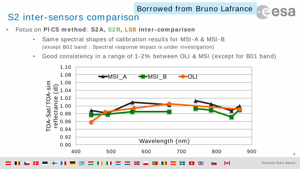
• Same spectral shapes of calibration results for MSI-A & MSI-B (except B02 band : Spectral response impact is under investigation)
• Good consistency in a range of 1-2% between OLI & MSI (except for B01 band)
0.900.920.940.960.981.001.021.041.061.081.10
400 500 600 700 800 900
TOA-
Sat
/TO
A-si
m
refle
ctan
ce (
dl)
Wavelength (nm)
MSI_A MSI_B OLI
Borrowed from Bruno Lafrance
9
APICS Results—Graphs
• Borrowed from Ron Morfitt• Who borrowed it from Dennis Helder• Who borrowed it from Morakot Kaewmanee
10
Libya-4 PICS Temporal Trend
• Borrowed from Ron Morfitt• Who borrowed it from Dennis Helder• Who borrowed it from Morakot Kaewmanee
Grassland
Alfalfa+Sentinel-2Landsat-8
Harmonized Landsat / Sentinel-2 ProductsLaramie County, WY
ND
VI
Day of Year
mow
ing
3km
May 4, 2016 (S2) Aug 8 (L8) Aug 17 (L8) Sep 1 (S2) Oct 20 (L8)
0.1 NDVI 0.9
Seasonal phenology (greening) for natural grassland (blue line) and irrigated alfalfa fields (red line) near Cheyenne Wyoming observed from Harmonized Landsat/Sentinel-2 data products. The high temporal density of observations allows individual mowing events to be detected within alfalfa fields. HLS Products available from https://hls.gsfc.nasa.gov