Deep-Sea Research, 1976, Vol. 23, pp. 429 to 440. Pergamon Press. Printed in Great Britain. Erosion and sedimentation around Mytilus Seamount, New England continental rise*t DAVID A. JOHNSON~ and PETER F. LONSDALE § (Received 10 February 1975; in revisedform 14 July 1975; accepted 30 July 1975) Abstract--The presence of Mytilus Seamount within the axis of the Western Boundary Undercurrent of the North Atlantic has modified the bottom water's flow pattern (measured by four current meters) and thermal structure (measured by a thermometer attached to a deeply towed instrument package). Attempts at bottom photography indicate that very high concentrations of suspended matter are present within a layer of isothermal (0 = 1"7°C)bottom water which covers the rise locally at the foot of the northern slopes of the seamount. Erosional channels up to 50 m deep have been incised into Pleistocene and Holocene continental rise sediments. The sediment-covered crest of the seamount is overlain by clear water and exhibits bedforms and truncated sediment horizons indicating strong scour by dominantly tidal currents. INTRODUCTION THE CONTINENTALrise off the east coast of the United States has been created by rapid deposition of terrigenous sediments. Average rates of accumulation during the Recent have been about 4 cm (1000 yr) -1 (HoLLISTER and HEEZEN, 1972). Faster than average sediment deposition has occurred despite the prevalence of strong (10 to 20 cm s-~) bottom currents along the western margin of the North Atlantic Basin. Indeed, it is widely believed that the Western Boundary Undercurrent (WBUC) of the North Atlantic is instrumental in forming and re-shaping the continental rise. HEEZEN, HOLLISTER and RUDDIMAN (1966) assumed that within this province current speeds are insufficient for erosion, and they proposed that the rate of deposition is directly proportional to current speed. A recent investigation of the New England continental rise (ZIMIVmRMAN, 1971), however, produced evidence of patchy non-deposition and active scouring at sites swept by strong bottom currents. Recent erosion may also be prevalent over much of the Blake-Bahama Outer Ridge System, a southerly extension of the North American continental rise (HOLLISTER, FLOOD, JOHNSON, LONSDALE and SOUTnAgD, 1974). When abyssal currents encounter major solid obstacles, they are accelerated and produce a characteristic moat in the sediment at the base of the obstacle. This effect has been observed for features ranging in size from cobbles and boulders, observable in bottom photographs (HEEZEN and HOLLISTER, 1964), to hills and seamounts with dimensions of kilometers or more (HEEZEN and JOHNSON, 1963 ; JOHNSON and JOHNSON, 1970; RUDDIMANN, 1972 ; DAVIES and LAUGHTON, 1972 ; ROBERTS, HOGG, BISHOP and FLEWELLEN, 1974). On this local scale, non-uniform rates of deposi- tion may be produced by lateral variations in current speed (ROBERTS, HOGG, BISHOP and FLEWELLEN, 1974); alternatively, moats may be created by erosion of evenly deposited sediments (NORMARK and SPIESS, 1973). We investigated a 150-kin ~ area of the New England continental rise in the vicinity of Mytilus Seamount (Fig. 1), which lies athwart the axis of the WBUC of the North Atlantic and projects *Contribution No. 3502 of the Woods Hole Oceano- graphic Institution. "l'Contribution of the Scripps Institution of Oceano- graphy, new series. :l:Woods Hole Oceanographic Institution, Woods Hole, Massachusetts 02543, U.S.A. §University of California, San Diego, Marine Physical Laboratory of the Scripps Institution of Oceanography, La Jolla, California 92037, U.S.A. 429
Transcript
Deep-Sea Research, 1976, Vol. 23, pp. 429 to 440. Pergamon Press. Printed in Great Britain.
Erosion and sedimentation around Mytilus Seamount,
New England continental rise*t
DAVID A. JOHNSON~ and PETER F. LONSDALE §
(Received 10 February 1975; in revised form 14 July 1975; accepted 30 July 1975)
Abstract--The presence of Mytilus Seamount within the axis of the Western Boundary Undercurrent of the North Atlantic has modified the bottom water's flow pattern (measured by four current meters) and thermal structure (measured by a thermometer attached to a deeply towed instrument package). Attempts at bottom photography indicate that very high concentrations of suspended matter are present within a layer of isothermal (0 = 1"7°C) bottom water which covers the rise locally at the foot of the northern slopes of the seamount. Erosional channels up to 50 m deep have been incised into Pleistocene and Holocene continental rise sediments. The sediment-covered crest of the seamount is overlain by clear water and exhibits bedforms and truncated sediment horizons indicating strong scour by dominantly tidal currents.
INTRODUCTION THE CONTINENTAL rise off the east coast of the United States has been created by rapid deposition of terrigenous sediments. Average rates of accumulation during the Recent have been about 4 cm (1000 yr) -1 (HoLLISTER and HEEZEN, 1972). Faster than average sediment deposition has occurred despite the prevalence of strong (10 to 20 cm s -~) bottom currents along the western margin of the North Atlantic Basin. Indeed, it is widely believed that the Western Boundary Undercurrent (WBUC) of the North Atlantic is instrumental in forming and re-shaping the continental rise. HEEZEN, HOLLISTER and RUDDIMAN (1966) assumed that within this province current speeds are insufficient for erosion, and they proposed that the rate of deposition is directly proportional to current speed. A recent investigation of the New England continental rise (ZIMIVmRMAN, 1971), however, produced evidence of patchy non-deposition a n d
active scouring at sites swept by strong bottom currents. Recent erosion may also be prevalent over much of the Blake-Bahama Outer Ridge System, a southerly extension of the North American continental rise (HOLLISTER, FLOOD, JOHNSON, LONSDALE and SOUTnAgD, 1974).
When abyssal currents encounter major solid
obstacles, they are accelerated and produce a characteristic moat in the sediment at the base of the obstacle. This effect has been observed for features ranging in size from cobbles and boulders, observable in bottom photographs (HEEZEN and HOLLISTER, 1964), to hills and seamounts with dimensions of kilometers or more (HEEZEN and JOHNSON, 1963 ; JOHNSON and JOHNSON, 1970; RUDDIMANN, 1972 ; DAVIES and LAUGHTON, 1972 ; ROBERTS, HOGG, BISHOP and FLEWELLEN, 1974). On this local scale, non-uniform rates of deposi- tion may be produced by lateral variations in current speed (ROBERTS, HOGG, BISHOP and FLEWELLEN, 1974); alternatively, moats may be created by erosion of evenly deposited sediments (NORMARK and SPIESS, 1973).
We investigated a 150-kin ~ area of the New England continental rise in the vicinity of Mytilus Seamount (Fig. 1), which lies athwart the axis of the WBUC of the North Atlantic and projects
*Contribution No. 3502 of the Woods Hole Oceano- graphic Inst i tut ion.
"l'Contribution of the Scripps Institution of Oceano- graphy, new series.
§University of California, San Diego, Marine Physical Laboratory of the Scripps Institution of Oceanography, La Jolla, California 92037, U.S.A.
429
430 DAVID A. JOHNSON and PETER F. LONSDALE
through the thick sediments of the lower conti- nental rise. The objectives of the survey were to investigate the effects of the seamount in modi- fying the regional flow of the WBUC, and to observe (with near-bottom instrumentation) the fine-scale bedforms and shallow sub-bottom structures of the continental rise in the region where the WBUC impinges on the seamount.
METHODS OF STUDY The deeply towed instrument package of the
Marine Physical Laboratory, Scripps Institution of Oceanography (SPIESS and MUDIE, 1970; SPIESS and TYCE, ]973) was used for conducting near-bottom observations of the northeastern flank of Mytilus Seamount and the adjacent continental rise (Fig. I). Instruments used during this study included a narrow-beam echo sounder, 4-kHz seismic profiler, side-scanning sonar,
stereo cameras, and thermometer. Height of operation above the sea floor was generally between l0 and 70 m. The towed instrument was navigated relative to an array of five moored acoustic transponders; accuracy of individual fixes was 20 m or better for most of the survey. The position of the towing ship (R.V. Knott, Woods Hole Oceanographic Institution) was also determined relative to the moored transponder array. Ship positions were simultaneously obtained with satellites and with LORAN A, thereby allowing the geographic coordinates of the transponder array to be determined.
The camera system on the towed 'fish' consisted of a 400-joule strobe suspended l0 m below the fish and a pair of stereo cameras attached to the main instrument package which photograph the area which the strobe illuminates. The strobe was positioned 1 to 2 m above the sea
0 o 2 5 ' N
9 o 2 0 '
Fig. 1. Bathymetry of deep-tow survey area around eastern flank of Mytilus Seamount. Dashed bathymetric contours are controlled by surface ship data from the Knott 31 survey and previous expeditions (ZEIGLER, 1955). Solid contours are based on precision echo-sounding by deep-towed instrument along survey track shown by dotted line. Regions of outcropping strata and lineated abyssal mud waves are shown. Lines X, Y, and Z locate the
profiles shown in Figs. 8 to 10. (inset) Regional setting of Mytilus Seamount on continental rise off New England. Bathymetric contours
modified after ZIraMERMAN (1971). Stippled area delineates continental rise.
Erosion and sedimentation around Mytilus Seamount, New England continental rise 431
floor during photography; even so, we failed to obtain useful photos of the sea floor during many of the attempted camera runs because of high backscattering, presumably due to high concentra- tions of suspended matter in the bottom water. This problem was not encountered in over 40 previous deep tow surveys at abyssal depths (SPIESS and TYCE, 1973).
Free-vehicle current meters (SCHICK, ISAACS and SESSIONS, 1968) were moored 20 m above the sea floor at the same locations as four of the acoustic transponders (Fig. 1). All current meters operated successfully for the duration of the 3½-day survey except Current Meter A, which malfunctioned after 44 h and subsequently recorded current direction only. The instruments monitored current direction continuously. Current speeds were obtained by averaging over half-hour increments; consequently, the method used is not sensitive to abnormally high or low current speeds which are of relatively short duration (several minutes or less).
GEOLOGICAL SETTING OF MYTILUS SEAMOUNT
Mytilus Seamount is 350 km southeast of Cape Cod on the lower continental rise at a water depth of approximately 4 km (Fig. 1). It is part of the linear group of volcanoes in the New England Seamount chain, although it is offset 70 km southwest of the main axis of the chain. The origin of the New England Seamounts is uncertain; recent investigations, however, suggest that the chain may have formed by volcanic activity along an old fracture zone during change in direction of sea floor spreading (UCHUPI, PHILLIPS and PRADA, 1970). Mytilus is capped by 200 to 300 m of sediment (EMERY, UCHUPI, PHILLIPS, BOWIN, BUNCE and KNOTT, 1970), consisting of lithified pelagic carbonate and coralline material, glacial erratics, and fora- miniferal sand. The oldest sediments previously recovered from the summit of Mytilus were Eocene coralline debris (ZEIGLER, 1955). NO volcanic material has been obtained from the seamount, although submersible operations on the summit of Mytilus during August 1974
recovered a considerable quantity of manganese encrustations and lithified sedimentary rocks (HEIRTZLER, BALLARD, HOUGHTON and TAYLOR, 1974).
The Holocene continental rise sediments surrounding the seamount are hemipelagic lutites composed of pelagic carbonate, amphibole, and montmorillonite (ZIMMERMAN, 1972). Some inves- tigators (HATHAWAY, 1972; HOLLISTER and HEEZEN, 1972; ZIMMERMAN, 1972) suggest that the mineralogy of the continental rise sediments requires a northerly source area and substantial southward sediment transport in the WBUC. Other evidence suggests that the continental rise sediments were emplaced by large-scale slumping and sliding (EMERY, UCHUPI, PHILLIPS, BOWIN, BUNCE and KNOTT, 1970). The total thickness of continental rise sediment adjacent to Mytilus Seamount is approximately 3 km (EMERY, UCHUPI, PHILLIPS, BOWIN, BUNCE and KNOTT, 1970, Fig. 42), although acoustic basement is poorly defined. Around Mytilus Seamount the sediment is disproportionately thicker on the northwest side (see EMERY, UCHUPI, PHILLIPS, BOWIN, HENCE and KNOTT, 1970, Fig. 19), and a depression, interpreted by ZIMMERMAN (1972) to be a scour channel, is present at the base of the eastern flank. A thicker sediment accumulation to the right of this seamount, looking downstream along the WBUC, would be a predictable con- sequence of streamline distortion around the obstacle on a rotating Earth (ROBERTS, HOGG, BISHOP and FLEWELLEN, 1974).
STOMMEL and ARONS, 1960) suggested the presence of a deep western boundary current along the western margin of the North Atlantic in the vicinity of the lower continental rise. Subse- quently, a large number of hydrographic observa- tions (SWALLOW and WORTHINGTON, 1961; VOLKMANN, 1962), bottom photographs (HEEZEN and HOLLISTER, 1964; SCHNEIDER, FOX, HOLLISTER, NEEDHAM and HEEZEN, 1967), and geological studies (HoLLISTER and HEEZEN, 1972; ZIMMERMAN, 1972) have yielded evidence that the
432 DAVID A. JOHNSON and PETER F. LONSDALE
New England continental rise is swept by a bot tom current that flows generally southwest= ward, parallel to the regional contours. Direct measurements of bot tom currents in the region are relatively few, however; they indicate that the direction of flow is not uniform. Z1MMERMAN (1971) measured southwestward f lowovertheNew England continental rise at speeds of 5 to 20 cm s -1 at several locations. BARRETT (1965), BETZER, RICHARDSON and ZIMMERMAN (1974), and RICHARDSON (1974) reported southwestward bot tom current flow on the rise of Cape Hatteras at speeds of up to 28 cm s -~. A near-bottom current meter deployed close to the boundary between the continental rise and the Sohm Abyssal Plain beneath the Gulf Stream, however, recorded a strong (up to 16 cm s -a) northeastward flow (ZIMMERMAN, 1971). There are other reports of fast northeasterly bot tom currents on the con- tinental rise beneath the surface Gulf Stream off
Cape Hatteras (KNAUSS, 1965; RICHARDSON and KNAUSS, 1971) and off New York (ScHM1TZ, ROBINSON and FUGLISTER, 1970). The most plausible interpretation is that the Gulf Stream extends to the bot tom for at least part of its route, part of the time, and interferes with the WBUC. The mean position of the surface Gulf Stream lies about 150 km south of Mytilus Seamount, although large meanders of the Gulf Stream do occasionally extend over the seamount, such as occurred in the late spring of 1973 (U.S. NAVAL OCEANOGRAPHIC OFFICE, 1973).
BOTTOM WATER FLOW AROUND THE SEAMOUNT
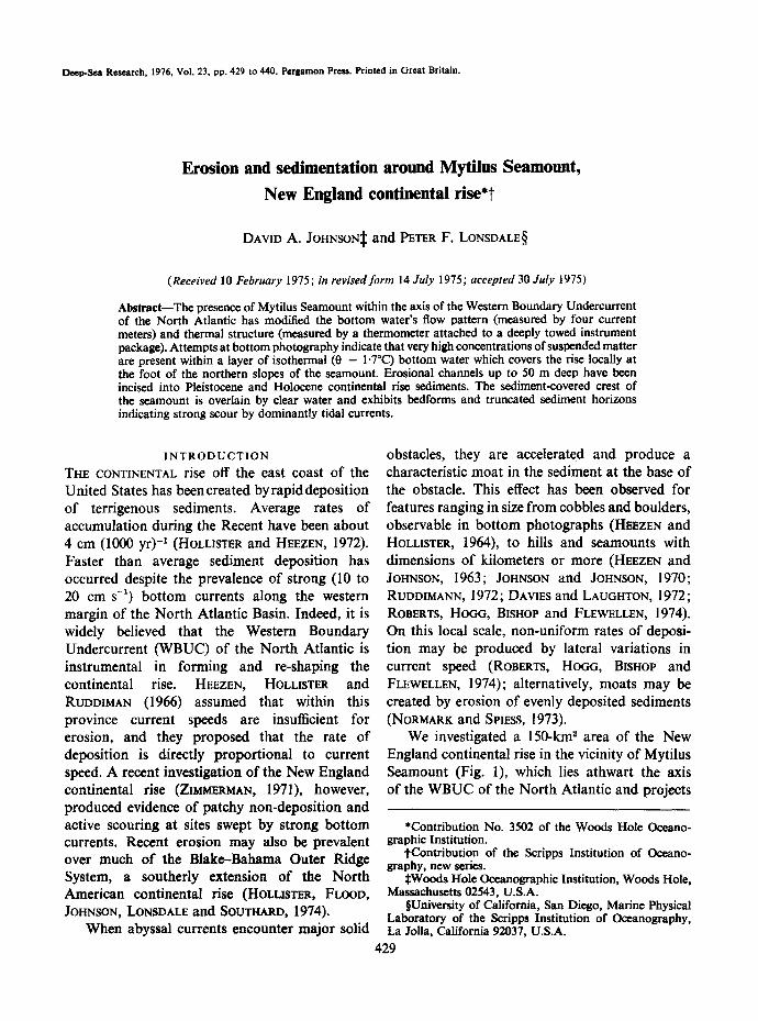
We deployed one near-bottom current meter (Meter D, Fig. 2) 10 km east of Mytilus Sea- mount to measure the regional flow during our survey. For most of its 87 working hours it measured a current of 5 to 20 cm s - ' toward the
I ' I
BOTTOM CURRENTS - - - -~. MEAN FLOW /
/
/
~-- MAXIMUM FLOW : / / o to ~ / /
, _ : - - - - ) j )
"% --~,,% i | 1 ~ /b ,4~ P ~ : t " ' - / /
%. ~i %. %, % ~ - - ~ " / i r a / m . . ~ % % " ' - - ~ 11¢" / ,~
%.% ~ , , - - - - ~ s l " s I #
t I i i I i t ! | i t
I i
/ .
'N
i 6"?'OtY 6B'~
Fig. 2. Location of bottom current meters around Mytilus Seamount and summary of mean and maximum flows recorded. Meters were 20 m above the sea floor at each of the locations shown. Current meter data are presented in more detail in Fig. 3. For meters B, C, and D, the records have been subdivided at the time of the abrupt change in flow direction from northwestward (see progressive vector diagrams in Fig. 3). Mean and maximum current velocities have been calculated separately for the time intervals before and after this abrupt change. Flow
direction at Sta. A was highly variable (see Fig. 3).
Erosion and sedimentation around Mytilus Seamount, New England continental rise 433
A 44 h
~ oo.,-so ~".~ -1z/31 12/50
DEPTH = 2420 m
B 91 h
J, 12/50 |2/2
.~ -N '~ - "~ 20
DEPTH •3885 rn
,2/,/-~ /oo,z~ TM
DEPTH =41t0 m
CURRENT METER RESULTS
PROGRESSIVE VECTOR DIAGRAMS & PLOTS OF AVERAGE SPEED E~ DIRECTION FOR EACH HOUR OF RECORD.
DEPTH • 4 | 8 0 m
Fig. 3. Scatter diagrams and progressive vector diagrams for each of the four current meters deployed around Mytilus Seamount. The heavy arrows on progressive vector diagrams B, C, and D denote the time of an abrupt change in flow direction. Numbers on concentric circles designate current speed in cm s -1. Each point represents an
hourly-averaged direction and magnitude of the current flow.
southwest (Fig. 3), similar to that reported by ZIMMERMANN (1971) for his Meter A, 16 km north of the seamount. However, for the first 20 h of record, Meter D measured a northwestward current. The other two meters on the continental rise (Meters B and C), which were closer to the seamount, also recorded a period of southwest- ward flow closely parallel to the local contours. This 'contour-current' flow was preceded by many hours of westward to northwestward flow (i.e. directed up-slope).
A conceptual model of a contour-following current with spatial variations in speed and direction caused by a large obstruction is clearly a gross over-simplification, because there are significant temporal variations in the regional current. These variations may be in addition to the fluctuations in speed and direction imposed by tidal forces; our records are much too short to
determine any non-tidal periodicity. ZIMMERMAN (1971) observed somewhat less extreme but equally abrupt changes in bottom-current direc- tion, and suggested that they were forced by the constantly changing pattern of Gulf Stream meanders, which extended down to the sea floor and directly affected the path of the WBUC for many kilometers upstream.
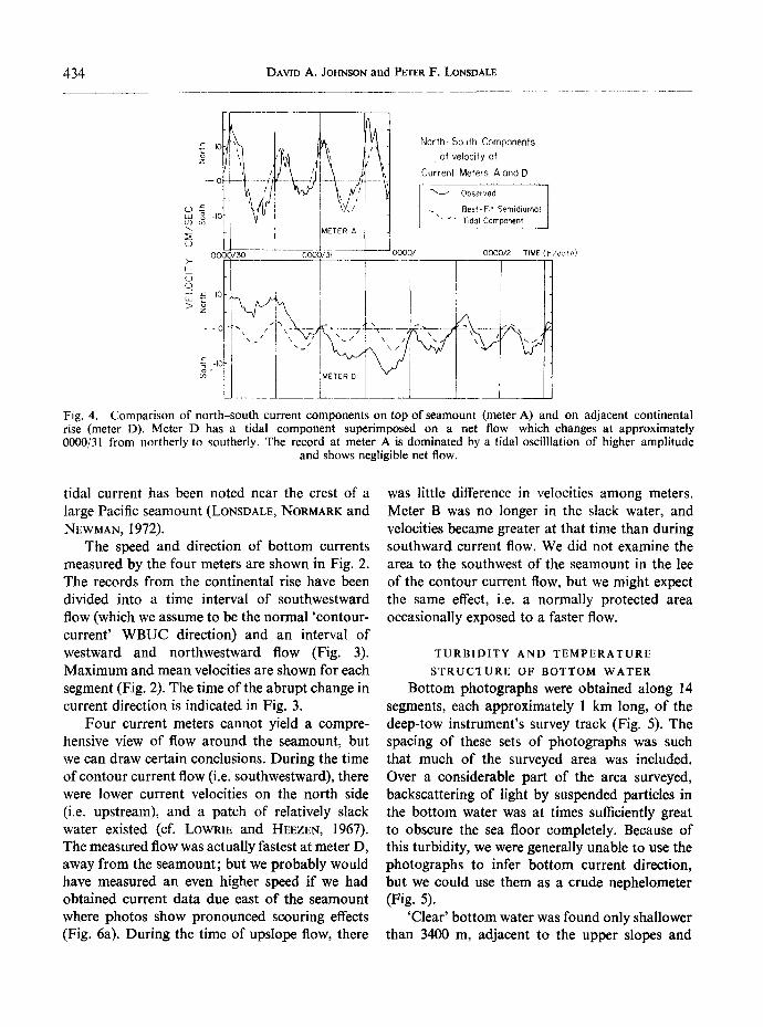
Current Meter A, at a depth of 2420 m near the crest of Mytilus Seamount, recorded a flow regime different from the meters on the continental rise; fast (up to 19 cm s -t) tidal currents were super- imposed on a slow (4 cm s -x) eastward drift (Fig. 3). The amplitude of the tidal component was much greater than for the other meters (Fig. 4) and was presumably amplified by inter- action of the internal tide and the irregular, sloping bottom topography. A similar topographic acceleration producing a geologically effective
434 DAVID A. JOHNSON and PETER F. LONSDALE
(D
b4
~D
0
>
:~ = "~ i ~ ~ t~ /"~ ~i/ North- of velocity South Components of --o - ~ ~/ ~ Current Meters AandD
- - o ~ ~I- ' %} ' ~ " ' ~ - - " i ' , ' - - . . . . " x ....
~ ,-I0
Fig. 4. Comparison of north-south current components on top of seamount (meter A) and on adjacent continental rise (meter D). Meter D has a tidal component superimposed on a net flow which changes at approximately 0000/31 from northerly to southerly. The record at meter A is dominated by a tidal oscilllation of higher amplitude
and shows negligible net flow.
tidal current has been noted near the crest of a large Pacific seamount (LoNSDALE, NORMARK and NEWMAN, 1972).
The speed and direction of bottom currents measured by the four meters are shown in Fig. 2. The records from the continental rise have been divided into a time interval of southwestward flow (which we assume to be the normal 'contour- current' WBUC direction) and an interval of westward and northwestward flow (Fig. 3). Maximum and mean velocities are shown for each segment (Fig. 2). The time of the abrupt change in current direction is indicated in Fig. 3.
Four current meters cannot yield a compre- hensive view of flow around the seamount, but we can draw certain conclusions. During the time of contour current flow (i.e. southwestward), there were lower current velocities on the north side (i.e. upstream), and a patch of relatively slack water existed (cf. LOWRIE and HEEZEN, 1967). The measured flow was actually fastest at meter D, away from the seamount; but we probably would have measured an even higher speed if we had obtained current data due east of the seamount where photos show pronounced scouting effects (Fig. 6a). During the time of upslope flow, there
was little difference in velocities among meters. Meter B was no longer in the slack water, and velocities became greater at that time than during southward current flow. We did not examine the area to the southwest of the seamount in the lee of the contour current flow, but we might expect the same effect, i.e. a normally protected area occasionally exposed to a faster flow.
TURBIDITY AND TEMPERATURE
STRUCTURE OF BOTTOM WATER
Bottom photographs were obtained along 14 segments, each approximately l km long, of the deep-tow instrument's survey track (Fig. 5). The spacing of these sets of photographs was such that much of the surveyed area was included. Over a considerable part of the area surveyed, backscattering of light by suspended particles in the bottom water was at times sufficiently great to obscure the sea floor completely. Because of this turbidity, we were generally unable to use the photographs to infer bottom current direction, but we could use them as a crude nephelometer (Fig. 5).
'Clear' bottom water was found only shallower than 3400 m, adjacent to the upper slopes and
Erosion and sedimentation around Mytilus Seamount, New England continental rise 435
BOTTOM WATER TURBIDITY ".'::~ CLEAR ¢ / I MODERATELY TURBID
Fig. 5. Relative concentrations of suspended matter in near-bottom water around Mytilus Seamount based on inspection of bottom photographs obtained by deep-towed instrumentation. Heavy solid lines designate portions of survey track along which bottom photographs were obtained. In the region designated 'clear', small-scale (1- to 10-cm) features on the sea floor can be deafly resolved in the photographs (e.g. Fig. 6b). In regions designated 'moderately turbid', considerable back-scattering appears in the water, and only large objects (0.1- to l-m) with high relief are clearly resolvable on the sea floor (e.g. Fig. 6a). In regions designated 'highly turbid', nothing at all is visible on the sea floor, and the strobe light is barely visible or totally obscured. Stars labeled J and K indicate the locations of bottom photographs shown in Fig. 6a and 6b. Heavy solid lines labeled I and II indicate the locations of abyssal temperature profiles obtained when the 'fish' was raised to shallower
depths (Fig. 7).
crest of Mytilus Seamount. Wherever we attempted to photograph the continental rise, we found murky water. 'Highly turbid' bot tom water was concentrated against the lower northern slopes. The intense bot tom nepheloid layer in that region seems to have an abrupt upper limit. Camera run 5 was taken up the northern slope; and while photographs at the beginningof therun (3600 m) show highly turbid water, towards the end of the run (2400 m) the water is almost as clear as that on the summit. EITTREIM, EWTNG and THORN'DIKE (1969) demonstrated that a thick near-bottom nepheloid layer with an upper limit usually between 3 and 4 km is a permanent and almost ubiquitous feature of the North American continental rise and adjacent abyssal plains.
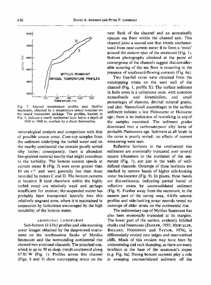
A quartz-crystal thermometer mounted on the deep tow instrument monitored water tempera- ture to a relative precision of 0.01°C. Temperature profiles obtained as the instrument was towed up the flanks of the seamount (Fig. 7, profiles I and II) show that a nearly isothermal layer of bot tom water is surmounted by a benthic thermoeline, a region of high stability that coincides with the upper limit o f the nepheloid layer. Temperature data obtained about 10 km northeast o f the seamount showed bot tom water that is more stably stratified [temperature gradient 0.03 ° (100 m)-l].
The source of the sediment within the turbid bot tom water is conjectural, as samples of the suspended sediment have not been obtained for
436 DAVID A. JOHNSON and PETER F. LONSDALE
32oo ~II "r
34oo
t~ ca 5600
~oo //ABYSSAL TEMPERATURE PROFILES
, / 4OO0
, I , 1 , I , I , I 1.70 1.80 1.90 2.00 2.10
TEMPERATURE (*C)
Fig. 7. Abyssal temperature profiles near Mytilus Seamount, obtained by a temperature sensor mounted on the towed instrument package. The profiles, located in Fig. 5, indicate a nearly isothermal layer below a depth of
3450 to 3500 m, overlain by a sharp thermocline.
mineralogical analysis and comparison with that of possible source areas. Core-top samples from the sediment underlying the turbid water and on the nearby continental rise cbntain poorly sorted silty lutites; consequently, there is abundant fine-grained material nearby that might contribute to the turbidity. The bottom current speeds at current meter B (Fig. 2) were never greater than 10 cm s -1 and were generally less than those recorded" by meters C and D. The bottom currents at location B (and elsewhere within the highly turbid zone) are relatively weak and perhaps insufficient for erosion; the suspended matter has probably been transported laterally into this relatively stagnant zone, where it is maintained in suspension by turbulence encouraged by the high instability of the bottom water.
EROSIONAL LANDFORMS Sub-bottom (4 kHz) profiles and side-scanning
sonar images obtained by the deep-towed instru- ment on the northeastern flanks of Mytilus Seamount and the surrounding continental rise showed two erosional channels. The principal one, which is up to 50 m deep, trends southward along 67°01'W (Fig. 1). Profiles across this channel (Figs. 8 and 9) show outcropping strata on the
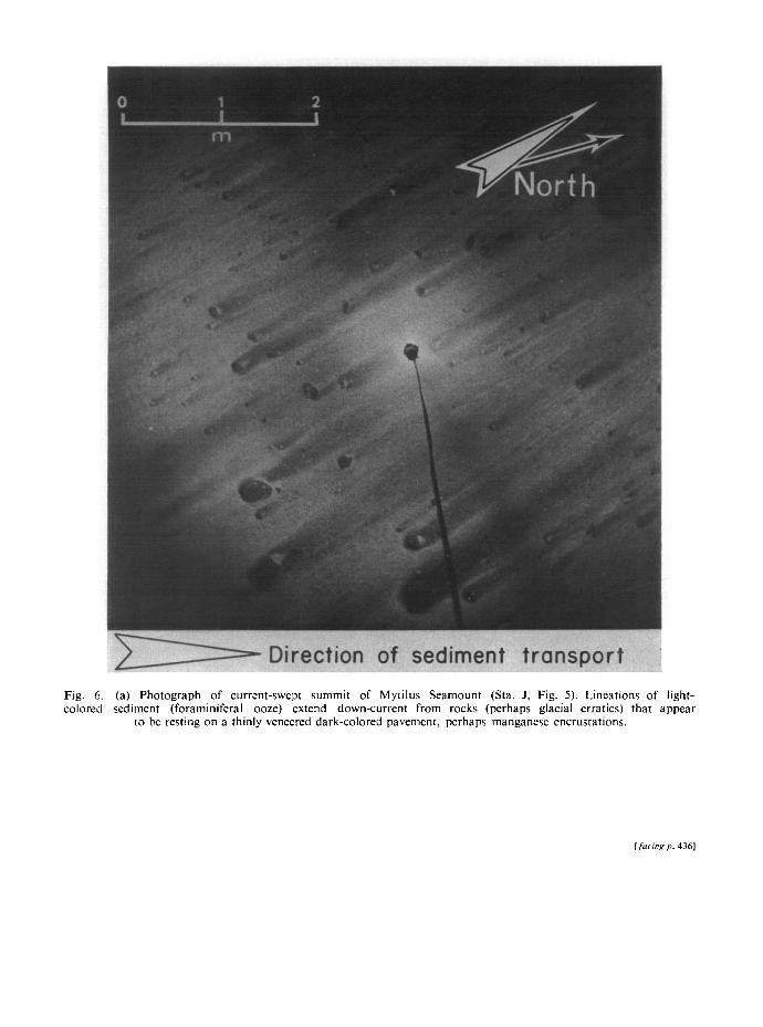
west flank of the channel and an acoustically opaque sea floor within the channel axis. This channel joins a second one that trends southeast- ward from near current meter B to form a 'moat ' around the eastern spur of the seamount (Fig. 1). Bottom photographs obtained at the point of convergence of the channels suggest thatconsider- able scouring of the sea floor is occurring in the presence of southward-flowing currents (Fig. 6a).
Two free-fall cores were obtained from the outcropping strata on the west wall of the channel (Fig. 1, profile X). The surface sediment in both cores is a calcareous ooze, with common nannofossils and foraminifera, and small percentages of diatoms, detrital mineral grains, and clay. Nannofossil assemblages in the surface sediment indicate a late Pleistocene or Holocene age; there is no indication of reworking in anyof the samples examined. The sediment grades downward into a carbonate-poor silty lutite of probable Pleistocene age. Sediment at all levels in the cores is poorly sorted; no effects of current winnowing were seen.
Reflective horizons in the continental rise sediments are erosionally truncated over several square kilometers to the northeast of the sea- mount (Fig. 1), not just in the walls of well- defined channels. Outcrops of these horizons are marked by narrow bands of higher side-looking sonar backscatter (Fig. 9). In places, these bands are discontinuous, indicating partial burial of reflective strata by unconsolidated sediment (Fig. 9). Further away from the seamount, in the eastern part of the survey area, 4-kHz seismic profiles and side-looking sonar records reveal no outcrops of older strata on the continental rise.
The sedimentary cap of Mytilus Seamount has also been erosionally truncated at its margins. The lower part of the section, evidently lithified chalks and limestones (ZEIGLER, 1955; HEIRTZLER, BALLARD, HOUGHTON and TAYLOR, 1974), is differentially eroded into ledges and near-vertical cliffs. Much of this erosion may have been by undermining and rock slumping, as there are many boulders at the base of the seamount's slopes (e.g. Fig. 6a). Strong bottom currents play a role in sweeping unconsolidated sediment off the
Fig. COlOl
6. (a) Photograph of current-swept summit of Mytilus Seamount (Sta. J, Fig. 5). Lineations of red sediment (foraminiferal ooze) extend down-current from rocks (perhaps glacial erratics) that
to be resting on a thinly veneered dark-colored pavement, perhaps manganese encrustations.
light- appear
[facing p. 4361
Fig. (Sta. side
6. (b) Scouring effects of bottom current flowing through channel around the east side of Mytilus Se; K, Fig. 5). The boulder, perhaps slumped from the flanks of the nearby seamount, is surrounded on the UK by a deep scour crescent. High backscattering of light indicates high concentrations of suspended
due to strong turbulence in the near-bottom water.
Imount Nream matter
‘EAST
3900 -
OUTCROPPING
WEST
Fig. 8. Near-bottom 4-kHz reflection profile across erosional channel at base of Mytilus Seamount. Profile location is X in Fig. 1. Near-horizontal strata outcrop on the western flank of the channel. Cores of
outcropping strata in channel and on western flank recovered Pleistocene sediment.
Fig. 9. Side-scanning sonar profile across erosional channel at base of seamount. Profile location is along Line Y in Fig. I. Path of deep-towed fish crosses channel at an oblique angle from east to west. Floor of channel appears as smooth relief. Prominent lineations on western flank of channel are outcropping strata that can be identi- fied in tow frequency (4 kHz) reflection profiles across the channel (e.g. Fig. 8). Irregular reflective patches on east
flank of channel may be outcropping strata partially obscured locally by sediment cover.
- FISH PATH
. MUD WAVES. :
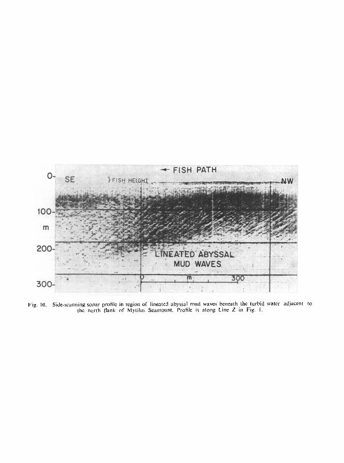
Fig. IO. Side-scanning sonar profile in region of lineated abyssal mud waves beneath the turbid water adjacent to the north flank of Mytilus Seamount. Profile is along Line Z in Fig. I.
Erosion and sedimentation around Mytilus Seamount, New England continental rise 437
ledges (Fig. 6b). They have also trimmed the superficial 'snow cone' of unconsolidated sedi- ments, which has flat-lying internal reflectors outcropping on its convex marginal slopes. A similar pattern has been reported from the crest of Horizon Guyot (LONSDAt.E, NORMARK and NEWMAN, 1972). The sediment at the summit of the seamount as sampled in a free-fall core, consists of pelagic foraminiferal-nannofossil ooze overlying a slightly calcareous ooze containing abundant terrigenous silt. Thus the lithologic sequence in the near-surface sediment is similar on the seamount summit to that of the adjacent continental rise.
DEPOSITION IN THE SLACK WATER
Near-bottom 4-kHz seismic profiles show that near current meter B, which recorded relatively low velocities during periods of contour current flow, there is a pond of acoustically transparent sediment. Its extent approximately corresponds to the area of 'highly turbid' bottom water mapped in Fig. 5. The surface of this sedimentary unit is covered with regular, lineated bedforms, vividly displayed on near-bottom side-looking sonar records (Fig. 10) but not visible on echo- grams or bottom photographs because of their low amplitude and the murkiness of the overlying water. A core from this region recovered Holocene fine-grained hemipelagic mud, typical of much of the continental rise.
Pre0ise description and interpretation of these bedforms is impossible in the absence of useful bottom photographs. They have amplitudes of 1 to 2 m, wavelengths of 10 to 20 m, crests up to several hundred meters long (see Fig. 10), and are elongated parallel to the local bathymetric contours. We refer to these regular elongate hummocks of mud as 'mud waves' and believe that they are depositional bedforms because of the smoothness of their slopes and their position beneath a pool of turbid, relatively slack bottom water. However, regular bedforms that are erosional in origin have been reported from the southern extension of the North American Con- tinental Rise, in regions swept by slow ( < 10 cm s-~), steady bottom currents (HOLLISTER,
FLOOD, JOHNSON, LONSDALE and SOUTHARD, 1974).
There is no moat between the depositional area around current meter B a r d the flanks of the seamount; instead, the lens of continental rise sediment laps on to the volcanic slope to a depth of approximately 3000 m. Rough bedrock slopes occur only in a narrow depth range between the smooth convex slopes of the pelagic sediment cap and the smooth concave slopes of onlapping continental rise sediment. On the eastern slopes of the seamount, where converging erosional channels form a distinct moat, bedrock appears to outcrop down to about 3500 m.
SEDIMENTATION DYNAMICS
On the continental rise adjacent to the northeast flank of Mytilus Seamount, there is an area that has suffered erosion of rapidly deposited hemipelagic silty clays, a depositional pond of sediments shaped into regular bedforms, and a local patch of highly turbid bottom water. The crest of the seamount is capped by pelagic ooze which is being eroded by clear water. These observations, and the short records from four current meters, are the basic data that we seek to relate in a discussion of the sedimentation dynamics.
The source of the sediment within the turbid bottom water is conjectural; no samples of the suspended material have been obtained for mineralogical analysis and comparison with that of possible source areas. Core-top samples from the underlying continental rise contain poorly sorted calcareous silty lutites; consequently, there is abundant fine-grained sediment nearby that might contribute to the turbidity. The bottom currents at location B, within the highly turbid zone, were never faster than 10 cm s -~ (Fig. 2) and are probably insufficient for erosion of the bed. The suspended matter may have been eroded from the region of truncated outcrops, erosional channels, and faster currents (at Meter C) and transported laterally into this relatively 'stagnant' zone. It is maintained in suspension by turbulence encouraged by the low stability of the almost isothermal bottom water
438 DAVID A. JOHNSON and PETER F. LONSDALE
that occurs adjacent to the seamount (Fig. 7). Supply of the nepheloid layer by direct settling of terrigenous particles from the overlying water seems less plausible because of the sharp thermo- cline overlying the turbid layer, and the apparent small-scale variability in the concentration of suspended particles near the base of the sea- mount.
The temperature profiles (Fig. 7) show a significant difference between profiles I and II, both of which were obtained from the turbid water adjacent to the north flank of the seamount. The water temperature within the near-bottom isothermal 'mixed layer' varies significantly between the two profiles, and the level of the overlying thermocline varies by approximately 50 m. These differences might be caused by the slight spatial separation of the profiles (about 2 km) but are probably an indication of temporal changes. The profiles were obtained approxi- mately two days apart (Profile I while Meter B recorded up-slope flow, and Profile II while Meter B recorded southward flow). This variability indicates that the turbid zone itself may well be a transient feature, and that its location relative to the seamount and the concentration of suspended matter within it probably vary with time in response to the varying bottom water flow.
Our data suggest that the depositional region near Mytilus Seamount may be substantially different today from that of the Pleistocene. Large quantities of detrital silt were supplied to the continental margin at times during the Pleistocene of maximum runoff from the North American ice cap; by contrast, the dominant sediment type supplied to both regions today is pelagic biogenic carbonate (foraminifera and nannofossils). Deep- tow data indicate that an environment of rapid deposition has recently been replaced by one of localized erosion on the continental rise to the northeast of the seamount. Several possible explanations for such a change seem plausible: (1) an increase in the strength of the WBUC since the late Pleistocene; (2) a change in the dominant flow direction, such that certain regions once protected from erosional processes are now exposed. Such changes in flow direction were
observed on a time scale of several days during our survey; or (3) a decreasing total suspended load in the WBUC (due to a lower input from terrigenous sources since the Pleistocene), perhaps allowing more entrainment of sediment by currents whose speed remained unchanged.
S U M M A R Y
1. Modification of continental rise sediments by bottom currents has occurred adjacent to the eastern flank of Mytilus Seamount. Con- verging channels up to several tens of meters deep truncate near-horizontal Pleistocene strata, indicating a pattern of either non- uniform accumulation or relatively recent erosion.
2. Concentrations of suspended matter in the near-bottom water vary greatly over small horizontal distances (km or less). Bottom photographs show that visibility is reduced to a few meters or less as a result of high concentra- tions of particulate material in a region of thick sediment accumulation adjacent to the north flanks of the seamount. Visibility increases at greater distances from the base of the seamount, and at shallower depths approaching the crest of the seamount.
3. The region of highly turbid bottom water corresponds to an isothermal (,-, 1.7°C) layer which is overlain by a sharp benthic thermo- cline. The isothermal layer occurs adjacent to the north flank of the seamount, and is indicative of intense vertical mixing within this localized region. At increasing distances from the base of the seamount a more stably stratified bottom boundary layer is present. The topographic effects of the seamount within the flow of the Western Boundary Undercurrent may be responsible for creating vertical instabilities in the near-bottom water on a small scale.
4. The direction of flow of bottom water near Mytilus Seamount was not uniformly parallel to the regional contours throughout the period of our measurements (3½ days). Up- slope (northward to northwestward) current flow was recorded for considerable periods of
Erosion and sedimentation around Mytilus Seamount, New England continental rise 439
t ime (1 to 2 days). The direct ion o f flow abrup t ly and s imul taneously shifted to south- ward at each of the three deep current meter stations. This i r regular flow pat tern may be a consequence of interact ions between the Western Boundary Undercur ren t and migrat - ing eddies of the overlying Gu l f St ream water ; such an in te rpre ta t ion is consistent with previous observat ions (SCHMITZ, ROBINSON and FUGLISTER, 1970) indicat ing that the effects of the Gu l f St ream appear to extend th roughou t the water co lumn in several relat ively deep areas ( > 3 km).
Acknowledgements--We thank F. N. SPIESS, J. D. MUDIE, A. E. MAXWELL, J. R. HEIRTZLER, and C. D. HOLLISTER for their support and encouragement during the planning of this project. Shipboard operations on Leg 5 of Knorr Cruise 31 (Savannah to Woods Hole) were supported under N.S.F. Grant No. GA-39049 to the Woods Hole Oceanographic Institution. Scientific and technical support for the deep-towed instrumentation was provided under N.S.F. Grant No. GA-31377X and O.N.R. Contract No. N00014-69-A-0200-6002 to the Marine Physical Labora- tory of the Scripps Institution of Oceanography. Analysis and interpretation of the Mytilus Seamount data were supported under O.N.R. Contract No. N00014-74-C-0262. The manuscript was critically reviewed by N. HoG6, R. HOUGHTON, C. D. HOLUSTEg, and J. B. SOtrTHARD. We thank Capt. E. H. HILLER, C. D. HOLLISTER, C. D. LOWENSTEIN, the officers, crew, and scientific party of the R.V. Knorr, and the U.S. Coast Guard for their assistance in the successful completion of this project.
REFERENCES BARRETT J. R., JR. (1965) Subsurface currents off
Cape Hatteras. Deep-Sea Research, 12, 173-184. BETZER P. R., P. L. RICHARDSON and H. B. ZIMMER-
MAN (1974) Bottom currents, nepheloid layers and sedimentary features under the Gulf Stream near Cape Hatteras. Marine Geology, 16, 21-29.
DAVIES T. A. and A. S. LAUGHTON (1972) Sedimentary processes in the North Atlantic. In : Initial Reports of the Deep Sea Drilling Project, A. S. LAUGHTON, W. A. BERGGREN, editors, Vol. 12. U.S. Govern- ment Printing Office, pp. 905-934.
EITTREIM S., M. EWING and E. M. THORNDIKE (1969) Suspended matter along the continental margin of the North American Basin. Deep-Sea Research, 16, 613-624.
EMERY K. O., E. UCHtJPI, J. D. PHILLIPS, C. O. BOWIN, E. T. BUNCE and S. T. KNOTT (1970) Continental rise off eastern North America. Bulletin of the American Association of Petroleum Geologists, 54, 44-108.
HATHAWAY J. C. (1972) Regional clay mineral facies in estuaries and continental margin of the United States east coast. Memoirs. Geological Society of America, 133, 293-316.
HEEZEN B. C. and G. L. JOHNSON (1963) A moated knoll in the Canary Passage. Deutsche hydro- graphische Zeitschrift, 16, 269-272.
HEEZEN B. C. and C. D. HOLLISTER (1964) Deep-sea current evidence from abyssal sediments. Marine Geology, 1, 141-174.
HEEZEN B. C., C. D. HOLLISTER and W. R. RUDDI- MAN (1966) Shaping of the continental rise by deep geostrophic contour currents. Science, 152, 502-508.
HEIRTZLER J. R., R. D. BALLARD, R. L. HOUGHTON and P. T. TAYLOR (1974) An investigation of the New England Seamounts by submersible. LOS Transactions. American Geophysical Union, 56, 1138.
HOLLISTER C. D. and B. C. HEEZEN (1972) Geological effects of ocean bottom currents. In: Studies in physical oceanography, A. L. GOgDON, editor, Gordon & Breach, Vol. 2, pp. 37-66.
HOLLISTER C. D., R. D. FLOOD, D. A. JOHNSON, P. LONSDALE and J. B. SOUTHARD (t974) Abyssal furrows and hyperbolic echo traces on the Bahama Outer Ridge. Geology, 2, 395-400.
JOHNSON D. A. and T. C. JOHNSON (1970) Sediment redistribution by bottom currents in the central Pacific. Deep-Sea Research, 17, 157-169.
KNAUSS J. A. 0965) A technique for measuring deep ocean currents close to the bottom with an unattached current meter and some preliminary results. Journal of Marine Research, 23, 237-245.
LONSDALE P. F., W. R. NORMARK and W. A. NEWMAN (1972) Sedimentation and erosion on Horizon Guyot. Bulletin of the Geological Society of America, 83, 289-316.
LOWRIE A. and B. C. HEEZEN (1967) Knoll and sediment drift near Hudson Canyon. Science, 157, 1552-1553.
NORMARK W. R. and F. N. SPIESS 0973) A hole in the bottom of the sea; erosion in the Line Islands archipelagic apron. Geological Society of America, Abstracts with Programs, 5, 754.
RICHARDSON P. L. (1974) Current measurements under the Gulf Stream near Cape Hatteras, North Carolina. University of Rhode Island, Graduate School of Oceanography, Technical Report No. 74-3, 136 pp.
RICHARDSON P. L. and J. A. KNAUSS (1971) Gulf Stream and Western Boundary Undercurrent observations at Cape Hatteras. Deep-Sea Research, 18, 1089-1109.
ROaERTS D. G., N. G. HOGG, D. G. BISHOP and C. G. FLEWELLEN (1974) Sediment distribution around moated seamounts in the Rockall Trough. Deep-Sea Research, 21, 175-184.
RUDDIMAN W. F. (1972) Sediment redistribution on the Reykjanes Ridge: seismic evidence. Bulletin of the Geological Society of America, 83, 2039-2062.
440 DAVID A. JOHNSON and PETER F. LONSDALE
SCHICK G. B., J. D. ISSACS and M. H. SESSIONS (1968) Autonomous instruments in oceanographic research. In: Marine sciences instrumentation, Plenum Press, Vol. 4, pp. 203-230.
SCnUaTZ W. J., A. R. ROB~SON and F. C. FUGLISTER (1970) Bottom velocity observations directly under the Gulf Stream. Science, 170, 1192-1194,
SCHNEIDER E. D., P. J. Fox, C. D. HOLLISTER, H. D. NEEDrIA~ and B. C. HEEZEN (1967) Further evidence of contour currents in the western North Atlantic. Earth and Planetary Science Letters, 2, 351-359.
Seir.ss F. N. and J. D. MuoiE (1970) Small-scale topographic and magnetic features. In: The sea, A. E. MAXWELL, editor, Interscience, Vol. 4, pp. 205-250.
Selr.SS F. N. and R. TYCE (1973) Marine Physical Laboratory deep tow instrumentation system. Scripps Institution of Oceanography, Ref. No. 73-4, 37 pp.
STOMMEL H. (1958) The abyssal circulation. Deep-Sea Research, 5, 80-82.
STOMMEL H. and A. B. ARO~S (1960) On the abyssal circulation of the World Ocean--II. An idealized
model of the circulation pattern and amplitude in oceanic basins. Deep-Sea Research, 6, 217-233.
SWALLOW J. C. and L. V. WOgTr~IrqGTON (1961) An observation of a deep counter-current in the western North Atlantic. Deep-Sea Research, 8, 1-19.
UCHUPI E., J. D. PHILLIPS and K. E. PRADA (1970) Origin and structure of the New England Sea- mount Chain. Deep-Sea Research, 17, 483-494.
U.S. NAVAL OCEANOGRAPmC OFfiCE (1973) The Gulf Stream: Monthly Summary, 8(4), 1 p.
VOLKMANN G. (1962) Deep current observations in the western North Atlantic. Deep-Sea Research, 9, 494--500.
ZEIGLER J. (1955) Seamounts near the eastern coast of North America. Woods Hole Oceanographic Institution Ref. No. 55-17, xx q-- 16 pp.
ZIMMERMAN H. B. (1971) Bottom currents on the New England continental rise. Journal of Geophysical Research, 76, 5865-5876.
ZIMMERMAN H. B. (1972) Sediments of the New England continental rise. Bulletin of the Geological Society of America, 83, 3709-3724.