86
Erosion and Sediment Control and Stormwater Management for Manual Franklin County, Virginia Franklin County 1255 Franklin Street Rocky Mount, Virginia 24151 July 2016
Erosion and Sediment Control and Stormwater Management
for Manual
Franklin County, Virginia
Franklin County 1255 Franklin Street
Rocky Mount, Virginia 24151
July 2016
Toc - ii
Franklin County Erosion and Sediment Control and Stormwater Management Manual July 2016
EROSION AND SEDIMENT CONTROL AND STORMWATER MANAGEMENT MANUAL
TABLE OF CONTENTS
Chapter 1 Introduction .............................................................................................................. 1 1.1 Purpose and Goals .................................................................................................................... 1
1.2 Applicability .............................................................................................................................. 1
1.3 Manual Amendments ............................................................................................................... 2
1.4 Guide Documents ...................................................................................................................... 2
1.5 Technical Requirements ........................................................................................................... 3
1.6 Allowable Calculation Methodologies ..................................................................................... 4
1.7 Resources ................................................................................................................................... 4
1.8 Permits ....................................................................................................................................... 4
Chapter 2 Erosion and Sediment Control Plan ....................................................................... 6 2.1 Purpose and Schedule ............................................................................................................... 6
2.2 Land Disturbance Permit Requirements ................................................................................ 6
2.3 Flowchart for Land Disturbance Permits .............................................................................. 6 2.3.1 Plan Requirements .................................................................................................................. 7
2.3.2 Agreement in Lieu of a Plan Requirements ............................................................................. 7
Chapter 3 Stormwater Management Plan ................................................................................ 8 3.1 Purpose and Schedule ............................................................................................................... 8 3.1.1 Plan Requirements .................................................................................................................. 8
3.1.2 Agreement in Lieu of a SWM Plan Requirements ................................................................. 8
3.2 Directions for Single Family Agreement in Lieu of a Stormwater Management Plan ....... 8
3.3 VSMP Permit Requirements ................................................................................................... 9 3.2.1 Flow Chart for VSMP Permits ................................................................................................. 9
Chapter 4 Stormwater Design ................................................................................................. 10 4.1 Time Limits ............................................................................................................................. 10
4.2 Grandfathering ....................................................................................................................... 10 4.2.1 General Requirements. ..................................................................................................................... 10 4.2.2 Local, State, and Federal Projects .................................................................................................... 11 4.2.3 Time Limits ...................................................................................................................................... 11 4.2.4 Governmental Bonding or Public Debt Finance Projects ................................................................. 11 4.2.5 Exceptions ........................................................................................................................................ 11
Chapter 5 Stormwater Design and Specifications for New Projects ..................................... 12 5.1 General Requirements ............................................................................................................ 12
5.1.1 Franklin County 24 Hour rainfall data table .................................................................... 12
Toc - ii
Franklin County Erosion and Sediment Control and Stormwater Management Manual July 2016
5.2 Stormwater Quality ................................................................................................................ 13 5.2.1 General Requirements. ................................................................................................................. 13 5.2.2 Water Quality Computations ........................................................................................................ 14
5.3 Stormwater Quantity ................................................................................................................ 15 5.3.1 Channel Protection ........................................................................................................................ 15 5.3.2 Flood Protection ............................................................................................................................ 17 5.3.3 Overland (Sheet) Flow .................................................................................................................. 17 5.3.4 Hydrologic Assumptions ............................................................................................................... 18
5.4 Offsite Compliance Options ..................................................................................................... 18
Chapter 6 Stormwater Design and Specifications for Grandfather Projects ........................ 19 6.1 General Requirements .............................................................................................................. 19
6.2 Stormwater Quantity Control/Hydrology .............................................................................. 20 6.2.1 General Requirements. .................................................................................................................. 20 6.2.2 Hydrologic Computations ............................................................................................................. 20
6.2.2.1 Rational Method ..................................................................................................................... 21 6.2.2.2 TR-55 Method Notes .............................................................................................................. 21
6.2.3 Stormwater BMPs ......................................................................................................................... 21 6.2.4 Performance-Based Water Quality Criteria Design ....................................................................... 22
6.2.4.1 Calculations ............................................................................................................................ 23 6.2.4.2 BMP Removal Efficiency ...................................................................................................... 23
6.2.5 Technology-Based Water Quality Criteria Design ........................................................................ 24
Chapter 7 Stormwater Design and Specifications for All Projects ........................................ 25 7.1 Stormwater Channels ............................................................................................................... 25
7.1.1 Channel Design Requirements ...................................................................................................... 25 7.1.2 Channel Lining Requirements ....................................................................................................... 25
7.2 Stormwater Culverts ................................................................................................................. 26 7.2.1 Culvert Design Requirements ........................................................................................................ 26
7.3 Storm Drainage Systems .......................................................................................................... 26 7.3.1 Curb and Gutter Design Requirements .......................................................................................... 26 7.3.2 Stormwater Inlets and Manhole Design......................................................................................... 26 7.3.3 Storm Drain Design ....................................................................................................................... 27
7.4 Stormwater Facilities ................................................................................................................ 27 7.4.1 Design Requirements..................................................................................................................... 28 7.4.2 Maintenance .................................................................................................................................. 28
Chapter 8 Stormwater Pollution Prevention Plan ................................................................. 29 8.1 Purpose and Schedule ............................................................................................................... 29
8.2 Plan Contents and Requirements ............................................................................................ 29
8.3 TMDL Requirements ................................................................................................................ 30
Chapter 9 Easements ............................................................................................................... 31 9.1 Stormwater Channels and Drainage Systems ........................................................................ 31
9.2 Stormwater Facilities ................................................................................................................ 31
Chapter 10 Performance Bonds, Construction Inspections, and Record Drawings........... 32 10.1 Performance Surety .................................................................................................................. 32
10.2 Record Drawings ....................................................................................................................... 32

Toc - ii
Franklin County Erosion and Sediment Control and Stormwater Management Manual July 2016
Chapter 11 Construction Monitoring and Inspections ........................................................ 33
Toc - iii
Franklin County Erosion and Sediment Control and Stormwater Management Manual July 2016
11.1 Construction Monitoring .......................................................................................................... 33
11.2 Construction Inspections .......................................................................................................... 33
Chapter 12 Maintenance and Inspections ............................................................................ 34 12.1 Maintenance Plan ...................................................................................................................... 34
12.2 Maintenance Agreement ........................................................................................................... 34
12.3 Maintenance Inspections .......................................................................................................... 34
12.4 Recordkeeping ........................................................................................................................... 34
List of Appendices Appendix A – Franklin County, Virginia Code of Ordinances, Chapter 7 - ESC&SM Appendix B – Stormwater Management Plan Submittal Checklists Appendix C – Stormwater Management Plan Submittal and Review Process Flowchart Appendix D – Common Plan of Development Permitting Flowchart Appendix E – Grandfathering Flowchart for New Projects Appendix F – Runoff Reduction Method and Energy Balance Worksheets Appendix G – Maintenance Agreement Appendix H – Stormwater Facility Maintenance and Inspection Form Appendix I – Documented Interpretations
Appendix J – LOC Appendix K – Cash Escrow (W-9) Appendix L – Insurance Bond

Page 1
Franklin County Erosion and Sediment Control and Stormwater Management Manual July 2016
Chapter 1 Introduction
1.1 Purpose and Goals
The purpose of Franklin County Erosion and Sediment Control and Stormwater Management Manual is to provide guidance to developers, property owners, and design professionals to assist them in meeting the requirements of the County’s Stormwater Management Program, as well as to aid in the design and analysis of stormwater management facilities in Franklin County.
As land is developed, the increase in impervious surfaces causes adverse affects,
including, but not limited to the following: increased flooding, increased erosion and sediment deposition, increased runoff of pollutants, and decreased stream biodiversity. The goal of the Franklin County Erosion & Sediment Control and Stormwater programs are to minimize and mitigate these adverse effects by implementing effective erosion & sediment control and stormwater management practices, as required by the County Code. Application of the procedures and criteria presented in this manual should contribute toward the effective and economical solution of local drainage and flooding problems, and improve water quality.
The use of this manual will help provide design guidance, but it neither replaces the need
for good engineering judgment nor precludes the use of information not included. Engineering design methods other than those included in this manual may be used if based on good engineering judgment as approved by the County. Franklin County encourages the development and use of innovative stormwater management practices that meet the requirements of the County's Stormwater Management Program and can be demonstrated as equivalent to the standards set forth in this manual.
1.2 Applicability
The requirements of this manual apply to all land disturbance activities that require a site
plan submittal, subdivision construction plan submittal, stormwater management plan submittal, erosion and sediment control plan submittal, or zoning, building, or land disturbance permit, except for the following activities, unless otherwise required by federal law:
1. Permitted surface or deep mining operations and projects, or oil and gas
operations and projects conducted under the provisions of Title 45.1 of the Code of Virginia;
2. Clearing of lands specifically for agricultural purposes and the management,
tilling, planting, or harvesting of agricultural, horticultural, or forest crops, livestock feedlot operations, or as additionally set forth by the State Board in regulations, including engineering operations as follows: construction of terraces, terrace outlets, check dams, desilting basins, dikes, ponds, ditches, strip cropping, lister furrowing, contour cultivating, contour furrowing, land drainage, and land irrigation; however, this exception shall not apply to harvesting of forest crops unless the area on which harvesting occurs is reforested artificially or naturally in
Page 2
Franklin County Erosion and Sediment Control and Stormwater Management Manual July 2016
accordance with the provisions of Chapter 11 (§ 10.1-1100 et seq.) of Title 10.1 of the Code of Virginia or is converted to bona fide agricultural or improved pasture use as described in Subsection B of § 10.1-1163 of Article 9 of Chapter 11 of Title 10.1 of the Code of Virginia;
3. Single-family residences separately built and disturbing less than one (1) acre and
not part of a larger common plan of development or sale, including additions or modifications to existing single-family detached residential structures;
4. Land disturbing activities that disturb less than one acre of land area;
5. Discharges to a sanitary sewer or a combined sewer system;
6. Activities under a state or federal reclamation program to return an abandoned property to an agricultural or open land use;
7. Routine maintenance that is performed to maintain the original line and grade,
hydraulic capacity, or original construction of the project. The paving of an existing road with a compacted or impervious surface and reestablishment of existing associated ditches and shoulders shall be deemed routine maintenance if performed in accordance with this Subsection; and
8. Conducting land-disturbing activities in response to a public emergency where
the related work requires immediate authorization to avoid imminent endangerment to human health or the environment. In such situations, the Administrator shall be advised of the disturbance within seven days of commencing the land-disturbing activity and compliance with the administrative requirements of Subsection (a) of Section 7-50 of the Franklin County Stormwater Management Ordinance is required within 30 days of commencing the land-disturbing activity.
1.3 Manual Amendments
This Design Manual may be periodically amended, as recommended by the Development
Review Coordinator, or designee. Amendments to this Design Manual will be posted on the County website, and will
become effective on the date listed on the website. It is the manual user's responsibility to check the website and verify that they have the latest requirements.
1.4 Guide Documents
This manual shall serve as a supplement to existing state and federal design manuals that
address proper stormwater management design techniques. The following documents are incorporated into this Erosion and Sediment Control and Stormwater Management Manual by reference:

Page 3
Franklin County Erosion and Sediment Control and Stormwater Management Manual July 2016
• Virginia Stormwater Management Handbook, Volumes I and II, prepared by the Virginia Department of Conservation and Recreation, dated 1999 or latest version, as amended.
• Virginia Stormwater BMP Clearinghouse, jointly administered by the Virginia
Department of Environmental Quality and the Virginia Water Resources Research Center, as amended.
• VDOT Drainage Manual, prepared by the Hydraulics Section of the Virginia
Department of Transportation, dated 2002 or latest version, as amended.
• VDOT BMP Design Manual of Practice, prepared by Virginia Tech, dated Effective April 2013 or latest version, as amended.
• Road and Bridge Standards, Volumes I and II, prepared by the Virginia
Department of Transportation, dated 2008 or latest version, as amended.
• Road and Bridge Specifications, prepared by the Virginia Department of Transportation, dated 2007 or latest version, as amended.
• Virginia Erosion and Sediment Control Handbook, prepared by the Virginia
Department of Conservation and Recreation, dated 1992 or latest version, as amended.
• NOAA Atlas 14 Precipitation-Frequency Atlas of the United States, Volume 2
Version 3.0, prepared by U.S. Department of Commerce National Oceanic and Atmospheric Administration National Weather Service, dated 2004 or latest version, as amended.
1.5 Technical Requirements
Franklin County, Virginia - Code of Ordinances, Chapter 7 - Erosion and Sediment Control and Stormwater Managment.
• https://www2.municode.com/library/va/franklin_county/codes/code_of_ordinances Refer to the following links for additional guidance and technical information on the Runoff Reduction Method and Energy Balance Equation:
• http://www.deq.state.va.us/Portals/0/DEQ/Water/Guidance/SWMHandbook/45_C hap%2012.pdf
• http://www.deq.virginia.gov/Programs/Water/LawsRegulationsGuidance/Guidanc e/StormwaterManagementGuidance.aspx
• http://www.deq.virginia.gov/Programs/Water/Laws,Regulations,Guidance/Guidance/WaterPermitGuidance.aspx
Page 4
Franklin County Erosion and Sediment Control and Stormwater Management Manual July 2016
1.6 Allowable Calculation Methodologies
The Soil Conservation Service (SCS) based methodology (TR-55 or TR-20) is preferred for the design of stormwater management/BMP facilities for sites with watersheds exceeding 200 acres. If a site is less than 200 acres, modified rational method or rational method may be used at the discretion of the VSMP Authority.
The modified runoff curve number as provided by the runoff reduction spreadsheet for
each drainage area for water quantity calculations.
1.7 Resources
• Franklin County ESC & SW: www.franklincountyva.gov/planning-erosion-stormwater
• Department of Environmental Quality: www.deq.virginia.gov
• BMP Clearinghouse: http://vwrrc.vt.edu/swc/
• Hydrologic Unit Codes: http://www.deq.virginia.gov/mapper_ext/default.aspx?service=public/wimby
• Soils Maps: http://websoilsurvey.sc.egov.usda.gov/App/HomePage.htm
• Rainfall Values: http://hdsc.nws.noaa.gov/hdsc/pfds/pfds_map_cont.html?bkmrk=va
• Approved TMDL Reports: http://www.deq.state.va.us/Programs/Water/WaterQualityInformationTMDLs/TM DL/TMDLDevelopment/ApprovedTMDLReports.aspx
• Draft TMDL Reports: http://www.deq.state.va.us/Programs/Water/WaterQualityInformationTMDLs/TM DL/TMDLDevelopment/DraftTMDLReports.aspx
1.8 Permits
The design professional is responsible for knowing and complying with all applicable ordinances and regulations before submitting a design plan. If more stringent requirements of other local, state, or federal codes, acts, ordinances, or regulations, are applicable the more stringent regulation shall apply. Please note, additional state and federal permits may be required prior to the commencement of land-disturbing activities.
Page 5
Franklin County Erosion and Sediment Control and Stormwater Management Manual July 2016
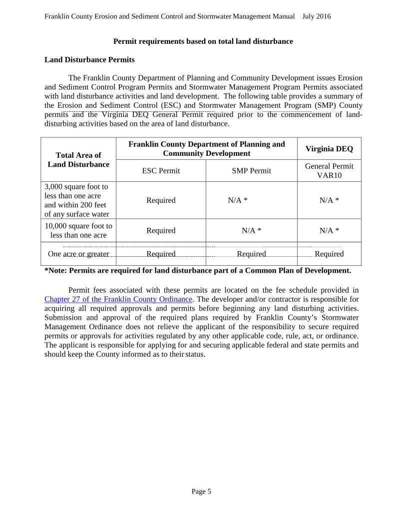
Permit requirements based on total land disturbance Land Disturbance Permits
The Franklin County Department of Planning and Community Development issues Erosion and Sediment Control Program Permits and Stormwater Management Program Permits associated with land disturbance activities and land development. The following table provides a summary of the Erosion and Sediment Control (ESC) and Stormwater Management Program (SMP) County permits and the Virginia DEQ General Permit required prior to the commencement of land-disturbing activities based on the area of land disturbance.
Total Area of Land Disturbance
Franklin County Department of Planning and Community Development Virginia DEQ
ESC Permit SMP Permit General Permit VAR10
3,000 square foot to less than one acre and within 200 feet of any surface water
Required N/A * N/A *
10,000 square foot to less than one acre Required N/A * N/A *
One acre or greater Required Required Required
*Note: Permits are required for land disturbance part of a Common Plan of Development.
Permit fees associated with these permits are located on the fee schedule provided in Chapter 27 of the Franklin County Ordinance. The developer and/or contractor is responsible for acquiring all required approvals and permits before beginning any land disturbing activities. Submission and approval of the required plans required by Franklin County’s Stormwater Management Ordinance does not relieve the applicant of the responsibility to secure required permits or approvals for activities regulated by any other applicable code, rule, act, or ordinance. The applicant is responsible for applying for and securing applicable federal and state permits and should keep the County informed as to their status.
Page 6
Franklin County Erosion and Sediment Control and Stormwater Management Manual July 2016
Chapter 2 Erosion and Sediment Control Plan 2.1 Purpose and Schedule
The purpose of the Erosion and Sediment Control Plan is to show full details of the
erosion and sediment control practices that will be included in the land development project to minimize on-site erosion and sediment deposition in downstream receiving channels.
The erosion and sediment control plan shall conform with the practices, specifications,
and requirements set forth by this guidance manual and by the Virginia Erosion and Sediment Control Handbook. The designer shall provide information to support the design for these erosion and sediment control practices.
The erosion and sediment control plan must be submitted and approved by the County
prior to the final approval of the land development project and before construction permits will be authorized.
If design conditions change or significant changes are made to a land development
proposal, the applicant or the County may withdraw the final design plan and require a re- submittal of a revised final design plan for County approval. The revised plan must meet all requirements of the County’s Ordinance.
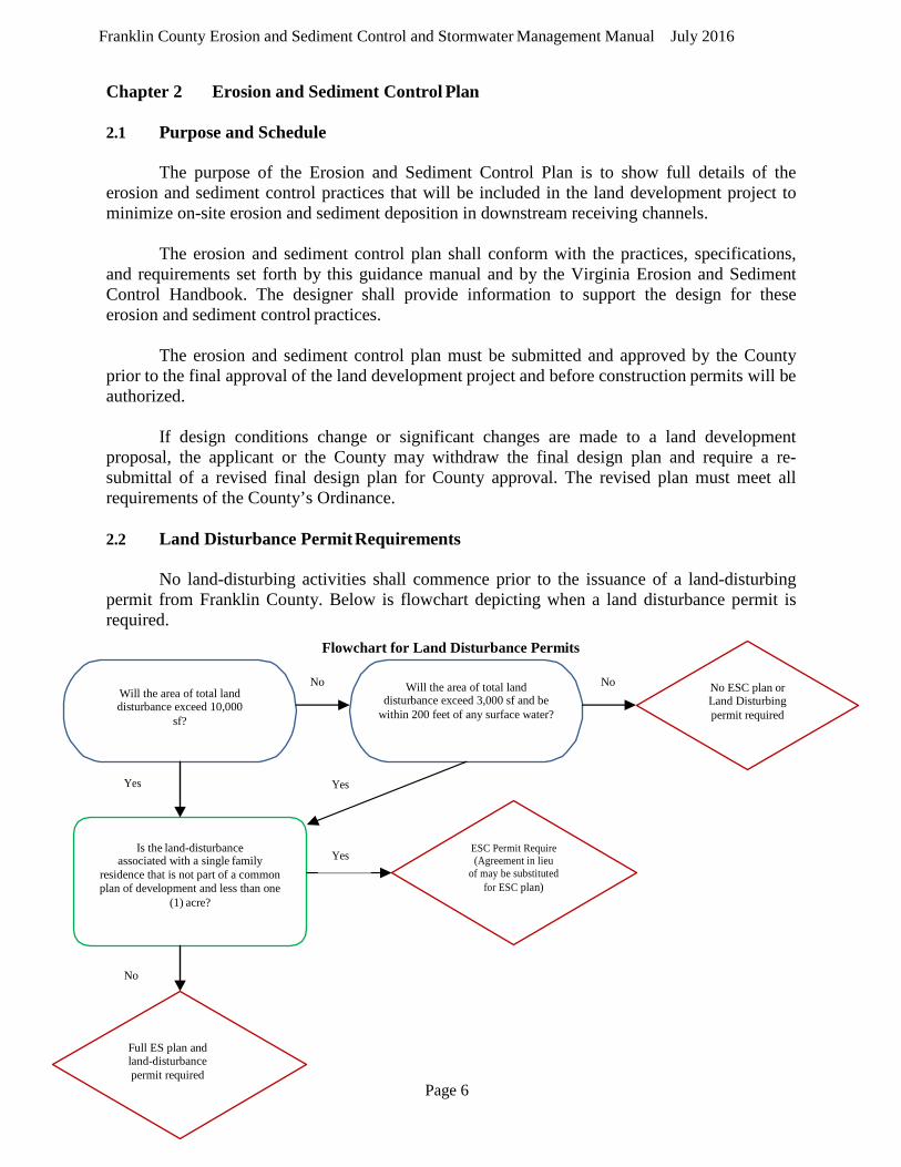
2.2 Land Disturbance Permit Requirements
No land-disturbing activities shall commence prior to the issuance of a land-disturbing
permit from Franklin County. Below is flowchart depicting when a land disturbance permit is required.
Flowchart for Land Disturbance Permits
No Will the area of total land disturbance exceed 10,000
sf?
Will the area of total land disturbance exceed 3,000 sf and be
within 200 feet of any surface water?
No No ESC plan or Land Disturbing permit required
Yes Yes
Is the land-disturbance associated with a single family
residence that is not part of a common plan of development and less than one
(1) acre?
Yes ESC Permit Require (Agreement in lieu
of may be substituted for ESC plan)
No
Full ES plan and land-disturbance permit required
Page 7
Franklin County Erosion and Sediment Control and Stormwater Management Manual July 2016
2.3.1 Plan Requirements
The erosion and sediment control plan should show all proposed erosion and sediment control features required to meet the County Code and the most recent editions of the Virginia Erosion and Sediment Control Law and Virginia Erosion and Sediment Control Handbook.
To accomplish this goal all information required by the checklists in Appendix B shall be included in the erosion and sediment control plan, if applicable. Completed checklists shall be included with all plan submissions to Franklin County. Submission of additional information is encouraged, and may be required by Franklin County, as needed to support the validity of the erosion and sediment control plan. 2.3.2 Agreement in Lieu of a Plan Requirements
An agreement in lieu of a plan may be obtained from the construction of a single family residence when the total land disturbance is less than five (5) acres. The forms may be found at the following link: http://www.franklincountyva.gov/planning-erosion-stormwater
Land disturbance totaling for one (1) to less than five (5) acres will also require an
agreement in lieu of a stormwater management plan. You must complete the forms located at: http://www.franklincountyva.gov/images/building-inspections/forms/Fill%20in%20PDF%20ES%20Application%20updated%2071415.pdf Please bring these completed forms to the Development Services for review and approval.

Page 8
Franklin County Erosion and Sediment Control and Stormwater Management Manual July 2016
Chapter 3 Stormwater Management Plan
3.1 Purpose and Schedule
The purpose of the stormwater management design plan is to mimic the pre-development hydrology, reduce water quantity, if necessary, and enhance the water quality, in full details of the stormwater management practices that will be included in the land development project to creeks, rivers, lakes, and property downstream.
The stormwater management design must conform to the practices, specifications, and requirements set forth
by this design manual and by the Virginia Stormwater Management Handbook, and other relevant documents listed in Chapter 7 of the Franklin County, Virginia Code of Ordinances. The designer shall provide information to support the design for these stormwater management practices.
The stormwater management final design plan must be submitted and approved by Franklin County prior to
the final approval of the land development project and before construction permits will be authorized.
The stormwater management design plan must be appropriately sealed and signed by a licensed registrant, registered in the Commonwealth of Virginia, in adherence to all minimum standards and requirements pertaining to the practice of that profession, certifying that the plan has been prepared with good engineering practice and meets all submittal requirements outlined in Franklin County’s checklists.
If design conditions change or significant changes are made to a land development proposal, the applicant or
the County may withdraw the final design plan and require a re- submittal of a revised final design plan for Franklin County approval. The revised plan must meet all requirements of Franklin County and the Virginia Stormwater Management Handbook.
3.1.1 Plan Requirements
The stormwater management design plan shall show all proposed stormwater management structures
and practices, and that these structures will achieve the required water quantity and water quality management required by the County’s Ordinance.
To accomplish this goal, all information required by the checklists in Appendix B shall be included in the final design plan, if applicable. Completed checklists shall be included with all plan submissions to Franklin County. Submission of additional information is encouraged, and may be required by Franklin County, as needed to support the validity of the stormwater management plan. The plan review process is outlined in the flowchart provided in Appendix C.
3.1.2 Agreement in Lieu of a Stormwater Management Plan Requirements
An agreement in lieu of a stormwater management plan may be obtained for the construction of a single family residence when the total land disturbance is from one (1) to less than five (5) acres. The forms may be found at: http://www.franklincountyva.gov/planning-erosion-stormwater
You must fill out and copy all four (4) documents: • Single Family Agreement in Lieu of a Stormwater Management Plan • Single Family Detached Residential Structure Coverage letter • Single Family Stormwater Pollution Prevention Plan • 2014 General Permit for Discharges of Stormwater from Construction Activities

Page 9
Franklin County Erosion and Sediment Control and Stormwater Management Manual July 2016
3.2 When a Storm Water permit is required: If your property is part of a Common Planned Unit Development (Subdivision) which was approved after July 1, 2004.
Where to find the Storm Water application information: www.franklincountyva.gov Under Quick links select: Planning Go to Erosion/Stormwater STORMWATERMANAGEMENT Erosion and Stormwater Management Manual. Four components are necessary for those who need an "Agreement in lieu of a Stormwater Plan". This is specifically for single family home construction in Franklin County. The components are: Single Family Agreement in Lieu of a Stormwater Management Plan Single Family Detached Residential Structure Coverage letter Single Family Stormwater Pollution Prevention Plan 2014 General Permit for Discharges of Stormwater from Construction Activities
The Single Family Agreement is an application which must be completed and printed.
The Single Family Detached Residential Structure Coverage Letter must be printed. (nothing to complete)
The Single Family Storm Water Pollution Prevention Plan must be completed on a computer and printed or you may print out and do by hand. The 2014 General Permit is part of the application that must be printed. (nothing to complete) These four (4) components must be submitted in completion with the review fee prior to the erosion and sediment control and storm water review. Erosion and Sediment Agreement in Lieu of Application: This application must also be completed with a drawing and narrative of the project site as well. If a Storm Water permit is required, it does not matter how much land disturbance you are doing you must apply for the erosion permit at the same time. 3.3 VSMP Permit Requirements
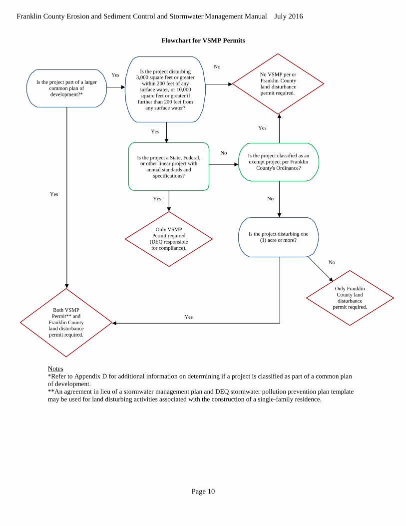
As outlined in Section 1.8 of this Manual, a Virginia Stormwater Management Program (VSMP) permit may
be required in addition to the Franklin County land disturbance permit based on the type of project and total area to be disturbed with the project. A flowchart depicting when a Virginia Stormwater Management Program (VSMP) permit must be obtained from the Virginia Department of Environmental Quality is provided below.
Page 10
Franklin County Erosion and Sediment Control and Stormwater Management Manual July 2016
Flowchart for VSMP Permits
Is the project part of a larger common plan of development?*
Yes No
Is the project disturbing 3,000 square feet or greater
within 200 feet of any surface water, or 10,000 square feet or greater if
further than 200 feet from any surface water?
No VSMP per or Franklin County land disturbance permit required.
Yes Yes
No Is the project a State, Federal,
or other linear project with annual standards and
specifications?
Is the project classified as an exempt project per Franklin
County's Ordinance?
Yes
Yes No
Only VSMP Permit required
(DEQ responsible for compliance).
Is the project disturbing one
(1) acre or more?
No
Both VSMP Permit** and
Franklin County land disturbance permit required.
Yes
Only Franklin County land disturbance
permit required.
Notes *Refer to Appendix D for additional information on determining if a project is classified as part of a common plan of development. **An agreement in lieu of a stormwater management plan and DEQ stormwater pollution prevention plan template may be used for land disturbing activities associated with the construction of a single-family residence.
Page 11
Franklin County Erosion and Sediment Control and Stormwater Management Manual July 2016
Chapter 4 Stormwater Design 4.1 Time Limits
Land disturbing activities that obtain an initial state permit or commence land disturbance
prior to July 1, 2014, shall be conducted in accordance with the technical criteria outlined in Part II C of the Regulations (9VAC25-870-93 et. seq.). Such activities shall remain subject to the Part II C technical criteria of the Regulations for two additional state permit cycles. Any portions of the project not under construction by such time shall become subject to any new technical criteria adopted by the Board.
Land disturbing activities that obtain an initial state permit on or after July 1, 2014 shall
be conducted in accordance with the technical criteria outlined in Part II B of the Regulations (9VAC25-870-62 et seq.). Such activities shall remain subject to the Part II B technical criteria for two additional state permit cycles. Any portions of the project not under construction by such time shall become subject to any new technical criteria adopted by the Board.
4.2 Grandfathering
Land disturbing activities shall be considered grandfathered by the County if they meet
the requirements of the following sections. A flowchart for grandfathering of new projects is provided in Appendix E.
4.2.1 General Requirements
Land disturbing activities shall be considered grandfathered by the County and
shall be subject to the technical criteria outlined in Part II C of the Regulations (9VAC25- 870-93 et seq.) provided:
1. A proffered or conditional zoning plan, zoning with a plan of
development, preliminary or final subdivision plat, preliminary or final site plan, or any document determined by the County as being equivalent thereto, which meets the following conditions: a. was approved by the County prior to July 1, 2012, b. provided a layout as defined in 9VAC25-870-10, c. complies with the Part II C technical criteria of 9VAC25-870-93 et
seq., and d. has not been subsequently modified or amended in a manner
resulting in an increase in the amount of phosphorus leaving each point of discharge and there is no net increase in the volume or rate of runoff;
2. A state permit has not been issued prior to July 1, 2014; and 3. Land disturbance did not commence prior to July 1, 2014.
Page 12
Franklin County Erosion and Sediment Control and Stormwater Management Manual July 2016
4.2.2 Local, State, and Federal Projects
Land disturbing activities for local, state, and federal projects shall be considered grandfathered by the County and shall be subject to the technical criteria outlined in Part II C of the Regulations (9VAC25-870-93 et seq.) provided:
1. There has been an obligation of local, state, or federal funding, in whole or in part, prior to July 1, 2012, or the County has approved a stormwater management plan prior to July 1, 2012;
2. A state permit has not been issued prior to July 1, 2014; and 3. Land disturbance did not commence prior to July 1, 2014.
4.2.3 Time Limits
Land disturbing activities grandfathered under subsections 4.2.1 and 4.2.2 shall
remain subject to the technical criteria outlined in Part II C of the Regulations for one additional permit cycle. Any portions of the project not under construction at this time shall become subject to any new technical requirements adopted by the Board.
4.2.4 Governmental Bonding or Public Debt Finance Projects
In cases where governmental bonding or public debt financing has been issued for
a project prior to July 1, 2012, such project shall be subject to the technical requirements Part II C of the Regulations (9VAC25-870-93 et seq.) , as adopted by the County.
4.2.5 Exceptions
The County may grant exceptions to the technical requirements of Part II B
(9VAC25-870-62 et seq.) or Part II C (9VAC25-870-93 et seq.) of the Regulations, provided the following conditions are met:
1. The exception is the minimum necessary to afford relief, 2. Reasonable and appropriate conditions are imposed so that the intent of
the Act, the Regulations, and this Ordinance are preserved, 3. Granting the exception will not confer any special privileges that are
denied in other similar circumstances, and 4. Exception requests are not based upon conditions or circumstances that are
self-imposed or self-created. Economic hardship alone is not sufficient reason to grant an exception.
Exceptions to the requirement that the land disturbing activity obtain the required
VSMP authority permit shall not be given by the Administrator, nor shall the Administrator approve the use of a BMP not found on the Virginia Stormwater BMP Clearinghouse Website.
Exceptions to requirements for phosphorus reductions shall not be allowed unless
offsite options otherwise permitted pursuant to 9VAC25-870-69 have been considered and found to not be available.
Page 13
Franklin County Erosion and Sediment Control and Stormwater Management Manual July 2016
Chapter 5 Stormwater Design and Specifications for New Projects
As a part of the Stormwater Management Final Design Plan for each site development project, a stormwater management system must be designed and certified by a licensed professional engineer. The stormwater management system must be adequately sized and designed to meet the water quantity and water quality standards established by the County’s ordinance and any federal, state, and local regulatory requirements.
The purpose of this section of the Design Manual is to provide guidance in the design
standards that are acceptable to the County for stormwater management sizing, design, and specifications for all projects which are not classified as grandfathered or exempt per Chapter 4. Where applicable, the Virginia Stormwater Management Handbook and other published documents and standards will be referenced.
5.1 General Requirements
When designing stormwater management systems, to include channels, culverts, inlets,
stormwater pipe, outfalls, retention and detention ponds, BMPs, and any other stormwater structure, the following requirements apply:
• The method or methods of drainage shall be consistent with the approved
stormwater management concept plan.
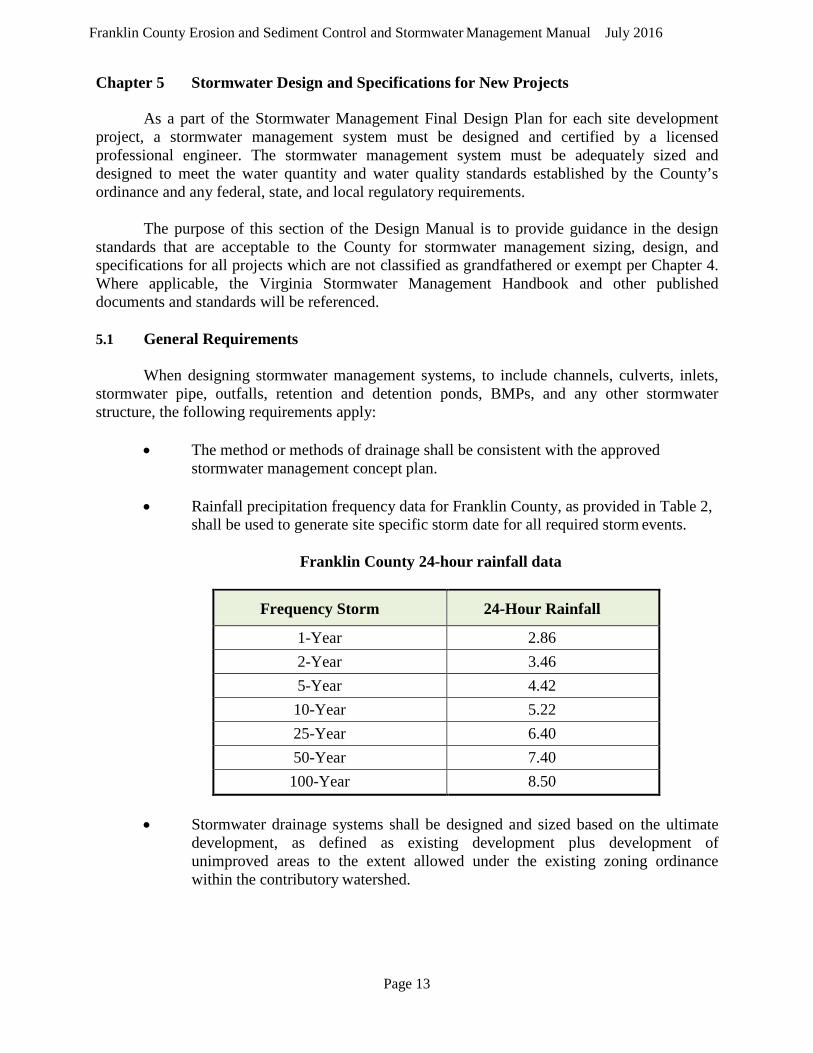
• Rainfall precipitation frequency data for Franklin County, as provided in Table 2, shall be used to generate site specific storm date for all required storm events.
Franklin County 24-hour rainfall data
Frequency Storm 24-Hour Rainfall
1-Year 2.86 2-Year 3.46 5-Year 4.42 10-Year 5.22 25-Year 6.40 50-Year 7.40 100-Year 8.50
• Stormwater drainage systems shall be designed and sized based on the ultimate development, as defined as existing development plus development of unimproved areas to the extent allowed under the existing zoning ordinance within the contributory watershed.
Page 14
Franklin County Erosion and Sediment Control and Stormwater Management Manual July 2016
• Stormwater drainage systems shall be designed to carry both onsite and offsite surface waters, where applicable.
• Stormwater drainage system shall include an adequate and safe overland path
should the drainage system not be fully operational due to blockage.
• Stormwater management detention or retention ponds should not be constructed within a Federal Emergency Management Agency (FEMA) designated 100-year flood plain. If unavoidable, the construction will be in compliance with all applicable regulations under the National Flood Insurance Program, 44 CFR Part 59.
• Ponds, wetlands, and other BMP practices should be designed to provide adequate
drainage controls to minimize long-term ponding that creates habitats for mosquitoes.
• All stormwater management facilities and modifications to channels must comply
with all applicable laws and regulations, and evidence of approval of all required permits will be required prior to approval of construction.
• All stormwater management and drainage structures will meet all erosion and
sediment control requirements, and will be designed to incorporate all required public safety measures as required by the Virginia Erosion and Sediment Control Regulations.
• Stormwater management and drainage systems shall show easement requirements
as specified in Chapter 9 of this Manual. 5.2 Stormwater Quality
Franklin County’s Stormwater Management Program requires that land disturbing
activities control the discharge of stormwater pollutants in order to protect the quality of state waters.
5.2.1 General Requirements
For new developments, the total phosphorus load shall not exceed 0.41 pounds
per acre per year, as calculated pursuant to 9VAC25-870-65.
For development on prior developed lands, the following requirements shall be met:
1. For land-disturbing activities disturbing greater than or equal to one acre that result in no net increase in impervious cover from the predevelopment condition, the total phosphorus load shall be reduced at least 20% below the predevelopment total phosphorus load.

Page 15
Franklin County Erosion and Sediment Control and Stormwater Management Manual July 2016
2. For land-disturbing activities disturbing less than one acre that result in no net increase in impervious cover from the predevelopment condition, the total phosphorus load shall be reduced at least 10% below the predevelopment total phosphorus load.
3. For land-disturbing activities that result in a net increase in impervious
cover over the predevelopment condition, the design criteria for new development shall be applied to the increased impervious area. Depending on the area of disturbance, the criteria of Items 1 or 2 above, shall be applied to the remainder of the site.
4. In lieu of Item 3, the total phosphorus load of a linear development project
occurring on prior developed lands shall be reduced 20% below the predevelopment total phosphorus load.
5. The total phosphorus load shall not be required to be reduced to below the
applicable standard for new development unless a more stringent standard has been established by a local stormwater management program.
5.2.2 Water Quality Computations
The Stormwater Management Final Design Plan must include engineering
computations verifying that the stormwater management plan satisfactorily meets the stormwater runoff quality requirements. The Virginia Runoff Reduction Method or another equivalent methodology that is approved by the State Water Control Board shall be used to demonstrate compliance with the water quality design criteria set forth in Section 5.2.1. Copies of the Runoff Reduction Method Worksheets are provided in Appendix F.
The BMPs listed below may be used to effectively reduce the phosphorus load
and runoff volume in accordance with the Virginia Runoff Reduction Method. Other approved BMPs listed in the Virginia Stormwater BMP Clearinghouse may also be used.
• Vegetated Rooftop • Rooftop Disconnection • Rainwater Harvesting • Soil Amendments • Permeable Pavement • Grass Channel • Bioretention • Infiltration • Dry Swale • Wet Swale • Sheet Flow to Filter/Open Space • Extended Detention Pond

Page 16
Franklin County Erosion and Sediment Control and Stormwater Management Manual July 2016
• Filtering Practice • Constructed Wetland • Wet Pond
BMPs differing from those listed above shall be reviewed and approved by the Director
of the Department of Environmental Quality or designee in accordance with the procedures established by the BMP Clearinghouse Committee and approved by the State Water Control Board.
Where a site drains to more than one hydrologic unit code (HUC), the pollutant load
reduction requirements shall be applied independently within each HUC unless reductions are achieved with a comprehensive watershed stormwater management plan.
Offsite alternatives where allowed in accordance with the Virginia Stormwater
Management Regulations may be used to meet the requirements of Section 5.2.1. 5.3 Stormwater Quantity
Site development projects shall protect downstream properties and waterways from
damages due to localized flooding caused by increases in volume and velocity. Compliance with this section shall be determined to satisfy the requirements of 9VAC25-840-40.19 (Minimum Standard 19 of the Virginia Erosion and Sediment Control Regulations.
5.3.1 Channel Protection
Concentrated stormwater flow shall be released into a stormwater conveyance
system and shall meet criteria 1, 2, or 3 of this subsection, where applicable, from the point of discharge to a point of the limits of analysis in subsection 4.
1. When stormwater is discharged to a manmade stormwater conveyance
system, following the land disturbing activity, either:
a. The manmade stormwater conveyance system shall convey the post-development peak flow from the 2-year, 24-hour storm event without causing erosion of the system. Detention of stormwater or downstream improvements may be incorporated into the design to meet this criteria; or
b. The peak discharge requirements for concentrated stormwater flow to natural stormwater conveyance systems in subsection 3 shall be met.
2. When stormwater is discharged to a restored stormwater system, which is
defined as a stormwater conveyance system that has been designed and constructed using natural channel design concepts, using natural design concepts, either
Page 17
Franklin County Erosion and Sediment Control and Stormwater Management Manual July 2016
a. The development shall be consistent, in combination with other stormwater runoff, with the design parameters of the restored stormwater conveyance system that is functioning in accordance with the design objectives; or
b. The peak discharge requirements for concentrated stormwater flow to natural stormwater conveyance systems in subsection 3 shall be met.
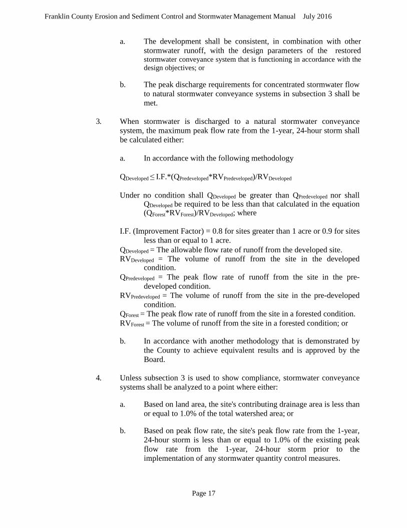
3. When stormwater is discharged to a natural stormwater conveyance
system, the maximum peak flow rate from the 1-year, 24-hour storm shall be calculated either:
a. In accordance with the following methodology
QDeveloped ≤ I.F.*(QPredeveloped*RVPredeveloped)/RVDeveloped
Under no condition shall QDeveloped be greater than QPredeveloped nor shall QDeveloped be required to be less than that calculated in the equation (QForest*RVForest)/RVDeveloped; where
I.F. (Improvement Factor) = 0.8 for sites greater than 1 acre or 0.9 for sites
less than or equal to 1 acre. QDeveloped = The allowable flow rate of runoff from the developed site. RVDeveloped = The volume of runoff from the site in the developed
condition. QPredeveloped = The peak flow rate of runoff from the site in the pre-
developed condition. RVPredeveloped = The volume of runoff from the site in the pre-developed
condition. QForest = The peak flow rate of runoff from the site in a forested condition. RVForest = The volume of runoff from the site in a forested condition; or
b. In accordance with another methodology that is demonstrated by
the County to achieve equivalent results and is approved by the Board.
4. Unless subsection 3 is used to show compliance, stormwater conveyance
systems shall be analyzed to a point where either:
a. Based on land area, the site's contributing drainage area is less than or equal to 1.0% of the total watershed area; or
b. Based on peak flow rate, the site's peak flow rate from the 1-year, 24-hour storm is less than or equal to 1.0% of the existing peak flow rate from the 1-year, 24-hour storm prior to the implementation of any stormwater quantity control measures.

Page 18
Franklin County Erosion and Sediment Control and Stormwater Management Manual July 2016
5.3.2 Flood Protection
Concentrated stormwater flow shall be released into a stormwater conveyance system and shall meet one of the following criteria as demonstrated by use of acceptable hydrologic and hydraulic methodologies:
1. When discharging concentrated stormwater flow to existing stormwater
conveyance systems that currently do not experience localized flooding during the 10-year, 24-hour storm, the post-development peak flow rate from the 10-year, 24-hour storm event must be confined within the stormwater conveyance channel. Detention of stormwater or downstream improvements may be incorporated into the approved design, at the discretion of the County.
2. When discharging concentrated stormwater flow to existing stormwater
conveyance systems that currently experience localized flooding during the 10-year, 24-hour storm, one of the following criteria must be met:
a. The post-development peak flow rate must be confined within the stormwater conveyance system from the 10-year, 24-hour storm event to avoid localized flooding. Detention of stormwater or downstream improvements may be incorporated into the approved design, at the discretion of the County; or
b. The post-development peak flow rate for the 10-year, 24-hour storm event is released such that it is less than the predevelopment peak flow rate from the 10-year, 24-hour storm event.
3. Unless 2b is used to comply with this section, all existing stormwater conveyance systems shall be analyzed for compliance to a point where:
a. The site's contributing drainage area is less than or equal to 1.0% of the total watershed area draining to the point of analysis in the downstream stormwater conveyance system;
b. Based on peak flow rate, the site's peak flow rate from the 10-year, 24-hour storm event is less than or equal to 1.0% of the existing peak flow rate from the 10-year, 24-hour storm event prior to implementation of any stormwater quantity control measures; or
c. The stormwater conveyance system enters a mapped 100-year floodplain or other flood-prone area, adopted by Franklin County.
5.3.3 Overland (Sheet) Flow
Increased volumes of sheet flow resulting from pervious or disconnected
impervious areas, or from physical spreading of concentrated flow through the use of level spreaders, must be evaluated for potential impacts on downstream properties. Increased volumes of sheet flow that will cause or contribute to erosion, sedimentation,
Page 19
Franklin County Erosion and Sediment Control and Stormwater Management Manual July 2016
or increased flooding shall be diverted to a stormwater management facility or conveyance system that will convey the runoff without causing downstream impacts. If all runoff from the site is sheet flow and the aforementioned conditions are met, no further water quantity controls are required.
Overland (sheet) flow shall be limited to 200 feet. Shallow concentrated flow
shall be limited to 1,000 feet.
5.3.4 Hydrologic Assumptions
When computing predevelopment runoff, all pervious lands on the site shall be assumed to be in good hydrologic condition in accordance with the US Department of Agriculture's Natural Resources Conservation Service (NRCS) standards, regardless of conditions existing at the time of development.
Runoff characteristics and site hydrology shall be verified by site inspections,
topographic surveys, available soil mapping or studies, and calculations consistent with good engineering practices. Guidance provided in the Virginia Stormwater Management Handbook and by the Virginia Stormwater BMP Clearinghouse shall be considered appropriated practices.
5.4 Offsite Compliance Options
If design of onsite BMPs is not feasible, the applicant may request to use offsite controls
with approval from the County. Documentation demonstrating compliance with 9VAC25-870- 69 must be submitted and approved by the County with the stormwater management plan.
Page 20
Franklin County Erosion and Sediment Control and Stormwater Management Manual July 2016
Chapter 6 Stormwater Design and Specifications for Grandfather Projects
As a part of the Stormwater Management Final Design Plan for each site development
project, a stormwater management system must be designed and certified by a licensed registrant. The stormwater management system must be adequately sized and designed to meet the water quantity and water quality standards established by the County’s and any other federal, state, or local regulatory requirements.
The purpose of this section of the Design Manual is to provide guidance in the design
standards that are acceptable to the County for stormwater management sizing, design, and specifications. Where applicable, the Virginia Stormwater Management Handbook and other published documents and standards will be referenced.
6.1 General Requirements
When designing stormwater management systems, to include channels, culverts, inlets,
stormwater pipe, outfalls, retention and detention ponds, BMPs, and any other stormwater structure, the following requirements apply:
• The method or methods of drainage shall be consistent with the approved
stormwater management concept plan.
• Stormwater drainage systems shall be designed to carry both onsite and offsite surface waters, where applicable.
• Stormwater drainage system shall include an adequate and safe overland path
should the drainage system not be fully operational due to blockage.
• Stormwater management detention or retention ponds should not be constructed within a Federal Emergency Management Agency (FEMA) designated 100-year flood plain. If unavoidable, the construction will be in compliance with all applicable regulations under the National Flood Insurance Program, 44 CFR Part 59.
• Ponds, wetlands, and other BMP practices should be designed to provide adequate
drainage controls to minimize long-term ponding that creates habitats for mosquitoes.
• All stormwater management facilities and modifications to channels must comply
with all applicable laws and regulations, and evidence of approval of all required permits will be required prior to approval of construction.
• All stormwater management and drainage structures will meet all erosion and
sediment control requirements, and will be designed to incorporate all required public safety measures as required by the Virginia Erosion and Sediment Control Regulations.
Page 21
Franklin County Erosion and Sediment Control and Stormwater Management Manual July 2016
• Stormwater management and drainage systems shall show easement requirements as specified in Chapter 9 of this Manual.
6.2 Stormwater Quantity Control/Hydrology
Franklin County’s Stormwater Management Program requires that all site development
projects protect downstream properties and waterways from damages due to localized flooding caused by increases in volume and velocity.
6.2.1 General Requirements
Eliminating all flooding events downstream of site development projects would be
impossible. Each land disturbing activity must be designed to prevent runoff negatively impacting properties and waterways downstream by complying with MS-19 of the Virginia Erosion and Sediment Control Law.
When analyzing the storm routing information, and providing stormwater
management design, these criteria shall be considered individually. Linear land development projects, such as utility lines, highways, and rail lines are not required to control post-development stormwater runoff, except in accordance with any watershed or regional stormwater management plans.
When evaluating stormwater quantity and erosion impacts due to land
development projects, all runoff shall be considered including runoff from the balance of the watershed upstream which contributes to the point of discharge from the project site.
6.2.2 Hydrologic Computations
The Stormwater Management Final Design Plan must include engineering
computations of hydrologic conditions verifying that the stormwater management plan satisfactorily meets the stormwater runoff quantity requirements. Franklin County rainfall precipitation frequency data, as provided in Table 2 of this manual, should be used to generate site specific storm date for all required storm events.
There are several documented computation methods for determining hydrologic
runoff rates. The two most commonly used methods are the Rational Method and the SCS TR-55 Method. The Rational Method, is the more simplistic method, and is best used for determining peak flow discharges from small drainage areas (less than 200 acres). The SCS TR-55 Method utilizes a 24-hour rainfall distribution graph, with nested rainfall intensities, which is appropriate for determining total runoff volumes as well as peak discharges for a range of drainage area sizes.
Procedures for both the Rational Method and the SCS TR-55 Method are
presented in detail in Chapter 4 and associated appendices of the Virginia Stormwater Management Handbook, 1999 edition or as amended. These procedures should be used

Page 22
Franklin County Erosion and Sediment Control and Stormwater Management Manual July 2016
when presenting the hydrologic computations in the Stormwater Management Final Design Plan. The Final Design Plan should verify that the post-development runoff rates are in compliance with the requirements of the County’s Stormwater Management Program.
6.2.2.1 Rational Method
The Rational Method will not be an acceptable method to compute peak hydrologic flows for drainage areas in excess of 200 acres. When using the Rational Method to compute peak hydrologic flows developed from storm return frequencies above a 10-year event, the Rational Formula will be adjusted to the following equation:
Q = C Cf I A
where Cf is listed in Table 4-4, Rational Equation Frequency Factors, in the Virginia Stormwater Management Handbook. When using this formula, C x Cf cannot exceed 1.0. When determining rainfall intensity, the VDOT BDE values shall be used.
6.2.2.2 TR-55 Method Notes
When analyzing existing, unimproved site conditions to determine the pre- development runoff rate, the hydrologic condition will be considered to be in good condition. When determining the 24-hour rainfall depth table (Virginia Stormwater Management Handbook, 1999 edition, Appendix 4B), Franklin County shall be used.
6.2.3 Stormwater BMPs
Stormwater quality requirements can be met through the use of performance-
based water quality criteria or technology-based water quality criteria. Performance- based water quality criteria requires the installation of a Best Management Practice (BMP) or a combination of BMPs to effectively reduce the pollutant loading in the stormwater runoff from a land development project, which required the calculation of the expected pollutant loading, design and implementation of a BMP or combination of BMPs, and the calculation of the pollutant removal based on the BMPs.
Technology-based water quality criteria requires an appropriate BMP selection
based on the post-development impervious cover, which assumes that for a certain percent impervious area, there are a select number of best available technologies to remove the pollutant loads.
For BMP selection and removal efficiency calculations to determine the
compliance with the water quality criteria, the target water quality pollutant is phosphorus; however, other pollutants may be targeted for removal efficiency
Page 23
Franklin County Erosion and Sediment Control and Stormwater Management Manual July 2016
calculations, if determined to be more appropriate for the existing land conditions and the intended land use. Other pollutants may include suspended solids, bacteria (coliforms), hydrocarbons, trace metals, BOD or dissolved oxygen, and temperature.
The location of all proposed BMPs must be shown in the Stormwater
Management Final Design Plan. The Plan should show the drainage areas for each BMP, and details and sections necessary to evaluate the proper design of the BMP in accordance with the requirements of the Virginia Stormwater Management Handbook, 1999 edition, as amended. Calculations should be submitted with the Final Design Plan to support the BMP selection, sizing, and pollutant removal.
6.2.4 Performance-Based Water Quality Criteria Design
For performance-based water quality design criteria, BMPs will be designed and
constructed as a part of land development projects to reduce the non-point source pollutant loading in the stormwater runoff. The calculated post-development non-point source pollutant runoff load will be compared to the calculated pre-development load based on the average land cover or existing site conditions. BMPs will be located, designed, and maintained to achieve target pollutant removal efficiencies. The following performance criteria apply to land development projects, defining the requirements of the BMPs:
• Situation 1 – Existing percent impervious (Iexisting) is less than or equal
to the average land cover condition (defined by the County’s Stormwater Management Program as 16%), and the post-development percent impervious (Ipost) is less the average land cover condition (16%).
Pollutant Reduction Required – No reduction is required.
• Situation 2 – Existing percent impervious (Iexisting) is less than or equal
to the average land cover condition (16%) and the post-development percent impervious (Ipost) is greater than the average land cover condition (16%)
Pollutant Reduction Required – Pollutant discharge after development will not exceed the existing pollutant discharge based on the average land cover condition.
• Situation 3 – Existing percent impervious (Iexisting) is greater than the
average land cover condition (16%).
Pollutant Reduction Required – Pollutant discharge after development will not exceed the pollutant discharge based on existing conditions less ten percent (10%), or the pollutant discharge based on the average land cover condition, whichever is greater.
Page 24
Franklin County Erosion and Sediment Control and Stormwater Management Manual July 2016
• Situation 4 – Existing percent impervious (Iexisting) is served by an existing stormwater management BMP or BMPs that addresses water quality.
Pollutant Reduction Required – The existing BMP will be shown to have been designed and constructed in accordance with approved design standards and specifications and to be in proper functioning condition.
Worksheets for each of these scenarios are provided in Appendix 5D of
the Virginia Stormwater Management Handbook, 1999 edition. Completed worksheets shall be submitted with the Final Design Plan.
6.2.4.1 Calculations
Based on the pollutant reduction required by the land development project,
calculations must be developed showing the pre-development pollutant loading, BMP selection and pollutant removal rate, and post-development pollutant loading. The accepted calculation procedure is the Simple Method, the equation as follows:
L = [0.05 + (0.009 x I)] x A x 2.28
L = relative total phosphorus load (pounds per year) I = percent impervious cover (whole numbers) A = applicable area (acres)
The performance-based criteria require that the pre- and post-development
condition pollutant load be calculated to determine the relative increase. The calculation procedure for the Simple Method is detailed in Section 5-10.2 of the Virginia Stormwater Management Handbook, 1999 edition, as amended. Calculation worksheets are included in Appendix 5D of the Virginia Stormwater Management Handbook, 1999 edition to help guide the BMP selection calculations.
6.2.4.2 BMP Removal Efficiency
The following table summarizes water quality BMPs that may be used to
meet the water quality requirements set forth by the County’s Stormwater Management Program. In order to qualify for phosphorus removal efficiency credits, the BMP must be designed and constructed in accordance with Virginia Stormwater Management Manual, 1999 edition or as amended.

Page 25
Franklin County Erosion and Sediment Control and Stormwater Management Manual July 2016
Stormwater BMP Standards*
Water Quality BMP Target Phosphorus Removal Efficiency
Percent Impervious Cover
Vegetated filter strip Grassed swale
10% 15% 16-21%
Constructed wetlands 30% Extended detention (2x WQV) 35% 22-37% Retention basin I (3x WQV) 40% Bioretention basin 50% Bioretention filter 50% Extended detention-enhanced 50% 38-66% Retention basin II (4x WQV) 50% Infiltration (1x WQV) 50% Sand Filter 65% Infiltration (2x WQV) Retention Basin III (4x WQV) with aquatic bench
65%
65% 67-100%
* Innovative or alternate BMPs not included in this table, including BMPs which target appropriate nonpoint source pollution other than phosphorus (such as petroleum, hydrocarbons, sediment, etc.) may be allowed at the discretion of Franklin County.
BMP calculations using the standard worksheets provided in Appendix 5D of the
Virginia Stormwater Management Handbook, 1999 edition, shall use removal efficiencies from Table 3, when calculating the L removed.
6.2.5 Technology-Based Water Quality Criteria Design
When utilizing technology-based water quality criteria design, post-development
stormwater runoff will be treated by an appropriate BMP for the post-development percent impervious cover. Once the post-development impervious cover has been defined, a corresponding BMP will be selected using the percent impervious cover ranges in Table 2. The selected BMP will then be located, designed, constructed, and maintained to perform at the removal efficiencies specified. Design standards and specifications for the selected BMP will be consistent with those provided in the Virginia Stormwater Management Handbook, 1999 edition, as amended.

Page 26
Franklin County Erosion and Sediment Control and Stormwater Management Manual July 2016
Chapter 7 Stormwater Design and Specifications for All Projects
7.1 Stormwater Channels
A stormwater conveyance channel is a permanent, designed waterway, shaped, sized, and
lined with appropriate vegetation or structural material used to safely convey stormwater runoff within or away from a developing area. Channels are designed to convey concentrated surface runoff to a receiving channel without damage from erosion. This section will provide guidance for the design of open channels, including channel capacity, slopes, and linings.
The location of all proposed stormwater channels should be shown in the Stormwater
Management Final Design Plan. The Plan should also show cross sections of the proposed channels at key locations, such as changes in slope or shape, and at 25 feet, 50 feet, etc. Calculations should be submitted with the Preliminary Design Plan to verify that each proposed stormwater channel meets the requirements of this section.
7.1.1 Channel Design Requirements
The design of a new channel will be based on the volume and velocity of peak
runoff flow expected in the channel. Unless otherwise noted in this Manual, the design of stormwater channels will be in accordance with Section 3.17 and Chapter 5, Part III, of the Virginia Erosion and Sediment Control Handbook, 1992 edition, as amended.
Any natural channel characteristics will be preserved to the maximum extent
possible. A constructed channel must have sufficient capacity to convey the peak flow from a post-development 10-year storm plus a minimum freeboard of six inches. The maximum side slope of vee, parabolic, or trapezoidal channels will be 2:1.
The design must include outlet protection, to provide energy dissipation and to
prevent scour of the receiving channel. Outlet protection will meet the design requirements set in Section 3.18 of the Virginia Erosion and Sediment Control Handbook, 1992 edition, as amended.
7.1.2 Channel Lining Requirements
Channel linings are used to help stabilize channels, thus preventing erosion and
sedimentation damage. Linings may be classified generally as either rigid (concrete or asphalt), or flexible (stone, rip rap, or vegetated). The channel lining must be resistant to erosion in the velocity from a 2-year storm event. Permissible velocities for grass-lined channels shall not exceed the velocities shown in Table 3.17-A, Virginia Erosion and Sediment Control Handbook, 1992 edition, as amended, for the slopes and lining material listed. If rip rap is used in the channel lining or as an energy dissipater, a geotextile filter fabric must be used to act as a separator and stabilizer between the stone and the earth. Stone design and gradation, and geotextile filter fabric specification will be designed and installed in accordance with the design requirements set in Section 3.18 of the Virginia Erosion and Sediment Control Handbook, 1992 edition, as amended.

Page 27
Franklin County Erosion and Sediment Control and Stormwater Management Manual July 2016
7.2 Stormwater Culverts
Stormwater culverts are short conduits which convey flow in open channels under roads, driveways, embankments, or other structures. The location of all proposed culverts should be shown in the Stormwater Management Design Plan. The Plan should also include details of inlets and outlets, and cross sections which show bedding and cover requirements. Calculations should be submitted with the Design Plan to support the sizing of the culvert, and if necessary the structural integrity.
7.2.1 Culvert Design Requirements
The design of stormwater culverts will be in accordance with Chapter 8, of the
VDOT Drainage Manual, 2008 edition, as amended. No stormwater culvert will be installed less than 15-inches in diameter, with the exception of gutter drains. In selecting the culvert materials, the design professional will consider service life, abrasion and corrosion, and loading requirements. Acceptable materials, dependant on size, location and surface loading, include reinforced concrete pipe (RCP), corrugated metal pipe (CMP), and corrugated polyethylene (PE) pipe.
7.3 Storm Drainage Systems
Where stormwater cannot be conveyed using open channels and culverts, a stormwater
system will be installed to collect and convey stormwater runoff. The location of all proposed inlets, stormwater pipes, manholes and outfalls should be shown in the Stormwater Management Design Plan. The Plan should also show details of inlets and outlets, a profile of the stormwater pipe showing current and proposed grades, manhole locations and all utilities crossed and a cross section which shows bedding and cover requirements for stormwater pipe. Calculations should be submitted with the Design Plan to support the pipe sizes, outfall requirements and, if necessary the structural integrity and buoyancy requirements for pipe and structures.
7.3.1 Curb and Gutter Design Requirements
When required, curb and gutter will be designed and constructed to VDOT Road
and Bridge standards and specifications, latest edition. Minimum pavement cross slope will be two percent (2%) except during the occurrence of superelevation transition. Curb and gutter will be designed and constructed to VDOT Road and Bridge standards and specifications, latest edition.
7.3.2 Stormwater Inlets and Manhole Design
The design and construction of stormwater inlets and manholes will be in
accordance with VDOT Road and Bridge standards and specifications, latest edition, and Chapter 9 of the VDOT Drainage Manual, 2008 edition, as amended. Stormwater inlet types will be selected from the VDOT Road and Bridge standards. Unless approved by the County, curb inlets should be used along road shoulders rather than grate inlets because of their debris handling capabilities. Table 9-1 in the VDOT Drainage Manual, 2008 edition, shall be consulted when developing criteria for inlet design along roadways.
Page 28
Franklin County Erosion and Sediment Control and Stormwater Management Manual July 2016
Curb or grate inlets will be designed and located so that the design storm event does not exceed the curb height minus one inch and does not cause water to pool over more than ½ the travel lane of the road. Drop inlets will be designed and located so that the design storm event does not create standing water greater than four inches deep and no standing water will cause impacts to the surrounding properties.
Inlet manholes will be in accordance with the VDOT Road and Bridge standards
and specifications, latest edition. All inlets will be bicycle safe when used in locations where bicycle traffic may be anticipated. Inlets shall not be located in pedestrian walk paths.
7.3.3 Storm Drain Design
Storm drains should be designed to have adequate capacity to accommodate runoff
that will enter the storm drain system. Storm drains should be sized considering future development which may occur upstream, based on local land use and zoning plans. The design and construction of storm drains and manholes will be in accordance with VDOT Road and Bridge standards and specifications, latest edition, and Chapter 9 of the VDOT Drainage Manual, 2008 edition, as amended.
On large projects, the proposed storm drain system design will be coordinated with
the proposed sequence of construction and traffic plans in order to prevent ponding of stormwater and to maintain an outlet for stormwater throughout the construction of the project. The minimum size for storm drain pipe, except for gutter drains, is 15-inch diameter for circular pipe and the equivalent size for non-circular shapes.
Manholes and junction boxes will be designed in accordance with the VDOT road
and bridge standards and specifications, latest edition. The invert elevation of the outflow pipe from manholes and junction boxes shall be set at least 0.1 feet lower than the lowest inflow pipe invert.
The design of the storm drain system will include a hydraulic grade line analysis
to verify that the hydraulic grade during the critical storm event does not result in a water elevation surcharging from a manhole, junction box, or stormwater inlet.
7.4 Stormwater Facilities
The location of all proposed stormwater management ponds must be shown in the
Stormwater Management Design Plan. The Plan should show the plan view, cross sections showing the design, and outlet design. Calculations should be submitted with the Design Plan to support the sizing, and outfall details.
Page 29
Franklin County Erosion and Sediment Control and Stormwater Management Manual July 2016
7.4.1 Design Requirements
Stormwater detention and retention ponds will protect downstream properties and waterways from damages from localized flooding due to increases in volume, velocity, and peak flow rate. Unless otherwise noted in this Manual, the design and construction of stormwater facilities ponds will be in accordance with the Virginia Stormwater BMP Clearinghouse and the Virginia Stormwater Management Handbook, Volumes I and II, latest edition, as amended. Stormwater detention and retention ponds must meet federal, state, and local dam safety standards and requirements.
7.4.2 Maintenance
The Owners shall maintain stormwater facilities in accordance with the
Maintenance Agreements that are required to be submitted with the Stormwater Management Final Design Plan. The Franklin County Maintenance Agreement may be found in Appendix G of this manual.
The stormwater management maintenance plan should include measures
that will be done to ensure the integrity of the stormwater facility. The Franklin County maintenance and inspection form may be found in Appendix H of this manual.
Page 30
Franklin County Erosion and Sediment Control and Stormwater Management Manual July 2016
Chapter 8 Stormwater Pollution Prevention Plan
8.1 Purpose and Schedule
In accordance with the County’s Stormwater Management Ordinance, a stormwater pollution prevention plan (SWPPP) must be developed, implemented, and updated, as necessary, and must detail the design, installation, implementation, and maintenance of effective pollution prevention measures to minimize the discharge of pollutants.
The SWPPP must conform to the practices, specifications, and requirements set forth by
this design manual, by the Virginia Stormwater Management Regulations (9VAC25-870-49), and by the VSMP general permit Section 9VAC25-880-70, Section II. The SWPPP must be prepared before construction permits will be authorized.
The SWPPP must be amended by the operator whenever there is a change in design,
construction, operation, or maintenance that has a significant effect on the discharge of pollutants to downstream waters which is not addressed by the existing SWPPP.
The SWPPP must be maintained by the operator at a central location on-site. If an on-
site location is not available, notice of the SWPPPs location must be posted at the main entrance of the construction site. The Operator shall make the SWPPP available for public review, either electronically or in hard copy.
8.2 Plan Contents and Requirements
At a minimum, the SWPPP must include the following:
• Approved erosion and sediment control plan; • Approved stormwater management plan; • Pollution Prevention Plan for regulated land disturbing activities; and • Description of any additional control measures necessary to address a TMDL.
The Pollution Prevention Plan must detail the design, installation, and maintenance of
effective pollution prevention measures in order to minimize the discharge of pollutants. At a minimum, the measures must be designed, installed, implemented, and maintained to:
• Minimize the discharge of pollutants from equipment and vehicle washing, wheel
wash water, and other wash waters. Wash waters must be treated in a sediment basin or alternative control that provides equivalent or better treatment prior to discharge.
• Minimize the exposure of building materials, building products, construction wastes, trash, landscape materials, fertilizers, pesticides, herbicides, detergents, sanitary waste, and other materials present on the site to precipitation and to stormwater.
• Minimize the discharge of pollutants from spills and leaks and implement chemical spill and leak prevention and response procedures.
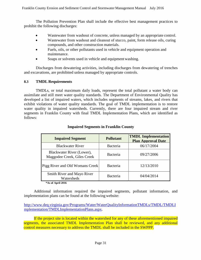
Page 31
Franklin County Erosion and Sediment Control and Stormwater Management Manual July 2016
The Pollution Prevention Plan shall include the effective best management practices to prohibit the following discharges:
• Wastewater from washout of concrete, unless managed by an appropriate control. • Wastewater from washout and cleanout of stucco, paint, form release oils, curing
compounds, and other construction materials. • Fuels, oils, or other pollutants used in vehicle and equipment operation and
maintenance. • Soaps or solvents used in vehicle and equipment washing.
Discharges from dewatering activities, including discharges from dewatering of trenches
and excavations, are prohibited unless managed by appropriate controls.
8.3 TMDL Requirements
TMDLs, or total maximum daily loads, represent the total pollutant a water body can assimilate and still meet water quality standards. The Department of Environmental Quality has developed a list of impaired waters, which includes segments of streams, lakes, and rivers that exhibit violations of water quality standards. The goal of TMDL implementation is to restore water quality in impaired watersheds. Currently, there are four impaired stream and river segments in Franklin County with final TMDL Implementation Plans, which are identified as follows:
Impaired Segments in Franklin County
Impaired Segment Pollutant TMDL Implementation Plan Approval Date
Blackwater River Bacteria 06/17/2004 Blackwater River (Lower),
Maggodee Creek, Giles Creek Bacteria 09/27/2006
Pigg River and Old Womans Creek Bacteria 12/13/2010
Smith River and Mayo River Watersheds Bacteria 04/04/2014
*As of April 2016
Additional information required the impaired segments, pollutant information, and implementation plans can be found at the following website:
http://www.deq.virginia.gov/Programs/Water/WaterQualityInformationTMDLs/TMDL/TMDLI mplementation/TMDLImplementationPlans.aspx. If the project site is located within the watershed for any of these aforementioned impaired segments, the associated TMDL Implementation Plan shall be reviewed, and any additional control measures necessary to address the TMDL shall be included in the SWPPP.

Page 32
Franklin County Erosion and Sediment Control and Stormwater Management Manual July 2016
Chapter 9 Easements
For all land development projects, easements will be obtained for all public or offsite storm drainage structures, facilities, and improvements.
9.1 Stormwater Channels and Drainage Systems
Stormwater drainage easements will be obtained for all improved stormwater drainage
systems. Any existing or improved swales concentrating flow from more than two lots will require an easement. Stormwater drainage easements will extend to upstream property lines to permit future development reasonable access to on-site drainage-ways or drainage systems for connections. Stormwater drainage easements will be shown on a record plat and on the Stormwater Management Design Plan.
Stormwater channels must have a minimum of five feet on one side of the channel as
measured from the edge of the channel top to the easement and 15 feet on the opposite side, for a total easement width of 20 feet. Storm drains and storm sewer pipes must have a minimum 25 feet easement width, with 10 feet provided on one side of the pipe and 15 feet provided on the opposite side. If the stormwater pipe is greater than 10 feet below finished grade, an additional five feet of easement width is required. An additional five feet of easement is required for each five-foot increment of additional depth.
9.2 Stormwater Facilities
Storm drainage easements will be obtained for all stormwater management facilities
located within any land development project. Storm drainage easements will be shown on the record plat and on the Stormwater Management Design Plan. All easements must encompass the entire facility, maintenance access areas, and all pretreatment facilities. Easements for ponds and infiltration basins will include the pond area, all embankments plus an additional 15 feet around the embankment, and outlet structures.
Page 33
Franklin County Erosion and Sediment Control and Stormwater Management Manual July 2016
Chapter 10 Performance Surety, Construction Inspections, and Record Drawings
10.1 Performance Surety
Prior to issuance of the land disturbance permit, applicants shall submit to Franklin County a performance surety, cash escrow, letter of credit, insurance bond or such other legal arrangement acceptable to Franklin County. The amount of the installation performance security shall be 110 percent of the total estimated construction cost of the stormwater management practices. The performance security shall meet all requirements of Section 7-59 of the County Code.
Required text, forms and procedures for the performance surety (cash escrow, letter of credit and insurance bond) are located in Appendix J of this manual.
A final inspection by Franklin County is required before the release of any performance securities can occur. Within 60 days of the completion of the requirements of the permit conditions, and Franklin County's final inspection, such bond, cash escrow, letter of credit, insurance bond or other legal arrangement, or the unexpended or unobligated portion thereof, shall be refunded to the applicant or terminated.
10.2 Record Drawings
Upon final completion of all land disturbing activities, record for any stormwater management practices located on-site, except for any stormwater management faculty for which a maintenance agreement was not required by Franklin County, shall be submitted and approved by Franklin County. The record drawings must show all stormwater management facilities, calculations, and certification language, and must be certified by a licensed professional registered in the Commonwealth of Virginia.
Page 34
Franklin County Erosion and Sediment Control and Stormwater Management Manual July 2016
Chapter 11 Construction Monitoring and Inspections
11.1 Construction Monitoring
Franklin County will perform regular inspections of stormwater management facilities during all phases of construction in addition to regular erosion and sediment control inspections. The applicant must notify Franklin County in writing at least five business days in advance of the commencement of construction activities. In addition, the applicant must notify Franklin County via email at least 48 hours in advance of construction of any critical components of all stormwater management facilities.
Periodic inspections will be performed by the County during all phases of construction
for compliance with the approved erosion and sediment control plan, approved stormwater management plan, implementation of the pollution prevention plan, and implementation of any measures required to address a TMDL. If Franklin County determines there is a failure to comply with the approved plans, enforcement activities will be performed in accordance with Section 7-61 of the County Code.
11.2 Construction Inspections
The applicant is required for performing all land disturbing activities in accordance with
the site specific SWPPP, which includes the approved erosion and sediment control plan, approved stormwater management plan, pollution prevention plan, and additional control measures necessary to address a TMDL. The person responsible for carrying out the SWPPP should ensure all inspections required by the approved plans, SWPPP, and VSMP permit, are performed by qualified personnel and maintained on-site with the SWPPP. Inspection monitoring and reports shall be available for review by Franklin County, when requested.
Page 35
Franklin County Erosion and Sediment Control and Stormwater Management Manual July 2016
Chapter 12 Maintenance and Inspections 12.1 Maintenance Plan
A maintenance plan will be prepared for all stormwater management facilities.
The maintenance plan will describe all structures and list items to be maintained to ensure successful long term use of these structures. Maintenance plans will be tailored to the specific stormwater management best management practice for which it applies. All required maintenance plans will be prepared in conjunction with the Stormwater Management Final design plan.
The maintenance plan shall specify a schedule of inspections in accordance with
the operation and maintenance inspection checklists provided in the Virginia Stormwater Management Handbook, as amended. The maintenance plan will specify that any modifications to a stormwater management or conveyance structure must be approved by Franklin County to the work commencing.
12.2 Maintenance Agreement
A maintenance agreement shall be entered into between the landowner and
Franklin County for all proposed stormwater management facilities. A copy of a Franklin County maintenance agreement has been included in Appendix G. The maintenance agreement shall be executed and recorded in Franklin County land records prior to approval of the construction permit. The agreement shall obligate the landowner to provide maintenance to ensure proper performance of the facility in accordance with the approved maintenance plan.
12.3 Maintenance Inspections
Franklin County will perform periodic maintenance inspections of stormwater
management facilities and provide copies of maintenance inspection reports to the landowner or agent(s) of the landowner, if available. The landowner shall ensure stormwater management facilities are inspected by qualified inspection personnel on an annual basis. Qualified inspection personnel include a professional engineer, architect, landscape architect or land surveyor registered in the Commonwealth of Virginia or stormwater management inspector or stormwater combined administrator who have meet the certification requirements of 9 VAC25-850-50. The owner shall keep written records of these inspections and any necessary repairs, and furnish records to the County every five (5) years or upon request, whichever comes first.
12.4 Recordkeeping
Reports, records, approved stormwater management plans, and permit
registration statements submitted in accordance with 9VAC25-870-59, for each project, will be kept on-file at the County file for a period of three years after permit termination or project completion. Construction record drawings will be maintained by the County in perpetuity or until a stormwater management facility is removed.

Page 36
Franklin County Erosion and Sediment Control and Stormwater Management Manual July 2016
Stormwater management maintenance inspections will be retained for at least five years from the date of the County's inspection.
Franklin County Erosion and Sediment Control and Stormwater Management Manual July 2016
Appendix A
Franklin County, Virginia - Code of Ordinances
Chapter 7 - Erosion and Sediment Control and Stormwater Management

Franklin County Erosion and Sediment Control and Stormwater Management Manual July 2016
Appendix B
Stormwater Management Plan Submittal Checklists

Franklin County Erosion and Sediment Control and Stormwater Management Manual July 2016
Application and Procedures for Site Development Plan Approval
Franklin County, Virginia
Franklin County 1255 Franklin Street
Rocky Mount, Virginia 24151 Ph: (540) 483-3027
May 2016
Franklin County Erosion and Sediment Control and Stormwater Management Manual July 2016
TABLE OF CONTENTS Procedures for Site Development Plan Review and Approval
Application for Site Development Plan Review – 1st Submission
Acknowledgement of Application Fee Payment Procedure
Application for Site Development Plan Approval – Resubmission
Checklist
This application is for use by all applicants for site plan approval, including commercial, industrial, multi-family residential, and institutional.
Because of the necessity for accurate boundaries, topography drawn to 2-foot contours, hydrological computations, and detailed location information for improvements, it may be required that the site development plan be prepared by an appropriate professional (engineer, surveyor, architect, or landscape architect). (Please check with Development Services for professional requirements.) You are also advised that any conveyance of a portion of the subject property may require subdivision review and approval.
Should you have any questions during the course of preparation of a site development plan for submittal, please contact Franklin County Development Services staff at 540-483-3027. The staff is available to assist you with any questions or problems.
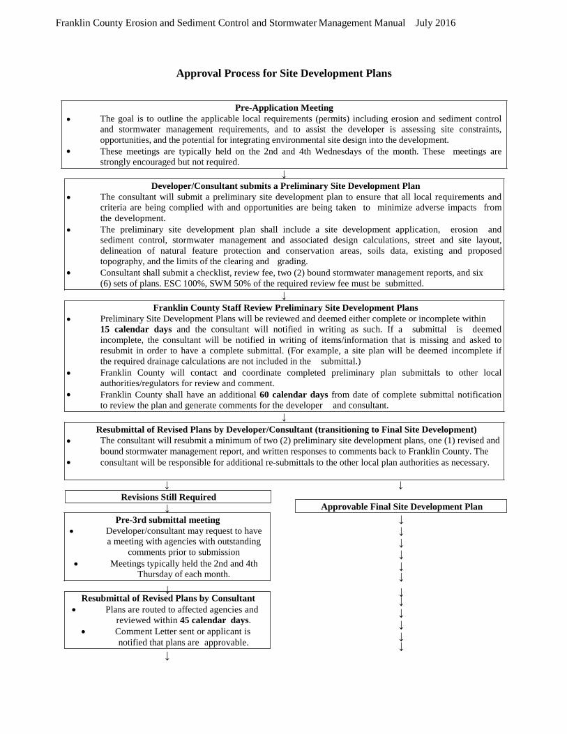
Franklin County Erosion and Sediment Control and Stormwater Management Manual July 2016
•
•
Pre-3rd submittal meeting Developer/consultant may request to have a meeting with agencies with outstanding
comments prior to submission Meetings typically held the 2nd and 4th
Thursday of each month.
Resubmittal of Revised Plans by Consultant • Plans are routed to affected agencies and
reviewed within 45 calendar days. • Comment Letter sent or applicant is
notified that plans are approvable.
Approval Process for Site Development Plans
↓
↓
↓
↓ ↓
↓
↓ ↓ ↓ ↓ ↓ ↓
↓ ↓ ↓ ↓ ↓ ↓ ↓
↓
Revisions Still Required
• •
Resubmittal of Revised Plans by Developer/Consultant (transitioning to Final Site Development) The consultant will resubmit a minimum of two (2) preliminary site development plans, one (1) revised and bound stormwater management report, and written responses to comments back to Franklin County. The consultant will be responsible for additional re-submittals to the other local plan authorities as necessary.
• • •
Franklin County Staff Review Preliminary Site Development Plans Preliminary Site Development Plans will be reviewed and deemed either complete or incomplete within 15 calendar days and the consultant will notified in writing as such. If a submittal is deemed incomplete, the consultant will be notified in writing of items/information that is missing and asked to resubmit in order to have a complete submittal. (For example, a site plan will be deemed incomplete if the required drainage calculations are not included in the submittal.) Franklin County will contact and coordinate completed preliminary plan submittals to other local authorities/regulators for review and comment. Franklin County shall have an additional 60 calendar days from date of complete submittal notification to review the plan and generate comments for the developer and consultant.
• • •
Developer/Consultant submits a Preliminary Site Development Plan The consultant will submit a preliminary site development plan to ensure that all local requirements and criteria are being complied with and opportunities are being taken to minimize adverse impacts from the development. The preliminary site development plan shall include a site development application, erosion and sediment control, stormwater management and associated design calculations, street and site layout, delineation of natural feature protection and conservation areas, soils data, existing and proposed topography, and the limits of the clearing and grading. Consultant shall submit a checklist, review fee, two (2) bound stormwater management reports, and six (6) sets of plans. ESC 100%, SWM 50% of the required review fee must be submitted.
• •
Pre-Application Meeting The goal is to outline the applicable local requirements (permits) including erosion and sediment control and stormwater management requirements, and to assist the developer is assessing site constraints, opportunities, and the potential for integrating environmental site design into the development. These meetings are typically held on the 2nd and 4th Wednesdays of the month. These meetings are strongly encouraged but not required.
Approvable Final Site Development Plan
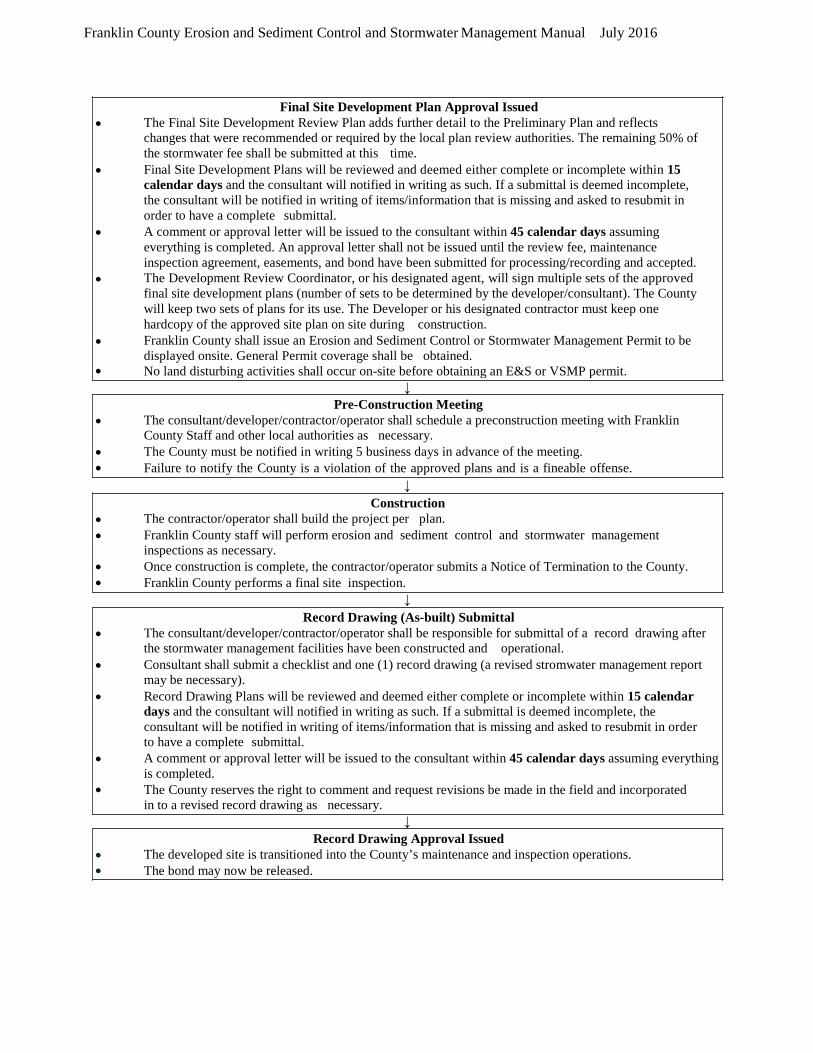
Franklin County Erosion and Sediment Control and Stormwater Management Manual July 2016
↓
↓
↓
↓
• •
Record Drawing Approval Issued The developed site is transitioned into the County’s maintenance and inspection operations. The bond may now be released.
• • • • •
Record Drawing (As-built) Submittal The consultant/developer/contractor/operator shall be responsible for submittal of a record drawing after the stormwater management facilities have been constructed and operational. Consultant shall submit a checklist and one (1) record drawing (a revised stromwater management report may be necessary). Record Drawing Plans will be reviewed and deemed either complete or incomplete within 15 calendar days and the consultant will notified in writing as such. If a submittal is deemed incomplete, the consultant will be notified in writing of items/information that is missing and asked to resubmit in order to have a complete submittal. A comment or approval letter will be issued to the consultant within 45 calendar days assuming everything is completed. The County reserves the right to comment and request revisions be made in the field and incorporated in to a revised record drawing as necessary.
• • • •
Construction The contractor/operator shall build the project per plan. Franklin County staff will perform erosion and sediment control and stormwater management inspections as necessary. Once construction is complete, the contractor/operator submits a Notice of Termination to the County. Franklin County performs a final site inspection.
• • •
Pre-Construction Meeting The consultant/developer/contractor/operator shall schedule a preconstruction meeting with Franklin County Staff and other local authorities as necessary. The County must be notified in writing 5 business days in advance of the meeting. Failure to notify the County is a violation of the approved plans and is a fineable offense.
• • • • • •
Final Site Development Plan Approval Issued The Final Site Development Review Plan adds further detail to the Preliminary Plan and reflects changes that were recommended or required by the local plan review authorities. The remaining 50% of the stormwater fee shall be submitted at this time. Final Site Development Plans will be reviewed and deemed either complete or incomplete within 15 calendar days and the consultant will notified in writing as such. If a submittal is deemed incomplete, the consultant will be notified in writing of items/information that is missing and asked to resubmit in order to have a complete submittal. A comment or approval letter will be issued to the consultant within 45 calendar days assuming everything is completed. An approval letter shall not be issued until the review fee, maintenance inspection agreement, easements, and bond have been submitted for processing/recording and accepted. The Development Review Coordinator, or his designated agent, will sign multiple sets of the approved final site development plans (number of sets to be determined by the developer/consultant). The County will keep two sets of plans for its use. The Developer or his designated contractor must keep one hardcopy of the approved site plan on site during construction. Franklin County shall issue an Erosion and Sediment Control or Stormwater Management Permit to be displayed onsite. General Permit coverage shall be obtained. No land disturbing activities shall occur on-site before obtaining an E&S or VSMP permit.
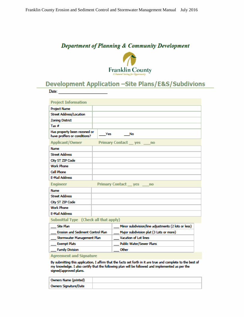
Franklin County Erosion and Sediment Control and Stormwater Management Manual July 2016

Franklin County Erosion and Sediment Control and Stormwater Management Manual July 2016
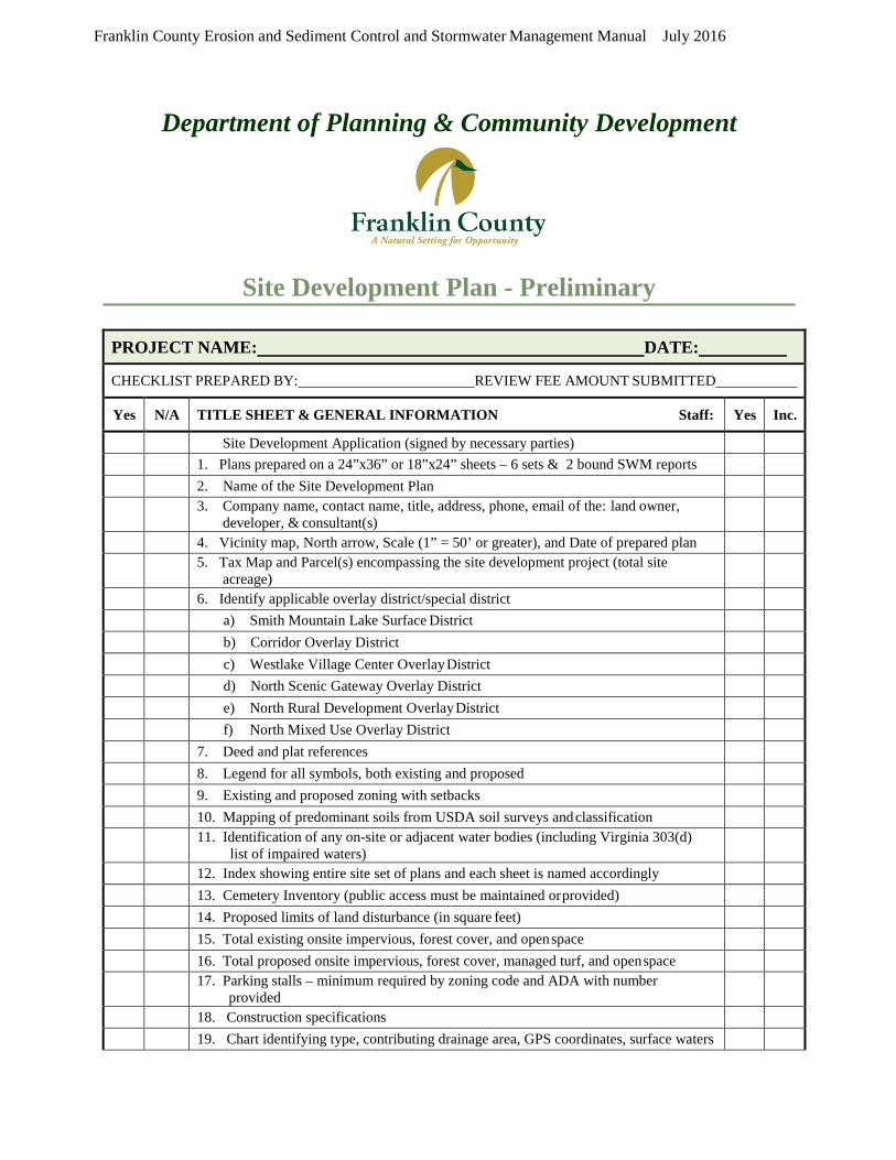
Franklin County Erosion and Sediment Control and Stormwater Management Manual July 2016
Department of Planning & Community Development
Site Development Plan - Preliminary
PROJECT NAME: DATE:
CHECKLIST PREPARED BY: REVIEW FEE AMOUNT SUBMITTED
Yes N/A TITLE SHEET & GENERAL INFORMATION Staff: Yes Inc.
Site Development Application (signed by necessary parties) 1. Plans prepared on a 24”x36” or 18”x24” sheets – 6 sets & 2 bound SWM reports 2. Name of the Site Development Plan 3. Company name, contact name, title, address, phone, email of the: land owner,
developer, & consultant(s)
4. Vicinity map, North arrow, Scale (1” = 50’ or greater), and Date of prepared plan 5. Tax Map and Parcel(s) encompassing the site development project (total site
acreage)
6. Identify applicable overlay district/special district a) Smith Mountain Lake Surface District b) Corridor Overlay District c) Westlake Village Center Overlay District d) North Scenic Gateway Overlay District e) North Rural Development Overlay District f) North Mixed Use Overlay District 7. Deed and plat references 8. Legend for all symbols, both existing and proposed 9. Existing and proposed zoning with setbacks 10. Mapping of predominant soils from USDA soil surveys and classification 11. Identification of any on-site or adjacent water bodies (including Virginia 303(d)
list of impaired waters)
12. Index showing entire site set of plans and each sheet is named accordingly 13. Cemetery Inventory (public access must be maintained or provided) 14. Proposed limits of land disturbance (in square feet) 15. Total existing onsite impervious, forest cover, and open space 16. Total proposed onsite impervious, forest cover, managed turf, and open space 17. Parking stalls – minimum required by zoning code and ADA with number
provided
18. Construction specifications 19. Chart identifying type, contributing drainage area, GPS coordinates, surface waters
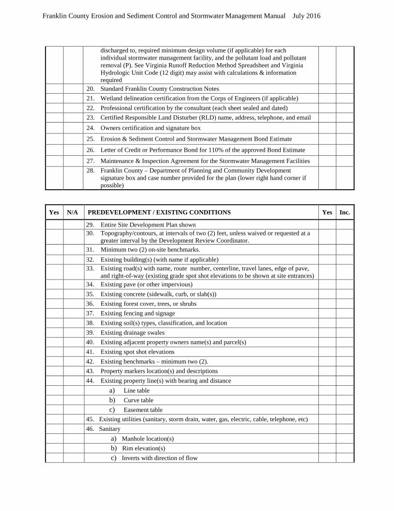
Franklin County Erosion and Sediment Control and Stormwater Management Manual July 2016
discharged to, required minimum design volume (if applicable) for each individual stormwater management facility, and the pollutant load and pollutant removal (P). See Virginia Runoff Reduction Method Spreadsheet and Virginia Hydrologic Unit Code (12 digit) may assist with calculations & information required
20. Standard Franklin County Construction Notes 21. Wetland delineation certification from the Corps of Engineers (if applicable) 22. Professional certification by the consultant (each sheet sealed and dated) 23. Certified Responsible Land Disturber (RLD) name, address, telephone, and email 24. Owners certification and signature box 25. Erosion & Sediment Control and Stormwater Management Bond Estimate 26. Letter of Credit or Performance Bond for 110% of the approved Bond Estimate 27. Maintenance & Inspection Agreement for the Stormwater Management Facilities 28. Franklin County – Department of Planning and Community Development
signature box and case number provided for the plan (lower right hand corner if possible)
Yes N/A PREDEVELOPMENT / EXISTING CONDITIONS Yes Inc.
29. Entire Site Development Plan shown 30. Topography/contours, at intervals of two (2) feet, unless waived or requested at a
greater interval by the Development Review Coordinator.
31. Minimum two (2) on-site benchmarks. 32. Existing building(s) (with name if applicable) 33. Existing road(s) with name, route number, centerline, travel lanes, edge of pave,
and right-of-way (existing grade spot shot elevations to be shown at site entrances)
34. Existing pave (or other impervious) 35. Existing concrete (sidewalk, curb, or slab(s)) 36. Existing forest cover, trees, or shrubs 37. Existing fencing and signage 38. Existing soil(s) types, classification, and location 39. Existing drainage swales 40. Existing adjacent property owners name(s) and parcel(s) 41. Existing spot shot elevations 42. Existing benchmarks – minimum two (2). 43. Property markers location(s) and descriptions 44. Existing property line(s) with bearing and distance a) Line table b) Curve table c) Easement table 45. Existing utilities (sanitary, storm drain, water, gas, electric, cable, telephone, etc) 46. Sanitary a) Manhole location(s) b) Rim elevation(s) c) Inverts with direction of flow

Franklin County Erosion and Sediment Control and Stormwater Management Manual July 2016
d) Pipe size, material if known e) Forcemain location, size, and inverts f) Approximate location of septic area 47. Storm Drain a) Manhole location(s) b) Inlet locations(s) c) Rim and grate elevation(s) d) Inverts with direction of flow e) Pipe size, material if known f) Culvert(s) (Pipe size, material, and length) g) Trench drain(s) (Pipe size, material, and length) 48. Water a) Pipe size, material if known b) Valve location c) Well location d) Water meter location e) Fire/yard hydrant location 49. Gas a) Line location b) Pipe size, material if known 50. Electric a) Line location b) Utility pole location c) Transformer location d) Generator location 51. Existing corporate limits (if applicable) 52. Existing wetlands limits and buffers 53. Existing flood plain limits, zone, and minimum building elevation(s)
Yes N/A PRELIMINARY SITE DEVELOPMENT PLAN (SITE, ROADWAY, PARKING) Yes Inc.
54. Phased projects will be clearly noted with areas outlined as necessary for constructability purposes.
55. Proposed detailed grading plan (detailed spot shot elevations as necessary for constructability purposes).
56. Proposed layout of roads, lots with driveways or building(s), with required parking (impervious areas) per zoning and include minimum ADA handicap spaces
57. Proposed elevations along the roadway (centerline of road, edge of pave, flow line, and top of curb) grade shots shall be provided at every 50’ stationing either in plan view or table format
58. Identify type and roadway used and provide standard cross section details 59. Identify type of curbing used and provide standard detail 60. Identify type of cul-de-sac being used and provide elevations and cross slope 61. Details related to road design tailored to each site
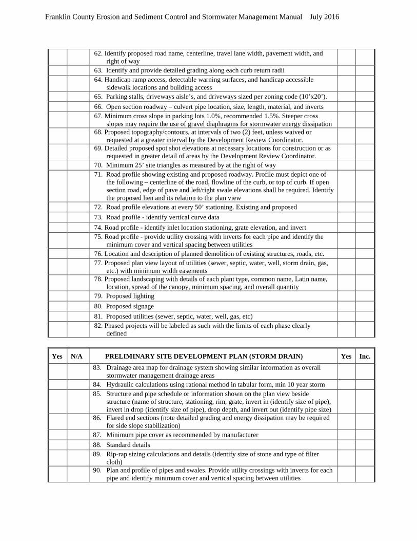
Franklin County Erosion and Sediment Control and Stormwater Management Manual July 2016
62. Identify proposed road name, centerline, travel lane width, pavement width, and right of way
63. Identify and provide detailed grading along each curb return radii 64. Handicap ramp access, detectable warning surfaces, and handicap accessible
sidewalk locations and building access
65. Parking stalls, driveways aisle’s, and driveways sized per zoning code (10’x20’). 66. Open section roadway – culvert pipe location, size, length, material, and inverts 67. Minimum cross slope in parking lots 1.0%, recommended 1.5%. Steeper cross
slopes may require the use of gravel diaphragms for stormwater energy dissipation
68. Proposed topography/contours, at intervals of two (2) feet, unless waived or requested at a greater interval by the Development Review Coordinator.
69. Detailed proposed spot shot elevations at necessary locations for construction or as requested in greater detail of areas by the Development Review Coordinator.
70. Minimum 25’ site triangles as measured by at the right of way 71. Road profile showing existing and proposed roadway. Profile must depict one of
the following – centerline of the road, flowline of the curb, or top of curb. If open section road, edge of pave and left/right swale elevations shall be required. Identify the proposed lien and its relation to the plan view
72. Road profile elevations at every 50’ stationing. Existing and proposed 73. Road profile - identify vertical curve data 74. Road profile - identify inlet location stationing, grate elevation, and invert 75. Road profile - provide utility crossing with inverts for each pipe and identify the
minimum cover and vertical spacing between utilities
76. Location and description of planned demolition of existing structures, roads, etc. 77. Proposed plan view layout of utilities (sewer, septic, water, well, storm drain, gas,
etc.) with minimum width easements
78. Proposed landscaping with details of each plant type, common name, Latin name, location, spread of the canopy, minimum spacing, and overall quantity
79. Proposed lighting 80. Proposed signage 81. Proposed utilities (sewer, septic, water, well, gas, etc) 82. Phased projects will be labeled as such with the limits of each phase clearly
defined
Yes N/A PRELIMINARY SITE DEVELOPMENT PLAN (STORM DRAIN) Yes Inc.
83. Drainage area map for drainage system showing similar information as overall stormwater management drainage areas
84. Hydraulic calculations using rational method in tabular form, min 10 year storm 85. Structure and pipe schedule or information shown on the plan view beside
structure (name of structure, stationing, rim, grate, invert in (identify size of pipe), invert in drop (identify size of pipe), drop depth, and invert out (identify pipe size)
86. Flared end sections (note detailed grading and energy dissipation may be required for side slope stabilization)
87. Minimum pipe cover as recommended by manufacturer 88. Standard details 89. Rip-rap sizing calculations and details (identify size of stone and type of filter
cloth)
90. Plan and profile of pipes and swales. Provide utility crossings with inverts for each pipe and identify minimum cover and vertical spacing between utilities
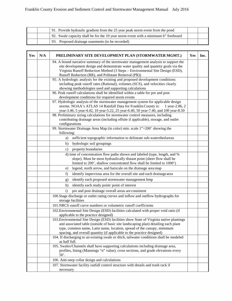
Franklin County Erosion and Sediment Control and Stormwater Management Manual July 2016
91. Provide hydraulic gradient from the 25 year peak storm event from the pond 92. Swale capacity shall be for the 10 year storm event with a minimum 6” freeboard 93. Proposed drainage easements (to be recorded)
Yes N/A PRELIMINARY SITE DEVELOPMENT PLAN (STORMWATER MGMT.) Yes Inc.
94. A bound narrative summary of the stormwater management analysis to support the site development design and demonstrate water quality and quantity goals via the Virginia Runoff Reduction Method (3 Steps – Environmental Site Design (ESD), Runoff Reduction (RR), and Pollutant Removal (PR))
95. A hydrologic analysis for the existing and proposed development conditions: including peak runoff rates (Rational), volumes (SCS), and velocities clearly showing methodologies used and supporting calculations
96. Peak runoff calculations shall be identified within a table for pre and post development conditions for required storm events
97. Hydrologic analysis of the stormwater management system for applicable design storms. NOAA’s ATLAS 14 Rainfall Data for Franklin County is: 1 year-2.86, 2 year-3.46, 5 year-4.42, 10 year-5.22, 25 year-6.40, 50 year-7.40, and 100 year-8.50
98. Preliminary sizing calculations for stormwater control measures, including contributing drainage areas (including offsite if applicable), storage, and outlet configurations
99. Stormwater Drainage Area Map (in color) min. scale 1”=200’ showing the following:
a) sufficient topographic information to delineate sub-watershed areas b) hydrologic soil groupings c) property boundaries d) time of concentration flow paths shown and labeled (type, length, and %
slope). Must be most hydraulically distant point (sheet flow shall be limited to 200’, shallow concentrated flow shall be limited to 1000’)
e) legend, north arrow, and barscale on the drainage area map f) identify impervious area for the overall site and each drainage area g) identify each proposed stormwater management bmp h) identify each study point/ point of interest i) pre and post drainage overall areas are consistent 100.Stage discharge or outlet rating curves and inflow and outflow hydrographs for
storage facilities
101.NRCS runoff curve numbers or volumetric runoff coefficients 102.Environmental Site Design (ESD) facilities calculated with proper void ratio (if
applicable to the practice designed)
103.Environmental Site Design (ESD) facilities show State of Virginia native plantings and associated table (outside of basic site landscaping plan) detailing each plant type, common name, Latin name, location, spread of the canopy, minimum spacing, and overall quantity (if applicable to the practice designed)
104. If discharging to an existing swale or ditch, tailwater conditions shall be modeled as half full.
105. Swales/Channels shall have supporting calculations including drainage area, profiles, lining (Mannings “n” value), cross sections, and grade elevations every 50’.
106. Anti-seep collar design and calculations 107. Stormwater facility outfall control structure with details and trash rack if
necessary
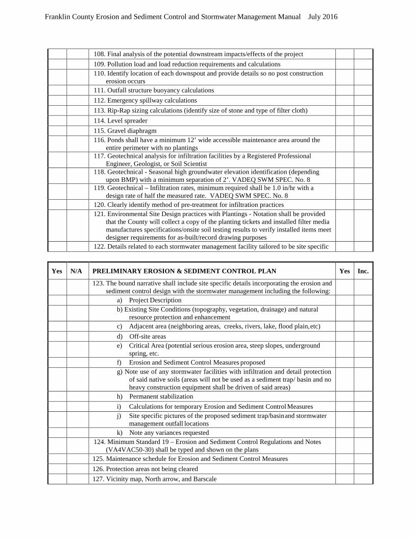
Franklin County Erosion and Sediment Control and Stormwater Management Manual July 2016
108. Final analysis of the potential downstream impacts/effects of the project 109. Pollution load and load reduction requirements and calculations 110. Identify location of each downspout and provide details so no post construction
erosion occurs
111. Outfall structure buoyancy calculations 112. Emergency spillway calculations 113. Rip-Rap sizing calculations (identify size of stone and type of filter cloth) 114. Level spreader 115. Gravel diaphragm 116. Ponds shall have a minimum 12’ wide accessible maintenance area around the
entire perimeter with no plantings
117. Geotechnical analysis for infiltration facilities by a Registered Professional Engineer, Geologist, or Soil Scientist
118. Geotechnical - Seasonal high groundwater elevation identification (depending upon BMP) with a minimum separation of 2’. VADEQ SWM SPEC. No. 8
119. Geotechnical – Infiltration rates, minimum required shall be 1.0 in/hr with a design rate of half the measured rate. VADEQ SWM SPEC. No. 8
120. Clearly identify method of pre-treatment for infiltration practices 121. Environmental Site Design practices with Plantings - Notation shall be provided
that the County will collect a copy of the planting tickets and installed filter media manufactures specifications/onsite soil testing results to verify installed items meet designer requirements for as-built/record drawing purposes
122. Details related to each stormwater management facility tailored to be site specific
Yes N/A PRELIMINARY EROSION & SEDIMENT CONTROL PLAN Yes Inc.
123. The bound narrative shall include site specific details incorporating the erosion and sediment control design with the stormwater management including the following:
a) Project Description b) Existing Site Conditions (topography, vegetation, drainage) and natural
resource protection and enhancement
c) Adjacent area (neighboring areas, creeks, rivers, lake, flood plain, etc) d) Off-site areas e) Critical Area (potential serious erosion area, steep slopes, underground
spring, etc.
f) Erosion and Sediment Control Measures proposed g) Note use of any stormwater facilities with infiltration and detail protection
of said native soils (areas will not be used as a sediment trap/ basin and no heavy construction equipment shall be driven of said areas)
h) Permanent stabilization i) Calculations for temporary Erosion and Sediment Control Measures j) Site specific pictures of the proposed sediment trap/basin and stormwater
management outfall locations
k) Note any variances requested 124. Minimum Standard 19 – Erosion and Sediment Control Regulations and Notes
(VA4VAC50-30) shall be typed and shown on the plans
125. Maintenance schedule for Erosion and Sediment Control Measures 126. Protection areas not being cleared 127. Vicinity map, North arrow, and Barscale
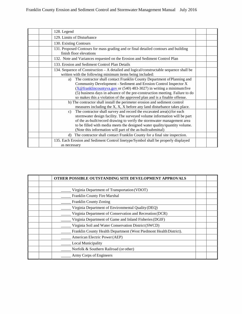
Franklin County Erosion and Sediment Control and Stormwater Management Manual July 2016
128. Legend 129. Limits of Disturbance 130. Existing Contours 131. Proposed Contours for mass grading and or final detailed contours and building
finish floor elevations
132. Note and Variances requested on the Erosion and Sediment Control Plan 133. Erosion and Sediment Control Plan Details 134. Sequence of Construction – A detailed and logical/constructable sequence shall be
written with the following minimum items being included:
a) The contractor shall contact Franklin County Department of Planning and Community Development - Sediment and Erosion Control Inspector X ([email protected] or (540) 483-3027) in writing a minimum five (5) business days in advance of the pre-construction meeting. Failure to do so makes this a violation of the approved plan and is a finable offense.
b) The contractor shall install the perimeter erosion and sediment control measures including the X, X, X before any land disturbance takes place.
c) The contractor shall survey and record the excavated area(s) for each stormwater design facility. The surveyed volume information will be part of the as-built/record drawing to verify the stormwater management area to be filled with media meets the designed water quality/quantity volume. (Note this information will part of the as-built submittal)
d) The contractor shall contact Franklin County for a final site inspection. 135. Each Erosion and Sediment Control linetype/Symbol shall be properly displayed
as necessary
OTHER POSSIBLE OUTSTANDING SITE DEVELOPMENT APPROVALS Virginia Department of Transportation (VDOT) Franklin County Fire Marshal Franklin County Zoning Virginia Department of Environmental Quality (DEQ) Virginia Department of Conservation and Recreation (DCR) Virginia Department of Game and Inland Fisheries (DGIF) Virginia Soil and Water Conservation District (SWCD) Franklin County Health Department (West Piedmont Health District). American Electric Power (AEP) Local Municipality Norfolk & Southern Railroad (or other) Army Corps of Engineers

STANDARD FRANKLIN COUNTY CONSTRUCTION NOTES
I. Franklin County Case # ______________.
2. The Franklin County Department of Planning and Community Development must be notified in
writing five (5) business days prior to commencing with construction to schedule a pre-construction
meeting. See the Sequence of Construction for details. Failure to do so constitutes a violation of the
approved plans.
3. The Registered Land Disturber (RLD) or their site representative will be required to maintain and
update the Stormwater Pollution Prevention Plan (SWPPP) as necessary. The SWPPP must remain
available for inspection at all times.
4. The Franklin County Department of Planning and Community Development Erosion and Sediment
Control/Stormwater Management (ESC/SWM) Site Inspector must be notified in writing forty-eight (48)
hours in advance of the construction of any critical components of all ESC/SWM installations (and noted
dates in the SWPPP).
5. Franklin County Department of Planning and Community Development reserves the right to alter
these plans, during the construction phase and as field conditions may warrant. Changes to the
construction plans must have Franklin County approval prior to the work being done (and noted
changes/dates will be added to the SWPPP).
6. Approval of these plans by Franklin County Department of Planning and Community Development is
not a representation, guarantee or warranty of any kind and shall create no liability upon the County, its
Officials or Employees.
7. Approved plans remain valid for the current 2014 Virginia Department of Environmental Quality
Permit Cycle only (5 year permit cycle).
8. Where applicable, an As-built/Record Plan shall be provided to the Franklin County Department of
Planning and Community Development within sixty (60) days after completion of construction for
approval. The ESC/SWM surety (letter of credit, performance bond, or escrow account) will not be fully
released until all items have been approved as constructed.
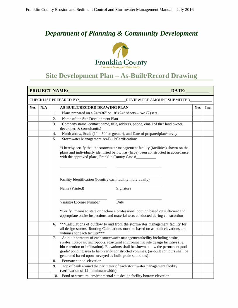
Franklin County Erosion and Sediment Control and Stormwater Management Manual July 2016
Department of Planning & Community Development
Site Development Plan – As-Built/Record Drawing
PROJECT NAME: DATE:
CHECKLIST PREPARED BY: REVIEW FEE AMOUNT SUBMITTED
Yes N/A AS-BUILT/RECORD DRAWING PLAN Yes Inc. 1. Plans prepared on a 24”x36” or 18”x24” sheets – two (2) sets 2. Name of the Site Development Plan 3. Company name, contact name, title, address, phone, email of the: land owner,
developer, & consultant(s)
4. North arrow, Scale (1” = 50’ or greater), and Date of prepared plan/survey 5. Stormwater Management As-Built Certification:
“I hereby certify that the stormwater management facility (facilities) shown on the plans and individually identified below has (have) been constructed in accordance with the approved plans, Franklin County Case #
Facility Identification (Identify each facility individually)
Name (Printed) Signature
Virginia License Number Date
“Cerify” means to state or declare a professional opinion based on sufficient and appropriate onsite inspections and material tests conducted during construction
6. ***Calculations of outflow to and from the stormwater management facility for all design storms. Routing Calculations must be based on as-built elevations and volumes for each facility***
7. As-built contours of each stormwater management facility including basins, swales, forebays, micropools, structural environmental site design facilities (i.e. bio-retention or infiltration). Elevations shall be shown below the permanent pool grade/ ponding area to help verify constructed volumes. (as-built contours shall be generated based upon surveyed as-built grade spot shots)
8. Permanent pool elevation 9. Top of bank around the perimeter of each stormwater management facility
(verification of 12’ minimum width)
10. Pond or structural environmental site design facility bottom elevation
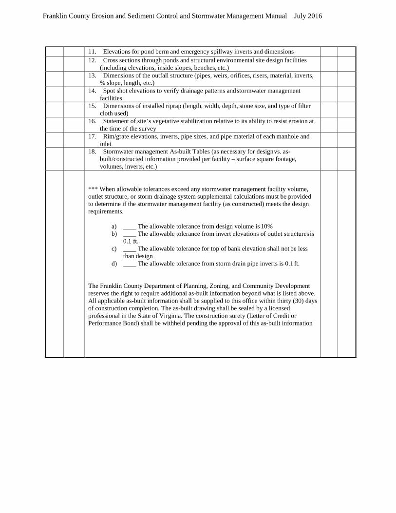
Franklin County Erosion and Sediment Control and Stormwater Management Manual July 2016
11. Elevations for pond berm and emergency spillway inverts and dimensions 12. Cross sections through ponds and structural environmental site design facilities
(including elevations, inside slopes, benches, etc.)
13. Dimensions of the outfall structure (pipes, weirs, orifices, risers, material, inverts, % slope, length, etc.)
14. Spot shot elevations to verify drainage patterns and stormwater management facilities
15. Dimensions of installed riprap (length, width, depth, stone size, and type of filter cloth used)
16. Statement of site’s vegetative stabilization relative to its ability to resist erosion at the time of the survey
17. Rim/grate elevations, inverts, pipe sizes, and pipe material of each manhole and inlet
18. Stormwater management As-built Tables (as necessary for design vs. as- built/constructed information provided per facility – surface square footage, volumes, inverts, etc.)
*** When allowable tolerances exceed any stormwater management facility volume, outlet structure, or storm drainage system supplemental calculations must be provided to determine if the stormwater management facility (as constructed) meets the design requirements.
a) The allowable tolerance from design volume is 10% b) The allowable tolerance from invert elevations of outlet structures is
0.1 ft. c) The allowable tolerance for top of bank elevation shall not be less
than design d) The allowable tolerance from storm drain pipe inverts is 0.1 ft.
The Franklin County Department of Planning, Zoning, and Community Development reserves the right to require additional as-built information beyond what is listed above. All applicable as-built information shall be supplied to this office within thirty (30) days of construction completion. The as-built drawing shall be sealed by a licensed professional in the State of Virginia. The construction surety (Letter of Credit or Performance Bond) shall be withheld pending the approval of this as-built information
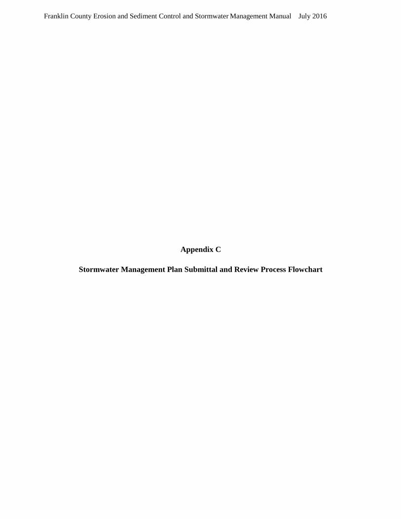
Franklin County Erosion and Sediment Control and Stormwater Management Manual July 2016
Appendix C
Stormwater Management Plan Submittal and Review Process Flowchart
Franklin County Erosion and Sediment Control and Stormwater Management Manual July 2016
Owner signs project certification
Stormwater Management Plan Submittal and Review Process Flowchart
Plan incomplete, Revise and resubmit
Plan approved or no comment after 60 days
Revise and resubmit
*State allowed maximum time frames.
Owner/Agent
prepares project registration
Owner submits site plan and 50% of the plan review fee to
Franklin County
State issues VSMP construction general permit number
Owner names Responsible Land Disturber and posts project bonds
to Franklin County
Plan complete
Project under 60 day review*
Owner begins construction
Plan approved
15 day completeness review*
45 day of review of resubmittal
Franklin County land disturbance permit issued
Owner pays any outstanding fees
Legend Blue box: Owner Action Green Box: City Action Red Box: State Action
Franklin County Erosion and Sediment Control and Stormwater Management Manual July 2016
Appendix D
Common Plan of Development Permitting Flowchart

Franklin County Erosion and Sediment Control and Stormwater Management Manual July 2016
Common Plan of Development Permitting Flow Chart
Was the lot created prior to July 1, 2004
No
Yes
Project is not considered part of a common plan of
development
Will the project disturb 3,000 square feet or greater within 200 No feet of any surface water, or 10,000 square feet or greater if further than 200 feet from any
surface water?
No VSMP permit
or Franklin County land disturbance
permit required.
Project is considered part of a common plan
of development
Yes
Will the project disturb one (1) acre or greater? No
Will the project disturb 3,000 square feet or greater within 200 No
feet of any surface water, or 10,000 square feet or greater if further than 200 feet from any
surface water?
No VSMP permit or Franklin County land disturbance
permit required.
Yes
Franklin County land disturbance
permit is required. VSMP permit is
not required.
Yes
Both VSMP* and Franklin County land disturbance
permits
*Agreement in lieu of a stormwater management plan and standard Department of Environmental Quality Stormwater Pollution Prevention Plan template may be used.

Franklin County Erosion and Sediment Control and Stormwater Management Manual July 2016
Appendix E
Grandfathering Flowchart for New Projects

Franklin County Erosion and Sediment Control and Stormwater Management Manual July 2016
Grandfathering Flow Chart for New Projects
Plan or permit submitted for review after 7/1/2012?
Yes
Has a VSMP permit been issued for the
project prior to 7/1/2014 and still active?
No
Did land disturbance commence prior to
7/1/2014?
Yes
Yes
Project does not require grandfathering
and is subject to criteria of Part II C for two additional VSMP
permit cycles.
Project is grandfathered and is subject to criteria of Part II C with no end
date.
No Yes
Is the project locality, state or Yes Were governmental bonding or No No Has there been an obligation of Did the County approve a
federally funded? public debt financing secured for the project prior to 7/1/2012? local, state, or federal funds? stormwater management plan for
the project prior to 7/1/2012?
No Yes Yes No
Does the project have a plan, plat, or other equivalent
document (i) approved by the
Yes
Project is
grandfathered and County prior to 7/1/2012, (ii)
provided a layout per 9VAC25- 870-10, (iii) comply with the
Part II C technical criteria, and (iv) has not been subsequently modified which will cause an
is subject to criteria of Part II C for one additional VSMP
permit cycle.
Project is not grandfathered
and is subject to criteria of Part II B.
increase in amount of No phosphorus or volume or rate of
runoff?

Franklin County Erosion and Sediment Control and Stormwater Management Manual July 2016
Appendix F
Runoff Reduction Method and Energy Balance Worksheets
http://www.deq.virginia.gov/Programs/Water/Laws,Regulations,Guidance/Guidance/Water
PermitGuidance.aspx
Guidance Number 16-2001 and Compliance Spreadsheets - Version 3.0

Franklin County Erosion and Sediment Control and Stormwater Management Manual July 2016
Appendix G
Stormwater Maintenance Facility Management Agreement
{00219040.DOCX } 1 11/2018
Prepared by and return to:
Franklin County Planning &
Community Development
Franklin County, Virginia
1255 Franklin Street, Suite 103
Rocky Mount, VA 24151
Phone: (540) 483-3027
Tax Map/Parcel Identification Number(s):
FRANKLIN COUNTY, VIRGINIA
STORM WATER MANAGEMENT INFRASTRUCTURE
MAINTENANCE AGREEMENT
THIS AGREEMENT, is made and entered into this ___ day of_____, by and between
_____________, hereinafter called the "Landowner," and Franklin County, Virginia, hereinafter called
the "County."
WHEREAS, the Landowner is the owner of certain real property described as Franklin County
Parcel Identification Number _________, located at _______________________________________, and
as described in the deed in the land records of Franklin County, Virginia, Deed Book ____, Page ____,
hereinafter called the "Property"; and
WHEREAS, the Landowner is proceeding to build on and develop the Property pursuant to the
Site Plan/Subdivision Plan known as _____________, hereinafter called the "Plan", which is expressly
made a part hereof, as approved or to be approved by the County, providing for the detention and
conveyance of stormwater within the confines of the Property; and
WHEREAS, the County and the Landowner, its successors and assigns, including any
homeowners’ association, agree that the health, safety, and welfare of the residents of Franklin County,
Virginia, require that on-site stormwater management/BMP facilities be constructed and maintained on
the Property; and
WHEREAS, the County requires that the on-site stormwater management infrastructure as shown
on the Plan be constructed and adequately maintained by the Landowner, its successors and assigns,
including any homeowners association, as set forth herein, and in the stormwater infrastructure plat,
description, and documents attached hereto as Exhibit A.
WITNESSETH:
NOW, THEREFORE, in consideration of the foregoing premises, the mutual covenants contained
herein, and the following terms and conditions, the parties hereto agree as follows:
1. The on-site stormwater management infrastructure for the Property shall be constructed
by the Landowner, its successors and assigns, in accordance with the plans and specifications identified in
the Plan and Exhibit A attached hereto.
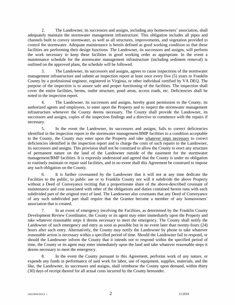
{00219040.DOCX } 2 11/2018
2. The Landowner, its successors and assigns, including any homeowners’ association, shall
adequately maintain the stormwater management infrastructure. This obligation includes all pipes and
channels built to convey stormwater, as well as all structures, improvements, and vegetation provided to
control the stormwater. Adequate maintenance is herein defined as good working condition so that these
facilities are performing their design functions. The Landowner, its successors and assigns, will perform
the work necessary to keep these facilities in good working order as appropriate. In the event a
maintenance schedule for the stormwater management infrastructure (including sediment removal) is
outlined on the approved plans, the schedule will be followed.
3. The Landowner, its successors and assigns, agrees to cause inspections of the stormwater
management infrastructure and submit an inspection report at least once every five (5) years to Franklin
County by a professional engineer, registered in Virginia, or other individual certified by VA DEQ. The
purpose of the inspection is to assure safe and proper functioning of the facilities. The inspection shall
cover the entire facilities, berms, outlet structure, pond areas, access roads, etc. Deficiencies shall be
noted in the inspection report.
4. The Landowner, its successors and assigns, hereby grant permission to the County, its
authorized agents and employees, to enter upon the Property and to inspect the stormwater management
infrastructure whenever the County deems necessary. The County shall provide the Landowner, its
successors and assigns, copies of the inspection findings and a directive to commence with the repairs if
necessary.
5. In the event the Landowner, its successors and assigns, fails to correct deficiencies
identified in the inspection report to the stormwater management/BMP facilities to a condition acceptable
to the County, the County may enter upon the Property and take whatever steps necessary to correct
deficiencies identified in the inspection report and to charge the costs of such repairs to the Landowner,
its successors and assigns. This provision shall not be construed to allow the County to erect any structure
of permanent nature on the land of the Landowner outside of the easement for the stormwater
management/BMP facilities. It is expressly understood and agreed that the County is under no obligation
to routinely maintain or repair said facilities, and in no event shall this Agreement be construed to impose
any such obligation on the County.
6. It is further covenanted by the Landowner that it will not at any time dedicate the
Facilities to the public, to public use or to Franklin County nor will it subdivide the above Property
without a Deed of Conveyance reciting that a proportionate share of the above-described covenant of
maintenance and cost associated with other of the obligations and duties contained herein runs with each
subdivided part of the original tract of land. The Landowner also covenants that any Deed of Conveyance
of any such subdivided part shall require that the Grantee become a member of any homeowners’
association that is created.
7. In an event of emergency involving the Facilities, as determined by the Franklin County
Development Review Coordinator, the County or its agent may enter immediately upon the Property and
take whatever reasonable steps it deems necessary to meet the emergency. The County shall notify the
Landowner of such emergency and entry as soon as possible but in no event later than twenty-fours (24)
hours after such entry. Alternatively, the County may notify the Landowner by phone to take whatever
reasonable action is necessary within a specified period of time. Should the Landowner fail to respond, or
should the Landowner inform the County that it intends not to respond within the specified period of
time, the County or its agent may enter immediately upon the land and take whatever reasonable steps it
deems necessary to meet the emergency.
8. In the event the County pursuant to this Agreement, performs work of any nature, or
expends any funds in performance of said work for labor, use of equipment, supplies, materials, and the
like, the Landowner, its successors and assigns, shall reimburse the County upon demand, within thirty
(30) days of receipt thereof for all actual costs incurred by the County hereunder.

{00219040.DOCX } 3 11/2018
9. Any amounts owed to the County and not paid within thirty (30) days of the date of
notification shall be the joint and several obligations of the Landowner of record of the Property or any
portion thereof served by the Facilities, on the date the liability arose and all of the successors in interest
of such Landowner. The full amounts owed shall be liens on the Property and on each and every portion
of the Property. Liens shall be recorded by the County in the Lien Book, in the Clerk’s office of the
Circuit Court of Franklin County or, if this is not possible for any reason, in a Lien book maintained by
and in the office of the Franklin County Development Review Coordinator
10. This Agreement imposes no liability of any kind whatsoever on the County and the
Landowner agrees to hold the County harmless from any liability in the event the stormwater
management infrastructure fails to operate properly.
11. In the event a claim is asserted against the County, its agents or employees, the County
shall promptly notify the Landowner and Landowner shall defend at its own expense any suit based on
such claim. If any judgment or claim against the County, its agents or employees shall be allowed, the
Landowner shall pay all costs and expenses immediately.
12. The Landowner shall promptly notify the County when the Landowner transfers its
interest in the Property or any portion thereof. The Landowner shall supply the County with a duly
executed copy of any document of transfer.
13. Except for the telephone notice in paragraph 8 above, notices required by this Agreement
shall be effective as delivered by the US Postal Service. Any notice to the County shall be given to the
Franklin County Development Review Coordinator, 1255 Franklin Street, Rocky Mount, Virginia, 24151,
and to the Landowner in the name and at the address given below:
To Landowner: Name:
(please print)
Address:
The Landowner agrees to notify the County immediately upon any change of legal status or of address.
14. This Agreement shall be recorded among the land records of Franklin County, Virginia,
and shall constitute a covenant running with the land, and shall be binding on the Landowner, its
administrators, executors, assigns, heirs and any other successors in interests, including any homeowners’
association.
15. The laws of the Commonwealth of Virginia shall govern the construction of this
Agreement and all claims and actions related to this Agreement shall be filed in the Franklin County
General District Court or the Franklin County Circuit Court.
16. The Landowner shall submit, attached to this Agreement as Exhibit A, a description and
plat of the stormwater infrastructure describing all and any type of installed practices and dedicated
easements. The attachment shall be on standard letter (8.5x 11) sized paper. This Agreement and Exhibit
A shall be recorded in the Franklin County Circuit Court Clerk’s office.
17. Special requirements and additional information (if necessary):
REMAINDER OF PAGE INTENTIONALLY LEFT BLANK
SIGNATURES ON NEXT PAGE
{00219040.DOCX } 4 11/2018
IN WITNESS OF ALL which the parties hereto have caused this Agreement to be executed on
their behalf.
by
_________________________________________________
STATE/COMMONWEALTH OF VIRGINIA:
COUNTY OF FRANKLIN, to wit:
The foregoing instrument was acknowledged before me this ____________day of
__________________________, 20___, by _______________________
My Commission expires: ________________________________
_____________________________________
Notary Public

{00219040.DOCX } 5 11/2018
ACCEPTED:
FRANKLIN COUNTY, VIRGINIA, by
_________________________________________________
Steven M. Sandy, Director of Planning & Community
Development
County Subdivision Agent
County Zoning Administrator
COMMONWEALTH OF VIRGINIA:
COUNTY OF FRANKLIN, to wit:
The foregoing instrument was acknowledged before me this ____________day of
__________________________, 20___, by Steven M. Sandy, Director of Planning & Community
Development, on behalf of Franklin County, Virginia.
My Commission expires: ________________________________
_____________________________________
Notary Public

{00219040.DOCX } 6 11/2018
APPROVED AS TO LEGAL FORM:
County Attorney
Franklin County Erosion and Sediment Control and Stormwater Management Manual July 2016
Appendix H
Stormwater Facility Maintenance and Inspection Form
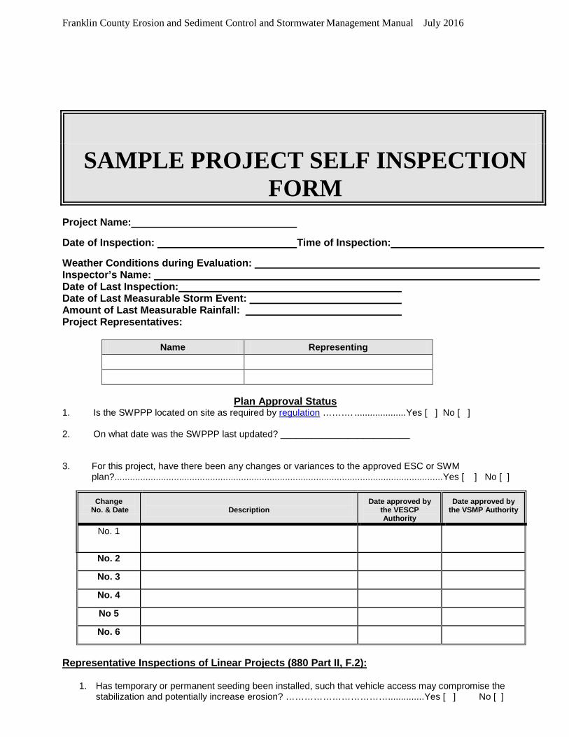
Franklin County Erosion and Sediment Control and Stormwater Management Manual July 2016
SAMPLE PROJECT SELF INSPECTION
FORM Project Name:
Date of Inspection: Time of Inspection:
Weather Conditions during Evaluation: Inspector’s Name: Date of Last Inspection: Date of Last Measurable Storm Event: Amount of Last Measurable Rainfall: Project Representatives:
Name Representing
Plan Approval Status
1. Is the SWPPP located on site as required by regulation ………. .................... Yes [ ] No [ ] 2. On what date was the SWPPP last updated? _________________________ 3. For this project, have there been any changes or variances to the approved ESC or SWM
plan?...............................................................................................................................Yes [ ] No [ ]
Change No. & Date
Description
Date approved by the VESCP Authority
Date approved by the VSMP Authority
No. 1
No. 2 No. 3 No. 4 No 5 No. 6
Representative Inspections of Linear Projects (880 Part II, F.2):
1. Has temporary or permanent seeding been installed, such that vehicle access may compromise the stabilization and potentially increase erosion? ……………………………..............Yes [ ] No [ ]
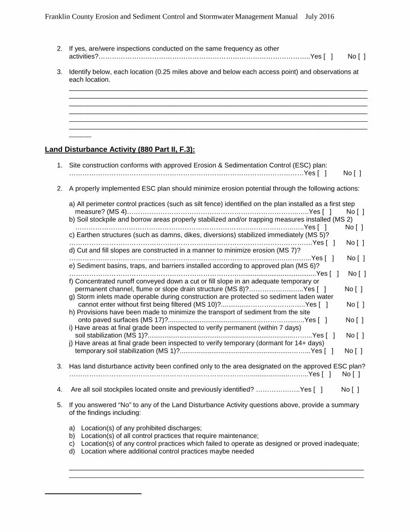
Franklin County Erosion and Sediment Control and Stormwater Management Manual July 2016
2. If yes, are/were inspections conducted on the same frequency as other
activities?…………………………………………………………………………………..Yes [ ] No [ ]
3. Identify below, each location (0.25 miles above and below each access point) and observations at each location. ______________________________________________________________________________________________________________________________________________________________________________________________________________________________________________________________________________________________________________________________________________________________________________________________________________________________________________________________________________________________________
Land Disturbance Activity (880 Part II, F.3):
1. Site construction conforms with approved Erosion & Sedimentation Control (ESC) plan: ……………………………………………………………………………………………Yes [ ] No [ ]
2. A properly implemented ESC plan should minimize erosion potential through the following actions:
a) All perimeter control practices (such as silt fence) identified on the plan installed as a first step
measure? (MS 4)…………………………………………………………………..…..Yes [ ] No [ ] b) Soil stockpile and borrow areas properly stabilized and/or trapping measures installed (MS 2)
……………………………………………………………………………………..…..Yes [ ] No [ ] c) Earthen structures (such as damns, dikes, diversions) stabilized immediately (MS 5)? ……………………………………………………………………………………………….Yes [ ] No [ ] d) Cut and fill slopes are constructed in a manner to minimize erosion (MS 7)? …………………………………………………………………………………….………...Yes [ ] No [ ] e) Sediment basins, traps, and barriers installed according to approved plan (MS 6)? ………………………………………………………………….…......................................Yes [ ] No [ ] f) Concentrated runoff conveyed down a cut or fill slope in an adequate temporary or permanent channel, flume or slope drain structure (MS 8)?………………..…..Yes [ ] No [ ] g) Storm inlets made operable during construction are protected so sediment laden water cannot enter without first being filtered (MS 10)?................………………..…..Yes [ ] No [ ] h) Provisions have been made to minimize the transport of sediment from the site onto paved surfaces (MS 17)?............................................………………..…..Yes [ ] No [ ] i) Have areas at final grade been inspected to verify permanent (within 7 days) soil stabilization (MS 1)?..............................................................................……...Yes [ ] No [ ] j) Have areas at final grade been inspected to verify temporary (dormant for 14+ days) temporary soil stabilization (MS 1)?............................................................……...Yes [ ] No [ ]
3. Has land disturbance activity been confined only to the area designated on the approved ESC plan? ……………………………………………………………………….....................……...Yes [ ] No [ ]
4. Are all soil stockpiles located onsite and previously identified? ………………..Yes [ ] No [ ]
5. If you answered “No” to any of the Land Disturbance Activity questions above, provide a summary of the findings including:
a) Location(s) of any prohibited discharges; b) Location(s) of all control practices that require maintenance; c) Location(s) of any control practices which failed to operate as designed or proved inadequate; d) Location where additional control practices maybe needed
______________________________________________________________________________________________________________________________________________________________
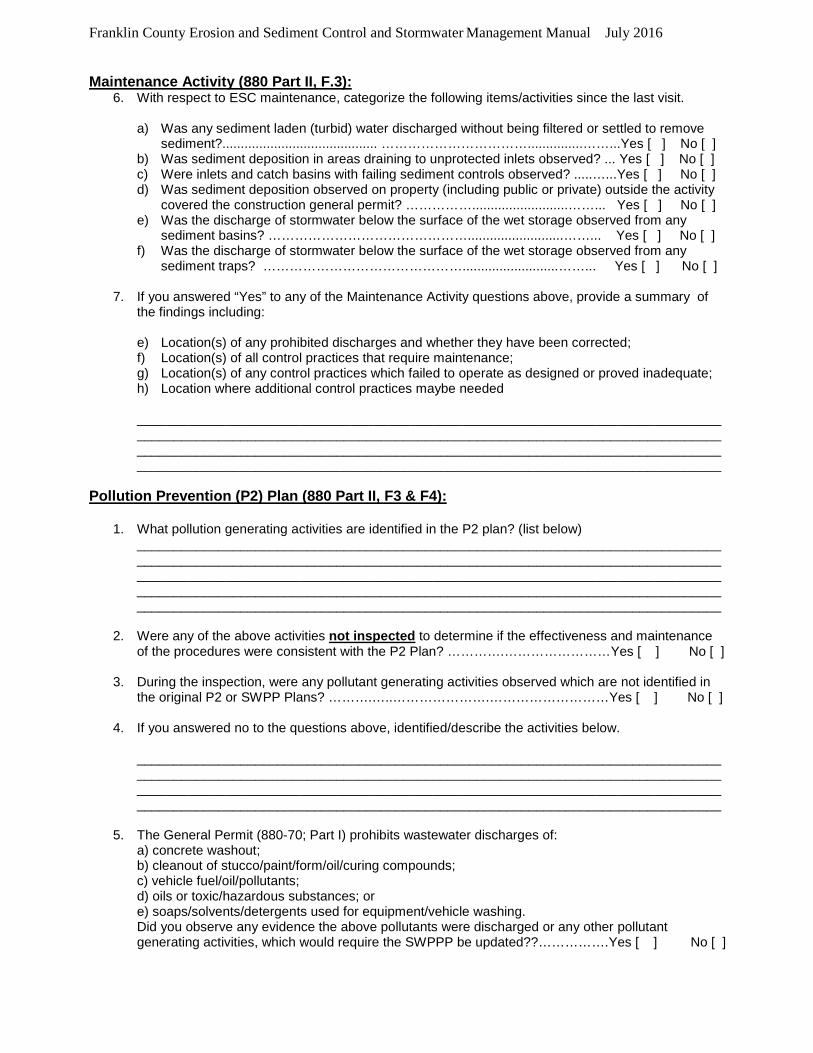
Franklin County Erosion and Sediment Control and Stormwater Management Manual July 2016
Maintenance Activity (880 Part II, F.3): 6. With respect to ESC maintenance, categorize the following items/activities since the last visit.
a) Was any sediment laden (turbid) water discharged without being filtered or settled to remove
sediment?.......................................... ……………………………...............……...Yes [ ] No [ ] b) Was sediment deposition in areas draining to unprotected inlets observed? ... Yes [ ] No [ ] c) Were inlets and catch basins with failing sediment controls observed? .....…...Yes [ ] No [ ] d) Was sediment deposition observed on property (including public or private) outside the activity
covered the construction general permit? ……………..........................……... Yes [ ] No [ ] e) Was the discharge of stormwater below the surface of the wet storage observed from any
sediment basins? ………………………………………..........................……... Yes [ ] No [ ] f) Was the discharge of stormwater below the surface of the wet storage observed from any
sediment traps? ………………………………………..........................……... Yes [ ] No [ ] 7. If you answered “Yes” to any of the Maintenance Activity questions above, provide a summary of
the findings including:
e) Location(s) of any prohibited discharges and whether they have been corrected; f) Location(s) of all control practices that require maintenance; g) Location(s) of any control practices which failed to operate as designed or proved inadequate; h) Location where additional control practices maybe needed
____________________________________________________________________________________________________________________________________________________________________________________________________________________________________________________________________________________________________________________________
Pollution Prevention (P2) Plan (880 Part II, F3 & F4):
1. What pollution generating activities are identified in the P2 plan? (list below) ___________________________________________________________________________________________________________________________________________________________________________________________________________________________________________________________________________________________________________________________________________________________________________________________________________
2. Were any of the above activities not inspected to determine if the effectiveness and maintenance
of the procedures were consistent with the P2 Plan? ………….……………………Yes [ ] No [ ]
3. During the inspection, were any pollutant generating activities observed which are not identified in the original P2 or SWPP Plans? ……….…..………………….………………………Yes [ ] No [ ]
4. If you answered no to the questions above, identified/describe the activities below.
____________________________________________________________________________________________________________________________________________________________________________________________________________________________________________________________________________________________________________________________
5. The General Permit (880-70; Part I) prohibits wastewater discharges of:
a) concrete washout; b) cleanout of stucco/paint/form/oil/curing compounds; c) vehicle fuel/oil/pollutants; d) oils or toxic/hazardous substances; or e) soaps/solvents/detergents used for equipment/vehicle washing. Did you observe any evidence the above pollutants were discharged or any other pollutant generating activities, which would require the SWPPP be updated??…………….Yes [ ] No [ ]
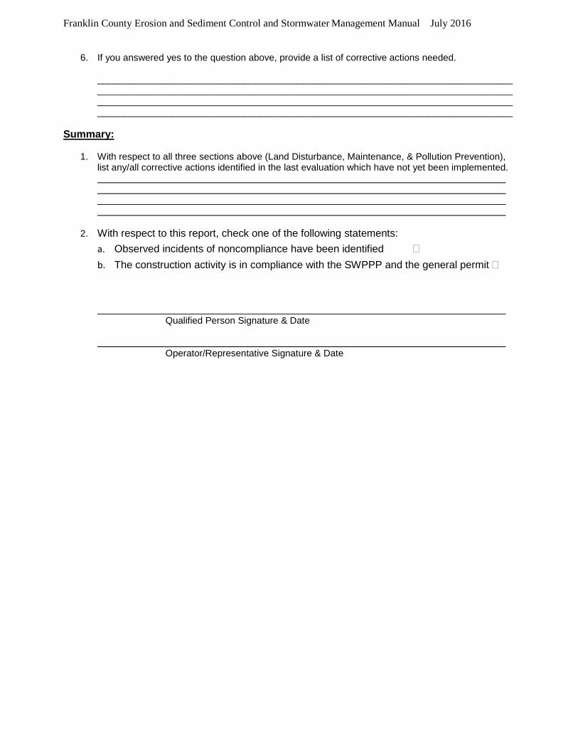
Franklin County Erosion and Sediment Control and Stormwater Management Manual July 2016
6. If you answered yes to the question above, provide a list of corrective actions needed.
____________________________________________________________________________________________________________________________________________________________________________________________________________________________________________________________________________________________________________________________
Summary:
1. With respect to all three sections above (Land Disturbance, Maintenance, & Pollution Prevention), list any/all corrective actions identified in the last evaluation which have not yet been implemented.
2. With respect to this report, check one of the following statements: a. Observed incidents of noncompliance have been identified �
b. The construction activity is in compliance with the SWPPP and the general permit �
Qualified Person Signature & Date Operator/Representative Signature & Date

Franklin County Erosion and Sediment Control and Stormwater Management Manual July 2016
Appendix I
Documented Interpretations

Franklin County Erosion and Sediment Control and Stormwater Management Manual July 2016
Appendix J
Letter of Credit (LOC)
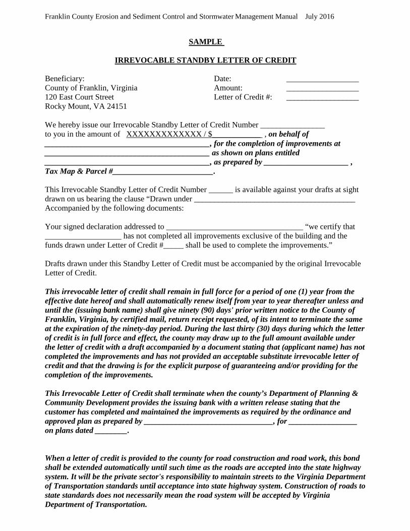
Franklin County Erosion and Sediment Control and Stormwater Management Manual July 2016
SAMPLE
IRREVOCABLE STANDBY LETTER OF CREDIT
Beneficiary: Date: __________________ County of Franklin, Virginia Amount: __________________ 120 East Court Street Letter of Credit #: __________________ Rocky Mount, VA 24151 We hereby issue our Irrevocable Standby Letter of Credit Number ________________ to you in the amount of XXXXXXXXXXXXX / $____________ , on behalf of _________________________________________, for the completion of improvements at _________________________________________ as shown on plans entitled _________________________________________, as prepared by _____________________ , Tax Map & Parcel #_________________________. This Irrevocable Standby Letter of Credit Number ______ is available against your drafts at sight drawn on us bearing the clause “Drawn under ________________________________________ Accompanied by the following documents: Your signed declaration addressed to __________________________________ “we certify that ___________________ has not completed all improvements exclusive of the building and the funds drawn under Letter of Credit #_____ shall be used to complete the improvements.” Drafts drawn under this Standby Letter of Credit must be accompanied by the original Irrevocable Letter of Credit. This irrevocable letter of credit shall remain in full force for a period of one (1) year from the effective date hereof and shall automatically renew itself from year to year thereafter unless and until the (issuing bank name) shall give ninety (90) days' prior written notice to the County of Franklin, Virginia, by certified mail, return receipt requested, of its intent to terminate the same at the expiration of the ninety-day period. During the last thirty (30) days during which the letter of credit is in full force and effect, the county may draw up to the full amount available under the letter of credit with a draft accompanied by a document stating that (applicant name) has not completed the improvements and has not provided an acceptable substitute irrevocable letter of credit and that the drawing is for the explicit purpose of guaranteeing and/or providing for the completion of the improvements. This Irrevocable Letter of Credit shall terminate when the county’s Department of Planning & Community Development provides the issuing bank with a written release stating that the customer has completed and maintained the improvements as required by the ordinance and approved plan as prepared by ________________________________, for _________________ on plans dated ________. When a letter of credit is provided to the county for road construction and road work, this bond shall be extended automatically until such time as the roads are accepted into the state highway system. It will be the private sector's responsibility to maintain streets to the Virginia Department of Transportation standards until acceptance into state highway system. Construction of roads to state standards does not necessarily mean the road system will be accepted by Virginia Department of Transportation.
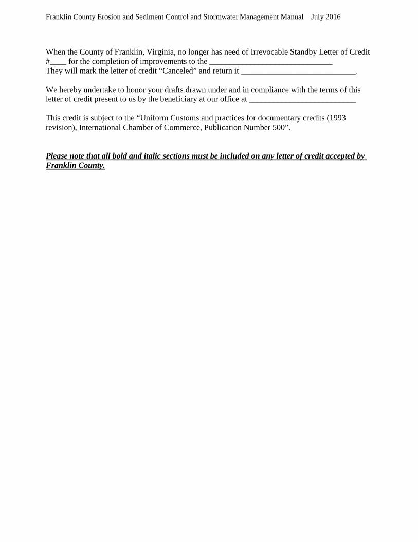
Franklin County Erosion and Sediment Control and Stormwater Management Manual July 2016
When the County of Franklin, Virginia, no longer has need of Irrevocable Standby Letter of Credit #____ for the completion of improvements to the ______________________________ They will mark the letter of credit “Canceled” and return it ____________________________. We hereby undertake to honor your drafts drawn under and in compliance with the terms of this letter of credit present to us by the beneficiary at our office at __________________________ This credit is subject to the “Uniform Customs and practices for documentary credits (1993 revision), International Chamber of Commerce, Publication Number 500”. Please note that all bold and italic sections must be included on any letter of credit accepted by Franklin County.
Franklin County Erosion and Sediment Control and Stormwater Management Manual July 2016
Appendix K
Cash Escrow W-9 Form
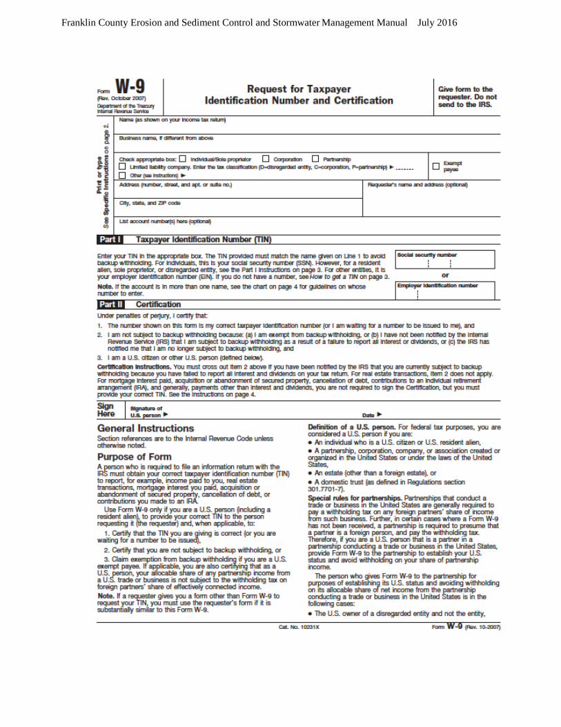
Franklin County Erosion and Sediment Control and Stormwater Management Manual July 2016

Franklin County Erosion and Sediment Control and Stormwater Management Manual July 2016
Appendix L
Insurance Bond
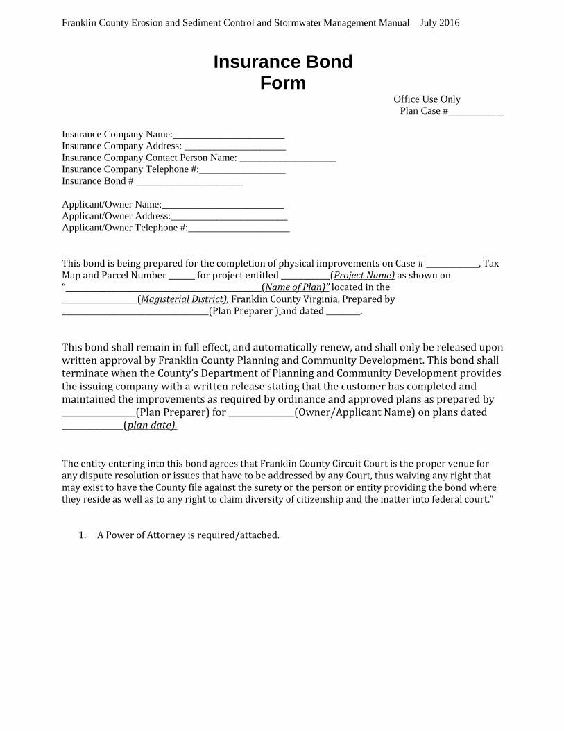
Franklin County Erosion and Sediment Control and Stormwater Management Manual July 2016
Insurance Bond Form
Office Use Only Plan Case #___________
Insurance Company Name:______________________ Insurance Company Address: ____________________ Insurance Company Contact Person Name: ___________________ Insurance Company Telephone #:_________________ Insurance Bond # _____________________ Applicant/Owner Name:________________________ Applicant/Owner Address:_______________________ Applicant/Owner Telephone #:____________________ This bond is being prepared for the completion of physical improvements on Case # ______________, Tax Map and Parcel Number _______ for project entitled _____________(Project Name) as shown on “____________________________________________________(Name of Plan)” located in the ____________________(Magisterial District), Franklin County Virginia, Prepared by _______________________________________(Plan Preparer ) and dated _________. This bond shall remain in full effect, and automatically renew, and shall only be released upon written approval by Franklin County Planning and Community Development. This bond shall terminate when the County’s Department of Planning and Community Development provides the issuing company with a written release stating that the customer has completed and maintained the improvements as required by ordinance and approved plans as prepared by __________________(Plan Preparer) for ________________(Owner/Applicant Name) on plans dated _______________(plan date). The entity entering into this bond agrees that Franklin County Circuit Court is the proper venue for any dispute resolution or issues that have to be addressed by any Court, thus waiving any right that may exist to have the County file against the surety or the person or entity providing the bond where they reside as well as to any right to claim diversity of citizenship and the matter into federal court.”
1. A Power of Attorney is required/attached.


