February 2018 ESKOM MEDUPI FGD Geotechnical Impact Assessment Study REPORT Report Number: 1415881-299047-3 Distribution: 1 x electronic copy Zitholele Consulting (Pty) Ltd 1 x electronic copy GAA project file 1 x electronic copy Global library Submitted to: Zitholele Consulting (Pty) Ltd Maxwell Office Park Cnr Allandale Road and Maxwell Drive, Waterfall City, Midrand
Transcript
February 2018
ESKOM MEDUPI FGD
Geotechnical Impact Assessment Study
REPO
RT
Report Number: 1415881-299047-3 Distribution: 1 x electronic copy Zitholele Consulting (Pty) Ltd 1 x electronic copy GAA project file 1 x electronic copy Global library
Submitted to: Zitholele Consulting (Pty) Ltd Maxwell Office Park Cnr Allandale Road and Maxwell Drive, Waterfall City, Midrand
ESKOM MEDUPI FGD
February 2018 Report No. 1415881-299047-3
Executive Summary
Golder Associates Africa (PTY) Ltd (Golder) washas been appointed by Zitholele Consulting (Pty) Ltd (Zitholele) to undertake preliminary geotechnical investigations for the waste disposal facilities of three waste streams to be generated by the operation of the Flue Gas Desulfurization (FGD) at Medupi power station at Lephalale, Limpopo.
The Scope of Work was to undertake a preliminary geotechnical assessment of the Ash Disposal Facility on the preferred Alternative Site 13. The waste disposal infrastructures include a gypsum landfill and lagoons to dispose salts and sludge. Alternative Site 13 is situated at the western portion of the Medupi power plant. Eight intrusive test pits were excavated in the area of Alternative Site 13.
A total of 8 test pits were excavated using a TLB to a median depth of 2m. The test pits intersected topsoil overlying alluvial non-cohesive material, with weathered sandstone intersected in only one test pit at a depth of 1.7m.
Recommendations have been provided on excavatability, engineering use, shear strength, shallow foundations and slope stability.
The scope of works was revised after the fieldwork was complete to include professional geotechnical opinion on additional scope items of infrastructure using supplied information.
No significant geotechnical hazards or fatal flaws were identified. All the geotechnical considerations mentioned can be mitigated in the design of the facility. Geotechnical investigations will be required as the project proceeds into design.
3.0 SCOPE OF WORK .................................................................................................................................................... 1
4.0 ASH DISPOSAL FACILITY SITE DESCRIPTION ..................................................................................................... 2
4.1 Site Description ............................................................................................................................................. 2
4.2 Nature of the Investigation ............................................................................................................................ 4
4.2.1 Field Investigation ................................................................................................................................... 4
4.3 Geology and Soil Profile ............................................................................................................................... 4
4.3.1 Geology and Climatic Value .................................................................................................................... 4
4.4 Laboratory test results .................................................................................................................................. 6
4.4.1 Foundation Indicators .............................................................................................................................. 6
4.5.1 Excavation Class ..................................................................................................................................... 8
4.5.2 Engineering Use ...................................................................................................................................... 9
TABLES Table 1: Samples types and quantities ..................................................................................................................... 4
Table 2: Typical Soil Profiles Over All Alternative Sites ............................................................................................ 5
Table 3: Depth and inferred thicknesses of the soils/ rocks underlying the sites ...................................................... 5
Table 4: Foundation Indicator test results ................................................................................................................ 6
Table 5: Compaction test results .............................................................................................................................. 7
Table 6: Permeability test results ............................................................................................................................. 7
Table 7: pH and Conductivity test results ................................................................................................................. 8
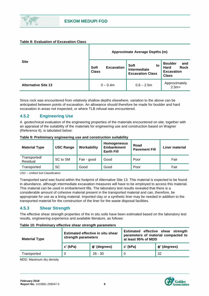
Table 8: Evaluation of Excavation Class .................................................................................................................. 9
Table 9: Preliminary engineering use and construction suitability ............................................................................ 9
Table 11: Geotechnical Impact Assessment of Alternative Site 13 .......................................................................... 1
FIGURES Figure 1: Site layout ................................................................................................................................................. 2
Figure 2: Construction activity seen on site .............................................................................................................. 3
Figure 3: Typical test pit investigated on site (shallow refusal) ................................................................................. 3
Figure 4: Typical material excavated from site ......................................................................................................... 3
Figure 5: Typical vegetation on site .......................................................................................................................... 3
APPENDICES APPENDIX A Document Limitations
APPENDIX B Figures
APPENDIX C Profile logs
ESKOM MEDUPI FGD
February 2018 Report No. 1415881-299047-3 1
1.0 INTRODUCTION Golder Associates Africa (PTY) Ltd (Golder) was appointed by Zitholele Consulting (Pty) Ltd (Zitholele) to undertake preliminary geotechnical investigation for the waste disposal facility of the three waste streams to be generated by operation of the Flue Gas Desulfurization (FGD) at Medupi power station at Lephalale, Limpopo.
This is a report of the geotechnical impact assessment findings.
2.0 OBJECTIVES The objectives of the geotechnical investigation and impact assessment were as follows:
¡ Undertake a site visit, taking cognisance of the geotechnical sensitivity of the site;
¡ Undertake a review of existing information and conceptual plans of the study area;
§ founding material
§ waste dump material (using previous or supplied reports, published, empirical or other data sources)
§ liner system (using previous or supplied reports, published, empirical or other data sources)
¡ Provide mitigation measures to prevent and/or mitigate any impacts that may occur due to the proposed project;
¡ Assess groundwater conditions encountered during the investigation and their potential engineering impact on the proposed development.
¡ Provide a Geotechnical Impact Assessment commenting on any visible or readily identifiable geotechnical issues exposed during the investigations which may affect the proposed development.
3.0 SCOPE OF WORK The scope of works was initially to assess the footprint of the ash dump waste disposal facility extension, but was revised after the fieldwork was complete to include the following:
1) Construction and operation of a rail yard/siding to transport Limestone from a source defined point via the existing rail network to the Medupi Power Station and proposed rail yard / siding. The rail yard infrastructure will include storage of fuel (diesel) in above ground tanks and 15m deep excavation for tippler building infrastructure;
2) Construction and operation of limestone storage area, preparation area, handling and transport via truck and conveyor to the FGD system located near the generation units of the Medupi Power Station;
3) The construction and operation of the wet FGD system that will reduce the SO2 content in the flue gas emitted;
4) Construction and operation of associated infrastructure required for operation of the FGD system and required services to ensure optimal functioning of the wet FGD system. The associated FGD infrastructure include a facility for storage of fuel (diesel), installation of stormwater infrastructure and conservancy tanks for sewage;
5) The handling, treatment and conveyance of gypsum and effluent from the gypsum dewatering plant. Disposal of gypsum on the existing ADF is not included in the current EIA application and will be addressed in the ADF WML amendment application.
6) Pipeline for the transportation of waste water from the gypsum dewatering plant and its treatment at the WWTP that will be located close to the FGD infrastructure within the Medupi Power Station;
ESKOM MEDUPI FGD
February 2018 Report No. 1415881-299047-3 2
7) Construction and operation of the WWTP;
8) Management, handling, transport and storage of salts and sludge generated through the waste water treatment process at a temporary waste storage facility. In terms of the EIA process impacts related to the management of salts and sludge will be considered in the EIR. However, licencing of the storage activity and requirements relating to the waste storage facility will be assessed in the WML registration application process.
9) The transportation of salts and sludge via trucks from the temporary waste storage facility to a final Waste Disposal Facility to be contracted by Eskom for the first 5 years of operation of the FGD system. Long term disposal of salts and sludge will be addressed though a separate independent EIA process to be commissioned by Eskom in future.
10) Disposal of gypsum together with ash on the existing licenced ash disposal facility (ADF), with resulting increase in height of the ADF from 60m to 72m.
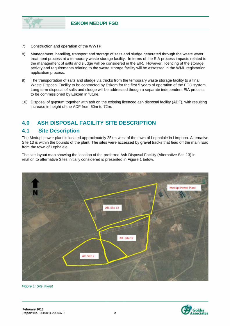
4.0 ASH DISPOSAL FACILITY SITE DESCRIPTION 4.1 Site Description The Medupi power plant is located approximately 25km west of the town of Lephalale in Limpopo. Alternative Site 13 is within the bounds of the plant. The sites were accessed by gravel tracks that lead off the main road from the town of Lephalale.
The site layout map showing the location of the preferred Ash Disposal Facility (Alternative Site 13) in relation to alternative Sites initially considered is presented in Figure 1 below.
Figure 1: Site layout
ESKOM MEDUPI FGD
February 2018 Report No. 1415881-299047-3 3
The general topography of the site comprises large level plains with wild animals (bucks and warthogs) seen on the sites during the investigation. Construction is currently taking place in an area adjacent to Alternative Site 13, but it is a progressing development.
The bush comprises a thick concentration of trees, shrubs and grass interspersed with large trees. Movement through the bush by vehicles is generally difficult, with some tracks used by Eskom. The site investigation team relied on tracks formed by the excavator to navigate the site. No major rivers or water bodies were observed.
Photographs of the sites, taken during the geotechnical fieldwork, are included below:
Alternative Site 13
Figure 2: Construction activity seen on site
Figure 3: Typical test pit investigated on site (shallow refusal)
Figure 4: Typical material excavated from site
Figure 5: Typical vegetation on site
ESKOM MEDUPI FGD
February 2018 Report No. 1415881-299047-3 4
4.2 Nature of the Investigation 4.2.1 Field Investigation over the ADF Footprint Geotechnical fieldwork was undertaken from 3 November to 6 November 2015 and comprised the following:
¡ Mechanical excavation, using an excavator provided by Golder, of 8 test pits at pre-determined positions. The pre-determined GPS positions of each test pit were located on site using a handheld GPS unit accurate to within about 5 m. Test pits were excavated to depths of approximately 3 m below natural ground level (NGL). Test pits were profiled according to the method of prescribed in SANS 633. Retrieval of representative soil samples was undertaken from some test pits for laboratory testing purposes.
The approximate fieldwork positions are presented in the figure attached in Appendix B.
4.2.2 Laboratory Testing Soil samples were collected from the test pits and transported to a specialist laboratory in Johannesburg. The soil samples were submitted for testing to determine fundamental geotechnical engineering properties of the materials including soil classification, material and compaction properties.
The following sample types and number of samples were retrieved during the investigations:
Table 1: Samples types and quantities
Source Disturbed Soil Disturbed Soil (Bulk)
Test Pits 5 1
4.3 Geology and Soil Profile 4.3.1 Geology and Climatic Value The published 1:250 000 Geological Map of Elisras (1993) shows the proposed site area is underlain by coarse grained brown sandstone and conglomerates of the Mogalakwena Formation, Waterberg Group. In the area of interest, thick profiles of sandy Alluvium can be expected.
The area is classified as having a climatic N-value (Weinert, 1980) of almost 5, which indicates that both chemical weathering and mechanical weathering are likely. From the description of the geology of the area it can be expected that residual soils are generally shallow and transported soils vary greatly in thickness.
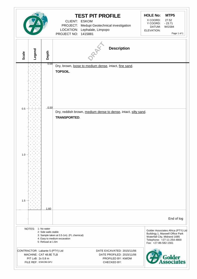
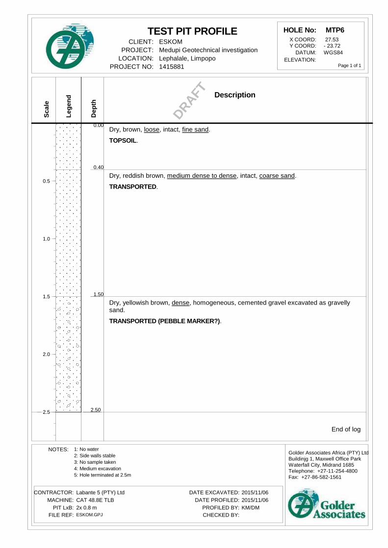
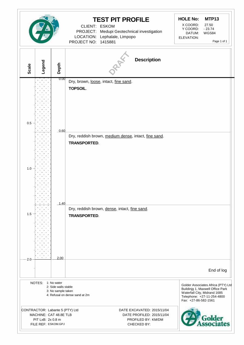
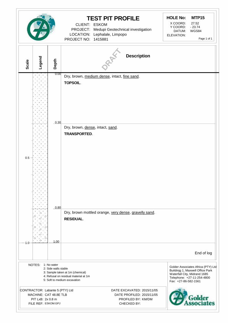
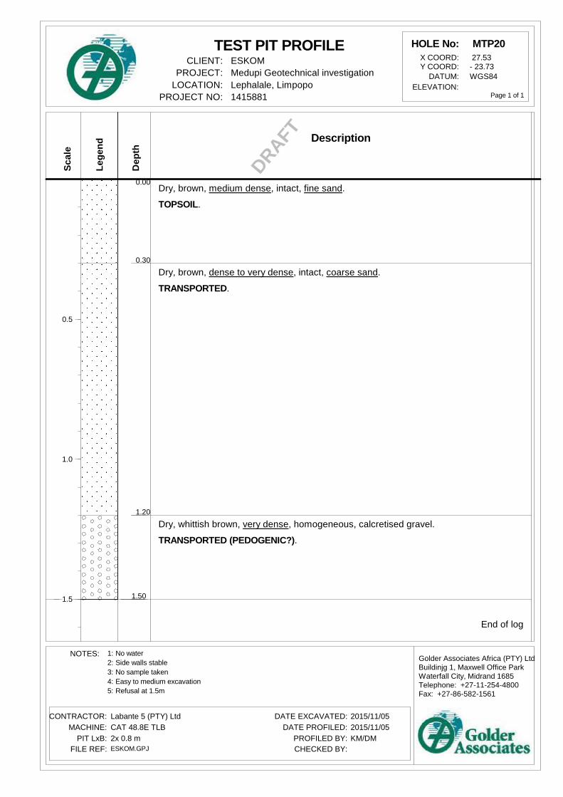
4.3.2 Soil Profile A total of 8 test pits were excavated within the footprint of Alternative Site 13. This is a deviation from the original 9 test pits that where initially planned. Test Pit 7 was inaccessible during the field investigation.
The excavated test pits intersected a relatively uniform near surface ground profile across all alternative sites. The intersected ground profile within the 3.0 m from NGL generally comprises four successive horizons. These general horizons have been described below for interpretive purposes.
ESKOM MEDUPI FGD
February 2018 Report No. 1415881-299047-3 5
Table 2: Typical Soil Profiles the Alternative ASF Site
Topsoil Dry to slightly moist, brown to brownish grey, very loose becoming loose with increasing depth, intact, fine grained; SILTY SAND – Topsoil with some roots and organic material.
Transported Sand (Alluvium)
Slightly moist, reddish brown, medium dense to dense with increasing depth, intact to slightly shattered, fine to medium grained; slightly SILTY CLAYEY SAND to SILTY SAND – Transported (Alluvium).
Transported Gravel
Dry, brown speckled black, dense becoming dense with depth, homogenous, medium to coarse grained, matrix supported, blocky, rounded, smooth to granular, hard rock; weakly cemented GRAVEL, excavates as gravel – Transported
Sandstone This material was only encountered in MTP9 at depth 1.1. Reddish brown, highly weathered, fine grained, soft rock, in situ weathered SANDSTONE excavated as rounded, subangular gravel.
Table 3: Ground Profile underlying the ADF Footprint Alternative Site 13
Test Pit ID Depth (m)
Depth to the base of indicated horizon (or base of excavation, where indicated) (m)
Topsoil Transported Sand
Transported Gravel Sandstone
Alternative Site 13
MTP1 1.1 0.2 1.1* - -
MTP2 1.2 0.4 1.2 - -
MTP3 1.1 0.4 1.1 - -
MTP4 1.4 0.4 1.3 1.4* -
MTP5 1.6 0.5 1.6* - -
MTP6 2.5 0.4 1.5 2.5* -
MTP8 1.5 0.5 1.0 1.5* -
MTP9 1.7 0.4 1.1 - 1.7*
*Base of excavation
The area of the proposed development appears to be covered in its entirety by relatively thick alluvial sand. This surface horizon was found to be dry and was up to 2 m thick in some test pits.
Cemented gravel material was found is some test pits. This material is interpreted to be also be of transported origin.
Of the 8 test pits, weathered rock was only encountered in MTP9.
ESKOM MEDUPI FGD
February 2018 Report No. 1415881-299047-3 6
4.3.3 Moisture Condition No seepage or groundwater was encountered in any of the test pits, which reached a maximum depth of 2.5m.
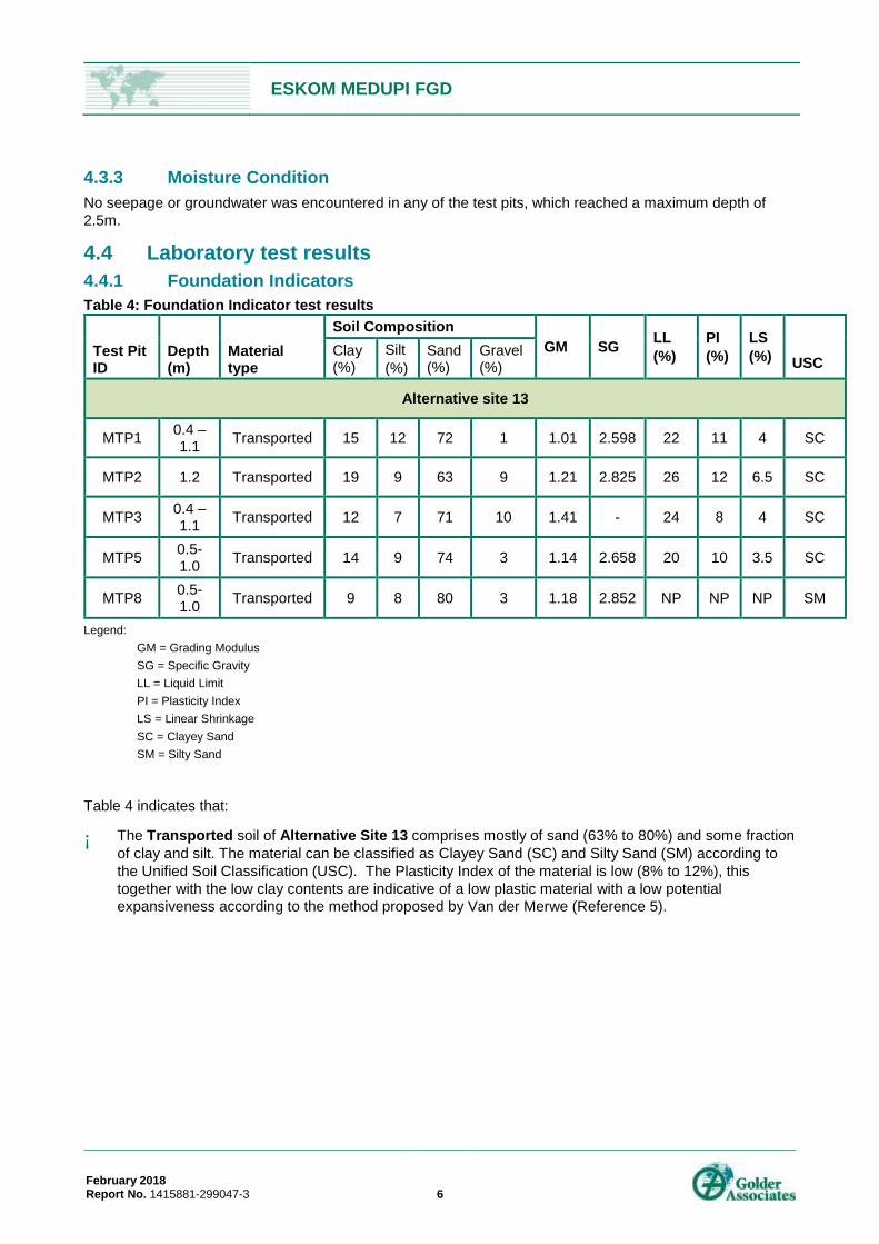
4.4 Laboratory test results 4.4.1 Foundation Indicators Table 4: Foundation Indicator test results
Legend: GM = Grading Modulus SG = Specific Gravity
LL = Liquid Limit PI = Plasticity Index LS = Linear Shrinkage SC = Clayey Sand SM = Silty Sand Table 4 indicates that:
¡ The Transported soil of Alternative Site 13 comprises mostly of sand (63% to 80%) and some fraction of clay and silt. The material can be classified as Clayey Sand (SC) and Silty Sand (SM) according to the Unified Soil Classification (USC). The Plasticity Index of the material is low (8% to 12%), this together with the low clay contents are indicative of a low plastic material with a low potential expansiveness according to the method proposed by Van der Merwe (Reference 5).
ESKOM MEDUPI FGD
February 2018 Report No. 1415881-299047-3 7
4.4.2 Compaction Characteristics Table 5: Compaction Test Results
Legend OMC = Optimum moisture content MDD = Maximum dry density (Modified AASHTO) Swell = Soaked at 100% Mod AASHTO compaction TRH = Material classification according to TRH14 guidelines CBR = California Bearing Ratio
The Transported sand for Alternative Site 13 has a moderate dry density of 1961 kg/m3 and 2115 kg/m3 and a relatively high moisture content of 11.3 and 8.4% respectively. The swell is low at 1.4% and 0.2% respectively. The CBR value of 93% and 95% compaction effort are relatively low, but typical for sandy material. Accordingly to the TRH 14, the material can be classified as G9 material.
4.4.3 Falling Head Permeability Table 6: Permeability Test Results
The laboratory test results show a relatively low permeability. This is due to the moderate content of clay and silt in the Transported material. Should the in-situ transported soil be used in the construction of embankments or liner material, a permeability of 1×10⁻⁷ m/s can be expected when compacted to 95% Mod AASHTO effort.
ESKOM MEDUPI FGD
February 2018 Report No. 1415881-299047-3 8
4.4.4 pH and Conductivity Table 7: pH and Conductivity test results
Test Pit ID
Depth (m)
pH-value
Conductivity mS/cm
Alternative Site 13 MPT1 0.40-1.10 5.74 0.3300 MTP5 0.50-1.00 4.56 0.0897
The pH and conductivity of soil is generally determined to get an indication of the potential corrosiveness of the soil. The pH of a soil gives an indication of the acidity of the soil. As a general guideline Evans (Reference 8) noted that corrosion may take place in soil with a pH of less than 6 and that should the pH be less than 4,5 , the problem may be serious. It should however be noted that a low pH value is not necessarily an indication of serious corrosiveness as the pH of the surrounding soil will generally start to rise as soon as corrosion starts.
Corrosion is an electrochemical process whereby metals are changed and electrical energy is released. The conductivity of the soil therefore has a profound influence on the rate of corrosion of buried metallic objects.
The conductivity results are generally very corrosive (0.25 – 0.5 mS/cm) corrosion classification accordingly to the method proposed by Duligal E (Reference 7) with the exception MTP 5 in Alternative site 13. The pH value obtained are indicative of material with medium potential to corrode.
4.5 Geotechnical Impact Assessment An evaluation of the impact of geotechnical conditions on Alternative Site 13 is presented in the sections below.
4.5.1 Excavation Class Excavation Class was assessed according to SANS 1200D: Earthworks Specification (Reference 4) for the areas investigated by means of test pits and at the positions of the test pits, based on a summary of the Excavation Class provided below:
¡ Soft excavation, which is possible using conventional light earthmoving equipment (TLB or similar)
¡ Intermediate excavation, which will require heavier plant (tracked excavator) or pneumatic tools to break up material prior to excavation
¡ Hard excavation, requiring drill-and-blast operations, and boulder material potentially requiring localised drill and blast operations and heavy plant for removal thereof.
¡ Boulder Class, requiring individual drilling and blasting in order to be loosened
The interpreted excavation class for the sites are as follows:
ESKOM MEDUPI FGD
February 2018 Report No. 1415881-299047-3 9
Table 8: Evaluation of Excavation Class
Site
Approximate Average Depths (m)
Soft Excavation Class
Soft to Intermediate Excavation Class
Boulder and Hard Rock Excavation Class
Alternative Site 13 0 – 0.4m 0.6 – 2.5m Approximately 2.5m+
Since rock was encountered from relatively shallow depths elsewhere, variation to the above can be anticipated between points of excavation. An allowance should therefore be made for boulder and hard excavation in areas not inspected, or where TLB refusal was encountered.
4.5.2 Engineering Use A geotechnical evaluation of the engineering properties of the materials encountered on site, together with an appraisal of the suitability of the materials for engineering use and construction based on Wagner (Reference 6), is tabulated below:
Table 9: Preliminary engineering use and construction suitability
Material Type USC Range Workability Homogeneous Embankment Earth Fill
Road Pavement Fill Liner material
Transported/ Residual SC to SM Fair - good Good Poor Fair
Transported SC Good Good Poor Fair USC – Unified Soil Classification
Transported sand was found within the footprint of Alternative Site 13. This material is expected to be found in abundance, although intermediate excavation measures will have to be employed to access this material. This material can be used in embankment fills. The laboratory test results revealed that there is a considerable amount of cohesive material present in the transported material and can, therefore, be appropriate for use as a lining material. Imported clay or a synthetic liner may be needed in addition to the transported material for the construction of the liner for the waste disposal facilities.
4.5.3 Shear Strength The effective shear strength properties of the in situ soils have been estimated based on the laboratory test results, engineering experience and available literature, as follows:
Material Type Estimated effective in situ shear strength parameters
Estimated effective shear strength parameters of material compacted to at least 95% of MDD
c' (kPa) ϕ' (degrees) c' (kPa) ϕ' (degrees)
Transported 0 26 - 30 0 32 MDD: Maximum dry density
ESKOM MEDUPI FGD
February 2018 Report No. 1415881-299047-3 10
4.5.4 Shallow Foundations The following recommendations on bearing capacity should be considered preliminary and subject to further investigation and analysis as the design proceeds.
Design of shallow strip and pad footings are considered suitable on properly compacted alluvial sand and gravel which covers the majority of Alternative Site 13. These should generally be designed for light structures (loads not exceeding 100kPa), subject to depth of embedment and minimum footing width requirements. The suitability of the site for deep pad foundations in order to found statically loaded heavy structures is considered suitable up to about 300kPa, subject to similar requirements as per lightly loaded structures above. Note that final recommendations need to be reviewed once the details of the waste disposal facilities and their accompanying loads are known. Further ground intrusive investigations (core drilling, geophysical investigation and SPT) will be required.
4.5.5 Lateral Stability of Excavation The lateral stability of excavation side walls are not expected to be problematic. We recommend the following preliminary slopes:
¡ Permanent cut slopes in non-cohesive sand and gravel: 1 Vertical (V): 3.0 Horizontal (H)
¡ Temporary cut slopes in sand and gravel: 1V: 2H
¡ Permanent embankment fill slopes in non-cohesive sand and gravel: 1V: 2.5H
4.5.6 Summary of Geotechnical Impact Assessment
ESKOM MEDUPI FGD
February 2018 Report No. 1415881-299047-3 1
Table 11: Geotechnical Impact Assessment of Alternative Site 13
Activity Nature of Impact Impact type Extent Duration Potential
Excavation Class was assessed according to SANS 1200D: Earthworks Specification for the areas investigated
by means of test pits and at the positions of the test pits.
Existing 2 1 2 1 6 - Moderate
The use of mechanical equipment or blasting to
excavate below 2.5m
A contingency should be allowed from
depths of 2.5m below NGL
Engineering Use
A geotechnical evaluation of the engineering properties of the materials encountered on site, together with an
appraisal of the suitability of the materials for engineering use and construction
based on Wagner (1957)
Existing 2 1 2 0.75 5.75 - Moderate
The material is good for use as an embankment fill but
better material would need to be imported to construct the roads leading to the facility.
Gravel material (G6 or better) and clay
material may need to be imported in the
construction phase to use as liner and
construction material
Shear strength
The effective shear strength properties of the in situ soils have been estimated based on the laboratory test results,
engineering experience and available literature
Residual 2 2 2 0.75 6.75 - Moderate
The shear strength of the material is quite low and would need to be further tested. The
shear strength can be improved by stabilising the
material with lime or cement.
The shear strength is appropriate for lightly loaded structures but
would need to be improved for heavy
structures
Bearing Capacity
Bearing capacity should be considered preliminary and subject to further
investigation and analysis as the design proceeds.
Existing 2 5 8 1 16 - High
Bearing capacity for shallow founding is suitable for lightly
loaded structures, deep foundations would be
necessary for heavy structures (bigger than 300kPa)
The bearing capacity is appropriate for
lightly loaded structures but would need to be improved for heavy structures
Lateral Stability
The lateral stability of excavation side walls are not expected to be problematic. We recommend the following preliminary
slopes:
Existing 2 2 4 1 9- Moderate
1V:2.5H excavations are recommended for permanent
slopes while 1V:2H excavations are recommended
for temporary slopes. Benching of slopes may be
required.
The lateral stability of excavation side
walls are not expected to be problematic if
mitigation measures are implemented
ESKOM MEDUPI FGD
February 2018 Report No. 1415881-299047-3 1
5.0 FGD SYSTEM WITHIN THE MEDUPI POWER STATION FOOTPRINT We provide a brief geotechnical assessment of the FGD system within the Power Station footprint using only supplied information, as this area was not included within our original scope of works.
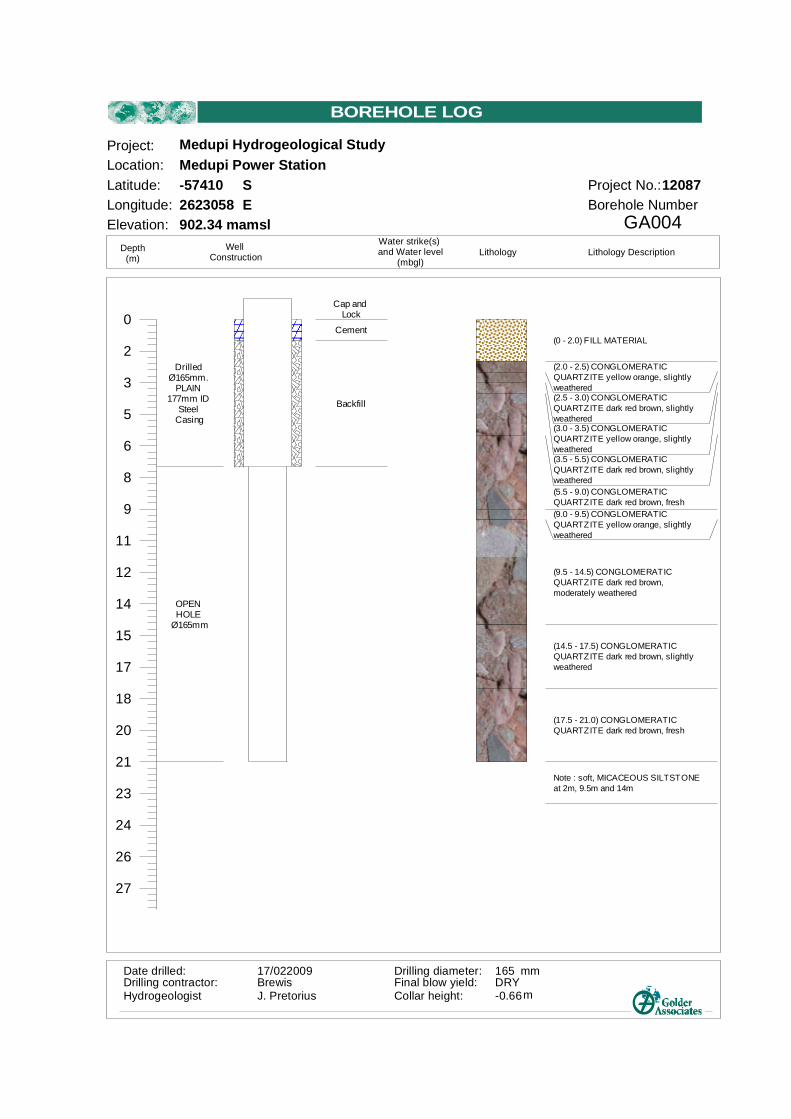
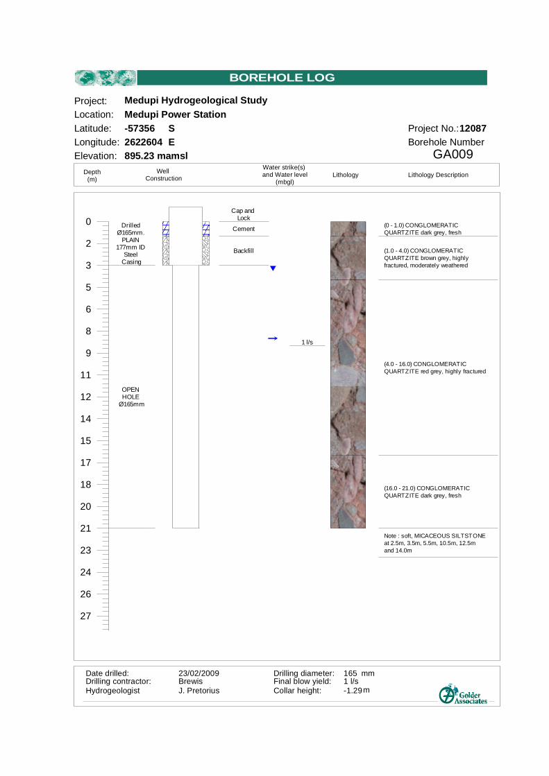
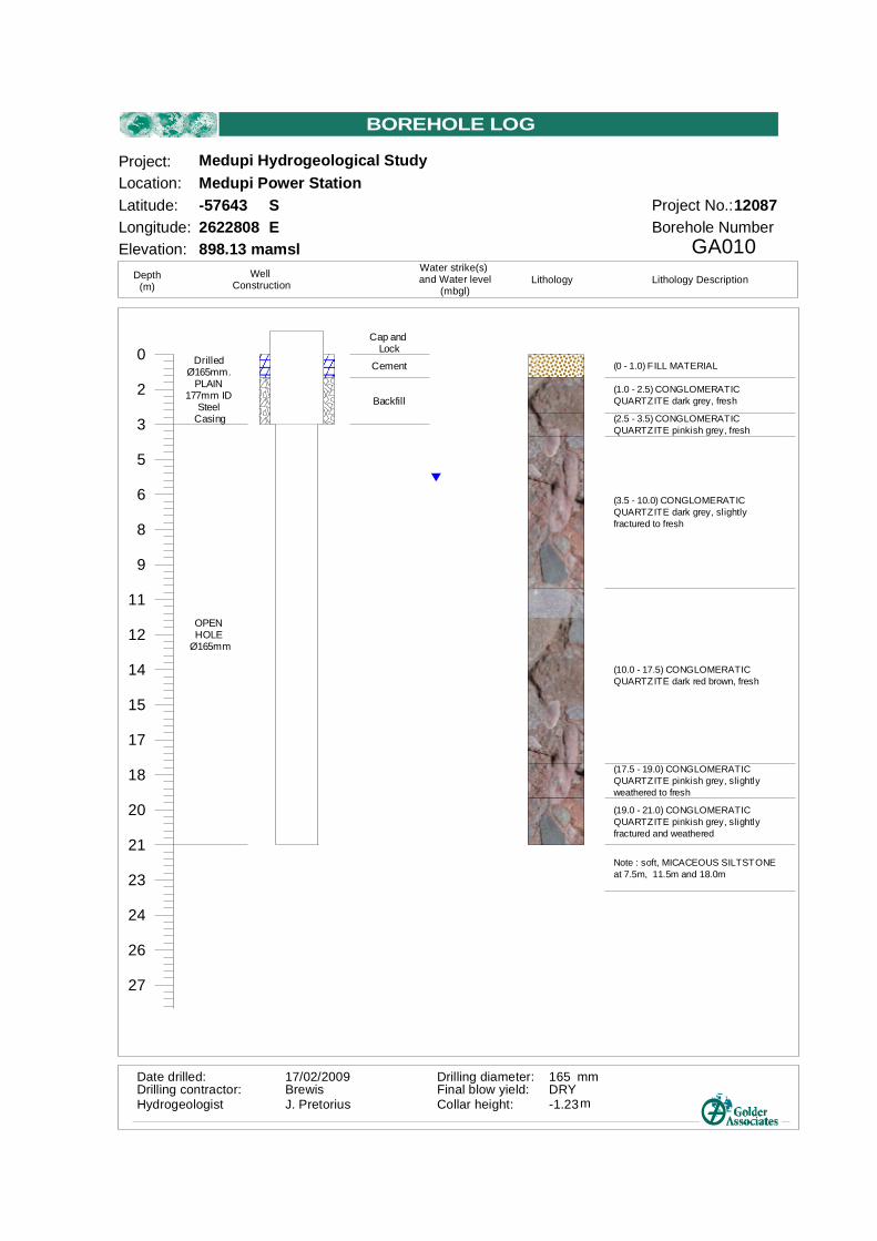
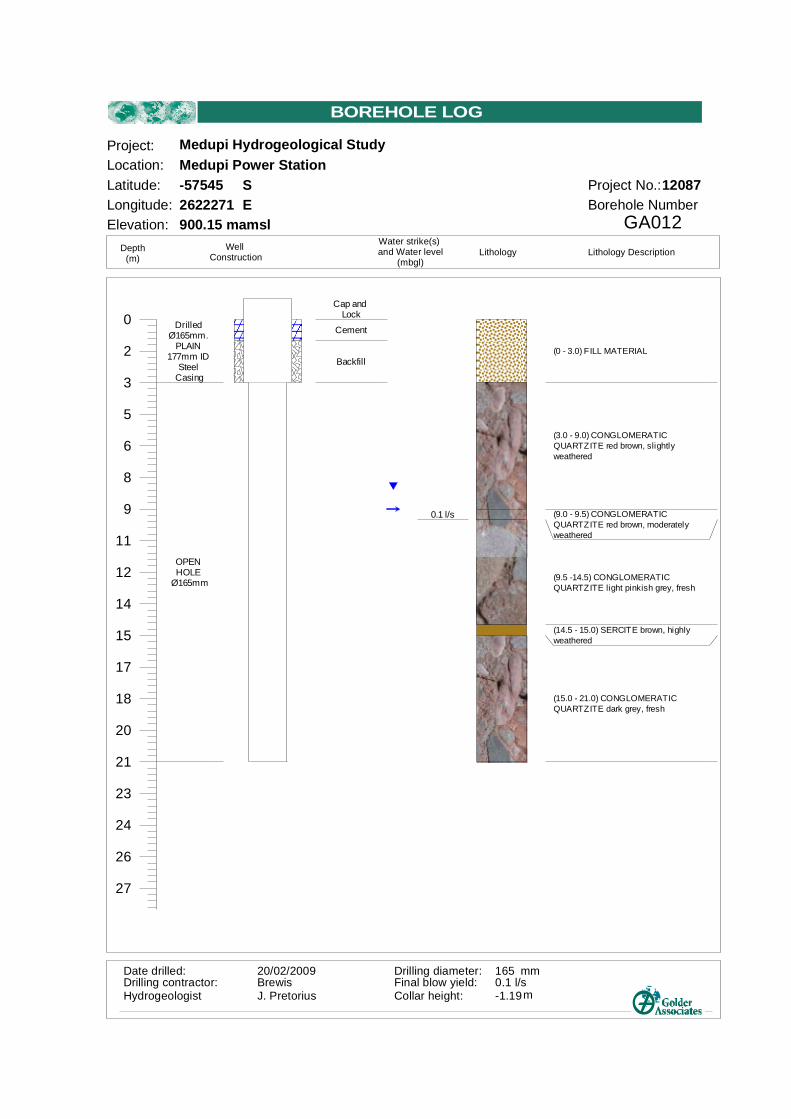
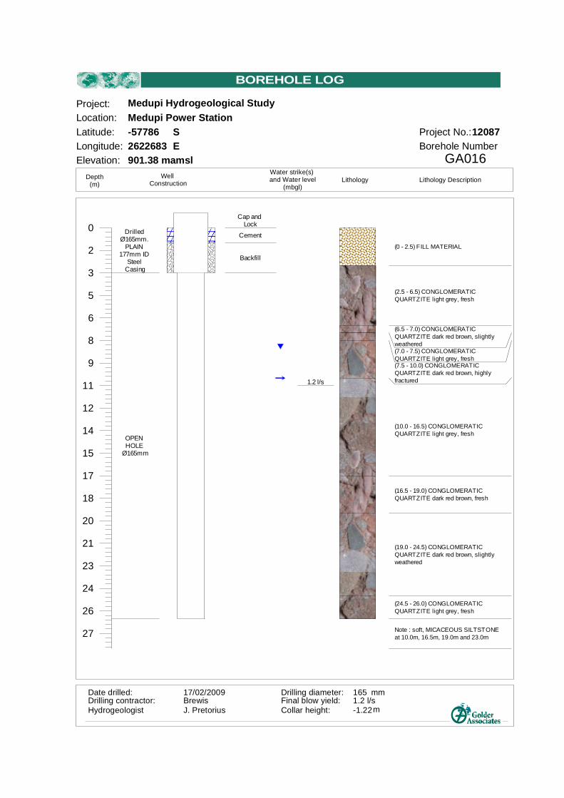
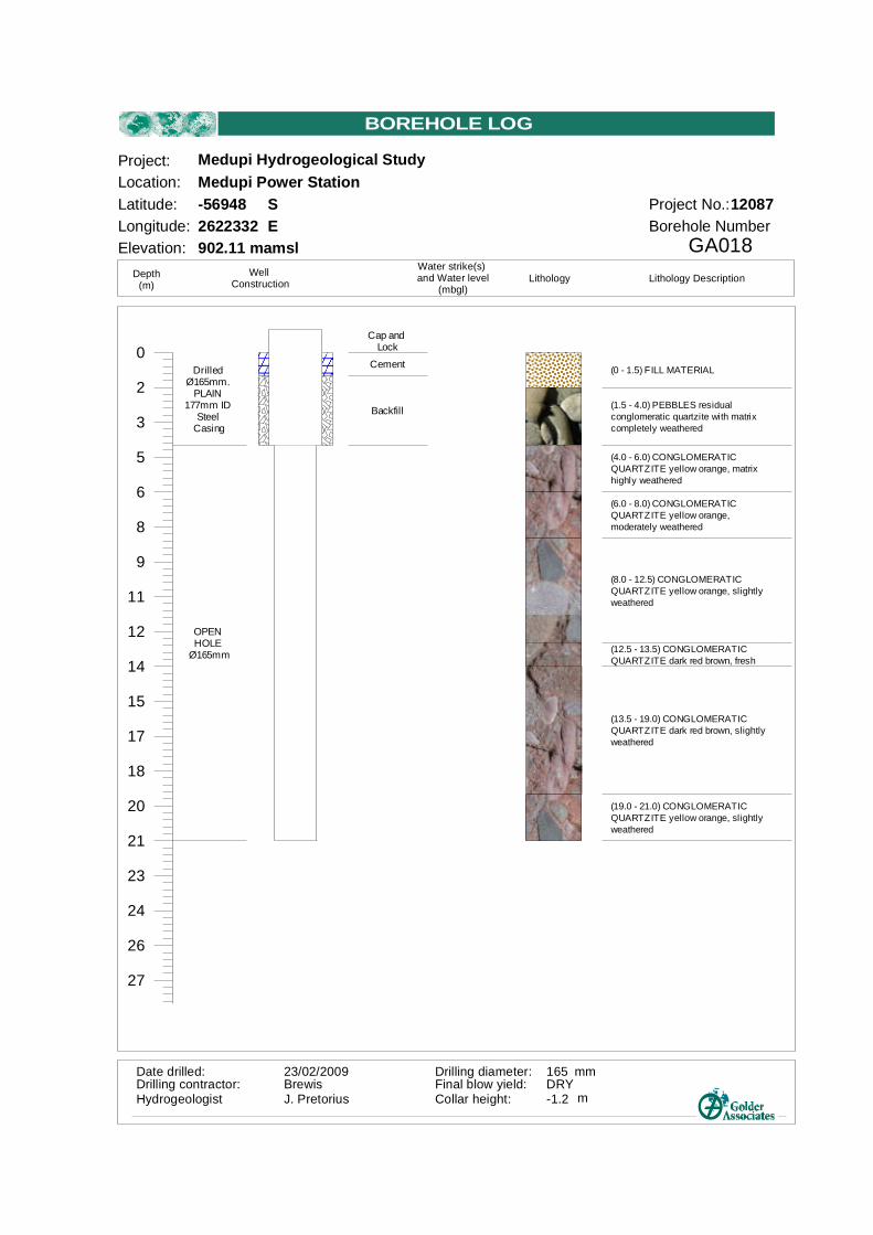
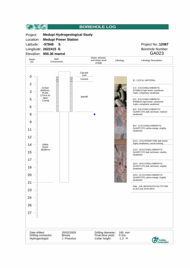
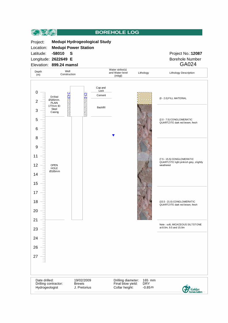
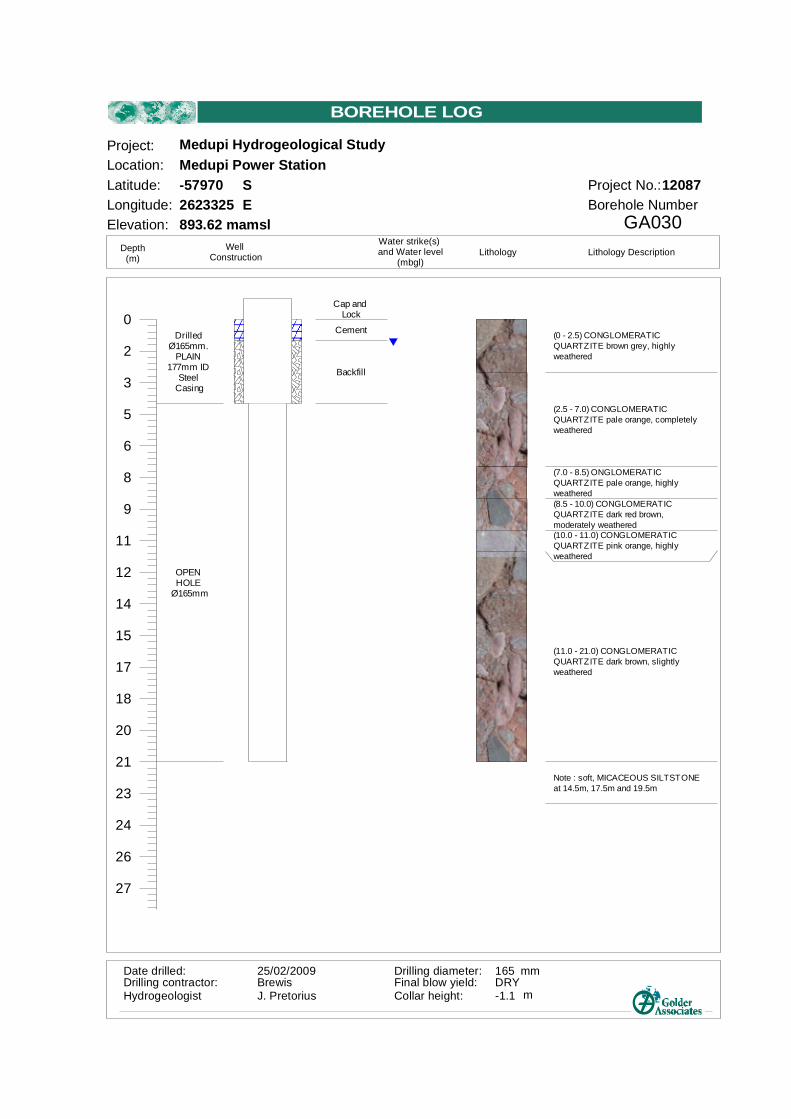
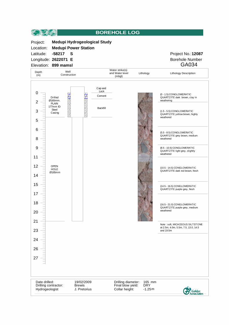
Based on the Golder report reference 12087-8856-1 entitled: Medupi Power Station: Shallow Groundwater Study, and dated June 2009 (Reference 2), a number of percussion (hydrological) boreholes were drilled in and around the Power Station footprint. The location of these boreholes are provided in the figure in Appendix B.
The profiles presented in the report indicates the following ground conditions:
¡ The site is underlain by a sequence of pebbles, weathered quartzitic conglomerate with fresh variously
fractured quartzitic conglomerate at depth. ¡ The conglomerate is interbedded with bluish grey siltstone (bands). The drilling has shown the siltstone forms discontinuous layers of up to 50cm thick but mostly about 20cm thick. ¡ Generally surface weathering to shallow depth (<5m) occurs. In some boreholes a second fractured and associated weathered zone is observed and is normally found between 7 - 14m. ¡ Some boreholes (e.g. GA001, GA003, GA004, GA005 and GA014) have no surface weathering. ¡ Boreholes in the extreme north or west, show the presence of deep weathering, up to 21m. ¡ Water strikes were made in 14 of the 35 boreholes at depths between 6 and 10.5m below surface. Based on this information, the following brief comments are provided:
¡ The site is mainly underlain by quartzites, shale, sandstones and conglomerates. Soils and weathered and fractures rock are present to depths typically varying from 10 to 15m, below which the soils become relatively fresh.
¡ Standard foundation systems are expected to be applicable, comprising generally shallow foundations.
¡ Excavatability is expected to be soft to intermediate, with hard rock class (drill and blast) for excavation in moderately weathered or harder rock (location dependent, but generally below about 5m depth).
6.0 RAILWAY YARD AND LIMESTONE AND GYPSUM HANDLING FACILITIES
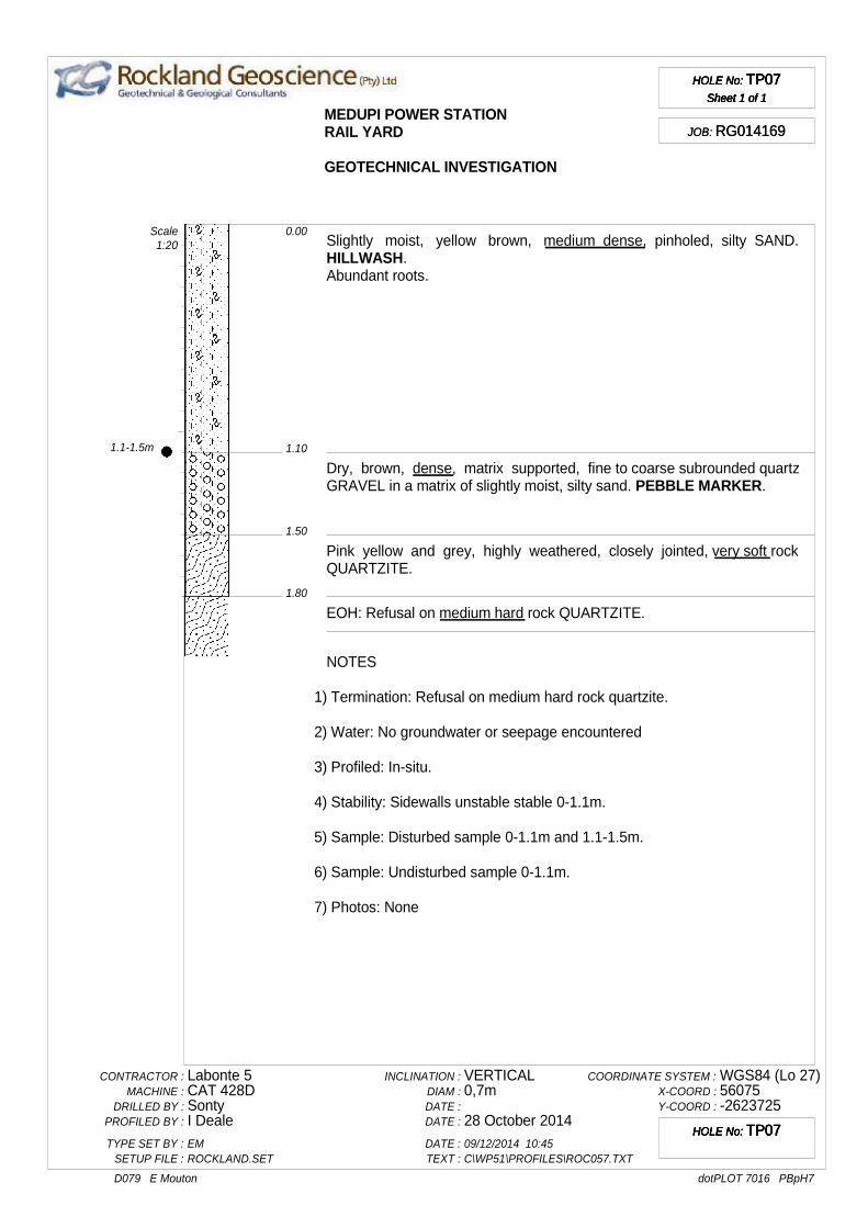
We provide a brief geotechnical assessment of the Railway Yard and Limestone and Gypsum Handling facilities using supplied information only, as this area was not included in our original scope of works.
Based on the supplied Rockland Geocscience report (Reference 3), the following is noted:
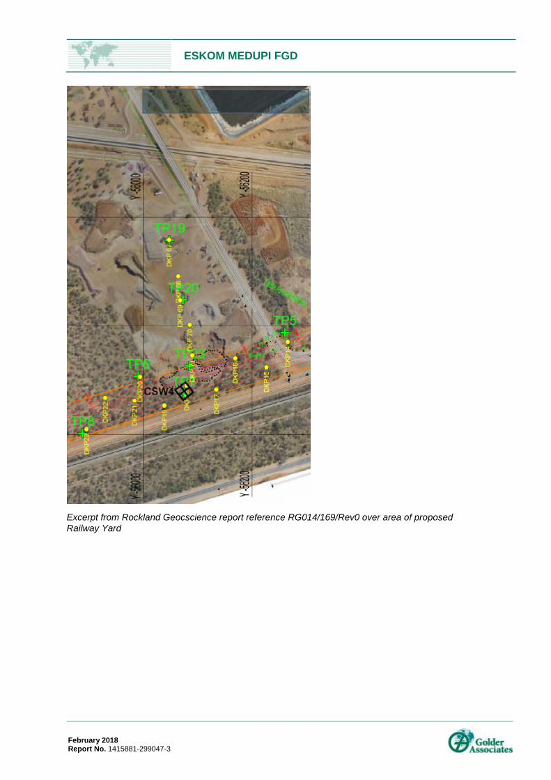
The investigation comprised the excavation of test pits and geophysical surveys over the site. Test pit TP7 and TP23 are located near to the proposed railway yard. These encountered medium dense silty sand to between 1.1m and 1.8m, underlain by dense gravel to between 1.5m and 2.4m, underlain by very soft rock quartzite in TP7, with TLB refusal at 1.8m on medium hard rock quartzite in TP7, and refusal on hardpan ferricrete at 2.4m in TP23. The geophysical continuous surface wave (CSW) survey CSW4 conducted adjacent to TP7 interpreted a shear wave velocity profile with highly weathered (quartzite) rock below about 1.5m, becoming moderately weathered below about 4m, then slightly weathered below about 8.5m.
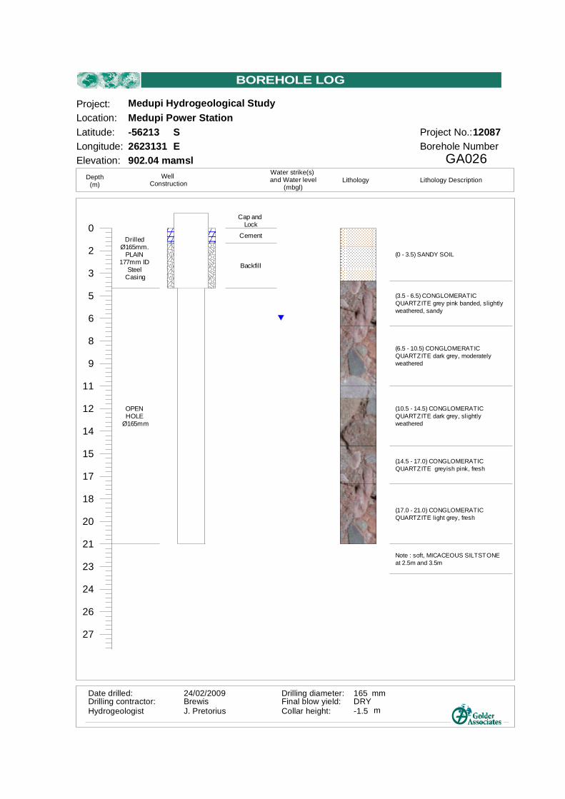
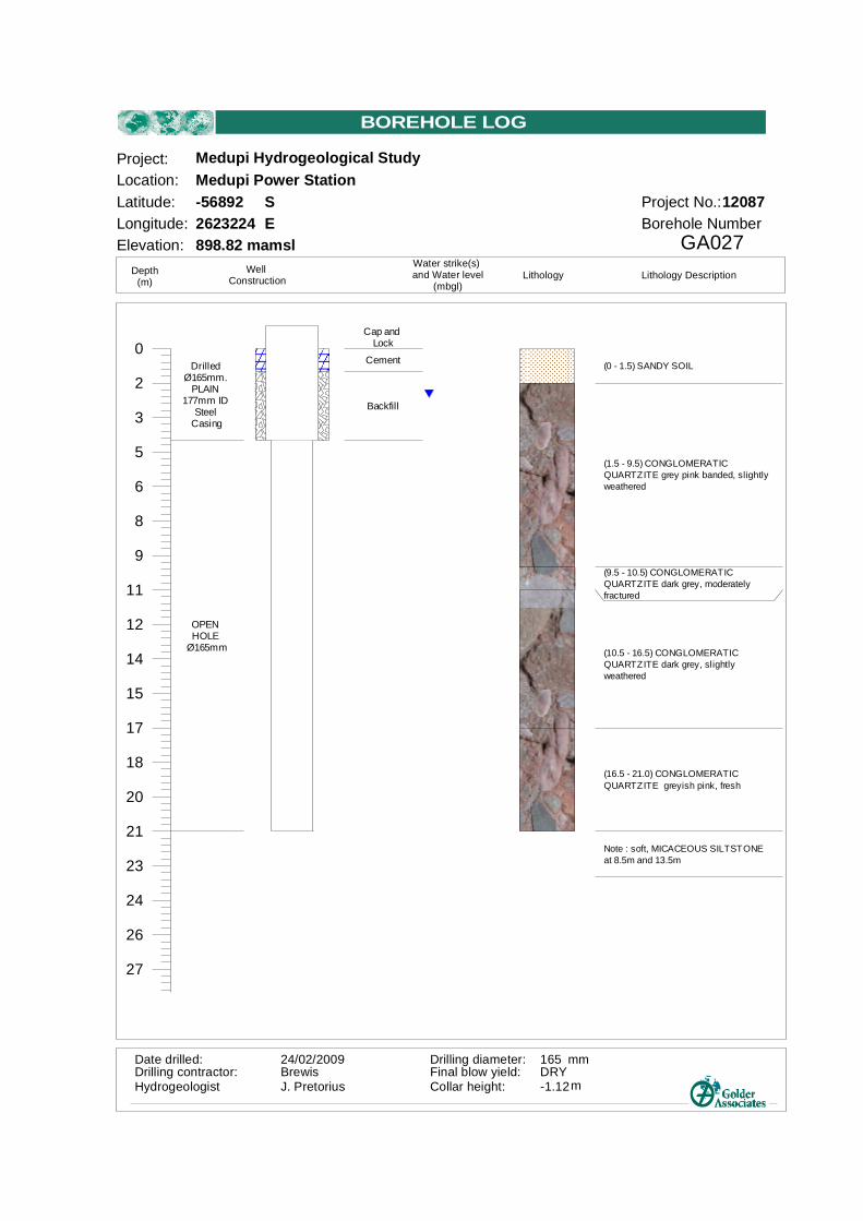
Based on the Golder report reference 12087-8856-1 entitled: Medupi Power Station: Shallow Groundwater Study and dated June 2009, a number of boreholes were drilled in and around the Power Station footprint. We have reviewed the two boreholes closest to the proposed Railway Yard, GA026 and GA027, which are located about 800 to 1000m away. The water level measured in GA026 was dry, and in GA027 was 2.6m below surface.
ESKOM MEDUPI FGD
February 2018 Report No. 1415881-299047-3 2
Borehole GA026 indicates slightly and moderately weathered conglomeratic quartzite in zones below 3.5m depth, becoming fresh from 14.5m depth, whilst GA027 indicated the boundary between slightly to moderately weathered quartzite and fresh quartzite at 16.5m.
The Limestone Offloading Facility below the railway yard is proposed to be 15m in depth. Based on the above, the following is interpreted:
Hard rock (drill and blast excavation) will be required from a depth of about 2m.
Dependent on the thickness of the surficial soils and any fill materials over the area, a contingency allowance should be made for encountering rock during the installation of such services or shallow foundations, where hard rock excavation (hydraulic rock hammer or drill and blast) may be necessary.
Standard footing systems such as shallow pad and strip footings are expected to be applicable for the area.
Deep excavations are expected to require reinforcement and/or stabilisation, particularly at shallow depths. Dependent on the quality of the rock and degree of fracturing, the lower half of the 15m deep excavation may potentially be unreinforced and unstabilised. Core orientated geotechnical drilling and associated structural analysis of the ground will be required prior to design to test for this design solution.
Groundwater can be expected from a shallow depth in the excavation. The volume of water seepage is expected to be relatively low, and reducing as the excavation proceeds into less fractured rock.
7.0 CONCLUSION A total of 8 test pits were excavated at the site of the ash disposal facility using a TLB to a median depth of 2m. The test pits intersected topsoil overlying alluvial non-cohesive material, with weathered sandstone intersected in only one test pit at a depth of 1.7m. Recommendations have been provided on excavatibility, engineering use, shear strength, shallow foundations and slope angles at the ash disposal facility.
The ground conditions at the site of the FGD system within the plant site were assessed using percussion (hydrological) boreholes. Based on this, weathered rock is expected from about 5m depth. We note that this depth will be highly variable, and further testing will be needed to confirm the ground conditions at each item of infrastructure.
The ground conditions at the site of the Rail Yard and the Limestone and Gypsum Offloading Facility were assessed using percussion (hydrological) boreholes about 800m to 1000m away from the area, as well as test pits and geophysics conducted near to the area. Based on this, weathered rock and/or hardpan ferricrete can be expected from about 2m depth. This is underlain by weathered quartzite, becoming slightly weathered to fresh from about 8m.
No significant geotechnical hazards or fatal flaws were identified. All the geotechnical considerations mentioned can be mitigated in the design of the facility. Significant further investigations will be required for all items of infrastructure as the design proceeds.
8.0 REFERENCES 11) Brink A.B.A. and Bruin R.M.H., 1990, “Guidelines for Soil and Rock Logging in South Africa”, 2nd
Impression 2001, eds. Proceedings, Geoterminology Workshop organised by AEG, SAICE and SAIEG.
12) Golder Associates, June 2009: “Medupi Power Station: Shallow Groundwater Study”, 12087-8856-1.
13) Rockland Geocscience, March 2015: “Report on the Geotechnical Investigation Conducted for a Proposed Rail Siding, Rail Yard and Off-loading Facility at Medupi Power Station, Lephalale, Limpopo Province”, RG014/169/Rev0.
14) SANS 1200D: 1990: “Standardized Specification for Civil Engineering Construction - Part D: Earthworks” South African National Bureau of Standards, ISBN 0-626-08060-6, pg.6.
15) Van der Merwe, D. H.,1964: “The prediction of heave from the plasticity index and percentage of clay fraction of soils”, Trans. SA Inst. Civ. Eng., Vol. 6, No 6. p 103-107.
ESKOM MEDUPI FGD
February 2018 Report No. 1415881-299047-3 3
16) Wagner A.A., 1957, “The use of unified soils classification system by Bureau of Reclamation”, Proceedings of the 4th ICSMFE, London, Vol 1:125.
17) Duligal E. 1996: “Significance of Soil Resistivity on Corrosivity”.
18) Evans, U R. 1977: “The Corrosion and Oxidation of Metals: Scientific principles and practical applications. Edward Arnold (Publishers ) Ltd.
9.0 DOCUMENT LIMITATIONS Your attention is drawn to the attached: “Document Limitations”. The statements presented in this document are intended to advise you of what your realistic expectations of this report should be, and to present you with recommendations on how to minimise the risks associated with the groundworks for this project. The document is not intended to reduce the level of responsibility accepted by Golder Associates, but rather to ensure that all parties who may rely on this report are aware of the responsibilities each assumes in so doing.
GOLDER ASSOCIATES AFRICA (PTY) LTD.
Simon Owens-Collins Senior Engineering Geologist
KM-SOC/SOC/soc
Reg. No. 2002/007104/07 Directors: SA Eckstein, RGM Heath, SC Naidoo, GYW Ngoma Golder, Golder Associates and the GA globe design are trademarks of Golder Associates Corporation.
c:\users\sowens-collins\appdata\local\microsoft\windows\temporary internet files\content.outlook\8ldyissg\1415881-299047-3_rep_geotechnical impact assessment_20180207.docx
ESKOM MEDUPI FGD
February 2018 Report No. 1415881-299047-3
APPENDIX A Document Limitations
DOCUMENT LIMITATIONS
GAA GAIMS Form 10 Version 2
January 2015 1/1
DOCUMENT LIMITATIONThis Document has been provided by Golder Associates Africa Pty Ltd (“Golder”) subject to the followinglimitations:
i) This Document has been prepared for the particular purpose outlined in Golder’s proposal and noresponsibility is accepted for the use of this Document, in whole or in part, in other contexts or for anyother purpose.
ii) The scope and the period of Golder’s Services are as described in Golder’s proposal, and are subject torestrictions and limitations. Golder did not perform a complete assessment of all possible conditions orcircumstances that may exist at the site referenced in the Document. If a service is not expresslyindicated, do not assume it has been provided. If a matter is not addressed, do not assume that anydetermination has been made by Golder in regards to it.
iii) Conditions may exist which were undetectable given the limited nature of the enquiry Golder wasretained to undertake with respect to the site. Variations in conditions may occur between investigatorylocations, and there may be special conditions pertaining to the site which have not been revealed bythe investigation and which have not therefore been taken into account in the Document. Accordingly,additional studies and actions may be required.
iv) In addition, it is recognised that the passage of time affects the information and assessment provided inthis Document. Golder’s opinions are based upon information that existed at the time of the productionof the Document. It is understood that the Services provided allowed Golder to form no more than anopinion of the actual conditions of the site at the time the site was visited and cannot be used to assessthe effect of any subsequent changes in the quality of the site, or its surroundings, or any laws orregulations.
v) Any assessments made in this Document are based on the conditions indicated from published sourcesand the investigation described. No warranty is included, either express or implied, that the actualconditions will conform exactly to the assessments contained in this Document.
vi) Where data supplied by the client or other external sources, including previous site investigation data,have been used, it has been assumed that the information is correct unless otherwise stated. Noresponsibility is accepted by Golder for incomplete or inaccurate data supplied by others.
vii) The Client acknowledges that Golder may have retained sub-consultants affiliated with Golder toprovide Services for the benefit of Golder. Golder will be fully responsible to the Client for the Servicesand work done by all of its sub-consultants and subcontractors. The Client agrees that it will only assertclaims against and seek to recover losses, damages or other liabilities from Golder and not Golder’saffiliated companies. To the maximum extent allowed by law, the Client acknowledges and agrees it willnot have any legal recourse, and waives any expense, loss, claim, demand, or cause of action, againstGolder’s affiliated companies, and their employees, officers and directors.
viii) This Document is provided for sole use by the Client and is confidential to it and its professionaladvisers. No responsibility whatsoever for the contents of this Document will be accepted to any personother than the Client. Any use which a third party makes of this Document, or any reliance on ordecisions to be made based on it, is the responsibility of such third parties. Golder accepts no responsibility for damages, if any, suffered by any third party as a result of decisions made or actionsbased on this Document.
GOLDER IN AFRICA
g:\new structure\99605 - risk division\gaims\forms\gaims\gaa gaims form 10_rev 2.docx
ESKOM MEDUPI FGD
February 2018 Report No. 1415881-299047-3
APPENDIX B Figures
ESKOM MEDUPI FGD
February 2018 Report No. 1415881-299047-3
ESKOM MEDUPI FGD
February 2018 Report No. 1415881-299047-3
ESKOM MEDUPI FGD
February 2018 Report No. 1415881-299047-3
Excerpt from Rockland Geocscience report reference RG014/169/Rev0 over area of proposed Railway Yard
ESKOM MEDUPI FGD
February 2018 Report No. 1415881-299047-3
APPENDIX C Profile logs
Dry, brown, medium dense, intact, fine sand with roots.
TOPSOIL.
Dry, brown speckled red, dense to very dense, intact, coarse sand.
(6.5 - 13.0)CONGLOMERATICQUARTZITE dark red brown, fresh
(13.0 - 14.5) CONGLOMERATICQUARTZITE dark red brown, mediumweathered
(14.5 - 21.0) CONGLOMERATICQUARTZITE dark red brown, slightlyweathered
DrilledØ165mm.
PLAIN177mm ID
SteelCasing
OPENHOLE
Ø165mm
Cap andLock
Cement
Backfill
Date drilled:Drilling contractor:Hydrogeologist Collar height:
Final blow yield:24/02/2009BrewisJ. Pretorius
0.1l/s-1.2 m
Drilling diameter: mm165
GA036Borehole Number
Latitude:Longitude:
Project:Location:
Project No.:
Medupi Hydrogeological Study
12087Medupi Power Station-583722622964
Elevation: 899 mamsl
SE
Depth(m)
WellConstruction
Water strike(s)and Water level
(mbgl)Lithology Lithology Description
BOREHOLE LOG
MEDUPI POWER STATIONRAIL YARD
GEOTECHNICAL INVESTIGATION
HOLE No: TP23Sheet 1 of 1
HOLE No: TP23Sheet 1 of 1
HOLE No: TP23Sheet 1 of 1
HOLE No: TP23Sheet 1 of 1
JOB: RG014169JOB: RG014169
0.80
0.00
1.80
2.40
Grey, angular, fine to coarse gravel size and minor boulder size, mediumhard to hard rock QUARTZITE, densely packed in silty SAND. FILL.
Slightly moist, orange brown, medium dense, pinholed, silty SAND.HILLWASH.
Slightly moist, grey brown mottled red and black, matrix supported fine tocoarse subrounded quartz GRAVEL and FERRICRETE NODULES in amatrix of clayey SAND. FERRUGINISED PEBBLE MARKER.
EOH: Refusal on HARDPAN FERRICRETE.
Scale1:20
NOTES
1) Termination: Refusal on well hardpan ferricrete.
2) Water: No groundwater or seepage encountered.
3) Profiled: In-situ.
4) Stability: Sidewalls stable short term - HILLWASH potential unstable.
5) Sample: No Sample
6) Photos: Nr. 1235
CONTRACTOR :MACHINE :
DRILLED BY :PROFILED BY :
TYPE SET BY :SETUP FILE :
Labonte 5CAT 428DSontyI DealeEMROCKLAND.SET
INCLINATION :DIAM :DATE :DATE :
DATE :TEXT :
Vertical0,7m
10 November 201409/12/2014 10:46C\WP51\PROFILES\ROC057.TXT