WORLD METEOROLOGICAL ORGANIZATION COMMISSION FOR BASIC SYSTEMS OPAG ON INTEGRATED OBSERVING SYSTEMS EXPERT TEAM ON EVOLUTION OF THE GLOBAL OBSERVING SYSTEM Fifth Session Geneva, Switzerland, 30 November – 4 December 2009 FINAL REPORT
Transcript
WORLD METEOROLOGICAL ORGANIZATION
COMMISSION FOR BASIC SYSTEMS
OPAG ON INTEGRATED OBSERVING SYSTEMS
EXPERT TEAM ON EVOLUTION OF THE GLOBAL OBSERVING SYSTEM
Fifth Session
Geneva, Switzerland, 30 November – 4 December 2009
FINAL REPORT
DISCLAIMER
Regulation 42
Recommendations of working groups shall have no status within the Organization until they have been approved by the responsible constituent body. In the case of joint working groups the
recommendations must be concurred with by the presidents of the constituent bodies concerned before being submitted to the designated constituent body.
Regulation 43
In the case of a recommendation made by a working group between sessions of the responsible constituent body, either in a session of a working group or by correspondence, the president of the body may, as an exceptional measure, approve the recommendation on behalf of the constituent body when the matter is, in his opinion, urgent, and does not appear to imply new obligations for Members. He may then submit this recommendation for adoption by the Executive Council or to the President of the Organization for action in accordance with Regulation 9(5).
The right of publication in print, electronic and any other form and in any language is reserved by WMO. Short extracts from WMO publications may be reproduced without authorization provided that the complete source is clearly indicated. Editorial correspondence and requests to publish, reproduce or translate this publication (articles) in part or in whole should be addressed to:
The designations employed in WMO publications and the presentation of material in this publication do not imply the expression of any opinion whatsoever on the part of the Secretariat of WMO concerning the legal status of any country, territory, city or area or of its authorities, or concerning the delimitation of its frontiers or boundaries.
Opinions expressed in WMO publications are those of the authors and do not necessarily reflect those of WMO. The mention of specific companies or products does not imply that they are endorsed or recommended by WMO in preference to others of a similar nature which are not mentioned or advertised.
This document (or report) is not an official publication of WMO and has not been subjected to its standard editorial procedures. The views expressed herein do not necessarily have the endorsement of the Organization.
____________
ET-EGOS-5, FINAL REPORT, p. 3
CONTENTS
Agenda p. 4Executive Summary p. 6General Summary p. 8 - p. 43Annex I List of Participants p. 44Annex II Terms of Reference and membership of the ET-EGOS p. 49Annex III Updated ET-EGOS workplan for 2009-2011 p. 52Annex IV Action sheet from ET-EGOS-5 p. 54Annex V Vision for the GOS in 2025 p. 61Annex VI Synthesis of the review of feedback from national focal
points (2008)p. 68
Annex VII Recommendations to ICT-IOS-6 and CBS p. 70Annex VIII Report on progress of the old EGOS-IP (December 2009) p. 72Annex IX Guidelines for the preparation of the new Implementation
Plan for Evolution of global observing systems - EGOS-IP (responding to new Vision for the GOS in 2025 and WIGOS needs)
p. 116
Annex X Changes proposed by ET-EGOS to the WIGOS CONOPS and WDIP
p. 120
Annex XI Terms of Reference of the consultant drafting the first version of the new EGOS-IP based on the Vision of the GOS in 2025
p. 122
Annex XII AMDAR coverage requirements p. 123Annex XIII Response to Dr Bizzarri proposals on User Requirements
databasep. 125
Annex XIV Atmospheric Composition issues p. 127Annex XV Preliminary list of actions from the draft 2010 update of
the GCOS IPp. 129
Annex XVI Template for requests to NFPs on progress regarding the EGOS-IP
p. 135
Annex XVII Suggestions for addition in a revised version of the Vision of the GOS for 2025
p. 151
Annex XVIII Procedure for update, validation and approval of SoGs within the RRR process
p. 152
____________
ET-EGOS-5, FINAL REPORT, p. 4
AGENDA
1. ORGANIZATION OF THE SESSION
1.1 Opening of the meeting1.2 Adoption of the agenda1.3 Working arrangements
2. REPORT OF THE CHAIRPERSON
3 GUIDANCE FROM CHAIRPERSON OF THE OPAG-IOS
4. REVIEW OF THE WORK PLAN
5. REVIEW OF ACTIONS
6. REVIEW OF OTHER ACTIVITIES RELATED TO ET-EGOS AND OPAG-IOS6.1 THORPEX6.2 Fifth WMO International Symposium on Data Assimilation6.3 IPY Legacy6.4 AMMA6.5 AMDAR6.6 GCOS6.7 EUCOS6.8 GEO / GEOSS6.9 ET-SBRSO
7. WMO Integrated Global Observing System (WIGOS)
7.1 Status of WIGOS activities7.2 Relevance of the Vision for the GOS in 2025 for the Vision for WIGOS7.3 Relevance of the Implementation Plan for the GOS for the WIGOS Implementation
Plan7.4 Other ET-EGOS contributions to WIGOS activities
8. ROLLING REVIEW OF REQUIREMENTS AND STATEMENTS OF GUIDANCE
8.1 Review database of User Requirements8.2 Review database of Observing System Capabilities8.3 Statements of Guidance (SoGs)
8.3.1 Overview of status8.3.2 Consider newly revised SoGs
Global NWP Regional NWP Aeronautical Meteorology Nowcasting and VSRF Ocean Applications Climate (other aspects-CCl)
8.3.3 Consider areas requiring revised SoGs8.3.4 Consider other areas requiring new SoGs, including new elements of
WIGOS
9. OBSERVING SYSTEM STUDIES
ET-EGOS-5, FINAL REPORT, p. 5
9.1 Update on recent OSEs/OSSEs9.2 Proposal for new OSEs/OSSEs to be promoted by ET-EGOS9.3 Next OSE/OSSE workshop
10. IMPLEMENTATION PLAN FOR EVOLUTION OF THE GOS (EGOS-IP)
10.1 Review of feedback from NFPs10.2 Review of progress and actions on EGOS-IP10.3 Preparation of new EGOS-IP, in response to new Vision for the GOS in 2025
and WIGOS needs.
11. ANY OTHER BUSINESS
12. PREPARATION FOR THE FORTHCOMING CBS MEETINGS12.1 Action Plan12.2 Draft report to ICT-IOS-6 and CBS-XV
13. CLOSURE OF THE SESSION
____________
ET-EGOS-5, FINAL REPORT, p. 6
EXECUTIVE SUMMARY
The Fifth Session of the CBS Expert Team on the Evolution of the Global Observing Systems (ET-EGOS-5) was held at the WMO Headquarters in Geneva, Switzerland, from 30 November to 4 December 2009, and was chaired by Dr John Eyre.
The Team updated its Work Plan based on the guidance of CBS-XIV (25 March – 3 April 2009) and CBS-MG-10 (24-26 June 2009). This includes members’ responsibilities, deliverables and deadlines. The progress made against each item from the ET-EGOS-4 (7-11 July 2008) was reviewed, and changes and updates to the action items were made as required.
The Team reviewed several activities related to Integrated Observing System, such as the WWRP-THORPEX and its Third International Science Symposium and TIGGE Users Meeting (Monterey, USA, September 2009), the Fifth WMO International Symposium on Data Assimilation (Melbourne, Australia, October 2009), the International Polar Year (IPY) legacy, the African Monsoon Multidisciplinary Analysis (AMMA), and AMDAR, GCOS, EUCOS, GEO/GEOSS and ET-SBRSO activities. It considered the consequences of these for its own activities.
The Team also reviewed the status of the development of the WIGOS concept and outcomes of EC Working Group on WIGOS & WIS and its Subgroup on WIGOS. The ET discussed the relevance for WIGOS of the Vision for the GOS in 2025 and of the Implementation Plan for Evolution of the GOS (EGOS-IP). Some changes were proposed to the WIGOS Concept of Operations (CONOPS) and the WIGOS Development and Implementation Plan (WDIP).
As part of the Rolling Review of Requirements process, the meeting reviewed the status of the WMO/CEOS database of user requirements for observations and of observing system capabilities. It defined detailed actions for the review and updating of the database of user requirements and observing system capabilities. New proposals for managing, maintaining and updating the databases were discussed, and some recommendations made.
The Team reviewed available updates on individual Statements of Guidance (SoGs) as provided by the nominated expert Points of Contact within the 12 application areas. The Team considered proposals on whether/how the process should be improved and considered which SoGs need revision. It considered newly revised SoGs for Global NWP, Regional NWP, Aeronautical Meteorology, Nowcasting and Very Short Range Forecasting, Ocean Applications, and Climate (other aspects - CCl). Discussion also took place regarding AMDAR coverage requirements and atmospheric composition, where specific recommendations were made. The meeting considered areas requiring new SoGs with regard to new component systems of WIGOS.
The Team reviewed recent activities with OSEs/OSSEs with emphasis on the design of the future of global observing systems. It considered proposals for new OSEs/OSSEs to be promoted by ET-EGOS and proposed a strategy for the preparation of the fifth workshop on the impact of observational data on NWP, to be organized in 2012.
The Team reviewed feedback from National Focal Points concerning the EGOS-IP and considered the information collected when updating the EGOS-IP. It reviewed the progress and actions related to the part of EGOS-IP covering surface-based and space-based sub-systems, and it updated the report on progress and actions.
The Team discussed preparation of a new plan for the evolution of global observing systems (EGOS-IP), based on new Vision for the GOS in 2025 and WIGOS needs. It proposed Terms of Reference for the consultant(s) who will be tasked to draft the new EGOS-IP and
ET-EGOS-5, FINAL REPORT, p. 7
guidelines for the development of a new EGOS-IP. The Team proposed a preliminary list of actions from the draft 2010 update of the GCOS Implementation Plan, to be addressed in the new EGOS-IP.
The Team agreed its action plan until the next ET-EGOS meeting, as well as plans for preparing a draft report that will be presented to the sixth session of ICT-IOS to be held in June 2010.
Finally the meeting discussed the preparation of documents to CBS-XV (December 2010). It agreed on some recommendations, including renaming of the EGOS-IP, and establishing an ad hoc expert team on GRUAN operational procedures and regulatory material, and an ad hoc team of experts between CBS and CAS for coordination of satellite data for atmospheric composition monitoring.
____________
ET-EGOS-5, FINAL REPORT, p. 8
GENERAL SUMMARY
1. ORGANIZATION OF THE SESSION
1.1 Opening of the meeting
1.1.1 The Meeting of the Expert Team on the Evolution of the Global Observing System (ET-EGOS) of the Open Programme Area Group for Integrated Observing Systems (OPAG/IOS) of the Commission for Basic Systems (CBS) of WMO opened at 10:00 hours on Monday, 30 November 2009, at the WMO Headquarters in Geneva, Switzerland.
1.1.2 Dr Wenjian Zhang, Director, WMO Observing and Information Systems Department, opened the meeting on behalf of WMO. He welcomed the participants and explained the significant developments relevant to CBS and especially OPAG-IOS since the last ET-EGOS meeting.
1.1.3 Dr Zhang recalled that, following the strategic decision made by the Fifteenth Congress (Geneva, May 2007) to embark on enhancing the integration between the WMO observing systems, the Executive Council Working Group on the WMO Integrated Global Observing Systems (WIGOS) and the WMO Information System (WIS) steered and monitored the development of WIGOS concept in a way to achieve the broadest possible collaboration and cooperation.
1.1.4 He also recalled the different steps and events that took place since the last ET-EGOS meeting that led to the further updating of the “WIGOS Development and Implementation Plan (WDIP)” and “WIGOS Concept of Operations (CONOPS)” which were endorsed by EC-LXI in June 2009. Substantial changes to these documents have been proposed later on by the second session of the EC Working Group on WIGOS/WIS Subgroup on WIGOS (Geneva, 19-23 October 2009), which also developed further WIGOS standardization aspects and elaborated WIGOS Development and Implementation Strategy.
1.1.5 Dr Zhang invited the Team to review its work plan as proposed by the fourteenth session of the Commission for Basic Systems (CBS-XIV), Dubrovnik, Croatia, 25 March - 2 April 2009, and to include tasks to support WIGOS concept development and its subsequent implementation.
1.1.6 Further, he recalled that CBS-XIV requested OPAG-IOS to develop a new version of the EGOS-IP that will incorporate information included in the adopted “Vision for the GOS in 2025”. There are high expectations that this expert team will play a crucial role in this process, for example regarding how climate aspects will be addressed by the ET-EGOS especially in the context of the developing Global Framework for Climate Services (GFCS). One of the major objectives of this meeting is to update the existing eleven and consider new Statements of Guidance.
1.1.7 Dr Zhang drew the Team’s attention also to the deliberations of the Fifteenth Congress, which requested that the redesign of the GOS be vigorously continued as part of the overall modernization of the WWW systems contributing to WIGOS.
1.1.8 In closing, Dr Zhang wished for a successful and productive session and an agreeable stay in Geneva.
1.1.9 Dr John Eyre, Chairperson of ET-EGOS, also greeted the participants and expressed his confidence that the session would work hard to fulfil its obligations.
1.1.10 The Team acknowledged apologies from Team members Mr Malamine Sonko (Senegal)
ET-EGOS-5, FINAL REPORT, p. 9
and Dr Luiz Augusto Toledo Machado (Brazil) for not being able to attend the meeting. The list of participants is given in Annex I.
1.2 Adoption of the agenda
The Team adopted the Agenda for the meeting, which is reproduced at the beginning of this report.
1.3 Working arrangements
The Team agreed on its working hours and adopted a tentative work plan for consideration of the various agenda items.
2. REPORT OF THE CHAIRPERSON
2.1 The Chairperson, Dr John Eyre (United Kingdom), recalled the Terms of Reference of the Team and reported on activities related to the work of ET-EGOS since its last meeting, ET-EGOS-4 (Geneva, Switzerland, 7-11 July 2008). He also addressed some of the key challenges for this Session and beyond.
2.2 Since ET-EGOS-4, there has been progress in many areas as the Team has addressed its former Work Plan and Actions list. These are discussed in detail under agenda item 5.
2.3 The Chairperson represented ET-EGOS at the Fifth Session of the OPAG/IOS Implementation/Coordination Team (ICT-IOS-5, Geneva, 15-18 Sept 2008). ICT-IOS-5 approved the “Vision for the GOS in 2025” (see agenda item 7.2), which was developed at ET-EGOS-4, for consideration by CBS-XIV, with a few minor revisions. The new “Vision” was then presented at the CBS Technical Conference on the WMO Integrated Observing Systems (WIGOS) in Dubrovnik, Croatia, 23-24 March 2009 and CBS-XIV. CBS-XIV adopted the new “Vision”, with some modifications to its Preamble.
2.4 Dr Eyre reported that CBS-XIV also commended various other aspects of the work done by ET-EGOS including (i) continued work within the Rolling Review of Requirements process; (ii) progress on studies through which real and hypothetical changes to the GOS are assessed for their impact on NWP performance, and in particular the outcomes of the 4 th WMO Workshop on “The impact of various observing systems on numerical weather prediction”, Geneva, 19-21 May 2008; and (iii) updates to the Implementation Plan for the Evolution of the GOS (EGOS-IP). CBS-XIV approved about 20 specific recommendations emerging from the work of ET-EGOS.
2.5 CBS-XIV also considered the Terms of Reference (ToR) and Work Plans for OPAG-IOS Expert Teams (ETs), as proposed by ICT-IOS. These were endorsed, subject to further consideration of detail by the CBS Management Group (CBS-MG). The Ninth CBS-MG met on 24-26 June in Geneva and finalised the Work Plans for CBS ETs and also their membership. The new ToR and membership of the ET-EGOS are provided in Annex II. The Team welcomed Dr Zhou, Dr Munro, Dr Machado and Mr Sonko as new members to the Team, as well as Dr Riishojgaard (USA) who is the OPAG/IOS Chairperson. The Team noted that Dr Dibbern (Germany) who in the ET-EGOS representing EUMETNET is also the OPAG/IOS Co-Chairperson.
2.6 The Chairperson finally reported that in March 2009, ET-EGOS was invited to contribute a Community White Paper to OceanObs’09 Conference (Venice, Italy; 21-25 Sept 2009). A group of ET-EGOS members and former members, together with members of the Secretariat, co-authored a paper on “Requirements of numerical weather prediction for observations of the ocean”. This paper has now been finalised for the conference proceedings. Some issues for ET-EGOS which arose in the review of this paper are discussed further under agenda item 8.3.2.
ET-EGOS-5, FINAL REPORT, p. 10
2.7 The chairperson proposed that this fifth Session of the Team give particular attention to the following issues:
The Team should review recent activities concerning WIGOS and consider how ET-EGOS activities might best contribute to promoting the objectives of WIGOS. The Team noted that most of the Work Plan of ET-EGOS (both past and new) addresses issues associated with integrated observing systems, in their broadest sense, across the whole spectrum of observing technologies and across the broad range of application areas within WMO Programmes. Nevertheless, the Team agreed that it should also consider what additional help we can give to the newly emerging activities within WIGOS.
Now that the new “Vision for the GOS in 2025” has been endorsed by CBS and approved by EC-LXI, the Team should turn its attention to the development of a new Implementation Plan for the Evolution of the GOS (or new name - to be discussed). Some preliminary thoughts on how this might be achieved are discussed under agenda item 10.3.
ET-EGOS should consider its preparations for the next session of CBS, which will be preceded by a meeting of ICT-IOS planned for June 2010. It is proposed not to convene another meeting of ET-EGOS before June 2010. Therefore it will be important for the Team to consider, through the report of ET-EGOS-5 and its intersessional plan of actions, how it adequately prepares for forthcoming meetings of ICT-IOS and CBS.
3 GUIDANCE FROM CHAIRPERSON OF THE OPAG-IOS
3.1 The Team considered guidance from the Chairperson of the OPAG-IOS, Dr Lars Peter Riishojgaard (USA) in the light of recommendations and resolutions of CBS-XIV and of relevant resolutions by EC-LXI and preparation of the Team report to the ICT-IOS-6 (June 2010) and the Extraordinary session of CBS (December 2010). Special consideration was given to the role and responsibilities of CBS and its expert teams vis-à-vis WIGOS.
3.2 Dr Riishojgaard updated the Team on the outcome of the CBS-XIV. CBS-XIV made relevant adjustment of the CBS future working structure and adopted new Terms of Reference of OPAG-IOS Expert Teams and rapporteurs addressing requirements of WIGOS for integration, interoperability, standardization and homogeneity. The Commission requested the chairs of OPAGs, ETs and relevant rapporteurs to include into their work plans, relevant tasks and activities that contribute to the further development and implementation of the WIGOS initiative. CBS-XIV has adopted the following recommendations of interest to the work of ET-EGOS:
Recommendation 1 (CBS-XIV) "Vision of the GOS in 2025". The vision was therefore adopted by the Session and included as an annex to the Recommendations.
Recommendation 2 (CBS-XIV), Revised functional specifications for Automatic Weather Stations. These will be included in the Guide to the Global Observing System (WMO No. 488)
Recommendation 3 (CBS-XIV), Basic set of variables for a standard Automatic Weather Station for multiple users. These concern SYNOP Land Stations, [Fixed] Ocean Weather Stations, Ocean observing platforms, Aeronautical meteorological station, Principal climatological station, and Standard AWS. These will be included in the Manual on the Global Observing System (WMO-No. 544).
Recommendation 4 (CBS-XIV), Revised list of CBS Lead Centres for GCOS, including their areas of responsibility and their Terms of Reference.
ET-EGOS-5, FINAL REPORT, p. 11
3.3 The Team noted that the CBS-XIV session:
Reviewed the training conducted by the GCMS/WMO Virtual Laboratory for Satellite Data Utilization, confirmed the need for this training to continue, and endorsed the expansion of the network of Centres of Excellence to include centres in South Africa and the Russian Federation, and a further possible centre to be established in India. It endorsed the new five-year strategy for the CGMS virtual laboratory for education and training in satellite meteorology.
Suggested that cloud radars and cloud/aerosol lidars satellite missions be considered as well in future versions of the Vision (see Annex XVII for complete list).
Noted that TECO-WIGOS had provided an excellent opportunity to review the progress achieved to date in exploring the WIGOS concept, inter alia through demonstrating its potential implementation through the range of Pilot and Demonstration Projects, to assess that progress against the timeline and objectives for WIGOS laid down by Cg-XV, and to outline both the achievements to date, the essential building blocks that exist and the challenges that remain. Welcomed the TECO-WIGOS Conference Statement and requested that ET-EGOS to give consideration to related requirements that may have implications for the future GOS, and potentially WIGOS, such as requirements for tsunami monitoring.
Reviewed and endorsed the conclusions and recommendations of the fourth Workshop on the Impact of Various Observing Systems on the NWP, and noted the appearance of new satellite observing systems and that, as a consequence, although the overall impact of observations has increased, the impact of most individual observing systems has decreased since the last Workshop in 2004.
Requested the OPAG-IOS to interact more closely on observational issues with CAS and the EC Panel of Experts on Polar Observations, Research and Services in accordance with THORPEX, AMMA and IPY activities; taking into account the need for legacy of these experiments and campaigns for the future of the GOS, establish a sustainable coordination mechanism with regional associations.
Encouraged NWP centres to keep stimulating the studies of observation targeting strategies in coordination with the THORPEX ad hoc groups. It requested the OPAG-IOS and the Secretariat to organize the fifth Workshop on the Impact of Various Observing Systems on the NWP to be held in 2012.
3.4 The Team noted the outcome EC-LXI. Through Resolution 6 (EC-LXI), the Council approved recommendations from CBS-XIV as outlined above, and adopted the Vision of the GOS in 2025. It was recalled that EC-LXI requested (i) CBS to develop a new version of the Implementation Plan for Evolution of Space and Surface-Based Sub Systems of the GOS that will incorporate the “Vision for the GOS in 2025, and (ii) CBS and the Secretariat to organize the fifth OSE/OSSE workshop in 2012. The Council also noted the importance of WIGOS to Members as it brings under a single framework all of the observing systems that are vital to the activities of National Meteorological and Hydrometeorological Services (NMHSs).
3.5 Dr Riishojgaard addressed required future involvement of the ET-EGOS, and prioritization, with regard to the development of WIGOS in light of the outcome of (i) the second session of the Executive Council Working Group on the WMO Integrated Global Observing System and the WMO Information System (EC-WG/WIGOS-WIS, Geneva, Switzerland, from 6 to 8 May 2009), and (ii) the second session of the Sub-Group of the EC-WG-WIGOS-WIS (SG-WIGOS-2, Geneva, Switzerland, 19 - 23 October 2009). In particular, the team agreed that the development of the Rolling Review of Requirements (RRR) should be made in such a way as (i)
ET-EGOS-5, FINAL REPORT, p. 12
all components of WIGOS are covered, and (ii) the development of the new EGOS-IP is based on the new Vision and links with WIGOS. Detailed discussion on WIGOS is addressed under agenda item 7.
3.6 The Team requested the Inter-programme Coordination Team on Space Weather (ICTSW) to provide the ET-EGOS with requirements for space weather (action; ICTSW; Mar 2001).
3.7 The Team agreed that it was not necessarily well understood within the WMO community that the work of the ET-EGOS was going beyond producing the gap analysis through the Statements of Guidance (SoG). Indeed, for example the Team uses input from the SoGs to make recommendations to Members as part of the Implementation Plan for the evolution of the surface and space based sub-systems of the GOS (EGOS-IP). The Team agreed that the RRR process should be documented in a condensed way in order to facilitate its communication to Members.
4. REVIEW OF THE WORK PLAN
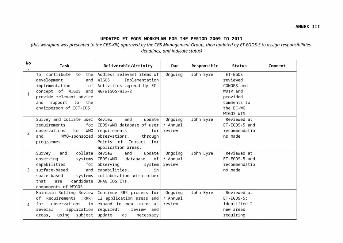
4.1 Dr Eyre presented the Work Plan for ET-EGOS for the 4-year period from CBS-XIV, as reviewed by CBS-XIV and adopted by the CBS-MG-9. During the course of the meeting, the Team updated the workplan by assigning responsibilities to Team members, specific deadlines, and status information where appropriate. The updated workplan is reproduced in Annex III and will be submitted to the next CBS Session.
4.2 There was some discussion about the scope and role of the RRR process in the new Work Plan, given the various discussions about RRR that have occurred in the WIGOS context. Dr Eyre provided guidance that this Team should maintain the existing process, and that any parallel RRR activity addressing WIS requirements or WIGOS implementation issues would need to be tackled in another forum.
5. REVIEW OF ACTIONS
5.1 The Chairperson reported on progress on actions from the ET-EGOS-4. These actions were structured as follows:
(i) User Requirements (URs) and Statement of Guidance (SoGs);(ii) Observing Systems Capabilities (OSCs);(iii) Other Terms of Reference (TORs); and (iv) Issue from the CBS-Ext.(06) (Seoul, Republic of Korea, 9-16 November 2006).
5.2 The Team reviewed progress made against each item, and updated further the actions, closed them or forward them to the actions resulting from the ET-EGOS-5, as appropriate. These, together with additional actions decided by this meeting, are listed in Annex IV.
6. REVIEW OF OTHER ACTIVITIES RELATED TO ET-EGOS AND OPAG-IOS
6.1 THORPEX
6.1.1 Dr Eyre reported on information provided by Dr Roger Saunders (United Kingdom) about the activities of the THORPEX Data Assimilation and Observation Strategy Working Group (DAOS-WG), and the outcome of the Third THORPEX International Science Symposium, Monterey, CA, USA, 14-18 September 2009. Presentations made at the Symposium are available from the WMO web site1.
6.1.2 Dr Saunders had also presented a report on DAOS-WG activities to the Eighth
Session of the International Core Steering Committee for THORPEX (Offenbach, Germany, 2-4 November 2009). The report is available from the WMO web site2.
6.1.3 Key issues relevant to the work of the ICT-IOS are:
1. Targeted observations are still not proven to be consistently effective in 4D-Var systems. However, the THORPEX Pacific Asian Regional Campaign (T-PARC) campaign should be fully analyzed to assess the impacts of additional observations for tropical Cyclone forecasts.
2. Some of the campaigns such as AMMA and T-PARC are bringing legacy issues in terms of additional observations for the GOS.
3. The NASA Global Modeling and Assimilation Office (GMAO), the Naval Research Laboratory (NRL), and Environment Canada have completed the DAOS inter-comparison experiment to directly compare observations in different assimilation systems using the Langland and Baker approach. All three centres showed similar impacts with AMSU-A radiances, radiosondes, AMVs and aircraft data providing significant contributions. However, the advanced IR sounders or GPS-RO were not included in this experiment.
4. There is a problem with the variety of different formats for radar data which could be exchanged. The Bureau of Meteorology (Australia) is pursuing with WMO to get an agreed data format for these data.
5. The DAOS-WG is drafting a statement on enhancing the observing network based on recent results to include (i) increasing commercial aircraft observations over the N. Pacific, N. Atlantic, and S. Hemisphere, and (ii) additional soundings from certain coastal stations including those in E. Siberia and perhaps selected stations in polar regions, Africa, and S. America.
6. Improvements in the Indian and Russian radiosonde networks have been noted by ECMWF and the Met Office (UK) leading to more of the data being assimilated.
7. Concern was expressed over the potential loss of scatterometer data in the PM orbit if Quickscat fails. Efforts to obtain the Indian Oceansat-II data should be encouraged.
8. The continuity of the COSMIC GPS-RO constellation needs to be assured and reassurance from OPAG-IOS on this would be welcome.
6.1.4 The Team noted that the DAOS-WG planned to meet in mid-2010.
6.1.5 The Team discussed the requirements for the exchange of weather radar data (data requirements, data policy, data formats), and noted that the CIMO-XV Session was planned in Helsinki, at the same time as the European Conference on Radar in Meteorology and Hydrology (ERAD, 6-10 September 2010, Sibiu, Romania). The Team suggested to have a session at ERAD devoted to WMO requirements for nowcasting and very short range forecasting involving the format for the exchange of data as well as session on quality of radar data. It requested the Organizer of ERAD to invite WMO to co-sponsor the event by participation and to identify a WMO representative who will attend and/or chair such a session (action; A. Bell (ET-EGOS; 31 Dec 2009) in coordination with Paul Joe (ET-SBRSO)).
6.2 Fifth WMO International Symposium on Data Assimilation
6.2.1 Dr Eyre reported on the outcome of the Fifth WMO International Symposium on Data Assimilation, which was held in Melbourne, Australia, from 5 to 9 October 2009. This symposium is the primary international forum for discussion of advances in the theory and practice of data assimilation. Some presentations and posters gave results relevant to observing system evolution and design. A few talks on observation impact were given (mainly GPS radio occultation data was covered showing substantial positive results in the medium range). Further discussion on the outcome of this Symposium will take place under agenda item 9.1. The programme, proceedings, presentations, and further information from the conference will be
6.2.2 The ET-EGOS Chairperson was invited to give a presentation on “Changes to the Global Observing System – evolution or design”. He informed the audience, largely of research scientists, of relevant work in progress within WMO CBS, (i) including the Rolling Requirements Review process, (ii) the new CBS “Vision for the GOS in 2025”, (iii) the WMO Workshops on “The impact of various observations on NWP” and the impact of their results on the evolution of the GOS, and (iv) key issues, derived from EGOS-IP, that CBS would like the data assimilation community to address.
6.2.3 The Team noted that the following questions and comments were raised at the Symposium:
Disappointment was expressed that we still have doppler wind lidar in the category of “R&D satellites and operational demonstrators” in 2025; Dr Eyre had explained to the symposium that this was a realistic target.
Ocean acoustic tomography is not mentioned in the list of “R&D and operational pathfinders” for the ocean;
Cloud radars (as opposed to precipitation radars) are not mentioned in any category of space-based observing system.
6.2.4 The Team agreed that the last two issues above (acoustic tomography, cloud radar) should be considered by the Team and monitored, as well as other observing capabilities that might have been omitted (see Annex XVII for complete list of elements to be proposed for addition in the Vision for the GOS in 2025); the Team invited the Secretariat to set a way of recording proposed additions to the Vision (action; Secretariat; Mar 2010).6.3 IPY Legacy
6.3.1 Dr Miroslav Ondráš (Secretariat) reported on IPY Legacy activities as they were presented to the Executive Panel of Expert on Polar Observations, Research and Services (EC-PORS, 13-15 October 2009, Ottawa, Canada). The EC-PORS particularly addressed the following activities:
(a) Conceptual model and strategy for establishing a Global Cryosphere Watch (GCW) as part of the IPY legacy, to include observations, monitoring, assessment, product development, prediction, and related research. The plan is to make a proposal for establishing GCW at WMO Congress in 2011. In particular, Pilot and Demonstration projects are being proposed to address specific elements of the Cryosphere (i.e. sea ice, snow, glacier, permafrost and frozen ground, solid precipitation) and focus on national and regional contributions (e.g. establishing a network of reference sites, initiation of integrated regional cryospheric products, transfer of Cryosphere remote sensing products from research to operations, real-time reporting, modelling, cryospheric changes in the Antarctic continent etc.) respectively.
(b) The development of the Southern Ocean Observing System (SOOS) as a sustained, circumpolar, multi-disciplinary, feasible, cost-effective, and integrated observing system to provide long term measurements required to improve understanding of climate change and variability, biogeochemical cycles and the coupling between climate and marine ecosystems. Geo-physical requirements for climate applications will be specified by the GCOS/GOOS/WCRP Ocean Observation Panel for Climate (OOPA). One critical element of SOOS will be establishment of a data system with accessible data sets of known quality. Greater integration of physical oceanography, surface meteorology, cryospheric and biological observations will also have to be addressed. Once implemented it will also
enhance meteorological observations (additional AWSs, profilers, sea level pressure observations from ice and ocean drifters, and aircraft observation, both manned and un-manned.
(c) The Integrated Arctic Ocean Observing System (iAOOS) was designed to optimize the cohesion and coverage or monitoring of the Arctic Ocean and surrounding seas during the IPY while focusing on Arctic change (e.g. perennial Arctic sea ice). Results have been published in two reports in 2007 and 2008, and recommendations for sustaining observations made. A legacy phase report will be published for the post-IPY conference in Oslo in June 2010 by Dr Robert Dickson to develop a fully-costed proposal for and integrated, sustained and pan-Arctic observing effort focused on the role of the northern seas in climate.
(d) The Global Interagency IPY Polar Snapshot Year (GIIPSY) was initiated to develop consensus polar science requirements (focusing on all aspects of the Cryosphere) and objectives that can best and perhaps only be met using the international constellation of earth observing satellites. The IPY Space Task Group (STG) provides for the link between the GIIPSY scientific community and the international space agencies. The STG adopted four primary data acquisition objectives for its contribution to the IPY, i.e. (i) Pole to coast multi-frequency InSAR measurements of ice-sheet surface velocity; (ii) Repeat fine-resolution SAR mapping of the entire Southern Ocean sea ice cover for sea ice motion; (iii) One complete high resolution visible and thermal IR (Vis/IR) snapshot of circumpolar permafrost; and (iv) Pan-Arctic high and moderate resolution Vis/IR snapshots of freshwater (lake and river) freeze-up and break-up. Much progress was made in achieving these objectives. Efforts will be made to expand the acquisition and product suite beyond the polar regions to all sectors of the Cryosphere.
(e) The Sustaining Arctic Observing Networks (SAON) was proposed by the Arctic Council to invite a number of international organizations to develop a set of recommendations on how to achieve long-term Arctic-wide observing activities that provide free, open and timely access to high quality data that will realize pan-Arctic and global added-value services and provide societal benefits. WMO perspective was addressed through the WCRP climate and Cryosphere Project (CliC). Recommendations regarding follow-up work to sustain future research and monitoring of the Arctic were made in 2009 in the “Observing the Arctic” report of the SAON Initiating Group (SAON-IG). The Arctic Council agreed in April 2009 with the SAON recommendations except for creating an Arctic Observing Forum. Further recommendations were then recommended by the Senior Arctic Officials (SAO) Report to Ministers, i.e. (i) supported continued international coordination to maximize the legacy of IPY including in particular observations, data access and management; (ii) promoted the establishment of a circumpolar Arctic observing network as a lasting legacy of the IPY; (iii) Emphasized that SAON is a long-term undertaking and recognizing the valuable contribution of the SAON process as an IPY legacy to coordination of multidisciplinary Arctic activities; (iv) Continuation of the SAON process, and development of an institutional framework to support circum–Arctic observing, and preparation and implementation of a workplan for the next two years to initiate work on priority issues including sustained funding and data management; and (v) Recommended that a group consisting of representatives from each Arctic country, and other relevant partners including the WMO be formed to draft and implement a detailed workplan for the next two years, drawing on all information gathered by the SAON process to date, and including arranging workshops to make concrete progress on priority issues. Mr. David Grimes, co-chair of the EC-PORS has been named as the WMO representative in the SAON Steering Group. The SAON workplan will be further developed through December 2009. SAON-SG will require an active participation of the WMO through its EC PORS Panel.
ET-EGOS-5, FINAL REPORT, p. 16
(f) The development by SCAR of a Pan-Antarctic Observations System (PAntOS) Action Group based on the experience from the Sustaining Arctic Observing Networks (SAON) initiative. However, limited resources have been allocated to the project so far.
(g) The IPY Data Policy is promoting that IPY data should be (with a few limited exceptions) “available fully, freely, openly, and on the shortest feasible timescale”, preserved, and their use acknowledged. However, timely release of the data is sometimes problematic. IPY also developed a data management strategy with the goal (i) to identify all the data with complete metadata description identified by now, (ii) to make all data available by mid-2010, and (iii) to make sure that all data are in secured archives by 2012. However, implementing the plan has been delayed by about one year so far. The International Polar Year Data and Information Service (IPYDIS) is a global partnership of data centres, archives and networks working to ensure proper stewardship of IPY and related data (17 countries having national IPY data coordinators). Some issues have to be addressed, (i) long term preservation of the data, (ii) establishing data systems and filling gaps for the land, people, ocean, ice, and atmospheric domains of IPY. Efforts have been made regarding data discovery using international standards. An IPY Data Management Strategy, Status, a Roadmap was published in February 2009. A Polar Information commons (PIC) Pilot Project was initiated to provide for a shared virtual resource mirroring the geographic commons. A “State of Polar Data” will also be produced through the IPY Data Committee. Many issues will have to be addressed by WMO, including (i) open and networked data (extending the principles of IPY data policy, encouraging Members to share data, labelling IPY data), (ii) governance (WMO and its members recognizing the diversity of polar data, maintaining national polar coordinators, working with ICSU on establishing the World Data System in both poles), (iii) interoperability (labelling data using the PIC badge, sponsoring workshops, making data discoverable via WIS, engaging with other disciplines and harmonizing interoperability standards), and (iv) preservation and stewardship (e.g. working with ICSU to get high-level political commitment to maintain long term data archives, rapid data sharing and publication, documenting data), and Canadian effort in implementation of the Polar Data Catalogue for the Arctic region.
(h) Brief information was provided on the legacies related to Polar predictions, a need for Polar Climate Outlook Forums, hydrological modelling and networks, such as Arctic-Hycos and Arctic-Hydra and WMO regional basic networks.
6.3.2 The meeting also discussed recommendations for WMO on IPY Legacy initiatives.
6.4 AMMA
6.4.1 Dr Ondráš (Secretariat) reported on behalf of Mr Mohammed Kadi (Director-General of ACMAD, Algeria) and Mr Mahaman Saloum (RA I Rapporteur on the Regional Aspects of the GOS) on African Monsoon Multidisciplinary Analysis (AMMA) activities since the last ET-EGOS meeting. The third AMMA conference held in Ouagadougou in July 2009 has made an appraisal of the achievements of the AMMA experiment first phase (2001-2009) and refined consequently the program for its planned second phase (2010-2020). A summary of the achievements and gaps with proposed priorities and strategy for the program have been detailed, and include (i) the West African Monsoon (WAM) System; (ii) the Mesoscale convective system & environment interactions; (iii) the water cycle with the GPS usefulness to monitor the WAM moisture content; and (iv) the intra seasonal to inter annual and long term WAM variability, weather & climate predictability and prediction, interactions climate with society, and climate change. Underlying these achievements is (i) the implementation of an observation program, (ii) the creation of multidisciplinary data base that is used from all over the world and has been mirrored in Africa; and (iii) a strong contribution to improving the critical mass of scientist and increased awareness on climate matters among Medias, users and decisions makers. The development of AMMA
ET-EGOS-5, FINAL REPORT, p. 17
permitted (i) reactivation of the silent radiosonde stations; (ii) renovation or upgrading of the unreliable stations; (iii) installing new stations (in regions of particular climatic importance), and (iv) widespread improvements, to the transmission of data to the Global Telecommunication System (GTS). These coordinated AMMA efforts led the upper air network in the AMMA region to jump between 2004 and 2006 from 5 to 21 active stations (including 4 new ones), some of which were able to perform up to 8 launchings per day. The “atmospheric sounding” component of the AMMA observing program also comprises a very reliable and well distributed GPS network providing all weather, high-resolution (5 minutes to 1 hour) precipitable water vapour (PWV) estimates. Data permit determination of radiosonde biases.
6.4.2 The Team noted the following issues:
(a) The AMMA upper air network has been proved to direct impacts on forecasting improvement. The demonstrated usefulness of the healthy atmospheric sounding observation built up by AMMA during SOP, for many applications, is being confirmed by many other studies.
(b) However, in 2009, customary problems such as limited soundings from the four new stations, and noticed poor performances for some of the long-standing (pre-AMMA) stations have been noticed.
(c) A project aiming as sustaining the radiosonde network, prepared by several institutions to be presented for funding to European Union has been submitted to ASECNA (as coordinator) for endorsement.
(d) The GCOS programme is also being asked to assist in achieving transition to ongoing operational funding, to support a study on setting up operational regional observing network coordination (including GTS data distribution), and to support the proposed project related to sustaining the AMMA built observation Upper air network and encourage the inclusion in the GUAN network, of two additional stations (Bamako & Pointe Noire) in the AMMA region as recommended in the recent past.
6.4.3 The Team was informed that Dr Jean-Luc Redelsperger (chair of AMMA Scientific Steering Committee) and Ms Odile Roussot (AMMA Office) had nominated Mr Kadi as the contact person for the WMO Observing systems Division and will thus act as person responsible for any interaction with AMMA.
6.4.4 The Team was also informed that AMMA is currently preparing the science plan for the second phase (2010 to 2020). AMMA science plan (2010-2020) will be distributed to ET-EGOS members when available. Members are invited to review the science plan and provide feedback through the Chairperson (action; J. Eyre; end Feb 2010).
6.5 AMDAR
6.5.1 Mr Frank Grooters (the Netherlands), reported on AMDAR activities since ET-EGOS-4. He particularly reported on the following issues:
(i.) A WIGOS Pilot Project for AMDAR has been initiated with participation from the EUMETNET AMDAR Programme (E-AMDAR) and USA AMDAR Programmes. The Pilot Project is aiming at (i) the development of a standardised BUFR Template for AMDAR (currently under validation); (ii) application of WMO Metadata relevant to AMDAR using WMO profile of ISO 19115 to ensure appropriate compatibility with WIS; (iii) the development of a standardised Quality Management Framework for AMDAR data (a set of minimum standards, including evaluation criteria and procedures, for AMDAR data monitoring will be developed); and (iv) the validation and preparation for intercomparison of
ET-EGOS-5, FINAL REPORT, p. 18
available Water Vapour sensor performance. For the longer term, the Pilot Project is aiming at (v) updating of the AMDAR Reference Manual WMO-No.958; and (vi) the development of the framework for generic software specification for AMDAR.
(ii.) Governance and programmatic issues were addressed. As a result, CBS-XIV established a CBS Expert Team on Airborne Observations (ET-AIR) and anchored the WMO AMDAR Panel to CBS. The AMDAR Technical Coordinator is now serving within the Aircraft Observation Unit (AIR) of the Observing and Information Systems Department (OBS) of the WMO Secretariat.
(iii.) Six countries and Europe are continuing to expand AMDAR coverage both domestically and internationally. The number of profiles available in data sparse regions of Africa, Eastern Europe, parts of the Russian Federation, the Middle East, South and East Asia and South America has increased. Other programmes are being planned and/or considered in more than 31 countries or territories.
(iv.) The E-AMDAR and USA-AMDAR programmes are currently evaluating the 2009 version of the water vapour sensor (WVSS-IIv3). The sensor covers a measurement range in the water vapour mass mixing ratio reaching from 20 g/kg in the ground pressure level down to at least 0.016 g/kg (26 ppmv), lower in an altitude of 200 hPa. The test has shown that the relative accuracy is better than 10 %. The water vapour sensor is achieving performances that are consistent with AMDAR initial expectations, and both programmes are planning to use this sensor in the future once further trials prove successful.
(v.) Some problems have been found in the AAAV3 software (BoM, and AirDatec) leading to wrong positions being reported on an occasional basis. Problem has been corrected and updated version will be provided to the airlines companies using it.
(vi.) NASA has now completed the multi-year development cycle of the TAMDAR integrated sensor suite. The TAMDAR sensor’s performance, using the TAMDAR temperature, humidity and wind data, is being validated to evaluate the impact of TAMDAR data on the Rapid Update Cycle’s (RUC) performance. The system will continue to be used by PenAir, Mesaba, and Chautauqua in the foreseeable future.
(vii.) Australia is conducting an investigation of the Automated Flight Information Reporting System (AFIRS) system and evaluating the performance of ADS-B air traffic surveillance system being installed in Australia. The ICAO Automatic Dependant Surveillance-Contract (ADS-C) system operates over the North Atlantic and SW Pacific Ocean areas and provides a relatively small amount of automated data.
(viii.) The development and refining of data optimisation schemes continues to show positive benefits to the AMDAR Programme (e.g. E-AMDAR Data Optimisation System (E-ADOS) in Europe, A-ADOS in Australia, impact of thinning on the Rapid Update Cycle (RUC) model in the USA).
(ix.) In accordance with the programme definition, E-AMDAR is contributing with 10% of its data to the Global AMDAR Programme. Currently, E-AMDAR is providing AMDAR data from flights to and from the eastern part of South America, India, China, Japan and the United States. At its 14th Session (2-4 November 2009) the Technical Advisory Group of E-AMDAR reviewed the E-AMDAR contribution to the GOS and was questioning the value of the current contribution to the GOS. ET-EGOS was requested to review the current coverage and to define alternative regions with an increased value for the GOS if appropriate (this issue is addressed in paragraph 6.5.5).
ET-EGOS-5, FINAL REPORT, p. 19
6.5.2 The Team noted that TAMDAR systems were used with small aircrafts and that there remained some data quality issues to be addressed while the data were not freely available. The AMDAR Panel is not looking at TAMDAR as a priority but these TAMDAR related issues will be addressed by the ET-AIR.
6.5.3 The Team noted the efforts by AMDAR towards standardization, especially in terms of quality management. This will permit to address concerns with regard to AMDAR systems reporting systematic errors (e.g. collecting metadata to evaluate quality of data by type of aircraft).
6.5.4 The Team recognized that it will be beneficial to promote the initiation of AMDAR programmes in developing countries. However, resources are lacking to organize training.
6.5.5 The Team discussed AMDAR coverage issues. The results of those discussions are summarized in Annex XII.
6.6 GCOS
6.6.1 The CBS Rapporteur for GCOS Matters, Dr Matthew Menne (USA) presented an overview of the recent development of the Progress Report on the Implementation of the Global Observing System for Climate in Support of the UNFCCC 2004-2008 (GCOS-129, August 2009)4. This Report assesses progress since late 2004 in implementing the Actions called for in IP-04. Implementing those Actions would help maintain, strengthen, or otherwise facilitate global observations of the climate system for the needs of the UNFCCC.
6.6.2 On the basis of the Report, it is clear that most of the Actions set down in the 2004 Plan have been enthusiastically embraced at both international and national levels, and implementation of the various observing systems in support of the UNFCCC has progressed significantly over the last five years. In some areas, however, progress since 2004 remains limited or absent (12% of Actions with poor progress, and 11% with none).
6.6.3 The Team noted the key top-level findings of the Report as detailed in its executive summary. The preparation of the Report has helped to identify a number of important priorities for the next five years if GCOS is to be further developed to serve optimally the evolving needs of the UNFCCC. These are detailed in the foreword of the report by the Chairman of the GCOS Steering Committee, Prof. John W. Zillman.
6.6.4 The Team recalled that it had agreed at its Second Session in 2006 that the GCOS Second Adequacy Report (2003) and the GCOS Implementation Plan (2004, IP-04), supplemented by the satellite requirements (2006), provided an adequate Statement of Guidance for Climate Monitoring, covering Climate Change and Climate Variability. In 2005, the ET-EGOS Implementation Plan has been linked with the 2004 GCOS Implementation Plan to ensure consistency of Actions in both Plans.
2010 Update of the GCOS Implementation Plan in Support of the UNFCCC (IP-10)
6.6.5 The Team noted progress with regard to the preparation of the 2010 Update of the GCOS Implementation Plan in Support of the UNFCCC (“IP-10”). Basis for the updated IP-10 are the 2004 GCOS IP (GCOS-92) and its 2006 Satellite Supplement (GCOS-107), recognizing progress and changes in the past five years in science, technology, user needs, and international coordination.
6.6.6 Around 140 Actions are proposed in the current draft. The list of ECVs has evolved slowly as scientific requirements change and as technological developments permit. For example, the
updated list of ECVs now includes soil moisture, soil carbon, ocean oxygen content, habitat properties (both marine and terrestrial), and recognizes the role of chemical precursors in forming some atmospheric composition ECVs, such as ozone and aerosols. A breakdown of costs involved - by region, observing system and between developed and developing countries - will be included in the plan. Open review of a draft has started in mid-November 2009 (at http://gcos.wmo.int), with finalization of the IP-10 being anticipated for April 2010.
6.6.7 The Team was invited to comment on the draft updated version of the GCOS Implementation Plan (IP-10).
6.6.8 The Team recalled that at its second Session, it agreed that it was not necessary to develop a SoG for Climate Monitoring (covering Climate Change and Climate Variability) via the CBS RRR process, as this guidance was already available through the GCOS Adequacy Reports and the 2004 GCOS Implementation Plan and the 2006 Satellite Supplement to the GCOS IP. The Team noted that the GCOS Adequacy Report has not been updated and that there was currently no plan for producing a new Adequacy Report in its own right. However, the GCOS Progress Report 2004-2008 assessed (non)adequacy of individual observing systems for climate, and the (currently draft5) 2010 update of the GCOS-IP does contain some "gap analysis" information and recommendations on how to address these gaps.
6.6.9 The Team therefore agreed that the SoG for climate monitoring within the CBS RRR framework is the 2004 Adequacy Report plus some elements of the final version of the 2010 update of the GCOS IP. The Team requested the WMO Secretariat, in liaison with the GCOS Secretariat to provide links from the SoG web page to all GCOS documents that, collectively, constitute the SoG for climate monitoring (action; GCOS Secretariat; 31 Oct 2010). GCOS Secretariat will also ensure that, by summer 2010, the GCOS requirements in the WMO/CEOS database are being updated (action; GCOS Secretariat; July-2010).
GCOS Reference Upper-Air Network (GRUAN)
6.6.10 The Team was informed on implementation of the GCOS Reference Upper-Air Network (GRUAN)6. GRUAN is still in its early stage of implementation but some major milestones have been achieved so far include (e.g. designation of the GRUAN Lead Centre at the Lindenberg Observatory (Germany), the definition of major requirements for reference measurements, the appointment of initial (14) GRUAN stations, and the publication of the GRUAN Implementation Plan 2009-2013 (GCOS-134). The Team noted the GCOS strategy to implement GRUAN in the next five years.
6.6.11 The Team noted the development of the GRUAN Pilot Project for WIGOS. Progress was made regarding CIMO intercomparison, with the inclusion of the GRUAN Lead Centre Head into the organizing committee for the campaign. However, the preparation of a GRUAN Manual of Operations and regulatory materials is a substantial issue due to the lack of resources. In the development of a data dissemination and archive model, roles and responsibilities are currently discussed. NCDC agreed to serve as an archive centre for the data from GRUAN as a minimum and a stronger connection to WMO-WIS will be necessary.
6.6.12 The Team discussed implementation of the GCOS Surface Network (GSN) and GCOS Upper Air Network (GUAN). There has been a marked improvement in the number of CLIMAT reports received at the GCOS Archive Centre, thanks in part to the efforts of each the nine GCOS Lead Centers. Ongoing rehabilitation/system improvement efforts have led to the near full implementation of the GUAN and the rate of CLIMAT receipt now exceeds 80% percent globally. However, there are still large differences in the receipt rates among regions.
6.6.13 The Team noted that the Lead Centres agreed to expand their efforts to address the entire RBCN rather than only the GCOS Surface Network.
Development of GCOS Guidelines for ensuring Acceptance of Climate Datasets and Products by the User Community
6.6.14 The Team noted the development of Guideline for the Generation of Satellite-based Datasets and Products Meeting GCOS Requirements7. These are expected to facilitate ensuring that long-term ECV datasets and products generated are truly meeting the requirements of the climate community.
6.6.15 The Guideline recalls the GCOS Climate Monitoring Principles, the requirements of the GCOS Satellite Supplement, and states a 12-point checklist which gives guidance to data providers on how to supply sufficient information to users for their assessment of dataset quality. Point 11 recommends the “Application of a quantitative maturity index if possible”, and point 12 the “Publication of a summary (preferably online) documenting point-by-point the extent to which the Guideline has been followed”. The guideline is currently being revised with a view to be useable for datasets and products of any kind, and the final draft of the revised Guideline available by March 2010.
6.6.16 The Team agreed that the CBS and GCOS should join efforts in monitoring the quality of surface observations for climate, including metadata, to avoid possible duplications.
6.6.17 The Team was invited to consider providing feedback regarding GCOS-128Error:Reference source not found document before April 2010 (action; ET-EGOS; February 2010).
6.7 EUCOS
6.7.1 The CBS OPAG-IOS Co-Chairperson and EUCOS Programme Manager, Dr Jochen Dibbern (Germany) reported on EUCOS activities related to ET-EGOS and on relevant recent developments. The EUCOS (EUMETNET Composite Observing System) Programme is responsible for improvements in the delivery of terrestrial observations in order to improve regional NWP in the European domain area. The work content of the EUCOS Programme includes the management of the operational observing networks, through the E-AMDAR, E-ASAP, E-SURFMAR and E-WINPROF Programmes. The coordination of NMSs’ owned territorial networks, data quality monitoring, fault reporting and recovery, a studies programme for the evolution of the observing networks and liaison with other organisations like WMO are among the tasks of the programme. Dr Dibbern particularly reported on the following:
(a) Currently, the E-ASAP fleet comprises 16 units (4500 launches planned in 2009). The programme is planning to increasingly use Iridium communication for reducing costs and provide better stability and timelines. All the ASAP units under E-ASAP managements report now high resolution BUFR data.
7 GCOS (2009) : Guideline for the Generation of Satellite-based Datasets and Products Meeting GCOS Requirements, March 2009, GCOS-128, http://www.wmo.int/pages/prog/gcos/Publications/gcos-128.pdf
(b) The E-AMDAR network continues to grow in terms of number of participating aircraft and participating airlines (9 companies). Daily around 450-460 aircraft are in operation for E-AMDAR producing 45000-50000 observations a day. The data quality continues to be excellent, well below the EUCOS threshold targets.
(c) Marine surface observations in the EUCOS area are coordinated by the E-SURFMAR programme. The programme is now providing for about 250 manned (decreasing), and 1000 automated (increasing) observations per day. E-SURMAR is working at specifying common standards for a EUMETNET ship-AWS and to conduct a common procurement. The E-SURMAR VOS metadata database will now be used to collect non European metadata as a contribution to WMO work. Drifting buoys are the main component of E-SURFMAR to provide air pressure measurements at the sea surface (100 units in operations). Timeliness and cost-effectiveness is improving thanks to the use of Iridium.
(d) The European wind profiler network started a new programme phase as of January 2009, now fully integrated in the EUCOS Operational Programme (25 units)). Subsequent to a request from the EUCOS Science Advisory Team an operational classification of the systems has been conducted (16 system were in agreement with the requirements). The programme also collects wind profiles from Doppler Weather Radar systems; currently data from almost 100 systems are available. The EUCOS Quality Monitoring identifies that a larger number of systems deliver poor data quality.
(e) The EUCOS Programme runs a Studies Programme to further develop the network. The main objective for the upper-air network redesign OSE is the definition of an integrated European-wide network of ground-based upper-air observing systems whose configuration and setting is based on scientific analyses rather than on a simple merging of historically grown national networks. Six different scenarios are currently under investigation by ECMWF, Hungarian Met Service and the HIRLAM group. The results of the experiment will be available at the end of 2009.
(f) On the density of surface marine observations ECMWF conducts an OSE with three different scenarios for a winter period with results to be expected until the end of 2009.
(g) The EURORISK-PREVIEW Data Targeting System project is progressed so that the evaluation of the 11 months trial period of 2008 can be started. At catalogue of cases is available, helping to select the most interesting cases.
(h) EUCOS supports a number of THORPEX activities. For T-PARC E-AMDAR activated a number of aircraft delivering data from the Asian-Pacific area.
(i) MEDEX uses the Data Targeting System (DTS) system to investigate high impact weather situation in the Mediterranean. EUCOS organises targeting of additional radiosondes ascents from 16 EUMETNET members, the regional Met. Service of Catalonia and Algeria and E-AMDAR aircraft data. ECMWF, Météo-France and the University of the Balearic Islands, with the collaboration of the Spanish AEMET, are running sensitive area computations.
(j) The future activities of the EUCOS programme will concentrate on finalizing the upper-air network redesign during 2010 and develop a proposal for the content of the EUCOS Operational Programme for the next programme phase 2012 to 2016. Among others an operational data targeting system might be included in the next programme phase if the trial evaluation is positive. A centralised data hub and monitoring service for all EUMETNET observing programmes, integrated as DCPC in the future WMO Information System, will be proposed.
ET-EGOS-5, FINAL REPORT, p. 23
6.7.2 The Team requested EUMETNET to report on the results of OSEs once available as well as to circulate the results of the surface marine observations study (action; J. Dibbern; Mar 2010).
6.8 GEO / GEOSS
6.8.1 Dr Barbara Ryan (Secretariat) reported on the role of WMO in the Global Earth Observation System of Systems (GEOSS) and its governing body, the Group on Earth Observations (GEO). In the past year the WMO Secretariat has served on two of the GEO Committees – Architecture and Data Committee (ADC) and Science and Technology Committee (STC). Approximately 13 staff either lead or participate in the GEO Work Plan Tasks. Areas of particular interest include the four Societal Benefit Areas (SBAs) of weather, water, climate and related disasters. Staff is also involved in agriculture, health, and architecture (WIS and GOS) tasks. WMO has also registered all of its data with GEOSS thus making these data available to the global community through the GEOSS interoperability arrangements.
6.8.2 In the past there has been a considerable amount of work in the creation of a GEOSS Common Infrastructure (GCI) which includes a Portal, a Clearinghouse and Registries to allow for participants to register their data and information resources and for users to search for and obtain these resources. During the Initial Operating Capacity test period, three independent companies each provided Portal and Clearinghouse services. Now that the initial testing is over the Task Force is recommending that GEO move to one supplier. The issues are: (1) the process to choose one supplier and, (2) the ability to provide the resources for the sustained operation of the service. WMO continues to monitor and interact with the Task Force to ensure that the technical standards and requirements are both consistent with the GEOSS 10-year Implementation Plan and also are interoperable with WIS.
6.8.3 In November 2009, GEO has held its annual Plenary meeting in Washington, D.C. Topics of discussions included (i) a status report on the development of a set of Implementation Guidelines for the GEOSS Data Sharing Principles. These Guidelines are expected to be approved at the 2010 GEO Ministerial Summit in Beijing; (ii) a set of Strategic Targets for the end of the 10-year Implementation Plan (2015) (these are updates from the original Plan); and (iii) the GCI task Force report addressed above.
6.8.4 EC-LXI requested the Secretary-General to undertake, in consultation with WMO Members involved in GEO, a review of WMO’s participation in GEO/GEOSS, and to evaluate the contributions being made by WMO and the benefits and results that the Organization has gained through its participation and potential opportunities for enhanced involvement. As a result the WMO Secretariat has been conducting internal surveys and consultations, both internal and with WMO Members, to complete the review and to prepare a report to EC at its June 2010 meeting. Early results have shown that WMO has benefited from increased attendance at workshops and training events thanks to co-sponsorship with GEO. Some concerns have been raised about apparent branding by GEO of WMO work and about the scope of the GEOSS work beyond observations into areas of prediction.
6.9 CBS Expert Team on Surface Based Remotely-sensed Observations (ET-SBRSO)
6.9.1 Dr Dibbern reported on the outcome of the first meeting of the new CBS Expert Team on Surface Based Remotely-sensed Observations (ET-SBRSO), Geneva, Switzerland, 23-27 November 2009. The meeting was held in conjunction with the CIMO Expert Team CIMO Expert Team on Remote Sensing Upper-air Technology and Techniques (ET-RSUTT), which permitted mutual exchange between observing system experts and network planning activities.
6.9.2 Both meetings permitted to make progress regarding a number of issues including:
ET-EGOS-5, FINAL REPORT, p. 24
Guidance and standards on weather radar Guidance and standards for wind profiler radar Current and potential capabilities of other surface based RS systems
6.9.3 The Team noted that the ET-SBRSO made comments regarding the Vision for the GOS in 2025 and the current version of the EGOS-IP.
6.9.4 While noting with appreciation efforts by ET-SBRSO to collect, and evaluate information on implementation status and plans for weather radar using questionnaire, the Team recommended that a properly resourced WIGOS Database should be developed for keeping a registry of all kind of observing networks that should be interactively updated by Members thus limiting the use of questionnaires in the future. Any discrepancies noted by Members regarding current DB of Weather Reporting Stations (WMO-No. 8, Volume A) should be reported to the Secretariat.
6.9.5 The Team noted that a comprehensive web based weather radar database was under development by CBS/ET-SBRSO and CIMO/ET-RSUTT. The database is based on the results – 2009 Excel sheets - from the questionnaires from ET-SBRSO, and its ToR will be developed by the ET-SBRSO. The Team requested Dr Aurora Bell (Romania) to review the database on behalf of ET-EGOS (action; A. Bell; Mar. 2010).
7. WMO Integrated Global Observing System (WIGOS)
7.1 Status of WIGOS activities
7.1.1 Dr Igor Zahumenský (Secretariat) reported on the status of the development of WIGOS concept and outcomes of EC Working Group on WIGOS & WIS and its Subgroup on WIGOS (SG-WIGOS). The Team noted that the WIGOS projects already provided useful lessons learned, feedbacks and perspectives on the potential benefits, value and impacts of the WIGOS implementation process at the national and/or regional levels. The Team noted the following recommendations from SG-WIGOS which are of particular relevance to the work of ET-EGOS:
A primary objective of WIGOS is the improvement of the WMO owned observing systems. Additionally, there are non-WMO components of co-sponsored observing systems, where cooperation between organizations could result in improvements having mutual benefits. Care should be taken to recognize these considerations in the WIGOS documentation. Coordination with partners to promote harmonized standards and interoperability should be continued and strengthened;
Some issues, such as integration of the management of satellite and in situ data climate aspects including operational climate monitoring from space have not been addressed by the WIGOS Projects yet; In this regard, there is a need to clarify what will be WIGOS approach towards climate monitoring, including from space;
Taking into account the role the Regional Associations should play in the WIGOS implementation, they are encouraged to establish dedicated WIGOS related Task Teams as well as to initiate the regionally focused WIGOS activities. The Regional Demonstration Projects of RA IV and RA VI provide examples;
When discussing the metadata issue, it is necessary to clearly distinguish between station/platform metadata (“WIGOS metadata”) and WIS metadata needed for Data Discovery, Access and Retrieval (DAR) services that WIS must provide; guidance on the generation of metadata in a standardized form (i.e. content and structure) is therefore needed.
7.1.2 The Team discussed the following proposals that had been presented and discussed at
ET-EGOS-5, FINAL REPORT, p. 25
the second meeting of SG-WIGOS (Geneva, Switzerland, 19-23 October 2009):
Framework for WIGOS Standardization of the Surface-based Observing Systems8: Under such a framework it is proposed to develop a tool that would provide a single access point to all the WMO standards, guidelines, best practices, procedures, etc., addressing observations. This concept does not only address the access to the standards, but it also plans a harmonization of the standards (removal of duplications, inconsistencies, etc.). Three steps are proposed 1) Proof of the Concept; 2) Extension to a full scale system; 3) Harmonization of the WMO technical regulations. SG-WIGOS recognized that this harmonization would need to be carried out in close cooperation with the WMO Quality Management Framework. SG-WIGOS supported this proposal and recommended that the proposal be further elaborated and included in the WIGOS implementation plan.
WIGOS Observing Systems’ components description database9: SG-WIGOS agreed that developing such a database would be valuable resource for the success of WIGOS development and implementation, and would enable to understand contributions of relevant WIGOS systems’ component, help develop and refine WIGOS implementation strategy and make clear and concrete recommendations to appropriate groups and bodies as well as to Members. In particular, information collected would permit answering specific questions and identifying strengths and weaknesses, gaps, duplication, uncertainties, ascertaining what standards are being promoted, and whether they are being followed. It will also permit to address the potential for data exchange, and to make recommendations for improving usefulness, and cost-effectiveness of these networks for addressing the requirements of WMO programmes and co-sponsored programmes.
A comprehensive analysis of WIGOS functional requirements and expectations10: At the WIGOS level, WMO defines organizational requirements in order to ensure that these observing systems can be integrated in a framework of observing systems meeting the aims and expectations of the WIGOS concept as specified by CONOPS. To meet the objective of enhanced integration of the WMO observing systems and enhanced coordination with observing systems of partner organizations, the key WIGOS requirements can be defined in terms of (i) integrated governance and collaboration (oversight, partnership, data policy/ownership); (ii) quality management (user focused, quality assurance/quality control, traceability, documentation, capacity building, monitoring, evaluation, feedback, remedial actions, improvement); (iii) observing system interoperability and data compatibility through data sharing and standardization; and (iv) optimization (coordinated planning, platform opportunities, innovation).
Two WIGOS Phases were proposed, (i) WIGOS Development and Implementation Phase (Project Phase) aiming at development and implementation of the WIGOS organizational global framework for integration, coordination and optimization of multiple observing systems owned by WMO and its partners (co-sponsors) expected to be conducted principally between Cg-XVI and Cg-XVII; and (ii) WIGOS Operational Phase (that will follow for decades and during which the implementation of WIGOS constituent observing systems / networks will evolve continuously to expand and improve services delivery and decision making, in response to evolving users’ needs and opportunities. The Strategy focuses on the WIGOS Development and Implementation Phase (Project Phase), will be a preparatory step towards the more detailed WIGOS Project and Implementation Plan, and will be presented to Cg-XVI. A draft new version of the WIGOS Development and Implementation Plan (WDIP) will be finalized by Dr J. Purdom, Senior Consultant on WIGOS, and will be submitted to EC-WG/WIGOS-WIS-3 for consideration and approval.
7.1.3 The Team recognized that the WIGOS Observing Systems’ components description database served a different purpose, and was different in content than the WMO/CEOS database, which is used by the Team for the RRR and critical review.
7.1.4 However, the Team recognized that there are several databases in place (the two parts from the WMO/CEOS database, the “Dossier” for space-based component, Volume A), and new proposals for databases (WIGOS observing systems component database, new proposal from Dr Bizzarri), which are related and may serve similar purposes. At the same time, the Team recognized that there are issues regarding the long term maintenance and updating of those databases and that a consolidated strategy should be proposed. The Team therefore tasked Dr Riishojgaard, Dr Eyre and the Secretariat to prepare a paper for submission to the next meeting of the ICT-IOS. The paper should outline the various problems, list the various databases that are in danger of not being updated, and make recommendations for the long term (action; J. Eyre, L.P. Riishojgaard and Secretariat; April 2010).
7.1.5 The Team agreed that the role of ET-EGOS with regard to WIGOS related directly to the WIGOS Operational Phase. The ET-EGOS should then deal with WIGOS in a similar manner as with GOS (i.e. through a Vision and an Implementation Plan addressing the Vision) but covering all WMO observing domains (i.e.. GOS, GAW, WHYCOS, co-sponsored observing systems). The RRR already applies to most applications addressed in WIGOS and should eventually encompass them all.
7.2 Relevance of the Vision for the GOS in 2025 for the Vision for WIGOS
7.2.1 The Team recalled the extensive consultation process leading to the endorsement of the “Vision for the GOS in 2025” by EC-LXI since the first drafting of the document at its third ET-EGOS session (Geneva, Switzerland, 9-13 July 2007). The document was reviewed and updated by other CBS/IOS Expert Teams, ET-EGOS-4, ICT-IOS-5, the CBS Technical Conference on WIGOS (TECO-WIGOS), CBS-XIV, and a number of other stakeholders, who provided substantial input. The new “Vision” is provided as an Annex V.
7.2.2 Now that the new “Vision for the GOS in 2025” has been endorsed by CBS-XIV and approved by EC-LXI, the Team agreed that (i) the Vision for the GOS in 2025 was relevant to the Vision of WIGOS, and (ii) the Implementation Plan for Evolution of Space and Surface-Based Sub-Systems of the GOS (EGOS-IP) was relevant for the WIGOS Comprehensive Costed Development and Implementation Strategy. The Team also agreed that the Vision is relevant to the Operational phase of WIGOS and this should be articulated in the WIGOS strategy.
7.2.3 The Team agreed that from the outset, the new “Vision” has attempted to cover the full scope of user requirements within WMO and WMO-sponsored programmes, and to embrace the full range of observing system technologies that might contribute to meeting these requirements. Hence the Team further agreed that the new “Vision” is already in line with the ambitions and strategy of WIGOS, and is a major contribution to defining, at a high level, the aspiration of WIGOS in terms of the system of observing systems to be achieved.
7.2.4 The Team considered how the new “Vision” might now be used, both generally within WIGOS activities, and specifically as part of the preparation of a new Implementation Plan for the Evolution of Global Observing Systems. Further discussions will take place under agenda item 10.3 in this regard.
7.3 Relevance of the Implementation Plan for the GOS for the WIGOS Implementation Plan
7.3.1 The Team recalled that ET-EGOS-4 reviewed EGOS-IP and updated it with the most recent information on progress and on additional actions where appropriate. Following discussion
ET-EGOS-5, FINAL REPORT, p. 27
at the combined ET-SAT/SUP (September 2008) meeting and at ICT-IOS-5, further updates to EGOS-IP were made. CBS-XIV endorsed the OPAG/IOS report on progress on EGOS-IP and requested OPAG/IOS to maintain and update EGOS-IP, taking into account the developments with respect to GEOSS, in close cooperation with the regional associations, their Working Groups on Planning and Implementation of the WWW and concerned technical commissions. EC-LXI requested CBS to develop a new version of the EGOS-IP that will incorporate the “Vision for the GOS in 2025”.
7.3.2 Progress with regard the implementation of the plan has been a major activity of the ET-EGOS in the last few years. ET-EGOS is now tasked by CBS with developing a new Implementation Plan for the Evolution of global observing systems that responds to and is consistent with the new “Vision for the GOS in 2025” (see agenda items 10.2 and 10.3). However, the Team agreed that the current EGOS-IP contains a wealth of important information which will need to be captured as part of the new Implementation Plan. The Team also considered how the information in the current EGOS-IP could be used in other aspects of WIGOS activities and considered its link to the future WIGOS Implementation Plan.
7.3.3 The Team recognized that the WDIP and CONOPS make many references to RRR but agreed that the WDIP should also provide more information on the Vision, and the EGOS-IP. At the same time, the EGOS-IP should only consider issues that relate to the implementation of observing systems, and not so much issues about the organizational framework.
7.3.4 Based on the information provided by the Planning office, the Team proposed update to the WDIP and the CONOPS in particular (see section 7.4).
7.3.5 Further discussion on the EGOS-IP took place under agenda item 10.3.
7.4 Other ET-EGOS contributions to WIGOS activities
7.4.1 The Team identified other potential activities contributing to WIGOS. In this context, the Team agreed that Capacity Building activities relevant to the implementation Plan need to be added in the WIGOS framework and corresponding documents to assist Members in preparing national plans for evolution of their observing systems.
7.4.2 The Team considered in a detailed way the WIGOS CONOPS, version 4.0, and WDIP, version 3.0, both approved by the second Session of the Sub-Group on WIGOS (October 2009). The changes to both documents as proposed by the Team are reflected in Annex X.
7.4.3 The Team agreed to provide the above proposals to EC-WG/WIGOS-WIS. (Action; ET-EGOS; end Feb 2010)
8. ROLLING REVIEW OF REQUIREMENTS AND STATEMENTS OF GUIDANCE
8.1 Review database of User Requirements
8.1.1 Mr Jerome Lafeuille (WMO Secretariat) recalled the concept and structure of WMO / CEOS database of User Observational Requirements and Observing System Capabilities and its on-going updating process in the context of RRR. The Team recalled that the database is a key element of the RRR process, in particular in the context of WIGOS. ET-EGOS-4 had reviewed the status of user requirements and noted that an update was in process. It also pointed out the need to restructure user requirements for ocean applications, possibly with a distinction between costal areas and Open Ocean.
8.1.2 Since ET-EGOS-4, updated requirements have been provided for the following application areas (i) Seasonal and Inter-annual Forecasting (Laura Ferranti, Jan 2009); (ii) Global
ET-EGOS-5, FINAL REPORT, p. 28
NWP (John Eyre, Feb 2009); and (iii) Regional NWP (Jean Pailleux and Florence Rabier, Feb 2009). The latest available user requirements were presented to the Team.
8.1.3 The database is also available for consultation on the WMO web site11, where explanations on the mechanism for collecting requirements and the concept of goal, breakthrough and threshold are provided. The Team noted that no change has been made to the user requirements database since 2008.
8.1.4 Dr. Bizzarro Bizzarri (WMO consultant, Italy) presented a proposal on how the requirements should be structured, maintained and updated in the future. The Team agreed that in order to allow evaluating the adequacy of observing capabilities to meet WMO user requirements, these requirements must be harmonized, streamlined and synthesized. This should facilitate compliance assessments and gap analysis.
8.1.5 The Team reviewed a proposal describing a possible way forward in this respect, which was applied to a hundred of key parameters, grouped in six themes (atmospheric profiles, clouds and precipitation, aerosols and radiation, ocean and sea ice, land and solid Earth, atmospheric chemistry). This initial study was focusing on space-based observations, but addressed the more general issue of how to deal with diverse requirements stemming from a number of different applications, an issue that is anticipated to become more and more important as we move towards WIGOS. Major elements of the proposed approach are within each theme (i) to determine a standard definition for each parameter; (ii) to check the consistency of the different requirements of each application; and (iii) to check the consistency of requirements from different applications addressing the same geophysical parameters.
8.1.6 The Team thanked Dr Bizzarri for reviewing the database and identifying problematic areas, and agreed with the overall principles proposed for restructuring and harmonizing the database.
8.1.7 Action to address problems of errors and inconsistencies within existing user requirements tables, proposals for restructuring application areas, as well as issues related to variables and accuracy are detailed in Annex XIII.
8.1.8 The Team also agreed that the current version of the database which is on-line should be updated (action; Secretariat; ongoing).
8.2 Review database of Observing System Capabilities
8.2.1 Mr Lafeuille reported on the status of the observing capabilities information contained in the CEOS-WMO Database on User Requirements and Observing Capabilities. The importance of maintaining a database of observing capabilities, as part of the RRR process, has been reaffirmed by the EC-WG/WIGOS-WIS as a building block of the WIGOS. Unfortunately, the so-called “CEOS-WMO Database on Observing Capabilities” has not been maintained for several years and its content is now outdated. As indicated on the WMO website 12, this database is only provided on line for traceability purpose.
8.2.2 Regarding surface-based capabilities, the Team recalled partial progress on compiling updated information on radiosonde accuracy, wind profilers, AMDAR observations and weather radars. Efforts were also planned in 2008 to review and update information relating to RAOBs, PILOTs and GUAN observations, as well as surface observations and the GSN. For the longer term, at its previous Session, the Team felt necessary to review and update the structure used to represent surface-based systems in what was originally designed as a space-based database as this is a main obstacle for inclusion of surface-based capabilities. For example, “horizontal
resolution” is a difficult concept to apply and to evaluate for some surface-based components of the GOS. The Team noted lack of guidance to update to the surface-based observing capabilities and that the access to this part of the database is not provided in a way to facilitate its update. The Team also noted that this was related to lack of resources in the Space Programme Office. See also discussion under agenda item 7.1.4.
8.2.3 The Team noted with concern that at the moment there is no plan and resource allocation within the WMO Secretariat to either re-design or update this database. However, the Team also noted with interest the following initiatives, both related only to space-based capabilities.
(a) Dossier on the Space-Based GOS : A comprehensive reference material called the Dossier on the Space-based Global Observing System has been developed over the past few years with consultancy support, thanks to the contribution of EUMETSAT to the WMO Space Programme Trust Fund and in collaboration with the Coordination Group for Meteorological Satellites (CGMS) and the Committee on Earth Observation Satellites (CEOS). The Dossier consists of an Introduction and 5 Volumes that are available for download at the WMO ftp site13: (i) Satellite Programme Description; (ii) Earth observation satellites and their instruments; (iii) Gap analysis in the space-based component of GOS; (iv) Estimated performance of products from typical satellite instruments; and (v) Compliance analysis of potential product performances with user requirements. Since 2009, three updates of the GOS Dossier are issued every year, on 1st January, 30th June, and 1st October respectively. The latest version is on line. In addition, Volume I (Programmes) is being printed as a WMO Technical Document (WMO-TD No. 1513/SP-7).
(b) CEOS Missions, Instruments and Measurements Data base (MIM) : The Committee on Earth Observation Satellites (CEOS) has entrusted the European Space Agency (ESA) to update and maintain the Earth Observation Handbook. The handbook describes all space-based Earth observation missions of CEOS members in terms of programmes, instruments and observations. Its contents are recorded in a database called the CEOS Missions, Instruments and Measurements Data base (MIM). This Handbook is available on line14, with a number of tools provided in order to search and visualize the information.
8.2.4 The Team noted that cooperation is pursued between WMO and ESA, as well as with the NASA/Langley System Engineering Office (SEO) which is supporting the CEOS Virtual Constellations. The major progress so far has been on (i) avoiding duplication in the call for input from space agencies; (ii) harmonizing the names of the geophysical parameters; and (iii) harmonizing instrument classification as a function of their operating principle.
8.2.5 The Team agreed that the “Dossier” includes comprehensive information and is very valuable for the RRR. In addition, its Volume III provides for a gap analysis against the Vision for the space-based component of the GOS, which is quite consistent with what the ET-EGOS is targeting. The Earth Observation Handbook also complements the “Dossier”. The team agreed that the space-based component of the database was well addressed through the “Dossier”, and recognized that the surface-based component of the database needs to be raised to a comparable level. The Team agreed that both space-based and surface-based parts of the database, while somehow potentially different in structure, should reside as part of the same database, if possible, and that the ET-SAT and CGMS should be responsible for updating the space-based part, with review by ET-EGOS, and that the ET-EGOS should be responsible for the surface-based part.
8.2.6 The team invited the ET-SBRSO to provide input for the surface-based part of the database. This will be coordinated by Russell Stringer through the Secretariat. Mr Stringer will also provide a temporary format to collect inputs from ET-SBRSO experts.
8.3.1.1 The ET Chairperson recalled that the SoG is a gap analysis and is meant to help CBS formulate plans to address gaps in the observing system with respect to user requirements. Recommendations from the ET-EGOS and CBS eventually go into the Implementation Plan and the Vision for the GOS.
8.3.1.2 The Team noted that following ET-EGOS-4 recommendations, some of SoGs have been updated in the last few months. The Team reviewed available updates on individual SoGs as provided by the nominated expert Points of Contact and as held by the WMO Secretariat within the twelve application areas:
1. Global Numerical Weather Prediction (NWP), (updated by John Eyre in December 2008). The new version includes (a) the deletion of surface pressure as a “key gap”; (b) the potential contributions of radio occultation and the NASA OCO mission to the measurement of surface pressure; and (c) and the role of global NWP in providing boundary conditions for regional NWP.
2. Regional NWP (updated by Jean Pailleux in February 2009). Structure of document was made more consistent with SoG for global NWP (to be considered for future versions).
3. Synoptic Meteorology (updated by Nick Grahame in June 2008). Minor typographical changes need to be made.
4. Nowcasting and Very Short Range Forecasting (updated by Aurora Bell and revised by Paul Joe in Jan 2009). Recommendations from ET-EGOS-4 have been taken into account.
5. Seasonal to Inter-annual Forecasts (updated by Laura Ferranti in April 2008). Information on data needs for long-range forecasting was added. An introduction paragraph needs to be re-written for outside readers. Laura Ferranti was invited to provide feedback in this regard (action; L. Ferranti; 31 Mar 2010). The Team requested the Secretariat to provide input to the Point of Contact (PoC) so that reference can be made in the SoG regarding requirements for the Global Framework for Climate Services (i.e. the operational part of the climate requirements) (action; Secretariat; end Feb 2010).
6. Aeronautical Meteorology (updated by Chi Ming Shun in August 2009). A new set of requirements for local observations at airports needs to be added. The SoG and associated user requirements need to be made consistent with the statement in the SoG that it addresses requirements additional to those for NWP and Nowcasting (action; J. Eyre to discuss with the PoC; 28 February 2010).
7. Atmospheric Chemistry (updated by Len Barrie in July 2004). Len Barrie and John Eyre had discussed on how to handle the URs and SoG for Atmospheric Chemistry in future. A mechanism similar to that used for Climate Monitoring has been proposed. The Team agreed that (i) the GCOS model should be used (i.e. the adequacy report being seen as a SoG) to address Atmospheric Chemistry and avoid duplication of work; (ii) the WMO database needs to be updated with Atmospheric chemistry requirements and observing systems capabilities; and (iii) a dedicated study should be made for the impact of the space based component of the GOS (virtual constellations).
8. Ocean Applications (updated by Alice Soares in June 2008). New version includes tsunami monitoring.
9. Agricultural Meteorology (updated by M. Sivakumar in July 2004). The Team requested ET-EGOS Chairperson to review the SoG and address to what extent (i) is this a gap
ET-EGOS-5, FINAL REPORT, p. 31
analysis; and (ii) this an homogeneous application area (action; J. Eyre; Mar 2010).
10. Hydrology (updated by Wolfgang Grabs in July 2008). The following needs to be addressed: (i) Appropriate terminology with regard to hydrological radars; and (ii) Small basins which can also produce flash floods. The Team requested ET-EGOS Chairperson to review the SoG and address to what extent (i) is this a gap analysis; and (ii) this an homogeneous application area (action; J. Eyre; Mar 2010).
11. Climate Monitoring (Stephan Bojinski). ET-EGOS-2 (July 2006) accepted as SOG the following documents: (i) GCOS Report on the Adequacy of the global climate observing systems (GCOS-48, October 1998); (ii) GCOS Second Adequacy Report (GCOS-82, 2nd, April 2003) GCOS Implementation Plan (GCOS-92, October 2004); (iii) Satellite Supplement to the GCOS Implementation Plan (GCOS-107, September 2006); and (iv) Progress Report on the Implementation of the Global Observing System for Climate in Support of the UNFCCC 2004-2008 (GCOS-129, August 2009). The updated GCOS IP (IP-10, see items 6.6.6 to 6.6.9) is undergoing a review to be finalized in April 2010, and the Team was invited to participate (action; ET-EGOS; end Jan 2010). Once reviewed by the Team and approved by GCOS, the updated GCOS-IP will then be treated as an updated element of the SoG. ET-EGOS drafted a response to make sure the EGOS-IP reflects the current draft GCOS IP-10 (see Annex XV).
12. Climate Applications (other aspects - CCl) . Raino Heino provided a draft SOG at this ET-EGOS Session. RRR process for this application was studied together with the CCl-OPAG4 (Climate Applications and Services).
8.3.1.3 In addition, some new application areas have been requested by CBS-XIV or might be needed in the context of the developing WIGOS framework:
CBS-XIV requested ET-EGOS to address requirements on tsunami; these have been included in the Ocean Applications SOG;
CBS-XIV also requested to address coastal applications in the framework of the ICSU-IOC-UNEP-WMO Global Ocean Observing System (GOOS); these will be included in the Ocean Applications SOG;
8.3.1.4 The Team considered proposals on whether / how the process should be improved including the timescale for doing so, and considered which SoGs need revision. This is reflected in the sections below. The procedure (agreed at ET-EGOS-4) for update, validation and approval of SoGs within the RRR process is detailed in Annex XIX.
8.3.2 Consider newly revised SoGs
Global NWP
8.3.2.1 Global NWP SoG was prepared and presented by the PoC, Dr John Eyre (United Kingdom). A version (dated 12 June 2008) of SoG for Global NWP was considered at ET-EGOS-4 in July 2008. Updates proposed by the meeting, included:
the deletion of surface pressure as a “key gap”;
the potential contributions of radio occultation and the NASA OCO mission to the measurement of surface pressure;
the role of global NWP in providing boundary conditions for regional NWP.
8.3.2.2 These were incorporated in a revised version (dated 9 December 2008).
ET-EGOS-5, FINAL REPORT, p. 32
8.3.2.3 Under this agenda item, the Team also discussed a Community White Paper15
presented at the OceanOBS’09 conference on requirements of NWP for observations of the oceans and prepared with several experts under the leadership of the ET-EGOS Chairperson, Mr John Eyre. The Team noted that the OceanObs’09 review team found the paper very informative, but suggested some improvements, i.e.
Better articulating readiness of the community, the opportunities or the challenges; Describing explicitly why observations listed are needed and how we came to that
conclusion; Providing information about proposed priorities; Defining terminology and making it consistent in the document (e.g.
“threshold/breakthrough/goal” vs. “marginal/acceptable/good”); Explaining whether national meteorological services are willing to build/invest in the GOS
vision where it applies to ocean observations; Providing information on how communities of ocean satellite and ocean in situ observers
can work with meteorological services to improve data to the requirements.
8.3.2.4 In his response to the review team, Dr Eyre indicated that the nature of the comments was such that the work involved in addressing them satisfactorily was not trivial - it would probably involve a year or two of team effort. The ET-EGOS discussed how to address the comments from the OceanOBS’09 review team, and agreed that some details are contained in the SoG itself rather than the CWP which was limited in terms of number of words. Some of the comments by the review team will have to be considered in the next SoGs for Global and Regional NWP respectively (action; for the 2 points of contacts for Global and Regional NWP; Mar 2010).
8.3.2.5 The Team considered the appointment of a new PoC for Global NWP to replace Dr Eyre. The Team appointed Dr Erik Andersson (ECMWF) as new PoC for Global NWP.
Regional NWP
8.3.2.6 Regional NWP SoG was prepared by the PoC Dr Jean Pailleux (France) and presented by Dr Eyre. The meeting recalled that a version of the SoG for Regional NWP was considered at ET-EGOS-4 in July 2008. Updates proposed by the meeting, included:
to take account of detailed comments recently received;
to make the content more consistent with that for global NWP.
8.3.2.7 These suggestions were incorporated a revised version (dated 13 February 2009) provided by the PoC for Regional NWP, Dr Pailleux.
8.3.2.8 Recent discussion between Dr Pailleux (France) and Dr Ad Stoffelen (the Netherlands) has taken place concerning whether the SoG makes appropriate reference to the role of scatterometer data in Regional NWP. The discussion concluded that such reference is implicitly included, by reference to the SoG for Global NWP. However, it was agreed that the text could be improved to make explicit reference to the potential benefits of scatterometer data in Regional NWP, as a source of high resolution information on sea surface wind. Dr Pailleux suggests the amendment: “This surface wind information is very useful for global models, and it is very good in terms of horizontal resolution for regional models, but temporal frequency is marginal for regional mesoscale forecasts.”
8.3.2.9 The Team considered the appointment of a new PoC for Regional NWP to replace Dr Pailleux, and requested Dr Eyre to liaise with ET-EGOS members and the regional NWP
8.3.2.10 The Team agreed that “High Resolution NWP” should be considered for the name of this application area.
8.3.2.11 The Team agreed that the version presented was adequate for publication on the WMO website.
Aeronautical Meteorology
8.3.2.12 The Aeronautical Meteorology SoG was prepared by PoC, Mr Chi Ming Shun (Hong Kong, China), and a written report presented to the Team. The SoG was updated in August 2009 and new set of localized requirements for airports were added. The Team agreed that new deficiencies identified now need to be included in the EGOS Implementation Plan.
8.3.2.13 The Team agreed that the new SoG is good but recalled that requirements of users at airports need to be included. The Team requested the Secretariat to liaise with the CAeM President in order to have a nomination for a new PoC for Aeronautical Meteorology who should be tasked to address the issue (action; Secretariat; Mar 2010).
8.3.2.14 Referring to the discussions under agenda item 8.1, the Team suggested that this application area should be expressed as requirements in addition to those captured by Global and Regional NWP, Nowcasting and Synoptic Meteorology.
8.3.2.15 The Team agreed that the version presented was adequate for publication on the WMO website.
Nowcasting and VSRF
8.3.2.16 The Nowcasting and VSRF SoG was prepared and presented by PoC, Dr Aurora Bell (Romania). A revised version dated January 2009 and that took into account the recommendations from ET-EGOS-4 was revised by Paul Joe (Canada).
8.3.2.17 The Team agreed that this new version of the SoG was a good gap analysis except for the summary which should be focusing on gaps rather than proposing solutions (as recommendations are made in the EGOS-IP). The Team also recommended the following:
The fourth paragraph dealing with nowcasting techniques applicable to aeronautical meteorology should be discussed with the PoC for Aeronautical Meteorology and the two SoGs made consistent.
Lightning detection should be discussed with the ET-SBRSO. The issue of data exchange between countries (e.g. through MoUs or other
mechanisms) should be addressed in the SoG.
8.3.2.18 The team agreed that the SoG should be rewritten to take into account paragraph 4.5 of the current EGOS-IP, i.e. “Capacity building in some countries needs further attention. Some countries have satellite-receiving stations or receive satellite data through the GTS, but lack the expertise to utilize the information to their benefit. Some countries are acquiring Doppler radar but need training on how to retrieve the information. For example, Region I has benefited with expanded access to conventional data and satellite imagery through the PUMA project. This type of project should be expanded to include other data types for routine application (synoptic, aviation, nowcasting). Developments through the AMMA project offer a proposing route forward in some parts of Region I, and special attention should be paid to maintaining the selected parts of the network once the AMMA project has concluded.”
ET-EGOS-5, FINAL REPORT, p. 34
8.3.2.19 The team recommended that expertise should be developed on how to use satellite data for retrieving precipitation estimates based on correlation with radar reflectivities.
Ocean Applications
8.3.2.20 Ocean Applications SoG was prepared and presented by PoC, Ms Alice Soares (WMO Secretariat). The Team recalled that a version dated June 2008 of the SoG for Ocean Applications was considered at ET-EGOS-4. CBS-XIV requested to include (i) Tsunami monitoring, and (ii) Coastal GOOS in the SoG for Ocean Applications.
8.3.2.21 The Team noted that JCOMM-III (Marrakech, Morocco, November 2009) requested that the existing SoG for Ocean Applications be kept updated, in particular, as far as relate to the operational requirements for data in polar regions including the new Arctic METAREAs require further definition. JCOMM-III urged CBS to give full consideration to the requirements of JCOMM for real-time data transmission, storage and access when implementing WIS plan, and to invite JCOMM experts to involve in the implementation of WIS plan.
8.3.2.22 A revised version (dated November 2009) that also addresses the requirements for Tsunami monitoring and Coastal GOOS as requested by the CBS has been produced. However, for some variables, the observational requirements are stated as they are not presented in any other document. Once this information is included in an updated version JCOMM User Requirement Document, these requirements will be removed from the SoG.
8.3.2.23 The Team noted the nomination of Mr Ali Mafimbo (Kenya) as new PoC for Ocean Applications.
8.3.2.24 The Team noted the following requirements from JCOMM-III:
There is a critical need for waves and sea level observations (sea level requirements for climate and for warning systems differ substantially, e.g. more frequent data are required for warning systems);
Operational requirements for data in polar regions where gaps have been identified was stressed;
Satellites need to provide non climate variables to support NWP and marine services;
8.3.2.25 The Team agreed that the new version, once revised; should be adequate for publication on the WMO website.
Climate (other aspects-CCl)
8.3.2.26 The draft Climate Applications SoG was prepared and presented by PoC, Mr Raino Heino (Finland), Chairperson of the CCl OPAG1 (Climate Data and Data Management).
8.3.2.27 The Team noted that:
For the quantification of user requirements, the CCl is adopting the GCOS requirements. Hence the GCOS adequacy report and GCOS IP will provide for the SoG for that part.
Aspects of CCl requirements not already addressed by GCOS should be identified and included in the SoG.
The updated 2010 GCOS IP, currently out for open review, includes elements of regional requirements for climate data and observations but is not complete in that regard. Comments/reactions from CCl on these elements from the draft 2010 GCOS IP are welcome.
ET-EGOS-5, FINAL REPORT, p. 35
Atmospheric chemistry
8.3.2.28 Satellite observations are recognised as an integral part of the implementation of the IGACO strategy within the GAW programme. At the same time there is considerable activity in the satellite community including by operational satellite operators, in support of atmospheric composition monitoring. These activities will result in a substantial contribution to meeting the objectives of the GAW programme. Taking into account the cross-cutting nature of satellite programmes and missions, coordination of data requirements for satellite observations for atmospheric composition monitoring would be beneficial. It is therefore recommended that an ad hoc team of experts be established between CBS and CAS for coordination of satellite data for atmospheric composition monitoring (see tasks 3.16 and 3.17 in the GAW Strategic Plan). The Team requested Dr Riishojgaard (Chairperson of OPAG-IOS) to provide corresponding information to the CBS MG, and if accepted, the CBS President to contact the CAS President in order to agree on the details (action; ICT-IOS Chairperson; 31 Dec 2010).
8.3.2.29 The Team agreed on a number of actions reflected in Annex IV.
8.3.2.30 A summary of Atmospheric Composition issues is provided in Annex XIV.
8.3.3 Consider areas requiring revised SoGs
8.3.3.1 The meeting considered areas requiring revised SoGs.
8.3.3.2 As noted under paragraph 8.3.2.25, the requirements for Tsunami Monitoring and Coastal ICSU-IOC-UNEP-WMO Global Ocean Observing System (GOOS) applications as requested by CBS-XIV have been incorporated in the SoG for Ocean Applications.
8.3.4 Consider other areas requiring new SoGs, including new elements of WIGOS
8.3.4.1 The Team also considered applications covered by WIGOS but not currently covered by RRR (e.g. some land applications) as well as requirements with potential implications for WIGOS as requested by CBS-XIV. The Team suggested that the following applications should be addressed:
(i.) Space Weather. Space weather events affect the meteorological infrastructure through their impact on environmental satellites, navigation satellites (e.g. GPS) and space-based telecommunication systems; they also represent a potential hazard for aviation and some large ground-based facilities. Critical phenomena to be monitored include solar radiation storms, high-energy particle rain, ionospheric and geomagnetic storms, and radio black-out by X-ray photons. This requires permanent measurements in the area of e.g. Solar imagery, High- and Low-energy particle detection, and Electron density. Refining these observation requirements is a prerequisite towards the standardization of Space Weather instruments that WMO is now expected to support.;
(ii.) GTOS requirements for understanding the global carbon cycle and related climate change issues. For consistent and comprehensive monitoring of the carbon cycle, ecosystems, forests and land dynamics in general, both long-term sustained observations of Essential Climate Variables as well as regionally-focussed, intermittent measurements of other variables (and their fluxes) for process-type studies are required. A comprehensive gap analysis of existing capabilities in relation to needs is yet to be undertaken. Such an analysis should build on the existing SoG for Climate Monitoring (ie. the GCOS Second Adequacy Report, the GCOS IP and its 2010 Update) as well as the status reports on the development of standards for terrestrial ECV (http://www.fao.org/gtos/topcECV.html).
8.3.4.2 The Team recognized that many GTOS requirements are being already considered by
GCOS, but not all of them. The Team requested the Secretariat to identify PoC who should be invited to identify those requirements that are not covered by GCOS (i.e. the non GCOS requirements of GTOS) (action; Secretariat; Mar 2010).
8.3.4.3 The Team invited the Inter-programme Coordination Team on Space Weather (ICTSW) to address user requirements on space weather, and provide feedback to the ET-EGOS Chairperson on the list of relevant Applications.
9. OBSERVING SYSTEM STUDIES
9.1 Update on recent OSEs/OSSEs
9.1.1 Dr Erik Andersson (ECMWF) presented an overview of the current activities with OSEs/OSSEs with emphasis on the design of the future of the GOS, including:
The fifth WMO Symposium on Data Assimilation (Melbourne, Australia, 5-9 October, 2009)16. The emphasis was on data assimilation methodology with few talks on observation impact: mainly GPS radio occultation data was covered showing substantial positive results in the medium range.
The 3rd THORPEX International Science Symposium (Monterey California, 14-18 September 2009). The focus was on dropsonde impact on tropical cyclones, and their extra-tropical transition in the west Pacific region. Adjoint-based data impact tools were also presented.
The European Meteorological Society meeting held (Toulouse, 28 September to 2 November 2009). There was a session with presentations on observation targeting and on the assimilation of satellite sounding data or in-situ measurements (radiosondes, dropsondes). The presentations on satellite sounders showed how the use of both microwave and infra-red sounders has been enhanced by using more specific information on the soil properties and/or the cloud estimation. This has been done in contexts as different as continental Africa (AMMA campaigns) and Antarctica (CONCORDIASI). It is very encouraging that positive impacts of the enhancements on the forecast quality could be identified in almost all the experiments. There is still important potential in using more satellite sounding data along these lines. AMMA was also an excellent opportunity to improve the very poor radiosonde network over Western Africa. It is interesting to note that the extra data have a demonstrative positive impact on forecast accuracy, including at day 3 in mid-latitudes far away from the AMMA area.
9.1.2 In addition, the Team noted the following activities related to observing system studies relevant to the status and evolution of the GOS:
(i.) Adaptive observing and targeting is being trialled within the MEDEX campaign (October -December 2009), in collaboration with EUCOS. The technical framework of the EUCOS/PREVIEW data targeting system (DTS) is being used to calculate the forecast sensitive areas, and the areas where additional observations may be the most beneficial. Evaluation of the earlier EUCOS/PREVIEW DTS campaign, which covered most of 2008, is underway.
(ii.) The WISDOM program (Weather In Situ Deployment Optimization Method), developed by NOAA's Office of Atmospheric Research (OAR), employs "super-pressure balloons" to obtain atmospheric data around the periphery of a hurricane (not in the storm itself)17. The
16 : http://www.wmo.int/pages/prog/arep/wwrp/new/mesoscale_new.html17 : The idea is for the balloons to probe the winds hundreds of miles around a storm which steer a hurricane and determine its eventual track. The winds are obtained by GPS. Individual balloons can stay aloft up to a week or more and obtain data over large areas of the Atlantic basin otherwise poorly observed.
WISDOM program's objective is to improve the hurricane track prediction in the 3 to 5 day range and enable extending forecasts to 7 days before a possible landfall. Proof-of-concept trials are ongoing (autumn 2009), with OSEs to follow.
(iii.) FY-3A impact has been studied (at CMA and ECMWF). Its four instruments are MWTS (AMSU-A), MWRI (AMSR-E), IRAS (HIRS) and MWHS (AMSU-B/MHS). The quality of FY-3A data is generally comparable or slightly lower than for the corresponding MetOp or NOAA-series data, which is consistent with its slightly higher instrument noise levels. Successful assimilation has been demonstrated, with positive forecast impact.
(iv.) Several OSEs have demonstrated substantial positive impact of GPS-RO. At the current time there are 6 COSMIC satellite delivering 2000 profiles per day, GRAS on MetOps delivering 650 profiles per day, as well as CHAMP and GRACE data. Traditional OSEs and ensemble-based impact assessments are planned to help determine the optimal GPS-RO constellation. Continuation of the COSMIC constellation beyond 2012 is not secured. There is no GRAS equivalent on NPOESS.
(v.) The advanced sounders, AIRS (on Aqua) and IASI (on MetOp), are now in general use in global NWP centres. Substantial benefit of their impact has been reported, based on OSEs over long periods.
(vi.) Adjoint sensitivity tools have been developed at several NWP centres. The forecast error sensitivity with respect to observations can be computed and accumulated. Average observation impact can be deduced. Recent results indicate that AMSU-A, AIRS, IASI and GPS-RO are the main satellite contributors to forecast performance, whereas AMDAR, TEMP and SYNOP are the main conventional observing systems. This is in good correspondence with general global OSE results.
(vii.) The joint OSSE project is coordinated by NCEP. A 13-month Nature Run at T511 (40 km) resolution has been provided by ECMWF. Most conventional and satellite observation data types have been simulated from the NR data. Detailed calibration of OSSE impacts against OSE results is ongoing.
(viii.) For Europe a set of OSEs are being run under EUCOS coordination. The goal is to assess the impact of reducing the potential overlap between profiles obtained from aircraft and radiosondes, respectively, to within certain horizontal spacing thresholds. Preliminary results indicate that thinning of vertical profiles to 100 km spacing over Europe can be done without detectable forecast degradation.
9.2 Proposal for new OSEs/OSSEs to be promoted by ET-EGOS
9.2.1 The Team recommended the following new OSEs/OSSEs should be considered:
In the presence of GPS-RO data, what radiosonde coverage is needed in the stratosphere – to what level? Tropics only?
OSSEs needed to assess saturation level for GPS-RO data. In the presence of dense satellite observation of ocean surface wind, what is the
requirement for the density of in-situ surface pressure observation? ASAPs (Automated Ship-borne Aerological Programme). Guidance needed on desirable
coverage of ASAP soundings over oceans Regional NWP – PBL obs. Which variables? What space/time resolution?
9.3 Next OSE/OSSE workshop
9.3.1 The Team recalled that the fourth WMO Workshop on the Impact of Various Observing
ET-EGOS-5, FINAL REPORT, p. 38
Systems on NWP was held in Geneva, Switzerland, from 19 to 21 May 2008. Draft recommendations from the workshop were presented to ET-EGOS-4. The workshop proved very successful and provided substantial input for reviewing SoGs for Global and Regional NWP, the ET-EGOS Implementation Plan for the Evolution of the GOS, and the Vision of the GOS for 2025.
9.3.2 Considering other related activities such as THORPEX, and the request from EC-LXI (see paragraph 3), the Team agreed organizing the Fifth NWP “Impact” Workshop in second half of 2012. The Team requested Dr Andersson to propose an Organizing Committee for approval by the President of CBS and develop an action plan for organizing the Workshop (action; Erik Andersson; by CBS 2010).
10. IMPLEMENTATION PLAN FOR EVOLUTION OF THE GOS (EGOS-IP)
10.1 Review of feedback from NFPs
10.1.1 Mr Russell Stringer (Australia) reported on National reports for 2008 on Progress and Plans related to EGOS-IP based on the feedback received from the National Focal Points (NFPs) concerning EGOS-IP.
10.1.2 The Team noted that the number of Members of WMO that have nominated an NFP for reporting progress and plans related to EGOS-IP has increased from thirty-seven to seventy-one. The number of reports submitted by NFPs grew from thirteen for 2007 to twenty-three for 2008. National reports from NFPs are very informative and helpful in assessing progress and plans relating to the EGOS-IP.
10.1.3 Mr Stringer reported on the number and representativeness of responses, and responses against the EGOS-IP recommendations. He indicated that:
(i) 23 responses were received for 2008 which is an increase on the 13 responses received for 2007.
(ii) Responses were classified as “no comment” (where there was no reference to the recommendation), “positive comment” (where the comment indicated some type of current involvement, capacity or plans relevant to the recommendation), or “negative comment” (where the comment indicated no involvement, capacity or plans in relation to the recommendation).
(iii) There were many more comments against the surface-based component of the GOS than the space-based component. Hence information obtained from NFP annual reports needs to be used in combination with information from other sources about the Space-Based sub system.
(iv) Positive comments outnumbered negative comments much more significantly than in the 2007 reports. There were only two recommendations where negative comments were ahead of positive comments (a) G12 (alternative AMDAR systems) by the small margin 4 to 3; and (b) G5 (stratospheric observations) by the same small margin 4 to 3.
10.1.4 Synthesized comments regarding the space-based component of the GOS, the surface-based component of the GOS, and High Priority Recommendations for Evolution of the GOS are summarized in Annex VI.
10.1.5 The Team recognized that the responses were received in a range of formats, with a range of coverage of some or all of the EGOS-IP recommendations, and with different types of comments. To make the analysis of reports easier and more repeatable, the Team requested Mr Stringer (Australia) to develop a standard structure for future reports using a template to be provided to the NFPs for their reporting. The Template should allow for explanations about why
ET-EGOS-5, FINAL REPORT, p. 39
progress is not being made. The proposed template is detailed in Annex XVI.
10.1.6 The Team recognized that there is better mechanism for collecting information regarding the space-based systems and that it was more important to collect information from the NFPs on the surface-based observing systems. The Team suggested to initiate targeted campaign to focus on specific recommendations in order to increase the level of engagement of the NFPs, e.g.
Collection and distribution of high resolution upper air data using the BUFR code; The collection of data from AMDAR enabled aircraft when they visit regions beyond
their normal reporting region GTS distribution of ozone sonde data Data timeliness issues (the cut off times shall not be considered in this context as
data received after the cut off time are still useful and can be assimilated; however, the faster the data are being received the more useful they are);
Impact of observations at the regional level (“impact” workshop also to consider this issue).
10.1.7 As well as contributing directly to progress on EGOS-IP, such selected campaigns may contribute to the broader awareness amongst Members of EGOS-IP and stimulate progress on a broader front.
10.1.8 Regarding the use of binary codes, the Team noted that a mailing list18 has been set up in Regional Association VI for facilitating communication between data users in Europe interested in data communication issues and the international community. The Team recognized that transmitting high resolution upper air data in BUFR format involved upgrading upper air sounding systems at a cost. Nevertheless, considering the impact of such data, the Team agreed to encourage Members to provide high resolution upper air data using appropriate BUFR templates by mean of a recommendation to CBS. This should be realized by mean of a recommendation to the ICT-IOS.
10.1.9 The Team discussed the apparent relative declining of radiosonde data impact compared to other observing system components, and noted that radiosondes is still the only observing system at the moment which permits to determine the top of the boundary layer, a variable which remains important for NWP and other aspects of weather forecasting.
10.1.10 The Team agreed that the information gathered provides an informative cross section but not a comprehensive or complete global picture of national contributions with respect to EGOS-IP. The Team agreed that it was necessary to establish a better dialogue with the NFPs, and suggested that it may be possible to increase the number of NFPs and their rate of reporting by further publicising EGOS-IP and providing elaborative notes on some of the recommendations, by communicating with NFPs about the analysis of previous reports, and by aligning the reporting on EGOS-IP with other routine reporting on the GOS. The Team recommended to inform the NFPs about the outcome of this analysis of national reports, and provide them with a copy of the final report once available (action; Secretariat; 31 Dec 2009). In addition, when calling for input for the 2009 national reports, the Team recommended to establish individual contact with the 71 NFPs. For those countries which do not have NFPs at the moment, the Team recommended that the Secretariat should write to the Permanent Representative of those countries, providing them with comprehensive background information, and inviting them to submit at national report for 2009 (action; Secretariat; 31 Mar 2010). The Team also invited Russell Stringer to liaise with the Secretariat in order to define a strategy for providing feedback and advice to the NFPs for Capacity Building purposes.
10.1.11 The Team requested the Secretariat to identify a single contact points in each
Regional Association (action; Secretariat; 31 Jan 2010), and to request the NFPs to provide input for the 2009 reports using the proposed template (action; Secretariat; 31 Jan 2010).
10.1.12 The Team also agreed that the analysis by Mr Stringer showed a good degree of alignment of national plans with elements of the EGOS-IP. The many positive comments against individual recommendations provide evidence that Members are involved, capable, and/or making plans relevant to the EGOS-IP. The Team recognized that many of the negative comments indicated a limitation to the scope or capacity of the Member’s networks and activities, rather than a lack of agreement with or priority on the recommendations of the EGOS-IP.
10.1.13 The Team agreed that the proposed template for the national reporting (see Annex XI) that should facilitate more focused responses from Members. The Team requested the Secretariat, in liaison with Dr Eyre and Mr Stringer, to check the format of the template for NFP annual reporting, and propose adjustments if necessary (action; Secretariat, J. Eyre, R. Stringer; 31 Jan 2010).
10.1.14 The Team noted that most elements are also beyond the scope, capacity or aspiration of at least some Members. It is evident that not all Members can contribute to the GOS at the same level, particularly due to differing levels of finances and expertise. To respond to the challenge, the Team agreed to highlight and encourage technical cooperation and capacity building amongst Members, aiming to enable all Members to contribute to the GOS and its evolution through EGOS-IP to the greatest extent possible. Some good examples are evident in the reports received, such as support for upper air stations.
10.1.15 The Team recognized that even where there is a widespread positive commitment to a recommendation of EGOS-IP, a long time period is typically required for enough Members to make enough progress to produce a noticeable improvement in the GOS. For example, the global introduction of AMDAR programmes by WMO Members appears to be a multi-decade evolutionary change to the GOS. The adoption of a BUFR reporting format for radiosonde data that includes high resolution as well as time and location details is another change that seems to take some time.
10.2 Review of progress and actions on EGOS-IP
10.2.1 The Team reviewed the progress and actions related to the surface-based and space-based sub-systems parts of the EGOS-IP.
10.2.2 Mr Etienne Charpentier (Secretariat) presented the review of progress and actions on the surface based sub-system of the GOS. The Team thoroughly reviewed the EGOS-IP and its specific actions.
10.2.3 Mr Jerome Lafeuille (Secretariat) presented the review of progress and actions on the space-based sub-system of the GOS. The Team thoroughly reviewed the EGOS-IP and its specific actions.
10.2.4 The Team reviewed progress and actions concerning EGOS-IP in the WMO Regions.
10.2.5 The progress and actions related to the surface-based and space-based sub-systems parts of the EGOS-IP was updated according to the discussion above, and is provided in Annex VIII.
ET-EGOS-5, FINAL REPORT, p. 41
10.3 Preparation of new EGOS-IP, in response to new Vision for the GOS in 2025 and WIGOS needs.
10.3.1 Dr Eyre recalled that the current version of EGOS-IP is structured according to the original 47 recommendations originally proposed by the predecessor of ET-EGOS, the Expert Team on Observational Data Requirements and the Redesign of the GOS (ET-ODRRGOS). Whilst these recommendations were all important in their own right, and they were informed by the “Vision for the GOS in 2015”, they were not a coherent and comprehensive response to the “Vision”. This remains a deficiency of the current EGOS-IP.
10.3.2 The Team is therefore now tasked by CBS with developing a new Implementation Plan for the evolution of the surface and space based sub-systems of the GOS (EGOS-IP) that responds to and is consistent with the new “Vision for the GOS in 2025” and WIGOS needs. Because the new Implementation Plan will respond to WIGOS needs, it will be named “Implementation Plan for the evolution of global observing systems”, however it will carry the same acronym (EGOS-IP).
10.3.3 In developing the new EGOS-IP, and based on lessons learned, the Team agreed to consider the following elements:
The new EGOS-IP should be a direct response to the new “Vision for the GOS in 2025”. It is proposed that its structure should follow closely that of the Vision.
The new EGOS-IP should make use of the wealth of material that currently exists within the existing EGOS-IP, to allow the progress and actions in these important areas to continue to be taken forward. However, it is proposed that the material within the current EGOS-IP should be re-organised within the structure of the new “Vision”.
There are several areas of the new “Vision” that are not represented by items in the current EGOS-IP. Appropriate recommendations and actions need to be developed for these areas.
EGOS-IP should also be enhanced to incorporate some aspects of WIGOS that are currently not covered by EGOS-IP. The scope of this extension will need careful consideration. For example, it may be appropriate to extend it to cover those observing systems which fall within the scope of WIGOS but outside that of the current EGOS-IP. However, it may not be appropriate to cover aspects of WIGOS such as governance and regulatory issues.
A good model for the new EGOS-IP is the GCOS Implementation Plan (GCOS-IP)19. This is a well-structured and comprehensive document for an equivalent activity. Advice on this approach from GCOS colleagues would be very welcome.
The Progress Report on the Implementation of the Global Observing System for Climate in Support of the UNFCCC 2004-200820 is also a good model for ET-EGOS for reporting progress regarding implementation of the EGOS-IP.
10.3.4 The Team recognized that plans for developing the new EGOS-IP should take account of the resources available for the task. Although a document comparable with GCOS-IP may be an admirable aspiration, it is probably not achievable without significant effort in both co-ordination and implementation.
10.3.5 The Team noted with appreciation that funds are being committed by the United Kingdom to hire a consultant(s) in 2010 to develop a structure for the EGOS-IP, based on the structure of the new “Vision”, WIGOS developments, and additional guidance from ET-EGOS, and then to “populate” the structure with content, initially derived from the existing EGOS-IP and later extended to include new elements. The Team thanked the United Kingdom for its offer, and agreed on the Terms of Reference for the consultant(s). These are provided in Annex XI.
10.3.6 Using GCOS as an example, the Team agreed that instead of updating the EGOS-IP document directly to reflect progress on actions, it would be preferable (i) to keep the original document of the EGOS-IP as a reference; and (ii) to regularly produce at ET-EGOS Session a report on progress against the EGOS-IP. The Team also suggested to implement version control of those two documents.
10.3.7 After discussion, and recommendations by the breakout groups who took into account the updated SoGs, the inputs from the Regional Associations, and feedback from national reports, the Team drafted guidelines for the preparation of the new EGOS-IP. These are provided in Annex IX. A revised update of progress on the old EGOS-IP is provided in Annex VIII.
11. ANY OTHER BUSINESS
11.1 The Team noted that the second GRUAN Implementation-Coordination Meeting (ICM-2) was planned in Payerne, Switzerland, from 2 to 4 March 2010 where ET-EGOS was invited to be represented. The Team requested the Secretariat to provide copies of the draft GRUAN Guide on how to run the GRUAN network21 to the Team as soon as such a draft was available, and the Team members to review and provide input on the draft Guide (action; Secretariat, ET-EGOS; October 2010).
11.2 The Team noted that the CBS MG-10 “stressed the importance of developing a GRUAN Manual (Guide to the GRUAN) and encouraged the Lead Centre and the WIGOS Planning Office to support such a development“. It also noted a recommendations of the Fifteenth Session (Geneva, April 2009) of the GCOS/WCRP Atmospheric Observation Panel for Climate (AOPC-XV) presented to CMD-MG-10 "to establish an expert team on the GRUAN by the end of 2010 (at the next CBS session) to ensure good liaison of GRUAN implementation with existing WMO networks:”
The Team recommended that CBS establishes a short-term Expert Team on GRUAN to translate the appropriate operational procedures described in the forthcoming Guide to the GRUAN into the WMO regulatory material (Manual on the Global Observing System (WMO-No. 544), Guide to the Global Observing System (WMO-No. 488) and the Guide to Meteorological Instruments and Methods of Observation (WMO-No. 8).
11.3 The Team requested the Secretariat, in liaison with Lars Peter Riishojgaard, John Eyre, and Matthew Menne to coordinate responses to any issue regarding GRUAN implementation with regard to CBS (action; Secretariat; ongoing).
11.4 The Team discussed the recommendation by ISO (and CIMO as included in the Guide to Meteorological Instruments and Methods of Observation) to reporting uncertainty of the measurements using 2-sigma points instead of 1-sigma. While recognizing that it would be difficult to completely address this recommendation, the Team agreed that – as a minimal solution – regulatory materials could eventually be updated in such a way as to mention how the uncertainties are expressed (e.g. 1 or 2 sigma) whenever references to uncertainties of measurements are made in those documents. The Team requested Frank Grooters to address the issue in liaison with Jitze van der Meulen (CIMO) and report to the Chairperson (action; Frank Grooters; Mar 2010).
21 : This guide is tentatively planned for completion in the second half of 2010
ET-EGOS-5, FINAL REPORT, p. 43
12. PREPARATION FOR THE FORTHCOMING CBS MEETINGS
12.1 Action Plan
12.1.1 The Meeting agreed its action plan. Actions decided by this meeting, are recorded in Annex IV.
12.2 Draft report to ICT-IOS-6 and CBS-XV
12.2.1 The Team agreed that the report presented to ICT-IOS-6 (28 June – 2 July 2010) should be using the template already agreed by ICT-IOS that include (i) an introduction; (ii) the list of achievements (in relation to the ET-EGOS Terms of Reference); (iii) the list of main issues; (iv) the list of recommendations to the ICT-IOS-6 and CBS-Ext.(2010); and (v) the updated work plan for the period for the period 2009-2011. The ET-EGOS report to ICT-IOS will be a summary of the report of ET-EGOS-5, updated to take account of progress between ET-EGOS-5 and May 2010.
12.2.2 Based on the guidance from ICT-IOS-6, the ET-EGOS chairperson will draft a report to CBS-Ext.(2010) (December 2010).
12.2.3 As discussed under agenda item 4, the Team developed an updated Work Plan (2009-2012) that will be submitted to ICT-IOS-6 for consideration and CBS-Ext.(2010) endorsement. The updated Work Plan is provided in Annex III.
12.2.4 The Team agreed on recommendations to ICT-IOS-6 and CBS-Ext.(2010). These are provided in Annex VII.
12.2.5 The Team requested the Chairperson to summarize the outcome and recommendations from ET-EGOS-5 to the ICT-IOS-6 according to the final report of this meeting, and in compliance with the ICT-IOS reporting format. The proposed outline for the new EGOS-IP document as detailed in Annex IX should be attached to the report to ICT-IOS. The Team requested the Chairperson to circulate the draft report to the Team members in advance (action; J. Eyre; Mar. 2010).
13. CLOSURE OF THE SESSION
13.1 The session closed at 13h10 hours on Friday 4 December 2009.
____________
ET-EGOS-5, FINAL REPORT, p. 44
ANNEX I
LIST OF PARTICIPANTS
ET Chair Dr John EYREMet OfficeFitzRoy RoadEXETER EX1 3PBUK
Dr Luiz Augusto Toledo MACHADOCentro de Previsao de Tempo e EstudosClimaticos (CPTEC)/INPERodovia Presidente Dutra Km 39CACHOEIRA PAULISTASAO PAULOTel.: +(55 12) 3186 9399Fax: +(55 12) 3186 9291E-mail: [email protected]
INTERNATIONAL ORGANIZATIONS:
ET MemberECMWF
Dr Erik ANDERSSONECMWFShinfield ParkBerkshire RG2 9AXREADINGUk
REPRESENTATIVES OF TECHNICAL COMMISSIONS AND PROGRAMMES:
Rapporteur on GCOS matters Dr Matthew J. MENNENational Climatic Data CenterNational Environmental Satellite, Data, and Information ServiceNOAA (E/CC21)Federal Building, Room 514151 Patton AvenueASHEVILLE, NC 28801-5001
Representing CAS Dr Wolfgang FRICKEHead, Hohenpeissenberg Meteorological ObservatoryDeutscher WetterdienstAlbin-Schwaiger-Weg 10D-82383 HohenpeissenbergTel: +49 8805 954 – 0Fax +49 8805 954 - 102E-mail: [email protected]
OTHER PARTICIPANTS:
CBS OPAG-IOS Chair Dr Lars Peter RIISHOJGAARDJoint Center for Satellite Data AssimilationNational Centers for Atmospheric ResearchNOAA5200 Auth RoadCAMP SPRINGS, MARYLAND 20746
GERMANY Dr Volker KURZDeutscher Wetterdienst (DWD)Geschäftsbereich Technische Infrastruktur und BetriebAbteilung Messnetze und DatenFrankfurter Str. 13563067 OFFENBACH
EXPERT TEAM ON THE EVOLUTION OF THE GLOBAL OBSERVING SYSTEM (ET-EGOS)
1) Terms of Reference
Expert Team on Evolution of the Global Observing System (ET-EGOS)
(a) Update and report on observational data requirements of the WWW as well as other WMO and international programmes supported by WMO;
(b) Review and report on the capability of both surface-based and space-based systems that are candidate components of the evolving composite GOS;
(c) Carry out the rolling requirements review of several application areas using subject area experts (including atmospheric chemistry through liaison with CAS, marine meteorology and oceanography through liaison with JCOMM, aeronautical meteorology through liaison with CAeM, agrometeorology through liaison with CAgM, hydrology through liaison with CHy, and climate variability and change detection through liaison with CCl and GCOS);
(d) Review the implications of the Statements of Guidance concerning the strengths and deficiencies in the existing GOS and evaluate the capabilities of new observing systems and possibilities for improvements and efficiencies in the GOS;
(e) Carry out studies of real and hypothetical changes to the GOS with the assistance of NWP centres;
(f) Develop new version of the Implementation Plan for Evolution of the GOS based on the Vision for the GOS in 2025, taking into account developments with respect to WIGOS and GEOSS; monitor progress against the Plan, report progress and updated Plan through the ICT-IOS to CBS;
(g) Prepare documents to assist Members, summarizing the results from the above activities;(h) Provide advice and support to the Chairperson of OPAG-IOS on development and
implementation of WIGOS concept.
2) Membership
Chair, ET-EGOS
Dr John EYREMet OfficeFitzRoy RoadEXETER EX1 3PBUnited Kingdom of Great Britain and Northern IrelandTel.: +(44 1392) 88 5175Fax: +(44 1392) 88 5681E-mail: [email protected]
Mr Malamine SONKOAgence nationale de la météorologie du SénégalAéoroport Léopold Sédar SenghorB.P. 8257DAKAR-YOFFSenegalTel.: +221-33 820 08 51E-mail : (not available)
Dr Luis Augusto MACHADOCentro de Previsao de Tempo e Estudos Climaticos (CPTEC)/INPERodovia Presidente Dutra Km 39CACHOEIRA PAULISTA SAO PAULOBrazilTel.: +(55 12) 3186 9399Fax: +(55 12) 3186 9291E-mail: [email protected]
Representation from International Organizations:
ECMWFDr Erik ANDERSSON(also Co-Rapporteur on OSEs/OSSEs)ECMWFShinfield ParkREADING Berkshire RG2 9AXUnited Kingdom of Great Britain and Northern IrelandTel.: +(44 118) 949 9627Fax: +(44 118) 986 9450E-mail: [email protected]
UPDATED ET-EGOS WORKPLAN FOR THE PERIOD 2009 TO 2011(this workplan was presented to the CBS-XIV, approved by the CBS Management Group, then updated by ET-EGOS-5 to assign responsibilities,
deadlines, and indicate status)
No. Task Deliverable/Activity Due Responsible Status Comment
1
To contribute to the development and implementation of concept of WIGOS and provide relevant advice and support to the chairperson of ICT-IOS
Address relevant items of WIGOS Implementation Activities agreed by EC-WG/WIGOS-WIS-2
Ongoing John Eyre ET-EGOS reviewed CONOPS and WDIP and provided comments to the EC-WG WIGOS WIS
2
Survey and collate user requirements for observations for WMO and WMO-sponsored programmes
Review and update CEOS/WMO database of user requirements for observations, through Points of Contact for application areas.
Ongoing / Annual review
John Eyre Reviewed at ET-EGOS-5 and recommendations made
3
Survey and collate observing systems capabilities for surface-based and space-based systems that are candidate components of WIGOS
Review and update CEOS/WMO database of observing system capabilities, in collaboration with other OPAG IOS ETs.
Ongoing / Annual review
John Eyre Reviewed at ET-EGOS-5 and recommendations made
4
Maintain Rolling Review of Requirements (RRR) for observations in several application areas, using subject area experts, including appropriate liaison with CAS, JCOMM, CAeM, CAgM, CHy, CCl and GCOS.
Continue RRR process for 12 application areas and expand to new areas as required: review and update as necessary Statements of Guidance on the extent to which present/ planned observing system capabilities meet user requirements, through Points of Contact on application areas.
Ongoing / Annual review
John Eyre Reviewed at ET-EGOS-5;Identified 2 new areas requiring SoGs
5
Prepare and maintain reviews of OSEs, OSSEs and other studies undertaken by NWP
Rapporteurs on Impact Studies and NWP experts, review results of impact studies relevant to the
End April 2010 (organization
Erik Andersson
Plan for the workshop to be ready y ICT-IOS-6
centres and to provide information for consideration by ET-EGOS and OPAG-IOS
evolution of GOS.
Organize and hold next NWP Impact Studies Workshop in 2012.
planning) meeting
6
Promote CBS activities in support of GCOS goals
Review the implications of the 2010 update of the GCOS Implementation Plan for the activities of CBSBring relevant issues to the attention of the ET-EGOS
End Jan 2010 (Impl. Plan)July 2010 (review GRUAN Guide)
Matthew Menne
ET-EGOS-5 has reviewed updated 2010 GCOS-IP for new items for EGOS-IP
7
Prepare a new version of the Implementation Plan for the Evolution of the global observing systems (EGOS-IP), fully responding to the “Vision for the GOS in 2025”Update current version of the IP during this transition period.
Based upon monitoring of the progress in the Evolution of the GOS and after successful endorsement of the “Vision for the GOS in 2025” by CBS-XIV, that the ET-EGOS prepare a new version of the EGOS-IP that will incorporate the information included in the Vision.
End 2010 (initial version of new EGOS-IP)
John Eyre ToR for the consultant, and guidelines for the new EGOS-IP proposed by ET-EGOS-5
Recommendation to CBS ICT-IOS to rename the EGOS-IP to the Implementation Plan for the Evolution of Global Observing Systems
____________
ANNEX IV
ACTION SHEET RESULTING FROM ET-EGOS-522
No.
Ref23 TOR24 WP25 Action By Deadline Comment
I. RRR PROCESS – general1 7.1.4 (a) (b) 2, 3 Prepare a paper on long term strategy for the maintenance
and updating of databases for submission to the next meeting of the ICT-IOS
J.Eyre, L.P. Riishojgaard, Secretariat
30 Apr 2010
2 8.3.2.28 (c) 4 Provide information on establishing an “ad hoc CBS-CAS team of experts of satellite data for atmospheric composition monitoring” to the CBS management group and, if accepted, CBS President to contact CAS President in order to agree on the details
L.P. Riishojgaard
31 Dec 2010
II. RRR process – User Requirements (URs) and Statements of Guidance (SoGs)1) General actions
3 8.1.8 (a) 2 Update the current version of the UR database which is on-line on the web
Secretariat ongoing
4 EGOS4 (c) 4 Review all revised SoG J.Eyre ongoing5 EGOS4 (c) 4 Refer revised SoGs to appropriate “owners” for endorsement J.Eyre ongoing6 8.1.7
(Anx XIII)(a) 2 Response to Dr Bizzarri proposals on UR database: Prepare,
as an Excel spreadsheet for each WMO application, a proposed update to the UR tables as provided by Dr Bizzarri, and send the existing UR table and the proposed UR table to the Points of Contact for the following applications: GNWP, RNWP, NWC, SIAF, Climate Monitoring, Ocean Applications
Secretariat 31 Jan 2010
7 8.1.7 (Anx XIII)
(a) 2 Response to Dr Bizzarri proposals on UR database: Discuss with Dr Bizzarri whether variables can be dropped from the database
Secretariat, J.Eyre
28 Feb 2010
8 8.1.7 (Anx XIII)
(a) 2 Response to Dr Bizzarri proposals on UR database: Circulate to ET-EGOS the list of variables with their precise definition for endorsement
Secretariat, J.Eyre
30 Apr 2010
9 8.3.2.108.1.7 (Anx
(c) 4 Response to Dr Bizzarri proposals on UR database: (1) Consider possible renaming of the current applications areas:
J.Eyre, E.Andersson,
(1) 30 Mar 2010 (2) 31 Apr 2010
22 : Pending action items from ET-EGOS-4 have been merged in this table.23 : Ref: reference to paragraph number of ET-EGOS-5 meeting report, or ET-EGOS4 as appropriate.24 : TOR: reference to the ET-EGOS Terms of Reference to which the action item applies25 : WP: reference to the item number of the CBS work programme for ET-EGOS to which this action item applies.
No.
Ref TOR WP Action By Deadline Comment
XIII) from Global NWP and Regional NWP, to Global (?) NWP and Convective-scale (?) NWP respectively, (2) revise the URs accordingly, and (3) amend application descriptions and revise the SoGs accordingly. The two Points of Contact to discuss detailed implementation.
PoC for Regional NWP
(3) 31 Oct 2010
10 8.3.2.108.1.7 (Anx XIII)
(c) 4 Response to Dr Bizzarri proposals on UR database: (1) Consider possible merging of the applications areas of Synoptic Meteorology with Nowcasting and very Short Range Forecasting, (2) revise the URs accordingly, and (3) amend application descriptions and SoGs accordingly.
J. Eyre, A.Bell, N.Grahame
(1) 30 Mar 2010(2) 31 Apr 2010 (3) 31 Oct 2010
2) Global NWP11 8.3.2.4 (c) 4 Consider comments by the OceanOBS’09 review team and
propose a response E.Andersson 31 Mar 2010
12 8.1.7 (Anx XIII)
(a) 2 Response to Dr Bizzarri proposals on UR database: review the changes proposed by Dr Bizzarri and decide which to accept, modify, etc., and provide revised UR table to the Secretariat (cc. Ch ET-EGOS)
14 8.3.2.9 (c) 4 Liaise with ET-EGOS members and the regional NWP community in order to identify a new PoC for Regional NWP
J. Eyre 31 Jan 2010
15 8.1.7 (Anx XIII)
(a) 2 Response to Dr Bizzarri proposals on user requirements database: Review the changes proposed by Dr Bizzarri and decide which to accept, modify, etc., and provide revised UR table to the Secretariat (cc. Ch ET-EGOS)
(c) 4 [details awaiting outcome of Action 10] J. Eyre, A.Bell, N.Grahame
31 Oct 2010
5) Nowcasting and very short range forecasting18 6.1.5 (c) 4 Arrange session at ERAD devoted to WMO requirements for
nowcasting and very short range forecasting including the format for the exchange of data. (Organizer of ERAD to invite WMO to co-sponsor the event by participation and identify a WMO representative who will attend and/or chair such a session.)
A. Bell in coordination with P. Joe
31 Dec 2009
19 8.3.2.16- (c) 4 Provide comments to A.Bell on new draft version of the SoG ET-EGOS 31 Jan 2010
No.
Ref TOR WP Action By Deadline Comment
1920 8.3.2.16-
19(c) 4 Update SoG on the basis of comments received A.Bell 28 Feb 2010
21 8.1.7 (Anx XIII)
(a) 2 Response to Dr Bizzarri proposals on UR: Review the changes proposed by Dr Bizzarri and decide which to accept, modify, etc., and provide revised UR table to the Secretariat (cc. Ch ET-EGOS)
A.Bell 30 Apr 2010
22 EGOS4 (c) 4 Update SoG A.Bell 31 Oct 20106) Seasonal to inter-annual forecasting
23 8.3.1.2 (5) (c) 4 Provide input to PoC so that reference can be made in the SoG to requirements for the Global Framework for Climate Services (i.e. operational part of the climate requirements)
Secretariat 28 Feb 2010
24 8.3.1.2 (5) (c) 4 Provide feedback regarding re-writing an introduction paragraph to the SoG for outside readers
L.Ferranti 31 Mar 2010
25 8.1.7 (Anx XIII)
(a) 2 Response to Dr Bizzarri proposals on UR database: Review the changes proposed by Dr Bizzarri and decide which to accept, modify, etc., and provide revised UR table to the Secretariat (cc. Ch ET-EGOS)
27 8.3.2.13 (c) 4 Liaise with the CAeM President in order to have a nomination for a new PoC for Aeronautical Meteorology
Secretariat 28 Feb 2010
28 8.3.2.16-19
(c) 4 Interact with the new PoC for Aeronautical Meteorology to clarify scope of URs and SoG for Aeronautical Meteorology
J. Eyre, PoC
31 Mar 2010
29 8.3.1.2 (6)8.3.2.13
(c) 4 Add a new set of requirements for users at airports. Also the URs need to be made consistent with the statement in the SoG that it addresses requirements *additional* to those for NWP and Nowcasting
PoC 30 Jun 2010
30 8.3.1.2 (6)8.3.2.13
(c) 4 Update SoG, including consistency with new URs PoC 31 Oct 2010
8) Atmospheric Chemistry31 8.3.2.29 (c) 4 Review target application areas for operational Atmospheric
Composition (AC) monitoring as articulated by GAW, EU GMES GAS, NAS/NRC decadal survey, CEOS ACC etc
R.Munro 28 Feb 2010
32 8.3.2.29 (c) 4 Review the available gap analyses that have been carried out by the space agencies targeting application areas of relevance to AC monitoring e.g. NAS/NRC’s decadal survey, CEOS ACC Gap Analysis, EUMETSAT user consultation
R.Munro 28 Feb 2010
No.
Ref TOR WP Action By Deadline Comment
processes, ESA commissioned studies, including the Dossier on the Space-Based Component of the GOS ,etc. Compare to any needs expressed by GAW
33 8.3.2.29 (c) (d) 4, 6 Review Actions identified in the GCOS Implementation Plan of relevance to AC monitoring and determine whether there is a need for ET-EGOS to respond.
R.Munro 28 Feb 2010
34 8.3.2.29 (c) 4 Cross-check available user requirements for space-based operational AC monitoring measurements for consistency, including the Dossier on the Space-Based Component of the GOS.
R.Munro 30 Apr 2010
9) Ocean Applications35 EGOS4 (c) 4 Include requirements for “Met-Ocean services” in UR
databaseA.Mafimbo 31Mar 2010 Partially done
36 EGOS4 (c) 4 Specific variables to describe waves (e.g. 2-D wave spectrum) to be included in the Manual of the CEOS/WMO Database of Observational User Requirements
A.Mafimbo 31 Mar 2010 Partially done
37 8.1.7 (Anx XIII)
(a) 2 Response to Dr Bizzarri proposals on UR database: Review the changes proposed by Dr Bizzarri and decide which to accept, modify, etc., and provide revised UR table to the Secretariat (cc. Ch ET-EGOS)
A.Mafimbo 30 Apr 2010
38 EGOS48.3.2.20-25
(c) 4 Update SoG A.Mafimbo 31 Oct 2010
10) Agricultural Meteorology39 8.3.1.2 (9) (c) 4 Review the Agricultural Meteorology SoG and address to
what extent (i) this is a gap analysis; and (ii) this is an homogeneous application area
J. Eyre 31 Mar 2010
40 8.3.1.2 (9) (c) 4 Prepare proposal for revised URs and SoG PoC, with J.Eyre
31 Oct 2010
11) Hydrology41 6.6.8
8.3.1.2 (10)
(c) 4 Review the Hydrology SoG and address to what extent (i) this is a gap analysis; and (ii) this is an homogeneous application area
J. Eyre 31 Mar 2010
42 8.3.1.2 (10)
(c) 4 Prepare proposal for revised URs and SoG PoC, with J.Eyre
31 Oct 2010
12) Climate monitoring (GCOS)43 8.1.7
(Anx XIII)(a) 2 Response to Dr Bizzarri proposals on UR database: Review
the changes proposed by Dr Bizzarri and decide which to GCOS Secretariat
30 Jul 2010
No.
Ref TOR WP Action By Deadline Comment
6.6.9 accept, modify, etc.; review new input from GCOS; provide revised UR table to the Secretariat (cc. Ch ET-EGOS)
44 6.6.9 (c) 4 The WMO Secretariat, in liaison with the GCOS Secretariat to provide links from the SoG web page to all GCOS documents that, collectively, constitute the SoG for climate monitoring
27(c) 4 Provide comments to R.Heino on new draft SoG ET-EGOS 31 Jan 2010
46 8.3.2.26-27
(c) 4 Update draft SoG on the basis of comments received R.Heino 31 Mar 2010
14) GTOS47 8.2.4.2 (c) 4 Identify a contact point who should be invited to identify those
GTOS requirements that are not already addressed by GCOS (non-GCOS requirements of GTOS)
Secretariat 31 Mar 2010
15) Space weather48 3.6
8.2.4.3(a) 2 Inter-programme Coordination Team on Space Weather
(ICTSW) to provide the ET-EGOS (through the Chair, J. Eyre) with observation requirements for space weather, structured by relevant applications
ICTSW, with Secretariat
31 Mar 2011
III. RRR PROCESS – observing system capabilities49 EGOS4 (b) 3 Update of Observing System Capabilities by space agencies
– seek review by ET-SAT and ET-EGOSJ.Lafeuille Ongoing When available
50 6.9.5 (b) 3 Review weather radar database (a result from the questionnaires from ET-SBRSO) on behalf of ET-EGOS
A.Bell 31 Mar 2010
51 11.4 (b) 3 Address the issue of uncertainties of measurements in liaison with Jitze van der Meulen (CIMO) and report to Ch. ET-EGOS
F.Grooters 31 Mar 2010
52 EGOS4 (b) 3 Pursue updates of observing capability database for remaining elements with 1st priority on WIN PROF, RADARs, AMDAR, continuing (as an interim arrangement pending the outcome of action 2) to use the WMO/CEOS Database to store surface based observing systems capabilities
R.Stringer in collab. with ICT-IOS ETs, ET-AIR, ET-SBRSO
31 Jul 2010
IV. IMPACT STUDIES, OSEs, OSSEs53 6.7.2 (e) 5 EUMETNET to report on the results of OSEs once available
as well as to circulate the results of the surface marine observations study
J. Dibbern 31 Mar 2010
54 6.2.4 (c)(d)
4,5 Per outcome of the 5th WMO International Symposium on Data Assimilation, set a way of recording proposed additions
Secretariat 31 Mar 2010
No.
Ref TOR WP Action By Deadline Comment
to the Vision (e.g. acoustic tomography in “R&D and operational pathfinders” for the ocean, and cloud radar in category of space-based observing system)
55 9.3.2 (e) 5 Gather an organizing committee for the Fifth NWP “Impact” Workshop (to be held in second half of 2012), and propose an action plan for organizing the Workshop
E. Andersson 30 Apr 2010
V. PREPARATION OF THE NEW EGOS-IP56 10.1.10 (f) 7 Inform the NFPs about the outcome of this analysis of
national reports, and provide them with a copy of the final report once available
Secretariat 31 Dec 2009 Done by R. Stringer in mid December
57 10.1.11 (f) 7 Identify a single contact points in each Regional Association Secretariat 31 Jan 201058 10.1.11 (f) 7 Request NFPs to provide input for the 2009 reports using the
proposed templateSecretariat 31 Jan 2010
59 10.1.13 (f) 7 Check the format of the template for NFP annual reporting, and propose adjustments if necessary
Secretariat, with J.Eyre, R.Stringer
31 Jan 2010
60 10.1.10 (f) 7 Write to PRs of those countries which do not have NFPs, provide them with comprehensive background information, and invite them to submit at national report for 2009.
Secretariat 31 Jan 2010
61 10.3.4 (f) 7 Organize recruitment of consultant(s) for drafting of the new EGOS-IP
Secretariat with J.Eyre
31 Mar 2010
62 10.3.6 (f) 7 Draft a new EGOS-IP based on guidelines proposed by the Team
Consultant(s) 30 Nov 2010
VI. OTHER ISSUES63 8.3.1.2
(11)(c) (d) 6 Participate in the review of the new GCOS IP (to be finalized
in April 2010)ET-EGOS 31 Jan 2010
64 6.4.4 (c) 4 Review the science plan for the second phase of AMMA for the period 2010 to 2020 and provide feedback through Ch. ET-EGOS
ET-EGOS via J.Eyre
28 Feb 2010
65 7.4.3 (h) 1 Provide comments on CONOPS and WDIP to EC-WG/WIGOS-WIS
ET-EGOS 28 Feb 2010 Some provided in Annex X
66 12.2.5 (h) 1 Circulate the draft ET-EGOS report for ICT-IOS-6 to the Team members in advance
J. Eyre 28 Mar 2010
67 6.6.17 (c) 6 Consider providing feedback regarding the “Guideline for the Generation of Satellite-based Datasets and Products Meeting GCOS Requirements, March 2009” (GCOS-12826) document before March 2010
68 11.1 (g) 6 Provide copies of the draft guide on how to run the GRUAN network to the Team, and the Team to review and provide input on draft guide
Secretariat, ET-EGOS
30 Oct 2010
69 11.3 (c) (d) 6 Coordinate responses to any issue regarding GRUAN implementation with regard to CBS
Secretariat with L.P. Riishojgaard, J.Eyre, and M. Menne
Ongoing
____________
ET-EGOS-5, FINAL REPORT, p. 61
ANNEX V
VISION FOR THE GOS IN 2025
PREAMBLE
This Vision provides high-level goals to guide the evolution of the Global Observing System in the coming decades. These goals are intended to be challenging but achievable.
The future GOS will build upon existing sub-systems, both surface- and space-based, and capitalize on existing, new and emerging observing technologies not presently incorporated or fully exploited. Incremental additions to the GOS will be reflected in better data, products and services from the National Meteorological and Hydrological Services (NMHSs); this will be particularly true for developing countries and LDCs.
The future GOS will play a central role within the WMO Integrated Global Observing System (WIGOS)1. This evolved integrated observing system will be a comprehensive “system of systems” interfaced with WMO co-sponsored and other non-WMO observing systems, making major contributions to the Global Earth Observation System of Systems (GEOSS); and will be delivered through enhanced involvement of WMO Members, Regions and technical commissions. The space-based component will rely on enhanced collaboration through partnerships such as the Coordination Group for Meteorological Satellites (CGMS) and the Committee on Earth Observation Satellites (CEOS). Portions of the surface and space-based sub-systems will rely on WMO partner organizations: the Global Terrestrial Observing System (GTOS), the Global Ocean Observing System (GOOS), the Global Climate Observing System (GCOS), and others.
The scope of these changes to the GOS will be major and will involve new approaches in science, data handling, product development and utilization, and training.
1. GENERAL TRENDS AND ISSUES
Response to user needs
• The GOS will provide comprehensive observations in response to the needs of all WMO Members and Programmes for improved data products and services, for weather, water and climate;
• It will continue to provide effective global collaboration in the making and dissemination of observations, through a composite and increasingly complementary system of observing systems;
• It will provide observations when and where they are needed in a reliable, stable, sustained and cost-effective manner;
• It will routinely respond to user requirements for observations of specified spatial and temporal resolution, accuracy and timeliness; and,
• It will evolve in response to a rapidly changing user and technological environment, based on improved scientific understanding and advances in observational and data-processing technologies.
Integration
• The GOS will have evolved to become part of the WIGOS27, which will integrate current GOS functionalities, which are intended primarily to support operational weather forecasting, with those of other applications: climate monitoring, oceanography, atmospheric composition, hydrology, and weather and climate research;
27 : Assuming WIGOS is adopted at Cg-XVI
ET-EGOS-5, FINAL REPORT, p. 62
• Integration will be developed through the analysis of requirements and, where appropriate, through sharing observational infrastructure, platforms and sensors, across systems and with WMO Members and other partners;
• Surface and space-based observing systems will be planned in a coordinated manner to cost-effectively serve variety of user needs with appropriate spatial and temporal resolutions.
Expansion
• There will be an expansion in both the user applications served and the variables observed;• This will include observations to support the production of Essential Climate Variables, adhering
to the GCOS climate monitoring principles;• Sustainability of new components of the GOS will be secured, with some R&D systems
integrated as operational systems;• The range and volume of observations exchanged globally (rather than locally) will be
increased;• Some level of targeted observations will be achieved, whereby additional observations are
acquired or usual observations are not acquired, in response to the local meteorological situation.
Automation
• The trend to develop fully automatic observing systems, using new observing and information technologies will continue, where it can be shown to be cost-effective;
• Access to real-time and raw data will be improved;• Observing system test-beds will be used to intercompare and evaluate new systems and
develop guidelines for integration of observing platforms and their implementation; and• Observational data will be collected and transmitted in digital forms, highly compressed where
necessary. Data processing will be highly computerized.
Consistency and homogeneity
• There will be increased standardization of instruments and observing methods;• There will be improvements in calibration of observations and the provision of metadata, to
ensure data consistency and traceability to absolute standards;• There will be improved methods of quality control and characterization of errors of all
observations;• There will be increased interoperability, between existing observing systems and with newly
implemented systems; and,• There will be improved homogeneity of data formats and dissemination via the WIS.
2. THE SPACE-BASED COMPONENT
Instruments: Geophysical variables and phenomena:
Operational geostationary satellites. At least 6, separated by no more than 70 deg longitudeHigh-resolution multi-spectral Vis/IR imagers
Cloud amount, type, top height/temperature; wind (through tracking cloud and water vapour features); sea/land surface temperature; precipitation; aerosols; snow cover; vegetation cover; albedo; atmospheric stability; fires; volcanic ash
IR hyper-spectral sounders Atmospheric temperature, humidity; wind (through tracking cloud and water vapour features); rapidly evolving mesoscale features; sea/land surface temperature; cloud amount and top height/temperature; atmospheric composition
Lightning imagers Lightning (in particular cloud to cloud), location of intense convection.
Operational polar-orbiting sun-synchronous satellites distributed within 3 orbital planes (~13:30,
Land-surface imaging for land use and vegetation; flood monitoring
Precipitation radars operated in conjunction with passive MW imagers in various orbits
Precipitation (liquid and solid)
Broad-band Vis/IR radiometer + total solar irradiance sensor - at least 1
Earth radiation budget (supported by imagers and sounders on polar-orbiting and geostationary satellites) and collocated aerosols and cloud properties measurements
Atmospheric composition instruments constellation, including high spectral resolution UV sounder on geostationary orbit and at least a UV sounder on am + pm orbit
Ozone; other atmospheric chemical species; aerosols – for greenhouse gas monitoring, ozone/UV monitoring, air quality monitoring
Synthetic aperture radar Wave heights, directions and spectra; floods; sea ice leads; ice shelf and icebergs
Operational pathfinders and technology demonstrators, includingDoppler wind lidar on LEO Wind; aerosol; cloud-top height [and base]Low-frequency MW radiometer on LEO Ocean surface salinity; soil moistureMW imager/sounder on GEO Precipitation; cloud water/ice; atmospheric humidity and
temperatureHigh-resolution, multi-spectral narrow-band Vis/NIR and CCD imagers on GEOs
Ocean colour, cloud studies and disaster monitoring
Vis/IR imagers on satellites in high inclination, highly elliptical orbits (HEO)
Winds and clouds at high latitudes; sea ice; high latitude volcanic ash plumes; snow cover; vegetation; fires
Gravimetric sensors Water volume in lakes, rivers, ground, etc.Polar and geo platforms / instruments for space weatherSolar imageryParticle detectionElectron density
Solar radiation storms, high-energy particle rain, ionospheric and geomagnetic storms, radio black-out by X-ray photons
3. THE SURFACE-BASED COMPONENT
Station type: Geophysical variables and phenomena:Land – upper-airUpper-air synoptic and reference stations Wind, temperature, humidity, pressureRemote sensing upper-air profiling remote Wind, cloud base and top, cloud water, temperature,
Land – hydrologyHydrological reference stations Water levelNational hydrological network stations Precipitation, snow depth, snow water content, lake and river
ice thickness/date of freezing and break-up, water level, water flow, water quality, soil moisture, soil temperature, sediment loads
Ground water stations Ground water measurementsLand – weather radarWeather radar station Precipitation (hydrometeor size distribution, phase, type),
There will be an expanded space-based observing capability both on operational and research satellites;
There will be an expanded community of space agencies contributing to the GOS; There will be increased collaboration between space agencies, to ensure that a broad
spectrum of user requirements for observations are met in the most cost-effective manner, and that system reliability is assured through arrangements for mutual back-up;
Observational capability demonstrated on R&D satellites will be progressively transferred to operational platforms, to assure the reliability and sustainability of measurements;
R&D satellites will continue to play an important role in the GOS; although they cannot guarantee continuity of observations, they offer important contributions beyond the current means of operational systems. Partnerships will be developed between agencies to extend the operation of functional R&D and other satellites to the maximum useful period;
Some user requirements will be met through constellations of satellite, often involving collaboration between space agencies. Expected constellations include: altimetry, precipitation, radio occultation, atmospheric composition and Earth radiation budget;
Higher spatial, temporal and spectral resolution will considerably enhance the information available, particularly to monitor and predict rapidly-evolving, small-scale phenomena, whilst increasing the demand on data exchange, management and processing capability;
Improved availability and timeliness will be achieved through operational cooperation among agencies and new communications infrastructure;
Improved calibration and inter-calibration will be achieved through mechanisms such as GSICS.
4.2 Surface-based
The surface-based GOS will provide:
• Improved detection of meso-scale phenomena;• Data that cannot be measured by space-based component;• Data for calibration and validation of space-based data;• Enhanced data exchange of regional scale observing data and product from weather radar,
hydrological networks, etc.;• High vertical resolution profiles from radiosondes and other ground based remote-sensing
systems, integrated with other observations to represent the atmospheric structure;• Improved data quality with defined standards on availability, accuracy and quality control; • Long-term datasets for the detection and understanding of environmental trends and changes
to complement those derived from space-based systems; • Maintenance of stations with long historically-uninterrupted observing records.
Radiosondes networks will:
Be optimized, particularly in terms of horizontal spacing which will increase in data-dense areas, and taking account of observations available from other profiling systems;
Be complemented by the aircraft (AMDAR) ascent/descents profiles and other ground-based profiling systems;
Maintain the GUAN subset of stations for climate monitoring;
ET-EGOS-5, FINAL REPORT, p. 66
Include a GCOS Reference Upper-Air Network (GRUAN) to serve as a reference network for other radiosonde sites, for calibration and validation of satellite records, and for other applications.
Aircraft observing systems
Will be available from most airport locations, in all regions of the world; Flight-level and ascent/descent data will be available at user-selected temporal resolution; Will observe humidity and some components of atmospheric composition, in addition to
temperature, pressure and wind; Will also be developed for smaller, regional aircraft with flight levels in the mid-troposphere
and providing ascent/descent profiles into additional airports.
Land-surface observations systems
Will come from a wider variety of surface networks (e.g., road networks, mobile platforms) and multi-application networks;
Will be primarily automated and capable of reproducing or substituting for measurements previously obtained subjectively (weather phenomena, cloud type, etc.);
Will include the GSN subset of surface stations for climate monitoring.
Surface marine observations
From drifting buoys, moored buoys, ice buoys and Voluntary Observing Ships will complement satellite observations;
With improved temporal resolution and timeliness, through reliable and cost-effective satellite data communication systems;
Ocean sub-surface observing technology will be improved, including cost-effective multi-purpose in-situ observing platforms, ocean gliders, and instrumented marine animals.
Remote-Sensing observing systems:
Weather radar systems will provide enhanced precipitation products but with increased data coverage. They will increasingly provide information on other atmospheric variables. There will be much improved data consistency and new radar technology. Collaborative multi-national networks will deliver composite products;
Coastal HF Radars will provide for ocean currents and wave data; Profilers will be developed and used by more applications. A wider variety of technologies
will be used, including lidars, radars and microwave radiometers. These observing systems will be developed into coherent networks and integrated with other surface networks;
Global Navigation Satellite System (e.g., GPS, GLONASS and GALILEO) receiver networks, for observing total column water vapour, will be extended;
These systems will be integrated into “intelligent” profiling systems and integrated with other surface observing technologies.
Lightning detection systems
Long-range lightning detection systems will provide cost-effective, homogenized, global data with a high location accuracy, significantly improving coverage in data sparse regions including oceanic and polar areas;
High-resolution lightning detection systems with a higher location accuracy, cloud-to-cloud and cloud-to-ground discrimination for special applications.
Surface-based observations of atmospheric composition (complemented by balloon- and
ET-EGOS-5, FINAL REPORT, p. 67
aircraft-borne measurements) will contribute to an integrated three-dimensional global atmospheric chemistry measurement network, together with a space-based component. New measurement strategies will be combined to provide near real-time data delivery.
Surface-based observations will support nowcasting and very short-range forecasting through the widespread integration of radar, lightning and other detection systems, with extension to continental and global scales of the networks.
____________
ET-EGOS-5, FINAL REPORT, p. 68
ANNEX VI
SYNTHESIS OF THE REVIEW OF FEEDBACK FROM NATIONAL FOCAL POINTS (2008)
This synthesis is based on the analysis from Russell Stringer of 2008 national reports on progress and plans submitted by the nominated National Focal Points (NFPs). Seventy-one Members of WMO have nominated an NFP for reporting progress and plans related to EGOS-IP, and twenty-three reports28 have been submitted for 2008. That analysis was presented to the fifth Session of the WMO CBS Expert Team on Evolution of the GOS in November 2009.
Space-based component of the GOS
It is apparent that ATOVS Retransmission Services are attracting active collaboration and results both.
The number of comments on GEO imagers reflects their usefulness in providing a solid base for operational meteorology.
There is an evident commitment to, and recognition of the value of, calibration and cross-calibration initiatives for satellites.
Surface-based component of the GOS
Comments were overwhelmingly positive regarding the first five EGOS-IP recommendations (improved data coverage, distribution and coding).
The comments about capacity constraints, including the perennial challenge of having the finances and expertise to sustain, calibrate, repair and replace systems, were less evident than in 2007 but not absent. The expense of maintaining and operating stations, particularly upper air stations, appears to have placed some countries in the position of relying on cooperation with other Members for access to essential funding and expertise.
Ozone sonde data is to some extent already disseminated on the GTS and other Members indicated plans to begin such dissemination.
Comments about observations targeting mostly referred to the THORPEX T-PARC project and the EUCOS PREVIEW Data Targeting System project. There were, however, many positive examples of the willingness of Members to conduct flexible and adaptable programs in response to already well established criteria including the requirements of forecasters, the expected occurrence of specified severe weather conditions and the proximity of typhoons / hurricanes, and so on.
Comments about the optimisation of rawinsonde operations revealed a range of initiatives to sustain and adjust activities for greatest impact.
Comments about AMDAR (recommendations G9 to G12) indicated fairly wide participation or interest in participating in AMDAR programs for data collection. The number of positive comments declined in relation to the various enhancements such as optimised reporting, humidity sensors, and alternative AMDAR systems. The failure of the TAMDAR / Iridium / Internet development in Canada with the First Air regional carrier is a reminder of how much coordination and collaboration is required to achieve an AMDAR program. The protracted efforts to implement a viable water vapour sensor may have lowered the general expectations about the role of AMDAR in upper air networks as there were only 4 positive and 4 negative comments on this topic.
Many positive comments were made about the collection of GPS total water vapour. It is evident that many Members depend on collaboration with relevant mapping and/or seismic agencies for access to data from their GPS ground stations.
Improved observations in ocean areas (recommendations 14 to 19) are being pursued by a relatively small number of countries. Japan, Sweden, the Netherlands and Australia
28 : Reports were submitted by Algeria, Argentina, Australia, Belgium, Bosnia and Herzegovina, Canada, Chile, China, Costa Rica, Cyprus, Ethiopia, Hong Kong (China), India, Japan, Kenya, Latvia, Morocco, Netherlands, Russian Federation, Slovakia, Slovenia, Sweden, and Trinidad & Tobago
ET-EGOS-5, FINAL REPORT, p. 69
each reported active involvement in pursuing most of the recommended improvements. That poses a challenge of uneven geographical distribution for some elements such as radiosonde profiles over ocean.
The collection of marine and ocean observations poses a number of unique challenges and expenses. There was a consistent base on comments indicating that some countries are not involved, or don’t have the capacity to be involved, in these elements of EGOS-IP.
The EGOS-IP recommendations emphasise ocean observations. However, as pointed out in the report from Morocco, there is a need for increased collection and distribution of marine meteorological observations in the coastal zone. As new plans are developed for the evolution of the GOS there may be an opportunity to add some emphasis on coastal zone wave and swell observations, wind and weather observations, currents, tides, tsunami approach and impact, and the use of new technologies for such measurements.
Increased atmospheric profiles in the tropics are being, or will be, collected thanks to the expanded collection of AMDAR data, new wind profilers and revival of some upper air stations.
A large number of positive comments were again made in relation to enhanced AWS operations. The improvements reported include: wider range of measured parameters; more frequent data, network expansion and further automation across the network.
Regarding new systems (recommendation G22) a number of reports were submitted. Systems mentioned included: automation in general; cloud base and amount from lidars; wind profiles from LIDARs; ground based radiometer; AMDAR; radiosondes; data derived from weather radar returns; investigations of Unmanned Aeronautical Vehicles and new marine and ocean facilities.
It may again (as for 2007) be observed that where EGOS-IP calls for complex and expensive technology it leads to a reliance on fewer countries to make sizeable contributions.
Several reports indicated that new initiatives were made possible through technical and financial cooperation with larger countries.
As noted in the 2007 analysis, the EGOS-IP has a stronger emphasis on upper air observations than on surface observations. It also focuses more on NWP requirements than on, for example, climate requirements. These two things are to some extent related. However the NFP reports for 2008 (as for 2007) reveal a wide relevance and positive commitment to enhanced AWS operations (responses to recommendation 21). As new plans are developed for the evolution of the GOS there may be an opportunity to add greater emphasis to the improvement of surface observations through automated technologies and to addressing the needs of climate monitoring. Guidance could be obtained from ET-AWS and the GCOS implementation plan.
Additional High Priority Recommendations for Evolution of the GOS
More comments were made against these recommendations than in 2007. Although there were many positive comments about the timely collection and availability
of observations to satisfy NWP cut-off times. Seven reports mentioned active participation in observing system studies compared to
only one in 2007. Four of those seven referred to their involvement through the EUCOS observing system studies.
____________
ET-EGOS-5, FINAL REPORT, p. 70
ANNEX VII
RECOMMENDATIONS TO THE SIXTH SESSION OF THE CBS IMPLEMENTATION COORDINATION TEAM ON THE INTEGRATED OBSERVING SYSTEM (ICT-IOS) AND TO
THE 2010 EXTRAORDINARY SESSION OF THE COMMISSION FOR BASIC SYSTEMS (CBS)
1) Renaming of the EGOS-IP
ET-EGOS-5 recommends that CBS ICT-IOS and CBS to consider renaming the new EGOS-IP to the “Implementation Plan for the evolution of global observing systems.”
2) Request to Members to conduct impact studies
ET-EGOS-5 recommends the following new OSEs/OSSEs should be considered by Members:
In the presence of GPS-RO data, what radiosonde coverage is needed in the stratosphere – to what level? Tropics only?
OSSEs needed to assess saturation level for GPS-RO data. In the presence of dense satellite observation of ocean surface wind, what is the
requirement for the density of in-situ surface pressure observations? ASAPs (Automated Ship-borne Aerological Programme). Guidance needed on desirable
coverage of ASAP soundings over oceans Regional NWP – PBL obs. Which variables? What space/time resolution? Studies to address identification of critical surface-based stations (critical locations).
3) Encouraging members to provide high resolution upper air data
ET-EGOS-5 agreed to encourage Members to provide high resolution upper air data using appropriate BUFR templates by means of a recommendation to CBS.
4) Encouraging technical cooperation and capacity building amongst Members
Most elements of EGOS-IP have been achieved or are being pursued by at least some Members. Noting that not all Members can contribute to the GOS at the same level, particularly due to differing levels of finances and expertise, the Team agreed to highlight and encourage technical cooperation and capacity building amongst Members based on partnership, aiming to enable all Members to contribute to the GOS and its evolution through EGOS-IP to the greatest extent possible. Some good examples are evident in the reports received, such as support for upper air stations.
5) Establishing an Expert Team on GRUAN operational procedures and regulatory material.
The Team noted that the CBS MG-10 “stressed the importance of developing a GRUAN Manual (Guide to the GRUAN) and encouraged the Lead Centre and the WIGOS Planning Office to support such a development“. It also noted a recommendations of the Fifteenth Session (Geneva, April 2009) of the GCOS/WCRP Atmospheric Observation Panel for Climate (AOPC-XV) presented to CMD-MG-10 "to establish an expert team on the GRUAN by the end of 2010 (at the next CBS session) to ensure good liaison of GRUAN implementation with existing WMO networks:”
The Team recommended that CBS establishes a short-term Expert Team on GRUAN to translate the appropriate operational procedures described in the forthcoming Guide to the GRUAN into the WMO regulatory material (Manual on the Global Observing System
ET-EGOS-5, FINAL REPORT, p. 71
(WMO-No. 544), Guide to the Global Observing System (WMO-No. 488) and the Guide to Meteorological Instruments and Methods of Observation (WMO-No. 8).
6) Establishing an ad hoc team of experts between CBS and CAS for coordination of satellite data for atmospheric composition.
The Team recommends establishing an ad hoc team of experts between CBS and CAS for coordination of satellite data for atmospheric composition monitoring (see tasks 3.16 and 3.17 in the GAW Strategic Plan). The Team requested Lars Peter Riishojgaard to provide corresponding information to the CBS management group, and if accepted, the CBS President to contact the CAS President in order to agree on the details.
7) WIGOS Database
ET-EGOS recommends that a properly resourced WIGOS Database should be developed for keeping a registry of all kind of observing networks that should be interactively updated by Members thus limiting the use of questionnaires in the future.
8) Recommendation to the ET-SBRSO:
With a view to further update the SoG for Nowcasting and VSRF, the ET-SBRSO should address capabilities for lightning detection, and provide feedback to the ET-EGOS.
9) Recommendation to the ICTSW:
The Team invited the Inter-programme Coordination Team on Space Weather (ICTSW) to address user requirements on space weather, and provide feedback to the ET-EGOS Chairperson on the list of relevant Applications.
___________
ET-EGOS-5, FINAL REPORT, p. 72
ANNEX VIII
REPORT ON PROGRESS ON THEIMPLEMENTATION PLAN FOR THE EVOLUTION OF
THE SURFACE- AND SPACE-BASED SUB-SYSTEMS OF THE GOS29
(Version 1.7, 4 December 2009)
CONTENTS
1. Introduction
2. Evolution of surface-based sub-system of the GOS
3. Evolution of space-based sub-system of the GOS
4. Considerations for evolution of the GOS in developing countries
Annex A Acronyms
Annex B Vision for the GOS in 2015
29 : This is the “old” EGOS-IP responding to the vision of the GOS for 2015
ET-EGOS-5, FINAL REPORT, p. 73
IMPLEMENTATION PLAN FOR THE EVOLUTION OFTHE SURFACE- AND SPACE-BASED SUB-SYSTEMS OF THE GOS
1. Introduction
1.1 This Implementation Plan has been prepared by the WMO/CBS/OPAG-IOS Expert Team on the Evolution of the Global Observing System (ET-EGOS, formerly the Expert Team on Observational Data Requirements and Redesign of the Global Observing System, ET-ODRRGOS).
1.2 The Plan is prepared and updated in the following way:
1.2.1 Using the CBS Rolling Review of Requirements (RRR) process, user requirements for observations are compared with the capabilities of present and planned observing systems to provide them. Both user requirements and observing system capabilities are collated in a comprehensive, systematic and quantitative way in the WMO/CEOS database, which attempts to capture observational requirements to meet the needs of all WMO programmes. The comparison of user requirements with observing system capabilities for a given “application area” is called a “Critical Review”. The output of the Critical Review process is reviewed by experts in the relevant application and used to prepare a Statement of Guidance (SOG), the main aim of which is to draw attention to the most important gaps between user requirements and observing system capabilities, in the context of the application. This has been done systematically for (currently) 11 “application areas”: global NWP, regional NWP, synoptic meteorology, nowcasting and very short range forecasting, seasonal and inter-annual forecasting, aeronautical meteorology, climate monitoring, ocean applications, agrometeorology, hydrology and water resources, and atmospheric chemistry. Thus a wide range of applications within WMO programmes have already been addressed. The latest versions of SOGs are available through the WMO web site.
1.2.2 The “gap-analysis” provided by these SOGs is then reviewed by ET-EGOS. The key issues emerging from them are used to formulate recommendations for action and, following endorsement by CBS, these recommendations form the basis of an Implementation Plan (IP), through which progress to meet the recommendation is recorded and appropriate actions are proposed. The IP is a living document and is reviewed regularly to take account of progress in implementation, and of changes in user requirements and observing system networks and technologies.
1.2.3 In drafting the IP, ET-EGOS has been guided by the vision for the GOS in 2015, as adopted by CBS (CBS-Ext.(06), Cairns, 1-12 December 2002).
1.3 The IP is also informed from a number of other sources:
1.3.1 ET-EGOS works closely with the CBS Rapporteurs on Global and Regional Observing System Experiments (OSEs) to take note of conclusions emerging from impact studies, through which real and hypothetical changes to the GOS are assessed for their impact on NWP performance. In particular ET-EGOS takes note of the conclusions of the WMO-sponsored Workshops on “the Impact of Various Observing Systems on NWP”. The conclusions of the workshops in Toulouse (2000) and Alpbach (2004) are recorded in WMO/TDs 1034 and 1228 respectively. The conclusions of the workshops in Geneva (2008) will be available on CD ROM from WMO. In addition, ET-EGOS commissions impact studies to answer specific questions when necessary.
1.3.2 ET-EGOS takes note of developments in observing system technology. Candidate observing systems (space-based and surface-based) for the coming decade were studied and reported in WMO/TD 1040.
ET-EGOS-5, FINAL REPORT, p. 74
1.3.3 The IP is informed by advice from a number of other bodies including: other CBS Expert Teams, the World Weather Watch Programme, the WMO Space Programme, JCOMM, the WMO AMDAR Panel, GCOS and representatives of the WMO Regions.
1.3.4 The scope and assumptions of the IP are as follows: It addresses both surface-based and space-based sub-systems of the GOS. It responds to observational requirements of all WMO programmes to which the
GOS might reasonably be expected to contribute. It responds to a vision of the GOS in 2015 and beyond as set out in section 5. It envisages that the future GOS will build upon existing sub-systems, both
surface- and space-based, and will capitalize on existing and new observing technologies not presently incorporated or fully exploited; each incremental addition to the GOS will be reflected in better data, products and services from the National Meteorological and Hydrological Services (NMHSs).
It responds to those elements of the GCOS Implementation Plan which call for action by WMO Members (through CBS) or by the WMO Space Programme. (A cross-check between the GCOS Implementation Plan and this IP has been performed.)
It takes note of the GAW Strategic Implementation Plan but does not attempt to duplicate its actions.
It does not explicitly express the need for aspects of continuity of current observing systems – it is concerned primarily with evolution rather than continuity. However it is recognized that aspects of continuity of observing systems are of key importance for many applications, including operational weather forecasting and climate monitoring.
It recognises the special challenges and issues concerning developing countries (see section 4).
1.5 In preparing this IP it has become clear the scope of changes required to the GOS in the next decade are massive and will need new approaches for science, data handling, product development, training and utilization.
1.6 The IP currently contains a set of about 50 recommendations, each with corresponding comments on progress and accompanying actions. There is a set of recommendations for the surface-based sub-system of the GOS (see section 2) and a set for the space-based sub-system of the GOS (see section 3).
2. Evolution of surface-based sub-system of GOS
Data coverage, distribution and coding
G1. Distribution - Some observations made routinely are not distributed in near real-time but are of interest for use in meteorological applications. In addition, hydrology applications, and also GCOS, will benefit from in-situ observation of parameters such as snow cover, snowfall, snow water content, soil moisture and run-off to be used in combination with satellite data.
(a) Observations made with high temporal frequency should be distributed globally at least hourly.
Comment: Studies have shown that modern, four-dimensional data assimilation systems can make excellent use of hourly data, e.g. from SYNOPs, buoys, profilers, and more frequent data from other automated systems, in particular AWS. The CBS has urged WMO Members to implement this recommendation at the earliest possible date. Availability to hourly surface pressure data is important for NWP and should be
ET-EGOS-5, FINAL REPORT, p. 75
improved. Drifting buoy hourly pressure data are now exchanged routinely. Over land, more frequent observations are available from AWS but are not necessarily being shared amongst Members in real-time.
Update July 2008: Recommendation relayed to the Ship Observations Team for transmission of data with higher temporal resolution at least from shipboard AWS. After the 2004 design study of EUCOS, E-SURFMAR made efforts to get hourly air-pressure data from VOS equipped with AWS. However, at this time, most of the AWS operators are facing high satellite data telecommunication costs (Inmarsat Code41). Inmarsat-C data reporting using compressed binary transmission and Iridium SBD transmissions looks promising. E-SURFMAR is expected to issue new recommendations by the end of 2008. In 2009, we should see European NMSs purchasing new AWS with agreed upon specifications. For its own objectives, E-SURFMAR should fund about 12-15 simple AWS each year to be installed on ships sailing in the Mediterranean Sea and in the North Atlantic, during the 2008-2011 period.
Actions July 2008: SOT to continue to address the issue about hourly ship data as an ongoing activity, and enhanced use of shipboard AWS. More frequent data than 1 hour from AWS are encouraged to be shared between Members in real-time.
Update, December 2009: Information provided to Members through CBS-XIV and EC-LXI. More countries have now indicated that they have increased the distribution of hourly data on GTS. ET-AWS has developed a BUFR template for higher temporal resolution data which is now more frequently being used.
New action December 2009: Secretariat to contact the EGOS-IP National Focal Points who indicated availability of high frequently data, and encourage them to realize distribution of such data.
(b) Observational data that are useful for meteorological applications at other NMHSs should be exchanged internationally. Examples include high resolution radar measurements (i.e. products, both reflectivity and radial winds, where available), surface observations, including those from local or regional mesonets, such as high spatial resolution precipitation networks, but also other observations, such as soil temperature and soil moisture, and observations from wave rider buoys. WMO Members in regions where these data are collected should make them available via WMO in real-time or near-real-time information systems, whenever feasible.
Comment: CBS agreed that the Commission working through Regional Rapporteurs, would urge all Members with existing operational observing capabilities and networks to distribute their full information content as quickly as possible. CBS further agreed that the OPAG-IOS Chairman, in consultation with the Chairs of the regional Working Group on Planning and Implementation of the WWW, should ensure that operators and managers of regional observing systems were made aware of GOS requirements (CBS-XIII Report).
The global exchange of radar wind and reflectivity data will require substantial development work concerning data specification and formatting. Also the SYNOP code, and its BUFR implementation, are inadequate for the transmission of a variety of surface observations currently not exchanged on the GTS, but are of interest to application areas.
Update July 2008: The most current version (July 2007) of GCOS observation requirements for in-situ parameters, such as snow cover, snow water equivalent, soil moisture and river discharge, are given in the WMO/CEOS database of observation requirements. An update of these observation requirements is planned for June 2009, in
ET-EGOS-5, FINAL REPORT, p. 76
order to ensure consistency with the planned update of the GCOS Implementation Plan in 2009.
Centres or groups (e.g. the EUMETNET OPERA radar group) have developed local BUFR Tables, by definition not published in the Manual on Codes. WWW Centres or groups such as the EUMETNET radar group should be invited to consolidate proposals for the extension to the BUFR Tables, including BUFR templates, required for the global exchange of radar data, and submit their proposals to the CBS/ET-DRC for their inclusion in the Manual on Codes. A meeting of the ET-DRC is scheduled from 1 to 5 September 2008 in Geneva.
Action July 2008: (i) The development of expanded BUFR templates for the exchange of these observations should be considered, to be addressed via ET-DRC;(ii) Encourage that existing regional composite radar data/maps be extended to continental scale and include neighbouring countries. Encourage international exchange of data on a free basis, including Radar reflectivity data, winds and other derived variables.
Update, December 2009: Information provided to Members through CBS-XIV and EC-LXI. ET-EGOS-5 discussed whether adequacy of Res.40 (and WMO No. 837) for achieving collective goals of Members of WMO remains an open question. This also relates to WIGOS/WIS with respect to sharing access to more and more data.
New action December 2009: ET-SBRSO to address encouraging Members to exchange more surface-based remotely-sensed data; ET-SBRSO to recommend Technical arrangements on how to deal with restricted data (e.g. tag on data to indicate use of the data and policy).
G2. Documentation - All observational data sources should be accompanied by good documentation including metadata, careful QC, and monitoring. The need for good metadata exchange in support of observational data, sometimes in real-time, is essential.
Comment: OPAGs IOS and ISS and JCOMM DMPA were encouraged to progress the development of an integrated metadata distribution system to support the needs of the GOS.
Update July 2008: The Inter-programme Expert Team on Metadata Implementation (IPET-MI) is tasked to pursue the development of the WMO core profile of the ISO metadata standard and to develop guidance for the implementation and use of operational information catalogues. The WMO Core profile of the ISO metadata standards concerns metadata required for the discovery of data in a first stage to be followed by further stages concerning the access and the usage of the data. Other metadata should be either exchanged together with the data or included in operational catalogues to be defined. Proposals to include metadata in the code forms for their exchange with the data, e.g. proposals for new entries in the BUFR tables, should be submitted to the CBS/ET-DRC.
Action July 2008: IPET-MI to provide a status report on the implementation to the next ET-EGOS. Ongoing action of ET-EGOS, to be reviewed in the light of the evolving WIS and WIGOS
New action December 2009: Ongoing action of ET-EGOS, to be reviewed in the light of the evolving WIS and WIGOS, and in liaison with the WIGOS Planning Office.
G3. Timeliness and Completeness
ET-EGOS-5, FINAL REPORT, p. 77
(a) There should be a timely distribution of radiosonde observations with ideally all observation points included in the message (together with the time and the position of each data point; information on instrument calibration prior to launch, and information on sensor type and sub-sensor type). Appropriate coding standards should be used to assure that the content (e.g. vertical resolution) of the original measurements, sufficient to meet the user requirements, is retained during transmission.
Comment: NWP OSEs have demonstrated the usefulness of full resolution data for NWP. The NWP OSE Workshop (Alpbach, 2004) reiterated the need for near real-time distribution of full resolution RAOB data. CBS has asked all Members to generate, as soon as possible, sounding data in Table Driven Code Forms (BUFR or CREX), following the technical specifications defined by CBS in the Guidance for Migration (see http://www.wmo.ch/web/www/documents.html#CodeTables).
Update July 2008: General information on the migration to TDCF is availablefrom http://www.wmo.int/pages/prog/www/WMOCodes/MigrationInfoDocum.html. Specific information on BUFR encoding/decoding software is available from http://www.wmo.int/pages/prog/www/WMOCodes/Software_encoder_decoder.doc and on BUFR templates from http://www.wmo.int/pages/prog/www/WMOCodes/TemplateExamples.html.
Guidelines regarding the required vertical resolution: transmit as high resolution data as possible and end users will apply appropriate filtering or algorithms to meet their specific requirements, if necessary.
Action July 2008: CBS to encourage Members to migrate to internationally agreed BUFR templates, especially regarding upper air radiosonde profiles for the distribution of high resolution data.
New Action December 2009: Ongoing action for the Regional Associations with assistance from the Secretariat to monitor migration to TDCs especially for distributing high resolution radiosonde data in BUFR.
(b) The timely availability of ocean observations for meteorological use is very important.
Comment: The DBCP noted that the drifting buoy data timeliness was poor in a number of ocean areas as less than 50% of the data collected by Argos through its global system were received in real-time. Whereas elsewhere more than 80% was received in real-time.
Update July 2008: Limited improvements noted despite some efforts to connect new Argos receiving stations to the global system.
Update December 2009: DBCP-25 (Oct 2009) supporting the use of Iridium in areas where timeliness is problematic.
Action December 2009: DBCP to continue efforts to improve the situation in the ocean regions where more real-time data are needed, including the South Atlantic Ocean, the South-East Pacific Ocean, and the North of the Indian Ocean. Promote use of Iridium satellite data telecommunication to improve data timeliness.
New action December 2009: CBS (through ICT-IOS) for remote stations, and JCOMM for marine stations (e.g. Argo) to address the use of alternative data collection systems to improve timeliness.
G4. Baseline system - Provide comprehensive and uniform coverage with at least 12-hour frequency of temperature, wind, and moisture profiles over mid-latitude continental areas and coastal regions. In tropical regions the wind profile information is particularly important.
Comment: Regional and global forecasting systems continue to show benefit from a comprehensive and uniform coverage with at least 12-hour frequency of temperature, wind, and moisture profiles over mid-latitude continental areas and coastal regions. In tropical regions the wind profile information is considered to be of particular importance. At this stage the radiosonde and PILOT network still plays an important role in meeting these requirements (NWP OSE Workshop, Geneva 2008). Profile data are now and will in future, to an increasing extent, be provided from a mix of observing system components and will be complemented by the utilization of radar winds and satellite data over land.
Members have been suitably informed of these requirements through CBS (CBS-XIII Report). This is more easily achievable where sub-regional programmes, such as EUCOS, or large national programmes exist. It is acknowledged that this is more of a challenge with a collection of small national programmes.
The EUCOS plans for the redesign of the upper air network in Europe will address the issue of best mix of radiosonde and AMDAR profile data. Although EUCOS is focused on regional aspects for NWP in Europe, their findings may be applicable elsewhere.
(i) WWW monitoring activities should reflect the baseline systems requirements and provide suitable feedback to Members concerning their baseline systems commitments.
Update July 2008: The statistics of the monitoring exercises coordinated by the Secretariat (see http://www.wmo.int/pages/prog/www/ois/monitor/monitor-home.htm ) include information on the availability of TEMP, PILOT and wind profiler reports; the monitoring information do not detail the availability of the data types such as wind, temperature or humidity. WWW centres have developed and implemented schemes for the monitoring of the availability of reports and are invited to contribute to the monitoring of data types such as wind, temperature or humidity; requirements on the presentation of the monitoring statistics should be specified by the ET-EGOS.
Action July 2008: Ongoing activity
(ii) Impact studies to address the question of best mix of vertical atmospheric profiles to be obtained from different observing systems.
Update July 2008: Results at the Geneva 2008 Workshop on observation impacts emphasized the importance of the existing radiosondes at high latitudes. In particular, significant impact was shown for the Canadian Arctic. The complementarity, at regional and global scales of radiosondes and aircraft profiling data was clearly demonstrated. The results indicate that the two observing systems provide equivalent wind and temperature profiling capabilities for the purposes of regional and global NWP, within the troposphere. It should be noted that the radiosondes additionally provide valuable humidity profiles and extend into the stratosphere. Other studies quantified a degree of redundancy between these two profiling observing systems. This is thought to originate from locations where aircraft and radiosondes are both present within a short period of time. Wind-profilers are currently available in Japan and in parts of America and Europe, where radiosondes and aircraft are also available. Their additive contribution is therefore relatively modest at present.
Update December 2009: Information provided to Members through CBS-XIV and EC-LXI.
Action December 2009: AMDAR Panel to promote AMDAR in data sparse areas; and to complement other upper-air observing systems in other areas. CBS (through ICT-IOS) to encourage NMHS to ascertain what is the appropriate mix of upper air observing systems to serve the needs of NWP, taking into account latest results from OSEs (e.g. mix of wind and temp profiles)
New action Dec 2009: CBS (through ICT-IOS) to encourage NMHS to ascertain what is the appropriate mix of upper air observing systems to serve the needs of NWP taking into account latest results from OSEs (e.g. mix of wind and temp profiles).
G5. Stratospheric observations - Requirements for a stratospheric global observing system should be refined. Document the respective needs for radiosondes, radiances, wind data, humidity data, noting the availability and required density of existing data sources, including GPS sounders, MODIS winds and other satellite data.
Comment: The GPS-RO missions (e.g., COSMIC) have provided a substantial enhancement to the stratospheric observing system. Impact studies have shown the benefit of high reaching radiosonde data. For humidity, AOPC has noted that current in-situ measurement capabilities for upper troposphere and lower stratosphere water vapour are not meeting climate requirements and stressed the need for further development. It is therefore important to address the question of the best mix of observations required from radiosondes and satellites in the stratosphere for NWP, but also for GCOS purposes.
Update July 2008: The Geneva Workshop (May 2008) noted that the description of the stratospheric temperature has been dramatically improved by new observing systems which are now assimilated in NWP, especially radio-occultation measurements. No OSE presented at the Workshop can answer directly the question: “how many radiosondes need to go up far into the stratosphere?” with reference to the additional challenges and cost of achieving balloon ascents to such heights. However, the question can be addressed again through new emerging tools which allow the evaluation of the observation impact (adjoint technique).
Action July 2008: CBS to recommend to EC that major NWP centres assess the impacts of the stratospheric observing systems and report to ET-EGOS-5.
Update December 2009: Information provided to Members through CBS-XIV and EC-LXI. This will be addressed at the next “NWP impact” workshop in 2012 (e.g. NWP centres to make impact studies e.g. tropical regions vs. extra tropical regions).
New action December 2009: Stratospheric measurements are especially important for the climate change community and must include measurements of meteorological as well as trace gases parameters (and included in SoG for Atmospheric Chemistry, and SoG for GCOS).
Broader use of ground-based and in-situ observations
G6. Ozone Sondes - Near real-time distribution of ozone sonde data is required for calibration and validation of newly launched instruments, for environmental monitoring and for potential use in NWP.
ET-EGOS-5, FINAL REPORT, p. 80
Comment: This requires close inter-commission co-ordination between CAS and CBS to be facilitated by the WMO Secretariat. The GAW meeting in Payerne October 2005 stressed the importance of real-time distribution of ozone data and total column ozone data on the GTS. BUFR formats have been developed and Members are encouraged to make use of them for data exchange.
Update July 2008: WIGOS Pilot Project for GOS-GAW will address ozone measurements and accessibility to the data in near real-time through WIS. A number of European ozone sonde stations submit data in NRT to the Norwegian Institute for Air Research (NILU), that pass the data on to ECMWF in CREX format. This service has been on-going for many years and NILU is willing to expand this to encompass all ozone sonde stations worldwide, if necessary/desired. This should be seen as an important component of the WIS-WIGOS pilot project. In the future, NILU could play a role of the WIS DCPC.
New Action December 2009: Ongoing within the WIGOS pilot project for GOS-GAW. WMO Secretariat to remind Members that all available ozone soundings be made available in near-real time on the GTS.
Update December 2009: Information provided to Members through CBS-XIV and EC-LXI. ET-EGOS to support the WIGOS Pilot Project (PP) for GAW-GOS, and inform the PP about the outcome of ET-EGOS-5.
Moving towards operational use of targeted observations
G7. Targeted Observations - Observation targeting to improve the observation coverage in data sensitive areas for NWP should be transferred into operations once the methodology has matured. The operational framework for providing information on the sensitive areas and responding to such information needs to be developed. Negative targeting, to release resources for use elsewhere in the GOS are also of value (excluding climate stations).
Comment: The proof of concept of observation targeting was demonstrated by the US Weather Service in the north-eastern Pacific for winter storms. THORPEX has declared observation targeting a core research activity in its implementation plan, has successfully carried out jointly with EUCOS the NA-TreC campaign, and has benefited from the lessons learned from FASTEX.
CBS-XIII requested the OPAG-IOS to maintain liaison and to ensure that targeting methodologies developed by programmes such as EUMETNET and targeting strategies developed by programmes such as THORPEX were carried through to operational implementation. A Data Targeting System (DTS) has been developed by EUCOS/PREVIEW and is under test in Europe (Met Office & ECMWF) until the end of 2008.
Update July 2008: At the Geneva workshop it was shown that observation-targeting experiments have demonstrated the benefits of additional profile information in otherwise data sparse areas. The measures of impact computed by the adjoint technique will probably be very useful to assess data targeting strategies like the ones which are currently tested within the EUCOS/PREVIEW Data Targeting System. It will take time before an optimal targeting strategy can be worked out. Whether it is better to add extra targeted observations every now and then, or to target intensively some particular weather episodes for several days in a row, is still an open question. To answer such a question, studies like the current DTS project are needed, but also studies using existing data, especially satellite data.
ET-EGOS-5, FINAL REPORT, p. 81
The discussion on the verification and validation of targeting strategies led also to the following points: (i) The verification and validation must not be limited to the averaged scores measuring the overall impact of targeted data. (ii) Some tests must be made to check if targeted data are more valuable than non-targeted data. (iii) Targeting of special meteorological events (cases of high impact) must continue to be supported.
National reports: Comments about observations targeting and optimisation of the rawinsonde network provided many positive examples of the willingness of Members to conduct flexible and adaptable programmes. The criteria for data targeting relate to the requirements of forecasters, the occurrence of specified severe weather conditions and the proximity of typhoons / hurricanes. Investigations are being pursued for NWP-based data targeting systems.
The THORPEX Pacific Regional Campaign (T-PARC) is addressing improvement of Typhoon forecasts through targeted observations.
Action July 2008: To encourage EUCOS to evaluate the EUCOS/PREVIEW DTS trial period and report to ET-EGOS-5.
Update December 2009: During 2009 the DTS will be kept running at a minimum level; this would include support for hosting the software at ECMWF. A catalogue is now available. Trial evaluation by European NWP centeres is planned for autumn 2009/spring 2010. ET-EGOS-5 addressed T-PARC.
New action December 2009: ET-EGOS to monitor the results from the trials and work of the THORPEX/DAOS WG.
Optimization of vertical profile distribution
G8. RAOBs - Optimize the distribution and the launch times of the radiosonde sub-system allowing flexible operation while preserving the GUAN network (taking into consideration regional climate requirements). Examples include avoiding duplication of Automated Ship-borne Aerological Programme (ASAP) soundings whenever ships are near a fixed rawinsonde site (freeing resources for observations at critical times) and optimizing rawinsonde launches to meet the local forecasting requirements. [recommendation is supported by information from the EUCOS Studies]
Comment: Observation targeting requires a flexible observing practice. THORPEX has included this concept in their considerations. ET-EGOS will follow the THORPEX Implementation Plan and to learn from the THORPEX experience whilst remembering the importance of safe-guarding the integrity of the baseline observing system.
Update July 2008: Several studies presented at the Geneva Workshop (May 2008) showed a very large impact (negative) obtained by removing a small number of radiosondes from data sparse areas (North Atlantic ASAPs, West Africa). Over an area like Europe (data dense) a reduction by a factor of 3 or 4 of the number of radiosondes also showed a large degradation. These studies give clues about the “optimum”.
A study in support of network optimisation for Australia identified potential redundancy in the most populated areas in mid-latitudes, relative to the sparsely populated tropical and sub-tropical regions. The optimisation activities within EUCOS were presented, and these received the support of the workshop. For regional high-resolution NWP applications, the benefit of high density of radiosondes was underlined. Studies performed by MGO (Russian Federation) showed that it was possible to plan improvements to the upper-air network (e.g. in Siberia and Africa) through simple
ET-EGOS-5, FINAL REPORT, p. 82
network studies based on the estimation theory.
Optimization strategies for the network are required in an increasingly adaptive context. A range of aspects are to be considered for the best mix of observing systems (e.g. impact, cost).
Action July 2008: Encourage development of a simple, portable mathematic software tool based on the optimal estimation theory for a design of RBSN/RBCN. The priority should be given to the upper-air network.
Update December 2009: Action frozen due to lack of funding. However, priority should be given here.
New action December 2009: Secretariat to follow outcome of EUCOS upper air OSE, and encourage similar initiatives in other regions.
G9. AMDAR - AMDAR technology should provide more ascent/descent profiles, with improved vertical resolution, where vertical profile data from radiosondes and pilot balloons are sparse as well as into times that are currently not well observed, such as 2300 to 0500 local times.
Comment: This recommendation is supported by impact results from the Toulouse, Alpbach and Geneva Workshop reports. The AMDAR Panel objective is to coordinate more homogeneous coverage of AMDAR data over 24 hours over as many regions as possible and to improve the value of upper-air data through a combination of:
a) Expanding the number of operational national and regional programmes;
Update June 2008: Existing AMDAR Programmes in Australia, Asia, Southern Africa, the USA and Europe continue to expand AMDAR coverage both domestically and internationally. The Republic of Korea and China have now full operational AMDAR Programmes.
b) Development and use of new onboard software and alternative AMDAR technologies;
Update June 2008: The AMDAR Panel is in the early stages of planning to develop and implement a generic version of onboard AMDAR software. This new standardized AMDAR software would be suitable for installation on all aircraft types and models and would enable those aircraft equipped with the appropriate water vapour sensing technology, to report humidity data. An instrument package developed for small regional aircraft (TAMDAR Tropospheric AMDAR) is still undergoing operational trials in the Great Lakes area of the USA. The AMDAR Panel is currently addressing problems associated with the free exchange of TAMDAR data on the GTS. The Australian AMDAR Programme recently developed a new version of AMDAR software. This particular version of software is suitable for some Boeing aircraft models (B737) and will support water vapour measurement and reporting. The ICAO Automatic Dependant Surveillance-Broadcast (ADS-B) system is under development and this system is providing limited coverage of AMDAR Type reports over the North Atlantic and SW Pacific Ocean.
Action July 2007: The AMDAR Panel to prepare a work plan to develop a standardized software solution for larger aircraft makes and models. This will be a longer term perspective.
ET-EGOS-5, FINAL REPORT, p. 83
Update December 2009: The WIGOS Pilot Project for AMDAR is addressing the need for standardized software solution for larger aircraft makes and models.
c) Selective deployment of humidity/water vapour sensors;
Update July 2008: The AMDAR Panel together with the E-AMDAR Programme are currently working closely with the manufacture of the WVSSII water vapour sensor to resolve several issues with the sensing technology. The newly updated version of the WVSSII water vapour sensor will undergo a further series of operational tests on a number of UPS B757 freighter aircraft and South West Airlines B737 aircraft in the USA before the release of the Final Report on the operational performance of the sensor. The European AMDAR Programme (E-AMDAR) is continuing with a European based WVSSII evaluation test on 3 Lufthansa A319 aircraft with the results of the test expected early 2009.
Action July 2007: The AMDAR Panel will make available and ET-EGOS to consider the evaluation reports of both the USA and European based trials.
Update December 2009: The WIGOS Pilot Project for AMDAR is addressing the need for a standardized humidity sensor, and substancial progress was made. The two reports corresponding to the E-AMDAR and USA evaluation on the WVSS-IIv3 water vapour sensor will be made available on the AMDAR web site30 in January 2010.
Action December 2009: The AMDAR Panel to prepare a work plan to develop a standardized humidity sensor solution for larger aircraft makes and models. This again will be a longer term perspective.
d) Provision of additional observations into data sparse areas and special weather situations;
Update June 2008: The E-AMDAR Programme continues to provide AMDAR data into the Southern Africa region and Singapore as part of a data agreement with those NMHSs. The E-AMDAR Programme has also been assisting the Indian Meteorological Service with a trial of AMDAR profiles and on-route data into the India area. Work coordinated by the AMDAR Panel continues on the establishment of a substantial AMDAR programme for the ASECNA group of countries, the North African and Western Asian region, and the South West Pacific area.
Action July 2007: AMDAR Panel to continue exploring opportunities for providing additional observations into data sparse areas.
Update December 2009: Action completed. ET-EGOS-5 discussed the issue and made proposals.
e) Use of optimization systems to improve cost effectiveness;
Update June 2008: E-AMDAR continues to develop and refine its AMDAR Optimization System to management data on-route and AMDAR profiles in the EUCOS area. Australia is currently undertaking a development of an appropriate AMDAR Optimisation System for the Australian AMDAR Programme. The USA has conducted an investigation into the impact of an optimization system on the USA AMDAR Programme and is now considering a development of an optimization system for the USA Programme. There is a need to specify, based on the advice from the various application areas, the GOS
requirements for the optimization of data collection. This task will greatly benefit from the experience from some of the operational AMDAR Programmes where optimization is in operation, e.g. the E-AMDAR Programme.
Action July 2007: (i) The AMDAR Panel to continue with the development and the implementation of the optimization schemes for operational AMDAR Programmes.(ii) AMDAR Panel to request input via the WMO Secretariat from the various application areas on the optimization requirements for AMDAR data collection.
Update December 2009: These issues were considered at ET-EGOS-5.
f) Improvements in the monitoring, quality control;
Update June 2008: All AMDAR monitoring centres have made substantial improvements to their AMDAR data quality monitoring systems. A series of studies have shown that temperature data quality is very clearly linked to individual aircraft type and model and that there are clear differences in the bias seen between ascent and descent profiles on many aircraft types. The AMDAR Panel Science Sub Group (SSG) is planning to conduct a study to investigate and develop a solution for these problems. The AMDAR Panel SSG is also planning to investigate and develop a solution for the poor wind quality derived from aircraft at high latitudes that results from the use of aircraft magnetic heading systems, which is unreliable at these latitudes.
Action July 2007: Continuing activity of the AMDAR Panel.
g) Efforts to encourage and pursue the free exchange of data;
Update July 2007: Discussions continue with the provider of the TAMDAR system to allow for the provision of data free of charge to NMHSs allowing for the free exchange of TAMDAR data on the GTS.
Action July 2007: (i) The AMDAR Panel to develop a standard text on data ownership and usage which can serve as the basis of agreements between NMHSs and data providers. (ii) CBS to encourage the USA AMDAR Programme to make available AMDAR data outside the USA as part of an AMDAR optimisation system.
Update December 2009: Development of a standard text on data ownership and usage is pending. EC-LXI encouraged USA to make AMDAR data available outside of the USA as part of an AMDAR optimization system. A Cooperation Programme regarding the optimization system is being pursued by the USA with the Caribbean countries and Mexico.
h) Improvements in user awareness & training plus operational forecasting toolsand systems;
Update July 2007: The AMDAR Panel webpage is now operational but requires updating. The AMDAR Panel held a regional Technical Workshop in Romania in November 2007 where a number of neighbouring member NMHS attended. Further AMDAR Technical Workshops have been requested by Malaysia, and interest has been expressed by Brazil, Chile, India, and the Russian Federation.
Comment Sept 2008: The integration of AMDAR into the GOS is being progressed through a WIGOS Pilot Project, with the AMDAR Technical Co-ordinator now part of the WMO Secretariat.
ET-EGOS-5, FINAL REPORT, p. 85
Atmospheric moisture measurements
G13. Ground-based GPS measurements for total water vapour. Develop further the capability of ground-based GPS systems for the inference of vertically integrated moisture towards operational implementation. Ground-based GPS processing (of Zenith Total Delay and Precipitable Water, priority for ZTD) should be standardized to provide more consistent data sets. Data should be exchanged globally. [Recommendation is supported by information from the NWP OSE Workshop in Alpbach.]
Comment: Such real-time networks currently exist in Europe, North America and Asia. It is expected that the coverage will expand globally over the coming years.
CBS has urged Members to collect and exchange the ground-based GPS data. Members were to take the appropriate action to ensure that the data-processing be standardized by November 2005. However, this is challenging as it is evident that Members generally depend on collaboration with relevant mapping and / or seismic agencies for access to data from their GPS ground stations.
A GPS BUFR template has been developed and approved. Ground-based GPS data are inserted on the GTS from Europe, by the Met Office in Exeter, UK.
Update July 2008: Good progress noted in Europe in 2007/2008, in the exchange and the use of GPS data. Global Exchange still not implemented.
Action July 2008: Ongoing action. WMO Secretariat to remind Members that all available ground-based GPS data be made available in near-real time on the GTS.
Update December 2009: Information provided to Members through CBS-XIV and EC-LXI. Relatively encouraging feedback from the EGOS-IP National Focal Points.
New action December 2009: Regional Associations with assistance from the Secretariat to help countries that need assistance with data processing (ET-SBRSO) through regional cooperation.
Improved observations in ocean areas
G14. More profiles over oceans - Increase the availability of high vertical resolution temperature, humidity, and wind profiles over the oceans. Consider as options ASAP and dropsondes by designated aircraft.
Comment: The main concentration of the ASAP operations continues to be over the Northern Atlantic (5153 launches in 2006). An important contribution is also made by Japanese research ships operating primarily in the North Western Pacific areas and seas adjacent to Japan (938 launches in 2006). Fewer manual soundings are made by South Africa from ships sailing in the South Atlantic. Radio sondes data are also needed for the calibration of satellite products, and are especially sparse in the North Pacific and the Southern Hemisphere. The transition of high vertical resolution data will be achieved by the migration from TEMP-SHIP to BUFR (G3). Useful ASAP observations should be continued.
Update July 2008: It was noted by the Geneva Workshop that radiance bias corrections for NWP models has improved with availability of GPS radio occultation temperature profiles.
There are cost issues when using BUFR to transmit high vertical resolution data through
ET-EGOS-5, FINAL REPORT, p. 86
Inmarsat. Investigations/tests show promising cost-effective results when using Iridium satellite data telecommunication. Need to investigate whether complete reports (without gaps) can be transmitted operationally via Iridium.
Action July 2008: SOT (and E-ASAP) to continue efforts and test Iridium data telecommunication.
Update December 2009: Information provided to SOT-V (May 2009). E-ASAP decided to change the satellite communication from Inmarsat-C to Iridium, including for transmission of high resolution data in BUFR.
New Action December 2009: ET-EGOS to solicit, e.g. through impact studies, further guidance on the desirable coverage of ASAP soundings over the oceans; Sensitivity study to be recommended for the workshop (FSO statistics).
G15. Improvements in marine observation telecommunications Considering the expected increase in spatial and temporal resolution of in-situ marine observing platforms (from include drifting buoys, profiling floats, XBTs for example) and the need for network management, the bandwidth of existing telecommunication systems should be increased (in both directions) or new relevant satellite telecommunications facilities should be established for timely collection and distribution.
Comment: The JCOMM Operations Plan provides background for actions in this area. Iridium provides for high resolution data transmission and is global. Experiments still being conducted with small number of Argo profiling floats. Argos 3 generation is onboard METOP and provides higher bandwidth and downlink capability. High resolution XBT data collected via Inmarsat are made available through Global Temperature and Salinity Profile Programme (GTSPP). BUFR distribution of high resolution XBT data is under development in the USA. Iridium and other providers also offer substantially reduced telecoms tariffs, with no reduction in performance.
Update July 2007: The DBCP has established a DBCP drifter Iridium Pilot Project to evaluate the Iridium satellite data telecommunication system for use with drifting buoys. The Pilot Project is targeting the deployment of about 50 units in the world oceans in the period 2007/2008. Similarly, the SOT has also engaged in the evaluation of the Iridium system for use from VOS ships. Iridium, which is a global system, provides potentially the cost-effectiveness, telecommunication bandwidth and the timeliness needed for applications of ocean data. Iridium could also potentially solve the problem of transmitting in real-time high vertical resolution ASAP soundings to shore.
Update July 2008: About 40 Iridium drifters are now operating and showing good and cost-effective results. JCOMM will continue to address these telecommunication activities. Some data management issues for automatic quality control and GTS distribution are being addressed.
Action July 2008: JCOMM to continue the DBCP and SOT Iridium pilot projects.
Update December 2009: Deployment phase finished. Evaluation phase underway; good early results; E-SURFMAR and E-ASAP decided to use Iridium on drifters and ASAP respectively.
G16. Tropical moorings - For both NWP (wind) and climate variability/climate change (sub-surface temperature profiles), the tropical mooring array should be extended into the tropical Indian Ocean at resolution consistent with that presently achieved in the tropical Pacific and
ET-EGOS-5, FINAL REPORT, p. 87
Atlantic Oceans. [The JCOMM Operations Plan provides background for actions in this area].
Comment: The overall target for the tropical moorings under the JCOMM/OPA strategic work plan is for 76 moorings in the Tropical Pacific Ocean, 18 in the Tropical Atlantic Ocean, and 47 moorings in the Tropical Indian Ocean. The Tropical Pacific Ocean array is complete. Operations and maintenance of most of the Tropical Pacific Ocean array has been transferred to an operational agency in USA. However, sustainability is still an issue for the rest of the network. Vandalism remains a concern.
Update July 2008: Salinity is now available nearly on every TAO mooring site. There are now 18 sites occupied in the PIRATA array. Progress continues towards the development of a 47-element Indian Ocean Observing System (IndOOS), a multi-national, multi- platform network designed to support climate forecasting and research. The array has been named the Research Moored Array for African-Asian-Australian Monsoon Analysis and Prediction (RAMA). In 2007, the number of ATLAS moorings in RAMA is now 32% complete. 2008 scheduled deployments will increase this to 43%. Progress has been made towards multinational sustained support for RAMA via Memoranda of Understanding and Implementing Arrangements between the US and India, between the US and Indonesia, and between the Peoples Republic of China and Indonesia. An existing MOU between the US and Japan is being updated to include RAMA.
Action, July 2008: JCOMM to continue working towards developing RAMA in the Indian Ocean and sustaining both RAMA and the Atlantic Ocean arrays.
Update December 2009: Progress was made in developing RAMA; now 24 sites (of 46) deployed. More will be deployed in 2010. Vandalism remains a concern.
New action December 2009: Recommendation to support JCOMM PANGEA workshops for building partnership between developed countries (providing training on data use) and developing countries (supporting implementation of the networks).
G17. Drifting buoys - Adequate coverage of wind and surface pressure observations from drifting buoys in the Southern Ocean in areas between 40S and the Antarctic Circle should be assured using an adequate mix of SVPB (surface pressure) and WOTAN technology (surface wind). The pressure observations are a valuable complement to the high-density surface winds provided by satellite. [Recommendation is supported by information in the Toulouse NWP OSE Workshop Report and the ET-EGOS OSE studies.]
Comment: DBCP maintains an array of about 1250 drifting buoys globally. About 450 of them report air pressure. It maintains an array of about 80 barometer drifters south of 40S. The JCOMM strategic work plan is targeting to install barometers on all operational
ET-EGOS-5, FINAL REPORT, p. 88
1250 drifters globally by 2010. This involves maintaining a network of about 300 drifters with barometers in the Southern Ocean. Hourly air pressure data are recorded by the instruments and distributed on GTS. Efforts are being made in Southeast Pacific and the South Atlantic to improve data timeliness by installing and/or connecting of Argos receiving stations to the Argos System.
The number of drifting buoys making wind is insignificant. Global coverage of near surface wind observations is achieved through satellites. Wind drifters with WOTAN technology are deployed in small quantities and in conjunction with hurricanes.
ET-EGOS has endorsed the JCOMM/OPA strategic work plan for the DBCP.
Update July 2008: The number of drifters with barometers has increased substantially (585 in April 2008). These are vitally important for NWP. Given that the scatterometers and Windsat provide ample coverage of wind information for the global oceans (with the exception of ice-covered areas), the Geneva Workshop concluded that the need for wind information from buoys is primarily for calibration of scatterometers.
Action July 2008: CBS to encourage major NWP centres to conduct a new study on requirements for in-situ surface pressure in terms of optimal horizontal resolution required in presence of satellite wind data (study was promoted by the Geneva 2008 Workshop). Results to be reported at the next ET-EGOS meeting and/or impact workshop.
Update December 2009: Information provided to members through CBS-XIV and EC_LXI. No substantive progress on this at any NWP centre. Some feedback was provided by Erik Andersson at ET-EGOS-5. J. Eyre raised the issue at the WMO Data Assimilation Symposium in Melbourne, Oct 2009.
New action December 2009: ECMWF (E. Andersson by June 2011) doing an OSE on the Atlantic (perhaps generalize results to the SO); NOAA/NCEP (L.P. Riishojgaard by 2012) doing a Southern Ocean OSSE.
G18. XBT and Argo - For Ocean Weather Forecasting purposes, improve timely delivery and distribution of high vertical resolution data for sub-surface temperature/salinity profile data from XBTs and Argo floats. Note: The JCOMM Operations Plan provides background for actions in this area.
Comments: All operational Argo floats report their data in real time. Most Argo national programmes are supported by research funding, which poses difficulties for sustaining the observations over decadal time-scales. Mechanisms for long-term support are required. Support from operational agencies and users are needed to justify the long term funding. Regarding the XBT network managed by the SOOPIP under the JCOMM SOT, between 2004 and 2006 there has been a gradual decrease in the annual number of XBT observations transmitted in real-time to the national data centres, from just over 25,000 in 2004 to about 18,000 in 2006. The target for 2010 is to sample 26 high density ship lines (4 transects per year a high horizontal res.) and 25 frequently repeated ship lines (18 transects per year at low horizontal res.). Significant progress has been made in improving the quality of the XBT observations (automated systems, improved real time QC), and in enhancing the real-time transmission of XBT observations in high vertical resolution. USA is now developing software to permit the distribution of the XBT data in BUFR format. OOPC is now planning to organize a conference focused on global ocean observations, in about 2009, ten years after the OceanObs99 conference that defined the implementation strategy for the SOOPIP, Argo, and the Tropical moored buoy array in support of upper ocean thermal applications.
ET-EGOS-5, FINAL REPORT, p. 89
Update July 2008: The Argo network achieved completion and is being maintained at the 3000 operational float level but the Argo Steering Team is still striving to achieve sustainability. XBT network remained at a similar level in 2007 as in 2006, i.e. about 18000 probes deployed. 15 out of the 45 recommended UOT SOOP Frequently Repeated and High Density lines were under sampled; 10 were not sampled. Progress is being made regarding the definition of an acceptable BUFR template for XBT data. USA is planning to implement the new template once accepted by CBS.
Action July 2008: JCOMM to continue efforts on sustainability. An upper ocean thermal review is being planned in conjunction with the OceanObs’09 conference, Venice, 21-24 Sept 2009, to address complementarity of observing networks providing thermal profiles (i.e. Argo, XBTs, and tropical moorings). The third Argo Science Workshop in early 2009 in Hangzhou, China, and the OceanObs’09 conference will also address the value of Argo and XBT networks. Results to be reported to ET-EGOS.
Update December 2009: OceanOBS'09 (Sept 2009) stressed the need to sustain the ocean networks and promote multi-disciplinary approach to ocean observations. OceanOBS'09 also reinforced the SOOP programme operating in "line" mode (especially high density) while Argo provides for the broad horizontal 3°x3° network. Some of the historical low density lines stressed and should be preserved for time series. The issued of transition of ARGO from a research facility to an operational facility remains open.
New action December 2009: Members (through JCOMM) to implement recommendations of OceanOBS’09 in terms of the design of the XBT and Argo networks.
G19. Ice buoys - For NWP purposes, coverage of ice buoys should be increased (500 km horizontal resolution recommended) to provide surface air pressure and surface wind data. Note: The JCOMM Operations Plan provides background for actions in this area.
Comments: After reviewing the requirements established by the WMO and NOAA for meteorological and oceanographic observations, it was determined that the IABP will strive for a spatial resolution of 250 km for the IABP buoy network. About 190 buoys are needed to achieve this resolution. On the other hand, the WCRP-SCAR International Programme for Antarctic Buoys (IPAB) is still targeting 500km*500km horizontal resolution in the sea-ice zone while actual resolution is actually substantially lower.
The Eurasian side of the Arctic Ocean appears to be data sparse. With the reduction of the sea ice extend due to global warming, development of seasonal ice buoys is becoming essential.
Update July 2008: 200 buoys were deployed for IPY in 2007, many with a short life-time; a sub-set, e.g. the DAMOCLES buoys did not report on the GTS. In September 2007, the buoys probably covered 2/3 of the Arctic, but by March, the array was compressed to about 1/3 of the Arctic by high-AO conditions against the Canadian Archipelago. About 80 buoys reported on GTS from the Arctic basin in April 2008. According to a EUCOS study, there are several indications that the current (2008) buoy observing network is close to optimality in terms of surface pressure in Northern Atlantic and near the Northern pole. However the Eurasian part of the polar cap (North of 75N, from East Greenland to the East up to 180E) is still a data-void area. Even if no case of obvious synoptic forecast error was found during the winter 2007-08, coming from this area and affecting Europe, it is clear that the first obvious recommendation would be to deploy a buoy network in this polar area (North of Europe and Siberia) comparable to what it is to the North of Canada. Another (smaller) improvement action could be the
ET-EGOS-5, FINAL REPORT, p. 90
refinement of the buoy data density in the less dense areas of North Atlantic. No scenario corresponding to a drastic change in buoy coverage can be envisaged. No specific OSE or OSSE seem to be needed to drive these changes.
Because of the lack of in-situ observations in the polar latitudes, every effort should be made to maintain the existing sites, and/or find new systems to observe the vertical structure of the atmosphere (wind, temperature, humidity) in the polar areas. The IPY year has provided the opportunity to deploy new systems. An exhaustive list of these IPY-specific observations should be made available to all NWP users to enable dedicated impact assessment. The extension of some of these systems beyond the IPY should be considered.
Update December 2009: Information provided to members through CBS-XIV and EC-LXI. This remains an issue. IPY activity is decreasing, and the lack of ice in summer, as well as the decreasing first year ice makes it a challenge to maintain ice buoys in this region. New types of buoys (AXIB) capable of surviving freezing/defreezing are now being used.IPY inventory report pending.
Action December 2009: DBCP/IABP to deploy a buoy network in this polar area (North of Europe and Siberia) comparable to what it is to the North of Canada. Collaboration from the Russian Federation is required in terms of logistics.
Improved observations over tropical land areas
G20. More profiles in Tropics - Temperature, wind and if possible the humidity profile measurements (from radiosondes, PILOTs, and aircraft) should be enhanced in the tropical belt, in particular over Africa and tropical America.
Comment: There is evidence from recent impact studies with the radiosonde / PILOT balloon network over the Indonesian / Australian region that such data give a better depiction of winds in the tropics and occasionally strongly influence the adjacent mid-latitude regions. Information on the collection of additional profile data from aircraft and ASAP is provided under G9 and G14. In addition, the AMMA (African Monsoon Multidisciplinary Analysis) project in West Africa is operating at various stages and during field phases a number of additional TEMP and PILOT stations. The AMMA Programme provides an opportunity for impact studies and subsequent network design. Sustaining an operational network in the region will be a challenging task.
Update July 2008: Impact studies on the radiosondes and/or AMDAR have been performed (Southern Africa; AMMA studies) over Africa. Results were reported at the Geneva Workshop. They confirmed that the availability of more profiles (temperature, wind) over Africa should receive the highest priority. The results can certainly be extrapolated to the whole tropical band.
A clear benefit of the existing aircraft data over Africa was demonstrated. Continued expansion of the collection AMDAR data in the tropics and in Africa in particular was recommended. The AMMA radiosondes contribute to the predictive skill of rainfall in the area, provided observation bias issues are addressed in the humidity profiles.
New action July 2008: Recommendation to CBS and EC that Members increase spatial resolution of radiosonde and/or AMDAR over Africa, and generally across the tropics.
ET-EGOS-5, FINAL REPORT, p. 91
Update December 2009: Information provided to members through CBS-XIV and EC-LXI.
New action Dec 2009: FSO studies to be made in the tropics, E. Andersson to coordinate participation from main NWP centres in the study in preparation for the “impact/NWP” workshop in 2012.
New Observing Technologies
G21. AWS - Noting the widespread adoption of AWS and their importance in the measurement of Essential Climate Variables,
(a) there should be coordinated planning that includes:
appropriate codes and reporting standards; global standard for quality management and the collection / sharing of metadata; and expanded range of measured parameters; ensuring recommended practices are complied with.
Update July 2008: Addressed at ET-AWS-5. A new action “Advances in AWS technology” was addressed by Item 15.
Update December 2009: ET-AWS did follow up on action proposed by ET-AWS5. Recommendations provided to CBS-XIV and resolutions approved by EC-LXI.
Action July 2008: Ongoing action, ET-AWS to be asked to summarize advances in AWS technology for ET-EGOS, and to formulate how the operational implementation of this technology might be formulated and promoted within the EGOS-IP.
Update December 2009: Will be finalized by the next ET-AWS meeting.
(b) exact time of observation, as distinct from a notional time or time period, should be reported.
The evolution of the AWS network needs to be addressed. National reports stress the importance of enhanced AWS operations, including wider range of measured parameters; more frequent data, network expansion and further automation across the network. OPAG/IOS needs to consider how best to carry this forward. ET-EGOS chair to liaise with ET-AWS chair on future co-operation.
Update July 2008: The meeting agreed that a new action “The evolution of the AWS network” had been addressed also under individual Agenda Items. Developing corresponding requirements and relevant guidelines, ET-AWS formulated how this technology can be implemented in operational practices of in Member countries. When considering the role of ET-AWS, the ET-EGOS adopted the Recommendation 10.
Action July 2008: Ongoing action to further address evolution and improving capability of AWS network in cooperation with ET-AWS.
Update December 2009: No action yet. Was adressed by ET-EGOS-5, then should be addressed by ET-AWS (use of BUFR). Is following up what ET-AWS is doing, and progress (a study was made, and a draft will go to CBS).
ET-EGOS-5, FINAL REPORT, p. 92
G22. New systems - The feasibility of new systems should be demonstrated as much as possible. These possible operational sub-systems include but are not limited to:
ground based interferometers and radiometers (e.g. microwave) that could provide continuous vertical profiles of temperature and humidity in selected areas;
Unmanned Aeronautical Vehicles (UAVs); high altitude balloons; TAMDAR (see G8); Ocean Gliders; Deep ocean time series reference stations (oceanSITES).
The OceanSITES is a worldwide system of long-term, deepwater reference stations measuring dozens of variables and monitoring the full depth of the ocean from air-sea interactions down to 5,000 meters. OceanSITES is installing meteorological instruments on most of its sites. While data are public for most of these southern ocean sites, the data are only being distributed in delayed mode.
Lightning detection
Long-range ground-based remote sensing lightning detection systems have now an accepted role as a cost-effective component of the evolving GOS. Such systems should be considered complementary to existing lightning detection systems for improving coverage in data sparse regions, including the oceans and polar areas.
Actions July 2007: (i) JCOMM to encourage OceanSITES to distribute their data in real-time. (ii) ET-EGOS to include remote sensing lightning detection systems in the revised “Vision for the GOS in 2025” and WMO Secretariat to encourage Members to collaborate on the realization of a truly global system for sharing real-time data with all Members.
Update July 2008: The WMO Workshop, Geneva, May 2008, discussed some studies on "vertical profiles of temperature and humidity in selected areas", and on wind profilers, GPS data, Doppler wind radars, and high altitude balloons. The ET-EGOS chair is not aware of any impact studies presented on any other "new systems" on the list. See also the report and proceedings of the second meeting of the THORPEX observing systems working group, Louisville, USA, 2-4 May 2007.
Action July 2008: ET-EGOS to keep informed about new developments and trials.
Update December 2009: OceanOBS'09 stressed the importance of free and unrestricted data exchange, including for OceanSITES.
New action December 2009: ET-EGOS chair to ensure that results from any impact studies for new technologies carried out by THORPEX or other groups are made available. J. Eyre, D. Parson to find information on T-PARC, and Meteo France observation campaigns and trials in the Indian Ocean and Antarctic.
New action December 2009: ET-EGOS Chairperson to follow up on recommendations from the OceanOBS’09 review team.
New action December 2009: ET-EGOS to include remote sensing lightning detection systems in the revised “Vision for the GOS in 2025” and WMO Secretariat to encourage Members to collaborate on the realization of a truly global system for sharing real-time data with all Members. Results of ET-SBRSO questionnaire will be published, and recommendations will have to be considered in this context.
ET-EGOS-5, FINAL REPORT, p. 93
G23. Quality Assurance - All observational data should be subject to careful QC, and monitoring and corrective procedures.
Update July 2008: Activity promoted under the WIGOS Pilot Projects. Members are encouraged to follow the example of EUCOS and AMDAR quality management approach.
New action December 2009: ET-EGOS members to review WIGOS documentation (CONOPS, WDIP, strategy) and provide comments to the Chair, to address small role of ET-EGOS in phase 1 of WIGOS.
NEW ACTIONS TO BE ADDED BASED ON NEW REQUIREMENTS SPECIFIED IN SEVERAL APPLICATION AREAS:
GN1. Develop in-situ wave observation capability. In-situ wave observations are needed to meet the requirements for maritime safety services, and in particular for (i) assimilation into offshore wave forecast models, (ii) validation of wave forecast models, (iii) calibration/validation of satellite wave sensors, (iv) description of the ocean wave climate and its variability on seasonal to decadal time scales. Some coastal buoys are presently making directional wave observations and some open ocean buoys are making significant wave height measurements. However, practically none are reporting directional or spectral wave data from the open ocean. Observations are needed at a minimum, significant wave height, peak period and 1-D spectra, hourly in real-time, for assimilation into coupled atmosphere-ocean wave models for real-time forecasting activities, and subsequent verification.
Action July 2007: JCOMM to set up a Pilot Project with a view towards integrating the in-situ wave observation capability into WIGOS.
Update July 2008: The idea of a sub pilot project under the WIGOS Pilot Project for JCOMM was abandoned. However, JCOMM is still pursuing the idea separately from the WIGOS, or at least not directly as part of it to address issues such as (1) assimilation into offshore wave forecast models; (2) validation of wave forecast models; (3) calibration and validation of satellite wave sensors; (4) ocean wave climate and variability; (5) role of waves in coupling. The DBCP and the JCOMM Expert Team on Storm Surges (ETWS) are jointly organizing a Technical Workshop on Wave Measurements from Buoys, tentatively in NE US in September 2008. The goal is (i) to provide a forum for the exchange of ideas and information related to wave measurement from moored and drifting buoys, taking into consideration the users requirements; (ii) to discuss priorities for the development of cost-effective wave observing technology; and (iii) to develop a technical work plan for implementation of enhanced global wave measurements, for consideration by the DBCP and its Action Groups.
Update December 2009: A Pilot Project established by the DBCP for the evaluation of wave measurements from buoys (inter-comparisons based on "first five" Fourrier transform). Another Pilot Project was established by the DBCP for the development of cost-effective wave observations from drifters. Information on both Pilot Projects were provided to members via EC-LXI.
New action December 2009: JCOMM to continue efforts in developing cost-effective in-situ wave observing technology.
ET-EGOS-5, FINAL REPORT, p. 94
GN2. Increase time resolution of SST data (in-situ observations from drifters). Increased time resolution SST data, at least hourly, are needed in order to better resolve the diurnal cycle of the SST. In-situ SST data are being used by the GHRSST together with satellite data. Relatively minor technological developments should eventually permit these requirements to be met for all global drifters.
Update July 2008: The PTT real-time clock on drifters can be used with sufficient accuracy to provide for the hourly SST. On the other hand, accurate real time clocks have been installed on some prototypes.
Update December 2009: DBCP considering establishing Pilot Project for a subset drifter network providing HR, and high accuracy SST data to address the requirements of GHRSST (merged space-based SST analysis). SOT to enhance efforts for using radiometers on-board ships to provide in-situ measurements of skin temperature for stallite calibration/validation
Action December 2009: DBCP to continue efforts to distribute hourly SST data and report to ET-EGOS. DBPC Pilot Project for high resolution SST in specific area to be developed.
GN3. Develop and consolidate the VOSClim fleet. Climate variability and predictability applications require better quality data from the VOS fleet (better QC and flags, additional metadata). The fleet is currently comprised of about 220 ships but not all of them report the required additional parameters and could increase the frequency of observations by using more automated systems together with the recording of traditional variables that can only be observed manually. The SOT has recommended increasing the number of ships participating in the VOSClim fleet which is now targeting a total of 250 ships. At the same time, efforts should be made to increase the number of observations and the number of VOS ships recording the additional parameters required by the VOSClim.
Update July 2008: The VOSClim fleet is now close to the 250 ships target. However, the collection of the additional elements remains a matter of concern. On the other hand, some of the VOS ships not participating in the VOSClim fleet are actually collecting the additional elements and are encouraged to join the VOSClim fleet.
Action July 2008: SOT to consolidate the VOSClim fleet and make sure that the additional elements are being recorded and collected by participating vessels.
Update December 2009: Discussed at SOT-V (May 2009). VOSClim ended as a project, and proposed for inclusion in the wider VOS. Technical Regulations to be updated (WMO 471) by JCOMM.
New action December 2009: JCOMM to promote making more VOS observations from Polar regions to support marine services applications.
GN4. Develop operational procedures for the GRUAN. The proposal for the GCOS Reference Upper Air Network (GRUAN) has been endorsed by the AOPC. The Lead Centre for the GRUAN will develop operational procedures in consultation with appropriate CBS and CIMO expert team, GSICS and other relevant partners.
Update July 2008: The Richard Assmann Observatory in Lindenberg, Germany, was designated by WMO as the Lead centre for the GRUAN network for an initial pilot phase. The Implementation Meeting of the GRUAN, organized by the AOPC Working Group on Atmospheric Reference Observations (WG-ARO) (Lindenberg, Germany, 26-28
ET-EGOS-5, FINAL REPORT, p. 95
February 2008) decided on necessary actions required to refine the cooperation with all partners, resolve scientific and technical issues from the report of the AOPC WG-ARO and define a work plan for the implementation of the network. As part of the work plan:
- A set of twelve initial candidate sites shall be invited by WMO/GCOS to become GRUAN sites;
- Close linkages with the satellite community, mainly through GSICS, shall be sought and maintained, particularly in view of utilization of GRUAN data for satellite instrument calibration and validation, and of possible sponsoring of additional radiosondes launches at GRUAN sites;
- The GRUAN Lead Centre, in collaboration with initial GRUAN sites, CBS, CIMO and WG-ARO will develop a manual for operating practices at GRUAN sites; the manual will be included in the WMO regulatory material. At its 8th session in June 2008, the CBS Management Group agreed to recommend formal establishment of GRUAN to CBS-XIV in 2009.
Actions July 2008: (i) Radiosonde inter-comparison is planned for 2010 under the auspices of GCOS and CIMO, to determine the best set of instrumentation and practices for GRUAN sites; (ii) it is recommended that the working group on reference radiosonde observations be made aware of the WIGOS pilot projects, and the GRUAN development advance in the spirit of such projects.
Update December 2009: Preparations are ongoing for the 2010 inter-comparision. WIGOS Pilot Project on GRUAN is conducted in collaboration with the WG on RRO.
New action December 2009: ET-EGOS to review and provide input on the draft of the Guide to the GRUAN, which is planned for completion in the second half of 2010.
GN5. Maintain and expand the Baseline Surface Radiation Network to obtain global coverage. Data are used for climate monitoring and to provide valuable observations for the validation of earth radiation budget satellite data.
Action July 2008: WMO Secretariat to seek commitment from Members to provide continuity for these measurements.
Update December 2009: Information provided to members through CBS-XIV and EC_LXI.
New action Dec 2009: WMO Secretariat to seek commitment from Members to provide continuity for these measurements (letter to specific Members/institutions).
GN7. Improve the accuracy of precipitation estimates from remotely sensing systems. This applies in particular to rain estimates from satellites and weather radar.
Comment: ET-EGOS chair to bring this to the attention of ET-SAT and the developers working on the algorithms to exploit radar measurements.
Update July 2008: The IPWG, which will meet in Beijing next October, is the appropriate forum to address this recommendation, but ET-EGOS may consider whether additional input from ET-SAT is needed. The Chair of ET-SAT sent an email to the Co-Chairs of the IPWG to request them to respond to this recommendation at the next IPWG meeting.
Action July 2008: Add an agenda item for ET-SAT-4 to discuss this issue (see
Update December 2009: ET-EGOS-5 addressed the issue. Can be considered at ET-SUP-5 and/or ET-SAT-5 in 2010.
New action December 2009: New processing techniques are emerging to process radar data to produce accurate precipitation estimates from ground based weather radar. Inter-comparison of these techniques is required to quantify the errors, to document the algorithms and assumptions and to identify their applicability and benefit on a global basis for the benefit of WMO member. The action is for ET-SBRSO and CIMO ET-STUTT address the issue and propose conducting a series of workshops to inter-compare and document the techniques for the benefit of WMO members.
New Action December 2009: In order to use precipitation estimates from radars (or satellite) or radar networks, the quality of the data is required for radar data merging purposes, use in hydro-logical and data assimilation applications. This issue will be addressed by CBS/ET-SBRSO and CIMO/ET-STUTT through the European radar community (ERAD, 2010).
GN8. Improve the ground based sea level networks.
New action December 2009: JCOMM to improve geographical coverage, and data timeliness of surface-based sea level observations for (i) the coastal sea level stations (validation of altimeter data, and models), and (ii) Tsunameter networks (Tsunami monitoring).
3. Evolution of space-based sub-system of GOS
A balanced GOS - Concern 1 - LEO/GEO balance
There has been commendable progress in planning for future operational geostationary satellites. In addition to the plans of China, EUMETSAT, India, Japan, Russian Federation and USA, WMO has been informed of the plans of the Republic of Korea to provide geostationary satellites. The Republic of Korea has made a formal declaration to WMO and is now considered part of the space-based component of the GOS. These developments increase the probability of good coverage of imagery and sounding data from this orbit, together with options for adequate back-up in case of failure. On the other hand, current plans for LEO missions are unlikely to fulfil all identified requirements. It would be timely for the WMO Space Programme and/or CGMS to study the balance between polar and geostationary systems and to advise if there is scope for optimizing this balance between the two systems in the long-term.
Progress July 2008: The optimal use of the GEO-LEO complementarity is one aspect of the optimization and re-design of the space-based observing system initiated in 2006. The first optimization workshop has reviewed the planned locations of geostationary satellites and proposed to take advantage of additional satellite capabilities to increase robustness of the geostationary constellation.
Actions July 2008: To bear in mind the desirable balance between GEO and LEO components in future global planning activities.
Update December 2009: Desirable balance between GEO and LEO components in future global planning activities was noted by ET-SAT-4 (September 2008) and will be kept in mind.
A balanced GOS - Concern 2 - Achieving complementary polar satellite systems
While no single satellite operator can provide all the LEO satellite missions needed to fulfil WMO requirements, this would be achievable through sharing of responsibility, investment and expertise among the various WMO Members contributing to the GOS, provided that the individual programmes of agencies can contribute to a globally planned system in a complementary fashion. Through this process, the goals of GEOSS could be greatly advanced. WMO Space Programme Office is encouraged to facilitate this process in fostering the development of an agreed vision of the future GOS, addressing any obstacles to progress, and identifying opportunities for international partnerships, an example of which is the NOAA-EUMETSAT Joint Polar System.
Progress July 2008: Following the two optimization workshops held in 2006 and 2007 the development of a new vision for the GOS to 2025 is well underway.
Update December 2009: New vision for the GOS in 2025 “that provides guidance on how individual agencies’ plans can best contribute to a globally optimized system in a complementary fashion” was refined by ET-SAT/SUP in Sept 08 and by CM-9 in Jan 09 was adopted by CBS-XIV and EC-LXI.
Calibration
S1. Calibration - There should be more common spectral bands on GEO and LEO sensors to facilitate inter-comparison and calibration adjustments; globally distributed GEO sensors should be routinely inter-calibrated using a given LEO sensor and a succession of LEO sensors in a given orbit (even with out the benefit of overlap) should be routinely inter-calibrated with a given GEO sensor.
Comment: A major issue for effective use of satellite data, especially for climate applications, is calibration. GCOS Implementation Plan (GIP) Action C10 calls for continuity and overlap of key satellite sensors. The advent of high spectral resolution infrared sensors (AIRS, IASI, to be followed by CrIS) enhances the possibilities for accurate intercalibration. As regards visible channels, MODIS offers very comprehensive onboard shortwave solar diffuser, solar diffuser stability monitor, spectral radiometric calibration facility, that can be considered for inter-comparison with geosynchronous satellite data at visible wavelengths. MERIS appears to have merit in this area due to its programmable spectral capability, if implemented. GOES-R selected ABI channels have been selected to be compatible with VIIRS on NPOESS. This only deals with optical sensors, and other sensor types (e.g., active, passive, MW) should be considered. The Global Space-based Inter-Calibration System (GSICS) has been established to ensure comparability of satellite measurements provided through different instruments and satellite programmes and to tie these measurements to absolute references. GSICS activities will ultimately include: regular processing of VIS-IR-MW radiances from co-located scenes of GEO and LEO satellites, with common software tools as well as: pre-launch instrument characterization; on-orbit calibration against on-board, space or earth-based references; calibration sites and field campaigns; radiative transfer modelling.
Progress July 2008: CMA, CNES, EUMETSAT, JMA, KMA, NASA, NIST and NOAA are joining their efforts in GSICS. LEO to LEO intercalibration is performed on a routine basis by NOAA. A common procedure has been developed in order to perform GEO to LEO IR intercalibration in a similar way for each geostationary satellite. Hyperspectral sensors such as MODIS and IASI are taken as references in order to account for
ET-EGOS-5, FINAL REPORT, p. 98
differences in Spectral Response Functions of the various broadband instrument channels. Results are available on a routine basis through the GSICS website31 .
Action July 2008: To pursue the implementation of GSICS with the expectation that GEO to LEO IR intercalibration becomes fully operational at global scale in 2009, and then extended to visible channels.
Update December 2009: Action to “pursue the implementation of GSICS with the expectation that GEO to LEO IR intercalibration becomes fully operational at global scale in 2009, and then extended to visible channels” partly completed. IR GEO intercalibration is now routinely performed within GSICS. See GSICS web pages32 and GSICS User Workshop (Sept 09). Extension to VIS is being developed.
S2. GEO Imagers - Imagers of future geostationary satellites should have improved spatial and temporal resolution (appropriate to the phenomena being observed), in particular for those spectral bands relevant for depiction of rapidly developing small-scale events and retrieval of wind information.
Progress July 2008: The following geostationary satellite operators have reported at CGMS that they will have at least SEVIRI-like capability before 2015: EUMETSAT (present), Russian Federation (2008). By 2015, future generation satellites should provide further improved imaging capabilities: GOES-R (NOAA), MTSAT-FO (JMA), FY-4-O (CMA) and MTG (EUMETSAT).
Update December 2009: Action for “WMO Space Programme to continue discussions with space agencies, via CGMS; IMD plans need clarification” completed: The EGOS IP was brought to the attention of CGMS-36 in November 2008. Advanced imagers are planned for the 2015 time frame(GOES-R, FY-4-O, MTSAT-FO, MTG-I). India plans were reported by ISRO at CGMS and ET-SAT.
S3. GEO Sounders - All meteorological geostationary satellites should be equipped with hyper-spectral infrared sensors for frequent temperature/humidity sounding as well as tracer wind profiling with adequately high resolution (horizontal, vertical and time).
Comment: Infrared hyperspectral sensors should be required on all operational geostationary satellites as a high priority for meeting existing user requirements in numerical weather prediction (NWP), nowcasting, hydrology and other applications areas. Based on the experience gained from classical IR sounding from GEO satellites and from hyper-spectral Infrared sounding from LEO satellites, hyper-spectral sensors on GEO satellites are expected to enable a breakthrough, in particular for regional and convective-scale NWP; it would help to overcome current limitations of rapidly evolving severe weather forecasting.
In addition, in order to ensure a timely and optimal preparation of the user community, to optimize the positive impact of this new instrument type, and as a risk reduction measure to refine the specifications of the relevant operational ground segments, it would be very useful to proceed with a preparatory mission in advance of the operational flights.
Progress July 2008:
- CMA has plans for its FY-4/Optical series by 2014; EUMETSAT has included IRS in the Phase A baseline for the MTG sounder series planned for launch around 2017; NOAA is re-considering options for a hyperspectral sounding instrument on GOES-R
series; JMA is exploring the possibility of such development for MTSAT-Follow-on.
- The CEOS Strategic Implementation Team has agreed an action to WMO to seek confirmation of plans for geostationary hyperspectral sounders on MTG and FY-4-O, by end 2008, and GOES-S and MTSAT-FO, later (Action WE-06-02_4).
- The US prototype instrument GIFTS is available and could be used for a preparatory mission if funding could be identified to upgrade the current engineering unit to the status of pre-operational space qualified instrument.
- Opportunities for international cooperation on such a demonstration mission are being explored by CGMS in the context of the International Geostationary Laboratory (IGeoLab), noting a flight opportunity for GIFTS on board of the geostationary satellite Elektro-L 2 planned for launch in 2010.
Progress September 08:
- JMA informed ET-SAT/SUP that an hyper-spectral sounder is no longer considered for MTSAT follow-on.
Update December 2009: Action for “WMO to encourage geostationary satellite operators to confirm and implement their plans for GEO hyperspectral instruments ” completed: The need for hyperspectral IR instrument was brought to the attention of CGMS and of specific satellite operators. Explicitly requested in Vision for 2025. Meanwhile, hyperspectral instruments are confirmed by CMA for FY-4-O and by EUMETSAT for MTG-S. Cannot be considered by Japan for Himawari 8 and 9, nor by NOAA for GOES-R and S.
Update December 2009: The initial idea of a demo mission in the IGEOLab framework was abandonned after discussions at CGMS-36 and CM-9. The first flights on FY-4-O and/or MTG-S1 shall serve as demonstrations.
S4. GEO System Orbital Spacing - To maximize the information available from the geostationary satellite systems, they should be placed “nominally” at a 60-degree sub-point separation across the equatorial belt. This will provide global coverage without serious loss of spatial resolution (with the exception of Polar Regions). In addition, this provides for a more substantial backup capability should one satellite fail. In particular, continuity of coverage over the Indian Ocean region is of concern.
Comment: The nominal configuration of the operational geostationary constellation should guarantee both system reliability and product accuracy. The 5-satellite system that has been maintained through recent years is not sufficient to meet these needs in the long-term.
Progress July 2008: WMO Space Programme office submitted a proposal to CGMS-35 in November 2007 for a geostationary locations scheme where inter-satellite separation would not exceed 60° longitude, and an action was agreed by satellite operators to review the constraints and flexibility of future geostationary locations.
Action July 2008: WMO and CGMS satellite operators to explore further the possibility to reduce the maximum longitude separation between future adjacent geostationary satellites.
ET-EGOS-5, FINAL REPORT, p. 100
Update December 2009: Issue was addressed at CGMS-36. It was concluded that there exist some flexibility to adjust the nominal locations, however the maximum separation between neighbouring nominal locations was currently 85 deg between MTSAT and GOES-West, and the potential for reducing this was limited. (See CGMS-36 Report, p.108). At CGMS-37 Japan informed that MTSAT-2 will be acquiring imagery from 145°E which will reduce the gap by 5 deg.
LEO satellites
S5. LEO data timeliness - More timely data are needed to improve utilization, especially in NWP. Improved communication and processing systems should be explored to meet the timeliness requirements in some applications areas (e.g., Regional and Global NWP).
Comment: There are several avenues to improve timeliness of LEO satellite data. The use of both an Arctic and Antarctic data acquisition station allows the collection of global data with no blind orbit and with a limited on-board storage time. A network of ground stations distributed around the globe such as the NPOESS SafetyNet allows further reducing the latency of global data. A complementary approach is to collect and retransmit direct readout data following the concept of the Regional ATOVS Retransmission System (RARS). For the long-term, the use of Data Relay Satellites can also be considered.
Progress July 2008: The current goal of the RARS project is to ensure that over 90% of the global ATOVS datasets can be acquired and retransmitted within 30 minutes. The RARS network includes the EUMETSAT EARS, the Asia-pacific RARS and the South-American RARS. Mid 2008, the coverage exceeds 75% of the globe and it is expected to reach 85% in 2009 thanks to planned extensions on Pacific islands, Africa and the Pacific coast of South-America. It is considered to extend the RARS approach to advanced sounders such as IASI, AIRS, and other time-critical data such as ASCAT.
The applicability to IASI data is subject to the reactivation of Metop HRPT, the capability of RARS receiving stations to receive Metop, and the reduction of data volume through eigenvector compression. The FY-3A satellite that was launched in May 2008 includes an IR and MW sounding capability (IRAS, MWTS, MWHS) and a direct readout capability in X-band and L-band (MPT, AHRPT) that could be considered for an extension of the RARS.
After complete implementation of the NPOESS SafetyNet, 80% of NPOESS global data should be acquired within 15 min, which would be consistent with the stated timeliness requirements for NWP, provided that provisions are made for the timely redistribution of these data towards international NWP centres. However the SafetyNet will not be available for NPP and, by the launch of NPOESS-C1, it would only be partly implemented with McMurdo and Svalbard but not all its 14 stations. Acquiring and distributing sounding data (CrIS, ATMS) from NPP and NPOESS-C1 through a RARS-type arrangement would be a useful gap-filler until data timeliness can be ensured through the SafetyNet. It would enhance the benefit of the NPP and NPOESS missions and minimize the negative impact of phasing out the last ATOVS instruments.
The use of direct broadcast imagery received at high-latitude stations enables derivation of polar winds with optimal timeliness.
Additionally, ERS-2 GOME and scatterometer data are now available in near real time (within 30 minutes) in the coverage region of ESA (e.g., Europe and North Atlantic) and cooperating ground stations (e.g., Beijing and Perth).
ET-EGOS-5, FINAL REPORT, p. 101
Action July 2008: WMO and the RARS Implementation Group to complete the implementation of the RARS network; to encourage the implementation of similar plans for LEO imagery from high-latitude stations for the timely derivation of polar winds; to consider an extension of the RARS project to include FY-3 sounding data.
Update December 2009: RARS network for ATOVS covered 68% of the globe in October 2009 with planned extension to 76% by the end of 2009. EUMETSAT-EARS includes pilot retransmission of AVHRR data. FY-3 data to be considered when pre-processing software will be available.
Action July 2008: WMO and the RARS Implementation Group, in cooperation with the NPOESS Integrated Program Office, to prepare an extension of the RARS project to include NPP and NPOESS sounding data as a gap filling measure until timely availability of this data can be ensured worldwide through the SafetyNet; to consider a possible demonstration step with Aqua/AIRS data.
Update December 2009: Project was initiated towards retransmission of CrIS-ATMS data from NPP and NPOESS-C1. Currently collecting requirements from NWP centres.
S6. LEO temporal coverage - Coordination of orbits for operational LEO missions is necessary to optimize temporal coverage while maintaining some orbit redundancy.
Comment: Coordinated orbital planning for both nominal and contingency situations is a permanent action of CGMS. On one hand, the orbital planes of sun-synchronous operational missions should be distributed to take advantage of the available spacecraft to improve the temporal coverage. On the other hand, Equatorial Crossing Times (ECT) should be stable to ensure homogeneity of long-term climate data records. Following the Re-design and Optimization Workshop in June 2007, a recommended scenario is to maintain the core operational LEO satellites in a 3-orbit configuration, with 4-hour nominal separation between ECT. If two or more satellites can perform comparable missions in the same orbital plan, they should preferably be synchronized and maintained with a phase difference allowing an optimal refresh cycle and ground track separation.
Progress July 2008: A 3-orbit configuration (13:30, 17:30, 21:30 LST) for core LEO sun-synchronous missions has been proposed as part of the new vision for the GOS in 2025 and discussed with CGMS and CEOS. There are plans for populating these 3 orbits over the coming decades, however the planned missions currently do not include sounding on the early morning orbit. The CEOS Strategic Implementation Team agreed that WMO should propose a plan for operational IR and MW sounding from the early morning orbit.
Update December 2009: Action to “refine the new Vision of the GOS to 2025 with respect to orbital configuration of sun-synchronous operational missions, and discuss its implementation with CGMS and CEOS satellite operators” was discussed by CGMS-36. There is no long-term plan for full sounding mission on the early morning orbit (17:30), however the short-term plans for Metop, Meteor-M1, FY-3A, FY-3B, Meteor-M2, NOAA-19 have Equatorial Crossing Times distributed across the morning and afternoon (See CGMS-36 Report, p.104). Action completed: The Vision for 2025 recommends maintaining imagery and sounding missions from three sun-synchronous orbital planes (13:30, 17:30, 21:30).
S7. LEO Sea Surface Wind - Sea-surface wind data from R&D satellites should continue to be made available for operational use; 6-hourly coverage is required.
ET-EGOS-5, FINAL REPORT, p. 102
Comment: GCOS (GIP, Action A11) calls for continuous operation of AM and PM satellite scatterometers or equivalent. QuikScat scatterometer data have been available to the NWP community since 1999, and will continue through the life of QuikScat (NASA has no current plans for a successor SeaWinds scatterometer). Oceansat-2 has scatterometer capability that may be made available to the world community (this availability needs to be confirmed). The relative performance of the multi-polarisation passive MW radiometry versus scatterometry requires further assessment.
Progress July 2008: For scatterometry, ERS-2 scatterometer has been followed by ASCAT on METOP, sea surface wind is thus being observed in an operational framework since 2007. There are plans for a scatterometer aboard the Indian Oceansat-2 and the Chinese HY-2 series, although data availability still needs confirmation.
Following the Windsat demonstration mission, early assessments of the microwave imagery polarimetric capabilities to provide information on sea surface wind direction suggest that, while this technology will not be competitive with scatterometry at low wind speed, good information is available at high wind speed.
The revised NPOESS baseline includes a microwave imager/sounder (MIS) expected to provide wind speed and direction information at sea surface starting with NPOESS-C2 in 2016.
A preliminary proposal for an Ocean Surface Wind constellation was presented by NOAA, EUMETSAT and ISRO at the CEOS Strategic Implementation Team and it was agreed to prepare a full proposal.
Actions July 2008: Satellite operators should maintain at least 2 scatterometers and 2 full polarimetric microwave imaging missions in order to achieve both sufficient accuracy and coverage. WMO shall bring this recommendation to the attention of CGMS.
Update December 2009: Was included in the Vision for 2025. The CEOS constellation for Ocean Surface Wind is working on such implementation. Oceansat-2, launched on 23 Sept 2009 includes a scatterometer.
S8. LEO Altimeter - Missions for ocean topography should become an integral part of the operational system.
Comment: GCOS (GIP, Action O12) requires continuous coverage from one high-precision altimeter and two lower-precision but higher-resolution altimeters.
Progress July 2008: Jason-1 continues to provide global ocean topography data to the NWP community. Jason-2 was successfully launched in June 2008. ESA has plans for a Sentinel-3 ocean mission that will include an altimeter. Cryosat-2 is planned for 2009, HY-2A in 2010. Jason-2 follow-on funding is still to be confirmed. China has not yet confirmed the availability of HY-2A data for WMO Members, noting that the HY-2A mission is not managed by CMA but by the State Oceanic Administration (SOA). Substantial agreement of the community was achieved on the concept of a constellation for Ocean Surface Topography including at least one reference altimetry mission plus 2 additional altimeter systems on higher inclination to ensure global coverage.
Actions July 2008: WMO Space Programme to continue to work with CGMS Satellite operators and CEOS Constellation on Ocean Surface Topography in order to confirm the plans and ensure continuity of at least one reference altimetry mission plus 2 additional altimeter systems on higher inclination to ensure global coverage.
ET-EGOS-5, FINAL REPORT, p. 103
Update December 2009: Was included in the Vision for 2025. The CEOS constellation on Ocean Surface Topography is working on such implementation. Jason-III programme approval process is on-going.
WMO Space Programme to request China to clarify intentions for sharing HY-2A data.
Update December 2009: Was raised at CGMS-36 with CNSA and NSOAS. CNSA indicated readiness to make data available in near-real time with experimental status for interested users.(See CGMS-36 Report p.105-106). No further detail given at CGMS-37
S9. LEO Earth Radiation Budget - Continuity of ERB type global measurements for climate records requires immediate planning to maintain broadband radiometers on at least one LEO satellite.
Comment: Plans for ERB-like measurements after Aqua remain uncertain. There are also concerns about the continuity of absolute measurements of incoming solar radiation. This is a high priority item for GCOS (GIP, Action A24).
Progress July 2008: FY-3A and FY-3B will have a prototype Earth Radiation Budget Unit (ERBU) in 2008/2009. NPP in 2010 and possibly the first NPOESS satellite (likely launch in 2013) are expected to carry the CERES instrument. The observation strategy proposed by the GOS Re-design and Optimization workshop, and confirmed by GCOS AOPC, calls upon one LEO broad-band multi-angle viewing radiometer, complemented by collocated cloud properties, aerosol and water vapour measurements, complementary geostationary diurnal cycle information, as well as Total Solar Irradiance measurement. In particular, satellite-derived information on the absorption properties of aerosols are urgently required to better understand the ERB and evaluate the contribution of aerosol radiative forcing.
Actions July 2008: To confirm or refine the recommended observation strategy with support of GCOS and the science community and to work with satellite operators towards its implementation.
Update December 2009: Was discussed at AOPC-XV (29 April 2009) that recommended to maintain at least one LEO broadband radiometer and Solar Irradiance Monitor, complemented by geostationary observations. To be discussed further with the GEWEX Radiation Panel
R&D satellites
S10. LEO Doppler Winds - Wind profiles from Doppler lidar technology demonstration programmes (such as ADM-Aeolus) should be made available for initial operational testing; a follow-on long-standing technological programme is solicited to achieve improved coverage characteristics for operational implementation.
Progress July 2008: Plans for ADM-Aeolus demonstration are proceeding with a launch now planned for May 2010; ESA and ECMWF are developing software for processing Doppler winds prior to their assimilation into NWP models; resulting winds will be available on the GTS. Scenarios for a preparatory mission and operational follow on are under consideration. EUMETSAT is considering the requirements for observations of the 3D wind field as part of their planning for post-EPS missions. NASA/GSFC has performed an accommodation study for a Doppler wind lidar on next generation NPOESS.
ET-EGOS-5, FINAL REPORT, p. 104
Actions July 2008: WMO Space Programme will continue to discuss with space agencies, via CGMS and WMO Consultative Meetings on High-level Policy on Satellite Matters, to ensure that the demonstration with ADM-Aeolus can be followed by a transition to operational systems for wind profile measurement. Plans for continuity of a Doppler Winds capability following ADM-Aeolus should be further discussed by CGMS satellite operators in 2008.
Update December 2009: Open action. Note that ADM-Aeolus is now planned for launch in 2011.
S11. GPM - The concept of the Global Precipitation Measurement Missions (combining active precipitation measurements with a constellation of passive microwave imagers) should be supported and the data realized should be available for operational use, thereupon, arrangements should be sought to ensure long-term continuity to the system.
Comment: GCOS (GIP Action A7) requires stable operation of relevant operational satellite instruments for precipitation and associated products.
Progress July 2008: TRMM continues to provide valuable data for operational use. Early termination of TRMM after 2004 was averted after user community appeals for its continuation. NASA has assured continued operation into 2009. In 2005, ESA’s European GPM was not selected as the next Earth Explorer Mission. At the fifth International planning workshop WMO expressed it support and its readiness to facilitate partnerships to expand the GPM constellation. It was recognized that ISRO’s Megha-tropiques has a passive microwave capability that is not yet part of the GOS but could be useful in the GPM constellation (availability needs to be confirmed). Other R&D and operational satellites in polar orbit may contribute to the constellation with their microwave radiometers. GPM was addressed at the 6 th Consultative Meeting (Buenos Aires, January 2006) and its importance was stressed. The GPM core satellite is now planned for launch in July 2013. Timely implementation of the GPM mission was identified as an action in the GEO work plan. CEOS has created a “Global Precipitation Constellation” initiative in order to coordinate efforts to take advantage of existing instruments while preparing the GPM mission.
Action July 2008: WMO Space Programme to continue to support initiatives for the timely implementation of GPM.
Update December 2009: On-going. WMO expressed support at the 8th GPM International Planning Workshop in 16-18 June 09 in Paris. New developments: China is considering a precipitation radar mission.
S12. RO-Sounders - The opportunities for a constellation of radio occultation sounders should be explored and operational implementation planned. International sharing of ground support network systems (necessary for accurate positioning in real time) should be achieved to minimize development and running costs.
Progress July 2008: SAC-C, CHAMP and COSMIC data have been successfully used in an operational context and the use of METOP/GRAS is starting. NWP OSEs have shown positive impact with small number of occultations. Climate applications are being explored. The GOS Re-design and Optimization Workshop clearly recommended constellations of small satellites with radio-occultation sensors. Upon proposal by WMO, CGMS-34 took an action to explore opportunities for cooperation on ground support
ET-EGOS-5, FINAL REPORT, p. 105
network.
Action July 2008: Within the CEOS Strategic Implementation Team (Apr 08), NOAA agreed to complete by end September 2008 the assessment of requirements needed to perform an OSSE to compare the operational benefits of the various ROS constellation options identified by the WMO Re-design and Optimization Workshop in June 2007. OSSEs would then be undertaken in 2009. Plan for a constellation providing operational follow-on to COSMIC should be discussed by CGMS.
Update December 2009: On-going action. NOAA has defined requirements for such an OSSE. Discussion on an operational constellation was initiated in CGMS-36.The only firm plans for operational missions so far are individual GPS sensors aboard the METOP and Meteor series. Additional sensors flying or planned on R&D missions (Oceansat-2, Megha-Tropiques, Tandem-X). CGMS-37 agreed to establish IROWG. ESA considering RO ReceiversS on Sentinel 1,2,3 series.
S13. GEO Sub-mm for precipitation and cloud observation - An early demonstration mission on the applicability of sub-mm radiometry for precipitation estimation and cloud property definition from geostationary orbit should be provided, with a view to possible operational follow-on.
Progress July 2008: Geo sub-mm is one of two systems being considered for IGeoLab. A task team evaluated the IGeoLab possibilities for a Geostationary Observatory for Microwave Atmospheric Sounding (GOMAS) as well as other possible instruments. This type of instrument in geosynchronous orbit is high priority for meeting existing user requirements in numerical weather prediction (NWP), nowcasting, hydrology and other applications areas. GOMAS was not accepted by ESA as a core Explorer mission.
Studies on GEO MW have continued in the context of IGeoLab. A GEO MW IGeoLab Focus Group workshop was held in April 2007 in Beijing and made a proposal to CGMS-XXXV to investigate two scenarios, one based on filled aperture antenna and the other based on synthetic aperture antenna. Choice between the two technologies is also linked to the relative priority given to the detection of precipitation and rapid vertical sounding.
Comment July 2008: It is planned to convene the IGeoLab GEO MW focus Group in October 2008 in Beijing, during IPWG timeframe. Mission requirements for a Phase A study of a microwave sounder on FY-4M will be discussed.
Update December 2009: Action for “WMO Space Programme to continue supporting this IGeoLab action and subsequent dialogue with space agencies, via CGMS” cancelled: Important work done by the GEO-MW Focus Group and WMO in preparation of a Phase A study of a demonstration mission aboard FY-4M. However, CGMS-36 and CM-9 agreed that action was premature since no space agency was in a position to take the lead on it for the time being. IGEOLab GEO MW action is terminated. A microwave mission is still planned in the FY-4 programme.
S14. LEO soil moisture and ocean salinity - The capability to observe ocean salinity and soil moisture for weather and climate applications (possibly with limited horizontal resolution) should be demonstrated in a research mode (as with ESA’s SMOS and NASA’s Aqua, and NASA/CONAE Aquarius/SAC-D) for possible operational follow-on. Note that the horizontal resolution from these instruments is unlikely to be adequate for salinity in coastal zones and soil moisture on the meso-scale.
ET-EGOS-5, FINAL REPORT, p. 106
Progress Jul 2008: ERS scatterometer data sets have provided monthly global soil moisture maps since 1991 at 50 km resolution. EUMETSAT delivers an operational global NRT soil moisture product from Metop/ASCAT data. WindSat and AMSR-E are being studied for possible utility of 6 and 10 GHz measurements for soil moisture for sparsely vegetated surfaces. SMOS is scheduled for launch in April 2009. Aquarius is scheduled for launch in May 2010.
Actions July 2008: WMO Space Programme will discuss at CGMS progress and options for provision of soil moisture and salinity products including real-time delivery of soil moisture products for NWP.
Update December 2009: Open action. SMOS was launched 2/11/09. Soil moisture can also be retrieved from ERS/SCAT and Metop/ASCAT scatterometer data. (METOP ASCAT product is operational product; the ERS/SCAT is climate product)
S15. LEO SAR - Data from SAR should be acquired from R&D satellite programmes and made available for operational observation of a range of geophysical parameters such as wave spectra, sea ice, and land surface cover.
Progress July 2008: The wave spectra from ENVISAT are available in near real-time from an ESA ftp server. CSA’s RADARSAT data are used in deriving ice products by the National Ice Center. Continuity of ESA SAR mission is considered as part of the Sentinel programme.
Actions July 2008: WMO Space Programme to continue to discuss with space agencies, via CGMS, (1) broader access by WMO Members to ENVISAT SAR data, (2) availability of SAR data from other agencies, and (3) continuity of such missions.
Update December 2009: On-going. Canada reported to ET-EGOS on CSA’s plans for Radarsat
S16. LEO Aerosol - Data from process study missions on clouds and radiation as well as from R&D multi-purpose satellites addressing aerosol distribution and properties should be made available for operational use.
Comment: Terra and Aqua carry the MODIS sensor that is providing global aerosol products over ocean and most land regions of the world at 10 km spatial resolution. Additional R&D satellites currently providing aerosol optical thickness and optical properties include Terra/MISR, PARASOL and Aura/OMI. CALIPSO carries an R&D lidar for monitoring the vertical distribution of aerosols along the orbital ground track of the spacecraft, which is in the A-train orbit along with Aqua, PARASOL, CloudSat, and Aura. NASA’s Glory mission (2008) has added APS, an aerosol polarimetry sensor. ESA and JAXA are preparing the Earthcare (cloud/aerosol mission) for launch in 2 013.
Actions July 2008: WMO Space Programme will continue discussions with space agencies, via CGMS, CM, and via CEOS Constellation for Atmospheric Composition, regarding availability of these data for operational use.
Update December 2009: Open action. Relevant data are provided e.g. by Parasol, Calipso, Aura missions. Links to information on R&D satellite data access are provided in following page: http://www.wmo.int/pages/prog/sat/GOSresearch.html .
S17. Cloud Lidar - Given the potential of cloud lidar systems to provide accurate measurements of cloud top height and to observe cloud base height in some instances
(stratocumulus, for example), data from R&D satellites should be made available for operational use.
Comment: GLAS data are currently able to determine vertical distribution of cloud top altitude along the nadir ground track of ICESat, but this spacecraft operates in ~100 day epochs and is not continuous. CALIOP on CALIPSO makes such data routinely available in the A-train orbit (with Aqua, PARASOL, CloudSat, and Aura). ADM-Aeolus is expected to contribute to cloud measurements.
Actions July 2008: WMO Space Programme will discuss with space agencies, via CGMS and at CM, near real time operational use of these data and operational follow-on planning.
Update December 2009: On-going. Relevant data are provided e.g. by Calipso, and in future by ADM-Aeolus, Earthcare. Links to information on R&D satellite data access are provided in following page: http://www.wmo.int/pages/prog/sat/GOSresearch.html
S18. (Recommendation S18 is to be found in Section “Process studies” below)
S19. Limb Sounders - Temperature profiles in the higher stratosphere from already planned missions oriented to atmospheric chemistry exploiting limb sounders should be made operationally available for environmental monitoring.
Progress July 2008: MIPAS and SCIAMACHY data are available in near real time from the ESA ftp server.
Actions July 2008: WMO Space Programme will discuss with space agencies, via CGMS, progress/plans for distribution of data from MIPAS and SCIAMACHY on ENVISAT, from MLS and HIRDLS on Aura, and from similar instruments.
Update December 2009: On-going action. Links to information on R&D satellite data access are provided in following page: http://www.wmo.int/pages/prog/sat/GOSresearch.html
S20. Active Water Vapour Sensing - There is need for a demonstration mission of the potential of high-vertical resolution water vapour profiles by active remote sensing (for example by DIAL) for climate monitoring and, in combination with hyper-spectral passive sensing, for operational NWP.
Actions July 2008: WMO Space Programme will discuss with space agencies, via CGMS.Update December 2009: Unknown status for this action.
S21. Lightning Observation - There is a requirement for global observations of lightning. Several initiatives for operational space-based implementation exist. These should be encouraged to fruition.
Comment: NASA’s observations of lightning from OrbView-1/OTD and TRMM/LIS have demonstrated that 90% of lightning occurs over land, and that it is heavily tied to deep convection. In addition to its importance in severe storms and warnings for safety, lightning is an importance source of NOx and thus contributes to elevated levels of tropospheric ozone.
Progress July 2008: The dynamics of lightning occurrence and its importance for nowcasting has been recognized by NOAA that plans to include a lightning sensor on GOES-R and CMA that plans a lightning mapper on FY-4. It is under consideration by EUMETSAT for MTG.
Update December 2009: Action for “WMO Space Programme to continue to monitor the issue with space agencies, via CGMS” completed: Lightning detection from GEO satellites is included in the Vision of the GOS in 2025. It is firmly planned in FY-4-O, GOES-R, and MTG-I payloads.
S22. Formation Flying - Advantages of formation flying need to be investigated.
Comment: NASA has already demonstrated both a morning constellation (involving Landsat 7, EO-1, SAC-C, and Terra) and an afternoon constellation (Aqua, PARASOL, Aura, CloudSat and CALIPSO, soon to be joined by OCO (December 2008)). These multi-agency and multi-country constellations demonstrate the added value of coordination of Earth observations to make a polar orbiting system greater than the sum of the parts, but able to launch when sensors and spacecraft are ready and available.
Update December 2009: Action for “the WMO Space Programme to discuss with space agencies, via CGMS, the utility of data from sensors flying in formation” completed: The interest of formation flying has been demonstrated with the A-train. Advantages and operational constraints should be assessed on a case-by-case basis.
Process studies
In reviewing the Implementation Plan for the Evolution of the Global Observing System, and not withstanding other potential requirements, the need for following process study mission was identified:
S18. LEO Far IR - An exploratory mission should be implemented, to collect spectral information in the Far IR region, with a view to improve understanding of water vapour spectroscopy (and its effects on the radiation budget) and the radiative properties of ice clouds.
Actions July 2008: WMO Space Programme to discuss with space agencies, via CGMS.
Update December 2009: This action remains open.
Additional recommendations for Climate Monitoring
Long-term continuity of observations shall be ensured for the following Essential Climate Variables, which are not addressed within the recommendations above:
Detailed requirements for these observations are contained in the Satellite Supplement to the GCOS Implementation Plan (GIP) “GCOS Systematic Observations Requirements for Satellite-based Products for Climate” (GCOS-107, September 2006, WMO/TD N°1338).
4. Considerations for evolution of the GOS in developing countries
4.1 In preparing this Implementation Plan, it was noted that redesign of the GOS included
ET-EGOS-5, FINAL REPORT, p. 109
several special considerations and issues that involve developing countries. In many areas of Africa, Asia, and Latin America (Regions I, II, and III and some tropical areas between 25N and 25S), the current GOS provides no observations, whereas in other areas observations should be improved. When looking at candidate observing systems, consideration must be given not only to NWP but also to many other applications, including human forecasting. The evolution of the GOS in developing countries must address some of the issues that fall in three categories: (a) lack of public infrastructure such as electricity, telecommunication, transport facilities, etc., (b) lack of expertise from people to do the job, training, etc., and (c) funding for equipment, consumables, spare parts, manpower, etc. The lack of infrastructure and expertise may be the result of a lack of funding.
4.2 The evolution must take into account upgrading, restoring, substitution and capacity building (especially in the use of new technologies). Two aspects need to be considered: the data production and the data use. It is possible that some countries do not and will not be able to produce data and will therefore only be users of data. To help developing countries produce data for international exchange, due consideration must be given to the three issues previously identified i.e. public infrastructure, expertise and funding.
4.3 Possible approaches towards the redesign have been discussed. A first step should be to identify observing systems that are less dependent on local infrastructure. In some circumstances, these include satellite, AMDAR, dropsondes, and AWS. Nonetheless, a minimum set of reliable RAOBs is required as a backbone to the GUAN and RBCN; these are also used to validate the satellite observations. Migration toward the table-driven codes (BUFR or CREX) as a reliable representation of the data is expected.
4.4 However, obtaining vertical profiles by AMDAR in many data sparse areas is worth testing. It must be recognized that AMDAR ascent/descent and en route data will provide little stratospheric information and currently no humidity data (although humidity sensors are being tested). It is imperative that useful approaches be drafted for studying the impact of additional observations (e.g. AMDAR) in regions of scarce conventional observations (e.g. RAOBS) and discuss possible observing system experiments to explore enhancing the observations on these areas. More generally the role of developing countries in the THORPEX through the regional associations should be explored.
4.5 Capacity building in some countries needs further attention. Some countries have satellite-receiving stations or receive satellite data through the GTS, but lack the expertise to utilize the information to their benefit. Some countries are acquiring Doppler radar but need training on how to retrieve the information. For example, Region I has benefited with expanded access to conventional data and satellite imagery through the PUMA project. This type of project should be expanded to include other data types for routine application (synoptic, aviation, nowcasting). Developments through the AMMA project offer a proposing route forward in some parts of Region I, and special attention should be paid to maintaining the selected parts of the network once the AMMA project has concluded.
4.6 If resources are available, the highest priority should go to (a) maintaining the RBSN and RBCN, noting that GSN and GUAN stations are part of the RBSN, and (b) to rehabilitate observing sites in critical locations.
4.7 Finally, the following recommendations should be taken into account when addressing the evolution of the GOS in developing countries:
o Define geographical areas using advanced techniques to help identify where priority should be if additional funding were available;
o Encourage regional associations in concert with CBS to define trial field experiments over data sparse areas, for a limited time, to evaluate how additional
ET-EGOS-5, FINAL REPORT, p. 110
data would contribute to improve performance at the regional and global scale. A clearly demonstrated impact might make it easier to agree on some coordinated funding mechanism for areas concerned including funding from GEF (Global Environmental Facilities) for climate stations;
o Examine whether automated stations could become a viable, cost effective alternative to manned stations for the surface network in the future;
o In data-sparse areas of the world, make full use of AMDAR ascent/descent data at major airports; however the RAOB network still plays an important role in human forecasting;
o When changes are made to the climate observing systems, the GCOS Climate Monitoring Principles should be followed;
o The telecommunication problems should be referred to the OPAG on ISS and looked at as a priority;
o Prioritize where the needs are most pressing for VCP or other funding.o High priority should be given by the region and secretariat to maintain a minimum
RAOB network with acceptable performance within data-sparse regions.
New action, December 2009: GCOS to identify critical stations in the surface observing network (RBSN, RBCN).
ET-EGOS-5, FINAL REPORT, p. 111
ANNEX A (of Annex VIII)
ACRONYMS
4DVAR Four-Dimensional Variational Assimilation
ADM-Aeolus Atmospheric Dynamics Mission (ESA)AES Atmospheric Environment Service (Canada)AFIRS Automated Flight Information Reporting SystemAIRS Advanced Infra-red SounderAMDAR Aircraft Meteorological Data DelayAMSU Advanced Microwave Sounding UnitAMV Atmospheric Motion Vector AOPC Atmospheric Observation Panel for ClimateArgo Array for Real-time Geostrofic OceanographyASCAT Advanced ScatterometerASAP Automated Shipboard Aerological ProgrammeATOVS Advanced TIROS Operational Vertical SounderAVHRR Advanced Very High Resolution RadiometerAWS Automatic Weather Station
BUFR Binary Universal Form for the Representation of Meteorological Data
CALIOP Cloud Aerosol Lidar with Orthogonal PolarizationCAS Commission for Atmospheric SciencesCBS Commission for Basic SystemsCGMS Coordination Group for Meteorological SatellitesCHAMP CHAllenging Minisatellite Payload CIMO Commission for Instruments and Methods of ObservationCMA China Meteorological AdministrationCOSMIC Constellation Observing System for Meteorology, Ionosphere and ClimateCOSNA Composite Observing System for the North AtlanticCREX Character Form for the Representation and Exchange of Data
DIAL Differential Absorption Lidar
E-AMDAR EUMETNET-AMDAREARS EUMETSAT ATOVS (now Advanced) Retransmission ServiceECMWF European Centre for Medium-Range Weather ForecastsEGPM European (contribution to) Global Precipitation MeasurementERB Earth Radiation BudgetESA European Space AgencyET-EGOS Expert Team (ET) on the Evolution of the Global Observing System (EGOS)ET-SSUP Expert Team (ET) on Satellite Systems Utilization and Products (SSUP)EUCOS EUMETNET Composite Observing SystemEUMETNET European Meteorological Services Network
GAW Global Atmosphere WatchGCOS Global Climate Observing SystemGEF Global Environment Facility GEO Geostationary Orbit Satellite
ET-EGOS-5, FINAL REPORT, p. 112
GIFTS Geosynchronous Imaging Fourier Transform SpectrometerGLAS Geoscience Laser Altimeter SystemGMES Global Monitoring of Environment and SecurityGNSS Global Navigation Satellite SystemGOES Geostationary Operational Environmental SatelliteGOME Global Ozone Monitoring ExperimentGOS Global Observing SystemGPM Global Precipitation Measurement GRAS GNSS Receiver for Atmospheric SoundingGSICS Global Space-based Inter-Calibration SystemGSN GCOS Surface NetworkGTS Global Telecommunication SystemGUAN GCOS Upper-Air Network
HIRDLS High Resolution Dynamic Limb SounderHIRS High Resolution Infra-red Sounder
IASI Infra-red Atmospheric Sounding InterferometerIGDDS Integrated Global Data Dissemination ServiceIGEOLab International Geostationary Laboratory for demonstration missionsIGOSS Integrated Global Ocean Services SystemIMD India Meteorological DepartmentIOC Intergovernmental Oceanographic CommissionIOS IGOSS Observing SystemIP Implementation PlanISRO Indian Space Research Organization
JASON Ocean surface topography missionJAXA Japan Aerospace Exploration AgencyJCOMM Joint WMO/IOC Technical Commission for Oceanography and Marine MeteorologyJMA Japan Meteorological Agency
LEO Low Earth Orbit LIS Lightning Imaging Sensor
MDS Meteorological Data SystemMERIS Medium Resolution Imaging SpectrometerMETOP Meteorological Operational Satellite (EUMETSAT)MIPAS Michelson Interferometer for Passive Instrument SoundingMLS Microwave Limb SounderMODIS Moderate Resolution Imaging SpectroradiometerMTG Meteosat Third GenerationMTSAT-FO Multi-purpose Transport Satellite Follow-On
NAOS North Atlantic Ocean StationsNASA National Aeronautics and Space AdministrationNESDIS National Environmental Satellite, Data and Information ServiceNMHSs National Meteorological and Hydrological Service(s)NOAA National Oceanic and Atmospheric AdministrationNPOESS National Polar-orbiting Operational Environmental Satellite SystemNPP NPOESS Preparatory ProgramNRT Near-Real TimeNWP Numerical Weather Prediction
OPAG Open Programme Area Group
ET-EGOS-5, FINAL REPORT, p. 113
OSE Observing System Experiments
PUMA Preparation for the Use of Meteosat Second Generation (MSG) in Africa
R&D Research and Development (satellite)RAOB Radiosonde ObservationsRBCN Regional Basic Climatological NetworkRRR Rolling Requirements Review
SAC-C Earth-observation satellite (CONAE, Argentina)SAR Synthetic Aperture RadarSCHIAMACHYScanning Imaging Absorption Spectrometer for Instrumental CartographySEG Scientific Evaluation Group of COSNASEVIRI Spinning Enhanced Visible and Infrared ImagerSMOS Soil Moisture and Ocean Salinity satelliteSVPB Surface Velocity Program Barometer drifter
TAMDAR Tropospheric Airborne Meteorological Data ReportingTHORPEX The Observing System Research and Predictability EXperimentTRMM Tropical Rainfall Measuring Mission
UAV Unmanned Aerial Vehicle
VCP Voluntary Co-operation ProgrammeVIIRS Visible Infrared Imager Radiometer Suite
WIGOS WMO Integrated Global Observing SystemWMO World Meteorological OrganizationWOTAN Wind Observation Through Ambient NoiseWVSS Water Vapour Sensing SystemWWWW World Weather Watch
XBT Expendable Bathy Thermograph
ZTD Zenith Total Delay
ET-EGOS-5, FINAL REPORT, p. 114
ANNEX B (of Annex VIII)
VISION FOR THE GOS in 2015
In drafting the recommendations for an evolved GOS and then the Implementation Plan, the ET was guided by the following vision for the GOS in 2015 and beyond, as adopted by CBS (CBS-Ext(06)., Cairns, 1-12 December 2002).
For the space-based sub-system, there would be:
6 operational GEOs• all with multi-spectral imager (IR/VIS)• some with hyper-spectral sounder (IR)
4 operational LEOs• optimally spaced in time• all with multi-spectral imager (MW/IR/VIS/UV)• all with sounder (MW)• three with hyper-spectral sounder (IR)• all with radio occultation (RO)• two with altimeter• three with conical scan MW or scatterometer
Several R&D satellites serving WMO members• constellation of small satellites for radio occultation (RO)• LEO with wind lidar• LEO with active and passive microwave precipitation instruments• LEO and GEO with advanced hyper-spectral capabilities• GEO lightning• possibly GEO microwave
All with improved inter-calibration and operational continuity.
For the surface-based sub-system, there would be:
Automation to enable• targeting of observations in data sensitive areas• optimal operation of
o radiosondeso ASAP systemso aircraft in flight
Radiosondes• optimized utilization• stable and functioning RBSN, RBCN and GUAN• supplemented by
o AMDAR ascent/descento ground-based GPS water vapour informationo wind profilerso satellite soundings
• automatically launched
ET-EGOS-5, FINAL REPORT, p. 115
• computerized data processing• real-time data transmission• high vertical resolution
Commercial aircraft observations• of temperature & wind plus humidity on some aircraft• In-flight and ascent/descent data• high temporal resolution• available from most airports including currently data void airports in Asia, Africa and South America.• possibly supplemented with UAVs
Surface observations• stable and functioning RBSN, RBCN and GSN• automated systems• land sensors at high spatial resolution, supporting local applications such as roadweather• ocean platforms (ship, buoys, profiling floats, moorings) in adequate number to complement satellite measurements
Radar observing systems measuring• radial winds• hydrometeor distribution and size• precipitation phase, rate, and accumulation• multiple cloud layers, including base and top height.
Data collection and transmission• digital in a highly compressed form• entirely computerized data processing• role of humans in observing chain reduced to minimum• information technology in all areas of life will provide new opportunities for obtainingand communicating observations• for satellite data in particular
- use of ADM including regional/special DCPC in the context of FWIS- DB for special local applications in need on minimal time delay and as backup
____________
ET-EGOS-5, FINAL REPORT, p. 116
ANNEX IX
GUIDELINES FOR THE PREPARATION OF THE NEW IMPLEMENTATION PLAN FOR EVOLUTION OF GLOBAL OBSERVING SYSTEMS - EGOS-IP
(RESPONDING TO NEW VISION FOR THE GOS IN 2025 AND WIGOS NEEDS)
The new Implementation Plan for Evolution of global observing systems (EGOS-IP) will be based on the Vision of the GOS in 2025, as well as WIGOS needs as documented in the WIGOS Concept of Operational (CONOPS) and the WIGOS Strategy.
The EGOS-IP will be modelled on the basis of the 2010 Update of the Implementation Plan for the Global Observing System for Climate in Support of the UNFCCC (GCOS-IP). In other words, it will include an executive summary, and introduction, a description of the strategic approach to the implementation of the GOS, and address overarching, and cross cutting action. However, the core of the document will be structured by observing system components (surface-based, and space-based, and their sub-components by type of instrumentation) instead of by application domain as is the case in the GCOS-IP. The EGOS-IP should not duplicate information with other Implementation Plans (e.g. GCOS, GAW) but references made.
The Introduction will make references to the context in which the EGOS-IP will apply, including WIGOS, and provide some general background information about the RRR, explain the purpose of the Vision for the GOS in 2025, and the EGOS-IP. The introduction will also explain the scope of the document, and explain the governance and the processes through which the EGOS-IP is being developed, approved, and implemented. Some information on document version control will also be provided. This section will also list the aspects that are not covered in the EGOS IP (e.g. Quality management, organizational framework, detailed costing) although those aspects can be mentioned in the introduction itself.
A section will describe the strategic approach to implementation that is being followed in the context of the Rolling Review of Requirements. This section will explain in more detail the links with the WIGOS and WIS, describe the RRR itself, and detail the roles and responsibilities of the various players and stakeholders (e.g. Space agencies, coordination groups (e.g. CGMS), Technical Commissions, Regional Associations, Organizations co-sponsoring WMO observing systems, etc.)
A section will address overarching, and cross cutting actions, i.e. (i) planning, reporting and oversight, (ii) sustainability issues and partnership between research and operational agencies, (iii) global observing systems (e.g. GCOS, GOOS, GTOS), and support from international organizations, (iv) space agencies coordination bodies (e.g. CGMS, CEOS), and (v) scientific and technical challenges, (vi) Quality Management Framework, and follow its principles, and (vii) General trends and issues as proposed in the Vision for the GOS in 2025. As the observing system evolves, and recommendations are made to Members as part of the EGOS-IP, specific recommendations will also have to be made to CBS for updating the Manual and guides in a consistent way.
A section will address considerations for the evolution of the GOS in developing countries building on the corresponding section from the current version of the EGOS-IP, recent ET-EGOS recommendations, and latest developments in this regard especially in the WIGOS framework.
In the core sections of the report, for each observing system component addressed in the EGOS-IP, the gaps identified from the Statements of Guidance (SoG) for various application areas will be considered and turned into generic recommendations (i.e. a recommendation can address the gaps identified for several applications areas), and sub key actions. Some generic issues, i.e. not related to a specific observing system, will also be addressed.
ET-EGOS-5, FINAL REPORT, p. 117
ET-EGOS-5, FINAL REPORT, p. 118
Outline of the EGOS-IP document:
1. Executive summary
2. Introduction (context, background, purpose of the plan, scope of document, approval process/governance, version control)
3. Strategic approach to implementation (e.g. link with WIGOS-WIS, description of the RRR, role of players – space agencies, CGMS, TCs, RAs, partners…)
4. Overarching, cross cutting actions
5. Considerations for the evolution of the GOS in developing countries
6. Surface-based observing system
6.1 Introduction6.2 Generic issues – not related to a specific observing system - (data calibration, data
exchange)6.2.1 Introduction
6.2.2 Title of Generic Recommendation 1 Introduction Text of Recommendation Sub action 1
o Descriptiono Responsible group, agency, organizationo Time frameo Target/Performance indicatoro Rationale explaining cost-effectiveness and general benefits to
Members Sub action 2 …
6.2.3 Title of Generic Recommendation 2…
6.3 Issues specific to observing system components6.3.1 Component Observing System 1
6.3.1.1 Introduction on specific SoG(s) and gap analysis6.3.1.2 Title of Generic Recommendation 1 (can relate to many
Applications) Introduction Text of Recommendation Sub action 1 … Sub action 2 ……
6.3.1.3 Introduction on specific SoG(s) and gap analysis6.3.1.4 Title of Generic Recommendation 2 (can relate to many
Applications) Introduction Text of Recommendation Sub action 1 … Sub action 2 ……
…
ET-EGOS-5, FINAL REPORT, p. 119
6.3.2 Component Observing System 2…
6.4 R&D and Operational pathfinders – examples
7. Space-based observing system
7.1 Same structure as 6.1 (including using information from the “Dossier” Volume-III)
7.2 Same structure as 6.2 (including using information from the “Dossier” Volume-III)
7.3 Same structure as 6.3 (including using information from the “Dossier” Volume-III)
7.4 Operational pathfinders and technology demonstrators
Annexes:
Vision of the GOS for 2025References (e.g. SOGs, GCOS IP, GCOS Progress report, Dossier)List of contact pointsGlossary
____________
ET-EGOS-5, FINAL REPORT, p. 120
ANNEX X
CHANGES PROPOSED BY ET-EGOS TO THE WIGOS CONOPS AND WDIP
CONOPS
ET-EGOS-5 considered in a detailed way WIGOS CONOPS, version 4.0 approved by the second session of the Subgroup on WIGOS (October 2009) and agreed on the following proposals:
(a) Section 1.3.2 (Vision): The second sentence should be amended as follows: “WIGOS will be an organizational framework and will enable …”;
(b) Section 2.3 Other relevant documentation: included reference to the Vision for the GOS in 2025;
(c) Section 3.3 - at the end of the first paragraph: to replace “… represents the following application areas:” by “… represents the following socioeconomic sectors (a) and activities of NMHSs (b):” and to split the list of areas as follows:(i): Agriculture and food production; Aviation; Land transport; Marine resources; Water resources; Industry; Disaster mitigation and prevention, emergency response; and Energy.(ii): Weather analysis and forecast, including early warning; Shipping services; Hydrology; Environmental monitoring; Public weather services, health and safety; Climatology and climate services.
(d). Section 4.3.1: the first sentence should be read as follows: “Features that should be provided by the new or modified observing system(s) are as follows:”;
(e). Section 4.3.1: move the 5th bullet “Improved production, use and application of data and information from across all WMO and co-sponsored observing systems, in a seamless way, to satisfy user requirements;” into Section 1.3.6 Benefits.
(f). Section 4.5: delete the last paragraph: “In addition, development in data assimilation techniques will allow the observations to be fully exploited in numerical models in an integrated manner. Assimilation will provide the means for data to be combined with other data in a cohesive and scientific way, as in NWP.” as data assimilation will be not in a scope of WIGOS as defined in Section 5.1;
(g). Section 5.2.5:(i) the title should be read as follows: “Rolling Review of Requirements (RRR) process and evolution of observing systems”(ii) the reference to Vision for the GOS in 2025 and EGOS-IP should be included in this Section in the second paragraph in a following way: “The “gap-analysis” provided by these SOGs is then reviewed by relevant CBS Expert Team. The key issues emerging from them are used to formulate recommendations for actions and, following endorsement by CBS, these recommendations form the basis of a new Implementation Plan (IP) for evolution of the global observing systems, which will be built on the Vision for the GOS in 2025. The IP is a living document and is reviewed regularly to take account of progress in implementation, and of changes in user requirements and observing system networks and technologies.”
ET-EGOS-5, FINAL REPORT, p. 121
(h). Section 5.2.6 Pilot and Demonstration Projects should be removed from CONOPS;
WDIP
ET-EGOS-5 considered in a detailed way WIGOS WDIP, version 3.0 approved by the second session of the Subgroup on WIGOS (October 2009) and agreed on the following proposals:
(a) Section 1.2 The WIGOS Vision: see comment (a) under CONOPS above.
(b) Section 1.2 Scope and Benefits: add new bullet: “WIGOS will aim towards a system of observing systems compliant with the Vision for the GOS in 2025.”
____________
ET-EGOS-5, FINAL REPORT, p. 122
ANNEX XI
TERMS OF REFERENCE OF THE CONSULTANT DRAFTING THE FIRST VERSION OF THE NEW EGOS-IP BASED ON THE VISION OF THE GOS IN 2025
A consultant(s) will be recruited to assist the CBS Expert Team in the Evolution of the Global Observing System (ET-EGOS) in submitting a new Implementation Plan for the Evolution of Global Observing Systems (EGOS-IP) to the CBS and seeking its endorsement.
The objective of the consultant(s) will be to draft the new EGOS-IP based on the Vision of the GOS for 2025, the RRR process, and WIGOS needs; and structure the document according to the outline proposed by the fifth Session of the ET-EGOS (Geneva, Switzerland, December 2009), and detailed in Annex IX of the final report of the Session.
To achieve this objective, the consultant(s) shall
1. Take into account the Vision of the GOS for 2025;2. Take into account the WIGOS Concept of Operations (CONOPS) and WIGOS strategy as
drafted by the Second meeting of the Sub-Group on WIGOS of the Executive Council Working Group on WIGOS and WIS, and subsequent meeting of the EC WG WIGOS-WIS as appropriate;
3. Review available supporting documentation, including Statements of Guidance for the 12 application areas currently covered by the Rolling Review of Requirements; and the report on progress and actions for the existing version of the EGOS-IP as prepared by ET-EGOS-5;
4. Review the 2010 Update of the Implementation Plan for the Global Observing System for Climate in Support of the UNFCCC (GCOS-IP), including the GCOS Progress report, and use them as a model for drafting the EGOS-IP;
5. Consult with ET-EGOS and other experts as appropriate;6. Deliver a draft report provided in electronic form according to the format proposed by the
ET-EGOS;7. Report to the secretariat (who will submit the report to the Chair of ET-EGOS).
The work shall be accomplished by the end of 2010 under a WMO Secretariat Special Service Agreement with the nominated consultant(s) using resources provided by the United Kingdom through the WIGOS Trust Fund for the purpose of updating the EGOS-IP, and to a level of GBP 25 000.
The following risks can potentially impinge on the success of this work: (i) unavailability of the funding; and (ii) missing necessary contributions from ET-EGOS or appropriate experts;
____________
ET-EGOS-5, FINAL REPORT, p. 123
ANNEX XII
AMDAR COVERAGE REQUIREMENTS
Review of the AMDAR Coverage by the E-AMDAR Programme as contribution to the WWW GOS
IntroductionIn accordance with the programme definition, E-AMDAR is contributing with 10% of its data to the Global AMDAR Programme. Currently, E-AMDAR is providing AMDAR data from flights to and from the eastern part of South America, India, China, Japan and the United States.
At its 14th Session (2-4 November 2009) the Technical Advisory Group of E-AMDAR reviewed the E-AMDAR contribution to the GOS and was questioning the value of the current contribution to the GOS. ET-EGOS was requested to review the current coverage and to define alternative regions with an increased value for the GOS if appropriate.
ET EGOS Recommendation to E-AMDARThe ET has reviewed the current coverage by the E-AMDAR Programme and concluded that several areas were lacking important upper-air data. In certain areas, the E-AMDAR programme was providing AMDAR data in addition to well established and operational national AMDAR programmes (western part of China, Japan, east-coast of the USA).Therefore the ET made the recommendation to request E-AMDAR to consider data provision from European aircraft as much as possible and assuming that data can be made available from the following areas (see fig. 1):
-All areas above 60N.-West and East Africa 10N - 10S, 15W - 50E (area below the current EUCOS area and above the South African Programme)-South America 10N - 40S, 80W - 35W
India and the surrounding area is also a data sparse region, but a MoU between E-AMDAR and the India Meteorological Department for providing targeted AMDAR data is pending.
ET-EGOS-5, FINAL REPORT, p. 124
____________
ET-EGOS-5, FINAL REPORT, p. 125
ANNEX XIII
RESPONSE TO DR BIZZARRI PROPOSALS ON USER REQUIREMENTS DATABASE
1. Problems of errors and inconsistencies within existing UR tables
It was agreed that the analysis performed by Dr Bizzarri has performed a very important role in identifying many gaps and inconsistencies in the current UR tables. This work will be used to improve the UR tables through the following actions:
- Sec. to prepare, as an Excel spreadsheet for each WMO application (list of applications tbc), a proposed update to the UR tables as provided to Dr Bizzarri.
- Sec to send the existing UR table and the proposed UR table to the PoC.- PoC to review the proposed changes and to decide which to accept, modify, etc.- PoC to provide revised UR table to Sec (cc. Ch ET-EGOS)
2. Proposals for restructuring application areas
The problems with current application areas identified by Dr Bizzarri were noted. The following actions are proposed to address them
- NWP. The current applications areas of Global NWP and Regional NWP to be replaced by Global (?) NWP and Convective-scale (?) NWP. Application descriptions to be amended accordingly, and URs and SoGs to be revised accordingly. Action: on two PoCs to discuss detailed implementation.
- Seasonal and Inter-Annual Forecasting (SIAF). Retain this application area, noting that its requirements are stated as additional to those of Global NWP.
- Nowcasting and Synoptic Meteorology – Should these be retained as separate application areas or combined into one? Action on two PoCs to discuss and to recommend preferred approach.
- Aeronautical Meteorology. Agreed that this application area should be expressed as requirements in addition to those captured by the above applications (i.e. NWP, Nowcasting and Synoptic Meteorology). Action: to revise URs and SoG accordingly.
- Hydrometeorology and Agrometeorology – Are these two headings suitable as application areas with homogeneous requirements for observations? To what extent are their requirements met by other applications (e.g. NWP, SIAF, Nowcasting)? Action: Ch ET-EGOS to review existing SoGs and to propose to PoCs revised structuring of these Application Areas.
- Oceans. Retain two applications areas: marine services – open ocean and coastal. Noting that other ocean observation requirements are captured by climate monitoring.
- Climate Monitoring. Retain this application area. Accept GCOS URs, and adopt GCOS Adequacy report as relevant SoG.
- Atmospheric Chemistry (details of revision under discussion).
3. Variables
There is a need to identify whether variables can be dropped from the database, taking into account that the user requirements, including the list of variables, are technology free (so whether some variables are measured from space or the surface is not an issue to consider in this context). Action: Secretariat/Chair ET-EGOS to discuss with Dr Bizzarri. After this exercise, the list of variables with their precise definition shall be circulated to ET-EGOS by the Chairperson for endorsement.
4. Accuracy
It was agreed that observation accuracies are in need of review. This should be accomplished via actions under section (1). Concerning accuracy values expressed in
ET-EGOS-5, FINAL REPORT, p. 126
percentage terms, it was not accepted that these should be replaced where they truly reflect user requirements. A requirement for observation accuracy expressed in percent would normally be taken to mean percent of the true value. There may be ambiguities in some cases (e.g. cloud cover – does percent mean relative to the actual value or relative to full cloud cover?). Such cases should be identified and clarified. Action: Sec / Ch ET-EGOS to discuss with Dr Bizzarri.
____________
ET-EGOS-5, FINAL REPORT, p. 127
ANNEX XIVATMOSPHERIC COMPOSITION ISSUES
Strategy
Basis for the strategy is the GAW Strategic Plan. It is an elaboration of the actions required to implement the IGACO vision.
It includes targets for development and integration of surface, aircraft and satellite observations: It specifically identifies actions required to develop and maintain ground-based and
aircraft observation networks, It recognises increasing availability of satellite observations and outlines a plan for
furthering interaction with the satellite community and satellite developers.
This strategy includes all elements necessary for implementation of GAW as a contribution to the WIGOS. These elements comprise organisational components (e.g NMHSs, SAGs, central facilities), observing systems, quality assurance, data management, integration and application of observations.
As a result, the EGOS-IP need refer to the GAW Strategic Plan. An area where additional action is recommended is the coordination of satellite observations of atmospheric composition. In this case it is recommended that an ad hoc CBS-CAS Team of experts of satellite data for atmospheric composition monitoring” be established (see tasks 3.16 and 3.17 in the GAW Strategic Plan).
Statements of Guidance (SoGs)
For satellite data, the development plans of satellite operators and the output of the CEOS atmospheric chemistry constellation group can be referred to.
For the space-based component there are existing gap analyses, e.g. by CEOS ACC. In addition the Dossier on the Space-Based Component of the GOS also addresses atmospheric composition capabilities and gap analysis. Additionally, space agencies have carried out extensive user requirement consultations for future mission planning, which can be referred to. These have been structured around the main application areas identified in the IGACO report.
A number of GCOS actions related to atmospheric composition exist. These will be reviewed to determine whether it is appropriate that they are carried forward to the EGOS-IP.
User requirements
Extensive work has been carried out to establish the requirements for the operational monitoring of atmospheric composition from space. It will be necessary to ensure consistency of the various sources of requirements per application area.
Satellites provide information on various physical and chemical parameters with global coverage. Due to different instrument types and ageing of instrument components, and bearing in mind the radiative transfer modeling uncertainties, a thorough and comprehensive validation of satellite data by referenced ground-based observations is mandatory. It should therefore be an integral part of satellite missions. Users expect data that are quality-controlled, preferably shortly after the measurement. Validation should therefore be implemented as an operational process.
The user requirements for ground-based observations are fully addressed in the IGACO strategy
ET-EGOS-5, FINAL REPORT, p. 128
for the different focus areas and, as a consequence, in the latest GAW strategy.
____________
ET-EGOS-5, FINAL REPORT, p. 129
ANNEX XV
PRELIMINARY LIST OF ACTION FROM THE DRAFT 2010 UPDATE OF THE GCOS IP
This document provides a preliminary list of actions proposed in the draft 2010 Update of the GCOS IP (Version 1.0—13 November 2009) that are not contained in the current version of the EGOS IP.
The original and draft 2010 Update to the GCOS Implementation Plan contain a number of cross-cutting themes that are now captured in the Vision for the GOS in 2025 (e.g. adherence to the GCOS Climate Monitoring Principles), but these general actions are not listed below since they do not refer to a specific action required for a particular observing system in support of climate. However, an example that relates to the sharing of data and metadata (including historic data) in support of reanalyses is provided below. In addition, specific action items that relate to ensuring the continuity of observing systems are provided as a separate sub-annex.
Action C11 [IP-04 C11]Action: Prepare the atmospheric, oceanic, terrestrial and cryospheric datasets and metadata, including historic data records, for climate analyses and reanalyses.Who: Parties with Data Centres (e.g., WDCs), working together with technical commissions and the scientific community, especially the joint WOAP/AOPC Working Group on Observational Data Sets for ReanalysisTime-Frame: Now and ongoing.Performance Indicator: New or improved data sets available for analysis or reanalysis.Annual Cost Implications: Covered in domains.
The list of actions below are specific to particular observing systems and are divided into the Atmospheric, Oceanic and Terrestrial domains. The action item numbers as contained in the draft 2010 Update to the GCOS IP are provided (and where appropriate the related 2004 IP action item is indicated in brackets).
Actions related to observations in the atmosphere:
Action A4 [IP-04 A4]Action: Implement guidelines and procedures for the transition from manual to automatic surface observing stations. Expert review of impact of increasing use of automatic stations on the surface climate data record.Who: Parties operating GSN stations for implementation. WMO CCl in cooperation with the WMO CIMO, WMO CBS for the review.Time-Frame: Ongoing for implementation. Review by 2014.Performance Indicator: Implementation noted in National Communication.Annual Cost Implications: 1-10M USD (60% in non-Annex-I Parties).
ET-EGOS-5, FINAL REPORT, p. 130
Action A8 [IP-04 A8]Action: Equip all buoys in the Ocean Reference Mooring Network with precipitation-measuring instruments.Who: Parties deploying moorings in cooperation with JCOMM and OOPC.Time-Frame: Complete by 2014.Performance Indicator: Number of instruments deployed and data submitted to International Data Centres.Annual Cost Implications: <1M USD (Mainly by Annex-I Parties).
Action A18 Action: Implement and evaluate a satellite climate calibration mission, e.g. CLARREO . Who: Space agencies (e.g., NOAA, NASA, etc)Time-Frame: OngoingPerformance Indicator: Improved quality of satellite radiance data for climate monitoring.Annual Cost Implications: 100-300M USD (Mainly by Annex-I Parties).
Action A21 [IP-04 A21]Action: Finalise standard and implement exchange of data globally from the networks of ground-based GPS receivers. Who: WMO CIMO and WMO CBS in cooperation with national agencies.Time-Frame: Finalisation of standard urgent, implementation by 2012.Performance Indicator: Number of sites providing data. Annual Cost Implications: <1M USD (20% in non-Annex-I Parties).
Actions related to ocean observations:
Action O5 [IP-04 O8] (Represents an enhancement to G16 of the IP-EGOS)
Action: Complete and maintain a globally-distributed network of 30-40 surface moorings as part of the OceanSITES Surface Reference Mooring Network.Who: Parties’ national services and ocean research agencies responding to the OceanSITES plan.Time-Frame: Network complete by 2014.Performance Indicator: Moorings operational and reporting to archives.Annual Cost Implications: 30-100M USD (10% in non-Annex-I Parties).
Action O15 [IP-04 O18]Action: Implement plans for an Ocean Colour Radiometry (OCR) Virtual Constellation (VC)Who: CEOS space agencies in consultation with IOCCG and GEO. Time-Frame: Complete OCR-VC plan in 2009, with subsequent implementation. Performance Indicator: Global coverage with consistent sensors operating according to the GCMPs; flow of data into agreed archives.Annual Cost Implications: 30-100M USD (10% in non-Annex-I Parties).
ET-EGOS-5, FINAL REPORT, p. 131
Actions related to terrestrial observations:
Action T22 [IP-04 T19]Action: Obtain, archive and make available in-situ calibration/validation measurements and collocated albedo products from all space agencies generating such products, and promote benchmarking activities to assess the quality and reliability of albedo products.Who: Space agencies in cooperation with CEOS WGCV.Time-Frame: Full benchmarking/intercomparison by 2012.Performance Indicator: Publication of inter-comparison/validation reports.Annual Cost Implications: 1-10M USD (20% in non-Annex-I Parties).
Action T23 [IP-04 T21]Action: Implement globally coordinated and linked data processing to retrieveland surface albedo from a range of sensors on a daily and global basis,using both archived and current Earth Observation systems.Who: space agencies, through the CGMS and WMO Space Programme.Time-Frame: Back-process archived data by 2012, then continuously generated.Performance Indicator: Completeness of archive.Annual Cost Implications: 1-10M USD (Mainly by Annex-I Parties)
ET-EGOS-5, FINAL REPORT, p. 132
Sub-Annex: GCOS IP action items related to the ensuring continuity of observing system capabilities.
Action A10 [IP-04 A11]Action: Ensure continuous generation of wind-related products from AM and PM satellite scatterometers or equivalent observations.Who: Space agencies.Time-Frame: Continuous.Performance Indicator: Long-term satellite observations of surface winds every six hours.Annual Cost Implications: 1-10M USD (Mainly by Annex-I Parties).
Action A19 Action: Ensure the continued derivation of MSU-like radiance data and establish FCDRs from the high-resolution IR sounders, following the GCMPs.Who: Space agencies.Time-Frame: Continuing.Performance Indicator: Quality and quantity of data; availability of data and products.Annual Cost Implications: 1-10M USD (for generation of datasets, assuming missions, including overlap and launch-on-failure policies, are funded for other operational purposes) (Mainly by Annex-I Parties).
Action A20Action: Ensure the continuity of the constellation of GNSS RO satellites.Who: Space agencies Time-Frame: Ongoing; replacement for current COSMIC constellation needs to be approved urgently to avoid or minimise a data gap.Performance Indicator: Volume of data available and percentage of data exchanged.Annual Cost Implications: 10-30M USD (Mainly by Annex-I Parties).
Action A22 [IP-04 A22]Action: Ensure continuation of the measurements needed to extend the climate data record of visible and infrared radiances, e.g., from the International Satellite Cloud Climatology Project, and include additional data streams as they become available. Pursue reprocessing as continuous activity taking into account lessons learnt from preceding research.Who: Space agencies, for processing.Time-Frame: Continuous.Performance Indicator: Long-term availability of global homogeneous data at high frequency.Annual Cost Implications: 1-10M USD (for generation of datasets and products) (Mainly by Annex-I Parties).
Action O10 [IP-04 O12]Action: Ensure continuous coverage from one high-precision altimeter and two sun-synchronous, higher-resolution altimetersWho: space agencies with coordination through the CEOS Constellation for Ocean Surface Topography, CGMS and the WMO Space Programme.Time-Frame: Continuous.Performance Indicator: Satellites operating, and provision of data to analysis centres.Annual Cost Implications: 30-100M USD (Mainly by Annex-I Parties).
ET-EGOS-5, FINAL REPORT, p. 133
ET-EGOS-5, FINAL REPORT, p. 134
Action O20 [IP-04 O23]
Action: Ensure sustained satellite-based (microwave, SAR, visible and IR) sea-ice products.Who: Parties’ national services, research programmes and space agencies, coordinated through the WMO Space Programme and Global Cryosphere Watch, CGMS, and CEOS; National services for in situ systems coordinated through WCRP/CliC and JCOMM.Time-Frame: Continuing.Performance Indicator: Sea-ice data in International Data Centres.Annual Cost Implications: 10-30M USD (Mainly by Annex-I Parties).
Action O25 [IP-04 O26]Action: Sustain the Ship-of-Opportunity XBT/XCTD trans-oceanic network of about 40 sections.Who: Parties’ national agencies coordinated through the Ship Observations Team of JCOMM.Time-Frame: Continuing.Performance Indicator: Data submitted to archive. Percentage coverage of the sections.Annual Cost Implications: 1-10M USD (Mainly by Annex-I Parties).
Action O26 [IP-04 O27]Action: Sustain the about 3000 Argo global profiling float network, reseeding the network with replacement floats to fill gaps and maintain density (about 800 per year).Who: Parties participating in the Argo Project and in cooperation with the Observations Coordination Group of JCOMM.Time-Frame: Continuous.Performance Indicator: Number of reporting floats. Percentage of network deployed.Annual Cost Implications: 30-100M USD (10% in non-Annex-I Parties).
____________
ET-EGOS-5, FINAL REPORT, p. 135
ANNEX XVI
IMPLEMENTATION PLAN FOR EVOLUTION OF GLOBAL OBSERVING SYSTEMS (EGOS-IP)
TEMPLATE FOR ANNUAL REPORT FOR 2009 ON PROGRESS AND PLANS BY NATIONAL FOCAL POINTS (NFPS)
I. BACKGROUND INFORMATION
During 2007 and in subsequent communications, WMO Member countries were invited to nominate an NFP for reporting progress and plans related to EGOS-IP. The role of NFPs includes the reporting of progress and plans in their country related to the EGOS-IP, in particular to:1. Report annually on the status of the national components of the Surface- and Space-Based
Sub Systems of the Global Observing System vis-à-vis recommendations of the EGOS-IP; and
2. Report annually on national plans for the evolution of the national components of the Surface- and Space-Based Sub Systems of the Global Observing System taking into account recommendations of the EGOS-IP.
This will be the third year for which national reports are provided by NFPs. The analysis of national reports for 2007 was presented to the CBS Expert Team on Evolution of the GOS (ET-EGOS) at its fourth meeting in July 2008 and may be accessed from the WMO web site at:http://www.wmo.ch/pages/prog/www/OSY/Meetings/ET-EGOS_Geneva2008/documents/Doc.9.3.7.doc
The analysis of national reports for 2008 was presented to the CBS Expert Team on Evolution of the GOS (ET-EGOS) at its fifth meeting in December 2009 and may be accessed from the WMO web site at:http://www.wmo.ch/pages/prog/www/OSY/Meetings/ET-EGOS_Geneva2009/documents/Doc10.1-Feedback-NFP.doc
For reference, the EGOS-IP was published as WMO/TD No. 1267 and may be accessed at:http://www.wmo.int/pages/prog/www/OSY/Publications/TD1267_Impl-Plan_Evol-GOS.pdf
At each of its meetings the ET-EGOS notes some new plans and actions in the form of updates to the EGOS-IP document. These may be found in the final reports of meetings at:http://www.wmo.int/pages/prog/www/CBS-Reports/IOS-index.html
Format for reports on progress and plans for 2009
In previous years, reports have been composed as free-form responses. Reports can be submitted in this format again, however it is preferred that the new template included below be used to prepare reports for 2009.
The template has several goals including: to make it easier for NFPs to compose a report; to guide NFPs on which Recommendations are the highest priority for response; to provide some additional explanation and background for some of the Recommendations;
and to collect responses in a structured way to better enable their collation and analysis.
Russell StringerMember of the CBS Expert Team on Evolution of the GOS(Australian Bureau of Meteorology)[email protected]
II PREVIOUS REPORT
Please indicate whether your previous annual report can be regarded as containing up-to-date information on recommendations that you haven’t made new comments on in the template (below):
YES
NO
III REPORT FOR 2009
The template for responses is set out below in three sections:
Section A (highest priority for reply) – these recommendations are relevant to all or many of the WMO Member countries, and have received the most replies in previous reports by NFPs;
Section B (next priority for reply) – these recommendations have relevance for a smaller subset of WMO Member countries, have received fewer replies in previous reports by NFPs, or are not directed to WMO Member countries but nevertheless have attracted some interest and response from NFPs in previous reports; and
Section C (other items) – NFPs may comment against these recommendations if they wish to, however the recommendations are not directed to WMO Member countries or the progress and plans for implementation can be monitored in other ways (for example through various groups dealing with satellite activities, or the WMO/IOC Joint Commission for Marine Meteorology, JCOMM).
Distribution - Some observations made routinely are not distributed in near real-time but are of interest for use in meteorological applications.(a) Observations made with high temporal frequency should be distributed globally at least
hourly.(b) Observational data that are useful for meteorological applications at other NMHSs should be
exchanged internationally, taking into account Res. 40 (Cg-XII). Examples include high resolution radar measurements (i.e. products, both reflectivity and radial winds, where available) to provide information on precipitation and wind, surface observations, including those from local or regional mesonets, such as high spatial resolution precipitation networks, but also other observations, such as soil temperature and soil moisture, and observations from wave rider buoys. WMO Members summarize the data available in their regions and strive to make these data available via WMO real time or near-real-time information systems, whenever feasible.
Some further information: studies have shown that 4D-Var data assimilation systems or analysis systems with frequent
update cycles can make excellent use of hourly data, e.g. from SYNOPs, buoys, profilers, and other automated systems, in particular Automatic Weather Systems (AWS).
CBS has urged WMO Members to implement this recommendation at the earliest possible date. Availability to hourly surface pressure data is important for NWP and should be improved. Drifting buoy hourly pressure data are now exchanged routinely.
More frequent data than 1 hour from AWS are encouraged to be shared between Members in real-time.
With respect to recommendation G1:
National observing systems are currently involved in this activity and responding to this recommendation, or have capacity and plans that will lead to progress on this recommendation.
National observing systems are currently not involved in this activity, and/or have no capacity or plans for evolution in this manner.
Documentation - All observational data sources should be accompanied by good documentation including metadata, QC, and monitoring.
For some recommendations, additional guidance on exactly is asked of NMHS, orCase Study / further explanatory material / references may be inserted
With respect to recommendation G2:
National observing systems are currently involved in this activity and responding to this recommendation, or have capacity and plans that will lead to progress on this recommendation.
National observing systems are currently not involved in this activity, and/or have no capacity or plans for evolution in this manner.
Timeliness and Completeness - There should be a timely distribution of radiosonde observations with all observation points (not just mandatory levels) included in the message (together with the time and the position of each data point; information on instrument calibration prior to launch, and information on sensor type and sub-sensor type). Appropriate coding standards should be used to assure that the content (e.g. vertical resolution) of the original measurements, sufficient to meet the user requirements, is retained during transmission.
For some recommendations, additional guidance on exactly is asked of NMHS, orCase Study / further explanatory material / references may be inserted
With respect to recommendation G3:
National observing systems are currently involved in this activity and responding to this recommendation, or have capacity and plans that will lead to progress on this recommendation.
National observing systems are currently not involved in this activity, and/or have no capacity or plans for evolution in this manner.
Baseline system - Provide comprehensive and uniform coverage with at least 12-hour frequency of temperature, wind, and moisture profiles over mid-latitude continental areas and coastal regions. In tropical regions the wind profile information is particularly important.
For some recommendations, additional guidance on exactly is asked of NMHS, orCase Study / further explanatory material / references may be inserted
With respect to recommendation G4:
National observing systems are currently involved in this activity and responding to this recommendation, or have capacity and plans that will lead to progress on this recommendation.
National observing systems are currently not involved in this activity, and/or have no capacity or plans for evolution in this manner.
RAOBs - Optimize the distribution and the launch times of the rawinsonde sub-system (allowing flexible operation while preserving the GUAN network and taking into consideration regional climate requirements of the RBCN). Examples include avoiding duplication of Automated Ship-borne Aerological Program (ASAP) soundings whenever ships are near a fixed rawinsonde site (freeing resources for observations at critical times) and optimizing rawinsonde launches to meet the local forecasting requirements.
For some recommendations, additional guidance on exactly is asked of NMHS, orCase Study / further explanatory material / references may be inserted
With respect to recommendation G8:
National observing systems are currently involved in this activity and responding to this recommendation, or have capacity and plans that will lead to progress on this recommendation.
National observing systems are currently not involved in this activity, and/or have no capacity or plans for evolution in this manner.
AMDAR technology should provide more ascent/descent profiles, with improved vertical resolution, where vertical profile data from radiosondes and pilot balloons are sparse as well as into times that are currently not well observed such as 2300 to 0500 local times.
For some recommendations, additional guidance on exactly is asked of NMHS, orCase Study / further explanatory material / references may be inserted
With respect to recommendation G9:
National observing systems are currently involved in this activity and responding to this recommendation, or have capacity and plans that will lead to progress on this recommendation.
National observing systems are currently not involved in this activity, and/or have no capacity or plans for evolution in this manner.
Ground GPS - Develop further the capability of ground-based GPS systems for the inference of vertically integrated moisture with an eye toward operational implementation. Ground based GPS processing (Zenith Total Delay and Precipitable Water, priority for ZTD) should be standardized to provide more consistent data sets. Data should be exchanged globally.
For some recommendations, additional guidance on exactly is asked of NMHS, orCase Study / further explanatory material / references may be inserted
With respect to recommendation G13:
National observing systems are currently involved in this activity and responding to this recommendation, or have capacity and plans that will lead to progress on this recommendation.
National observing systems are currently not involved in this activity, and/or have no capacity or plans for evolution in this manner.
More profiles in Tropics - Temperature, wind and if possible humidity profile measurements (from radiosondes, PILOTs, and aircraft) should be enhanced in the tropical belt, in particular over Africa and tropical America.
For some recommendations, additional guidance on exactly is asked of NMHS, orCase Study / further explanatory material / references may be inserted
With respect to recommendation G20:
National observing systems are currently involved in this activity and responding to this recommendation, or have capacity and plans that will lead to progress on this recommendation.
National observing systems are currently not involved in this activity, and/or have no capacity or plans for evolution in this manner.
AWS - Noting the widespread adoption of AWS, there should be coordinated planning that includes: Appropriate codes and reporting standards, Global standard for quality management and the collection / sharing of metadata, and Expanded range of measured parameters.
For some recommendations, additional guidance on exactly is asked of NMHS, orCase Study / further explanatory material / references may be inserted
With respect to recommendation G21:
National observing systems are currently involved in this activity and responding to this recommendation, or have capacity and plans that will lead to progress on this recommendation.
National observing systems are currently not involved in this activity, and/or have no capacity or plans for evolution in this manner.
Ozone Sondes - Near real-time distribution of ozone sonde data is required for calibration and validation of newly launched (satellite) instruments and for potential use in NWP.
National observing systems are currently involved in this activity and responding to this recommendation, or have capacity and plans that will lead to progress on this recommendation.
National observing systems are currently not involved in this activity, and/or have no capacity or plans for evolution in this manner.
Targeted Observations - Observation targeting to improve the observation coverage in data sensitive areas for NWP should be transferred into operations once the methodology has matured. Non-linear methods in targeting have been studied and should also be considered. The operational framework for providing information on the sensitive areas and responding to such information needs to be developed.
National observing systems are currently involved in this activity and responding to this recommendation, or have capacity and plans that will lead to progress on this recommendation.
National observing systems are currently not involved in this activity, and/or have no capacity or plans for evolution in this manner.
Recommendation G10 - Transmission of AMDAR reports
Transmission of AMDAR reports - Optimize the transmission of AMDAR reports taking into account, en route coverage in data-sparse regions, vertical resolution of ascent/descent reports, and targeting related to the weather situation.
National observing systems are currently involved in this activity and responding to this recommendation, or have capacity and plans that will lead to progress on this recommendation.
National observing systems are currently not involved in this activity, and/or have no capacity or plans for evolution in this manner.
Humidity sensors on AMDAR - Further development and testing of water vapour sensing systems is strongly encouraged to supplement the temperature and wind reports from AMDAR.
National observing systems are currently involved in this activity and responding to this recommendation, or have capacity and plans that will lead to progress on this recommendation.
National observing systems are currently not involved in this activity, and/or have no capacity or plans for evolution in this manner.
TAMDAR & AFIRS - To expand ascent/descent profile coverage to regional airports, the development of TAMDAR, and use of AFIRS should be monitored with a view towards operational use.
National observing systems are currently involved in this activity and responding to this recommendation, or have capacity and plans that will lead to progress on this recommendation.
National observing systems are currently not involved in this activity, and/or have no capacity or plans for evolution in this manner.
New systems - In the context of THORPEX, the feasibility of new systems should be demonstrated as much as possible. These possible operational sub-systems include but are not limited to: ground based interferometers and radiometers (e.g. microwave) that could provide
continuous vertical profiles of temperature and humidity in selected areas; Unmanned Aeronautical Vehicles (UAVs); High altitude balloons; and Lidars.
National observing systems are currently involved in this activity and responding to this recommendation, or have capacity and plans that will lead to progress on this recommendation.
National observing systems are currently not involved in this activity, and/or have no capacity or plans for evolution in this manner.
Observing System Study - Support well-resourced studies of re-designed observing systems. This is an ongoing process.
National observing systems are currently involved in this activity and responding to this recommendation, or have capacity and plans that will lead to progress on this recommendation.
National observing systems are currently not involved in this activity, and/or have no capacity or plans for evolution in this manner.
Recommendation S5 - LEO (satellite) data timeliness
LEO data timeliness - More timely data are needed. Improved communication and processing systems should be explored to meet the timeliness requirements in some applications areas (e.g. Regional NWP).
National observing systems are currently involved in this activity and responding to this recommendation, or have capacity and plans that will lead to progress on this recommendation.
National observing systems are currently not involved in this activity, and/or have no capacity or plans for evolution in this manner.
The other recommendations are not directed to WMO Member countries, or a global view of the progress and plans for implementation can be monitored in other ways (for example through various groups dealing with satellite activities, or the WMO/IOC Joint Commission for Marine Meteorology, JCOMM).
If you wish to comment against any of the other recommendations in EGOS-IP: G5 (stratospheric observations) G14 (more atmospheric profiles over ocean) G15 (improved telecommunications for marine/ocean observations) G16 (tropical moorings) G17 (drifting buoys) G18 (XBT and ARGO) G19 (ice buoys) N1 (new data for NWP centres) N2 (data from research satellites) N3 (NWP data cut-off times) T1 (training) other recommendations relating to the Space-Based Sub-System of the GOS (S1 to S20,
SUGGESTIONS FOR ADDITION IN A FUTURE REVISED VERSION OF THE VISION FOR THE GOS
The following elements are proposed for addition in a future revised version of the Vision for the GOS:
Cloud radars (as opposed to precipitation radars) and cloud/aerosol lidars satellite missions.
Ocean acoustic tomography.
____________
ET-EGOS-5, FINAL REPORT, p. 152
ANNEX XVIII
THE PROCEDURE FOR UPDATE, VALIDATION AND APPROVAL OF STATEMENTS OF GUIDANCE WITHIN THE WMO ROLLING
REVIEW OF REQUIREMENTS PROCESS
(As of: 4 December 2009)
1. The Point-of-Contact (PoC) for the Application Area reviews the latest version of the SoG and proposes amendments, in the form of a Microsoft Word document using the “track changes” option. (If there is no pre-existing version, then the PoC drafts the first version of the SoG.) In performing this update, the PoC is expected to refer to some or all of the following: (i) the latest version of the user requirements for the Application Area; (ii) the latest version of the database Observing System Capabilities; (iii) his / her own expertise on the Application Area; and (iv) advice from other international experts on the Application Area;
2. The PoC refers the new draft version of the SoG to the Chair of the ET-EGOS, with copy to the WMO Secretariat staff responsible for ET-EGOS;
3. The Chairperson of the ET-EGOS decides the appropriate review process for the new draft. If a meeting of ET-EGOS is imminent, the new draft becomes a document for this meeting and is reviewed by the Meeting. If a meeting is not imminent, the new draft may be referred to the ET-EGOS for comment(s) by correspondence;
4. The Chairperson of the ET-EGOS refers the comments of the ET-EGOS to the PoC, either by reference to the report of an ET-EGOS meeting or otherwise, as appropriate;
5. The PoC updates the draft to take account of comments received. Contentious issues are discussed with the Chairperson of ET-EGOS, as necessary. Microsoft Word “track changes” option continues to be used at this stage;
6. The PoC refers the revised draft version of the SoG to Chairperson of ET-EGOS, with copy to WMO Secretariat staff responsible for the ET-EGOS;
7. The Chairperson of the ET-EGOS considers the revised draft and approves it, or refers it back to the PoC with comments for further revision (by steps 5 and 6 mentioned above);
8. The Chairperson of the ET-EGOS informs the WMO Secretariat staff responsible for the ET-EGOS when the revised version has been approved;
9. The WMO Secretariat staff responsible for the ET-EGOS updates the WMO documentation (website, etc.) with the new version of the SoG, with due attention to version control procedures; and
10. At each ET-EGOS meeting, the WMO Secretariat staff responsible for the ET-EGOS reports to the ET on changes since the last meeting, in relation to the SoG version and its approval status.