56
European Action Plan for Airspace Infringement Risk Reduction Airspace Infringement Action Plan
| Date post: | 06-Feb-2018 |
| Category: |
Documents |
| Upload: | hoangkhuong |
| View: | 214 times |
| Download: | 0 times |
European Action Plan for Airspace Infringement
Risk Reduction
Airspace Infringement Action Plan

Airspace Infringement Action Plan2
1 STATEMENT OF COMMITMENT
2 ASSESSING THE SCALE, CAUSES AND CONSEQUENCES OF THE PROBLEM
Airspace infringement - the definition
How often do infringements occur?
How do infringements occur?
What are the consequences?
3 THE AIRSPACE INFRINGEMENT INITIATIVE
4 HOW TO USE THIS ACTION PLAN
5 SAFETY IMPROVEMENT ACTIONS
5.1 Actions for airspace users (USE)
5.2 Actions for AIS and MET services providers (AIS)
5.3 Actions for ANS (including FIS) providers (ASP)
5.4 Actions for military organisations (MIL)
5.5 Action for training organisations (TRN)
5.6 Actions for Regulatory Authorities (REG)
5.7 Actions for EUROCONTROL Agency (AGY)
6 EXPLANATORY NOTES
7 ACRONYMS
ANNEX 1
4
5
5
5
6
8
9
10
12
12
13
14
17
18
19
21
22
45
47
TABLE OF CONTENTS
Airspace Infringement Action Plan 3
The effective design and management of airspace, and associated
procedures for the use of airspace are critical to aviation safety.
Airspace infringement, also known as “unauthorised penetration of
airspace ”is a major operational hazard that can result from the divi-
sion of airspace into different classes and structures,with their asso-
ciated procedures and services, and its joint use by different cate-
gories of users,often with competing objectives and different oper-
ational requirements and capabilities.
Infringements are not rare events in busy European airspaces and,
without prompt action by air traffic controllers and pilots, could
result in loss of separation, or even mid-air collision.
Recognising the severity of this threat to aircraft operations and the
need to ensure the safe use of airspace and sustainable develop-
ment of commercial, military and general aviation in the short,
medium and long term, the major aviation stakeholder groups in
Europe agreed that coordinated actions should be taken to control
this aviation risk. The launch of the Airspace Infringement Safety
Improvement Initiative in 2006 provided the vehicle for achieving
this goal.
This Action Plan, the key deliverable of the Airspace Infringement
Initiative, presents a set of safety improvement measures and pro-
vides guidance on how they can best be implemented. The plan
was developed with the support of, and active contributions from,
organisations representing the airspace users, service providers,
regulatory and military authorities. Notable contributions were
made by the International Council of Aircraft Owner and Pilot
Associations (European region), Europe Air Sports, Association of
European Airlines, International Air Transport Association, the
European Commission and EUROCONTROL.
In addition, many hundreds of individual general aviation (GA)
pilots contributed to the work and supported this pan-European
safety improvement effort.
The organisations that have contributed to and endorsed this
Action Plan are committed to enhancing flight safety by promoting
the implementation of safety improvement actions in line with the
recommendations of the Action Plan. Improving the safety of
European airspace will require the collaborative effort of all parties
concerned - national authorities, airspace user organisations, serv-
ice providers and military.The coordinated action will ensure effec-
tive and harmonised application of ICAO provisions, implementa-
tion of risk mitigation solutions at system level, increased safety
awareness, wide dissemination and effective adoption of best prac-
tices. It is recognised that the set of safety measures to be imple-
mented will be aligned with the established national implementa-
tion priorities based on the local operational environment and safe-
ty improvement needs.
The implementation cost of the safety improvement measures sug-
gested by the Action Plan can differ significantly depending on
their nature and scope. The cost of implementing systemic solu-
tions, like enhanced Flight Information Service, is expected to be
higher than the cost of producing awareness materials .The respec-
tive risk mitigation effects will also differ depending on the specific
operational environments. It is important to ensure that the cost
considerations do not have priority over safety. Decisions on
implementation actions should aim for more efficient use of avail-
able resources, fair cost allocation and economies of scale through
coordinated projects at regional and European scale.
The Action Plan aims to achieve the right balance between positive
encouragement and regulatory enforcement, which is of particular
importance for the development of general aviation in Europe. It is
a further acknowledgement of the recognised need for harmonisa-
tion and standardisation of the services provided to all flights in
European airspace, and calls for a consistent and integrated
approach to the needs of general aviation, military and commercial
operations.
A European Single Sky Implementation (ESSIP) objective relates to
this Action Plan.
Airspace Infringement Action Plan4
1. STATEMENT OF COMMITMENT
1 As per the taxonomy used in ESARR 2 and EC Directive 2003/42/EC2 Initial high level cost benefit assessment is provided in Flight Information Services Survey, edition 1.0 from 4 February 2008

Airspace Infringement Action Plan 5
AIRSPACE INFRINGEMENT - THE DEFINITION
Airspace infringement (also referred to as 'unauthorised penetra-
tion of airspace') is generally defined as a flight into notified air-
space without previously requesting and obtaining approval from
the controlling authority of that airspace in accordance with inter-
national and national regulations. Notified airspace includes con-
trolled airspace (ICAO airspace classes A to E3 , such as airways,
TMAs, and CTRs), restricted airspaces (e.g.Prohibited, Restricted and
Danger Areas,Temporary Reserved Airspace or airspace notified by
a restriction of flying in accordance with national requirements)
and aerodrome traffic information zones or areas (ATZ or TIZ)
implemented by a number of European states.
HOW OFTEN DO INFRINGEMENTS OCCUR?
The graph below shows the number of reported infringements for
the period 2002 - 2008, taken from the annual safety reports sent to
EUROCONTROL by European states.
Since 2004 the overall number of reported incidents is constantly
increasing. After a significant increase of 30% in the number of
reported infringements in 2005, the increase in 2006 was 29 %,
which corresponds to a total of more than 2000 reported incidents.
The SRC4 annual safety reports for the years 2008 and 2009
acknowledge this upward trend by notifying of a further increase of
reported infringements of 18% and 13,5% respectively.The share of
incidents with a significant to serious safety impact has remained
consistently more than 40% over recent years. The statistics for the
years 2005 - 2008 show an increase in the number of incidents of
significant and major safety impact, while the absolute number of
serious incidents decreases.
The overall upward trend may be influenced by the increasing
awareness of this type of risk and other improvements in the gen-
eral reporting culture. However, a comparison with the evolution in
the number of reported incidents assigned to other key risk areas
(such as Separation minima infringement5 and Near CFIT6) shows a
particularly marked trend. It should also be noted that a number of
States still do not report this category of safety occurrence.
2. ASSESSING THE SCALE, CAUSES AND CONSEQUENCES OF THE PROBLEM
Source: EUROCONTROL Safety Regulation Unit
3 VFR traffic cannot infringe Class E airspace because under ICAO rules neither an ATC clearance nor a radio communication is required to enter or operate within it, unless filed nationaldifferences call for one or the other (or both). IFR traffic can infringe Class E airspace when not in receipt of a clearance to enter it.4 EUROCONTROL Safety Regulation Commission5 The final data for 2007 demonstrate a stabilization of overall numbers and a slight decrease in the numbers of risk bearing (severity A and B) occurrences. (EUROCONTROL Annual SafetyReport 2008) 6 In the overall data for 2007, the total numbers are generally back at the level of 2004 and 2005. (EUROCONTROL Annual Safety Report 2008)
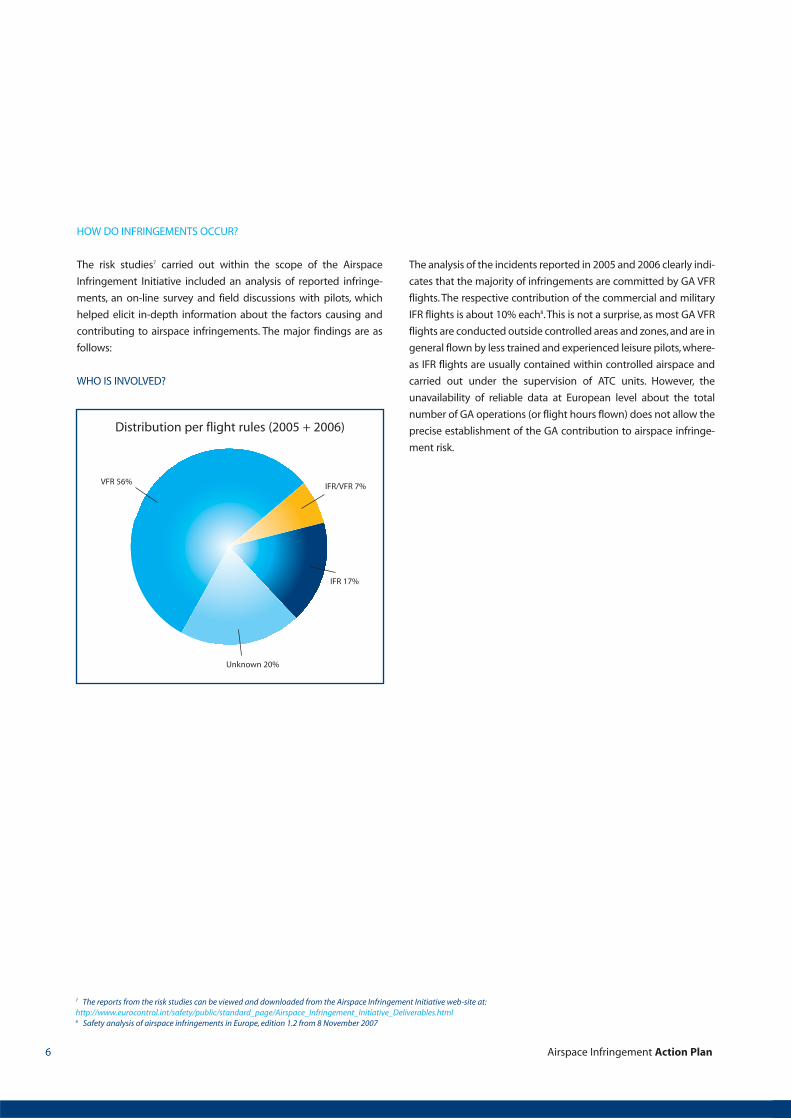
HOW DO INFRINGEMENTS OCCUR?
The risk studies7 carried out within the scope of the Airspace
Infringement Initiative included an analysis of reported infringe-
ments, an on-line survey and field discussions with pilots, which
helped elicit in-depth information about the factors causing and
contributing to airspace infringements. The major findings are as
follows:
WHO IS INVOLVED?
The analysis of the incidents reported in 2005 and 2006 clearly indi-
cates that the majority of infringements are committed by GA VFR
flights. The respective contribution of the commercial and military
IFR flights is about 10% each8.This is not a surprise, as most GA VFR
flights are conducted outside controlled areas and zones,and are in
general flown by less trained and experienced leisure pilots, where-
as IFR flights are usually contained within controlled airspace and
carried out under the supervision of ATC units. However, the
unavailability of reliable data at European level about the total
number of GA operations (or flight hours flown) does not allow the
precise establishment of the GA contribution to airspace infringe-
ment risk.
Airspace Infringement Action Plan6
VFR 56%
Distribution per flight rules (2005 + 2006)
IFR/VFR 7%
IFR 17%
Unknown 20%
7 The reports from the risk studies can be viewed and downloaded from the Airspace Infringement Initiative web-site at:http://www.eurocontrol.int/safety/public/standard_page/Airspace_Infringement_Initiative_Deliverables.html8 Safety analysis of airspace infringements in Europe, edition 1.2 from 8 November 2007

WHERE DO INFRINGEMENTS OCCUR?
The most commonly infringed airspace structures are terminal con-
trol areas (40%) and airport control zones (36%). The majority of
infringements occur during level flight rather than on departure or
approach, i.e. the infringement of the lateral airspace structures'
boundaries prevail (Safety analysis of airspace infringements in
Europe, edition 1.2 from 8 November 2007).
WHAT FACTORS LEAD TO AIRSPACE INFRINGEMENTS?
No single factor could be identified as the major cause of airspace
infringements. However, pilots' navigation skills appear to play the
most prominent role. The survey among the GA pilots in Europe
carried out in 2007 established that although the level of naviga-
tion and communication skills acquired by student pilots during
initial training raises some concerns, it is the apparent gradual
diminishing of the skills of “low-hours”pilots which requires consid-
eration and adequate measures. Refresher training is considered of
particular importance by the vast majority of pilots interviewed.
As there are fewer reported infringements involving commercial
and military flights, the data on causal factors associated with such
flights are limited,but suggest that co-ordination between different
control sectors (including between civil and military sectors) may
often be an important reason for airspace infringement.
Airspace Infringement Action Plan 7
Distribution per infringed airspace structure
Control area 5%
Control zone 36%
Terminal control
area 40%
ATS route 7%
Temp reserved
area 3%
Restricted area 1%
Danger area 1%
Unknown 7%
Causal factors’ distribution
Navigationfailure 15%
Restricted area 1%
Distraction 11%
Misread map 10% Bad weather 10%
Unfamiliarairspace 6%
Other 32%Inadequate clearance 7%

WHAT ARE THE CONSEQUENCES?
Three major categories of consequences were established follow-
ing the hazard analysis performed within the scope of the Airspace
Infringement Initiative.These consequences are described below in
decreasing order of severity:
Mid-air collision. This is the worst-case scenario, which the Action
Plan is aiming to prevent.The collaboration of all aviation sectors is
essential for the achievement of this goal.
Loss of separation. An infringement leading to loss of separation
may cause loss of control due to wake vortex encounter and even
injuries to passengers or crew when violent manoeuvres are need-
ed to avoid the other aircraft.
Disruption to flight operations. An infringement can significantly
increase controller and pilot workload due to the need to break an
approach,change aircraft sequence for landing or implement other
contingency measures. Any disruption to flight operations is likely
to have adverse environmental and economic impact due to
increased fuel burn by aircraft subject to delays both in the air and
on the ground arising from infringements. In addition, such delays
will cause disruption to operating schedules and considerable
inconvenience to passengers.
The risk mitigation potential of the ATM system was analysed using
a dedicated safety barrier model (Safety analysis of airspace
infringements in Europe, edition 1.2 from 8 November 2007). Five
different barriers were identified that can prevent an airspace
infringement developing into a mid-air collision. By applying the
model it was established that in a quarter of all airspace infringe-
ments the only safety barrier available to prevent a mid-air collision
appeared to be “see and avoid” had there been another aircraft in
close proximity to the infringing aircraft.
“See and avoid” is seen as a potentially weak barrier in an IFR-VFR
flight encounter and the need to strengthen the other barriers (e.g.
safety nets like TCAS and STCA) is further reinforced by the mid-air
collision between Pacific Southwest Airlines Flight 182, a Boeing
727 commercial airliner, and a private Cessna 172 on 25 September
1978 over San Diego, California.
Airspace Infringement Action Plan8
Airspace Infringement Action Plan 9
Recognising the risk posed by airspace infringements, EUROCON-
TROL launched the Airspace Infringement Initiative at the begin-
ning of 2006. The ultimate goal of the initiative is to develop a
Europe-wide Action Plan for airspace infringement risk reduction
and to assist airspace users, civil and military service providers
and national authorities in implementing the recommended
actions.
The approach adopted had proved its worth in other EUROCON-
TROL safety improvement initiatives such as those for runway
safety9 and air-ground communications10. It includes:
Identification, by risk analysis and consultation with stakehold-
ers, of the factors that lead to airspace infringements (as
described in section 2);
Collection and dissemination of locally existing experience
and knowledge about the potential solutions;
Identification of measures that can effectively and proportion-
ately reduce the risk;
Establishment of an Action Plan;
Coordinated and harmonised implementation of measures by
stakeholders, supported by briefing notes and guidance.
It was recognised from the outset that a priority is the involve-
ment and cooperation of all aviation sectors in order to ensure a
good understanding of their needs, draw on their experience and
propose practical and effective risk solutions. Extensive efforts
were taken to conduct in-depth risk analysis involving a wide
range of organisations and individuals. These efforts culminated
in a draft set of potential safety improvement actions, which were
made available to the aviation community at the end of 2007.
THE AIRSPACE INFRINGEMENT WORKSHOP
A major initiative event - the Airspace Infringement Workshop -
was held in January 2008. It brought together over a hundred
representatives of major aviation stakeholder groups from
around Europe, to discuss and consolidate the acquired knowl-
edge from the risk analysis phase and elaborate the risk-reduction
strategy and recommendations.
The workshop facilitated the establishment of a common under-
standing and awareness of the dimensions of airspace infringe-
ment risk and of the risk reduction potential that planned
changes to the ATM system may have in the short and medium
term. It enabled the identification of the actions considered most
relevant, achievable, and affordable, and, above all, measures that
would actually deliver the improvements in safety we all desire.
The following important conclusions emerged from the work-
shop discussions:
The collaboration of all actors (airspace users, service
providers, regulators, military) is essential for achieving the
required safety improvement; the cooperation of air naviga-
tion service providers and flying clubs is of crucial importance;
A particular challenge is to develop an integrated approach to
the needs of GA and airline operations, devising solutions that
will work across the many different types of aircraft and users
within the GA sector, and to communicate effectively with
such a diverse group;
Realising “quick wins” is still possible and should be actively
pursued, based on: wide dissemination and effective applica-
tion of existing good practices for infringement prevention;
improved communication between ATC units and airspace
user establishments; increased risk awareness and improved
mutual understanding of each other's needs and limitations;
Implementation of risk mitigation solutions at system level will
take time and effort, but this should not preclude the inclusion
of such measures in the Action Plan;
The need for harmonisation and standardisation is recognised,
on the understanding that local solutions will sometimes be
required due to the different operational environments;
The right balance needs to be struck between positive encour-
agement and regulatory enforcement. The former was clearly
preferable - enforcement should be a last resort.
EUROCONTROL aims to address all these areas through the pro-
duction of this Action Plan and further guidance material to be
included in an implementation toolkit, and by co-ordinating and
supporting the safety improvement efforts of all partners in this
key risk area
3. THE AIRSPACE INFRINGEMENT INITIATIVE
9 European Action Plan for the Prevention of Runway Incursions, Release 1, 20 March 200310 European Action Plan for Air Ground Communications Safety, Edition 1.0, May 2006

The safety improvement actions set out in section 5 are arranged in
tables for each of the following groups of action owners:
AGY EUROCONTROL Agency
AIS AIS and MET services providers
ASP Air navigation service (including FIS) providers
MIL Military organisations (service providers, airspace users
and regulators)
TRN Training organisations (whether for controllers or pilots)
REG Regulatory authorities (national and supranational)
USE Airspace users (civil and military)
Some of these action owner groups may be included in one organi-
sational entity. For example, the provision of AIS or MET services may
fall within or outside the responsibility of the ANSP (civil or military),
but all entities providing such services should consider that list of
actions. Similarly, training may be provided within or outside the
organisational structures of ANSPs and airspace user organisations,
but the actions under 'training organisations' are relevant to both.
A dedicated section identifies actions which are considered of direct
relevance to military organisations. However, as indicated above,
depending on the roles and responsibilities assigned to a particular
military unit or entity, actions included in other sections may be rele-
vant.
Actions requiring the coordinated efforts of several stakeholder
groups appear in more than one section. This is particularly the case
with the recommendations designed to improve and harmonise pilot
training and licensing requirements. Specific coordination measures
have not been identified for efficiency reasons and in order to avoid
duplication of existing arrangements at national and supranational
level. The appropriate EC, EASA and EUROCONTROL consultation
mechanisms,working and reporting arrangements,such as European
Single Sky Implementation (ESSIP) should be used for those actions
that require coordinated efforts.
For each action owner group, the relevant safety improvement
actions are assigned to two categories (and presented in two sepa-
rate tables) in accordance with the results of the stakeholder consul-
tation process that preceded the establishment of this Action Plan.
These categories are:
Recommended actions: actions that received extensive support,
consistently considered of key or high importance with respect to
their potential for improvement of safety. Action owners should
endeavour to implement them.
Proposed actions: actions that are widely supported, consistently
considered of high or medium importance with respect to their
potential for improvement of safety.Action owners should consid-
er their implementation in the light of their specific operational
environment and safety improvement needs.
Not all actions are phrased in precise terms as measurable achieve-
ments that can be 'ticked off' when completed. Some are, intention-
ally, phrased in more general terms - such as 'improve' or 'harmonise'.
This recognises that some actions are matters of degree and that
there should be flexibility for action owners to decide how far they
need to go, in line with their particular operational context and safe-
ty needs. It is acknowledged that different action owners will start
from different positions.
While airspace infringement is an important operational risk across
much of Europe, the nature and scale of the problem varies between
States. The complexity of the airspace structure, the scale of military
flying activity, the scale and maturity of both commercial and gener-
al aviation sectors, the scope and nature of air traffic service provision
and State's regulatory and legislative frameworks are the factors
which will shape the local airspace infringement risk reduction strate-
gies and determine the most appropriate and effective actions to be
taken by individual States. Therefore the number of Action Plan rec-
ommendations that can be implemented is likely to differ from State
to State. National authorities should play the leading role in
establishing and promoting local implementation priorities and
actions in consultation with airspace users and service provider
organisations.
Airspace Infringement Action Plan10
4. HOW TO USE THIS ACTION PLAN
Airspace Infringement Action Plan 11
To help identify the type of measures necessary, safety improvement
actions have been assigned to the following broad domains:
AOM Airspace organisation and management
ATS Air traffic services
COM Air-ground communications
HUM Human factors
INF Information management
NAV Navigation
SAF Safety management (culture and awareness)
Each action is assigned a unique reference number and recommend-
ed implementation target date. It should be noted that some actions
may require implementation in incremental steps over a number of
years. Identified dependencies between actions are reflected by the
“Related action” column.
More detailed information and an explanation of the recommended
and proposed actions, as well as references to existing projects, best
practices and guidance material in support of their implementation
are provided in section 6 - Explanatory Notes. Some of the support-
ing materials referred to are already available, others are yet to be
developed.
All actions and explanatory notes have reference numbers, which
provide hyperlinks to the relevant texts. This allows easy navigation
and cross-reference within the document.
An explanation of the acronyms used in this document is provided at
section 7.
Annex 1 contains excerpts from ICAO documents and best practices
used in FIS provision.
Airspace Infringement Action Plan12
5. SAFETY IMPROVEMENT ACTIONS
5.1.1 RECOMMENDED ACTIONS
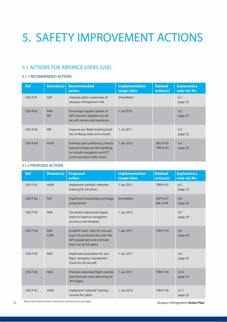
5.1 ACTIONS FOR AIRSPACE USERS (USE)
USE-R-01
USE-R-02
USE-R-03
USE-R-04
SAF
NAV
INF
INF
HUM
Improve pilots' awareness of
airspace infringement risk
Encourage regular update of
GPS systems' database by GA
aircraft owners and operators
Improve pre-flight briefing facili-
ties at flying clubs and schools
Enhance pilot proficiency checks
beyond simple aircraft handling
to include navigation and R/T
communication skills check
Immediate11
1 Jul 2010
1 Jul 2011
1 Jan 2012 REG-R-05
TRN-R-05
6.1
page 22
6.2
page 22
6.3
page 22
6.4
page 23
Ref Domain(s) Recommended Implementation Related Explanatoryaction target date action(s) note ref. No
5.1.2 PROPOSED ACTIONS
USE-P-01
USE-P-02
USE-P-03
USE-P-04
USE-P-05
USE-P-06
USE-P-07
HUM
SAF
NAV
NAV
COM
NAV
NAV
HUM
Implement periodic refresher
training for GA pilots
Implement knowledge exchange
programmes
Use better (advanced) equip-
ment to improve navigation
accuracy and integrity
Establish basic rules for manual
input of positional data into the
GPS equipment and promote
their use by GA pilots
Implement procedure for pre-
flight navigation equipment
check for GA aircraft
Promote extended flight corridor
and alternate route planning for
VFR flights
Implement “tailored” training
courses for pilots
1 Jan 2011
Immediate
1 Jan 2012
1 Jan 2011
1 Jan 2011
1 Jan 2011
1 Jan 2012
TRN-P-01
ASP-R-07
MIL-R-04
TRN-P-03
TRN-P-04
TRN-P-05
6.5
page 23
6.6
page 24
6.7
page 24
6.8
page 24
6.9
page 25
6.10
page 25
6.11
page 25
Ref Domain(s) Proposed Implementation Related Explanatoryaction target date action(s) note ref. No
11 Means that implementation should start without unnecessary delay

Airspace Infringement Action Plan 13
5.2.1 RECOMMENDED ACTIONS
AIS-R-01
AIS-R-02
AIS-R-03
AIS-R-04
INF
INF
INF
INF
Standardise (harmonise) lower
airspace charts
Investigate the feasibility of
providing aeronautical
information free of charge
for GA
Provide and enhance on-line
(web-based) accessibility of
aeronautical information
services
Harmonise and enhance AIS
provision to VFR flights as
necessary
1 Jan 2013
1 Jan 2011
1 Jul 2011
1 Jan 2012
AGY-R-01 6.12
page 25
6.13
page 26
6.14
page 26
6.16
page 28
Ref Domain(s) Recommended Implementation Related Explanatoryaction target date action(s) note ref. No
5.2.2 PROPOSED ACTIONS
AIS-P-01
AIS-P-02
AIS-P-03
INF
INF
INF
Improve availability of VFR charts
and dissemination of updates to
pilots
Include geographical
coordinates in information
items containing position details
wherever possible
Implement MET products
tailored to low level VFR flights
in line with ICAO requirements
1 Jan 2011
Immediate
1 Jan 2012
REG-P-01
AIS-R-01
6.17
page 28
6.18
page 29
6.19
page 29
Ref Domain(s) Proposed Implementation Related Explanatoryaction target date action(s) note ref. No
5.2 ACTIONS FOR AIS AND MET SERVICES PROVIDERS (AIS)
Airspace Infringement Action Plan14
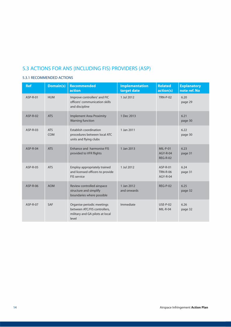
5.3.1 RECOMMENDED ACTIONS
ASP-R-01
ASP-R-02
ASP-R-03
ASP-R-04
ASP-R-05
ASP-R-06
ASP-R-07
HUM
ATS
ATS
COM
ATS
ATS
AOM
SAF
Improve controllers' and FIC
officers' communication skills
and discipline
Implement Area Proximity
Warning function
Establish coordination
procedures between local ATC
units and flying clubs
Enhance and harmonise FIS
provided to VFR flights
Employ appropriately trained
and licensed officers to provide
FIS service
Review controlled airspace
structure and simplify
boundaries where possible
Organise periodic meetings
between ATC/FIS controllers,
military and GA pilots at local
level
1 Jul 2012
1 Dec 2013
1 Jan 2011
1 Jan 2013
1 Jul 2012
1 Jan 2012
and onwards
Immediate
TRN-P-02
MIL-P-01
AGY-R-04
REG-R-02
ASP-R-01
TRN-R-06
AGY-R-04
REG-P-02
USE-P-02
MIL-R-04
6.20
page 29
6.21
page 30
6.22
page 30
6.23
page 31
6.24
page 31
6.25
page 32
6.26
page 32
Ref Domain(s) Recommended Implementation Related Explanatoryaction target date action(s) note ref. No
5.3 ACTIONS FOR ANS (INCLUDING FIS) PROVIDERS (ASP)
Airspace Infringement Action Plan 15
5.3.2 PROPOSED ACTIONS
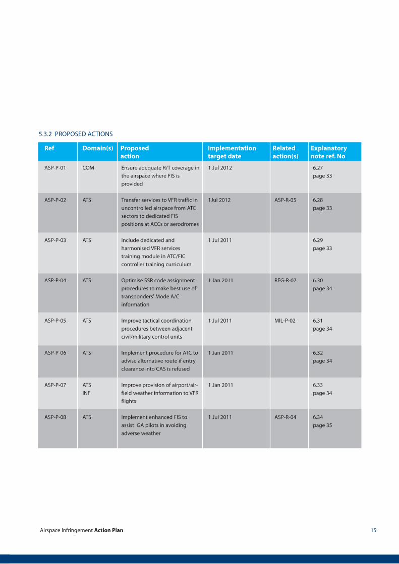
ASP-P-01
ASP-P-02
ASP-P-03
ASP-P-04
ASP-P-05
ASP-P-06
ASP-P-07
ASP-P-08
COM
ATS
ATS
ATS
ATS
ATS
ATS
INF
ATS
Ensure adequate R/T coverage in
the airspace where FIS is
provided
Transfer services to VFR traffic in
uncontrolled airspace from ATC
sectors to dedicated FIS
positions at ACCs or aerodromes
Include dedicated and
harmonised VFR services
training module in ATC/FIC
controller training curriculum
Optimise SSR code assignment
procedures to make best use of
transponders' Mode A/C
information
Improve tactical coordination
procedures between adjacent
civil/military control units
Implement procedure for ATC to
advise alternative route if entry
clearance into CAS is refused
Improve provision of airport/air-
field weather information to VFR
flights
Implement enhanced FIS to
assist GA pilots in avoiding
adverse weather
1 Jul 2012
1Jul 2012
1 Jul 2011
1 Jan 2011
1 Jul 2011
1 Jan 2011
1 Jan 2011
1 Jul 2011
ASP-R-05
REG-R-07
MIL-P-02
ASP-R-04
6.27
page 33
6.28
page 33
6.29
page 33
6.30
page 34
6.31
page 34
6.32
page 34
6.33
page 34
6.34
page 35
Ref Domain(s) Proposed Implementation Related Explanatoryaction target date action(s) note ref. No
Airspace Infringement Action Plan16
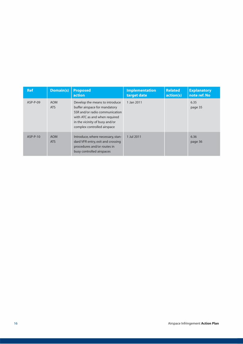
ASP-P-09
ASP-P-10
AOM
ATS
AOM
ATS
Develop the means to introduce
buffer airspace for mandatory
SSR and/or radio communication
with ATC as and when required
in the vicinity of busy and/or
complex controlled airspace
Introduce, where necessary, stan-
dard VFR entry, exit and crossing
procedures and/or routes in
busy controlled airspaces
1 Jan 2011
1 Jul 2011
6.35
page 35
6.36
page 36
Ref Domain(s) Proposed Implementation Related Explanatoryaction target date action(s) note ref. No
Airspace Infringement Action Plan 17
5.4.1 RECOMMENDED ACTIONS
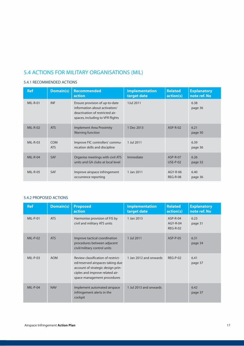
MIL-R-01
MIL-R-02
MIL-R-03
MIL-R-04
MIL-R-05
INF
ATS
COM
ATS
SAF
SAF
Ensure provision of up-to-date
information about activation/
deactivation of restricted air-
spaces, including to VFR flights
Implement Area Proximity
Warning function
Improve FIC controllers' commu-
nication skills and discipline
Organise meetings with civil ATS
units and GA clubs at local level
Improve airspace infringement
occurrence reporting
1Jul 2011
1 Dec 2013
1 Jul 2011
Immediate
1 Jan 2011
ASP-R-02
ASP-R-07
USE-P-02
AGY-R-06
REG-R-08
6.38
page 36
6.21
page 30
6.39
page 36
6.26
page 32
6.40
page 36
Ref Domain(s) Recommended Implementation Related Explanatoryaction target date action(s) note ref. No
5.4.2 PROPOSED ACTIONS
MIL-P-01
MIL-P-02
MIL-P-03
MIL-P-04
ATS
ATS
AOM
NAV
Harmonise provision of FIS by
civil and military ATS units
Improve tactical coordination
procedures between adjacent
civil/military control units
Review classification of restrict-
ed/reserved airspaces taking due
account of strategic design prin-
ciples and improve related air-
space management procedures
Implement automated airspace
infringement alerts in the
cockpit
1 Jan 2013
1 Jul 2011
1 Jan 2012 and onwards
1 Jul 2013 and onwards
ASP-R-04
AGY-R-04
REG-R-02
ASP-P-05
REG-P-02
6.23
page 31
6.31
page 34
6.41
page 37
6.42
page 37
Ref Domain(s) Proposed Implementation Related Explanatoryaction target date action(s) note ref. No
5.4 ACTIONS FOR MILITARY ORGANISATIONS (MIL)
Airspace Infringement Action Plan18
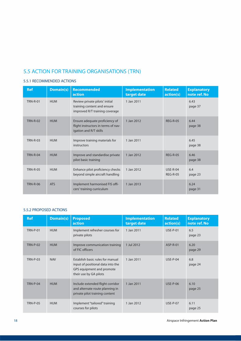
5.5.2 PROPOSED ACTIONS
TRN-P-01
TRN-P-02
TRN-P-03
TRN-P-04
TRN-P-05
HUM
HUM
NAV
HUM
HUM
Implement refresher courses for
private pilots
Improve communication training
of FIC officers
Establish basic rules for manual
input of positional data into the
GPS equipment and promote
their use by GA pilots
Include extended flight corridor
and alternate route planning in
private pilot training content
Implement “tailored” training
courses for pilots
1 Jan 2011
1 Jul 2012
1 Jan 2011
1 Jan 2011
1 Jan 2012
USE-P-01
ASP-R-01
USE-P-04
USE-P-06
USE-P-07
6.5
page 23
6.20
page 29
6.8
page 24
6.10
page 25
6.11
page 25
Ref Domain(s) Proposed Implementation Related Explanatoryaction target date action(s) note ref. No
5.5.1 RECOMMENDED ACTIONS
TRN-R-01
TRN-R-02
TRN-R-03
TRN-R-04
TRN-R-05
TRN-R-06
HUM
HUM
HUM
HUM
HUM
ATS
Review private pilots' initial
training content and ensure
improved R/T training coverage
Ensure adequate proficiency of
flight instructors in terms of nav-
igation and R/T skills
Improve training materials for
instructors
Improve and standardise private
pilot basic training
Enhance pilot proficiency checks
beyond simple aircraft handling
Implement harmonised FIS offi-
cers' training curriculum
1 Jan 2011
1 Jan 2012
1 Jan 2011
1 Jan 2012
1 Jan 2012
1 Jan 2013
REG-R-05
REG-R-05
USE-R-04
REG-R-05
6.43
page 37
6.44
page 38
6.45
page 38
6.46
page 38
6.4
page 23
6.24
page 31
Ref Domain(s) Recommended Implementation Related Explanatoryaction target date action(s) note ref. No
5.5 ACTION FOR TRAINING ORGANISATIONS (TRN)
Airspace Infringement Action Plan 19
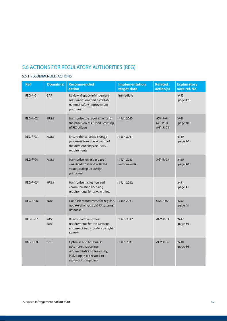
5.6.1 RECOMMENDED ACTIONS
REG-R-01
REG-R-02
REG-R-03
REG-R-04
REG-R-05
REG-R-06
REG-R-07
REG-R-08
SAF
HUM
AOM
AOM
HUM
NAV
ATS
NAV
SAF
Review airspace infringement
risk dimensions and establish
national safety improvement
priorities
Harmonise the requirements for
the provision of FIS and licensing
of FIC officers
Ensure that airspace change
processes take due account of
the different airspace users'
requirements
Harmonise lower airspace
classification in line with the
strategic airspace design
principles
Harmonise navigation and
communication licensing
requirements for private pilots
Establish requirement for regular
update of on-board GPS systems
database
Review and harmonise
requirements for the carriage
and use of transponders by light
aircraft
Optimise and harmonise
occurrence reporting
requirements and taxonomy,
including those related to
airspace infringement
Immediate
1 Jan 2013
1 Jan 2011
1 Jan 2013
and onwards
1 Jan 2012
1 Jan 2011
1 Jan 2012
1 Jan 2011
ASP-R-04
MIL-P-01
AGY-R-04
AGY-R-05
USE-R-02
AGY-R-03
AGY-R-06
6.53
page 42
6.48
page 40
6.49
page 40
6.50
page 40
6.51
page 41
6.52
page 41
6.47
page 39
6.40
page 36
Ref Domain(s) Recommended Implementation Related Explanatoryaction target date action(s) note ref. No
5.6 ACTIONS FOR REGULATORY AUTHORITIES (REG)
Airspace Infringement Action Plan20
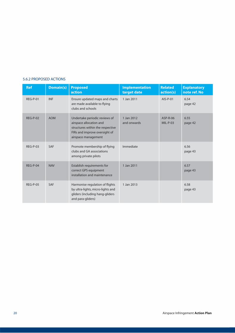
5.6.2 PROPOSED ACTIONS
REG-P-01
REG-P-02
REG-P-03
REG-P-04
REG-P-05
INF
AOM
SAF
NAV
SAF
Ensure updated maps and charts
are made available to flying
clubs and schools
Undertake periodic reviews of
airspace allocation and
structures within the respective
FIRs and improve oversight of
airspace management
Promote membership of flying
clubs and GA associations
among private pilots
Establish requirements for
correct GPS equipment
installation and maintenance
Harmonise regulation of flights
by ultra-lights, micro-lights and
gliders (including hang-gliders
and para-gliders)
1 Jan 2011
1 Jan 2012
and onwards
Immediate
1 Jan 2011
1 Jan 2013
AIS-P-01
ASP-R-06
MIL-P-03
6.54
page 42
6.55
page 42
6.56
page 43
6.57
page 43
6.58
page 43
Ref Domain(s) Proposed Implementation Related Explanatoryaction target date action(s) note ref. No
Airspace Infringement Action Plan 21
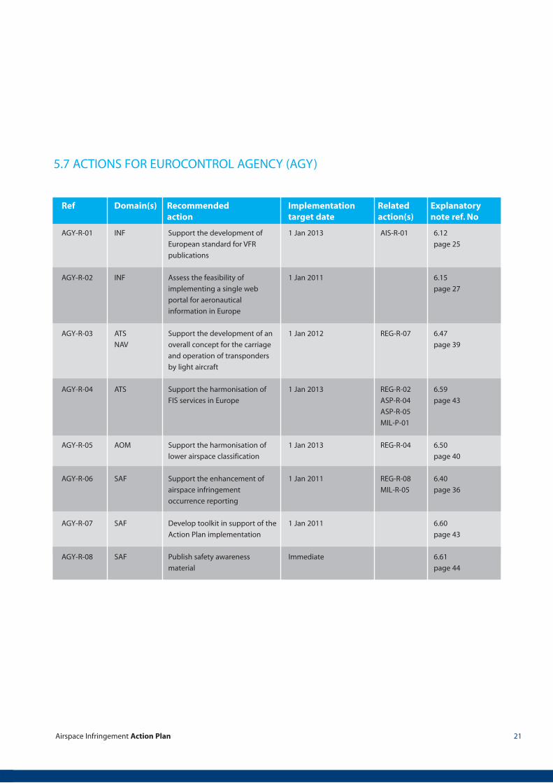
AGY-R-01
AGY-R-02
AGY-R-03
AGY-R-04
AGY-R-05
AGY-R-06
AGY-R-07
AGY-R-08
INF
INF
ATS
NAV
ATS
AOM
SAF
SAF
SAF
Support the development of
European standard for VFR
publications
Assess the feasibility of
implementing a single web
portal for aeronautical
information in Europe
Support the development of an
overall concept for the carriage
and operation of transponders
by light aircraft
Support the harmonisation of
FIS services in Europe
Support the harmonisation of
lower airspace classification
Support the enhancement of
airspace infringement
occurrence reporting
Develop toolkit in support of the
Action Plan implementation
Publish safety awareness
material
1 Jan 2013
1 Jan 2011
1 Jan 2012
1 Jan 2013
1 Jan 2013
1 Jan 2011
1 Jan 2011
Immediate
AIS-R-01
REG-R-07
REG-R-02
ASP-R-04
ASP-R-05
MIL-P-01
REG-R-04
REG-R-08
MIL-R-05
6.12
page 25
6.15
page 27
6.47
page 39
6.59
page 43
6.50
page 40
6.40
page 36
6.60
page 43
6.61
page 44
Ref Domain(s) Recommended Implementation Related Explanatoryaction target date action(s) note ref. No
5.7 ACTIONS FOR EUROCONTROL AGENCY (AGY)

Airspace Infringement Action Plan22
6. EXPLANATORY NOTES
6.1
6.2
6.3
USE-R-01
USE-R-02
REG-R-06
USE-R-03
User organisations should organise and encourage member partic-
ipation at safety seminars and other events aimed to improve pilot
awareness of airspace infringement risk. Internet fora should also
be considered.
Examples of good practice are the flight safety seminars organised
by national AOPAs and the UK CAA.
Awareness materials, such as posters, leaflets, safety letters pro-
duced by international and national organisations and authorities
(e.g. CAA) can be used directly or adapted according to local needs.
GA organisations and establishments should encourage their
members, the owners and operators (pilots) of GA aircraft to
update regularly the database of the GPS systems used as
navigation support means during VFR operations.
The recommendation is relevant to both hand-held GPS receivers
and those permanently installed on the aircraft. Reminders could
be issued to pilots in case of planned implementation of
considerable airspace changes. The database update procedure
should also include verification of the parity between the GPS
database and the VFR chart(s) used during flight. The 28-day cycle
for aeronautical information publication used by the majority of
GPS manufacturers and database providers need be considered in
this respect.
The GPS manufacturers and database providers should be asked to
support this effort. They could provide regular notifications to the
users of their services to download the relevant data upon update.
This action is designed to improve the pre-flight preparation of
pilots. It calls for improvements to capabilities of existing briefing
facilities and the implementation of new facilities, where they do
not exist at the various GA locations, for example at flying clubs.
Cooperation with the AIS and MET services providers (or ANSPs) is
essential for successful implementation of this action. Support from
the regulatory authorities should be sought and obtained.
A typical briefing facility available at flying clubs should include
provision of aeronautical and meteorological information, but also
support the filing and submission of flight plans.
Remote access of members to the briefing facility should be
ensured.Potentially, a personal computer can serve the purpose of
a flight briefing station, but those who do not use computers or are
not comfortable with them will have to be considered.
EUROCONTROL risk analysis
reports, posters, safety letters
National publications and
materials (e.g. UK CAA safety
sense leaflets)
Procedures for update of FMS
navigation database used by
airlines
GPS user manuals
Ref Action ref Explanatory note Supporting material,project or workingarrangement
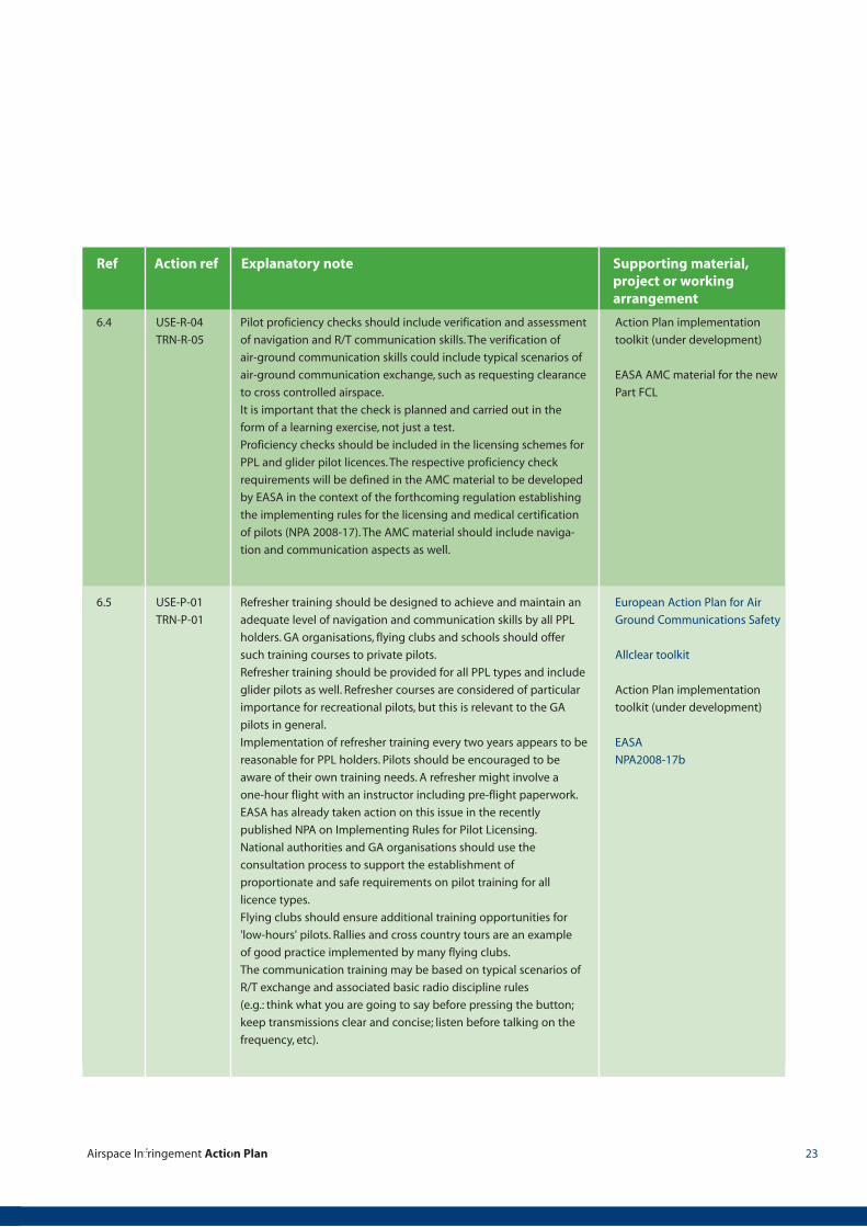
Airspace Infringement Action Plan 23
6.4
6.5
USE-R-04
TRN-R-05
USE-P-01
TRN-P-01
Pilot proficiency checks should include verification and assessment
of navigation and R/T communication skills. The verification of
air-ground communication skills could include typical scenarios of
air-ground communication exchange, such as requesting clearance
to cross controlled airspace.
It is important that the check is planned and carried out in the
form of a learning exercise, not just a test.
Proficiency checks should be included in the licensing schemes for
PPL and glider pilot licences. The respective proficiency check
requirements will be defined in the AMC material to be developed
by EASA in the context of the forthcoming regulation establishing
the implementing rules for the licensing and medical certification
of pilots (NPA 2008-17). The AMC material should include naviga-
tion and communication aspects as well.
Refresher training should be designed to achieve and maintain an
adequate level of navigation and communication skills by all PPL
holders. GA organisations, flying clubs and schools should offer
such training courses to private pilots.
Refresher training should be provided for all PPL types and include
glider pilots as well. Refresher courses are considered of particular
importance for recreational pilots, but this is relevant to the GA
pilots in general.
Implementation of refresher training every two years appears to be
reasonable for PPL holders. Pilots should be encouraged to be
aware of their own training needs. A refresher might involve a
one-hour flight with an instructor including pre-flight paperwork.
EASA has already taken action on this issue in the recently
published NPA on Implementing Rules for Pilot Licensing.
National authorities and GA organisations should use the
consultation process to support the establishment of
proportionate and safe requirements on pilot training for all
licence types.
Flying clubs should ensure additional training opportunities for
'low-hours' pilots. Rallies and cross country tours are an example
of good practice implemented by many flying clubs.
The communication training may be based on typical scenarios of
R/T exchange and associated basic radio discipline rules
(e.g.: think what you are going to say before pressing the button;
keep transmissions clear and concise; listen before talking on the
frequency, etc).
Action Plan implementation
toolkit (under development)
EASA AMC material for the new
Part FCL
European Action Plan for Air
Ground Communications Safety
Allclear toolkit
Action Plan implementation
toolkit (under development)
EASA
NPA2008-17b
Ref Action ref Explanatory note Supporting material,project or workingarrangement
Airspace Infringement Action Plan24
6.6
6.7
6.8
USE-P-02
USE-P-03
USE-P-04
TRN-P-03
The knowledge exchange programmes should aim to support
controllers and GA pilots in sharing their knowledge of airspace
and aircraft, improve understanding of each other's needs,
limitations and way of working. Programmes should include pilots
with different experience, e.g. pilots of light aircraft, gliders pilots,
helicopters, etc.
Such knowledge exchange programmes should be organised at
local level in order to maximise effectiveness. Meeting events
should be held at the flying schools and clubs and ATC facilities.
Pilots associations and flying clubs should play an essential role for
improvement of the interface to ATC.
The primary means of navigation in VFR flying is visual reference to
the terrain using VFR charts. However, the use of GPS systems is
spreading rapidly at a global scale. Sometimes GPS systems are
used which are not certified for aerial navigation. In the context of
this Action Plan “better or advanced” navigation equipment refers
to modern aircraft GPS receivers, accurate GPS moving map
software, data link, ADS-B and Mode S transponders.
Enhanced GPS systems are already available providing
cartographic map display, but also automated (audible alarm may
be considered) alerts to pilots of imminent or actual airspace
infringement. Such a warning could also be displayed during the
planning phase, when the flight route is being set up.
Advanced GPS functions can alert the pilot to deviations from the
“safe flight path”, for example flight alarm (FLARM) used by gliders.
In the long term, digital radio could provide a simple and universal
means of reliable and prompt communication between controllers
and pilots. Integrative software can support download and uplink
information in flight.
GA organisations, flying clubs and schools, should establish a sim-
ple set of ground rules for manual input of data into the GPS sets
based on the available best practices and promote its use by the
private pilots.
This set of rules should be generic enough to be used with the var-
ious GPS receiver models and makes. The following best practice
may be considered:
� Input route data on the ground, prior to engine start at latest;
� Check visually the displayed route for inconsistencies and gross
errors;
� Call the display of the input data (coordinates) and verify their
identity with the source document (map).
Action Plan implementation
toolkit (under development)
Ref Action ref Explanatory note Supporting material,project or workingarrangement

Airspace Infringement Action Plan 25
6.9
6.10
6.11
6.12
USE-P-05
USE-P-06
TRN-P-04
USE-P-07
TRN-P-05
AIS-R-01
AGY-R-01
GA organisations, in cooperation with the flying clubs and schools,
should develop a simple checklist for use by private pilots. Further
guidance and explanations may be provided in the form of a
briefing note.
These procedures may be included in the "pilot's notes" for each
aircraft type. Developing a dedicated briefing note is considered
particularly useful for unregulated recreational aviation types,
ultra-lights, etc. It needs to be kept simple.
Promote awareness of the need and encourage private pilots to
plan alternative/secondary routes to be flown in the event of
unexpected/unforeseen circumstances, e.g. clearance to cross
controlled airspace is refused, weather changes occurring faster
than predicted, etc.
“Tailored” (focused) training courses designed to improve specific
skills and techniques in the flight training process, depending on
the type of airplane and the experience of the pilot. Based on
periodical analyses of everyday operations, weak points are
identified and the appropriate measures taken. For example,
following identification of a weakness in landing techniques, the
teaching process and/or the training syllabus should be
reorganised and training hours increased if necessary.
Improved VFR publications will contribute to better IFR traffic
protection. Standardisation of VFR en-route charts is considered
the highest priority. The products provided by commercial sources
(different from the State AIS organisations) should be considered
within the scope of this standardisation effort.
There has to be a standard representation of lower airspace to
prevent confusion in cross-border flights. Compliance with and
common interpretation of ICAO Annex 4 requirements needs to be
achieved. This includes common map layout conventions,
consistent use of colour coding, symbols etc. High priority should
be assigned to the standardisation of the most commonly used
ICAO VFR chart (1:500 000).
The action aims to improve the readability and simplify VFR charts
as much as possible. Only information relevant to VFR flights
should be printed. There are instances of VFR charts saturated by
the volume of printed information. It takes the pilot too long to
consult during flight and may lead to distraction. However,
simplification should not lead to loss of important features.
The clarity of frequency information should be improved.
Frequencies should be indicated clearly on electronic and paper
maps, allowing easy reference by pilots during flights.
Action Plan implementation
toolkit (under development)
ICAO Annex 4
ICAO Doc 8700
EUROCONTROL AIS Team
working arrangements
Ref Action ref Explanatory note Supporting material,project or workingarrangement
Airspace Infringement Action Plan26
6.13
6.14
AIS-R-02
AIS-R-03
Harmonisation may include a review of needs and an agreement to
publish charts with more appropriate scales (e.g. 1:250 000) for
local flights.
Harmonisation of VFR AIPs (manuals) should also be considered.
The involvement of GA representatives in such reviews and in the
process of VFR publications' standardisation is essential.
The EUROCONTROL Agency should support and coordinate AIS
providers' chart harmonisation efforts through the existing AIS
Team working arrangements.
The action aims to make aeronautical and MET information, that is
relevant to lower airspace and airports/airfields open to VFR flights,
freely available to the GA VFR flying community. This would reduce
the probability of inadequate pre-flight preparation. For example,
VFR charts should be freely accessible and downloadable via
internet from the service provider sites. There is a need for a
dedicated study to identify what kind of information will bring the
highest benefit to the users of lower airspace.
EUROCONTROL, national authorities and AIS service providers
should support GA establishments in their efforts to improve the
briefing facilities on airfields (for example feeding them with the
relevant aeronautical data, making necessary HW/SW available,
etc.). See note 6.3.
A variety of solutions and business models (or combinations
thereof ) could be considered in this context. For instance the
service provision cost could be recovered through license fees or
public (state or European Community) funds.
The development of the SES2 package offers an opportunity to
support the implementation of a high quality and
"publicly accessible" AIS portal.
NOTAMs, maps, charts and current weather information shall be
made easily accessible at the service provider websites. Dedicated
pages for GA VFR flights that provide access to all information
needed for a flight could be designed.
Visualisation of information should be improved: it should be user-
friendly and intuitively comprehensible. The
mechanisms, processes and means for delivery of the actual air-
space structures' status to users (in particular GA) should be
reviewed and optimised.
Online AIS provision should not totally replace the traditional
methods. Pilots should be provided with the option to obtain pre-
flight briefing materials in hard copy or to contact the appropriate
briefing office (e.g. FIS free phone), whichever is the preferred
method of preparing for the flight.
Ref Action ref Explanatory note Supporting material,project or workingarrangement
Airspace Infringement Action Plan 27
6.15 AGY-R-02 The feasibility of creating a pan-European facility for integrated
and timely provision of up-to-date aeronautical and meteorologi-
cal information to all users in the ECAC states should be studied.
The feasibility assessment should include a rigorous cost-benefit
analysis. A number of implementation options could be
considered, for example:
� Creation of a centralised database for aeronautical and
meteorological information with ECAC coverage.
� Creation of a webpage providing links to the websites of
European aeronautical and meteorological data providers
� A hybrid solution.
The various options should be analysed and the most efficient
solution recommended for implementation in case of positive
cost-benefit ratio.
The “one stop shop” should be designed in a user-friendly manner
and provide for easy and prompt access to any flight related
information that the pilot might need for preparation. The liability
issues with regard to the provision and use of the information
should be resolved.
The implementation of this action may be guided by an EAIP
(Electronic Aeronautical Information Publications) mandate.
The site may need to be regulated to ensure a high standard, and
may need to be accessible in many different languages.
The European AIS Database (EAD) could be a vehicle for this.
However, the quality of the information and its suitability for use by
the different types of operations (e.g. GA VFR flights) needs to be
examined. Publicity and guidance to GA on how to use it would
need to be ensured.
European AIS Database
European AIS page
ESSIP objective INF04
Ref Action ref Explanatory note Supporting material,project or workingarrangement
Airspace Infringement Action Plan28
6.16
6.17
AIS-R-04
AIS-P-01
The implementation of this action should include:
� Provision of dedicated VFR sections in the AIPs or VFR AIPs
(manuals);
� Provision of up-to-date VFR charts;
� Implementation of a user-friendly NOTAM system for VFR flights.
The NOTAM briefing facilities should provide for:
� Graphical visualisation of information about changes to airspace
structures and activation/deactivation of restricted airspaces.
� Narrow route briefing for (long distance) route flights.
� NOTAM selection and prioritisation tool
Grouping NOTAMs by topic, enabling the generation of
briefing packages tailored to the needs of the various user types
may be considered (e.g. a glider pilot would need different
information to a pilot planning a cross country flight).
In case of generation of NOTAM update packages the type of users
the update is intended for should be taken into account
(e.g. GA VFR flight). It would be desirable to include a short
summary outlining the changes in traffic schemes and airspace.
The readability of NOTAMs and other publications (AIC) of potential
interest to VFR flights should be improved using plain language
rather than encoded text where possible. The names of towns,
villages and other well known geographic notions should be used
instead of coordinates, which most of pilots can not use in-flight.
Both electronic and hard copy (paper) versions of maps/charts
should be maintained in order to provide the preferred means of
flight briefing to the different generations of GA pilots.
Enabling downloads of current charts or sections thereof is an
improved service requested by pilots.
Further improvement could be achieved by alerting
subscribers (users) to implemented changes/updates, for example
by means of e-mail notification messages. In
addition, site visits and seminars should be considered in the case
of major airspace changes.
EUROCONTROL AIS Team
European AIS Database
Ref Action ref Explanatory note Supporting material,project or workingarrangement
Airspace Infringement Action Plan 29
6.18
6.19
6.20
AIS-P-02
REG-P-01
AIS-P-03
ASP-R-01
TRN-P-02
MIL-R-03
Geographical coordinates are a major issue in GPS systems. Most
GPS systems provide an extensive data file including all kinds of
way points, navigational aids etc.
The availability of LAT/LONG information on VFR maps would
support the crosscheck and input of correct data in the GPS set.
However, increasing clutter on VFR charts must be avoided.
Therefore, more appropriate vehicle appears to be ENR and/or AD
part of the AIP, rather than charts. This information can also be pro-
vided on-line (on the service provider or CAA website) and can be
picked up by commercial data providers.
The recommendation concerns the implementation of weather
reports and forecasts in line with ICAO Annex 3 requirements,
e.g. GAMET and AIRMET.
Integrated on-line provision of aeronautical and meteorological
information should be ensured, for example on the AIS/ATS
providers websites.
This action reinforces the objectives and provisions of the Action
Plan for Air Ground Communications, focusing on the aspects that
are of particular importance in the communication exchange
between ATS units and VFR flights.
ATS staff should be trained to:
� Strictly apply the readback/hearback procedure;
� Actively seek confirmation in case of doubt;
� Use unambiguous call-signs - full call-sign or call-sign coupled
with type of aircraft;
� Use published reference points in ATS messages to pilots, to the
extent possible;
� Use simple ATC clearances and instructions;
� Use more concise transmissions, if necessary broken in
segments;
� Use reduced rate of speech when talking to VFR pilots;
� Issue pre-warning of instructions to be passed;
� Provide FIS in English language;
� Acquire adequate knowledge of and apply communication
failure procedures as required.
ICAO Annex 3
ESSIP objective INF04
European Action Plan for Air
Ground Communications Safety
Allclear toolkit
Action Plan implementation
toolkit (under development)
ESSIP objective SAF05
Ref Action ref Explanatory note Supporting material,project or workingarrangement

6.21
6.22
ASP-R-02
MIL-R-02
ASP-R-03
The objective is to implement an automated safety net
function that should systematically alert controllers of
airspace infringements, i.e. of unauthorised entries into
controlled and restricted airspaces. Implementation decision
should be based on positive cost-benefit-analysis and safety
assessment.
Area Proximity Warning (APW) is a ground-based safety net
intended to warn the controller of unauthorised penetration into
an airspace volume by generating, in a timely manner, an alert of a
potential or actual infringement of the required spacing to that
airspace volume. The safety nets APW, STCA and ACAS are three of
the safety barriers that help prevent mid-air collisions, but each of
them depends upon the carriage and operation of pressure
altitude reporting transponders by both of the aircraft concerned.
The potential of CIMACT for providing warning to military users
about infringement of active restricted or controlled airspaces
should be explored.
This action aims to establish standard coordination procedures
between closely located ATS units, military and user sites.
The implementation of such procedures will reduce the volume of
routine coordination, and thus controller and pilot workload.
The FUA concept implementation work should also take account of
the specific needs of the GA VFR fights with regard to the timely
dissemination of information about the activation/deactivation of
reserved airspaces (including those for glider activity).
Implementation of (direct) communication lines or means between
local ATC units, military units and GA airports/airfields should be
considered in this respect.
The implementation of the above referred coordination
procedures, which would enhance the FUA procedures in lower
airspace at local level, should be preceded by careful safety
assessment.
SPIN sub group work
ESSIP objective ATC02.5
CIMACT
FUA specification
Ref Action ref Explanatory note Supporting material,project or workingarrangement
Airspace Infringement Action Plan30
6.23
6.24
ASP-R-04
MIL-P-01
REG-R-02
ASP-R-05
TRN-R-06
Harmonisation of FIS provided to VFR flights should be based on
ICAO recommendations and existing best practices. Examples of
best practices are the Low Airspace Radar Service provided in UK
airspace and the radar information services provided in German
airspace.
Radar-derived information available at ATS units should be used to
enhance the information passed to pilots. It should include, as
appropriate, navigational assistance, coordination of CAS
entry/crossing clearance, passing traffic information and
information about restricted airspace activation/deactivation and
concerned traffic, as well as provision of other aeronautical
information and information about potential hazardous conditions.
The service could include provision of warnings to pilots of any
unfavourable factors including airspace infringement and traffic
warnings. FIS level could be raised to enable proactive prevention
of potential conflict situations.
The scope of this action should include the harmonisation of
services provided by civil and military FIS provider organisations.
Improve and harmonise FIS officers' training curriculum. Training
curriculum should be improved to adequately match the level of
service to be provided.
FIC staff should receive dedicated training improving their
awareness and understanding of the VFR flights’ needs, specificities
and light aircraft performances. Best practices already exist
(e.g. in Germany) to deliver emergency situation training to FIC
staff and VFR pilots in a coordinated manner.
A sufficient number of FIC staff should be made available to
support the provision of enhanced FIS. A number of ATS providers
have already implemented dedicated training programmes for staff
that become redundant or underutilised due to the increasing
automation of ATS provision (e.g. implementation of OLDI).
See also 6.20 and 6.23 above.
ANNEX 1
Action Plan implementation
toolkit (under development)
ESSIP objective HUM02 and
HUM05
Ref Action ref Explanatory note Supporting material,project or workingarrangement
Airspace Infringement Action Plan 31

6.25
6.26
ASP-R-06
ASP-R-07
MIL-R-04
This action is particularly relevant to areas of dense VFR traffic.
It should aim to simplify, where possible, the numerous boundary
level changes of TMAs and CTRs that can contribute to vertical
navigation error.
It should also aim to ensure the reliable protection of the IFR traffic
established on the extended runway centreline and within 15 NM
from the runway threshold from the nearby VFR traffic. This would
reduce the number of RAs generated by TCAS.
Alignment of lower airspace structure boundaries and of VFR
routes (corridors) with prominent ground features and landmarks
should be sought to make them more easily identifiable by pilots
during flights.
The review should be informed by identification of hot spots based
on the analysis of (infringement) incident reports or other
appropriate methods.
Automated tools may also be used to plot actual flight tracks in a
particular area onto the existing airspace structures in order to
identify potential inconsistencies in the design of protected
(controlled) airspaces. Such methods will also facilitate the
identification of underutilised portions of controlled or restricted
airspaces that may be released for use by GA VFR flights.
This action concerns ANSPs that have been delegated the
responsibility of developing and implementing changes to the
airspace organisation subject to the approval of the National
authorities. See also 6.55.
“Open doors days” at ATS units and familiarisation visits by ATS staff
to flying clubs and military sites should improve the understanding
of each other's operational needs, capabilities and concerns. ATS staff
will improve their awareness of single-pilot aircraft operation (pilot
workload, limits, priorities, etc) and mission/training requirements
(for military). Pilots will improve their knowledge of controllers' tasks,
ways of working and the assistance that may be provided to them
by ATS.
Other approaches that could be adopted are dedicated safety
seminars with the participation of all airspace user types,
service provider organisations and regulatory authorities, or periodic
safety analyses (e.g. bi-annual) of the common use of airspace.
Pilot associations and flying clubs could play a role in improving the
interface with ATC. Knowledge exchange programmes should
include pilots with different experience from the various GA types,
e.g. pilots of light aircraft, gliders, helicopters, etc.
EUROCONTROL manual for
airspace planning
Action Plan implementation
toolkit (under development)
Ref Action ref Explanatory note Supporting material,project or workingarrangement
32
6.27
6.28
6.29
ASP-P-01
ASP-P-02
ASP-P-03
Review and improve, if necessary, the low-level radio coverage in
particular around CTRs/TMAs and of airspaces containing high
density VFR routes and choke points. Some receiver/transmitter
sites, built for IFR traffic, may not be appropriate for FIS provision
due to the terrain.
Subject to availability, the number of ATS frequencies for the
provision of FIS in busy areas may need to be reviewed and
increased to ensure the required quality of service provision and
better controlled airspace protection.
25 kHz channel spacing needs to be ensured, unless a decision is
taken at European level to implement 8.33 kHz below FL 195.
Most GA aircraft are not equipped for reduced channel spacing.
Also the availability and location of DF facilities should be assessed.
The objective is to ensure provision of FIS from dedicated positions
that will not reduce the level of service to VFR flights when there is
a high level of IFR traffic in the airspace assigned to the ATC
sector(s).
Procedures may be established for the delegation of services to
VFR flights in class E airspace from the control sectors to FIC,
if appropriate and depending on the specific operational
environment and regulatory framework.
The objective is to ensure that ATS staff:
� Are aware of the different levels of training and experience of
PPL holders, military and airline pilots;
� Have improved knowledge of light aircraft, ultra-light, gliders
and balloons and their performance characteristics, which will
ensure correct understanding and communication with GA
pilots. (ATS/FIC controllers should be trained to ask, not to
assume);
� Are familiar with the cockpit workload of VFR flights (mostly sin-
gle-pilot operated aircraft) in the various conditions and flight
phases;
� Are aware of the fact that a VFR GA flight might not be able to
follow the clearance due to the need to stay in VMC.
Inclusion of dedicated limited training in VFR flying may be
considered. It will improve ATC/FIC controllers understanding of
VFR flying.
ESSIP objective HUM01.1
Action Plan implementation
toolkit (under development)
ESSIP objective HUM02.1
Ref Action ref Explanatory note Supporting material,project or workingarrangement
Airspace Infringement Action Plan 33
6.30
6.31
6.32
6.33
ASP-P-04
ASP-P-05
MIL-P-02
ASP-P-06
ASP-P-07
Better utilisation of SSR codes can assist in the identification of
traffic in congested airspace. Existing best practices should be
applied as widely as possible. For example, an “FIR lost” SSR code
applied by FIS units to aircraft when pilots are unsure of their
position draws attention to the aircraft and its predicament
without multiple communications taking place across sectors.
The 'Listening out' SSR code identifies to a controller that the air-
craft is listening on their frequency should they wish to call them.
It is specifically valuable for aircraft operating outside a busy CTR.
Other examples are: implementation of mandatory transponder
areas or zones (e.g. at and above a certain altitude or flight level);
SSR codes and frequency coupling; GA single event codes;
dedicated codes for VFR corridors/routes etc.
Improved civil - military coordination (FUA level 3) will enable:
� The provision of up-to-date, correct information to all flights
about current airspace restrictions and their use;
� Timely action by the controllers/officers (in the control units
concerned) in the case of imminent or actual infringement of
controlled or restricted airspace to reduce the severity of the
possible consequences.
Implementation of this action should be considered within the
scope of efforts for further enhancement of the FUA concept.
When a VFR flight is refused clearance to cross controlled airspace,
a possible alternative route should be proposed. However, the pilot
is responsible for planning his/her flight and he/she should decide
whether to follow the suggested alternative route.
ATC staff should also inform pilots of the reason for refusing a
service or entry into controlled airspace. This should be done in a
clear and unambiguous manner to prevent discussions or debates
that could “block” the operating frequency.
Messages should be simple, clear and concise to keep the R/T load
to the possible minimum.
Internet, automatic broadcast (radio, telephone) and provision by
FIC (on request or broadcast on the frequency) should be
considered.
This may include assessment of the need for and implementation
of ATIS at airports, where this can bring significant safety benefits.
Action plan implementation
toolkit (under development)
FUA specification
Ref Action ref Explanatory note Supporting material,project or workingarrangement
Airspace Infringement Action Plan34

6.34
6.35
ASP-P-08
ASP-P-09
Additional navigation support should be provided to VFR flights in
compliance with ICAO Doc 4444 PANS-ATM, section 15.4.1 “Strayed
VFR flights and VFR flights encountering adverse meteorological
conditions” in order to help pilots avoid flying into meteorological
conditions not conforming with the required minima.
The objective of this action is to ensure the protection of high-
density controlled airspaces, like busy TMAs and CTRs.
Implementation decisions should be taken following analysis of
safety data and records.
It should be noted that establishing mandatory R/T buffer zone
may not always be possible. Indeed, the feasibility of implementing
such buffer airspace depends on the typology of adjacent airspace
(continuous controlled airspace, military airspace, etc.) and relevant
consultation with other stakeholders and airspace users.
Implementation of mandatory R/T buffer zones should also include
a review of existing "buffer airspace" at the TMA or CTR boundaries
and corresponding optimisation (decrease) of such airspace to the
necessary minimum due to the additional protection provided by
the R/T buffer zone.
A possible implementation may include tracking all flights
operating within a certain range of the controlled airspace in
question. Depending on the operational need a minimum
altitude/level above which the requirement will be applicable may
be defined.
Since radio communication is not required by ICAO in class G
airspace, an alternative means of reducing the probability of severe
airspace infringement incidents occurring is to require GA flights to
maintain listening watch on 121.5 MHz, except when in contact
with an ATS unit. This would help ATC contact an infringing aircraft
early enough to prevent the infringement from evolving into
high-risk incident.
Action Plan implementation
toolkit (under development)
Ref Action ref Explanatory note Supporting material,project or workingarrangement
Airspace Infringement Action Plan 35
6.36
6.37
6.38
6.39
6.40
ASP-P-10
MIL-P-03
MIL-R-01
MIL-R-03
AGY-R-06
MIL-R-05
REG-R-08
Implementation of this action should support:
� Achievement of high level of safety in common use of airspace
by IFR and VFR flights
� Fair access to busy airspaces for all airspace user types
� Reduced controller workload due to standard procedures
(reduced coordination and R/T)
Such procedures should make good use of visual reference points
(VRPs).
Establishment of VFR arrival and departure routes could be a
relevant safety improvement measure at airports serving both IFR
and VFR traffic.
Implementation should be decided on a case-by-case basis, taking
due account of the local environment and traffic
patterns. Simplicity (of VFR routes) should be an objective.
Intentionally left blank.
Two implementation aspects should be considered:
� In the case of military ATS providers, the airspace status
information should be made available to the units providing
services to the VFR flights. Military controllers should pass this
information to concerned flights which maintain radio contact.
� In cases where FIS is provided by a civil entity, the airspace
status information should be made available according to the
implemented FUA procedures. Concerned FIC(s) may be
informed directly or through the responsible FUA structures.
This action is relevant for military organisations providing FIS to
General Air Traffic (GAT) VFR flights. See also note 6.20.
The action is designed to improve the overall risk picture, and in
particular the understanding and management of airspace
infringement risk by:
� Improved reporting of infringement occurrences, and in
particular of infringement of restricted and prohibited areas and
zones.
� The use of a harmonised taxonomy to improve the risk analysis
with respect to the identification of infringement scenarios,
causal and contributory factors.
EUROCONTROL AST reporting arrangements should provide the
vehicle for the implementation of this action.
Infringement data should be analysed at national level and made
available for safety analysis to EUROCONTROL in line with
established reporting procedures (AST).
FUA specification
Project for dynamic
visualisation of
activation of the RTBA
in France
EUROCONTROL risk analysis
reports
Annual Summary Template
ESSIP objective SRC-RMLK
Ref Action ref Explanatory note Supporting material,project or workingarrangement
Airspace Infringement Action Plan36

6.41
6.42
6.43
MIL-P-03
MIL-P-04
TRN-R-01
The restricted and reserved airspace structures in lower airspace
should be reviewed and their classification, dimensions and
activation times updated according to actual use. Improved
flexibility and airspace management procedures (including
information dissemination) should be the primary objective.
Restrictions should be enforced in periods of actual use of the
designated airspaces and activation/ deactivation communicated
in a timely manner to all concerned parties. Many restricted zones
may become obsolete due to evolution and changes in the armed
forces.
Improving the oversight of airspace use will support
implementation of the action. Periodical analyses should be carried
out, providing the basis for improved restricted airspace design
and management.
Implementation of this action should be considered within the
context of implementation of the FUA concept.
Implementation of this action would help reduce the practice of
“cutting the corners” of unused restricted airspaces.
Busy civil controlled airspace structures like TMAs and/or CTRs that
are located close to the planned mission trajectory should be
included in the aircraft navigational database. Alerts should be
issued to the pilot in case of imminent or actual infringement of
such airspaces.
Private pilots should be taught to:
� Use unambiguous call-signs - full call-sign or call-sign coupled
with type of aircraft;
� Contact ATS for assistance in complex situations (e.g. unsure of
position);
� Actively seek confirmation in case of doubt;
� Strictly apply the readback/hearback procedure;
� Use 121.5 MHz in complex/unusual and emergency situations if
not in contact with an ATS unit on another frequency;
� Adhere to communication failure procedures;
� Use standard phraseology in English for essential air-ground
communication exchanges, like clearance requests.
The training course should include practising R/T skills for the most
common R/T exchange scenarios, like crossing controlled airspace,
reporting basic flight plan data and requesting information.
FUA specification
Action Plan implementation
toolkit (under development)
Ref Action ref Explanatory note Supporting material,project or workingarrangement
Airspace Infringement Action Plan 37

6.44
6.45
6.46
TRN-R-02
TRN-R-03
TRN-R-04
The navigation and communication skills requirements for flight
instructors should be reviewed and updated, as needed, to meet
the training syllabus needs. The requirements for the revalidation
of the instructor rating in EASA NPA 2008-17 need to be taken into
account.
The risk awareness of instructors at flying schools should be raised
through dedicated workshops, safety seminars and publications.
Support from the regulatory authorities should be sought and
obtained.
Training materials used by instructors should be enhanced to cover
the improved scope of the pilot basic training curriculum.
See explanatory note 6.46.
The private pilot training curriculum should be enhanced in
cooperation with EASA to ensure consistency with the AMC materi-
al for the new Part FCL in respect of:
� Map-reading skills (A pilot has to learn how to use the chart
properly. For example using the chart correctly means also
knowing how to mark and annotate the route on it.);
� GPS use;
� Use of redundant (back-up) methods of navigation (e.g. the pilot
should monitor the aircraft's position at an appropriate interval
(minutes) and execute VOR cross-bearing checks, verification
and adjustment of navigational aids indications and settings);
� Carrying out pre-flight check of ATC/FIS frequencies along the
intended route;
� Writing down clearances.
The action aims to improve the identification and monitoring of
flights carried out by light aircraft and gliders in controlled airspace
EASA
NPA2008-17b
Action Plan implementation
toolkit
Action Plan implementation
toolkit (under development)
EASA AMC material for the
new Part FCL
Ref Action ref Explanatory note Supporting material,project or workingarrangement
Airspace Infringement Action Plan38
6.47 REG-R-07
AGY-R-03
(class C to E) and of flights carried out in uncontrolled airspace, but
in close proximity to busy control areas or zones.
Various practices are used by European service providers and
regulators to achieve this goal. The most common appear to be:
� Mandating the carriage of SSR (or Mode S) transponders in
controlled airspace;
� Mandating/advising the carriage of SSR transponders above
certain altitude/flight level;
� Establishing mandatory transponder zones (for example around
airports or airfields).
Exemptions are also granted according to the provisions approved
by national authorities.
The harmonisation of transponder carriage requirements could be
based on the above commonly applied practices and should aim
to achieve:
� The establishment of a common altitude above which the
carriage of a Mode C capable SSR transponder is mandatory for
all aircraft and gliders, except in temporary reserved airspace;
� More efficient use of equipment fitted on board aircraft and of
available SSR codes.
An overall concept for the carriage and operation of transponders
by light aircraft, gliders and balloons should provide the ultimate
long-term solution. It is considered an essential and necessary step
in the implementation of the SESAR concept with respect to GA.
The development of such a concept should make use of the
studies addressing the detection and recognition of light aircraft in
the current and future environment carried out by the
EUROCONTROL Surveillance Domain.
However, significant issues need to be resolved: cost (one-off and
recurring); power requirements and panel space; potential impact
on ANSPs RDPSs and TCAS operation. Light transponders exist, but
low-power transponders are not recognised as ICAO-compliant.
An example of best practice in using the SSR codes for VFR flights
is the FIR code conspicuity procedure, i.e. assignment of a code
different from 7000 coupled with R/T frequency listening watch
requirement. The implementation of this practice is recommended
in particular at units where individual code assignment is not
feasible.
EUROCONTROL
LAST report
Amendment 31 to ICAO Annex
6 from 16 July 2007
ESSIP objective SUR02
Ref Action ref Explanatory note Supporting material,project or workingarrangement
Airspace Infringement Action Plan 39

6.48
6.49
6.50
REG-R-02
REG-R-03
REG-R-04
AGY-R-05
Review and enhance, as necessary, the requirements for provision
of FIS and for the licensing (or certification) of FIC staff to ensure a
high level of safety and quality of service provision through:
� Enhanced FIS
� Dedicated training of staff
� Refresher courses
� Competence checks
See also 6.23.
The applicable airspace change processes, methodology and
practices should be reviewed and, as necessary, modified to ensure
that the needs of the various airspace user categories are fairly
considered in the process of designing and implementing changes
to airspace organisation. All stakeholders affected by the intended
change should be afforded the chance to (at best) influence the
shapes and volumes of airspace structures, or (at least) to make
change sponsors aware of airspace user requirements so that the
impacts of an airspace change can be minimised or mitigated
through, for example, operating arrangements (that in effect be in
the spirit of the FUA concept).
Changes to lower airspace structures should be introduced follow-
ing consultation with GA user representatives and organisations.
See also 6.50 below.
An appropriate strategic design of the airspace is crucial in permit-
ting the ATM System to provide the right services, at the right time
and in the right places decreasing routine tasks and the require-
ment for tactical intervention.
Harmonisation of lower airspace classification should be based on
the ICAO-defined airspace classes. It should aim for the establish-
ment of common vertical limits, as far as practicable. It should also
include harmonised application of associated rules, procedures and
air traffic services.
It is highly recommended deploying airspace structures that pro-
vide a greater degree of strategic de-confliction with particular
consideration of the Cross Border Operation.
The EUROCONTROL Agency should support and facilitate the har-
monisation efforts of the Member States within the framework of
the existing EATM working arrangements (ANT and sub-groups)
providing the required expertise, and in line with the approved
Strategic Guidance in support of the execution of the European
ATM Master Plan and SES regulations.
ANNEX 1
Action Plan implementation
toolkit (under development)
EUROCONTROL manual for
airspace planning
Action Plan implementation
toolkit (under development)
Strategic Guidance
in support of the execution of
the European ATM Master Plan
Ref Action ref Explanatory note Supporting material,project or workingarrangement
Airspace Infringement Action Plan40
6.51
6.52
REG-R-05
REG-R-06
Basic navigation and communication skills training requirements
for all private pilot licences should be harmonised. Knowledge and
use of GPS systems should be addressed as well.
A minimum adequate level of pilot navigation and communication
skills should be achieved and maintained by the introduction of
mandatory refresher training.
Competence checks should include exercises on basic navigation
and communication exchange (e.g. requests for clearance to cross
controlled airspace) irrespective of the pilot's qualification. The
flight check should include “pass/fail” criteria, and could include
some basic theory as well. Oversight of the pilot training process
should be improved by strengthening the regulatory oversight of
flying schools, training and licensing process. The competency and
proficiency of instructors and examiners will need to be assessed
and appropriate standards established. The currency of instructors'
knowledge of aviation regulations should be ensured.
EASA has already taken action on this issue by publishing on 5
June 2008 the NPA on Implementing Rules for Pilot Licensing.
National authorities and GA organisations should use the consulta-
tion process to pursue the establishment of proportionate and safe
licensing requirements on pilot navigation and communication
skills and experience.
See also 6.4 , 6.5 and 6.43.
It is recognised that there is no mandatory requirement for VFR
pilots to have a GPS set in their aircraft. However, the airspace
infringement causal factor analysis carried out within the scope of
the Airspace Infringement Initiative indicates that a considerable
number of incidents occurred due to use of out-of-date GPS maps
or due to other GPS use related issues (e.g. power failure). Therefore
aircraft operators and pilots, who intend to use a GPS set in the
planning and execution phases of a flight, should be required to
operate a GPS system with the correct database only. The suitability
of placing appropriate requirements on GPS database providers
could be considered in this context.
See also 6.2.
EASA
NPA2008-17b
on Implementing Rules for
Pilot Licensing
Ref Action ref Explanatory note Supporting material,project or workingarrangement
Airspace Infringement Action Plan 41
Airspace Infringement Action Plan
6.53
6.54
6.55
REG-R-01
REG-P-01
REG-P-02
The responsible national authority should review in consultation
with the concerned airspace user and service provider organisations
the dimensions of airspace infringement risk in their particular
operational environment and establish local safety measure
implementation priorities.This will enable the identification of the
most relevant (for the given operational environment)
recommended and proposed actions contained in this plan for
implementation at national and local level.
Risk awareness should be raised by dedicated safety seminars and
workshops with the participation of the service providers and all
airspace user types.
The safety related efforts of GA organisations should be supported.
Strengthening the voice and influence of GA organisations and
establishments will help proactively shape pilot safety culture by
campaigning on different safety issues.Various means and best
practices could be used to this effect: publications (safety letters,
notices, magazines), dedicated safety evenings at flying clubs,
participation at flight safety seminars, dedicated safety web-pages,
etc. See also 6.40.
Updated VFR charts should be available on-line. Frequent changes
should be avoided. Sponsorship should be considered to ensure
that as a minimum the GA clubs directly affected by airspace
changes (located in the vicinity) obtain the updated maps and
charts for use by their members. See also 6.17.
The action is designed to support the implementation of an
optimised airspace organisation that takes into account, to the
extent possible, the requirements of the different airspace user
categories, while ensuring the safe use of airspace. Improved
efficiency of airspace allocation and management will reduce the
probability (hence the risk) of airspace infringements caused by the
practice of 'cutting the corners' of controlled and restricted
airspaces.
It should include a review and optimisation of the number and
volume of restricted airspace volumes according to their actual
utilisation parameters.
The regime of restricted airspaces should be reviewed and tactical
airspace management procedures improved, if needed.
The review should include all airspace structures within the
respective FIRs. It should be carried out in consultation with the
concerned military organisations, airspace users and service
providers. Given its scope and the amount of efforts required, it is
expected that the optimisation of the airspace structure will be
performed in incremental steps over a number of years. Priorities
may be established, as necessary (For example areas of dense VFR
traffic may be reviewed first).
See also 6.25 and 6.41.
EUROCONTROL Airspace
Infringement Initiative
Action Plan implementation
toolkit (under development)
ESSIP objectives SAF 05 and
SAF10
FUA specification
Ref Action ref Explanatory note Supporting material,project or workingarrangement
42
6.56
6.57
6.58
6.59
6.60
REG-P-03
REG-P-04
REG-P-05
AGY-R-04
AGY-R-07
Encouraging private pilots to become members of flying clubs,
schools and/or GA associations (for example AOPA, FAI, etc) would
support an improved downward flow of aeronautical information
(e.g. notification of airspace changes), guidance materials and
information supply in general. It would improve availability and
accessibility of education and awareness materials and thus
contribute to raising pilots' general knowledge and awareness of
risk. However, flying schools and clubs may have to accept that this
will place additional responsibility on them.
Implementation of the action should reduce the probability of GPS
system failure, in particular due to loss of power supply or signal.
A minimum level of pilot navigation and communication skills
should be achieved. While the operation and licensing of
sailplane/glider pilots is under EASA's remit and action has already
been taken (NPA 2008-17), the other mentioned categories (e.g.
micro-lights) are operated under national rules because they are
Annex II aircraft.
The EUROCONTROL Agency should:
� Coordinate and facilitate stakeholder efforts aimed at
harmonisation of FIS;
� Collect and disseminate best practices in FIS provision;
� Develop guidance material to support harmonisation of
services and the training curriculum for FIC officers;
� Prepare, as necessary, proposed amendments to the ICAO SARPs
in consultation with stakeholders.
A pan-European FIS manual could be developed along the same
lines as the proposed development of a pan-European AFIS
manual.
See also 6.23 and 6.24.
A toolkit will be developed to support the implementation of the
actions designed to improve the navigation and communication
skills of pilots, as well as the enhancement and harmonisation of
FIS provision.
Industry GPS manuals
EASA
NPA2008-17b
on Implementing Rules for Pilot
Licensing
ANNEX 1
EUROCONTROL Airspace
Infringement Initiative
EUROCONTROL APDSG
Action Plan implementation
toolkit (under development)
Ref Action ref Explanatory note Supporting material,project or workingarrangement
Airspace Infringement Action Plan 43
6.61 AGY-R-08 Stakeholders' safety improvement efforts should be supported by
annual airspace infringement risk analyses and dedicated safety
publications, for example safety letters, posters, leaflets, etc.
The feasibility and safety benefits of establishing a pan-European
mechanism and means for sharing experience and disseminating
lessons learnt for GA should be evaluated.
Best practices in airspace infringement risk mitigation will be dis-
seminated to stakeholders in ECAC states.
EUROCONTROL Airspace
Infringement Initiative
Ref Action ref Explanatory note Supporting material,project or workingarrangement
Airspace Infringement Action Plan44

7. ACRONYMS
Acronym or Term
ADS-B
AGC
AGY
AIC
AIRMET
AIS
AMC
AMSL
ANS
ANSP
ANT
AOPA
APDSG
APW
ASP
AOM
AST
ATS
ATC
ATIS
ATS
ATZ
BN
CAA
CAS
CFIT
CIMACT
COM
CTR
DF
EAD
EASA
EATM
ECAC
NAV
FAI
FCL
FIC
FIS
FLARM
FMS
Meaning
Automatic Dependent Surveillance (broadcast)
Air Ground Communication
EUROCONTROL Agency
Aeronautical Information Circular
Information about significant en-route weather phenomena for low level flights
Aeronautical Information Services
Acceptable Means of Compliance
Above Mean Sea Level
Air Navigation Service
Air Navigation Service Provider
EUROCONTROL Airspace and Navigation Team
Airline Owners and Pilots Association
Air Traffic Management Procedure Development Sub-group
Area Proximity Warning
Air Navigation Service (including FIS) providers
Airspace Organisation and Management
Annual Summary Template
Air Traffic Control (services)
Air Traffic Control
Automatic Terminal Information System
Air Traffic Service
Aerodrome Traffic Zone
Briefing Note
Civil Aviation Administration
Controlled Airspace
Controlled Flight Into Terrain
Civil/Military ATM/Air Defence Coordination Tool
Air Ground Communications
Control Zone
Direction Finder
European AIS Database
European Aviation Safety Agency
European Air Traffic Management
European Civil Aviation Conference
Navigation
Fédération Aéronautique Internationale
Flight Crew Licensing
Flight Information Centre
Flight Information Service
Flight Alarm
Flight Management System
Airspace Infringement Action Plan 45

Airspace Infringement Action Plan46
Acronym or Term
FUA
GA
GAMET
GPS
HUM
IATA
ICAO
IFR
IMC
INF
IOAPA
LARS
MET
MIL
MSAW
NDB
NOTAM
OLDI
PPL
RAS
RIS
REG
RDPS
R/T
SAF
SARPS
SES
SID
SISG
SPIN
SRC
SSR
STCA
STAR
TCAS
TIZ
TMA
TRN
USE
VOR
VFR
VPR
Meaning
Flexible Use of Airspace
General Aviation
Area forecast for low-level flights
Global Positioning System (used in the context of GPS receiver)
Human Factors
International Air Transport Association
International Civil Aviation Organisation
Instrument Flight Rules
Instrument Meteorological Conditions
Information Management
International Council of Airline Owners and Pilots Associations
Lower Airspace Radar Service
Meteorological
Military service providers and regulators
Minimum Safe Altitude Warning
Non-directional Beacon
Notice to Airmen
On-line Data Interchange
Private Pilot Licence
Radar Advisory Service
Radar Information Service
Regulatory Authorities
Radar Data Processing System
Radiotelephony
Safety Management (culture and awareness)
Standards and Recommended Practices
Single European Sky (legislation)
Standard Instrument Departure Scheme
Safety Improvement Sub Group
EUROCONTROL Safety Nets Planning and Enhancement Sub Group
EUROCONTROL Safety Regulation Commission
Secondary Surveillance Radar
Short Term Conflict Alert
Standard Arrival Scheme
Traffic Collision Avoidance System
Traffic Information Zone
Terminal Control Area
Training organisations (whether for controllers or pilots)
Airspace users
VHF Omni-directional Radio-range
Visual Flight Rules
Visual Reference Point
Airspace Infringement Action Plan 47
ANNEX 1
This annex contains the ICAO provisions and some best practices rel-
evant to the provision of FIS. It should provide the baseline for the
harmonisation of FIS provision in Europe as recommended in actions
ASP-R-04, MIL-P-01 and REG-R-02.
1. ICAO SARPs on FIS provision
ANNEX 11 - AIR TRAFFIC SERVICES
2.9 Establishment and designation of the units providing air traffic
services
The air traffic services shall be provided by units established and des-
ignated as follows:
2.9.1 Flight information centres shall be established to provide flight
information service and alerting service within flight information
regions, unless the responsibility of providing such services within a
flight information region is assigned to an air traffic control unit hav-
ing adequate facilities for the discharge of such responsibility.
Note.- This does not preclude delegating to other units the function of
providing certain elements of the flight information service.
2.9.2 Air traffic control units shall be established to provide air traffic
control service, flight information service and alerting service within
control areas, control zones and at controlled aerodromes.
CHAPTER 4. FLIGHT INFORMATION SERVICE
4.1 Application
4.1.1 Flight information service shall be provided to all aircraft which
are likely to be affected by the information and which are:
a) provided with air traffic control service; or
b) otherwise known to the relevant air traffic services units.
Note.- Flight information service does not relieve the pilot-in-command
of an aircraft of any responsibilities and the pilot-in-command has to
make the final decision regarding any suggested alteration of flight plan.
4.1.2 Where air traffic services units provide both flight information
service and air traffic control service, the provision of air traffic control
service shall have precedence over the provision of flight information
service whenever the provision of air traffic control service so
requires.
Note.- It is recognized that in certain circumstances aircraft on final
approach, landing, take-off and climb may require to receive without
delay essential information other than that pertaining to the provi-
sion of air traffic control service.
4.2 Scope of flight information service
4.2.1 Flight information service shall include the provision of perti-
nent:
a) SIGMET and AIRMET information;
b) information concerning pre-eruption volcanic activity, volcanic
eruptions and volcanic ash clouds;
c) information concerning the release into the atmosphere of
radioactive materials or toxic chemicals;
d) information on changes in the serviceability of navigation aids;
e) information on changes in condition of aerodromes and associat-
ed facilities, including information on the state of the aerodrome
movement areas when they are affected by snow,ice or significant
depth of water;
f ) information on unmanned free balloons; and of any other infor-
mation likely to affect safety.
4.2.2 Flight information service provided to flights shall include, in
addition to that outlined in 4.2.1, the provision of information con-
cerning:
a) weather conditions reported or forecast at departure, destination
and alternate aerodromes;
b) collision hazards, to aircraft operating in airspace Classes C, D, E, F
and G;
c) for flight over water areas, in so far as practicable and when
requested by a pilot, any available information such as radio call
sign, position, true track, speed, etc., of surface vessels in the area.
Note 1.- The information in b), including only known aircraft the presence
of which might constitute a collision hazard to the aircraft informed, will
sometimes be incomplete and air traffic services cannot assume respon-
sibility for its issuance at all times or for its accuracy.
Note 2.- When there is a need to supplement collision hazard information
provided in compliance with b), or in case of temporary disruption of
flight information service, traffic information broadcasts by aircraft may
be applied in designated airspaces. Guidance on traffic information
broadcasts by aircraft and related operating procedures is contained in
Attachment C.
4.2.3 Recommendation.- ATS units should transmit, as soon as prac-
ticable, special air-reports to other aircraft concerned, to the associat-
Airspace Infringement Action Plan48
ed meteorological office, and to other ATS units concerned.
Transmissions to aircraft should be continued for a period to be
determined by agreement between the meteorological and air traffic
services authorities concerned.
4.2.4 Flight information service provided to VFR flights shall include,
in addition to that outlined in 4.2.1,the provision of available informa-
tion concerning traffic and weather conditions along the route of
flight that are likely to make operation under the visual flight rules
impracticable.
4.3 Operational flight information service broadcasts
4.3.1 Application
4.3.1.1 The meteorological information and operational information
concerning navigation aids and aerodromes included in the flight
information service shall, whenever available, be provided in an oper-
ationally integrated form.
CHAPTER 5. ALERTING SERVICE
5.1.2 Flight information centres or area control centres shall serve as
the central point for collecting all information relevant to a state of
emergency of an aircraft operating within the flight information
region or control area concerned and for forwarding such informa-
tion to the appropriate rescue coordination centre.
6.1 Aeronautical mobile service (air-ground communications)
6.1.2 For flight information service
6.1.2.1 Air-ground communication facilities shall enable two-way
communications to take place between a unit providing flight infor-
mation service and appropriately equipped aircraft flying anywhere
within the flight information region.
6.1.2.2 Recommendation.- Whenever practicable, air ground com-
munication facilities for flight information service should permit
direct, rapid, continuous and static-free two-way communications.
PANS ATM (DOC 4444)
4.2 RESPONSIBILITY FOR THE PROVISION OF FLIGHT INFORMATION
SERVICE AND ALERTING SERVICE
Flight information service and alerting service shall be provided as
follows:
a) within a flight information region (FIR):by a flight information cen-
tre, unless the responsibility for providing such services is
assigned to an air traffic control unit having adequate facilities for
the exercise of such responsibilities;
b) within controlled airspace and at controlled aerodromes: by the
relevant air traffic control units.
4.3.1 General
The appropriate ATS authority shall designate the area of responsibil-
ity for each air traffic control (ATC) unit and, when applicable, for indi-
vidual control sectors within an ATC unit. Where there is more than
one ATC working position within a unit or sector, the duties and
responsibilities of the individual working positions shall be defined.
8.11 USE OF ATS SURVEILLANCE SYSTEMS IN THE FLIGHT INFORMA-
TION SERVICE
Note.- The use of an ATS surveillance system in the provision of flight
information service does not relieve the pilot-in-command of an aircraft
of any responsibilities, including the final decision regarding any sug-
gested alteration of the flight plan.
8.11.1 Functions
The information presented on a situation display may be used to pro-
vide identified aircraft with:
a) information regarding any aircraft observed to be on a conflicting
path with the identified aircraft and suggestions or advice regard-
ing avoiding action;
b) information on the position of significant weather and, as practi-
cable, advice to the aircraft on how best to circumnavigate any
such areas of adverse weather (see 8.6.9.2, Note);
c) information to assist the aircraft in its navigation.
9.1. FLIGHT INFORMATION SERVICE
9.1.1 Recording and transmission of information on the progress of
flights
Information on the actual progress of flights, including those of heavy
or medium unmanned free balloons, under neither air traffic control
service nor air traffic advisory service shall be:
a) recorded by the air traffic services unit serving the FIR within
which the aircraft is flying in such a manner that it is available for
reference and in case it is requested for search and rescue action;
b) transmitted by the air traffic services unit receiving the informa-
tion to other air traffic services units concerned, when so required
in accordance with Chapter 10, 10.2.2.

Airspace Infringement Action Plan 49
9.1.2 Transfer of responsibility for the provision of flight informa-
tion service
The responsibility for the provision of flight information service to a
flight normally passes from the appropriate ATS unit in an FIR to the
appropriate ATS unit in the adjacent FIR at the time of crossing the
common FIR boundary. However, when coordination is required in
accordance with Chapter 10, 10.2, but communication facilities are
inadequate, the former ATS unit shall,as far as practicable,continue to
provide flight information service to the flight until it has established
two-way communication with the appropriate ATS unit in the FIR it is
entering.
9.1.3 Transmission of information
9.1.3.1 MEANS OF TRANSMISSION
9.1.3.1.1 Except as provided in 9.1.3.2.1, information shall be dissemi-
nated to aircraft by one or more of the following means as deter-
mined by the appropriate ATS authority:
a) the preferred method of directed transmission on the initiative of
the appropriate ATS unit to an aircraft, ensuring that receipt is
acknowledged; or,
b) a general call, unacknowledged transmission to all aircraft con-
cerned; or
c) broadcast; or
d) data link.
Note.- It should be recognised that in certain circumstances, e.g. during
the last stages of a final approach, it may be impracticable for aircraft to
acknowledge directed transmissions.
9.1.3.1.2 The use of general calls shall be limited to cases where it is
necessary to disseminate essential information to several aircraft
without delay, e.g. the sudden occurrence of hazards, a change of the
runway-in-use, or the failure of a key approach and landing aid.
9.1.3.2 TRANSMISSION OF SPECIAL AIR-REPORTS, SIGMET AND
AIRMET INFORMATION
9.1.3.2.1 Appropriate SIGMET and AIRMET information, as well as spe-
cial air-reports which have not been used for the preparation of a SIG-
MET, shall be disseminated to aircraft by one or more of the means
specified in 9.1.3.1.1 as determined on the basis of regional air navi-
gation agreements. Special air-reports shall be disseminated to air-
craft for a period of 60 minutes after their issuance.
9.1.3.2.2 The special air-report, SIGMET and AIRMET information to be
passed to aircraft on ground initiative should cover a portion of the
route up to one hour's flying time ahead of the aircraft except when
another period has been determined on the basis of regional air nav-
igation agreements.
9.1.3.5 TRANSMISSION OF SPECI AND AMENDED TAF
9.1.3.5.1 Special reports in the SPECI code form and amended TAF
shall be transmitted on request and supplemented by:
a) directed transmission from the appropriate air traffic services unit
of selected special reports and amended TAF for the departure,
destination and its alternate aerodromes, as listed in the flight
plan; or
b) a general call on appropriate frequencies for the unacknowl-
edged transmission to affected aircraft of selected special reports
and amended TAF; or
c) continuous or frequent broadcast or the use of data link to make
available current METAR and TAF in areas determined on the basis
of regional air navigation agreements where traffic congestion
dictates.VOLMET broadcasts and/or D-VOLMET should be used to
serve this purpose (see Annex 11, 4.4).
9.1.3.5.2 The passing of amended aerodrome forecasts to aircraft on
the initiative of the appropriate air traffic services unit should be lim-
ited to that portion of the flight where the aircraft is within a specified
time from the aerodrome of destination, such time being established
on the basis of regional air navigation agreements.
11.4.3.1.1 MESSAGES CONTAINING TRAFFIC INFORMATION TO AIR-
CRAFT OPERATING OUTSIDE CONTROLLED AIRSPACE
11.4.3.1.1.1 Due to the factors influencing the nature of the flight
information services, and particularly the question of provision of
information on possible collision hazards to aircraft operating outside
controlled airspace, it is not possible to specify standard texts for
these messages.
11.4.3.1.1.2 Where such messages are transmitted they shall, howev-
er, contain sufficient data on the direction of flight and the estimated
time, level and point at which the aircraft involved in the possible col-
lision hazard will pass, overtake or approach each other.This informa-
tion shall be given in such a way that the pilot of each aircraft con-
cerned is able to appreciate clearly the nature of the hazard.
11.4.3.1.2 MESSAGES CONTAINING ESSENTIAL TRAFFIC INFORMA-
TION TO IFR FLIGHTS OUTSIDE CONTROLLED AIRSPACE
Whenever such messages are transmitted they shall contain the fol-
Airspace Infringement Action Plan50
lowing text:
a) identification of the aircraft to which the information is transmit-
ted;
b) the words TRAFFIC IS or ADDITIONAL TRAFFIC IS;
c) direction of flight of aircraft concerned;
d) type of aircraft concerned;
e) cruising level of aircraft concerned and ETA for the significant
point nearest to where the aircraft will cross levels.
11.4.3.1.3 MESSAGES CONTAINING ESSENTIAL LOCAL TRAFFIC INFOR-
MATION
Whenever such messages are transmitted they shall contain the fol-
lowing text:
a) identification of the aircraft to which the information is transmit-
ted;
b) the words TRAFFIC IS or ADDITIONAL TRAFFIC IS, if necessary;
c) description of the essential local traffic in terms that will facilitate
recognition of it by the pilot, e.g. type, speed category and/or
colour of aircraft, type of vehicle, number of persons;
d) position of the essential local traffic relative to the aircraft con-
cerned, and direction of movement.
15.4 ASSISTANCE TO VFR FLIGHTS
15.4.1 Strayed VFR flights and VFR flights encountering adverse
meteorological conditions
Note.- A strayed aircraft is an aircraft which has deviated significantly
from its intended track or which reports that it is lost.
15.4.1.1 A VFR flight reporting that it is uncertain of its position or lost,
or encountering adverse meteorological conditions, should be con-
sidered to be in a state of emergency and handled as such. The con-
troller shall, under such circumstances, communicate in a clear, con-
cise and calm manner and care shall be taken, at this stage, not to
question any fault or negligence that the pilot may have committed
in the preparation or conduct of the flight. Depending on the circum-
stances, the pilot should be requested to provide any of the following
information considered pertinent so as to better provide assistance:
a) aircraft flight conditions;
b) position (if known) and level;
c) airspeed and heading since last known position, if pertinent;
d) pilot experience;
e) navigation equipment carried and if any navigation aid signals are
being received;
f ) SSR Mode and code selected if relevant;
g) departure and destination aerodromes;
h) number of persons on board;
i) endurance.
15.4.1.2 If communications with the aircraft are weak or distorted, it
should be suggested that the aircraft climb to a higher level, provid-
ed meteorological conditions and other circumstances permit.
15.4.1.3 Navigation assistance to help the pilot determine the aircraft
position may be provided by use of radar, direction-finder, navigation
aids or sighting by another aircraft. Care must be taken when provid-
ing navigation assistance to ensure that the aircraft does not enter
cloud.
Note.- The possibility of a VFR flight becoming strayed as a result of
encountering adverse meteorological conditions must be recognized.
15.4.1.4 The pilot should be provided with reports and information
on suitable aerodromes in the vicinity where visual meteorological
conditions exist.
15.4.1.5 If reporting difficulty in maintaining or unable to maintain
VMC, the pilot should be informed of the minimum flight altitude of
the area where the aircraft is, or is believed to be. If the aircraft is
below that level, and the position of the aircraft has been established
with a sufficient degree of probability, a track or heading, or a climb,
may be suggested to bring the aircraft to a safe level.
15.4.1.6 Assistance to a VFR flight should only be provided using an
ATS surveillance system upon the request or concurrence of the pilot.
The type of service to be provided should be agreed with the pilot.
15.4.1.7 When providing radar assistance in adverse meteorological
conditions, the primary objective should be to bring the aircraft into
VMC as soon as possible. Caution must be exercised to prevent the
aircraft from entering cloud.
15.4.1.8 Should circumstances be such that IMC cannot be avoided
by the pilot, the following guidelines may be followed:
a) other traffic on the ATC frequency not able to provide any assis-
tance may be instructed to change to another frequency to
ensure uninterrupted communications with the aircraft; alterna-
tively the aircraft being assisted may be instructed to change to
another frequency;
b) ensure, if possible, that any turns by the aircraft are carried out
clear of cloud;
c) instructions involving abrupt manoeuvres should be avoided; and
d) instructions or suggestions to reduce speed of the aircraft or to
Airspace Infringement Action Plan 51
lower the landing gear, should, if possible, be carried out clear of
cloud.
15.5.1 Strayed or unidentified aircraft
Note 1.- The terms “strayed aircraft” and “unidentified aircraft” in this
paragraph have the following meanings:
Strayed aircraft. An aircraft which has deviated significantly from its
intended track or which reports that it is lost.
Unidentified aircraft. An aircraft which has been observed or reported to
be operating in a given area but whose identity has not been established.
Note 2.- An aircraft may be considered,at the same time,as a “strayed air-
craft” by one unit and as an “unidentified aircraft” by another unit.
15.5.1.1 As soon as an air traffic services unit becomes aware of a
strayed aircraft, it shall take all necessary steps as outlined in 15.5.1.1.1
and 15.5.1.1.2 to assist the aircraft and to safeguard its flight.
Note.- Navigational assistance by an air traffic services unit is particular-
ly important if the unit becomes aware of an aircraft straying,or about to
stray, into an area where there is a risk of interception or other hazard to
its safety.
15.5.1.1.1 If the aircraft's position is not known, the air traffic services
unit shall:
a) attempt to establish two-way communication with the aircraft,
unless such communication already exists;
b) use all available means to determine its position;
c) inform other ATS units into whose area the aircraft may have
strayed or may stray, taking into account all the factors which may
have affected the navigation of the aircraft in the circumstances;
d) inform, in accordance with locally agreed procedures, appropriate
military units and provide them with pertinent flight plan and
other data concerning the strayed aircraft;
e) request from the units referred to in c) and d) and from other air-
craft in flight every assistance in establishing communication with
the aircraft and determining its position.
Note.- The requirements in d) and e) apply also to ATS units informed in
accordance with c).
15.5.1.1.2 When the aircraft's position is established, the air traffic
services unit shall:
a) advise the aircraft of its position and corrective action to be taken;
and
b) provide, as necessary, other ATS units and appropriate military
units with relevant information concerning the strayed aircraft
and any advice given to that aircraft.
15.5.1.2 As soon as an air traffic services unit becomes aware of an
unidentified aircraft in its area, it shall endeavour to establish the
identity of the aircraft whenever this is necessary for the provision of
air traffic services or required by the appropriate military authorities
in accordance with locally agreed procedures.To this end, the air traf-
fic services unit shall take such of the following steps as are appropri-
ate in the circumstances:
a) attempt to establish two-way communication with the aircraft;
b) inquire of other air traffic services units within the FIR about the
flight and request their assistance in establishing two-way com-
munication with the aircraft;
c) inquire of air traffic services units serving the adjacent FIRs about
the flight and request their assistance in establishing two-way
communication with the aircraft;
d) attempt to obtain information from other aircraft in the area.
15.5.1.2.1 The air traffic services unit shall, as necessary, inform the
appropriate military unit as soon as the identity of the aircraft has
been established.
Note.- Requirements for coordination between military authorities and
air traffic services are specified in Annex 11.
15.5.1.3 Should the ATS unit consider that a strayed or unidentified
aircraft may be the subject of unlawful interference, the appropriate
authority designated by the State shall immediately be informed, in
accordance with locally agreed procedures.
Airspace Infringement Action Plan52
2. BEST PRACTICES IN FIS PROVISION
The best practices described below were derived from the UK AIP
within the scope of the FIS provision survey, carried out at the end of
2007.
The readers should note, that the UK has undertaken a review of the
provision of ATC services outside controlled airspace (ATSOCAS), and
the services described in UK AIP have been subject to a number of
significant refinements in 2009.
LOWER AIRSPACE RADAR SERVICE (LARS)
1. AVAILABILITY
The service is available to all aircraft flying outside controlled airspace
up to and including FL 95, within the limits of radar/radio cover. The
service is provided within approximately 30 nm of each participating
ATS unit. Unless a participating ATS unit is H24, the service will nor-
mally be available between 0800 and 1700 during wintertime and
between 0700 and 1600 during summertime, except weekends and
public holidays.
Some participating units may remain open to serve evening, night or
weekend flying. Therefore pilots are recommended to call for the
service irrespective of the published hours of ATS. If no reply is
received after three consecutive calls, it should be assumed that the
service is not available.
Pilots intending to operate above FL 95 may be advised to contact an
appropriate ATC unit and request a RAS or RIS.
In case that VHF frequencies at military control units are not continu-
ously monitored (unless in use), civil pilots may ask controllers to
arrange a frequency on which to call the appropriate unit.
2. ESTABLISHING A RADAR SERVICE
In order to establish a radar service the pilot and controller must
reach an 'accord'.When requesting a radar service the pilot must state
the flight rules under which he is operating and whether he requires
an RAS or RIS. If the controller is able to offer a service he will attempt
to identify the aircraft.When he is satisfied that he has positively iden-
tified the aircraft, the controller will confirm the type of service he is
about to provide, and the pilot must give a read-back of the service.
The identification procedure does not imply that a radar service is
being provided and the pilot must not assume that he is in receipt of
an RAS or an RIS until the controller makes a positive statement to
that effect. If a controller is unable to provide a service he will inform
the pilot.
Should the pilot fail to specify the type of service required, the con-
troller will ask the pilot which service he requires before endeavour-
ing to provide any service.
In order to avoid excessive RTF conversations on ATC frequencies,
pilots who intend to request RAS or RIS are to make their initial
request on the FIS frequency appropriate to their geographical posi-
tion.The FIS controller will coordinate with the appropriate radar sec-
tor and subsequently inform the pilot whether or not an RAS or RIS
can be provided and, if so, on what frequency.
A serviceable transponder will be a pre-requisite for either RAS or RIS
service.
3. DESCRIPTION OF SERVICE
The service provided will be a Radar Advisory Service (RAS) or Radar
Information Service (RIS).
If for any reason RAS cannot be provided (for example due to con-
troller's workload) the controller will offer a RIS.
Outside regulated airspace any radar service may be limited. If a radar
controller considers that he cannot maintain a full radar service he
will warn the pilot of the nature of the limitations which may affect
the service being provided. Thereafter the pilot is expected to take
the stated limitations into account in his general airmanship. In par-
ticular, warning of the limitations will be given to the pilot in the fol-
lowing circumstances:
(a) When the aircraft is close to the lateral or vertical limits of solid
radar cover;
(b) When the aircraft is close to areas of permanent echoes or weath-
er returns;
(c) When the aircraft is operating in areas of high traffic density;
(d) When the controller considers the performance of his radar sus-
pect;
(e) When the controller is using SSR only.
In areas of high traffic density,controllers may have to limit RAS to the
extent that standard separation from all traffic cannot be maintained
and advisory avoiding action cannot be given. In these circum-
stances,pilots will be so advised.However standard separation will be

Airspace Infringement Action Plan 53
applied between participating traffic.
Emergency Service. In emergency, pilots will be given all possible
assistance.
4. PROCEDURES
Pilots intending to use LARS should note the participating ATS units
close to their intended track and comply with the following proce-
dures:
(a) When within approximately 40 nm of a participating ATS Unit,
establish two-way RTF communication on the appropriate fre-
quency using the phraseology:
'. . . . .[name of participating ATS unit], this is . . . . . [aircraft call-sign],
request Lower Airspace Radar Service';
(b) The controller may be engaged on another frequency; pilots may,
therefore, be asked to 'stand-by for controller'. When asked to go
ahead, pilots should pass the following information:
Call-sign and type of aircraft;
Estimated position;
Heading;
Flight level or altitude;
Intention (next reporting/turning point, destination etc);
Request for radar service (RAS or RIS);
(c) Pilots should:
Maintain a listening watch on the allocated RTF frequency;
Follow advice issued by controllers,or if unable to do so,advise
controller of non-compliance;
Advise the controller when service is no longer required.
Reporting of flight conditions is not required unless requested by
controllers.
Aircraft will be identified and pilots so informed before radar service
is given.
Aircraft receiving RAS under LARS must be flown in accordance with
the flight level allocation rule, except during short term manoeuvres,
as advised by the controller for separation against known participat-
ing traffic, or avoiding action against non-participating traffic.
Whenever possible, aircraft will be handed over from controller to
controller in an area of overlapping radar cover and pilots told to con-
tact the next unit. When this cannot be effected, pilots will be
informed of their position and advised which unit to call for further
service.
If a pilot wishes to enter regulated airspace, even though he may be
in receipt of a LARS beforehand, he remains responsible for obtaining
the required clearances before entry. LARS controllers may assist in
obtaining clearance, if workload permits, but pilots must be prepared
to carry out this task independently.
The provision of LARS is at the discretion of the controllers concerned
because they may be fully engaged in their primary tasks. Therefore,
occasionally, the service may not be available.
While every effort will be made to ensure safe separation for pilots
complying with RAS procedures, since compliance is not compulsory,
some aircraft may not be known to controllers.Pilots should therefore
keep a careful look out at all times.
5. TERRAIN CLEARANCE
Terrain clearance will be the responsibility of pilots. However, LARS
units will set a level or levels below which a RAS is to be refused or ter-
minated.
RADAR ADVISORY SERVICE (RAS)
RAS is an air traffic radar service in which the controller will provide
advice necessary to maintain prescribed separation between aircraft
participating in the advisory service, and in which he will pass to the
pilot the bearing, distance, and, if known, level of conflicting non-par-
ticipating traffic, together with advice on action necessary to resolve
the confliction. Where time does not permit this procedure to be
adopted, the controller will pass advice on avoiding action followed
by information on the conflicting traffic. Under an RAS, the following
conditions apply:
1. The service will only be provided to flights under IFR irrespective
of meteorological conditions.
2. Controllers will expect the pilot to accept vectors or level alloca-
tions which may require flight in IMC. Pilots not qualified to fly in
IMC should accept an RAS only where compliance with ATC advice
permits the flight to be continued in VMC.
3. There is no legal requirement for a pilot flying outside controlled
airspace to comply with instructions because of the advisory
nature of the service. However, a pilot who chooses not to comply
with advisory avoiding action must inform the controller.The pilot
will then become responsible for initiating any avoiding action
that may subsequently prove necessary.
4. The pilot must advise the controller before changing heading or
level.
5. The avoiding action instructions which a controller may pass to
resolve a confliction with non-participating traffic will, where pos-
Airspace Infringement Action Plan54
sible,be aimed at achieving separation which is not less than 5 nm
or 3000 ft, except when specified otherwise by the regulating
authority.However, it is recognised that in the event of the sudden
appearance of unknown traffic, and when unknown aircraft make
unpredictable changes in flight path, it is not always possible to
achieve these minima.
6. Information on conflicting traffic will be passed until the conflic-
tion is resolved.
RADAR INFORMATION SERVICE (RIS)
RIS is an air traffic radar service in which the controller will inform the
pilot of the bearing,distance,and, if known,the level of the conflicting
traffic. No avoiding action will be offered.The pilot is wholly responsi-
ble for maintaining separation from other aircraft whether or not the
controller has passed traffic information. Under an RIS, the following
conditions apply:
1. The service may be requested under any flight rules or meteoro-
logical conditions.
2. The controller will only update details of conflicting traffic, after
the initial warning, at the pilot's request or if the controller consid-
ers that the conflicting traffic continues to constitute a definite
hazard.
3. The controller may provide radar vectors for the purpose of tacti-
cal planning or at the request of the pilot. However, vectors will
not be provided to maintain separation from other aircraft, which
remains the responsibility of the pilot.There is no requirement for
a pilot to accept vectors.
4. The pilot must advise the controller before changing level, level
band or route.
5. RIS may be offered when the provision of RAS is impracticable.
6. Requests for an RIS to be changed to an RAS will be accepted sub-
ject to the controller's workload; prescribed separation will be
applied as soon as practicable. If an RAS cannot be provided the
controller will continue to offer an RIS.
7. For manoeuvring flights which involve frequent changes of head-
ing or flight level, RIS may be requested by the pilot or offered by
the controller. Information on conflicting traffic will be passed
with reference to cardinal points.The pilot must indicate the level
band within which he wishes to operate and is responsible for
selecting the manoeuvring area, but may request the controller's
assistance in finding a suitable location. The controller may sug-
gest re-positioning on his own initiative,but the pilot is not bound
to comply.
8. The pilot remains responsible for terrain clearance. ATSUs provid-
ing an RIS will set a level or levels below which vectors will not be
provided, except when specified otherwise by the regulating
authority.

Airspace Infringement Action Plan 55

© The European Organisation for the Safety of Air Navigation (EUROCONTROL).
January 2010
This document is published by EUROCONTROL in the interests of exchange of information. It may be
copied in whole or in part, providing that the copyright notice and disclaimer is included. The
information contained in this document may not be modified without prior written permission from
EUROCONTROL.EUROCONTROL makes no warranty, either implied or expressed, for the information
contained in this document, neither does it assume any legal liability or responsibility for the
accuracy, completeness or usefulness of this information.
www.eurocontrol.int


