Evaluating GEM-LAM precipitable water vapour output using the southern Alberta GPS network during UNSTABLE 2008 Craig D. Smith Climate Research Division, Environment Canada, Saskatoon, SK Jason Milbrandt Atmospheric Numerical Prediction Research Section, Meteorological Research Division, Environment Canada, Dorval, QC Susan Skone Dept. of Geomatics Engineering, University of Calgary, Calgary, AB CMOS Congress 2009, May 31-June 4, Halifax,
Transcript
Evaluating GEM-LAM precipitable water vapour output using the southern Alberta
GPS network during UNSTABLE 2008 Craig D. Smith
Climate Research Division, Environment Canada, Saskatoon, SK
Jason MilbrandtAtmospheric Numerical Prediction Research Section, Meteorological Research
Division, Environment Canada, Dorval, QC
Susan SkoneDept. of Geomatics Engineering, University of Calgary, Calgary, AB
CMOS Congress 2009, May 31-June 4, Halifax, NS
Page 2
Background: GPS Derived PWV
• GPS signal is refracted or “delayed”
by the atmosphere
• Through post-processing techniques,
the signal delay due to Precipitable
Water Vapour (PWV) can be isolated
• Requires precise P0
• PWV at temporal resolution of 30 to 60 minutes
• no costly expendables
• all weather conditions
• Accuracies of ± 1-2 mm PWV
Page 3
AAlberta lberta
GGPS PS
AAtmospheric tmospheric
MMoisture oisture
EEvaluationvaluation
Background: GPS Derived PWV
• July 2003 and 2004
• ~110 radiosonde flights
• Olds, Airdrie, and Sundre
• July 2004: 10 GPS point intercomparisons with the 15km GEM REG
– Same physics package as 15km GEM REG– Enhanced (1km) topography and land-cover – July 7-23 (IOP)– Initialized daily at 15Z, 12 1-hour prognosis including PWV– During IOP: severe weather forecasting and mission guidance– Post IOP: generated output for examining pre-storm processes
and storm evolution– Requires validation – No vertical or horizontal interpolation
• Preliminary results
Page 7
UNSTABLE 2008
Limestone Mt
Olds
Cremona
Cochrane UofC Strathmore
Vulcan
Priddis
EA3
WVX
Page 8
UNSTABLE 2008: GPS vs. Radiosonde PWV
r2Bias*
mm
SD
mmn
.92 0.2 0.9 50
*Bias = (GPS – RS)
Olds GPS vs. EA3 Radiosonde
0
5
10
15
20
25
30
0 5 10 15 20 25 30
Radiosonde PWV (mm)
OL
DS
GP
S P
WV
(m
m)
Page 9
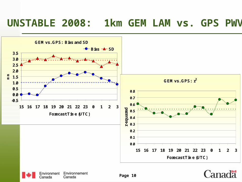
UNSTABLE 2008: 1km GEM LAM vs. GPS PWV
r2Bias*
mm
SD
mmn
.52 1.0 2.9 1198
*Bias = (GEM – GPS)
GEM vs. GPS: ALL
0
5
10
15
20
25
30
0 5 10 15 20 25 30
GPS PWV (mm)
GE
M P
WV
(m
m)
(Includes Limestone)
Page 10
UNSTABLE 2008: 1km GEM LAM vs. GPS PWV
GEM vs. GPS: Bias and SD
-0.5
0.0
0.5
1.0
1.5
2.0
2.5
3.0
3.5
15 16 17 18 19 20 21 22 23 0 1 2 3
Forecast Time (UTC)
mm
Bias SD
GEM vs. GPS: r2
0.0
0.1
0.2
0.3
0.4
0.5
0.6
0.7
0.8
15 16 17 18 19 20 21 22 23 0 1 2 3
Forecast Time (UTC)
r-sq
uar
ed
Page 11
UNSTABLE 2008: 1km GEM LAM vs. GPS PWV
GEM Bias and SD vs. Elevation
-1.0
0.0
1.0
2.0
3.0
4.0
5.0
750 1000 1250 1500 1750 2000
Elevation (m)
Bia
s o
r S
D (
mm
)
Bias
SD
Linear (Bias)
r-squared vs. Elevation
0.30
0.40
0.50
0.60
0.70
0.80
0.90
1.00
750 1000 1250 1500 1750 2000
Elevation (m)
r2
Delta-Z (GEM - GPS Elevation)
-200
-150
-100
-50
0
50
Prid
dis
Uo
fC
Vu
lca
n
Co
ch
ran
e
Cre
mo
na
Stra
thm
ore
Old
s
Lim
es
ton
e
Del
ta-Z
(m
)
Page 12
Page 13
Page 14
Summary and Conclusions
• GPS vs. RS intercomparison of PWV at EA3/Olds very good
• Overall, 1km GEM LAM is too wet (average bias of 1.0 mm)
• Bias starts low at initialization and peaks between 21Z and 23Z
• Correlations start high but drop towards 19Z before increasing to a peak towards the end of the model run - ????
• GEM vs. GPS correlations unaffected by elevation but the bias tends to increase with elevation (can’t all be explained by Delta-Z)
Page 15
Further Work
• Figure out what is wrong with GEM LAM data at Limestone and fix
• Add some missing GPS data (Rocky Mt. House and Okotoks)
• More spatial and temporal trend analysis
• Include more of the mobile RS data
• Add 2.5km GEM LAM and revisit the 15km GEM REG for UNSTABLE 2008