Page 1
EVALUATING URBAN SPRAWL USING REMOTE SENSING AND
GEOGRAPHIC INFORMATION SYSTEMS TECHNIQUES
MAHDI SABET SARVESTANI
A thesis submitted in fulfilment of the
requirements for the award of the degree of
Doctor of Philosophy (Remote Sensing)
Faculty of Geoinformation and Real Estate
Universiti Teknologi Malaysia
MARCH 2012
Page 2
iii
To Samaneh and Ronika
Page 3
iv
ACKNOWLEDGEMENT
In preparing this thesis, I was in contact with many people, researchers,
academicians, and practitioners. They have contributed significantly towards my
understanding and thoughts. In particular, I wish to express my sincere appreciation to
my thesis supervisor, Associate Professor Dr. Ab. Latif bin Ibrahim, for encouragement,
guidance, critics and friendship. Without his continued support and interest, this thesis
would not have been the same as presented here.
I am also indebted to Universiti Teknologi Malaysia (UTM) for providing all
needed facilities for my Ph.D. study and to Librarians at UTM. My special thanks go to
Professor Pavlos Kanaroglou and his kind colleagues in McMaster University, Hamilton,
Canada, that they had a great influence in my research enhancement.
My sincere appreciation also extends to all my friends and others who have
provided assistance at various occasions. Their views and tips are useful indeed.
Unfortunately, it is not possible to list all of them in this limited space.
I am grateful to all my family members. Especially my wife, without her
support, this thesis was impossible.
Page 4
v
ABSTRACT
Urban sprawl and climate change are two main environmental problems of
the 21st century, and these two aspects are interconnected. The objectives of this
study are to; (i) investigate the process of urban sprawl in Shiraz city, Iran, (ii)
describe the history of city growth and to predict the growth using Cellular Automata
(CA) environmentally protected scenarios, and (iii) analyze the environmental
impact of the past and future urban growth. Urban sprawl of Shiraz city, located in
southern part of Iran, in the last 30 years has been measured using multi temporal
Landsat and SPOT satellite images taken from four different years; 1976, 1990, 2000
and 2005. Shannon’s entropy method has been used to measure the urban sprawl and
the results showed that Shiraz city is in the early stages of sprawl. A Cellular
Automata model which is integrated with Markov chain analysis is used to predict
the future city growth pattern for the years 2010, 2015 and 2020 by three different
designed scenarios. The first scenario takes into account the current growth pattern
for the future years, while, the second and the third scenarios have different
environmental protection considerations for prediction. The results showed the
abilities of CA-Markov based models for city growth simulation. Impacts of urban
sprawl on vegetation coverage and water resources for the previous and projected
years have been quantified. The results showed that during the past three decades,
vegetation coverage and surface water resources in many places have been replaced
by the built-up area. It showed that during the past three decades, there was no
environmental protection planning over Shiraz city and if the current growth pattern
continues in the future, the city will encounter serious environmental problems.
Page 5
vi
ABSTRAK
Penyerakan bandar dan perubahan iklim merupakan dua masalah persekitaran
di abad ke 21, dan kedua-dua perkara ini adalah sering berkaitan. Tujuan utama
kajian ini adalah untuk; (i) mengkaji proses penyerakan bandar di Bandaraya Shiraz,
Iran, (ii) menghurai sejarah pertumbuhan bandar dan meramal pertumbuhan bandar
dengan menggunakan Model Cellular Automata (CA) yang berasaskan senario
kawalan persekitaran, dan (iii) menganalisis impak persekitaran terhadap
pertumbuhan bandar pada masa lepas dan masa akan datang. Penyerakan bandar di
Bandaraya Shiraz yang terletak di selatan Iran pada masa 30 tahun yang lepas telah
diukur menggunakan imej-imej satelit Landsat dan SPOT bagi empat tahun yang
berbeza, iaitu tahun 1976, 1990, 2000, dan 2005. Kaedah Shannon’s entropy telah
digunakan untuk mengukur penyerakan bandar dan keputusan yang diperolehi
menunjukkan Bandaraya Shiraz adalah pada tahap-tahap awal penyerakan. Model
CA yang di integrasikan dengan rantaian analisis Markov digunakan untuk meramal
corak pertumbuhan bandar pada tahun 2010, 2015, dan 2020, dengan berdasarkan
tiga senario berbeza yang telah di bentuk. Senario pertama mengambil kira corak
pertumbuhan masa kini untuk tahun-tahun akan datang, sementara senario kedua dan
ketiga mempunyai pertimbangan kawalan persekitaran yang berbeza untuk membuat
ramalan. Keputusan menunjukkan keupayaan model CA-Markov untuk simulasi
pertumbuhan bandar. Impak penyerakan bandar ke atas litupan tumbuhan dan
sumber air di kawasan kajian untuk tahun-tahun yang lepas dan tahun-tahun ramalan
telah dikira. Keputusan telah menunjukkan bahawa litupan tumbuhan dan permukaan
air di beberapa tempat telah pun diganti dengan kawasan pembangunan. Adalah
didapati bahawa semenjak tiga dekad yang lepas tidak terdapat sebarang
perancangan pengawalan alam sekitar di Bandaraya Shiraz, dan sekiranya corak
pertumbuhan bandar semasa akan terus berlaku di masa-masa akan datang,
Bandaraya Shiraz akan mengalami masalah persekitaran yang serius.
Page 6
vii
TABLE OF CONTENST
CHAPTER TITLE PAGE
DECLARATION ii
DEDICATION iii
ACKNOWLEDGEMENTS iv
ABSTRACT v
ABSTRAK vi
TABLE OF CONTENTS vii
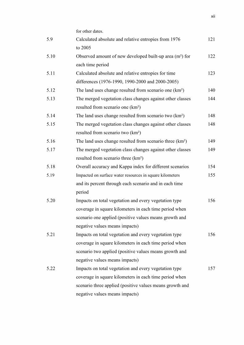
LIST OF TABLES xi
LIST OF FIGURES xiv
LIST OF APPENDICES
xviii
1 INTRODUCTION 1
1.1 Background of the study 1
1.1.1 Urban growth and its global importance 1
1.1.2 Urban Sprawl 3
1.1.3 Urban growth modeling 5
1.1.4 Remote sensing and GIS and their urban 6
application
1.2 Statement of the problem 8
1.3 Objectives of the study 9
1.4 Significance of the study 9
1.5 Scope of the study 10
1.6 Dissertation structure 11
Page 7
viii
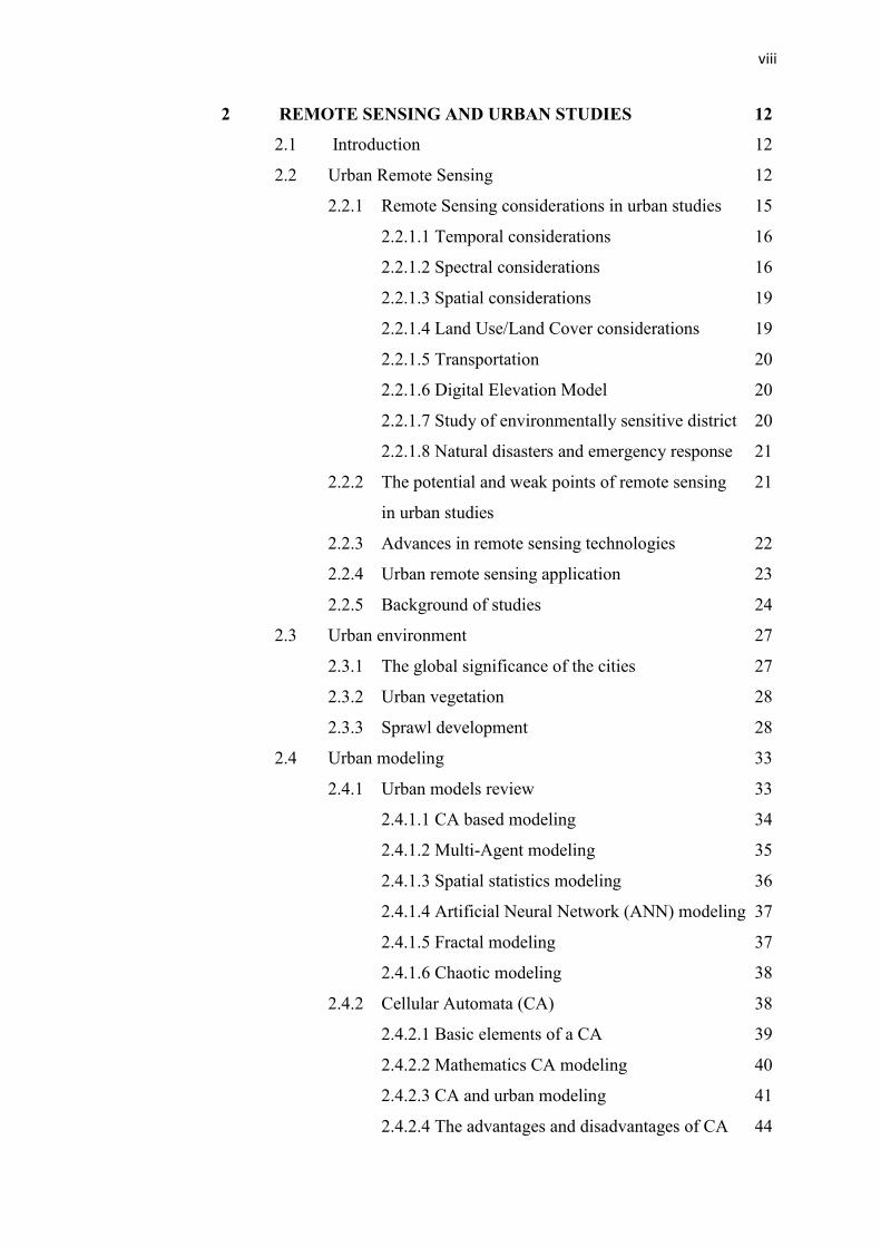
2 REMOTE SENSING AND URBAN STUDIES 12
2.1 Introduction 12
2.2 Urban Remote Sensing 12
2.2.1 Remote Sensing considerations in urban studies 15
2.2.1.1 Temporal considerations 16
2.2.1.2 Spectral considerations 16
2.2.1.3 Spatial considerations 19
2.2.1.4 Land Use/Land Cover considerations 19
2.2.1.5 Transportation 20
2.2.1.6 Digital Elevation Model 20
2.2.1.7 Study of environmentally sensitive district 20
2.2.1.8 Natural disasters and emergency response 21
2.2.2 The potential and weak points of remote sensing 21
in urban studies
2.2.3 Advances in remote sensing technologies 22
2.2.4 Urban remote sensing application 23
2.2.5 Background of studies 24
2.3 Urban environment 27
2.3.1 The global significance of the cities 27
2.3.2 Urban vegetation 28
2.3.3 Sprawl development 28
2.4 Urban modeling 33
2.4.1 Urban models review 33
2.4.1.1 CA based modeling 34
2.4.1.2 Multi-Agent modeling 35
2.4.1.3 Spatial statistics modeling 36
2.4.1.4 Artificial Neural Network (ANN) modeling 37
2.4.1.5 Fractal modeling 37
2.4.1.6 Chaotic modeling 38
2.4.2 Cellular Automata (CA) 38
2.4.2.1 Basic elements of a CA 39
2.4.2.2 Mathematics CA modeling 40
2.4.2.3 CA and urban modeling 41
2.4.2.4 The advantages and disadvantages of CA 44
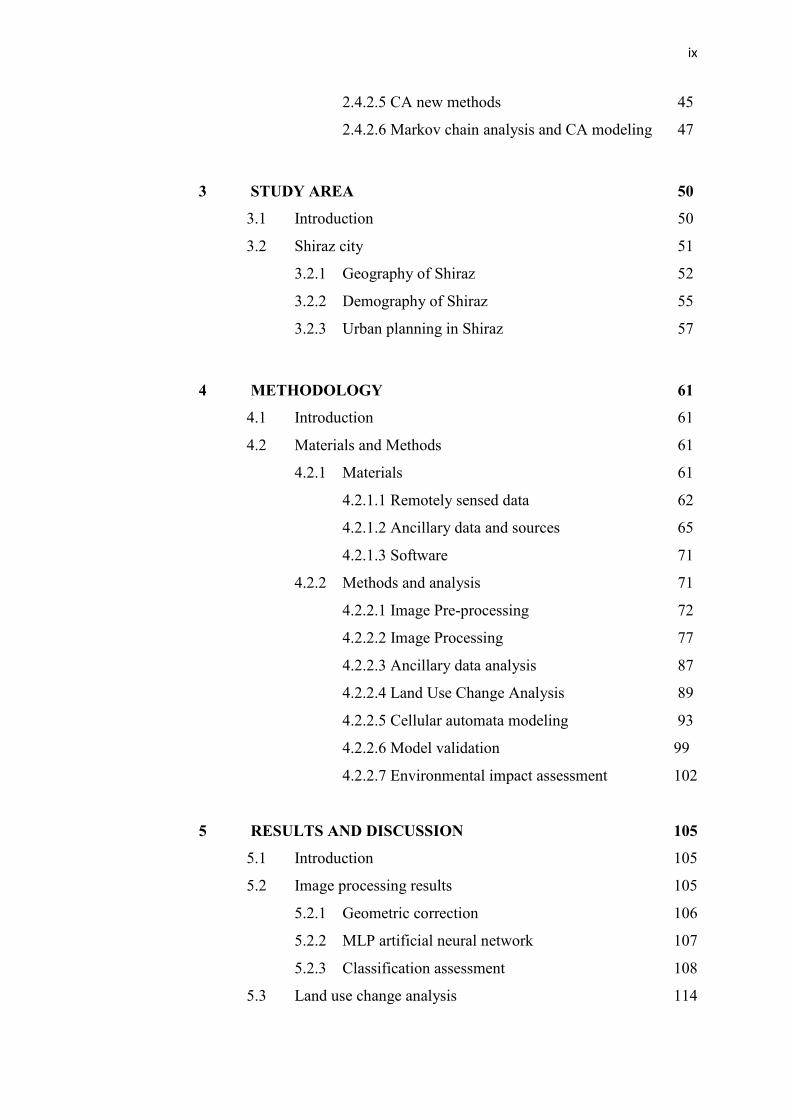
Page 8
ix
2.4.2.5 CA new methods 45
2.4.2.6 Markov chain analysis and CA modeling 47
3 STUDY AREA 50
3.1 Introduction 50
3.2 Shiraz city 51
3.2.1 Geography of Shiraz 52
3.2.2 Demography of Shiraz 55
3.2.3 Urban planning in Shiraz 57
4 METHODOLOGY 61
4.1 Introduction 61
4.2 Materials and Methods 61
4.2.1 Materials 61
4.2.1.1 Remotely sensed data 62
4.2.1.2 Ancillary data and sources 65
4.2.1.3 Software 71
4.2.2 Methods and analysis 71
4.2.2.1 Image Pre-processing 72
4.2.2.2 Image Processing 77
4.2.2.3 Ancillary data analysis 87
4.2.2.4 Land Use Change Analysis 89
4.2.2.5 Cellular automata modeling 93
4.2.2.6 Model validation 99
4.2.2.7 Environmental impact assessment 102
5 RESULTS AND DISCUSSION 105
5.1 Introduction 105
5.2 Image processing results 105
5.2.1 Geometric correction 106
5.2.2 MLP artificial neural network 107
5.2.3 Classification assessment 108
5.3 Land use change analysis 114
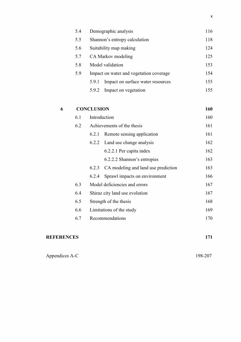
Page 9
x
5.4 Demographic analysis 116
5.5 Shannon’s entropy calculation 118
5.6 Suitability map making 124
5.7 CA Markov modeling 125
5.8 Model validation 153
5.9 Impact on water and vegetation coverage 154
5.9.1 Impact on surface water resources 155
5.9.2 Impact on vegetation 155
6 CONCLUSION 160
6.1 Introduction 160
6.2 Achievements of the thesis 161
6.2.1 Remote sensing application 161
6.2.2 Land use change analysis 162
6.2.2.1 Per capita index 162
6.2.2.2 Shannon’s entropies 163
6.2.3 CA modeling and land use prediction 163
6.2.4 Sprawl impacts on environment 166
6.3 Model deficiencies and errors 167
6.4 Shiraz city land use evolution 167
6.5 Strength of the thesis 168
6.6 Limitations of the study 169
6.7 Recommendations 170
REFERENCES 171
Appendices A-C 198-207
Page 10
xi
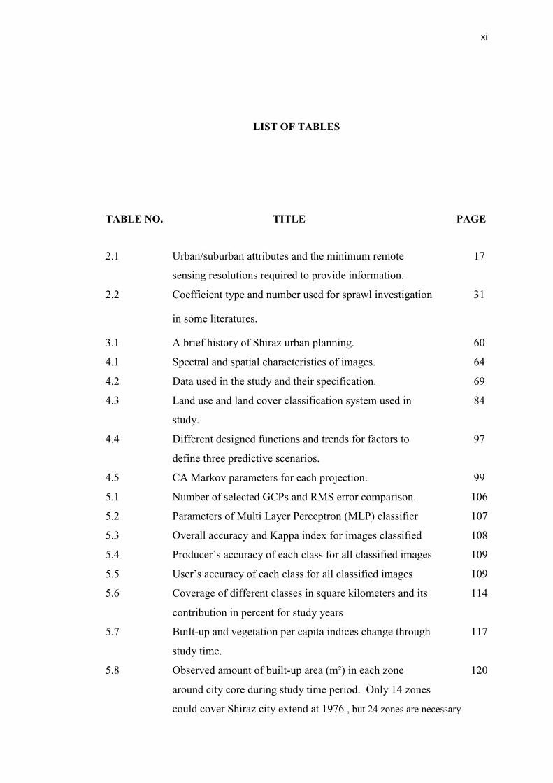
LIST OF TABLES
TABLE NO. TITLE PAGE
2.1 Urban/suburban attributes and the minimum remote 17
sensing resolutions required to provide information.
2.2 Coefficient type and number used for sprawl investigation 31
in some literatures.
3.1 A brief history of Shiraz urban planning. 60
4.1 Spectral and spatial characteristics of images. 64
4.2 Data used in the study and their specification. 69
4.3 Land use and land cover classification system used in 84
study.
4.4 Different designed functions and trends for factors to 97
define three predictive scenarios.
4.5 CA Markov parameters for each projection. 99
5.1 Number of selected GCPs and RMS error comparison. 106
5.2 Parameters of Multi Layer Perceptron (MLP) classifier 107
5.3 Overall accuracy and Kappa index for images classified 108
5.4 Producer’s accuracy of each class for all classified images 109
5.5 User’s accuracy of each class for all classified images 109
5.6 Coverage of different classes in square kilometers and its 114
contribution in percent for study years
5.7 Built-up and vegetation per capita indices change through 117
study time.
5.8 Observed amount of built-up area (m²) in each zone 120
around city core during study time period. Only 14 zones
could cover Shiraz city extend at 1976 , but 24 zones are necessary
Page 11
xii
for other dates.
5.9 Calculated absolute and relative entropies from 1976 121
to 2005
5.10 Observed amount of new developed built-up area (m²) for 122
each time period
5.11 Calculated absolute and relative entropies for time 123
differences (1976-1990, 1990-2000 and 2000-2005)
5.12 The land uses change resulted from scenario one (km²) 140
5.13 The merged vegetation class changes against other classes 144
resulted from scenario one (km²)
5.14 The land uses change resulted from scenario two (km²) 148
5.15 The merged vegetation class changes against other classes 148
resulted from scenario two (km²)
5.16 The land uses change resulted from scenario three (km²) 149
5.17 The merged vegetation class changes against other classes 149
resulted from scenario three (km²)
5.18 Overall accuracy and Kappa index for different scenarios 154
5.19 Impacted on surface water resources in square kilometers 155
and its percent through each scenario and in each time
period
5.20 Impacts on total vegetation and every vegetation type 156
coverage in square kilometers in each time period when
scenario one applied (positive values means growth and
negative values means impacts)
5.21 Impacts on total vegetation and every vegetation type 156
coverage in square kilometers in each time period when
scenario two applied (positive values means growth and
negative values means impacts)
5.22 Impacts on total vegetation and every vegetation type 157
coverage in square kilometers in each time period when
scenario three applied (positive values means growth and
negative values means impacts)
Page 12
xiii
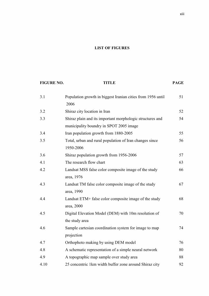
LIST OF FIGURES
FIGURE NO. TITLE PAGE
3.1 Population growth in biggest Iranian cities from 1956 until 51
2006
3.2 Shiraz city location in Iran 52
3.3 Shiraz plain and its important morphologic structures and 54
municipality boundry in SPOT 2005 image
3.4 Iran population growth from 1880-2005 55
3.5 Total, urban and rural population of Iran changes since 56
1950-2006
3.6 Shiraz population growth from 1956-2006 57
4.1 The research flow chart 63
4.2 Landsat MSS false color composite image of the study 66
area, 1976
4.3 Landsat TM false color composite image of the study 67
area, 1990
4.4 Landsat ETM+ false color composite image of the study 68
area, 2000
4.5 Digital Elevation Model (DEM) with 10m resolution of 70
the study area
4.6 Sample cartesian coordination system for image to map 74
projection
4.7 Orthophoto making by using DEM model 76
4.8 A schematic representation of a simple neural network 80
4.9 A topographic map sample over study area 88
4.10 25 concentric 1km width buffer zone around Shiraz city 92
Page 13
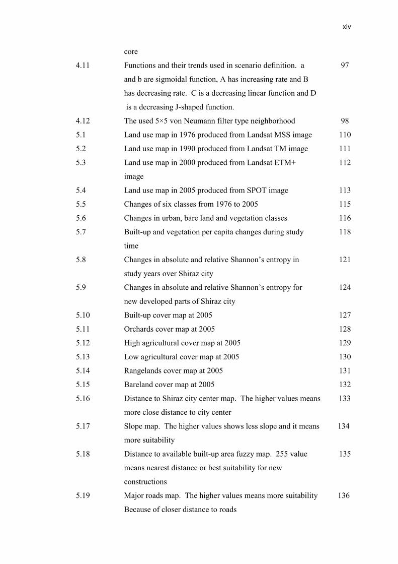
xiv
core
4.11 Functions and their trends used in scenario definition. a 97
and b are sigmoidal function, A has increasing rate and B
has decreasing rate. C is a decreasing linear function and D
is a decreasing J-shaped function.
4.12 The used 5×5 von Neumann filter type neighborhood 98
5.1 Land use map in 1976 produced from Landsat MSS image 110
5.2 Land use map in 1990 produced from Landsat TM image 111
5.3 Land use map in 2000 produced from Landsat ETM+ 112
image
5.4 Land use map in 2005 produced from SPOT image 113
5.5 Changes of six classes from 1976 to 2005 115
5.6 Changes in urban, bare land and vegetation classes 116
5.7 Built-up and vegetation per capita changes during study 118
time
5.8 Changes in absolute and relative Shannon’s entropy in 121
study years over Shiraz city
5.9 Changes in absolute and relative Shannon’s entropy for 124
new developed parts of Shiraz city
5.10 Built-up cover map at 2005 127
5.11 Orchards cover map at 2005 128
5.12 High agricultural cover map at 2005 129
5.13 Low agricultural cover map at 2005 130
5.14 Rangelands cover map at 2005 131
5.15 Bareland cover map at 2005 132
5.16 Distance to Shiraz city center map. The higher values means 133
more close distance to city center
5.17 Slope map. The higher values shows less slope and it means 134
more suitability
5.18 Distance to available built-up area fuzzy map. 255 value 135
means nearest distance or best suitability for new
constructions
5.19 Major roads map. The higher values means more suitability 136
Because of closer distance to roads
Page 14
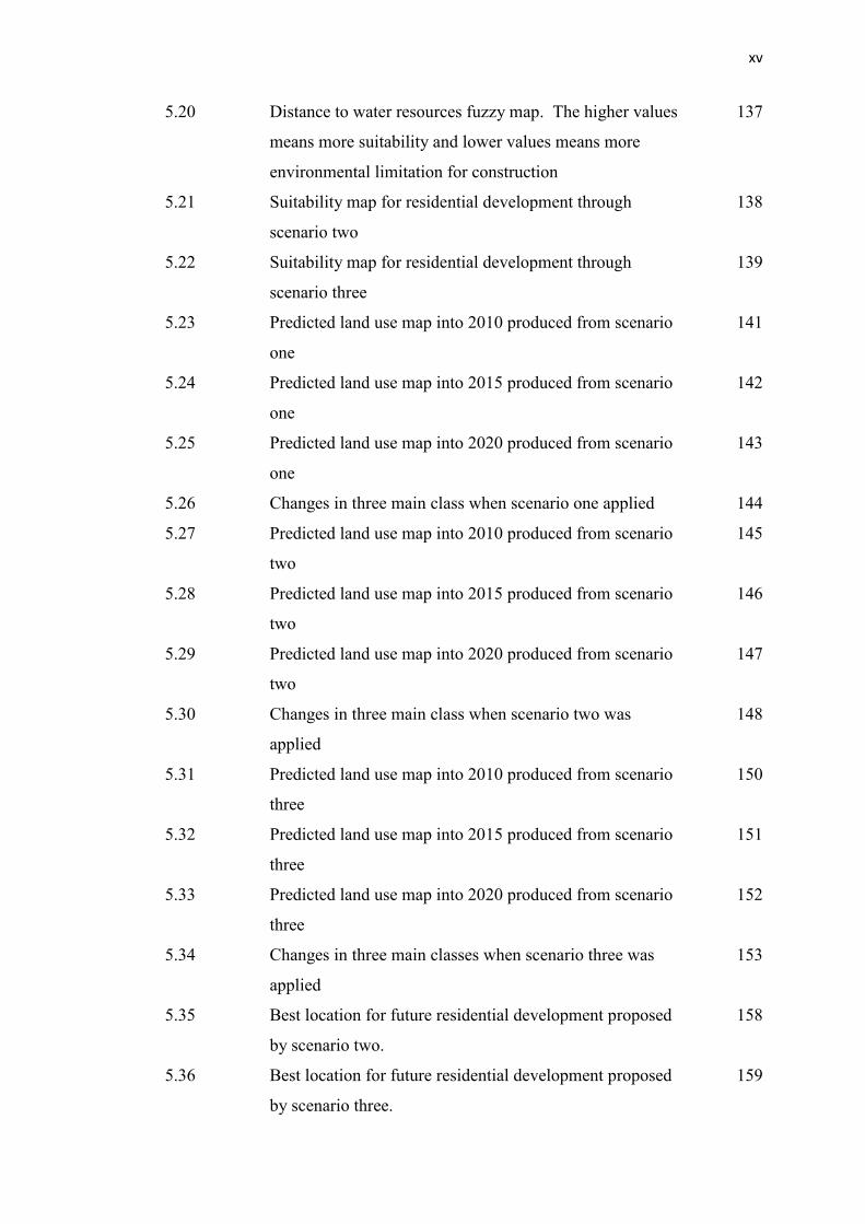
xv
5.20 Distance to water resources fuzzy map. The higher values 137
means more suitability and lower values means more
environmental limitation for construction
5.21 Suitability map for residential development through 138
scenario two
5.22 Suitability map for residential development through 139
scenario three
5.23 Predicted land use map into 2010 produced from scenario 141
one
5.24 Predicted land use map into 2015 produced from scenario 142
one
5.25 Predicted land use map into 2020 produced from scenario 143
one
5.26 Changes in three main class when scenario one applied 144
5.27 Predicted land use map into 2010 produced from scenario 145
two
5.28 Predicted land use map into 2015 produced from scenario 146
two
5.29 Predicted land use map into 2020 produced from scenario 147
two
5.30 Changes in three main class when scenario two was 148
applied
5.31 Predicted land use map into 2010 produced from scenario 150
three
5.32 Predicted land use map into 2015 produced from scenario 151
three
5.33 Predicted land use map into 2020 produced from scenario 152
three
5.34 Changes in three main classes when scenario three was 153
applied
5.35 Best location for future residential development proposed 158
by scenario two.
5.36 Best location for future residential development proposed 159
by scenario three.
Page 15
xvi
LIST OF APPENDICES
APPENDIX TITLE PAGE
A Satellite images classification assessments 210
B Markov analysis probability matrices 215
C Cellular automata model validation results 219
Page 16
1
CHAPTER 1
INTRODUCTION
1.1 Background of the study
1.1.1 Urban growth and its global importance
Urbanization and climate change are two environmental phenomen of the
21st century, and these two processes are increasingly interconnected. Currently,
more than half of the world‟s population lives in urban areas, and it is expected that
70% will live in urban areas by 2050 (United Nations, 2007). Most of the urban
demographic transformation in the coming decades will occur in developing
countries. It is more important when we found that nearly one-quarter of the world‟s
population lives within 100 km of the coast (Small and Nicholls, 2003) and 13% of
the world‟s urban population lives less than 10 m above sea level that are most
critical area to global warming (McGranahan et al., 2007).
In the past several decades, land use/land cover change has been a key subject
for the study of global change or global warming. Urban land expansion is one of
the most direct representation forms of land use/land cover change, and refers
specifically to change in land use pattern and urban space distribution resulted from
land, social and economic pressure (Alphan et al., 2009; Gilliesa et al., 2003). With
the fast development of urbanization, urban land expansion and urban land use/land
cover change has been one of the key subjects for study on dynamic changes of
urban land use (Dewan and Yamaguchi, 2009; Wu et al., 2006).
Page 17
2
Although the world's urban areas only account for approximately 3% of the
planet's terrestrial surface, impacts of urbanization on the environment and
ecosystem services are far reaching, affecting global biogeochemical cycles, climate,
and hydrologic regimes (Foley et al., 2005; Grimm et al., 2008). Therefore, research
on how ecosystems are transformed by urbanization and especially land conversion
of peri-urban environments has been identified as a pivotal area of future land change
research (GLP, 2005).
Currently, our understanding of both current and future patterns of global
urban land-use is poor and fragmented. This is largely due to an uneven global
distribution of urban land-use studies. A majority of studies focus on urbanizing
regions in developed countries, but there are comparatively few studies of urban
land-use change in the rest of the world. The lack of understanding about past urban
land-use processes limits our ability to identify regions at risk for urban
development.
Most of our understanding about global urban land-use comes from case
studies on individual cities or regions (Xiao et al., 2006, Geymen and Baz, 2008,
Schneider and Woodcock, 2008). From these individual case studies is emerging a
picture of varied rates of urban land-use change around the world. Rates of urban
land-use change are highest in Asia and some areas in South America and are
strongly correlated with patterns of economic development (Schneider and
Woodcock, 2008, Angel et al., 2005). When economic development is driven by
shifts in the economy from agriculture to manufacturing, it leads to more expansive
urban land-use change than the economic transition from manufacturing to services
(Guneralp and Seto, 2008).
Land change science, including urban land-use change, is emerging as a
fundamental component of global environmental change (Turner et al., 2007). Given
the increasing importance of urban areas in driving and being impacted by global
environmental change, there is urgent need to understand how urban areas evolve,
and how and where they may develop in the future.
Page 18
3
1.1.2 Urban Sprawl
Urban sprawl, a consequence of socioeconomic development under certain
circumstances, has increasingly become a major issue facing many metropolitan
areas, although a general consensus regarding the definition and impact of urban
sprawl has not been achieved (Johnson, 2001). Urban sprawl as a concept suffers
from difficulties in definition (Angel et al., 2007; Barnes et al., 2001; Johnson 2001;
Roca et al., 2004; Sudhira and Ramachandra, 2007; Wilson et al., 2003). Galster et
al., (2001) review of the literature found that sprawl can alternatively or
simultaneously refer to: (i) certain patterns of land-use, (ii) processes of land
development, (iii) causes of particular land-use behaviors, and (iv) consequences of
land-use behaviors. They reviewed many definitions of sprawl from different
perspectives.
Urban sprawl is often discussed without any associated definition at all.
Some researchers make no attempt at definition while others „„engage in little more
than emotional rhetoric‟‟ (Harvey and Clark, 1965). Johnson (2001) presented
several alternative definitions for consideration, concluded that there is no common
consensus. Because sprawl is demonized by some and discounted by others, how
sprawl is defined depends on the perspective of who presents the definition (Barnes
et al., 2001). Wilson et al., (2003) argued that the sprawl phenomenon seeks to
describe rather than define. Galster et al., (2001) also emphasized describing the
sprawl rather than defining.
Accurate definition of urban sprawl, although is debated, a general consensus
is that urban sprawl is uncontrolled, scattered suburban development that increases
traffic problems, depletes local resources, and destroys open space (Peiser, 2001).
The direct implication of sprawl is change in land-use and land-cover of the region as
sprawl induces the increase in built-up and paved area (Sudhira and Ramachandra,
2007). It is worth mentioning that opinions on sprawl held by researchers, policy
makers, activists, and the public differ sharply; and the lack of agreement over how
to define the sprawl certainly complicates the efforts to characterize and restrict this
Page 19
4
type of land development (Bhatta, 2010). Wilson et al., (2003) argued that without a
universal definition, quantification and modeling of urban sprawl is extremely
difficult. Creating an urban growth model instead of an urban sprawl model allows
us to quantify the amount of land that has changed to urban uses (Angel et al., 2007).
It is critically important to properly characterize urban sprawl in order to
develop a comprehensive understanding of the causes and effects of urbanization
processes. However, due to its association with poorly planned urban land use and
economic activity (Pendall, 1999), urban sprawl is often evaluated and characterized
exclusively based on major socioeconomic indicators such as population growth,
commuting costs, employment shifts, city revenue change, and number of
commercial establishments (Brueckner, 2000; Lucy and Phillips, 2001).
This approach cannot effectively identify the impacts of urban sprawl in a
spatial context. To fill this gap, remote sensing has been used to detect urban land
cover changes in relation to urbanization (Epstein et al., 2002; Ji et al., 2001; Lo and
Yang, 2002; Ward et al., 2000; Yeh and Li, 2001). Remote sensing techniques have
advantages in characterizing the spatiotemporal trends of urban sprawl using multi-
stage images, providing a basis for projecting future urbanization processes. Such
information can support policymaking in urban planning and natural resource
conservation.
Accurate information on urban growth is of great interest for the
municipalities of growing urban and suburban areas for diverse purposes such as
urban planning, water and land resource management, marketing analysis, service
allocation, etc. Urban authorities and municipal corporations are required to devote
more time, attention and effort to manage the use of land and other resources in order
to accommodate the expanding population or other urban land uses. Urban sprawl
monitoring and prediction are the basic information they need for long-term
planning. For sustainable development, municipal authorities need tools to monitor
how the land is currently used, assess future demand, and take steps to assure
adequacy of future supply. For a better planning of future urban development and
Page 20
5
infrastructure planning, municipal authorities need to know urban sprawl phenomena
and in what way it is likely to move in the years to come.
1.1.3 Urban growth modeling
Urban growth is recognized as physical and functional changes due to the
transition of non-urban landscape to urban forms (Thapa et al., 2010). The time-
space relationship plays an important role in order to understand the dynamic process
of urban growth. The dynamic process consists of a complex nonlinear interaction
between several components like: topography, drainage pattern and rivers, land use,
transportation, culture, population, economy, and growth policies.
There are a number of ways of classifying the models regarding urban
growth, such as in terms of system completeness, dimension, and objectives of
analysis. It is possible to classify them as cellular automata modeling, multi-agent
modeling, spatial statistics, neural network modeling, fractal modeling and chaotic
modeling.
Models based on the principles of Cellular Automata (CA) are developing
rapidly. CA approach provides a dynamic modeling environment which is well
suited to modeling complex environment composed of large number of individual
elements. The land use change and urban growth process can be compared with the
behavior of a cellular automaton in many aspects, for instance, the space of an urban
area can be regarded as a combination of a number of cells, each cell taking a finite
set of possible states representing the extent of its urban development with the state
of each cell evolving in discrete time steps according to local transition rules.
Therefore, CA based urban models usually pay more attention to simulating the
dynamic process of urban development and defining the factors or rules driving the
development (Batty et al., 1997). Different CA models have been developed to
simulate urban growth and urban land use/cover change over time. The differences
Page 21
6
among various models exist in modifying the five basic elements of CA, i.e., the
spatial tessellation of cells, states of cells, neighborhood, transition rules, and time
(Liu, 2009). CA models have demonstrated to be effective platforms for simulating
dynamic spatial interactions among biophysical and socio-economic factors
associated with land use and land cover change (Jantz et al., 2010).
Using CA models in urban systems for the first time was proposed by
Couclelis (1985) and then has been used by several researchers. Many interesting
fields in cellular automata studies have been documented in: (i) the simulation of
urban development (Deadman et al., 1993; Torrens and O‟Sullivan, 2001; Waddell,
2002), (ii) landscape dynamics (Soares-Filho et al., 2002), (iii) urban expansion
(Batty and Xie, 1994; Clarke et al., 1997; He et al., 2006; Wu and Webster, 1998),
and (iv) land-use changes (Li and Yeh, 2002). Also, many efforts have been made to
improve such dynamic process representation with the utility of cellular automata
coupling with (i) fuzzy logic (Liu, 2009), (ii) Artificial Neural Network (ANN)
(Almeida et al., 2008; Li and Yeh, 2002) and (iii) Markov chain analysis (Tang et
al., 2007).
1.1.4 Remote sensing and GIS and their urban application
Remote Sensing is a cost effective approach to collect the information from
far and sometimes untouchable physical phenomen in atmosphere, hydrosphere and
on ground surface (Jensen, 2005). To analyze the urban changes and to model
growth of urban areas many researchers have used remote sensing (Bahr, 2004;
Hardin et al., 2007; Hathout, 2002; Herold et al., 2003; Jat et al., 2008; Jensen and
Im, 2007; Liu and Lathrop, 2002; Maktav and Erbek, 2005; Ridd and Liu, 1998;
Yang, 2002; Yuan, 2008). On the other hand, number of researches have focused on
evaluation of Land Use/Cover (Alphan, 2003; Lopez et al., 2001; Xiao et al., 2006;
Yang and Lo, 2002; Yuan et al., 2005). Kato and Yamaguchi (2005) and Weng
(2001) studied some urban environmental aspects like heat islands. According to
usefulness of remote sensing in Land Use/Cover studies, Liu et al., (2003)
Page 22
7
highlighted that remote sensing based multi-temporal land use change data provides
information that can be used for assessing the structural variation of Land Use/Cover
patterns which can be applied to avoiding irreversible and cumulative effects of
urban growth and are important for optimizing the allocation of urban services.
Remote sensing and Geographic Information System (GIS) are increasingly
used for the analysis of urban sprawl (Sudhira et al., 2004; Yang and Liu, 2005;
Haack and Rafter, 2006). Since early years of 1970‟s, many researchers used remote
sensing for urban change detection (Green et al., 1994; Yeh and Li, 2001; Yang and
Lo, 2003; Haack and Rafter, 2006). To quantifying urban sprawl, generally, the
impervious (built-up) area is used as a parameter (Torrens and Alberti, 2000; Barnes
et al., 2001; Epstein et al., 2002). Simply, it is possible to consider impervious area
as built-up which can refer to built-up, commercial, industrial areas including paved
ways, roads, markets, etc. There are many methods for estimation or measuring
impervious area, such as land surveying or satellite images. For urban sprawl
quantification, impervious coverage considered as a simple index.
Among the new methods for impervious area and sprawl measurement using
remote sensing are supervised and unsupervised classification and knowledge-based
expert systems (Greenberg and Bradley, 1997; Vogelmann et al., 1998; Stuckens et
al., 2000; Stefanov et al., 2001; Lu and Weng, 2005). In some articles related to
urban sprawl studies, statistical techniques used along with remote sensing and GIS
(Jat et al., 2006).
To describe landscape pattern and to quantify urban growth and urban spatial
distribution, many metrics are available. At the landscape level, GIS can use for
landscape metrics calculation like patchiness and density to enhance landscape
properties with respect to spatial distribution and spatial change (Trani and Giles,
1999; Yeh and Li, 2001; Civco et al., 2002, Sudhira et al., 2004). Shannon‟s entropy
that is based on information theory, have used to quantify urban forms like
impervious area and other spatial phenomen (Yeh and Li, 2001; Sudhira et al., 2004;
Joshi et al., 2006). Shannon‟s entropy is a measure of uncertainty to realize a
Page 23
8
random variable, like urban sprawl in the form of impervious patches in newly
developed areas. For monitoring and identification of urban sprawl, a quantitative
scale is necessary. A mathematical representation of urban sprawl and the concept of
entropy are closely related for developing the analogy. Shannon‟s entropy is used to
measure the degree of spatial concentration or dispersion of a geographical variable
among n spatial zones. Shannon‟s entropy is used to indicate the degree of urban
sprawl (built-up dispersion) by measuring spatial concentration or dispersion of land
development in a city (Lata et al., 2001; Sudhira et al., 2004; Joshi et al., 2006).
Larger value of calculated Shannon‟s entropy indicates more dispersion of spatial
variable (built-up) which means more urban sprawl.
1.2 Statement of the problem
Rapid urban development usually happens at the expense of prime
agricultural land, with the destruction of natural landscape and public open spaces,
which has an increasing impact on the global environmental change (Liu, 2009). In
Iran, population census shows that more than 68% of people are living in urban
centers and expected to increase in the next years (Statistical Center of Iran, 2006).
This indicates an alarming rate of urbanization and possible urban sprawl.
Measurement of urban sprawl and its modeling using remote sensing techniques are
not studied yet in Iran.
Shiraz city in south part of Iran is selected for detail study. The city is a fast
growing urban area and during past three decades has experienced high rate of
population growth, mostly because of: migration from close small cities and rural
areas, migration of refugees of the 1980‟s war against Iraq and conjunction of close
villages to city during city growth. However, Simultaneously, Shiraz city has
suffered from unplanned development. As a result, some environmental problems
have induced and increased through time, in the city and around. Among the highly
stressed environmental resources of the area are vegetation coverage that has greatly
Page 24
9
decreased and drainage network which have occupied by construction in last 30
years.
1.3 Objectives of the study
The objectives of the study are:
1- To investigate urban sprawl in the study area.
2- To describe the historical city growth and to predict urban growth pattern
using CA Markov based environmentally protected scenarios.
3- To analyze the environmental impact of urban growth in past and future.
1.4 Significance of the study
In this research, an attempt has been made as one of contributions to
investigate the usefulness of the spatial techniques, remote sensing and GIS for urban
sprawl detection and handling of spatial and temporal variability of the same. Urban
sprawl of Shiraz city (situated in Fars province of Iran) in the last 30 years has been
estimated using remote sensing images of four different years ranging from 1976 to
2005. An Artificial Neural Network Multi Perceptron has been used for the analysis
of satellite images obtained from various sensor systems. Classified images have
been used to understand the dynamics of urban sprawl and to extract the area of
impervious surfaces. In order to quantify the urban forms, such as impervious area
in terms of spatial phenomen, the Shannon‟s entropy is computed. Remote sensing
and GIS techniques have been used to extract the information related to urban
sprawl. Spatial and temporal variation of urban sprawl is studied to establish a
relationship between urban sprawl and some its causative factors, like population,
population density, density of built-up.
Page 25
11
In next step, the study tried to predict the future of the city development by
using two types of scenarios; the first one, if the current pattern continues into the
future and the second type - because the city has been suffered from the lack of a
sustainable development planning - if an environmental protection scenario will be
applied for the city. Hopefully, the study tried to find the places that they have
serious environmental problems and has been tried to recommend protective solution
to preserve available resources during future development. This study is another
assessment of effectiveness and validity of remote sensing and GIS in solving urban
environmental problems.
1.5 Scope of the study
In this study, the used data were: medium resolution satellite images (Landsat
MSS, TM, ETM+ and SPOT) taken in various dates; 1976, 1990, 2000 and 2005,
Digital 3-D topographic maps in 1:25000 scale, a generated Digital Elevation Model
from topographic maps with 10m vertical spacing, demographic statistics from Iran
national and UN censuses. Most of data have been collected from internal Iranian
archives and the others were downloaded from internet websites.
The methods used include complete range of image processing for satellite
images and a CA Markov based modeling to predict future urban changes. Shiraz
city is selected as the study area. Shiraz is the largest urban area in south of Iran and
selection is based on its historical, cultural, social and economical importance and
environmental problems caused by its development.
The following software have manipulated for processing procedure. PCI
Geomatica©, ENVI© and IDRISI© were the software which have used for different
image processing. ArcGIS© and IDRISI© were the platforms which have used for
map making, sprawl measurement, spatial analysis and CA Markov based urban
growth modeling and land use prediction.
Page 26
11
1.6 Dissertation structure
This research is organized into six chapters. Chapter one introduces a brief
review on background of the study, represented the statement of the problem,
introduced objectives of the study and shortly explained the study significance.
Chapter two reviews the most striking literatures regarding to the remote sensing and
its different application in urban studies, its integration with GIS and urban growth
modeling including cellular automata and other modeling approaches. Additionally,
this chapter reviews urban environmental features and related publications which
they used remote sensing and GIS for solving the problems. Chapter three gives an
overview to the geography and climate of the study area, the reasons for the selection
and a brief planning history of the city. This chapter also represents the materials
used including: satellite images, topographic maps and demographic censuses.
Chapter four focuses on the methodology used to implement this research. The
proposed method covers different type of processing and analysis. Image pre-
processing, image classification, socio-spatial analysis and urban growth modeling
and land use change prediction are among the methods. After each stage, an
accuracy assessment has been applied on the findings to reach to trustable results.
Chapter five represents the results of performed methods and brings full discussion
on the findings. Chapter six as the last chapter concludes the main findings of the
study in relation to the research objectives and recommends some solution for
problems which stated here. Finally, the chapter proposed important issues for future
studies.
Page 27
171
REFERENCES
Abdollahi, K.K. and Ning, Z.H., (2000). Urban vegetation and their relative ability in
intercepting particle pollution (PM2.5). In: Proceedings of the Third
Symposium on the Urban Environment. Davis, CA, 15 January 2000.
Aerts, J. C. J. H., Clarke, K. C. and Keuper, A. D., (2003). Testing popular
visualization techniques for representing model uncertainty. Cartography
and Geographic Information Science, 30, 249-261.
Aguilar, A.G., Ward, P.M. and Smith C.B., (2003). Globalization, regional
development, and mega-city expansion in Latin America: analyzing Mexico
City‟s peri-urban hinterland. Cities, 20, 3–21.
Akbari, H., Rosenfeld, A., Taha, H. and Gartland, L., (1996). Mitigation of summer
urban heat islands to save electricity and smog. In: Proceedings of the 76th
Annual American Meteorological Society Meeting. Atlanta, GA, 28 January–
2 February 1996. Report No. LBL-37787, Lawrence Berkeley National
Laboratory, Berkeley, CA.
Akbari, H., Konopacki, S. and Pomerantz, M., (1999). Cooling energy savings
potential of reflective roofs for built-up and commercial buildings in the
United States. Energy, 24, 391–407.
Akbari, H., Pomerantz, M. and Taha, H., (2001). Cool surfaces and shade trees to
reduce energy use and improve air quality in urban areas. Solar Energy, 70
(3), 295–310.
Al-Ahmadi, K., See, L., Heppenstall, A. and Hogg, J., (2009). Calibration of a fuzzy
cellular automata model of urban dynamics in Saudi Arabia, Ecological
Complexity, 6, 80–101.
Alkheder, S., Wang, J. and Shan, J., (2006). Change detection cellular automata
method for urban growth modeling, ISPRS Commission VII Mid-term
Symposium "Remote Sensing: From Pixels to Processes", Enschede, the
Netherlands, 8-11 May 2006.
Page 28
172
Almeida, C. M., Gleriani, J. M., Castejon, E. F. and Soares-Filho, B. S. (2008).
Using neural networks and cellular automata for modeling intra-urban land-
use dynamics. International Journal of Geographical Information Science,
22, 943–963.
Almeida, C. M., Monteiro, A.M.V., Camara, G., Soares-Filho, B.S., Cerqueira, G.C.,
Pennachin, C.L., Batty, M. (2005). GIS and remote sensing as tools for the
simulation of urban land use change. International Journal of Remote
Sensing. 26 (4), 759-774.
Andersson, C., Steen, R. and White, R. (2002). Urban settlement transitions.
Environment and Planning B: Planning and Design, 29, 841-865.
Alphan, H., (2003). Land use change and urbanization in Adana, Turkey, Land
Degradation and Development, 14(6):575-586.
Alphan, H., Doygun, H. and Unlukaplan, Y. I. (2009). Post-classification comparison
of land cover using multitemporal Landsat and ASTER imagery: the case of
Kahramanmara angstrom, Turkey. Environmental Monitoring and
Assessment, 151, 327–336.
Anderson, J. R., Hardy, E. E., Roach, J. T. and Witmer, R. E. (1976). A Land Use
and Land Cover Classification Scheme for Use with Remote Sensor Data,
U.S. Geological Survey Professional Paper 964.
Angel, S., Sheppard, S. and Civco D. (2005): The Dynamics of Global Urban
Expansion. World Bank.
Angel, S., Parent, J. and Civco, D. (2007). Urban sprawl metrics: an analysis of
global urban expansion using GIS. Proceedings of ASPRS 2007 Annual
Conference, Tampa, Florida May 7–11.
Bahr, H. (2004). Image segmentation for change detection in urban environments. In:
J.P. Donnay, Barnsley, M.J. and Longley, P.A., Editors, Remote sensing and
urban analysis, Taylor and Francis, London, 95–114.
Barnes, K. B., Morgan, J. M., III, Roberge, M. C. and Lowe, S. (2001). Sprawl
development: Its patterns, consequences, and measurement. A White Paper,
Towson University.
Barredo, J.I., Demicheli, L., Lavalle, C., Kasanko, M., McCormick, N. (2004).
Modeling future urban scenarios in developing countries: an application case
Page 29
173
study in Lagos, Nigeria, Environmental Planning, B: Planning and Design,
31, 65-84.
Bastin, L. (1997). Comparison of fuzzy c-means classification, linear mixture
modeling and MLC probabilities as tools for unmixing coarse pixels.
International Journal of Remote Sensing, 18, 3629– 3648.
Batisani, N. and Yarnal, B., (2009). Urban expansion in Centre County,
Pennsylvania: Spatial dynamics and landscape transformations,
Applied Geography, 29, 235– 249.
Batty, M., Longley, P. and Fotheringham, S. (1989). Urban growth and form:
scaling, fractal geometry, and diffusion-limited aggregation.
Environment and Planning 21: 1447–72.
Batty, M. and Longley, P.A., (1994). Fractal Cities: AGeometry of Form and
Function. Academic Press, London.
Batty, M., Couclelis, H. and Eichen, M. (1997). Urban systems as cellular automata.
Environmental and Planning B, 24, 175–192.
Batty, M. (1998) Urban evolution on the desktop: simulation with the use of
extended CA. Environment and Planning A, 30(11), 1943-1967.
Batty, M. and Xie, Y. (1994). From cells to cities. Environment and Planning B, 21,
pp. 31–48.C
Batty, M., Xie, Y. and Sun, Z. (1999). Modeling urban dynamics through GIS-based
cellular automata. Computers, Environment and Urban Systems 23: 205–33.
Batty, M., (2002). Thinking about cities as spatial events, Environmental and
Planning B, 29, pp. 1-2.
Baz I., Geymen A. and Nogay S., (2008). Development and application of GIS-based
analysis/synthesis modeling techniques for urban planning of Istanbul
Metropolitan Area, Advances in Engineering Software, 40, 128–140
Benati, S. (1997). A cellular automaton for the simulation of competitive location.
Environment and Planning B: Planning and Design, 24, 205–218.
Ben-Dor, E., Levin, N. and Saaroni, H. (2001). A spectral based recognition of the
urban environment using the visible and near-infrared spectral region (0.4–
1.1 m). A case study over Tel-Aviv. International Journal of Remote Sensing,
22(11), 2193– 2218.
Page 30
174
Benenson, I. (1998). Multi-agent simulations of built-up dynamics in the city.
Computers, Environment and Urban Systems, 22(1), 25-42.
Berberoglu, S., Lloyd, C.D., Atkinson, P.M. and Curran, P.J., (2000). The integration
of spectral and textural information using neural networks for land cover
mapping in the Mediterranean, Computers and Geosciences, 26, 385-396.
Berling-Wolff, S. and Wu, J. (2004). Modeling urban landscape dynamics: A case
study in Phoenix, USA, Urban Ecosystems, 7(3), 215-240.
Besussi, E., Cecchini, A., Rinaldi, E. (1998). The diffused city of the Italian north-
east: identification of urban dynamics using cellular automata urban
models, Computer and Environmental Urban Systems, 22 (5), 497-523.
Bhatta, B. (2009). Analysis of urban growth pattern using remote sensing and GIS: a
case study of Kolkata, India. International Journal of Remote Sensing, Vol.
30, No. 18, 4733–4746.
Bhatta, B., Saraswati, S. and Bandyopadhyay, D., (2010). Quantifying the degree-of-
freedom, degree-of-sprawl, and degree-of-goodness of urban growth from
remote sensing data, Applied Geography, 30, 96–111.
Bhatta, B., Saraswati, S. and Bandyopadhyay, D., (2010). Urban sprawl
measurement from remote sensing data, Applied Geography, 30, 731–740.
Bone, C., Dragicevic, S. and Roberts, A. (2007). Evaluating forest management
practices using a GIS-based cellular automata modeling approach with
multispectral imagery. Environmental Modeling and Assessment, 12, 105-
118.
Bornstein, R. and Lin, Q., (2000). Urban heat islands and summertime convective
thunderstorms in Atlanta: three case studies, Atmospheric Environment, 34,
507- 516.
Breuste, J., (2004). Decision making, planning and design for the conservation of
indigenous vegetation within urban development. Landscape and Urban
Planning, 68, 4, 439-452.
Brueckner, J. K. (2000). Urban Sprawl: Diagnosis and remedies. International
Regional Science Review, 23(2), 160–171.
Burkholder, E.F. (1997). Definition and Description of a Global Spatial Data Model
(GSDM), filed with the U.S. Copyright Office, Washington, D.C.
Page 31
175
Campbell, J.B., (2002). Introduction to Remote Sensing, Third Edition, The Guilford
Press, New York, New York, 621 p.
Carlson, T.N. and Augustine, J.A., (1977). Potential application of satellite
temperature-measurements in analysis of land-use over urban areas. Bulletin
of the American Meteorological Society. 58 (12), 1301–1303.
Carlson, T. N., Gillies, R.R. and Perry, E.M., (1994). A method to make use of
thermal infrared temperature and NDVI measurements to infer surface soil
water content and fractional vegetation cover, Remote Sensing Reviews, 9,
161-173.
Carlson, T.N. and Arthur, S.T., (2000). The impact of land use - land cover changes
due to urbanization on surface microclimate and hydrology: a satellite
perspective, Global and Planetary Change, 25, 49–65.
Carlson, T.N. (2004). Analysis and prediction of surface runoff in an urbanizing
watershed using satellite imagery, Journal of the American Water Resources
Association, 40,(4), 1087–1098.
Cecchini A. and Rizzi P. (2001). Are Urban Gaming Simulations Useful? in
Simulation and Games Special Issue.
Cheng, J. and Masser, I., (2004). Understanding spatial and temporal processes of
urban growth: cellular automata modeling, Environmental Planning, B:
Planning and Design, 31, 167-194.
Cibula, W. G. and Nyquist, M. O. (1987). Use of topographic and climatological
models in a geographical data base to improve Landsat MSS classification for
Olympic National Park. Photogrammetric Engineering and Remote Sensing,
53, 67– 75.
Civco, D. L., Hurd, J. D., Wilson, E. H., Arnold, C. L. and Prisloe, S. (2002).
Quantifying and Describing Urbanizing Landscapes in the Northeast United
States. Photogrammetric Engineering and Remote Sensing, 68(10), 1083–
1090.
Civerolo, K., Sistla, G., Rao, S.T., Nowak, D.J. (2000). The effects of land use in
meteorological modeling: implications for assessment of future air quality
scenarios. Atmospheric Environment, 34(10), 1615–1621..
Page 32
176
Clarke, K.C., Hoppen, S. and Gaydos, L., (1997). A selfmodifying cellular automata
model of historical urbanization in the San Francisco Bay area. Environment
and Planning B, 24, pp. 247-261.
Clarke, K. C. and Gaydos, L. J. (1998). Loose-coupling a cellular automata model
and GIS: Long-term urban growth prediction for San Francisco and
Washington/Baltimore. International Journal of Geographical Information
Science, 12(7), 699–714.
Cleugh, H.A. and Grimmond, C.S.B., (2001). Modeling regional scale surface energy
exchanges and CBL growth in a heterogeneous, urban–rural landscape.
Boundary-Layer Meteorology, 98 (1), 1-31.
Cohen, J.E. (2003). Human Population: The Next Half Century, Science, 302(5648),
1172-1175.
Congalton, R. G. and Mead, R. A., (1983), A quantitative method to test for
consistency and correctness in photointerpretation. Photogrammetric
Engineering and Remote Sensing, 49, 69-74.
Congalton, R.G., Oderwald, R.G. and Mead, R.A., (1983). Assessing Landsat
classification accuracy using discrete multivariate analysis statistical
techniques. Photogrammetric Engineering and Remote Sensing. 49, 1671–
1678.
Congalton, R.G., 1991. A review of assessing the accuracy of classification of
remotely sensed data, Remote Sensing of Environment, 37, 35–46.
Côté, M, Mkhabela, M, Stockermans, D. (2003) Considering biophysical impact
analysis and forecasting in EIA. Unpublished manuscript prepared for the
class ENVI5001: Environmental Impact Assessment, Dalhousie University,
Halifax, NS.
Couclelis, H. (1985). Cellular worlds. International Journal of Urban and Regional
Research 17, 585-596.
Couclelis, H. (1985). Cellular Worlds: A Framework for Modeling Micro-Macro
Dynamics, Environment and Planning A, 17, 585-596.
Couclelis, H., (1997), From cellular automata to urban models: new principles for
model development and implementation. Environment and Planning B:
Planning and Design, 24, 165-174.
Page 33
177
Deadman, P. D., Brown, R. D., and Gimblett, H. R. (1993). Modeling rural built-up
settlement patterns with cellular automata. Journal of Environmental
Management, 37,147–160.
Dabberdt, W.F. and Hales, J. (2000). Forecast issues in the urban zone: report of the
10th Prospectus Development Team of the US Weather Research Program.
Bulletin of the American Meteorological Society. 81(9). 2047–2064.
Del Frate, F., Pacifici, F., Schiavon, G. and Solimini, C. (2007). Use of neural
networks for automatic classification from high-resolution images, IEEE
Transactions on Geoscience and Remote Sensing, 45, 800-809.
Dewan, A.M. and Yamaguchi, Y., (2009). Land use and land cover change in
Greater Dhaka, Bangladesh: Using remote sensing to promote sustainable
urbanization, Applied Geography, 29, 390–401
Dietzel, C. and Clarke, K.C. (2004a). Spatial differences in multi-resolution urban
modeling. Transactions in GIS, 8, 479 – 492.
Dietzel, C. and Clarke, K., (2006). The effect of disaggregating land use categories in
cellular automata during model calibration and forecasting, Computers,
Environment and Urban Systems, 30, 78–101.
Di Gregorio, S., Rongo, R., Spataro, W., Spezzano, G. and Talia, D. (1996). A
Parallel Cellular Tool for Interactive Modeling and Simulation. IEEE
Computational Science & Engineering, 3(3), 33–43.
Dragicevic, S. (2004). Coupling fuzzy sets theory and GIS-based cellular automata
for landuse change modeling. In Fuzzy Information, IEEE Annual Meeting of
the Processing NAFIPS’04, 203–07. Banff.
Duinker, P.N. and Baskerville, G.L. (1986). A systematic approach to forecasting in
environmental impact assessment, Journal of Environmental Management
, 23, 271–290.
Eastman, J. R., and Fulk, M., (1993), Long sequence time series evaluation using
standardized principal components. Photogrammetric Engineering and
Remote Sensing, 59, 991–996.
Ehlers, M., Jadkowski, M.A., Howard, R.R. and Brostuen, D.E., (1990). Application
of SPOT data for regional growth analysis and local planning.
Photogrammetric Engineering and Remote Sensing. 56, 175–180.
Page 34
178
Epstein, J., Payne, K. and Kramer, E. (2002). Techniques for mapping suburban
sprawl. Photogrammetric Engineering and Remote Sensing, 68(9), 913–918.
European Commission, (2010). Proceeding of: Conference for the 25th
anniversary ot
the EIA, Directive: Successes-Failures-Prospects, Leuven, Belgium, 18-19
November 2010.
Ewing, R., Pendall, R. and Chen, D., (2002), Measuring sprawl and its impact,
http://www.smartgrowthamerica.org/sprawlindex/sprawlreport.html
Fanni, Z., (2006). Cities and urbanization in Iran after the Islamic revolution,
Cities,23, 6, 407–411.
Fars Meteorological Organization, (http://www.farsmet.com).
Feranec, J., Jaffrain, G., Soukup, T. and Hazeu, G., (2010). Determining changes and
flows in European landscapes 1990–2000 using CORINE land cover data,
Applied Geography, 30, 19–35.
Fisher, P.F. and Pathirana, S., (1990). The Evaluation of Fuzzy Membership of Land
Cover Classes in the Suburban Zone, Remote Sensing of Environment. 34,
121-132.
Foley, J. A., DeFries, R., Asner, G. P., Barford, C., Bonan, G. and Carpenter, S. R.,
(2005). Global consequences of land use. Science, 309, 570−574.
Foody, G.M., (2000). Estimation of sub-pixel land cover composition in the presence
of untrained classes, Computers and Geosciences, 26, 469-478.
Fotheringham, S. and Wegener, M. (2000). Eds., Spatial Models and GIS: new
potential and new models, Taylor & Francis, London (2000), p. 279.
Franklin, S. E. (1994). Discrimination of subalpine forest species and canopy density
using digital CASI, SPOT PLA and Landsat TM data. Photogrammetric
Engineering and Remote Sensing, 60, 1233– 1241.
Fulton, W., Pendall, R., Nguyen, M. and Harrison, A., (2001). Who Sprawls Most?
How Growth Patterns Differ Across the U.S, The Brookings Institution
Center on Urban and Metropolitan Policy.
Gallo, K.P., McNab, A.L., Karl, T.R., Brown, J.F., Hood, J.J. and Tarpley, J.D.,
(1993). The use of a vegetation index for assessment of the urban heat island
effect. International Journal of Remote Sensing. 14 (11), 2223–2230.
Page 35
179
Galster, G., Hanson, R., Wolman, H. and Coleman, S. (2000). Wrestling sprawl to
the ground: defining and measuring an elusive concept. Report for Fannie
Mae Foundation, Washington, D.C., USA.
Galster, G., Hanson, R., Ratcliffe, R.M., Wolman, H., Coleman, S. and Freihage, J.,
(2001). Wrestling Sprawl to the Ground: Defining and Measuring an Elusive
Concept. Housing Policy Debate, 12(4), 681–715.
Geertman, S., Hagoort, M. and Ottens, H. (2007). Spatial-temporal specific
neighborhood rules for cellular automata land-use modeling. International
Journal of Geographical Information Science, 21(5), 547–568.
Geri, F., Amici, V. and Rocchini, D. (2010). Human activity impact on the
heterogeneity of a Mediterranean landscape, Applied Geography, 30, 370–
379.
Gillies, R.R., Carlson, T.N., Cui, J., Kustas, W.P. and Humes, K.S., (1997). A
verification for the triangle method for obtaining surface soil water content
and energy fluxes from remote measurements of the Normalized Difference
Vegetation Index (NDVI) and surface radiant temperature. International
Journal of Remote Sensing. 18(15), 3145–3166.
Gilliesa, R. R., Boxb, J. B. and Symanzik, J. (2003). Effects of urbanization on the
aquatic fauna of the Line GreekWatershed, Atlanta satellite perspective.
Remote Sensing of Environment, 86(3), 411–412.
Gilpin, A. (1995). Environmental impact assessment (EIA): cutting edge for the
twenty-first century, Cambridge University Press, 182.
Glaeser, E., Kahn, M. and Chu C. (2001). Job sprawl: Employment location in U.S.
metropolitan areas. Washington D.C.: Brookings Institution.
GLP. (2005). Science plan and implementation strategy, IGBP report no. 53/IHDP
report no. 19. Stockholm: IGBP Secretariat.
Gong, P. and Howarth, P. J. (1990). The use of structural information for improving
land-cover classification accuracies at the rural– urban fringe.
Photogrammetric Engineering and Remote Sensing, 56 (1), 67– 73.
Goldstein, N. C., Candau, J. T. and Clarke, K. C. (2004). Approaches to simulating
the "March of Bricks And Mortar". Computers, Environment and Urban
Systems, 28, 125-147.
Page 36
181
Gong, P. and P.J. Howarth, (1992). Frequency-based contextual classification and
gray-level vector reduction for land-use identification, Photogrammetric
Engineering and Remote Sensing, 58:423–437.
Goward, S. N., Cruickshanks, G.D. and Hope, A.S. (1985). Observed relation
between thermal emission and reflected spectral radiance of a complex
vegetated landscape, Remote Sensing of Environment, 18, 137-146.
Green, K., Kempka, D. and Lackey, L. (1994). Using remote sensing to detect and
monitor land cover and land use change. Photogrammetric Engineering and
Remote Sensing, 60(3), 331–337.
Greenberg, J. D. and Bradley, G. A. (1997). Analyzing the urban– wildland interface
with GIS. Journal of Forestry, 95, 18– 22.
Grey, W.M.F., Luckman, A.J. and Holland, D., (2003). Mapping urban change in the
UK using satellite radar interferometry. Remote Sensing of Environment, 87,
16–22.
Grimm, N. B., Faeth, S. H., Golubiewski, N. E., Redman, C. L., Wu, J. G., Bai, X.
M. and Briggs, J. M. (2008). Global change and the ecology of cities.
Science, 319, 756−760.
Grimmond, C. S. B., Cleugh, H.A. and Oke, T. R., (1991). An objective urban heat
storage model and its comparison with other schemes, Atmospheric
Environment, 25(3), 311- 326.
Guneralp B. and Seto KC, (2008). Environmental impacts of urban growth from an
integrated dynamic perspective: A case study of Shenzhen, South China,
Global Environmental Change, 18, 720–735
Haack, B., Guptill, S., Holz, R., Jampoler, S., Jensen, J. and Welch, R., (1997).
Urban analysis and planning. Manual of Photographic Interpretation.
ASPRS, Bethesda.
Haack, B.N., Solomon, E.K., Bechdol, M.A. and Herold, N.D. (2002). Radar and
optical data comparison/integration for urban delineation: a case study,
Photogrammetric Engineering and Remote Sensing, 68:1289–1296.
Haack, B.N. and Rafter, A. (2006). Urban growth analysis and modeling in the
Kathmandu Valley, Nepal, Habitat International, 30, 1056–1065.
Hardin, P. J., Jackson, M. W. and Otterstrom, S. M. (2007). Mapping, measuring,
and modeling urban growth. In R. R. Jensen, J. D. Gatrell, and D. McLean
Page 37
181
(Eds.) (2nd ed).Geo-Spatial Technologies in Urban Environments. Berlin:
Springer. 141–176.
Hargis, C.D., Bissonette, J.A. and David, J.L. (1998). The behavior of landscape
metrics commonly used in the study of habitat fragmentation, Landscape
Ecology, 13(3), 167-186.
Harrington, L. P., (1997). The role of urban forests in reducing urban energy
consumption, edited by Proceedings of the Society of American Foresters,
Washington, D.C., 60-66.
Harris, P.M. and Ventura, S.J., (1995). The integration of geographic data with
remotely sensed imagery to improve classification in an urban area.
Photogrammetric Engineering and Remote Sensing. 61, 993-998.
Harvey, R. O. and Clark, W. A. V. (1965). The nature of economics and urban
sprawl. Land Economics, XLI(1), 1-9.
Hasse, J.E. and dan Kornbluh, A., (2004). Measuring Accessibility as a Spatial
Indicator of Sprawl. Middle States Geographer. 37, 108–115.
Hathout, S., (2002). The use of GIS for monitoring and predicting urban growth in
East and West St Paul, Winnipeg, Manitoba, Canada. Journal of
Environmental Management. 66, 229–238.
He, C., Okada, N., Zhang, Q., Shi, P. and Zhang, J. (2006). Modeling urban
expansion scenarios by coupling cellular automata model and system
dynamic model in Beijing, China, Applied Geography, 26, 323–345.
He, C., Okada, N., Zhang, Q., Shi, P. and Li, J. (2008). Modeling dynamic urban
expansion processes incorporating a potential model with cellular automata,
Landscape and Urban Planning, 86, 79-91.
Heikkila, E. J., Shen, T. and Kaizhong, Y. (2003). Fuzzy urban sets: theory and
application to desakota regions in China. Environment and Planning B, 30,
239-254.
Herold, M. and Clarke, K. C. (2002). The use of remote sensing and landscape
metrics to describe structures and changes in urban land uses. Environment
and Planning A, 34, 1443-1458.
Herold, M., Goldstein, N.C. and Clarke, K.C., (2003). The spatiotemporal form of
urban growth: measurement, analysis and modeling, Remote Sensing of
Environment, 86, 286–302.
Page 38
182
Herold, M., Roberts, D.A., Gardner, M.E. and Dennison, P.E., (2004). Spectrometry
for urban area remote sensing-Development and analysis of a spectral library
from 350 to 2400 nm, Remote Sensing of Environment, 91, 304–319.
Herold, M., Couclelis, H. and Clarke, K.C., (2005). The role of spatial metrics in the
analysis and modeling of urban land use change, Computers, Environment
and Urban Systems, 29, 369–399.
Hudson, W. and Ramm, C. (1987). Correct formulation of the kappa coefficient of
agreement, Photogrammetric Engineering and Remote Sensing. 53 (4), 421–
422.
Hung, M. and Ridd, M.K. (2002). A subpixel classifier for urban land-cover mapping
based on a maximum-likelihood approach and expert system rules,
Photogrammetric Engineering and Remote Sensing, 68, 1173–1180.
Iovine, G., D‟Ambrosio, D. and Di Gregorio, S. (2005). Applying genetic algorithms
for calibrating a hexagonal cellular automata model for the simulation of
debris flows characterised by strong inertial effects, Geomorphology, 66,
287–303.
Iran Environment Protection Organization (http://www.irandoe.org)
Iron, J. R. and Petersen, G. W. (1981). Texture transforms of remote sensing data.
Remote Sensing of Environment, 11, 359– 370.
Itami, R. M., (1994), Simulating spatial dynamics: cellular automata theory.
Landscape and Urban Planning, 30, 24-47.
Jantz, C.A., Goetz, S.J. and dan Shelley, M.K., (2003). Using the SLEUTH Urban
Growth Model to simulate the Impacts of Future Policy Scenario on Urban
Land Usein the Baltimore-Washington Metropolitan Area. Environment and
Planning B: Planning and Design, 30, 251–271.
Jantz, P. and Goetz, S. (2005). Urbanization and the loss of resource lands within the
Chesapeake Bay watershed, Environmental Management, 36, 808–825.
Jantz, C.A., Goetz, S.J. and Shelley, M.K. (2004). Using the SLEUTH urban growth
model to simulate the impacts of future policy scenarios on urban land use in
the Baltimore-Washington metropolitan area. Environment and Planning B,
31, 251-271.
Page 39
183
Jantz, C. A., Goetz, S. J., Donato, D. and Claggett, P. (2010). Designing and
implementing a regional urban modeling system using the SLEUTH cellular
urban model. Computers, Environment and Urban Systems, 34, 1–16.
Jat, M.K., Garg, P.K. and Khare, D., (2006). Assessment of urban growth pattern
using spatial analysis techniques. In: Proceedings of Indo-Australian
Conference on Information Technology in Civil Engineering (IAC-ITCE),
February 20–21, p. 70.
Jat, M. K., Garg, P. K., and Khare, D. (2008). Monitoring and modeling of urban
sprawl using remote sensing and GIS techniques. International Journal of
Applied Earth Observation and Geoinformation, 10(1), 26–43.
Janssen, L.F.J. and van der Wel, F.J.M. (1994). Accuracy assessment of satellite
derived land-cover data: a review, Photogrammetric Engineering and Remote
Sensing, 60, 419–426.
Jensen, J.R. and Cowen, D.C., (1999). Remote sensing of urban suburban
infrastructure and socio-economic attributes. Photogrammetric Engineering
and Remote Sensing. 65, 611–622.
Jensen, J.R and Im, J. (2007). Remote sensing change detection in urban
environments. In: R.R. Jensen, J.D. Gatrell and D. McLean, Editors, Geo-
spatial technologies in urban environments: Policy, practice and pixels
(2nd ed.), Springer-Verlag, Heidelberg, 7–30.
Jensen, J. R., (2005). Introductory digital image processing a remote sensing
perspective (3rd ed.), Pearson/Prentice Hall, Upper Saddle River, N.J., 526 p.
Jensen, J. R., (2007). Remote sensing of the environment: An earth resource
perspective (2nd ed.), Pearson/Prentice Hall, Upper Saddle River, N.J.
Ji, C. Y., Lin, P., Li, X., Liu, Q., Sun, D. and Wang, S. (2001). Monitoring urban
expansion with remote sensing in China. International Journal of Remote
Sensing, 22(8), 1441–1455.
Jiang, F., Liu, S., Yuan, H. and Zhang, Q. (2007). Measuring urban sprawl in Beijing
with geo-spatial indices, Journal of Geographical Sciences, 17(4), 469-478.
Jim, C.Y. and Chen, W.Y. (2009). Diversity and distribution of landscape trees in the
compact Asian city of Taipei, Applied Geography, 29(4), 577–587.
Page 40
184
Johnson, M. P. (2001). Environmental Impacts of urban sprawl: a survey of the
literature and proposed research agenda. Environment and Planning A, 33(4),
717–735.
Joshi, P.K., Lele, N. and Agarwal, S.P., (2006). Entropy as an indicator of
fragmented landscape. Current Science. 91 (3), 276–278.
Kalnay, E. and Cai, M., (2003). Impact of urbanization and land-use change on
climate. Nature, 423 (29), 528–531.
Kaothien, U. and Webster, D. (2001). The Bangkok region. In: R. Simmonds and G.
Hack, Editors, Global city-regions: their emerging forms, SPON Press,
London and New York, pp. 23–37.
Kato, S. and Yamaguchi, Y., (2005), Analysis of urban heat-island effect using
ASTER and ETM+ Data: Separation of anthropogenic heat discharge and
natural heat radiation from sensible heat flux, Remote Sensing of
Environment, 99, 44 – 54
Kirk, D. (2000) A Decision Support Tool to Aid in Evaluating Significance of
Adverse Effects on Birds for Environmental Assessment. Prepared for the
Research and Development Monograph Series 2000. Research supported by
the Canadian Environmental Assessment Agency‟s Research and
Development Program.
Kline, J. (2000). Comparing States with and without growth management: analysis
based on indicators with policy implication comment. Land Use Policy, 17,
349–355.
Kocabas, V. and Dragicevic, S. (2006). Assessing cellular automata model behaviour
using a sensitivity analysis approach. Computers, Environment, and Urban
Systems 30: 921–53.
Kosko, B. 1993. Thinking Fuzzy: The New Science of Fuzzy Logic, New York,
Hyperion Press.
Kruse, F.A., Boardman, J.W., Lefkoff, A.B., Young, J.M. and Kierein-Young, K.S.
(2000). HYMAP: An australian hyperspectral sensor solving global
problems-results from USA HYMAP data aquisitions, available online at:
(http://www.hyvista.com/wordpresshvc/wp-
content/uploads/2008/08/10arspc_hymap.pdf)
Page 41
185
Kumar, A. S., Basu, S. K. and Majumdar, K. L. (1997). Robust classification of
multispectral data using multiple neural networks and fuzzy integral. IEEE
Transactions on Geoscience and Remote Sensing, 35, 787– 790.
Kumar, A.V., Pathan, S.K. and Bhanderi, R.J., (2007), Spatio-temporal analysis for
monitoring urban growth – a case study of Indore city, Journal of the Indian
Society of Remote Sensing, 35, 1, 57-69.
Lacy, R., (1992). South Carolina finds economical way to update digital road data.
GIS World, 5(10), 58–60.
Lata, K. M., Rao, C. H. S., Prasad, V. K., Badarianth, K. V. S. and Rahgavasamy, V.
(2001). Measuring urban sprawl: a case study of Hyderabad. GIS
Development, 5(12), 26–29.
Li, X. and Yeh, A.G., (2000). Modeling sustainable urban development by the
integration of constrained cellular automata and GIS, International Journal of
Geographical Information Science, 14(2), 131-152.
Li, X. and Yeh, A. G. (2002). Neural-network-based cellular automata for simulating
multiple land use changes using GIS. International Journal of Geographical
Information Science, 16(2), 323–343.
Li, X., Yeh, A. G., (2004). Analyzing spatial restructuring of land use patterns in a
fast growing region using remote sensing and GIS, Landscape and Urban
Planning, 69, 335-354.
Li, X., Yang, Q., Liu, X, (2008). Discovering and evaluating urban signatures for
simulating compact development using cellular automata, Landscape and
Urban Planning, 86, 177-186.
Lillesand, T.M., Kiefer, R.W. and Chipman, J.W. (2004). Remote Sensing and Image
Interpretation, 5th Edition, John Wiley & Sons, Inc., New York.
Liu, Y. S., Gao, J. and Yang, Y. F., (2003). A holistic approach towards assessment
of severity of land degradation along the Greatwall in northern Shannxi
province, China, Environmental Monitoring and Assessment, 82, 187-202.
Liu, Y. and Phinn, S. R. (2003). Modeling urban development with cellular automata
incorporating fuzzy-set approaches. Computers, Environment, and Urban
Systems, 27, 637–58.
Page 42
186
Liu, X.H. and Andersson, C., (2004). Assessing the impact of temporal dynamics on
land-use change modeling, Computers, Environment and Urban Systems. 28,
107–124.
Liu, Y. (2009). Modeling urban development with geographical information system
and cellular automata. Boca Raton, FL: Taylor and Francis Group.
Liu, X. and Lathrop, R.G. (2002). “Urban change detection based on an artificial
neural network”, International Journal of Remote Sensing, 23, 2513-2518.
Lo, C.P. and Faber, B.J., (1997). Integration of Landsat thematic mapper and census
data for quality of life assessment. Remote Sensing of Environment, 62, pp.
143–157.
Lo´pez, E., Bocco, G., Mendoza, M. and Duhau, E. (2001). Predicting landcover and
land-use change in the urban fringe. A case in Morelia City, Mexico.
Landscape and Urban Planning, 55(4), 271– 285.
Loveland, T. R., Merchant, J. W., Ohlen, D. O. and Brown, J. F. (1991).
Development of a land-cover characteristics database for the conterminous
U.S. Photogrammetric Engineering and Remote Sensing, 57, 1453– 1463.
Lu, D., Mausel, P., Brondizio, E. and Moran, E., (2003). Change detection
techniques, International Journal of Remote Sensing, 25(12), 2365–2407.
Lu, D. and Weng, Q., (2005) Urban Classification Using Full Spectral Information of
Landsat ETM_ Imagery in Marion County, Indiana, Photogrammetric
Engineering and Remote Sensing, 71(11), 1275–1284.
Lucy, W. H. and Phillips, D. L. (2001). Suburbs and the Census: Patterns of Growth
and Decline. Washington, DC: The Brookings Institute.
Makse, H. A., de Andrade, J. S., Batty, M., Havlin, S. and Stanley, H. E. (1998).
Modeling urban growth patterns with correlated percolation, Physics Review
E, 477, 608-612.
Maktav, D., Erbek, F. S. and Jurgens, C. (2005). Remote sensing of urban areas.
Iinternational Journal of Remote Sensing, 26, 655−659.
Mandelas, E. A., Hatzichristos, T. and Prastacos, P. (2007). A Fuzzy Cellular
Automata Based Shell for Modeling Urban Growth-A Pilot Application in
Mesogia Area. In: 10th AGILE International Conference on Geographic Information
Science, Denmark.
Page 43
187
Masek, J.G., Lindsay F.E. and Goward, S.N., (2000). Dynamics of urban growth in
Washington DC metropolitan area 1973-1996, from Landsat observations.
International Journal of Remote Sensing, 21(18), 3473-3486.
McGarigal K. and Marks B.J. (1995). FRAGSTATS: Spatial Pattern Analysis
Program for Quantifying Landscape Structure. General Technical Report.
PNW-GTR-351. Pacific Northwest research Station.
McGarigal, K., Cushman, S.A., Neel, M.C. and Ene, E., (2002). FRAGSTATS:
Spatial Pattern Analysis Program for Categorical Maps. Computer Software
Program Produced by the Authors at the University of Massachusetts,
Amherst. Available at the following website:
http://www.umass.edu/landeco/research/fragstats/fragstats.html.
McGranahan, G., Balk, D. and Anderson, B. (2007). The rising tide: assessing the
risks of climate change and human settlements in low elevation coastal zones.
Environment Urban, 19, 17-37.
McKinney, M.L. (2002). Urbanization, biodiversity, and conservation. BioScience,
52, 883–890
Menard, A. and Marceau, D. J. (2005). Exploration of spatial scale sensitivity in
geographic cellular automata. Environment and Planning B, 32, 693–714.
Mesev, T.V., Longley, P.S., Batty, M. and Xie, Y., (1993). Morophology from
imagery: detecting and measuring the density of urban land use.
Environmental Planning. 27, 759–780.
Mesev, T.V., (1998). Integration issues in GIS and remote sensing. Computers,
Environment and Urban Systems. 23, 1–3.
Meyer, W. B. and Turner, B. L. (1992). Human Population Growth and Global Land-
Use/Cover Change, Annual Review of Ecology and Systematics. 23, 39-61.
Miller, R.B. and Small, C., (1999). Digital cities. I. Integrating data and information
resources, towards digital Earth. In: Proceedings of the International
Symposium on Digital Earth. Science Press, Beijing, 217–222.
Movahed K., (2004). A study on the dwindling of Shiraz green areas, Proceedings of
40th ISoCaRP Congress, 18-22 September 2004, Geneva, Switzerland.
Movahed K., (2008). Discerning sprawl factors of Shiraz city and how to make it
livable, Proceedings of 44th ISoCaRP Congress, 19-23 September 2008,
Dalian, China.
Page 44
188
Muller, D. and Zeller, M., (2002). Land use dynamics in the central highlands of
Vietnam: a spatial model combining village survey data with satellite
imagery interpretation. Agricultural Economics. 27, 333-354.
Nagel, K., Rasmussen, S. and Barrett, C. (1997). Network traffic as a self-organized
critical phenomen. In Self-organization of complex structures: from
individual to collective dynamics, Eds. F. Schweitzer and H. Haken, 579–
92. New York: CRC Press.
Nelson, A.C. (1999). Comparing states with and without growth management
analysis based on indicators with policy implications. Land Use Policy, 16,
121–127.
Norzailawati, M. R. and Hashim, M., (2009). Modeling Un-authorized Land Use
Sprawl with Integrated Remote Sensing-GIS Technique and Cellular
Automata, Gervasi, O., et al., (Eds.): ICCSA 2009, Part I, LNCS 5592,
163–175. Springer-Verlag Berlin Heidelberg, 2009.
Nowak, D.J. and Civerolo, K.L. (2000). A modeling study of the impact of urban
trees on ozone. Atmospheric Environment. 34 (10), 1601–1613.
Oke, T.R. (1979). Technical Note No. 169: Review of Urban Climatology, World
Meteorological Organization, Geneva, Switzerland, 43 pp.
O‟N eill , R.V., Krummel, J.R., Gardner, R.H., Sugihara, G., Jackson, B.,
Deangelis, and Graham, R.L., (1988). Indices of landscape pattern.
Landscape Ecology, 1, 153-162.
O‟Sullivan, D. (2001). Exploring spatial process dynamics using irregular cellular
automaton models. Geographical Analysis, 33(1), 1–18.
Owen, T.W., Carlson, T.N. and Gillies, R.R., (1998), Remotely sensed surface
parameters governing urban climate change: Internal Journal of Remote
Sensing. 19, 1663–1681.
Pan, Y., Roth, A., Yu, Z. and Doluschitz, R. (2010).The impact of variation in scale
on the behavior of a cellular automata used for land use change modeling,
Computers, Environment and Urban Systems, 34, 400–408.
Paola, J. D. and Schowengerdt, R. A. (1995). A detailed comparison of back
propagation neural networks and maximum likelihood classifiers for urban
land use classification. IEEE Transactions on Geoscience and Remote
Sensing, 33, 981–996.
Page 45
189
Park, S. and Wagner, D. F., (1997), Incorporating cellular automata simulators as
analytical engines in GIS. Transitions in GIS, 2, 213-231.
Park, M. and Stenstrom, M. K., (2008), Classifying environmentally significant
urban land uses with satellite imagery, Journal of Environmental
Management, 86, 181–192.
Peiser, R. (2001). Decomposing urban sprawl. Town Planning Review, 72(3), 275–
298.
Pendall, R. (1999). Do land-use controls cause sprawl? Environment and Planning
B: Planning and Design, 26(4), 555–571.
Phinn, S., Stanford, M., Scarth, P., Murray, A.T. and Shyy, P.Y. (2002). Monitoring
the composition of urban environments based on the vegetation-impervious
surface-soil (VIS) model by subpixel analysis techniques, International
Journal of Remote Sensing, 23, 4131–4153.
Phipps, M., and A. Langlois, (1997). Spatial dynamics, cellular automata, and
parallel processing computers, Environment and Planning B, 24(2),
193-204.
Pijanowskia, B. C., Brown, D. G., Shellitoc, B. A. and Manikd, G. A. (2002) Using
neural networks and GIS to forecast land use changes: a land transformation
model. Computers, Environment and Urban Systems, 26(6), 553-575.
Poelmans, L. and van Rompaey, A., (2010). Complexity and performance of urban
expansion models, Computers, Environment and Urban Systems, 34, 17–27.
Portugali, J., Benenson, I. and Omer, I. (1997). Spatial cognitive dissonance and
sociospatial emergence in a self-organizing city. Environment and Planning
B: Planning and Design, 24, 263-285.
Price, J. C., (1990). Using spatial context in satellite data to infer regional scale
evapotranspiration, I.E.E.E. Transactions on Geoscience and Remote
Sensing, 28, 5, 940-948.
Rahman, A. and Netzband, M., (2007), An assessment of urban environmental issues
using remote sensing and GIS techniques an integrated approach: A case
study: Delhi, India, PRIPODE workshop on Urban Population, Development and
Environment Dynamics in Developing Countries Jointly organized by
CICRED, PERN and CIESIN With support from the APHRC, Nairobi, 11-13
June 2007, Nairobi, Kenya.
Page 46
191
Rao, S.T. and Zurbenko, I.G., (1997). Space and time scales in ambient ozone data.
Bulletin of the American Meteorological Society. 78 (10), 2153–2166.
Rashed, T., Weeks, J.R., Gadalla, M.S., and Hill, A.G. (2001). Revealing the
anatomy of cities through spectral mixture analysis of multisepctral satellite
imagery: a case study of the Greater Cairo region, Egypt, Geocarto
International, 16, 5–15.
Raymond, K. and Coates, A. (2001). Guidance on EIA-Scoping. Luxembourg:
European Communities Office for Official Publications of the European
Communities.
Richards, J.A. and Jia, X. (2006). Remote Sensing Digital Image Analysis, An
Introduction, Springer-Verlag, 216.
Ridd and Liu, (1998). A Comparison of Four Algorithms for Change Detection in an
Urban Environment, Remote Sensing of Environment. 63, 95–100.
Riitters, K.H., O'Neill, R.V., Hunsaker, C.T., Wickham, J.D., Yankee, D.H.,
Timmins, S.P., Jones, K.B. and Jackson, B.L. (1995). A factor analysis of
landscape pattern and structure metrics, Landscape Ecology, 10(1), 23-39.
Riitters, K.,Wickham, J., O‟Neill, R., Jones, B. and Smith, E. (2000). Global scale
patterns of forest fragmentation. Conservation Ecology, 4(2), 3.
Roca, J., Burnsa, M. C. and Carreras, J. M. (2004). Monitoring urban sprawl around
Barcelona‟s metropolitan area with the aid of satellite imagery. Proceedings
of Geo-Imagery Bridging Continents, XXth ISPRS Congress, July 12–23,
Istanbul, Turkey.
Rosen, R.D. and Murray, R. (1997). Opening doors: access to the global market for
financial sectors. In: Crahan, M.E., Vourvoulias-Bush, A. (Eds.), The City
and the World: New York’s Global Future. Council on Foreign Relations,
New York.
Rosenfield, G. H. and Fitzpatrick-Lins, K. (1986). A coefficient of agreement as a
measure of thematic classification accuracy. Photogrammetric Engineering
and Remote Sensing 52, 223–7.
Rosenzweig, C. and Solecki, W.D. (Eds.), (2001). Climate Change and a Global
City: The Potential Consequences of Climate Variability and Change.
Columbia Earth Institute, New York.
Page 47
191
Roth, M., Oke, T.R. and Emery, W.J., (1989). Satellite-derived urban heat islands
from three coastal cities and the utilization of such data in urban
climatology. International Journal of Remote Sensing. 10(11), 1699–1720.
Sadler, G.J. and Barnsley, M.J., (1990). Use of Population Density Data to Improve
Classification Accuracies in Remotely-sensed Images of Urban Areas.
Working Report No. 22, South East Regional Research Laboratory, Birkbeck
University, London.
Samat, N., (2002). A geographic Information system and cellular automata spatial
model of urban growth for Penang State, Malaysia. Ph.D. Thesis, School of
Geography, University of Leeds, Leeds, United Kingdom.
Santé, I., Garcia, A.M., Miranda, D., Crecente, R., (2010). Cellular automata models
for the simulation of real-world urban processes: A review and analysis.
Landscape and Urban Planning, 96, 108-122.
Sassen, S., (1991). The Global City: New York, Tokyo and London. Princeton
University Press, Princeton.
Schneider, A. and Woodcock C.E. (2008). Compact, Dispersed, Fragmented,
Extensive? A Comparison of Urban Growth in Twenty-five Global Cities
using Remotely Sensed Data, Pattern Metrics and Census Information.
Urban Studies. 659-692.
Schweitzer, B and McLeod, B. (1997). Marketing technology that is changing at the
speed of light, earth observation Magazine, 6, 22-24.
Semboloni, F. (2000). The growth of an urban cluster into a dynamic self-modifying
spatial pattern. Environment and Planning B: Planning & Design, 27(4), 549-
564.
Shaban, M.A. and Dikshit, O. (2001). Improvement of classification in urban areas
by the use of textural features: The case study of Lucknow city, Uttar
Pradesh, International Journal of Remote Sensing, 22, 565–593
Shen, G. (1997) A fractal dimension analysis of urban transportation networks.
Geographical and Environmental Modeling, 1(2), 221-236.
Shi, W. and Pang, M.Y.C. (2000). Development of Voronoi-based cellular automata-
an integrated dynamic model for Geographical Information Systems.
International Journal of Geographical Information Science 14: 455–74.
Shiraz Municipality, (http://www.shiraz.ir)
Page 48
192
Sierra Club (2000). Sprawl costs us all: How your taxes fuel suburban sprawl. Sierra
Club, http://www.sierraclub.org/sprawl/report00/.
Small, C. and Nicholls R.J. (2003). A global analysis of human settlement in coastal
zones. Journal of Coastal Research. 19, 584-599.
Soares-Filho, B.S., Coutinho Cerqueira, G., Pennachin, P.L. (2002). DINAMICA-A
stochastic cellular automata model designed to simulate the landscape
dynamics in an Amazonian colonization frontier, Ecological Modeling, 154,
217-235
Statistical Centre of Iran, (http://www.amar.sci.org.ir)
Stefanov, W.L., Ramsey, M.S. and Christensen, P.R., (2001). Monitoring urban land
cover change: an expert system approach to land cover classification of
semiarid to arid urban centers. Remote Sensing of Environment. 77 (2),
173–185.
Stevens, D. and Dragicevic, S. (2007). A GIS-based irregular cellular automata
model of landuse change. Environment and Planning B: Planning and
Design, 34, 708–24.
Stuckens, J., Coppin, P.R. and Bauer, M.E. (2000). Integrating contextual
information with per-pixel classification for improved land cover
classification, Remote Sensing of Environment, 71, 282–296.
Sudhira, H.S., Ramachandra, T.V. and Jagadish, K.S., (2004). Urban sprawl: metrics,
dynamics and modeling using GIS. International Journal of Applied Earth
Observation. 5, 29–39.
Sudhira, H.S., Ramachandra, T.V. and Bala Subrahmanya, M.H. (2007). City profile,
Bangalore, Cities, 24(5), 379–390.
Sun, Z. Deal, B. and Pallathuchril, W. G. (2005). The Land use Evolution and Impact
Assessment Model: A Comprehensive Urban Planning Support System.
Sutton, P. (2003). A scale-adjusted measure of “urban sprawl” using nighttime
satellite imagery, Remote Sensing of Environment. 86(3), 370–384.
Swerdlow, J. L. (1998). Making Sense of the Millennium. National Geographic,
193(1),2-11.
Syphard, A. D., Clarke, K. C. and Franklin, J. (2005). Using a cellular automaton
model to forecast the effects of urban growth on habitat pattern in southern
California. Ecological Complexity, 2, 185–203.
Page 49
193
Takeyama, M. and Couelelis, H. (1997) Map dynamics: integrating CA and GIS
through Geo-algebra. International Journal of Geographical Information
Science, 11(1), 73-91.
Tang, J., Wang, L. and Yao, Z. (2007). Spatio-temporal urban landscape change
analysis using the Markov chain model and a modified genetic algorithm.
International Journal of Remote Sensing, 28, 3255–3271.
Thapa, R. B. and Murayama, Y. (2010). Drivers of urban growth in the Kathmandu
valley, Nepal: examining the efficacy of the analytic hierarchy process.
Applied Geography, 30, 70–83.
Thapa, R.B. and Murayama, Y., (2010), Urban growth modeling of Kathmandu
metropolitan region, Nepal, Computers, Environment and Urban Systems, in
press.
Thomas, R. W. and Huggett, R. J. (1980). Modeling in geography: a mathematical
approach. New Hersey: Barnes and Noble Books.
Tobler, W. (1979). Cellular Geography. Philosophy in Geography. S. Gale, Olsson,
G. Dordrecht, D. Reidel Publishing Company.
Torrens, P. (2000). How cellular models of urban systems work. London: Centre for
Advanced Spatial Analysis, University College London: Paper 28.
Torrens, P.M., Alberti, M., (2000). Measuring sprawl. Working paper no. 27, Centre
for Advanced Spatial Analysis, University College, London.
http://www.casa.ac.uk/working papers/.
Torrens, P.M. and O„Sullivans, D. (2001). Cellular automata and urban simulation:
where do we go from here? Editorial Environment and Planning B: Planning
and Design, 28, 163–168.
Torrens, P. M. and Benenson, I. (2005). Geographic Automata Systems.
International Journal of Geographical Information Science, 19, 385–412.
Torrens, P. M. (2006). Remote sensing as dataware for human settlement simulation.
In: Ridd, M. and Hipple, J. D. (eds.) Remote Sensing of Human
Settlements. Bethesda, MA: American Society of Photogrammetry and
Remote Sensing.
Torrens, P. M. (2006). Simulating sprawl. Annals of the Association of American
Geographers, 96, 248-275.
Page 50
194
Torrens, P. M. (2008). A toolkit for measuring sprawl. Applied Spatial Analysis and
Policy, 1, 5-36.
Trani, M.K. and Giles, R.H. (1999). An analysis of deforestation: Metrics used to
describe pattern change, Forest Ecology and Management, 114, 459-470.
Treitz, P. M. (1992). Application of satellite and GIS technologies for landcover and
land-use mapping at the rural-urban fringe: a case study. Photogrammetric
Engineering and Remote Sensing, 58 (4), 439– 448.
Tsai, Y.H. (2005). Quantifying urban form: compactness versus „sprawl‟. Urban
Studies, 42(1), 141–161.
Turner, B.L., Lambinm, E.F. and Reenberg, A., (2007). The emergence of land
change science for global environmental change and sustainability.
Procedeng of National Academy of Sciences, U.S.A, 104, 20666-20671.
United Nations, (2007). World Urbanization Prospects: The 2007 Revision, New
York: URL: http://esa.un.org/unup.
US Environmental Protection Agency (USEPA). (2001).
www.epa.gov/owm/gen2.htm
Vitousek, P.M., Mooney, H.A., Lubchenco, J. and Melillo, J.M., (1997). Human
domination of Earth‟s ecosystems. Science, 277, 494–499.
Vogelmann, J. E., Sohl, T. and Howard, S. M. (1998). Regional characterization of
land cover using multiple sources of data. Photogrammetric Engineering and
Remote Sensing, 64, 45– 57.
Waddell, P. (2002). UrbanSim: Modeling urban development for land use,
transportation, and environmental planning. Journal of the American
Planning Association, 68, 3, 297-314.
Wagrowski, D.M. and Hites, R.A., (1997). Polycyclic aromatic hydrocarbon
accumulation in urban, suburban and rural vegetation. Environmental Science
and Technology. 31(1), 279–282.
Ward, D., Phinn, S. R. and Murray, A. T. (2000). Monitoring growth in rapidly
urbanizing areas using remotely sensed data. Professional Geographer, 52(3),
371–386.
Ward Thomson, C., (2002). Urban open space in the 21st century. Landscape and
Urban Planning, 60, 59–72.
Page 51
195
Welch, R. (1982). Spatial resolution requirements for urban studies. International
Journal of Remote Sensing, 3(2), 139– 146.
Weng, Q., (2001). Modeling urban growth effects on surface runoff with the
integration of remote sensing and GIS. Journal of Environmental
Management. 28 (6), 737–748.
Weng, Q.H., (2002). Land use change analysis in the Zhujiang Delta of China using
satellite remote sensing, GIS and stochastic modeling. Journal of
Environmental Management. 64, 273–284.
White, R. and Engelen, G., (1993), Cellular automata and fractal urban form: a
cellular modeling approach to the evolution of urban land-use patterns.
Environment and Planning A, 25, 1175-1199.
White, R. and Engelen, G. (1994). Cellular dynamics and GIS: modeling spatial
complexity. Geographical Systems, 1: 237–53.
White, R. and Engelen, G., (1997), Cellular automata as the basis of integrated
dynamic regional modeling. Environment and Planning B: Planning and
Design, 24, 235-246.
White, R., Engelen, G. and Uljee, I. (1997). The use of constrained cellular automata
for high-resolution modelling of urban land use dynamics. Environment and
Planning B, 24, 323-343.
White, R. and Engelen, G. (2000) High resolution integrated modeling of the spatial
dynamics of urban and regional systems. Computers, Environment and Urban
Systems, 24, 383-440.
Wilson, E.H., Hurd, J.D., Civco, D.L., Prisloe, M.P. and Arnold, C., (2003).
Development of a geospatial model to quantify, describe and map urban
growth, Remote Sensing of Environment, 86, 275–285.
Wood, C. (1995). Environmental Impact Assessment: A Comparative Review
Longman, Harlow.
Wu, F. (1996). A linguistic cellular automata simulation approach for sustainable
land development in a fast growing region. Computers, Environment, and
Urban Systems 20: 367–87.
Wu, F. and Yeh, A. G.O. (1997) Changing spatial distribution and determinants of
land development in Chinese cities in the transition from a centrally planned
Page 52
196
economy to a socialist market economy: a case study of Guangzhou. Urban
Studies, 34(11), 1851-1879.
Wu, F. (1998). An empirical model of intrametropolitan land-use changes in a
Chinese city. Environment and Planning. B, 25, 245–263.
Wu, F. (1998) SimLand: a prototype to simulate land conversion through the
integrated GIS and CA with AHP-derived transition rules. International
Journal of Geographic Information Science, 12(1), 63-82.
Wu, F. (1998). An experiment on the generic polycentricity of urban growth in a
cellular automatic city. Environment and Planning B, 25, 731-752.
Wu, F. and Webster, C. J., (1998), Simulation of land development through the
integration of cellular automata and multicriteria evaluation. Environment
and Planning B, 25, 103-126.
Wu, Q., Li, H., Wang, R., Paulussen, J., He, Y., Wang, M., Wang, B. and Wang, Z.,
(2006). Monitoring and predicting land use change in Beijing using remote
sensing and GIS, Landscape and Urban Planning, 78, 322–333.
Xiao, J. Y., Shen, Y. J., Ge, J. F., Tateishi, R., Tang, C. Y. and Liang, Y. Q. (2006).
Evaluating urban expansion and land use change in Shijiazhuang, China, by
using GIS and remote sensing. Landscape and Urban Planning, 75(1–2), 69–
80.
XIE, Y. 1996. A generalized model for cellular urban dynamics. Geographical
Analysis, 28, 350-373.
Xiuwan, C., (2002), Using remote sensing and GIS to analyse land cover change and
its impacts on regional sustainable development, international journal of
remote sensing, 23(1), 107–124
Yand, X., and Lo, C. P. (2002), Using a time series of normalized satellite imagery to
detect land use/cover change in the Atlanta, Georgia metropolitan area.
International Journal of Remote Sensing, 23, 1775–1798.
Yang, X. (2002). Satellite monitoring of urban spatial growth in the Atlanta
metropolitan area. Photogrammetric Engineering and Remote Sensing, 68(7),
725–734.
Yang, X. and Liu, Z., (2005). Use of satellite derived landscape imperviousness
index to characterize urban spatial growth. Computers, Environment and
Urban Systems. 29, 524–540.
Page 53
197
Yang, X. and Lo, C.P., (2003). Modeling urban growth and landscape changes in the
Atlanta metropolitan area. International Journal of Geographic Information
Science. 17 (5), 463–488.
Yeh, A.G.O. and Li, X. (1999). Economic development and agricultural land loss in
the Pearl River Delta, China. Habitat International, 23(3), 373–390.
Yeh, A. G. and Li, X. (2001). Measurement and monitoring of urban sprawl in a
rapidly growing region using entropy. Photogrammetric Engineering and
Remote Sensing, 67(1), 83– 90.
Yeh, A.G. and Li, X., (2006). Errors and uncertainties in urban cellular automata,
Computers, Environment and Urban Systems, 30, 10–28.
Yuan, F., Sawaya, K. E., Loeffelholz, B. C., and Bauer,M. E. (2005). Land cover
mapping and change analysis in the Twin Cities Metropolitan Area with
Landsat remote sensing. Remote Sensing of Environment, 98(2–3), 317−328.
Yuan, F. (2008). Land-cover change and environmental impact analysis in the
Greater Mankato area of Minnesota using remote sensing and GIS modeling.
International Journal of Remote Sensing, 29(4), 1169-1184.