Page 1
Evaluation Of Community Preparedness On Flood Management; A Public
Survey In Kano Metropolitan
Ahmad Said Abubakar1 Nura Isyaku Bello2* Umar Abba1 and Abdulkadir Bello3 Adamu Hassan2
1Geography Department, Aminu Kano College of Islamic and Legal Studies
2Department of Geography, Kano University of Science and Technology, Wudil, Nigeria 3Department of Social Sciences, Geography Unit, Kano State College of Education and Preliminary Studies
Received: / Accepted: 18-April-2021 / 28-June-2021
Abstract
Flooding is one of the frequent natural/human-induced phenomena, which occurred annually for
decades in Nigeria. This disaster claimed several lives and properties worth more than N6,120 Bn
(which is close to the 2016 budget of the country, Nigeria). Flooding usually occurs in Kano because
of lack of community participation, blockage of water drainage as well as lack of law enforcement
to force people living in prone areas to vacate. The focus group discussion (FGD) was employed as
a tool for data collection. The sampling frame is all district-heads, (Local Government Emergency
Management agency) LEMA representatives, and other stakeholders in each local government area.
The purposive-sampling technique was adopted in selecting the respondents. It is found that the
majority of the respondents believed that climate change is one of the causes of flooding. Others
include lack of urban planning, indiscriminate dumping of refuse in the drainage, lack of community
participation, etc. Some of the responses made by the respondents about their preparedness are after
flooding took place. Some of the recommendations made by this paper include non-structural
responses, which include more accurate flood forecasting through the use of satellites, high-tech
equipment, zoning and land-use policies, insurance programs, evacuation planning, and public
enlightenment programs to sensitize people on the consequences of flooding.
Key words: Kano Metropolitan, flooding response, mitigation, recovery
1. Introduction
Disaster is the effect of a hazard on society, usually as an event that occurs over a limited time
span in a particular geographic area. The term disaster is used when the interaction between
humans and a natural process results in significant damage of properties, injuries, or loss of
life. A catastrophe, simply put, is a massive disaster, requiring the significant expenditure of
time and money for recovery [1].
Flood disaster is the commonest and frequent environmental problem in the world today [2]. It
is recorded that in 2012 alone flooding caused a loss of a significant amount of money which
exceeded $19.6 billion, destroyed more than 590,000 houses, and claimed the lives of more
than 360 people Nigeria emergency management agency [3]. This common environmental
problem, but hazardous causes psycho-environmental as well as socio-economic effects to the
people been affected by it. Mammoth of billion US dollars were lost via aftermaths of flooding
through washed off farmland, devastating homes, and so on. It also spread waterborne and
* Corresponding Author,
e-mail: [email protected]
Research ArticleAcademic Platform Journal of Natural Hazards and Disaster Management2(1), 37-46, 2021 DOI: 10.52114/apjhad.919669
Page 2
vector diseases, physical injuries and death. Loss of relationship or neighborhood and many
people lost their homes [4], [5].
For the African continent, flooding caused a loss of property worth about US$832 million in
2012 alone. Nigeria experiences different types of flooding; fluvial and coastal due to the nature
of its location [6]. A devastating flood was recorded in Ibadan city when Nigeria became
Republic in 1963, where the River Ogunpa flood claimed many lives and properties [7]. As the
most populous country in Africa, in 2012, Nigeria recorded the worst flooding, which never
experienced in the last four decades affected almost all the states particularly the northern part
of the country because heavy rainfall lasted for many days. This affected more than 7 million
people [3]. Kano is one of the states that have been affected by floods badly often [8]. According
to the Kano State Relief and Emergency Agency (SREA), at least 5,300 houses were destroys
by flood in six Local Government Areas of Kano State in 2016 [9].
It attracts the attention and interest of professionals from different fields of study. Researchers
and practitioners look at flooding from a different perspective and take some portion of it to
study such as causes, frequencies of occurrence, effects, impacts, and remedies of it. For
example in the field of geography they looked at the analysis of vulnerability to flood disaster
[10], [11]; research from the field of health, studied the effects of flooding on the heath [12],
[13]; Microbiology studies flooding and waterborne and vector disease [4]. Engineers study
mostly related technologies intending to create a model or to curb the menace of flooding [7],
[14] while researchers from the field of geo-informatics focus more on mapping and modeling
flood risk areas [15], [16]. Economists heed their attention on monetary effects of flooding [8],
[17].
In the Nigerian context, flooding is categorized based on the location of its occurrence and the
effects put on the nearby people. The urban and rural areas experience flooding mostly occur
due to heavy downpour, coastal flooding (which occurs in a coastal area and affects most coastal
areas) and the last is fluvial flooding (which occurs as a result of an overflow of a river due to
breaking or overtopping natural or manmade barriers) [9].
It is a tradition of people to wait for government in some aspects that can easily manage and
control by the community. The same people will bear the consequences first and victimizing
their lives. People do not want to spend their money, time or energy on issues that matter to
them. This is what makes people have an ‘I don’t care attitude’ or concrete plan and get ready
against conditions or situations that have a potential impact on causing harm, injury, diseases,
or loss of life during a disaster.
Urbanization is also a factor that might lead to flooding in some areas of the municipality. As
soon as the human being starts to congregate even in small villages, certain practices are set in
motion that enlarges the settlement into towns, cities, metropolises, conurbations, etc.
Therefore, such practice is the construction of concrete structures and the creation of impervious
surfaces that reduce the infiltration capacity of city-landscapes to virtually zero percent [18].
Rainfall varies in intensity and duration, and so does the volume of rainwater that runs across
the land. When rain is heavy, floods can result. No matter where you live – be it the tropics, the
plains, the desert – floods occur. Within a human lifetime, everyone will have a flood pass near
him or her. Within small drainage basins, brief, localized downpours can cause fast-moving but
a short-lasting maximum flood. Everyone living near a stream needs to understand the
frequency with which floods occur. Small floods happen every year or so. Large floods return
Abubakar et al.
Evaluation Of Community Preparedness On Flood Management; A Public Survey In Kano Metropolitan
Academic Platform Journal of Natural Hazards and Disaster Management 2(1), 37-46, 2021 38
Page 3
less often – every score of years, century, or longer. Statistically speaking, the larger the floods,
the longer is the recurrence times between each.
Human-induced flooding is the key figure in causing flooding in urban centers. An increase in
population in an area especially a smaller one (urban) can make people erect buildings close to
or on culverts or drainage systems. Apart from the increase in population, the lackadaisical
behavior of government especially in developing countries causes and exacerbates the problem
and has been regarded as a major creator of urban flood risk [19].
The research aimed to examine the human activity on the wise use of the environment and his
readiness to flood within the metropolitan Kano. Understanding community readiness is
important in such a way that people will come to know what they are supposed to do before,
during, and after the incidence.
2. Materials and Method
2.1 Study Area
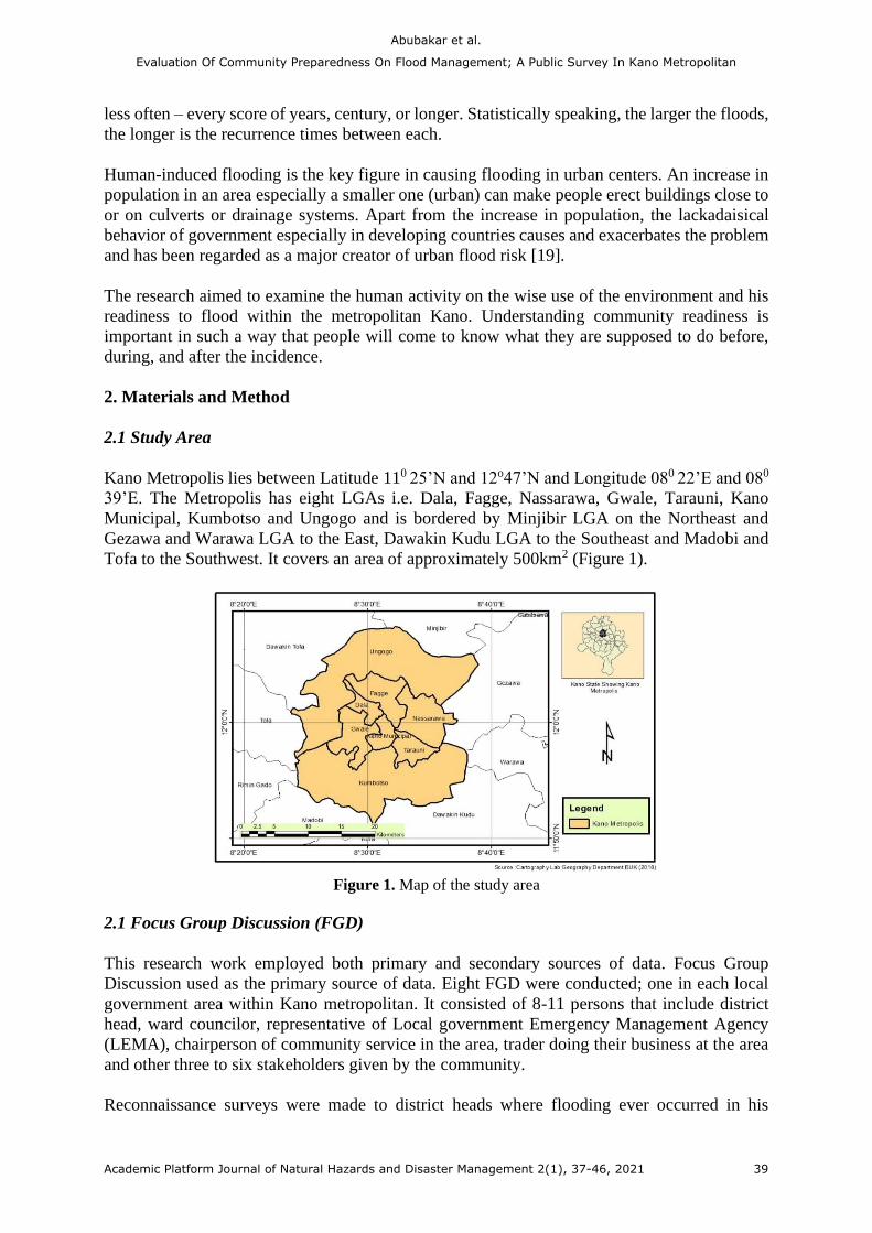
Kano Metropolis lies between Latitude 110 25’N and 12o47’N and Longitude 080 22’E and 080
39’E. The Metropolis has eight LGAs i.e. Dala, Fagge, Nassarawa, Gwale, Tarauni, Kano
Municipal, Kumbotso and Ungogo and is bordered by Minjibir LGA on the Northeast and
Gezawa and Warawa LGA to the East, Dawakin Kudu LGA to the Southeast and Madobi and
Tofa to the Southwest. It covers an area of approximately 500km2 (Figure 1).
Figure 1. Map of the study area
2.1 Focus Group Discussion (FGD)
This research work employed both primary and secondary sources of data. Focus Group
Discussion used as the primary source of data. Eight FGD were conducted; one in each local
government area within Kano metropolitan. It consisted of 8-11 persons that include district
head, ward councilor, representative of Local government Emergency Management Agency
(LEMA), chairperson of community service in the area, trader doing their business at the area
and other three to six stakeholders given by the community.
Reconnaissance surveys were made to district heads where flooding ever occurred in his
Abubakar et al.
Evaluation Of Community Preparedness On Flood Management; A Public Survey In Kano Metropolitan
Academic Platform Journal of Natural Hazards and Disaster Management 2(1), 37-46, 2021 39
Page 4
custody as well as the environmental unit at the local government secretariat. The essence of
this visitation was to introduce the topic and asked for gathering at least 8 to 12 people which
should include; district-head, LEMA or environmental department representative, ward
councilor, trader or business person doing his/her business close to the most affected area,
chairman of community service in the area and other stakeholders selected by district-head. The
researchers encouraged district heads to put females in their selection, as they are the ones
mostly affected by flooding. Fagge, Kumbotso, Ungogo, Nasarawa put two females each in
their selection. The phone calls were made within two weeks (9/2/2020 to 23/2/2020). For
conducting FGD, the research team took different roles: one acted as note taker (and used
recorder for recording), one acted as moderator while the other one was the observer of the
general mood and body language of the participants. FGD have started between 10:05am to
11:37am (1/3/2020); 10:09 to 11:25am (2/3/2020); 5:32pm to 6:25pm (2/3/2020); 4:15pm to
5:28pm (5/3/2020); 10:02 to 11:34 am (6/3/2020); 11:00am to 12:35pm (10/3/2020); 11:10am
to 12:13pm (11/3/2020); and between 2:58pm to 3:59pm in Gwale, Kano Municipal, Dala,
Fagge, Tarauni, Kumbotso, Ungogo and Nasarawa respectively. For the analysis, FGDs were
coded alphabetically; starting Dala and ended in Ungogo local government areas. All the FGDs
took place at the district head’s offices. There is mutual understanding between the research
team and participants which makes the respondents answer questions freely both males and
females, as they were sitting together.
The main reason for employing FGD in this research work is to involve people to explore what
is the ground in their locality. On the other hand, secondary sources of literature include
published and unpublished literature that is relevant to this research work. Thematic analysis
was adopted where responses of the participants in FGDs were divided based on some thematic
heading with a few questions under each thematic heading. The thematic headings were
categorized into four: the relationship between flooding and NAMA prediction, causes of
flooding, relief received from governmental agencies or non-governmental agencies (NGOs),
and measures are taken to cope with flooding. The theme was a classified and coded letter to
follow the theme of the presentation and compared with the field note taken during the session,
views were gathered and interpreted based on the theme. This is because research uses the
qualitative approach in analyzing data generated from FGDs. However, lessons from the
aforementioned literature and theoretical frameworks together with the same experience used
in developing questions under four major thematic categories.
Results and Discussion
The data collected through FGD, recordings were transcribed and coded based on three thematic
headings. All long descriptions were discarded and focused mainly on the theme. The
followings are the results of the discussions with focus groups.
There is unanimous agreement among all FDGs that climate change is among the causative
agents of flooding in their areas. They responded by saying that in previous years they used to
predict the amount of rainfall to be received based on the winter season, but now they cannot
predict, as reported directly from the response of FGD in the Kumbotso local government area.
We used to predict the duration of the month we would receive rainfall based on the
winter season. Because there is a correlation between the winter season and the rainy
season in terms of length of months experience in the two seasons. Mostly, our winter
season starts from November to February; that is four months. The same with rainy
season is four months: May to September; but now we cannot predict due to fluctuation
Abubakar et al.
Evaluation Of Community Preparedness On Flood Management; A Public Survey In Kano Metropolitan
Academic Platform Journal of Natural Hazards and Disaster Management 2(1), 37-46, 2021 40
Page 5
of winter and rainy season caused by climate change.- FGD 5
Based on the finding of this research 75% of the respondents do not know the function of
NAMA in predicting the amount of rain falling in an area. What they believe is that media
stations broadcast weather forecasts mostly by them. However, even the forecast made by
media stations on the amount of rain falling in a year is only 40 – 50% happen. For that, they
do not believe media stations play a critical role in minimizing flooding. This negates the
finding of Aderogba [17] which stated that media station in Nigerian media has been applauded
by furnishing qualitative information regarding the widespread flooding in Nigeria. Only two
local government areas (Fagge and Kumbotso) agreed that mostly they depend on NAMA on
the amount of rain received every year through media stations.
While responding to questions on causes of flooding in their areas, it is stated by the respondents
that, poor urban planning causes most of the flooding in Dala, Kano Municipal Nasarawa and
Fagge local government areas. That is to say, there is poor urban planning not only in old Kano
city but rather outside Kano city wall such as Dandinshe, Bridget, Fagge, Kurna. As one of
FGD (Dala local government area) stated:
Akwai karancin tsarin layuka a wannan karamar hukumar saboda tsofaffin unguwannin
da suke wannan local government. Wannan shi ne babban abin da yake jawo ambaliyar
ruwa a wannan karamar hukumar kusan kowacce shekara. (There is a lack of urban
planning in our own local government due to the old quarters it consists of. This is the
main cause of flooding in this local government almost every year). - FGD 1
This result is the same as what is in Fagge, Kano Municipal, Gwale and some parts of Nasarawa
Ungogo. It is the same finding recorded in the work of Agbonkhese et al. [2] which found out
poor urban planning causes most of the urban flooding in Nigeria.
Another cause of flooding mentioned by FGD in Kumbotso, Tarauni and Ungogo local
government is that there is a lack of communal spirit:
Most people do not have a communal spirit. This means that most people engage in
community activities are done if the environmental problem will affect their own dwelling.
And at the same time, they have a misconception about the concept of ‘environment’.
People think that only their house is their environment. This makes them show 'I do not
care' behavior. - FGD 7
This lack of communal spirit recorded by some FGDs negates the finding of Vis et al. [20],
which recorded that each person pays hundreds of Euros each year and takes the responsibility
of flooding management as they have a communal spirit.
In Gwale, Fagge, Tarauni, Ungogo and Nasarawa FGDs there is a poor organization of
community self-help groups. Almost all the community self-help groups are poorly organized.
They only meet if there is an environmental hazard. They do not, most of the time, take
preventive measures for flooding problems. They only organized after the first or second heavy
rainfall. This poorly organized community self-help group leading them not even attempt to
talk to the authority about what will be done to them before, during, and after flooding (if
happened). This corroborates with the findings of Obeta [21] which indicated that stakeholders
and community are poorly organized in tackling environmental hazards and take the hazard as
momentary.
Abubakar et al.
Evaluation Of Community Preparedness On Flood Management; A Public Survey In Kano Metropolitan
Academic Platform Journal of Natural Hazards and Disaster Management 2(1), 37-46, 2021 41
Page 6
All FGDs discussed within Kano metropolitan local government unanimously agreed that there
are inadequate tools to evacuate all refuse dumped at drainage such as containers, rain boots,
shovels, wheelbarrows, hand gloves, rake, etc. this is a result of their poorly organization.
According to some respondents in Dala, KMC, Ungogo, and Gwale identified that:
We have few instruments to clear our own gutters and culverts before the month of rain
starts. Moreover, sometimes, the few instruments we have are always lost through
borrowing from a member of that community as they are feeling they put their own share
in purchasing these tools. - FGD 3
According to all the respondents in all the study areas the major cause of the flooding is not
climate change but rather a poor drainage and culverts. This according to them people erect
structures in haphazardly except some parts of the Gwammaja ward. This is contrary to the
finding of Agbonkhese et al. [2], which found out that climate change is among the causes of
flooding in Nigeria.
On the people side, arbitrary dumping of refuse in waterways especially during the rainy season
is among the causative agent of flooding. Respondents from Adakawa, Mazugal (Dala local
government area), Diso, Mandawari (Gwale Local government area), Kurna and Fagge (Fagge
local government area) dump their refuse in the waterways during the rainy season. This
corroborated the result of [2], [22], which found out that a poor refuse disposal system is among
the key causes of flooding in Borno.
The absence of dumping sites by the authority in most of the locality is a major reason because
most of the respondents have the intention to dump their refuse in the designated area provided
by the government. Nevertheless, unfortunately, local government provides little in some areas
such as Ungogo, Mazugal.
Inadequate preparedness is considered by many respondents as the major cause of urban
flooding in the Kano metropolitan. Contrary to what was used to practice to evacuate and clear
all culvert and drainage before the rain starts falling. In line with this, Agbonkhese et al., [2]
identified poor preparation for the rainy season as among the factors that determine the flooding
in Nigeria.
3.1 Relief (Assistance)
There is no relief received by our people during or after flooding by Non-governmental
Organizations (NGOs) in all local government areas. For example, in the 2012-2020 floodings,
no palliative given by NGOs received by victims or affected people in our local government
areas. Non-governmental Organizations do not give anything economic support, but rather from
our relatives and neighbors. To emphasize their view, here it is FGD result from Nasarawa local
government which is almost the same as other local government areas within Kano
metropolitan:
We do not receive any relief from any non-governmental organizations, but rather from
our relatives and neighbors who provided clothes, food, mosquito nets, and sometimes
money. We do not know if these NGOs give financial support to authorities like local
governments. - FGD 6
Abubakar et al.
Evaluation Of Community Preparedness On Flood Management; A Public Survey In Kano Metropolitan
Academic Platform Journal of Natural Hazards and Disaster Management 2(1), 37-46, 2021 42
Page 7
There is seldom give out palliative from the government, but there is discrimination in the
distribution of such kinds of palliatives due to differences in political views as FGDs in Dala,
Gwale, Kumbotso and Ungogo. This reported from FGD in Dala:
We receive some relief from the government after flooding depending upon the influence
of your ward on the incumbent government especially we in Dala local government as
you can compare with those in Kano Municipal where they receive full government
support since they participate more in politics. - FGD 1
This view is supported by all FGDs in Kano metropolitan, though there are differences in terms
of the amount of support received from their relatives and neighbors. Those in Kumbotso, Kano
Municipal, Fagge and Dala receive higher relief than those in the rest of the local government
areas.
3.2 Measures/Disaster management plan
The disaster management plan includes a detail of the specification of equipment and
machinery in plan. Similarly, planning is the plot, and hazardous areas classifications are map
out; details of the risk assessment procedure adopted are also captured. Additionally, details of
the on-site and off-site emergency plans are also required in the disaster management plan
(Galatchi, 2005). As flooding is the most common disaster Nigeria experiences, Disaster
Management Plan was used to see how preparedness the respondents are. Four stage disaster
management cycle was used to see how people cope with the plan. These four stages are:
preparedness, response, recovery, and mitigation.
3.2.1 Preparedness
This refers to the degree of alertness and readiness of an individual, a household, or a
community against an upcoming disaster. Among many activities taken include providing
hazard warnings, communicating with the public and others regarding disaster vulnerability,
providing disaster training for emergency responders and the general public, just mentioned a
few (Tierneyet, 2001). Almost all the measures taken are during or after flooding except in
Dala, Kano Municipals, Gwale, Fagge and some parts of Nasarawa local government. The
measures taking as mention by FGDs in clearing gutters and culvert a month before rain start.
Tools such as a rake, shovel, hoe, and wheelbarrow provided together with food for the people
to do such work. Nowadays, people liaise with REMASAB at the local government level to
evacuate refused piled up along the gutter side.
3.2.2 Response
The response is referred to all activities conducted immediately before, during and after a
disaster to save lives, minimize damage to property, and enhance the effectiveness of recovery
in the shortest possible time [23]. Based on the result of FGDs all the FGDs identified that they
participate hundred percent during flooding in rescuing and removing flooded water from
entering rooms. One of the FGD in KMC quoted that:
Even if we did not prepare for flooding, when it happened, we do our best to rescue people
and their properties; because everyone wishes to help. We sometimes create a path where
flooded water can pass. - FGD 4
Abubakar et al.
Evaluation Of Community Preparedness On Flood Management; A Public Survey In Kano Metropolitan
Academic Platform Journal of Natural Hazards and Disaster Management 2(1), 37-46, 2021 43
Page 8
3.2.3 Recovery
Recovery is a process of returning to a normal situation before disaster happen after a disaster
has occurred. In this phase mostly increase in safety and future disaster preparedness are taken
place here. This process includes interactive sessions and decision-making among different
groups and institutions (both governmental agencies and NGOs), households, artisans,
businesspersons, and the community at large [23]. Most of the urban flooding claims properties
than lives.
The result of all FGDs indicated that there is no recovery phase taken by the community. They
only focus on what happened. But there is one divergence in the opinion of FGD in Gwale and
other FGDs. In the Gwale it is recorded that:
Immediately when flooding has taken place, we gather in our own community and discuss
how to prevent such a disaster from the occurrence. However, this gathering is base on
economic class. Within Gwale local government, rich men are gathering without inviting
poor people or even district-head while in other areas only poor people struggle for taken
recovery measures. Both rich and poor people leave their decision unimplemented up to
the next rainy season. - FGD 3
3.2.4 Mitigation
Mitigation activities actually eradicate or reduce the probability of disaster occurrence, or
reduce the effects of unavoidable disasters. Mitigation measures include building codes; zoning
and land use management; building use regulations and safety codes; preventive health care;
public education, and so on. This phase is absent as reported by all FGDs:
This is the government's responsibility to make urban and regional planning, providing
healthcare facilities, enforce the use of building regulation. - FGD 8.
4. Conclusion and recommendation
This research identified that the functions of the National Emergency Management Agency
(NEMA) were not known to the majority of people and the major causes of flooding such as
lackadaisical behavior of people, lack of communal spirit, dumping of refuse in the gutter and
culvert. The research work also showcased the relief when flooding occurred government and
NGOs do not go to the hand of affected people if it is given. Based on the finding of this research
work, the research recommended that Non-structural responses which include more accurate
flood forecasting through the use of satellites and high-tech equipment, zoning and land-use
policies, insurance programs, evacuation planning, and education should be adopted.
Authors Contribution
Ahmad Said Abubakar and Umar Abba design the topic and made literature survey on the
subject matter. Nura Isyaku Bello, Abdulkadir Bello and Hassan Adamu partake fully in the
course of data collection across the study area. All the authors contributed to the analysis of the
data.
Abubakar et al.
Evaluation Of Community Preparedness On Flood Management; A Public Survey In Kano Metropolitan
Academic Platform Journal of Natural Hazards and Disaster Management 2(1), 37-46, 2021 44
Page 9
References
[1] S. N. Muhammed, I. K. Abdullahi, N. I. Bello, and A. S. Abdullahi, ‘The need for
implementation of Environmental Education in Nigeria-A Review’, Dutse Journal of
Pure and Applied Sciences, vol. 4, no. 1, pp. 280–288, 2018.
[2] O. Agbonkhese, E. G. Agbonkhese, E. O. Aka, J. Joe-Abaya, M. Ocholi, and A.
Adekunle, ‘Flood menace in Nigeria: impacts, remedial and management strategies.’,
Civil and Environmental Research, vol. 6, no. 4, pp. 32–40, 2014.
[3] Nigerian Emergency Management Agency, ‘Report on flood disasters in Nigeria’.
https://nema.gov.ng/ (accessed Jun. 30, 2021).
[4] P. R. Hunter, ‘Climate change and waterborne and vector-borne disease’, Journal of
applied microbiology, vol. 94, pp. 37–46, 2003.
[5] M. Ahern, R. S. Kovats, P. Wilkinson, R. Few, and F. Matthies, ‘Global health impacts
of floods: epidemiologic evidence’, Epidemiologic reviews, vol. 27, no. 1, pp. 36–46,
2005.
[6] ‘Climate change, urban flooding and the rights of the urban poor in Africa’, ActionAid
International. https://actionaid.org/publications/2006/climate-change-urban-flooding-
and-rights-urban-poor-africa (accessed Jun. 30, 2021).
[7] A. A. Adegbola and J. K. Jolayemi, ‘Historical rainfall-runoff modeling of river Ogunpa,
Ibadan, Nigeria’, Indian Journal of Science and Technology, vol. 5, no. 5, pp. 2725–
2728, 2012.
[8] N. O. Adeoye, A. Ayanlade, and O. Babatimehin, ‘Climate change and menace of floods
in Nigerian cities: socio-economic implications’, Advances in Natural and Applied
Sciences, vol. 3, no. 3, pp. 369–378, 2009.
[9] O. O. Bashir, A. H. Oludare, O. O. Johnson, and B. Aloysius, ‘Floods of fury in Nigerian
cities’, Journal of Sustainable Development, vol. 5, no. 7, p. 69, 2012.
[10] A. B. Nabegu, ‘Analysis of vulnerability to flood disaster in Kano State, Nigeria’,
Greener Journal of Physical Sciences, vol. 4, no. 2, pp. 22–29, 2014.
[11] C. Green, ‘The evaluation of vulnerability to flooding’, Disaster Prevention and
Management: An International Journal, 2004.
[12] L. Fewtrell and D. Kay, ‘An attempt to quantify the health impacts of flooding in the UK
using an urban case study’, Public health, vol. 122, no. 5, pp. 446–451, 2008.
[13] S. Tunstall, S. Tapsell, C. Green, P. Floyd, and C. George, ‘The health effects of
flooding: social research results from England and Wales’, Journal of water and health,
vol. 4, no. 3, pp. 365–380, 2006.
[14] H. Garba, A. Ibrahim, S. Ahmed, and B. Faustinus, ‘Hydrological modeling of the
impact of climate change on a tropical perennial river flooding’, Research Inventy:
International Journal of Engineering and Science, vol. 3, no. 6, pp. 30–35, 2013.
[15] J. Chen, A. A. Hill, and L. D. Urbano, ‘A GIS-based model for urban flood inundation’,
Journal of Hydrology, vol. 373, no. 1–2, pp. 184–192, 2009.
[16] A. R. Clement, ‘An application of Geographic Information System in mapping flood risk
zones in a north central city in Nigeria’, African Journal of Environmental Science and
Technology, vol. 7, no. 6, pp. 365–371, 2013.
[17] K. A. Aderogba, ‘Qualitative studies of recent floods and sustainable growth and
development of cities and towns in Nigeria’, International Journal of Academic
Research in Economics and Management Sciences, vol. 1, no. 3, p. 1, 2012.
[18] E. A. Olofin, ‘Lecture note on environment and development, Kano’, Geography
department Bayero University, 2011.
Abubakar et al.
Evaluation Of Community Preparedness On Flood Management; A Public Survey In Kano Metropolitan
Academic Platform Journal of Natural Hazards and Disaster Management 2(1), 37-46, 2021 45
Page 10
[19] ‘Planning Sustainable Cities: Global Report on Human Settlements 2009 | UN-Habitat’.
https://unhabitat.org/planning-sustainable-cities-global-report-on-human-settlements-
2009 (accessed Jun. 30, 2021).
[20] M. Vis, F. Klijn, K. M. De Bruijn, and M. Van Buuren, ‘Resilience strategies for flood
risk management in the Netherlands’, International journal of river basin management,
vol. 1, no. 1, pp. 33–40, 2003.
[21] M. C. Obeta, ‘Institutional approach to flood disaster management in Nigeria: need for a
preparedness plan.’, British Journal of Applied Science & Technology, vol. 4, no. 33, pp.
4575–4590, 2014.
[22] H. B. Bwala, R. O. Oladosu, and S. M. Nghalmi, ‘Application of Physical Planning
Strategies to Flood Control in Maiduguri, Borno State, Nigeria’, Research Journal of
Environmental and Earth Sciences, vol. 7, no. 1, pp. 1–8, 2015.
[23] D. Mileti, Disasters by design: A reassessment of natural hazards in the United States.
Joseph Henry Press, 1999.
Abubakar et al.
Evaluation Of Community Preparedness On Flood Management; A Public Survey In Kano Metropolitan
Academic Platform Journal of Natural Hazards and Disaster Management 2(1), 37-46, 2021 46