CON106-1 Leadership in Sustainable Infrastructure Leadership en Infrastructures Durables Vancouver, Canada May 31 – June 3, 2017/ Mai 31 – Juin 3, 2017 EVALUATION OF COMPUTER VISION- AND 4D BIM-BASED CONSTRUCTION PROGRESS TRACKING ON A UAV PLATFORM Hamledari, Hesam 1,5 , McCabe, Brenda 2 , Davari, Shakiba 3 , Shahi, Arash 2 , Rezazadeh Azar, Ehsan 4 , Flager, Forest 1 1 Stanford University, United States 2 University of Toronto, Canada 3 Georgia Institute of Technology, United States 4 Lakehead University, Canada 5 [email protected]Abstract: The application of image-based progress tracking and object detection techniques has recently been extended to dynamic automated data collection and image capture platforms such as unmanned aerial vehicles (UAV). The use of UAVs has a great potential to eliminate tedious, labor-intensive, costly, and manual image capture processes. It can also provide a clearer and more informative view of construction work due to the UAVs’ high agility and maneuverability. However, it is also of utmost importance to analyze the effect of UAVs’ highly dynamic behavior on the accuracy of image-based solutions. UAV-captured images are subject to motion blur which not only can jeopardizes the object and progress recognition accuracy, but also the quality and reliability of resulting as-built 4D building information models (BIM). This study evaluates the performance of a 4D BIM- and computer vision-based construction progress detection method on images captured by an unmanned aerial vehicle. In this research, the components of indoor partitions such as studs, insulation, electrical outlets, and state of drywall work are automatically detected, and the 4D BIM is updated with schedule and progress information. In a series of experiments, the accuracy of this solution is analyzed with respect to the UAV’s velocity and photo capture configuration. This analysis can benefit UAV-based progress tracking systems and facilitate reliable UAV- based data collection at construction sites. Keywords: unmanned aerial vehicles, automation, construction progress tracking, 4D BIM, computer vision, digital images 1 Introduction The recent advancements in the design of light-weight unmanned aerial vehicles (UAV) has introduced them as a platform for automated photo capture and data collection at construction sites and infrastructures (Ham et al. 2016; Irizarry and Costa 2016; Siebert and Teizer 2014). Due to their high maneuverability, agility, and better coverage, UAVs can both reduce the need for manual photo capture and improve the quality of the analyzed visual data (Lin et al. 2015; McCabe et al. 2017; Tuttas et al. 2016). Research has focused on the use of UAVs in several application domains including, but not limited to, quality inspections, surveying, and construction progress tracking. To facilitate image-based progress tracking, frameworks (Hamledari 2016; Lin et al. 2015) and formalisms (Han et al. 2015) have been developed for the use of these dynamic photo capture platforms at construction sites. This is essential for ensuring the quality of analyzed data and the robust integration of results with a project’s virtual models
Transcript
CON106-1
Leadership in Sustainable Infrastructure
Leadership en Infrastructures Durables
Vancouver, Canada
May 31 – June 3, 2017/ Mai 31 – Juin 3, 2017
EVALUATION OF COMPUTER VISION- AND 4D BIM-BASED CONSTRUCTION PROGRESS TRACKING ON A UAV PLATFORM
1 Stanford University, United States 2 University of Toronto, Canada 3 Georgia Institute of Technology, United States 4 Lakehead University, Canada 5 [email protected]
Abstract: The application of image-based progress tracking and object detection techniques has recently been extended to dynamic automated data collection and image capture platforms such as unmanned aerial vehicles (UAV). The use of UAVs has a great potential to eliminate tedious, labor-intensive, costly, and manual image capture processes. It can also provide a clearer and more informative view of construction work due to the UAVs’ high agility and maneuverability. However, it is also of utmost importance to analyze the effect of UAVs’ highly dynamic behavior on the accuracy of image-based solutions. UAV-captured images are subject to motion blur which not only can jeopardizes the object and progress recognition accuracy, but also the quality and reliability of resulting as-built 4D building information models (BIM). This study evaluates the performance of a 4D BIM- and computer vision-based construction progress detection method on images captured by an unmanned aerial vehicle. In this research, the components of indoor partitions such as studs, insulation, electrical outlets, and state of drywall work are automatically detected, and the 4D BIM is updated with schedule and progress information. In a series of experiments, the accuracy of this solution is analyzed with respect to the UAV’s velocity and photo capture configuration. This analysis can benefit UAV-based progress tracking systems and facilitate reliable UAV-based data collection at construction sites.
Keywords: unmanned aerial vehicles, automation, construction progress tracking, 4D BIM, computer vision, digital images 1 Introduction The recent advancements in the design of light-weight unmanned aerial vehicles (UAV) has introduced them as a platform for automated photo capture and data collection at construction sites and infrastructures (Ham et al. 2016; Irizarry and Costa 2016; Siebert and Teizer 2014). Due to their high maneuverability, agility, and better coverage, UAVs can both reduce the need for manual photo capture and improve the quality of the analyzed visual data (Lin et al. 2015; McCabe et al. 2017; Tuttas et al. 2016). Research has focused on the use of UAVs in several application domains including, but not limited to, quality inspections, surveying, and construction progress tracking. To facilitate image-based progress tracking, frameworks (Hamledari 2016; Lin et al. 2015) and formalisms (Han et al. 2015) have been developed for the use of these dynamic photo capture platforms at construction sites. This is essential for ensuring the quality of analyzed data and the robust integration of results with a project’s virtual models
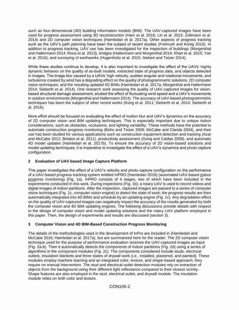
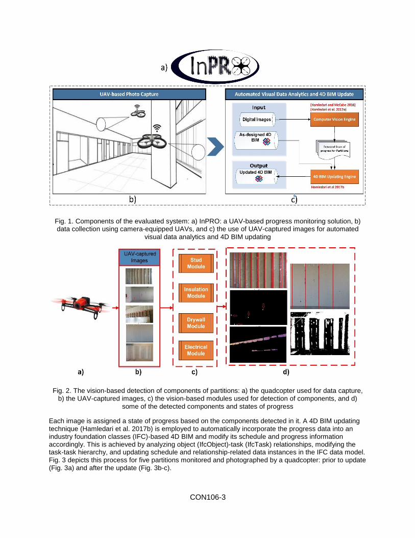
such as four-dimensional (4D) building information models (BIM). The UAV-captured images have been used for progress assessment using 3D reconstruction (Ham et al. 2016; Lin et al. 2015; Zollmann et al. 2014) and 2D computer vision techniques (Hamledari et al. 2017a). Other aspects of progress tracking such as the UAV’s path planning have been the subject of recent studies (Freimuth and König 2016). In addition to progress tracking, UAV use has been investigated for the inspection of buildings (Morgenthal and Hallermann 2014; Roca et al. 2013), bridges (Hallermann and Morgenthal 2014; Khan et al. 2015; Yan et al. 2016), and surveying of earthworks (Hugenholtz et al. 2015; Siebert and Teizer 2014). While these studies continue to develop, it is also important to investigate the effect of the UAVs’ highly dynamic behavior on the quality of as-built models, extracted state of progress data, and objects detected in images. The image blur caused by a UAVs’ high velocity, sudden angular and rotational movements, and turbulence created by wind has a degrading effect on the quality of photogrammetric solutions, 2D computer vision techniques, and the resulting updated 4D BIMs (Hamledari et al. 2017a; Morgenthal and Hallermann 2014; Sieberth et al. 2014). One research work assessing the quality of UAV-captured images for vision-based structural damage assessment, studied the effect of fluctuating wind speed and a UAV’s movements in outdoor environments (Morgenthal and Hallermann 2014). The accuracy of UAV-based photogrammetric techniques has been the subject of other recent works (Küng et al. 2011; Sieberth et al. 2014; Sieberth et al. 2016). More effort should be focused on evaluating the effect of motion blur and UAV’s dynamics on the accuracy of 2D computer vision and BIM updating techniques. This is especially important due to unique indoor considerations, such as obstacles, occlusions, and lighting variability. These methods have the potential to automate construction progress monitoring (Bohn and Teizer 2009; McCabe and Clarida 2004), and their use has been studied for various applications such as construction equipment detection and tracking (Azar and McCabe 2012; Brilakis et al. 2011), productivity assessment (Gong and Caldas 2009), and automatic 4D model updates (Hamledari et al. 2017b). To ensure the accuracy of 2D vision-based solutions and model updating techniques, it is imperative to investigate the effect of a UAV’s dynamics and photo capture configuration. 2 Evaluation of UAV-based Image Capture Platform This paper investigates the effect of a UAV’s velocity and photo capture configuration on the performance of a UAV-based progress tracking system entitled InPRO (Hamledari 2016) (automated UAV-based indoor progress monitoring) (Fig. 1a). InPRO consists of 4 stages, two of which have been included in the experiments conducted in this work. During inspections (Fig. 1b), a rotary UAV is used to record videos and digital images of indoor partitions. After the inspection, captured images are passed to a series of computer vision techniques (Fig. 1c, computer vision engine) to detect the state of work; the progress results are then automatically integrated into 4D BIMs and schedule by an updating engine (Fig. 1c). Any degradation effect on the quality of UAV-captured images can negatively impact the accuracy of the results generated by both the computer vision and 4D BIM updating engines. The following discussions provide details with respect to the design of computer vision and model updating solutions and the rotary UAV platform employed in this paper. Then, the design of experiments and results are discussed (section 3). 3 Computer Vision and 4D BIM-Based Construction Progress Monitoring The details of the methodologies used in the development of InPro are included in (Hamledari and McCabe 2016; Hamledari et al. 2017a), but are summarized here for the reader. The 2D computer vision technique used for the purpose of performance evaluation receives the UAV-captured images as input (Fig. 2a-b). Then it automatically detects the components of indoor partitions (Fig. 2d) using a series of algorithms in the component modules (Fig. 2c). The components considered include studs, electrical outlets, insulation blankets and three states of drywall work (i.e., installed, plastered, and painted). These modules employ machine learning and an integrated color, texture, and shape-based approach; they require no manual intervention. The stud and electrical outlet detection modules rely on extraction of objects from the background using their different light reflectance compared to their closest vicinity. Shape features are also employed in the stud, electrical outlet, and drywall module. The insulation module relies on both color and texture.
CON106-3
Fig. 1. Components of the evaluated system: a) InPRO: a UAV-based progress monitoring solution, b) data collection using camera-equipped UAVs, and c) the use of UAV-captured images for automated
visual data analytics and 4D BIM updating
Fig. 2. The vision-based detection of components of partitions: a) the quadcopter used for data capture, b) the UAV-captured images, c) the vision-based modules used for detection of components, and d)
some of the detected components and states of progress
Each image is assigned a state of progress based on the components detected in it. A 4D BIM updating technique (Hamledari et al. 2017b) is employed to automatically incorporate the progress data into an industry foundation classes (IFC)-based 4D BIM and modify its schedule and progress information accordingly. This is achieved by analyzing object (IfcObject)-task (IfcTask) relationships, modifying the task-task hierarchy, and updating schedule and relationship-related data instances in the IFC data model. Fig. 3 depicts this process for five partitions monitored and photographed by a quadcopter: prior to update (Fig. 3a) and after the update (Fig. 3b-c).
CON106-4
Fig. 3. The 4D BIM updating process: a) the as-designed schedule (prior to update), b) the updated schedule using UAV-generated progress data, and c) the color-coded 4D BIM based on each partition’s
state of progress (see Fig. 3b)
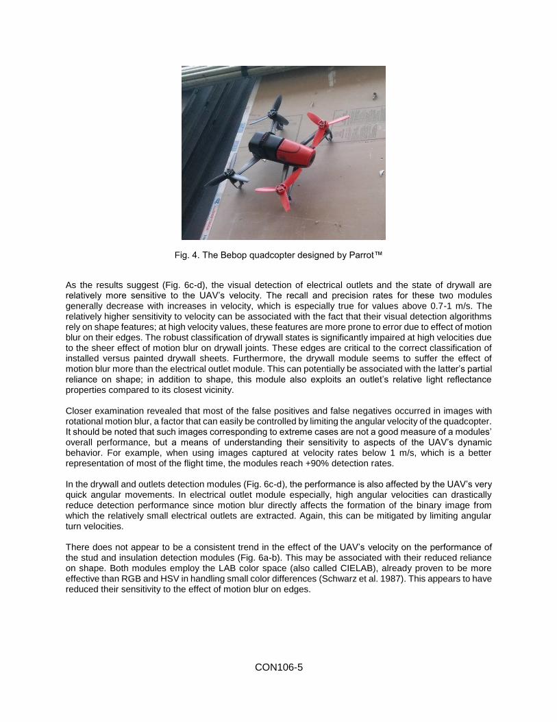
4 UAV Platform The quadcopter used in this study is a Bebop (Fig. 4) designed by Parrot™, which was chosen due to the high stability of its on-board camera, a crucial factor for ensuring the robust performance of the vision-based methods. The on-board computers and sensors are almost eight times more powerful than its predecessor, Parrot.AR., which was extensively used in some of the original research in this field. Finally, its affordable cost and available software developer kit provide essential support for designing autonomous navigation systems. The specifications of this device are summarized in Table 1.
Table 1. The quadcopter’s specification
CPU Dual-core ARM Cortex-A9, with quad-core GPU Memory 8 GB (internal) and micro USB (extended) Wi-Fi 802.11a/b/g/n/ac Wi-Fi antennas MIMO dual-band (2.4 and 5 GHz) Camera CMOS 14 Megapixel Fish-eye lens 180° 1/2,2" Video definition 1920×1080p (30 fps) Video encoding H264 Photo definition 3800×3188 pixels Photo file format JPEG, RAW, DNG
5 Experiments and Results To examine the effect of the UAV’s dynamics and photo capture configuration on image quality and module accuracy, the flight statistics from a typical on-site flight video were accessed through the graphical user interface of the quadcopter (Fig. 5). Four 4-second videos were manually extracted from the flight; one for each detection module. Next, the videos were broken down into frames, providing 120 frames for each module. The videos were chosen to contain the worst conditions: high velocity, angular turns, and changes between low and high flight velocity. Using consecutive images from a video focused the experiment on evaluating the motion and not differences in the scene contained in the images. The images were processed by their respective modules. Each module’s performance was evaluated using recall and precision measures. For each object category, the absolute deviations from the average precision and recall rates were plotted against the velocity at which their corresponding frames were captured (Fig. 6).
CON106-5
Fig. 4. The Bebop quadcopter designed by Parrot™
As the results suggest (Fig. 6c-d), the visual detection of electrical outlets and the state of drywall are relatively more sensitive to the UAV’s velocity. The recall and precision rates for these two modules generally decrease with increases in velocity, which is especially true for values above 0.7-1 m/s. The relatively higher sensitivity to velocity can be associated with the fact that their visual detection algorithms rely on shape features; at high velocity values, these features are more prone to error due to effect of motion blur on their edges. The robust classification of drywall states is significantly impaired at high velocities due to the sheer effect of motion blur on drywall joints. These edges are critical to the correct classification of installed versus painted drywall sheets. Furthermore, the drywall module seems to suffer the effect of motion blur more than the electrical outlet module. This can potentially be associated with the latter’s partial reliance on shape; in addition to shape, this module also exploits an outlet’s relative light reflectance properties compared to its closest vicinity. Closer examination revealed that most of the false positives and false negatives occurred in images with rotational motion blur, a factor that can easily be controlled by limiting the angular velocity of the quadcopter. It should be noted that such images corresponding to extreme cases are not a good measure of a modules’ overall performance, but a means of understanding their sensitivity to aspects of the UAV’s dynamic behavior. For example, when using images captured at velocity rates below 1 m/s, which is a better representation of most of the flight time, the modules reach +90% detection rates. In the drywall and outlets detection modules (Fig. 6c-d), the performance is also affected by the UAV’s very quick angular movements. In electrical outlet module especially, high angular velocities can drastically reduce detection performance since motion blur directly affects the formation of the binary image from which the relatively small electrical outlets are extracted. Again, this can be mitigated by limiting angular turn velocities. There does not appear to be a consistent trend in the effect of the UAV’s velocity on the performance of the stud and insulation detection modules (Fig. 6a-b). This may be associated with their reduced reliance on shape. Both modules employ the LAB color space (also called CIELAB), already proven to be more effective than RGB and HSV in handling small color differences (Schwarz et al. 1987). This appears to have reduced their sensitivity to the effect of motion blur on edges.
CON106-6
Fig. 5 Screenshots of flight statistics available through the device’s user graphical interface: (a) the whole flight; (b) a portion of the flight, in more details
The in-flight speeds below 1 m/s do not appear to affect any of the modules’ performance, i.e. the UAV does not need to be fully stationary when inspecting locations of interest to achieve high detection rates. This is important because the algorithms can be applied to any indoor flight, without imposing constraints on the flight and the process of capturing images. To make the best use of the limited battery life, the quadcopter can travel at higher velocities when not capturing images and slow down for image capture. The effect of UAV velocity on the updated 4D BIMs was investigated. Experiments suggest that the 4D model updating process is relatively less affected by increased velocity than object recognition. For a partition to be assigned to the correct state of progress, not all of its objects need to be detected. For example, even if 80% of a partition’s studs are detected, it can still be correctly classified into the “framing” state. Therefore, it appears that state detection and 4D model updating is relatively insensitive to velocity. This, however, is not the case in high level of detail (LoD) updates where object detection results are used directly. 4D models can also provide crucial a priori information for robotic data capture solutions, which can potentially facilitate object detection and scene understanding. The 4D BIM updating techniques use as input the progress data generated by the data capture solution. Hence, the accuracy of the updated models directly depends on the quality of data collection and analysis. To ensure the accuracy of updated 4D BIMs, the use of UAVs as a multi-sensory platform needs to be investigated. Data fusion techniques can potentially increase the robustness of the updates (Shahi et al. 2014).
Sp
ee
d
Alt
itu
de
(m
)
Battery (%)
Speed (m/s)
Altitude (m)
Sp
ee
d (
m/s
)
Alt
itu
de
(m
)
Battery (%)
Speed (m/s)
Altitude (m)
Sp
ee
d (
m/s
)
CON106-7
Photo capture configuration and image exposure settings are other factors that can significantly affect the performance. The image exposure was studied for challenging indoor lighting conditions. The three factors known as the exposure triangle, namely ISO number, shutter speed, and aperture size, were examined for this quadcopter’s on-board camera as they together control the exposure and hence the formation and quality of images. A high ISO number indicates a higher sensitivity to incoming light, which can be valuable for low-light scenes common indoors. However, the increased noise associated with high ISO numbers may reduce the accuracy of vision-based methods. In our tests with Bebop, its high ISO values and short exposure times caused surprisingly high levels of random noise. Overall, however, the level of noise was not sufficient to jeopardize the accuracy of the modules. This ensures robust algorithm performance when using off-the-shelf UAVs and cameras.
Fig. 6. The variations of precision and recall against the velocity: (a) stud; (b) insulation; (c) drywall; (d) electrical outlets
As for image configuration, the best results were achieved when the UAV operated at a partition’s mid height, its camera’s axis was perpendicular to the wall’s longitudinal axis, camera was not tilted toward the partition’s extreme heights, and the partition’s height filled 80-90% of image’s height. The use of canonical view for UAV’s image capture has also proven to result in higher performance in 3D reconstruction-based progress tracking (Lin et al. 2015). Images captured at distances very close (less than 1-2 m) or very far
CON106-8
also resulted in low performance measures. This calls for more attention on proper UAV-based photo capture. Fig. 7 depicts some of the photo capture configurations where performance is degraded due to the UAV incomplete capture of the scene, caused by sudden rotation around its roll and pitch axes. The experiments performed in this paper and other similar analyses can benefit future UAV-based progress solutions for the automatic selection of image frame from the UAV’s video feed and also for inspection planning. Based on prior knowledge of the effect of velocity on the performance of computer vision methods, the image frame selection process for each partition may be automated. Further, the integration of such analysis with BIMs can provide new opportunities for automated BIM-based inspection planning. Having a clearer understanding of in-flight restrictions, more accurate estimates of battery use and coverage can be provided for inspection planning applications. More importantly, as research toward autonomous UAV flight advances, the use of multi-dimensional BIMs can provide a rich source of information for the automatic selection of UAV inspection targets.
Fig. 7. Incomplete capture of scenes due to sudden rotation around roll and pitch axes
6 Conclusion In contrast to fixed cameras, the images captured by a UAV’s on-board cameras are captured in motion and are therefore subject to motion blur and degradation in quality. This not only can jeopardize the performance of computer vision techniques, but also the accurateness of as-built 4D BIMs, which are generated using the results of visual data analytics. This paper examines the effect of a UAV’s velocity and image capture configuration on the performance of a computer vision and 4D BIM-based progress detection system, entitled InPRO. Results indicate that motion blur caused by high velocity values has a more significant effect on algorithms relying on shape features (e.g., visual detection of drywall joints), while color-based approaches appeared to be less sensitive on the UAV’s velocity. Overall, velocity values below 0.7-1 m/s appear to provide reliable performance for most object detection algorithms. It is suggested that angular velocity be closely controlled on camera-equipped UAVs. The updated 4D BIM’s accuracy was less sensitive on the changes in velocity. The best results were achieved when the UAVs were operated at a partition’s mid heights and were aligned perpendicular to the wall’s longitudinal axis. Future research should investigate the performance of other vision-based techniques and progress tracking solutions. This research calls for more emphasis on the integrated solutions where the UAV’s velocity is taken into consideration prior to the design and specification of the inspection plan and restrictions on UAVs’ operation during photo capture. 7 Acknowledgement The authors extend their deepest gratitude to Adrienne De Francesco and Steve Miszuk, from University of Toronto; Tom Finan, PMX Construction’s project manager; Steve Di Santo, Eastern construction’s project coordinator; Fernando Tito, president of SKYGRiD Construction; and Teresa Marsico, project administrator at SKYGRiD Construction. This research was financially supported by the Natural Science and Engineering Research Council (grant number 203368-2015) and Stanford School of Engineering Fellowship. The authors are also grateful to Seyyed Omid Sajedi for his constructive comments.
CON106-9
8 References
Azar, E. R., and McCabe, B. (2012). "Part based model and spatial–temporal reasoning to recognize hydraulic excavators in construction images and videos." Automation in construction, 24, 194-202.
Bohn, J. S., and Teizer, J. (2009). "Benefits and barriers of construction project monitoring using high-resolution automated cameras." Journal of construction engineering and management, 136(6), 632-640.
Brilakis, I., Park, M.-W., and Jog, G. (2011). "Automated vision tracking of project related entities." Advanced Engineering Informatics, 25(4), 713-724.
Freimuth, H., and König, M. "Generation of Waypoints for UAV-Assisted Progress Monitoring and Acceptance of Construction Work (2016)." Proc., Proceedings of the International Conference on Construction Applications of Virtual Reality.
Gong, J., and Caldas, C. H. (2009). "Computer vision-based video interpretation model for automated productivity analysis of construction operations." Journal of Computing in Civil Engineering, 24(3), 252-263.
Hallermann, N., and Morgenthal, G. "Visual inspection strategies for large bridges using Unmanned Aerial Vehicles (UAV) (2014)." Proc., Proc. of 7th IABMAS, International Conference on Bridge Maintenance, Safety and Management, 661-667.
Ham, Y., Han, K. K., Lin, J. J., and Golparvar-Fard, M. (2016). "Visual monitoring of civil infrastructure systems via camera-equipped Unmanned Aerial Vehicles (UAVs): a review of related works." Visualization in Engineering, 4(1), 1.
Hamledari, H. (2016). "InPRO: Automated Indoor Construction Progress Monitoring Using Unmanned Aerial Vehicles." Master of Applied Science, University of Toronto, Toronto, Canada, http://hdl.handle.net/1807/74735.
Hamledari, H., and McCabe, B. (2016). "Automated Visual Recognition of Indoor Project-Related Objects: Challenges and Solutions." Construction Research Congress 2016, ASCE, San Juan, Puerto Rico.doi:10.1061/9780784479827.256
Hamledari, H., McCabe, B., and Davari, S. (2017a). "Automated computer vision-based detection of components of under-construction indoor partitions." Automation in Construction, 74(Feb 2017), 78-94.
Hamledari, H., McCabe, B., Davari, S., and Shahi, A. (2017b). "Automated Schedule and Progress Updating of 4D BIMs." Journal of Computing in Civil Engineering.
Han, K., Lin, J., and Golparvar-Fard, M (2015). "A formalism for utilization of autonomous vision-based systems and integrated project models for construction progress monitoring." Proc., Proc., 2015 Conference on Autonomous and Robotic Construction of Infrastructure.
Hugenholtz, C., Walker, J., Brown, O., Myshak, S. (2015). "Earthwork Volumetric with an Unmanned Aerial Vehicle and Softcopy Photogrammetry", Journal of Surveying Engineering, 141 (1).
Irizarry, J., and Costa, D. B. (2016). "Exploratory Study of Potential Applications of Unmanned Aerial Systems for Construction Management Tasks." Journal of Management in Engineering, 32(3), 05016001.
Khan, F., Ellenberg, A., Mazzotti, M., Kontsos, A., Moon, F., Pradhan, A., and Bartoli, I (2015). "Investigation on Bridge Assessment Using Unmanned Aerial Systems." Proc., Structures Congress 2015, 404-413.
Küng, O., Strecha, C., Beyeler, A., Zufferey, J.-C., Floreano, D., Fua, P., and Gervaix, F (2011). "The accuracy of automatic photogrammetric techniques on ultra-light UAV imagery." Proc., UAV-g 2011-Unmanned Aerial Vehicle in Geomatics.
Lin, J., Han, K., and Golparvar-Fard, M (2015). "A framework for model-driven acquisition and analytics of visual data using UAVs for automated construction progress monitoring." Proc., Computing in Civil Engineering, Austin, Texas, 156-164.
McCabe, B., and Clarida, B. (2004) "Using Digital Images to Automate Construction Progress Reporting." Proc., #234 Proceedings of the CIB2004 World Building Conferenc, Toronto, Canada.
McCabe, B., Hamledari, H., Shahi, A., Zangeneh, P., and Azar, E. (2017). "Roles, Benefits, and Challenges of using UAVs for Smart Construction Applications." Proc., ASCE International Workshop on Computing in Civil Engineering 2017.
Morgenthal, G., and Hallermann, N. (2014). "Quality assessment of unmanned aerial vehicle (UAV) based visual inspection of structures." Advances in Structural Engineering, 17(3), 289-302.
Roca, D., Lagüela, S., Díaz-Vilariño, L., Armesto, J., and Arias, P. (2013). "Low-cost aerial unit for outdoor inspection of building façades." Automation in Construction, 36, 128-135.
Schwarz, M. W., Cowan, W. B., and Beatty, J. C. (1987). "An experimental comparison of RGB, YIQ, LAB, HSV, and opponent color models." ACM Transactions on Graphics (TOG), 6(2), 123-158.
Shahi, A., Safa, M., Haas, C. T., and West, J. S. (2014). "Data fusion process management for automated construction progress estimation." Journal of Computing in Civil Engineering, 29(6), 04014098.
Siebert, S., and Teizer, J. (2014). "Mobile 3D mapping for surveying earthwork projects using an Unmanned Aerial Vehicle (UAV) system." Automation in Construction, 41, 1-14.
Sieberth, T., Wackrow, R., and Chandler, J. H. (2014). "Influence of blur on feature matching and a geometric approach for photogrammetric deblurring." The International Archives of Photogrammetry, Remote Sensing and Spatial Information Sciences, 40(3), 321.
Sieberth, T., Wackrow, R., and Chandler, J. H. (2016). "Automatic detection of blurred images in UAV image sets." ISPRS Journal of Photogrammetry and Remote Sensing, 122, 1-16.
Tuttas, S., Braun, A., Borrmann, A., and Stilla, U (2016). "Evaluation of acquisition strategies for image-based construction site monitoring." Proc., The International Archives of the Photogrammetry, Remote Sensing and Spatial Information Sciences. ISPRS Congress, Prague, Czech Republic.
Yan, Y., Guldur, B., Yoder, L., Kasireddy, V., Huber, D., Scherer, S., Akinci, B., and Hajjar, J. F (2016). "Automated Damage Detection and Structural Modelling with Laser Scanning." Proc., Proceedings of the Annual Stability Conference Structural Stability Research Council.
Zollmann, S., Hoppe, C., Kluckner, S., Poglitsch, C., Bischof, H., and Reitmayr, G. (2014). "Augmented reality for construction site monitoring and documentation." Proceedings of the IEEE, 102(2), 137-154.