Evaluation of hypothesized water-system triggers for rock falls from Glacier Point, Yosemite National Park, California, USA
G.M. StockNational Park Service, Yosemite National Park, El Portal, California, USA
N. SitarDepartment of Civil and Environmental Engineering, University of California, Berkeley, California, USA
J.W. BorchersHydrogeologist, Davis, California; U.S. Geological Survey (retired), Sacramento, California, USA
E.L. HarpU.S. Geological Survey, Golden, Colorado, USA
J.B. SnyderNational Park Service, Yosemite National Park (retired), El Portal, California, USA
B.D. CollinsU.S. Geological Survey, Menlo Park, California, USA
R.C. BalesSierra Nevada Research Institute, University of California, Merced, California, USA
G.F. WieczorekU.S. Geological Survey (retired), Reston, Virginia, USA
ABSTRACT: At least 135 rock falls have occurred from Glacier Point in Yosemite Valley since 1870. Rock falls in 1996 and 1998–1999 led to hypotheses that these events were triggered by water system discharges from visitor facilities (leachfield and storage tank overflows, respectively). Geological and hydrological data indicate that water system discharges are highly unlikely triggers. Evidence for hypoth-esized discontinuities that might connect water system discharge points to rock fall sources is equivocal; even if such features exist, they are intercepted by numerous cross-cutting discontinuities, including large regional fractures that direct surface and shallow groundwater away from rock fall sources. The seasonal timing of rock falls does not support water system triggering because summertime rock falls are common throughout Yosemite Valley. When all data are evaluated, rock fall timing does not correlate with water system discharges. Natural sources of infiltration at Glacier Point vastly exceed water system discharges; watershed analyses demonstrate that at the time of the 1996 and 1999 rock falls, volumes of natural water available for infiltration were 30 to 100 times greater than water system discharge volumes. Precipitation on upslope rock faces is likely the source of seepage observed at rock fall source areas, and exfoliation joints are present there to transmit this water. We conclude that the Glacier Point rock falls of 1996 and 1998–1999 were due to natural processes unrelated to water system discharges.
glaciations. Many possible triggering mechanisms have been recognized, including earthquakes, rain, snowmelt, thermal stress, and stress redistribution (Wieczorek & Jäger 1996, Stock et al. in review).
Rock falls in 1996 and 1998–1999 from two different locations at Glacier Point in eastern Yosemite Valley (Fig. 1) caused two fatalities and several injuries (Wieczorek & Snyder 1999,
1 INTRODUCTION
Rock falls are common in Yosemite National Park, with nearly 900 rock falls and other slope movement events documented between 1957 and 2011 (Stock et al. in review). The vast majority of rock falls occurred in Yosemite Valley, a ∼1-km deep valley cut into granitic rock by repeated Pleistocene
1166
Wieczorek et al. 2000). Watts et al. (2007) and Watters et al. (2007) subsequently hypothesized that these rock falls were triggered by water system discharges from nearby visitor facilities. Although there is no direct evidence that water was involved in triggering these rock falls, we evaluate these hypotheses in light of existing geologic and hydro-logic data. These data suggest that water system discharges are highly unlikely to have triggered rock falls from Glacier Point.
2 GLACIER POINT ROCK FALLS
Since 1870, at least 135 rock falls have been documented from the cliffs below Glacier Point (Stock et al. in review). These rock falls originated from at least 65 discrete source areas on the cliffs, many of which displayed progressive failure from the same source areas over months to years. Large volumes of talus, exceeding 7 million m3, flank the
cliffs of Glacier Point (Fig. 1), attesting to substan-tial postglacial (circa 15–17 ka) rock fall activity.
On 10 July 1996, four rock falls occurred in quick succession from the upper eastern portion of Glacier Point, above Happy Isles (Fig. 1). The cumulative volume of these rock falls was approxi-mately 30,000 m3 (Wieczorek et al. 2000). The impact of intact blocks on the talus slope produced an airblast and dense sandy cloud that felled about 1000 trees, leading to several injuries and one fatal-ity in the Happy Isles area (Wieczorek et al. 2000).
Beginning on 16 November 1998 and continu-ing through 15 June 1999, a series of rock falls totaling approximately 820 m3 occurred from the north face of Glacier Point above Curry Village (Fig. 1; Wieczorek & Snyder 1999). A 213 m3 rock fall on 13 June 1999 resulted in the death of a rock climber at the base of the Glacier Point cliff.
Subsequent to these rock falls, Watts et al. (2007) hypothesized that a leachfield active from approximately 1969 to 1997 and located upslope of
Figure 1. Shaded relief map of the Glacier Point area in eastern Yosemite Valley produced from airborne lidar data, showing key locations discussed in this paper.
1167
the Happy Isles rock fall source area triggered the 1996 rock falls. They also hypothesized that over-flows associated with water storage tanks upslope of the Glacier Point parking lot pooled beneath the parking lot, flowed down a moderately north-east-dipping discontinuity for 1.02 km to the cliff face, and triggered the 1998–1999 Curry Village rock falls (Watts et al. 2007, Watters et al. 2007). In both cases, discharged water was argued to have elevated cleft pressures behind unstable rock slabs.
Here we evaluate these hypotheses based on existing geological and hydrological data for Gla-cier Point, focusing on potential groundwater flow paths, rock fall timing, and volumetric compari-sons of possible water sources from visitor facili-ties versus natural sources.
3 POTENTIAL GROUNDWATER FLOW PATHS
Discontinuities (joints, faults, contacts, etc.) in a rock mass are potentially important ground-water flow paths, but such paths are often nota-bly complex (e.g., Long et al. 1996). Watts et al. (2007) assert that the dominant discontinuities at Glacier Point are oriented in such a way as to directly conduct water discharged from water systems (the 1969–1997 era leachfield above the Happy Isles area and water storage tanks upslope of the Glacier Point parking lot) directly to the two rock fall source areas. Evidence for such direct connections is equivocal.
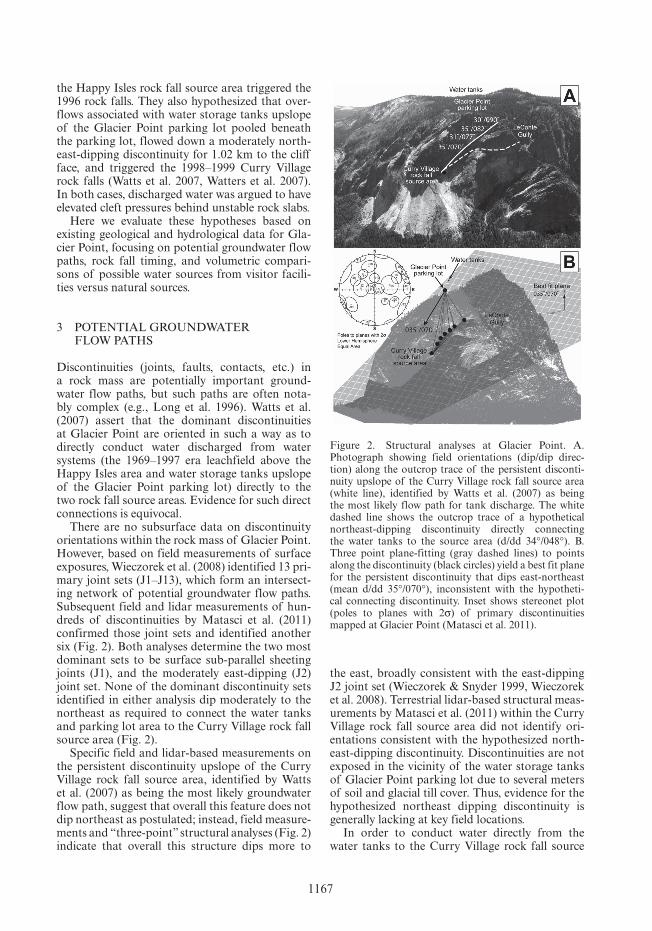
There are no subsurface data on discontinuity orientations within the rock mass of Glacier Point. However, based on field measurements of surface exposures, Wieczorek et al. (2008) identified 13 pri-mary joint sets (J1–J13), which form an intersect-ing network of potential groundwater flow paths. Subsequent field and lidar measurements of hun-dreds of discontinuities by Matasci et al. (2011) confirmed those joint sets and identified another six (Fig. 2). Both analyses determine the two most dominant sets to be surface sub-parallel sheeting joints (J1), and the moderately east-dipping (J2) joint set. None of the dominant discontinuity sets identified in either analysis dip moderately to the northeast as required to connect the water tanks and parking lot area to the Curry Village rock fall source area (Fig. 2).
Specific field and lidar-based measurements on the persistent discontinuity upslope of the Curry Village rock fall source area, identified by Watts et al. (2007) as being the most likely groundwater flow path, suggest that overall this feature does not dip northeast as postulated; instead, field measure-ments and “three-point” structural analyses (Fig. 2) indicate that overall this structure dips more to
the east, broadly consistent with the east-dipping J2 joint set (Wieczorek & Snyder 1999, Wieczorek et al. 2008). Terrestrial lidar-based structural meas-urements by Matasci et al. (2011) within the Curry Village rock fall source area did not identify ori-entations consistent with the hypothesized north-east-dipping discontinuity. Discontinuities are not exposed in the vicinity of the water storage tanks of Glacier Point parking lot due to several meters of soil and glacial till cover. Thus, evidence for the hypothesized northeast dipping discontinuity is generally lacking at key field locations.
In order to conduct water directly from the water tanks to the Curry Village rock fall source
Figure 2. Structural analyses at Glacier Point. A. Photograph showing field orientations (dip/dip direc-tion) along the outcrop trace of the persistent disconti-nuity upslope of the Curry Village rock fall source area (white line), identified by Watts et al. (2007) as being the most likely flow path for tank discharge. The white dashed line shows the outcrop trace of a hypothetical northeast-dipping discontinuity directly connecting the water tanks to the source area (d/dd 34°/048°). B. Three point plane-fitting (gray dashed lines) to points along the discontinuity (black circles) yield a best fit plane for the persistent discontinuity that dips east-northeast (mean d/dd 35°/070°), inconsistent with the hypotheti-cal connecting discontinuity. Inset shows stereonet plot (poles to planes with 2σ) of primary discontinuities mapped at Glacier Point (Matasci et al. 2011).
1168
area, the hypothetical northeast-dipping discon-tinuity would have to extend uninterrupted for 1.02 km, under as much as 300 m of rock over-burden, and would have to hydraulically bypass numerous persistent intersecting discontinuities. One such steeply dipping discontinuity controls the morphology of LeConte Gully (Figs. 1 and 2), a deeply incised gully containing an annual stream (Staircase Creek) that gains volume as it flows through the Glacier Point parking lot area toward the cliff. This suggests that LeConte Gully inter-cepts groundwater and directs it down Staircase Creek. The trend of the LeConte Gully disconti-nuity bisects the hypothetical northeast-dipping discontinuity of Watts et al. (2007). Water dis-charged from the tanks is likely also intercepted by this discontinuity and directed down Staircase Creek, away from the rock fall source area.
Individual discontinuities revealed in boreholes in Yosemite have highly variable apertures (Borchers 1996). However, it is instructive to con-sider how much water the uniform hypothetical discontinuity of Watts et al. (2007) could transmit if it were saturated throughout its 1.02 km length. With a typical fracture aperture of 3 mm and water at 4° C, the flow rate is 650,680 liters per day per meter width of the facture (distance normal to the flow direction). In a single day, each meter of the hypothetical fracture could transmit all of the water discharged from the water tanks during 1999. Because the hypothetical discontinuity would be very transmissive, it would drain easily, preclud-ing an increase of hydraulic head. Additionally, because fracture aperture typically widens near outcrop, the transmissivity of the hypothetical discontinuity would likely increase near the cliffs, making it unlikely that a flow restriction would allow hydraulic head to increase there.
4 TIMING OF WATER SYSTEM DISCHARGES AND ROCK FALLS
4.1 Seasonality of rock falls
The seasonality of rock falls at Glacier Point has been argued by Watts et al. (2007) and Watters et al. (2007) to support water system trigger-ing hypotheses, in that rock fall activity occurred broadly coincident with discharges in the late spring and summer. However, rock falls in the late spring and summer are common throughout Yosemite Valley, in areas where no water system discharges occur. Analysis of records from 1857 to 2011 (Stock et al. in review) reveals that there is not a pronounced “rock fall season” in Yosemite Valley (Fig. 3); rather, rock falls occur during all months of the year. The seasonality of rock falls at Glacier
Point is similar to that of Yosemite Valley rock falls overall (Fig. 3). Undeveloped areas without water systems such as Half Dome show a much greater tendency toward summertime rock falls (Fig. 3). Thus, seasonal timing of the Glacier Point rock falls does not support hypothesized water system triggers.
4.2 Timing of the Happy Isles rock falls
The leachfield upslope of the Happy Isles rock fall source area was removed, as planned, in 1997. In the fourteen years since the leachfield was removed, at least 16 rock falls have occurred in the Happy Isles area, 50% of which occurred during the summer, and 38% of which occurred during July. Seepage patterns at the source area visible immediately after the 1996 rock falls continue to be observed every spring and summer. Thus, seep-age patterns and rock fall timing at the Happy Isles rock fall source area are independent of leachfield discharges, diminishing the likelihood that the leachfield influenced rock-fall activity.
4.3 Timing of the Curry Village rock falls
Watts et al. (2007) claim a “direct correlation” between the timing of water tank overflows and rock falls at the Curry Village source area in 1999, offering as support a plot comparing the two (in Watts et al. 2007). However, this plot does not show actual water discharges, but rather water levels within one of two storage tanks at Glacier Point.
Using operator’s logs and flow meter records for all water sources, we show actual tank discharge volumes and compare these to rock falls from the Curry Village source area (Fig. 4). When all data are evaluated, the timing of specific rock falls does not correlate with tank discharges in 1999. The 25 May 1999 rock fall occurred prior to any known discharges (Fig. 4). Rock falls in June occurred after small discharges, but no rock falls occurred after larger discharges in late August and September. A large discharge in October, associated with seasonal tank draining, is also not
Figure 3. Seasonality of rock falls at Yosemite Valley, Glacier Point and Half Dome (1857–2011).
1169
accompanied by a rock fall from the source area; a rock fall did occur on 28 October 1999, but witness accounts suggest that it did not originate from the Curry Village source area, but rather from existing loose rock debris on a nearby ledge (Stock et al. in review), precluding elevated cleft pressures on the cliff face as the trigger. Evaluating all data reveals no temporal correlation between tank discharges and rock falls in 1999; similar lack of correlation is evident in other years.
Notably, water system discharges in the vicin-ity of the tanks occurred for at least eight years prior to the first Curry Village rock fall in 1998—at times these earlier discharges were twice as large as discharges that occurred in 1999—yet no rock falls occurred during this time period. Data from groundwater monitoring wells adjacent to the Gla-cier Point parking lot indicate that modification of the parking lot in 1997 does not cause ponding of groundwater beneath it as has been suggested.
Furthermore, patterns of seepage at the Curry Village source area following the 13 June 1999 rock fall are also present in the winter and spring before any water system discharges occur. Seepage at the rock fall source area appears closely tied to precipi-tation on the adjacent cliff face.
5 VOLUMETRIC COMPARISONS OF WATER SYSTEM DISCHARGES AND PRECIPITATION
In order to evaluate the potential significance of water system discharges in triggering rock falls at Glacier Point, it is useful to compare discharge volumes with volumes of natural water available for infiltration. Mean annual precipitation at Glacier Point is estimated to be about 95 cm, with the vast majority of precipitation delivered as snow during the fall and winter, which subsequently melts throughout the spring and early summer. Annual variability in precipitation ranges from less than half to more than twice mean annual precipitation.
5.1 Volumetric comparisons for Happy Isles
Comparison of leachate volumes discharged upslope from the Happy Isles rock fall source area with precipitation falling in a watershed (73,250 m2) that drains to the source area reveals that, during the period 1988–1997, average pre-cipitation exceeded average leachate by a factor of 30. The annual variability in precipitation was 10 times greater than leachate discharges, suggesting that these discharges could not generate unique cleft pressure conditions.
5.2 Volumetric comparisons for Curry Village
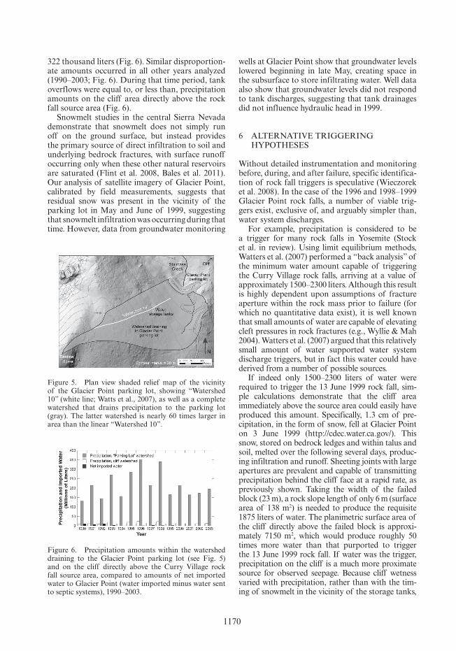
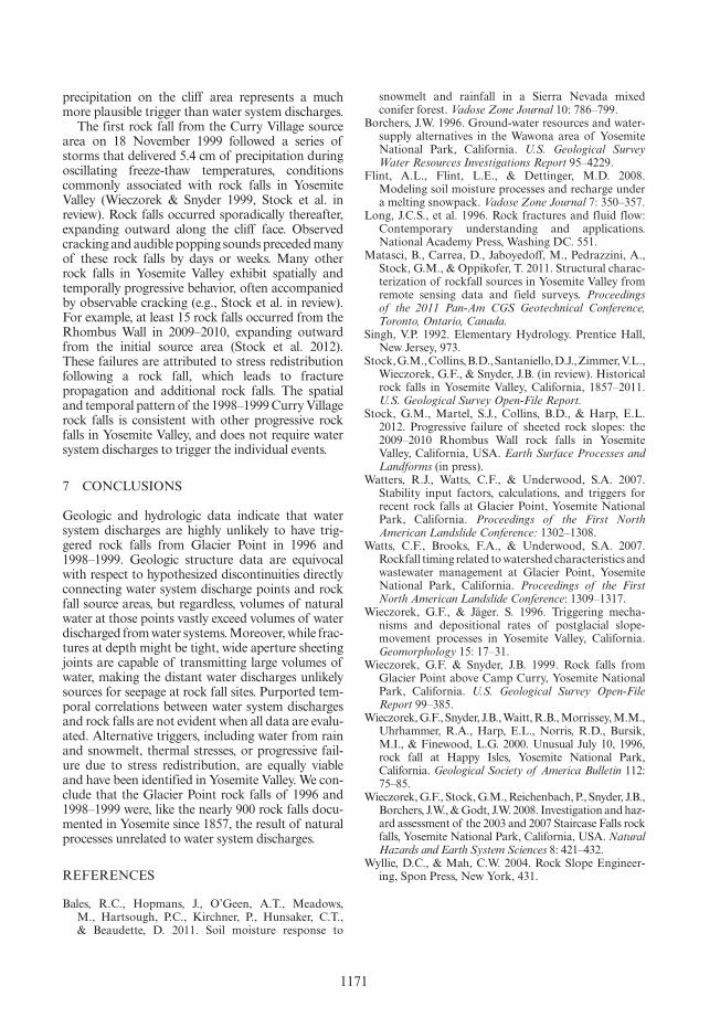
Watts et al. (2007) compared tank overflow vol-umes in 1999 with precipitation amounts for that year. They did so by delineating a linear region (“Watershed 10”) upslope of the storage tanks, with an area of 3931 m2. Because this “watershed” extends 540 m upslope, its width must be less than 8 m. Watts et al. (2007) calculate a volume of pre-cipitation falling in this area in 1999 of 3.21 mil-lion liters. This volume was subsequently reduced to 106–159 thousand liters by applying the Rational Method for calculating runoff from rainfall, assum-ing that most precipitation became runoff rather than infiltration, and assuming that some pre-cipitation was diverted by unspecified “modified terrain” (note that the Rational Method is typically used to estimate rainfall runoff in urbanizing areas, not snowmelt runoff in forested watersheds; Singh 1992). Comparing this amount of water assumed by Watts et al. (2007) to infiltrate from precipitation with the approximately 322 thousand liters of water discharged from the storage tanks between January and June of 1999, Watts et al. (2007) conclude that natural water sources “were insignificant in com-parison to the quantities of wastewater released”.
This analysis is flawed for several reasons. Foremost, “Watershed 10” does not accurately por-tray a watershed that drains precipitation through the area of the storage tanks to the Glacier Point parking lot. Watts et al. (2007) justify the narrow width of “Watershed 10” by asserting that it sits “on the rounded divide of a topographic spur sloping downward from Sentinel Dome toward the Glacier Point parking lot”, but topographic mod-els derived from airborne lidar data do not support the existence of a “topographic spur”; rather, the hillslope here dips uniformly toward the parking lot (Fig. 5). Topographic analysis of drainage to the Glacier Point parking lot yields a watershed with a minimum planimetric area of approximately 228,100 m2, nearly 60 times larger than “Watershed 10” (Fig. 5). Precipitation falling on this watershed in 1999 amounts to more than 185 million liters, vastly exceeding tank overflows of approximately
Figure 4. Water discharges from storage tanks at Glacier Point (black bars) and rock falls from the Curry Village source area (gray arrows) as a function of time, May–November 1999.
1170
322 thousand liters (Fig. 6). Similar disproportion-ate amounts occurred in all other years analyzed (1990–2003; Fig. 6). During that time period, tank overflows were equal to, or less than, precipitation amounts on the cliff area directly above the rock fall source area (Fig. 6).
Snowmelt studies in the central Sierra Nevada demonstrate that snowmelt does not simply run off on the ground surface, but instead provides the primary source of direct infiltration to soil and underlying bedrock fractures, with surface runoff occurring only when these other natural reservoirs are saturated (Flint et al. 2008, Bales et al. 2011). Our analysis of satellite imagery of Glacier Point, calibrated by field measurements, suggests that residual snow was present in the vicinity of the parking lot in May and June of 1999, suggesting that snowmelt infiltration was occurring during that time. However, data from groundwater monitoring
wells at Glacier Point show that groundwater levels lowered beginning in late May, creating space in the subsurface to store infiltrating water. Well data also show that groundwater levels did not respond to tank discharges, suggesting that tank drainages did not influence hydraulic head in 1999.
6 ALTERNATIVE TRIGGERING HYPOTHESES
Without detailed instrumentation and monitoring before, during, and after failure, specific identifica-tion of rock fall triggers is speculative (Wieczorek et al. 2008). In the case of the 1996 and 1998–1999 Glacier Point rock falls, a number of viable trig-gers exist, exclusive of, and arguably simpler than, water system discharges.
For example, precipitation is considered to be a trigger for many rock falls in Yosemite (Stock et al. in review). Using limit equilibrium methods, Watters et al. (2007) performed a “back analysis” of the minimum water amount capable of triggering the Curry Village rock falls, arriving at a value of approximately 1500–2300 liters. Although this result is highly dependent upon assumptions of fracture aperture within the rock mass prior to failure (for which no quantitative data exist), it is well known that small amounts of water are capable of elevating cleft pressures in rock fractures (e.g., Wyllie & Mah 2004). Watters et al. (2007) argued that this relatively small amount of water supported water system discharge triggers, but in fact this water could have derived from a number of possible sources.
If indeed only 1500–2300 liters of water were required to trigger the 13 June 1999 rock fall, sim-ple calculations demonstrate that the cliff area immediately above the source area could easily have produced this amount. Specifically, 1.3 cm of pre-cipitation, in the form of snow, fell at Glacier Point on 3 June 1999 (http://cdec.water.ca.gov/). This snow, stored on bedrock ledges and within talus and soil, melted over the following several days, produc-ing infiltration and runoff. Sheeting joints with large apertures are prevalent and capable of transmitting precipitation behind the cliff face at a rapid rate, as previously shown. Taking the width of the failed block (23 m), a rock slope length of only 6 m (surface area of 138 m2) is needed to produce the requisite 1875 liters of water. The planimetric surface area of the cliff directly above the failed block is approxi-mately 7150 m2, which would produce roughly 50 times more water than that purported to trigger the 13 June 1999 rock fall. If water was the trigger, precipitation on the cliff is a much more proximate source for observed seepage. Because cliff wetness varied with precipitation, rather than with the tim-ing of snowmelt in the vicinity of the storage tanks,
Figure 5. Plan view shaded relief map of the vicinity of the Glacier Point parking lot, showing “Watershed 10” (white line; Watts et al., 2007), as well as a complete watershed that drains precipitation to the parking lot (gray). The latter watershed is nearly 60 times larger in area than the linear “Watershed 10”.
Figure 6. Precipitation amounts within the watershed draining to the Glacier Point parking lot (see Fig. 5) and on the cliff directly above the Curry Village rock fall source area, compared to amounts of net imported water to Glacier Point (water imported minus water sent to septic systems), 1990–2003.
1171
precipitation on the cliff area represents a much more plausible trigger than water system discharges.
The first rock fall from the Curry Village source area on 18 November 1999 followed a series of storms that delivered 5.4 cm of precipitation during oscillating freeze-thaw temperatures, conditions commonly associated with rock falls in Yosemite Valley (Wieczorek & Snyder 1999, Stock et al. in review). Rock falls occurred sporadically thereafter, expanding outward along the cliff face. Observed cracking and audible popping sounds preceded many of these rock falls by days or weeks. Many other rock falls in Yosemite Valley exhibit spatially and temporally progressive behavior, often accompanied by observable cracking (e.g., Stock et al. in review). For example, at least 15 rock falls occurred from the Rhombus Wall in 2009–2010, expanding outward from the initial source area (Stock et al. 2012). These failures are attributed to stress redistribution following a rock fall, which leads to fracture propagation and additional rock falls. The spatial and temporal pattern of the 1998–1999 Curry Village rock falls is consistent with other progressive rock falls in Yosemite Valley, and does not require water system discharges to trigger the individual events.
7 CONCLUSIONS
Geologic and hydrologic data indicate that water system discharges are highly unlikely to have trig-gered rock falls from Glacier Point in 1996 and 1998–1999. Geologic structure data are equivocal with respect to hypothesized discontinuities directly connecting water system discharge points and rock fall source areas, but regardless, volumes of natural water at those points vastly exceed volumes of water discharged from water systems. Moreover, while frac-tures at depth might be tight, wide aperture sheeting joints are capable of transmitting large volumes of water, making the distant water discharges unlikely sources for seepage at rock fall sites. Purported tem-poral correlations between water system discharges and rock falls are not evident when all data are evalu-ated. Alternative triggers, including water from rain and snowmelt, thermal stresses, or progressive fail-ure due to stress redistribution, are equally viable and have been identified in Yosemite Valley. We con-clude that the Glacier Point rock falls of 1996 and 1998–1999 were, like the nearly 900 rock falls docu-mented in Yosemite since 1857, the result of natural processes unrelated to water system discharges.
REFERENCES
Bales, R.C., Hopmans, J., O’Geen, A.T., Meadows, M., Hartsough, P.C., Kirchner, P., Hunsaker, C.T., & Beaudette, D. 2011. Soil moisture response to
snowmelt and rainfall in a Sierra Nevada mixed conifer forest. Vadose Zone Journal 10: 786–799.
Borchers, J.W. 1996. Ground-water resources and water-supply alternatives in the Wawona area of Yosemite National Park, California. U.S. Geological Survey Water Resources Investigations Report 95–4229.
Flint, A.L., Flint, L.E., & Dettinger, M.D. 2008. Modeling soil moisture processes and recharge under a melting snowpack. Vadose Zone Journal 7: 350–357.
Long, J.C.S., et al. 1996. Rock fractures and fluid flow: Contemporary understanding and applications. National Academy Press, Washing DC. 551.
Matasci, B., Carrea, D., Jaboyedoff, M., Pedrazzini, A., Stock, G.M., & Oppikofer, T. 2011. Structural charac-terization of rockfall sources in Yosemite Valley from remote sensing data and field surveys. Proceedings of the 2011 Pan-Am CGS Geotechnical Conference, Toronto, Ontario, Canada.
Singh, V.P. 1992. Elementary Hydrology. Prentice Hall, New Jersey, 973.
Stock, G.M., Collins, B.D., Santaniello, D.J., Zimmer, V.L., Wieczorek, G.F., & Snyder, J.B. (in review). Historical rock falls in Yosemite Valley, California, 1857–2011. U.S. Geological Survey Open-File Report.
Stock, G.M., Martel, S.J., Collins, B.D., & Harp, E.L. 2012. Progressive failure of sheeted rock slopes: the 2009–2010 Rhombus Wall rock falls in Yosemite Valley, California, USA. Earth Surface Processes and Landforms (in press).
Watters, R.J., Watts, C.F., & Underwood, S.A. 2007. Stability input factors, calculations, and triggers for recent rock falls at Glacier Point, Yosemite National Park, California. Proceedings of the First North American Landslide Conference: 1302–1308.
Watts, C.F., Brooks, F.A., & Underwood, S.A. 2007. Rockfall timing related to watershed characteristics and wastewater management at Glacier Point, Yosemite National Park, California. Proceedings of the First North American Landslide Conference: 1309–1317.
Wieczorek, G.F., & Jäger. S. 1996. Triggering mecha-nisms and depositional rates of postglacial slope-movement processes in Yosemite Valley, California. Geomorphology 15: 17–31.
Wieczorek, G.F. & Snyder, J.B. 1999. Rock falls from Glacier Point above Camp Curry, Yosemite National Park, California. U.S. Geological Survey Open-File Report 99–385.
Wieczorek, G.F., Snyder, J.B., Waitt, R.B., Morrissey, M.M., Uhrhammer, R.A., Harp, E.L., Norris, R.D., Bursik, M.I., & Finewood, L.G. 2000. Unusual July 10, 1996, rock fall at Happy Isles, Yosemite National Park, California. Geological Society of America Bulletin 112: 75–85.
Wieczorek, G.F., Stock, G.M., Reichenbach, P., Snyder, J.B., Borchers, J.W., & Godt, J.W. 2008. Investigation and haz-ard assessment of the 2003 and 2007 Staircase Falls rock falls, Yosemite National Park, California, USA. Natural Hazards and Earth System Sciences 8: 421–432.
Wyllie, D.C., & Mah, C.W. 2004. Rock Slope Engineer-ing, Spon Press, New York, 431.