59
TRANSPORTATION Document 259646 – RW – 230-50-0001 BC Ministry of Transportation and Infrastructure Evaluation of the E & N Railway Corridor: Baseline Reference Report FINAL
TRANSPORTATION
Document 259646 – RW – 230-50-0001
BC Ministry of Transportation and Infrastructure
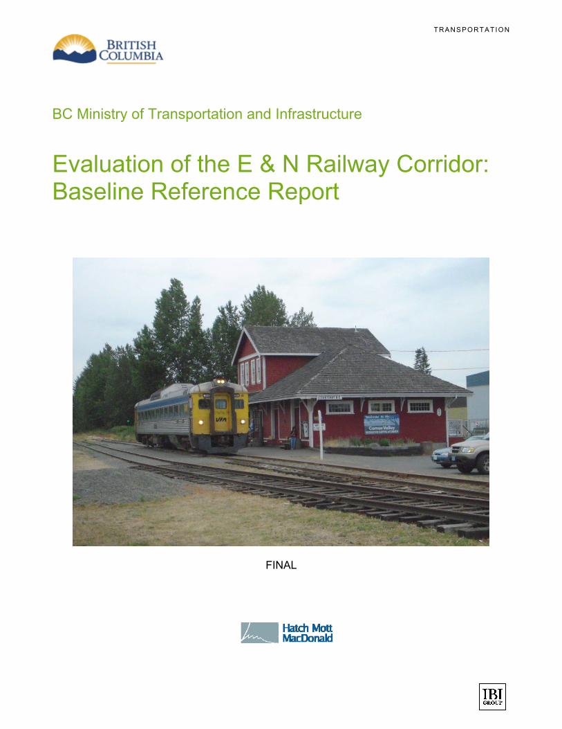
Evaluation of the E & N Railway Corridor: Baseline Reference Report
FINAL
F I N A L D R A F T – O C T O B E R 8 , 2 0 0 9
O C T O B E R 2 0 0 9 i
TABLE OF CONTENTS
EXECUTIVE SUMMARY ........................................................................................................................... 1
1. BACKGROUND AND OBJECTIVES ................................................................................................. 3
1.1 Study Team ............................................................................................................................................ 5
1.2 Report Structure .................................................................................................................................... 5
2. FACILITIES ASSESSMENT APPROACH ........................................................................................... 6
2.1 Assessment Scope & Criteria .............................................................................................................. 6
2.2 Reference Documents .......................................................................................................................... 7
2.3 Methodology .......................................................................................................................................... 8
3. RAIL CORRIDOR CONDITION ASSESSMENT ................................................................................... 9
3.1 Roadbed ................................................................................................................................................. 9
I. Drainage ............................................................................................................................................... 10
II. Vegetation ............................................................................................................................................ 10
3.2 Track Structure .................................................................................................................................... 13
3.3 Bridges and Culverts .......................................................................................................................... 21
3.4 Yard Condition ..................................................................................................................................... 22
3.5 Communications ................................................................................................................................. 23
3.6 Fencing ................................................................................................................................................ 23
3.7 Barge Ramp ......................................................................................................................................... 23
3.8 Crossings ............................................................................................................................................. 24
3.9 Wire Crossings and Clearances ........................................................................................................ 25
3.10 Passenger Stations, Shops and Offices............................................................................................ 25
3.11 Trespasser Issues ............................................................................................................................... 26
3.12 Operating Speed Constraints ............................................................................................................. 26
3.13 Operating Load Restrictions .............................................................................................................. 26
3.14 Signals Condition Assessment .......................................................................................................... 27
3.15 Condition Assessment Summary ...................................................................................................... 30
4. BASELINE IMPROVEMENTS ........................................................................................................ 31
4.1 Immediate maintenance and rehabilitation ....................................................................................... 31
4.2 Recommendations for detailed assessment studies ....................................................................... 31
5. RECONFIGURATION OPTIONS ..................................................................................................... 32
6. COST ESTIMATES ...................................................................................................................... 33
7. ENVIRONMENTAL OVERVIEW ..................................................................................................... 34
7.1 Assessment Scope & Criteria ............................................................................................................ 34
F I N A L D R A F T – O C T O B E R 8 , 2 0 0 9
O C T O B E R 2 0 0 9 ii
7.2 Review of Available Environmental Data & Gap Identification ....................................................... 35
7.3 Environmental Review of Business Plan Options ............................................................................ 38
7.4 Environmental Regulatory Requirements ......................................................................................... 40
7.5 The Business Plan Options and Associated Environmental Regulatory Processes .................... 46
APPENDICES ........................................................................................................................................ A
Disclaimer This document is issued for the party which commissioned it and for specific purposes connected with the above-captioned project only. It should not be relied upon by any other party or used for any other purpose. Hatch Mott MacDonald accept no responsibility for the consequences of this document being relied upon by any other party, or being used for any other purpose, or containing any error or omission which is due to an error or omission in data supplied to Hatch Mott MacDonald by other parties.” This document contains confidential information and proprietary intellectual property. It should not be shown to other parties without consent from Hatch Mott MacDonald and from the party which commissioned it.” Copyright Declaration Copyright © 2009. Hatch Mott MacDonald Inc. All rights reserved.
Primary Contact Barry Singer, P.Eng Deputy Practice Leader – Rail and Transit Senior Associate Hatch Mott MacDonald Ste. 1010 – 1066 West Hastings Street Vancouver, BC V6E 3X2 Telephone: 604-629-1736 Fax: 604-639-1191 Direct Telephone: 604-639-1036 E-mail: [email protected]

F I N A L D R A F T – O C T O B E R 8 , 2 0 0 9
O C T O B E R 2 0 0 9 1
EXECUTIVE SUMMARY
The Island Corridor Foundation (ICF) is the owner of the historic Esquimalt and Nanaimo (E & N) Railway on Vancouver Island. Currently, the Railway is operated and maintained by Southern Railway Vancouver Island (SRVI) between Victoria and Courtenay. There is an out-of-service leg between Parksville and Port Alberni that was previously operated by RailAmerica.
The British Columbia Ministry of Transportation and Infrastructure (BC MoT) commissioned this study to support the investigation and identification of business plan options to ensure the long term viability of operating and maintaining the E & N Railway Corridor. The ICF has been engaged in this study as the owners of the railway.
Hatch Mott MacDonald (HMM) was engaged to review and validate past facility assessment reports, carry out a site visit including an inspection of the operating trackage and provide advice on railway maintenance and Capital costs to support specific business plans developed by IBI. This report includes an overview of the current Railway condition.
The existing traffic is a twice daily passenger service between Victoria and Courtenay and a small volume of freight (less than 1,000 car loads) mainly between Duncan and Courtenay.
Rail Corridor Condition Assessment
The track was inspected by hi-rail vehicle (highway truck with convertible steel wheels for rail travel) on June 15-17, 2009 from Victoria to Courtenay including the Wellcox spur and yard. Southern Railway Vancouver Island supervisors were interviewed. They shared their extensive experience and records of the long term maintenance history of the infrastructure and current issues. The track from Parksville to Port Alberni was too overgrown with vegetation to allow a hi-rail vehicle inspection.
The Railway condition is considered not to be in compliance with BC Safety Authority Railway Regulations and Rules Respecting Track Safety (Part 30) for Common Carrier Railways in the following areas:
Vegetation growth in the ballast section and crossing approaches
Clusters of decayed ties and decayed ties under the rail joints
Worn, loose rail joints and frozen bolts
In brief, the track structure is in poor to fair condition. Automatic crossing signal conditions are deteriorating. Current Capital and maintenance resources are inadequate to safely maintain the track. Over the last several years, maintenance has included some vegetation control and the use of Holland Trackstar testing equipment to identify the worst decayed tie clusters.
Significant Capital investment has been deferred for the last several decades except where funded by road authorities at crossings for railway realignment to accommodate the construction of the Island highway; and to replace a burned bridge. In particular, tie replacements have not been at a sustaining level.
Without a significant on-going investment in ties and rail joint maintenance, the line will become inoperable. Other Capital requirements include bridge repair and crossing protection replacement.
F I N A L D R A F T – O C T O B E R 8 , 2 0 0 9
O C T O B E R 2 0 0 9 2
Baseline Improvements & Reconfiguration Options
The rail corridor condition assessment indicated a pressing need for repair and increased maintenance of the corridor if only to support existing usage. These improvements are covered by the associated business plan options for maintaining existing freight and VIA Rail services.
Options for reconfiguration of the corridor and rail facilities follow the business plans identified in the course of this study. These include commuter rail service between Victoria and Langford; maintaining freight service between Duncan and Courtenay; reopening freight service between Parksville and Port Alberni; and developing passenger and tourist services between Victoria and Courtenay as well as vintage rail excursions from Port Alberni.
Cost Estimates
Conceptual capital cost estimates have been developed for each of the business plan options developed through this project. These estimates cover capital expenditures over a period of five years as applicable to each configuration option. No allowances have been included for operation costs.
Environmental Overview
Review of documents provided by the ICF as well as web-based search indicates that there has been a very limited environmental study undertaken to support business plan initiatives and complete due diligence investigations. It is recognised that each of these corridor business plan alternatives (or overall combination of alternatives considered as a whole) would likely pose differing constraints and opportunities for the surrounding communities and the natural environment. Therefore environmental assessments would have to be carried out to support the regulatory processes required for any specific business plan option.
It is assumed that all of the business plan options will not be initiated at the same time. From the business plan options under consideration there are two which would likely require an environmental assessment: the Victoria-Langford Commuter Rail option and the Alberni-Parksville line re-commissioning. Although the Commuter Rail option falls below the BCEAA 20km threshold for mandatory assessment, the potential for socio-economic impacts warrants a voluntary review. The Alberni-Parksville segment of the corridor has not been in use since 2002 and re-opening this rail service may trigger the provincial EA process if the project was considered “new” and not a modification to an existing facility.
The other business plan options do not appear to require any significant infrastructure (e.g., re-build stations) nor would materially increase rail traffic in the short term. Therefore we would expect that there would be little (e.g., municipal permitting for stations), or in the case of repair and maintenance, no environmental assessment certification required.
F I N A L D R A F T – O C T O B E R 8 , 2 0 0 9
O C T O B E R 2 0 0 9 3
1. BACKGROUND AND OBJECTIVES
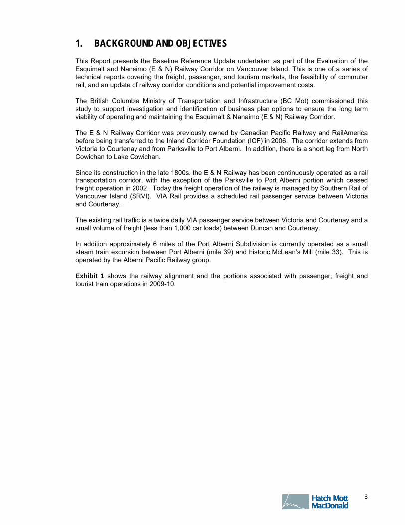
This Report presents the Baseline Reference Update undertaken as part of the Evaluation of the Esquimalt and Nanaimo (E & N) Railway Corridor on Vancouver Island. This is one of a series of technical reports covering the freight, passenger, and tourism markets, the feasibility of commuter rail, and an update of railway corridor conditions and potential improvement costs.
The British Columbia Ministry of Transportation and Infrastructure (BC Mot) commissioned this study to support investigation and identification of business plan options to ensure the long term viability of operating and maintaining the Esquimalt & Nanaimo (E & N) Railway Corridor.
The E & N Railway Corridor was previously owned by Canadian Pacific Railway and RailAmerica before being transferred to the Inland Corridor Foundation (ICF) in 2006. The corridor extends from Victoria to Courtenay and from Parksville to Port Alberni. In addition, there is a short leg from North Cowichan to Lake Cowichan.
Since its construction in the late 1800s, the E & N Railway has been continuously operated as a rail transportation corridor, with the exception of the Parksville to Port Alberni portion which ceased freight operation in 2002. Today the freight operation of the railway is managed by Southern Rail of Vancouver Island (SRVI). VIA Rail provides a scheduled rail passenger service between Victoria and Courtenay.
The existing rail traffic is a twice daily VIA passenger service between Victoria and Courtenay and a small volume of freight (less than 1,000 car loads) between Duncan and Courtenay.
In addition approximately 6 miles of the Port Alberni Subdivision is currently operated as a small steam train excursion between Port Alberni (mile 39) and historic McLean’s Mill (mile 33). This is operated by the Alberni Pacific Railway group.
Exhibit 1 shows the railway alignment and the portions associated with passenger, freight and tourist train operations in 2009-10.

F I N A L D R A F T – O C T O B E R 8 , 2 0 0 9
O C T O B E R 2 0 0 9 4
Exhibit 1: E & N Railway Corridor – Current Operation
Tourist Train
VIA Passenger
Freight + VIA
Source: IBI Group

F I N A L D R A F T – O C T O B E R 8 , 2 0 0 9
O C T O B E R 2 0 0 9 5
1.1 Study Team
The assessment of the railway facilities was carried out by a team of experienced professionals. IBI Group was the prime consultant to manage, coordinate and compile information from other consultants for this Baseline Reference Study.
Hatch Mott MacDonald (HMM), railway infrastructure experts, reviewed and validated past facility assessment reports, carried out site visits and determined elements necessary for railway maintenance and to support specific business plans. HMM was assisted by Anthony Steadman Associates on cost estimates. Hatch Ltd. provided environmental overview input into this study.
In addition, the condition assessment of the existing facilities was supported by information provided by following organizations involved in the current railway operation:
Island Corridor Foundation
Southern Railway of Vancouver Island
Seaspan
The assessment made use of information from previous studies undertaken by IBI, Southern Railway Vancouver Island and DRE Transportation Inc. The reports from these studies are listed in Appendix A, in addition to the inspection team.
1.2 Report Structure
The Baseline Reference Report covers review of past railway facilities assessment studies, observations as to the validity of such assessments information for business plan development; provides recommendations for future assessments; summarizes data to support potential business plans identified under this project; and provides an environmental overview including anticipated regulatory process for expansion of corridor railway operations / development.
The report includes the following main sections:
Background and Objectives
Facilities Assessment Approach
Corridor Condition Assessment
Baseline Improvements
Reconfiguration Options
Cost Estimates
Environmental Overview

F I N A L D R A F T – O C T O B E R 8 , 2 0 0 9
O C T O B E R 2 0 0 9 6
2. FACILITIES ASSESSMENT APPROACH
As part of the valuation of the E & N Railway Corridor, an assessment of the present condition of the railway’s infrastructure is required as summarized below. This assessment is required to contain sufficient information to enable an order of magnitude determination of the time and costs to upgrade the existing railway to a level that complies with legislated safety requirements appropriate to carry future traffic requirements under the contemplated business plans. These plans are described separately from this Baseline Reference Report and include forecasts for freight and passenger movements.
2.1 Assessment Scope & Criteria
The primary basis in preparing the updated baseline infrastructure condition assessment will be the asset evaluation documents used to support the Canadian Pacific Railway’s donation of its property and improvements to the ICF. Appraisal studies related to the valuation of these assets were carried out during 2003 and 2005. These studies also included assessment of the condition of track, signals and associated railway facilities such as bridges and culverts. The study findings are documented in IBI reports dated January 2004 covering the E & N Railroad corridor; and the January 2006 report covering the RailAmerica corridor. These documents consist of policy papers, land and improvement evaluations, track condition and geotechnical reports, rail and track replacement cost assessments, grade crossing signal valuations, and bridge and culvert condition assessments.
Further information regarding facilities condition is documented in the Property Appraisal Report concerning the E & N Railway Stations prepared by Ray Baker Appraisals Inc. for Canadian Pacific Railway 2004, and E & N Infrastructure Capital Plan prepared for ICF by DRE Transportation Solutions Inc. June 2006.
In addition, a “Limited Phase 1 Environmental Site Assessment E & N Railway” report prepared by Jacques Whitford Environment Ltd. (report dated December 2003) was reviewed. No reference documents were provided or discovered for any environmental study of the RailAmerica corridor.
The facilities covered by the assessment were prescribed by MoT to include:
1. Victoria and Port Alberni Subdivisions
2. Wellcox Yard and barge slip
3. All passenger stations
4. All industrial spurs and sidings now serviced by the railway
5. Nanaimo offices and workshops
6. All bridges and trestles
7. All grade crossings including pedestrian crossings
It is noted that the previous evaluation studies referenced above did not cover items 2, 3, 4 and 5 noted above, or any pedestrian crossings. Consequently the level of assessment of these facilities has been limited to within the rail corridor inspection carried out under this study. The assessment was also supported by discussions with facility operations personnel.
F I N A L D R A F T – O C T O B E R 8 , 2 0 0 9
O C T O B E R 2 0 0 9 7
The assessment of the physical plant and right-of-way was requested by BC Mot to address the following elements:
Roadbed, including drainage, vegetation growth
Track geometry of the main track, including gauge, alignment, curvature, curve elevation and surface
Track component evaluation, including condition of rail, track ties, rail joints, other rail fastenings, track ballast, and turnouts (switches, frogs, etc)
Bridges, trestles, tunnels, culverts & similar structures, including condition, ability to carry traffic
Yard tracks, including overall condition and layout
Industrial sidings & spurs (either owned or operated on), including condition of both track and loading / unloading facilities
Communications equipment, including condition of radios and other communications equipment
Fencing, including condition and adequacy
Barge ramp, including condition of track, structures and mechanical equipment
Grade crossings, including condition of sight lines and crossing surfaces
Grade crossing protection, including type and condition of protection and advanced warning signs
Wire crossings, including clearances and conditions of supporting structures
Yard and main track clearances, including clearance between tracks, in bridges, tunnels, overpasses, structures and buildings, and signage condition and location
Passenger stations, including condition, clearances, protection and signage, adequacy of occupation provisions, fire protection, location and adequacy of ingress / egress locations
Work shops and offices, including adequacy and general condition
Some of the above parameters noted above are outside the level of effort assigned to this project. For example, determination of load capacity of bridges warrants archive search for original design drawings (or extensive field measurements), detailed site inspections, materials sampling and testing, together with engineering analyses. Where foundations are located on soils or at river crossings geotechnical investigation can also be expected. Such investigations are likely to be warranted to implement some business plan options.
2.2 Reference Documents To provide the basis for the Canadian Pacific Railway’s donation of its property and improvements to the ICF, appraisal studies related to the valuation of these assets were carried out during 2003 and 2005. These studies also included a screening level assessment of the condition of track, signals and associated railway facilities such as bridges and culverts. The HMM review of these study documents in conjunction with other reports and together with the site overview, confirms the validity of use of these reports for this project. The reference documents reviewed for this Baseline Reference Report are listed in Appendix A.

F I N A L D R A F T – O C T O B E R 8 , 2 0 0 9
O C T O B E R 2 0 0 9 8
2.3 Methodology
This assessment comprises of five primary components:
Assessment of the existing evaluation data provided by BC MoT and the ICF as to general completeness and suitability for use on the project. These assessments include the primary condition data on which Baseline Reference Report assessment has been based. The reports comprise the IBI report dated January 2004 covering the E & N Railroad corridor; the IBI report dated January 2006 covering the RailAmerica corridor, and other reports listed in Appendix A.
The environmental overview made use of a “Limited Phase 1 Environmental Site Assessment E & N Railway” report prepared by Jacques Whitford Environment Ltd. (Report dated December 2003), as well as vegetation and pest management reports. No reference environmental documents were provided by BC Mot or ICF, nor following a web search appear to exist, for the RailAmerica corridor.
Site assessment of existing facilities not covered by the previous evaluation studies. This assessment was carried out at a screening level appropriate to support the development of the business plans.
Compliance overview of the rail infrastructure with current practice and the British Columbia’s railway safety legislation.
Compilation of cost data to support the financial components of the business plans.
The assessment of the rail corridor and associated facilities did not include any geotechnical review, determination of facility seismic resistance or for vulnerability to settlement from past mining operations along the corridor.
F I N A L D R A F T – O C T O B E R 8 , 2 0 0 9
O C T O B E R 2 0 0 9 9
3. RAIL CORRIDOR CONDITION ASSESSMENT
Southern Railway Vancouver Island supervision staff was interviewed and then the line was inspected by hi-rail vehicle from June 15th to 17th, 2009. SRVI staff shared their extensive experience and records of the long term maintenance history of the infrastructure and current issues. The track was inspected from Victoria to Courtenay including the Wellcox spur and yard. The track from Parksville to Port Alberni was inaccessible to hi-rail due to vegetation growth. As a result site review was limited from several crossings driven to by road.
The team inspector’s findings and suggestions were communicated verbally to E & N Track Maintenance Supervisors Al Kutaj and Bryon Reed. This report draws extensively on their comments and 28 year history with the Railway in “track and structures” maintenance.
Site review of signal facilities was conducted by Mr. Bohmert on July 23, 2009 with the assistance of Don McGregor, General Manager and Marvin Beveridge and Kevin Eppele, Signals and Communications Maintainers of the Southern Railway of Vancouver Island. Site visits covered the signal maintenance facility in Nanaimo, representative crossing signal installations between Nanaimo and Victoria, and a number of unsignalled crossings in the Langford-Victoria corridor were examined. The latter in the context of a potential commuter rail service. The rock fall hazard areas near mileage 16 were also studied to assess the location for a possible slide detector fence installation.
The observations from the site review and discussions with Southern Rail staff, together from review of the reference Valuation Study reports are noted below
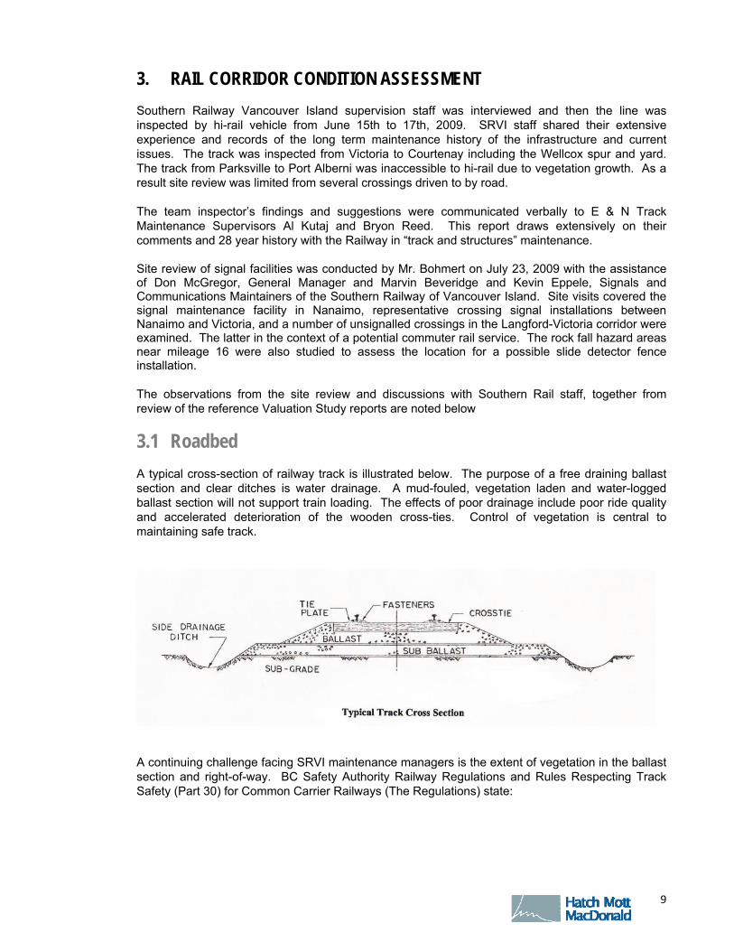
3.1 Roadbed
A typical cross-section of railway track is illustrated below. The purpose of a free draining ballast section and clear ditches is water drainage. A mud-fouled, vegetation laden and water-logged ballast section will not support train loading. The effects of poor drainage include poor ride quality and accelerated deterioration of the wooden cross-ties. Control of vegetation is central to maintaining safe track.
A continuing challenge facing SRVI maintenance managers is the extent of vegetation in the ballast section and right-of-way. BC Safety Authority Railway Regulations and Rules Respecting Track Safety (Part 30) for Common Carrier Railways (The Regulations) state:

F I N A L D R A F T – O C T O B E R 8 , 2 0 0 9
O C T O B E R 2 0 0 9 10
I. Drainage
Each drainage or other water carrying facility under or immediately adjacent to the roadbed must be maintained and kept free of obstruction, to accommodate expected water flow for the area concerned.
II. Vegetation
Vegetation on railway property which is on or immediately adjacent to roadbed must be controlled so that it does not:
a. become a fire hazard to track-carrying structures;
b. obstruct visibility of railway signs and signals;
c. interfere with railway employees performing normal track side duties;
d. prevent proper functioning of signal and communication lines; or
e. prevent railway employees from visually inspecting moving equipment from their normal duty stations.
The existing vegetation conditions are considered to be in contravention to the above rules. In particular, the density of vegetation prevents Track Inspectors from viewing the condition of joints and fastenings; and, foliage on the rails has interfered with the signal shunt which activates crossing signals upon the approach of a train.
Boundary between treated and non-treated sections. Extensive growth hides the condition of joint bars, tie plates and ties. The vegetation traps water in the ballast section and limits drainage in the ditches.

F I N A L D R A F T – O C T O B E R 8 , 2 0 0 9
O C T O B E R 2 0 0 9 11
Since 2006, the SRVI has developed and is implementing a Pest Management Plan (PMP). The PMP uses herbicides combined with mechanical methods of brush control. The current vegetation condition appears much improved from an inspection carried out in 2006 but is still not considered adequate. The herbicide used, “Vantage”, has no impact on pre-emergent weeds so effectiveness is very dependant on the timing of the spraying to plant life cycle. Generally, very good progress is being made wherever it has been employed. About 10% - 15% of the trackage is in non-treatment zones and other means should be employed.
Brush removal is required to restore and maintain crossing sightlines to standard. There is legal hazard to the railway in the instance of a crossing accident where required sightlines have not been maintained for visibility of the signs and / or signals or for a vehicle looking down the track for an approaching train.
Near Courtenay looking north Showing start of re-growth in
the sprayed area and a non-spray area
Note: obscured crossing sightlines due to brush
Note trees at a leaning angle in proximity to the track
Victoria Yard: Note effectiveness of herbicide on existing plants directly sprayed in the ballast section but no effect on plants that were pre-emergent in their growth cycle at time of application.
F I N A L D R A F T – O C T O B E R 8 , 2 0 0 9
O C T O B E R 2 0 0 9 12
Brush removal is also required beneath bridges. A priority would be any bridges with timber trestle approaches. The Railway’s bridges should be fire guarded. Brake shoe sparking, maintenance welding or cutting, trespasser smoking and adjacent forest fire have all been ignition sources to brush that have consumed railway bridges by fire in British Columbia. A mulcher / chipper should be employed to avoid leaving drying branches.
There should be a continuing effort for the pre-emptive removal of “danger trees”. The removal of some “danger trees” on the crests of slopes will avoid wind-fall or jacking loose of rock debris. Historically, the VIA Dayliner has been damaged several times by impact with fallen trees. The priorities are trees on the side and crests of rock slopes or in areas where adjacent forest has been removed leaving a thin screen of high trees susceptible to wind-throw.
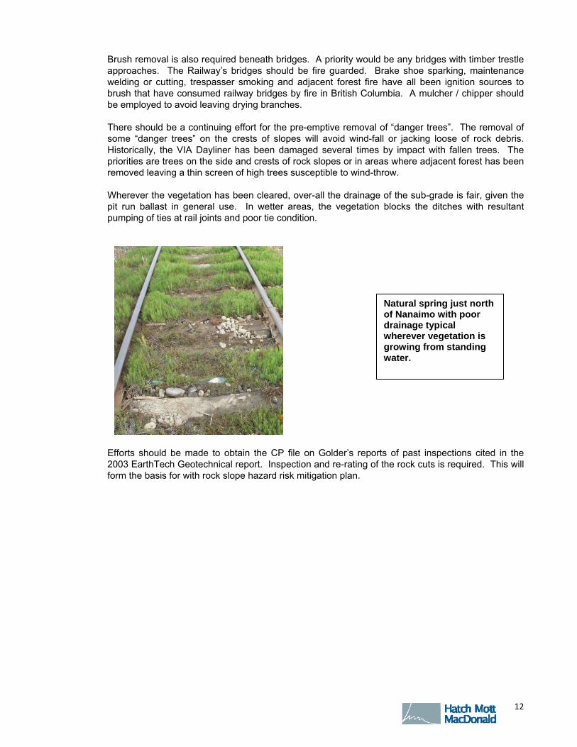
Wherever the vegetation has been cleared, over-all the drainage of the sub-grade is fair, given the pit run ballast in general use. In wetter areas, the vegetation blocks the ditches with resultant pumping of ties at rail joints and poor tie condition.
Efforts should be made to obtain the CP file on Golder’s reports of past inspections cited in the 2003 EarthTech Geotechnical report. Inspection and re-rating of the rock cuts is required. This will form the basis for with rock slope hazard risk mitigation plan.
Natural spring just north of Nanaimo with poor drainage typical wherever vegetation is growing from standing water.

F I N A L D R A F T – O C T O B E R 8 , 2 0 0 9
O C T O B E R 2 0 0 9 13
It was noted that trains are instructed to stop short of potential rock fall sites at Mile 15.6, 15.7, 16.2 and 16.3
3.2 Track Structure
3.2 .1 RAIL JOINTS
The purpose of a rail joint is to connect the rails together so that they form a “continuous girder” that deflects under load similarly to the rails it joins. A rail joint should prevent relative vertical and lateral movement of the rail ends but should allow longitudinal expansion and contraction of the joint for temperature. Joint maintenance includes regular lubrication and torquing of bolts.
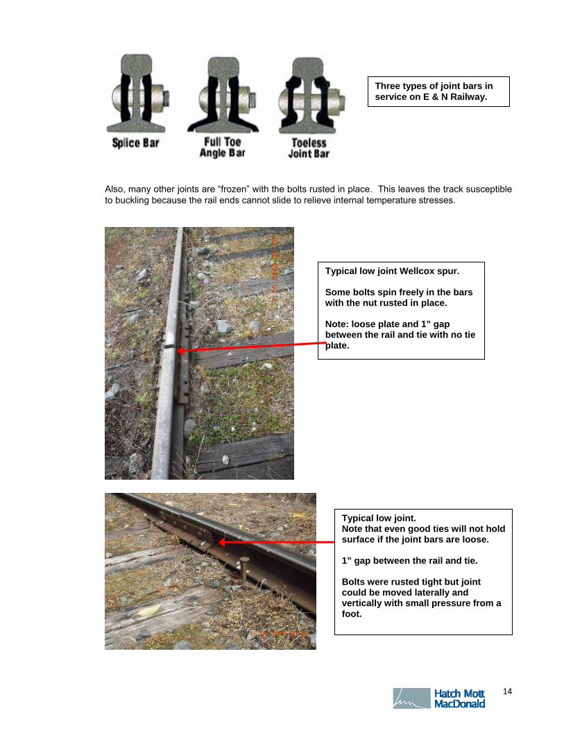
Poor joint condition is responsible for the rough ride on the Budd cars. The bulk of the rail joints on the E & N are in poor condition and not in compliance with the Regulations. The full-toe angle bar design pre-dates the use of tie plates; the bars have holes for spiking the bar directly to the tie. The bars can’t be used with a double shoulder tie plate. It is the opinion of the SRVI Maintenance staff that there are thousands of full toe angle bars that are worn in the fishing surfaces (contact zones under the head and on the rail base); no longer have an interference fit with the standard oval neck track bolt; and, have the bolts rusted and seized with the bars loose. This leads to a pounding down of the ties under the joints, accelerated tie deterioration and accelerated wear on the fishing surfaces.
Active rock faces with freshly fallen material in the ditches and significant cracking between the blocks M.21.7
F I N A L D R A F T – O C T O B E R 8 , 2 0 0 9
O C T O B E R 2 0 0 9 14
Also, many other joints are “frozen” with the bolts rusted in place. This leaves the track susceptible to buckling because the rail ends cannot slide to relieve internal temperature stresses.
Typical low joint Wellcox spur. Some bolts spin freely in the bars with the nut rusted in place. Note: loose plate and 1” gap between the rail and tie with no tie plate.
Typical low joint. Note that even good ties will not hold surface if the joint bars are loose. 1” gap between the rail and tie. Bolts were rusted tight but joint could be moved laterally and vertically with small pressure from a foot.
Three types of joint bars in service on E & N Railway.
F I N A L D R A F T – O C T O B E R 8 , 2 0 0 9
O C T O B E R 2 0 0 9 15
Correction of the worst joint conditions should be performed prior to any major tie program. If the joint bars are not tight, then newly tamped track will not maintain level surface at the joints. They will rapidly pound down.
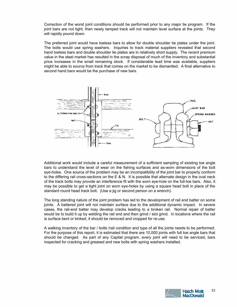
The preferred joint would have toeless bars to allow for double shoulder tie plates under the joint. The bolts would use spring washers. Inquiries to track material suppliers revealed that second hand toeless bars and double shoulder tie plates are in relatively short supply. The recent premium value in the steel market has resulted in the scrap disposal of much of the inventory and substantial price increases in the small remaining stock. If considerable lead time was available, suppliers might be able to source from track that comes on the market to be dismantled. A final alternative to second hand bars would be the purchase of new bars.
Additional work would include a careful measurement of a sufficient sampling of existing toe angle bars to understand the level of wear on the fishing surfaces and as-worn dimensions of the bolt eye-holes. One source of the problem may be an incompatibility of the joint bar to properly conform to the differing rail cross-sections on the E & N. It is possible that alternate design in the oval neck of the track bolts may provide an interference fit with the worn eye-hole on the full-toe bars. Also, it may be possible to get a tight joint on worn eye-holes by using a square head bolt in place of the standard round head track bolt. (Use a jig or second person on a wrench).
The long standing nature of the joint problem has led to the development of rail end batter on some joints. A battered joint will not maintain surface due to the additional dynamic impact. In severe cases, the rail-end batter may develop cracks leading to a broken rail. Normal repair of batter would be to build it up by welding the rail end and then grind / slot grind. In locations where the rail is surface bent or kinked, it should be removed and cropped for re-use.
A walking inventory of the bar / bolts /rail condition and type of all the joints needs to be performed. For the purpose of this report, it is estimated that there are 10,000 joints with full toe angle bars that should be changed. As part of any Capital program, every joint will need to be serviced, bars inspected for cracking and greased and new bolts with spring washers installed.

F I N A L D R A F T – O C T O B E R 8 , 2 0 0 9
O C T O B E R 2 0 0 9 16
3 .2 .2 TRACK T IES
A cross-tie constrains the rails in position under the repeated loading of the trains. The tie holds the rails a fixed distance apart (track gauge), so that vehicle wheels track properly. The ties transmit the train loads through the ballast section to the sub-grade. The ties must have the bearing capacity to maintain the rails at a level “surface” to avoid vehicle rocking or instability. The ballast type, tie spacing, tie cross-section sizes and tie species are chosen to ensure the expected train loadings are safely supported at the lowest life-cycle cost.
As ties rot, additional stress is put on adjacent ties, particularly at loose rail joints. The eventual result is a loss of track gauge and track surface leading to slower train speeds and a higher derailment risk.
It was noted that the main track is currently restricted to 20 mph for freight trains between Parksville and Courtenay account poor tie conditions.
BCSA Regulations are:
TC Class 2 track: Passenger train speed up to 30 mph
TC Class 3 track: Passenger train speed up to 60 mph
For the E & N tie spacing of 2800 ties per mile
1. Class 2 requires approximately 40% non-defective ties and one good tie within 24” of a joint
2. Class 3 requires approximately 50% non- defective ties and one good tie within 18” of a joint
3. Ties are defective when they will not support the tie plate / rail; will not hold spikes; are cut through more than 40% of the thickness; or broken through.
Insufficient tie replacement has been performed to address the issue of poor joint ties. The track does not currently comply with Regulatory safety standards due to decayed tie clusters and poor joint ties.
Comprehensive records of prior tie installations were not available. It was estimated that 2,000 ties were installed in 2008, 1,500 ties in 2007, 5,000 ties in 2006; that 2,500 ties / year were installed
Battered joint partially corrected by rail-end welding on one rail.

F I N A L D R A F T – O C T O B E R 8 , 2 0 0 9
O C T O B E R 2 0 0 9 17
2001 – 2005; 7,000 ties in 2000 and 12,000 ties in 1999; many of which were on the Port Alberni Sub. About 60,000 ties total in the prior two decades. This is a replacement rate of about 3,300 ties per year over a period of 30 years.
During the inspection, reference was made to two previous spot tie counts; one done by E & N supervisors and one by A & B rail in the 2003 Earth Tech report (Miles 69 - 95 were not inspected by Earth Tech). In the 2006 inspection, correlation between the two counts was generally good but tie counts were generally heavier, particularly near Duncan, just north of Parksville and near Courtenay. The tie conditions are generally 20% to 35% defective with areas in Miles 42, 96 and 138 over 50%.
Information on the tie spacing varies. It is noted in several reports as being 2880 per mile or 22”. Re-spacing for missing ties has occurred over time and a count of 2,800 per mile on average is more likely. This is a reasonable spacing for the light loadings on the line. Tie spacing should be tightened in the sharper curves. Tie spacing should be confirmed in total tie per mile counts to be done with the defective tie marking.
For distances: 139.7 miles of main track, 3.2 miles Wellcox spur, 2 miles of yard / siding; less 0.8 miles of bridges and 1.2 miles of recent revisions = 142.9 miles or approximately 400,000 total ties. Treated ties under light axle loads can be expected to last 30 to 35 years prior to rotting. Some reduction in life should be expected in higher degree curves and where one good tie is required to support several adjacent decayed ties. To keep the E & N track on a maintenance cycle for rot, a replacement level of approximately 12,000 ties per year is required.
There has been a substantial capital deficit in tie replacement over the last 30 years and an immediate near term investment is required to break up clusters and replace poor ties under the joints. Defective ties in track total approximately 140,000. More critically, due to the age of the existing ties, approximately 260,000 ties can be expected to reach their service life due to rot in the next 15 to 20 years. Significant on-going investment will be required.
Tie type selection is a function of annual tonnage and axle loading expected over the service life; presently a #2 tie is adequate for most locations. For increased traffic, #1 ties should be used on the sharper curves.
SRVI has been employing Holland Trackstar testing equipment to measure track geometry and tie restraint strength. This equipment measures alignment, cross-level and gauge and reports track defect exceptions to the Regulations. It is extremely difficult to provide good surface and cross-level because of the poor tie and joint condition. The joints will not “stay up” due to batter. Poor tie
Example of cluster of more than 50% defective ties and no good ties at a joint in Class 3 track near Parksville.
F I N A L D R A F T – O C T O B E R 8 , 2 0 0 9
O C T O B E R 2 0 0 9 18
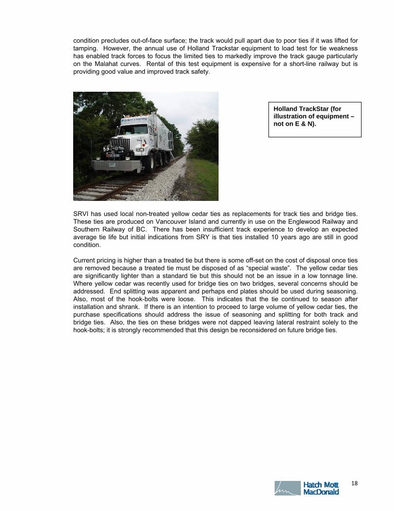
condition precludes out-of-face surface; the track would pull apart due to poor ties if it was lifted for tamping. However, the annual use of Holland Trackstar equipment to load test for tie weakness has enabled track forces to focus the limited ties to markedly improve the track gauge particularly on the Malahat curves. Rental of this test equipment is expensive for a short-line railway but is providing good value and improved track safety.
SRVI has used local non-treated yellow cedar ties as replacements for track ties and bridge ties. These ties are produced on Vancouver Island and currently in use on the Englewood Railway and Southern Railway of BC. There has been insufficient track experience to develop an expected average tie life but initial indications from SRY is that ties installed 10 years ago are still in good condition.
Current pricing is higher than a treated tie but there is some off-set on the cost of disposal once ties are removed because a treated tie must be disposed of as “special waste”. The yellow cedar ties are significantly lighter than a standard tie but this should not be an issue in a low tonnage line. Where yellow cedar was recently used for bridge ties on two bridges, several concerns should be addressed. End splitting was apparent and perhaps end plates should be used during seasoning. Also, most of the hook-bolts were loose. This indicates that the tie continued to season after installation and shrank. If there is an intention to proceed to large volume of yellow cedar ties, the purchase specifications should address the issue of seasoning and splitting for both track and bridge ties. Also, the ties on these bridges were not dapped leaving lateral restraint solely to the hook-bolts; it is strongly recommended that this design be reconsidered on future bridge ties.
Holland TrackStar (for illustration of equipment – not on E & N).

F I N A L D R A F T – O C T O B E R 8 , 2 0 0 9
O C T O B E R 2 0 0 9 19
3 .2 .3 T IE PLATES
Before about 1920, rail was commonly spiked directly to the ties. As train weights increased, it was found that the area of the tie directly under the rail wore rapidly and spikes sheared off. Canted, single shoulder tie plates were developed to provide a wear surface with a lip (shoulder) to support the rail under lateral loads. Tie plates markedly increased the life of wood ties by providing a bearing / wear surface for the rail. As rail car axle loads increased again in the 50’s / 60’s, larger area double shoulder plates were developed to supply a “seat” for the rail, improve spike life and give more bearing area. The tie plates on E & N are typically single shoulder plates about 60% the size of the double shoulder tie plates in normal branch line railway use. There are many instances of missing and broken plates. It would be preferable to replace the existing plates with second-hand double shoulder plates during the tie change program on all ties being changed out. This will pay for itself in tie life, particularly on curves where freight trains operate. New spikes would be used with a per plate spiking pattern of 2 on tangents, 3 on curves to 6 degrees and 4 on curves 6 degrees and over.
Typically single shoulder plates on E & N; should upgrade to double shoulder tie plates when ties are changed.
Untreated yellow cedar ties in stockpile. The ties weather to grey in track.
F I N A L D R A F T – O C T O B E R 8 , 2 0 0 9
O C T O B E R 2 0 0 9 20
3 .2 .4 RAIL ANCHORS
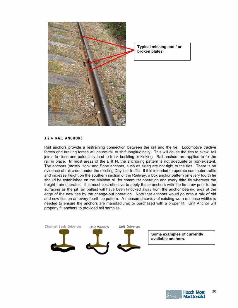
Rail anchors provide a restraining connection between the rail and the tie. Locomotive tractive forces and braking forces will cause rail to shift longitudinally. This will cause the ties to skew, rail joints to close and potentially lead to track buckling or kinking. Rail anchors are applied to fix the rail in place. In most areas of the E & N, the anchoring pattern is not adequate or non-existent. The anchors (mostly Hook and Shoe anchors, such as exist) are not tight to the ties. There is no evidence of rail creep under the existing Dayliner traffic. If it is intended to operate commuter traffic and increase freight on the southern section of the Railway, a box anchor pattern on every fourth tie should be established on the Malahat hill for commuter operation and every third tie wherever the freight train operates. It is most cost-effective to apply these anchors with the tie crew prior to the surfacing as the pit run ballast will have been knocked away from the anchor bearing area at the edge of the new ties by the change-out operation. Note that anchors would go onto a mix of old and new ties on an every fourth tie pattern. A measured survey of existing worn rail base widths is needed to ensure the anchors are manufactured or purchased with a proper fit. Unit Anchor will properly fit anchors to provided rail samples.
Typical missing and / or broken plates.
Some examples of currently available anchors.
F I N A L D R A F T – O C T O B E R 8 , 2 0 0 9
O C T O B E R 2 0 0 9 21
3 .2 .5 TRACK BALLAST
Ballast is normally a select crushed rock placed on the sub-grade under and between the track ties to:
Firmly support and restrain the track under the dynamic loads of trains
Prevent track buckling from thermal stresses induced in the rails by changing temperature.
Provide drainage of the track.
Distribute the rail loads to prevent overstressing and failing the sub-grade.
The existing ballast is contaminated pit run ballast with a proportion of large round rock (2” to 4”). Surfacing equipment lifts and aligns the track, where required, and packs ballast under and around the ties to produce a safe, smooth riding track. The issue on E & N Railway is that severely rotted ties will disintegrate under the forces from the tamper tools and brooming.
Any surfacing program should include crushed rock at a rate of 480 to 600 cubic yards per mile to replace shoulder cut level to improve drainage, ballast lost by tie change-out, to fill skeleton areas and to provide sufficient material to smooth-out the joints. On a winter program, it should be possible to rent ballast cars from CPR or CN with MK / control flow doors. SRVI currently sources crushed rock near Mile 110.
3 .2 .6 RAIL CONDITION
The main track rail is predominantly a mix of 129.4 miles of 80lb. and 85lb. short bolted rail with about 10.6 miles of 100lb. (rail is described by weight in pounds per yard). The 80 / 85lb. rail is not suitable for a heavier axle loading than currently carried. Recent ultrasonic inspections of the rail from Victoria to Parksville were reviewed; 2006 - 2008. They were predominately Bolt Hole defects with some Vertical Split Head and Split Webs all of which would be expected in older bolted rail. The frequency of less than 0.3 defects / mile tested is not unusual.
The E & N track is not CTC equipped (track circuits with signal light control) so a broken rail will only be detected by track inspection, train report or if the break is inside the approach circuits of a crossing.
Rail supplied for replacement of defective rails should have been recently tested. Rail removed for detail fractures, transverse defects or head web separations should not be cropped and reinstalled. With regular testing and joint maintenance, the existing rail will be adequate for the present service. Any increase in tonnage would require more frequent testing to stay ahead of defect growth. If there is any intention to operate a commuter service or increase tonnage such as Coal service, the 80 / 85lb. rail in those areas should be replaced.
3 .2 .7 TURNOUTS
The turnouts are in fair to good condition. Mostly 9lb. – 85lb. mixed material with some new 115lb. upgrades paid for during road relocation work. No exceptions were noted in gauge or point adjustment. Most frogs could use grinding. Most turnouts could use some tie replacement. Speed through turnouts on SRVI is limited to 10 mph.
3.3 Bridges and Culverts
None of the bridges between Victoria and Courtenay showed obvious signs of distress. The Port Alberni spur was inaccessible to hi-rail vehicle thus the bridges on this leg were not inspected. The

F I N A L D R A F T – O C T O B E R 8 , 2 0 0 9
O C T O B E R 2 0 0 9 22
notes from the inspections performed in 1999, the 2006 AMEC report and the 2003 McLeman report were briefly reviewed. They are comprehensive reports but their detailed inspections on the larger structures were limited by time and budget available; so there are significant potential unknowns as detailed in those reports. Recent inspections by SRVI personnel have been visual and limited to areas of the bridges that were safely accessible. Two bridge decks and some pile cap work on the trestle M.1.4 Wellcox spur have been done since the 2006 inspection.
It is noted that there are many bridges along the corridor and notwithstanding the large expense of repairing or replacing these structures, the current information is dated and limited in depth of study. Therefore it is recommended that detailed inspections by bridge professionals should be performed including drilling of timber piling, scour condition of piers and abutments, cleaning of debris and inspection of steelwork. Inspection of the steelwork will require specialized lifting and climbing equipment. Cleaning of debris packed into the crevasses of the steel work to allow inspection and measurement of corrosion is not a small issue. A number of the bridges are of unique design and there would be considerable expense in “reverse engineering” the bridges, if necessary to calculate capacity and remaining life for increased axle loading.
There are speed restrictions of 10 mph on bridges at M. 14.9, M.39.3, M.64.4, M.110.7
It is reported that there are some low clearances on bridges that cross highways. As such these structures are vulnerable to damage from road vehicle impacts (e.g. bridge crossing over Shaunessy Road).
A thorough inspection of the culverts was done by McLeman in 2003. Little of the recommended work has been performed (40 recommended replacements over a 5 year period and extensive cleaning). An updated inspection of all culverts should be done. The McLeman report can be used as a basis for the approximate Capital work estimate now required. There is a 10mph speed restriction over the culvert at M.114.95.
3.4 Yard Condition
The major yard is Wellcox yard in Nanaimo. The E & N yards and sidings that are required for current use are maintained for track safety. Some yard trackage has been taken out of service and speeds have been reduced to 5mph on shop tracks. The wye at Parksville is out of service. As with the main track, decayed tie and poor joint conditions in the yards are serious issues.
Wellcox Yard Locomotive Spur Note Ties and OTM buried in the gravel.

F I N A L D R A F T – O C T O B E R 8 , 2 0 0 9
O C T O B E R 2 0 0 9 23
3.5 Communications
Communications are by radio and cell phone. There are 2 repeater towers for the radios. The south repeater covers Victoria to Nanaimo; the north repeater covers Nanaimo to Parksville. Personnel can call from either repeater to the Rail Traffic Controller but cannot call to each other when on different repeaters. The equipment is relatively modern; 8 years old, and is properly maintained.
3.6 Fencing
There is very little livestock fencing. The length was estimated in the order of 2 miles and it is in fair to good condition. This presented a risk estimated as less than 1 call per year for escaped livestock.
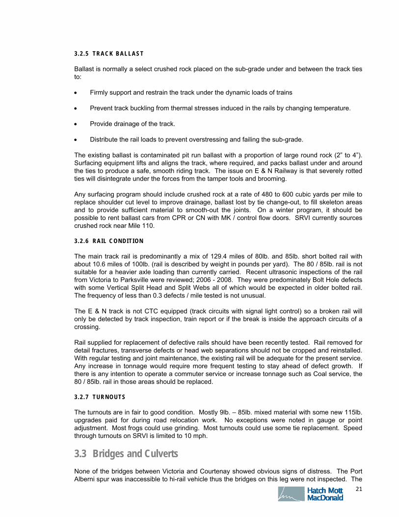
3.7 Barge Ramp
The Barge ramp located in Wellcox yard is very active for trailer loading and is used approximately weekly for rail car delivery. The yard trackage servicing the barge ramp is in safe but poor condition due to deteriorated ties. The deck of the ramp is being well maintained both for timber for the trucks and the switches and rails for the rail cars. SRVI personnel did not advise of any mechanical concerns with the ramp mechanism.
The barge ramp is owned and operated by Seaspan.
Wellcox Yard Storage tracks.
F I N A L D R A F T – O C T O B E R 8 , 2 0 0 9
O C T O B E R 2 0 0 9 24
3.8 Crossings
There are approximately 93 signalled crossings between Victoria and Courtenay. The equipment in some of these installations has reached its service life. Parts are no longer supported by the original manufacturers. The condition inventory performed in 2005 by Quality Signal Construction Inc. is a good base line for estimating immediate and future requirements. This subject is discussed in detail in section 3.14.
Barge ramp looking towards the rail car loading yard.
Barge ramp looking from the rail car loading yard.
Rail car loading yard for the barge service.

F I N A L D R A F T – O C T O B E R 8 , 2 0 0 9
O C T O B E R 2 0 0 9 25
3.9 Wire Crossings and Clearances
There are numerous wire crossings; most frequently at or near the automatic signals at highway crossings. SRVI maintains a list of Railway restricted clearances which are typically through-truss bridges, tunnels and rock cuts. SRVI recently moved dimensional loads for delivery to Duncan.
3.10 Passenger Stations, Shops and Offices
The RJ Baker appraisal of July 2004 is a good guide to passenger station condition. The exception is that the station at Nanaimo has burned down.
Typically the stations are not equipped with platforms. This impedes efficient boarding and disembarking of passengers. Provision for upgrade of the stations has been included in the cost estimates (refer to Appendix B).
There is an issue with some of the VIA station shelters. They are becoming laterally unstable due to rot and deterioration in the pile supports coupled with a large heavy roof.
Mechanical work is done on shop tracks or by mobile yard repair. There is no covered mechanical work area in Wellcox Yard. Major locomotive work is sent off-island. SRVI has an office building in Wellcox yard for management staff that is also used for vehicle maintenance and signals storage. It did not appear in need of immediate repairs.
Station Platform at 27.9 Shawingan Lake with deteriorated supports.
F I N A L D R A F T – O C T O B E R 8 , 2 0 0 9
O C T O B E R 2 0 0 9 26
3.11 Trespasser Issues
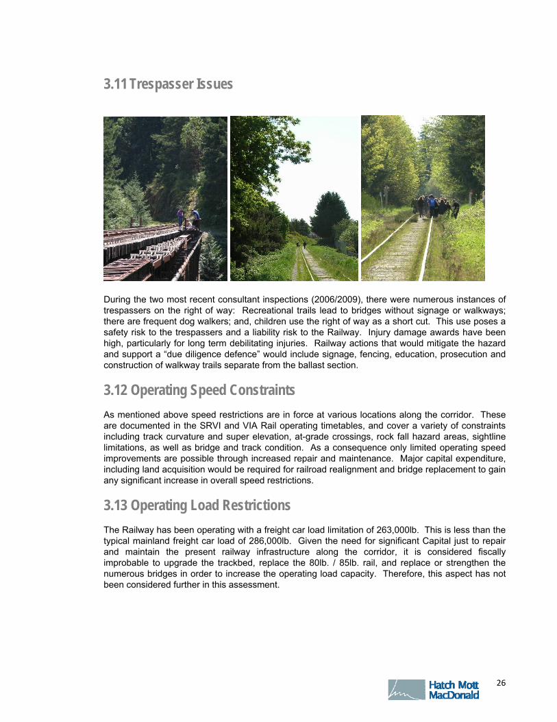
During the two most recent consultant inspections (2006/2009), there were numerous instances of trespassers on the right of way: Recreational trails lead to bridges without signage or walkways; there are frequent dog walkers; and, children use the right of way as a short cut. This use poses a safety risk to the trespassers and a liability risk to the Railway. Injury damage awards have been high, particularly for long term debilitating injuries. Railway actions that would mitigate the hazard and support a “due diligence defence” would include signage, fencing, education, prosecution and construction of walkway trails separate from the ballast section.
3.12 Operating Speed Constraints
As mentioned above speed restrictions are in force at various locations along the corridor. These are documented in the SRVI and VIA Rail operating timetables, and cover a variety of constraints including track curvature and super elevation, at-grade crossings, rock fall hazard areas, sightline limitations, as well as bridge and track condition. As a consequence only limited operating speed improvements are possible through increased repair and maintenance. Major capital expenditure, including land acquisition would be required for railroad realignment and bridge replacement to gain any significant increase in overall speed restrictions.
3.13 Operating Load Restrictions
The Railway has been operating with a freight car load limitation of 263,000lb. This is less than the typical mainland freight car load of 286,000lb. Given the need for significant Capital just to repair and maintain the present railway infrastructure along the corridor, it is considered fiscally improbable to upgrade the trackbed, replace the 80lb. / 85lb. rail, and replace or strengthen the numerous bridges in order to increase the operating load capacity. Therefore, this aspect has not been considered further in this assessment.

F I N A L D R A F T – O C T O B E R 8 , 2 0 0 9
O C T O B E R 2 0 0 9 27
3.14 Signals Condition Assessment
3.14 .1 EXIST ING S IGNALS OVERVIEW
The E & N railway has a total of 104 signaled grade crossings between Victoria and Courtenay. There are pair of train control signals on the approaches to the Johnson Street Bridge which are interlocked with the bridge opening mechanism. The signal plant on the E & N is typical of a low traffic branch line. The E & N is not equipped with a Central Traffic Control (CTC) system. There are no wayside defect detection systems such as Hot Box Detectors or Wheel Impact Load Detectors and there are no Automatic Equipment Identification Readers.
The crossing warning devices are standard railway flashing light warning signals and bell, with some crossings also equipped with gates. The train detection equipment spans several generations of signal technology. The oldest crossings use DC track circuits and DC relays. Beginning in the 1970s crossings began to be equipped with audio frequency track circuits and then some with older model motion sensors. The newest crossings are equipped with modern motion sensors or constant warning time devices.
The DC relays used for DC track circuits are still manufactured, and spares are still available. DC relays must be tested regularly to comply with Transport Canada requirements. SRVI representatives advised that the relays on the E & N are being tested on a 4 year cycle and are currently in compliance. However, the oldest electronic equipment, including the Harmon AFTAC audio frequency track circuits and the Harmon MD-II motion detectors is obsolete and no longer supported by the manufacturer. Spare parts can no longer be purchased.
Crossing sight lines are poor at many of the crossings. In some cases sight lines are so restricted that motorists have to be almost on the track before they can see an oncoming train. In urban areas of Nanaimo and Victoria the right of way is narrow and buildings often block sight lines. In more rural areas uncontrolled vegetation growth on the right of way is blocking sight lines.
Track conditions can affect the operation of crossing signal systems. On the E & N railway there are two particular areas of concern, rusty rail and fouled ballast. Rusty rail can cause poor shunting and train detection. Inconsistent warning times and unreliable pre-emption operation can result. Lighter rolling stock such as passenger trains or Rail Diesel Cars are especially likely to suffer from poor shunting. In the worst case, crossings may fail to provide sufficient warning time in advance of a train. Fouled ballast drains poorly and will remain saturated with water in wet weather. This will cause track circuits to “leak” excessive current from rail to rail. This can cause nuisance operation of crossings when no trains are present, especially at motion sensor or constant warning time equipped crossings. The problem is made worse by road salt in the winter. These problems are likely to occur to some degree at almost all the crossings on the E & N.
3 .14 .2 CHANGES S INCE VALUATION ASSESSMENT
A corridor valuation assessment survey of all crossing signal installations was performed in 2005 by Quality Signal Construction. In the 4 years since this survey approximately 10 new crossing signal systems have been installed. A few of the older crossings have been upgraded. The upgrades include new train detection equipment, typically GETS PMD-3 motion detectors, as well as new batteries and chargers. Other than these noted changes, the survey by Quality Signal Construction is still a good reference for the state of the signal plant.
F I N A L D R A F T – O C T O B E R 8 , 2 0 0 9
O C T O B E R 2 0 0 9 28
3 .14 .3 EQUIPMENT CONDITION AND MAINTENANCE
The majority of the crossing installations have been maintained in fair to good condition. The equipment cases are generally clean and tidy. Batteries are generally clean, free of corrosion and electrolyte levels topped up. Cable connections appeared to be tight and secure. There were no signs of rodent entrance or activity. Track connections and bonds were in generally good condition. The crossing cases all had up to date wiring drawings. There were no immediate safety issues related to equipment maintenance noted.
Many of the older steel equipment cases are showing signs of rusting especially at the floor level and around doorsills. Steel cases require constant maintenance including rust removal and painting. Hoods and backgrounds of crossing warning signals also showed signs of rusting at many of the older locations. Newer equipment cases are made of aluminum and newer signals have polyethylene hoods and backgrounds and are immune to rust problems.
While the crossing equipment is generally well maintained, in many cases it has reached the end of its useful service life and needs to be upgraded or replaced.
3 .14 .4 REQUIRED UPGRADES
An ongoing program of crossing upgrades is required to keep the plant in working condition. There appears to have been some good progress in this direction in the last few years.
First priority should be to replace the oldest motion detectors (the MD-II units) and the AFTAC audio frequency track circuit equipment. This equipment is no longer supported by the manufacturer and spare parts are no longer available. As these are replaced, new spares become available to maintain the remaining old equipment. However, as the electronic components age, even unused spares will become unreliable. This equipment should be replaced with new modern constant warning time or motion sensor equipment such as the GE HXP-3 or PMD-3 units.
The older GCP-660 constant warning time units should be the next priority for replacement. These are older units and are known for poor performance in rusty rail conditions and for inconsistent pre-emption warning times. This equipment should also be replaced with new modern constant warning time or motion sensor equipment such as the GE HXP-3 or PMD-3 units.
In parallel with the upgrades of train detection equipment, the oldest standby battery plants should be upgraded. A number of the crossings were still equipped with Lead Acid batteries, which would have been installed over 25 year ago. There were a small number of crossings still equipped with old-style steel-cased NiCad cells which are at least 30 years old. Given an expected service life of 15 to 20 years, the oldest batteries in service are unlikely to meet current standby power time requirements. Batteries and battery chargers should be replaced with new NiCad cells and modern constant current chargers.
In Nanaimo between about mileage 70 to mileage 74 there are a number of crossings in close proximity and the approach circuits overlap. These crossings are interconnected with underground signal cable so that track relays from multiple crossings can be combined to provide sufficiently long approach circuits. This underground cable has reached the end of its service life and will gradually begin to break down. By replacing the train detection equipment at these crossings with new motion detector or constant warning equipment, the approach circuits can be overlapped on the track and the underground signal cable can be removed from service. In addition, new train detection equipment will allow the removal of all the insulated rail joints at these crossings.
3 .14 .5 ROCK FALL HAZARD AREAS
There is a rockfall hazard area between about mileage 15.6 and mileage 16.3. This area was visited to investigate the possibility of installing slide fences or rockfall detectors. There are four separate hazard areas ranging from 100 to 200 feet in length. These areas are remote, and access to AC power will be difficult.

F I N A L D R A F T – O C T O B E R 8 , 2 0 0 9
O C T O B E R 2 0 0 9 29
It should be noted that detector systems are generally installed in rockfall hazard areas where other means of mitigation are not feasible. Detector systems have a high installation cost; a standard railway slide detection fence can cost as much as $300 per running foot. Maintenance costs can also be high since a signal maintainer must be called out to fix broken detector wires each time a slide fence is tripped.
It may be premature to consider installing slide detection fences if the rockfall hazard in this area could be mitigated by employing more traditional rock slope stability measures such as scaling, rock anchors, shotcrete and rock mesh. In this respect a detailed assessment by a rock slope geotechnical engineer is recommended prior to developing alternative hazard mitigation plans.
3 .14 .6 POTENTIAL COMMUTER RAIL CORRIDOR VICTORIA TO LANGFORD
A business plan option provides for commuter rail service in the Victoria-Langford corridor. The site review covered all the existing crossings, both signaled and unsignalled, in the proposed corridor from mileage 0 to mileage 10.6. The 24 crossings in the potential commuter rail corridor are shown in the table below. Proposed upgrades are also shown. As a baseline the proposed upgrades are the installation of warning signals and gates at all crossings not already so equipped. It is noted that the upgrades listed below are conceptual and require further assessment before any implementation. The cost estimate includes provision for upgrades at those locations marked below with an asterisk. Mileage Road Name Existing Warning System Proposed Upgrade: 0.37 *Tyee Rd Flashing Lights Add Gates 0.57 *Sitkum Rd Flashing Lights and Gates -- 0.77 Catherine St Flashing Lights and Gates -- 0.83 *Mary St Crossbucks and Stop Sign Flashing Lights and Gates 0.88 *Russel St Crossbucks and Stop Sign Flashing Lights and Gates 0.95 *Esquimalt Rd Flashing Lights Add Gates 1.10 *Wilson Rd Flashing Lights Add Gates 1.57 *Devonshire Rd Crossbucks and Stop Sign Flashing Lights and Gates 1.75 *Lampson Rd Flashing Lights Add Gates 2.14 *Hutchinson Ave Crossbucks and Stop Sign Flashing Lights and Gates 2.29 *Intervale Ave Crossbucks and Stop Sign Flashing Lights and Gates 2.53 Admirals Rd Flashing Lights Add Gates 3.13 *Maple Bank Rd Crossbucks and Stop Sign Flashing Lights and Gates 3.37 *Thomas Rd Crossbucks and Stop Sign Flashing Lights and Gates 3.65 *Hallowell Rd Crossbucks and Stop Sign Flashing Lights and Gates 4.81 *Burnett Rd Flashing Lights Add Gates 5.03 Kislingbury (Gated private
Xing) Crossbucks and Stop Sign Flashing Lights and Gates
5.63 *PJ McEany (driveway) N/A Flashing Lights and Gates 6.90 *Adkins Rd Flashing Lights Add Gates 7.90 Goldstream Ave Flashing Lights Add Gates 8.30 Peatt Ave Flashing Lights and Gates -- 8.52 Jacklin Rd Flashing Lights and Gates -- 9.30 *Pedestrian Xing Crossbucks Flashing Lights and Gates 10.30 *Westshore Parkway
(Future) n/a Flashing Lights and Gates
A number of the unsignalled crossings in this corridor will likely need to be upgraded with crossing warning signals and gates when commuter rail service is initiated. A number of existing crossings that are equipped with flashing lights and bell may also require the addition of gates.
Before a commuter rail service is initiated a Detailed Safety Assessment as per the Transport Canada RTD-10 guidelines should be performed for each crossing. Many factors are considered in the Transport Canada guidelines to determine whether a public crossing needs warning lights or warning lights and gates. These include the number of tracks, the volumes of road and rail traffic,

F I N A L D R A F T – O C T O B E R 8 , 2 0 0 9
O C T O B E R 2 0 0 9 30
the maximum railway operating speed, the presence of sidewalks and proximity to other road intersections with traffic signals. Once the detailed assessment has been completed, it may be that upgrading all the roads to flashing lights and gates is not required.
There are a number of smaller road crossings in close proximity between mileage 0.5 and mileage 0.95. It may be possible to rationalize the road network and close some of these crossings.
3.15 Condition Assessment Summary
In brief, the track structure is in poor to fair condition. Automatic crossing signal conditions are deteriorating. Current Capital and maintenance resources are inadequate to safety maintain the track. Maintenance personnel are doing the best job possible given the limited resources. Over the last several years, this has included some good progress on vegetation control and the use of Holland Trackstar testing equipment to identify the worst decayed tie clusters.
Significant Capital investments have been deferred for the last three decades except where funded by road authorities at crossings; at two revisions for the construction of the Island highway and to replace a burned bridge. In particular, tie replacements and joint repairs have not been at a sustaining level.
The Railway is not considered to be in compliance with Transport Canada Rules Respecting Track Safety in the following areas:
Vegetation growth in the ballast section and crossing sightlines
Clusters of decayed ties and decayed ties under the rail joints
Worn, loose rail joints and frozen bolts
Without a significant on-going investment in ties and rail joints, the Railway will become inoperable. Other urgent Capital requirements include bridge repair and crossing protection replacement.
F I N A L D R A F T – O C T O B E R 8 , 2 0 0 9
O C T O B E R 2 0 0 9 31
4. BASELINE IMPROVEMENTS
4.1 Immediate maintenance and rehabilitation
The rail corridor condition assessment indicated a pressing need for repair and increased maintenance of the corridor if only to support existing services. These baseline improvements are covered by the associated business plan options for maintaining existing freight and VIA Rail services.
4.2 Recommendations for detailed assessment studies
The scope of services under this study does not provide for detailed assessment of the facilities, consequently the deterioration noted herein should be considered as indicative rather than definitive. It is recommended that before any significant capital expenditure is committed that detailed condition assessments be carried out to determine a definitive action plan and budget. In particular the following detailed assessments should be considered:
Sight-line Assessment: review sightlines at all crossings and remove obstructions to
acceptable standards Bridge Condition Assessment: follow-on past studies for priorities for detailed assessment
and repairs Stations and Shelters Assessment: initial focus on heritage stations to be retained and
restored, and the structural integrity of passenger shelters Rock Slope Hazard Assessment: build on past investigations and develop a detailed
hazard mitigation plan Arborist Assessment: assess ailing or damaged trees and wind throw hazard areas and
identify priorities for removal of hazard trees Corridor wide drainage and flood potential assessment.

F I N A L D R A F T – O C T O B E R 8 , 2 0 0 9
O C T O B E R 2 0 0 9 32
5. RECONFIGURATION OPTIONS
Options for reconfiguration of the corridor and rail facilities follow the business plans identified in the course of this study. These include commuter rail service between Victoria and Langford; maintaining freight service between Duncan and Courtenay; reopening freight service between Parksville and Port Alberni; and developing passenger and tourist services between Victoria and Courtenay, as well as vintage rail excursions from Port Alberni.

F I N A L D R A F T – O C T O B E R 8 , 2 0 0 9
O C T O B E R 2 0 0 9 33
6. COST ESTIMATES
Conceptual capital cost estimates have been prepared for each of the business plan options developed through this project. These estimates cover capital expenditures over a period of five years as applicable to each configuration option. No allowances have been included for operation costs.
The various business plan options and associated estimated total cost are:
Victoria to Langford Commuter Rail Option - $73 million
Corridor Rehabilitation Victoria to Westhills - $11.8 million
Corridor Rehabilitation Westhills to Duncan - $17.2 million
Corridor Rehabilitation Duncan to Courtenay - $51.4 million
Corridor Rehabilitation Parksville to Port Alberni (Port Alberni Spur) - $25.7 million
Stations Rehabilitation Victoria to Courtenay - $17.2 million
It is noted that the cost estimates are strictly conceptual and are provided to assist MoT’s identification of individual business plans to advance for further study. The data supporting each estimate is from various sources and differing levels of investigation and should be also considered conceptual. Further investigation and determination of corridor condition, in particular bridges and the Parksville to Port Alberni leg, is required to support implementation of any business plan.
The basis for each estimate is included in Appendix B.
F I N A L D R A F T – O C T O B E R 8 , 2 0 0 9
O C T O B E R 2 0 0 9 34
7. ENVIRONMENTAL OVERVIEW
Hatch Mott MacDonald provided an indication of the future environmental assessment requirements associated with the development of all or parts of the Vancouver Island Railway corridor for:
Freight;
Passenger (long haul);
Seasonal (and / or ecotourism); and,
Commuter Rail (short haul) opportunities.
In summary, the preliminary business plan options provided include:
Improve the basic condition of the corridor assets by restoring this infrastructure to a minimum standard;
Add Commuter Rail (short haul) Service in the Victoria sector;
Expand VIA Long Haul Passenger Service;
Reinstate the seasonal (ecotourism) service on the Port Alberni segment only; and,
Seek ways to increase Freight movement on the overall rail network in the medium to longer term, and reinstate freight service on the Port Alberni segment in the near term.
It is recognised that each of these corridor business plan alternatives (or overall combination of alternatives considered as a whole) would likely pose differing constraints and opportunities for the surrounding communities and the natural environment.
7.1 Assessment Scope & Criteria
The scope of the environmental component of this study is to:
Review readily available existing environmental baseline information associated with the E & N Railway corridor;
Identify the likely key issues (Environmental and Social Impact Assessment baseline or component studies content) to be addressed during the project definition and evaluation phases of the retained business plan options;
Determine the probable environmental regulatory requirements (ESIA regimes and process steps) that will be applicable to the retained corridor development alternatives (business plan options);
Estimate the likely duration to complete the environmental regulatory requirements; and,
Review the preliminary findings with the Client and if appropriate at this early planning stage, seek the views of relevant regulatory representatives (i.e. discuss potential options with a representative from the BC Environmental Assessment Office).

F I N A L D R A F T – O C T O B E R 8 , 2 0 0 9
O C T O B E R 2 0 0 9 35
The approach to the environmental overview of the Project is summarized below.
Review the available environmental data provided;
Review the business plan options provided by the IBI group to be retained for the next phase of the project study program;
Determine the requirements for likely additional baseline data collection necessary to support the implementation of the retained business plan options;
Assess the probable regulatory requirement for Environmental and Social Impact Assessment (ESIA) and the likely overall environmental regulatory process timeline for the retained business plan. Consider if other Federal and / or Provincial environmental regulatory processes, such as from MoE or DFO necessitate evaluations and the probable scope and timing of such studies; and,
Preparation of this Baseline Reference Report.
7.2 Review of Available Environmental Data & Gap Identification
A review of the readily available environmental and related reports produced for the Island Corridor Foundation and others was undertaken to gain an appreciation of the current state of knowledge of the study zone. The results of this review are provided below.
7 .2 .1 PROJECT SPECIF IC REFERENCE DOCUMENTS
The Jacques Whitford Environmental Limited (JWEL) “Phase 1 audit” (2003), Streamline Environmental Consulting Ltd “E & N Railway Pest Management Plan” (2005), and the College Transportation Consulting Inc. “Socio-Economic Assessment” (2007) are project specific "Social and Environmental" background documents made available to the project team by BC Mot and ICF. The latter report provides a recent Socio-Economic profile of the corridor and arguments for maintaining the corridor intact. The (Vegetation) Pest Management Plan provides a summary environmental description of the corridor, environmental sensitivities to alternative vegetation maintenance techniques.
As part of the 2003 / 2004 valuation assessment, Jacques Whitford Environmental Limited (JWEL) was engaged by the Vancouver Island Railway to carry out a Phase 1 Environmental Site Assessment of the E & N Railway portion of the Victoria Subdivision and the abandoned Lake Cowichan Subdivision, Vancouver Island right-of-way. The remaining sections of the Southern Railway of Vancouver Island were owned by RailAmerica, through a subsidiary E & N Railway Company (1998) Ltd. (ENR98). No environmental screening studies appear to have been carried out for this ENR98 corridor from the Wellcox Spur in Nanaimo to Parksville and the east-west line from Nanaimo to Port Alberni.
This initial audit of a portion of the overall corridor, now somewhat dated (5+ years), provides a preliminary indication of the condition of the assets surveyed and the then identified potential hazards.
During the course of this referenced site assessment, a log of areas of potential environmental concern was generated with the majority of findings considered typical for railway facilities similar to this operation. Eighteen (18) sites on the ROW (three of which are documented spill sites) and twenty-two (22) sites adjoining the ROW were identified as having a potential environmental concern subject to more detailed further evaluation. Not all buildings within the project right-of-way were accessible during the site investigation and, therefore, were not investigated; four (4) locations were classified as being of “moderate concern”; and no sampling of suspected hazardous materials or possible contamination sites were undertaken as part of the mandate. Given the age of the
F I N A L D R A F T – O C T O B E R 8 , 2 0 0 9
O C T O B E R 2 0 0 9 36
buildings that were available for investigation the potential for asbestos-containing materials (ACMs), polychlorinated biphenyls (PCBs), urea formaldehyde foam insulation (UFFI), lead, and ozone depleting substances (ODS) exists. Recommendations were offered for more detailed analysis of suspect building materials and particular sites prior to any future modification of these facilities or locations.
Other reference documents provided by BC Mot with an environmental component include:
a) The Data Inventory Report (Resource Users Database) which provides an accounting of the location of watercourse crossings and wells (potable water), adjacent assets such as parks, agricultural land, First Nations lands, watersheds as well as an initial listing of known stakeholders along the corridor. This information was gathered in 2006 and was used to support the Pest (Vegetation) Management Plan; and,
b) Weed Burner Report 2008 (and an application for Government funding to the SDTC) illustrate potential use of an evolving track vegetation removal technology utilizing steam supplemented with mechanical removal in lieu of the use of herbicides.
7 .2 .2 OTHER AVAILABLE REFERENCE DOCUMENTS
Although not yet identified, other background information may exist for this rail corridor and if made available, should be reviewed in order to identify potential gaps in baseline data that would be the subject of future work as the project advances beyond the business planning stage.
Since a comprehensive set of Social and Environmental baseline data, specific to the region, was not available as part of the project background information, a brief review of a sampling of public data sites to identify possible relevant information was conducted. The initial findings are summarized below.
7 .2 .3 CANADIAN ENVIRONMENTAL ASSESSMENT AGENCY
A search for Environmental Assessments of similar Railway projects in BC revealed that Environmental Assessments within existing railway right-of-ways is generally not required or undertaken. However, a reference was found to a proposed trail that would be interconnected with (part of) the E & N Railway corridor:
“Capital Regional District (CRD) proposes to construct a multi-use path alongside the existing Esquimalt & Nanaimo Railway (E & N Rail) corridor. This path would encroach on the Esquimalt Graving Dock property by a width of 4 meters to allow for the construction of a retaining wall and new security fencing. The operations associated with this path will be for recreational purposes. Under section 5 of the Canadian Environmental Assessment Act, an environmental assessment is required in relation to this project because Public Works and Government Services Canada may provide federal lands for the purpose of enabling this project to be carried out.”1
The terms of reference agreed on this short section of the corridor will provide an indication of the stakeholder assessment requirements triggered along the corridor in general, given the number of agencies involved.
7 .2 .4 BC ENVIRONMENTAL ASSESSMENT OFFICE
No Provincially controlled Environmental and Social Impact Assessment’s (ESIA) of railway projects were found. The Delta Port Third Berth Project (Railway track component) is an exception and
1 See: http://www.ceaa-acee.gc.ca/050/details-eng.cfm?CEAR_ID=46214

F I N A L D R A F T – O C T O B E R 8 , 2 0 0 9
O C T O B E R 2 0 0 9 37
provides some useful guidance on the scope (screening and terms of reference) of an ESIA of a rail corridor. 2
7 .2 .5 THE ISLAND CORRIDOR FOUNDATION ( ICF) WEBSITE
The Island Corridor Foundation has made a significant contribution by compiling supporting documents and links on their Website. Under the Community tab, for example, a number of documents identify work in progress, or links to related sites where relevant information can be found. This will be a valuable reference point for an Environmental and Social Assessment of the short-listed project development opportunities to be evaluated collectively. However, the information currently contained on the ICF site does not provide a complete or up to date profile of the entire corridor. 3
New West Hills community introduces the E & N Railway adjacent Bike and Pedestrian path to Victoria which I believe is related to the CEAA Environmental Assessment above.4
Sagehill development and Kensington Point in the Comox Valley are listed on the Island Corridor Foundation Website as other communities attached to the corridor. These are other potential social assets and attractions associated with the corridor. 5
7 .2 .6 STAKEHOLDER WORKSHOPS
A Stakeholder Workshop held in Nanaimo on June 9, 2009 provided some additional comments on sources of relevant Growth Management and Environmental information which could be investigated as part of a future study program. These suggestions are documented in the IBI report associated with the workshop and public outreach.
This workshop identified the need for a good understanding of the projected population growth adjacent to the railway corridor and the community plans and various developments already underway to manage or accommodate this growth. Workshop participants reminded the study team of the requirement to consult with affected First Nations and to identify the potential heritage and economic opportunities introduced as a result of future investment in the contiguous right-of-way, spur lines and intermodal connections. The workshop participants raised some specific concerns with respect to the existing condition of some of the railway assets, such as: the loss of the Nanaimo station due to fire; use of chemicals to control vegetation within the corridor; and, the need for a thorough rationalization of necessary railway crossings and the maintenance of drainage systems.
7 .2 .7 GAP IDENTIF ICATION
With the exception of the high level screening study conducted by Jacques Whitford in 2003 on the CP Rail Corridor, no other investigations appear to have been carried out or documented to support implementation of the business plans noted in Section 7.3. Consequently, it should be assumed that the preparation of baseline social and environmental studies of the potentially affected study zones and receptors will be needed to support the evaluation of any retained business plan options.
2 See: http://a100.gov.bc.ca/appsdata/epic/html/deploy/epic_document_212_22382.html 3 See: http://www.islandcorridorfoundation.ca/ Regional Impact Study results awaited. See: http://www.bamberton.com/ New Malahat Bus Service October 2008 (competition for ridership) - See: http://www.bamberton.com/pdfs/100208-TC.pdf
4 http://www.westhillsbc.com/vision Look under "Our Vision" then Roads and Rail.
5 http://www.independentacademies.com/location and http://www.kensingtoncoastalpoint.com/index.html

F I N A L D R A F T – O C T O B E R 8 , 2 0 0 9
O C T O B E R 2 0 0 9 38
7.3 Environmental Review of Business Plan Options
The following conceptual business plan options were provided to the environment study team by the IBI Group on July 30, 20096:
1. Improve condition of the existing track work within the corridor. This is not a separate option per se but is considered to be a minimum requirement to conserve the corridor in a functional / safe / operable condition. SRY capital plan would be to start with the Parksville to Duncan section (repair the ties and tracks first, and allow for moving to the higher strength rail).
2. Victoria-Langford Commuter Rail (short haul). The background for the Commuter rail option is included in the IBI Report “Evaluation of the E & N Railway Corridor: Commuter Rail”. This option covers a Light Rail commuter service from downtown Victoria to a new terminal station at Westhills, Langford. The service would cover a length of 16.4 kilometers.
3. VIA (long haul) passenger service expansion. This option would require rolling stock, safety-related improvements to the track, passing locations and perhaps new platforms next to some of the stations. Assume this service would be between Courtenay and Victoria; would use the existing station locations and refurbish or rebuild stations; all work would be within the existing corridor; maintenance and improvement to existing operations only, not new facilities (including vegetation management, asset renewal, etc).
4. Port Alberni line Tourist train. Port Alberni contacts indicated they have some idea what it would cost them to obtain more rolling stock.
5. Increase freight movement within the corridor. Near to medium term: Port Alberni line freight service revival.
From this preliminary list of options there are two business plans which may require an environmental assessment: the Victoria-Langford Commuter Rail option and the Alberni-Parksville line re-commissioning (or reinstatement). The latter because this segment of the corridor has not been in use since 2002 and re-opening this segment for rail service may trigger the provincial EA process if the project was considered “new” and not a modification to an existing facility.
Under the BC Environmental Assessment Act (BCEAA), Reviewable Projects regulation (BC Reg. 370/2002), Part 8 – Transportation Projects, Section 2 Railways, modification to an existing project (Public Highway or Right of way used by the General Public) is subject to an Environmental Assessment when:
a) the addition of one or more lines of track to an existing railway over a continuous distance of > 20 km, or
b) a railway designed to accommodate high-speed trains with a design speed of > 200 km/hour.
6 It is noted that the set of business plan options introduced are conceptual and are subject to change. It is assumed that all of the business plan options will not be initiated at the same time and that initial implementation activities may be limited to performing basic improvements and maintenance to the corridor.

F I N A L D R A F T – O C T O B E R 8 , 2 0 0 9
O C T O B E R 2 0 0 9 39
The Victoria-Langford Commuter Rail option (16.4km)
● Is under the BCEAA length threshold of 20km
● But BC EA certification very likely because of public interest and precedence of similar projects in the Lower Mainland
● CEAA possible if triggered, such as impact on federal owned land or federally funded.
The Alberni-Parksville line re-commissioning option, while it could be argued work to re-commission the line is regular maintenance; it may be regarded as a new project by BCEAA.
The other preliminary options do not appear to require any significant infrastructure (e.g., re-build stations) nor would these options materially increase rail traffic in the short term. Therefore there would be little (e.g., municipal permitting for stations), or no, in the case of repair and maintenance, environmental assessment certification required.
7 .3 .1 ENVIRONMENTAL ASSESSMENT OF THE OVERALL CORRIDOR PLANS
The Vancouver Island Rail Corridor Socio-Economic Assessment prepared by College Transportation Consulting Inc, dated July 2007 provides an indication of the overall value of the corridor and the range of future development opportunities. An earlier Light Rail Economic Opportunity Study, Victoria Transport Policy Institute (Dec 2002) is also referred too which begs the question:
Should a Strategic Environmental Assessment (SEA) of the overall transportation value that the development of the ICF corridor could potentially bring be conducted before the individual projects (freight component, passenger travel etc) are considered?
The Gateway program in the Greater Vancouver Region considered the question of the various modes of transport and movement of goods and people within a regional context. It is not clear from the readily available information if this type of holistic review of an integrated transportation plan for southern Vancouver Island has fully taken place or if the total value of the corridor and the contribution it can make to the overall transportation network has been taken into account.
Clearly defined stand-alone Projects are usually evaluated separately. However, under the principal of one project, one assessment there may be a requirement, from a regulatory perspective, to consider all modifications proposed to the corridor as an overall project.
If an Environmental Assessment was triggered due to:
a specific business plan option exceeding a BCEAA regulation threshold;
is ordered by the Provincial Minister of the Environment due to public concern;
a CEAA requirement; or,
the Client opts into the review process voluntarily
then the lead agency could conceivably propose that the Vancouver Island Railway Corridor be assessed as a whole. The lead agency under these conditions could choose not to limit their review to stand-alone project proposals within the corridor, such as the Alberni - Parksville line re-commissioning.

F I N A L D R A F T – O C T O B E R 8 , 2 0 0 9
O C T O B E R 2 0 0 9 40
7.4 Environmental Regulatory Requirements
The objective of this section of the report is to identify the probable regulatory requirement for Environmental and Social Impact Assessment (ESIA) and the likely overall environmental certification timeline for each retained business plan option. In addition to the EA process requirements, retained business plan option projects may also be subjected to:
a) Regional and municipal review for conformity with Community Plans, guidelines and bylaws;
b) Ministry of Environment, Regional Districts and / or Municipalities permits for air emissions, water usage, etc;
c) The BC Safety Authority would participate in the review of applicable Construction and Operating permits for particular aspects of the project. and;
d) In certain instances, supplementary evaluation to determine compensation measures (e.g. Habitat replacement (HADD), Impacts and Benefits Agreements with affected First Nation groups etc).
In Canada, the Federal government and all Provinces have legislation requiring Environmental and Social Impact Assessment (ESIA) studies of projects to be submitted for review and approval before the physical works can be constructed when such projects meet threshold requirements (BCEAA) or trigger the CEAA. .When a Comprehensive Assessment is required under CEAA for major projects raising public concerns, formal public hearings are normally held by or under the authority of a Review Panel. After the concept of a project has been authorised, its proponent must seek various operational permits, some of which are required before the commencement of construction while others are required before the commissioning of the undertaking.
Since a particular project may involve federal, provincial and regional/municipal powers, projects launched in a particular province may actually be subject to the federal and provincial processes, as well as regional/community planning provisions and local bylaws. In these cases, the resulting ESIA regime will have to meet the requirements of the federal and those of the provincial jurisdictions involved. When projects implicating more than one level of government jurisdiction are made public, the interested governments typically recognise the need for harmonisation of the implicated jurisdictional processes. British Columbia and the Federal Government entered into an agreement to harmonise their ESIA processes while maintaining departmental level independence. In practice this translates into the establishment of shared services (e.g. the Environmental Assessment Office functions as an implementation arm) and avoidance of certain duplication, while each government manages their distinct processes.
When a project requires authorisations from more than one government, having triggered their respective ESIA process, the proponent will have to establish continuous working relations with several departments. In British Columbia, a single project window approach is possible given the coordination function of the Environmental Assessment Office. At the Federal level the Canadian Environmental Assessment Agency are increasingly taking on a coordination role whereas previously, the proponent often maintained regular liaison with the lead agency and key departments (Fisheries and Oceans, Environment, Health, Transport, Natural Resources, and Indian Affairs).
Simply registering a new major project or linear development in British Columbia will also raise questions in connection to First Nations rights and their concerns need to be integrated into the ESIA terms of reference. Implicated governments have a duty to consult and accommodate affected First Nations groups. Under certain circumstances it is necessary for project proponents to negotiate a Memorandum of Agreement with implicated First Nations and participate in the development of an Impact and Benefits Agreement. In order to properly manage this process, project proponents and government lead agencies should coordinate any ESIA baseline studies
F I N A L D R A F T – O C T O B E R 8 , 2 0 0 9
O C T O B E R 2 0 0 9 41
and First Nations consultations/negotiations and ensure the particular requirements of each are satisfied.
7 .4 .1 THE CANADIAN FEDERAL ENVIRONMENTAL ASSESSMENT PROCESS
Projects subject to the Canadian Environmental Assessment Act (CEAA) are reviewed by the Federal government. Those having limited negative impacts are subject to the shorter Screening process whose steps can be completed in about 1 year from submission of a Screening Level Assessment Report.
In the unlikely case that an ICF project involves a new alignment with potentially significant impacts or one or more of the four duties described in step 2 below has to be exercised with respect to the project (or one of the project components), then the Comprehensive Environmental Assessment process may apply. More than one federal department may then determine they have to exercise their responsibility. In this particular situation, one of the federal departments would play a lead role in the management of the process.
1) Notification of the project is made to the Canadian Environmental Assessment Agency.
2) A federal authority determines an EA is required when:
The project or a component of the project is on federal land or requires the transfer of federal land under its authority.
Examples: a project connecting facility is built in federal waters (e.g. a freight transfer dock), an access road would cross a federal park (e.g. a park and ride access associated with the project), and a maintenance or storage facility is proposed to be built on an abandoned federal site or other Crown Land.
The project or one of its components requires a permit in virtue of an act or regulations under the responsibility of this federal authority.
Example: a bridge would be built over a navigable river and consequently will require the authorization in accordance with the Navigable Waters Protection Act.
The project or one of its components is launched by a federal minister or a federal agency.
This determination is based on documentation describing the project provided by the proponent at step 1. The responsible department is referred to as the responsible authority.
3) Identify other departments involved at the federal level:
The responsible authority identifies other federal agencies that may have an interest, or may be called upon to provide expert information.
4) Plan the environmental assessment:
Federal authority defines the scope of the project (all components, or only the rail line and stations, or only the facilities outside the corridor right-of-way, etc.);
Issuance of guidelines in addition to the terms of reference defined in the CEAA;
The Minister may refer immediately projects to an independent Review Panel when there is uncertainty regarding environmental effects or there is public concern regarding

F I N A L D R A F T – O C T O B E R 8 , 2 0 0 9
O C T O B E R 2 0 0 9 42
the project. If such is the case the review panel will determine the environmental assessment guidelines to be followed by the proponent.
5) Proponent prepares the Environmental and Social Impact Assessment (ESIA) report:
Conducts field studies;
Proponent consults with affected parties and other stakeholders;
Identify and assess environmental effects and develops mitigation measures.
6) ESIA is made public.
7) Formal public review panel may be set-up if project raises concerns in communities:
Minister to appoint independent assessors;
Panel to hold consultation meetings;
Panel makes recommendations.
8) Review the assessment report:
The responsible authority reviews the ESIA;
Additional public input on the responsible authority internal report may be sought if no formal public review panel has been set-up.
9) All involved federal authorities make their decisions:
Based on the ESIA and their own findings, the Review Panel determines if the project has significant adverse effects and recommends further actions required;
Additional information may be requested if deemed necessary to make the decision;
If a federal authority concludes that negative effects are significant, it will not exercise its duty unless the authority judges the project to be essential.
10) Federal authority requests the proponent to implement mitigation and follow-up programs, as appropriate.
7 .4 .2 THE BRIT ISH COLUMBIA ENVIRONMENTAL ASSESSMENT PROCESS
The BC Environmental Assessment Process involves 12 key steps:
1) A proponent submits a proposal for a project to the Environmental Assessment Office (EAO).
2) The EAO determines whether the project is reviewable and how the review should be conducted.
3) EAO issues an order for the project review including: - what is to be assessed; - consultation requirements; and - the review process.
4) Draft Application Information Requirements (DAIR) that identify the structure, contents and environmental assessment studies scope of an application for an Environmental Assessment Certificate are usually developed by the proponent.
5) In developing the DAIR, the proponent: - consults with First Nations, government agencies, and the public to identify issues, impacts to

F I N A L D R A F T – O C T O B E R 8 , 2 0 0 9
O C T O B E R 2 0 0 9 43
be assessed, and types of mitigation needed; - will provide opportunities for public comments on draft terms of reference; and - gets final sign-off from the EAO.
6) The proponent conducts studies and prepares an application in accordance with requirements in the terms of reference (DAIR).
7) The EAO accepts the application for review if it contains the information required by the terms of reference.
8) First Nations, government agencies, and the public are asked to review and comment on the application. There is usually a formal public comment period.
9) The proponent is given the opportunity to address issues identified by First Nations, government agencies, and the public.
10) The findings of the review are documented in an assessment report prepared by the EAO.
11) The assessment report is referred to two ministers for a decision on whether the project should be approved and an environmental assessment certificate issued.
12) If the project is approved, the proponent obtains any necessary permits and authorizations from permitting authorities (e.g. Federal, Provincial, Municipal and Regional).
7 .4 .3 ENVIRONMENTAL ASSESSMENT PROCESS HARMONISATION
The Canadian and BC Environmental Assessment processes are formally harmonized. The Canadian and BC authorities cooperate through the Environmental Assessment Office established by BC to issue one integrated set of guidelines and the proponent produces one environmental impact report which should cover the needs of both BC and Canadian authorities. The administrative review process, however, remains somewhat distinct as both the Canadian and BC authorities will analyse, comment, request additional information, and eventually authorize the project based on their individual sets of criteria and policies.
7 .4 .4 COMMON CHARACTERISTICS OF THE CANADIAN AND BC EA PROCESSES
The Canadian and British Columbia ESIA processes share some common characteristics. These features can be summarized as follows:

F I N A L D R A F T – O C T O B E R 8 , 2 0 0 9
O C T O B E R 2 0 0 9 44
Risk of having to go through formal public consultation may be reduced, but only to a certain extent.
Project registration
Issuance of Guidelines
Public Notice
Production of ESIA
ESIA is made public
Government reviews
Public hearings
Government authorization
Project raises significant concerns
Project does not raise concerns
Responsibility of Regulator
Responsibility of Proponent
Mandatory
Legend
Determine whether project is subject to EA

F I N A L D R A F T – O C T O B E R 8 , 2 0 0 9
O C T O B E R 2 0 0 9 45
As the flow chart shows, the first step is to determine whether a project and / or one or more of its components are subject to the mandatory activities required by the applicable process or processes. Because the BC regulations use particular thresholds (capacity of selected equipment. length of commuter rail operations, location of facilities, etc) the assessment of the process to be followed can be influenced by decisions the proponent makes at the conceptual phase of the project.
The BC regulations refer to lists of undertakings to determine whether a project is subject or not to EA. These regulations also define the extent of the ESIA required. Whereas the Canadian Environmental Assessment Act (CEAA) uses a set of preconditions to be met before referring to similar lists. The CEAA process will be triggered only if at least one of the following pre-conditions is met:
The project is on federal land or requires the transfer of federal land;
A federal agency is providing specific financial assistance to the project;
The project or one of its components requires a federal permit;
The project is launched by a federal minister or a federal agency.
A good understanding of the above mentioned criteria may bring the Client to present to the authorities a concept that would limit the number of processes to be applied. In defining its project, the proponent would want to take into consideration that the federal process is the most arduous and procedural of the two mechanisms that could be applicable.
At this time it is assumed that there are no federally owned lands within the E & N Railway corridor. However this requires investigation and confirmation by ICF.
7 .4 .5 INCLUDE ALL V IABLE OPTIONS IN THE ESIA
The EA application should focus on the preferred project option and include a short chapter on other potentially viable alternatives that were considered and rejected with the rationale provided. In doing so, the Client would avoid having to demonstrate later that particular alternative projects are not suitable for the corridor. Moreover, such a methodology would be compliant with the spirit of guidelines issued normally for major projects.
7 .4 .6 INVOLVING F IRST NATIONS GROUPS
Ancestral land titles, settled or unsettled, translate into two requirements that should be incorporated into the project planning:
The proponent has a duty to consult with First Nations, and mitigate and / or accommodate
where possible.
Since First Nations have ancestral rights, a proponent must consult with the affected First Nations. These consultations should focus on the impacts the Project may have on the community, in terms of land use, protection of traditional and heritage sites, economic development, etc., and measures to be incorporated in the project to protect aboriginal rights and interests. If their ancestral lands (which are not classified as “Fee Simple”) were to be used for the construction of the project, an Impacts and Benefits Agreement should be negotiated. This type of consultation and compensation is a minimal requirement.
Governments have the obligation to consult and accommodate.
In 2002, the Taku River Tlingit First Nation and Haida Nation Supreme Court Decisions have ruled that governments must consult Aboriginal Nations when they have a formal claim on lands where a
F I N A L D R A F T – O C T O B E R 8 , 2 0 0 9
O C T O B E R 2 0 0 9 46
new project utilizing natural resources is considered and might affect ancestral rights. During the consultation, the government must endeavour to find accommodations to conciliate development activities and Aboriginal claims. In practice, this obligation means, for example, that before issuing their environmental authorisations after their review of the ESIA, involved provincial and federal authorities will have to consult with First Nations and, if required, seek accommodation in the form of certain requirements affecting the construction or operation of the facility. Because this activity may induce delays to the project, liaison with government agencies is proposed at the inception of the ESIA process, and should be maintained throughout the ESIA approval process.
The above requirements are applicable to any major undertaking. The proposed ICF corridor project(s) may well prove to be of no concern or interest but they should be reviewed as early as possible in the project cycle with the affected First Nations groups.
7 .4 .7 LESSONS LEARNED FROM SIMILAR PROJECTS
Discussions with colleagues involved in recent environmental assessments suggest that the project proponent may wish to demonstrate its willingness to:
Develop a proactive communication and consultation process with all stakeholders right from
the beginning of the process;
Demonstrate the use of Best Available Technology (BAT) for mitigating impacts;
Make reasonable effort to produce recent baseline data and a high quality ESIA;
Demonstrate that several design or engineering preliminary decisions have been modified to
accommodate environmental or social considerations (close collaboration between design,
social/environmental and management teams);
Show commitment to implementing a follow up program to monitor the effects;
Involve stakeholders in the follow-up management programs.
7.5 The Business Plan Options and Associated Environmental Regulatory Processes
The individual business plan options noted in Section 7.3 contribute to the larger objectives
of:-
- Developing and maintaining the overall corridor for the benefit of the Vancouver Island
population
- Use of the corridor as part of the overall transportation network for Vancouver Island.
- Encouraging greater use of rail to move people and goods.
The Victoria-Langford Commuter Rail option and the Alberni-Parksville line re-commissioning option were reviewed to determine if they would likely trigger the federal and / or BC provincial environmental assessment process.
7 .5 .1 V ICTORIA-LANGFORD COMMUTER RAIL (SHORT HAUL) OPTION
The background for the Commuter Rail option is included in the IBI Report “Evaluation of the E & N Railway Corridor: Commuter Rail” dated June 2009. This option covers a Light Rail commuter service from downtown Victoria to a new terminal station at Westhills, Langford. The service would cover a length of 16.4 kilometres.

F I N A L D R A F T – O C T O B E R 8 , 2 0 0 9
O C T O B E R 2 0 0 9 47
By way of comparison, other recent public transportation projects involving the federal, provincial, First Nations groups and the general public include the TransLink Millennium, Canada and the Evergreen Lines. These comparative projects are highlighted below:
a) Millennium Line (March 1998 to March 2000)
This SkyTrain compatible, design build project is approximately 20 km (+/-) in length and runs from Vancouver to Burnaby to New Westminster.
The Environmental Assessment was not technically harmonised but followed the CEAA and Special Commission for Sky Train Review Process and a derivative of the BCEAA process.
The project EA Certification was issued approximately 24 months from commencement of environmental management program.
The EA program cost $2.0 million up to securement of the EA certificate and approximately $5.7 million in total which included the environmental management throughout construction by the Owner's team and $1 million worth of habitat compensation.
b) Canada Line (January 2005 to March 2007)
The Canada Line project is not SkyTrain compatible but links the Vancouver International Airport to Richmond and the downtown Waterfront station which is served by the Expo SkyTrain line, Seabus and West Coast Express. This project employed a design, build, finance, operate and maintain (DBFOM) contract approach and the project is approximately 19 km (+/-) in length.
The proponent opted in to the EA review process (below the reviewable project threshold) which was a harmonised BCEAA/CEAA process.
The project EA Certification was issued approximately 26 months from commencement of environmental management program.
The EA program cost: approximately $2 million to secure the EA certificate and the environmental management during construction (by the DBFOM team) is estimated to have cost in the order of $1 million dollars (the actual costs are not readily available).
c) Evergreen Line (January 2009 to June 2010)
The Evergreen Line is an active project, 11.2km in length, currently under development. It is a design build project that will run from Burnaby to Port Moody to Coquitlam and connect to the Millennium Line at Lougheed Station. It will be SkyTrain (Millennium and Expo Lines) compatible.
The proponent opted in to the Provincial EA review process (below the reviewable project threshold) and is technically excluded under the current CEAA requirements.
The EA certificate is planned to be obtained within an 18 month period from commencement of environmental management program
The EA program costs are estimated to be between $1.6 to $2 million to secure the EA certificate.
F I N A L D R A F T – O C T O B E R 8 , 2 0 0 9
O C T O B E R 2 0 0 9 48
The EA program of the three comparable projects described above evaluated a range of social and environmental issues which may be directly induced by similar Commuter Rail developments within a 1km rail alignment buffer zone. The broad categories of issues typically addressed during the project pre-application period include an evaluation and mitigation (or enhancement) of potential project induced changes (+/-) to:
First Nations heritage;
Existing land use (archaeological, socio-economic, socio-community and any contaminated sites screening);
Habitat values (arboreal, terrestrial wildlife and aquatic resources);
Air quality, electromagnetic, noise and vibration (effects assessments); and,
Occupational Health and Safety and project events risk assessment
The Victoria-Langford Commuter Rail option (16.4km) is under the BCEAA length threshold of 20km. Unless the project proponent opted into the EA review process or CEAA was triggered (land, funding …) it is likely that the project would be exempted from both the BCEAA and CEAA. Under these circumstances any Social and Environmental studies would serve to improve the design of the project and reduce any residual impacts.
It is anticipated that a Draft Application Information Requirements (DAIR) – terms of reference – for a Victoria-Langford Commuter Rail project would identify the site specific issues to be addressed as part of the EA screening process.
7 .5 .2 THE ALBERNI -PARKSVILLE L INE RE-COMMISSIONING OPTION
The Alberni-Parksville line re-commissioning option may be regarded as a new project by BCEAA.
We will need to determine if the Alberni-Parksville segment of the corridor was formally retired as a railway operation or if 20 or more kilometres of rail line will need to be newly installed. Under these circumstances the BCEAA would likely be triggered.
7 .5 .3 TYPICAL SCHEDULE TO COMPLETE AN ESIA OF THE RETAINED OPTIONS ABOVE
The BCEAA process is divided into a) Pre-Application Phase which typically takes 1 to 1.5 years to complete; and, b) Project Review / Certification Phase which generally takes about 8 months to complete.
It is assumed that for the Business Plan options above could be performed within the typical BCEAA process durations.

F I N A L D R A F T – O C T O B E R 8 , 2 0 0 9
O C T O B E R 2 0 0 9
APPENDICES
Appendix A – Reference Documents and Inspection Staff
Appendix B – Cost Estimate Details

F I N A L D R A F T – O C T O B E R 8 , 2 0 0 9
O C T O B E R 2 0 0 9
APPENDIX A – REFERENCE DOCUMENTS
1. IBI Group E & N Railway Valuation Study CP Rail Corridor July 2004
2. Ray Baker Appraisals Inc. Property Appraisal Report Concerning The E & N Railway Stations, July 26 2004
3. IBI Group E & N Railway Valuation Study RailAmerica Corridor January 2006
4. DRE Transportation Solutions Inc. E & N Railway Infrastructure Capital Plan, August 8 2006
5. Jacques Whitford Environment Limited Phase I Environmental Site Assessment, Esquimalt & Nanaimo Railway, Portion of the Victoria Subdivision and the Abandoned Lake Cowichan Subdivision, Vancouver Island, BC, December 18 2003
6. Polster Environmental Services Ltd., Vegetation Management Concepts: Esquimalt & Nanaimo Railway Island Corridor Foundation, January 2007
7. Streamline Environmental Consulting Ltd. A Review of Alternative Vegetation Control Techniques for the E & N Railway, May 31 2006
8. Streamline Environmental Consulting Ltd. E & N Railway Pest Management Plan, September 2005
9. SVI Rail Link Letter dated 15 July 2009 regarding Railway Infrastructure Assessment – Draft Report June 2009
Senior Project Engineer Norman Hooper, P. Eng. of HMM was engaged to review available documentation on the current condition of the main track, yards and related infrastructure and confirm the present condition of track through a physical inspection of the system. Mr. Hooper is a former Vice-President Maintenance and Chief Engineer with BC Rail and has had experience in the construction and maintenance of a 1440km long railway that included 3 subdivisions with very similar track conditions to the E & N Railway. He is familiar with the operation and maintenance of diesel passenger equipment similar to the VIA Dayliner. Mr. Hooper had performed a similar inspection for ICF in 2006, so he was familiar with the track and personnel.
Railway signal facilities were reviewed on site by Peter Bohmert P. Eng. Senior Engineer, Rail Systems of Hatch Mott MacDonald.

F I N A L D R A F T – O C T O B E R 8 , 2 0 0 9
O C T O B E R 2 0 0 9
APPENDIX B – COST ESTIMATE DETAILS

F I N A L D R A F T – O C T O B E R 8 , 2 0 0 9
O C T O B E R 2 0 0 9
Evaluation of the E & N Railway Corridor – Appendix B
Victoria to Langford Commuter Rail Option – Basis of Conceptual Cost Estimate The background for the Commuter rail option is included in the IBI Report “Evaluation of the E & N Railway Corridor: Commuter Rail” drafted in 2009 and completed in 2010.
1. Configuration Summary
This option covers a Light Rail commuter service from downtown Victoria to a new terminal station at Westhills, Langford. The service covers a length of 16.4 kilometres. The commuter service infrastructure will utilize the existing single track rail corridor as much as practical. New passing tracks are proposed to accommodate vehicle headway operation of approximately 30 minutes. Two terminal and four new intermediate stations are proposed along the alignment. The existing stations within this area will be removed. A maintenance facility together with an operations centre will be located within the commuter corridor. The facility will include provision for fleet storage of four LRT vehicles. The vehicles, similar to the Ottawa O-Train, will be low floor DMU three-car consists. No provision has been included for an extended commuter rail service beyond the proposed Westhills Station to Duncan. This cost basis assumes a conventional design-bid-build project delivery with an implementation period of five years leading up to start of operation. No operations costs are included in the estimate.
2. Rehabilitation of Existing Corridor
2.1 Trackwork
The existing track comprises 80lb. and 85lb. rail on timber ties. Past and recent site assessments indicate that the trackwork and ballast are only in fair condition and in need of rehabilitation. The estimate provides for retention of the existing rail, initial repair and replacement of rail joints, ties, tie plates and anchors, as well as an annual allowance for maintenance and repair though the 5 year coverage of the estimate. No allowances have been included for necessary tie replacement and track repair beyond the 5 year coverage of the estimate. Although beneficial to ride comfort and maintenance, no provision has been made for the capital investment for upgrade of the track to continuously welded rail.
2.2 Rockfall Stabilization
Towards the northern end of the commuter service the corridor enters locations of rock cut. An allowance has been included for initial site investigation and stabilization together with an annual allowance for inspection and rock slope maintenance. Since the known areas of higher risk rock slope instability are located outside of the commuter services, no provision has been included for a rockfall annunciation system for this option.
2.3 Vegetation Control & Hazard Tree Removal
Site assessments indicate that vegetation control is at a less than desirable standard to protect the integrity of the road bed and ties. Also vegetation control is required to maintain sightlines for vehicle operators and for the public, such as at grade crossings. In addition, it was observed that some trees flanking the corridor present hazards to vehicle operation, either due poor condition, proximity to the track or at increased risk to wind-throw from adjacent property developments.

F I N A L D R A F T – O C T O B E R 8 , 2 0 0 9
O C T O B E R 2 0 0 9
Cost allowance includes for initial vegetation and hazard tree removal, followed by an annual maintenance allowance.
2.4 Signals
No allowance has been included for upgrade of existing signals, other than for crossing upgrades noted below.
2.5 Culverts
Past culvert inspections indicate that the majority of culverts through the commuter service area are in good condition. However, four culverts are noted to be in poor condition and require replacement. Cost allowance has been included for these replacements.
2.6 Bridges
There are eight bridges located within the commuter service area and all require repair to varying degrees. Allowance has been included for these repairs as well as for annual inspection and maintenance. No allowance has been included for longer term capital expenditure for major repairs or replacement. To mitigate such risk a detailed bridge inspection program is recommended every 10 years. An initial such inspection has been included in the estimate.
2.7 Existing Stations
Allowance has been included for removal of existing stations at Victoria, Palmer and Langford. It is noted that although the Langford Station is relatively new its configuration does not lend itself to commuter rail operation.
3. New Facilities
3.1 Property Acquisition
No allowance has been included for the purchase or compensation costs for property acquisition or right-of-way or easements to accommodate the new facilities noted below. It is assumed that such property impacts will be addressed by the ICF.
3.2 Environmental Remediation
The Jacques Whitford Environment Ltd. Phase 1 Environmental Site Assessment report dated December 2003, identified four sites with low levels of concern for contamination, together with the expected residual contamination typical for a railway corridor such as creosote leachate from ties. These typical railroad contaminations were also noted to be of low concern. Not withstanding these findings, but considering that the phase 1 site assessment was carried out at a screening level, a limited allowance has been provided in the estimate to mitigate the risks of environmental remediation should that be required, in particular for construction of the new facilities.
3.3 Passing Tracks
Four new sidings are proposed to be constructed and one existing siding will be rebuilt. Which together with two existing sidings, will provide the necessary passing tracks to manage two-way LRT vehicle operation on the single main track
F I N A L D R A F T – O C T O B E R 8 , 2 0 0 9
O C T O B E R 2 0 0 9
3.4 Tail Tracks
Allowance has been included for a tail track at or close to each terminal station. This provides for flexibility in the commuter rail operation. For conceptual cost estimates the tail track assumes the same configuration as a passing track.
3.5 Signals & Grade Crossings
For public and LRT vehicle safety allowance has been included for upgrading 16 existing rail crossings along the commuter corridor. Of these 13 will be equipped with new gate, and three locations will be improved with new signals (flashing lights).
3.6 Stations
Two terminal and four new intermediate stations are proposed along the alignment. It is noted that although Atkins Station and Westhills Station may be deferred, allowance has been included for these two stations. Typically stations will be open facilities with partial roofs to provide some weather shelter to commuters. No public washrooms will be provided. However a washroom for operational staff is assumed to be provided at the terminal stations. No fare machines or vending machines will be provided at the stations. Platform lighting will be provided together with maintenance power. Security systems will be limited to CCTV coverage of the platform. It is assumed that an emergency phone / panic button will be provided as well. Although it is anticipated that commuter transportation transfer provisions will be provided at each station to varying degrees, such as Park & Ride, Kiss & Ride and bus transfer, no allowance has been included for the facilities to accommodate such provisions. The new terminal station in Victoria is expected to be located east of the proposed new Johnson Street Bridge. Because of space constraints the storage / tail track will be located west of the bridge. Construction of the mew bridge is assumed to be completed prior to construction of the commuter rail facilities.
3.7 Corridor Fencing
A nominal allowance for fencing has been included in the estimate to cover incidental replacement of existing fencing impacted by new construction. No allowance has been included for fencing the commuter rail corridor or for securing stations. It is assumed that adjacent developments, including trails, will be responsible for fencing to suit their risk management policies as appropriate.
3.8 Maintenance & Operations Facility
Allowance has been made for a facility for light maintenance and storage of the LRT vehicles, as well as an operations office. The maintenance building will be able to accommodate one vehicle equipped with an in-pit wheel lathe as well as parts storage and equipment for light duty maintenance. The facility will have adequate storage tracks for the fleet of four vehicles. An external car wash rack will be provided. An office will be provided for operations personnel. A separate office, locker room and lunch room will be provided for maintenance personnel. The facility will be secured by perimeter fencing. CCTV cameras will assist with security supervision. Parking for personnel and visitors will be located within the secured area. No allowance has been included for off-site heavy maintenance, since this is unlikely during the initial operation.

F I N A L D R A F T – O C T O B E R 8 , 2 0 0 9
O C T O B E R 2 0 0 9
A location for the Maintenance and Operations Facility has yet to be determined.
4. Systems
4.1 Train Control & Communications System
PTC (positive train control system) has been allowed for to provide for mixed VIA/LRT rail use
4.2 Fare Collection
Allowance has been made for fare machines to be located within each LRT vehicle. No fare machines will be provided at the stations. It is assumed that commuter rail tickets and monthly fare cards will be integrated with existing bus service provisions. No costs have been included for the latter.
5. Vehicles
The estimate provides for a fleet of four LRT vehicles similar to the Ottawa O-Train (Bombardier Talent model BR642). These are low floor diesel multiple unit trains (DMUs) in three-car consists. The vehicles will be under manual operation. Allowance has been made for a limited amount of spare parts and consumables associated with light maintenance to cover the first 5 years of operation.
6. Project Delivery
This cost basis assumes a conventional design-bid-build project delivery with procurement strategy to suit separate contracts for rehabilitation and trackwork, buildings, vehicles and systems.
7. Schedule
The estimate assumes an implementation period of five years leading up to start of operation as broadly outlined below. Year 1. Planning, detailed public consultation, environmental permitting process, conceptual design,
identification of property acquisition, base topographic and cadastral survey. Year 2. Detailed design, property / ROW acquisition, vehicle procurement and construction tendering.
Initial rehabilitation of existing corridor. Year 3 and 4. Construction and vehicles manufacture, systems procurement, and ongoing repair and
maintenance of existing corridor. Year 5. Certification, commissioning and training, and ongoing maintenance of corridor and facilities.
8. Commissioning and Training
No allowance has been included for commissioning and training of operation and maintenance personnel. It is assumed that the commuter rail system will be integrated within BC Transit.
F I N A L D R A F T – O C T O B E R 8 , 2 0 0 9
O C T O B E R 2 0 0 9
9. Service Operation
No commuter rail service operations costs are included in the estimate.
10. Consultants and Engineering
Allowance has been included for costs of project management and engineering consultants, conceptual and detailed design, and contract management services (e.g., construction management/resident engineering services). No allowances have been included for project implementation costs for ICF, BC MoT, BC Transit, municipalities and other government agencies; first nations, and legal and financial services, or third party costs or compensation.
11. Estimate Costs
All estimate costs are in 2009 dollars.
12. Project Financing
No costs have been included for project financing.
Reference documents
E & N Railway Valuation Study, IBI report dated July 2004 Evaluation of the E & N Railway Corridor: Commuter Rail, IBI report, 2009-10 E & N Railway Infrastructure Capital Plan, DRE Transportation Solutions report dated August 2006 Johnson Street Bridge. Site Plan – HMM Sketch July 2009
Note: Cost Estimates for specific options are presented in the Foundation Report


