+ All Categories
Home > Documents > EVIDENCE OF EARLY MARTIAN OCEANS FROM … · Martian shorelines can instead be explained by...

EVIDENCE OF EARLY MARTIAN OCEANS FROM … · Martian shorelines can instead be explained by...

Date post: 24-Apr-2018
Category:
Upload: lamminh
View: 215 times
Download: 2 times
Share this document with a friend
2
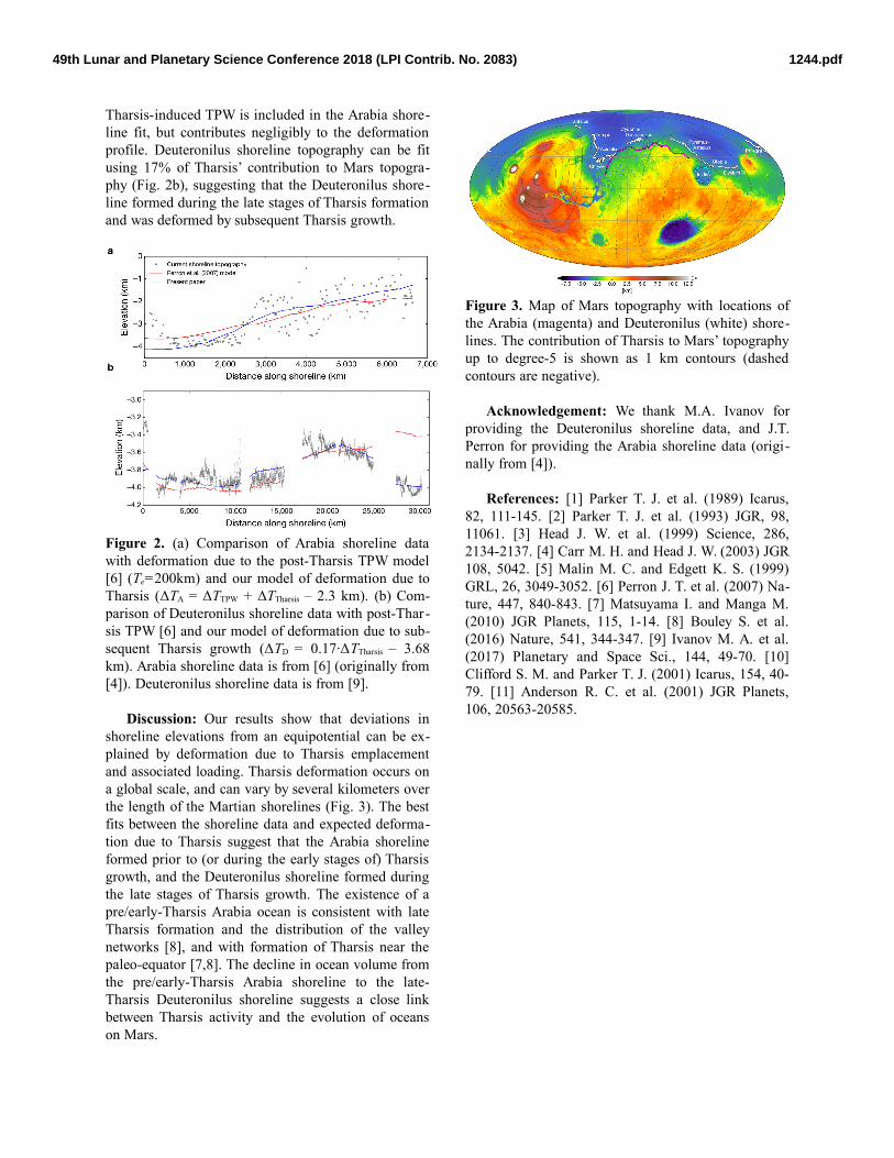
EVIDENCE OF EARLY MARTIAN OCEANS FROM SHORELINE DEFORMATION DUE TO THARSIS. R. I. Citron 1 , M. Manga 1 , and D. Hemingway 1 , 1 Department of Earth and Planetary Science, University of Califor- nia, Berkeley, CA 94720 ([email protected]). Introduction: The existence of an early ocean on Mars has been a subject of much debate. The most compelling evidence for an ancient ocean may be the putative shorelines in the northern plains [1-4]. How- ever, the shorelines fail to follow an equipotential, a necessary condition for them to have been emplaced by an ocean [5]. Perron et al. [6] showed that the devi- ation of two shorelines, Arabia and Deuteronilus, from an equipotential can be explained by post-Tharsis true polar wander (TPW) caused by ocean loading. How- ever, ocean loads can only drive the necessary TPW (30-60° for Arabia, and 5-25° for Deuteronilus) if Tharsis formed far from the equator (Fig. 1; see also Fig. S2 of [6]). Most evidence suggests Tharsis formed near the equator [7,8], meaning that Mars’ fossil bulge would have stabilized the planet against post-Tharsis TPW. Explaining the topographic deviations of the shorelines thus remains a challenge. Figure 1. (a) If Tharsis forms far from the equator, then (b) large scale TPW reorients Mars until Tharsis is at the equator. (c) After reorientation, the fossil bulge is nearly perpendicular to the equatorial bulge, allowing subsequent TPW due to ocean loading along an arc 90° from Tharsis (blue dashed line) [6]. (d) If Tharsis forms near the equator, then (e) limited (<20°) TPW occurs. (f) This results in a fossil bulge that is close to the equatorial bulge, which stabilizes Mars against TPW driven by ocean loads. We propose that the topographic deviations of Martian shorelines can instead be explained by defor- mation due to the formation of Tharsis. The Deuteronilus shoreline has been recently dated to 3.6 Ga [9], and the Arabia shoreline was potentially em- placed ~4 Ga [10]. Formation of Tharsis likely began >3.7 Ga, however, its complex and multi-stage growth extended into the Hesperian and Amazonian [11]. Be- cause Tharsis emplacement and associated loading contribute significantly to Martian topography on a global scale, shorelines that formed prior to (or dur- ing) Tharsis formation could have been deformed by subsequent Tharsis growth. We compare deformation due to Tharsis with the topographic profiles of the Arabia and Deuteronilus shorelines. Methods: We consider how each shoreline could have been deformed by subsequent global changes to Martian topography from both Tharsis-induced TPW (~20° from the paleopole identified by [7]) and Thar- sis emplacement and associated loading. Because the ~ 4 Ga Arabia shoreline likely pre-dates most of Thar- sis, we compare the current Arabia shoreline eleva- tions to a long-wavelength deformation profile given by ΔTA = ΔTTPW + ΔTTharsis + Z, where ΔTTPW is the de- formation due to Tharsis-induced TPW, ΔTTharsis is the deformation due to Tharsis emplacement/loading, and Z is a constant to adjust for the elevation of the equipotential surface that would define sea-level. ΔTTPW is computed as in [6] but using the paleopole corresponding to Mars’ fossil bulge from [7] (20° of TPW) and an elastic lithosphere thickness Te = 58 km [7]. The contribution of Tharsis to Mars’ topography is given by ΔTTharsis = S N, where S and N are the shape and gravity coefficients for Tharsis up to degree-5 from [7]. Because the younger (3.6 Ga) Deuteronilus shore- line likely formed after a portion of Tharsis growth, we assume Tharsis-induced TPW would have already been complete, and compare the current Deuteronilus shoreline elevations to deformation expected from the late stages of Tharsis growth. The long-wavelength deformation of the Deuteronilus shoreline due to a portion of Tharsis emplacement/loading is given by ΔTD = C·ΔTTharsis + Z, where C is a constant to adjust for the portion of Tharsis that formed after Deuteronilus. We determine the best fit profiles ΔTA and ΔTD by adjusting C and Z and minimizing the misfit to the shoreline data. Results: We find our model of deformation due to Tharsis can explain the long-wavelength topography of the Arabia and Deuteronilus shorelines (Fig. 2). The Arabia shoreline’s topography can be explained by its formation prior to Tharsis, and deformation due to Tharsis’ contribution to Mars topography (Fig. 2a). 1244.pdf 49th Lunar and Planetary Science Conference 2018 (LPI Contrib. No. 2083)
Transcript

EVIDENCE OF EARLY MARTIAN OCEANS FROM SHORELINE DEFORMATION DUE TO THARSIS.R. I. Citron1, M. Manga1, and D. Hemingway1, 1Department of Earth and Planetary Science, University of Califor-nia, Berkeley, CA 94720 ([email protected]).

Introduction: The existence of an early ocean onMars has been a subject of much debate. The mostcompelling evidence for an ancient ocean may be theputative shorelines in the northern plains [1-4]. How-ever, the shorelines fail to follow an equipotential, anecessary condition for them to have been emplacedby an ocean [5]. Perron et al. [6] showed that the devi-ation of two shorelines, Arabia and Deuteronilus, froman equipotential can be explained by post-Tharsis truepolar wander (TPW) caused by ocean loading. How-ever, ocean loads can only drive the necessary TPW(30-60° for Arabia, and 5-25° for Deuteronilus) ifTharsis formed far from the equator (Fig. 1; see alsoFig. S2 of [6]). Most evidence suggests Tharsis formednear the equator [7,8], meaning that Mars’ fossil bulgewould have stabilized the planet against post-TharsisTPW. Explaining the topographic deviations of theshorelines thus remains a challenge.

Figure 1. (a) If Tharsis forms far from the equator,then (b) large scale TPW reorients Mars until Tharsisis at the equator. (c) After reorientation, the fossilbulge is nearly perpendicular to the equatorial bulge,allowing subsequent TPW due to ocean loading alongan arc 90° from Tharsis (blue dashed line) [6]. (d) IfTharsis forms near the equator, then (e) limited (<20°)TPW occurs. (f) This results in a fossil bulge that isclose to the equatorial bulge, which stabilizes Marsagainst TPW driven by ocean loads.

We propose that the topographic deviations ofMartian shorelines can instead be explained by defor-mation due to the formation of Tharsis. TheDeuteronilus shoreline has been recently dated to 3.6Ga [9], and the Arabia shoreline was potentially em-placed ~4 Ga [10]. Formation of Tharsis likely began>3.7 Ga, however, its complex and multi-stage growthextended into the Hesperian and Amazonian [11]. Be-

cause Tharsis emplacement and associated loadingcontribute significantly to Martian topography on aglobal scale, shorelines that formed prior to (or dur-ing) Tharsis formation could have been deformed bysubsequent Tharsis growth. We compare deformationdue to Tharsis with the topographic profiles of theArabia and Deuteronilus shorelines.

Methods: We consider how each shoreline couldhave been deformed by subsequent global changes toMartian topography from both Tharsis-induced TPW(~20° from the paleopole identified by [7]) and Thar-sis emplacement and associated loading. Because the~ 4 Ga Arabia shoreline likely pre-dates most of Thar -sis, we compare the current Arabia shoreline eleva-tions to a long-wavelength deformation profile givenby ΔTA = ΔTTPW + ΔTTharsis + Z, where ΔTTPW is the de-formation due to Tharsis-induced TPW, ΔTTharsis is thedeformation due to Tharsis emplacement/loading, andZ is a constant to adjust for the elevation of theequipotential surface that would define sea-level.ΔTTPW is computed as in [6] but using the paleopolecorresponding to Mars’ fossil bulge from [7] (20° ofTPW) and an elastic lithosphere thickness Te = 58 km[7]. The contribution of Tharsis to Mars’ topography isgiven by ΔTTharsis = S – N, where S and N are the shapeand gravity coefficients for Tharsis up to degree-5from [7].

Because the younger (3.6 Ga) Deuteronilus shore-line likely formed after a portion of Tharsis growth,we assume Tharsis-induced TPW would have alreadybeen complete, and compare the current Deuteronilusshoreline elevations to deformation expected from thelate stages of Tharsis growth. The long-wavelengthdeformation of the Deuteronilus shoreline due to aportion of Tharsis emplacement/loading is given byΔTD = C·ΔTTharsis + Z, where C is a constant to adjustfor the portion of Tharsis that formed afterDeuteronilus.

We determine the best fit profiles ΔTA and ΔTD byadjusting C and Z and minimizing the misfit to theshoreline data.

Results: We find our model of deformation due toTharsis can explain the long-wavelength topographyof the Arabia and Deuteronilus shorelines (Fig. 2).The Arabia shoreline’s topography can be explainedby its formation prior to Tharsis, and deformation dueto Tharsis’ contribution to Mars topography (Fig. 2a).

1244.pdf49th Lunar and Planetary Science Conference 2018 (LPI Contrib. No. 2083)

Tharsis-induced TPW is included in the Arabia shore-line fit, but contributes negligibly to the deformationprofile. Deuteronilus shoreline topography can be fitusing 17% of Tharsis’ contribution to Mars topogra-phy (Fig. 2b), suggesting that the Deuteronilus shore-line formed during the late stages of Tharsis formationand was deformed by subsequent Tharsis growth.

Figure 2. (a) Comparison of Arabia shoreline datawith deformation due to the post-Tharsis TPW model[6] (Te=200km) and our model of deformation due toTharsis (ΔTA = ΔTTPW + ΔTTharsis – 2.3 km). (b) Com-parison of Deuteronilus shoreline data with post-Thar-sis TPW [6] and our model of deformation due to sub-sequent Tharsis growth (ΔTD = 0.17·ΔTTharsis – 3.68km). Arabia shoreline data is from [6] (originally from[4]). Deuteronilus shoreline data is from [9].

Discussion: Our results show that deviations inshoreline elevations from an equipotential can be ex-plained by deformation due to Tharsis emplacementand associated loading. Tharsis deformation occurs ona global scale, and can vary by several kilometers overthe length of the Martian shorelines (Fig. 3). The bestfits between the shoreline data and expected deforma-tion due to Tharsis suggest that the Arabia shorelineformed prior to (or during the early stages of) Tharsisgrowth, and the Deuteronilus shoreline formed duringthe late stages of Tharsis growth. The existence of apre/early-Tharsis Arabia ocean is consistent with lateTharsis formation and the distribution of the valleynetworks [8], and with formation of Tharsis near thepaleo-equator [7,8]. The decline in ocean volume fromthe pre/early-Tharsis Arabia shoreline to the late-Tharsis Deuteronilus shoreline suggests a close linkbetween Tharsis activity and the evolution of oceanson Mars.

Figure 3. Map of Mars topography with locations ofthe Arabia (magenta) and Deuteronilus (white) shore-lines. The contribution of Tharsis to Mars’ topographyup to degree-5 is shown as 1 km contours (dashedcontours are negative).

Acknowledgement: We thank M.A. Ivanov forproviding the Deuteronilus shoreline data, and J.T.Perron for providing the Arabia shoreline data (origi-nally from [4]).

References: [1] Parker T. J. et al. (1989) Icarus,82, 111-145. [2] Parker T. J. et al. (1993) JGR, 98,11061. [3] Head J. W. et al. (1999) Science, 286,2134-2137. [4] Carr M. H. and Head J. W. (2003) JGR108, 5042. [5] Malin M. C. and Edgett K. S. (1999)GRL, 26, 3049-3052. [6] Perron J. T. et al. (2007) Na-ture, 447, 840-843. [7] Matsuyama I. and Manga M.(2010) JGR Planets, 115, 1-14. [8] Bouley S. et al.(2016) Nature, 541, 344-347. [9] Ivanov M. A. et al.(2017) Planetary and Space Sci., 144, 49-70. [10]Clifford S. M. and Parker T. J. (2001) Icarus, 154, 40-79. [11] Anderson R. C. et al. (2001) JGR Planets,106, 20563-20585.

1244.pdf49th Lunar and Planetary Science Conference 2018 (LPI Contrib. No. 2083)


Recommended