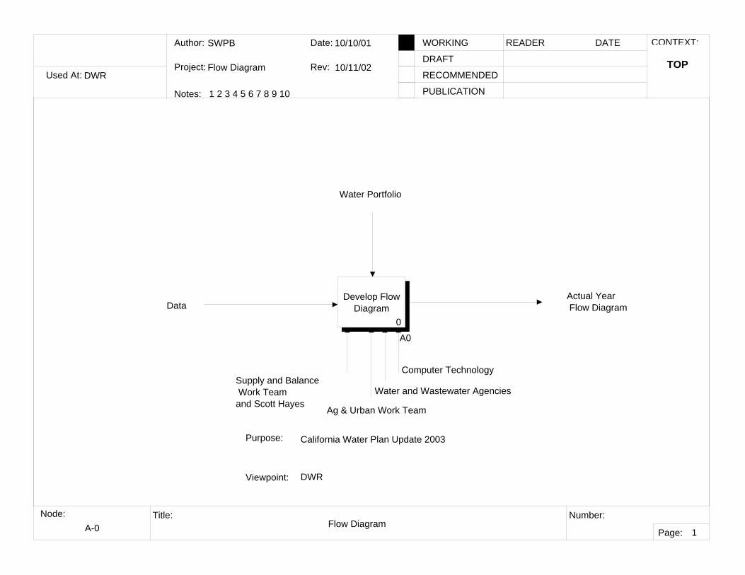
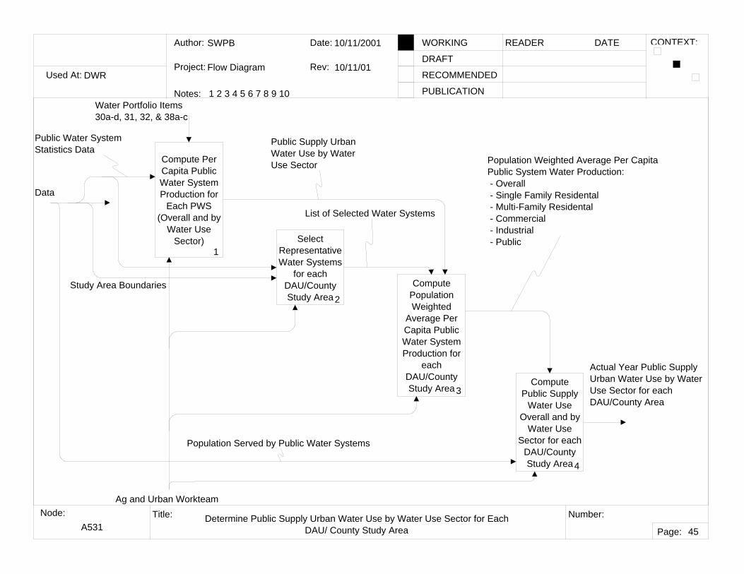
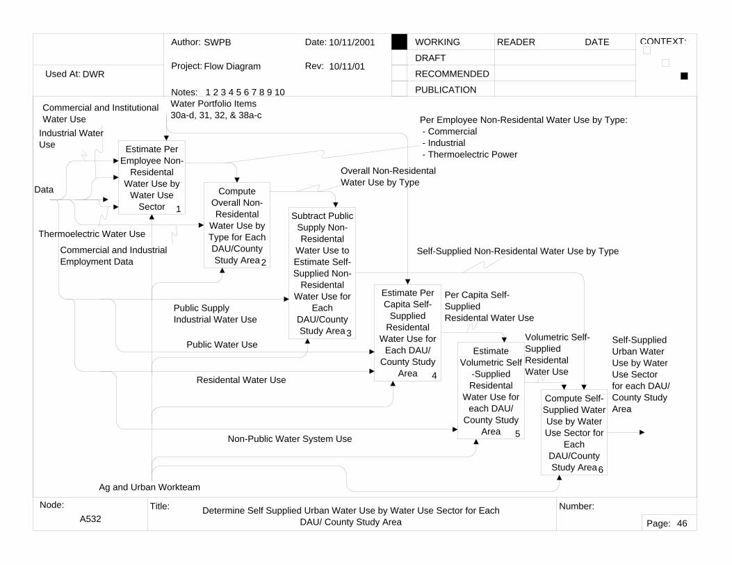
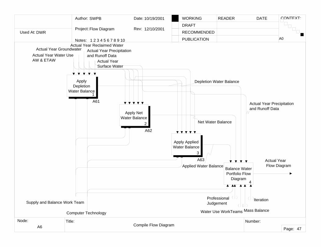
Used At: Author: Notes: 1 2 3 4 5 6 7 8 9 10 Date: Rev: READER DATE WORKING DRAFT RECOMMENDED PUBLICATION Project: Node: Title: Number: Page: CONTEXT: DWR SWPB Flow Diagram 10/10/01 10/11/02 A-0 Flow Diagram TOP 1 Purpose: Viewpoint: California Water Plan Update 2003 DWR Develop Flow Diagram 0 A0 Data Water Portfolio Actual Year Flow Diagram Supply and Balance Work Team and Scott Hayes Water and Wastewater Agencies Ag & Urban Work Team Computer Technology
Transcript
Used At:
Author:
Notes: 1 2 3 4 5 6 7 8 9 10
Date:
Rev:
READER DATEWORKING
DRAFT
RECOMMENDED
PUBLICATION
Project:
Node: Title: Number:
Page:
CONTEXT:
DWR
SWPB
Flow Diagram
10/10/01
10/11/02
A-0 Flow Diagram
TOP
1
Purpose:
Viewpoint:
California Water Plan Update 2003
DWR
Develop Flow Diagram
0
A0
Data
Water Portfolio
Actual Year Flow Diagram
Supply and Balance Work Team and Scott Hayes
Water and Wastewater Agencies
Ag & Urban Work Team
Computer Technology
Used At:
Author:
Notes: 1 2 3 4 5 6 7 8 9 10
Date:
Rev:
READER DATEWORKING
DRAFT
RECOMMENDED
PUBLICATION
Project:
Node: Title: Number:
Page:
CONTEXT:
DWR
SWPB
Flow Diagram
10/10/01
10/11/02
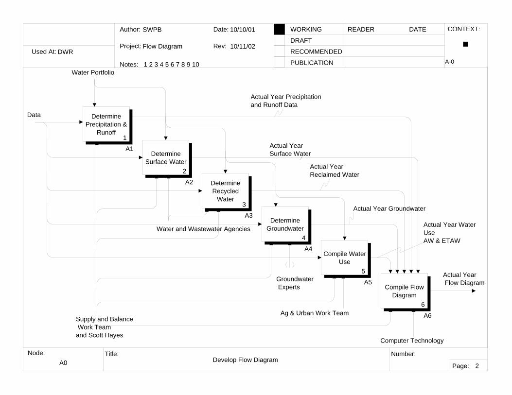
A0 Develop Flow Diagram
A-0
2
Determine Precipitation &
Runoff1
A1Determine
Surface Water2
A2 Determine Recycled
Water3
A3Determine
Groundwater4
A4Compile Water
Use 5
A5Compile Flow
Diagram6
A6
Water Portfolio
Supply and Balance Work Team and Scott Hayes
Actual Year Flow Diagram
Actual Year Precipitation and Runoff Data
Actual Year Reclaimed Water
Actual Year Groundwater
Actual Year Water UseAW & ETAW
Water and Wastewater Agencies
Ag & Urban Work Team
Groundwater Experts
Data
Computer Technology
Actual Year Surface Water
Used At:
Author:
Notes: 1 2 3 4 5 6 7 8 9 10
Date:
Rev:
READER DATEWORKING
DRAFT
RECOMMENDED
PUBLICATION
Project:
Node: Title: Number:
Page:
CONTEXT:
DWR
SWPB
Flow Diagram
10/10/01
3/5/02
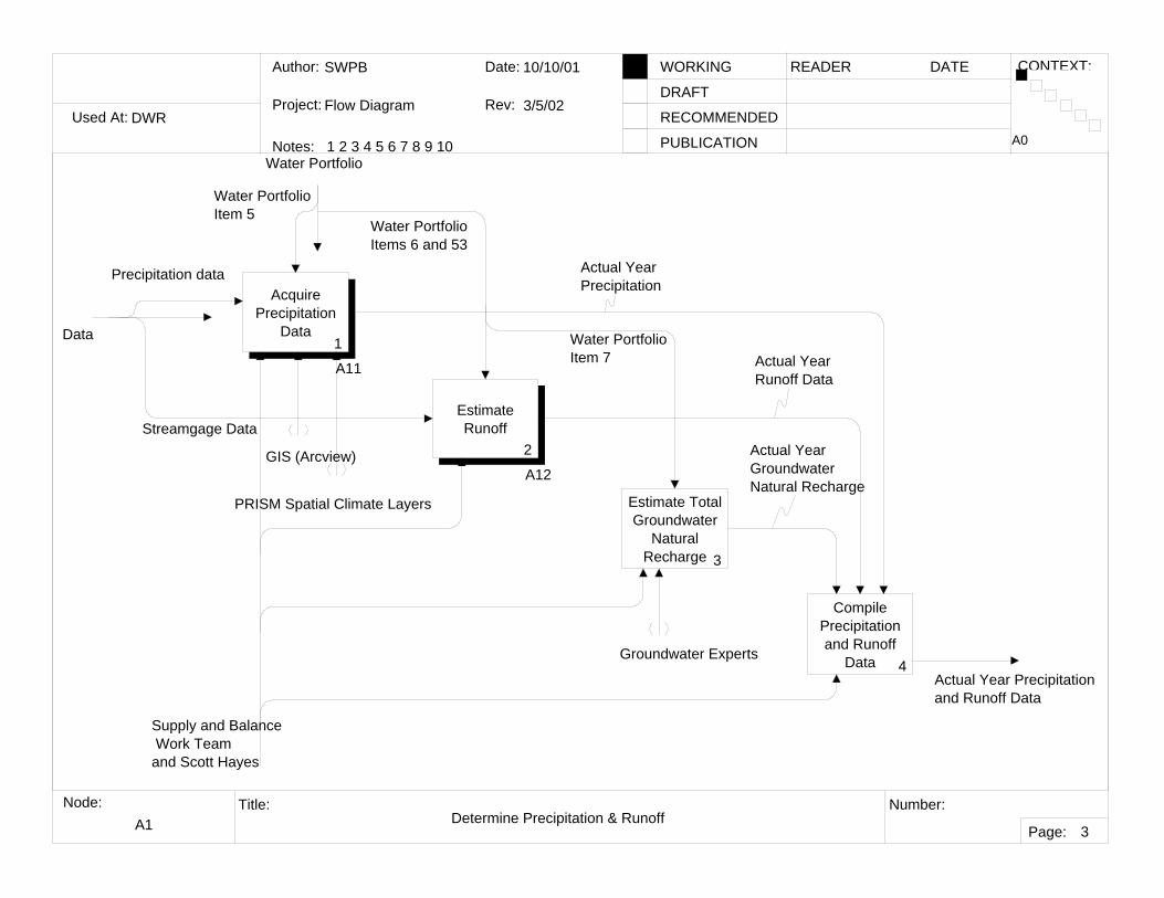
A1 Determine Precipitation & Runoff
A0
3
Acquire Precipitation
Data1
A11
Estimate Runoff
2
A12
Estimate Total Groundwater
Natural Recharge 3
Compile Precipitation and Runoff
Data 4Actual Year Precipitation and Runoff Data
Water Portfolio Item 5
Water Portfolio Items 6 and 53
Water PortfolioItem 7
Actual YearPrecipitation
Actual YearRunoff Data
Actual Year Groundwater Natural Recharge
Precipitation data
Streamgage Data
Groundwater Experts
Supply and Balance Work Team and Scott Hayes
Water Portfolio
Data
GIS (Arcview)
PRISM Spatial Climate Layers
Used At:
Author:
Notes: 1 2 3 4 5 6 7 8 9 10
Date:
Rev:
READER DATEWORKING
DRAFT
RECOMMENDED
PUBLICATION
Project:
Node: Title: Number:
Page:
CONTEXT:
DWR
SWPB
Flow Diagram
3/5/02
3/5/02
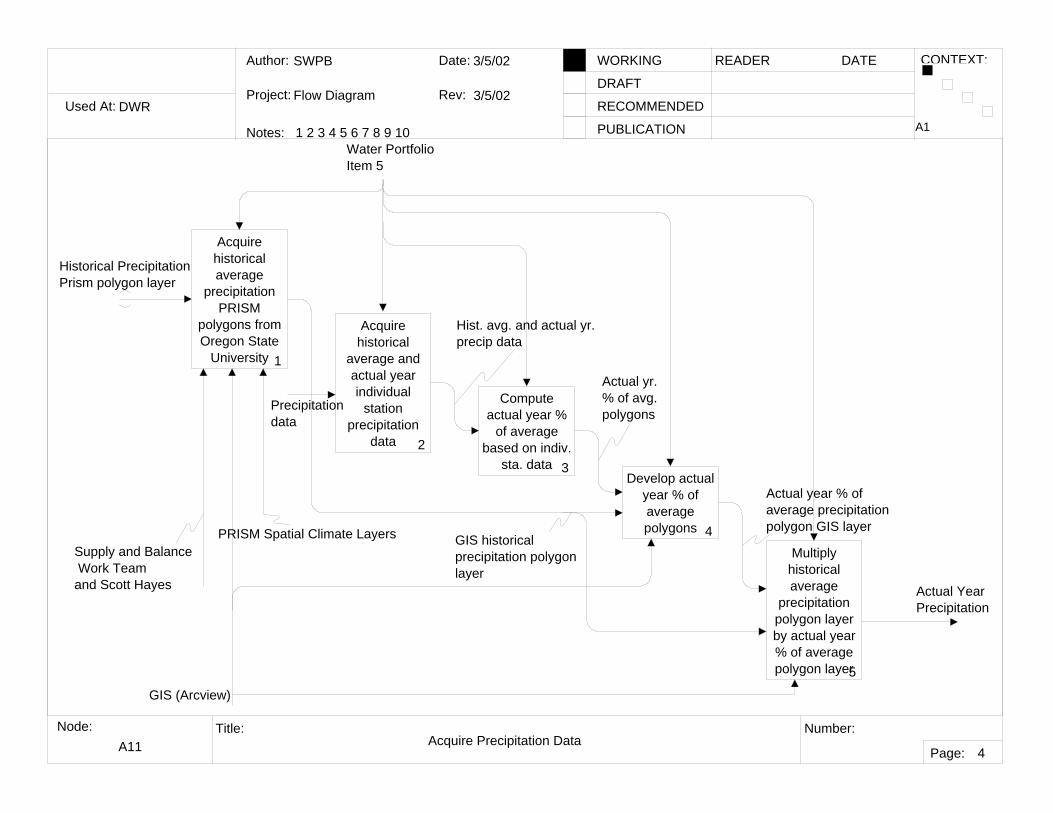
A11 Acquire Precipitation Data
A1
4
Acquire historical average
precipitation PRISM
polygons from Oregon State
University 1
Acquire historical
average and actual year individual
station precipitation
data 2
Compute actual year %
of average based on indiv.
sta. data 3Develop actual
year % of average polygons 4
Multiply historical average
precipitation polygon layer by actual year % of average polygon layer5
Water Portfolio Item 5
Precipitationdata
GIS (Arcview)
Supply and Balance Work Team and Scott Hayes Actual Year
Precipitation
PRISM Spatial Climate Layers
Historical PrecipitationPrism polygon layer
GIS historical precipitation polygon layer
Hist. avg. and actual yr. precip data
Actual yr. % of avg. polygons
Actual year % of average precipitation polygon GIS layer
Used At:
Author:
Notes: 1 2 3 4 5 6 7 8 9 10
Date:
Rev:
READER DATEWORKING
DRAFT
RECOMMENDED
PUBLICATION
Project:
Node: Title: Number:
Page:
CONTEXT:
DWR
SWPB
Flow Diagram
10/10/01
10/10/01
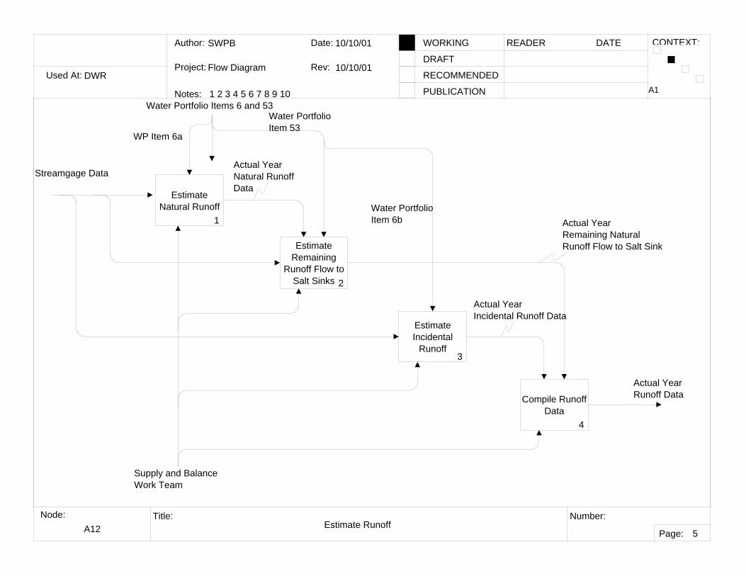
A12 Estimate Runoff
A1
5
Estimate Natural Runoff
1
Estimate Remaining
Runoff Flow to Salt Sinks 2
Estimate Incidental
Runoff3
Compile Runoff Data
4
Streamgage Data
Water Portfolio Item 53
Water PortfolioItem 6b
Actual Year Natural RunoffData
Actual YearRemaining NaturalRunoff Flow to Salt Sink
Actual Year Incidental Runoff Data
Actual YearRunoff Data
Supply and BalanceWork Team
WP Item 6a
Water Portfolio Items 6 and 53
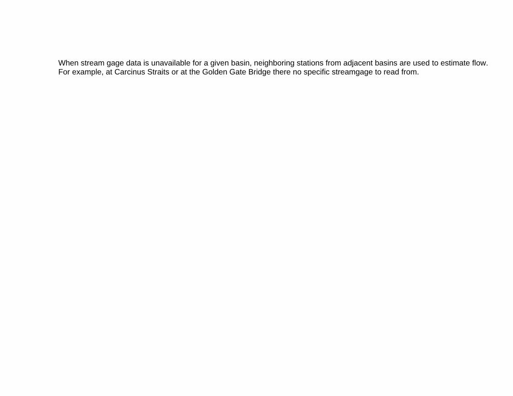
When stream gage data is unavailable for a given basin, neighboring stations from adjacent basins are used to estimate flow. For example, at Carcinus Straits or at the Golden Gate Bridge there no specific streamgage to read from.
Used At:
Author:
Notes: 1 2 3 4 5 6 7 8 9 10
Date:
Rev:
READER DATEWORKING
DRAFT
RECOMMENDED
PUBLICATION
Project:
Node: Title: Number:
Page:
CONTEXT:
DWR
SWPB
Flow Diagram
10/10/01
10/10/01
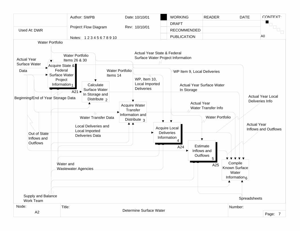
A2 Determine Surface Water
A0
7
Acquire State & Federal
Surface Water Project
Information1
A21
Calculate Surface Water In Storage and
Distribute 2Acquire Water
Transfer Information and
Distribute 3
Acquire Local Deliveries
Information4
A24 Estimate Inflows and
Outflows5
A25 Compile Known Surface
Water Information6
Water Portfolio
Spreadsheets
Water PortfolioItems 26 & 30
Water PortfolioItems 14
Data
Supply and BalanceWork Team
Water and Wastewater Agencies
Actual Year State & FederalSurface Water Project Information
Actual Year Surface WaterIn Storage
Actual Year Water Transfer Info
Actual Year LocalDeliveries Info
Actual Year Inflows and Outflows
Beginning/End of Year Storage Data
Water Transfer Data
WP Item 9, Local Deliveries
WP, Item 10, Local Imported Deliveries
Water Portfolio
Local Deliveries and Local Imported Deliveries DataOut of State
Inflows and Outflows
Actual Year Surface Water
Used At:
Author:
Notes: 1 2 3 4 5 6 7 8 9 10
Date:
Rev:
READER DATEWORKING
DRAFT
RECOMMENDED
PUBLICATION
Project:
Node: Title: Number:
Page:
CONTEXT:
DWR
SWPB
Flow Diagram
10/10/01
10/10/01
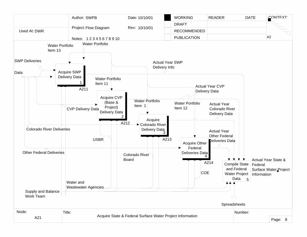
A21 Acquire State & Federal Surface Water Project Information
A2
8
Acquire SWP Delivery Data
1
A211
Acquire CVP (Base & Project)
Delivery Data2
A212Acquire
Colorado River Delivery Data
3
A213Acquire Other
Federal Deliveries Data
4
A214 Compile State and Federal
Water Project Data 5
Supply and BalanceWork Team
Water and Wastewater Agencies
Water Portfolio Item 13
Water PortfolioItem 11
Water Portfolio Item 1
Water PortfolioItem 12
Spreadsheets
Actual YearOther FederalDeliveries Data
Actual Year Colorado RiverDelivery Data
Actual Year CVP Delivery Data
Actual Year SWPDelivery Info
USBR
COE
Actual Year State & FederalSurface Water Project Information
Water Portfolio
Data
SWP Deliveries
CVP Delivery Data
Colorado River Deliveries
Other Federal Deliveries Colorado River Board
Used At:
Author:
Notes: 1 2 3 4 5 6 7 8 9 10
Date:
Rev:
READER DATEWORKING
DRAFT
RECOMMENDED
PUBLICATION
Project:
Node: Title: Number:
Page:
CONTEXT:
DWR
SWPB
Flow Diagram
10/15/2001
11/1/01
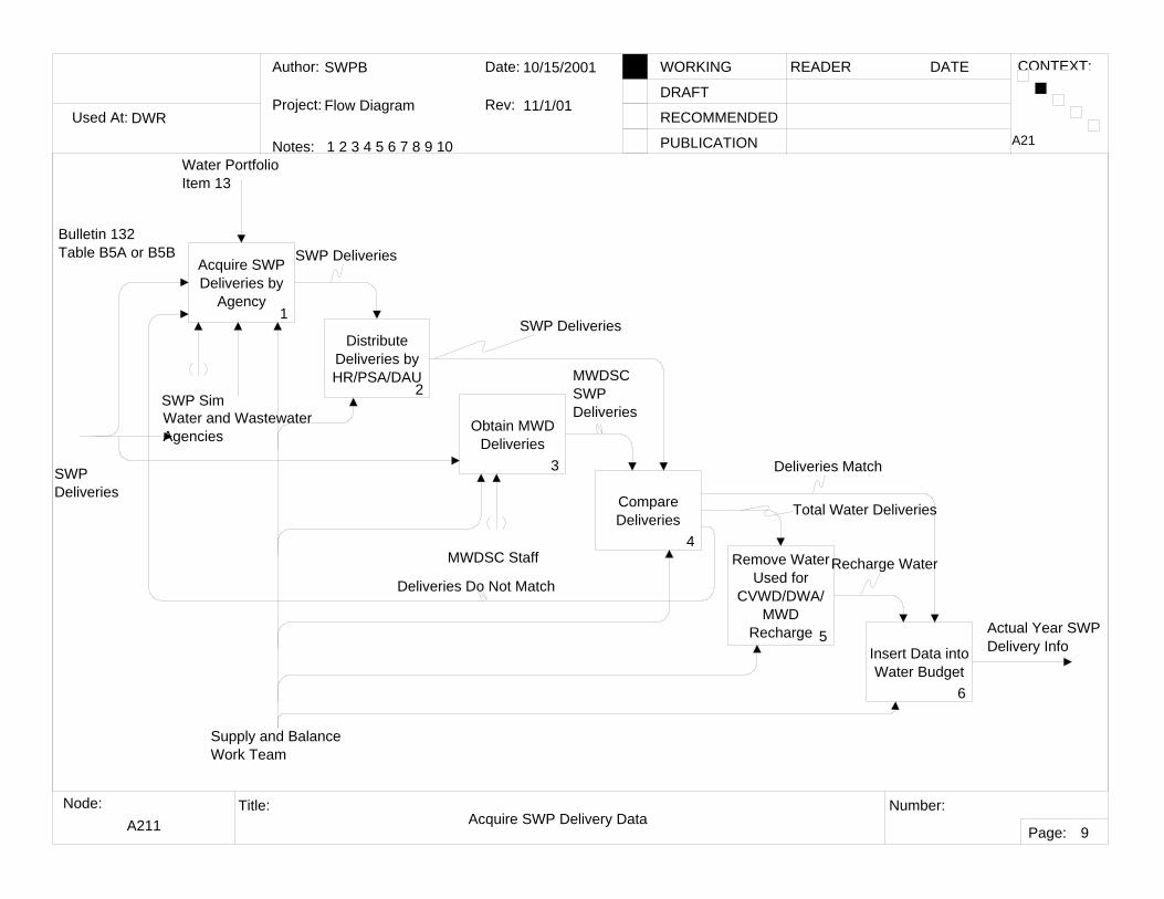
A211 Acquire SWP Delivery Data
A21
9
Acquire SWP Deliveries by
Agency1
Distribute Deliveries by HR/PSA/DAU
2
Obtain MWD Deliveries
3
Compare Deliveries
4Remove Water
Used for CVWD/DWA/
MWD Recharge 5
Insert Data into Water Budget
6
Water and Wastewater Agencies
Supply and BalanceWork Team
SWP Sim
Water Portfolio Item 13
Actual Year SWPDelivery Info
SWP DeliveriesBulletin 132Table B5A or B5B
SWP Deliveries
MWDSC Staff
MWDSCSWPDeliveries
Deliveries Do Not Match
Deliveries Match
Total Water Deliveries
Recharge Water
SWP Deliveries
Obtain MWD Deliveries For Southern California District Only
Used At:
Author:
Notes: 1 2 3 4 5 6 7 8 9 10
Date:
Rev:
READER DATEWORKING
DRAFT
RECOMMENDED
PUBLICATION
Project:
Node: Title: Number:
Page:
CONTEXT:
DWR
SWPB
Flow Diagram
12/7/01
12/7/01
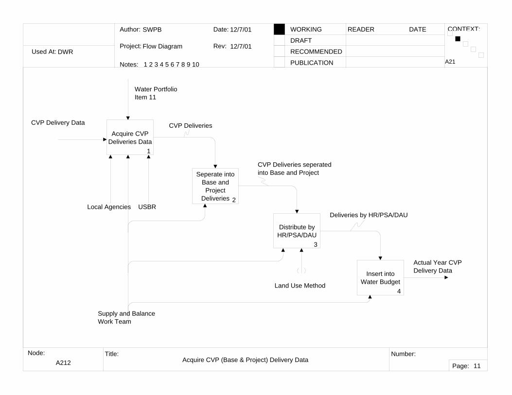
A212 Acquire CVP (Base & Project) Delivery Data
A21
11
Acquire CVP Deliveries Data
1
Seperate into Base and Project
Deliveries 2
Distribute by HR/PSA/DAU
3
Insert into Water Budget
4
CVP Delivery Data
Water PortfolioItem 11
Supply and BalanceWork Team
Local Agencies USBR
Actual Year CVP Delivery Data
Land Use Method
CVP Deliveries
CVP Deliveries seperated into Base and Project
Deliveries by HR/PSA/DAU
Used At:
Author:
Notes: 1 2 3 4 5 6 7 8 9 10
Date:
Rev:
READER DATEWORKING
DRAFT
RECOMMENDED
PUBLICATION
Project:
Node: Title: Number:
Page:
CONTEXT:
DWR
SWPB
Flow Diagram
10/15/2001
10/15/01
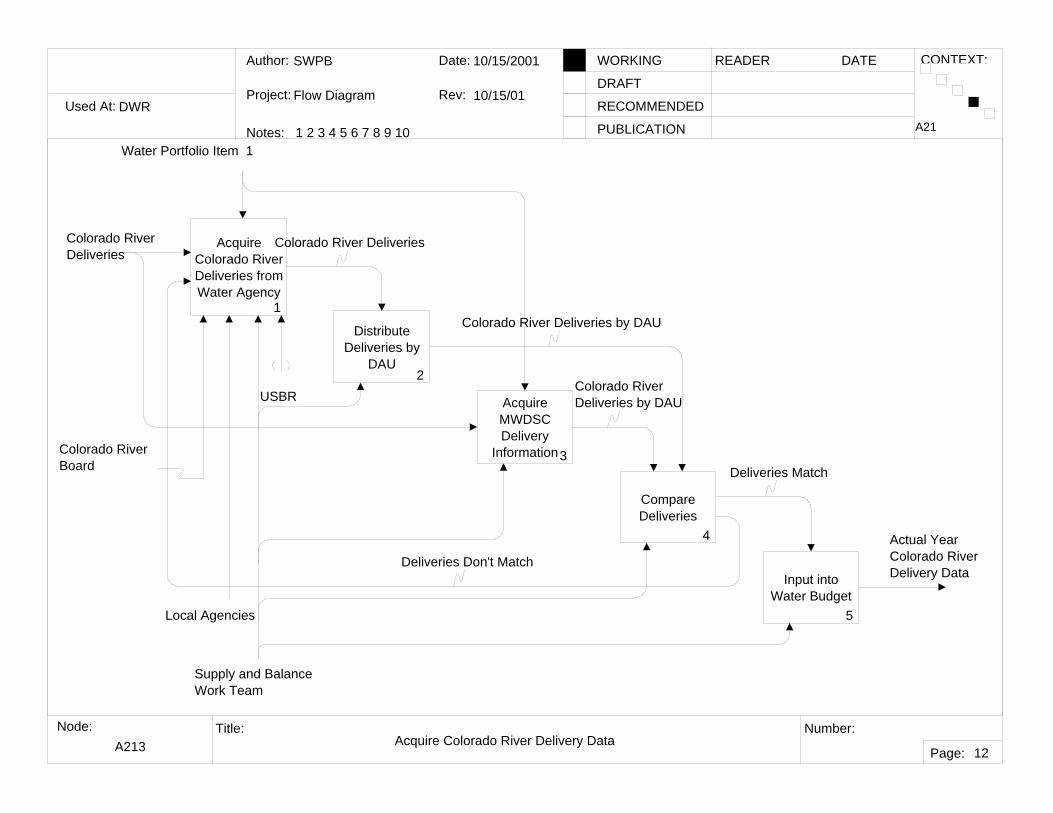
A213 Acquire Colorado River Delivery Data
A21
12
Acquire Colorado River Deliveries from Water Agency
1
Distribute Deliveries by
DAU2
Acquire MWDSC Delivery
Information3
Input into Water Budget
5
Supply and BalanceWork Team
Local Agencies
Water Portfolio Item 1
Actual Year Colorado RiverDelivery Data
Colorado River Board
USBR
Compare Deliveries
4
Deliveries Match
Deliveries Don't Match
Colorado River Deliveries
Colorado River Deliveries by DAU
Colorado RiverDeliveries by DAU
Colorado River Deliveries
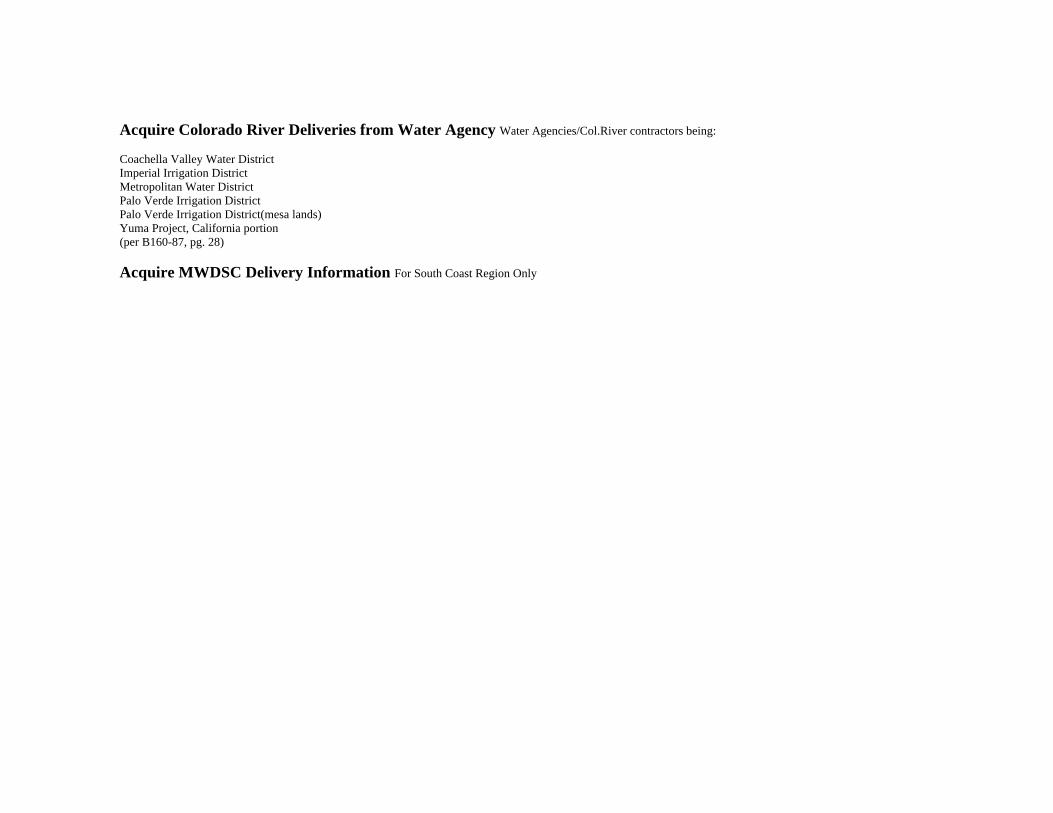
Acquire Colorado River Deliveries from Water Agency Water Agencies/Col.River contractors being:
Coachella Valley Water DistrictImperial Irrigation DistrictMetropolitan Water DistrictPalo Verde Irrigation DistrictPalo Verde Irrigation District(mesa lands)Yuma Project, California portion(per B160-87, pg. 28)
Acquire MWDSC Delivery Information For South Coast Region Only
Used At:
Author:
Notes: 1 2 3 4 5 6 7 8 9 10
Date:
Rev:
READER DATEWORKING
DRAFT
RECOMMENDED
PUBLICATION
Project:
Node: Title: Number:
Page:
CONTEXT:
DWR
SWPB
Flow Diagram
10/15/2001
10/15/01
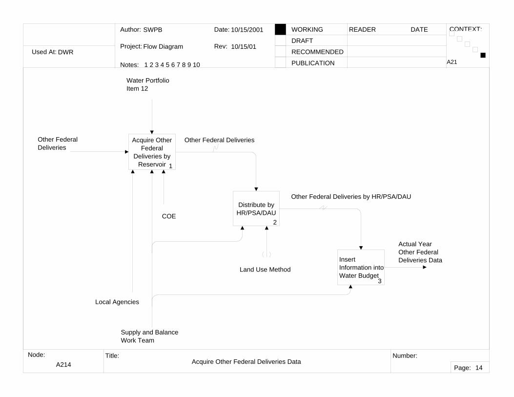
A214 Acquire Other Federal Deliveries Data
A21
14
Acquire Other Federal
Deliveries by Reservoir 1
Distribute by HR/PSA/DAU
2
Insert Information into Water Budget
3
COE
Supply and BalanceWork Team
Local Agencies
Water PortfolioItem 12
Actual YearOther FederalDeliveries Data
Other Federal Deliveries
Other Federal Deliveries by HR/PSA/DAU
Other Federal Deliveries
Land Use Method
Used At:
Author:
Notes: 1 2 3 4 5 6 7 8 9 10
Date:
Rev:
READER DATEWORKING
DRAFT
RECOMMENDED
PUBLICATION
Project:
Node: Title: Number:
Page:
CONTEXT:
DWR
SWPB
Flow Diagram
10/10/01
10/10/01
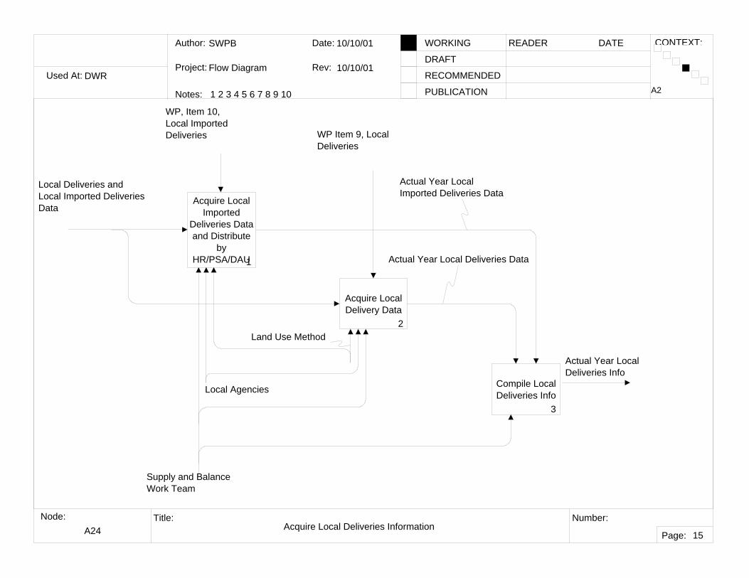
A24 Acquire Local Deliveries Information
A2
15
Acquire Local Imported
Deliveries Data and Distribute
by HR/PSA/DAU1
Acquire Local Delivery Data
2
Compile Local Deliveries Info
3
Local Agencies
Supply and BalanceWork Team
Actual Year Local Deliveries Data
Actual Year Local Imported Deliveries Data
Actual Year LocalDeliveries Info
Local Deliveries and Local Imported Deliveries Data
WP Item 9, Local Deliveries
WP, Item 10, Local Imported Deliveries
Land Use Method
Used At:
Author:
Notes: 1 2 3 4 5 6 7 8 9 10
Date:
Rev:
READER DATEWORKING
DRAFT
RECOMMENDED
PUBLICATION
Project:
Node: Title: Number:
Page:
CONTEXT:
DWR
SWPB
Flow Diagram
10/10/01
10/10/01
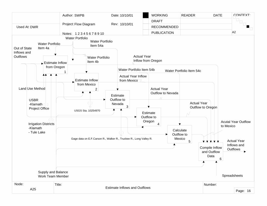
A25 Estimate Inflows and Outflows
A2
16
Estimate Inflow from Oregon
1
Estimate Inflow from Mexico
2
Estimate Outflow to Nevada
3
Estimate Outflow to
Oregon4
Calculate Outflow to
Mexico5
Compile Inflow and Outflow
Data 6
Supply and BalanceWork Team Member
Actual Year Inflow from Mexico
Actual YearOutflow to Nevada
Actual YearOutflow to Oregon
Acutal Year Outflow to Mexico
Water PortfolioItem 4a
Water Portfolio Item 4b
Water Portfolio Item 54a
Water Portfolio Item 54b Water Portfolio Item 54c
Actual YearInflow from Oregon
Land Use Method
Spreadsheets
USBR-KlamathProject Office
Irrigation Districts -Klamath- Tule Lake
Actual Year Inflows and Outflows
Water Portfolio
Out of State Inflows and Outflows
USGS Sta. 10254970
Gage data on E.F.Carson R., Walker R., Truckee R., Long Valley R.
Used At:
Author:
Notes: 1 2 3 4 5 6 7 8 9 10
Date:
Rev:
READER DATEWORKING
DRAFT
RECOMMENDED
PUBLICATION
Project:
Node: Title: Number:
Page:
CONTEXT:
DWR
SWPB
Flow Diagram
10/10/01
10/10/01
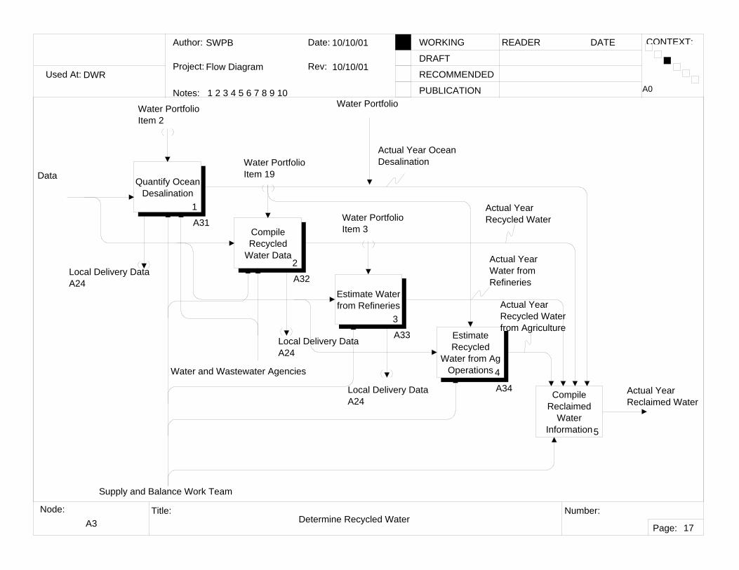
A3 Determine Recycled Water
A0
17
Quantify Ocean Desalination
1
A31Compile Recycled
Water Data2
A32Estimate Water from Refineries
3
A33
Compile Reclaimed
Water Information5
Actual Year Reclaimed Water
Water PortfolioItem 2
Water Portfolio Item 19
Water PortfolioItem 3
Actual Year Ocean Desalination
Actual Year Recycled Water
Actual YearWater fromRefineries
Local Delivery Data A24
Local Delivery DataA24
Local Delivery Data A24
Water and Wastewater Agencies
Estimate Recycled
Water from Ag Operations 4
A34
Actual YearRecycled Water from Agriculture
Data
Supply and Balance Work Team
Water Portfolio
Used At:
Author:
Notes: 1 2 3 4 5 6 7 8 9 10
Date:
Rev:
READER DATEWORKING
DRAFT
RECOMMENDED
PUBLICATION
Project:
Node: Title: Number:
Page:
CONTEXT:
DWR
SWPB
Flow Diagram
10/15/2001
10/15/01
A31 Quantify Ocean Desalination
A3
18
Acquire Desalting
Information by Plant 1
Distribute by HR/PSA/DAU
2
Quantify Ocean Desal
3
Water PortfolioItem 2
Actual Year Ocean Desalination
Local Delivery DataA24
Desalting Information Desal Information by Plant
Ocean Desal by HR/PSA/DAU
Data
Supply and Balance Work Team
Water and Wastewater Agencies
Used At:
Author:
Notes: 1 2 3 4 5 6 7 8 9 10
Date:
Rev:
READER DATEWORKING
DRAFT
RECOMMENDED
PUBLICATION
Project:
Node: Title: Number:
Page:
CONTEXT:
DWR
SWPB
Flow Diagram
10/15/2001
10/15/01
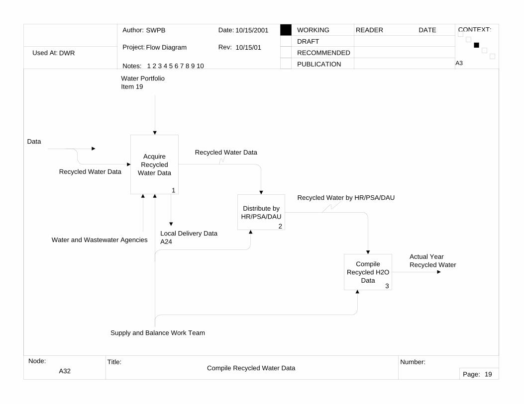
A32 Compile Recycled Water Data
A3
19
Acquire Recycled
Water Data
1
Distribute by HR/PSA/DAU
2
Compile Recycled H2O
Data3
Water Portfolio Item 19
Water and Wastewater AgenciesLocal Delivery Data A24
Actual Year Recycled Water
Recycled Water Data
Recycled Water Data
Recycled Water by HR/PSA/DAU
Supply and Balance Work Team
Data
Used At:
Author:
Notes: 1 2 3 4 5 6 7 8 9 10
Date:
Rev:
READER DATEWORKING
DRAFT
RECOMMENDED
PUBLICATION
Project:
Node: Title: Number:
Page:
CONTEXT:
DWR
SWPB
Flow Diagram
10/15/2001
10/15/01
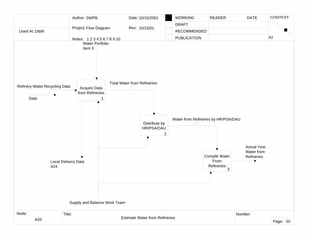
A33 Estimate Water from Refineries
A3
20
Acquire Data from Refineries
1
Distribute by HR/PSA/DAU
2
Compile Water From
Refineries3
Water PortfolioItem 3
Actual YearWater fromRefineries
Local Delivery Data A24
Water from Refineries by HR/PSA/DAU
Total Water from RefineriesRefinery Water Recycling Data
Supply and Balance Work Team
Data
Used At:
Author:
Notes: 1 2 3 4 5 6 7 8 9 10
Date:
Rev:
READER DATEWORKING
DRAFT
RECOMMENDED
PUBLICATION
Project:
Node: Title: Number:
Page:
CONTEXT:
DWR
SWPB
Flow Diagram
10/15/2001
10/15/01
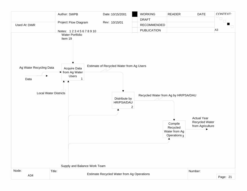
A34 Estimate Recycled Water from Ag Operations
A3
21
Acquire Data from Ag Water
Users1
Distribute by HR/PSA/DAU
2
Compile Recycled
Water from Ag Operations 3
Water Portfolio Item 19
Local Water Districts
Actual YearRecycled Water from Agriculture
Estimate of Recycled Water from Ag Users
Recycled Water from Ag by HR/PSA/DAU
Supply and Balance Work Team
Ag Water Recycling Data
Data
Used At:
Author:
Notes: 1 2 3 4 5 6 7 8 9 10
Date:
Rev:
READER DATEWORKING
DRAFT
RECOMMENDED
PUBLICATION
Project:
Node: Title: Number:
Page:
CONTEXT:
DWR
SWPB
Flow Diagram
10/10/01
10/10/01
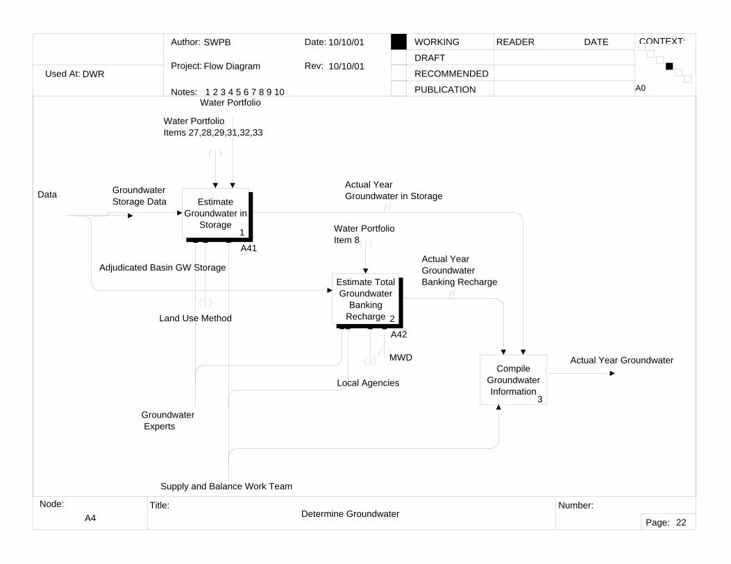
A4 Determine Groundwater
A0
22
Estimate Groundwater in
Storage1
A41
Estimate Total Groundwater
Banking Recharge 2
A42
Compile Groundwater Information
3
Actual Year Groundwater
Water PortfolioItems 27,28,29,31,32,33
Water Portfolio Item 8
Actual Year Groundwater in Storage
Actual YearGroundwater Banking Recharge
Groundwater Storage Data
Adjudicated Basin GW Storage
Groundwater Experts
Land Use Method
Water Portfolio
Data
Supply and Balance Work Team
Local Agencies
MWD
Used At:
Author:
Notes: 1 2 3 4 5 6 7 8 9 10
Date:
Rev:
READER DATEWORKING
DRAFT
RECOMMENDED
PUBLICATION
Project:
Node: Title: Number:
Page:
CONTEXT:
DWR
SWPB
Flow Diagram
10/15/2001
10/15/01
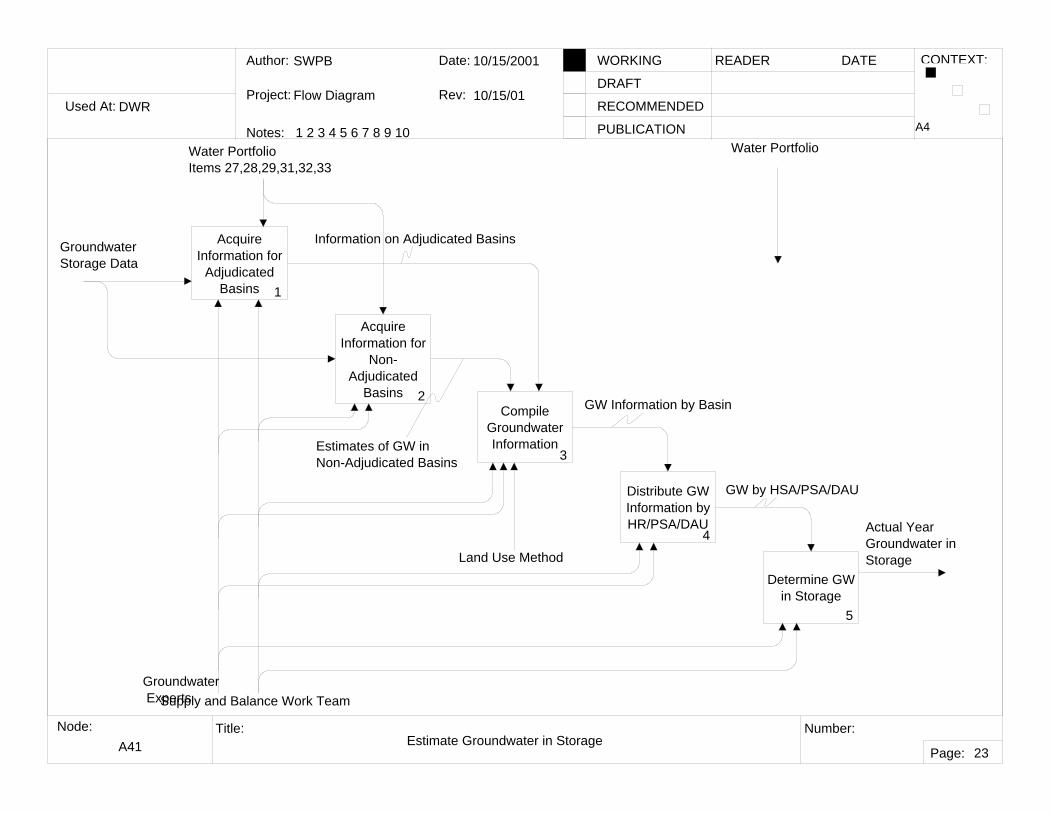
A41 Estimate Groundwater in Storage
A4
23
Acquire Information for
Adjudicated Basins 1
Acquire Information for
Non-Adjudicated
Basins 2Compile
Groundwater Information
3
Distribute GW Information by HR/PSA/DAU
4
Determine GW in Storage
5
Water PortfolioItems 27,28,29,31,32,33
Groundwater Storage Data
Groundwater Experts
Land Use Method
Water Portfolio
Actual Year Groundwater in Storage
Information on Adjudicated Basins
Estimates of GW in Non-Adjudicated Basins
GW Information by Basin
GW by HSA/PSA/DAU
Supply and Balance Work Team
Used At:
Author:
Notes: 1 2 3 4 5 6 7 8 9 10
Date:
Rev:
READER DATEWORKING
DRAFT
RECOMMENDED
PUBLICATION
Project:
Node: Title: Number:
Page:
CONTEXT:
DWR
SWPB
Flow Diagram
10/15/2001
10/15/01
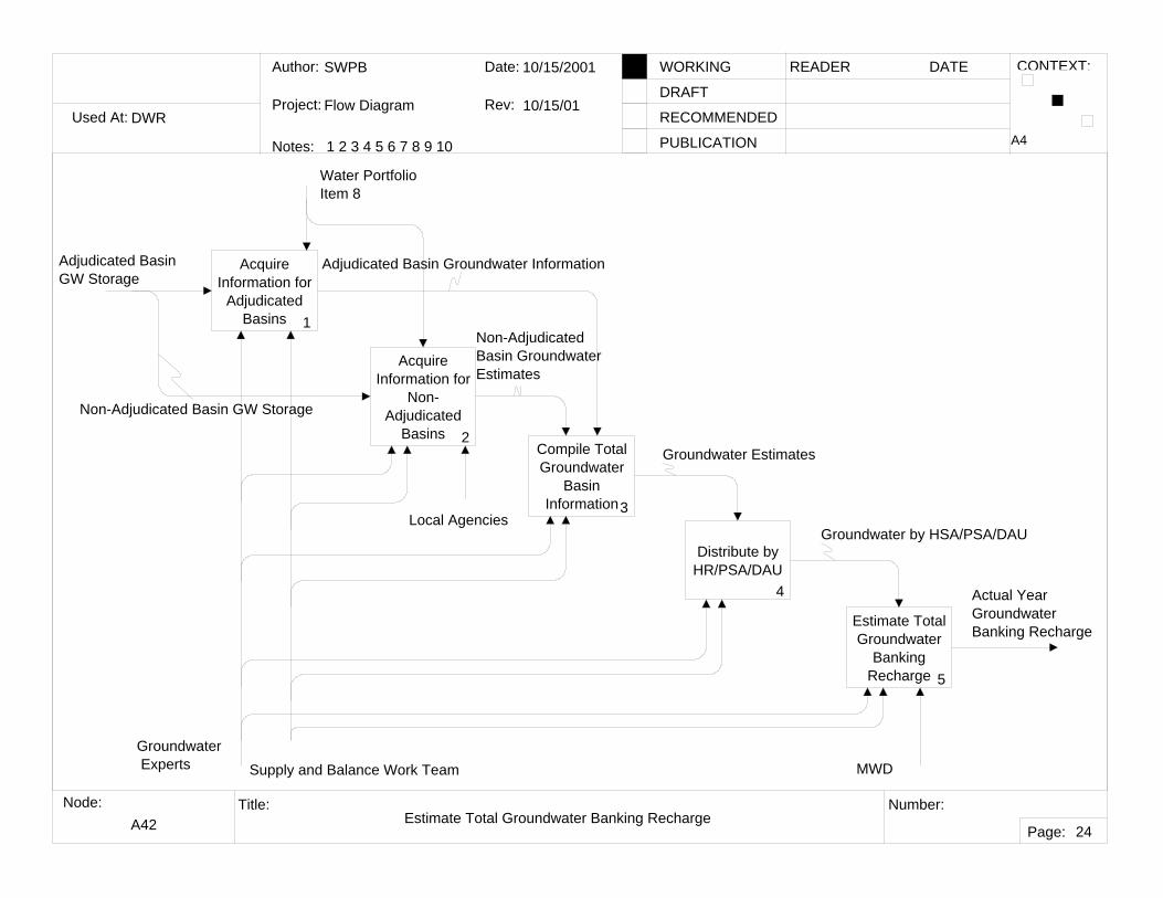
A42 Estimate Total Groundwater Banking Recharge
A4
24
Acquire Information for
Adjudicated Basins 1
Acquire Information for
Non-Adjudicated
Basins 2Compile Total Groundwater
Basin Information3
Distribute by HR/PSA/DAU
4
Estimate Total Groundwater
Banking Recharge 5
Water Portfolio Item 8
Adjudicated Basin GW Storage
Actual YearGroundwater Banking Recharge
Local Agencies
Adjudicated Basin Groundwater Information
Non-AdjudicatedBasin GroundwaterEstimates
Groundwater Estimates
Groundwater by HSA/PSA/DAU
Groundwater Experts Supply and Balance Work Team MWD
Non-Adjudicated Basin GW Storage
Used At:
Author:
Notes: 1 2 3 4 5 6 7 8 9 10
Date:
Rev:
READER DATEWORKING
DRAFT
RECOMMENDED
PUBLICATION
Project:
Node: Title: Number:
Page:
CONTEXT:
DWR
SWPB
Flow Diagram
10/19/2001
10/19/01
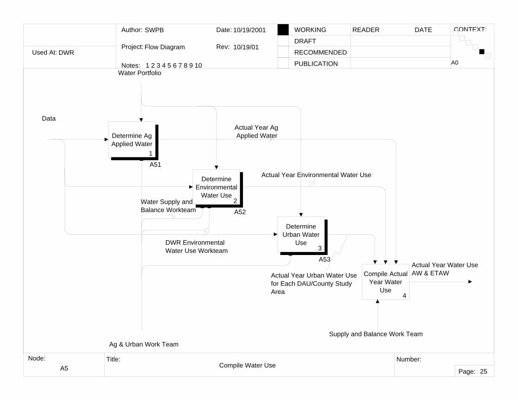
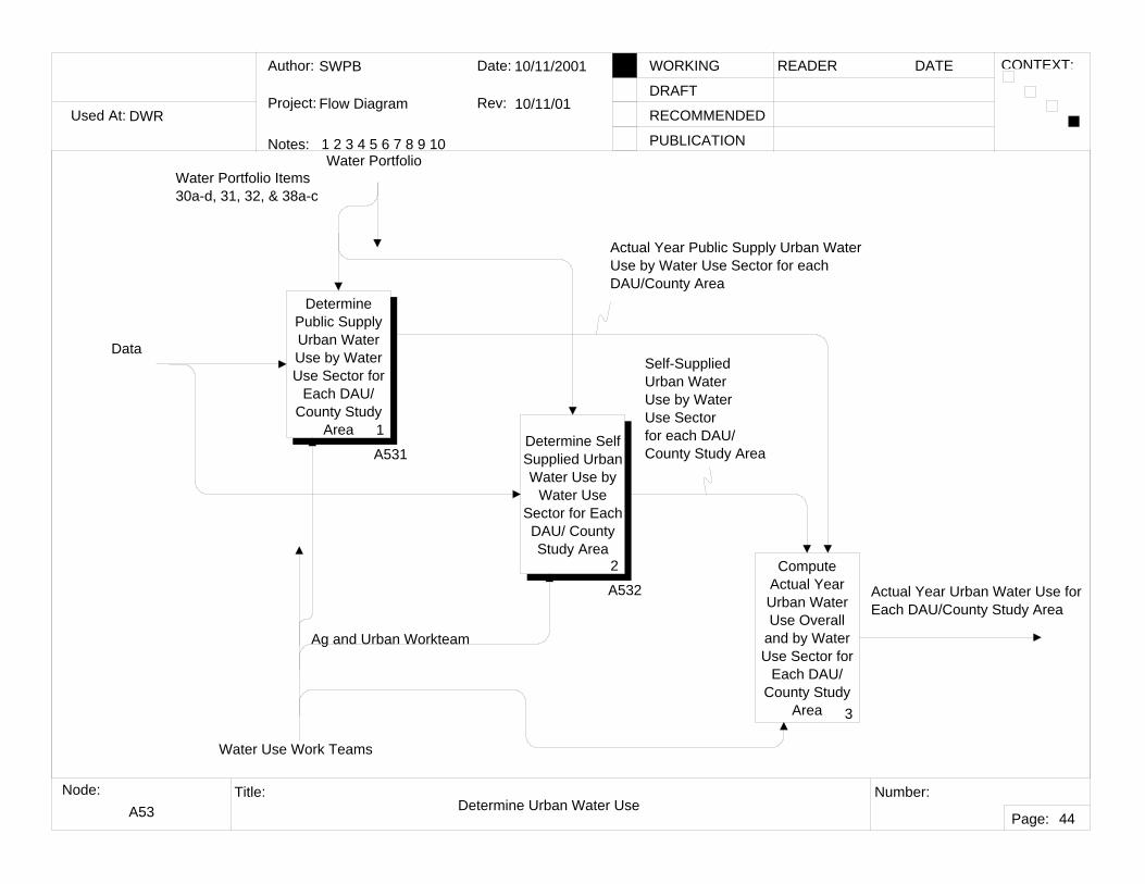
A5 Compile Water Use
A0
25
Determine Ag Applied Water
1
A51
Determine Environmental
Water Use2
A52
Determine Urban Water
Use3
A53
Compile Actual Year Water
Use4
Data
Ag & Urban Work Team
Water Portfolio
Supply and Balance Work Team
Actual Year Water UseAW & ETAW
Actual Year Ag Applied Water
Actual Year Environmental Water Use
Actual Year Urban Water Use for Each DAU/County Study Area
Water Supply and Balance Workteam
DWR Environmental Water Use Workteam
Used At:
Author:
Notes: 1 2 3 4 5 6 7 8 9 10
Date:
Rev:
READER DATEWORKING
DRAFT
RECOMMENDED
PUBLICATION
Project:
Node: Title: Number:
Page:
CONTEXT:
DWR
SWPB
Flow Diagram
10/1/2001
11/14/2001
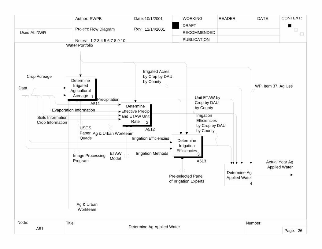
A51 Determine Ag Applied Water
26
Determine Irrigated
Agricultural Acreage 1
A511 Determine Effective Precip and ETAW Unit
Rate 2
A512
Determine Irrigation
Efficiencies3
A513
Determine Ag Applied Water
4
Soils Information
Crop Acreage
Crop Information
Pre-selected Panel of Irrigation Experts
ETAWModel
Ag & Urban Workteam
USGSPaperQuads
Image ProcessingProgram
Irrigation Efficiencies by Crop by DAU by County
Unit ETAW byCrop by DAUby County
Irrigated Acresby Crop by DAU by County
Precipitation
Actual Year Ag Applied Water
Data
Water Portfolio
WP, Item 37, Ag Use
Evaporation Information
Irrigation Efficiencies
Irrigation Methods
Ag & Urban Workteam
Used At:
Author:
Notes: 1 2 3 4 5 6 7 8 9 10
Date:
Rev:
READER DATEWORKING
DRAFT
RECOMMENDED
PUBLICATION
Project:
Node: Title: Number:
Page:
CONTEXT:
DWR
SWPB
Flow Diagram
10/1/2001
10/1/01
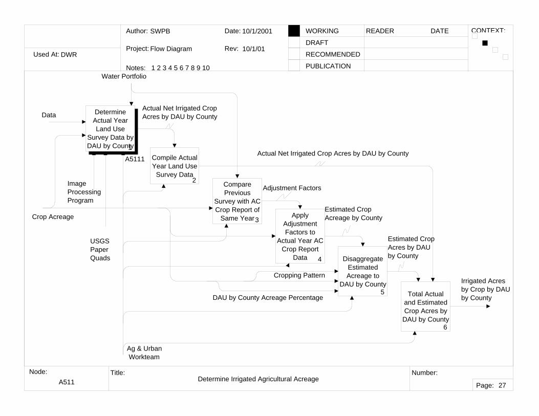
A511 Determine Irrigated Agricultural Acreage
27
Determine Actual Year Land Use
Survey Data by DAU by County1
A5111
Compare Previous
Survey with AC Crop Report of
Same Year3Apply
Adjustment Factors to
Actual Year AC Crop Report
Data 4 Disaggregate Estimated Acreage to
DAU by County5 Total Actual
and Estimated Crop Acres by DAU by County
6
Crop Acreage
Ag & Urban Workteam
Image ProcessingProgram
USGSPaperQuads
Irrigated Acresby Crop by DAU by County
Actual Net Irrigated Crop Acres by DAU by County
Adjustment Factors
Estimated CropAcreage by County
Estimated CropAcres by DAUby County
Compile Actual Year Land Use
Survey Data2
Actual Net Irrigated Crop Acres by DAU by County
Water Portfolio
Cropping Pattern
DAU by County Acreage Percentage
Data
Used At:
Author:
Notes: 1 2 3 4 5 6 7 8 9 10
Date:
Rev:
READER DATEWORKING
DRAFT
RECOMMENDED
PUBLICATION
Project:
Node: Title: Number:
Page:
CONTEXT:
DWR
SWPB
Flow Diagram
11/6/2001
11/6/01
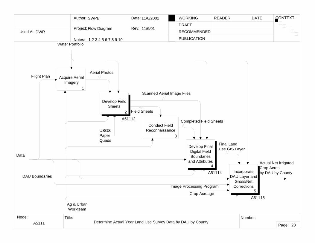
A5111 Determine Actual Year Land Use Survey Data by DAU by County
28
Acquire Aerial Imagery
1
Develop Field Sheets
2
A51112Conduct Field
Reconnaissance3
Develop Final Digital Field Boundaries
and Attributes4
A51114 Incorporate DAU Layer and
Gross/Net Corrections
5
A51115
Aerial Photos
Field Sheets
Completed Field Sheets
Final Land Use GIS Layer
DAU Boundaries
Water Portfolio
USGSPaperQuads
Ag & Urban Workteam
Image Processing Program
Actual Net Irrigated Crop Acresby DAU by County
Scanned Aerial Image Files
Flight Plan
Data
Crop Acreage
Used At:
Author:
Notes: 1 2 3 4 5 6 7 8 9 10
Date:
Rev:
READER DATEWORKING
DRAFT
RECOMMENDED
PUBLICATION
Project:
Node: Title: Number:
Page:
CONTEXT:
DWR
SWPB
Flow Diagram
11/6/2001
11/6/01
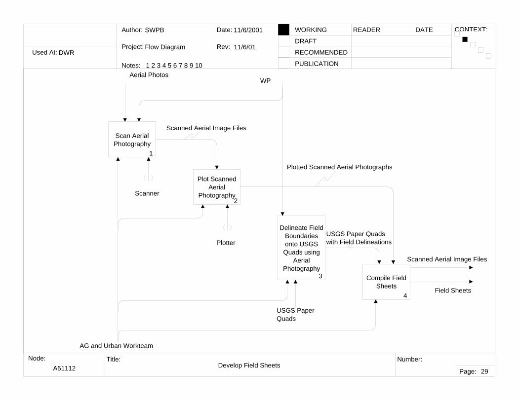
A51112 Develop Field Sheets
29
Scan Aerial Photography
1
Plot Scanned Aerial
Photography2
Delineate Field Boundaries onto USGS Quads using
Aerial Photography
3 Compile Field Sheets
4
AG and Urban Workteam
Aerial Photos
Field Sheets
Scanned Aerial Image Files
Plotted Scanned Aerial Photographs
USGS Paper Quadswith Field Delineations
WP
Scanner
Plotter
USGS PaperQuads
Scanned Aerial Image Files
Used At:
Author:
Notes: 1 2 3 4 5 6 7 8 9 10
Date:
Rev:
READER DATEWORKING
DRAFT
RECOMMENDED
PUBLICATION
Project:
Node: Title: Number:
Page:
CONTEXT:
DWR
SWPB
Flow Diagram
11/6/2001
11/6/01
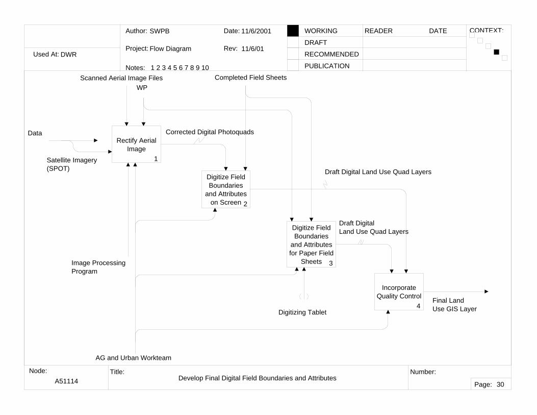
A51114 Develop Final Digital Field Boundaries and Attributes
30
Rectify Aerial Image
1
Digitize Field Boundaries
and Attributes on Screen 2
Digitize Field Boundaries
and Attributes for Paper Field
Sheets 3
Incorporate Quality Control
4
AG and Urban Workteam
Completed Field Sheets
Final Land Use GIS Layer
WP
Corrected Digital Photoquads
Draft Digital Land Use Quad Layers
Draft Digital Land Use Quad Layers
Digitizing Tablet
Satellite Imagery (SPOT)
Image ProcessingProgram
Scanned Aerial Image Files
Data
Used At:
Author:
Notes: 1 2 3 4 5 6 7 8 9 10
Date:
Rev:
READER DATEWORKING
DRAFT
RECOMMENDED
PUBLICATION
Project:
Node: Title: Number:
Page:
CONTEXT:
DWR
SWPB
Flow Diagram
11/6/2001
11/6/01
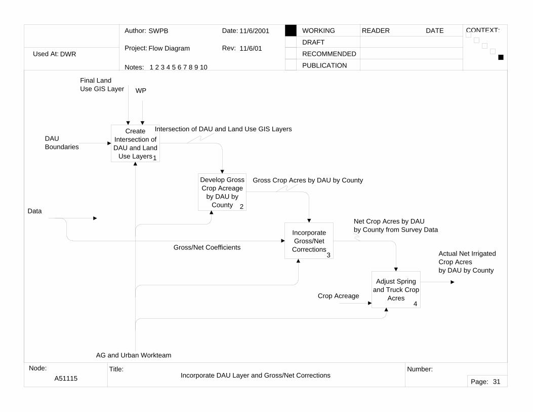
A51115 Incorporate DAU Layer and Gross/Net Corrections
31
Create Intersection of DAU and Land
Use Layers1
Develop Gross Crop Acreage
by DAU by County 2
Incorporate Gross/Net
Corrections3
AG and Urban Workteam
Final Land Use GIS Layer WP
Intersection of DAU and Land Use GIS Layers
Gross Crop Acres by DAU by County
Gross/Net Coefficients
DAU Boundaries
Actual Net Irrigated Crop Acresby DAU by County
Adjust Spring and Truck Crop
Acres4
Net Crop Acres by DAU by County from Survey Data
Data
Crop Acreage
Used At:
Author:
Notes: 1 2 3 4 5 6 7 8 9 10
Date:
Rev:
READER DATEWORKING
DRAFT
RECOMMENDED
PUBLICATION
Project:
Node: Title: Number:
Page:
CONTEXT:
DWR
SWPB
Flow Diagram
10/4/2001
10/4/01
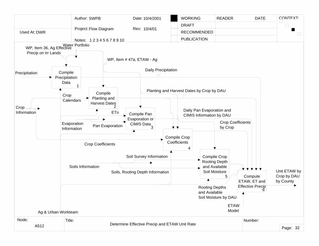
A512 Determine Effective Precip and ETAW Unit Rate
32
Compile Precipitation
Data1
Compile Planting and
Harvest Dates2
Compile Pan Evaporation or
CIMIS Data3
Compile Crop Coefficients
4
Compile Crop Rooting Depth and Available Soil Moisture
5 Compute ETAW, ET and Effective Precip
6
Soils Information
ETAWModel
Crop Information
Unit ETAW byCrop by DAUby County
PrecipitationDaily Precipitation
Planting and Harvest Dates by Crop by DAU
Daily Pan Evaporation and CIMIS Information by DAU
Crop Coefficients by Crop
Rooting Depthsand AvailableSoil Moisture by DAU
Ag & Urban Workteam
Water PortfolioWP, Item 36, Ag Effective Precip on Irr Lands
WP, Item # 47a, ETAW - Ag
Crop Calendars
Evaporation Information
ETo
Pan Evaporation
Crop Coefficients
Soil Survey Information
Soils, Rooting Depth Information
Used At:
Author:
Notes: 1 2 3 4 5 6 7 8 9 10
Date:
Rev:
READER DATEWORKING
DRAFT
RECOMMENDED
PUBLICATION
Project:
Node: Title: Number:
Page:
CONTEXT:
DWR
SWPB
Flow Diagram
10/4/2001
10/4/01
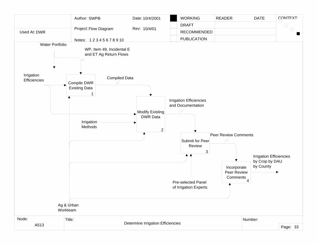
A513 Determine Irrigation Efficiencies
33
Compile DWR Existing Data
1
Modify Existing DWR Data
2
Submit for Peer Review
3
Incorporate Peer Review Comments
4Pre-selected Panel of Irrigation Experts
Irrigation Efficiencies
Irrigation Efficiencies by Crop by DAU by County
Compiled Data
Irrigation Efficienciesand Documentation
Peer Review Comments
Water PortfolioWP, Item 49, Incidental E and ET Ag Return Flows
Ag & Urban Workteam
Irrigation Methods
Used At:
Author:
Notes: 1 2 3 4 5 6 7 8 9 10
Date:
Rev:
READER DATEWORKING
DRAFT
RECOMMENDED
PUBLICATION
Project:
Node: Title: Number:
Page:
CONTEXT:
DWR
SWPB
Flow Diagram
10/10/2001
10/10/01
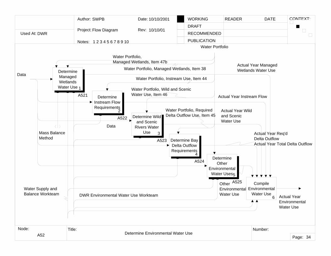
A52 Determine Environmental Water Use
34
Determine Managed Wetlands
Water Use 1
A521 Determine Instream Flow Requirements
2
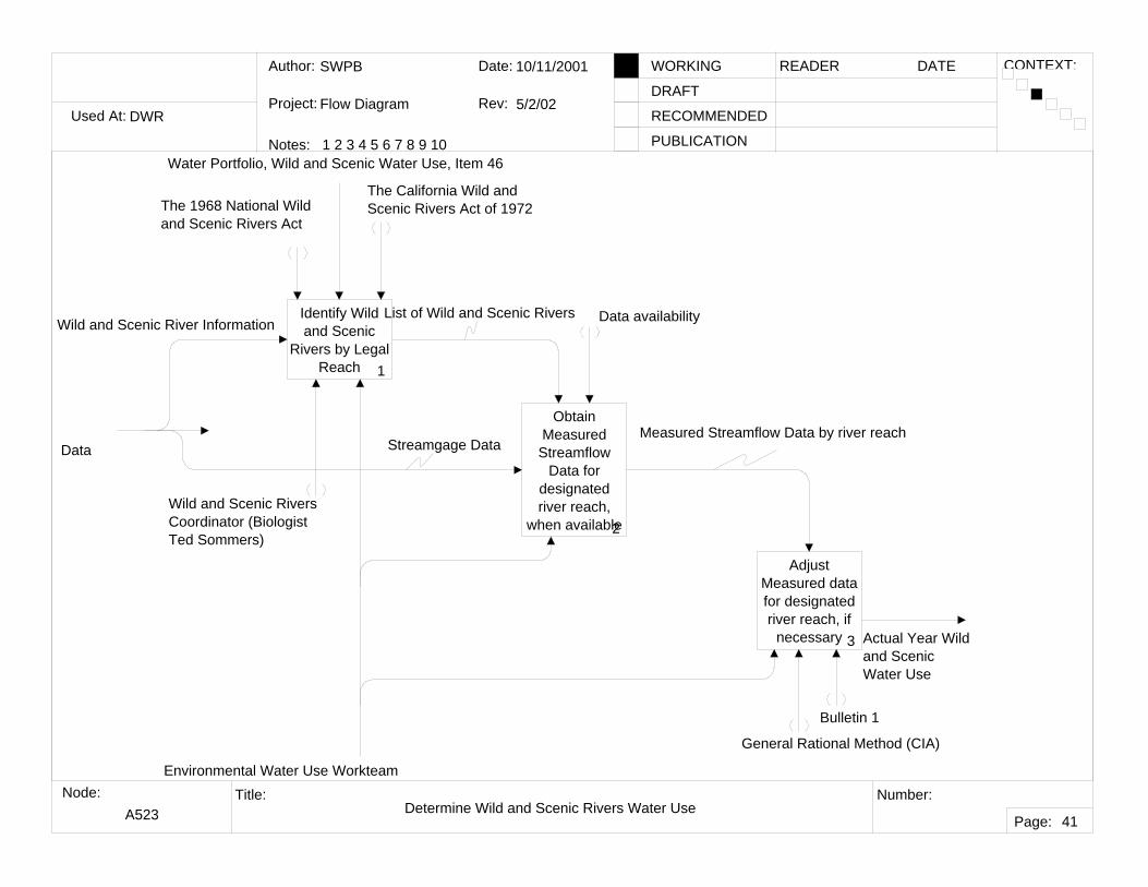
A522 Determine Wild and Scenic
Rivers Water Use 3
A523 Determine Bay Delta Outflow Requirements
4
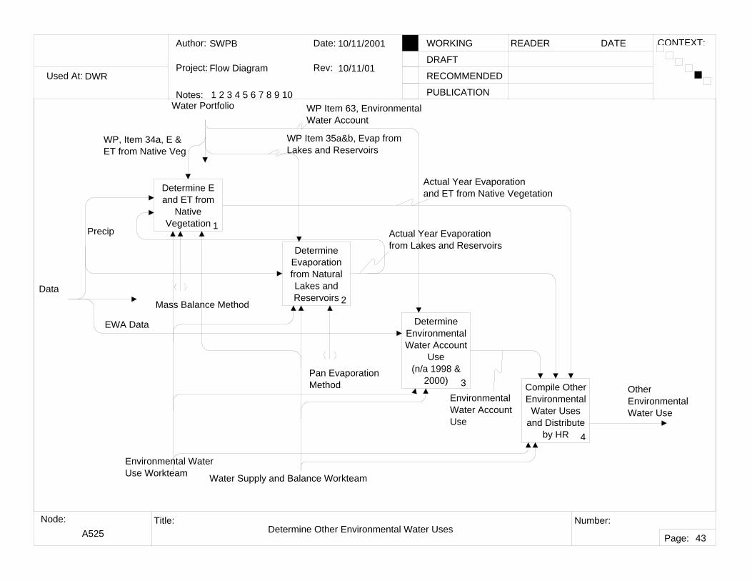
A524Determine
Other Environmental
Water Uses5
A525 Compile Environmental
Water Use6
Water Portfolio
Mass Balance Method
Water Portfolio, Instream Use, Item 44
Water Portfolio, Wild and Scenic Water Use, Item 46
Water Portfolio, RequiredDelta Outflow Use, Item 45
Water Portfolio, Managed Wetlands, Item 38Actual Year ManagedWetlands Water Use
Actual Year Instream Flow
Actual Year Wildand Scenic Water Use
Actual Year Req'dDelta Outflow Actual Year Total Delta Outflow
OtherEnvironmentalWater Use
Water Portfolio, Managed Wetlands, Item 47b
Data
Data
Actual YearEnvironmentalWater Use
Water Supply and Balance Workteam DWR Environmental Water Use Workteam
Used At:
Author:
Notes: 1 2 3 4 5 6 7 8 9 10
Date:
Rev:
READER DATEWORKING
DRAFT
RECOMMENDED
PUBLICATION
Project:
Node: Title: Number:
Page:
CONTEXT:
DWR
SWPB
Flow Diagram
10/10/2001
10/10/01
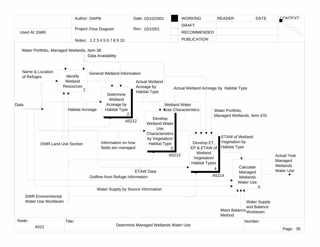
A521 Determine Managed Wetlands Water Use
35
Identify Wetland
Resources1
Determine Wetland
Acreage by Habitat Type
2
A5212 Develop Wetland Water
Use Characteristics by Vegetation/Habitat Type
3
A5213
Develop ET, EP & ETAW of
Wetland Vegetation/
Habitat Types4
A5214
Calculate Managed Wetlands
Water Use5
Water Portfolio, Managed Wetlands, Item 38
Mass Balance Method
Actual YearManagedWetlandsWater Use
Data Availability
General Wetland Information
Actual WetlandAcreage by Habitat Type
Wetland WaterUse Characteristics Water Portfolio,
Managed Wetlands, Item 47b
ETAW of WetlandVegetation by Habitat Type
Water Supply by Source Information
Outflow from Refuge Information
Data
Water Supply and Balance Workteam
Habitat Acreage
DWR Land Use Section
Name & Locationof Refuges
Information on how fields are managed
ETAW Data
Actual Wetland Acreage by Habitat Type
DWR Environmental Water Use Workteam
Used At:
Author:
Notes: 1 2 3 4 5 6 7 8 9 10
Date:
Rev:
READER DATEWORKING
DRAFT
RECOMMENDED
PUBLICATION
Project:
Node: Title: Number:
Page:
CONTEXT:
DWR
SWPB
Flow Diagram
10/10/2001
10/10/01
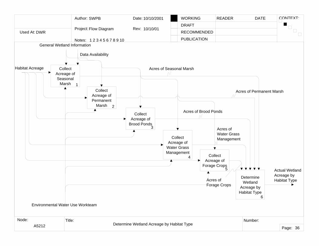
A5212 Determine Wetland Acreage by Habitat Type
36
Collect Acreage of Seasonal
Marsh 1Collect
Acreage of Permanent
Marsh 2
Collect Acreage of
Brood Ponds3
Collect Acreage of
Water Grass Management
4 Collect Acreage of
Forage Crops5
Determine Wetland
Acreage by Habitat Type
6
General Wetland Information
Actual WetlandAcreage by Habitat Type
Data Availability
Acres of Seasonal Marsh
Acres of Permanent Marsh
Acres of Brood Ponds
Acres of Water Grass Management
Acres of Forage Crops
Habitat Acreage
Environmental Water Use Workteam
Used At:
Author:
Notes: 1 2 3 4 5 6 7 8 9 10
Date:
Rev:
READER DATEWORKING
DRAFT
RECOMMENDED
PUBLICATION
Project:
Node: Title: Number:
Page:
CONTEXT:
DWR
SWPB
Flow Diagram
10/10/2001
10/10/01
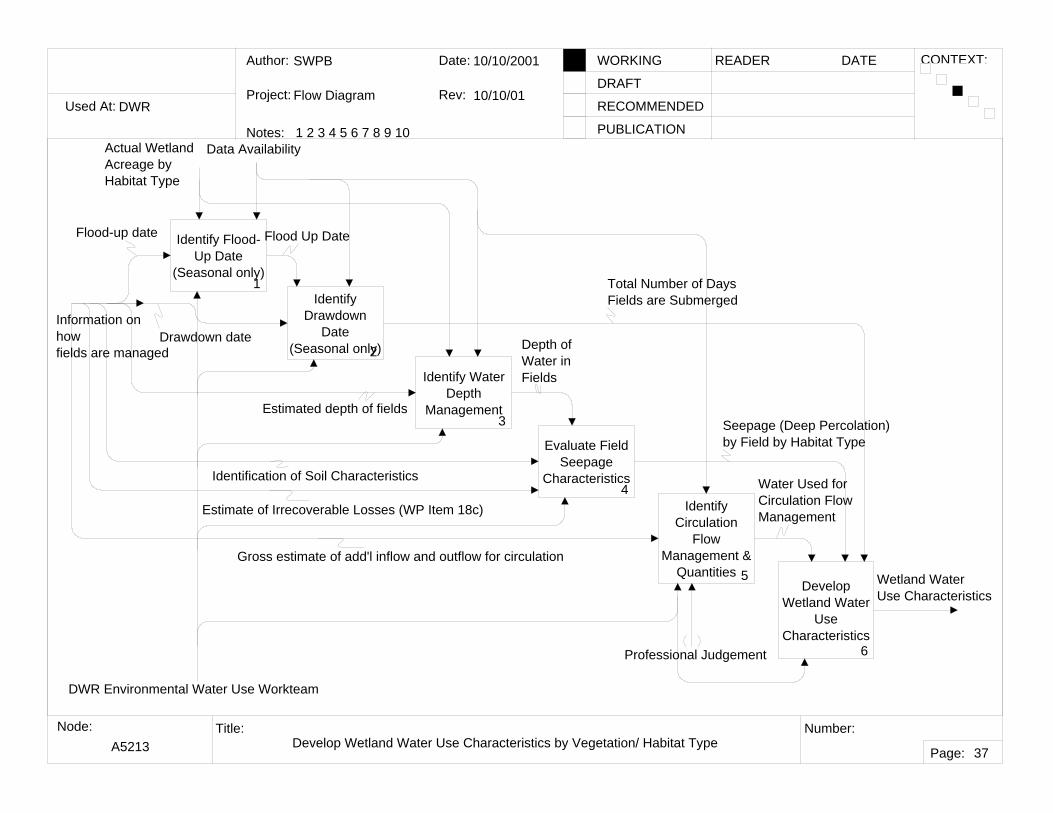
A5213 Develop Wetland Water Use Characteristics by Vegetation/ Habitat Type
37
Identify Flood-Up Date
(Seasonal only)1
Identify Drawdown
Date(Seasonal only)2
Identify Water Depth
Management3
Evaluate Field Seepage
Characteristics4
Identify Circulation
Flow Management &
Quantities 5Develop
Wetland Water Use
Characteristics6
Actual WetlandAcreage by Habitat Type
Wetland WaterUse Characteristics
Data Availability
Flood Up Date
Total Number of Days Fields are Submerged
Depth of Water in Fields
Seepage (Deep Percolation)by Field by Habitat Type
Water Used forCirculation FlowManagementEstimate of Irrecoverable Losses (WP Item 18c)
Identification of Soil Characteristics
Information on how fields are managed
Flood-up date
Drawdown date
Estimated depth of fields
Gross estimate of add'l inflow and outflow for circulation
Professional Judgement
DWR Environmental Water Use Workteam
Used At:
Author:
Notes: 1 2 3 4 5 6 7 8 9 10
Date:
Rev:
READER DATEWORKING
DRAFT
RECOMMENDED
PUBLICATION
Project:
Node: Title: Number:
Page:
CONTEXT:
DWR
SWPB
Flow Diagram
10/11/2001
10/11/01
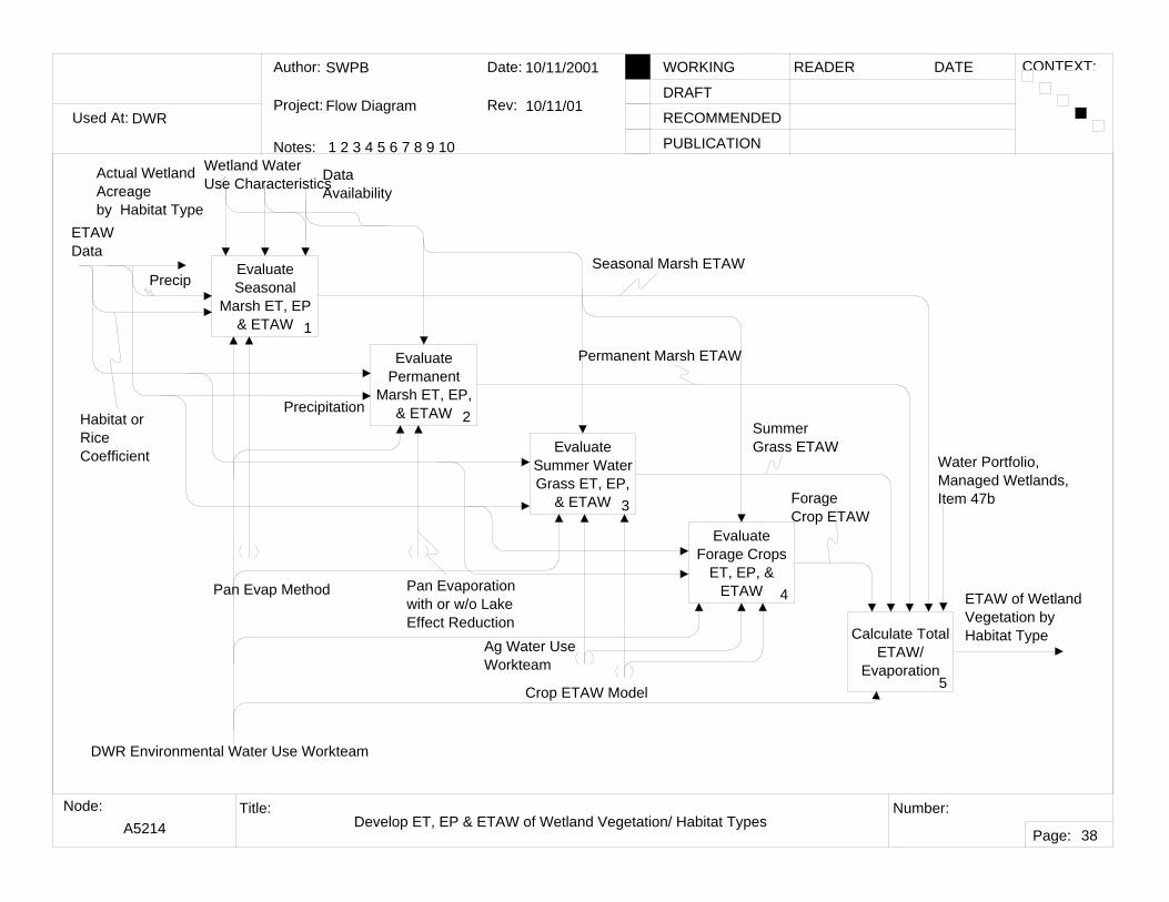
A5214 Develop ET, EP & ETAW of Wetland Vegetation/ Habitat Types
38
Evaluate Seasonal
Marsh ET, EP & ETAW 1
Evaluate Permanent
Marsh ET, EP, & ETAW 2
Evaluate Summer Water Grass ET, EP,
& ETAW 3
Evaluate Forage Crops
ET, EP, & ETAW 4
Calculate Total ETAW/
Evaporation5
Wetland WaterUse Characteristics
ETAW of WetlandVegetation by Habitat Type
Habitat or Rice Coefficient
Pan Evaporationwith or w/o LakeEffect Reduction
Crop ETAW Model
Ag Water UseWorkteam
Data Availability
Precipitation
ForageCrop ETAW
SummerGrass ETAW
Permanent Marsh ETAW
Seasonal Marsh ETAW
Water Portfolio, Managed Wetlands, Item 47b
ETAW Data
Actual Wetland Acreage by Habitat Type
Precip
Pan Evap Method
DWR Environmental Water Use Workteam
Used At:
Author:
Notes: 1 2 3 4 5 6 7 8 9 10
Date:
Rev:
READER DATEWORKING
DRAFT
RECOMMENDED
PUBLICATION
Project:
Node: Title: Number:
Page:
CONTEXT:
DWR
SWPB
Flow Diagram
10/11/2001
7/25/02
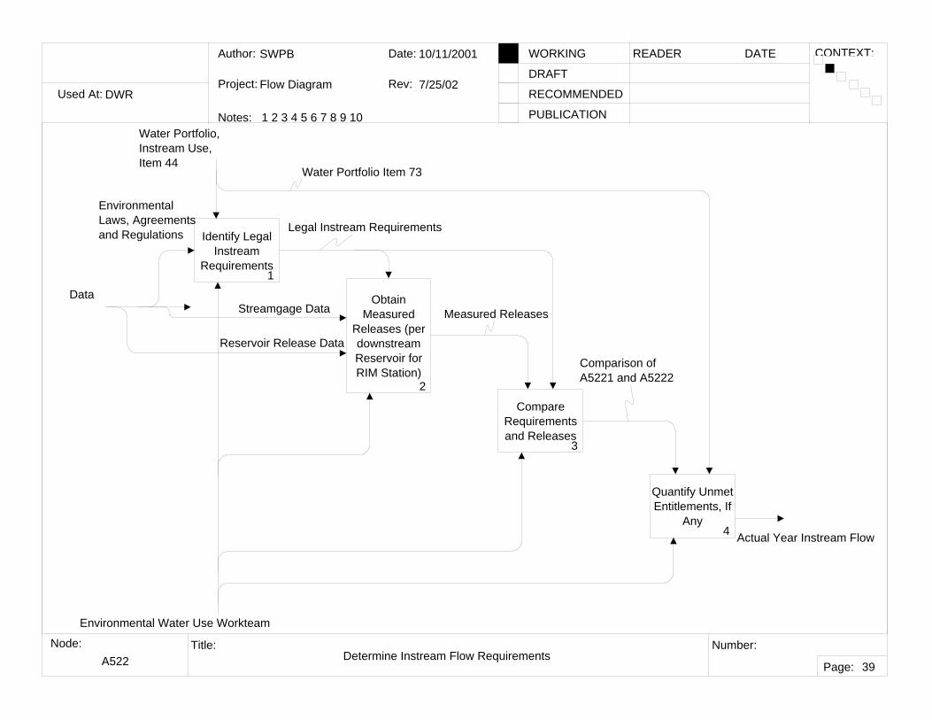
A522 Determine Instream Flow Requirements
39
Identify Legal Instream
Requirements1
Obtain Measured
Releases (per downstream Reservoir for RIM Station)