+ All Categories
Home > Documents > Executive Analysis of Restoration Actions in Big Springs ...

Executive Analysis of Restoration Actions in Big Springs ...

Date post: 12-Jan-2022
Category:
Upload: others
View: 2 times
Download: 0 times
Share this document with a friend
20
1 Executive Analysis of Restoration Actions in Big Springs Creek March 2008-September 2011 Jeffrey F. Mount, Peter B. Moyle, and Michael L. Deas, Principal Investigators Project Team: Carson A. Jeffres (Project Team Lead), Andrew L. Nichols, Ann D. Willis Report prepared for: The National Fish and Wildlife Foundation Recommended Citation: Willis, A.D., M.L. Deas, C.A. Jeffres, J.F. Mount, P.B. Moyle, and A.L. Nichols. 2012. Executive Analysis of Restoration Actions in Big Springs Creek March 2008- September 2011. Report prepared for: National Fish and Wildlife Foundation Center for Watershed Sciences University of California, Davis • One Shields Avenue Davis, CA 95616
Transcript

1

Executive Analysis of Restoration Actions in Big Springs Creek March 2008-September 2011

Jeffrey F. Mount, Peter B. Moyle, and Michael L. Deas,

Principal Investigators

Project Team:

Carson A. Jeffres (Project Team Lead), Andrew L. Nichols, Ann D. Willis

Report prepared for:

The National Fish and Wildlife Foundation

Recommended Citation: Willis, A.D., M.L. Deas, C.A. Jeffres, J.F. Mount, P.B. Moyle, and A.L. Nichols. 2012. Executive Analysis of Restoration Actions in Big Springs Creek March 2008-September 2011. Report prepared for: National Fish and Wildlife Foundation

Center for Watershed Sciences

University of California, Davis • One Shields Avenue • Davis, CA 95616

2

Introduction

The management and restoration of Big Springs Creek has previously been identified as

critical to the recovery of the salmonid population in the Shasta River to which it is a

tributary. Improving physical habitat, flow, and water temperature regimes in Big

Springs Creek was shown to have the highest potential for maintaining and eventually

restoring coho salmon in the Shasta River watershed (Jeffres et al., 2009). In March

2009, The Nature Conservancy, California (TNC) initiated a multi-year river restoration

effort on Big Springs Creek through the acquisition of Shasta Big Springs Ranch (SBSR)

and an easement on the adjacent Busk Ranch (Figures 1 and 2). Together, Shasta Big

Springs Ranch and the Busk Ranch easement provided access and restoration

opportunities along the entire length of Big Springs Creek. Unlike many restoration

efforts, the UC Davis Center for Watershed Sciences in association with Watercourse

Engineering Inc. (Watercourse Engineering) was able to obtain baseline data prior to the

beginning of restoration activities (Jeffres et al., 2009), thus allowing for the

quantification of physical, chemical, and biological responses to restoration actions. The

primary component of the restoration project was the construction of cattle exclusion

fencing, which has eliminated cattle access to the riparian zone and river channel. This

passive restoration approach was augmented by the targeted planting of riparian trees and

emergent plants. The restoration actions have resulted in a rapidly changing ecosystem

both physically and biologically, with changes largely initiated by the growth of aquatic

macrophytes. Herein, changes in aquatic macrophyte biomass following cattle exclusion

are quantified. This is followed by a description and quantification of the complex

response of physical conditions (channel hydraulics and water temperature) and biotic

communities to aquatic plant (macrophyte) growth between March 2008 and September

2011, providing a unique understanding of a spring-fed lotic ecosystem’s response to

passive restoration.

For this project an interdisciplinary river restoration case study was employed using a

“Before-After (BA)” experimental design to explore the trajectory and rate of ecosystem

response to cattle exclusion in Big Springs Creek, a large spring-fed creek in northern

California. Rarely in restoration is the opportunity available to quantitatively assess the

results/outcomes of restoration actions at this scale on spring creeks. Monitoring change

and the associated effects on physical, chemical and biological processes within the Big

Springs Creek and nearby Shasta River reaches has helped guide the continuing

restoration activities, determined the success to date of this project, and allowed the

transfer and application of restoration actions defined at SBSR. Activities completed to

date have documented the ecosystem response to restoration actions, tested hypotheses

that currently guide management activities, and have continued to support future

refinements of those activities.

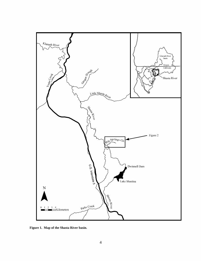
Study Area Big Springs Creek is a 3.7-km, low gradient spring-fed tributary to Shasta River, located

at an elevation of approximately 800 m in the Shasta Valley of northern California,

U.S.A (Figure 1). Located along the western edge of the Cascade Volcanic Range and

3

approximately 26 km north of Mount Shasta (4322 m), Big Springs Creek emanates from

a large groundwater spring complex located at the terminus of a fractured and porous

basalt flow (Blodgett et al., 1988). Big Springs Creek is the primary source of

summertime water to the Shasta River. Spring water entering Big Springs Creek exhibits

nearly invariant and “slightly thermal” temperatures (10-12ºC) (Nathenson et al., 2003;

Jeffres et al., 2009; Jeffres et al., 2010) and has a mean recharge elevation of 2880 m on

Mount Shasta (Dahlgren et al., 2010). During transport as groundwater, nitrogen and

phosphorous are released from underlying marine sedimentary and volcanic rocks,

resulting in elevated nutrients in the exsurgent spring water (Dahlgren et al., 2010). This

cool and nutrient-rich water fuels tremendous primary productivity (principally aquatic

macrophyte growth), providing food and habitat for aquatic invertebrates, which in turn

support cold-water fish populations including the federally-threatened coho salmon.

Since the late 1800s upland riparian areas surrounding Big Springs Creek have been used

for cattle grazing. The lack of exclusion fencing, combined with typically wide and

shallow channel morphologies of spring creeks, allowed cattle to graze on submerged and

emergent aquatic macrophytes growing throughout the channel bed, removing biomass

from the lotic system and further widening the channel. Cattle foraged extensively on

aquatic vegetation during the winter months when upland grazing conditions were poor.

In March 2009, exclusion fencing eliminated cattle access to Big Springs Creek, allowing

the identification and quantification of the rate of change to the hydrogeomorphic and

ecological conditions throughout Big Springs Creek following the increased growth of

aquatic macrophytes, including 1) channel hydraulics; 2) surface water temperature; 3)

water quality; and 4) fish habitat use. Methods for quantification of these baseline

monitoring elements are presented in Jeffres et al. (2009, 2010).

4

Figure 1. Map of the Shasta River basin.

5

Figure 2. Sampling locations in Big Springs Creek.

Results: The results of field work at Big Springs Creek relating to quantification of aquatic plants,

channel hydraulics, water temperature, water quality, and fish from March 2008 through

September 2011 are outlined below. Consistent application of methods over this extended

period provides directly comparable results that are subsequently used to identify changes

through space and time of physical, chemical and biological processes within Big Springs

Creek.

Aquatic Plants The standing crop of aquatic plants (i.e., macrophytes + filamentous algae) at sample

location RKM 1.5 throughout the year prior to cattle exclusion (March 2008 to April

2009) exhibited seasonal growth patterns typical of aquatic vegetation in temperate

regions (Figure 3), with minimum biomass in winter and early spring and maximum in

summer. Total standing crop in March 2008 averaged 35.7 ± 10.7 g AFDM·m2

(n = 6).

Mean total standing crop increased by 282% (136.2 ± 33.0 g AFDM·m-2; n = 6) between

March 2008 and June 2008, and by an additional 34% (182.1 ± 60.6 g AFDM·m2; n = 6)

between June 2008 and September 2008. The temporal increase in plant biomass between

June 2008 and September 2008 was not statistically different (ANOVA, p = 0.06) due to

high variability among the replicate samples. Total standing crop in April 2009,

6

immediately following a winter of unrestricted cattle grazing in the river channel,

averaged 32.4 ± 12.2 g AFDM·m2

(n = 12), a 132 g AFDM·m2 decrease from September

2008 (Figure 3).

Following cattle exclusion in March 2009, aquatic plant biomass averaged across

sampling locations RKM 0.4, 1.5, and 2.6 exhibited a similar spring/summer growth

trend to that observed at RKM 1.5 prior to cattle exclusion (Figure 3). Between April

2009 and July 2009, mean standing crop increased from 32.4 ± 12.2 AFDM·m2

(n = 12)

to 200 ± 10.7 g AFDM·m2

(n = 18). In all years, biomass increases after March (the

approximate seasonal minimum), reaching maximum biomass in September. Seasonal

minima varied throughout the study period, but generally showed an increase following

cattle exclusion. During September 2010 and 2011 the highest measured biomasses

during the study were collected with 345.61± 20.71 g AFDM·m2 (n=18) and 311.94 ±

44.14 g AFDM·m2 (N=18) respectively.

In summary, seasonal growth and senescence patterns in Big Springs Creek pre- and

post-restoration identify the importance of cattle exclusion. Further, aquatic plants are

directly related to almost all metrics within Big Springs Creek including hydraulic

characteristics, sediment dynamics, stream stage, water temperature, invertebrate

populations, and fish habitat.

1/1/08 7/1/08 1/1/09 7/1/09 1/1/10 7/1/10 1/1/11 7/1/11

Aq

ua

tic M

acro

phyt

e A

FD

M/m

2

0

100

200

300

400

Catt

le E

xclu

sio

n

Figure 3. Ash Free Dry Mass (AFDM) of aquatic macrophytes collected in Big Springs Creek from

April 2009 through September 2011. Circles represent the mean value of all the subsamples from all

locations and error bars are standard error.

7

Channel Hydraulics Hydrologic and sediment transport conditions in Big Springs Creek are largely

determined by groundwater-derived springflow and adjacent land use. Without upstream

tributaries, streamflow magnitudes are relatively stable with respect to changes in

seasonal or annual precipitation patterns or snowmelt. Agricultural water use alters

hydrologic conditions during the annual April through September irrigation season, as a

0.3 m3/s surface water diversion and unquantified local groundwater pumping reduce

flow magnitudes and increase variability. From April 2008 through September 2011,

mean non-irrigation season (i.e. unimpaired) streamflow was 2.37 m3/s (σ = 0.13), while

mean irrigation season streamflow was 1.85 m3/s (σ = 0.34) (Jeffres et al., 2009; Jeffres

et al., 2010). Minimum streamflow in Big Springs Creek during the entire period was

1.21 m3/s. Alluvial sediment is derived entirely by localized channel bed and bank

erosion, and qualitative observations suggest available streamflow is only capable of

transporting sand-sized and finer bed materials. Rounded, gravel- and cobble-sized bed

material appears to be mobilized only during redd-construction by spawning salmonids.

One feature of aquatic macrophyte growth is to obstruct water flow, which subsequently

impacts flow velocities and dependent hydraulic variables such as water stage (i.e.,

depth), wetted cross-sectional area and channel resistance (Marshall & Westlake, 1990;

Green, 2005b). In Big Springs Creek, flow obstruction by both submerged and emergent

aquatic macrophytes along channel margins as well as large patches within the main

channel created complicated flow and velocity fields generally characterized by low flow

velocities (<0.1 m/s) within macrophytes and notably higher flow velocities (~0.2 to 1.0

m/s) between patches. The acceleration of flow around macrophytes patches created a

mosaic of flow fields (Cotton et al., 2006), resulting in a relatively unique channel pattern

often referred to as “pseudo-braided” (Green, 2005b) (Figure 4).

Figure 4. Photo showing macrophyte growth and multiple channels in Big Springs Creek.

8

Seasonal patterns in hydraulic conditions prior to and following cattle exclusion from Big

Springs Creek largely co-varied with seasonal patterns of aquatic macrophyte biomass.

During the macrophyte growing season (March through September) mean flow velocities

progressively decreased, resulting in a concomitant increase in channel depth (Figure 5)

and cross-sectional area (Figure 6). Following the senescence of macrophytes throughout

the fall and winter, mean flow velocities typically increased while channel depth and

cross-sectional area decreased. Such seasonal patterns in hydraulic conditions appear

related to patterns of channel resistance associated with macrophyte growth, although

some observers suggest this resistance-biomass relationship may be indirect (Green,

2005a). In contrast with observed seasonal covariance of hydraulic conditions and

aquatic macrophyte biomass, spatial variations in hydraulic conditions throughout Big

Springs Creek appeared to be largely controlled by the size and structural properties of

localized macrophyte growth (e.g., patches). In channel locations with distributed

patches of macrophytes, very complex flow fields developed (Figure 4), while large

homogenous patches or channel margin growth created relatively simple flow fields

dominated by one or several channels around these patches through which the majority of

flow was routed (Figure 6).

Figure 5. River stage continuously measured at RKM 0.4 streamflow monitoring station in Big

Springs Creek. The grey line represents the minimum unimpaired stage during each year.

9

Interestingly, hydraulic conditions, as tracked by channel depth, in March 2009 were

nearly identical to those observed in 2008 (Figure 5). However, after one year of

complete cattle exclusion (March 2009 to March 2010), seasonal minimum channel

depths in March 2010 exhibited a 0.07 meter, or 19%, increase over minimum channel

depths observed at the same location the previous year, even though flow magnitudes

remained nearly identical. Further, minimum channel depths in March 2011 exhibited an

additional 0.06 m, or 14%, increase over the same period in 2010 (Figure 5). In addition

to increased seasonal water depths and wetted cross-sectional areas, hydraulic variability

increased in response to increased biomass following the reduction of grazing pressures

by cattle. This variability was often characterized by large local variations in lateral and

vertical flow velocities. Increases in both habitat area and spatial flow velocity

variability provided improved habitat for both juvenile and adult fish.

10

Figure 6. Flow velocity contour plots created from point velocity measurements collected at the Big

Springs Creek Downstream Crossing study site transect location, with approximate submergent and

emergent vegetation distribution.

Approximate extent of aquatic vegetation:

Submergent

Emergent

11

Water temperature A baseline assessment of Big Springs Creek in 2008 illustrated that peak water

temperatures during the spring and summer (approximately April through September)

were the key impairment to salmonid habitat (Jeffres et al., 2009). As such, this

temperature analysis is limited to peak temperatures during the study period (April 2008-

September 2011). Field observations illustrated that spring sources emerged at stable

temperatures of 10-12oC and contributed a steady source of cool water (~1.13 m

3/s) to

Big Springs Creek. Water temperatures of other significant inflow sources, such as

releases from Big Springs Dam, were also monitored. However, the water temperatures

of those small or more diffuse spring sources and Big Springs Dam were more variable

than spring sources.

Following the implementation of restoration actions (primarily cattle exclusion), water

temperature trends began to change in response to the recovering aquatic macrophyte

community. The presence of aquatic vegetation and the underlying effects of aquatic

vegetation growth on stream geomorphology, hydraulics, and shading resulted in

generally decreased rates of heating from pre-restoration to post-restoration conditions

and seasonal water temperature shifts in response to the aquatic vegetation’s annual

growth and senescence.

Peak water temperatures declined as annual minimum levels of aquatic vegetation

biomass increased. Comparing 2008 to 2011 water temperature conditions at the mouth

of Big Springs Creek shows that seasonal peak water temperatures declined by an

average of 2.5°C from 2008 to 2011 (Figure 7). The maximum rate of heating from the

principal spring sources to the mouth decreased from 4.6°C/km in 2008 to 3.3°C/km in

2011 (local heating rates varied depending on channel geometry). These results suggest

that cool water was transported more quickly through Big Springs Creek as vegetation

biomass increased. This result is consistent with the decreased travel times that occurred

as increased vegetation growth created high velocity corridors within Big Springs Creek

through which a majority of the streamflow was conveyed.

0

5

10

15

20

25

30

3/1/08 9/17/08 4/5/09 10/22/09 5/10/10 11/26/10 6/14/11 12/31/11

Wat

er

tem

pe

ratu

re (o

C)

BSC abv SR

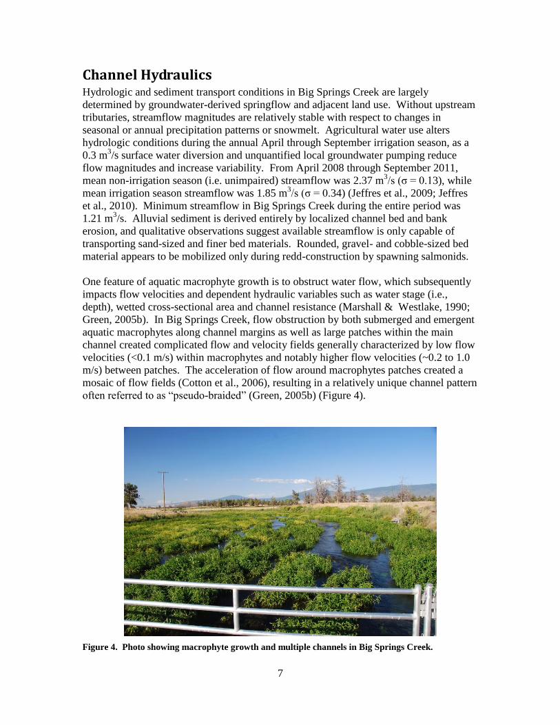
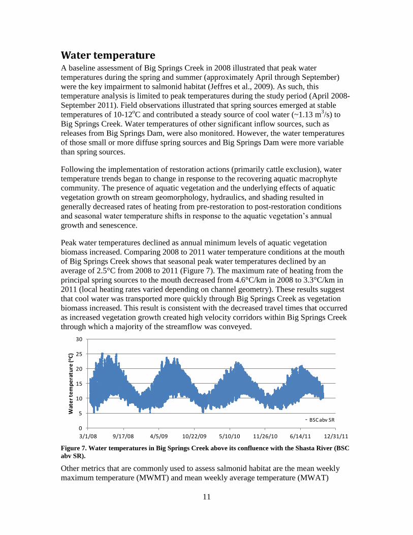
Figure 7. Water temperatures in Big Springs Creek above its confluence with the Shasta River (BSC

abv SR).

Other metrics that are commonly used to assess salmonid habitat are the mean weekly

maximum temperature (MWMT) and mean weekly average temperature (MWAT)

12

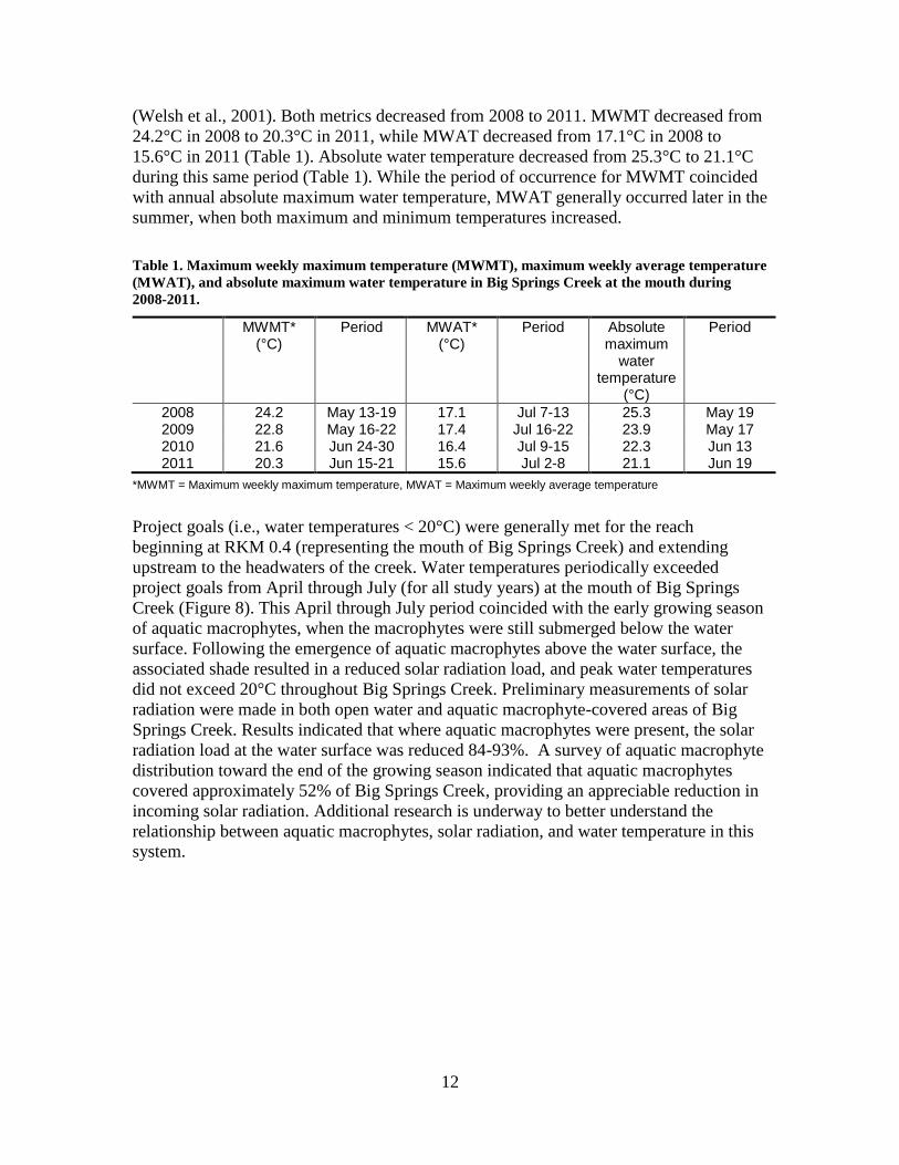
(Welsh et al., 2001). Both metrics decreased from 2008 to 2011. MWMT decreased from

24.2°C in 2008 to 20.3°C in 2011, while MWAT decreased from 17.1°C in 2008 to

15.6°C in 2011 (Table 1). Absolute water temperature decreased from 25.3°C to 21.1°C

during this same period (Table 1). While the period of occurrence for MWMT coincided

with annual absolute maximum water temperature, MWAT generally occurred later in the

summer, when both maximum and minimum temperatures increased.

Table 1. Maximum weekly maximum temperature (MWMT), maximum weekly average temperature

(MWAT), and absolute maximum water temperature in Big Springs Creek at the mouth during

2008-2011.

MWMT* (°C)

Period

MWAT* (°C)

Period

Absolute maximum

water temperature

(°C)

Period

2008 24.2 May 13-19 17.1 Jul 7-13 25.3 May 19 2009 22.8 May 16-22 17.4 Jul 16-22 23.9 May 17 2010 21.6 Jun 24-30 16.4 Jul 9-15 22.3 Jun 13 2011 20.3 Jun 15-21 15.6 Jul 2-8 21.1 Jun 19

*MWMT = Maximum weekly maximum temperature, MWAT = Maximum weekly average temperature

Project goals (i.e., water temperatures < 20°C) were generally met for the reach

beginning at RKM 0.4 (representing the mouth of Big Springs Creek) and extending

upstream to the headwaters of the creek. Water temperatures periodically exceeded

project goals from April through July (for all study years) at the mouth of Big Springs

Creek (Figure 8). This April through July period coincided with the early growing season

of aquatic macrophytes, when the macrophytes were still submerged below the water

surface. Following the emergence of aquatic macrophytes above the water surface, the

associated shade resulted in a reduced solar radiation load, and peak water temperatures

did not exceed 20°C throughout Big Springs Creek. Preliminary measurements of solar

radiation were made in both open water and aquatic macrophyte-covered areas of Big

Springs Creek. Results indicated that where aquatic macrophytes were present, the solar

radiation load at the water surface was reduced 84-93%. A survey of aquatic macrophyte

distribution toward the end of the growing season indicated that aquatic macrophytes

covered approximately 52% of Big Springs Creek, providing an appreciable reduction in

incoming solar radiation. Additional research is underway to better understand the

relationship between aquatic macrophytes, solar radiation, and water temperature in this

system.

13

0

5

10

15

20

25

1/1/10 3/2/10 5/2/10 7/1/10 8/31/10 10/30/10 12/30/10

Wat

er

tem

pe

ratu

re (o

C)

BSC abv SR

Aquatic vegetation emerges

above water surface

Aquatic vegetation is submerged

below water surface

Figure 8. An example of seasonal water temperature trends measured in Big Springs Creek above its

confluence with the Shasta River (BSC abv SR). The red lines bound the period during which aquatic

vegetation emerges past the water surface and provides shade to portions of the creek.

Finally, a comparison of water temperatures in Big Springs Creek to the mainstem Shasta

River illustrated the key value of restored conditions in Big Springs Creek: cool water

temperatures were maintained in Big Springs Creek during the summer, when other

waterways experienced elevated water temperatures. Water temperatures measured in the

Shasta River above the confluence with Big Springs Creek generally exceeded those at

the mouth of Big Springs Creek from July through October.

0

5

10

15

20

25

30

3/1/08 9/17/08 4/5/09 10/22/09 5/10/10 11/26/10 6/14/11 12/31/11

Wat

er

tem

pe

ratu

re (o

C)

BSC abv SR SR abv BSC

No data for SR abv BSC

Figure 9. Water temperatures measured in Big Springs Creek above its confluence with the Shasta

River (BSC abv SR) and in the Shasta River above its confluence with Big Springs Creek (SR abv

BSC). Periods when water temperatures in the Shasta River exceed or fall below water temperatures

in Big Springs Creek are illustrated. No data is available between 4/15/2009-5/1/2010 for SR abv

BSC.

Overall, water temperatures at the mouth of Big Springs Creek were cooler in 2011

compared to 2008 and resulted in increased habitat available to salmonids. Furthermore,

the benefit likely extended into the Shasta River downstream of its confluence with Big

Springs Creek, extending improved habitat conditions downstream of Big Springs Creek.

14

Water quality (nutrients) Water quality samples were collected to identify water chemistry conditions and

understand the source and fate of nutrients in Big Springs Creek. Due to their biological

importance in aquatic systems and the potential role of these constituents in restoration

actions (Jeffres et al., 2009; Jeffres et al., 2010), the water quality analysis focused on

nutrients. Both total and inorganic concentrations of nitrogen and phosphorus were

analyzed for the period March 2008 through July 2011. An analysis was completed to

determine the source of nutrients in groundwater-fed springs in Big Springs Creek.

Finally, the seasonal role of nutrients in primary productivity was examined.

Nutrient concentrations in waters emanating from the Big Springs complex were high for

natural waters experiencing limited impact from human activities. Mean soluble-reactive

PO4-P (SRP) concentrations over a four-year period were 0.135 (±0.014) and 0.154

(±0.007) mg L-1

(n=33) in the north and east springs, respectively. These findings suggest

that during transport from the groundwater source area on Mt. Shasta, groundwater

interacts with the underlying volcanic and marine sedimentary rocks, which results in

mobilization of nutrients. The SRP concentrations were in equilibrium with

hydroxyapatite (Ca2OHPO4), suggesting that release of SRP by chemical weathering of

the highly weatherable volcanic deposits was the primary source of the PO4. Mineral

nitrogen concentrations were also unexpectedly high with mean NO3-N of 0.44 (±0.07)

and 0.17 (±0.01) mg L-1

in the north and east springs, respectively, and NH4-N

concentrations of 0.01 mg L-1

in both springs (n=33). The primary source of nitrogen is

assumed to originate from detrital organic matter incorporated in the marine sedimentary

rocks during diagensis. This “geologic” nitrogen is released from rocks by hydrothermal

waters and transported with the groundwater.

Downstream trends in constituent concentrations illustrated that despite elevated loads

contributed from groundwater-fed springs, nitrate concentrations seasonally declined in

downstream reaches while SRP remained relatively stable. During summer, nitrate

concentrations declined from an average of .31 mg L-1

in the north and east springs

(located at RKM 3.3) to .12 mgL-1

at RKM 0.4 (ammonia values were typically near or

below detection). Similarly, SRP concentrations showed little variation: an average of

.151 mgL-1

in the north and east springs to .157 mg L-1

at RKM 0.4. These results

supported preliminary conclusions made by Jeffres et al. (2009) that seasonal aquatic

macrophyte growth resulted in a nitrogen-limited system. These decreased

concentrations, when considered along with aquatic macrophyte biomass data, indicated

that the geologically derived nutrients formed the chemical foundation of a robust food

web. A previous food web and stable isotope analyses support this conclusion (Jeffres et

al., 2009).

Fish The single largest change in habitat for salmonids in Big Springs Creek was the growth

of aquatic macrophytes following the exclusion of cattle from the stream benefiting all

life stages of salmonids in Big Springs Creek from egg incubation to adult spawning.

Macrophytes increased stream depth (Figure 5), allowing for dramatic increases in

15

margin habitat for newly emerged fry that was not available prior to cattle exclusion.

During summer, increased depth, cover and velocity heterogeneity benefited fish rearing

in Big Springs Creek (figure 6). Where macrophyte growth created high velocity

channels, fine sediments were scoured away, exposing spawning gravels for adults.

Further, the geomorphic changes associated with macrophyte growth (narrow channels),

coupled with macrophyte shading during summer periods, expanded the thermally

suitable habitat from a few lineal meters to several kilometers of appropriate over-

summering temperatures for multiple species of anadromous fish.

Coho salmon have been the driver for much of the restoration actions in the Shasta River.

Over-summering habitat, primarily water temperature, has been determined to be a

limiting factor for juvenile coho and a target for restoration (Jeffres et al., 2008; Jeffres et

al., 2009). In 2008, after May, coho were only observed in Big Springs Creek in a single

pool at the outlet of Big Springs Lake. The outlet was the only location where suitable

depth, velocity, cover, and temperature were located in Big Spring Creek (Jeffres et al.,

2009). Because two of the three coho cohorts are functionally extinct with very low

returns (Chesney, 2010), 2011 was the next opportunity to observe coho rearing in Big

Spring Creek. In 2011 the dramatically increased habitat available to over-summering

coho resulted in juvenile coho salmon distributed throughout Big Springs Creek and also

in Parks Creek and the Shasta River above Highway A-12. This broader distribution of

coho resulted in reduced counts compared to the 2008 snorkel surveys, likely due to the

larger distribution of the rearing fish in the system and the growth of aquatic macrophytes

providing cover and making observations difficult. Despite observing few individual

coho in 2011, observations were made at five dive locations throughout Big Springs

Creek, where as in 2008, only one dive location had coho during the summer.

In October 2008, adult Chinook returned to Big Springs Creek and spawned in the lower

portion of the creek (RKM 0 to RKM 1.6). Cattle were allowed access to the river

following the spawning season and were observed trampling redds while walking in the

channel. In the 2008-2009 sampling effort, only three juvenile Chinook were observed in

Big Springs Creek. During the following spawning season (October-November 2009),

cattle had been excluded from Big Springs Creek since March 2009. Consequently,

juvenile Chinook were protected from egg deposition to emergence and rearing.

Furthermore, the exclusion of the cattle allowed for redds to remain intact and mostly

free from fine sediment. Seventy-eight (78), 101, and 31 redds were counted in Big

Springs Creek in 2008, 2009, and 2010 respectively (CDFG unpublished data). The 2008

and 2009 redd counts are relatively similar, yet the apparent juvenile productivity

between the two years is markedly different. Juvenile Chinook were observed at relative

densities of .0004/m and .086/m in 2009 and 2010 respectively (Figure 10). A small

percentage of the juvenile Chinook remained in Big Springs Creek in 2010 and appeared

to mature and spawn with returning adults in the fall (Figure 10). Due to this project

period ending in the September, a full analysis of juvenile Chinook relative abundance in

the 2011 will be provided in a future report.

In the 2009-2010 sampling season 0+ steelhead were observed at .219/m while in 2008-

2009 only .138/m were observed (Figure 10). The single greatest change in habitat was

16

in margin habitat for newly emerged fish created by remnant non-growing season aquatic

macrophytes that increased the baseline stream stage (Figure 5). This habitat had

adequate depth, velocity refuge, and cover from overhanging riparian vegetation. Prior to

cattle exclusion, this habitat was not present throughout the majority of Big Springs

Creek.

Observations of 1+ steelhead more than doubled from .068/m to .182/m between the pre-

and post-restoration activities (Figure 10). Along with the increased number of

observations, the number of sample locations where 1+ steelhead were observed also

increased. In 2008, the majority of 1+ steelhead observed were in the vicinity of the

waterwheel (RKM 2.6) where stream depth was adequate. The increase in depth created

by the roughness in aquatic vegetation increased the area of Big Springs Creek where

depth was suitable for the larger 1+ steelhead. From 2009-2011, 1+ steelhead have been

regularly observed at all dive locations on Big Springs Creek.

Poorly managed grazing practices can lead to aquatic vegetation removal, sediment

mobilization, degraded stream banks. Additionally, grazing practices that allow cattle

access to streams can result in trampled salmonid redds, having a considerable effect on

the salmonid population (Roberts & White, 1992; Gregory & Gamett, 2009). When

cattle were allowed access to Big Springs Creek during the fall Chinook salmon

spawning period, they were often observed physically trampling redds and mobilizing

fine sediment capable of smothering downstream salmonid redds. Adult Chinook redd

counts were relatively similar in pre- and post-exclusion (78 and 101 respectively), yet

the apparent fry production between the two years is remarkably different. Following

removal of cattle from the stream, a 215-fold increase in juvenile Chinook was observed

despite comparable adult returns between the two years. Abundant high quality habitat

was available throughout Big Springs Creek due to the growth of aquatic macrophytes,

which provided cover, depth, and a velocity refuge, as well as decreased water

temperatures. Because coho populations are currently so low, degradation and

restoration of Chinook salmon spawning and early rearing habitat was used as a proxy of

what benefits may be realized as coho populations begin to grow.

Livestock grazing practices around streams can have profound impacts on instream

conditions. For example, allowing livestock access to streams can reduce the quantity of

trout that utilize any given reach of stream, while limiting access through livestock

exclosures have been shown to increase the abundance of trout in reaches (Stuber, 1985;

Bayley & Li, 2008). A similar trend was observed in Big Springs Creek where

steelhead were more than two times more abundant after cattle exclusion from the

riparian area. Exclusion of cattle not only allowed for successful spawning, but provided

additional rearing habitat for juvenile salmonids.

17

3/1/08 9/1/08 3/1/09 9/1/09 3/1/10 9/1/10 3/1/11 9/1/11

0+

Chin

oo

k p

er

me

ter

sa

mp

led

0.0

0.2

0.4

0.6

0.8

1.0

3/1/08 9/1/08 3/1/09 9/1/09 3/1/10 9/1/10 3/1/11 9/1/11

0+

Ste

elh

ea

d p

er

me

ter

surv

eye

d

0.0

0.2

0.4

0.6

0.8

1.0

3/1/08 9/1/08 3/1/09 9/1/09 3/1/10 9/1/10 3/1/11 9/1/11

1+

Ste

elh

ea

d p

er

me

ter

surv

eye

d

0.0

0.2

0.4

0.6

0.8

1.0

Mature Parr

Catt

le E

xclu

sio

n

Figure 10. Relative abundance of 0+ steelhead (top), 1+ steelhead (middle), and 0+ Chinook (bottom)

from snorkel surveys in Big Springs Creek from March 2008 to September 2011.

Discussion Big Springs Creek was an ideal candidate for a passive restoration approach due to stable

hydrologic conditions, water chemistry and thermal regimes inherited from local springs.

Predictable hydrologic conditions allowed for the growth of aquatic macrophytes and

18

trapping of fine sediment without scouring events typical of streams governed by

precipitation-derived hydrologies. By removing the cattle access to the stream channel,

restoration of ecological and geomorphic processes has created conditions suitable for the

recovery of threatened salmonids.

The role of aquatic vegetation in Big Springs Creek is critical to the restoration of the

aquatic habitat. Observed feedbacks between seasonal growth of aquatic vegetation and

abiotic stream conditions in a spring-fed system indicate aquatic macrophytes act not

only as geomorphic agents with impacts to hydraulic processes, but also play a critical

role in reducing water temperature on a reach scale (through hydraulic effects and

shading), impact water quality (principally through nutrient retention), and directly

benefit salmonid habitat by providing food resources and refuge (Whiting & Moog,

2001; Clarke, 2002; Barquin & Death, 2004). Under existing management conditions, a

natural succession of aquatic plant communities and hydrogeomorphic conditions will

likely occur, a process sometimes referred to as “fluvial biogeomorphic succession”

(Corenblit et al., 2007). It is anticipated that the initial phase of this succession regime

will be dominated by the continued seasonal growth and senescence of aquatic

macrophytes. Two years after cattle exclusion, qualitative observations suggest

macrophyte root masses and more resilient stem materials have allowed the capture of

mobile sediments and organic material sourced from upstream macrophyte senescence.

This feedback between macrophyte growth/senescence and hydraulic conditions

favorable to sediment deposition may ultimately create a peat/marsh habitat (dominated

by emergent vegetation) along the channel margins and low-velocity channel areas

adjacent the main flow paths. This hypothesized outcome is consistent with the original

condition at Big Springs Creek documented during initial (1856) public land surveys, in

which Big Springs Creek was described as a wide marsh with a several meters wide

freshwater creek flowing through it.

It is anticipated that physical conditions and biological community structure will continue

to evolve throughout Big Springs Creek as passive restoration actions mature across

annual to decadal time scales. Expected changes include:

continued decreases in water temperatures,

temporal succession in vegetation assemblages from principally submerged

aquatics to a mixture of submerged and emergent aquatics within the channel and

along the channel margins,

a reduction in the functional cross-sectional area of the stream,

reduced water residence times through increases in streamflow velocities, and

increased shade and cover following the emergence of aquatic vegetation past the

water surface and the transition from soft-stemmed and woody aquatic vegetation

to seral growth.

These abiotic responses to changes in aquatic vegetation assemblages will be the

principal drivers of continued improvements to salmonid habitat throughout Big Springs

Creek.

19

References

Barquin, J., and R. G. Death 2004. Patterns of invertebrate diversity in streams and

freshwater springs in Northern Spain. Archiv Fur Hydrobiologie 161:329-349.

Bayley, P. B., and H. W. Li 2008. Stream fish responses to grazing exclosures. North

American Journal of Fisheries Management 28:135-147.

Blodgett, J. C., K. R. Poeschel, and J. L. Thornton. 1988. A water-resources appraisal of

the Mount Shasta area in Northern California, 1985. WRI 87-4239. U.S. Geological

Survey.

Chesney, W. R., C. C. Adams , W. B. Crombie , H. D. Langendorf ,S. A. Stenhouse , and

K. M. Kirkby 2010. Shasta River Juvenile Coho Habitat and Migration Study. California

Department of Fish and Game.

Clarke, S. J. 2002. Vegetation growth in rivers: influences upon sediment and nutrient

dynamics. Progress in Physical Geography 26:159-172.

Corenblit, D., E. Tabacchi, J. Steiger, and A. M. Gurnell 2007. Reciprocal interactions

and adjustments between fluvial landforms and vegetation dynamics in river corridors: A

review of complementary approaches. Earth-Science Reviews 84:56-86.

Cotton, J. A., G. Wharton, J. a. B. Bass, C. M. Heppell, and R. S. Wotton 2006. The

effects of seasonal changes to in-stream vegetation cover on patterns of flow and

accumulation of sediment. Geomorphology 77:320-334.

Dahlgren, R. A., C. A. Jeffres, A. L. Nichols, M. L. Deas, A. D. Willis, and J. F. Mount

2010. Geologic sources of nutrients for aquatic ecosystems. American Geophysical

Union, Fall Meeting 2010, abstract #H52D-03, San Francisco, CA2010, [insert place of

publication].

Green, J. C. 2005a. Modelling flow resistance in vegetated streams: review and

development of new theory. Hydrological Processes 19:1245-1259.

Green, J. C. 2005b. Velocity and turbulence distribution around lotic macrophytes.

Aquatic Ecology 39:1-10.

Gregory, J. S., and B. L. Gamett 2009. Cattle Trampling of Simulated Bull Trout Redds.

North American Journal of Fisheries Management 29:361-366.

Jeffres, C. A., E. M. Buckland, M. L. Deas, B. G. Hammock, J. D. Kiernan, A. M. King,

N. Y. Krigbaum, J. F. Mount, P. B. Moyle, D. L. Nichols, and S. E. Null. 2008. Baseline

Assessment of Salmonid Habitat and Aquatic Ecology of the Nelson Ranch, Shasta

River, California Water Year 2007. Report prepared for: United States Bureau of

Reclamation, Klamath Area Office.

20

Jeffres, C. A., R. A. Dahlgren, M. L. Deas, J. D. Kiernan, A. M. King, R. A. Lusardi, J. F.

Mount, P. B. Moyle, A. L. Nichols, S. E. Null, S. K. Tanaka, and A. D. Willis. 2009.

Baseline Assessment of Physical and Biological Conditions Within Waterways on Big

Springs Ranch, Siskiyou County, California. UC Davis Center for Watershed Sciences

and Watercourse Engineering. Report prepared for: California State Water Resources

Control Board. http://watershed.ucdavis.edu/pdf/Jeffres-et-al-SWRCB-2009.pdf.

Jeffres, C. A., A. L. Nichols, A. D. Willis, M. L. Deas, J. M. Mount, and P. B. Moyle

2010. Assessment of Restoration Actions on Big Springs Creek, Shasta River, California

2009-2010. Prepared for The National Fish and Wildlife Foundation by U.C. Davis

Center for Watershed Sciences and Watercourse Engineering, Inc. Available online

(http://watershed.ucdavis.edu/pdf/Jeffres-et-al-Big-Springs-2010.pdf).

Marshall, E. J. P., and D. F. Westlake 1990. WATER VELOCITIES AROUND WATER

PLANTS IN CHALK STREAMS. Folia Geobotanica & Phytotaxonomica 25:279-289.

Nathenson, M., J. M. Thompson, and L. D. White 2003. Slightly thermal springs and

non-thermal springs at Mount Shasta, California: Chemistry and recharge elevations.

Journal of Volcanology and Geothermal Research 121:137-153.

Roberts, B. C., and R. G. White 1992. Effects of angler wading on survival of trout eggs

and pre-emergent fry. North American Journal of Fisheries Management 12:450-459.

Stuber, R. J. 1985. Trout habitat, abundance, and fishing opportunities in fenced vs

unfenced riparian habitat along Sheep Creek, Colorado. USDA Forest Serivce Fort

Collins, CO.

Whiting, P. J., and D. B. Moog 2001. The geometric, sedimentologic and hydrologic

attributes of spring-dominated channels in volcanic areas. Geomorphology 39:131-149.


Recommended